Embed Size (px)
Citation preview
OFFICERS 2008 ~ 2009
PRESIDENT ~ PETER REI Director of Public Works County of Tuolumne 2 South Green Street Sonora, CA 95370
PRESIDENT-ELECT ~ PATRICK DECHELLIS Deputy Director of Public Works County of Los Angeles 900 S. Fremont Avenue, 11th Floor Alhambra, CA 91803
SECRETARY ~ JULIE BUEREN Director of Public Works Contra Costa County 255 Glacier Drive Martinez, CA 94553
TREASURER ~ MEHDI SADJADI 120 Round Court Petaluma, CA 94952
PARLIAMENTARIAN ~ DOUG WILSON 735 W. Cambridge Visalia, CA 93277
PAST PRESIDENT ~ GEORGE JOHNSON Director Transportation and Land Management Agency County of Riverside 4080 Lemon Street, 14th Floor Riverside, CA 92502
NACE REPRESENTATIVE ~ GEORGE JOHNSON Director TLMA County of Riverside 4080 Lemon Street, 14th Floor Riverside, CA 92502
HISTORIAN ~ DAVE GRAVENKAMP 105 4th Street Yreka, CA 96097
NEWSLETTER EDITOR ~ KEN A. MILLER 11374 Oak Hill Lane Yucaipa, CA 92399
TREASURER EMERITUS ~ WILLIAM MCINTOSH 1200 Running Springs Road, #6 Walnut Creek, CA 94595
DIRECTORS 2008 ~ 2009
NORTHERN CALIFORNIA ~ TOM MATTSON Director of Public Works County of Humboldt 1106 Second Street Eureka, CA 95501
NORTH BAY ~ BIRGITTA CORSELLO Resource Management Director County of Solano 675 Texas Street Suite 5000 Fairfield, CA 94533 CENTRAL COAST ~ JIM PORTER Director of Public Works County of San Mateo 555 County Center, 5th Floor Redwood City, CA 94063
SACRAMENTO-MOTHER LODE ~ MIKE PENROSE Director, Department of Transportation County of Sacramento 827 7th Street, Room 304 Sacramento, CA 95814 SAN JOAQUIN VALLEY ~ TOM FLINN Director of Public Works County of San Joaquin PO Box 1810 Stockton, CA 95201
SOUTH CENTRAL COAST ~ PAUL GREENWAY Assistant Public Works Director County of Monterey 168 W. Alisal Street, 2nd Floor Salinas, CA 93901
SOUTHERN CALIFORNIA ~ IGNACIO OCHOA Director of Engineering County of Orange PO Box 4048 Santa Ana, CA 92702
COUNTY ENGINEERS ASSOCIATION
OF CALIFORNIA
GUIDE TO THE PREPARATION
OF
RECORDS OF SURVEY
AND
CORNER RECORDS
Michael B. Emmons Chair
Surveyor Policy Committee March 27, 2009
4th Revision

RECORD OF SURVEY AND CORNER RECORD
PREFACE
In writing this, it was the purpose of the County Engineers Association of California to develop a statement of procedure for filing records of survey and corner records which, if followed by the surveyor or engineer, would result in the document being filed with a minimum of difficulty in all of the counties. The materials presented here represent the results of this effort. Recognizing that the Land Surveyor or Civil Engineer is a professional practitioner and that the Professional Land Surveyors' Act allows great flexibility in the preparation of the record of survey map, these materials are presented as guidelines which are believed to reflect good professional practice without being unduly restrictive. These guidelines are NOT to be construed as representing one method which is acceptable in all of the counties. This Guide is current and conforms to the Professional Land Surveyors Act through January 1, 2009. It is not our intent to update it annually. That responsibility will be left up to each individual county. This Guide was revised in June 1991 to include GPS records of survey guidelines (1st Revision). These guidelines were developed with the participation of the following agencies/ organizations: County Engineers Association of California League of California Surveying Organizations Caltrans California Land Surveyors Association Prepared by: Lou Hall -San Diego County
and E. Art Varon -Ventura County
Submitted by: John Canas Chair Surveying and Land Use Committee March 10, 1989
2nd Revision by: John Canas -Orange County - January 1, 1995
3rd Revision by: John Canas – Orange County – January 1, 2000 With input from: The League of California Surveying Organizations – Revision Committee Daniel Moye, San Bernardino County, Chair Michael Emmons, Santa Barbara County Robert Chacon, Ventura County Paul Smith, Los Angeles County Robert Vasquez, Orange County
4th Revision by: Michael B. Emmons – Santa Barbara County – March 27, 2009 With input from: The League of California Surveying Organizations – Revision committee Ray Mathe, Orange County, Chair Michael Raihle, San Bernardino County Jon Hornecker, Orange County California Land Surveyors Association
TABLE OF CONTENTS
CORNER RECORDS
Purposes and Requirements for a Corner Record..............................................................................……..1-2 Responsibilities of the Private Surveyor/Engineer...............................................................................……...3 State of California Business & Professions Code………………………………………………….……......4 Responsibilities of the County Surveyor when reviewing a Corner Record .................................................5 Section 464, Board Rules ..............................................................................................................................6
RECORDS OF SURVEY
Purpose and Requirements for a Record of Survey ...................................................................................7-8 Responsibilities of the Private Surveyor/Engineer.........................................................................................9 Responsibilities of the County Surveyor when reviewing a Record of Survey………………....................10 Record of Survey Check Sheet .....................................................................................................................11 Explanatory Notes for Record of Survey Check Sheet ...........................................................................12-13 GPS Record of Survey Guidelines.................................................................................................................14
SAMPLES
Sample Corner Records and Records of Survey............................................................................................15
LAND SURVEYOR DEFINED
Surveyor or Land Surveyor as used in this guide shall refer to a licensed land surveyor or registered civil engineer authorized to practice land surveying in accordance with Section 8731 of the Professional Land Surveyors Act.
PURPOSES AND REQUIREMENTS FOR A CORNER RECORD
The corner record is the means by which the re-establishment or rehabilitation of public land survey corners or other property corners may be made of record and brought to public attention. The Professional Land Surveyors Act (Business and Professions Code, Chapter 15, Division 3, Section 8700 et.seq.) provides that:
1. A corner record shall be filed for every public land survey corner or accessory, except a "lost corner", which is found, set, reset or used as control in any survey by a Land Surveyor. (8773(a))
After the establishment of a lost corner, as defined by the Manual of Instructions for the Survey of the Public Lands of the United States, a record of survey shall be filed as set forth in Section 8764. (8773(c)) A Land Surveyor may file a corner record as to any property corners, property controlling corners, reference monuments or accessories to a property corner. (8773(c)) The filing of a corner record with the County Surveyor does not relieve the Land Surveyor of the responsibility to file a record of survey if required by Section 8762 of the Professional Land Surveyors Act. A record of survey may be filed in lieu of a corner record.
2. A corner record shall be filed in cases where a Record of Survey is not required per 8765(d) when the
survey is a retracement of lines shown on a subdivision map, official map or record of survey, where no material discrepancies with such record are found and sufficient monumentation is recovered to accurately locate the record corner positions and any property corners set, reset or found to be of a different character than indicated by prior records are shown thereon. (8765(d))
3. No corner record needs to be filed (8773.4) when:
(a) A corner record is on file and the corner is found as described in the existing corner record.
(b) All conditions of Section 8773 are complied with by proper notation on a record of survey or subdivision map filed in compliance with the Land Surveyor's Act or Subdivision Map Act.
(c) Section 8773.4 shall not apply to maps filed prior to January 1, 1974
(d) When the survey is a survey of a mobile home park interior lot as defined in Section 18210 of the
Health and Safety Code, provided that no subdivision map, official map, or record of survey has been previously filed for the interior lot or no conversion to residential ownership has occurred pursuant to Section 66428.1 of the Government Code.
-1-

The corner record was created to fill the need for a short and inexpensive method of making survey information available to the public without the necessity of a record of survey. The County Engineers Association of California believes that the following interpretation of the Professional Land Surveyors Act as it relates to corner records is a reasonable approach and in line with the purpose for which the corner record was created.
1. The corner record shall be legible, clear and dark enough for archival and reproduction purposes. All signatures
to be in ink.
2. A Corner Record shall be a single 8.5 x 11 inch sheet which may consist of a front and back page.
3. When monuments are recovered, their record, status and description shall be identified. “No record” monuments shall be identified as such.
4. The corner record shall clearly indicate the method used to determine the location of all monuments set.
5. A corner record may be used when monuments are set at points previously shown on a subdivision map, official
map or record of survey.
6. More than one monument can be shown on a corner record provided the sketch is adequate to indicate how each monument was set and its relationship to other monuments of record.
7. The survey of a parcel described by a "metes and bounds" description and not shown on a previously filed or
recorded subdivision map, official map or record of survey requires that a record of survey be filed.
8. Unless a Record of Survey is filed, a corner record shall be filed on property corners within a subdivision where no original monuments are shown to have been set, provided there is no material discrepancy with record and sufficient monumentation is found to establish the precise location of property corners thereon. (8765(d))
9. Sections 8762 (b) and 8765 (d) of the Professional Land Surveyor’s Act limits "material discrepancy" to the
material discrepancy in the position of points, lines, or in dimensions.
10. A reference to the California Coordinate System is optional at the discretion of the submitting surveyor. However, if a reference to the California Coordinate System is shown, field measured ties to CCS83 points must be shown. Refer to Sections 8813 and 8817 of the Public Resources Code.
11. Any survey based upon the metric system shall be clearly identified as such. It is recommended that a bold note
and/or metric logo be placed on the page with the drawing.
12. A Corner Record or Record of Survey shall be filed to perpetuate existing monuments as referenced in Section 8771(b) of the Professional Land Surveyors Act.
-2-

RESPONSIBILITIES OF THE PRlVATE SURVEYOR
-CORNER RECORD-
1. The surveyor is responsible to recognize the conditions permitting the use of a corner record in compliance with the Professional Land Surveyors Act.
2. The surveyor shall complete, sign, date and stamp with his/her seal, enter expiration date of license or
registration, and file with the County Surveyor of the County in which the corner is located, a corner record when required. (411(h))
3. The sketch prepared as part of the corner record shall be sufficiently complete and in accordance with Board
Rule 464 to allow another surveyor to determine the method used to establish the corner. The drawing shall show measurements which relate the corner to other identifiable monuments. (Board Rule 464 (a)(6))
4. The surveyor shall reconstruct or rehabilitate the corner monuments shown on a corner record and accessories
to such corners, so that the same shall be left by him/her in such physical condition that it remains a permanent monument. (8773.3)
5. The surveyor shall file the corner record within 90 days from the date a corner was found, set, reset or used as
control on any survey, when required. (Board Rule 464(10)(c), 8762 LS Act)
-3-
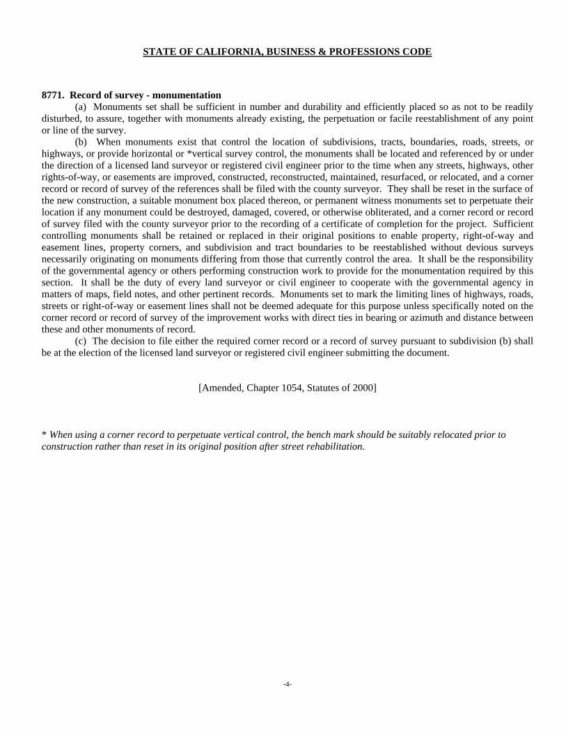
STATE OF CALIFORNIA, BUSINESS & PROFESSIONS CODE 8771. Record of survey - monumentation
(a) Monuments set shall be sufficient in number and durability and efficiently placed so as not to be readily disturbed, to assure, together with monuments already existing, the perpetuation or facile reestablishment of any point or line of the survey.
(b) When monuments exist that control the location of subdivisions, tracts, boundaries, roads, streets, or highways, or provide horizontal or *vertical survey control, the monuments shall be located and referenced by or under the direction of a licensed land surveyor or registered civil engineer prior to the time when any streets, highways, other rights-of-way, or easements are improved, constructed, reconstructed, maintained, resurfaced, or relocated, and a corner record or record of survey of the references shall be filed with the county surveyor. They shall be reset in the surface of the new construction, a suitable monument box placed thereon, or permanent witness monuments set to perpetuate their location if any monument could be destroyed, damaged, covered, or otherwise obliterated, and a corner record or record of survey filed with the county surveyor prior to the recording of a certificate of completion for the project. Sufficient controlling monuments shall be retained or replaced in their original positions to enable property, right-of-way and easement lines, property corners, and subdivision and tract boundaries to be reestablished without devious surveys necessarily originating on monuments differing from those that currently control the area. It shall be the responsibility of the governmental agency or others performing construction work to provide for the monumentation required by this section. It shall be the duty of every land surveyor or civil engineer to cooperate with the governmental agency in matters of maps, field notes, and other pertinent records. Monuments set to mark the limiting lines of highways, roads, streets or right-of-way or easement lines shall not be deemed adequate for this purpose unless specifically noted on the corner record or record of survey of the improvement works with direct ties in bearing or azimuth and distance between these and other monuments of record.
(c) The decision to file either the required corner record or a record of survey pursuant to subdivision (b) shall be at the election of the licensed land surveyor or registered civil engineer submitting the document.
[Amended, Chapter 1054, Statutes of 2000]
* When using a corner record to perpetuate vertical control, the bench mark should be suitably relocated prior to construction rather than reset in its original position after street rehabilitation.
-4-
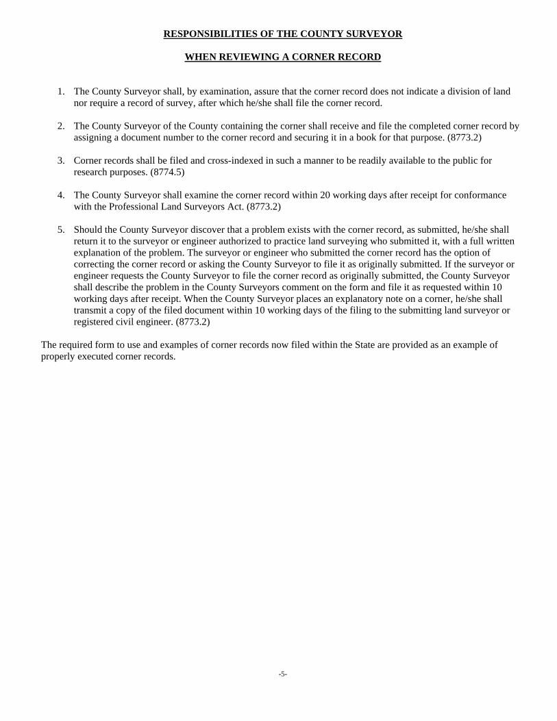
RESPONSIBILITIES OF THE COUNTY SURVEYOR
WHEN REVIEWING A CORNER RECORD
1. The County Surveyor shall, by examination, assure that the corner record does not indicate a division of land nor require a record of survey, after which he/she shall file the corner record.
2. The County Surveyor of the County containing the corner shall receive and file the completed corner record by
assigning a document number to the corner record and securing it in a book for that purpose. (8773.2)
3. Corner records shall be filed and cross-indexed in such a manner to be readily available to the public for research purposes. (8774.5)
4. The County Surveyor shall examine the corner record within 20 working days after receipt for conformance
with the Professional Land Surveyors Act. (8773.2) 5. Should the County Surveyor discover that a problem exists with the corner record, as submitted, he/she shall
return it to the surveyor or engineer authorized to practice land surveying who submitted it, with a full written explanation of the problem. The surveyor or engineer who submitted the corner record has the option of correcting the corner record or asking the County Surveyor to file it as originally submitted. If the surveyor or engineer requests the County Surveyor to file the corner record as originally submitted, the County Surveyor shall describe the problem in the County Surveyors comment on the form and file it as requested within 10 working days after receipt. When the County Surveyor places an explanatory note on a corner, he/she shall transmit a copy of the filed document within 10 working days of the filing to the submitting land surveyor or registered civil engineer. (8773.2)
The required form to use and examples of corner records now filed within the State are provided as an example of properly executed corner records.
-5-
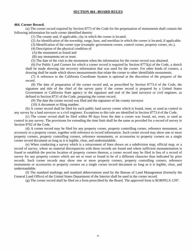
SECTION 464 –BOARD RULES
464. Corner Record. (a) The corner record required by Section 8773 of the Code for the perpetuation of monuments shall contain the
following information for each corner identified therein: (1) The county and, if applicable, city in which the corner is located. (2) An identification of the township, range, base, and meridian in which the corner is located, if applicable. (3) Identification of the corner type (example: government corner, control corner, property corner, etc.). (4) Description of the physical condition of (A) the monument as found and (B) any monuments set or reset. (5) The date of the visit to the monument when the information for the corner record was obtained. (6) For Public Land Corners for which a corner record is required by Section 8773(a) of the Code, a sketch
shall be made showing site recovery information that was used for the corner. For other kinds of corners, a drawing shall be made which shows measurements that relate the corner to other identifiable monuments.
(7) A reference to the California Coordinate System is optional at the discretion of the preparer of the record.
(8) The date of preparation of the corner record and, as prescribed by Section 8773.4 of the Code, the signature and title of the chief of the survey party if the corner record is prepared by a United States Government or California State agency or the signature and seal of the land surveyor or civil engineer, as defined in Section 8731 of the Code, preparing the corner record.
(9) The date the corner record was filed and the signature of the county surveyor. (10) A document or filing number.
(b) A corner record shall be filed for each public land survey corner which is found, reset, or used as control in any survey by a land surveyor or a civil engineer. Exceptions to this rule are identified in Section 8773.4 of the Code.
(c) The corner record shall be filed within 90 days from the date a corner was found, set, reset, or used as control in any survey. The provisions for extending the time limit shall be the same as provided for a record of survey in Section 8762 of the Code.
(d) A corner record may be filed for any property corner, property controlling corner, reference monument, or accessory to a property corner, together with reference to record information. Such corner record may show one or more property corners, property controlling corners, reference monuments, or accessories to property corners on a single corner record document so long as it is legible, clear, and understandable.
(e) When conducting a survey which is a retracement of lines shown on a subdivision map, official map, or a record of survey, where no material discrepancies with these records are found and where sufficient monumentation is found to establish the precise location of property corners thereon, a corner record may be filed in lieu of a record of survey for any property corners which are set or reset or found to be of a different character than indicated by prior records. Such corner records may show one or more property corners, property controlling corners, reference monuments or accessories to property corners on a single corner record document so long as it is legible, clear, and understandable.
(f) The standard markings and standard abbreviations used by the Bureau of Land Management (formerly the General Land Office) of the United States Department of the Interior shall be used in the corner record.
(g) The corner record shall be filed on a form prescribed by the Board. The approved form is BORPELS-1297.
-6-
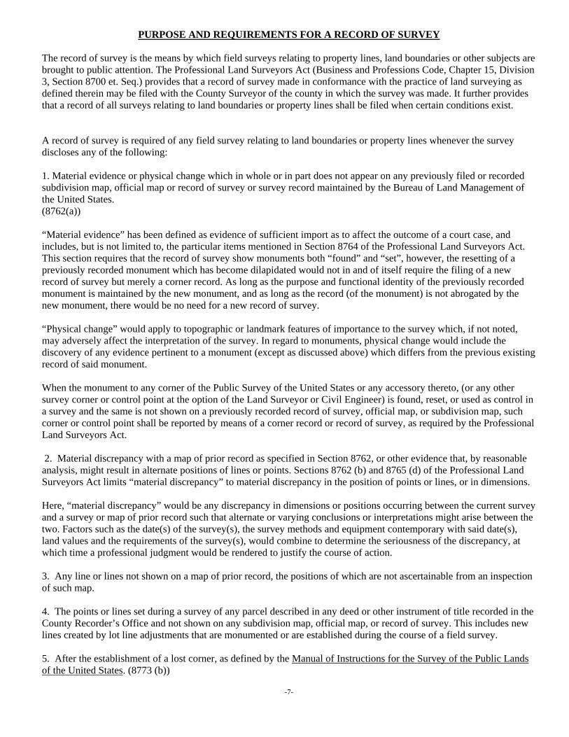
PURPOSE AND REQUIREMENTS FOR A RECORD OF SURVEY
The record of survey is the means by which field surveys relating to property lines, land boundaries or other subjects are brought to public attention. The Professional Land Surveyors Act (Business and Professions Code, Chapter 15, Division 3, Section 8700 et. Seq.) provides that a record of survey made in conformance with the practice of land surveying as defined therein may be filed with the County Surveyor of the county in which the survey was made. It further provides that a record of all surveys relating to land boundaries or property lines shall be filed when certain conditions exist. A record of survey is required of any field survey relating to land boundaries or property lines whenever the survey discloses any of the following: 1. Material evidence or physical change which in whole or in part does not appear on any previously filed or recorded subdivision map, official map or record of survey or survey record maintained by the Bureau of Land Management of the United States. (8762(a)) “Material evidence” has been defined as evidence of sufficient import as to affect the outcome of a court case, and includes, but is not limited to, the particular items mentioned in Section 8764 of the Professional Land Surveyors Act. This section requires that the record of survey show monuments both “found” and “set”, however, the resetting of a previously recorded monument which has become dilapidated would not in and of itself require the filing of a new record of survey but merely a corner record. As long as the purpose and functional identity of the previously recorded monument is maintained by the new monument, and as long as the record (of the monument) is not abrogated by the new monument, there would be no need for a new record of survey. “Physical change” would apply to topographic or landmark features of importance to the survey which, if not noted, may adversely affect the interpretation of the survey. In regard to monuments, physical change would include the discovery of any evidence pertinent to a monument (except as discussed above) which differs from the previous existing record of said monument. When the monument to any corner of the Public Survey of the United States or any accessory thereto, (or any other survey corner or control point at the option of the Land Surveyor or Civil Engineer) is found, reset, or used as control in a survey and the same is not shown on a previously recorded record of survey, official map, or subdivision map, such corner or control point shall be reported by means of a corner record or record of survey, as required by the Professional Land Surveyors Act. 2. Material discrepancy with a map of prior record as specified in Section 8762, or other evidence that, by reasonable analysis, might result in alternate positions of lines or points. Sections 8762 (b) and 8765 (d) of the Professional Land Surveyors Act limits “material discrepancy” to material discrepancy in the position of points or lines, or in dimensions. Here, “material discrepancy” would be any discrepancy in dimensions or positions occurring between the current survey and a survey or map of prior record such that alternate or varying conclusions or interpretations might arise between the two. Factors such as the date(s) of the survey(s), the survey methods and equipment contemporary with said date(s), land values and the requirements of the survey(s), would combine to determine the seriousness of the discrepancy, at which time a professional judgment would be rendered to justify the course of action. 3. Any line or lines not shown on a map of prior record, the positions of which are not ascertainable from an inspection of such map.
4. The points or lines set during a survey of any parcel described in any deed or other instrument of title recorded in the County Recorder’s Office and not shown on any subdivision map, official map, or record of survey. This includes new lines created by lot line adjustments that are monumented or are established during the course of a field survey. 5. After the establishment of a lost corner, as defined by the Manual of Instructions for the Survey of the Public Lands of the United States. (8773 (b))
-7-
A record of survey is not required per Section (8765) if any of the following conditions exist: 1. The survey was made by a public officer or under his direction, in his official capacity and a reproducible copy thereof, showing all the data required by Section 8764 with the exception of the recorders statement, has been filed with the County Surveyor of the county in which the land is located. 2. The survey was made by the U.S. Bureau of Land Management. 3. A Final Map or Parcel Map is in preparation for recording under the provisions of the Subdivision Map Act. 4. When the survey is a retracement of lines shown on a subdivision map, official map, or a record of survey, where no material discrepancies with those records are found and sufficient monumentation is found to establish the accurate location of property corner thereon, provided that a corner record is filed for any property corners which are set or reset or found to be of a different character than indicated by prior records. 5. When the survey is of interior lots in a mobile home park provided that the park has not converted to residential ownership or no subdivision map, official map or record of survey has been previously filed of record. A record of survey cannot be used to create a division of land. All divisions of land must be made by means of a subdivision map, unless exempted by the Subdivision Map Act. Any line shown on a record of survey map which does not represent an existing title line and which appears to create a new parcel of land shall be clearly labeled as to its purpose.
-8-
RESPONSIBILITIES OF THE PRIVATE SURVEYOR
-RECORD OF SURVEY-
1. The surveyor is responsible to recognize the need to file a record of survey in accordance with Section 8762 of the Professional Land Surveyors Act.
2. The surveyor must verify that no violation of the Subdivision Map Act will be created by the filing of the record
of survey.
3. The survey must be made in conformance with the accepted practices of land surveying in the State of California and the latest edition of the Professional Land Surveyor’s Act and of Section 465 of the Rules and Regulations of the Board for Professional Engineers and Land Surveyors.
4. The survey must be made under the direct supervision of a licensed Land Surveyor in accordance with Section
8762 of the Professional Land Surveyors Act.
5. All information pertinent to the establishment of land boundary lines must be clearly shown or referenced on the map of the survey. It shall be the responsibility of the surveyor to examine available records in analyzing his or her survey.
6. Lines of occupation or features near corners shall be shown if they assists in determining the location of
boundary lines and must be shown if they indicate possible alternate locations.
7. The surveyor shall administer and certify oaths when necessary in accordance with Section 8760(a) of the Professional Land Surveyors Act and so indicate on his/her map.
8. The surveyor shall supply the County Surveyor with copies of pertinent deeds, field notes, and other such
evidence not readily available in the office of the County Surveyor to aid in the examination of the map.
9. The surveyor shall deliver to the County Surveyor the required number of prints of each sheet and shall deposit with him/her the required examination and filing fees when or as required.
10. Upon the filing of a record of survey or amended record of survey the surveyor who prepared the map shall
transmit a copy of the map, including all recording information, to the County Surveyor, who shall maintain an index, by geographic location, of the maps. The County Surveyor may charge a fee equal to the cost of recording the maps for the purpose of maintaining an index of the maps. This requirement shall not apply to any county which requires these documents to be transmitted to the County Surveyor and requires that official to maintain an index of those documents.
11. The surveyor should encourage the filing of record of survey maps in other situations where a public record
would be desirable but not necessarily mandatory under Section 8762 of the Professional Land Surveyors Act.
-9-
RESPONSIBILITIES OF THE COUNTY SURVEYOR
WHEN EXAMINING A RECORD OF SURVEY
1. The Professional Land Surveyors Act requires the County Surveyor to examine the map for conformance with the requirements of Section 8766 of said Act.
2. Section 8766 states that the County Surveyor shall examine the map within 20 working days or such additional
time as may be mutually agreed upon, with respect to:
a. Its accuracy of mathematical data and substantial compliance with the information required by Section 8764 of the Professional Land Surveyors Act. b. Its compliance with Section 8762.5, 8763, 8764.5, 8771.5, and 8772 of the Professional Land Surveyors Act.
The Land Surveyor submitting the record of survey shall not be required to change the methods or procedures utilized or employed in the performance of the survey, nor is a field survey required for the County Surveyor to verify the data shown on the record of survey. The County Surveyor may add notes to the record of survey expressing opinions regarding the methods or procedures used. The County Surveyor's examination shall be performed by, or under the direct supervision of a licensed Land Surveyor. 3. County Surveyor endorsement -If the County Surveyor finds that the record of survey complies with the examination in Section 8766, the County Surveyor shall endorse a statement on it of his or her examination, and shall present it to the County Recorder for filing. Otherwise, the County Surveyor shall return it to the person who presented it, together with a written statement of the changes necessary to make it conform to the requirements of Section 8766. The Licensed Land Surveyor submitting the record of survey may then make the agreed changes and note those matters which cannot be agreed upon in accordance with the provisions of Section 8768 and shall resubmit the record of survey within 60 days or within a time that is mutually agreed upon. (8767) 4. Record of survey explanations of differences: If the matters appearing on the record of survey cannot be agreed upon by the licensed Land Surveyor and the County Surveyor within 10 working days after the licensed Land Surveyor resubmits and requests the record of survey be filed without further change, an explanation of the differences shall be noted on the map and it shall be presented by the County Surveyor to the County Recorder for filing, and the County Recorder shall file the record of survey. The parties shall attempt to reach agreement regarding the language for explanation of the differences and if an agreement cannot be reached, then both shall add a notation explaining the differences. The explanation shall be specific to identify the factual basis for the difference. (8768) 5. Upon completion of his examination of the map, the County Surveyor shall endorse a statement on the map showing his or her stamp or seal and the expiration date of his or her license or registration and present it to the County Recorder for filing.
Note: The following page is a guideline endorsed by the County Engineers Association for the review of Records of Survey by the County Surveyor. The guideline is based upon the provisions of the Business and Professions Code and is intended to provide consistency in map checking statewide.
-10-

County Engineers Association of California
RECORD OF SURVEY CHECK SHEET First Check File No.___________________ Recheck No.________ Fee Paid $________ Date Paid_________ Date______________________ Surveyor__________________________________________ Checked By_____________________________ Survey Requested By________________________________ Location_______________________________ Circle (0) indicates deficiency – Check (√) indicates no deficiency Business and Professions Code, Chapter 15, Division 3, Section 8700 et seq. ______ Map appears to create a division of land; Subdivision or Parcel Map required. (8762.5) MAP TITLE ______ Name of City, if applicable ______ Name of County, California ______ “RECORD OF SURVEY,” ______ General description of land surveyed. (8764) ______ Date of survey. ______ Sheet number, when two or more sheets. CERTIFICATES ______ County Recorder’s Certificate or space for same (8764.5) ______ Surveyor’s Statement (8764.5) ______ Signed, dated and sealed (8764.5 & 411(h)) ______ County Surveyor’s Statement (8764.5) ______ Certificate per Sec. 8762.5, if applicable. ______ Memorandum of oaths, if applicable (8760) ______ No nontechnical certificates or statements on map. (8764.5) SURVEYOR’S NOTES ______ Basis of Bearings: map of record, celestial observation, State Plane Coordinates, or County Surveyor’s Records. ______ Found or Set monuments should be shown with distinguishing symbols and include type, size, LS or RCE No. (8764) ______ Symbols and nonstandard abbreviations defined. (8764) MATHEMATICAL ACCURACY ______ Map loop closures less than 0.02 ft* ______ Bearings shown (8764) ______ Distances shown. (8764)* ______ Overall bearings shown ______ Sum of parts equal total distance or delta.* ______ Curve data shown. (Minimum = Delta, Radius, Arc length).* ______ radial bearings shown where appropriate. ______ Areas shown if required for survey ______ Others ____________________________________________ * Allowable tolerances for rounding are to be expected. MAP BODY ______ Map material; tracing cloth or polyester base film; black ink. (8763) ______ Map size: 18” x 26” or 460 x 660 mm (8763)
______ Margin: 1” or 025 mm all around. (8763) ______ Map orientation, title and map body to read from bottom or right side of sheet when north arrow points away from reader where practicable. ______ North arrow. (8764) ______ Scale. (8764) ______ City, County or State boundary lines as required. ______ Reference to adjacent tracts or other maps of record when pertinent. (8764(d)) ______ Legibility of map data. (8763) ______ Street names and widths shown. ______ Reference for all found monuments or statement of acceptance if used as a control monument (8764) ______ Reference to deeds or official records if necessary for the establishment of lines or points (8764). ______ Record measurements in parenthesis to be shown when beneficial to the interpretation of lines or points or substantially different from measured. ______ Purpose indicated for all easements shown. ______ Detail required for clarity. ______ Arrows needed to clarity dimensions. ______ No ditto marks. ______ Spelling SURVEY PROCEDURES ______ Survey based upon sufficient control. ______ Additional survey information required (8762) ______ Prorations correct. ______ Sectional breakdowns correct. ______ Deed interpretations correct. ______ Durable monuments sufficient in number. (8771) ______ Monuments tagged. (8772) ______ Relationship to adjacent lines of record when pertinent. (8764) ______ Methods of establishment of lines or points shown where necessary. (8764) ______ Other _______________________________________________
To the Surveyor: Pursuant to Section 8767 of the land Surveyor’s Act, the subject map shall be corrected as indicated on the above check list and / or check print and returned to this office with:
□ Corrected Prints
□ The corrected original and the ____________ filing fee (Payable to County Recorder) (Name), County Surveyor ______________________________________________ Deputy
-11-

EXPLANATORY NOTES FOR RECORD OF SURVEY CHECK SHEET The notes below apply to the stated items on the Check Sheet. The remaining items are (hopefully) self-explanatory. A. MAP TITLE: The recommended title block for the map sheet shall contain the essential items listed on the Check Sheet and shall, for the sake of conformity, follow the basic format shown on the sample sheet. B. SURVEYOR’S NOTES: 1. Basis of Bearings: The bearings shown on the map shall be defined in terms of one of the following:
a. A line appearing shown or described on an existing map or title document of record. The reference line shall be a line between any two existing monuments which have been made a part of the current survey and have been shown on the map. The bearing of the reference line shall be shown on the map. Acceptable for reference purposes are final maps, parcel maps (based on a field survey), records of survey maps, City or County Surveyor or Engineer maps, State Highway Department Coordinate Control maps and those Deeds with calls to or for monuments having been previously set.
The form of the note shall be substantially as follows: "The basis of bearings for this survey is the North line of the NW ¼ Sec. 3, T.7S., R.2W., S.B.M., shown on R.S. 54/23-25 as S89°21’58”E."
b. A solar or stellar observation.
If the astronomic observations were made on a line which is monumented and shown on the map, the note shall make specific reference to that line as, for example: "The basis of bearings for this survey is the centerline of Sierra Road, shown hereon as N10°15'20"E…; as determined by observation of (Polaris) (the sun). If the astronomic observations were made on a line not appearing on the map, the note may be generalized to indicate that the bearings shown on the map are referred to the true meridian as determined by observation of (Polaris) (the sun). In either case, the field notes of the sun or Polaris observation and connection to the lines on the map shall be made available to the County Surveyor for his review.
c. The California Coordinate System: When this system is used, the map shall show the line or lines connecting the survey to the control stations used, showing the grid bearings between them, and the relationship between grid north and astronomic north (theta angle). Should coordinates be shown for points established on the map, the control scheme by means of which the coordinates were determined must also be shown on the map. Refer to Section 8813 of the Public Resources Code. The form of the note shall be substantially as follows: "The basis of bearings for this survey is the California Coordinate System (NAD 27 or NAD 83) Zone 5, as determined locally by the line between USG&GS stations BACHELOR and MARCH, shown herein as: N27°32'15"E." If an FGCS, or its successor, order of accuracy is claimed for a survey or a map, it shall be justified by additional written data that shows equipment, procedures, closures, adjustments, and a control diagram.
Note: Public Resources Code, Section 8817 requires NAD 83 on all new surveys and new mapping projects effective January 1, 1995. The Federal Geodetic Control Subcommittee (FGCS) was formerly the Federal Geodetic Control Committee.
-12-
2. Any survey based upon the metric system shall be clearly identified as such. It is recommended that a bold note and/or metric logo be placed conspicuously on the map. 3. Other explanatory notes and comments as required. C. MAP BODY: 1. All lettering shall be placed so as to be read most conveniently with the North arrow pointing away from the reader where practicable. 2. Adjacent Subdivisions, etc: The relationship to those portions of adjacent tracts, streets, or senior conveyances which have common lines with the survey. 3. References for Found Monuments: All monuments shown as "found on the map shall be described as to type, material, height relative to the ground surface, stamping/tagging, with a reference to a record map or field book where the monument was shown as having been set or accepted for use as the corner cited. If no record can be found to substantiate the monument, indicate same. It is recommended that untagged monuments used for control or accepted as corners be tagged by the surveyor in responsible charge. D. LEGIBILITY OF MAP DATA: (Note: The County Surveyor as ex officio County Recorder is responsible for determining the clarity, legibility and archival quality of a map and based on these criteria can make a determination as to the recordability of a map. The following are some general recommendations.) 1. Lines: Normally, the weight of a line is used to denote a specific level of importance to that line, the heavier lines being of more importance than the light weight lines. It has been customary to represent various types of lines as follows:
a. Lines denoting the boundary of the land requested specifically to be surveyed are shown with heavy solid lines, the weight being usually three times greater than that of other lines on the map, except the border, unless clarity dictates otherwise. b. Public street side lines are shown by light solid lines, unless clarity dictates otherwise. c. Other lines (adjoining lots, tracts, etc.) are shown as light dashed lines, unless clarity would dictate otherwise. Lines that do not contribute to the easy interpretation of the map shall be kept to a minimum. d. Other special purpose lines may be used (e.g., centerlines, county boundary lines, section lines, control lines, etc.) but shall be clearly identified by note or symbol.
2. Lettering: Lettering shall be of an open, rounded style, either vertical or slanted, and of such size that it can be reproduced via microfilming, scanning or equivalent processes and still be easily read. Experience has indicated that the minimum size of lettering which will meet these requirements is 0.080”, with a pen size that will keep the letters open. A sufficient space shall be left between any letters and lines to insure that the lettering will not bleed into the lines when reproducing a map copy from microfilm.
-13-
THE LEAGUE OF CALIFORNIA SURVEYING ORGANIZATIONS
GPS RECORD OF SURVEY
GUIDELINES REVISED JULY 1, 1999
PREPARED BY
CEAC GUIDE REVISION COMMITTEE
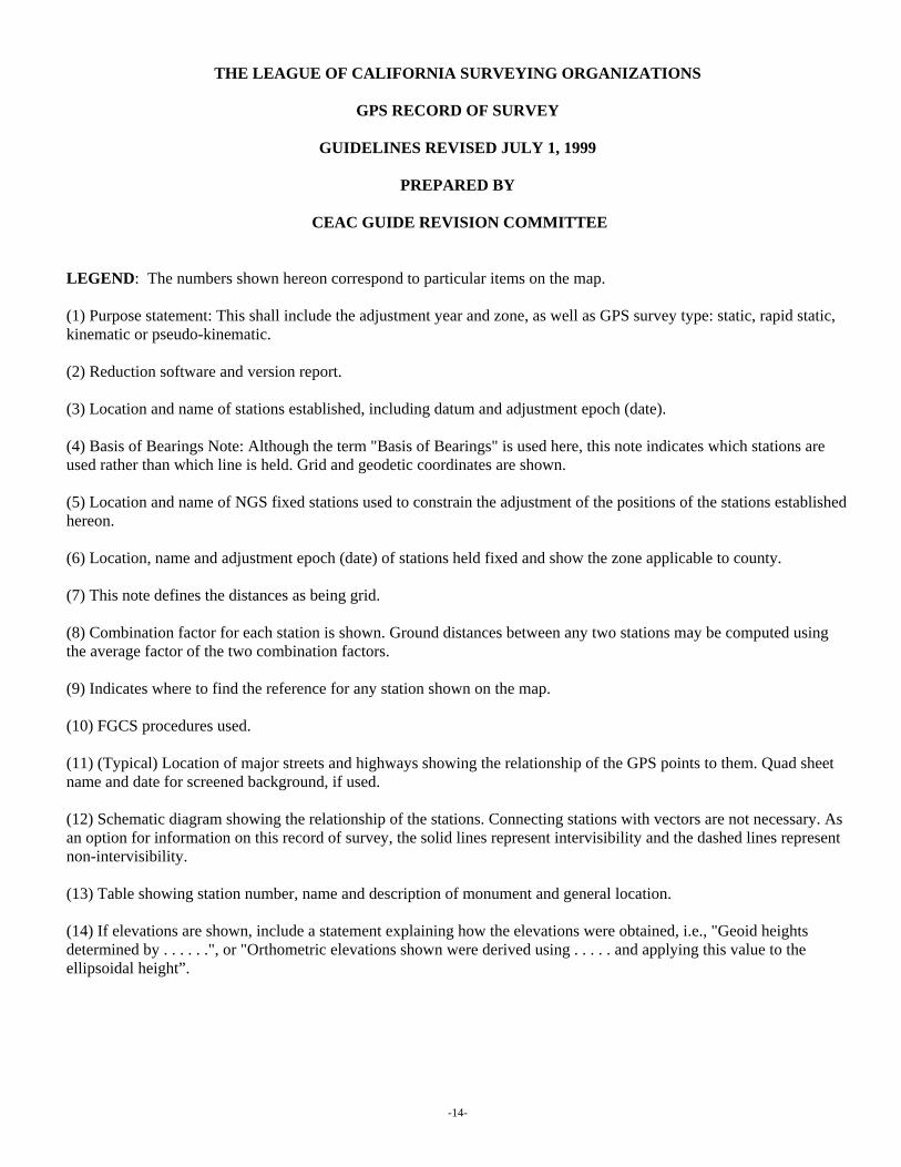
LEGEND: The numbers shown hereon correspond to particular items on the map. (1) Purpose statement: This shall include the adjustment year and zone, as well as GPS survey type: static, rapid static, kinematic or pseudo-kinematic. (2) Reduction software and version report. (3) Location and name of stations established, including datum and adjustment epoch (date). (4) Basis of Bearings Note: Although the term "Basis of Bearings" is used here, this note indicates which stations are used rather than which line is held. Grid and geodetic coordinates are shown. (5) Location and name of NGS fixed stations used to constrain the adjustment of the positions of the stations established hereon. (6) Location, name and adjustment epoch (date) of stations held fixed and show the zone applicable to county. (7) This note defines the distances as being grid. (8) Combination factor for each station is shown. Ground distances between any two stations may be computed using the average factor of the two combination factors. (9) Indicates where to find the reference for any station shown on the map. (10) FGCS procedures used. (11) (Typical) Location of major streets and highways showing the relationship of the GPS points to them. Quad sheet name and date for screened background, if used. (12) Schematic diagram showing the relationship of the stations. Connecting stations with vectors are not necessary. As an option for information on this record of survey, the solid lines represent intervisibility and the dashed lines represent non-intervisibility. (13) Table showing station number, name and description of monument and general location. (14) If elevations are shown, include a statement explaining how the elevations were obtained, i.e., "Geoid heights determined by . . . . . .", or "Orthometric elevations shown were derived using . . . . . and applying this value to the ellipsoidal height”.
-14-

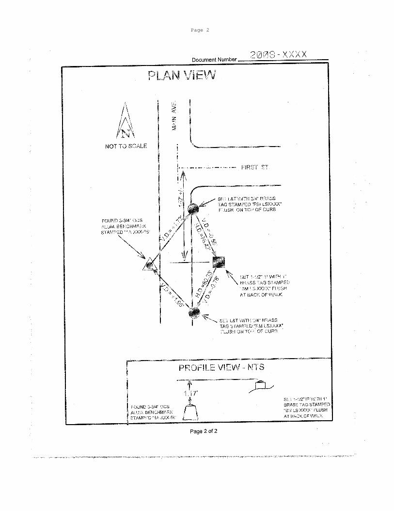
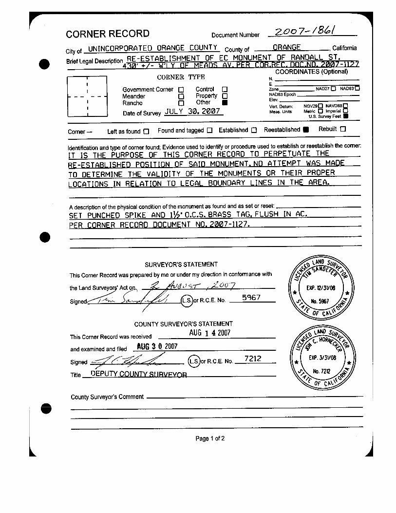
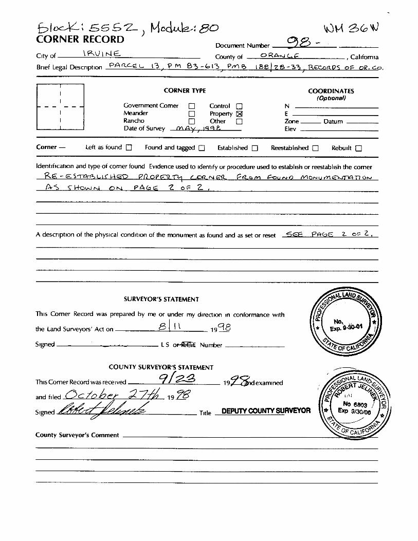
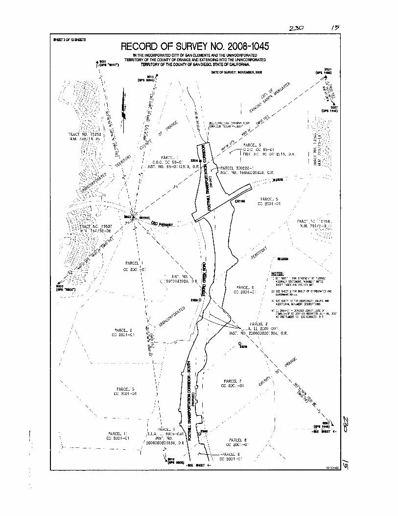
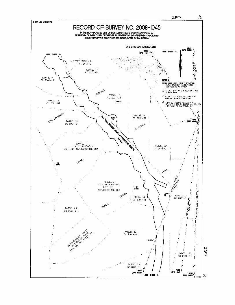
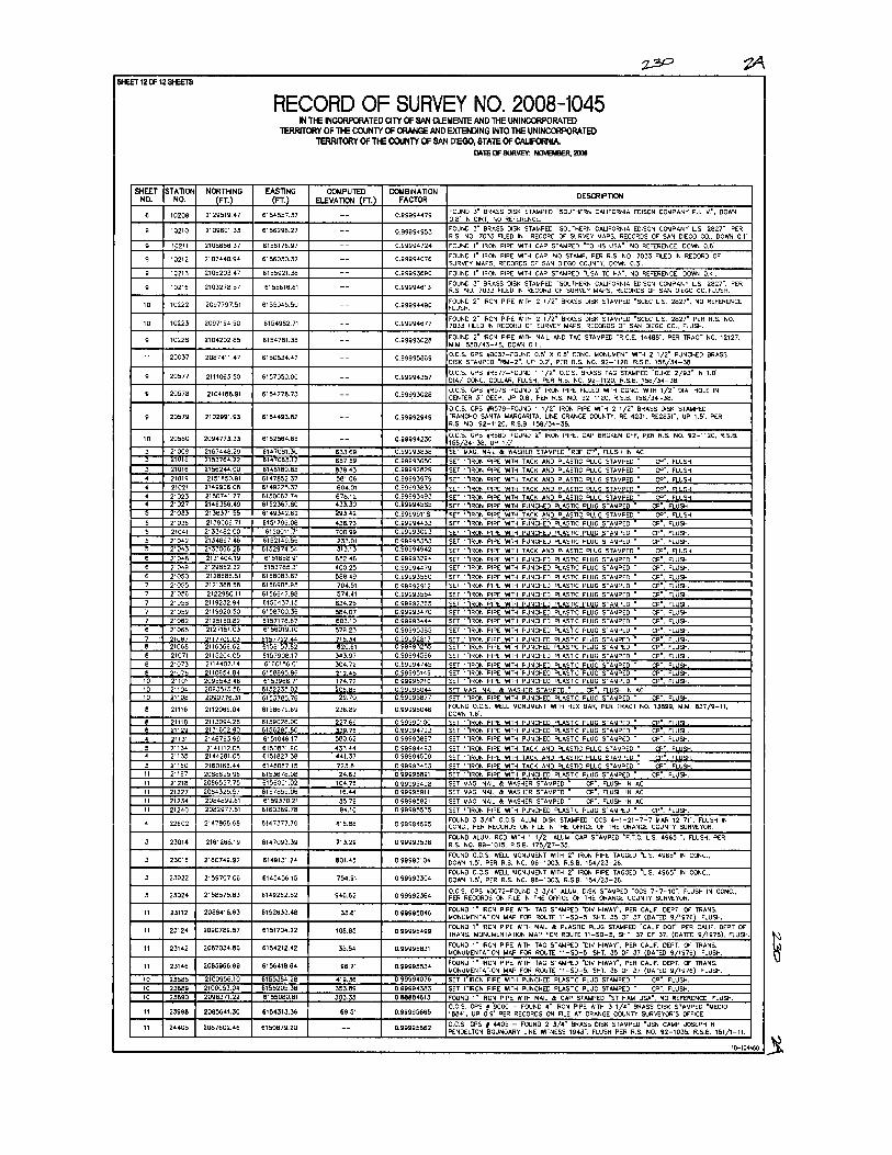
Sample Corner Records & Records of Survey
(This section reserved for counties to provide samples from their respective jurisdictions)
-15-

Vertical Corner Record
Page 2

Monument Preservation Corner Record

Boundary Corner Record


GPS Record of Survey


Boundary Record of Survey

Lot Line Adjustment RS