Embed Size (px)
Citation preview

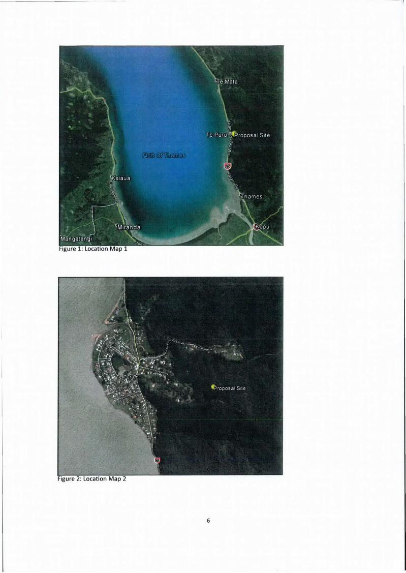
C Landscape and Visual Effects Assessment
Hawkes Bay Office: www.hudsonassociates.co.nz
PO Box 8823 [email protected]
Havelock North Ph 06 877-9808
Hawke's Bay 4157 HUDSON ASSOCIATES M 021 324-409
iAKIDSCAVE AR( 1 U iS
LANDSCAPE AND VISUAL EFFECTS ASSESSMENT
For
VODAFONE NEW ZEALAND, PROPOSED
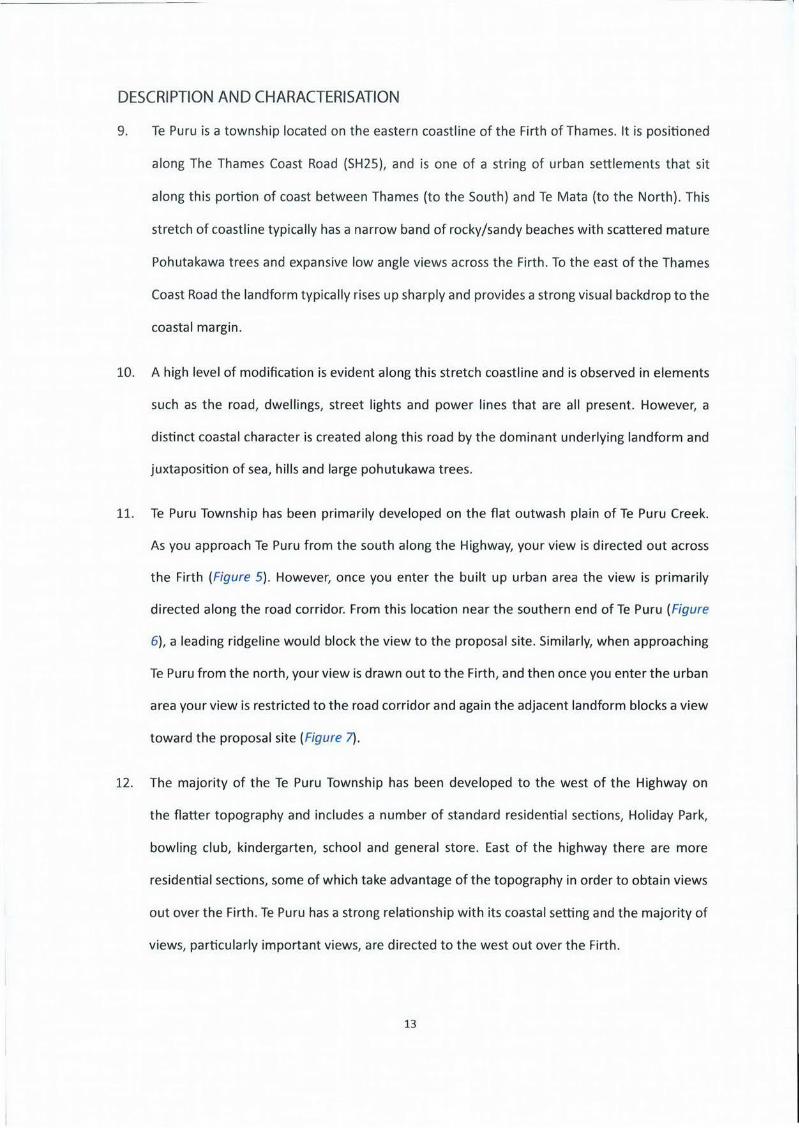
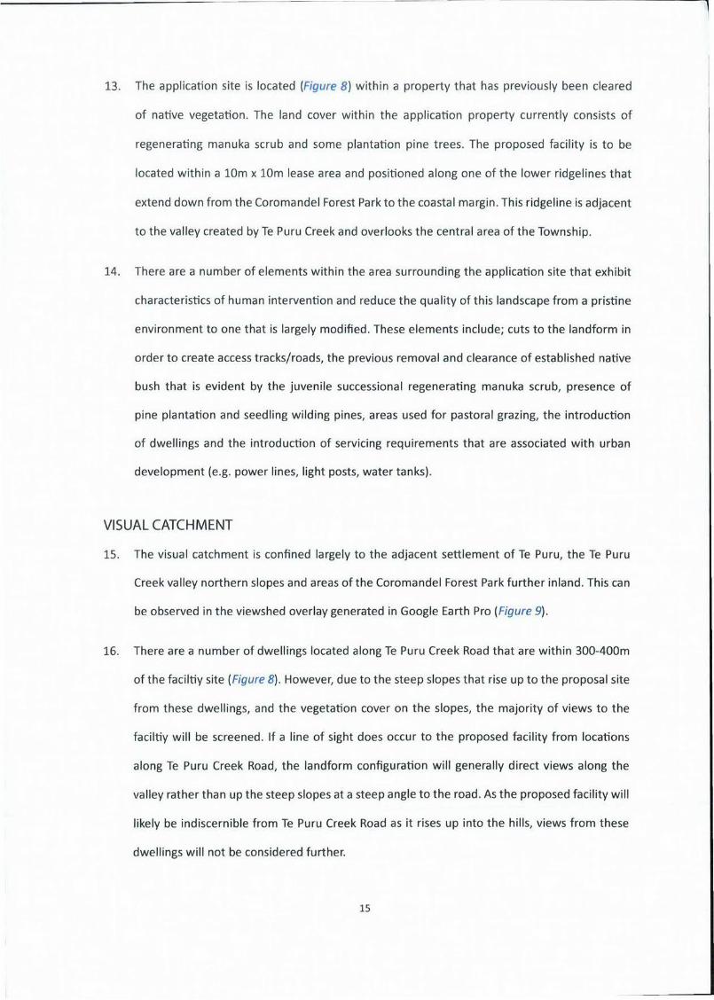
TELECOMMUNICATIONS TOWER, TE PURU,
THAMES COAST
Prepared by
Hudson Associates Landscape Architects For Consideration by
Thames Coromandel District Council
5 June 2015

(This page has been intentionally left blank)
HUDSON ASSOCIATES AWISfAPF A ( ! I 1 (1
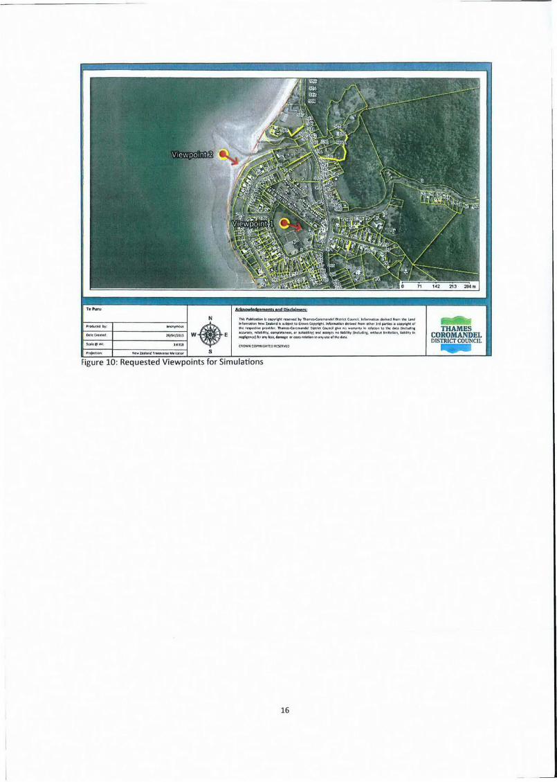
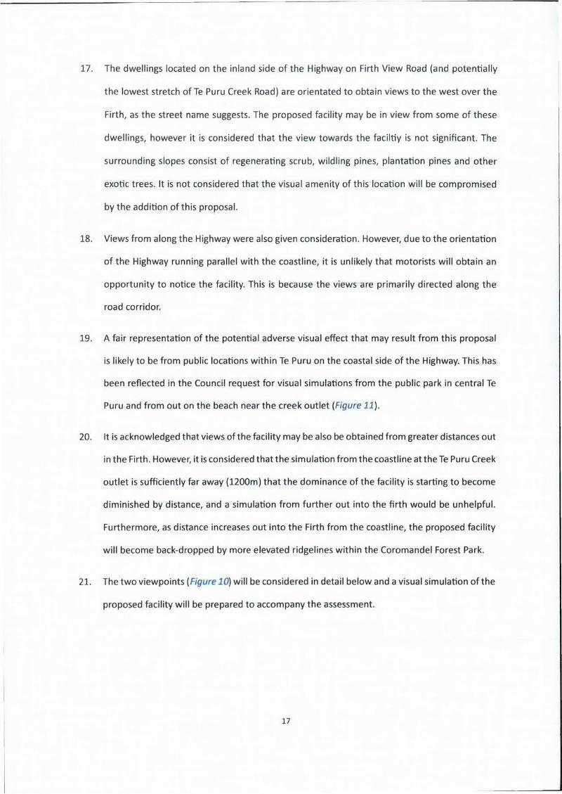
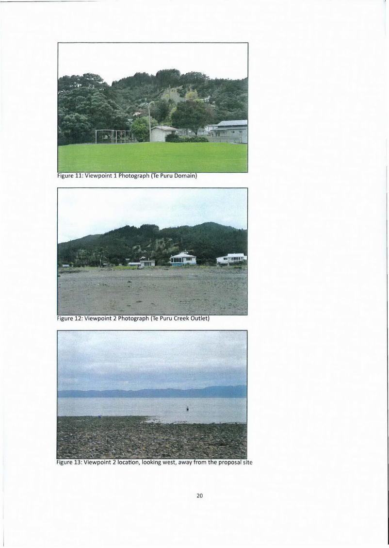
Prepared by
Hudson Associates
Registered Landscape Architects
P0 Box 8823 Havelock North
Ph 06 877-9808
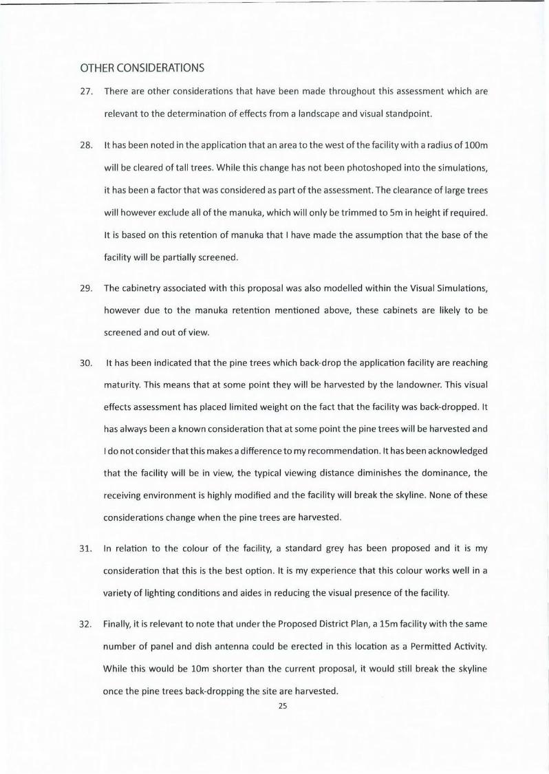
john@hudsonasscc LECO, nz
W W ' ) C O flZ
For
Vodafone N e w Zealand
4 June 2015
This report is intended to be printed and read in duplex
3

TABLE OF FIGURES
Figure 1 - Location Map 1 6
Figure 2 - Location Map 2 6
Figure 3: Operative District Plan Zone Map 10
Figure 4: Proposed District Plan Zone Map 10
Figure 5: View toward the Firth as you enter Te Puru from the south 12
Figure 6: View from the Highway near the southern extent of Te Puru 12
Figure 7: View from the Highway near the northern extent of Te Puru 12
Figure 8: Location Map 3 14
Figure 9: Viewshed Analysis 14
Figure 10: Requested Viewpoints for Simulations 16
Figure 11: Viewpoint 1 Photograph (Te Puru Domain) 20
Figure 12: Viewpoint 2 Photograph (Te Puru Creek Outlet) 20
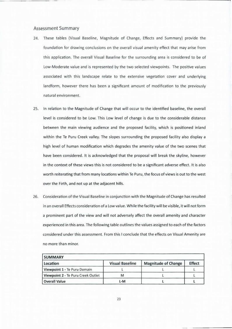
Figure 13: Viewpoint 2 location, looking away from the proposal site 20
4
TABLE OF CONTENTS
INTRODUCTION 7
THE PROPOSAL 7
METHODOLOGY 9
PLANNING FRAMEWORK 11
DESCRIPTION AND CHARACTERISATION 13
VISUAL CATCHMENT 15
VISUAL EFFECTS ASSESSMENT 19
Assessment Summary 23
OTHER CONSIDERATIONS 25
ASSESSMENT AGAINSTTHE PLANNING FRAMEWORK 27
CONCLUSION 29
5

INTRODUCTION
1. Hudson Associates have been engaged by Vodafone to prepare a Landscape and Visual Effects
assessment for a proposed telecommunications facility. This application relates to a site that
is located behind the township of Te Puru along the western coastline of the Firth of Thames.
The facility will consist of 25m tall lattice structure with attached panel and dish antenna,
located over 700m inland from the nearest point of the coastline.
THE PROPOSAL
2. Vodafone are proposing to erect a telecommunications facility within the 16ha property Lot
2 DP 332870, near the Te Puru Township (Figure 1). The Resource Consent Application will be
presented to the Thames Coromandel District Council for consideration. The proposal site is
indicated in Figure 2, and is located amongst an area of regenerating scrub and plantation pine
trees. The proposal consists of the following elements (Refer to Application Documents);
• a lattice structure with a total height of 25m
• a cable tray and ladder running up the middle of the structure
• a circular headframe
• 18 panel antenna (each up to 3m high) attached to the headframe in two rows
• 2 dish antenna (1.9m diameter) attached to the structure at a height of 17.5m
• 2 dish antenna (1.9m diameter) attached to the structure at a height of lOm
• a lightning rod extending beyond the structure
• equipment cabinets located at the base of the structure
• a site perimeter fence
• installation of an under-ground power and telecommunication line
• clearance of nearby pine trees (retention of manuka scrub)
7

(This page has been intentionally left blank)
METHODOLOGY
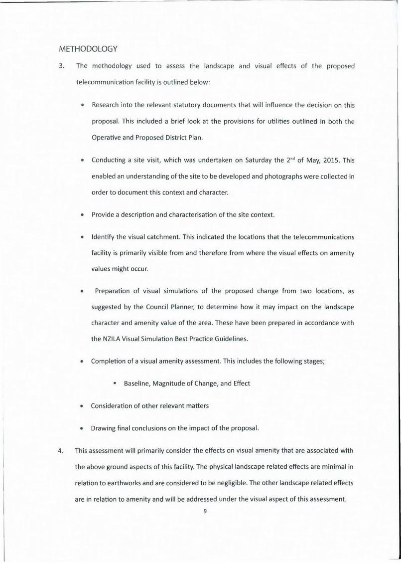
3. The methodology used to assess the landscape and visual effects of the proposed
telecommunication facility is outlined below:
• Research into the relevant statutory documents that will influence the decision on this
proposal. This included a brief look at the provisions for utilities outlined in both the
Operative and Proposed District Plan.
• Conducting a site visit, which was undertaken on Saturday the 2 nd of May, 2015. This
enabled an understanding of the site to be developed and photographs were collected in
order to document this context and character.
• Provide a description and characterisation of the site context.
Identify the visual catchment. This indicated the locations that the telecommunications
facility is primarily visible from and therefore from where the visual effects on amenity
values might occur.
Preparation of visual simulations of the proposed change from two locations, as
suggested by the Council Planner, to determine how it may impact on the landscape
character and amenity value of the area. These have been prepared in accordance with
the NZILA Visual Simulation Best Practice Guidelines.
Completion of a visual amenity assessment. This includes the following stages;
Baseline, Magnitude of Change, and Effect
• Consideration of other relevant matters
• Drawing final conclusions on the impact of the proposal.
4. This assessment will primarily consider the effects on visual amenity that are associated with
the above ground aspects of this facility. The physical landscape related effects are minimal in
relation to earthworks and are considered to be negligible. The other landscape related effects
are in relation to amenity and will be addressed under the visual aspect of this assessment.
9
10
PLANNING FRAMEWORK
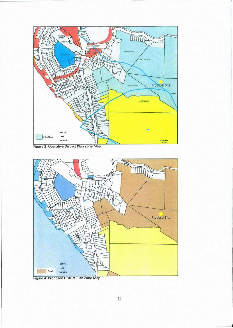
5. The Thames Coromandel District Plan is the main document influencing the assessment of
this resource consent application. There are currently both an Operative and Proposed version
available on the Council Website. Under the Operative District Plan, the site is located within
the Coastal Zone ( :T) and would be assessed as a Discretionary Activity. However, under
the Proposed District Plan, the site is located within the Rural Zone (Figure 4) and would
be assessed as a Restricted Discretionary Activity. We have approached this Landscape and
Visual Assessment based on the more onerous activity status. Our assumption being that if
the Vodafone proposal satisfies the landscape and visual effects concerns of a Discretionary
Activity under the Operative District Plan, then the more permissive Proposed District Plan will
also be satisfied.
Thames Coromandel Operative District Plan
6. The Thames Coromandel Operative District Plan outlines Activity Rules under Section 5. Rule
562.4.1 specifically refers to this application, and references an activity table identifying the
Discretionary Status.
7. As a Discretionary Activity, the matters listed in section 851 are of relevance. In particular,
851.2 (All Discretionary Activities) and 851.5 (Character and Amenity Values) are of relevance
to this landscape and visual assessment. While it is not considered necessary to explicitly
reference each item within these provisions, in general this assessment will address character
and amenity concerns.
Pre-application Meeting
8. It is understood that there was a pre-application meeting held with Council. Part of the outcome
of this meeting was for the applicant to engage Hudson Associates to conduct this Landscape
and Visual Assessment, which will be lodged with the Resource Consent Application. The
Council Officer also specified two viewpoint locations from which to prepare visual simulations
from.
11
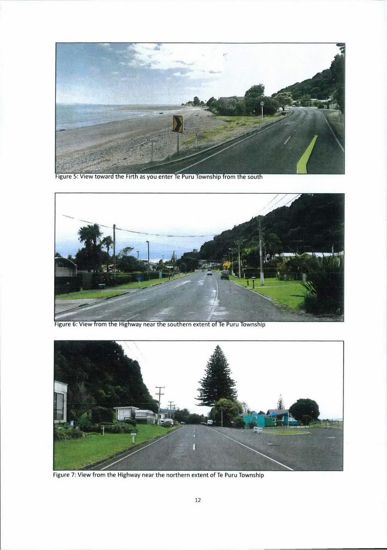
Figure 7: View from the Highway near the northern extent of Te Puru Township
12
DESCRIPTION AND CHARACTERISATION
9. Te Puru is township located on the eastern coastline of the Firth of Thames. It is positioned
along The Thames Coast Road (SH25), and is one of a string of urban settlements that sit
along this portion of coast between Thames (to the South) and Te Mata (to the North). This
stretch of coastline typically has a narrow band of rocky/sandy beaches with scattered mature
Pohutakawa trees and expansive low angle views across the Firth. To the east of the Thames
Coast Road the landform typically rises up sharply and provides a strong visual backdrop to the
coastal margin.
10. A high level of modification is evident along this stretch coastline and is observed in elements
such as the road, dwellings, street lights and power lines that are all present. However, a
distinct coastal character is created along this road by the dominant underlying landform and
juxtaposition of sea, hills and large pohutukawa trees.
11. Te Puru Township has been primarily developed on the flat outwash plain of Te Puru Creek.
As you approach Te Puru from the south along the Highway, your view is directed out across
the Firth (Figure 5). However, once you enter the built up urban area the view is primarily
directed along the road corridor. From this location near the southern end of Te Puru (Figure
6), a leading ridgeline would block the view to the proposal site. Similarly, when approaching
Te Puru from the north, your view is drawn out to the Firth, and then once you enter the urban
area your view is restricted to the road corridor and again the adjacent landform blocks a view
toward the proposal site ( r f . i 7.
12. The majority of the Te Puru Township has been developed to the west of the Highway on
the flatter topography and includes a number of standard residential sections, Holiday Park,
bowling club, kindergarten, school and general store. East of the highway there are more
residential sections, some of which take advantage of the topography in order to obtain views
out over the Firth. Te Puru has a strong relationship with its coastal setting and the majority of
views, particularly important views, are directed to the west out over the Firth.
13

14
13. The application site is located ( ) within a property that has previously been cleared
of native vegetation. The land cover within the application property currently consists of
regenerating manuka scrub and some plantation pine trees. The proposed facility is to be
located within a lOm x lOm lease area and positioned along one of the lower ridgelines that
extend down from the Coromandel Forest Park to the coastal margin. This ridgeline is adjacent
to the valley created by Te Puru Creek and overlooks the central area of the Township.
14. There are a number of elements within the area surrounding the application site that exhibit
characteristics of human intervention and reduce the quality of this landscape from a pristine
environment to one that is largely modified. These elements include; cuts to the landform in
order to create access tracks/roads, the previous removal and clearance of established native
bush that is evident by the juvenile successional regenerating manuka scrub, presence of
pine plantation and seedling wilding pines, areas used for pastoral grazing, the introduction
of dwellings and the introduction of servicing requirements that are associated with urban
development (e.g. power lines, light posts, water tanks).
VISUAL CATCHMENT
15. The visual catchment is confined largely to the adjacent settlement of Te Puru, the Te Puru
Creek valley northern slopes and areas of the Coromandel Forest Park further inland. This can
be observed in the viewshed overlay generated in Google Earth Pro (Figure 9).
16. There are a number of dwellings located along Te Puru Creek Road that are within 300-400m
of the faciltiy site ( i ; ?). However, due to the steep slopes that rise up to the proposal site
from these dwellings, and the vegetation cover on the slopes, the majority of views to the
faciltiy will be screened. If a line of sight does occur to the proposed facility from locations
along Te Puru Creek Road, the landform configuration will generally direct views along the
valley rather than up the steep slopes at a steep angle to the road. As the proposed facility will
likely be indiscernible from Te Puru Creek Road as it rises up into the hills, views from these
dwellings will not be considered further.
15
--
T e Pon . A , o w 4 . e d e . . , e e o t .00d Dedm1t,,eo
N i t t Pubflt loo b ogeyright reelved by Th.r,es-CuronoaedeI Wot,Int CounuL 1 1 1 — derived Iron, the Lard -
by A _ IrIn.m.1000 W-W-lasted b whiny to Clown Copyright rdormallnn derived freon other 3,4 p.fieo S 1 0 ~ 1 or PVOdOCO4 WrO'iYr000t the re,p.dioe p000yder. ihs.reo-Cwyorr.00dol 051,1,1 C o u l d X . ooeirarty I , relelpon to the dote (lyolootyg THAMES
Dory Cleated: 33/03/2015 WW E wlar.nn, retabetry 000npwye,eoy. or evteb.vy) teed froepto ye debtOr IW,din& wftlroor flrrIltllOn, Shiny In
t I t le ( A n : 16310 COOWN COPYOIGL*T00 63510130 DISTRICT COUNCIL
3501.000,: flOw Z0.I.nd T r o t r s . Melalor S
Figure 10: Requested Viewpoints for Simulations
16
17. The dwellings located on the inland side of the Highway on Firth View Road (and potentially
the lowest stretch of Te Puru Creek Road) are orientated to obtain views to the west over the
Firth, as the Street name suggests. The proposed facility may be in view from some of these
dwellings, however it is considered that the view towards the faciltiy is not significant. The
surrounding slopes consist of regenerating scrub, wildling pines, plantation pines and other
exotic trees. It is not considered that the visual amenity of this location will be compromised
by the addition of this proposal.
18. Views from along the Highway were also given consideration. However, due to the orientation
of the Highway running parallel with the coastline, it is unlikely that motorists will obtain an
opportunity to notice the facility. This is because the views are primarily directed along the
road corridor.
19. A fair representation of the potential adverse visual effect that may result from this proposal
is likely to be from public locations within Te Puru on the coastal side of the Highway. This has
been reflected in the Council request for visual simulations from the public park in central Te
Puru and from out on the beach near the creek outlet (Figure ii).
20. It is acknowledged that views of the facility may be also be obtained from greater distances out
in the Firth. However, it is considered that the simulation from the coastline at the Te Puru Creek
outlet is sufficiently far away (1200m) that the dominance of the facility is starting to become
diminished by distance, and a simulation from further out into the firth would be unhelpful.
Furthermore, as distance increases out into the Firth from the coastline, the proposed facility
will become back-dropped by more elevated ridgelines within the Coromandel Forest Park.
21. The two viewpoints( 4 will be considered in detail below and a visual simulation of the
proposed facility will be prepared to accompany the assessment.
17

(This page has been intentionally left blank)
18

VISUAL EFFECTS ASSESSMENT
22. The visual effects assessment of this proposal is broken down into three stages which include;
Baseline, Magnitude of Change, and Effects. The details of these three stages are outlined
below.
. Determine the Baseline —This stage draws on the description and characterisation process
documented above in order to outline the value of the existing views associated with each
of the identified viewpoints.
• Determine the Magnitude of Change - This stage determines the nature and scale of
change that will occur to the baseline factors that have been considered. This includes the
impact that the proposal will have on the documented viewpoint values.
• Determine the Effect - This stage of the evaluation process determines the level of visual
effect that will occur from the proposal by interpreting the relationship between the
'baseline' and 'magnitude of change'. This stage also makes a judgement on the level of
sensitivity to change that is inherent in the identified viewpoints when determining the
overall effect.
23. The following rankings assigned have been based on a 5 point scale that includes; Very High
(VH), High (H), Moderate (M), Low (L) and Very Low (VL).
19
20

VISUAL BASELINE Location Rank Comment Viewpoint 1 - L The amenity value of the views from this location are consid-
ered to be Low. The foreground is filled with aspects of the Te Te Puru Domain Puru Domains facilities such as; a portion of the sports field (3 West Crescent) (cricket), a public toilet, playground, tennis court and Kinder-
garten building. The surrounding slopes which back-drop the Te Puru Townhip have; a few scattered dwellings, a water tank, ar- eas of grazing, exotic forestry and regenerating scrub. The scene comprises a highly modified environment, however the extent of vegetative cover and scale of the landform backdrop provides some amenity value.
Viewpoint 2— M The amenity values of the views from this location are consid- ered to be Moderate. The foreground is filled with the sands!
Te Puru Creek Outlet rocks of Te Puru beach and in the distance there are portions (In front of 31 Seaview Avenue) of the Coromandel Forest Park in view. These two aspects com-
plement each other and portray a natural aesthetic. The mid- ground is however highly modified as can be seen by the de- bris washed up on shore, coastal edge dwellings, and modified land-cover on the nearby slopes. It is worth noting that from this location, a view in the other direction would display unin-
______________________________ terrupted views across the Firth (
MAGNITUDE OF CHANGE Location I Rank I Comment Viewpoint 1: L These viewpoints are considered to have a Low Magnitude
of Change due to the distance from the proposal (850m and Attachment 1-Simulation 1 1200m respectively), and the modified character of the receiv- Te Puru Domain ing environment. The level is raised above 'Very Low' due to the
elevation and positioning that will break the skyline. And
Viewpoint 2:
Attachment 1-Simulation 2
Te Puru Creek Outlet
EFFECT Location I Rank I Comment Viewpoint 1 L The overall effect on visual amenity from the two identified
viewpoints are considered to be Low. This is largely because Te Puru Domain there is a significant distance between these viewpoints and the (3 West Crescent) proposed facility location, which reduces the apparent scale of
the proposal. There are also a number of elements which add And to the visual complexity of each scene and draw attention away V 2 from the facility. For instance, the buildings in the foreground Viewpoint and on the nearby slopes display a number of bright colours Te Puru Creek Outlet which draw the eyes attention. The base of the facility will be
partially screened by the retained manuka vegetation as well (In front of 31 Seaview Avenue) as the shape of the landform. The facility will be visible, how-
ever the overall effect on the amenity experienced within these views will be Low.
21

(This page has been intentionally left blank)
T
22
Assessment Summary
24. These tables (Visual Baseline, Magnitude of Change, Effects and Summary) provide the
foundation for drawing conclusions on the overall visual amenity effect that may arise from
this application. The overall Visual Baseline for the surrounding area is considered to be of
Low-Moderate value and is represented by the two selected viewpoints. The positive values
associated with this landscape relate to the extensive vegetation cover and underlying
landform, however there has been a significant amount of modification to the previously
natural environment.
25. In relation to the Magnitude of Change that will occur to the identified baseline, the overall
level is considered to be Low. This Low level of change is due to the considerable distance
between the main viewing audience and the proposed facility, which is positioned inland
within the Te Puru Creek valley. The slopes surrounding the proposed facility also display a
high level of human modification which degrades the amenity value of the two scenes that
have been considered. It is acknowledged that the proposal will break the skyline, however
in the context of these views this is not considered to be a significant adverse effect. It is also
worth reiterating that from many locations within Te Puru, the focus of views is out to the west
over the Firth, and not up at the adjacent hills.
26. Consideration of the Visual Baseline in conjunction with the Magnitude of Change has resulted
in an overall Effects consideration of a Low value. While the facility will be visible, it will not form
a prominent part of the view and will not adversely affect the overall amenity and character
experienced in this area. The following table outlines the values assigned to each of the factors
considered under this assessment. From this I conclude that the effects on Visual Amenity are
no more than minor.
SUMMARY Location Visual Baseline Magnitude of Change Effect Viewpoint 1 - Te Puru Domain L L L Viewpoint 2 - Te Puru Creek Outlet M L L Overall Value L-M I I
23

(This page has been intentionally left blank)
P) I
Li
24
OTHER CONSIDERATIONS
27. There are other considerations that have been made throughout this assessment which are
relevant to the determination of effects from a landscape and visual standpoint.
28. It has been noted in the application that an area to the west of the facility with a radius of lOOm
will be cleared of tall trees. While this change has not been photoshoped into the simulations,
it has been a factor that was considered as part of the assessment. The clearance of large trees
will however exclude all of the manuka, which will only be trimmed to 5m in height if required.
It is based on this retention of manuka that I have made the assumption that the base of the
facility will be partially screened.
29. The cabinetry associated with this proposal was also modelled within the Visual Simulations,
however due to the manuka retention mentioned above, these cabinets are likely to be
screened and out of view.
30. It has been indicated that the pine trees which back-drop the application facility are reaching
maturity. This means that at some point they will be harvested by the landowner. This visual
effects assessment has placed limited weight on the fact that the facility was back-dropped. It
has always been a known consideration that at some point the pine trees will be harvested and
I do not considerthat this makes a difference to my recommendation. It has been acknowledged
that the facility will be in view, the typical viewing distance diminishes the dominance, the
receiving environment is highly modified and the facility will break the skyline. None of these
considerations change when the pine trees are harvested.
31. In relation to the colour of the facility, a standard grey has been proposed and it is my
consideration that this is the best option. It is my experience that this colour works well in a
variety of lighting conditions and aides in reducing the visual presence of the facility.
32. Finally, it is relevant to note that under the Proposed District Plan, a 15m facility with the same
number of panel and dish antenna could be erected in this location as a Permitted Activity.
While this would be lOm shorter than the current proposal, it would still break the skyline
once the pine trees back-dropping the site are harvested. 25

(This page has been intentionally left blank)
26
ASSESSMENT AGAINST THE PLANNING FRAMEWORK
33. Having completed my assessment of visual amenity effects, it is my consideration that the
proposal results in adverse effects that are less than minor on the surrounding area. In relation
to this application and the relevant assessment criteria matters that are listed in the District
Plan under 851.2 and 851.5, it is my consideration that;
The surrounding landscape is of a scale that is capable of accommodating the size and
scale of the proposed facility.
. The nature of the application site displays characteristics of a working landscape
(plantation forestry).
The facility is considered to be a relatively simple addition to the landscape and has a
relatively simple form.
. The offsite effects on visual amenity are considered to be no more than minor.
The proposal does not appear to create any risks to the environment (landscape), beyond
the limited vegetation removal.
The key landscape elements of this location relate to the underlying landform composition
and extent of vegetated landcover. This will not be compromised by the application.
The application will not generate adverse landscape effects through noise or other
disturbances (e.g. dust, odour, glare) to the local community.
The proposal has been well located in a valley adjacent to a settlement, as to appropriately
integrate this modification.
27

(This page has been intentionally left blank)
28
CONCLUSION
34. Vodafone is seeking a telecommunications facility to be located behind the Te Puru Township
along the eastern coastline of the Firth of Thames. While the proposal will be visible from the
surrounding area, it is my consideration that the proposal site is well-suited to accommodating
this infrastructural addition. This is primarily due to the large scale of the Coromandel Ranges,
the modified nature of the setting and the setback from the residential areas and State
Highway. The adverse visual effects on the surrounding area are considered to be no more
than minor when viewed from the nearby Township of Te Puru. From a landscape and visual
effects perspective I support this application for Resource Consent.
John Hudson
FNZILA
29