Embed Size (px)
Citation preview

C E O S w o r k i n g g r o u p o n D i s a s t e r s 1 3 - 1 5 M a r c h 2 0 1 8
Emergency Management Peter SPRUYT
European Commission - DG Joint Research Centre

Emergency Management • a growing number of disaster management organizations are using
Earth Observation (EO) images and Geographic Information Systems (GIS) for disaster management,
• the challenge lies in supporting these efforts with relevant policy also at regional and international level.
In this context the European Commission is offering to actors involved in the emergency management the Copernicus Emergency Management Service (Copernicus EMS), a fully operational service which provides geospatial information addressing emergency response, prevention, preparedness, disaster risk reduction or recovery phases
E M S M a p p i n g - I n t r o d u c t i o n

Emergency Management
Operational since 2012 Managed directly by the Joint Research Centre (JRC) of the European Commission Provides disaster information on the impact of natural & man-made disasters Supports all phases of the disaster management cycle: • Warnings & risk assessments • Information on the impact of natural and man-made disasters

Emergency Management
C E M S – S e r v i c e O v e r v i e w
On-demand provision of geospatial information in support of preparedness, emergency response, recovery for any type of disaster
Drought Observatory
Early warning, monitoring & forecasting of droughts & their impacts
Flood monitoring and forecasting across Europe
European Flood Awareness System (EFAS)
European Forest Fire Information System (EFFIS)
Near real-time & historical information on forest fires & forest fire regimes in the European, Middle Eastern & N-African regions
On-demand Mapping
Likelihood of Drought Impact, 16 October 2015
• Complementary to national efforts
• Supporting the EC’s Emergency Response and Coordination Centre (ERCC)
• Focus on Europe but available globally
Scope

Emergency Management
m a p p i n g s e r v i c e s
• On-demand • Can only be directly activated by Authorised Users (see schema) • JRC role: technical coordination & contract management • Map production by European consortia through service contracts • All products available at emergency.copernicus.eu/mapping
Rapid Mapping • 24/7/365 • Supporting emergency response • Highly standardised workflow &
products • Rapid tasking & delivery of satellite
images • Delivery in hours/days (avg. 24-48h)
Risk & Recovery Mapping • During working hours • Supporting situations which do not
require immediate action • Tailored to user needs
(case specific) • Delivery in weeks/months
Two temporal modes

Emergency Management
P r o v i s i o n o f i m a g e d a t a
Sentinels
Copernicus is a European Union Programme, coordinated and managed by the European Commission, aimed at developing European information services based on satellite Earth Observation and in situ (non-space) data.
Copernicus Contributing Missions: missions from ESA, their Member States, and other European & international 3rd party missions
Aerial (drones, planes) Through a pilot project in order to evaluate possible operational integration in CEMS

Emergency Management
C E M S - o p e r a t i o n a l a c t o r s
7
Joint Research Centre of the European Commission, technical supervision of operations, management of dissemination platforms
DG JRC The Emergency Response Coordination Centre, entry point for the EMS activations, providing 24/7 responses to all request coming from the EMS users
ERCC @DG ECHO
The European Space Agency, providing the REACT, a fully dedicated team to promptly support EO data to the EMS mapping team
ESA
Generally Civil Protection Authorities or other National Focal Points, they can submit a request for activation to the ERCC
Authorized Users
Private sector consortia, in charge of the EMS activation coordination and mapping tasks
Service Provider

Emergency Management
R a p i d M a p p i n g
24/7/365 service
Supporting emergency response
Highly standardised workflow & products
Standardised products (three map types)
Two production modes (service levels SL)
Rapid tasking & delivery of satellite images
Delivery in hours/days
Service Portfolio
268 Activations since April 2012
Geographic location activations
53% Regional (EU)
47% International (Outside EU)
Who is activating the service?
40% EC Services
60% EU National Focal Points (also outside EU

Emergency Management • Volume 2017: 62 activations, mainly for fires (42%) & storms (23%)
• Intensive start in 2018 with 9 activations (fires (1), floods (4), storm (3), earthquake (1))
– Several large activations for TC Madagascar & GITA (Tonga), storm Friederike (D), floods in N-France
– Latvia and Lithuania activated RM for the first time since 2012 (floods)
• Finalisation of a first draft procedure on the collaboration with the Int. Charter
R a p i d M a p p i n g ( R M )
Overall service statistics: 271 activations since 04/2012
Triggering Entity Disaster Types Disaster location
(nb; %)

Emergency Management
Tropical Cyclone ENAWO-17 in Madagascar (EMSR197)
R a p i d M a p p i n g P r o d u c t e x a m p l e s
Grading Map

Emergency Management
Floods in Niger - (08/2017)
Torrential rains have caused serious flooding in Niger at the end of August 2017. The authorities reported that hundreds of houses have been destroyed, key roads cut in several parts of the country and ordered thousands of people to leave their homes in the capital, Niamey.
Reference Map Delineation Map

Emergency Management
Mudflow – Freetown Area – Sierra Leone- (15/08/2017)

Emergency Management
G r a d i n g m a p s F o r e s t F i r e
Grading map example (forest fires) Detailed damage assessment, estimation of affected population & assets
Fire of Pampilhosa (PT) June 2017 (EMSR207)

Emergency Management
I r m a h u r r i c a n e 2 0 1 7

Emergency Management • Not constrained by the need for rapid delivery
• Serves prevention, preparedness, disaster risk reduction, reconstruction, recovery
• Service is customised to suit the user requirements specific to each activation
• Product delivery in several weeks
• More dependent on the integration of relevant ancillary
layers
R i s k a n d r e c o v e r y m a p p i n g
• Hazard exposure • Vulnerability & resilience of
buildings or people • Risk status for population and assets • Evacuation plan • Probabilistic risk assessment based
on likely hazards
• Changes of Vulnerability & resilience of urban settlements
• Risk status for new assets • Post-disaster needs assessment • Recovery plans • Reconstruction/rehabilitation
monitoring
Pre-disaster Mapping Post-disaster Mapping
02468
1012damage…
mitigation…Planning and…
Exposure,…
Forest Fire
flood
landslide risk
risk
erosion risk
Natural hazardsLULCMultiplepopulationpopulation and…
reference
denisty
hazard
impact
progress…
settelments
Urban Sprawl
extentAccessibility
aricultural
Most common EMSN subjects of interest (2012-2017)

Emergency Management
16 16
ERCC Criteria check
Authorised User
SFTP
EMS Portal
JRC 1) Preparation of technical specifications & call for proposals 2) Evaluation of offers 3) Contract assignment
Procurement by tender (~20 dd) Service Provider (3) Offer preparation & biding
JRC Quality check & delivery
Service Provider (winner) Gathering of input data Data analysis/processing Summary of results incl. map production
Production (20 dd) Service Request
Image data
provision
Product delivery

Emergency Management
Population density estimation and land-use database for Al Geneina and El Daein, Sudan
R R M e x a m p l e s i n A f r i c a

Emergency Management
URBAN SPRAWL (CITY GROWTH)

Emergency Management
Monitoring and assessment of local humanitarian recovery construction projects in Somalia
Activation output requested by World Food Program (WFP) • Detailed maps of the constructions of interest • Overview reference maps • Vegetation maps for analysing the impact of the
drought mitigation measures on the surrounding vegetation

Emergency Management
Green area extent
Biomass
Vegetation Vigour Village of Dindinta
Reference Map

Emergency Management
L a s t a c t i v a t i o n s
Emergency Management
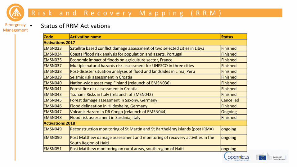
• Status of RRM Activations
R i s k a n d R e c o v e r y M a p p i n g ( R R M )
Code Activation name Status
Activations 2017
EMSN033 Satellite based conflict damage assessment of two selected cities in Libya Finished
EMSN034 Coastal flood risk analysis for population and assets, Portugal Finished
EMSN035 Economic impact of floods on agriculture sector, France Finished
EMSN037 Multiple natural hazards risk assessment for UNESCO in three cities Finished
EMSN038 Post-disaster situation analyses of flood and landslides in Lima, Peru Finished
EMSN039 Seismic risk assessment in Croatia Finished
EMSN040 Nation-wide asset map Finland (relaunch of EMSN036) Finished
EMSN041 Forest fire risk assessment in Croatia Finished
EMSN043 Tsunami Risks in Italy (relaunch of EMSN042) Finished
EMSN045 Forest damage assessment in Saxony, Germany Cancelled
EMSN046 Flood delineation in Hildesheim, Germany Finished
EMSN047 Volcanic Hazard in DR Congo (relaunch of EMSN044) Ongoing
EMSN048 Flood risk assessment in Sardinia, Italy Finished
Activations 2018
EMSN049 Reconstruction monitoring of St Martin and St Barthelémy islands (post IRMA) ongoing
EMSN050 Post Matthew damage assessment and monitoring of recovery activities in the South Region of Haiti
ongoing
EMSN051 Post Matthew monitoring on rural areas, south region of Haiti ongoing
Emergency Management
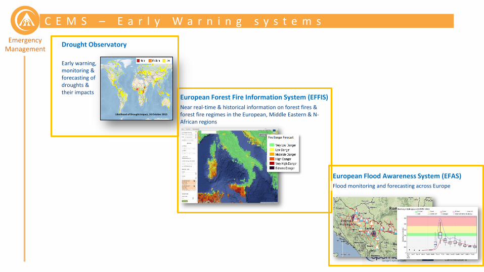
C E M S – E a r l y W a r n i n g s y s t e m s
European Forest Fire Information System (EFFIS)
Near real-time & historical information on forest fires & forest fire regimes in the European, Middle Eastern & N-African regions
Flood monitoring and forecasting across Europe
European Flood Awareness System (EFAS)
Drought Observatory
Early warning, monitoring & forecasting of droughts & their impacts
Likelihood of Drought Impact, 16 October 2015

Emergency Management
D r o u g h t o b s e r v a t o r y
Terrestrial & Freshwater Ecosystems
Waterborne Transport
Tourism
Forest/Wild Fires
Energy Production
Agriculture
Public Water Supply
Drought
Impacts
Human Health
Forestry

Emergency Management
D r o u g h t O b s e r v a t o r y
• Why? Droughts are …
– increasing in frequency and severity in many parts of the world, including parts of Europe.
– a transboundary problem.
– a global hazard with significant economic, societal and environmental impacts (~3 billion Euros/year in Europe).
EUROPEAN (EDO) & GLOBAL (GDO) COMPONENTS
Likelihood of Drought Impact, 16 October 2015
• What? – European and global early warning, monitoring and forecasting
of drought and their impacts, based on satellite data, hydro-meteorological modelling and in-situ observations.
– Satellite data play a key role for monitoring vegetation stress, soil moisture and land surface temperatures.
– The combination of different indicators can provide decision support to policy makers and different economic sectors.
Combined Drought Indicator, 11 - 20 October 2015

Emergency Management
D r o u g h t O b s e r v a t o r y
EUROPEAN (EDO) & GLOBAL (GDO) COMPONENTS
• Users: – Commission services (e.g., ECHO, ENV, REGIO, CLIMA)
– National and Regional Authorities
– River Basin authorities (especially international RBs)
– Agriculture, water-related industries (including energy production), water-borne transportation, public water supply, …
– Nature conservation (e.g., wildfires, wetlands)
– European and national aid services, international organizations and industries
• Synergies: – Copernicus Land Service
– Copernicus Climate Change Service
fAPAR, 11 - 20 August 2016
Emergency Management
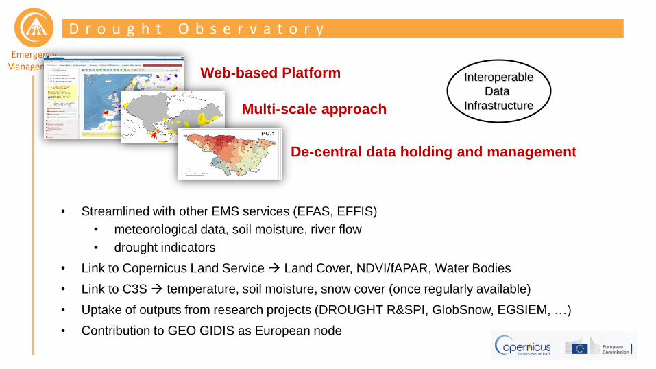
D r o u g h t O b s e r v a t o r y
Interoperable
Data
Infrastructure
De-central data holding and management
Web-based Platform
Multi-scale approach
• Streamlined with other EMS services (EFAS, EFFIS)
• meteorological data, soil moisture, river flow
• drought indicators
• Link to Copernicus Land Service Land Cover, NDVI/fAPAR, Water Bodies
• Link to C3S temperature, soil moisture, snow cover (once regularly available)
• Uptake of outputs from research projects (DROUGHT R&SPI, GlobSnow, EGSIEM, …)
• Contribution to GEO GIDIS as European node
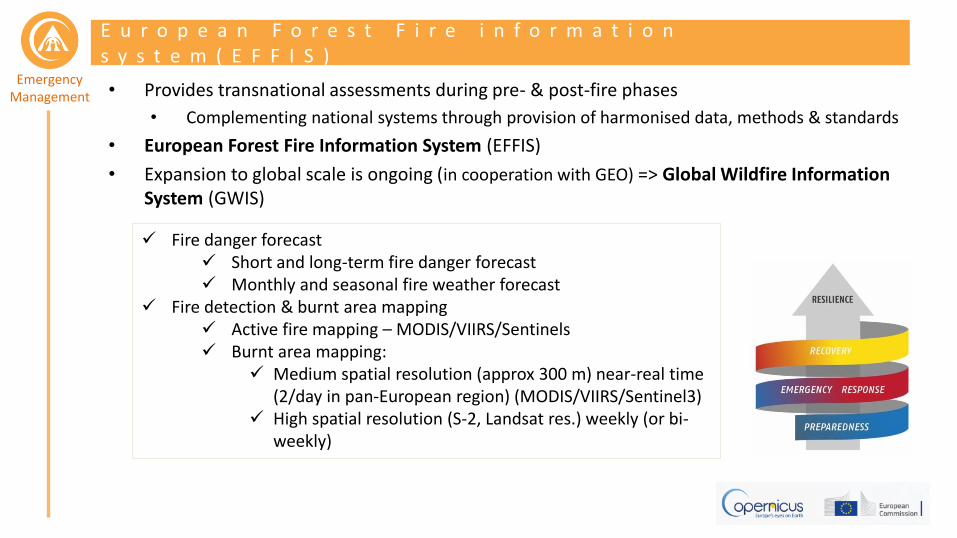
Emergency Management • Provides transnational assessments during pre- & post-fire phases
• Complementing national systems through provision of harmonised data, methods & standards
• European Forest Fire Information System (EFFIS)
• Expansion to global scale is ongoing (in cooperation with GEO) => Global Wildfire Information System (GWIS)
E u r o p e a n F o r e s t F i r e i n f o r m a t i o n s y s t e m ( E F F I S )
Fire danger forecast Short and long-term fire danger forecast Monthly and seasonal fire weather forecast
Fire detection & burnt area mapping Active fire mapping – MODIS/VIIRS/Sentinels Burnt area mapping:
Medium spatial resolution (approx 300 m) near-real time (2/day in pan-European region) (MODIS/VIIRS/Sentinel3)
High spatial resolution (S-2, Landsat res.) weekly (or bi-weekly)

Emergency Management
E F F I S v s . R a p i d M a p p i n g o f F i r e s
EFFIS Rapid Mapping
Aim of the service Monitoring of all forest wildfires, providing
pre-fire and post-fire products, including burnt areas.
Mapping of selected (by the user) wildfire events (not limited to forests).
Activation of the service Not needed – continuous monitoring of all
forest fires Needs to be activated by an authorised user
Frequency in the updates of burnt area maps
Updated up to 3 times every day In the same activation updates are done on request only. The requested map shows the affected area at
the requested date.
Spatial resolution 250 meters – provides a map of the burnt area based of an automatic classification
supervised by an operator
Typically <10 meters – provides a detailed map of the burnt area by either visual interpretation or semi-
automatic processing of very high resolution imagery
Grading (fire severity) 5 levels of fire severity are provided by
automatic classification of the pre-fire and post-fire images
On request impact assessment is provided (3 levels of grading) on the basis of visual interpretation or semi-
automatic processing of the post-fire imagery
Strong points of the service
Provides a continuous monitoring of the evolution of all forest wildfires, with a high
frequency update, at medium spatial resolution. Maps are available shortly after
the satellite pass.
Provides an accurate map of a single wildfire event at high spatial resolution, within the next 24/48 hours of
the activation. Is not limited to forest fires.

Emergency Management
• European & Global Flood Awareness Systems EFAS & GloFAS
• Probabilistic, transnational, river basin wide flood forecasting, monitoring and early warning information
• Users: ERCC, national/regional/local hydro-met authorities, civil protection, intern. organizations & NGOs, industry
• EFAS NRT forecasts currently not publicly accessible – ongoing efforts to provide all historic and in the future also more NRT data
• GloFAS is publicly accessible
E u r o p e a n F l o o d A w a r e n e s s s y s t e m ( E F I S )
http://globalfloods.eu
http://efas.eu

Emergency Management
F l o o d W a r n i n g b a s e d p r e - t a s k i n g ( F l o o d s )
Why?
• Reduce time for image tasking & acquisition (currently covering ca. 80% of RM workflow)
• Optimise acquisition time with respect to event time
What?
• EFAS warning based pre-tasking of images (in absence of user activation)
• Warning issued on forecast-based flood hazard mapping & risk assessment
– Warning is sent 24h before the expected event to RM service provider: Event time, AOI with high potential impact, suggestion of acquisition dates
– As a consequence radar satellites are tasked (10-30m resolution)
high
medium
low
Flood return periods
Flood location & magnitude Flood prone areas Exposure => potential impact
Map production
Image reception
Satellite tasking & acquisition
Request handling
Emergency Management
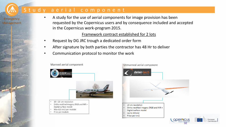
• A study for the use of aerial components for image provision has been requested by the Copernicus users and by consequence included and accepted in the Copernicus work-program 2015.
Framework contract established for 2 lots
• Request by DG JRC trough a dedicated order form
• After signature by both parties the contractor has 48 Hr to deliver
• Communication protocol to monitor the work
32
S t u d y a e r i a l c o m p o n e n t

Emergency Management Need for a “emergency Notam” to be
able to fly in a segregated airspace for time x without altitude limitation in the Area Of Interest
Higher flight altitude means less time on site for data acquisition and less time for data processing, this is key to the success of UAV missions
Need forEuropean regulation with the same procedure in all countries Can be integrated as an operational service in Copernicus EMS in rapid mode still some issues with regulations needs to be resolved.
33
C o n c l u s i o n a n d r e c o m m e n d a t i o n s
Mature market segment since decades
Flight permissions are well established
Ability to cover large areas (up to 625 km2) with superior resolution
Important for high quality damage assessments in urban areas
Perfectly compatible with using VHR
Could be integrated as an operational service in Copernicus EMS as we speak.
unmanned manned
Advantages aerial imagery Higher flexibility of deployment and better timeliness Superior resolution over VHR satellite imagery After processing accurate ortho recitified imagery and digital surface model Quick deployable (when flight permissions are solved)
Rapid revisit opportunities (monitoring) Can fly under cloud canopy (ex. To outline floods in urban areas) Rapid revisit opportunities (monitoring)
We suggest to continue with the feasibility study as written down in the work program 2018 and to consider a full operational aerial component for image acquisition for the work program 2019.

Emergency Management
S o m e e x a m p l e s – i t a l y E Q

Emergency Management

Emergency Management
S o m e e x a m p l e s – U A V A c q u a r e s i m i n i n g s i t e
Deliverables per UAV flight (lightweight fixed wing) – 10 km2 - 10 cm resolution
RGB true color ortho Digital surface model NIR false color ortho

Emergency Management • Quick data transmission to local servers from
terrestrial UAV derived imagery over disaster area
• Depending on the payload of the HAPS device
– Optical sensors (superior resolution then VHR)
– Radar
– Video streaming
P o s s i b l e s y n e r g y w i t h H A P S


![O · 2018. 4. 4. · =`qvsab`o rszzo b]aqo\o 4]\r] /\r`so boqqvw. =`qvsab`o rszzo b]aqo\o 4]\r] /\r`so boqqvw. =`qvsab`o rszzo b]aqo\o 4]\r] /\r`so boqqvw](https://img.pdfslide.us/doc/110x75/6129f0f2f0b6560cb8570017/o-2018-4-4-qvsabo-rszzo-baqoo-4r-rso-boqqvw-qvsabo-rszzo-baqoo.jpg)


![O · 2018-03-02 · =`qvsab`o rszzo b]aqo\o 4]\r] /\r`so boqqvw. =`qvsab`o rszzo b]aqo\o 4]\r] /\r`so boqqvw. =`qvsab`o rszzo b]aqo\o 4]\r] /\r`so boqqvw](https://img.pdfslide.us/doc/110x75/5e926eedf4990e581b3f7a54/o-2018-03-02-qvsabo-rszzo-baqoo-4r-rso-boqqvw-qvsabo-rszzo-baqoo.jpg)


![Vern [ ] 'MLD O(H) 9748 r-r-r- gaga 9748 9748 gaga …Vern [ ] 'MLD O(H) 9748 r-r-r- gaga 9748 9748 gaga gaga Vern [ xls ] 'MLD O(H) o. r-r-r- o .029496582562681 100.000 95.224 69.247](https://img.pdfslide.us/doc/110x75/5e8e489236336a5ea87e1e77/vern-mld-oh-9748-r-r-r-gaga-9748-9748-gaga-vern-mld-oh-9748-r-r-r-.jpg)