Embed Size (px)
Citation preview
“This map is created within the project 7949 “Thracian and Byzantine Cultural Heritage in the Rhodopi Mountains and the Northern Aegean Sea Coast”. ACRONYM: THRABYZHE, which is implementing with the financial aid of the Programme for European territorial cooperation Greece-Bulgaria 2007-2013, co-funded
by the European Union through the European Fund for Regional Development. The whole responsibility for the content of the map is carried from the Municipality of Smolyan and at no circumstances it cannot be consider that this map reflect the official position of the European Union and the Negotiated Member”.
Greece - Bulgaria 2007-2013INVESTING IN OUR FUTURE
The Programme is co-funded by the European Union (ERDF)and National Funds of Greece and Bulgaria
European Territorial Cooperation Programme
Lead partner - Smolyan Municipality Greece partner - Samothrace Municipality Bulgarian partner - Regional museum of his-tory “Stoyu Shishkov”
Project
,,Thracian and Byzantine Cultural Heritage in the Rhodopi Mountains
and the Northern Aegean Sea Coast”with acronym THRABYZHE
Contract for gratuitous financial support№ B1.12.03 from 14.04.2011
Funding for the «Programme for European Territorial Cooperation Greece - Bulgaria 2007 - 2013»
Thracian routeThe road of Gods and People
53
PESSANI
Evros
Evro
s
sorvE
1611Fengari
E85
1
2
3
45
6
8 9
1011
12
13
14
15 16
17
18
19 4
3
12
1
2
3 4
5
67 8
9
10
11
12
13 14
5
3
4
2
1
Gela
Shiroka laka
Zabardo
Hvoyna
Narechenski bani
Bachkovf
Wonderful bridges
Trigradsko zhdrelo
Bachkovo mon.
Dyavolskoto garlo
Buynovsko zhdrelo
Yagodina cave
Skalni mostove
Stoykite
Trigrad
Yagodina
Sarnitsa
Pamporovo
Mogilitsa
Koshnitsa
Arda
Smilyan
Thermes
Ehinos
Sminthi
Vafeika
Genisea
AvdiraLagos
Fanari
MaroneiaАвра
Mesembria
Paleopulis
Samotraki Terma
Keramoti
Thasos
Uhlovica cave
SmolyanKardzali
Haskovo
Samotraki
Plovdiv
Pazardzhik
Chepelare
Devin
SeptemvriBelovo
Borino
Dospat
SatovchaGarmen
Gotse Delchev
Hadzhidimovo
RudozemMadan
Banite
Ardino
Momchilgrad
КРУМОВГРАДNedelino
Zlatograd
Kirkovo
Xanthi
Kavala
Drama
Komothini
Sapes
ДИДИМОТИНО
ЕЛИНОХОРИ
ЛАВАРА
Alexandroupoli
Laki
Asenovgrad
Parvomay
ДИМИТРОВГРАД
Chirpan
Makri
Periterion
Amaxades
0
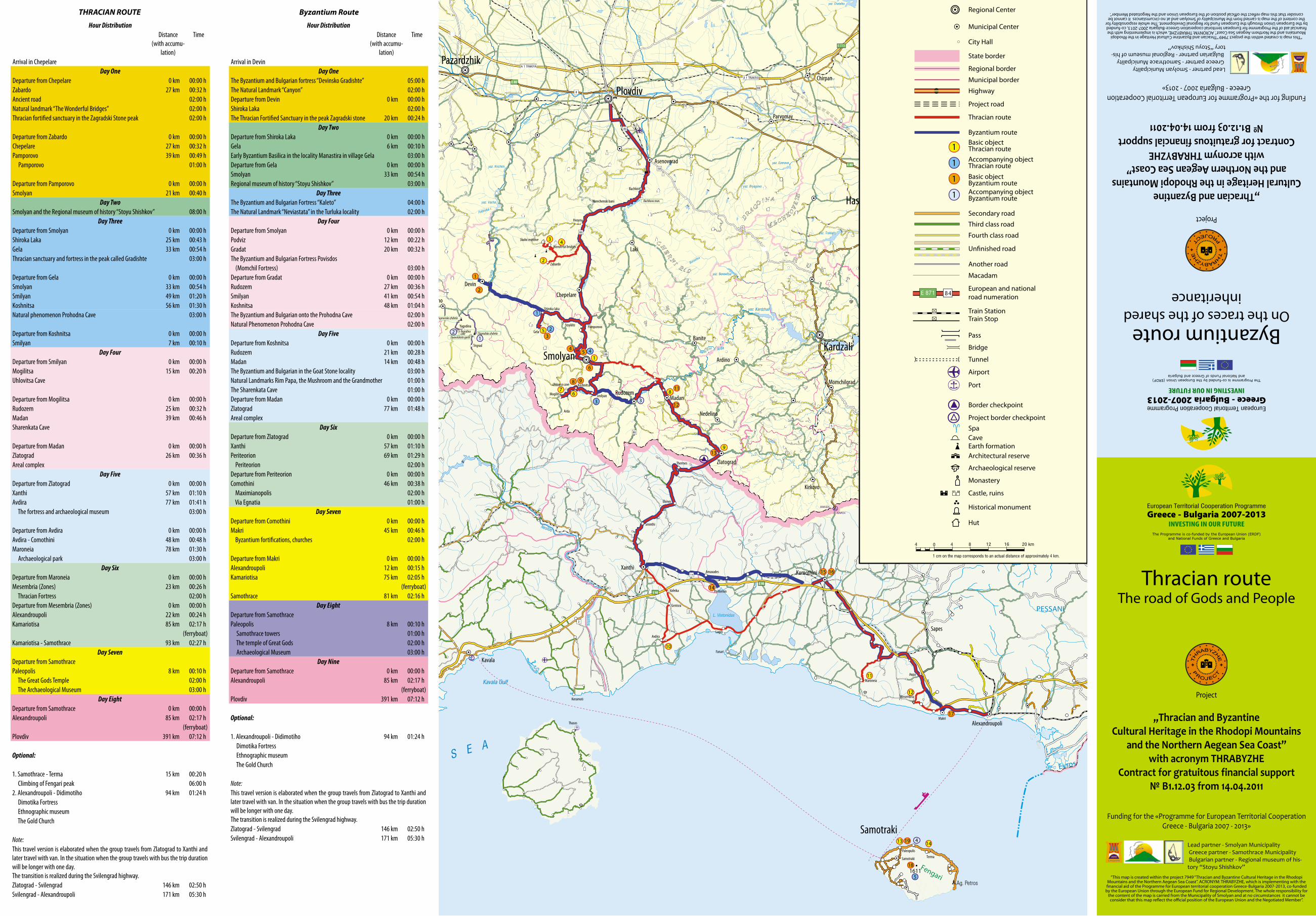
Fourth class road
Un�nished road
Third class road
Secondary road
Thracian route
Project road
Highway
State border
Regional border
Municipal border
Municipal Center
City Hall
Regional Center
Project border checkpoint
Border checkpoint
Port
Tunnel
Bridge
Train StopTrain Station
European and national road numeration
Macadam
Another road
Hut
Historical monument
Castle, ruins
Monastery
Archaeological reserve
Architectural reserve
Pass
Earth formationCaveSpa
Byzantium routeBasic object Thracian routeAccompanying object Thracian route
Basic object Byzantium routeAccompanying object Byzantium route
4 4 8 12 16 20 km
1 cm on the map corresponds to an actual distance of approximately 4 km.
Airport
1
1
1
1
Hour DistributionDistance
(with accumu-lation)
Time
Arrival in ChepelareDay One
Departure from Chepelare 0 km 00:00 hZabardo 27 km 00:32 hAncient road 02:00 hNatural landmark “The Wonderful Bridges” 02:00 hThracian fortified sanctuary in the Zagradski Stone peak 02:00 h
Departure from Zabardo 0 km 00:00 hChepelare 27 km 00:32 hPamporovo 39 km 00:49 h Pamporovo 01:00 h
Departure from Pamporovo 0 km 00:00 hSmolyan 21 km 00:40 h
Day TwoSmolyan and the Regional museum of history “Stoyu Shishkov” 08:00 h
Day ThreeDeparture from Smolyan 0 km 00:00 hShiroka Laka 25 km 00:43 hGela 33 km 00:54 hThracian sanctuary and fortress in the peak called Gradishte 03:00 h
Departure from Gela 0 km 00:00 hSmolyan 33 km 00:54 hSmilyan 49 km 01:20 hKoshnitsa 56 km 01:30 hNatural phenomenon Prohodna Cave 03:00 h
Departure from Koshnitsa 0 km 00:00 hSmilyan 7 km 00:10 h
Day FourDeparture from Smilyan 0 km 00:00 hMogilitsa 15 km 00:20 hUhlovitsa Cave
Departure from Mogilitsa 0 km 00:00 hRudozem 25 km 00:32 hMadan 39 km 00:46 hSharenkata Cave
Departure from Madan 0 km 00:00 hZlatograd 26 km 00:36 hAreal complex
Day FiveDeparture from Zlatograd 0 km 00:00 hXanthi 57 km 01:10 hAvdira 77 km 01:41 h The fortress and archaeological museum 03:00 h
Departure from Avdira 0 km 00:00 hAvdira - Comothini 48 km 00:48 hMaroneia 78 km 01:30 h Archaeological park 03:00 h
Day SixDeparture from Maroneia 0 km 00:00 hMesembria (Zones) 23 km 00:26 h Thracian Fortress 02:00 hDeparture from Mesembria (Zones) 0 km 00:00 hAlexandroupoli 22 km 00:24 hKamariotisa 85 km 02:17 h
(ferryboat)Kamariotisa - Samothrace 93 km 02:27 h
Day SevenDeparture from SamothracePaleopolis 8 km 00:10 h The Great Gods Temple 02:00 h The Archaeological Museum 03:00 h
Day EightDeparture from Samothrace 0 km 00:00 hAlexandroupoli 85 km 02:17 h
(ferryboat)Plovdiv 391 km 07:12 h
Optional:
1. Samothrace - Terma 15 km 00:20 h Climbing of Fengari peak 06:00 h2. Alexandroupoli - Didimotiho 94 km 01:24 h Dimotika Fortress Ethnographic museum The Gold Church
Note:This travel version is elaborated when the group travels from Zlatograd to Xanthi and later travel with van. In the situation when the group travels with bus the trip duration will be longer with one day.The transition is realized during the Svilengrad highway.Zlatograd - Svilengrad 146 km 02:50 hSvilengrad - Alexandroupoli 171 km 05:30 h
“This map is created within the project 7949 “Thracian and Byzantine Cultural Heritage in the Rhodopi Mountains and the Northern Aegean Sea Coast”. ACRONYM: THRABYZHE, which is implementing with the financial aid of the Programme for European territorial cooperation Greece-Bulgaria 2007-2013, co-funded
by the European Union through the European Fund for Regional Development. The whole responsibility for the content of the map is carried from the Municipality of Smolyan and at no circumstances it cannot be consider that this map reflect the official position of the European Union and the Negotiated Member”.
Greece - Bulgaria 2007-2013INVESTING IN OUR FUTURE
The Programme is co-funded by the European Union (ERDF)and National Funds of Greece and Bulgaria
European Territorial Cooperation Programme
Lead partner - Smolyan Municipality Greece partner - Samothrace Municipality Bulgarian partner - Regional museum of his-tory “Stoyu Shishkov”
Project
,,Thracian and Byzantine Cultural Heritage in the Rhodopi Mountains
and the Northern Aegean Sea Coast”with acronym THRABYZHE
Contract for gratuitous financial support№ B1.12.03 from 14.04.2011
Funding for the «Programme for European Territorial Cooperation Greece - Bulgaria 2007 - 2013»
Byzantium routeOn the traces of the shared
inheritance
Hour DistributionDistance
(with accumu-lation)
Time
Arrival in DevinDay One
The Byzantium and Bulgarian fortress “Devinsko Gradishte” 05:00 hThe Natural Landmark “Canyon” 02:00 hDeparture from Devin 0 km 00:00 hShiroka Laka 02:00 hThe Thracian Fortified Sanctuary in the peak Zagradski stone 20 km 00:24 h
Day TwoDeparture from Shiroka Laka 0 km 00:00 hGela 6 km 00:10 hEarly Byzantium Basilica in the locality Manastira in village Gela 03:00 hDeparture from Gela 0 km 00:00 hSmolyan 33 km 00:54 hRegional museum of history “Stoyu Shishkov” 03:00 h
Day ThreeThe Byzantium and Bulgarian Fortress “Kaleto” 04:00 hThe Natural Landmark “Neviastata” in the Turluka locality 02:00 h
Day FourDeparture from Smolyan 0 km 00:00 hPodviz 12 km 00:22 hGradat 20 km 00:32 hThe Byzantium and Bulgarian Fortress Povisdos (Momchil Fortress) 03:00 hDeparture from Gradat 0 km 00:00 hRudozem 27 km 00:36 hSmilyan 41 km 00:54 hKoshnitsa 48 km 01:04 hThe Byzantium and Bulgarian onto the Prohodna Cave 02:00 hNatural Phenomenon Prohodna Cave 02:00 h
Day FiveDeparture from Koshnitsa 0 km 00:00 hRudozem 21 km 00:28 hMadan 14 km 00:48 hThe Byzantium and Bulgarian in the Goat Stone locality 03:00 hNatural Landmarks Rim Papa, the Mushroom and the Grandmother 01:00 hThe Sharenkata Cave 01:00 hDeparture from Madan 0 km 00:00 hZlatograd 77 km 01:48 hAreal complex
Day SixDeparture from Zlatograd 0 km 00:00 hXanthi 57 km 01:10 hPeriteorion 69 km 01:29 h Periteorion 02:00 hDeparture from Periteorion 0 km 00:00 hComothini 46 km 00:38 h Maximianopolis 02:00 h Via Egnatia 01:00 h
Day SevenDeparture from Comothini 0 km 00:00 hMakri 45 km 00:46 h Byzantium fortifications, churches 02:00 h
Departure from Makri 0 km 00:00 hAlexandroupoli 12 km 00:15 hKamariotisa 75 km 02:05 h
(ferryboat)Samothrace 81 km 02:16 h
Day EightDeparture from SamothracePaleopolis 8 km 00:10 h Samothrace towers 01:00 h The temple of Great Gods 02:00 h Archaeological Museum 03:00 h
Day NineDeparture from Samothrace 0 km 00:00 hAlexandroupoli 85 km 02:17 h
(ferryboat)Plovdiv 391 km 07:12 h
Optional:
1. Alexandroupoli - Didimotiho 94 km 01:24 h Dimotika Fortress Ethnographic museum The Gold Church
Note:This travel version is elaborated when the group travels from Zlatograd to Xanthi and later travel with van. In the situation when the group travels with bus the trip duration will be longer with one day.The transition is realized during the Svilengrad highway.Zlatograd - Svilengrad 146 km 02:50 hSvilengrad - Alexandroupoli 171 km 05:30 h
THRACIAN ROUTE Byzantium Route
THRACIAN ROUTE1. Regional Museum of History „Stoyu Shishkov“
The museum is about the general history The topic of the constant exhibition - „
Cultural and historical richness of the Rhodopes from the ancient years to nowadays“ is divided into two sections: Archaeology, with exhibition sections „Prehistory“, „Thracians“, „Middle Age“ and Ethnography with exhibition sections „Traditional clothes“, „Ritual Objects“, „Traditional crafts“, „Rhodope architecture“ and „Traditions and Modernity“.
The visit in the Regional museum of history „Stoyu Shishkov“ - Smolyan is the fastest way to understand about the millennial history of the Middle Rhodopes, which is preserved and transferred through the years and save for the future.
2. Ancient road
The Ancient road Oescus - Philippopolis - Abdera is one of the first trade road crossing the Rhodope Mountain.
His first layout is marked with a lot of archaeological objects and findings dated from the period XIII - II century B.C. Typical example is the discovered coins in Abdera town from IV century B.C., which are stored in the Smolyan and Plovdiv museums. They show the main direction of the ancient trade implement between the Hellenes towns and the Thracian tribes.
Later in the middle of the I century A.C. this trade road ,which was used almost one thousand years from the Thracians and Hellenes, is convert from the Romans into a road with solid stone layout. This road is preserved in the area: Modar hut - Persenk peak - Mezargidik locality - Deaf stone locality - Sunrise hut - Mechi Chal peak.
3. Natural Landmark „ The wonderful bridges“
The natural phenomenon „the wonderful bridges“ is located east from the ancient road. 4 km from the natural phenomenon is located the village Zabardo, in which there are many caves each with their own history. Zabardo is small village in the South central region of Bulgaria and it is part of the Chepelare Municipality, Smolyan Province. The village is very old and there are many evidences that it is existed even during IV - V century a.c. These are the Thracian sanctuary and the Destroyed stronghold Zagradski stone.
„The Wonderful bridges“ are stone phenomenon known as the Rock bridges. They are located in the karst valley of the Erkyupriya River in the Western Rhodopes at 1,450 m above sea level, at the foot of Persenk Peak. The bridges were formed by the erosive activity of the once larger Erkyupryia River. It transformed the marble clefts into a deep-water cave, the ceiling of which eroded through time and collapsed. It is suggested that the water carried the debris away. As a result, the two remaining bridge-shaped outcrops remained. The larger one (upstream) is 15 m at its widest and almost 100 m long, and shaped by three vaulted arches, the largest of which is 45 m high and 40 m wide. The smaller bridge is 200 m downstream. It is impassable to tourists, 60 m in length, with a total height of 50 m, 30 m at the highest point of the arch. After the second bridge there is a third small bridge the entrance to a pothole cave where the Erkyupriya river waters disappear underground, reaching a sump after 3 km.
The Wonderful Bridges are included among the 100 National Touristic Places of the Bulgarian Touristic Union. The possible tourism places and spending the night: the „Wonderful bridges“ hut and the „Rock bridges“ hut.
4. Thracian sanctuary and stronghold in the peak Zagradski stone near the village Zabardo
The Archaeological object is located 4 km south from the Zabardo village, Chepelare municipality. It is located onto high stone peak, inaccessible from its north side, in which foot there are two caves. In the peak south foot, around 700 m the Thracian mound necropolis is located.
It is suggested that there was a wall, which was build with dry masonry, onto which a wood fence is probably
build. Nowadays people can see only the destroyed stone basic. On the surface, as well as on the fortified part and outside, on the slopes of the stone peak there are big
amount of household Thracian ceramics from the period of Late Bronze and Early Iron Age (XIII - XI century b.c.).
The discovered fragments and clay crockery and cutlery from the IV century a.c. , from the fortress slopes showed that probably the fortress was being used from the Thracian even in the later ages.
5. Thracian sanctuary and fortress in the Gradishte peak near to Gela townThe archaeological object is located to the ridge of the west
slope, which north node of the Perelikskia dial, descending from Shilesta Chuka peak (Big Snezhnik peak 2188,1 m altitude). It is located around 3,5 km southwest from village Gela. The maximum altitude of the Gradishte locality is 1875,50 m. The fortress covers the area of 1,850 m above.
The fortress wall is build to the north and west ridge slope. The area passes between horizontals with altitude 1852- 1854. There are 85 m from the west side which are revealed. The total
length of the outside fortress wall was around 120 m. During the construction of the fortress are used the most rationally resources of the area, which provide easy defense of the facility. As a west wall the stone precipice is used which is high around 100 m. The fortified area from the inner fortress wall is around 3 acres. She has elliptic shape with maximum length of 110 m and maximum wide of 45 m. The entrance of the inner fortress wall was located in the north sector, where the outside area is suitable, i.e. with easier access.
When have in mind the ceramics quantity used, the construction and the fortress culmination existence are related to the period XI - IX century b.c. The discovered ceramic fragments show that there are sanctuary and a house. The sanctuary is panoramic landing (without architecture) with fireplace clues. She is with slight east slope. The discovered ceramics is not kitchen, but ritual with the Early Iron Age characteristics (cups and plates decorations).
6. Natural phenomenon the Prohodna Cave
It is located near village Koshnitsa and it represents a huge stone vault, leading toward to the peak, where there are relics from the ancient fortress. Here the tourists have an opportunity to live through one amazing event - „alpine swing“. With special equipment you will be shoot from 40 m height from the cave stone vault and you will have the opportunity to see unforgettable view toward the river Arda valley.
The complex of two caves „Golubovica“ near village Koshnitsa is interesting for people who seek strong emotions. Hard accessible are and you can enter with special equipment. In the caves you can try your skills for rope drop - called „rapel“ and climbing under the observation of the instructor. In the water cave you have an opportunity to overcome hindrances with boat, after which the mountain will reveal for you many secrets, which were keep many ages. After you go out you have new adventure - the Alpine trolley. With this device you will fly around 40 m to the rope line between the two
slopes of the river Esenna, 20 m height above the water mirror under the trolley. The route is available from June to September. You can book a place in the Smolyan Municipality Tourist Information Center. Attractions: alpine swing... near to Garga dere - trolley, via ferrata, water cave.
7. Uhlovitsa Cave
The only utilities cave in the Smolyan territory is „The Uhlovitsa“ - mandatory object for every tourist. It is famous as one of the underground castle of the Western Rhodopes, the cave is included in the map of the 100 National Touristic Places of the Bulgaria. It is located 25 km south from Smolyan and 3 km from Mogilitsa
village. It is a natural landmark with altitude in the entrance - 1040 m. After some km path, you will see 288 iron steps. Finally, you are in the cold cave tunnel, where the temperature through the whole year is around 10-11 degrees. After the entrance started the precipices hall. The name is related to the 4 precipices, located in the back part of the hall. The gallery walls are covered with fabulous formations, like a coral and helectit bunches.
In the north end of the gallery 2 pokes are created. Toward the bigger poke are descend the stone flow of so called Brilliant waterfall. Around 460 m are observed. 330 m are urbanized, but the biggest displacement is 25 m. It is found for tourists in 1984. It is open for tourists during the whole year.
8. Cave „ Sharenkata“
The cave „Sharenkata“ is cave - museum, located in the marble massif in deep gorge, around 2 km from Madan. It brings the name of the biggest neighborhood in Madan - Sharenka neighborhood. To the cave you can go through asphalt road, but for the lovers of pedestrian tourism there are mountain path with length around 1 km. Near to the entrance there are wood pavilion with fountain, but in the canyon you can hear the waterfall.
„Cave Sharenkata“ is relatively small cave, located around 830 m altitude. The cave entrance is located in marble stone and after a slight slope you can reach to the underground corridor, leading to the two small galleries. Archaeologists are established that in the there were mining, and the cave was inhabited even during the Bronze Age (XVI - XII century b.c.).
In the ceiling of the big hall there is a crevice, which as a natural chimney is played an important role for the extraction and melting of the ore. In the „cave Sharenka“ the exhibition of 10 wax figures in natural human growth, fireplace, tools, as well as crockery and cutlery are restored.
9. Zlatograd. Areal complex
Zlatograd is a small town in the Rhodope Mountains located just 2 km away from the Greek border and 60 km southeast of Smolyan.
Zlatograd Ethnographic Areal Complex lies in the heart of the town. It is an open-air museum which is also part of the everyday life of local people. The complex comprises an ethnographic museum, workshops and an exhibition of water equipment.
The complex is open with cooperation of Municipality Zlatograd on 24 May 2001. This day is dedicated on Bulgarian education and culture and Slavonic literature. The Ethnographic Areal Complex - Zlatograd is a big museum which shows how the city look like before more then 100 years. His structure consisted - I cultural - historical objects; II Accommodation; III restaurants
where people have an opportunity to eat and enjoy. During 2004 the Ethnographic Area Complex - Zlatograd is include in the list of 100 national historical places in Bulgaria.
Many Bulgarian holidays and customs are celebrated in a traditional style at the ethnographic complex, for example: Trifon Zarezan (the Day of the Vine-Grower - mid-February), Baba Marta (Grandma March Day – beginning of March), Todorovden (St. Theodore’s Day – the first Sunday of the Easter Fast), Enyovden (St. John’s Eve - 24 June), Waits (24 December) and so on. The Day of Zlatograd is celebrated on 21 November.
After the tour around the complex tourists can sit and relax in some of the restaurants in the town or drink a cup of spun coffee made on hot sand and served in a special way. There are many hotels in Zlatograd due to the fact that the town is a popular tourist destination. Accommodation is also available in the ethnographic complex itself – in an old house with authentic atmosphere from the Bulgarian Revival Period.
10. Abdera - fortress and archaeological museum
Abdera is a Greek town in West Greece, based according to the Hercules legends in the place where his friend Abder died. Today you can see the ancient town ruins, where more impressive are the Abdera acropolis and the church in it. There are seven small hills, and they spread from the east to the west part of the port, but in the northwest hills there are ruins from the Polistolon Middle Age town.
In the Abdera archaeological museum there are archaeological discoveries, which were found in the town between VII century B.C. and XII century A.C.
The museum is created in January 2000 and its exhibition consists of three thematic sections. The first one is public life,
which include exhibits, related to the religion, state organization, coin hew, weights, stamps and guns. The second one is private life, which include exhibits, related to the people profession, trade and seminars, construction elements, ceramics, weaving, embellishment, dress, hairstyle and jewelry. The third one is related to the rituals and funerals and includes sarcophagus, urns, tomb details, donations and funeral reconstruction. These exhibits are found in Abdera ancient tombs.
11. Maroneia - archaeological park
It is North Greece town, 34 km southeast from the regional center Comothini and some km far away from the Aegean Sea coast in the small mountain. The town is successor of the famous ancient Thracian town of the Kikoni tribe, arises before 3,000 years ago. It was mention for the first time by Homer under the name
Ismaros, but later from the Pliny the Elder as Thracian town called Ortagure (ruins from which the archaeologists found in the St. George hill). It was ruined by the Thracian legendary king Maron, who is Wine and Mystery God son Dionysus. The wine that the Thracian prepare is not a myth (ancient vintner halls) chipped in the stones are kept even today. The deep honor of the Wine and Theater God is evidenced by the ruins of his temple and the big theater that was found in the ancient Maroneia - God and grapes are customary symbol
from which the Maroneia coins distinguish from another coins. Through the whole Antiquity and the Middle Ages, the exclusive Thracian wine that was produced in the Maronia is one of the most valuable and remain town symbol. The wine aroma is considered to be similar with the Ambrosia aroma.
During the XVII century the ancient town is completely destroyed and abandoned. Until today Dionysus temple and theater are survived as well as ruins from mosaic, triumphal arch from the time of Emperor Adrian and the Middle Ages churches. The region is built as a archaeological park. In the town you can find the typical and well known Bulgarian architecture from XIX century. Some of the traditional houses are preserved until today.
12. Zones (Mesembria) - the Thracian fortress
Aegean Sea Mesembria is ancient town, which ruins are found not so far away from Alexandroupoli in the Aegean Sea coast, 3 km west from the village called Mesimvria. In this village there are around 149 people
who live their. The excavations show that initially here was a Thracian
settlement from the Early Iron Era. The Ancient settlement arose at the end of VII century b.c. as a fortified market point - Mesembria or Zones of Samos island citizens. The town reaches its heyday in V and IV century b.c. It became a local center of the native Thracian citizens. With the establishment of the Macedonian domination over the Thracian coast of the Aegean Sea started to decline. Through the Rome domination many roads started to be build, which did not pass near to it and toward I century a.c. this town started to abandon.
Through the archaeological excavations that were made, the archaeologists found a town from V - II century B.C. Wall with towers was found, fortress gate from the west wall. groups of accommodations with yards, repositories, shops, workshops, amphora storage, street network, Demetra`s temple (IV-III century B.C.), where they found a lot of silver plates with messages from the ancient worshipers; Apollo sanctuary (VI - V century B.C.) where pieces of ancient kouroses, vases and crockery and cutlery with inscription of the God name; construction remnants with sizes 9 X 15 m including vestibule, unicameral hall and crypt; the Middle Age tower over the ancient settlement. Outside the walls there was a necropolis. The researches continue even today. The found 2,000 coins prompt the archaeologists to connect the settlement with Zones, the most important center in Samothrace - Pereas, which had its own currency and its gave more taxes in compare with other towns in the ancient union. The Mesembria - Zones discoveries are showed in the Comothini Archaeological Museum. The region is developed as a small outside archaeological museum.
13. The Great Gods Temple
It is located in Paleopolis, 6.5 km from Kamariotisa, near to the archaeological museum and cover area
approximately of 50 acres. In front of us there are a lot of buildings, which evidenced about big religion activity, wide spread in this region.
For example, Ptolemy II Philadelphus Gate in Ionic order was build between 285 - 280 year b.c. Arsinoe - round construction, build around 500 year b.c. The square building, donation from Philip from Ardei and Alexander
IV. The palace, the sacred building, the Rotonda, the Sanctuary, the Marble altar, the temple, the ancient cave, the Hellenes building, the arcade and spring where the famous God of the Victory lived their from Samothrace, Nike.
14. The Archaeological Museum
It is located in Paleopolis. It is build from the American Archaeological Mission ( which started in Samothrace during 1938). It is maintained by the Greece. The German archaeologist A. Shampaozo first starts excavations in Samothrace. He found the Wing God of Victory statue and he brought it in the Louvre. In the museum there are ruins from native discoveries. Most of them are found during excavations, implemented by American scientists, some of the discoveries are found by the native citizens, also some of them are collected by the scientist called Nikolaos Fardis from Samothrace.
In the museum you can see Arsinoe Rotonda colonnade (288-281 years b.c. ). It is decorated with bulls and rosettes. You can see the Rotonda Entablature and the Central Temple Acroterion (approximately 130 years b.c.), sanctuary ornament and the fertility symbol. After that you can see the Column Capitals from the Corinthian order, which come from the west arcade of the Ptolemy II Gate (285 - 281 years b.c.).
Part of the Sanctuary Gate frieze represents a plate, which depict dancing girls (approximately 340 years b.c.). It is considered that these girls were the Muses.
5. Other places and attractions
1. Kuker holidays in Shiroka LakaIn the beginning of March one of the biggest Kuker celebrations in Bulgaria is conducted. This celebration
is called from the native people „Pesponedelnik“, it is preserved from Thracian time. Ancient heathen custom is implemented by young men in the village which are dressed in special costumes and masks. When they go around the village, they play different kind of dances and ritual scenes, representing the fight between good and bad. With the sound of the bells and with the wood swords they scared away the evil and revived fertility hopes, abundance and health. The celebration culmination is in Sunday, when guests in Shiroka Laka are different Kuker groups from the whole country and even from other countries such as -Ireland, Macedonia, Greece, etc.. Shiroka Laka village is architecture - ethnographic reserve, famous with his original Rhodope style, musical traditions and history. A lot of traditional houses are preserved the character Rhodope architecture, cobblestones, river bridges, the specific speak, songs and traditions of the native people give an opportunity to every visitor to understand about the Bulgarian and Rhodope culture. For cultural monuments are announced around 100 objects - houses, bridges and churches. The oldest houses are from the beginning of the XIX century and they are typical for this region and architecture style.
2. Celebration - outplay in Ilinden and GelaFrom many years ago each year in the beginning of August in the Ilinden mows near the Rhodope
village Gela the native people gather each other for fun and talk. The tradition is preserved until today and it preserves the richness of the Rhodope Mountain. This eternal tradition is in the basic for idea arises and bagpipes outplay organization in these mows. The first bagpipe outplay was organized in 2002.
The aim of the festival is to promote the Rhodope folklore. The mandatory requirement for Bulgarian participants is the performance to not be play with Kaba Bagpipe. The participants are divided into age groups, in the following way: free programme implementation and mandatory performance of slow and fast melody. Competent jury evaluates participants’ performance. The prizes are money, different subjects, but every participant takes a certificate.
Byzantium Route1. Byzantium and Bulgarian fortress „Devinsko Gradishte“
In the locality Gradishteto, ruins of Late Antiquity and Middle Ages fortress in Devin are located. The fortress worked in the period between VI - XIII century, but in the locality „Lakata“ Middle Ages village is registered. Both places are with monument status with native significance and under special protection.
2. Natural landmark „Canyon“
The natural resources are good conditions for development of different tourism forms. The protected area „Devinska river valley“ is exclusively attractive for the tourists. It represents pictorial gorge with specific landscape art and remarkable stone forms and formations. There are a lot of rare and protected vegetable and animal species, such as Haberlea rhodopensis and Chamois. The river formed a lot of beautiful meanders, reaching the depth of 2-3 m.
For tourist facilitation access to the protected area, the eco-path „Struilica - Kaleto - Lakata“ is created, which is exclusively attractive and include metal bridges, steps and relax places. The protected area is preserved area for fishing with 3 km length, which submits excellent conditions for fishing of Brown trout.
The outside swimming pools attract many tourists each year in the locality „Struilica“. There are therapeutic swimming pools, sauna, Jacuzzi, and after 30 minutes walking from the parking you will see the waterfalls called „Struiliski vale“.
3. Early Byzantium basilica in the locality Manastira in village Gela
Early Byzantium basilica in village Gela is located in the locality Manastira, of around 1,480 m altitude. The church is with outside sizes: length 30 m and wide 14, 80 m. It represents basilica with a transverse ship forward. The building was created in mixed masonry and stone. Big quantity fragments from flat window glasses with round edges were found.
In the northeast basilica edge is the central entrance. North from the church edge, a wall is
created, probably glued to her. From the wall 7 m are researched. West from this wall south-north the area is with big stone plates, which formed big plate with sizes 5,40 X 4 m.
The basilica construction started in the beginning of V century and burning and its abandoned after the second half or the end of VI century. It is the biggest and the richest decorated church from this period and researched until nowadays in the Middle Rhodopes.
4. Regional museum of history „Stoyu Shishkov“
5. Byzantium and Bulgarian fortress in the locality Turluka, north from Smolyan.
The fortress takes East Ridge, which compound the locality Turluka. Its average altitude is 1,450 m. Its approximate area is around 5 acres, surrounded with walls from south, east and north. Kaleto visually communicate with the fortresses in the village Podvis - around 10 km east and the fortress in the Rudozem - around 18 km southeast.
In the period 1998-2004 a lot of archaeological excavations are made. The whole south fortress wall is researched and some sectors from the east and
north walls, as well their inner rooms. The fortress is conserve, renovate and socialize by the project won by the municipality of Smolyan called „Thracian and Byzantium cultural inheritance in the Rhodopes and North Aegean Sea coast“, funded by the Programme for European Territorial Cooperation Greece - Bulgaria 2007-2013, co-funded by the European Union through the European Regional Development Fund (ERDF).
6. The natural landmark „Neviastata“ in the locality „Turluka“
The rock massif Neviastata (Turluka) is part of the unique natural landscape art in the Black river valley, located west from Smolyan. There are many legends about the origin of the rock name. One of them tell about the Smolyan girl who was loved by a soldier in the Karadzha leader army. She was wanted for a wife by the
local Turkish leader. She agreed but she wanted to see for the last time her native place. After that she jumped from the rock. Since then they called the rock Neviastata.
Another legend, connected with the Ottoman slavery tell about that during the conversion to Islam in village Raikovo the Ottomans attacked its citizens, but a group of brave Bulgarian people killed the Ottomans. Ottomans started to search this group of brave Bulgarian men and when they reach this rock they heard children crying. Mother
with her baby stayed under the rock. She did not say where the Bulgarian men are the Ottomans killed her and her baby and the whole rock was in blood. According to another legend version this happened when the Ottomans came in these places. They killed the women and her child because she did not say where it’s the secret entrance for Aetos fortress, where many Ottomans were killed.
The rock Neviastata is adapted and organized as a green tourist destination, which participate in elaboration of complex and integrated products of the resistant tourism and in stimulating for wider resources use, related with the region tourism and expand of the geographical scope. Certified eco - path is marked and created, which started from the chapel arch St. Pantaleon toward the rock Neviastata, with total length 750 m, three panoramic yards, children landing and campsite place, four routes for climbing with different difficulty degree, via ferrata (iron road) with two routes, alpine trolley and artificial climbing wall.
7. Byzantium and Bulgarian fortress Povisdos (Momchil Fortress)
Village Gradat is located in the South Rhodopes of 1,050 m altitude in municipality of Smolyan. The village is famous with the Momchil fortress located around one km far away. The native people called it Gradishte. The legend connects the fortress with the mythical figure of Momchil Leader, who protected the Rhodopes from the Ottomans slavery in the end of XIV century. It is located in the locality Gradishteto, from where specialists consider that the name of the village came from.
It is found that the fortified building inherited Thracian stone sanctuary from the end of V millennium B.C. It is located in the fortress highest point and from it you can see 360 degrees panoramic view - toward Big Perelik peak, Snow White tower in Pamporovo, National Astronomic Observatory Rozhen, Freedom peak. Moreover, you can see the stone cusps, onto which other two fortresses are located: The Smolyan fortress in the locality Turluka and the fortress located south from Rudozem. After you enjoy the panoramic view, you can go using the created road following the area in the south foot stone road. After that you reach the wall for Alpine climbing. Moreover, from the beginning of April to the end of October tourists have an opportunity to have a guide. During the whole year the informative center worked for the object, it is located in the second floor in the town hall building in the village Gradat. In the center you can receive information materials and to see the showcases in which there are archaeological discoveries from the object research. The valuable discoveries in it are showed in the exhibition of the Regional museum of history „Stoyu Shishkov“ - Smolyan.
This rich history related with the fortress, its renovation and with the beautiful locality made the place popular tourist landmark. Attractions: climbing.
8. Byzantium and Bulgarian fortress onto the Prohodna Cave near to village Koshnitsa, Municipality Smolyan
The fortress onto the Prohodnata cave near the village Koshnitsa is the second military fortress- accommodation in the Central ancient Trans Rhodope road in the Middle Rhodopes. The area is around 2,5 acres, and the thickness of its wall is around 1,70 m - 1,80 m. Unlike from the North stone and steep fortress part, the South one is equal. In plan it has semicircle outline with radius around 25 m. In this side the fortress
wall is more destroyed and only in some places following the area. The research results confirm the team guesses that there is a chapel in the east side of the fortress. Two chapels basic are registered which working periods are similar with the fortress one. The first is during VI century and the second between XI - XII century. The end of the each period is marked with burned layer, testify about fortress burning.
The archaeological complex near village Koshnitsa is a clear example for succession of states. From the Chalcolithic era to the beginning of XIII century in the peak and in the cave there are stone sanctuaries and Christian temples, unfortified accommodations and fortresses. The whole research of this archaeological place will reveal more details about the native people manners as well as their contacts with inner Thrace and The North Aegean Sea Coast.
9. Natural phenomenon the Prohodna Cave
10. Byzantium and Bulgarian fortress in the locality Goat stone near town of Rudozem
Koznik is medieval fortress, built in the locality slightly southeast from today town called Rudozem, in the right side of Arda River, with the aim to keep the caravan roads from Thrace toward the Aegean Sea (today the road Raikovo - Rudozem - Xanthi. In the moment from the fortress called Koznik is excavated around 50 m wall with thickness between 1,5 - 2 m. In some places its high reaches around 2 m. The total length of the fortress wall is around 180 m. The area which is surrounded by the walls is divided into rocks to the east and west side. In the past the fortress wall were spread from southeast - 60 m long, from south - in three places - total 85 m and from northeast long until 50 m, but nowadays the fortress walls are destroyed to the ground. They are made by rough stones from the locality and they are bonded by white mortar. Their thickness varied between 1,65 - 1,70 m.
11. Natural Landmarks Rim Papa, the Mushroom and the Grandmother.12. The cave „Sharenkata“13. Zlatograd. Areal complex.14. Anastasiopolis - Periteorion
The fortress was take and destroy by the king Kaloian, for which evidenced the chronicler called George Akropolites. According to Kantakouzenos, emperor Andronicus III Palaiologos renovate the fortress wall in the city during 1341 year. Again Kantakouzenos in his „History“ wrote that the town Anastasiopolis is arise
and bring the name of emperor called Anastasias I Decorous (491-518).
When you go there, you will see without doubt the monolithic construction of the fortress towers. In fact the old craftsmen are built with the whole efforts, in order to have what to enjoy and to make picture today! More interesting is however that the fortress is connected with the Sebastokrator Momchil, the Rhodope Mountain leader. The Momchil fortress is named on him near Podvis! The battle during the summer 1,345 year, when in front
of the city walls the two armies fight with each other - Momchil army against the Ioan Kantakouzenos.. The remain is legend... About the Sebastokrator Momchil, the robber, dreaming to be a lord in the forests of the Rhodope Mountain.
15. Mosionopol – Maximianopolis
Comothini started its existence as Byzantium fortress, built from emperor Theodosius during IV century B.C. The ruins of this quadrangular structure can be seen northwest from the Central Square. In Comothini there are several museums - archaeological, Byzantium and folklore. 6 km northeast from the town is located the Nimfeia forest. There are relaxing buildings, including paths, courts, children playground and spaces for nature researches. The forest is divided from paved road, which lead to the ruins of the Byzantium fortress Mosinopol or Mesinopol, famous in the Late Antiquity as
Maximianopolis. This is the Byzantium town in Thrace, located in Via Egnacia. The town was destroyed from the Bulgarian king Kaloian through the 1,207 year after his victory over the knights of the Latin empire. The monk Efrem evidenced that the town was took also from Friedrich I, the empire of the Sacred Rome Empire during 1,190 year.
16. Via Egnacia
Via Egnacia is through the most famous military roads. It is created around 146 years B.C. in the Rome Empire Ages, in order to facilitate the communication between Rome and Constantinople (nowadays called Istanbul), between the West and East. The sequel of Via Appia is beyond Adriatic Sea. The road pass through Macedonia and Thrace and end in Anatolia, where it is joined with the Persian King road, famous from the time of Cyrus the Great and Darius I. Via Egnacia passed through the Aegean
Sea and Marble Sea coast, i.e. the south coasts of Thrace and connect Rome with the East empire provinces.Via Egnacia is connected basically with cultural influences, reflecting belief and knowledge exchange. He
plays strategic role from the Antique until nowadays as one conductor of cultural influences and information from east to west and from west to east. Even in II century B.C. the cultural corridor bring the name of the Rome proconsul Gnaios Egnatios. Via Egnacia was expanded several times. It remains one of the most important road in the Byzantium Empire. Precisely, from Constantinople under the spiritual and cultural axis started the spread of the Orthodox Christian in the Southeast Europe, and later the spread of the monasticism. This is a Orthodox Christian eternal road, alive even today, with a lot of monasteries and churches. Via Egnacia is important branch in the pilgrim road of the Franks toward Rome - Via Francizhena, which lead to the European Pilgrims toward Jerusalem. Interesting fact is that the Castillian language route axis and the spread in the medieval. The Castillian language route and the spread in the medieval, so called Sephardi roads - in the bigger part repeat the Via Egnacia route. This one more time marked the significance of Via Egnacia as one of the most significant religious axis in Europe.
17. Makri
Makri is not so big settlement in the Aegean Sea Thrace in the municipality Alexandroupoli in the east part of the most south eminences in the mountain called Ovcharitsa where it is connected with Aegean Sea. It is 9 km west from town called Alexandroupoli and around 700 m of the Aegean Sea coast, where after the Olive, Almond and Fig plantation its the Makri coastal neighborhood with its not so big, but relatively good developed port and its beach called of the located their chapel St.
Petka (Agia Paraskevi). The place is inhabited from prehistoric ages until the Byzantium period. There are different structures
which are carved, such as steps and niches. There are found: very important for the science chalcolithic settlement from 4,500 - 3,000 years B.C. with ruins from settlement floors, clay walls, furnace, three Neolithic funerals under the settlement floors. Through the Early Iron Era (1,050 - 650 years B.C.), around 1,000 years B.C Thracian made their own settlement. The Greek colonists came in VII century B.C. and they created a small trade point surrounded by a wall. From it is found many ruins - from two storage buildings from the Ancient Era, part of the Rome Wall, shafts, walls and settlements belonging to small trade station from Rome Ages. There are late buildings from tooled rock - there are different stares, niches, containers, and watchtower.
From Byzantium time are found ruins, including Byzantium strongholds, churches from X and XII century, as well as the Ottoman period ruins and Turkish baths.
Makri Parish (Catholic Church) called St. Anastasia is built around 1,833 as a square building with sizes 30 X 25 m in basilica style with wood attic onto the ruins of older Christian church, because this was the Turkish law requirement and there is a inscription onto it people can read the year 1,100. The temple is with carved gilded iconostasis from XVII century and old orthodox icons from XVII to XIX century with high artistic value. A lot of marble plate fragments, capital, pictures, which are exposed outside in the South side of the building. They are evidences for the existence of Late Antique Temple. Most of the icon, especially the smaller one is in the Church museum in Alexandroupoli and they are replaced by modern Byzantium style icons. Really near to St. Anastasia church from south are the ruins of the earlier church „St. Dimitar“, which was reverse into mosque and later destroyed by an earthquake.
18. Samothrace towersThe Samothrace towers and fortresses are
through the clearest examples of Byzantium architecture fortified buildings. Near to the Fonias river spring, you can see the isolated tower of Paleoloia. West from Samothrace, in the peak of steep slope, which is high over the mountain, you can find ruins from a fortress. Probably, this position was fortified around the end of X century A.C. when the citizens were escaped from Paleolopolis toward the inner, in order to avoid the following attack by pirates.
The Gatilusite fortified not only Samothrace. In Paleolopolis they build common fortress, created of three towers onto the rock hill near to the port. For this building they were used ancient building materials, which were find in abundance in this region.
Another place is the Paleo - Christian Paleolopolis basilica located in the east side of ancient port under the Gatilusite towers. It is found during the excavations by an American Scientists Team in 1,938. Its researched is not end until nowadays. The basilica is created in order to celebrate the Apostle Pavel arrival in Samothrace.
The Paleo - Christian basilica in Kamariotisa is not preserved. Its existence was established during 1,972, when the construction of the new church started. The new church was devoted to Mary (mother of Jesus) from Kamariotisa.
The ruins from different Byzantium churches can be seen in different places in the whole island. For example: Agios Konstantinos, Pangaea Galatiani, and the Jesus church, ruins from the monastery several km west from Terma.
19. Archaeological museum
Archaeological museum is located in Paleopoli. The museum is built by an American archaeological mission, which started to work in Samothrace in 1938. Today this museum is maintain by Greece. The German archaeologists A. Shampoazo begin excavations in Samothrace. He found a statue of The Wing God of Victory and he bring it in Louvre. Ruins form native excavations are stored in this museum.
A lot of them are found by an American scientists, some of them are found by native citizens, other are collect by Samothrace scientist Nikolaos Fardis.
In the museum people have chance to see Arsinoe Rotonda Column ( 288 - 281 year B.C.), which is decorated by bulls and rosettes. People can see the Rotonda Entablature and the central acroterion of the temple ( approximately 130 years B.C.), sanctuary ornament and the symbol of fertility. After that people can see column capital which come from west arcade of Ptolemy II Gate ( 285 - 281 year B.C.).
One part of gate frieze represent a plate, which image dancing girls ( approximately 340 year B.C.). This girls are muses.
Other places and attractions:
1. Trigrad Gorge2. Iagodina cave3. Rudozem - Madan
The region around Rudozem - Madan is appropriate for all kind of tourism: eco - paths, rural tourism, hunting tourism, cycling and driving, speleology.
4. The temple of the Great GodsIt is located in Paleopoli , 6,5 km from Kamariotisa, near to the archaeological museum and covered
approximately 50 acres.
Services and accessibility of places
Thracian route
No. ObjectTransport accessibil-
ity
Accommodationhotel / houses/
campsite
Informative / Tourist center
Conditions for eating
Object socialization
Chepelare
123
ZabardoAncient roadWonderful bridgesZagradski stone
Pamporovo
4SmolyanRegional museum
5GelaThracian fortress
Smilyan
6Koshnitsa Prohodna cave
7MogilitsaUhlovica cave
Rudozem
8MadanSharenkata cave
9ZlatogradAreal complex
10Avdira Fortress and archaeo-logical museum
11MaroneiaArcheological park
12Mesembria (Zones)Tracian fortress
Samotraki
13
14
PaleopulisThe temple of Great GodsArchaeological museum
Services and accessibility of places
Byzantium route
No. ObjectTransport accessibil-
ity
Accommodationhotel / houses/
campsite
Informative / Tourist center
Conditions for eating
Object socialization
Devin
12
DevinDevinsko gradishteCanyon
3GelaEarly Byzantium Basilica
456
Smolyan Regional museumFortress ,,Kaleto”Neviastata
7PodvisByzantium fortress
8
9
KoshnitsaByzantium and Bulgarian fortressUhlovica cave
Rudozem
101112
MadanFortress ,,Kozi stone”Natural landmarksSharena cave
13ZlatogradAreal complex
14XanthiPeriterion
1516
KomothiniMaximianopolis Via Egnatia
17MakriEntrenched Churches
18SamotrakiTowers
19
20
PaleopolisTemple of the Gread GodsArcheological museum
The complete information about the routes
can be found on the following website:
www.thrabyzhe.com


![32a Byzantium[1]](https://img.pdfslide.us/doc/110x75/577ce3c61a28abf1038cf9e6/32a-byzantium1.jpg)