Embed Size (px)
Citation preview

Pilote site presentation Düzlerçamı/Antalya
By TURKEY
Dr. Cumhur Güngöroğlu
Dr. Şükran Gökdemir
Workshop to define and adopt a common methodology for vulnerability assessment of FFEM pilot sites
Component 1
« Optimize the production of goods and services provided by Mediterranean forest ecosystems in the context of global change »
27-31 May 2013, Solsona

Atelier de lancement et Comité de pilotage du projet FFEM - 18-21 septembre 2012
Présentation des sites pilotes proposés par les pays
General description of the pilot site
TURKEY
SYRIA IRAQ
GEORGIA BULGARIA
GREECE
EGYPT
Black Sea
Mediterranean Sea
Düzlerçamı Antalya

Atelier de lancement et Comité de pilotage du projet FFEM - 18-21 septembre 2012
Présentation des sites pilotes proposés par les pays
General description of the pilot site

Atelier de lancement et Comité de pilotage du projet FFEM - 18-21 septembre 2012
Présentation des sites pilotes proposés par les pays
General description of the pilot site

Atelier de lancement et Comité de pilotage du projet FFEM - 18-21 septembre 2012
Présentation des sites pilotes proposés par les pays
General description of the pilot site

General description of the pilot site
Site area (ha) Total forested area 17.703,30 ha
Productive forested area 11.182,82 ha
Non-productive forested area 6520,48 ha
Total area 29.168,2 ha
Forest area is 60 % of total area
Forest stand types are characterised mainly by the 10 trees:
Area (ha) Distrib. (%)
Pinus brutia 7373.6 41.7
Cedrus libani 1.3 0.0
Juniperus exelca 509.1 2.9
Pinus pinea 59.5 0.3 Cupressus sempervirens 1.2 0.0
Pinus halepensis 2.2 0.0
Degraded Oak stands 5.3 0.0
(Q. ithaburensis subsp. macrocarpa,
Quercus infectoria subsp. boissieri )
Platanus orientalis 2.0 0.0 Ocaliptus spp. 1.1 0.0 Evergreen sklerofil shrubs 8119.3 45.9
Other deciduous 171.2 1.0
Mixed coniferous 545,8 3.1
Mixed coniferous-deciduous 896.5 5.1

Atelier de lancement et Comité de pilotage du projet FFEM - 18-21 septembre 2012
Présentation des sites pilotes proposés par les pays
General description of the pilot site

Atelier de lancement et Comité de pilotage du projet FFEM - 18-21 septembre 2012
Présentation des sites pilotes proposés par les pays
General description of the pilot site
DEVLET METEOROLOJİ İŞLERİ GENEL MÜDÜRLÜĞÜ
Antalya Meteoroloji Bölge Müdürlüğü
ANTALYA İLİ VE ÇEVRESİ İKLİM ELEMANLARININ DAĞILIMI VE
METEOROLOJİK RİSK HARİTALARI
Bioclimatic zone and climatic data available
- There is a published work for meteorological
data.
- This work is including monthly and yearly min.,
max. and avarage values of temperature,
precipitation, relative humidity, speed and
direction of wind, e.g.
- Between 1980 and 2000, for 21 years,11 stations
Daily, monthly and yearly meteorological data values from 1970 is available

Atelier de lancement et Comité de pilotage du projet FFEM - 18-21 septembre 2012
Présentation des sites pilotes proposés par les pays
General description of the pilot site
Derived from published work for meteorological data.
Bioclimatic zone and climatic data available

Atelier de lancement et Comité de pilotage du projet FFEM - 18-21 septembre 2012
Présentation des sites pilotes proposés par les pays
General description of the pilot site
available stations
Turkish state meteorological service (TSMS) is the only legal organization which provides all meteorological information in Turkey. The main objectives of the TSMS are:
To make observations, To provide forecasts, To provide climatological data, archive data, and other information, To communicate these to the public, To provide meteorological needs of army and civil avaition.

Atelier de lancement et Comité de pilotage du projet FFEM - 18-21 septembre 2012
Présentation des sites pilotes proposés par les pays
General description of the pilot site
Population Size: 28.065
Village Number: 15
There is needs to work demographic
structure (information about age, gender,
education, profession, income level etc.)
Province Town Village Population Area (ha)
Antalya Döşemealtı Yukarıkaraman 3117 7360.9
Antalya Döşemealtı Akkoç 364 5325. 2
Antalya Döşemealtı Bademağacı 3850 2530
Antalya Döşemealtı Yağca 652 2465.9
Antalya Döşemealtı Çığlık 2558 2363.3
Antalya Döşemealtı Yeniköy 4256 1667.8
Antalya Döşemealtı Yeşilbayır 4173 1639.7
Antalya Döşemealtı Dağbeli 3912 1467.9
Antalya Döşemealtı Bıyıklı 206 1418
Antalya Döşemealtı Kömürcüler 1086 936
Antalya Konyaaltı Aşağıkaraman 1029 713.1
Antalya Döşemealtı
Kovanlık 1221 528
Antalya Döşemealtı
Çıplaklı 1050 540.2
Antalya Korkuteli Bayatbademler 291 133
Antalya Döşemealtı
Aşağıoba 300 76.7
Population

Atelier de lancement et Comité de pilotage du projet FFEM - 18-21 septembre 2012
Présentation des sites pilotes proposés par les pays
General description of the pilot site
Population

Atelier de lancement et Comité de pilotage du projet FFEM - 18-21 septembre 2012
Présentation des sites pilotes proposés par les pays
General description of the pilot site
Ecosystems
- There isn’t an existing map special for ecosystems
- Forest was mapped based on forest types for FFEM (19 types)
- There is existing CORINE land cover maps for the years 1990,2000 and 2006
- There are lists for existing plant and animals incl. IUCN categories, endemism according to some scientific studies
- Some importante species have map for distribution (wildgoat, fallow deer)
- There is a need some data and methodological concepts to analyse and assesment ecosystems in respect to species distribution (fielddata, satellite image classification, e.g.)
Atelier de lancement et Comité de pilotage du projet FFEM - 18-21 septembre 2012
Présentation des sites pilotes proposés par les pays
General description of the pilot site
Ecosystems

Atelier de lancement et Comité de pilotage du projet FFEM - 18-21 septembre 2012
Présentation des sites pilotes proposés par les pays
General description of the pilot site
Plant Species
76 family, 288 species, 430 taxa
33 taxa is endemic
2 species are in the list of bern convention
25 taxa is in IUCN catagories (determined from national scientist)
48 taxa is economically important (spice, medical, fruit, vegetable etc.)
Lichens of burned areas in Düzlerçamı
• 38 taxa
Pholomis lycia (endemic)

Atelier de lancement et Comité de pilotage du projet FFEM - 18-21 septembre 2012
Présentation des sites pilotes proposés par les pays
General description of the pilot site
Fauna
26 mammals
20 reptiles
147 birds
5 fishes (1 endemic)
Pseudophoxinus antalyae
(endemic)
Fallow Deer (Dama dama)
Wild Goat (Capra aegagrus) Eurasian lynx (Lynx lynx)

Atelier de lancement et Comité de pilotage du projet FFEM - 18-21 septembre 2012
Présentation des sites pilotes proposés par les pays
General description of the pilot site
some data for site characterization is available (Soil map 1/100.000, geological map 1/500.000)

Atelier de lancement et Comité de pilotage du projet FFEM - 18-21 septembre 2012
Présentation des sites pilotes proposés par les pays
General description of the pilot site
Socio-economic activities
Agriculture (complex cultivation, irrigated and non-irrigated arable land, citrus and pomegranate trees, other fruit trees, Olive groves, land principally occupied by agriculture, with significant areas of natural vegetation, e.g.) Livestock (goat, lamb, cattle → livestock numbers is ca. 20.000) Employement in industry, tourism and factories (in the city of Antalya) Non-wood collection

Atelier de lancement et Comité de pilotage du projet FFEM - 18-21 septembre 2012
Présentation des sites pilotes proposés par les pays
General description of the pilot site
•Activities related to forest area
(e.g. exploitation, reforestation, management plan etc…
Please, specify available data)
Some exploitation problems
Overgrazing in the development area of wildlife
Overgrazing in evergreen sklerofil shrubs (some
villages have very high number of goats)
Hunting activities out of hunting season
Environmental problems with a limestone quarry
and a lime factory
Developing new urban areas (Düzlerçamı is
closed to city Antalya)
Increased demand for recreation
Increasing forest fire risk on the forest-urban
interfaces

Atelier de lancement et Comité de pilotage du projet FFEM - 18-21 septembre 2012
Présentation des sites pilotes proposés par les pays
General description of the pilot site
There are some protected areas with different management and conservation rules - national park (NP Termessos) which is adjoining to study site. It’s management plan worn out (from the year 1973) - development area for wildlife. It is covering the half part of total site area. - fallow deer breeding station inside of development area for wildlife - natural site around the güver canyon
•Activities related to forest area
Güver Canyon
2 km long, up to 30 m wide, and 115 m deep

Atelier de lancement et Comité de pilotage du projet FFEM - 18-21 septembre 2012
Présentation des sites pilotes proposés par les pays
General description of the pilot site
-There is a forest management plan (FMP) for the period 2012-2021 -FMP imply functions of management units, which are based on the stand types -FMP functions are basically in three forms: economical forest production non-wood production easement forest ecological nature conservation developing and conservation of wildlife poor site (erosion and rocky places, etc.) natural site areas socio-cultural hydrological recreational research forest archaeological site areas
Activities related to forest area

Atelier de lancement et Comité de pilotage du projet FFEM - 18-21 septembre 2012
Présentation des sites pilotes proposés par les pays
General description of the pilot site
compartments
stand types
Showing of forest functions (in code) on the forest stand map

Atelier de lancement et Comité de pilotage du projet FFEM - 18-21 septembre 2012
Présentation des sites pilotes proposés par les pays
General description of the pilot site
The forest lands are divided into 471 compartments. Their size are ranging from 12 and 1313 ha. (meanly 62 ha)
The compartments are further divided into 63 forest stands types with 2029 parcels
compartments
stand types
stand map
Forest Management Plan

Atelier de lancement et Comité de pilotage du projet FFEM - 18-21 septembre 2012
Présentation des sites pilotes proposés par les pays
General description of the pilot site
Other activities
Collection and sale morel mushroom (Morchella esculenta) in
some villages
Beekeeping in some villages
Pathfinder as a guide during hunting in the developing area of wildlife
Karain Cave
to B.C. 200.000
Evidence of human habitation
back to the early Paleolithic
age (150,000-200,000) years
has been discovered in the
caves, including a fragment of
a Neanderthal skull

Atelier de lancement et Comité de pilotage du projet FFEM - 18-21 septembre 2012
Présentation des sites pilotes proposés par les pays
General description of the pilot site
Data on forest cover and recent events of forest degradation (wildfires, diseases...)
- There is a forest fire database between 1979 and 2012
- 48 forest fire with 1853,77 ha
- Only one forest fire cover 1715 ha (21.july.1997 )
- Meanly burned are size is 2,95 ha
- There is not maps for forest fire that was occured befor 2005
- It is possible to map the oldest fire area accordingly
to satellite images (fire -> bigger than 4 ha)
-There isn’t a forest diseases database, but, there is possibility
to find the data for last 10 or 5 years.
-Thaumetopea pityocampa is meaningful for forest disease
-It is possible to map some the oldest biggest diseases area
accordingly to archiv document or investigate old forest
people
Reforestation of big fire area
Damages of Thaumetopea pityocampa

Atelier de lancement et Comité de pilotage du projet FFEM - 18-21 septembre 2012
Présentation des sites pilotes proposés par les pays
General description of the pilot site
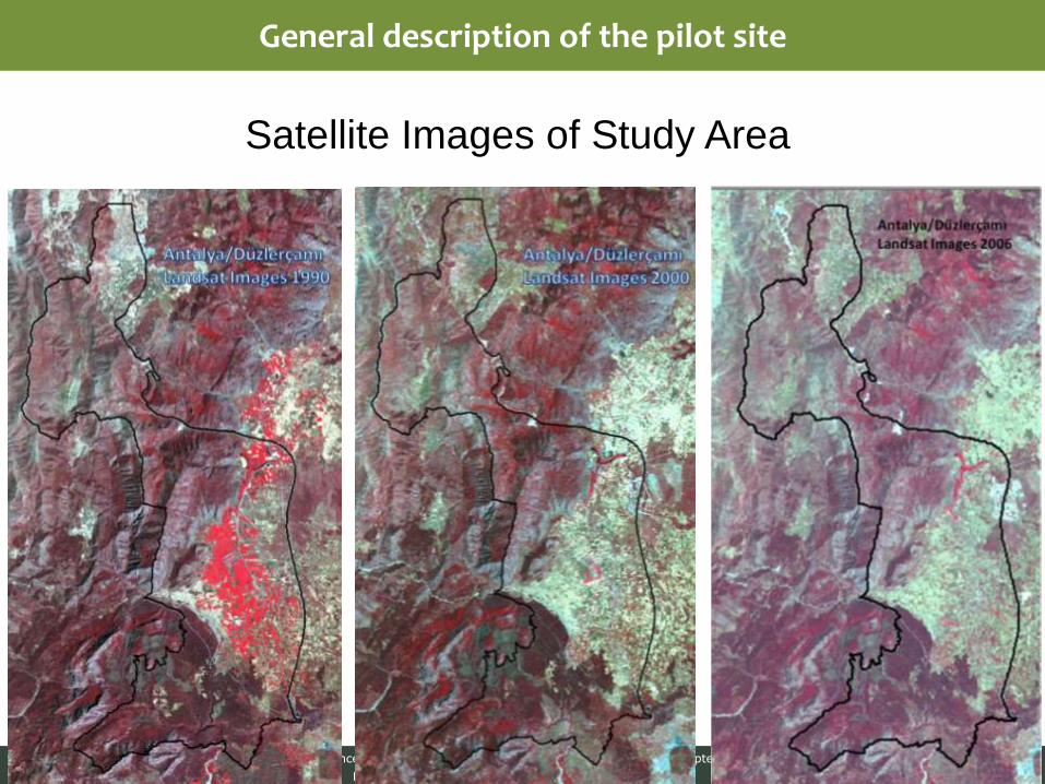
• Anthropogenic pressures
-There is existing CORINE land cover maps for the years 1990, 2000 and 2006
-Accuracy of CORINE land cover maps are ineffectiv (scala of maps are 1/100.000 and they made only by remotely sensed data. The local field works for verification image data are insufficient.
-There are not available data based on the land uses or impacts of land uses.
-There is possibility to map land uses in according to forest stand maps in the period of
10 years, CORINE maps, and remotely sensed data combined with field verification.
Atelier de lancement et Comité de pilotage du projet FFEM - 18-21 septembre 2012
Présentation des sites pilotes proposés par les pays
General description of the pilot site
Satellite Images of Study Area

Atelier de lancement et Comité de pilotage du projet FFEM - 18-21 septembre 2012
Présentation des sites pilotes proposés par les pays
General description of the pilot site
Forest owners
Forest manager
17686,7 ha → state forest (General Directorate of Forestry) 16,6 ha → easement forest ( 17.703,30 ha total forest area
General Directorate of Forestry General Director Regional Directorate of Forestry Regional Director Forest District District Director Forest Ranger District Forest Ranger Turkey Antalya (Province) Antalya (Central) Düzlerçamı

Atelier de lancement et Comité de pilotage du projet FFEM - 18-21 septembre 2012
Présentation des sites pilotes proposés par les pays
General description of the pilot site
Stakeholders
Inhabitants (28.065)
Village mukhtar (4)
town as small municipal authority (4)
district governorate (1)
Sheperds
Hunters
Visitors for recreation and tourismus
Public services (forestry, hydrology, agrarian, cultus and tourismus, e.g.)
Private services
NGO’s
Ariasos Ruins
from the Etruscans → to BC 3000

Atelier de lancement et Comité de pilotage du projet FFEM - 18-21 septembre 2012
Présentation des sites pilotes proposés par les pays
General description of the pilot site
• wood product (Please, specify available data)
Informationen about wood products is available, but to be processed (for how many
years?)
main wood products are wood for fuel, fiber, chipboard, industry and round wood, e.g.
• non wood forest products (Please, specify available data)
Information about non-wood products is available, but to be processed (for how many
years?)
• services (Please, specify available data)
organised industrial area, limestone quarry and a lime factory, recreation areas, hunting
areas, grazing areas, agricultural areas, visits to archaeological and natural sites, transport,
water spring, e.g.
•Economic importance of the site

Atelier de lancement et Comité de pilotage du projet FFEM - 18-21 septembre 2012
Présentation des sites pilotes proposés par les pays
General description of the pilot site
•Some specific ecological, economical and socio-cultural activities, which can derive impacts
•There isn’t the specific study/studies about impacts of land uses available
•There is a need to collect and analyse governmental datas and to prepare a map, based on the specific field works and remotely sensed data
•Economic importance of the site

Atelier de lancement et Comité de pilotage du projet FFEM - 18-21 septembre 2012
Présentation des sites pilotes proposés par les pays
General description of the pilot site
• Risk associated with climate change impacts
There is any data or past, existing scientific studies related to risk associated with
climate change and its impacts.
There is a need to analysis land use changes in the past (in the period of 10 years).
And, the changes between land uses can be used to find risks. The risks and
direction of changes between land uses can be related to climate change in the
future.
“Kırkgözhan Ruins”
from Anatolian Seljuk Sultanate (AD 1236 – 1247)

Atelier de lancement et Comité de pilotage du projet FFEM - 18-21 septembre 2012
Présentation des sites pilotes proposés par les pays
General description of the pilot site
Lack of data ?
Ecosystem map → The ecosystems must be classified and mapped consistently in a system. There is available some attributes for ecosystems in Turkish literature. It can be used to characterize and define the ecosystems. Land use map → There is a need for general rules (FFEM guides) to assess attributes of land use. There is available some attributes to characterize land uses in Turkey, like CORINE LULC maps Request to collect data from forest, agriculture, cultus and tourism, environment and urbanization, hydrologie, meteorologie, transport services. (management plans, advantages and misadvantages of measure of public services in the past, present and in the future) Request to inventory and survey data in the field to map ecosystems and land uses (livestock number, areas for overgrazing and illegal hunting, employement and population structure of inhabitants, number of visitor related to recreation and tourism, other socio-economical activities e.g.)

Atelier de lancement et Comité de pilotage du projet FFEM - 18-21 septembre 2012
Présentation des sites pilotes proposés par les pays
General description of the pilot site
There is a need for one employee. The employement is for 10 months. The employee will be responsible to collect and enter the data for public and private sectors and during the field works (routine works)
There is a need for archiv satellite images (SPOT 4, 5 and/or Landsat TM and/or ETM data) from the 1980 to 2010.
There is a need for training of staff. The training themes include the advanced analysis of remotely sensed data and the methods for (spatial) vulnerability assessment.
There is a need to assess some methods related to define impacts of land uses, to assess risks of land use land cover changes and its adaptation in relation to climate change.

Atelier de lancement et Comité de pilotage du projet FFEM - 18-21 septembre 2012
Présentation des sites pilotes proposés par les pays
General description of the pilot site
THANK YOU ANY QUESTIONS !