Embed Size (px)
Citation preview

Man b y T I M B R A D Y
Ecologists, foresters, and other resource managers have come to depend on this famously meticulous map of historical Minne-sota. Yet precious little is known about its origin or its creator.
t 's known simply as the Marschner map to those interested in Minnesota as it once was. It paints the southern and western portions of the state a bright prairie yellow. Oak openings and aspen-oak lands, done in various shades of brown, sweep like a pageant sash from the northwest to the southeast. The northern forest is a rag rug of greens, blues, violet-pinks, and grays.
J A N U A R Y - F E B R U A R Y 2 0 0 3 2 1

T h r o u g h every townsh ip and every c o u n t y , Interpretation of Francis J. Marschner's Map of the Original Vegeta-tion of Minnesota, t h e c a r d c a t a l o g name, details the look of the land before it was settled by Euro-Americans. Based on the notes of the Public Land Survey, 1847-1907, the Marschner map outlines just how much of the state was once wet p r a i r i e , oak o p e n i n g s , Big W o o d s , mixed h a r d w o o d , or any of a dozen o ther vegetative types that have been u t t e r l y c h a n g e d by 19th- a n d 2 0 t h -century h u m a n habi ta t ion . The notes themselves provide the descr ipt ion of these earlier landscapes; bu t the only way we can apply them to the present, without ourselves reading all 200 hand-wri t ten volumes, has come by way of Francis Joseph Marschner.
For ecologists, natural resources man-agers and planners, historians, landscape architects, foresters, and others, the map is an invaluable tool. "It's been the base reference for years," says Daniel Wovcha, p l an t c o m m u n i t y ecologis t wi th the Department of Natural Resources Minne-sota County Biological Survey.
The Marschner map has been adapted for use by the DNR Natura l Heri tage Program and used extensively by MCBS. Dig i t i zed v e r s i o n s of t h e m a p have recently been created and used by the U.S. Depar tment of Justice, Minnesota Department of Transportation, and U.S. D e p a r t m e n t of A g r i c u l t u r e Fo re s t Service. It's a favorite selection of stu-dents and visitors to the map library at the University of Minnesota. It has, in short, withstood the test of time.
John Almendinger, a forest ecologist
for the DNR, remembers road trips just o u t s i d e the Twin Ci t ies in the ear ly 1980s w i th his f e l low U n i v e r s i t y of Minneso ta grad s tuden t Eric G r i m m , who was doing a paleoecological study of t h e Big W o o d s . T h e y k e p t t h e M a r s c h n e r m a p in t h e f r o n t sea t between them. "It was remarkably accu-rate," Almendinger says. "If it said you should be looking at basswoods , you would be looking at basswoods."
Like many of his colleagues, Almen-d inge r p o i n t s o u t l i m i t a t i o n s to the map. "When you get up into some of t h e pa r t s , l ike the p i n k a s p e n - b i r c h areas, things get a little fuzzy," he says. But all who rely on it for their work are unstinting in their praise of the map and its value to the study of vegetation in the state of Minnesota. "When you think of all the variables that go into making a map like this—reading and reconstruct-ing the words of so many different sur-v e y o r s — i t ' s p r e t t y a m a z i n g h o w [Marschner's] interpretat ions still hold up," says Wovcha. "If Marschner hadn' t made the map, someone would need to do it today."
Still Visible. Ed Cushing, professor in the university's Department of Ecology, Evolution and Behavior and advisor to Almendinger and Grimm, used to do the same kind of road trips with Marschner's map. "It's always surprising how the veg-etation pattern and boundaries that he outlined are still visible on the landscape."
Diane Hellekson, a landscape ecologist at Barr Engineering Company, has used the m a p o f t e n in p r e p a r i n g n a t u r a l resources management plans for clients,
2 2 M I N N E S O T A C O N S E R V A T I O N V O L U N T E E R

1974 Reproduction of Marschner Map
Through painstaking work from historical records, Marschner constructed a map of the original vegetation of Minnesota, even though he probably never set foot in the state. Source: U.S. Forest Service, North Central Forest Experiment Station, St. Paul.
J A N U A R Y - F E B R U A R Y 2 0 0 3 2 3

Marschner's Map: A Useful Basejor DNR Research
Presettlement vegetation as compiled by F.J. Marschner
Prairie
Wet prairie, marshes, and sloughs
Brush prairie
Aspen-oak land
Oak openings and barrens
Big Woods
River-bottom forest
Mixed hardwood and pine
White pine
Aspen-birch (conifer)
Conifer bogs and swamps
Water features
Present day native vegetation as compiled by the Minnesota County Biological Survey 198J-1990
* 3
U.i
SOURCE: MINNESOTA'S ST. CROIX RIVER MLLEV AND ANOKA SANDPLAIN. MINNESOTA COUNTY BIOLOGICAL SURVEY
The DNR, among others, uses the Marschner map as one of the most accurate records of Minnesota's presettlement landscape. For example, ecologists and botanists of the Minnesota County Biological Survey used Marschner's work (top left) to guide searches for remaining vegetation of the St. Croix River Valley and Anoka Sandplain of east-central Minnesota. The map at left, recorded a decade ago by MCBS, shows that only small fragments of the native landscape that Marschner mapped remain.
2 4 M I N N E S O T A C O N S E R V A T I O N V O L U N T E E R
Area of detail: St. Croix River Valley and Anoka Sandplain

such as the ci ty of Mendota Heights. "You can f ind resources that will help you determine an area's geologic or soil his tory, bu t Mar schne r brings things above the ground. You get a really nice picture of what was, w h i c h i n f o r m s w h a t could be."
The m a p was created in 1929 and 1930, a time in history when Americans were just beginning to under-s t and the a w e s o m e changes tha t had taken place on landscapes in the 19th and ear ly 20 th c e n t u r i e s . T h e m a p was undoubtedly ahead of its time.
Yet for all the renown that has come to the map, for all its uses, and for all the admiration that has been heaped upon it, l i t t le is k n o w n a b o u t its o r ig ins a n d author. In fact, it spent the first 40 years of its existence either lost or in obscurity. Adding to its mystery is the fact that its creator may have never spent a day in the landscapes of Minnesota; and no one has been able to say with any certainty just why he made the map in the first place. To m o s t of t he p e o p l e w h o use a n d admire his work, Marschner is himself unmapped.
Out of the Drawer. Miron "Bud" H e i n s e l m a n shou ld be c red i t ed wi th rescuing the Marschner m a p f r o m the recesses of a map file. Heinselman, who spent years studying the fire and paleo-ecology of northern Minnesota, was a sci-entist working for USDA North Central Forest Exper iment Stat ion in St. Paul
A d d i n g to its mystery is the
fact that its creator may have
never spent a day in the
landscapes o f Minnesota.
when he discovered the m a p in the s t a t i o n ' s offices. "It was in pretty r o u g h shape , " says his w i d o w , Fran H e i n -se lman. "Just si t t ing at the bottom of a drawer." She says he r h u s b a n d "fell in love with it" and decided it should be pub-lished.
With the assistance of two university cartographers, Heinselman reconstructed the map and, in 1974, con-vinced the station that it should be print-ed. It is this published version that has, over the years, attracted so much interest.
Published in the same scale as the origi-nal—1:500,000—the 1974 map has a few minor changes in the color scheme, but the vegetation types were faithfully re-draf ted . To the m a p ' s flip side, Hein-selman attached a lengthy note outlining w h a t was k n o w n a b o u t M a r s c h n e r ' s method and the map's early history.
According to Heinselman, Marschner was a research assistant in the USDA B u r e a u of A g r i c u l t u r a l E c o n o m i c s , Washington, D.C. Sometime in 1929, he began using early surveyors' written de-script ions of the landscape to create a map of the original vegetation of Minne-sota. In July 1930, the completed map was sent to the director of the Lake States (now North Central) Forest Experiment Station in St. Paul.
At about the same time, Marschner, or someone under his supervision in the Bureau of Agricultural Economics, made a copy of the map—a fortunate event, as it turned out, because sometime between
J A N U A R Y - F E B R U A R Y 2 0 0 3 2 5

1940 and 1950, the original disappeared. In 1963 the second version of the map
was sent to St. Paul to replace the original, and it was this map that Heinselman and t h e e x p e r i m e n t s t a t ion r e d r a f t e d a n d published.
As for Marschner 's methods for creat-ing t h e m a p , H e i n s e l m a n w r i t e s , " U n f o r t u n a t e l y , [he] n e v e r gave t h e USDA Forest Service a detailed descrip-tion of how he used these notes to con-struct the map , n o t h i n g was ever p u b -lished by him on this subject, and no fur-
ther records of this work became available upon his death."
H e i n s e l m a n was a b l e t o f i n d o n e m e m o describing the process, written in 1956 by Marschner himself. It reads in part:
" T h e N a t u r a l V e g e t a t i o n M a p of Minneso ta is in the main based on the field notes written, and the plats prepared by the su rveyors of the Gene ra l Land Office. . . . The distribution pattern of the v e g e t a t i o n t y p e s was c o n s t r u c t e d by checking out the tree associations accord-
OHAINS. SKi> •
Lto.tru
iy.qi
< H— I J j f c l of the M- P.M.,Minn. J
hJr- CH^vtrraj ^ l iAJUt iv lv r i u . ,4 ^L,. 1 t L j m_, ^ i^LJ. - I
ILS i r j f -
Uk-ffuih- X-juf-'iI. -(jtw, I ^ C ul uAr-JU
»LdCu.({L VST) ULx L L T U R I O U i \
d b l & J t u T i ^ ucdv (Wils
of the '< * P. M., Minn.
gttO^lro Til
Wl^ l&SMjtl
" K ( m L (HJGSAU, <£>l.$ Iff * lie
Vru*. ' a V ^t^tH, L-t-Ur.
I u, Q f f v u j ^ c K ' ^ ' U ^ L . v ^ l U n . l A J l I
V c 9 CUx^ I 0 aL V ] i b, IC UC, tA. (b Cu. Uur-Vt
CLO U6v. UrCdU IjjU/ia Uu , t - r i u , ElJZ.^tL^^LuT
OiTvu^cl IjU Ci^k q.lcr.ij-^ IU
<3>u eltj lA &<*<\ Uclo Oh ^ SH-b-'O- Uc,
iTT"-/.. i. -J k i . . . a a (9,.. •
Though Marschner left little record of how he constructed his map, he apparently relied on field notes and other records from early surveyors working in the state. Source: U.S. Surveyor General.
2 6 M I N N E S O T A C O N S E R V A T I O N V O L U N T E E R
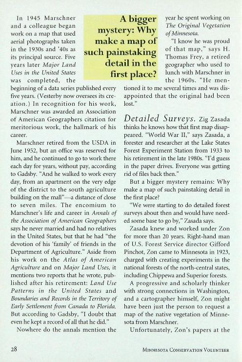
ing to significant distinc-t i o n s wh ich r e f l ec t ed causal relationship with cl imate, soil, and slope conditions. The distribu-tion patterns were devel-o p e d on the t o w n s h i p plats, which usually con-tained already such dis-tinctions as swamp, tree g roves in the p ra i r i e s , and, if I remember correctly, the bounda-ry between woodland and prairie where it was sufficiently distinct. From the plats these distr ibution pat terns were trans-ferred by hand, township by township, to the 1:500,000 scale base map of Minne-sota. The procedure required reading of more than 200 volumes of field notes, nearly all written in longhand, only the latest ones are typed."
Prodigious Feat. The painstaking labor suggested in this description was typical Marschner—or so it seemed to those who knew him or his reputation. "This was truly a prodigious feat," says John Fraser Hart, long a professor in the University of Minnesota Department of G e o g r a p h y . " I m a g i n e the n u m b e r of h o u r s it would take to pu t th is work together. And it was only one of several
Tim Brady is a St. Paul writer cur-rently working on a four-part televi-sion documentary, U n c o m m o n G r o u n d : M i n n e s o t a ' s O n c e a n d Future Landscapes, for the University of Minnesota's College of Natural Resources and Twin Cities Public Television.
great m a p s t h a t Marschner produced."
"Absolutely dedicated to his w o r k , " says Mar low Vesterby, who holds a position first cre-a ted a n d he ld by Marschner at the USDA Economic Research Ser-vice in Washington, D.C. " T h e l egend he re was
that he took just three days of sick leave in his entire working life."
"He was a very special person," says D w i g h t Gadsby , w h o began his own career as an agricultural economist at the USDA Economic Research Service in the 1960s as Marschner was ending his. "I r e m e m b e r this little old man walking a round the building. Everyone treated him with such reverence, I thought he was someone's grandfather."
Born in Austria in 1882, Marschner studied at the Cartographic Institute in Berlin before immigrating to this country in 1915. He soon began working for the USDA in Washington, D.C., where his cartographic forte was land-use mapping. The first major project that Marschner worked on, according to a 1967 article in Annals of the Association of American Geographers, was the Atlas of American Agriculture, p u b l i s h e d in p o r t i o n s between 1922 and 1936, just when he would have been working on his map of the natural vegetation of Minnesota. One of his co l l abo ra to r s on the at las was Raphael Zon, director of the Lake States Forest Experiment Station and the man to whom Marschner sent his Minnesota map in 1930.
"The procedure required reading o f more than 200 volumes o f field notes, nearly all
writ ten in l o n g h a n d . . . ."
J A N U A R Y - F E B R U A R Y 2 0 0 3 2 7
In 1945 M a r s c h n e r a n d a co l league began work on a map that used aerial photographs taken in the 1930s and '40s as its principal source. Five years later Major Land Uses in the United States was c o m p l e t e d , t h e beginning of a data series published every five years. (Vesterby now oversees its cre-a t i on . ) In r e c o g n i t i o n fo r his w o r k , Marschner was awarded an Association of American Geographers ci tat ion for mer i tor ious work, the hal lmark of his career.
Marschner retired f rom the USDA in June 1952, but an office was reserved for him, and he continued to go to work there each day for years, without pay, according to Gadsby. "And he walked to work every day, from an apartment on the very edge of the district to the south agriculture building on the mall"—a distance of close to seven miles . T h e e n c o m i u m to Marschner's life and career in Annals of the Association of American Geographers says he never married and had no relatives in the United States, but that he had "the devotion of his 'family' of friends in the Department of Agriculture." Aside from his work on the Atlas of American Agriculture and on Major Land Uses, it mentions two reports that he wrote, pub-l ished a f te r his r e t i r emen t : Land Use Patterns in the United States and Boundaries and Records in the Territory of Early Settlement from Canada to Florida. But according to Gadsby, "I doubt that even he kept a record of all that he did."
Nowhere do the annals ment ion the
year he spent working on The Original Vegetation of Minnesota.
"I know he was proud of t h a t m a p , " says H. T h o m a s Frey, a ret ired geographer who used to lunch with Marschner in the 1960s. " H e m e n -
tioned it to me several times and was dis-a p p o i n t e d that the or ig inal had been lost."
Detailed Surveys, z i g Zasada thinks he knows how that first map disap-peared. "World War II," says Zasada, a forester and researcher at the Lake States Forest Experiment Station from 1933 to his retirement in the late 1980s. "I'd guess in the paper drives. Everyone was getting rid of files back then."
But a bigger mystery remains: W h y make a map of such painstaking detail in the first place?
"We were starting to do detailed forest surveys about then and would have need-ed some base to go by," Zasada says.
Zasada knew and worked under Zon for more than 20 years. Right-hand man of U.S. Forest Service director Gifford Pinchot, Zon came to Minnesota in 1923, charged with creating experiments in the national forests of the north-central states, including Chippewa and Superior forests.
A progressive and scholarly th inker with strong connections in Washington, and a cartographer himself, Zon might have been just the person to request a map of the native vegetation of Minne-sota from Marschner.
U n f o r t u n a t e l y , Zon ' s papers at the
A bigger mystery: Why
make a map of such painstaking
detail in the first place?
2 8 M I N N E S O T A C O N S E R V A T I O N V O L U N T E E R

To\n,sl,ij>.\> Ml X.Jtnut/v. V II.' .7 M J / r / : Minnesota. i n-.tfr .ilr .1. ( i I >.„•
s. ' - < • •'-
is-C*
• J c <-
A. V
• . - * ,.M * - "v. -
-.3 ft-. ^ ^ -A.
A
3fi<M • C » , <• ' It) ^ IftAY •' «••
'! < «. i--vl^-i. » . ' . ' « i! * " < *"• * *
A
1 i ,
y«U> — • |
r - ! \ I /V tr/iuui .wniytU
hjtfij Miwk/ rif. lrnv »".<<«>«/ \(l-Ult UltMlHfl .1/ """"'u- """u. | H/HM -.11011*4
j Tnn l-Iu;. \ \'/*H rr>//, •>,, tfn/i ">. M'-t 1 AI-/7 1 l)Xr«/hr. //«/' t / bmv/ii/i h /(iJ .'•> I >/ dt«Hfr V ! / •yht^rytt,/. frftn/uru '///ntfr.jr/*t i i il/'ir'y /. /A
Also available to Marschner were township plat maps drawn by public land surveyors, who recorded the major kinds of vegetation they encountered— such as forest, prairie, and marsh—as they walked section lines. This map from 1877 shows the wetland areas recorded by land surveyors in Polonia Township in Roseau County. Source: U.S. Surveyor General.
J A N U A R Y - F E B R U A R Y 2 0 0 3 2 9

Since it was published more than a quarter-century ago, Marschner's map has provided guidance for the conservation and restoration of native habitats across Minnesota. Photograph of native prairie at The Nature Conservancy's Seven Sisters Prairie Preserve in Otter Tail County by Gary Alan Nelson.
3 0 M I N N E S O T A C O N S E R V A T I O N V O L U N T E E R

Minnesota Historical Society hold no cor-respondence between him and Marschner.
Yet Marschner may have needed no reques t f r o m Zon at all. Frey t h i n k s Marschner was probably compelled by his own interests to turn the survey notes into maps. "My guess is that he came upon those survey notes [at the Bureau of Land Management in Washington] and just thought, 'I can make a map out of these,'" Frey says. "I know that Marschner was never in Minnesota. Researchers in the Department of Agriculture in those days had a lot of latitude. I know that he never visited the western states that he mapped using those aerials [in Land Use Patterns in the United States]."
Maybe that's enough. Maybe the value of the th ing needs no enhanc ing by a provenance that includes a particular pas-sion for the landscapes of Minnesota . Maybe the map has done its greatest ser-vice simply by helping induce those feel-ings in others.
As for Marschner, he remained utterly t rue to his l egendary di l igence at the USDA. In 1966, at age 83, he was trudg-ing t h r o u g h a heavy s n o w s t o r m in Washington, on his way to another day of work, when he collapsed and died of a heart attack on the Capitol Mall.
To the best of Gadsby 's knowledge, Marschner died without a will, and with no known relatives. What estate he had would have been subsumed by the district government. Marschner was buried in a p a u p e r ' s grave. Gadsby, his son, and ano the r Mar schne r admi re r f r o m the Economic Research Service went looking for a marker in the cemetery a few years back. They couldn't find one. #
J A N U A R Y - F E B R U A R Y 2 0 0 3 3 1