Embed Size (px)
Citation preview

By Stephen Tavella
Copyright
Heart Sign® Books
Published by Stephen Tavella and Heart Sign® Books
Dummerston, Vermont, U.S.A.
Copyright © 2013 Stephen Tavella
All rights reserved. No part of this publication, including photographs, may be
reproduced, distributed, or transmitted in any form or by any means, including
photocopying, recording, or other electronic or mechanical methods, without the prior
written permission of the author, except in the case of brief quotations embodied in
critical reviews and certain other noncommercial uses permitted by copyright law. For
permission requests, write to the author, addressed “Attention: Permissions
Coordinator,” at the address below.
Stephen Tavella
P.O. Box 160 Email: [email protected]
West Chesterfield, NH 03466 Web: www.heart-sign.com
Disclaimer
The information contained in this book represents the views of the author at time of publication. The author makes no warranty about the accuracy of the information contained herein, and accepts no
responsibility for errors or exclusions that may be contained within. Although the author has made
every effort to ensure that the information in this book was correct at press time, the author and publisher do not assume and hereby disclaim any liability to any party for any loss, damage, or
disruption caused by errors or omissions, whether such errors or omissions result from negligence,
accident, or any other cause.
The information is designed to provide helpful information on the subjects discussed. The publisher and author are not responsible for road or water conditions that may change due to weather,
construction, changing environmental conditions, human interventions, or any other factors that create
alterations different from what is described in the book. Nor are the publisher and author responsible for the health and safety of anyone choosing to recreate at any of the swim spots described in this book.
Neither the publisher nor the author shall be liable for any physical, psychological, emotional,
financial, or commercial damages, including, but not limited to, special, incidental, consequential or
other damages. Our views and rights are the same: You are responsible for your own choices, actions,
and results. Use good judgment; know your limitations; safety first. References are provided for
informational purposes only and do not constitute endorsement of any websites or other sources. Readers should be aware that the websites listed in this book may change.
Cover design by Stephen Tavella and Heart Sign®
Book design by Stephen Tavella and Heart Sign®
First edition, August 2013

Stephen Tavella
Page 3 of 31
Introduction
Several years ago while swimming in a southern New Hampshire lake, an
open water swim buddy proclaimed, “You spend so much time in the open
water it’s a wonder you haven’t grown gills!” That pretty much sums up
my relationship with water. I spend a lot of time in it.
Southern Vermont and Southwest New Hampshire are my primary
stomping, or I guess I should say swimming, grounds. This is where I’ve
lived for the past twenty-seven years. I raised my daughter here. She’s now
21. During those early parenting years we spent a lot of time at what I
consider some of the sweetest swim holes in this area. In 2003 I started to
consider entering swim races held in lakes, rivers and oceans.
My first job as a 14 year-old was at the public pool and park in my
hometown. It suited me. I continued to swim in pools until I entered the
Peace Corps in 1982 and landed in the middle of the Pacific Ocean in the
tiny island nation of Kiribati. I lived on a coral atoll that was twenty-seven
square miles of sand and coconut trees surrounded by thousands of miles
of endless ocean. There were also lots of fish and a need to feed myself in
an environment made up primarily of a subsistence-based economy. The
ocean suited me. I loved being in the open water and feeling the power of
the water speak to me of the need for humility and respect. When my two
years of service ended, I extended for an additional two years in the island
nation of the Solomon Islands. It was there I learned to scuba dive among
the WWII wrecks of Iron Bottom Sound. The open water and I developed a
close relationship through those years.
When I returned to the United States I settled in southern Vermont. I
immediately joined the local swim club, but I didn’t immediately take to
the open water. I discovered the swim holes quickly, but I kept my exercise
to the hamster-like activity of swimming 25 yards, kick turning at the end
of the pool and returning to where I came from. A circle in the water for
thousands of yards is what it was. Eventually, I got married, had a daughter
and took her to swim holes around the area from her earliest memories. I
soon discovered that some of the swim spots my daughter and I frequented
were also places where I could hop in the water and just swim for hours on
end without kick turning at the end of a wall.
The Best! Open Water Swimming (and swim holes) in Southern Vermont and Southwest New Hampshire
Page 4 of 31
After years of spending hours in the water spear fishing for my food while
in the Peace Corps, I found the open water again, or perhaps it found me.
Given the special bond I developed with water early in life, I don’t think
our re-acquaintance was all my doing. I’ve given up on trying to unravel
life’s mysteries. I just know some things in life are mysterious and I revel
in it. It wasn’t long before I started to seek out new locations where I could
train for my open water events while enjoying some of the gorgeous
scenery this area of the country has to offer. While I was doing this, open
water swim competitions were becoming more and more popular. By 2008
it was introduced as a new event at the Beijing Olympics. One swim spot
turned into two, then three, and before you know it I had compiled a list of
some of the sweetest spots to swim with no lanes, no lines and no limits.
These spots helped me train for open water swim competitions like the
5.25 mile Little Red Lighthouse on the Hudson River, a couple of 10 mile
races on Lake Memphremagog on the Vermont-Canada border, Alcatraz
and various other swims in San Francisco’s bay, a 12.5 mile race around
Key West, Florida, and a smattering of 1-3 mile swims throughout the
northeast.
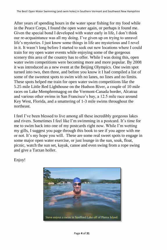
I feel I’ve been blessed to live among all these incredibly gorgeous lakes
and rivers. Sometimes I feel like I’m swimming in a postcard. It’s time for
me to swim back into one of my postcards right now. While I’m wetting
my gills, I suggest you page through this book to see if you agree with me
or not. It’s my hope you will. These are some real sweet spots to engage in
some major open water exercise, or just lounge in the sun, soak, float,
picnic, watch the sun set, kayak, canoe and even swing from a rope swing
and give a Tarzan holler.
Enjoy!
Steve enjoys a swim in Spofford Lake off of Pierce Island.

Stephen Tavella
Page 5 of 31
Map
Area of Detail
Maps courtesy of http://www.50states.com

The Best! Open Water Swimming (and swim holes) in Southern Vermont and Southwest New Hampshire
Page 6 of 31
Antrim, New Hampshire
Map data © 2013 Google
Antrim is a small town of approximately 2,360 residents covering 32
square miles of mostly forests, fields and small bodies of water. It is in a
part of southwest New Hampshire known as the Contoocook River Valley.
The original settlers to the area were English and Scotch-Irish. As other
areas of Massachusetts and New Hampshire became more heavily
populated, people left to settle new areas in the mid 1700’s. The waterways
helped get these settlers to the area.
Along the waterways, the settlers built mills – saw mills, grist mills, and
later silk mills and woolen factories. By 1830 nearly 20 mills lined these
waterways. The railroad arrived in the mid 1800’s, built by Irish laborers
escaping the potato famine. This new mode of transportation caused shifts
in population to South Antrim. Today, most of the farms and factories are
gone. The schools are one of the largest employers. Most residents work in
the bigger surrounding towns of Peterborough and Hillsboro.1
1 A Brief History of Antrim New Hampshire,
http://www.antrimnh.org/pages/antrimnh_about/briefhistory, accessed 07/11/2013
Willard Pond

Stephen Tavella
Page 7 of 31
Willard Pond (dePierrefeu-Willard Pond Wildlife Sanctuary)
Photo by Stephen Tavella ©
Description
Here’s a little gem nestled among 1,700 acres of mixed hardwood forest
only a stone’s throw from Southern New Hampshire’s main east-west
arterial, route 101, but buried deep enough in the woods that you won’t
hear a peep from motorized vehicles. Willard Pond is the largest of 38
wildlife sanctuaries owned and managed by the New Hampshire Audubon
society.
This is a pristine body of water nearly 100 acres in size. Surrounding the
pond are several hills with hiking trails and abundant wildlife. No
petroleum powered motors allowed here, so your swim is sure to be serene
and free from the wake caused by larger boats. The entrance to the pond is
via an unpaved forest road. You’ll need to park your car at the parking lot
several hundred yards from the pond, but if you have a canoe or kayak you
can drive to the pond, unload and return your car to the parking area.
The length of the pond is approximately .65 miles (1.3 miles roundtrip).
Circumnavigate and extend your open water swim to upwards of 1.75
miles. Whatever length you choose, serenity will be your constant
companion. And if you’ve come to simply float and cool off, the inviting,
The Best! Open Water Swimming (and swim holes) in Southern Vermont and Southwest New Hampshire
Page 8 of 31
gently sloping entry to the pond provides plenty of room to cool your
ankles or submerge your entire body while you revel in this solitude thanks
to New Hampshire Audubon. Considering a hike? Trail maps are available
at the information board at the parking lot, or print this PDF here:
http://www.nhaudubon.org/wp-
content/uploads/2012/05/WillardPondsmaller.pdf.
Category
Open Water
Swim Hole
Road Conditions
Paved road
Unpaved maintained forest road
Unpaved parking lot
Facilities
No facilities. Carry In - Carry Out. Do not litter!
Directions
From route 101 in southern New Hampshire, take route 137 north between
Dublin and Peterborough. Travel approximately 7 miles to Hancock. Turn
left on route 123 and travel approximately 3 miles to Davenport Rd. Turn
right on Davenport (dirt road). At .7 miles bear left onto Willard Pond Rd.
Continue for .9 miles until you reach the parking area on the left. If you
have a canoe or kayak you may continue up the road to unload at the pond.
You’ll need to return your car to the parking lot – about 100 yards from the
lake.
Conswimerations
Pack a snack or lunch. Hiking trails invite you into the woods
before or after your swim.
Additional items to consider:
o Bug juice

Stephen Tavella
Page 9 of 31
o Sunscreen
o Extra pair of goggles (you don’t want to drive out here
only to find the one pair you brought with you is broken).
o Food and water
o Camera
o An appreciation for the beauty of this lake
If you wish to rent a kayak or canoe, consider these:
o Amherst Kayak & Canoe, 114 State Route 101A, Amherst,
NH (603) 882-2600
o Contoocook River Canoe Co., 9 Horse Hill Rd, Concord,
NH (603) 753-9804
o Spofford Boat Sales, Route 9, Spofford, NH (603) 363-
8806 [email protected] (.1 mile beyond the turn-
off to Spofford Lake on Route 9)
Carry In – Carry Out. Do not litter!
» Don’t forget to thank the water Gods for their many blessings! ;-)
Recommended Swim Routes
1. Straight across the lake to the opposite shore will give you an
approximate swim of 1.3 miles. No need to fear high-speed boats
here – they’re not allowed.
2. Circumnavigate the shoreline for a longer swim, or if you’re on
your own without canoe or kayak support and you don’t like being
in deeper water alone. This will give you an approximate swim of
1.75 miles.

The Best! Open Water Swimming (and swim holes) in Southern Vermont and Southwest New Hampshire
Page 10 of 31
Image ©2013 DigitalGlobe
trackstick Google earth

Stephen Tavella
Page 11 of 31
Chesterfield, New Hampshire
Map data © 2013 Google
The town of Chesterfield, New Hampshire, has a population of
approximately 3,600, and also includes the villages of West Chesterfield
and Spofford. Chesterfield was established in 1735 while still under the
governance of Massachusetts. It was the site of one of several protective
trading forts built along the Connecticut River. It was incorporated as
Chesterfield in 1752.2
Chesterfield boasts two swim spots – one to the north and one to the south.
The village of Spofford sits on the north side of Highway 9, on Route 9A.
Most of the homes sit along the lakeshore of Lake Spofford, a 739 acre
body of water that invites you to lounge on a sand beach or exercise your
large muscle groups with swims ranging anywhere from several hundred
yards upwards to five miles. You can even plunge into the water via a rope
swing, but you’ll have to swim or row the .4 miles from Wares Grove to
Pierce Island to do so. Early evening’s the best time to enjoy this.
2 Economic & Labor Market Information Bureau, NH Employment Security, 2013.
The Best! Open Water Swimming (and swim holes) in Southern Vermont and Southwest New Hampshire
Page 12 of 31
In 2005 the New Hampshire Fish and Game Department named it the
cleanest lake in southwestern New Hampshire, despite the amount of
motor boating! For you George Carlin fans, you’ll be pleased to know that
some of his ashes were spread here after he was cremated in 2008. When
he was young he purportedly attended Camp Notre Dame.
Kilburn Pond is a little gem of a pond ½ mile long within the confines of
New Hampshire’s largest state park, Pisgah. Pisgah lies to the south and
east of Chesterfield on Route 63. You’ll need to walk about 20 minutes by
forest trail to reach it, but it’s worth every step you take. This is like a big
lap pool in the middle of forest heaven. How many laps can you do?
Not feeling that energetic? Soak up the sun on the smooth granite
shoreline rocks and cool off with periodic leaps into the water. A trail
circling the pond permits you to choose one of several spots to set your
blanket for the day. You’re not going to hear a car or motorboat here, but
you may hear a periodic squeal from a nearby swimmer as they jump from
one of the several rock outcroppings into the seductive waters. You may
have swimming neighbors, but fear not the crowds. Enjoy, respect and
honor this remote gem by carrying out what you carry in.
Stephen Tavella
Page 13 of 31
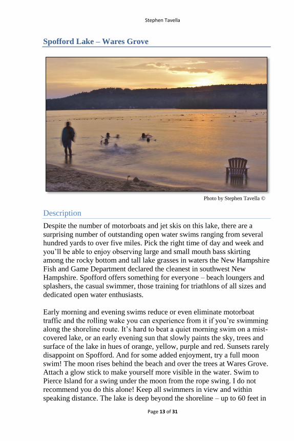
Spofford Lake – Wares Grove
Photo by Stephen Tavella ©
Description
Despite the number of motorboats and jet skis on this lake, there are a
surprising number of outstanding open water swims ranging from several
hundred yards to over five miles. Pick the right time of day and week and
you’ll be able to enjoy observing large and small mouth bass skirting
among the rocky bottom and tall lake grasses in waters the New Hampshire
Fish and Game Department declared the cleanest in southwest New
Hampshire. Spofford offers something for everyone – beach loungers and
splashers, the casual swimmer, those training for triathlons of all sizes and
dedicated open water enthusiasts.
Early morning and evening swims reduce or even eliminate motorboat
traffic and the rolling wake you can experience from it if you’re swimming
along the shoreline route. It’s hard to beat a quiet morning swim on a mist-
covered lake, or an early evening sun that slowly paints the sky, trees and
surface of the lake in hues of orange, yellow, purple and red. Sunsets rarely
disappoint on Spofford. And for some added enjoyment, try a full moon
swim! The moon rises behind the beach and over the trees at Wares Grove.
Attach a glow stick to make yourself more visible in the water. Swim to
Pierce Island for a swing under the moon from the rope swing. I do not
recommend you do this alone! Keep all swimmers in view and within
speaking distance. The lake is deep beyond the shoreline – up to 60 feet in

The Best! Open Water Swimming (and swim holes) in Southern Vermont and Southwest New Hampshire
Page 14 of 31
spots. Remember, safety first. With that in mind, there’s plenty to enjoy on
this lake.
Category
Open Water
Swim Hole
Rope Swing
Road Conditions
Paved road
Unpaved parking lot
Facilities
Fee for use (Memorial Day to Labor Day):
o Daily rate non-residents: adults, $6.00; children, $3.00;
season pass, $125. BUT, go to Wares Grove early morning
before 9:00 AM or early evening after 5:30 PM and swim
for free.
Bath house
Picnic tables
Charcoal grills
Playground
Sand beach
Limited food to purchase
Rubbish disposal
Canoe, kayak and boat rentals at:
o Spofford Boat Sales, Route 9, Spofford, NH (603) 363-
8806 [email protected] (.1 mile beyond the turn-
off to Spofford Lake on Route 9)
o Vermont Canoe Touring Center, 451 Putney Rd,
Brattleboro, VT (802) 257-5008
Directions
From Brattleboro, Vermont, take route 9 east from the traffic circle at exit
3 off of interstate 91. Travel 6.3 miles to Route 9A. Turn left toward Lake
Stephen Tavella
Page 15 of 31
Spofford. Travel approximately .3 miles and turn left into the Wares Grove
parking lot.
From the last traffic light heading west out of Keene, New Hampshire (Ash
Brook Rd), travel 6 miles to Rt. 9A. Turn right. Travel approximately2.3
miles and turn right into the Wares Grove parking lot.
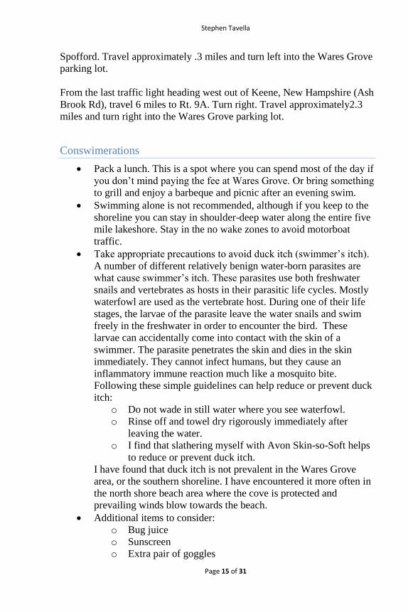
Conswimerations
Pack a lunch. This is a spot where you can spend most of the day if
you don’t mind paying the fee at Wares Grove. Or bring something
to grill and enjoy a barbeque and picnic after an evening swim.
Swimming alone is not recommended, although if you keep to the
shoreline you can stay in shoulder-deep water along the entire five
mile lakeshore. Stay in the no wake zones to avoid motorboat
traffic.
Take appropriate precautions to avoid duck itch (swimmer’s itch).
A number of different relatively benign water-born parasites are
what cause swimmer’s itch. These parasites use both freshwater
snails and vertebrates as hosts in their parasitic life cycles. Mostly
waterfowl are used as the vertebrate host. During one of their life
stages, the larvae of the parasite leave the water snails and swim
freely in the freshwater in order to encounter the bird. These
larvae can accidentally come into contact with the skin of a
swimmer. The parasite penetrates the skin and dies in the skin
immediately. They cannot infect humans, but they cause an
inflammatory immune reaction much like a mosquito bite.
Following these simple guidelines can help reduce or prevent duck
itch:
o Do not wade in still water where you see waterfowl.
o Rinse off and towel dry rigorously immediately after
leaving the water.
o I find that slathering myself with Avon Skin-so-Soft helps
to reduce or prevent duck itch.
I have found that duck itch is not prevalent in the Wares Grove
area, or the southern shoreline. I have encountered it more often in
the north shore beach area where the cove is protected and
prevailing winds blow towards the beach.
Additional items to consider:
o Bug juice
o Sunscreen
o Extra pair of goggles

The Best! Open Water Swimming (and swim holes) in Southern Vermont and Southwest New Hampshire
Page 16 of 31
o Food and water
o Camera
o An appreciation for the beauty of this lake
If you wish to rent a kayak or canoe, consider these:
o Spofford Boat Sales, Route 9, Spofford, NH (603) 363-
8806 [email protected] (.1 mile beyond the turn-
off to Spofford Lake on Route 9)
o Vermont Canoe Touring Center, 451 Putney Rd,
Brattleboro, VT (802) 257-5008
» Don’t forget to thank the water Gods for their many blessings! ;-)
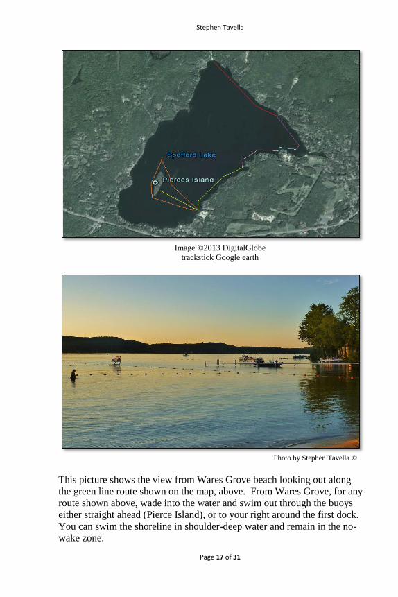
Recommended Swim Routes
1. Yellow route: Wares Grove to Pierce Island, direct to the rope
swing (.38 miles)
2. Orange route: Wares Grove around Pierce Island and following all
buoys (1.34 miles)
3. Green route: Wares Grove to the Lighthouse (.5 miles)
4. Green route + Pink route: Wares Grove to Gazebo (.9 miles)
5. Green route + Pink route + Blue route: Wares Grove to Deep Cove
(1.1 miles)
6. Green route + Pink route + Blue route + Purple route: Wares
Grove to far end of Boat Club (1.5 miles)
7. Green route + Pink route + Blue route + Purple route + Red route:
Wares Grove to North Shore (2.25 miles)
8. Circumnavigate the lake from Wares Grove going counter-
clockwise (approx. 5 miles). Hint: If you don’t have kayak or
canoe support, store fluids and food in a container on the North
Shore before you begin your swim. Exit the water at the halfway
point (North Shore), fuel up and continue your swim.
Stephen Tavella
Page 17 of 31
Image ©2013 DigitalGlobe
trackstick Google earth
Photo by Stephen Tavella ©
This picture shows the view from Wares Grove beach looking out along
the green line route shown on the map, above. From Wares Grove, for any
route shown above, wade into the water and swim out through the buoys
either straight ahead (Pierce Island), or to your right around the first dock.
You can swim the shoreline in shoulder-deep water and remain in the no-
wake zone.

The Best! Open Water Swimming (and swim holes) in Southern Vermont and Southwest New Hampshire
Page 18 of 31
Dummerston, Vermont
Map data © 2013 Google
Beautiful Dummerston, Vermont! Perhaps I’m biased now that I’m a new
resident. I’ve lived in the area since the mid-1980’s, have taken up
residence in the communities of Brattleboro and Newfane and I have to say
that my most recent decision to purchase a home here has settled quite
well, thank you! It's been said that there are more writers-per-square-mile
here than just about anywhere - a tradition started when Rudyard Kipling
lived at Naulakha from 1892-1896. As a new writer myself, I guess I just
added to the density of writers to which Dummerston has claimed bragging
rights.
Consider Stickney Brook, the first of two delicious swim holes featured in
this section. Stickney Brook could arguably be considered the most
beautiful set of cascading waterfalls in the southern Vermont area. Just up
the road you can’t miss the Dummerston Covered Bridge spanning the
West River. It’s the longest working covered bridge in Vermont. The

Stephen Tavella
Page 19 of 31
longest covered bridge (not currently open) is the Scott bridge, featured
later in this book. The Dummerston Covered Bridge is the second swim
hole featured for Dummerston. What a gorgeous spot, it is! Continue
across the bridge from Route 30, wind up and down the East West Road
into the town of Dummerston and you’ll drop into a Vermont postcard with
a white steeple church, small pond, sugar shack, grange and typical New
England homes. Visit in early October and you’ll have a chance to gorge
yourself on homemade apple pie and ice cream at Dummerston’s Apple Pie
festival. If that’s not a southern Vermont tradition, I don’t know what is!
You’ll find Naulakha, the home designed by Rudyard Kipling and where
he lived with his Vermont-born wife, Caroline Balestier, from 1892-1896,
just down the road from Dummerston Center. In this same area you’ll find
the Scott Farm, a 571-acre working apple orchard with 23 historic
buildings and 90 varieties of apples, many of them heirloom. It is here that
much of John Irving’s book, The Cider House Rules, was filmed. Scott
Farm’s neighbor is World Learning and the School for International
Training, an 81 year-old international education institution that hosted
some of the original training programs for the U.S. Peace Corps at its
inception in the early 1960’s.
Dummerston is full of wonder, magic and all the very best Vermont has to
offer. The two swimming holes featured here speak for themselves. Come
see for yourself!
Photo by Stephen Tavella ©

The Best! Open Water Swimming (and swim holes) in Southern Vermont and Southwest New Hampshire
Page 20 of 31
Stickney Brook
Photo by Stephen Tavella ©
Description
Sweet! Delicious! Nirvana! These falls are well-known by the locals as one
of the most beautiful set of cascading falls in southern Vermont. My
daughter once said when she was a teeny-tot that she thought fairies lived
here. I think children know best. With that in mind, enter here with
reverence and a sense of the magical all around you.
Stickney Brook Falls lie just a short turn off of Route 30, the main
north/south thoroughfare through the West River valley. You’ll turn onto a
dirt road and immediately know you’ve landed someplace special. The
waters are as clear as they get, cascading over smooth, molded granite
bowls and dropping into gravel-filled pools. The sound of the water fills
your ears, and the smell of the damp forest wafts through your nose as the
cool air lifting from the layers of tumbling water cools you before you
even reach your first pool. When October rolls around and the leaves turn
gold, red and orange, you’ll delight in sitting by the brook and soaking in
the shimmering colors while you consider whether you should dip your
toes to test your fortitude. It doesn’t matter if you do or not. You’re at
Stickney Brook and everything’s just okay!
Stephen Tavella
Page 21 of 31
Category
Swim Hole
Road Conditions
Paved road
Unpaved maintained road
Facilities
No facilities. Carry In – Carry Out. Do not litter!
Parking is along the side of the road (Stickney Brook). Make sure
you’re parked completely off the road so as to not block residents
who live up the mountain.
Directions
Take Route 30 north out of Brattleboro. From the Grafton Cheese
Company on Route 30, travel approximately 4.5 miles to Stickney Brook
Road. Turn left onto the dirt road. The falls are on your right. Pull securely
off to the side of the road so as to not block traffic.
Coming from the north on Route 30, Stickney Brook Road will be on your
right just after the green iron bridge down the road from the Dummerston
Covered Bridge.
Conswimerations
These falls are private property. It is by the goodness of the owner
that the public is permitted to enjoy them. Remain appreciative of
this fact. Be respectful, do not harm vegetation, and keep noise
levels down. Do not litter!
Pack a lunch, but carry out what you carry in!
Be careful walking along the pools and falls. Rocks may be
slippery.
Additional items to consider:
o Bug juice
o A picnic lunch
o Camera
o An appreciation for the beauty and magic of the falls.

The Best! Open Water Swimming (and swim holes) in Southern Vermont and Southwest New Hampshire
Page 22 of 31
» Don’t forget to thank the water fairies for their many blessings at
this magical spot! And also thank the private landowner who
currently permits you to imbibe its unmatched beauty.
Photo by Stephen Tavella ©

Stephen Tavella
Page 23 of 31
Dorset, Vermont
Map data © 2013 Google
Forty-seven square miles of Vermont bliss speckled with white clapboard
houses and steeped in the history of the old Republic of Vermont. The first
general convention of the freemen of the New Hampshire Grants met at
Dorset in 1776 to consider the organization of a free and independent
district, and for many years the town played a vital part in the
establishment of Vermont as a separate entity. Many times during the early
years of the Vermont republic (1777 to 1791), the Legislature met at
Cephas Kent's Tavern in Dorset. Vermont was admitted to the United
States at the 14th state in 1791.
3
The first marble quarry in the US was opened in South Dorset in 1785.
Over the next 130 years, two dozen or more quarries located on the slopes
of Dorset Mountain and Mt. Aeolus provided marble for headstones,
3 Virtual Vermont Internet Magazine,
http://www.virtualvermont.com/towns/dorset.html#about, accessed 08/01/2013
The Best! Open Water Swimming (and swim holes) in Southern Vermont and Southwest New Hampshire
Page 24 of 31
lintels, hearths and the like in the early years, followed by monumental
uses and later building stone used in many notable buildings, such as the
New York Public Library, the library of Brown University, and Memorial
Continental Hall of the Daughters of the American Revolution in
Washington, D.C. Several mansions on New York City's 5th Avenue were
built of Dorset marble, and many bank buildings across the land were
graced by interiors lined with polished Dorset marble. After the clapboard
church in Dorset Village burned in 1907, a new church was built in the
same style using locally quarried marble.4
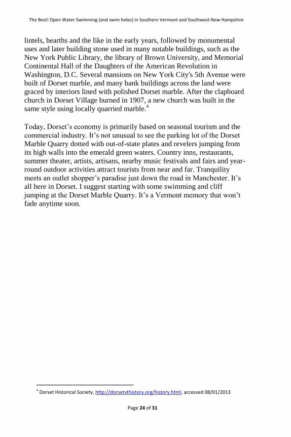
Today, Dorset’s economy is primarily based on seasonal tourism and the
commercial industry. It’s not unusual to see the parking lot of the Dorset
Marble Quarry dotted with out-of-state plates and revelers jumping from
its high walls into the emerald green waters. Country inns, restaurants,
summer theater, artists, artisans, nearby music festivals and fairs and year-
round outdoor activities attract tourists from near and far. Tranquility
meets an outlet shopper’s paradise just down the road in Manchester. It’s
all here in Dorset. I suggest starting with some swimming and cliff
jumping at the Dorset Marble Quarry. It’s a Vermont memory that won’t
fade anytime soon.
4 Dorset Historical Society, http://dorsetvthistory.org/history.html, accessed 08/01/2013

Stephen Tavella
Page 25 of 31
Marble Quarry
Photo by Stephen Tavella ©
Description
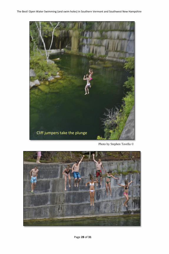
I was introduced to this swim hole years ago by my undying open water
swim buddy, Jimmy, and I’ve been coming back here ever since. What a
find! Thanks Jimmy! Isaac Underhill opened this quarry in 1785. It’s the
oldest Marble Quarry in the United States. It was most active in the 1800’s
when the slabs cut here were used primarily for hearths, doorsills and
headstones. Now cliff jumpers are writing a new history as young and old
alike come here to float, jump, exercise, or lay on the rocks and lawn to
catch a Vermont tan.
The water is deep, for the most part, right off the edge of most of this small
body of water, as most quarries are. The water’s squeaky clean, so you
don’t need to look too hard around the edges of the wooded and quieter
sections of the quarry to see fish hovering under the shade of trees, or
flitting from rock to rock. For lap swimmers, the best entry point is right in
front of you as you approach the water’s edge from the parking lot (see the
picture, above). For cliff jumpers, walk around the Route 30 side of the
quarry, follow the trail across the small wooden bridge and climb the trail
to the rocks along the back side of the quarry. Lap swimmers are safest

The Best! Open Water Swimming (and swim holes) in Southern Vermont and Southwest New Hampshire
Page 26 of 31
following a central route up the middle of the water. This way you’ll avoid
any possible collisions with jumpers.
Just up the road is the hamlet of Dorset, and south is Manchester. No
shortage of places to dine, drink or play in this area. The lawn and rocks
invite you to spread a picnic lunch, so consider packing your cooler and
staying for a while. If you’re not in the mood for a swim there’s plenty of
entertainment watching those who are.
Category
Open Water
Swim Hole
Road Conditions
Paved road
Unpaved parking lot
Facilities
No facilities. Carry in – Carry out. Do not litter!
Directions
Traveling north, take Route 30 to the intersection at Route 11 near
Bromley. Turn left towards Manchester. Travel approximately 6.6 miles to
the traffic circle. Make your first left in the circle, and your last left in the
circle that immediately follows. You’re staying on Route 30. Travel
approximately 4.4 miles to the quarry on the right side of the road. Mark in
the designated parking area.
Traveling south on Route 30 from Dorset you’re approximately 1.5 miles
from the quarry on your left.
Conswimerations
This is posted private land with restrictions, so please heed the
signs to respect the landowner’s wishes.
o No Alcohol

Stephen Tavella
Page 27 of 31
o No Glass
o No Litter
o No Fires
o No Graffiti
o No Parties
o No Loud Music or Property Damage
o Vacate at Dusk
The owner of this land also notes that dangerous conditions exist.
Use Care.
Pack a lunch and hang out on the rocks or lawn.
Additional items to consider:
o Bug juice
o Sunscreen
o Camera
Carry In - Carry Out. Do not litter!
» Don’t forget to thank Isaac Underhill for carving out this
unforgettably fun swim hole... and the landowners for allowing you to
enjoy it!
Recommended swim routes
Straight across the quarry! It’s one big open water lap pool at
approximately 175 yards in length. Watch for cliff jumpers from the quarry
walls. Enter the water from the left side towards the parking lot, or the
bottom of the quarry. From those points you can walk into the water and
then push yourself off for your lap workout. Otherwise, your choices are
deep entries from the marble cliffs surrounding the quarry.
The Best! Open Water Swimming (and swim holes) in Southern Vermont and Southwest New Hampshire
Page 28 of 31
Photo by Stephen Tavella ©
Cliff jumpers take the plunge

Stephen Tavella
Page 29 of 31
Photo by Stephen Tavella ©
Photo by Stephen Tavella ©

The Best! Open Water Swimming (and swim holes) in Southern Vermont and Southwest New Hampshire
Page 30 of 31
List of Swim Holes by Category
Open Water
Willard Pond Page 13
Nubanusit Lake Page 18
Dublin Lake Page 23
Spofford Lake – Wares Grove Page 29
Pisgah State Park: Kilburn Pond Page 34
Pisgah State Park: Round Pond and the Reservoir Page 40
West River: Brattleboro Outing Club Docks Page 46
West River: West River Park Page 52
Dorset Marble Quarry Page 78
Connecticut River from Putney Page 85
Harriman Reservoir Page 91
Grout Pond Page 99
Somerset Reservoir Page 103
Searsburg Reservoir Page 111
Swim Hole
Willard Pond Page 13
Spofford Lake – Wares Grove (rope swing) Page 29
Pisgah State Park: Kilburn Pond Page 34
Pisgah State Park: Round Pond and the Reservoir Page 40
West River: Brattleboro Outing Club Docks (rope swing) Page 46
West River: West River Park (rope swing) Page 52
Stickney Brook Page 58
West River: Dummerston Covered Bridge Page 61
West River: Rock and West Rivers Page 68
West River: The Scott Covered Bridge (rope swing) Page 73
Dorset Marble Quarry Page 78
Harriman Reservoir (rope swing) Page 92
Grout Pond Page 99
Somerset Reservoir Page 103
Searsburg Reservoir Page 111
Stephen Tavella
Page 31 of 31
About the Author
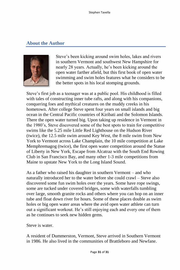
Steve’s been kicking around swim holes, lakes and rivers
in southern Vermont and southwest New Hampshire for
nearly 28 years. Actually, he’s been kicking around the
open water farther afield, but this first book of open water
swimming and swim holes features what he considers to be
the better spots in his local stomping grounds.
Steve’s first job as a teenager was at a public pool. His childhood is filled
with tales of constructing inner tube rafts, and along with his companions,
conquering foes and mythical creatures on the muddy creeks in his
hometown. After college Steve spent four years on small islands and big
ocean in the Central Pacific countries of Kiribati and the Solomon Islands.
There the open water turned big. Upon taking up residence in Vermont in
the 1980’s, Steve discovered some of the best spots to train for competitive
swims like the 5.25 mile Little Red Lighthouse on the Hudson River
(twice), the 12.5 mile swim around Key West, the 8 mile swim from New
York to Vermont across Lake Champlain, the 10 mile competition at Lake
Memphremagog (twice), the first open water competition around the Statue
of Liberty in New York, Escape from Alcatraz with the South End Rowing
Club in San Francisco Bay, and many other 1-3 mile competitions from
Maine to upstate New York to the Long Island Sound.
As a father who raised his daughter in southern Vermont – and who
naturally introduced her to the water before she could crawl – Steve also
discovered some fun swim holes over the years. Some have rope swings,
some are tucked under covered bridges, some with waterfalls tumbling
over large, smooth granite rocks and others where you can hop on an inner
tube and float down river for hours. Some of these places double as swim
holes or big open water areas where the avid open water athlete can turn
out a significant workout. He’s still enjoying each and every one of them
as he continues to seek new hidden gems.
Steve is water.
A resident of Dummerston, Vermont, Steve arrived in Southern Vermont
in 1986. He also lived in the communities of Brattleboro and Newfane.