Embed Size (px)
Citation preview

UNITED STATES
DEPARTMENT OF THE INTERIOR
GEOLOGICAL SURVEY
A METHOD FOR ESTIMATING MAGNITUDE AND
FREQUENCY OF FLOODS IN MONTANA
By M. V. Johnson and R. J. Omang
Open-File Report 75-650
Prepared in cooperation with the
Federal Highway Administration,
Montana Department of Highways,
and the U.S. Forest Service
Helena, Montana
January 1976

CONTENTS
Page
Abstract. ....................... 1
Introduction. ..................... 2
Cooperation. ................... 3
Previous reports ................. 3
Hydrologic definitions .............. 4
Use of metric units of measurement ........ 6
Estimating flood magnitudes .............. 7
Use of gaging station records. .......... 7
Use of estimating relations. ........... 10
Limitations and accuracy of estimating relations. ... 16
Maximum known floods. ................. 19
Example ........................ 21
Frequency analysis ................... 22
Gaging records .................. 22
Flood characteristics. .............. 22
Regional skew. .................. 23
Regression analysis .................. 24
References. ...................... 27
Appendix. ....................... 29
II

ILLUSTRATIONS
Page
Plate 1. Map showing average annual precipitation,
western Montana, 1953-67. ......... In pocket
2. Map showing average annual precipitation,
eastern Montana, 1953-67. ......... In pocket
3. Map of Montana and adjacent areas showing
the areal boundaries and location of
selected crest-stage partial record and
continuous record gaging stations ..... In pocket
Figure 1. Graph showing relation of discharge to
drainage area for selected flood frequencies
along main stem of Clark Fork ....... 8
2. Graph showing relation of discharge to
drainage area for selected flood frequencies
along main stem of Yellowstone River. ... 9
3. Nomographs for computing statewide flood
magnitudes, 2- and 25-year floods ..... 13
4. Nomographs for computing statewide flood
magnitudes, 5- and 50-year floods ..... 14
5. Nomographs for computing statewide flood
magnitudes, 10- and 100-year floods .... 15
6. Graph showing relation of maximum recorded
discharge to drainage area at gaging
stations in Montana ............ 20
III

TABLE
Page
Table 1. Drainage basins and flood-frequency
characteristics for selected gaging
stations in Montana and some in
adjacent states. ............. Appendix
IV

A METHOD FOR ESTIMATING MAGNITUDE AND FREQUENCY OF
FLOODS IN MONTANA
by
M. V. Johnson and R. J. Omang
ABSTRACT
This report provides methods for estimating flood
characteristics at most natural flow sites on rural streams
in Montana. It also contains significant flood data and
related information for many gaged sites on Montana streams.
Frequency curves are provided for 442 gaged sites as
defined by log-Pearson Type III analysis. To allow estimates
at ungaged sites, mathematical equations relate the 2-, 5-,
10-, 25-, 50-, and 100-year flood magnitudes to basin charac
teristics. Drainage area, main channel slope, and mean
annual precipitation were found to be the most significant
estimating variables. Equations presented are limited to
use on streams with drainage areas from about 0.1 to 2,600
square miles (0.3 to 6,700 square kilometres), with slope
from about 5 to 1,200 feet per mile (1.5 to 366 metres per
kilometre), and with precipitation from 10 to 100 inches
(250 to 2,500 millimetres).
Nomographs provide a simple graphical means of solving
the estimating relations, and illustrative examples are
presented.
1

INTRODUCTION
Knowledge of flood characteristics is essential for
optimum design of bridges, culverts, and drainage systems
and to help reduce flood damage. Reliable estimates of flood
magnitudes and frequency of occurrence can result in economical
designs, realistic flood insurance rates, and equitable land
use regulations.
The purpose of this report is to describe methods to
estimate the magnitude of floods, having frequencies of
occurrence ranging from once each 2 years to once each 100
years, for rural stream sites in Montana. A flood-frequency
curve is provided for each site where flood gaging records
are of adequate length to justify frequency analysis. Techniques
are provided to transfer information from gaged to ungaged
sites. These transfer techniques are mathematical equations
relating flood-flow magnitudes to characteristics of the
drainage basins. The relations were defined from data at the
gaged sites but they may be used to estimate flood magnitudes
at ungaged sites by solving the equations using data on basin
characteristics for the ungaged site. Basin characteristics
used in the equations may be evaluated simply from topographic
maps and other maps in this report.
To aid in more complete flood assessment, information is
presented in the maximum flood flows recorded or observed
on Montana streams.
2

Cooperation
This report was prepared in cooperation with the
Montana Department of Highways, the Federal Highway Admin
istration, and the U.S. Forest Service. The opinions, findings,
and conclusions expressed in this publication are those of
the authors and not necessarily those of the cooperating agencies
Previous reports
Numerous previous reports (Berwick, 1958; Boner and Omang,
1967; Bodhaine and Thomas, 1964; Patterson, 1966; Boner and
Buswell, 1970; and Dodge, 1972) have described techniques for
estimating flood-peak magnitude and frequency in Montana. At
the time of most of those analyses little information was
available from small streams and the techniques were limited
to use on relatively large streams. Because the relations
given in this report are based upon a larger data base and were
defined by a more technically rigorous analysis, they are
believed to be more reliable than relations previously suggested.

Hydrologic definitions
Hydrologic terms and concepts used in this report:
1. Cubic feet per second (ft 3 /s).--One ft 3 /s is the rate of
discharge of a stream having a cross-sectional area of 1
square foot and an average velocity of 1 foot per second.
One ft 3 /s equals 0.646 million U.S. gallon per day, 449
gallons per minute, or 0.02832 cubic metre per second.
2. Continuous-record gaging station. --A site on a stream
where stage and discharge data are obtained continously
over a period of time.
3. Crest-stage partial-record gaging station. A site on a
stream where flood peak data only are collected systemati
cally over a period of years.
4. Skew coefficient.--^, measure of the non-symmetry of the
probability distribution of annual flood peaks and a
measure of curvature in the flood-frequency relation.
5. Recurrence interval. --The average interval of time, in
years, within which the given flood event is expected to
be equaled or exceeded once. The reciprocal of the
recurrence interval is the probability of occurrence
during any year. (A 50-year flood, QCQ, has a 2 percent
chance of being equaled or exceeded in any given year.)
Recurrence intervals imply no regularity of occurrence;
a 50-year flood event might be exceeded in consecutive
years, or it might not be exceeded in a 100-year period.
4

6. Flood-frequency curve. --A graph showing the relationship
between recurrence interval as abscissa and flood-
magnitude as ordinate.
7. Multiple regression. --A statistical technique for
defining the relationship between a dependent variable
and two or more independent variables. In this report
the dependent variable is the flow characteristic
(flood discharge of a given frequency), and the
independent variables are drainage basin characteristics,
such as main-channel slope and drainage area.
8. Standard error or estimate (S e ).--A range of error such
that the value estimated by the regression equation is
within this range at about two out of three sites and
is within twice this range at about 19 out of 20 sites
(Thomas and Benson, 1969, p. 20).

Use of metric units of measurement
The analyses and data in this report are based on
English units of measurements. The equivalent metric units
are given in the text and illustrations where appropriate.
English units only are shown in tables where, because of
space limitations, the dual system of English and metric
units would not be practicable. To convert English units
to metric units, the following conversion factors should be
used:
English units
Length in inches (in) Xin feet (ft) Xin miles (mi) X
Area in square miles X (mi 2 )
Runoff rate in cubic X feet per second (ft 3 /s)
Unit runoff in cubic feet X per second per square mile [(ft 3 /s)/mi 2 ]
Conversion factor
25.4.3048
1.609
2.590
.02832
.01093
Metric units
millimetres (mm) metres (m) kilometres (km)
square kilometres (km 2 )
cubic metres per second (m 3 /s)
cubic metres per second per square kilometre [(m 3 /s)/km 2 ]

ESTIMATING FLOOD MAGNITUDES
Use of gaging station records
A frequency analysis of gaging stations records is usually
the most reliable method for estimating future flood magnitudes
at or near gaged sites. Any estimate first should include
searching for gage data which may have been collected at or
near the desired site. Streamflow characteristics are listed
in table 1 (appendix) for sites that are used in this study.
The most reliable estimates are obtained for sites where 15
or more years of peak flow record is available. At sites
a short distance upstream or downstream, the flow charac
teristics of a gaged location can be transferred with
considerable reliability. The transfer technique requires
determination of the drainage areas of the two sites for use
in the equation
/-\Q = (A /A )°' 6 (X x t u g' t
/s
where Q is flood magnitude, in ft /s, having a t-year
recurrence interval at the ungaged sites; A is drainage
area, in square mil"es, at ungaged site; A is drainageo
area, in square miles, at gaged site; and Q is flood
magnitude, in ft 3 /s, at the gaged site as listed in table
1. This relation will give reasonably accurate results
when the drainage area ratio lies between % and 2.
For larger streams that are gaged at several sites,
the flood-frequency data for ungaged intermediate sites
may be estimated by interpolation. Figures 1 and 2 show
frequency relations for Clark Fork and Yellows tone River.
7

00
30
0,0
00
o
o UJ en
cr UJ a. UJ
UJ o
CD ID
O UJ o
cr o CO
100,0
00
10
,00
0
DR
AIN
AG
E
AR
EA
, IN
T
HO
US
AN
DS
O
F S
QU
AR
E
KIL
OM
ET
RE
S
20
4
0
60
ro
10
0-y
ea
r flo
od,
50
-ye
ar
flood,
25
-ye
ar
floo
d>
8 12
16
2
0
DR
AIN
AG
E
AR
EA
, IN
T
HO
US
AN
DS
O
F S
QU
AR
E
MIL
ES
50
00
1000
500
O
o UJ
CO a: UJ a_ CO
UJ a: \- LL)
O 00 ID
O UJ or x
o CO
Q
24
FIG
UR
E
I.-R
EL
AT
ION
O
F
DIS
CH
AR
GE
T
O
DR
AIN
AG
E
AR
EA
F
OR
S
EL
EC
TE
D
FLO
OD
F
RE
QU
EN
CIE
S
ALO
NG
M
AIN
S
TE
M
OF
C
LA
RK
F
OR
K

0c TO mro*l
j ~n TO - r m : or- i o >3 OH
700°c"1 n o
r~ O
m
H O
>O 70-r\ m
> -< m -
m oHm o
DISCHARGE, IN CUBIC FEET PER SECOND
CM
b o o
01b o o
o o o
01 ob o o
o ob o o
o
> o om> ?om
I ocO)
o
O)oc
m en o
m co
o> o
6-1865
o =
-2145
6-3295
6-3090
\T
J
r\> o ob o o
ro O
88O8O
o m
m
oo o
ocCO
85w co
O -n
co
m
i'1mH
m co
DISCHARGE JN CUBIC METRES PER SECOND

The reliability of flood magnitude estimates decreases
as the frequency curve is extended to recurrence intervals
beyond the length of gaging record. To keep the estimates
listed in table 1 reasonably accurate, the frequency curves
were defined only to these limits:
Years of record 10 15 20 25
Maximum recurrence interval 10 25 50 100
Hardison (1969) showed these limits to produce estimates of
about equal reliability.
Use of estimating relations
Following is a method to estimate flood magnitude of
ungaged streams where the flood flow is largely unregulated.
Streams with short peak flow record, generally less than 10
years, may give unreliable results when frequency relations
are based on station data. The proposed method of estimating
flood characteristics may give improved results over those
determined from short term gage records. The method requires
solving the following mathematical equations relating drainage
area (A), main channel slope (S), mean annual precipitation (P),
and areal factor (F) to flood magnitudes.
10

Q2 "
Q5 '
QIO 'Q25 =
QSO Qi nn=
2.18
31.7
112
388
855
1,745
A°
A°
A°
A°
A°
A°
. 5
."*
.«*
."*
k
.3
5 1
8 it
5 5
2 9
1 2
9 6
s-°s-°
s-°s-°s-°
s-°
. 5
. 5
. 5
.5
.6
.6
2 0
5 3
7 6
9 7
1 1
2 it
P 1
P 1
P°
pO
pO
pO
. 5
. o
.8
.6
.5
.3
8
8
6 0
4 0
0 3
7 8
F
F
F
F
F
F
Values for the basin characteristics, A, S, and P, and for the
areal factor, F, can be obtained as described below.
Drainage area (A) is the area above the site, in square
miles, contributing to surface runoff. At ungaged sites the
drainage area can be determined by outlining the drainage
basin on the largest scale topographic maps available and
planimetering the area within the boundary. Size of area
can be approximated by using a transparent grid overlay with
squares of a known size and counting the number of squares
within the basin boundary. Orthophotographs or aerial
photographs of known scale can be used for delineation of
drainages where adequate maps are available.
Main channel slope (S), in feet per mile, is the slope
of the stream between points that are 10 percent and 85
percent of the distance along the channel from the desired
location to the basin divide. Above each junction, the
main channel is the one that drains the largest area. The
measured main channel length should approximate the meander
length and the line on the map indicating the stream must
be extended to the basin divide. Channel length can be
measured by stepping with dividers set at 0.1 mile.
11

Altitudes are determined by interpolation between contour
lines. The slope is the difference in altitude between the
10 percent and 85 percent points divided by 0.75 of the total
main channel length.
Mean annual precipitation (P) is the basin average in
inches (1953-67) determined from an isohyetal map compiled
from unpublished maps prepared by the Soil Conservation
Service and National Weather Service in cooperation with the
Montana Department of Natural Resources and Conservation
(plates 1 and 2). Mean annual precipitation is determined
by weighing the values of precipitation lines within the
basin. The grid sampling method can also be used for obtain
ing average precipitation by determining the precipitation
at each grid intersection and averaging the results.
The areal factor (F) is a coefficient to reduce
unexplained variance (plate 3). The numerical values of
these coefficients are the average of residuals obtained
from the statewide multiple regression. When streams cross
areal factor boundaries the factor should be areally weighted
(See example, page 21).
Flood magnitudes for the selected recurrence interval
can be determined directly by entering the basin characteristic
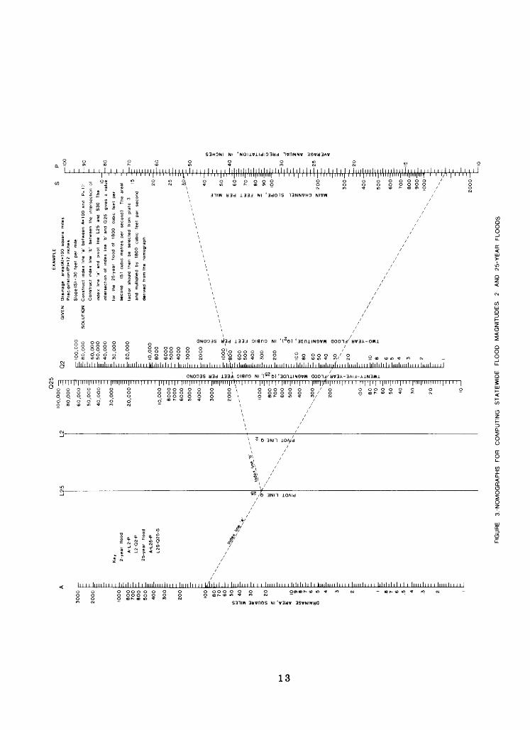
values into the equations and solving. Nomographs (figs. 3, 4,
and 5) are provided that will solve the equation except for the
areal factor (F) which must be applied separately. An example
for determining a 25-year magnitude using the nomograph method
is shown on figure 3.12
L2
5
30
00
20
00
IOO
O
8OO
700
80
0
50
0
400
30
0
IOO
80
70
60
50
40
Key 2-ye
ar
flood
A
-L2-P
L2-O
2-P
25-y
ear
flood
A
-L25
-P
L2
5-Q
25
-S
Q2
100,0
00
80,0
00 -^
60,0
00 -
E;
50,0
00 -E
-
40,0
00 -
^ ^3
0,0
00
-=
20, 0
00 -
E ^1
0,0
00
80
00
70
00
6000 -
50
00
-E -
40
00
-^
30
00
-^ =
20
00
-E
, -
- - "I
.,--
~~
~ -
IOO
O-
800
700 -
600
50
0 -
E
""" x
4
00
~"x^
"^,,300 -
^X
x-x
_E ^200 -
E - ~
100
80
70
60 -
E
50 -
E
40 -
^ ;30 |
20 ~ -_
10
5
(
o z 0
L -
. x_
i! z *
32 1
00,0
00
E-
80
,00
0
6
0,0
00
=- 5
0,0
00
=-
40,0
00
E-
30
,00
0
=-
20
,00
0
E 1
0,0
00
E- 8
00
0
6
00
0
5000
^ 4000
E1 3000
~- 2000
§
E. o
~- I0
0° -
5-E-
'So'
o'
o-
Z- 6
00
lu|-
500
£
i- 40
0 o
E
OD 3
00
3
~
0- ^-
200
?
E.
~E
°=
l00
J
z-8
0
§
6
0
5
r 50
S
1-40
*
^3
0
§i-
~~
x O
I >-
1
0 o
8
*
-
6
r 5
i-
4
3- =-
2
E- i
EX
AM
PLE
GIV
EN
D
rain
age
are
a(A
)*1
00
sq
uare
m
iles
Pre
cipita
tion(P
)"12
inch
es
Slo
pe (
SI
= 30
fe
et
per
mile
SO
LUTI
ON
C
onst
ruct
in
dex
line
'a'
betw
een
A-1
00 a
nd
P= 1
Con
stru
ct
inde
x lin
e 'b
' be
twee
n th
e in
ters
ectio
n
inde
x lin
e 'a
' an
d pi
vot
line
L25
and
S30
Th
e
inte
rsec
tion
of
inde
x lin
e 'b
' an
d O
25
give
s a
vi
for
the
25-y
ear
flood
of
18
00
cubi
c fe
et
per
seco
nd
(51
cubi
c m
etre
s pe
r se
cond
) Th
e ar
e
fact
or
shou
ld
then
be
se
lect
ed
from
p
late
3
and
mul
tiplie
d by
18
00
cubi
c fe
et
per
seco
nd
deriv
ed
from
the
no
mog
raph
60-
70-
50
0-
60
0-
70
0-
80
0-
90
0-
IOO
O-
FIG
UR
E
3.-N
OM
OG
RA
PH
S
FO
R
CO
MP
UT
ING
S
TA
TE
WID
E
FLO
OD
M
AG
NIT
UD
ES
. 2-
AN
D
25-Y
EA
R
FLO
OD
S

L5
30
00
20
00
10
00
800
70
06
00
500
40
0
300
2OO
100
80
70
60
50
40
30
20 10 g 7
<
6£
5 4 3 2 1 8 7 6 5 4 3 2
0 1
- K
ey
~ 5-
year
flo
od
- A
-L5-P
Z L
5-Q
5-P
50-y
ear
floo
d^
A-L
50-P
L50-Q
50-S
'- f- E- jj- [ z. '- E- r ~ _ ; E ^ I. Z. - = =- '^ ^ - '=
'- '=;
-
g o u z o > 0-
Q5
0
50,0
00
40,0
00 -
z
30,0
00 -
^
20,0
00
10,0
00
8000 -
^7
00
0
6000
5000
4000-=I
3000 -
j; -
2000
z ~ - 10
00
800
700
600
50
0-=
400 -
E
300-^ ~
200 -
100
80
70
60
50
40 -
E
30 ~
-
20
r -
10
Q5
1
00,0
00
80,0
00
- 70,0
00
60,0
00
-
50,0
00
40,0
00
-
30,0
00
~
20,0
00
=
10,0
00
80
00
70
00
60
00
50
00
4000
30
00
3 ^-
2000
o-
0
1000
0
^
800
"
700
5 6
00
^ 5
00
w
400
" _
o n
300
~
0
z=
- 20
0 -
E
2~~
1U
o=
r 10
0 §
E- s
o |
70
|
60
o
50
0
40
"
IL <
30
^|
~
>
20
"-=
10
8
7
6
5
4
3
2
FO
R
EX
AM
PL
E
SE
E
FIG
UR
E
3
20
-
25 ±
30-
40-
50-
60^ ;
70 ~
=E
80-S
-
90-=
;
100
-= -
30
0-
400-t
50
0-
800-
90
0-
10
00
-
FIG
UR
E
4-N
OM
OG
RA
PH
S
FO
R
CO
MP
UT
ING
S
TA
TE
WID
E
FLO
OD
M
AG
NIT
UD
ES
5
- A
ND
50
Y
EA
R
FLO
OD
S

SI
DRAINAGE AREA. IN SQUARE MILES N> O"
_ ro o" * w o> -J* o o o. . . _ ro o* * 01 at --J CD o O OOOOOOO o o
* yi (7> ^J CD ro 01 * (Ji ot ^J GO O o OOOOOOO O OOOOOOO O O
2 H 095
PIVOT LINE Q,
PIVOT LINE Q
ro 01 * w o') --Jro 01 -t* <* 0" ^ 00 O O OOOOO
3 O OOOOOOO O OOOOO
I M i 1 1 1 lilllilllllll 1 1 III llllllllll i 1 I 1 1 111 1 1 1 1 1 I llllimliiiil i Mililiilinil i 1
1 1 H[llll[ 1 1 ll|llll|llll| 1 [ 1 |l|l|l[ 1 1 1 I|IIM| 1 1 1 l|lll
° o o o o o o o 2 o o 0 00
Tru-vCAD rl nrtn u Aftu ITI iner in
CDOO
hrrrn
OO
o00
ll"100
IU
ooo
1 1 1 llllllllll
1 1 1 1 lllll{ 1 1 1O> -*J 00 Qooo Xooo g
r.l IDI r cc P T
O O0 0O 0
Illlllllllll
1 | Illlj III
0o0
PCQ ccrr
0O0
Illll
|ii01 0o o
nun
0O0
III
'1
Oo o
o o0 00 0
llTTTTT
O1 0 0 Co c0 C
ooo
III 1 1 Illll
1 ll[l[l[ 1 1 1
3 O O P3 O O O 3 O O O
0
O OO 0O 0
Illlllllllllllll
l|im| M 1 1 1
p pb b0 0 0 0
O O O (O O O (0 0 0 (
Illlllllllll 1
lllllllll 1 1* yi a>000
b b b ooo ooo
3 O O300300
1 Illll
I'l'l'l
00 §oo b oo 2 oo §
O O£ -0
H
zHUNDRED-YEAR FLOOD MAGNITUDE, <O1QQ>. IN CUBIC FEET PER SECOND
MAIN CHANNEL SLOPE, IN FEET PER MILE
ooo000
imlmllmilinillllll 11 11 I I I I I 111 I ill I I 11 I l I I 1 I I i I .WI'.'l'JU'.'JlllllU '.' I '.'.' J I I U .'. I1.1 JU'.UI ).'.1111 1111 [ r]T[r| r|i|r|l|l|l| i 1 i i | I I I i) n i 11 1111| f 11
Ui O OOO
AVERAGE ANNUAL PRECIPITATION, IN INCHES

Substitution of metric values for the variables A, P,
and S will give incorrect solutions. The solution in English
units can be multiplied by 0.02832 to obtain the metric
equivalent in cubic metres per second.
Flood magnitudes for several recurrence intervals can
be plotted on a discharge-versus-recurrence-interval graph
to develop a full frequency curve. Extensions beyond the
100-year flood are not recommended.
LIMITATIONS AND ACCURACY OF ESTIMATING RELATIONS
Flood-frequency relations are applicable to all sites
in Montana where the flood flows are virtually unaffected
by urbanization, regulation, or diversion. The estimating
relations are known to apply only to the range in variables
tested or sampled. The data used to define relations for
estimating included drainage areas ranging from 0.1 square
mile (0.3 square kilometre) to about 2,600 square miles
(6,700 square kilometres). The sample of mean annual
precipitation ranged from 10 to 100 inches (250 to 2,500
millimetres). The range in slope was from 5 to 1,200 feet
per mile (1.5 to 366 metres per kilometre). Streams that
should be excluded are those where a substantial part of the
flow originates outside of Montana.
16

The standard errors of estimate are obtained from
equations developed from data at gaged sites and are
indices of the reliability of results to be expected at
ungaged sites. The standard error, in percent, is the range
of error to be expected as the difference between the
computed and the actual discharges about two-thirds of
the time. The use of logarithms of variables in the
analyses causes the standard errors to be larger in the
positive direction.
17

Approximate standard errors of estimate for defined re
lations are:
Geo graphic area
1
2
3
4
5
6
7
Flood rela- Standard tion estimate
Average Q2 81
Q 5 65
Q10 66
Q 2 66
Q5 67
Q10 72
Q2 86
Q 5 66
Q 10 69
Q 2 90
Q 5 so
Q10 so
Q 2 68
Q 5 61
Qio 61
Q 2 94
Q 5 63
Qi n
Q 2 150
Q 5 HO
QIO 10°
error of , in percent
Range (+109 to -52)
(+85 to -45)
(+86 to -46)
(+86 to -46)
(+87 to -47)
(+95 to -49)
(+117 to -54)
(+86 to -46)
(+90 to -48)
(+125 to -55)
(+108 to -52)
(+108 to -52)
(+89 to -47)
(+78 to -44)
(+78 to -44)
(+132 to -56)
(+81 to -45)
(+78 to -44)
(+230 to -70)
(+159 to -61)
(+142 to -58)
18
Flood rela tion
Q25
QSO
QIOO
Q25
Qso
QIOO
^25
^50
QIOO
Q25
Q50
Q100
Q25
QSO
QIOO
Q25
Q50QIOO
Q25
Qso
QIOO
Standard estimateAverage
72
78
83
82
90
96
76
83
93
83
88
93
64
67
70
66
72
80
98
99
106
error of , in percent
Range (+95 to -49)
(+104 to -52)
(+113 to -53)
(+111 to -53)
(+125 to -55)
(+135 to -57)
(+101 to -51)
(+113 to -53)
(+130 to -56)
(+113 to -53)
(+121 to -55)
(+130 to -56)
(+83 to -45)
(+87 to -47)
(+92 to -48)
(+86 to -46)
(+95 to -49)
(+108 to -52)
(+138 to -58)
(+139 to -59)
(+152 to -60)

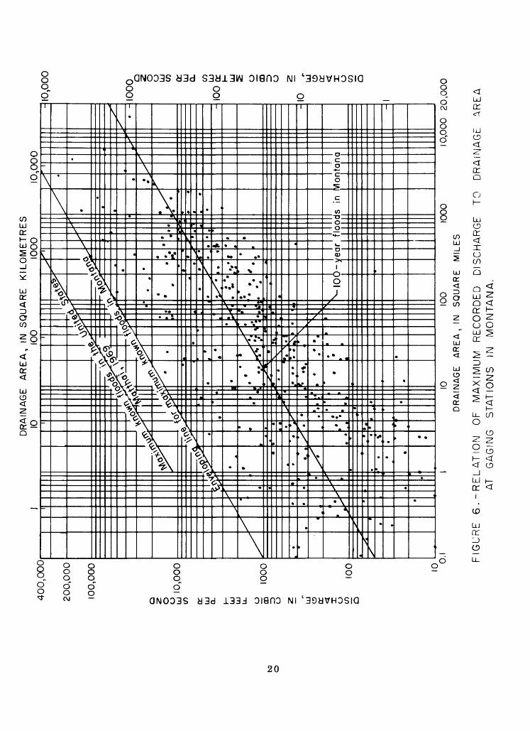
MAXIMUM KNOWN FLOODS
Floods of record at many miscellaneous gaged sites as
well as all gaged sites in Montana are shown in figure 6.
This figure shows the range of maximum flood discharges that
have been experienced on drainage areas from 0.1 square
mile to about 15,000 square miles (0.3 to 39,000 square
kilometres).
Enveloping lines showing the comparison of maximum
floods in Montana with maximum known floods in the United
States (Matthai, 1969) are shown on figure 6. The line
enveloping maximum floods in Montana was constructed with
a 0.5 slope (Jarvis and others, 1936). The line showing
expected 100-year flood peaks in Montana was determined
from a regression study using drainage area as the only
basin characteristic.
19
DISCHARGE, IN CUBIC FEETSECOND
CD d30mCD
i mr~
CD J> J> H2 6CD
CO I J>
0
i 5CO ^
<. m
iSH ~n > Oz: mj> °
oCOo x
CDm
o
o
CDm
m
om
m
COOc
3Dm
CO
DISCHARGE, IN CUBIC METRES

EXAMPLE
The following example illustrates the application of the
design equations. When the flood magnitudes are desired in
metric units (m 3 /s) multiply the answer, in cubic feet per
second, by 0.02832.
Determine the 25-year flood magnitude for a hypothetical
ungaged site tributary to the Milk River near Nashua. Basin
characteristics are assumed as follows :
Drainage area = 100 square miles, of which 30 square
miles are in area 3 and 70 square
miles are in area 6.
Slope = 30 feet per mile.
Average annual precipitation = 12 inches.
Step 1. Enter the total drainage area, slope, and precipitation
values into the 25-year flood nomograph (fig. 3) and solve.
Statewide Q = 1,800 ft 3 /s
Step 2. From plate 3 the areal coefficient for a 25-year
flood is 0.94 for area 3 and 1.94 for area 6. Find the
weighted average areal coefficient (F 2 ) .
(30 x 0.94) + (70 x 1.94) Favg = = L640
At the site, Q25 = 1,800 (1.640) = 2,950 ft 3 /s
= 2,950 (0.02832) = 83.5 m 3 /s
21

FREQUENCY ANALYSIS
Gaging records
Peak-flow data from 422 continuous record and crest-
stage partial-record gaging stations were used in this study
(table 1). Twenty-nine of these stations have 6 to 9 years
of record, 304 stations have 10 to 24 years of record, and
89 stations have 25 or more years of record. Peak-flow
data from 36 stations in adjacent states are included in
table 1.
Flood characteristics
A flood-frequency curve was defined from each gage
record by the log-Pearson Type III method of fitting
frequency curves as suggested by the Water Resources
Council (1967). The mean and standard deviation as com
puted from the logarithms of the annual flood peaks were
used with a regional average skew coefficient to define
station frequency relations listed in table 1.
A graphic plot was prepared for each frequency curve to
visually judge the adequacy of the fit of the computed curve
to the flood data. Use of regional average skew coefficient
greatly reduced the problems frequently encountered with low
and high outliers. Frequency curves for sites with zero-flow
years were computed on basis of only the years with flow and
subsequently adjusted by the Jennings-Benson (1969) method.
22
Regional skew
The use of regional average skew coefficients (Hardison,
1974; Beard, 1974) has been shown to be the best way to
define station frequency curves. Techniques for evaluating
regionalized skew coefficients are not yet fixed and are sub
ject to continued investigation. In this study long-term
stations (25 or more years of record) were used to develop a
regional average skew coefficient for Montana. As a start, a
circle of diameter great enough to encompass 40 or more stations
was considered a region. The mean skew value was determined
for each encircled region. The regions had average skew
values ranging from -0.13 to -0.19 and the statewide average
is -0.15. This report uses a statewide skew coefficient of
-0.15 for determination of all station flood-frequency
relations. The computed frequency curves for all stations
were examined graphically but no changes from average skew
were deemed necessary.
23

REGRESSION ANALYSIS
The regression analysis used a model of the form
Qt = aAb B cCd ...Nm where:
Qt is a flow magnitude, in cubic feet per second, having
a t-year recurrence interval,
a is a constant defined by regression analysis,
b, c, d, and m are coefficients defined by regression
analysis, and
A, B, C,...N are basin characteristics.
Flood magnitudes for selected years of occurrence at
each site were used as the dependent variables and basin char
acteristics were used as the independent parameters. A separate
set of equations was defined for each selected recurrence
interval by step-backwards computer programs. Numerous com
puter runs were made to define a consistent set of equationst
and to test for the practicality of defining different sets
of relations for various divisions of the State.
24

Eight basin characteristics (drainage area, slope of
the main channel, area of lakes and ponds, mean basin eleva
tion, area of forest cover, mean annual precipitation, drain
age area above 6,000 feet, 1,830 metres, and length of the
main channel) were tested for use at the 5 percent level of
significance. Of these parameters drainage area proved to
be the most significant. The next most significant parameters,
slope of the main channel and mean annual precipitation,
were nearly equal in correlative value. Other parameters did
not greatly improve the estimating ability of the relations.
Various tests indicated that separate relations for vari
ous divisions of the State were impractical. From the state
wide relations, the differences in log units between observed
and computed peak values, herein called residuals, were
plotted on a map at their respective station points. Group
ings of similar residual values were then used to divide the
State into areas where like frequency estimates could be
expected. The average of the log residual values for the
selected floods in each area was then converted to a natural
number and is used as an areal correction factor (F) in the
frequency equations. This method simplifies peak computa
tions for the user in that the parameter exponents in the
equations remain the same statewide.
25

The values on page 18 for geographic areas 1-7 show the
standard error of estimate for each area after the respective
areal coefficients are applied. Tabulated below are statewide
values of the standard error of estimate when the regression
equations are supplied without consideration for areal divisions
Geo Flood Floodgraphic rela- Standard error of ' rela- Standard error ofarea tion estimate, in percent tion estimate, in percent
Average Range Average Range
Q 2 109 (+157 to -61) Q 98 (+138 to -58)
State- Q 90 (+125 to -55) Q sn 104 (+148 to -60) i -^ -J\Jwide
Q1Q 91 (+126 to -56) Q / 112 (+162 to -62)
Standard errors of estimate obtained from multiple
regression methods, using the flood characteristics of stations
within each geographic area, are comparable to those obtained
from the presented method, which uses the statewide equations
times an areal multiplier.
The relatively high standard errors of estimate shown in
this report are in some cases misleading. For example, in area
1 there are 102 gaged sites and the 100-year flood shows an
average standard error of estimate of 90 percent. If the three
stations with the highest residuals were not used the standard
error of estimate would be reduced to 69 percent and there
would be negligible changes in the formulas.
26

REFERENCES
Beard, L. R., 1974, Flood flow frequency techniques: Tech.
Rept. CRWR-119, University of Texas, Austin, Tex.
Berwick, V. K., 1958, Floods in eastern Montana -- magnitude
and frequency: U.S. Geol. Survey open-file report, 23 p.
Bodhaine,G. L., and Thomas, D. M., 1964, Magnitude and frequency
of floods in the United States, part 12, Pacific slope
basins in Washington and upper Columbia River basin:
U.S. Geol. Survey Water-Supply Paper 1687, 337 p.
Boner, F. C., and Buswell, G. W., 1970, A proposed streamflow
data program for Montana: U.S. Geol. Survey open-file
report, 96 p.
Boner, F. C., and Omang, R. J., 1967, Magnitude and frequency
of floods from drainage areas less than 100 square miles
in Montana: U.S. Geol. Survey open-file report, 23 p.
Dodge, E. R., 1972, Application hydrologic and hydraulic research
to culvert selection in Montana: Montana State University,
Bozeman, Montana., 2 volumes, 118 p., appendix.
Hardison, C. H., 1969, Accuracy of streamflow charactersitics
in Geological Survey Research, 1971: U.S. Geol. Survey
Prof. Paper 650-D, p. D210-D214.
Hardison, C. H., 1974, Generalized skew coefficients of annual
floods in the United States and their application: Water
Resources Research, vol. 10, no. 4.
27

Jarvis, C. S., and others, 1936, Floods in the United States-
magnitude and frequency: U.S. Geol. Survey Water-Supply
paper 771, 497 p.
Jennings, M. E., and Benson, M. A., 1969, Frequency curves for
annual flood series with some zero events or incomplete
data: Water Resources Research, vol. 5, no.1, Feb. 1969,
p. 276-280.
Matthai, H. F., 1969, Floods of June 1965 in the South Platte
River basin, Colorado: U.S. Geol. Survey Water-Supply
Paper 1850-B, 64 p.
Patterson, J. L., 1966, Magnitude and frequency of floods in
the United States-- Part 6-A, Missouri River basin above
Sioux City, Iowa: U.S. Geol. Survey Water-Supply Paper
1679, 471 p.
Thomas, D. M., and Benson, M. A., 1969, Generalization of
streamflow characteristics: U.S. Geol. Survey open-file
rept., 45 p.
Water Resources Council, 1967, A uniform technique for deter
mining flood-flow frequencies: Water Resources Council
Bull. 15, 15 p.
28

APPENDIX
29

Table 1 .--Drainage-basin and flood-frequency characteristics for selected gaging stations in Montana and adjacent areas.
Basin characteris
\ aj Station Station name Drain- Main ]number Period age channel c
of area slope t«record (mi 2 ) (ft/mi)
06011000 Red Rock River 1936-67 323 16.606011400 Long Creek 1960-67 33.9 65.206011900 Red Rock River tributary 1960-67 1.00 19206013200 Traux Creek 1960-73 4.06 59206013400 Muddy Creek 1960-73 62.7 95.006013500 Big Sheep Creek 1946-73 280 75.206015500 Grasshopper Creek 1921-73 348 46.006016900 Beaverhead River tributary 1960-73 .93 27606017500 Blacktail Deer Creek 1946-64 312 36.506018200 Beaverhead River tributary No. 2 1958-65 .40 78.606019500 Ruby River 1938-73 538 53.306019800 Idaho Creek 1960-73 10.8 26306023500 Big Hole River 1948-53 44.0 80.006024000 Miner Creek 1948-53 17.6 14506025300 Moose Creek 1960-73 41.4 14406025500 Big Hole River 1923-73 2,476 15.406027700 Fish Creek 1959-73 39.5 19706028500 Little Pipestone Creek 1935-40 30.7 21106029000 Whitetail Creek 1949-53 30.8 232
1955-6806030200 Jefferson River tributary 1960-73 1.85 23106030300 Jefferson River tributary No. 2 1958-73 4.50 31706030500 Boulder River 1946-57 19.4 85.206033000 Boulder River 1929-72 381 66.006034000 South Boulder Creek 1926-33 27.5 31006034700 Sand Creek 1960-73 9.41 23306034800 Jefferson River tributary No. 3 1960-73 1.14 30006035000 Willow Creek 1938-73 83.8 13006035500 Norwegian Creek 1938-43 22.4 122
1946-5106036600 Jefferson River tributary No. 4 1960-73 .53 24706036700 Jefferson River tributary No. 5 1960-73 3.69 10006037500 Madison River 1913-73 420 34.206043000 Taylor Creek 1946-67 98.0 13806043200 Squaw Creek 1959-73 40.4 20506043300 Logger Creek 1959-73 2.48 97006043500 Gallatin River 1930-73 825 16.806046500 Rocky Creek 1952-53 49.0 96.0
1959-7306046700 Pitcher Creek 196<J-73 2.33 24506047000 Bear Canyon Creek 1952-53 17.0 256
1959-7306048000 East Gallatin River 1939-61 148 14306048500 Bridger Creek 1945-69 62.5 91.406050000 Hyalite Creek 1934-73 48.2 70.806052500 Gallatin River 1895-1905 1,795 37.8
1928-7306053000 Sixteenmile Creek 1950-55 79.0 43.806055500 Crow Creek 1919-29 78.0 219
1966-7306056200 Castle Creek tributary 1960-73 2.59 30206056300 Cabin Creek 1960-73 12.6 30706056600 Deep Creek 1959-73 87.7 13106058700 Mitchell Gulch 1959-73 8.09 30206061500 Prickley Pear Creek 1908-16 192 157
1923-331945-71
06061700 Jackson Creek 1961-73 3.44 62606061800 Crystal Creek 1961-73 3.77 35506061900 McClellan Creek 1960-73 33.2 21206062500 Tenmile Creek 1914-73 32.7 25306062700 Little Porcupine Creek tributary 1959-73 .48 1,10006063000 Tenmile Creek 1908-54 102 13506071200 Lyons Creek 1959-73 29.4 14406071400 Dog Creek 1960-73 15.9 84.406071600 Wegner Creek 1960-73 35.0 11906073000 Dearborn River 1929-73 123 33.706073050 Dearborn River 1945-69 325 50.306075600 Fivemile Creek 1960-73 6.00 12106076000 Newland Creek 1946-73 6.74 18206076700 Sheep Creek 1960-73 5.22 28106076800 Nugget Creek 1959-73 1.48 59006077000 Sheep Creek 1941-72 54.4 85.406077500 Smith River 1951-69 1,594 20.006077700 Smith River tributary 1960-73 1.44 25506077800 Goodman Coulee 1959-73 21.8 53.706078500 North Fork Sun River 1945-68 258 48.506079600 Beaver Creek 1959-73 20.3 14506080000 Sun River 1904-40 609 42.606081500 Willow Creek 1905-25 96.1 77.906084000 Smith Creek 1945-52 74.0 89.706084500 Elk Creek 1904-24 157 55.406087900 Muddy Creek tributary 1963-73 3.15 28.9
:ics Flood characteristics
lean Discharge, in ft 3 /s mual >re- Recurrence interval, in years, lpl ...... , ........ ... . ition Q 000 00in) 2 ^5 ^10 25 ^50 ^100
22 705 931 1,070 1,240 1,360 1,48018 165 230 - -17 4 8 - -IS 3 19 46 -16 62 119 166 -19 367 519 619 743 83419 375 657 872 1,170 1,410 1,66011 .1 4 13 -16 209 292 346 41210 2 15 - -18 915 1,180 1,340 1,530 1,660 1,79019 20 36 49 -31 482 651 - -34 273 316 - -18 99 141 16923 7,110 10,600 13,100 16,100 18,500 20,80019 126 175 207 24616 21 66 - -21 66 95 114 140
12 .5 7 15 -12 13 39 65 10720 161 285 380 -19 1,090 1,690 2,100 2,640 3,040 3,46041 246 335 - -11 29 222 571 -12 .6 12 38 -27 235 364 454 571 661 75216 22 24 25 -
12 2 6 9 -12 1 31 77 -24 1,330 1,630 1,810 2,020 2,160 2,29040 779 927 1,01035 257 381 466 57430 15 23 28 35 -37 5,000 6,630 7,650 8,870 9,740 10,60027 401 594 725 892
21 15 26 34 -28 146 234 297 381
26 553 828 1,010 1,250 1,43033 295 462 580 735 854 97536 402 541 628 734 810 88427 4,820 6,400 7,390 8,590 9,440 10,300
15 109 379 - -25 525 677 770 881
22 21 31 38 -26 18 26 32 -24 220 309 367 43815 13 61 125 24819 274 414 509 632 724 817
19 11 17 21 -19 10 21 31 -19 136 233 305 -24 225 353 443 562 653 74720 2 5 7 10 -20 262 464 620 837 1,010 1,20027 103 200 279 39513 52 272 600 -17 109 263 411 -37 1,190 2,290 3,190 4,500 5,590 6,78028 2,200 4,130 5,680 7,910 9,75019 16 27 36 -25 13 26 38 54 6829 59 98 128 -29 9 16 22 29 -30 211 300 359 433 487 54123 2,170 4,160 5,780 8,150 10,10015 3 8 13 -15 85 185 272 40242 3,450 5,730 7,420 9,690 11,500 13,30029 137 395 677 1,18042 8,000 14,000 18,600 25,000 30,200 35,60021 195 453 693 1,080 1,43024 544 1,600 2,77021 1,150 2,510 3,740 5,660 7,35013 109 259 403
Maximum of
record
1,3602651528
187909
1,87019
426170
1,70090
938336180
23,000228175126
22169582
3,490434
2,13096
81328
10153
2,1501,020
69029
9,2701,230
60450
1,240902956
9,840
5451,000
4740
445139900
2030
39078116
995490
1,1601,020
17,40015,400
5256
13837
46012,300
30437
51,1004,36059,7001,1506,140
12,000620
30

Table 1.--Drainage-basin and flood-frequency characteristics for selected gaging stations in Montana and adjacent areas--continued
Basin charac
Station Station name Drain- Mail number Period age chani
of area slo record (mi 2 ) (ft/i
teristics Flood characteristics
Mean Discharge, in ft 3 /sannual
i pre- Recurrence interval,lei cipi- 3 e tation Q Q Q Q ni) (in) 2 5 10 25
06088500 Muddy Creek 1934-73 314 15.2 12 638 1,120 1,500 2,02006089300 Sun River tributary 1956-73 21.1 406090500 Belt Creek 1951-73 368 6
3.0 13 80 216 357 604).2 25 1,600 2,810 3,740 5,030
06092000 Two Medicine River 1907-24 317 27.6 36 3,660 6,620 8,930 12,2001951-73
06092500 Badger Creek 1951-73 133 66.0 39 1,850 3,700 5,260 7,58006098000 Dupuyer Creek 1912-37 137 67.3 25 511 1,660 3,000 5,57006099000 Cut Bank Creek 1905-19 1,065 2
1951-735.6 19 1,930 3,700 5,140 7,250
06099500 Marias River 1902-06 2.724 15.9 24 6,770 12,800 17,700 24,8001911-73
in years
Q 50
2,440-
6,07014,900
9,5508,2409,020
30,800
100
2,880--
17,700
11,70010,900
37,200
06099700 Middle Fork Dry Fork Marias River 1960-73 20.2 65.1 19 128 417 75706100200 Heines Coulee tributary 1960-73 .60 506100300 Lone Man Coulee 1960-73 14.1 3
3.0 13 6 17 27 -3.0 13 95 343 657 -
06101600 Marias River tributary No. 3 1962-73 .26 62.0 11 8 19 28 -06101700 Cottonwood Creek tributary 1963-73 2.47 42.0 11 38 68 91 -06101800 Cottonwood Creek tributary No. 2 1963-73 24.6 11.0 11 11 105 259 -06101900 Dead Indian Coulee 1963-73 2.85 9 2.3 11 7 53 -06102000 Marias River 1921-56 5,907 7.30 17 6,510 12,900 18,200 26,000
-32 ,600
-39,900
06102100 Dry Fork Coulee tributary 1959-73 .84 140 12 18 64 119 22806102200 Marias River tributary 1956-73 1.62 150 12 18 57 100 17706102300 Marias River tributary No. 2 1956-73 .25 1806102500 Teton River 1947-54 105 7
3 12 4 12 21 383.5 35 2,030 6,890 - -
06105800 Bruce Coulee tributary 1963-73 1.70 109 14 69 188 312 -06106000 Deep Creek 1911-24 223 1006107000 Blackleaf Creek 1912-24 61.3 706108000 Teton River 1954-73 1,307 2
7 21 912 2,860 5,1003.6 20 135 270 3843.4 18 1,470 4,120 6,940 12,000
--
---
06108200 Kinley Coulee 1963-73 9.67 34.0 13 19 224 756 -06108300 Kinley Coulee tributary 1963-73 2.65 56.5 13 12 73 17306109800 South Fork Judith River 1956-73 58.7 12 <> 21 262 561 824 1,230 - -06109900 Judith River tributary 1960-73 7.15 204 15 13 46 81 -06110000 Judith River 1919-73 328 7 2.8 24 477 764 971 1,240 1,460 1,67006111000 Ross Fork 1946-64 337 40.6 17 564 1,170 1,69006111700 Casino Creek tributary 1960-73 3.14 141 22 17 36 52 -06112100 Cottonwood Creek 1958-73 47.9 8 5.9 29 307 663 978 1,470 -06114500 Wolf Creek 1950-62 112 93.6 25 21 62 109 -06115100 Missouri River tributary 1962-73 3.39 167 12 40 240 580 -06115300 Duval Creek 1963-73 3.31 7 3.0 13 57 141 22206115500 North Fork Musselshell River 1940-73 31.4 131 21 87 163 223 30906117000 Checkerboard Creek 1922-32 23.9 12 2 23 50 104 15106118500 South Fork Musselshell River 1941-73 287 58.7 20 699 1,010 1,210 1,47006120500 Musselshell River 1905-73 1,125 2 8.9 18 1,010 1,920 2,670 3,760
-381
-1,6604,670
-458
-1,8505,660
06120600 Antelope Creek tributary 1956-73 .47 160 15 2 7 12 21 -06120700 Antelope Creek tributary 1956-73 1.92 156 15 58 140 218 34706120800 Antelope Creek tribuary No. 2 1956-73 21.2 506120900 Antelope Creek 1954-73 88.7 6
3.4 13 87 329 643 1,2903.3 14 97 524 1,230 3,000
06122000 American Fork below Lebo Creek 1946-67 166 65.8 19 351 652 893 1,240
-5,2701,520
---
06125500 Careless Creek 1934-42 471 36.1 15 199 289 - - - - '06125700 Big Coulee Creek 1957-73 232 24.4 14 115 388 716 1,36006126300 Currant Creek 1958-73 220 4 3.3 13 140 424 742 1,330 - -06127100 South Willow Creek tributary 1962-73 1.38 93.3 11 107 258 397 -06127200 Musselshell River tributary 1963-73 10.8 606127570 Butts Coulee 1963-73 6.71 3
2.5 11 21 160 4004.2 11 106 232 344
--
--
06128400 South Fork Bear Creek 1962-73 39.6 52.6 16 231 582 92806128500 South Fork Bear Creek tributary 1962-73 5.40 57.1 15 57 115 165 -06128900 Box Elder Creek tributary 1955-73 16.2 2 5.5 13 125 280 421 642 - -06129000 Box Elder Creek 1930-38 684 12.7 14 1,500 3,170 4,620 6,850
1958-7306129100 North Fork McDonald Creek trib. 1960-73 2.24 223 20 12 24 33 -06129200 Alkali Creek 1960-73 3.76 222 18 25 105 218 -06129400 South Fork McDonald Creek trib. 1963-73 .51 650 17 16 28 - -06129500 McDonald Creek 1931-73 421 2 5.0 18 338 696 1,000 1,470 1,870 2,31006129700 German Coulee 1955-73 2.32 29.2 13 75 255 472 89806129800 German Coulee tributary 1955-73 .81 29.6 13 42 133 237 43306130600 Cat Creek 1958-73 36.5 3 1.1 13 94 214 322 496 -06130700 Sand Creek 1957-67 317 17.2 11 761 1,810 ... -06130800 Second Creek tributary 1958-73 .52 83.3 11 22 69 119 20406130850 Second Creek tributary No. 2 1958-73 2.08 62.9 11 33 112 207 39306130900 Second Creek tributary No. 3 1958-72 .72 2506130950 Little Dry Creek 1958-73 1,224
4 11 18 49 80 1339.40 11 1,780 3,070 4,040 5,370
06131000 Big Dry Creek 1939-69 2,554 19.3 11 3,220 8,040 12,800 20,60006132200 South Fork Milk River 1961-73 68.6 10 3 36 514 1,410 2,350
--
28,000-
-
36,600
06132250 Livermore Creek 1962-67 25.0 92.7 28 460 1,620 -06132400 Dry Fork Milk River 1962-73 17.4 67.0 28 233 684 1,18006132700 Milk River 1906-08 325 29.6 24 1,650 3,840 5,890 9,190
19111913-171919
1923-2419271929-301961-67
12,200 -
Maximum of
record
7,600470
11,000100,000
49,70021,60016,600
241,000
4,24064
1,7403296
220220
70,10024430042
54,600390
41,800600
71,3002,070
4651,340
1041,1202,640
661,220
6281,950
340423167
1,3304,530
68307
3,23024,4001,570
4102,4001,620
510380488
1,490185
1,0309,910
3675742
1,440810380748
4,410334760458
5,20024,60012,0004,8801,880
17,300
31
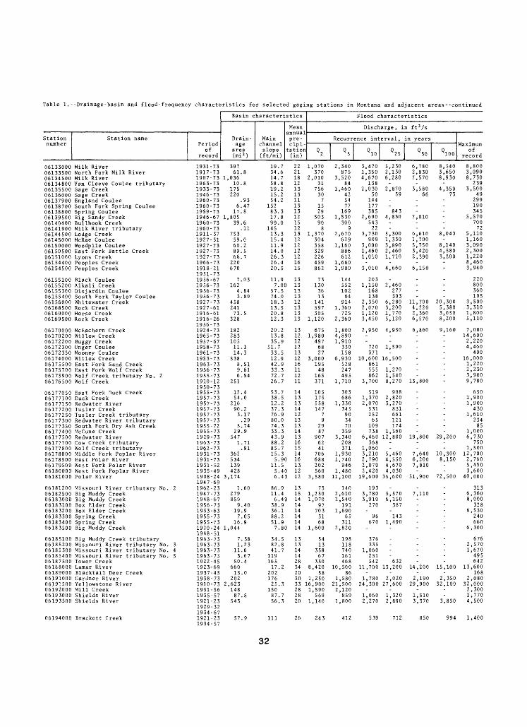
Table 1.--Drainage-basin and flood-frequency characteristics for selected gaging stations in Montana and adjacent areas--continued
Basin character
Station Station name Drain- Mainnumber Period age channel
of area sloperecord (mi 2 ) (ft/mi)
06133000 Milk River 1931-73 397 19.706133500 North Fork Milk River 1917-73 61.8 34.606134500 Milk River 1907-73 1,036 14.706134800 Van Cleeve Coulee tributary 1963-73 10.8 58.806135500 Sage Creek 1933-73 175 19.206136000 Sage Creek 1946-73 220 15.206137900 England Coulee 1960-73 .93 54.206138700 South Fork Spring Coulee 1960-73 6.47 15206138800 Spring Coulee 1959-73 17.8 83.306139500 Big Sandy Creek 1946-67 1,805 17.806140400 Bullhook Creek 1960-73 39.6 99.006141900 Milk River tributary 1960-73 .11 145
istics Flood characteristics
Mean Discharge, in ft 3 /sannual pre- Recurrence interval, in yearscipi- ____
tation Q Q Q Q Q( in ) *2 *S y !0 y 25 y 50
22 1,070 2,340 3,470 5,230 6,78021 370 875 1,350 2,130 2,83018 2,010 3,520 4,670 6,280 7,57012 31 84 13813 756 1,460 2,030 2,870 3,58013 30 42 50 59 6611 7 54 14413 15 77 17713 29 169 385 84312 503 1,530 2,690 4,830 7,01015 90 300 54312 8 9 22 -
06144500 Lodge Creek 1911-37 753 13.3 13 1,370 2,670 3,730 5,300 6,61006145000 McRae Coulee 1927-51 59.0 15.406150000 Woodpile Coulee 1927-73 60.2 11.906150500 East Fork Battle Creek 1927-73 89.5 14.0
12 304 629 909 1,330 1,70012 358 1,160 3,000 3,890 5,75012 329 886 1,460 2,460 3,420
06151000 Lyons Creek 1927-73 66.7 26.3 12 226 612 1,010 1,710 2,39006154400 Peoples Creek 1966-73 220 26.406154500 Peoples Creek 1918-21 670 20.5
1951-7306155100 Black Coulee 1956-67 7.03 11.906155200 Alkali Creek 1956-73 162 7.006155300 Disjardin Coulee 1956-73 4.84 57.506155400 South Fork Taylor Coulee 1956-73 3.89 74.006156000 Whitewater Creek 1927-73 458 18.306168500 Rock Creek 1927-61 241 13.506169000 Horse Creek 1916-61 73.5 20.806169500 Rock Creek 1916-26 328 12.3
1956-7306170000 McEachern Creek 1924-73 182 20.206170200 Willow Creek 1965-73 283 13.8
16 459 1,66015 862 1,980 3,010 4,660 6,150
13 73 144 2030 13 130 552 1,150 2,460
13 36 102 168 27713 13 64 138 30312 141 914 2,350 6,280 11,70013 597 1,360 2,070 3,200 4,22013 305 725 1,120 1,770 2,36013 1,120 2,360 3,450 5,120 6,570
13 675 1,800 2,950 4,950 6,86012. 1,980 4,890
Q100
8,5403,6508,930
-4,350
73------
8,040-
8,1404,5803,200--
----
20,3005,3803,0508,200
9,160-
06172200 Buggy Creek 1957-67 105 35.9 12 497 1,910 -06172300 Unger Coulee 1958-73 11.1 51.7 12 68 330 720 1,590 -06172350 Mooney Coulee 1961-73 14.3 33.5 13 27 158 371 -06174000 Willow Creek 1953-73 538 12.9 12 3,000 6,930 10,600 16,500 -06175500 East Fork Sand Creek 1963-73 8.51 42.9 16 195 528 861 -06175700 East Fork Wolf Creek 1956-73 9.61 33.3 11 48 247 555 1,27006175900 Wolf Creek tributary No. 2 1955-73 6.54 72.7 12 165 495 862 1,54006176500 Wolf Creek 1910-12 251 26.7 11 371 1,710 3,700 8,270 13,800
1950-7306177050 East Fork Duck Creek 1955-73 12.4 53.7 14 105 303 519 908 -06177100 Duck Creek 1957-73 54.0 38.5 13 175 686 1,370 2,82006177150 Redwater River 1957-73 216 12.206177200 Tusler Creek 1957-73 90.2 37.3
13 558 1,330 2,070 3,27014 147 345 531 831 -
06177250 Tusler Creek tributary 1957-73 3.17 76.9 12 7 90 252 66106177300 Redwater River tributary 1957-73 .29 80.006177350 South Fork Dry Ash Creek 1955-72 5.74 74.306177400 McCune Creek 1955-73 29.9 33.3
13 9 34 65 12113 29 70 109 17414 87 359 738 1,560
06177500 Redwater River 1929-73 547 43.9 13 907 3,340 6,460 12,800 19,80006177700 Cow Creek tributary 1963-73 1.71 88.206177800 Wolf Creek tributary 196.2-73 .91 85.706178000 Middle Fork Poplar River 1931-73 362 15.306178500 East Polar River 1931-73 534 5.9
16 62 208 36815 41 371 1,06014 706 1,930 3,210 5,460 7,640
0 16 688 1,740 2,790 4,550 6,200
--
29,200
-10,3008,150
06179500 West Fork Polar River 1931-52 139 11.5 13 202 946 2,070 4,670 7,81006180000 West Fork Poplar River 1935-49 428 5.40 12 560 1,480 2,420 4,03006181000 Polar River 1908-24 3,174 6.4
1947-693 12 3,580 11,100 19,600 35,600 51,900 72,500
06181200 Missouri River tributary No. 2 1962-23 1.60 86.9 13 73 140 19306182500 Big Muddy Creek 1947-73 279 11.4 15 1,250 2,610 3,780 5,570 7,110 -06183000 Big Muddy Creek 1948-67 850 6.40 14 1,070 2,540 3,910 6,15006183100 Box Elder Creek 1956-73 9.40 38.9 14 97 191 270 387 -06183200 Box Elder Creek 1953-63 19.9 36.1 14 703 1,690 -06183300 Spring Creek 1955-73 7.05 88.2 14 31 65 96 14306183400 Spring Creek 1955-73 16.9 51.9 14 68 311 670 1,49006183500 Big Muddy Creek 1920-24 1,044 7.80 14 1,600 2,820 -
1948-5106185100 Big Muddy Creek tributary 1963-73 7.38 34.5 13 54 198 376 -06185200 Missouri River tributary No. 3 1963-73 1.23 82.806185300 Missouri River tributary No. 4 1963-73 11.6 41.706185400 Missouri River tributary No. 5 1963-73 3.67 11906187500 Tower Creek 1922-45 50.4 165
13 13 118 33514 358 740 1,06014 67 161 25128 350 468 542 632
06168000 Lamar River 1923-69 660 17.2 34 8,420 10,500 11,700 13,200 14,20006189000 Blacktail Deer Creek 1937-45 15.0 20206191000 Gardner River 1938-73 202 176
20 58 8630 1,250 1,580 1,780 2,020 2,190
06191500 Yellowstone River 1910-73 2,623 25.3 33 16,900 21,500 24,300 27,600 29,90006192000 Mill Creek 1951-56 148 150 28 1,590 2,120
----
15,100
2,35032,100
06193000 Shields River 1935-57 87.8 87.7 28 569 859 1,060 1,320 1,51006193500 Shields River 1921-23 543 56.3 20 1,140 1,800 2,270 2,890 3,370
1929-321934-67
06194000 Brackett Creek 1921-23 57.9 1111934-57
26 243 412 539 712 850
3,850
994
Maximum of
record
8,8003,0908,730
2393,500
49299190345
5,57070072
5,1101,1603,0902,3001,2208,4603,940
220800360105
3,5003,3101,8005,110
7,08014,6002,2204,460
40016,0001,2202,2303,9009,780
6501,9001,900
4301,610
23485
1,0006,730
7501,500
12,7002,7605,4503,600
40,000
3136,3608,000
3286,530
240660
6,300
6762,5701,670
495642
13,600168
2,08032 ,0002,3001,7704,500
1,400
32

rable 1.--Drainage-basin and flood-frequency characteristics for selected gaging stations in Montana and adjacent areas continued
Basin characteris
1 , a Station Station name Drain- Mainnumber Period age channel
of area slope trecord (mi 2 ) (ft/mi)
06197000 Big Timber Creek 1912-24 74.9 30406197500 Boulder River 1910-16 226 104
1950-7306199000 West Fork Boulder River 1907-14 135 10706200000 Boulder River 1947-73 523 55.606200500 Sweet Grass Creek 1913-24 63.8 106
1937-7306201000 Sweet Grass Creek 1907-24 143 70.4
1937-421946-52
06201550 Yellowstone River tributary 1960-73 2.72 17306201600 Bridger Creek 1960-73 61.5 10306201650 Work Creek 1959-73 32.5 11106201700 Hump Creek 1960-73 7.61 13106201750 Berry Creek 1958-73 23.5 80.206204050 West Rosebud Creek 1965-73 52.1 18606204500 Rosebud Creek 1935-69 394 12306205000 Stillwater River 1910-14 975 73.3
1935-7306205100 Alien Creek 1961-73 7.17 10006207500 Clarks Fork Yellowstone River 1921-73 1,154 76.306207540 Silver Tip Creek 1967-73 88.0 51.906209500 Rock Creek 1934-73 124 24306210000 West Fork Rock Creek 1937-56 63.1 19506211000 Red Lodge Creek 1937-73 143 98.006211500 Willow Creek 1937-73 53.3 91.106215000 Pryor Creek 1921-24 39.6 208
1966-7306216200 Wets Creek 1955-73 8.80 92.506216300 West Buckeye Creek 1955-73 2.64 12106216500 Pryor Creek 1912-24 435 42.9
1938-7306217700 Crooked Creek tributary 1962-73 7.21 97.206217750 Fly Creek 1968-73 285 10.706217800 Yellowstone River tributary No. 2 1962-73 .66 17206287500 Soap Creek 1939-53 98.3 282
1967-7306288200 Beauvais Creek 1967-73 100 70.206289000 Little Bighorn River 1939-73 193 26606290000 Pass Creek 1935-56 111 12706290500 Little Bighorn River 1939-73 428 15706291000 Owl Creek 1939-45 161 28.906291500 Lodgegrass Creek 1939-73 80.7 23806294000 Little Bighorn River 1912-24 1,294 23.7
1928-321938-60
06294400 Andresen Coulee 1963-73 2.35 80.006294800 Unknown Creek 1962-73 14.6 47.306294850 Buckingham Coulee 1962-73 2.63 97.106294900 Middle Fork Froze to Death Creek 1962-73 1.36 10706295020 Short Creek 1962-73 3.23 10506295050 Little Porcupine Creek 1958-73 614 7.2006295100 Rosebud Creek 1960-73 34.2 20.906295130 Rosebud Creek tributary 1963-73 1.14 12006295200 Whitedirt Creek 1959-73 1.58 16806296000 Rosebud Creek 1948-69 1,279 13.706296100 Snell Creek 1963-73 10.5 70.306306900 Spring Creek 1958-73 34.7 45.506306950 Leaf Rock Creek 1960-73 4.53 12506307640 Spring Creek 1962-73 1.56 83.306307660 Walking Horse Creek 1963-73 3.33 87.206307760 Stebbins Creek 1963-73 5.41 -J.7806307780 Stebbins Creek 1963-73 20.8 76.906308200 Basin Creek tributary 1955-73 .14 71.406308300 Basin Creek 1955-73 10.9 40.006309020 North Fork Sunday Creek trib. 1963-73 .96 60.906309040 Dry House Creek 1963-73 35.6 16.006309060 North Fork Sunday Creek trib. No. 2 1962-73 .22 79.406309080 Deep Creek 1962-73 11.5 40.806309090 Ash Creek 1962-73 6.23 57.006324700 Sand Creek 1955-73 10.6 48.006326400 Myers Creek 1962-73 9.42 62.006326600 O'Fallon Creek 1962-73 669 8.9006326650 O'Fallon Creek tributary 1962-73 .17 75.006326700 Deep Creek 1962-73 1.55 34.806326800 Pennel Creek 1962-73 1.00 28.606326900 Yellowstone River trib. No. 4 1962-73 .67 11606326950 Yellowstone River trib. No. 5 1962-73 .82 10906327700 Griffith Creek 1955-61 15.5 69.806327800 Krug Creek tributary 1955-67 1.74 66.7
tics Flood characteristics
4ean Discharge, in ft 3 /s inual - -ire- Recurrence interval, in years;ipl- ,.,,,,
ition Q Q Q Q Q Qin ) 2 5 10 25 50 100
25 697 1,180 1,54037 3,660 4,260 4,600 5,000 5,250 5,490
28 1,620 1,810 - ...30 5,900 7,210 7,980 8,860 9,480 10,10033 941 1,290 1,500 1,770 1,970 2,160
15 983 1,560 1,970 2,510 2,930 3,360
15 8 23 38 -19 165 514 914 -16 86 350 688 1,34015 34 88 141 -13 6 126 508 1,93055 701 993 - -32 2,360 3,270 3,850 4,580 5,100 5,62032 6,620 8,310 9,330 10,500 11,300 12,100
13 72 269 515 99017 7,570 9,050 9,900 10,900 11,500 12,2008 316 1,010 -
40 1,230 1,720 2,040 2,440 2,720 3,01038 515 672 886 96922 552 1,120 1,610 2,34020 238 496 719 1,060 1,350 1,68017 135 279 402 -
14 128 223 295 39514 80 189 291 45715 671 1,170 1,560 2,090 2,520 2,970
14 302 973 1,76013 838 2,380 -12 -> .2 4 14 -18 467 1,030 1,550 2,350 3,070
15 636 1,210 -20 1,060 1,470 1,730 2,060 2,290 2,52022 330 574 759 1,02020 1,330 2,030 2,510 3,140 3,610 4,09015 292 639 - -22 440 620 737 883 990 1,10016 2,180 3,550 4,540 5,860 6,900
12 7 19 31 -13 118 422 805 -13 27 88 15712 95 180 24812 165 510 90313 1,540 3,070 4,350 6,25016 113 228 322 -14 4 8 12 -14 8 25 42 72 -15 404 676 877 1,15013 123 255 369 -14 116 413 774 1,47015 77 176 26712 137 312 472 -12 2 23 54 -15 4 12 23 -14 111 295 48314 22 64 110 19014 165 521 931 1,70012 8 20 31 -12 170 625 1,21012 55 120 17812 796 1,610 2,30014 31 124 25014 36 125 233 44712 254 534 778 -14 1,530 2,530 3,27013 36 55 67 -14 115 167 202 -14 65 130 184 -12 92 211 322 -12 10 36 65 -13 133 641 - -13 4 34 - -
Maximum of
record
1,9605,590
1,9909,8402,270
3,000
552,680
720307
2,0001,4705,790
12,000
1,58010,9001,1003,110
9332,2601,720
575
565924
3,720
5,1202,680
224,170
1,6002,7301,1503,6301,0201,1304,520
40800398463938
9,3505401045
3,000380
1,400222
2,0805839
57039099039
1,500320
2,4301,400
7151,3704,100
61225350338127
14,60070
33
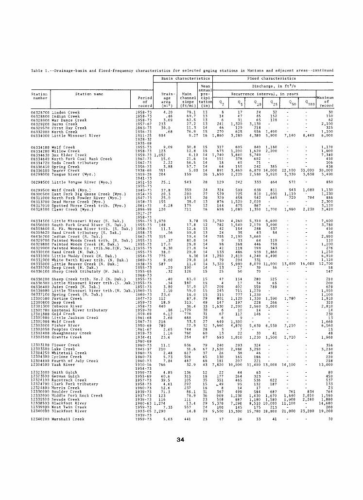
Table 1.--Drainage-basin and flood-frequency characteristics for selected gaging stations in Montana and adjacent areas--continued
Basin characl
Station Station name Drain- Mair number Period age chanr
record (mi 2 ) (ft/n
eristics ' Flood characteristics
Mean Discharge, in ft*/sannual
i pre- Recurrence interval,lei cipi-
li) (in) 2 5 10 25
in years
Q 50 Q l
06328700 Linden Creek 1958-73 4.20 78.1 13 8 17 24 32 -06328800 Indian Creek 1958-73 .46 69.7 13 14 47 85 15206328900 War Dance Creek 1958-73 3.69 62 .5 13 6 31 65 128 -06329200 Burns Creek 1957-67 233 27.2 13 241 1,320 3,13006329570 First Hay Creek 1963-73 30.0 1106332900 North Creek 1956-73 .68 76
.3 14 46 129 218
.9 15 270 625 956 1,49006334000 Little Missouri River 1911-25 904 9.27 16 1,860 3,280 4,380 5,900
1928-321935-69
-
Maximum of
00 record
3015062
2,100325
1,1007,140 8,440 6,000
06334100 Wolf Creek 1955-73 9.09 30.8 15 317 605 840 1,18006334200 Willow Creek 1958-73 123 12 .8 15 673 1,200 1,620 2,200 -06334630 Box Elder Creek 1959-73 1,092 6.10 14 1,740 3,840 5,74006334640 North Fork Coal Bank Creek 1962-73 15.0 21.6 14 151 378 602 -06334720 Soda Creek tributary 1962-73 2.22 56.5 14 18 45 71 -06336450 Spring Creek 1956-73 3.88 5706336500 Beaver Creek 1938-69 351 5
.7 14 64 155 242 385
.00 14 891 3,460 6,870 14,00006298000 Tongue River (Wyo.) 1919-29 204 159 26 1,650 2,220 2,580 3,020
1941-7306298500 Little Tongue River (Wyo.) 1951-53 25.1 543 20 129 242 333 464
1955-7306299500 Wolf Creek (Wyo.) 1945-73 37.8 350 24 324 509 639 81106300500 East Fork Big Goose Creek (Wyo.) 1954-73 20.3 200 27 529 725 850 1,00006311000 North Fork Powder River (Wyo.) 1947-73 25.0 103 20 329 458 542 645
-22,100 33,0
1,1701,8007,340
450106438
00 30,0003,330 3,630 3,400
572 850
943 1,080 1,1301,110 1,230
720 794 88606313700 Dead Horse Creek (Wyo.) 1958-73 155 38.0 13 876 1,520 2,02006317050 Spotted Horse Creek trib. (Wyo.) 1961-73 4.28 175 12 144 475 86706318500 Clear Creek (Wyo.) 1896-99 120 211 16 698 1,080 1,350 1,700
1917-271958-73
2,3003,120
1,960 2,230 3,420
06334500 Little Missouri River (S. Dak.) 1956-73 1,970 3.78 15 2,750 4,260 5,310 6,69006356000 South Fork Grand River (S. Dak.) 1955-73 148 17 .8 12 782 1,540 2,170 3,09006358600 S. Fk . Moreau River trib. (S. Dak.) 1958-73 11.3 12.6 13 42 154 288 53706358620 Sand Creek tributary (S. Dak.) 1958-73 .06 50.0 13 24 35 43 54 -06436700 Indian Creek (S. Dak.) 1962-73 315 10.4 14 795 2,190 3,66006329700 Painted Woods Creek trib. (N. Dak.) 1955-73 .37 80 .0 14 9 33 64 12906329800 Painted Woods Creek (N. Dak.) 1955-73 17.0 25.0 14 98 268 446 75806329900 Painted Woods Cr. trib.No.2(N. Dak.)1955-73 8.30 21 .0 14 42 118 199 34306330100 Sand Creek (N. Dak.) 1955-73 38.0 20.0 14 133 486 939 1,86006331000 Little Muddy Creek (N. Dak.) 1954-73 775 8 .30 14 1,250 2,810 4,240 6,490 -06331900 White Earth River trib. (N. Dak.) 1960-73 9.60 29.0 14 79 204 331 -06335000 Little Beaver Creek (N. Dak.) 1938-73 587 11 .4 14 3,320 5,990 8,070 11,000 13,400 16,006335700 Deep Creek (N. Dak.) 1955-73 .29 190 14 13 '27 39 56 -06336100 Sheep Creek tributary (N. Dak.) 1955-65 .32 126 15 25 50 70 -
1968-7306336200 Sheep Creek trib. No . 2 (N. Dak.) 1955-73 .40 83.0 15 47 154 280 52506336300 Little Missouri River trib.(N. Dak.)1955-73 .34 180 15 4 17 34 65 -06336400 Jules Creek (N. Dak.) 1955-73 3.80 35.0 15 209 402 559 78906336980 Little Missouri River trib.fN. Dak.)1960-73 2.10 59.0 15 245 711 1,220 06337100 Spring Creek (N. Dak.) 1960-73 23.0 18.0 15 315 777 1,23012300500 Fortine Creek 1947-73 112 87 .6, 29 801 1,120 1,330 1,590 1,78012300800 Deep Creek 1959-73 18.9 3111 ' 49 147 197 228 26612301300 Tobacco River 1958-73 440 36 .4 33 1,630 2,200 2,560 3,000 -12301700 Kootenai River tributary 1959-70 .86 1,729 30 ' 6 10 14 -12301800 Gold Creek 1959-69 6.12 776 31 67 112 146 -12301900 Little Jackson Creek 1961-68 2.60 688 29 6 912301999 Wolf Creek 1967-73 216 3312302000 Fisher River 1950-69 780 2212302050 Peoples Creek 1961-67 2.65 74412302400 Shaughnessy Creek 1959-73 1.16 76012302500 Granite Creek 1934-41 23.6 254
1960-69
.5 27 649 1,300
.9 32 3,660 4,870 5,630 6,55028 3 7 - -60 13 22 30 4167 693 1,010 1,230 1,500
-7,210--
1,710
12303100 Flower Creek 1960-73 11.1 636 79 240 293 324 -12303500 Lake Creek 1945-57 210 31 .6 67 2,520 2,980 3,250 _12304250 Whitetail Creek 1960-73 2.48 617 37 26 "38 4612304300 Cyclone Creek 1960-73 5.73 506 65 130 165 186 -12304400 Fourth of July Creek 1960-73 7.84 487 68 181 207 221 -12304500 Yaak River 1910-16 766 32
1954-7312323300 Smith Gulch 1959-73 4.85 13612323500 German Gulch 1955-69 40.6 31512324100 Racetrack Creek 1957-73 39.5 10512324700 Clark Fork tributary 1958-73 4.61 29212324800 Morris Creek 1960-73 12.6 23712330000 Boulder Creek 1939-73 71.3 89
.9 43 7,820 10,000 11,400 13,000
12 22 44 6318 177 264 32335 351 465 536 62215 .,49 95 132 18718 8 14 17 -
.1 31 367 499 584 68712332000 Middle Fork Rock Creek 1937-73 123 78.9 36 909 1,230 1,430 1,67012335500 Nevada Creek 1939-73 116 111 23 508 887 1.180 1.58012338500 Blackfoot River 1940-63 1,274 13.4 29 5,370 7,290 8^510 lO'.OOO12339900 West Twin Creek 1959-73 7.33 557 24 100 145 175 21312340000 Blackfoot River 1903-05 2,290 14.8 29 9,500 13,300 15,700 18,800
1939-7312340200 Marshall Creek 1959-73 5.63 441 23 17 26 33 41
14,100
-----761 8
7,6003,780
45064
2,690110
1,200276
1,2506,9101,120
00 12,70058
147
210200629
1,050 1,1001,810
3102,810
1423013
1,6606,560
1548
1,960
3563,250
49220258
13,400
8045053713323
34 7641,840 2,010 1,5901,900 2,2
11,100-
40 1,80014,600
20021,000 23,200 19,200
- 50
34

Table 1.--Drainage-basin and flood-frequency characteristics for selected gaging stations in Montana and adjacent areas--continued
Station number
123405001234100012343400123443001234580012346500
1234750012348500
12350000
1235020012350500
12351000
123514001235200012352200123S34001235380012353850123S4000
123541001235500012356000
1235650012357000
123573001235740012358500123S9000
123595001235980012360000
1236050012361000
12361500
12363900123650001236600012370500123709001237090012371100
123743001237570012389500
123907001230S500123108001231680012321000
1239210012392300124110001241310012413200
0501000005010500OS011000050115000501200005012500050130000501400005014500
Basin characteris
, , a Station name Drain- Main
Period age channel
record (mi 2 ) (ft/mi)
Clark Fork 1929-73 5,999 14.7Rattlesnake Creek 1908-67 79.7 135East Fork Bitterroot River 1956-73 381 67.9Burke Gulch 1958-73 6.50 423Camas Creek 1958-73 5.05 771Skalkaho Creek 1946-53 87.8 186
1957-73Blodgett Creek 1946-69 26.4 172Willow Creek 1920-23 22.4 551
1958-73Bear Creek 1938-54 26.8 278
1957-59Gash Creek 1958-73 3.37 1,071Kootenai Creek 1948-53 28.9 302
1958-73Burnt Fork Bitterroot River 1920-24 74.0 171
1938-73Eightmile Creek 1958-73 20.6 302Lolo Creek 1950-60 250 47.4Hays Creek 1959-73 4.16 516Nigger Gulch 1959-73 8.02 580Thompson Creek 1961-73 12.2 416East Fork Timber Creek 1961-73 2.72 590St. Regis River 1910-17 303 45.0
1958-73North Fork Little Joe Creek 1960-73 14.7 227Flathead River 1929-73 450 31.7Skyland Creek 1946-54 8.37 266
1959-73Bear Creek 1946-52 20.7 215Middle Fork Flathead River 1939-53 510 36.7
1956-64Moccasin Creek 1959-73 2.38 1,610Middle Fork Flathead River trib. 1960-73 .14 356Middle Fork Flathead River 1939-73 1,128 11.7South Fork Flathead River 1948-57 958 25.3
1959-67Spotted Bear River 1948-56 184 64.6South Fork Flathead River 1964-73 1,160 21.2Twin Creek 1948-56 47.0 121
1964-67Lower Twin Creek 1948-66 22.4 128Sullivan Creek 1948-56 71.3 124
1959-73Graves Creek 1948-56 27.0 328
1964-67Rock Creek 1961-73 3.61 846Stillwater River 1931-50 524 19.8Whitefish Creek 1928-50 170 52.3Dayton Creek 1959-73 20.9 175Teepee Creek 1960-73 2. 55 900Teepee Creek 1960-73 2.55 900Hellroaring Creek 1917-32 6.22 748
1948-67Mill Creek 1959-73 28.2 254Garden Creek 1959-73 3.29 543Thompson River 1911-16 642 21.9
1956-73Prospect Creek 1956-73 182 118Boulder Creek (Idaho) 1928-73 53.0 152Trail Creek (Idaho) 1961-73 16.1 472Mission Creek (Idaho) 1959-73 23.0 288Smith Creek (Idaho) 1928-60 70.0 156
1962-73Trapper Creek (Idaho) 1962-73 1.12 1,590Pack River (Idaho) 1959-73 124 132Coeur d'Alene River (Idaho) 1951-73 335 37.0Boulder Creek (Idaho) 1961-73 3.13 793Montgomery Creek (Idaho) 1962-73 4.53 548
Belly River 1947-64 74.8 42.1North Fork Belly River 1946-55 10.1 212Belly River 1912-73 121 23.7Waterton River 1947-64 61.0 74.7Street Creek 1948-55 6.00 626Boundary Creek 1948-61 21.0 190Waterton River 1948-73 238 27.6Grinnell Creek 1947-64 3.47 1,560Swiftcurrent Creek 1912-73 31.4 283
tics Flood characteristics
Mean Discharge, in ft 3 /snnual pre- Recurrence interval, in yearscipi- ation Q Q 0 Q Q Q( in ) 2 y 5 10 X 25 50 100
30 14,600 21,200 25,700 31,300 35,500 39,70034 1,420 1,940 2,28032 2,310 3,250 3,860 4,62020 7 12 16 22 -75 147 209 249 30036 635 821 935 1,070 ' 1,170
73 623 741 808 885 93733 104 137 157 181
76 696 893 1,010
70 108 159 192 23576 804 1,060 1,210 1,440 1,530
32 337 506 622 770 881 993
20 52 75 90 11052 1,520 1,840 2,02033 9 24 37 -33 34 69 99 14343 68 117 154 -58 37 53 64 -52 4,070 5,960 7,220 8,820 10,000
56 180 233 265 -55 7,570 10,700 12,800 15,400 17,300 19,20047 177 333 457 637 785
51 627 1,590 -52 10,100 16,200 20,600 26,500 31,100
57 116 201 266 -39 2 5 8 -59 21,800 31,200 37,400 45,100 50,800 56,50052 16,300 20,900 23,700 27,100
56 4,480 7,160 9,08052 21,100 29,200 34,50053 1,570 2,440 3,050
56 656 865 - -60 1,920 2,570 2,980 3,470 3,820
67 1,310 1,890 2,270
35 14 21 26 -31 1,600 2,560 3,240 4,150 4,86037 829 1,090 1,260 1,460 1,60020 36 63 85 114 138 16352 10 19 26 -52 10 19 26 -48 28 58 83 120 153 188
27 97 173 233 31719 28 50 66 88 -41 2,880 4,370 5,400 6,720
54 1,760 2,350 2,720 3,16040 1,300 1,710 1,950 2,250 2,460 2,67032 175 256 310 -25 341 438 497 56650 1,940 2,520 2,880 3,310 3,620 3,910
47 34 44 50 -47 2,500 3,090 3,440 3,84053 6,210 8,200 9,440 10,900 12,00051 96 126 144 -48 74 122 157 -
79 1,700 2,750 3,510 4,54075 245 338 - -65 1,970 2,830 3,400 4,110 4,640 5,16084 2,360 3,470 4,220 5,16080 253 739 - -75 622 1,050 1,370 1,80068 4,750 6,830 8,200 9,930 11,200 12,50095 181 244 283 331 36595 1,030 1,400 1,640 1,930 2,140 2,340
Maximum of
record
31,7002,4004,000
25265
1,210
836170
1,340
2001,300
1,100
1042,430
5617019066
11 ,000
26216,3003,580
8,38075,300
490490
140,00036,700
20,20050,9005,830
1,2005,020
3,780
294,3301,400
1314444
104
250100
6,190
2,8602,720
341528
3,810
524,370
11,900144155
12,000416
16,40012 ,4005,7405,930
25,700536
6,700
35