Embed Size (px)
Citation preview
V
::,
0
w
...
I-
c(
Maps of the Surficial Geology and Depth to Bedrocl< of False Bay, Friday Harbor,
Richardson, and Sha\N Island 7 .5-minute Quadrangles,
San Juan County, Washington
by David P. Dethier, Daniel P. White, and Christopher M. Brookfield
WASHINGTON DIVISION OF GEOLOGY
AND EARTH RESOURCES
Open File Report 96-7 November 1996
WASHINGTON STATE DEPARTMENTOF
Natural Resources Jennifer M. Belcher Commissioner of Public Lands Kaleen Cottingham - Supervisor

Maps of the surficial geology and depth to bedrock of False Bay, Friday Harbor, Richardson, and
Shaw Island 7 .5-minute ·quadrangles, San Juan County, Washington
David P. Dethier, Daniel P. White, and Christopher M. Brookfield Department of Geology, Williams College, Williamstown, MA 01267
INTRODUCTION
The four I :24,000-scale maps portray the distribution of surficial deposits that accumulated in the southwest San Juan Islands during the past 18,000 years (late Pleistocene and Holocene time), as well as outcrops of bedrock that formed more than 100 million years ago in Paleozoic and Mesozoic time. Our field mapping from 1992 to 1994 emphasized distinctions among different kinds of surficial deposits and the geologic processes that produced these materials. We use stratigraphic sections to portray vertical relations of glacial deposits where they are particularly well exposed along sea cliffs, in gravel pits, or described in well logs that we compiled and field checked during 1994. The depth-to-bedrock maps, based on geologic mapping and an analysis of well logs, portray the three-dimensional extent of surficial deposits, which locally cover bedrock with sediment more than 300 ft thick. We did not distinguish among the types of bedrock. Readers interested in bedrock geology of the San Juan Islands should consult Whetten and others (1988), Brandon and others (1988), and references in those reports.
Studies of surface- and ground-water hydrology of the areas (Russell, 1975; Whiteman and others, 1983) use surficial and bedrock geology, climatic data, and field measurements to analyze water availability and quality. Our detailed mapping and compilation are intended, in part, to provide additional basic information for studies concerned with water quantity and quality and patterns of land use.
LATE PLEISTOCENE AND HOLOCENE GEOLOGIC HISTORY
Our mapping and dating of surficial deposits and regional geologic relations (Pessl and others, 1988; Easterbrook, 1992) demonstrate that most of the sediment exposed in the San Juan Islands was deposited during the past 18,000 years, mainly during the Vashon Stade of the Fraser Glaciation. During this glaciation, continental ice flowed south into the Puget .Lowland from source areas in Canada. Braided streams deposited large amounts of sediment as coalescing outwash fans in front of the advancing ice, smoothing topographic irregularities. Eventually the Fraser ice flowed over the outwash surface, depositing till and covering the highest points in the San Juan Islands some time after 18,000 14C years before present (18.0 ka).
Continental ice split into two lobes in the vicinity of the San Juan Islands and continued to flow south and west. The Juan de Fuca lobe terminated in tidewater west of Vancouver Island and the northern Olympic Peninsula, whereas the Puget lobe advanced south to near Olympia. Both lobes began to retreat between 15.0 and 14.5 ka in response to warming climate, globally rising sea level, and reduced accumulation of snow and ice in the source areas.
The Juan de Fuca lobe retreated by marginal calving, depositing sediment into marine waters as it alternately floated and grounded temporarily on topographic highs such as San Juan Island. Retreat of the Juan de Fuca lobe probably resulted in a deep embayment in the retreating Puget lobe, producing calving margins near Whidbey Island by about 13.6 ka. The continental ice margin retreated rapidly back to Canada through the San Juan Islands before about 13 ka (Dethier and others, 1995).
As the ice disappeared, marine waters invaded the area up to an elevation of about 300 ft, depositing marine sediment and shell assemblages in moderately deep to intertidal environments. The marine invasion, termed the Everson interval, resulted from the depression of the northern Puget Lowland by the weight of the massive continental ice sheet and from rising global sea level.
Between about 13.1 and 12.5 ka, most of the area rebounded rapidly (more than 0.4 ft per year), lifting the land through slowly rising sea level and eroding much of the recently deposited glacial, glaciomarine, and marine sediment Waves cut into beach cliffs and deposited prominent beaches on such areas as Mount Finlayson on San Juan Island. Rebound slowed before 11 ka, and by about 8 ka local sea level was rising more rapidly than the· rebounding land, producing slow submergence.
During Holocene time (the past 10,000 years), geologic processes have been dominated by coastal change produced by wave erosion and sediment transport, particularly in the vicinity of south-facing shores and other areas of high wave and current activity. Relative sea level has risen more than 150 ft in the Holocene, changing the locations of maximum erosion and gradually moving the shoreline inland. Shallow marine platforms composed of gravel, such as Salmon Bank, probably were part of San Juan Island until they were planed by erosion. Modem retreat rates of about 0.5 to 1.0 ft/yr (Keuler, 1988) along the cliffs near Cattle Point, for instance, could have produced Salmon Bank from a land mass in a couple of thousand years. Undercutting by waves has produced landslides locally.
In inland areas, slope and soil-forming processes acting at relatively slow rates modified the landscape, and as much as 7 m (ca. 22 ft) of organic and inorganic sediment has accumulated in both coastal lagoons and upland areas. Changes in landscape shape and drainage patterns have been rapid since European settlement, particularly during the past 30 years.
DESCRIPTIONS OF MAP UNITS
f Fill (Holocene)--Mixtures of earth materials, demolition debris, garbage, and other debris disposed of as solid waste; thickness generally more than 6 ft; overlies till, diamicton, or recessional deposits. Small areas of fill near roads are not shown.
Qd Dune deposits (Holocene)--Generally well-sorted medium to coarse sand containing layers of silt and fine sand; massive to planar cross-stratified; locally include one or more buried soil intervals; thickness generally 7-16 ft; occur adjacent to beaches exposed to strong onshore winds; overlies glaciomarine deposits in most areas; active and sparsely vegetated dunes most extensive near South Beach, San Juan Island.
Qb Beach deposits (Holocene)-Moderately well to well-sorted gravel and coarse sand along shorelines above high tide; planar and channel cross-stratified; locally massive; thickness more than 7 ft; overlies bedrock in most areas; forms elongate spits near Lopez and Flat Point on Lopez Island, and at Low Point and North Bay, San Juan Island. Numerous pocket beaches too small to show at this scale occur in shorelines mapped as bedrock, particularly along the southwest and northeast sides of San Juan Island, on Shaw Island, and along the south side of Lopez Island.
Qtf Tidal-flat deposits (Holocene)--Fine sand, sand, silt, and minor clay, generally water saturated, adjacent to active beach spits; massive; locally horizontally stratified; contain numerous burrows and remains of roots, particularly of eel grass; thickness and contact relations unknown; extends from high tide level to mean lower-low sea level. These deposits are most extensive near sheltered coves such as False Bay, San Juan Island, Fishermans Bay and west of Richardson, Lopez Island, and Squaw Bay, Indian Cove, and Blind Bay, Shaw Island.
QI Landslide deposits (Holocene)--Heterogeneous mixtures of silt, sand, and diamicton transported downslope by sliding, slumping, or flowing and exposed in coastal bluffs; stratification discontinuous, reflecting original layers in the bluff or layers formed during sliding; thickness 7-20 ft; overlie fine Pleistocene sediments; deposit surfaces commonly hummocky and include closed depressions and
7.5-MINUTE GEOLOOIC MAPS, SAN JUAN COUNTY 3
irregular low ridges; common along the west side of Lopez Island. Landslides too small to show at map scale are indicated by symbol.
Qm Marsh, bog, or swamp deposits (Pleistocene and Holocene)--Fine sand and silt mixed with decomposing vegetation; includes peat deposits and locally contains interlayered tephra; deposited in fresh or brackish water; stratification generally horizontal; thickness 7-27 ft; overlies Pleistocene deposits such as till and marine silt, or bedrock. Upland bogs and marshes fill local depressions on glacial deposits and bedrock, such as those near Sportsmans Lake, San Juan Island; salt marshes and swamps occur adjacent to lagoons, sand spits, and tidal flat deposits at Fishermans Bay, Lopez Island; small wetlands formed by dams and other impoundments are not shown.
Deposits of the Vashon Stade of Fraser Glaciation (Pleistocene)
Qvrm Recessional-marine deposits-Interbedded pebbly silt, sand and gravel, silt and sand containing lenses of diverse sediment types and sparse to locally abundant marine fossils; deposited in a glaciomarine or marine environment. Subdivided into:
Qvrme
Qvrms
Qvrmd
Emergence deposits-Moderately well sorted to well-sorted gravel and sand containing sparse boulders; fine to medium sand in a few places; beds massive to locally channel crossstratified; thickness ranging from a boulder lag less than 1 ft thick to about 27 ft thick; common at elevations below about 200 ft; unconformably overlies other marine deposits or till; locally fills channels cut into underlying deposits; lies beneath or grades up into sandy eolian deposits rich in organic matter; buried soil profiles 0.7-2 ft thick in some gravelly deposits. Two deposits south of Friday Harbor have the morphology of beach deposits. This unit contains local concentrations of shell fragments, many highly leached, and molds (in sand) of Protothaca staminae, Saxidomus giganteus, Chlamys sp. and other species (see table). Age between about 12.8 and 12.3 ka.
Marine subtidal deposits-Moderately well to well-sorted sand, silty sand, and silt containing local pods and lenses of gravel; laminated to thin-bedded, locally massive and crossstratified; thickness generally 10-50 ft; generally lies above marine diamicton, till, and undifferentiated diamicton and can be distinguished from these units by the lack of clasts; lies beneath organic-rich soils or peat deposits; gray to bluish gray; preserved in topographic depressions below an elevation of 200 ft; most extensive near False Bay, San Juan and Beaverton valleys, San Juan Island, north of Lopez and northwest of Richardson on Lopez Island. Locally fossiliferous (see table). Age between about 12.9 and 12.5 ka.
Marine diamicton-Poorly to moderately well sorted pebbly silt and diamicton; contains lenses and discontinuous beds of silt, sand, and gravel; massive to poorly stratified; normally graded bedding common locally; unweathered matrix light olive gray to gray, locally bluish gray; olive to buff colors common in the upper 3 ft of oxidized diamicton; thickness generally 10-27 ft, but as great as 50 ft near Cattle Point and American Camp, San Juan Island; overlies marine outwash or Vashon till; generally lies beneath gravelly emergence deposits or marine subtidal deposits; locally mantles the landscape below elevations of about 200 ft, particularly in topographic depressions, where some marine diamicton is included with Vashon diamicton (unit Qvd); sparsely to highly fossiliferous (see table); fossils commonly in growth position; at other localities sedimentary structures and mixtures of fossils of different depths demonstrate the polygenetic origin of this unit. Age between about 13.1 and 12.8 ka.
4 OPEN FILE REPORT 96-7
Qvrmo Marine outwash--Moderately well to well-sorted gravel and sand, matrix-supported gravel and sand-rich diamicton, and lenses and beds of pebbly silt; generally well stratified in beds 1-7 ft thick; some beds massive to poorly stratified. Beds dip 5°-30° southeast, south, southwest, and west; planar crossbeds commonly extend 33-165 ft down dip; channels locally cut planar crossbeds. Pebbly marine silt most common in channels near the top and along margins of the deposit. Thickness ranges from 16 ft to more than 200 ft near Cattle Point, where deposits form an extensive moraine, and near Pear Point, San Juan Island, an area of extensive gravel mining. Marine outwash deposits overlie till, undifferentiated diamicton, or bedrock and lie beneath marine diamicton or marine emergence fades. The unit is locally collapsed or cut by thrust faults. Gravel units and beds of pebbly silt are locally fossiliferous (see table). Age about 13.2 ka.
Qvt Till-Poorly sorted, compact mixture of silt, sand, and clay containing 5-30 percent (by volume) pebble to boulder gravel; generally nonstratified, but subhorizontal layering, parting, and deformation structures present locally; contains lenses, pods, and thin discontinuous beds of sorted material, generally gravel, in some exposures; thickness variable, but generally ranging between 13 and 33 ft; matrix colors similar to those of the marine diamicton unit, mainly olive gray and gray where unoxidized and olive to buff in the upper 3-7 ft; clasts subangular to subround; rock types mainly local greenstones and graywackes, but granitic rocks derived from the Coast Range of British Columbia make up more than 10 percent of the larger clasts; generally rests on striated bedrock or on advance outwash and lies beneath marine diamicton or underlies the soil layer in most areas. Older than 13.2 ka.
Qvd Diamicton, undifferentiated-Poorly sorted, generally nonstratified till covered by 1.5-10 ft of marine diamicton; used as a map unit below an elevation of about 200 ft where till and marine diamicton cannot be differentiated at map scale; includes areas of marine diamicton; generally unfossilferous.
Qva Advance outwash deposits--Moderately well to well-sorted sand, gravel, and minor silt; mainly composed of well-stratified planar stratified, medium and coarse sand; contains lenses and thin beds of pebble gravel; channel-crossbedding also common; thin (less than 3 ft) beds of silty sand and silt common near the base of the section; lenses of fine material present throughout the section. Cross-beds indicate that paleocurrents flowed southeast, south, and southwest. Thickness ranges from 16 to more than 265 ft on Lopez Island; exposures absent on San Juan and southern Orcas Islands. The unit overlies deformed nonglacial deposits at Indian Cove on Shaw Island; base not exposed on Lopez Island. Well logs suggest outwash deposits overlie bedrock or fine-grained preglacial deposits in most locations. The unit lies beneath till or diamicton, undifferentiated.
Deposits of pre-Vashon Age
Qpfn Nonglacial deposits of pre-Fraser Glaciation age (Quatemary}-Interbedded silty sand, sand, silt, and clay overlying patches of diamicton; locally contains flattened woody fragments; massive to laminated and thin bedded; exposed on Shaw Island at Indian Cove where wood pieces gacea 14C age of 22.9 ± 0.2 ka (Beta 9495). Drill logs suggest the deposits may be more than 66 ft thick locally. The deposit base not exposed, but the unit probably lies on bedrock. Advance outwash (unit Qva) deposits unconformably overlie the nonglacial deposits.
br Bedrock (pre-Tertiary}-Abundant bedrock exposures mantled with thin (less than 10 ft) surficial deposits.
7.5-MINUTE GEOLOGIC MAPS, SAN JUAN COUNTY 5
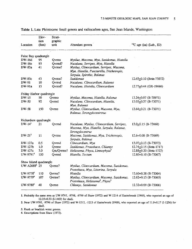
Table 1. Late Pleistocene fossil genera and radiocarbon ages, San Juan Islands, Washington
Location
Elevtion (feet)
False Bay quadrangle DW-16d 95 DW-16e. 93 DW-83a 41
DW-83c 43 DW-91 10 DW-91a 15
Stratigraphic unit
Qvrms Qvrmd? Qvrms?
Qvrms? Qvrmd Qvrmd?
Friday Harbor quadrangle DW-15 50 Qvrmo DW-30 92 Qvrmd
DW-58 150 Qvrms
Richardson quadrangle DW-141 21 Qvrmd
DW-212 11 Qvrms
DW-127a 0.5 Qvrmd DW-127b 1.0 Qvrme DW-127c 3.0 Qm/Qvnne? UW-97914 150 Qvrmd
Shaw Island quadrangle UW-A268S4 25 Qvrms?
UW-977S4 110 Qvnns? UW-977~ 107 Qvrme?
UW-978if 40 Qvnne
Abundant genera
Mytilus, Macoma, Mya, Saxidomus, Hiatella Nuculana, Serripes, Mya, Hiatella Mytilus, Clinocardium, Serripes, Macoma, Mya, Hiatella, Puncturella, Trichotropis, Serpula. Spirobis. Ba/anus Saxidomus Nuculana, Clinocardium, Ba/anus Nucu/ana, Hiatella, Clinocardium
Mytilus, Macoma, Hiatella. Ba/anus Nuculana, Clinocardium, Hiatella. Mya, Balanus Mytilus, Clinocardium, Macoma, Mya, Ba/anus, Strongylocentrotus
Nucu/ana, Myti/us, Clinocardium. Serripes, Macoma, Mya, Hiatella, Serpula, Ba/anus, Strongylocentrus Macoma, Saxidomus, Mya, Trichotropis, Serpula. Ba/anus Clinocardium, Mya Saxidomus, Protothaca, Chlamys Heliosoma, Physa, Limnophysa3
Hiatella, Tectum
Myti/us, Clinocardium, Macoma, Saxidomus. Protothaca, Mya, Littorina. Serpula Hiatella Mytilus, Clinocardium, Macoma, Saxidomus, Protothaca, Heliosoma3, Physa3
Chlamys, Saxidomus
14C age (lea) (Lab., ID)
12.65±0.10 (Beta-73072)
12.77±0.44 (GX-19686)
13.24±0.07 (B-70971) 13.05±0.37 (B-73071)
12.64±0.21 (B-73071)
13.()±0.15 (B-73068)
12.6+0.08 (B-73069)
13 .07 ±0.13 (B-73073) 12.74±0.15 (Beta-1717) 12.88±0.20 (Beta-1723) 12.80+0.10 (B-73067)
12.60+0.38 (B-73064) 12.62+0.13 (B-73065)
12.32+0.09 (B-73066)
1. Probably the same area as UW-9797, -9798, -9799 of Shaw (1972) and W-1214 of Easterbrook (1969), who reported an age of 1235+0.33 a-1469) for shell.
2. Near UW-9795, -9796 of Shaw (1972) and W-1212, -1213 of Easterbrook (1969), who reported an age of 11.9+0.17 (I-1256) for shell.
3. Fresh or brackish water genera. 4. Descriptions from Shaw (1972).
6 OPEN FILE REPORT 96-7
FOSSIL ASSEMBLAGES AND RADIOCARBON AGES
Fossil assemblages and radiocarbon age as listed in Table 1 fall into three categories: (1) genera such as Nuculana, Serripes, and Clinocardium that lived in moderately deep to subtidal water when calving ice was present before about 13.0 ka; (2) organisms such as Saxidomus that lived in shallow subtidal to intertidal water during the period of rapid emergence about 12.5 ka; and (3) fresh- or brackish-water gastropods such as Lymnophysa that lived in lagoons or coastal wetlands as the areas emerged after about 12.5 ka.
Radiocarbon ages in the table are from shell and have not been corrected for marine reservoir effects or to the calibrated time scale. Reservoir effects probably make the reported ages "too old" by about 6()()..800 years when compared, for instance, to wood that grew at the same time. Correction of marine shell ages to the calibrated time scale is not warranted because of uncertainty about the 14C age of marine reservoirs in late Pleistocene time. However, calibrated ages likely would be more than 2,000 years older than the tabulated ages.
Acknowledgments
Fieldwork was supported by the Sperry Fund, Department of Geology, and the Bronfman Science Center, Williams College. Acquisition of new radiocarbon ages reported here was partially funded by the Washington Department of Natural Resources, Division of Geology and Earth Resources. Shell material was identified by Megan Dethier, Department of Zoology, University of Washington, and V. Standish Mallory, Thomas Burke Memorial Washington State Museum, University of Washington, Seattle. Vicki Heater, San Juan County Health Department, gave us access to well records and encouraged this research. The Friday Harbor Marine Laboratory of the University of Washington provided research facilities and logistical support, and staff and researchers gave abundantly of their time and knowledge of the local marine environment
Technical reviews by Derek Booth, King County Department of Planning, Seattle, and Gerald Thorsen, consultant, Port Townsend, helped to improve this report. Josh Logan, Department of Natural Resources, made valuable suggestions that improved this map product.
SELECTED REFERENCES
Balzarini, M. A., 1983, Paleoecology of late Pleistocene glacial-marine sediments in northwestern Washington and southwestern British Columbia. In Molnia, B. F., editor, Glacial-marine sedimentation: Plenum Press, p. 571-592.
Booth, D. B., 1987, Timing and process of deglaciation along the southern margin of the Cordilleran ice sheet In Ruddiman, W. F.; Wright, H. E., Jr., editors, North America and adjacent oceans during the last glaciation: Geological Society of North America DNAG Geology of North America, v. K-3, p. 71-90.
Brandon, M. T.; Cowan, D.S.; Vance, J. A., 1988, The Late Cretaceous San Juan thrust system, San Juan Islands, Washington: Geological Society of America Special Paper 221, 81 p.
Dethier, D. P.; Pessl, Fred, Jr.; Keuler, R. F.; Balzarini, M.A.; Pevear, D.R., 1995, Late Wisconsin glaciomarine deposition and isostatic rebound, northern Puget Lowland, Washington: Geological Society of America Bulletin, v. 107, no. 11, p. 1288-1303.
Domack. E.W., 1983, Facies of late Pleistocene glacial-marine sediments on Whidbey Island-An isostatic glacial marine sequence. In Molnia, B. F., editor, Glacial-marine sedimentation: Plenum Press, p. 535-570.
Easterbrook, D. J., 1969, Pleistocene chronology of the Puget Lowland and San Juan Islands, Washington: Geological Society of America Bulletin, v. 80, no. 11, p. 2273-2286.
Easterbrook, D. J., 1992, Advance and retreat of Cordilleran ice sheets in Washington, U.S.A.: Geographie physique et quaternaire, v. 46, no. 1, p. 51-68.
Gower, H. D.; Yount, J.C.; Crosson, R. S., 1985, Seismotectonic map of the Puget Sound region, Washington: U.S. Geological Survey Miscellaneous Field Investigations Map I-1613, 15 p., 1 pl., scale 1:250,000.
Keuler, R. F., 1988, Map showing coastal erosion, sediment supply, and longshore transport in the Port Townsend 30- by 60-minute quadrangle, Puget Sound region, Washington: U.S. Geological Survey Miscellaneous Investigations Series Map I-1198-E, 1 sheet, scale 1:100,000.
7.5-MINUTE GEOLOGIC MAPS, SAN JUAN COUNTY 7
Pessl, Fred, Jr.; Dethier, D. P.; Booth, D. B.; Minard, J. P., 1989, Surficial geologic map of the Port Townsend 30- by 60-minute quadrangle, Puget Sound region, Washington: U.S. Geological Survey Miscellaneous Investigations Series Map I-1198-F, 1 sheet, scale 1:100,000, with 13 p. text
Powell, R. D., 1984, Glaciomarine processes and inductive lithofacies modelling of iceshelf and tidewater glacier sediments based on Quaternary examples: Marine Geology, v. 57, p. 1-52.
Russell, R.H., editor, 1975, Geology and water resources of the San Juan Islands, San Juan County, Washington: Washington Department of Ecology Water-Supply Bulletin 46, 171 p.
Shaw, J. D., 1972, Late Pleistocene paleontology of Orcas, Shaw, Lopez, and San Juan Islands of the San Juan Archipelago: University of Washington Master of Science thesis, 60 p.
Thorson, R. M., 1980, Ice-sheet glaciation of the Puget Lowland, Washington, during the Vashon Stade (late Pleistocene): Quaternary Research, v. 13, no. 3, p. 303-321.
Thorson, R. M., 1989, Glacio-isostatic response of the Puget Sound area, Washington: Geological Society of America Bulletin, v. 101, no. 9, p. 1163-1174.
Whetten, J. T.; Carroll, P. I.; Gower, H. D.; Brown, E. H.; Pessl, Fred, Jr., 1988, Bedrock geologic map of the Port Townsend 30- by 60- minute quadrangle, Puget Sound region, Washington: U.S. Geological Survey Miscellaneous Investigations Series Map 1-1198-G, 1 sheet, scale 1:100,000.
Whiteman, K. J.; Molenar, Dee; Bortleson, G. C.; Jacoby, J. B., 1983, Occurrence, quality, and use of ground water in Orcas, San Juan, Lopez, and Shaw Islands, San Juan County: U.S. Geological Survey Water-Resources Investigations Report 83-4019, 12 pl., scale 1:62,500.
Willis, Bailey, 1898, Drift phenomena of Puget Sound: Geological Society of America Bulletin, v. 9, p. 111-162.
I ,i ,, ~1 ., i • 1 l )1 g! •
•l
l:Jtll " N,;; : ,w.,.~ORON ISLAND!
• •. '. •,
•, ••
'•
..
"
"
<"JO., ----·-------- -------,- ------
'• \
• ',,
••
DW-143b
'• •••
' •, • •
Qvrmd
Ova, delorm~d
O,a
,1,
w ,.,_ ·s F-
FRlDA Y HARBOR QUADRANGLE. WASH!NGTON-SAN JUAN CO.
7.5 MINUTE SERIES (fOPOORAPHIC) 1 23,'~'
•
" • • •
N OS
,.., Cl 1•1a na Qvd· --
' , . . b I ' . r I ·
,1
' ' • ' ' ' , \
' ' ' '
"' • • • • • '
~;.. -- ....
A
•• ,,
':_·;:\,; . .), ','
'"'"'ii \ \ ,- s:..1/<'i '·' ..y _,. . : -~-:i i ·ooubl• ..~
' . ....~ ,_
... "' v> ...
5;7'30" wcsr SOUND,:,, .. ,
. ._
IW!if<o "-" ... !
Qvd
/ " }"·-· ,-·~· 0
' ,' I ,• , -{ • • • !
/. I I
' I I I I
<
v,
" • • u
\~,~~'""
\, ••
' -'
~' '
:I .~ 40 c ., • ~ 20
•
"
" 0
' "'
DW-94
• Ov! Ir)
•
°''
SHAW ISL'.ND QUADRANGLE WASHINGTON~SAN .RJAN CQ_
7.5 MINUTE SERIES (TOPOGRAPHIC)
(weM log)
Qvrm~ (?)
=--
Opfn ?J \ ...
\, ' ' ' ' ' ' " :.; ,· .. " ' .,. t' ,/
,'/ /'
• • .. • -:
"' .,
...
...
.,,
... OW-6"1
·.·, _ ,r.,n 0 ·--+ _.Z; , '
/.
/
Qvrme. ,. eo1 14
'\--.;;; ~, - ------,-, _,-.. __ i '
' ' ' •
b<
:ii
"" '" '" JOO
.. - .
. .
Peat
Qvrme (?)
Qvrme (?)
o,rmd
Ovrmo (1 ~ 2 ka)
Ovrmo
Ovrmo
"
. F'"··
- --
· .....
'. ,_. (. ... , ''rWl-• •u 1ti.u i•uNM , ,: i.,..,.;.,\ ATIOMAL WlLllllJ't .D'll<ll
·.,Jbr·:/i· .., •• ··~·n ....... n •
, ,
'
----
---- -- ... - --.. .. ---·-- ----
J, ' . ~ ;
14 0 · -
120 -
100 -
" 0
JOO
1 ' ~ 50
j
0
OW-102
-,·
... ... .....
Qvrmd
°'' '
.. b_c_::.
°''
OplfVOpld _1,.~._1u.~1<11f.
Ovrmd, Ovrms
,..- ...... ' / l .l
; j
Qyt
•n
•
Qvd I
----1 r~·
_J~l ·'·'a.:: -
J~-----:~ Ovd
Qvnn::, '
, • ,, '·· . '. . . ' x-
Hia le/la Qvrm s Ovrmd
/ :I rl
''68 1 ' ]
! I ,.
27'3C" r-
' l ~:
0
<l'
·~ .· : ' ' . •• . . . .. '
DW·91a
- · •
=--=----==
Q,d V·--- -
28 ,,
,,
Ovrmd
Clinoeardium; Hia rella 112.e k,,) o.~,
Ovrmo P)
•
"
---- .... .J -----
"
"
.?- :
'
OW -83
O,d
• ) ·, 9,
/ '--~-
Ovrms v, ,th m-s,/11
S1JJ1i<1Nlw~ (12.6kaJ
Ovrms(?) wilh sllol
b e ,, --...- ' ' ·----------·
\ . --·--"·' ! '" ~r ._t .... , •.;oc.~,
i ' / ~,.,-;. •e ..,~-be ,,· . ' . . _,,.- ~")' .. , ~. ,. '
' '• 26 lifrrrijii f.li · .:,.: h ~-- , ,m.a,
25 GRJ FFlN
RA Y
•
be
• V
Ciinocardwm {1 3.1 ka\
. '
Co,ered
, "'"'" ~,c,t,c Ro,,
"
' ! ;
0
.. Ob a,,,.,
• " o~, I ' .
" Y\ . /C
~ - -'
"
D1'1·21
00 Qvime Qvrme
Osrms
Ovrmd (13 0 ka )
,oo
j 190
j "'
"'
O,rme Qvrme, fosS< l
rich (12.6 ka)
Ovri no. Ovrmd Gravel dips tow~rd 140"
Ovrmd(?)
•
DW -104
-------~-~ ------,oo ~·:...:· :~ ·,.:-!..,7--.,. -,.r-
Qvrmd
,,
SW
' ' - o' .
...
(, /5 ·_:.
Q v:i S h a>"I< .. • :."
.. R"""~:);
Base ot ,,,
Ov:i_i
be
' ,:
"..J'.).---~c,;~;~:: ". ,, " ,,: .. . . JI b " AT Wl!l>l, I ,~ R~ilU' l $ '.
'"
··h,iQ,'· C.oooe · · \lr. ' 111. ~<1
' be "'
~ -:·~= --::::- ,1.~_
]l
'
0 W·127
5.0 a ,·rme {?)
..
'" Ovrm9: tresh -
9
J 3.0
~ wale, shell ( 12.9 ka )
av,,.,.,: shell
25, L i
!
"" ~20~~
<\"' ET '
!
"'I
I ... j
V
\
CORRELATION OF MAP UNITS
Ob 01! 0 1
Qm
v <>,rn,
<>,rnd
C>,rno "'' (lv<
Q,o
Qpln
b,
SURFICIAL GEOLOGY OF THE FALSE BAY, FRIDAY
HARBOR, RICHARDSON, AND SHAW ISLAND
7.5-MINUTE QUADRANGLES,
SAN JUAN COUNTY, WASHINGTON
David P. Dethier, Daniel P. White, and Christopher M. Brookfield
November 1996
'
" 0
DESCRIPTION OF MAP UNITS
.I
0d Ob OH QI Om
Fill
Dune deposits Beach deposits · Tidal !lat deposits Landslide deposits Marsh, bog , or swap deposits
Vashon Stade Deposits
Qvrm Recessional marine deposits Qvrme Emergence deposits Qvrms Marine subtidal deposits Ovrmd Marine diamioton Qvrmo Marine outwash
Qvt Till Q,<j Diamicton, undifferentialed
Advance outwash deposits Q,a
Qpfn b,
Pre-Vashon Deposits
Nonglacial deposits Bedrock
JOO
~ 150
00
Bod rock
EXPLANATION
' Landslide deposit, too small to show at map scale
F Fossil locality (see table)
C Location of radiocarbon-dated sample
+ Measured section
:·: J-5 • Well-log location
~ Striation or trough and direction of ice motion
--e- Drumlin, indicating orientation of long axis
, , Uplifted beach deposit ,
a ..
a ..
Ova(?)
Opln (1)
'
•
" 0
--~~--..=-:=.--~~:.
I
48"2?'ff"',.,,",-.,-&-·""·"•"•- - ---------,,=-~-------r1's'o'oo-,-,-,·,-,- ---------~ ·-,-.. -·-----------~1---_------------1--;9&---- ---- -- ----'---------~--· ------------~-- --------·-·--·--<----- -~- --~ ----------· 2'3011 '97 '98 • ,,.,•,o•--O f~ c<>•" "' · ~""'' ·"'"'~'-"""'""-•"'
-- ----·-- ------------·-- ··---------------·--·-·--··· --- ·- -- '------------ - - -- ---·- ·------1 • 80000 ~£Ef i 'O? 57'JO'- 'O<I
Mapped by U .. S. Coast and Geodetic Sllrvey Edited and published by the Geological Survey Control by USC&GS
foP<lir&Ph) from eerle l ohotoiraphs I>)< multlpl~• methods Aeria l photoa:rtphs l•~en 1949. ~iold ched, 1954
1-!:,droaraphy eompilt<I ,,om USC&GS chirt ,SJBO {1955)
?olyecnie p,cj..:t,on. Hl27 North Amtric,n d,t~m
10,000-Joct ,,1~ bilwc! on Wnhin,t<>n coo,dinate system, north ,one
lQOO.m,w i.;~iwnal Tr1ns.11,H Mtr,;tto, 1rid 1iek$.
zon• 10. shown in blul
~,., ,.~,c •~o 1g5-1 .. 1111~lnc ~" t)(CU~•t>O ~ •T CE~T! R o, SH~ET
SCALE I 240C0
' , " ~---ESC:....EiiE • ..l-- I E
CONTOu>i i NiERVil.L '20 FEET NATIONA~ GlOO~TIC ',l(RTI CAL D~Tl.l M or l9£9
OEPTH CURVES IN F'EH-OATU ,. •S MHN LOW(~ LOW w• lfR s~e" .. '"' ,~o,,.~ •t••tst•'• ' "~ ,....,o,.,.,.,, l' " ' c• M&~ "m" "'''""
'"' A, ERAU< •••~• O• HO• tS ' """°''"-' EC< • •s<r
.,,..., 123°00
RQAD CLASSIFICATIO N
FALSE BAY, WASH. N4822 .~Wl2300/7 .5
,, .. PI-IOTOINSP£CTEC 1972
AM$ JMQ I N&--t1BRtE8 lPl
t: ed (1 2 .7 ka)
0,rmd: sparse she ! (13 1 ka)
'· 1
'
./)<I , . . ,,
"·
,,, -· .
" •
, br. Cvo~ · --- · .- . ,, . ~ - ,
.l · ton, - ~ -. ~"'
' ' ·. -Q.~d ' -:-- ' br
JU ,O i . "!SL A I' 1>6 .. ,LII LJ F~ R!!:FU G!:
' . .J:!l' Hail .
/~_:,:;,'talan<I b,
CONTACTS AND SYMBOLS FOR
GRAPHIC LOGS
Conformable (suriaca exposures); er unknown (well log)
,1. o ,opstone
;..~-~ ~L Diamicion. deformed (Ovt. Ovd, Ovrmd} "-~'- --
•
Diamicton (Ovl, Ovd. Ovrmd)
Gra~I (Ova, O,rmo, Ovrme1
Fioe gravel . coarse sand (Ova, Ovrmo, Ob)
Fine 1o medium und {Ova. Ovrms)
Silty sand {Ova . Ovrms. Om. Ott)
Sil! aod clayey silt (Ova , Oplnl
•
.
' ., ,,
. br ~-1!.M Isl•~
WASHINGTON STATE DEPARTMENT OF
Natural Resources Je11", fer M . Bel< her - (Dmm, ss,on~r of Public Lands Ka leen Cott1ngh.1m - Superv iso r
WASHINGTON DIVISION OF GEOLOGY AND EARTH RESOURCES Raymond Lasmanis, State Geologist
PLATE 1
OPEN FILE REPORT 96-7
I ! i '.,, I
I'"
I MAPS OF THE SURFICJAL GEOLOGY AND DEPTH TO BEDROCK OF FALSE BAY. i-
FRrDA Y HARBOR.RICHARDSON, AND SHAW ISLAND 7.5-MINUTEQUADRANGLES l,,
- - ________ _: 'Oli ~5'
SAN JUAN COUNTY, WASHINGTON
----- ...... ·-··· ·-------------- __ J ·::: '° • '~" , ,s, -0£~.-' '1oC•• - ''"'" ''"· "S,OS ' "~ , ,,.,_ - ' • •• J 2]" 52' JO"
'1)8M"'• [,
RICHARDSON, WASH. N IO I • 11,c~UOMN ,. . CUAORAIIQc~·
t<4822 .5-Wl2252.S/ 7 .5
1977
... ,
"'· '
I 25' r
.... 1
520 000 i FE('fi
I
· _/ r ,,.,, _ ____;,_ ___ __ __ ' .
•·
0
" \
S' ... 1 I W .. LDRON I Si.AND! ..
••
+ -+- •
-t +
FRIDAY HARBOR ' ouAORANGLE WASHINGTON-SAN JUAN CO.
7.5 MIN UTE SERIES (TOPOGRAPHIC) 123,· ~·
: 't~. ' R«:I\S~ .. ,.._
,_- . J t•iar,d '· _: , i t , i '<,j ·
-,
• . ~ - " Rf><'•
•
' ' • ' ' ' '
,'
\ '
1• _JmM7' &,,y . '
~ ... ~Pt - ·'
0 P, l,s . -. •
,f·-
--"· •
/
-'
-,~ '·
-- · -'
,No•t~ P~c<'i~ Ro« ,
• ·,
-', '
-'"·
. HC
•
••
-,, ,,,
·-
, •
O · 0
"'
I";
••
"
·-
.. ,
10 MC
"""'°" Point
~ )J , 'I . '
s
. . . -
T
'
•
+- ----- --
R
" "' >
"-,,_
-·
,.-, .
"
+
A l T
/
l
'
i i , ..
_. -{ ! I.
,.
,: ;
0 F
' w • <
,.
0
,.
,,
~,.,,. JL' ...- N !St.o.~· o ~ Mumm~ N A.J' ~-1 1 !HJ Ill> - Ill! ~ I " C f: ;'>;, ~~·
. ~ _.- __ ,
,; "-· , Wl\al• . ..._ ·R0<:•~ ,
-.
,,,
,I
..
I]
••
/
A N D E
<~, 26, '--· I / "·--- _r
"'· ( ,~ •• •.<,' --- ---
.
..
F u
- -~---·
/ ,/
,' ,'
i ' -
,,. /
•
, , , -, \ C
I. / ' , ' ._ '
(
.. $..,.., --·-U.!>1 J\illiN--:;u j ~~l<DS Ii.O T IW !Ll)l ! l'll REH' <.:~ ,"·\.,.~-<' •.a,.~...i '._
·-- -- .
-.. ,.
C A
/
" ,1
SHAW ISLAND QllAilRANGLE ' 0 WA.5HINGTON- SAN JUAN CO. I
7 .5 MINlITT SERIES (TOPOGRAPHIC)
·-._
• ~,,-
-~ ' \ J«.ns .. -.1
---·
i \
.. ;, - ' . ' ' ' ,' .,
, 121 "52''°~ ... . ....37'l0" • '
-• .. -: «
"
. i ', 1 ,-- .• 'V - ..._....,
I
'
..,
.. , "'
I.,.
' ... ,.
';qf'30'
,,,
""
i"'' , _
,.,
I
! "'"
I
I "60:
I
DEPTH TO BEDROCK OF THE FALSE BAY, FRIDAY
HARBOR, RICHARDSON, AND SHAW ISLAND
I 7.5-MINUTE QUADRANGLES,
..,,1
I SAN JUAN COUNTY, WASHINGTON
-I
I ""1
.. '2"3--''--=~-~~-----~~- ~---- -~~===c .,.. u- · '92 li~MOOOFEH 123'07'30" '9!
Mapped by U .. S. Coast and Geodetic Survey Edited and published by the Geolog,cal Survey Control t,y USC&GS
fopo1r•llhy !rel!' 1erl1I 1>hoto11roph• by multlplt, ~tho~~ A.ril l pt,o\!>tf•:>~S ttktn 1949. Fie ld c~eck . 1954
Hyd'OIJ'1phy compillG frcrn USC&GS chart 6380 (195!:i)
P<>lyr;M,e projection. 1927 North Ame,ian datum 10,000.foot ,rid t>asec on Wu hi nat."1'1 ,:oor(linllle system, north ,one
David P. Dethier, Daniel P. White, and Christopher M. Brookfield
November 1996
__J_ _____________ _ __________________ ~--
5' '9.1 '% '% 2'30" ·~7
SCALE l.2400'J
' ' CONTOVR it!TER \IAL 2Cl FEET
N,'.TIC!MAL GEODETIC ~ERT•CAL 0,0.TU M OF 1929
UIM o~,o ..... o lY"" 1'-'4N€llC •KUrll< D£CL1JIOTION lT CS:~TU OS ~MUr
O[PTl-l ClJRVtS IN rnT-D,TIJi,j IS MtAN LOWER LDW WATER
s~o•e ciM i;: ""ow~ "'""E~•••• •~• '""""''M'" ""' o, " .. " '""" w•••• '"' »••••E ~• HG< or t,0£ ,1 v~•o.,,o,,c, , ,.,, G
1000--m•tM U/tiYerHI r,.n,'<$rW Merc110• F id tieQ. 1011, I O. gho,..., in blve
25 o
>25 0 O
/20-
'------ ----• , • .-..,o.,_o,o, oo«u., •~"'""· .,,.o,,, ... v,.,C,C,= .,C,C,--'!l'r-£ !23°00'
Light-duty
ROAD CLA5Slfl~TION
FALSE BAY, WASH. N4822. 5-W 12300/7. 5
rn M PHOTOINSPECTEO 1972
ANS 1380 I N&--SBRIU Vii i
EXPLANATION
Well finished in bedrock: thickness of Quaternary sediment, In feet. indicated at selected wells
Well finished in Quaternary sediment; minimum thickness of Quaternary sdfmenl, in feet, indicated at selected well sites
Line connecting points ol equal depth to bedrock, In feet; contour interval 20 ft; locally not shown or generalized where gradient Is steep and values are uncertain near American Camp.
WASHINGTON STATE DEPARTMENT OF
Natural Resources Jennifer M. Belcher - Commi"ioner of Pu t>l ,c La nd, Kal~~n Cottingham - Superv iso r
WASHINGTON DIVISION OF GEOLOGY AND EARTH RESOURCES
Raymond Lasmanis, Sta~ Geolo1ist
PLATE 2
OPEN FILE REPORT 96. 7
MAPS OF THE SURFIC JAL GEOLOGY AND DEPTH TO BED1t0CK OF FALSE BAY, FRIDAY HARBOR, RIC HARDSON. AND SHAW ISLAND 7.5-MINUTE Q UADRANGLES
SAN JUAN COUNTY. WASHINGTON
---------------··--..l....·--------··----------------- ---------•- ------------ ----------- I -- ---------·-- -----~----57' 30" '04 (RICHA RDSON l-ll 2 ~ao, '« 55' 'fl J
RICHARDSON, WASH. "WI ~ ~>C~•RO~QJ< ' ' ' QUAU~A .. OL~
N48n.et-W122'52 .5/7 .5
11177
AMS ••81:1 JV NW - SERIES vn,
'"
," 22'30" 30"