Embed Size (px)
Citation preview

Business Paper Ordinary Meeting
Venue: Administrative Headquarters Civic Place Katoomba Meeting: 7.30pm. 29 September, 2009

- 2 -

- 3 -
ORDINARY MEETING
29 SEPTEMBER 2009
AGENDA
ITEM NO.
PAGE SUBJECT COMMENTS
PRAYER/REFLECTION (and Recognition of the Traditional
Owners, the Darug and Gundungurra People)
APOLOGIES CONFIRMATION OF MINUTES Ordinary Meeting held on 8 September 2009 DECLARATIONS OF INTEREST MINUTE BY MAYOR PROVIDING GOOD GOVERNMENT
1 17 Lawson Community Hall (Mechanics Institute) Advisory Committee
2 20 Code of Conduct Issues Analysis 2009
3 22 Schedule of Invested Monies for July 2009 Attachments x 1
4 28 Media Policy 2009
Attachments x 1

- 4 -
ITEM NO.
PAGE SUBJECT COMMENTS
5 34 Community Consultation Policy 2009
Attachments x 1 Enclosures x 3
6 44 Annual General Purpose Financial Reports
and Special Purpose Financial Reports for the Year Ended 30 June 2009 Attachments x 2
7 52 Community Assistance / Donations -
Recommendations by Councillors
LOOKING AFTER ENVIRONMENT
8 54 Amendment of Two Previous Resolutions to Include the Application of the Common Seal to Contract Documents
LOOKING AFTER PEOPLE
9 56 Benoit Park, Valley Heights Enclosures x 1
USING LAND FOR LIVING
10 64 Housing of Live Animals within Blue Mountains Local Government Area Attachments x 1
11 74 Development Application No. X/373/2008 for
the Renovation and Extension of the Existing Commercial Building on Lot 1 DP 127415, Lot 1 DP 167210, 177-179 Leura Mall, LEURA Attachments x 3
12 96 Development Application No. X/453/2008 for
a Cluster Housing Development for ten (10) Dwellings and a Community Title Subdivision on 3 Renwick Close, 3a Renwick Close, 115a Old Bathurst Road And 121 Old Bathurst Road, Blaxland Attachments x 10

- 5 -
ITEM NO.
PAGE SUBJECT COMMENTS
MOVING AROUND
13 156 Traffic Calming Devices for Greenway Lane, Springwood
14 159 Local Traffic Committee
Attachments x 1
NOTICES OF MOTION
15 173 Safety Enhancements and Traffic Calming Options at Wilson Way Roundabout
16 174 Katoomba Coles/Kmart Abandoned Shopping
Trolleys.
17 175 Summerhayes Park Clubhouse
Attachments x 1
PRECIS OF SELECTED
CORRESPONDENCE
18 179 Precis of Selected Correspondence - 29
September 2009 Attachments x 9
RESPONSES TO QUESTIONS WITH
NOTICE
19 201 Renaissance Centre, 10-14 Civic Place,
Katoomba

- 6 -

- 7 -
THE COUNCIL MEETING
The following information has been taken directly from the Blue Mountains City Council Code of Meeting Practice 2009 using corresponding section numbers, and should be used to assist the public in participating in the Council’s decision making process. To obtain the full version of Blue Mountains City Council Code of Meeting Practice, please visit the Council website, Council Libraries or contact Blue Mountains City Council.
1.1 PUBLIC ATTENDANCE AT MEETINGS Everyone is entitled to attend meetings of the Council and those of its
Committees of which all the members are Councillors, except in the limited circumstances set out in 1.8 below. The Council has a responsibility to ensure that such meetings are open to the public.
1.3 PUBLIC NOTICE OF MEETINGS The Council gives public notice of all scheduled Council meetings in the Blue
Mountains Gazette newspaper each Wednesday. This information is also available on the Council’s website at address www.bmcc.nsw.gov.au.
1.6 PARTICIPATION IN THE COUNCIL MEETINGS 1.6.1 Public Access Members of the public are welcome to address the Council on any items of
business in the Business Paper other than Minutes by the Mayor, responses to Questions without Notice, Notices of Motion (including Rescission Motions), the Précis of Correspondence and Matters of Urgency. A “Guide to Public Speakers” will be available at each meeting.
Members of the public may make representation to, or at a meeting, before any
part of the meeting is closed to the public as to whether that part of the meeting should be closed. The representations may be made by addressing the Council at the meeting (see also Section 1.8.1 of this Code).
Members of the public must remain behind the roped barrier in front of the
Councillors seating at all times. Councillors must enter the Public Gallery when speaking with members of the public. No communication with the Councillors is permitted once the meeting commences.
Those wishing to address the Council must register with the Council
Administration Officer present in the Council Chamber prior to the commencement of the Meeting. Speakers may register from 6:45 to 7:20 pm.
Registrations may be also be made prior to the Meeting by completing the on-
line Registration form and emailing or faxing the form to Executive Services staff.
- 8 -
The following details are to be completed on the Registration form:
• name; • address; • organisation (if applicable); • item on business paper to be addressed; • a clear statement as to whether the person is for (supports) or against
(opposes) the recommendation or proposition as printed in the business paper;
• interest of speaker (as affected neighbour or as applicant or applicant’s spokesperson, or as interested citizen).
If, due to exceptional circumstances, a member of the public is unable to
complete a registration form prior to the commencement of the meeting, that person must speak to the Council Administration Officer and the Mayor will determine if the speaker can address the item.
Members of the public will not be able to address the Council on a particular
item after the business on that item has been completed Only persons who have completed the Registration form and clearly indicated
their intention to speak for or against a recommendation or proposition in the business paper may address the Council. Speakers who do not speak in accordance with their stated intention shall forfeit the right to continue speaking.
The Council encourages members of the public to present their views to
meetings in order that the Council deliberations may be better informed. An opportunity to speak will be afforded to persons representing a diverse range of views and opinions in preference to hearing the same view stated repeatedly or sequentially. Organisations may be restricted in number of speakers.
1.6.2 Protocol for public speakers Up to 3 speakers for each opposing viewpoint will be permitted to address the
Council. On development applications, the applicant (or a spokesperson) will be permitted a final 3 minute address. In selecting other speakers, preference will be given to neighbours who would be affected by the proposal, whether favourably or unfavourably. If more than 3 persons wish to speak on each of the differing views on an issue, they register through lodging a completed form with the Council staff. The Mayor or Chairperson will determine the number of speakers to be heard and may on occasions put a procedural resolution to the Council to increase the number of speakers. If the number of persons requesting to speak exceeds the number the Council has nominated, the Mayor shall invite persons to voluntarily withdraw, and if necessary, the Council staff will conduct a draw to determine the speakers. The draw provides that, on development applications, the speakers shall include the applicant (or a spokesperson) as above, and at least one neighbour for and one against the recommendation. Where necessary, a separate ballot will be conducted to determine the two neighbour speakers.

- 9 -
Public speakers are restricted to three (3) minutes. No extensions of time will be granted. All speakers must state their name and address, organisation (if applicable), and interest in the issue before speaking. Presentations and questions should be made or put courteously and concisely, and without hectoring. Councillors will observe the same courtesies while members of the public are addressing the Council. Personal allegations against Councillors and/or staff may not be made. A member of the public making such allegations forfeits forthwith the opportunity to address the Council. The Mayor shall insist that an offending speaker cease speaking. Councillors may ask questions of speakers at the conclusion of their address. Those in the public gallery shall not ask questions of members of the public addressing the Council or otherwise canvass issues in a public way. Special arrangements apply when members of the public wish to make representations to the Council on the question of whether or not part of the meeting should be closed to the public. Where an agenda includes notice that an item of business is likely to be considered in closed session, the following procedure will be followed: (a) any person may make written representations to the General Manager up to
the time of commencement of the meeting; (b) any person who wishes to make verbal representations at the meeting must
follow the procedures set out above for registering with the Administration Officer and for addressing the Council;
(c) after a motion proposing to close part of the meeting to the public has been moved and seconded, the Chairperson will ask the General Manager to read out any written representations;
(d) the Chairperson will then invite members of the public to address the Council. After three speakers have spoken in favour of the proposal and three against, the Chairperson will ask the Council to indicate by a show of hands whether the majority of Councillors present are satisfied that the range of views has been sufficiently canvassed. If the vote is in the affirmative, the motion to close part of the meeting will be put to the vote; and
(e) in the event that the Council disagrees with the recommendation of the General Manager to discuss an item in closed session and no motion to that effect is forthcoming, the Chairperson will announce that representations from the public will not be needed.
If it becomes apparent during a meeting that a matter should be considered in a closed part of the meeting, the Council can consider such a motion notwithstanding that notice has not been given in the agenda. In such cases, time will permit neither the registration of speakers nor written representations. However, the Chairperson will invite members of the public to address the Council and the procedure set out in (d) above will be followed.

- 10 -
1.7 SOUND RECORDINGS BY THE PUBLIC Unless the Council otherwise resolves, no recording equipment, excepting the official recording system, may be used to record the proceedings at meetings of the Council or its Committees. This prohibition applies to tape recorders, video cameras and any electronic devices including mobile phones or notebook computers capable of recording speech.
A person may be expelled from a meeting for using a recording device in
contravention of the above. (See Clause 3.10). 1.7.1 Mobile Phones All mobile phones in the Chamber and Public Gallery are to be turned off or
switched to silent/vibrate. Failure to do so may be treated as an act of disorder. 1.7.2 Photography in the Council Chambers Photographers are permitted to take photos in the Council Chambers by prior
approval, on the condition that the press respects people’s right not to be photographed if they do not wish to be.
1.8 MEETINGS CLOSED TO PUBLIC 1.8.1 General Section 10A of the Local Government Act, 1993 provides that the Council or a
Committee may close part of a meeting to the public. The Act states: “10A(1) A Council, or a Committee of the Council of which all members are
Councillors, may close to the public so much of its meeting as comprises: (a) the discussion of any of the matters listed in subclause (2); or (b) the receipt or discussion of any of the information so listed. (2) The matters and information are the following:
(a) personnel matters concerning particular individuals; (b) the personal hardship of any resident or ratepayer; (c) information that would, if disclosed, confer a commercial advantage on a
person with whom the Council is conducting (or proposes to conduct) business;
(d) commercial information of a confidential nature that would, if disclosed: (i) prejudice the commercial position of the person who supplied it; or (ii) confer a commercial advantage on a competitor of the Council; or (iii) reveal a trade secret;
(e) information that would, if disclosed, prejudice the maintenance of law; (f) matters affecting the security of the Council, Councillors, the Council staff
or the Council property; (g) advice concerning litigation or advice that would otherwise be privileged
from production in legal proceedings on the ground of legal professional privilege.
(3) The Council, or a Committee of the Council of which all the members are Councillors, may also close to the public so much of its meeting as comprises a motion to close another part of the meeting to the public.”

- 11 -
The grounds on which part of a meeting is closed to the public will be specified in the decision to close the meeting and recorded in full in the minutes of the meeting. The grounds will specify:
(a) the relevant provision of Section 10A(2) which applies; (b) the matter that is to be discussed during the closed part of the
meeting; (c) the reasons why that part of the meeting is being closed to the public
indicating whether it is being closed for preservation of confidentiality, privilege or security (this does not apply to personnel matters concerning particular individuals, or the personal hardship of a resident or ratepayer or a trade secret); and
(d) an explanation of the way in which discussion of the matter in open meeting would, on balance, be contrary to the public interest.
For the purpose of determining whether the discussion of a matter in an open
meeting would be contrary to the public interest, the Council will regard the following as irrelevant:
(a) a person may misinterpret or misunderstand the discussion; or (b) the discussion could cause embarrassment to the Council, a
Committee, Councillors or staff or cause a loss of confidence in the Council or a Committee.
When considering, at a meeting closed to the public, a motion to close another
part of the meeting as provided under Section 10A(3) of the Local Government Act, the Council will not consider any details of the matter concerned other than whether or not it constitutes one of the grounds for closure specified in Section 10A(2).
The Council may close part of a meeting to the public notwithstanding that
notice has not been given in the agenda only in the following circumstances:-
(a) It becomes apparent that the matter is one of those specified in Section 10A(2) as grounds for closure; and
(b) The Council considers representations by the public as to whether or not the meeting should be closed; and
(c) The Council resolves that discussion on the matter should not be deferred because of its urgency and should take place while the meeting is closed to the public.
In accordance with Section 10B of the Local Government Act, a meeting will
remain closed only so long as necessary to preserve the relevant confidentiality, privilege or security of the matter concerned, but only for such portion of the debate on an item as is necessary to preserve confidentiality, privilege or security. In all cases other than personnel matters concerning particular individuals, the personal hardship of residents or ratepayers, or a trade secret, the meeting will not remain closed unless the Council is satisfied that discussion of a matter in open meeting would, on balance, be contrary to the public interest.

- 12 -
A member of the public is not entitled to be present at part of a meeting which has been closed in accordance with Section 10A of the Act. A resolution passed at a closed meeting or part of a meeting must be made public by the Chairperson as soon as practicable after the meeting or part of the meeting has ended. The Council will at all times keep principles of open and transparent governance and the public interest in mind when discussing closure of meetings to the public.
1.8.2 Representations by the public on closure of part of meeting In accordance with clause 252 of the Regulation, the Council is required to give members of the public the opportunity to make representations as to why part of a meeting should be closed. There are two mechanisms for achieving such representation: a) By registering to speak to the Business Paper calling for the item to be
heard in Confidential Session (see Section 1.6); OR b) Following a resolution of the Council to close the meeting to the public, the
Chairperson will call for members of the public to make representations as to why the meeting should be closed.
In either of these circumstances the representation by a member of the public will be limited to 3 minutes.
3.9 MAKING DECISIONS - RULES OF DEBATE 3.9.1 Standing to Address the Council Any Councillor or member of the public (unless physically disabled or elderly) must stand to address the Council. This does not apply to the Mayor or Council officers and may not apply during Committee meetings. A Councillor who is unable to stand to address the Council due to a physical impairment or ill-health should notify the Chairperson prior to the meeting commencing.
4.1 EFFECT OF RESOLUTIONS
Once a motion has been passed, it becomes a resolution of the Council and the General Manager must ensure that it is implemented without undue delay as required by Section 335(1) of the Act. However, a resolution of the Council will not be implemented for a period of two days after the meeting at which a motion has been passed to allow time for rescission motions to be lodged. Thereafter action necessary to give effect to the Council decision must be commenced immediately to avoid excessive delay in implementation. (See also 4.3 below, “Limits on when/how often Decisions can be revisited”). Each Business Paper shall include a public notice of the Council policy that decisions of the Council will not be implemented until the third day after a meeting, or until after any notices of rescission have been dealt with. The Council decisions should not therefore be acted upon until officially communicated in writing.

- 13 -
There is no time limit on the lodgement of a Rescission Motion. Until a resolution of the Council is “carried into effect” - meaning that irrevocable steps have been taken to implement the resolution - a Rescission Motion may be lodged. However in the case of approvals of building or development applications, once the applicant has been formally advised of the Council’s decision the approval or consent may not, in the absence of clear statutory authority (s. 109 LGA 1993 or s.9 E&PA Act) be rescinded or altered.
* * * * * * * * * *


OFFICERS REPORTS


PROVIDING GOOD GOVERNMENT Item 1, Ordinary Meeting, 29.09.09
- 17 -
ITEM NO: 1 SUBJECT: LAWSON COMMUNITY HALL (MECHANICS INSTITUTE) ADVISORY
COMMITTEE FILE NO: F05289 - 09/146310 Management Plan Link
Principal Activity: Looking After People Service: Community Development Project: This report does not relate to a Management Plan project
Recommendations: 1. That the Council formally accept the recommendations for the appointment of Ann-
maree Bonner, Erst Carmichael, Leila Wedd, John Sheehy, Michael Neal and Mick Barrett as community members of the Lawson Community Hall (Mechanics Institute) Advisory Committee; and
2. That the Council write to the unsuccessful applicants thanking them for their submission
and interest in the Committee.
Report by Group Manager, Community & Corporate: Reason for report This report provides the Councillors with the community membership recommendations for the Lawson Community Hall (Mechanics Institute) Advisory Committee. Background At the Council Meeting of 26 May 2009, the Council resolved:
"1. That the Council adopt the Terms of Reference for the proposed Lawson Community Hall (Mechanics Institute) Advisory Committee as set out in Attachment 1 with an amendment to Section 15; Decision Making Procedures, to read:
15.1 It is intended that the Advisory Committee will make recommendations to the Council based on consensus, however, if consensus cannot be reached then a straw poll shall take place and the majority view shall be expressed in the report back to the Council.
2. That the Council conduct an Expression of Interest process calling for community
members to participate on the Lawson Community Hall (Mechanics Institute) Advisory Committee;
3. That the assessment criteria adopted by the initial panel of Ward Councillors, staff
and the General Manager, be used for the selection of community members of the committee;
4. That the names of the nominees, once received, and recommended composition of
the Lawson Community Hall (Mechanics Institute) Advisory Committee then be reported back to the Council for adoption; and

PROVIDING GOOD GOVERNMENT Item 1, Ordinary Meeting, 29.09.09
- 18 -
5. That the Council appoint Councillors Van der Kley and Clark as alternating Chair and Vice Chair of the Lawson Community Hall (Mechanics Institute) Advisory Committee."
(Minute No 196, 26/5/09) The Objectives of the Lawson Community Hall (Mechanics Institute) Advisory Committee as per the adopted Terms of Reference are:
1. To determine the precise scope of works necessary for the hall to be made available for public use;
2. To explore ways for the community to participate in contributing to this work; and 3. To review, assess access and make formal recommendations to the Council taking
into consideration a range of options and inputs including the findings of the Lawson Town Centre Re-development Project, the Lawson Community Service Hub Project which includes an assessment of needed community services and facilities, the Community Buildings Policy, Lawson Community Hall (Mechanics Institute) Plan of Management and previous review panel recommendations.
The initial panel comprising the Ward Councillors, the General Manager and three staff members met on 14 July 2009 and determined the assessment criteria to be used in selecting community membership of the committee. The agreed criteria include a range of key skills and personal attributes as follows: Key Skills
• An ability to hold paramount the interests of the wider community; • Demonstrated experience in the provision of services, activities and meeting places
which address community needs; • An ability to identify and resolve ethical issues such as potential conflicts of interest,
equity issues and issues of social justice; and • An understanding of the need to maximise community benefit in light of the
competing demands on the Council’s limited resources. Key Personal Attributes
• Sufficient time to devote to the role. (It is envisaged that the Committee would meet monthly and other consultation may be carried out between meetings);
• Ability to work collaboratively and engage productively in critical debate; • Demonstrated understanding of committee processes; and • A commitment to achieving a positive outcome for the Lawson Community Hall
(Mechanics Institute). Expressions of Interest for community membership of the committee were advertised in the local press on 22 and 29 July and on the Council’s website. Individuals and groups that had previously shown particular interest in the facility were advised directly of the Expression of Interest process. Expressions of Interest closed on 11 August 2009. The initial panel met on 25 August 2009 to consider the submissions received, and the recommendations are provided below. Report and recommendations of the initial panel Eleven submissions were received from individuals for membership of the Committee. The submissions were individually scored against the agreed criteria, and discussed at the meeting of 25 August 2009. In addition to the assessment criteria the initial panel gave consideration to ensuring the membership was as representative of the broader community as possible.

PROVIDING GOOD GOVERNMENT Item 1, Ordinary Meeting, 29.09.09
- 19 -
After consideration of the agreed criteria, consensus was reached by the initial panel on the preferred community members as follows:
• Ann-maree Bonner • Erst Carmichael • Leila Wedd • John Sheehy • Michael Neal • Mick Barrett
There is no significance to the order in which the recommendations are listed above. Sustainability assessment Effects Positive Negative Environmental Not applicable Not applicable Social • Supports the utilisation of existing
services and facilities. • Strengthens sense of local identity
and place. • Fosters mutual understanding. • Strengthens community and
Council partnerships.
Nil
Economic Nil Nil Governance • Proposal supports partnerships
with other stakeholders. • Proposal engages community
through improved consultation processes.
• Proposal demonstrates and develops opportunities for empowerment.
Nil
Financial implications for the Council There are no known financial implications for the Council in regard to the content of this report. Legal and risk management issues for the Council There are no known legal or risk management issues for the Council in regard to the content of this report. External consultation Expressions of Interest have been called for community membership of the Lawson Community Hall (Mechanics Institute) Advisory Committee in accordance with the resolve of the Council. Reference to the background section of this report is made for details. Conclusion The recommendations heading this report provide the Council with the opportunity to formalise the membership of the Lawson Community Hall (Mechanics Institute) Advisory Committee. The initial panel has given consideration to the submissions received in accordance with the agreed assessment criteria, and recommend acceptance of the membership as proposed.
* * * * * * * * * *

PROVIDING GOOD GOVERNMENT Item 2, Ordinary Meeting, 29.09.09
- 20 -
ITEM NO: 2 SUBJECT: CODE OF CONDUCT ISSUES ANALYSIS 2009 FILE NO: F04905 - 09/126808 Management Plan Link
Principal Activity: Providing Good Government Service: Governance Project: This report does not relate to a Management Plan project
Recommendation: That the Council note the annual report on the Blue Mountains City Council Code of Conduct issues for 2008-09 as required under that Code.
Report by General Manager:
Reason for report The Blue Mountains City Council adopted Code of Conduct, which is based on the Department of Local Government’s model Code of Conduct, contains the following requirement at clause 12.43:
“The General Manager must report annually to Council on code of conduct complaints. This report should include, as a minimum, a summary of the:
a) nature of complaints received b) nature of the issues raised by complainants; and c) outcomes of complaints”
Background The Code of Conduct states that Councillors, administrators, members of staff of council, independent conduct reviewers, members of council committees including Conduct Reviewers and delegates of the council, must comply with the applicable provisions of the Code. The Code applies when carrying out functions as council officials. Mechanisms are contained within the Code for the reporting of complaints against Council Officials and the subsequent handling of those complaints. Allegations received in 2008-09 Complaints received, the nature of the complaints and issues raised, together with the respective outcomes are outlined in the table below:
CATEGORY NATURE AND ISSUES RAISED OUTCOME
Personal relationship with neighbour making complaints
Enquiries into the complaint undertaken and not proven – determination made to take no further action
Staff Complaints
Allegations of misconduct relevant to the Serious and Substantial Complaints Policy
Enquiries into the complaint undertaken and not proven – determination made to take no further action

PROVIDING GOOD GOVERNMENT Item 2, Ordinary Meeting, 29.09.09
- 21 -
CATEGORY NATURE AND ISSUES RAISED OUTCOME
Inappropriate communication of Council information
Independently reviewed and reported to Council
Councillor Complaints
Pre-determined opinion on a matter being presented to the Council
Assessed by General Manager with no further action
Sustainability Assessment Effects Positive Negative Environmental Nil Nil Social Nil Nil Economic Nil Nil Governance Annual reports provide for
accountability and transparency of the organisation as per the Local Government Act and the Council’s Code of Conduct.
Nil
Financial implications for the Council Investigations require considerable resources to be applied to each situation to assess the complaints and then if required, undertake a review.
Legal and risk management issues for the Council No known legal or risk management issues. External consultation Nil required.
Conclusion The Code of Conduct Report 2008-09 provides information about complaints received and the outcomes from those complaints as required under the applicable legislation.
* * * * * * * * * *

PROVIDING GOOD GOVERNMENT Item 3, Ordinary Meeting, 29.09.09
- 22 -
ITEM NO: 3 SUBJECT: SCHEDULE OF INVESTED MONIES FOR JULY 2009 FILE NO: F04905 - 09/148562 Management Plan Link
Principal Activity: Providing Good Government Service: Financial Management Project: This report does not relate to a Management Plan project
Recommendations: 1. That the Council’s Schedule of Invested Monies report for July 2009 be received and
noted; and 2. That the Certificate of the Responsible Accounting Officer be noted.
Report by Group Manager Community & Corporate: Reason for report This report is submitted for July 2009 for the purpose of financial accountability and in satisfaction of the investment reporting requirements of the Local Government (General) Regulation 2005 (clause 212), the Local Government Act 1993 (Section 625) and the Council’s investment policy. The report also certifies that the Council investments comply with the forms of investment made by order of the Minister under section 625(2) of the Local Government Act 1993. The current Ministerial Order was issued under the Council Circular 08-48 on 18 August 2008. Report The Schedule of the Council Invested Monies for July 2009 is attached for information (refer Table 1). The increased returns, above budget as at July 2009, on the Council investments are due to greater than anticipated cash position for the month of July 2009 (refer Table 6). Valuations and credit ratings have been calculated and updated to 31 July 2009 for all the Council investments and shows the Council investments’ fair value market valuation increasing for the third consecutive month and by $86,835 (refer Table 2) for the month of July 2009 and by $558,000 since May 2009. The financial impact on the Council’s investment portfolio is that the mark to market valuation of the Council investment securities, classified as fair value through the profit and loss statement, has now been reduced by a total of $6.2m indicatively between 1 July 2007 and 30 June 2009. If the Council were forced to sell these securities for liquidity reasons it could potentially realise a loss based on current market conditions. However, based on current cash flow projections, there is no short-term requirement to liquidate the long-dated investments for cash flow needs. The Council continues to monitor and review the liquidity position so that any potential future financial impacts can be understood for proactive decision making to be considered by the

PROVIDING GOOD GOVERNMENT Item 3, Ordinary Meeting, 29.09.09
- 23 -
Council. The Executive Management Team of the Council continues to explore potential legal avenues against Lehman Brothers Australia Ltd and other defendants as an additional means to securing its investment position. Global developments:
• The worst US economic slump since the Great Depression abated in the second quarter as the US government spending program assisted the economy;
• The latest release of US new home sales revealed a 11% gain, the largest jump in 8 years; and
• In Europe, Germany is showing signs of stabilisation which is raising some hopes that the European recession may ease.
Domestic developments:
• The Reserve Bank of Australia acknowledged that the downside risk to domestic growth has diminished: “The outlook remains for a gradual recovery to begin later in the year, and downside risks to that had diminished”;
• The NAB survey showed business confidence turned positive for the first time since December 2007; and
• Employment rose in July by 32,200, boosted by the large part-time employment figure. The unemployment rate remained at 5.8%.
Interest rates:
• The Reserve Bank of Australia kept the official cash rate on hold at 3% at the 4 August 2009 Board meeting, commenting: “the most likely outcome in the near term is a period of sluggish output, with consumer spending likely to slow somewhat and investment remaining weak”.
Council Investment Portfolio Following on from the strong close at the end of the last financial year, Council’s overall investment portfolio backed up with a strong first month in the new 2009/10 financial year. The portfolio outperformed the bank bill index benchmark. The improved domestic outlook has provided increased confidence in the strength of the domestic banks. Since the onset of the global financial crisis, the credit ratings of most global financial institutions have come under downward pressure by the ratings agencies. However, the ratings on major Australian banks remain at “AA”, underpinned by their earnings stability and asset quality relative to their global peers. Despite the expected weak economic growth ahead, earnings for major Australian banks are anticipated to remain positive with capital reserve levels unlikely to come under threat in the near future according to the ratings agency Standard and Poor’s. The Council’s investments in structured products and non major bank issued securities will continue to be impacted by the turbulence of the credit markets. The credit market opportunities, corporate default rates, the Lehman Brothers Holding Inc. bankruptcy and the Lehman Brothers Australia Ltd Administration continue to be reviewed by the Council independent investment advisor Oakvale Capital, in conjunction with advice from the Council legal advisor, Piper Alderman. The Council continues to take advice from law firm Piper Alderman on Lehman Brothers Administration matters and is considering options going forward and will report developments at Councillor Briefing Sessions and at Council Meetings where appropriate.

PROVIDING GOOD GOVERNMENT Item 3, Ordinary Meeting, 29.09.09
- 24 -
ATTACHMENTS/ENCLOSURES 1 Investment Attachments July 2009 09/155621 Attachment
* * * * * * * * * *
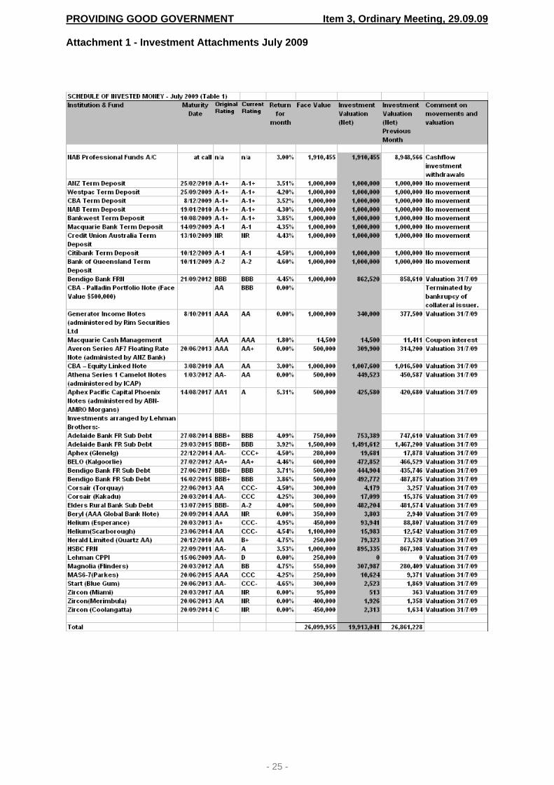
PROVIDING GOOD GOVERNMENT Item 3, Ordinary Meeting, 29.09.09 Attachment 1 - Investment Attachments July 2009
- 25 -

PROVIDING GOOD GOVERNMENT Item 3, Ordinary Meeting, 29.09.09
- 26 -
(Table 2)
BBSW 30 Days 3.16% Average Rate of Return for Month 3.53% (including defaults) Current market valuations of all investments are as at 31 July 2009. It is important to note that valuations are indicative only with no assurance that trades could be completed at such values. (Table 3)
Investment Portfolio (based on current valuations)
Call10%
Term Deposits45%Bank Note
9%
FRN29%
CDO7%
Call – Cash at Call Term Deposits – Deposits for Fixed Term Bank Note – Structured Notes FRN – Floating Rate Note CDO – Collateralised Debt Obligation

PROVIDING GOOD GOVERNMENT Item 3, Ordinary Meeting, 29.09.09
- 27 -
(Table 4) Investments by Institution (based on current valuations)
(Table 5)
Investment Balances 2007/08 to 2009/2010(based on current valuations)
05,000,000
10,000,00015,000,00020,000,00025,000,00030,000,000
31 July Aug Sept Oct Nov Dec Jan Feb Mar Apr May 30 Jun
Month
2007/08 2008/09 2009/10
(Table 6)
I hereby certify that the investments in the attached report have been made in accordance with Section 625 of the Local Government Act 1993, clause 212 of the Local Government (General) Regulation 2005 and the Council’s Investment Policy. Neil Farquharson Responsible Accounting Officer

PROVIDING GOOD GOVERNMENT Item 4, Ordinary Meeting, 29.09.09
- 28 -
ITEM NO: 4 SUBJECT: MEDIA POLICY 2009 FILE NO: F05420 - 09/151796 Management Plan Link
Principal Activity: Providing Good Government Service: Governance Project: This report does not relate to a Management Plan project
Recommendation: That the Council adopts the Blue Mountains City Council Media Policy 2009.
Report by Executive Officer: Reason for report The purpose of this report is to respond to the requirements of the Local Government Act 1993 relating to the review of Council policies within 12 months of a local government election. The Blue Mountains City Council (BMCC) Media Policy 2009 has been reviewed and placed on public exhibition. At the meeting of the Council on 16 June 2009 it was resolved:
1. That the Council approves the Draft Blue Mountains City Council Media Policy 2009 for the purpose of public exhibition.
2. That the exhibition of the Draft Media Policy be for a period of 28 days and be
advertised and promoted with submissions being receipted for 42 days. 3. That a report comes back to the Council following the public exhibition period and
consolidation of submissions. (Minute No. 229 16/06/09)
Background The Blue Mountains City Council Media Policy 2009 is updating the Blue Mountains City Council Media Policy 2003. The purpose of this policy is to establish protocols and consistent methods for managing communication between the Council and the media, to ensure coordinated, accurate, and reliable representation. In addition, the Policy includes the principles that inform Council’s media liaison, practical advice on media engagement for both Council staff and elected representatives, and procedures relating to the preparation of information for the media, responses to media enquiries, media advertising and media monitoring.

PROVIDING GOOD GOVERNMENT Item 4, Ordinary Meeting, 29.09.09
- 29 -
Public Exhibition The Draft Media Policy was placed on public exhibition for a period of 28 days between the dates of Wednesday 24 June to Tuesday 21 July 2009 inclusive with submissions being received for 42 days between the dates of Wednesday 24 June to Tuesday 4 August 2009 inclusive. No submissions were received in response to the public exhibition of the Draft Media Policy 2009. As a result, the draft Policy has not been changed since the document was reviewed and adopted by the Council for the purpose of Public Exhibition on the 16 June 2009. Sustainability Assessment Effects Positive Negative Environmental Nil Nil Social Provides a clear understanding of the
communication channels between Council and the media to ensure the community receives accurate and meaningful coverage of Council matters of interest to the community
Nil
Economic Nil Nil Governance Provides transparent government through
consultation on policy formulation Nil
Financial implications for the Council There are no financial implications associated with the adoption of the BMCC Media Policy 2009. Legal and risk management issues for the Council Adoption of the BMCC Media Policy 2009 ensures compliance with the Local Government Act in that a review of the BMCC Media Policy 2003 has taken place within 12 months of a local government election. Adoption of the Media Policy 2009 will assist the Council to manage legal risk by:
• Raising awareness of how the communication between Council and the media is managed; and
• Providing clear guidelines relating to the procedures for communicating with the media by Council staff and elected representatives.
External consultation The draft BMCC Media Policy 2009 was placed on Public Exhibition for a period of 28 days with submissions received for a period of 42 days. Direct consultation was undertaken with the local press, the Blue Mountains Gazette, inviting comments on the BMCC Media Policy 2009. Internal consultation with Council staff was also undertaken. Conclusion This report recommends that the Council adopt the BMCC Media Policy 2009. ATTACHMENTS/ENCLOSURES 1 Media Policy 2009 09/159868 Attachment
* * * * * * * * * *

PROVIDING GOOD GOVERNMENT Item 4, Ordinary Meeting, 29.09.09 Attachment 1 - Media Policy 2009
- 30 -
POLICY: MEDIA POLICY POLICY TYPE: Council STATUS: DRAFT ADOPTED: LAST REVISION: 2009 MEETING/MINUTE: TRIM REF.: 09/159868 ISSUED BY: Executive Services INQUIRIES: Communications Officer x5744
PURPOSE The purpose of this policy is to establish protocols and consistent methods for managing communication between the Council and the media, to ensure coordinated, accurate, and reliable representation. OBJECTIVE A co-ordinated approach to media liaison is necessary to:
• Promote a professional and consistent corporate image; • Maximise the positive promotion of Council work and achievements; • Minimise the possibility for miscommunication and negative publicity; • Provide a timely and unified response to media enquiries and negative publicity; • Ensure that media comments reflect Council’s position on the topic, consistent with
corporate plans, strategies, policies and minutes; • Ensure that media comments consider broader ‘global’ issues that may override the
specific issue in question; • Ensure communications strategies are part of the planning process for each major
Council project; • Ensure staff understand the importance of media liaison and the related workflow
required; and • Ensure appropriate use of emerging social media if and when required.
POLICY STATEMENT Blue Mountains City Council encourages open communication with the media and the community, with an emphasis on promoting a positive, progressive and professional image of Council and staff. Principles of media liaison
• The Council will openly discuss matters of interest with the media unless disclosure of information contravenes the Council’s duty of care, contractual obligations, or could infringe laws or regulations that govern its operations, (or the privacy of any individual.)
• Media organisations and their representatives will be treated equally and without bias. • Media enquiries are to be dealt with promptly, truthfully and within the media’s
deadline wherever possible. • In the case of matters with possible legal consequences, that is, official investigations,
accidents, or inquiries into business dealings or actions, any statements made to the media must be authorised by the General Manager with the input and approval of legal counsel.
• Invitations to relevant functions eg. Launches and civic events, will be extended to a representative of the local press.

PROVIDING GOOD GOVERNMENT Item 4, Ordinary Meeting, 29.09.09
- 31 -
PROCEDURES Spokespeople The Mayor and/or the General Manager are the official spokespersons for the Council on all matters. The General Manager may nominate other staff to act as spokespeople for the Council. The Communications Officer is responsible for coordinating Council’s media liaison and has been delegated responsibility to respond to media enquiries on behalf of Council.
Councillors The Mayor will be the spokesperson on Council business or matters before Council. Therefore all media enquiries should be directed to the Mayor in the first instance or if unavailable, to the Deputy Mayor. Council Staff Members of staff are not permitted to speak with the media without prior permission from the Group Manager and/or General Manager. The Communications Officer must be advised of any staff representation to the media before taking place. Staff may express their views in a public debate in their capacity as a local citizen and not as a Council representative (unless authorised by the Group Manager, General Manager or Communications Officer). However, staff should avoid any perception of a conflict of interest and take care not to give the impression that the comments are made on behalf of Blue Mountains City Council.
Response to Media Enquiries All media enquiries should be directed to the Communications Officer in the first instance. The Communications Officer will then liaise with relevant staff, Managers, the General Manager and/or Mayor to prepare a response to the enquiry.
Councillors Statements made by Councillors are to be identified as their opinions only and as such do not necessarily represent the position of the Council.
As specified by the Local Government Act, Councillors must not disclose material classified as confidential in reports presented to Council. The Mayor and Councillors may, out of courtesy, inform the Communications Officer of comments provided to the media.
Council Staff All media enquiries, requests for interviews or statements etc are to be referred to the Communications Officer and relevant Group Manager, who will advise of most appropriate response and /or action. In some instances, it is appropriate that staff with particular expertise, be nominated to speak to the topic of a media enquiry. This will be done in consultation with the Communications Officer and the relevant Group Manager. Council staff will not engage in media activity which may be to the personal advantage of a Councillor e.g. during an election campaign. Staff are required to comply with the statutory requirements contained in the Privacy Act and Local Government Act, which prohibit the disclosure of personal and confidential information.
Media releases Media releases are distributed in a standard format by the Communications Officer who will ensure that relevant staff have access to these media releases at the time of release and that

PROVIDING GOOD GOVERNMENT Item 4, Ordinary Meeting, 29.09.09
- 32 -
all staff and the community have access to Council media releases in a timely fashion via the Council website. The Communications Officer will obtain approval of the relevant Group Manager, General Manager, the Mayor and relevant staff on significant media releases prior to release. The Communications Officer will handle any follow up media enquiries relating to media releases issue by Blue Mountains City Council. Where a media release is prepared by another organisation that relates to a Council project or in which Council is involved, the Communications Officer will provide an official comment on behalf of BMCC, in consultation with the Mayor and/or General Manager, and will ensure that a copy of the comment and the media release is provided to relevant staff and Manager/s.
Councillors The Mayor and Councillors may, out of courtesy, inform the Communications Officer of a media release or other forms of communication forwarded to the media. Council staff Staff should provide draft information and photo/s for a media release to the Communications Officer (including a staff name and contact number for further information) with the approval of the relevant Group Manager. Draft releases or information should be approved by the appropriate Manager before being sent to Communications Officer. Where a media release is prepared by another organisation that relates to a Council project or in which Council is involved, the Council officer involved is to ensure that a copy of the release is provided to the Communications Officer, who will advise the General Manager and the Mayor.
Articles for Publication / Public Speaking From time to time staff will be asked to provide an article for a journal, newspaper or magazine or undertake a public speaking engagement. All requests for articles and public speaking should be referred to the Communications Officer and, if required, approved by the Group Manager and General Manager. A draft of the article/speech should be forwarded to the Communications Officer. Letters to the Editor Any Letters to the Editor should be forwarded to the Communications Officer and approved by the relevant Group Manager and General Manager before being forwarded to the media outlet by the Communications Officer. Media Alerts Any Council officer who is aware of an occurrence that may be of interest to the media (positive or negative) should immediately contact their Group Manager and the Communications Officer, providing relevant background details and the name and contact of the appropriate Council officer for further communication if required.

PROVIDING GOOD GOVERNMENT Item 4, Ordinary Meeting, 29.09.09
- 33 -
Paid media advertising Paid media advertising is the responsibility of the relevant Group Manager. The design and content of the advertising material should be undertaken in consultation with the Communications Officer and mindful of corporate branding guidelines. Web Communication All Council material which is to be published electronically should be submitted to the Web Administrator for publishing in a timely manner. Emergency Media and Communications Emergency Media and Communications are to be co-ordinated through Communications Officer in accordance with BMCC Guidelines for Emergency Communications. Filming permits Applications to use areas under the Control of Council for the purpose of filming shall be subject to the issuing of appropriate approval by the Environmental and Customer Services Group. Media Monitoring The Communications Officer will:
• Maintain records of media enquiries and responses, copies of media releases, associated background information and media clippings, including web, TV footage and radio recordings where possible;
• Maintain an ‘Issues’ folders on subjects in which the Council has an interest and which could become controversial;
• Produce a monthly media roundup in which a record of media exposure is kept by date and publication, including a reference to the status of that exposure (positive/negative/neutral) and significant articles and letters; and
• Inform the General Manager, Group Managers and /or Executive Officer of significant media enquiries or liaison.
Media training and briefings The Communications Officer will provide or arrange for media training for nominated Council officers, and provide advice on handling controversial issues. The Communications Officer will provide briefings for the General Manager, relevant Group Managers, the Mayor, or other staff nominated as spokespeople for any issues likely to generate media interest. Communication Strategies as a component of projects All projects undertaken by Council should include a communications strategy. The Communications Officer will provide advice to all staff on the preparation of a Communications Strategy as required. Implementation of the Media Policy The Communications Officer, Executive Services Branch is responsible for the implementation of the Media Policy. RELEVANT LEGISLATION & DOCUMENTS Personal Information and Privacy Act 1998 Local Government Act 2003 BMCC Guidelines for Emergency Communications 2004 BMCC Strategic Communications Plan 2007

PROVIDING GOOD GOVERNMENT Item 5, Ordinary Meeting, 29.09.09
- 34 -
ITEM NO: 5 SUBJECT: COMMUNITY CONSULTATION POLICY 2009 FILE NO: F05258 - 09/152329 Management Plan Link
Principal Activity: Providing Good Government Service: Governance Project: This report does not relate to a Management Plan project
Recommendations: 1. That Council notes the submissions received on the Draft Blue Mountains City Council
Community Consultation Policy 2009; and 2. That Council adopts the Blue Mountains City Council Community Consultation Policy
2009 incorporating recommended changes from the public exhibition process.
Report by Executive Officer: Reason for report The purpose of this report is to respond to the requirements of the Local Government Act 1993 relating to the review of Council policies within 12 months of a local government election. The Draft Blue Mountains City Council Community Consultation Policy 2009 has been reviewed and placed on public exhibition. At the meeting of the Council on 16 June 2009 it was resolved
1. That the Council approves the Draft Blue Mountains City Council Community Consultation Policy 2009 for the purpose of public exhibition.
2. That the exhibition of the Draft Community Consultation Policy be for a period of
28 days and be advertised and promoted with submissions being receipted for 42 days.
3. That a report comes back to the Council following the public exhibition period and
consolidation of submissions. (Minute No. 228 16/06/09)
Background Draft Blue Mountains City Council Community Consultation Policy 2009, provided at Attachment 1, is replacing the Blue Mountains City Council Community Consultation Policy 2004. The Council undertakes community consultation on a large number, and a wide range of issues and projects, each year, for the purposes of informing, involving and partnering the local community.

PROVIDING GOOD GOVERNMENT Item 5, Ordinary Meeting, 29.09.09
- 35 -
The purpose of this Policy is to establish protocols and provide tools for managing community consultation and participation with the aim of facilitating citizen participation in Council planning and decision-making. In addition, the Policy includes the principles that inform Council’s community consultation and engagement, a Community Consultation Matrix (Enclosure 1) and Community Consultation Toolkit (Enclosure 2), which provide the framework for community consultation practice, and practical advice on community consultation techniques and the implementation of these techniques by Council Officers. Public Exhibition The Draft Community Consultation Policy 2009 was placed on public exhibition for a period of 28 days between the dates of Wednesday 24 June to Tuesday 21 July 2009 inclusive with submissions being received for 42 days between the dates of Wednesday 24 June to Tuesday 4 August 2009 inclusive. Four submissions were received in response to the public exhibition of the Draft Community Consultation Policy 2009. A summary of the comments made in the submissions, with proposed responses to the issues and suggestions raised, is provided in the Table below: Resident / Organisation & Item of interest
Summary of submission Council Comment Recommended action to be taken
Resident Policy Objective
Amend policy objective as follows: Ensure community views are considered and fed into the decision making process in a transparent way that yields outcomes that directly reflect the views of the community
The current policy objective: Ensure community views are considered in council decisions is adequate to express policy intent and to avoid the potential for misrepresenting majority views as the submission is only valid in the case of overwhelming support or objection. Policy states the ‘Principles of Community Consultation’ “Includes the promise that the public’s contribution will be considered and contribute to the decision.”
No further action proposed
Policy Objective
Develop a guideline for decision-making for public comment
A singular, prescriptive decision-making protocol is deemed to be impractical given the variable nature of projects and the variable legislative decision-making criteria of the Council, including statutory requirements, Code of Conduct, the role of Committees etc
Recommended inclusion of broad ‘Decision-Making Framework’ has been included in the ‘Introduction’ of the Community Consultation Matrix.
Community Consultation Matrix
Amend the definition of ‘Partner’ in the Step 2: Level of Community participation, to read “Establish partnerships (non commercial) for involvement in decision making – task force, resident feedback panel etc”
The exclusion of commercial partners is considered not to be practical as it may limit the future strategic direction of Council.
No further action.
Community Consultation
Amend ‘Informing’ matrix table to include an essential requirement
It is not intended that the Matrix be prescriptive, rather a guideline only,
No further action proposed

PROVIDING GOOD GOVERNMENT Item 5, Ordinary Meeting, 29.09.09
- 36 -
Resident / Organisation & Item of interest
Summary of submission Council Comment Recommended action to be taken
Matrix for Public Notice in local paper for Level 2 Low Impact City-wide and Level 2 Low Impact Local Level activities
acknowledging: i) that many routine actions and services of Council do not require the undertaking of public notification, community consultation or participation ii) that many actions and services of Council are resolved by the BMCC policy framework or statutory requirement iii) the variability of Council projects, services and actions Matrix allows for discretion of the Council staff for the most appropriate type of consultation for particular groups and issues/ activities.
Amend ‘Consulting’ matrix table to include an essential requirement for Public exhibition of Level 1 High Impact Local Level activities
As above
No further action proposed
Amend ‘Consulting’ matrix table to include an essential requirement for Public Notice in local paper inviting submissions Level 2 Low Impact City- wide and Level 2 Low Impact Local Level activities
As above
No further action proposed
Amend ‘Involving’ matrix table to include an essential requirement for a Workshop Session and a Public Meeting for Level 1 High Impact Local Level activities
As above
No further action proposed
Amend ‘Involving’ matrix table to include an essential requirement for a Public Notice in local paper inviting involvement for Level 2 Low Impact City- wide and Level 2 Low Impact Local Level activities
As above
No further action proposed
Amend ‘Partnerships’ matrix table to include an essential requirement for a Public Notice in local paper inviting involvement for Level 2 Low Impact City- wide and Level 2 Low Impact-Local activities but only where opportunity for partnership exists
As above Level 2 activities do not generally involve partnerships
No further action proposed
Organisation Community Consultation Matrix
Shaded areas on Matrix are not clearly explained
Shaded areas on matrix table were included to reinforce the types of consultation that is ‘essential’
Improved formatting of Matrix table completed
Community Consultation Matrix
The Matrix table has only 3 ‘essential’ requirements making policy a motherhood statement
The Matrix table has 29 ‘essential’ requirements across the four types of consultation. The provision of optional types of consultation represents the variability of Council
No further action proposed

PROVIDING GOOD GOVERNMENT Item 5, Ordinary Meeting, 29.09.09
- 37 -
Resident / Organisation & Item of interest
Summary of submission Council Comment Recommended action to be taken
projects, services, activities and appropriate consultation.
Community Consultation Matrix
Does the policy/matrix meet relevant statutory requirements?
There is no statutory requirements for the provision of community consultation other than EP&A Act re: statutory notification relating to land use management (note BMCC DCP 35 Community consultation for Land use Management and Manual of Procedures)
No further action proposed
Attach a list of community groups wishing to be advised of Council plans and proposals to accompany the Policy
It is current and standard practice for Council officers to include relevant stakeholders in consultations on a case by case basis. Community consultation is a shared responsibility of Council officers with no central database of stakeholders. A central database of stakeholders requires high level maintenance to ensure currency.
No further action proposed
Organisation Policy
Noting there are many examples of plans made, or works undertaken without the consultation of the relevant group, in direct contradiction of the commitment made by Council in accepting the Bushcare Procedures Manual in October 2002: This means that the group will be consulted and involved whenever possible in any planning for future works that may impact upon the reserve.
It is recommended that staff training relating to the use of the BMCC Community Consultation Policy include reference to the involvement of relevant Bushcare groups
Include in staff training re policy dissemination
Policy That the following words be added to the Policy Statement “in accordance with the principles of community consultation outlined in this policy.”
The Principles of Community Consultation presented in the Policy inform and reinforce the Policy Statement. Inclusion of the suggested text is not essential but an acceptable amendment to the Policy Statement as follows “in accordance with the principles of community consultation outlined in this policy”.
Recommended wording added to Community Consultation Policy
Community Consultation Matrix
Suggest additional criterion to Step 1: Assess Level of Impact: High Impact/Local Level, eg. “Matters affecting any group or committee that works on behalf of council eg. Community hall committees, Bushcare groups, community advisory committees etc”
Inclusion of the suggested text an acceptable amendment to the Community Consultation Matrix as a Level 1: High Impact / Local Level.
Recommended words added to Community Consultation Matrix
Community Consultation
Suggest an additional criteria to the Matrix:
Inclusion of the suggested text is an acceptable amendment to the
Recommended for inclusion in the

PROVIDING GOOD GOVERNMENT Item 5, Ordinary Meeting, 29.09.09
- 38 -
Resident / Organisation & Item of interest
Summary of submission Council Comment Recommended action to be taken
Matrix - Formal notification to the group of the proposal, and - An offer of a meeting to discuss the matter if the group wishes to be involved (to fit in with their normal meeting times and/or a public meeting as determined by the group)
Community Consultation Matrix with the qualification that “, such an action can be practically undertaken by Council officers.”
Community Consultation Matrix with qualification.
Community Consultation Toolkit
Adequate notice prior to meetings is critical to enable participation by community groups. 6 weeks notice is the minimum for all groups to be notified to allow for discussion at a normal group meeting. 8 weeks notice would more adequate. This same consideration of 6 weeks min notice also applies to the following types of consultation Community Forums; Site / Tour Meeting; Public Meeting.
Inclusion of the suggested text is an acceptable amendment to the Community Consultation Toolkit with the qualification as follows: Advanced notice of 6 weeks is given to involved community groups and/or committees where possible and practical to do so. when such an action can be practically undertaken by Council officers.
Recommended for inclusion in the Community Consultation Toolkit with qualification.
Community Consultation Toolkit BMCC Meeting Kit
All meetings require a facilitator who is independent of the project and not the same person who has developed the proposal and given the presentation. An advertised public meeting should almost always have an independent facilitator.
The suggestion that an independent facilitator is present at Council-managed public meetings is an acceptable amendment to the Community Consultation Toolkit and BMCC Meeting Kit with the qualification that such an action can be undertaken by Council officers where possible and practical to do so as follows: Council officers are to consider the use of an independent facilitator at Council-managed public meetings where possible and practical to do so.
Recommend for inclusion in Community Consultation Toolkit and BMCC Meeting Kit.
Community Consultation Toolkit
It suggests that evening meetings should not be Mon or Fri, why not Mondays?
It is standard practice to preclude Mondays and Fridays for the conduct of public meetings for the purpose that public holidays, rostered days off etc are generally on these days
No further action proposed
Organisation Policy
Critique of the community consultation undertaken for the Springwood Revitalisation Project. No comments or suggestions were made specific to the Draft Community Consultation Policy.
No further action proposed
Further minor amendments to the Draft Community Consultation Policy 2009 and companion documents have been made in response to consultation undertaken with Council Officers during the Public Exhibition period. These changes are highlighted within the document and do not change the intention of the Policy.

PROVIDING GOOD GOVERNMENT Item 5, Ordinary Meeting, 29.09.09
- 39 -
Amendments to the Draft Community Consultation Policy 2009 Amendments to the Draft Community Consultation Policy 2009, Community Consultation matrix and Community Consultation Toolkit are highlighted in the respective documents. There are no significant changes to the intent of the Draft Community Consultation Policy 2009 and companion documents as these amendments are improvements to the clarity of the intent of, and the procedures relating to, the Policy. Additional appendices have also been included to provide further templates and resources for staff undertaking community consultation. It is proposed that the Community Consultation Toolkit and Meeting Kit are updated as required, or at a minimum, on an annual basis, outside of the policy review process to ensure accuracy, currency and relevance of information, methods, resources and references, templates and case studies, in keeping with the intent of the Community Consultation Policy. Sustainability Assessment Effects Positive Negative Environmental Nil Nil Social Provide a clear understanding of how the
principles and process relating to community consultation and engagement is managed by the Council and contribute to achieving effective interaction between the Council and the Community.
Nil
Economic Nil Nil Governance Provide transparent government by
seeking public input to the policy framework of the Council
Nil
Financial implications for the Council There are no financial implications associated with the adoption of the BMCC Community Consultation Policy 2009. The costs associated with the implementation of the Community Consultation Policy 2009, in the undertaking of community consultation, will continue to be carried within the relevant operational budgets as required. In March 2009, the Council purchased a package of 20 on-line community consultations from a provider, ‘Bang the Table’, at a cost of $15,000, which equates to $750 per consultation. The license agreement for the use of these consultations expires in March 2010 at which time an evaluation of this consultation tool will be undertaken with a view to possible continued use in the future. The purchase of the on-line community consultations was offset as the organisation allocates budget for community consultation relating to scheduled Council projects. Legal and risk management issues for the Council Mandatory consultation is required by legislation and is set out in the Local Government Act and the Environmental Planning and Assessment Act. The Blue Mountains City Council Community Consultation Policy 2009 and Development Control Plan 35 (Community Consultation for Land use Management and Manual of Procedures) reinforces compliance with this legislation.

PROVIDING GOOD GOVERNMENT Item 5, Ordinary Meeting, 29.09.09
- 40 -
External consultation The draft BMCC Community Consultation Policy 2009 was placed on Public Exhibition for a period of 28 days with submissions received for a period of 42 days. The public exhibition period was advertised in the ‘Council News and Information’ of the Blue Mountains Gazette on 24 June and 8 July 2009 and on Council’s website. Documents were available at the Council’s Katoomba and Springwood Offices and at the Council’s library branches or by contacting the Council. In conjunction with the above, Council’s on-line consultation tool was utilised during the public exhibition as follows: Number of unique visitors 217Number of visitors who viewed documents 99Number of visitors leaving comments 3Number of comments posted 4Document downloads – Community Consultation Policy, Matrix, Toolkit, Meeting Kit
147
Internal consultation with Council staff was also undertaken. Conclusion This report recommends that the Council adopt the BMCC Community Consultation Policy 2009. Following adoption, final versions of all the documents will be made available to all staff and will be posted on the BMCC Staff Intranet. ATTACHMENTS/ENCLOSURES 1 Draft Community Consultation Policy 2009 09/155565 Attachment 2 Draft Community Consultation Matrix 09/152339 Enclosure 3 Draft Community Consultation Toolkit 09/152343 Enclosure 4 Meeting Kit 2009 09/160067 Enclosure
* * * * * * * * * *

PROVIDING GOOD GOVERNMENT Item 5, Ordinary Meeting, 29.09.09 Attachment 1 - Draft Community Consultation Policy 2009
- 41 -
BLUE MOUNTAINS CITY COUNCIL POLICY Community Consultation
STATUS: DRAFT COUNCIL MEETING DATE: 29 September 2009 MEETING MINUTE: TRIM REF.: 09/155565 ISSUED BY: Executive Services ENQUIRIES: Communications Officer
PURPOSE The purpose of this policy is to establish protocols and to provide guidelines and tools to assist staff in the undertaking and management of community consultation and participation. The aim of effective consultation and participatory democracy is to facilitate citizen participation in Council’s planning and decision-making. OBJECTIVES
Ensure community views are considered in council decisions; Ensure the council decisions are well informed; Ensure that community consultation is relevant and appropriately innovative,
including the use on-line community consultation, social and digital media, where appropriate, to ensure broad community participation in matters of significance;
Ensure that community consultation is coordinated and integrated in a consistent manner across Council;
Ensure meaningful community engagement in consultation; Establish and maintain partnerships between Council and community; Build a network of community contacts; Minimise burden on community representation to Council by
individuals/organisations; Provide requirements for project management of community consultations; and Provide a toolkit for Council staff to undertake community consultation.
BACKGROUND / DEFINITIONS The Council considers consultation as a central principle in sound planning and decision-making. Council broadly defines community consultation as a process or processes implemented by Council to facilitate communication (including notification) and discussion between the Council, the community of the City of Blue Mountains and the directly affected stakeholders in the planning, determination, delivery and evaluation of policy, programs and services provided to the Blue Mountains community. POLICY STATEMENT Blue Mountains City Council actively consults with its community in a consistent and professional manner at all times and in accordance with the principles of community consultation and the criteria set out in the Community Consultation Matrix. Principles of Community Consultation The purpose of these principles is to assist the Council to make better decisions which reflect the interests and concerns of potentially affected people and stakeholders. Blue Mountains City Council considers that community consultation and participation:

PROVIDING GOOD GOVERNMENT Item 5, Ordinary Meeting, 29.09.09
- 42 -
Is based on the belief that those who are affected by a decision have a right to be involved in the decision-making process; Includes the promise that the public's contribution will be considered and contribute to
the decision; Promotes sustainable decisions by recognising and communicating the needs and
interests of all participants, including decision makers; Seeks out and facilitates the involvement of those potentially affected by or interested
in a decision (considering the Disability & Discrimination Act and Council’s Access & Equity Policy); Seeks input from participants in designing how they participate; Provides participants with the information they need to participate in a meaningful way;
and Communicates to participants how their input affected the decision.
* Principles adapted from the International Association of Public participation (IAP2) Core Values for Public Participation. PROCEDURES Mandatory consultation and notification is required by numerous Legislation and Regulations relating to Council. Council will ensure that all legal requirements are met. The Environmental Planning and Assessment Act and related instruments prescribe notification and consultation requirements for many land use development related functions. Council’s DCP 35 – ‘Community Consultation for Land Use Management and Manual of Procedures 2003’, guides the Council’s implementation of those statutory processes. The procedures are a combination of statutory requirements of the EPA Act 1979, the Local Government Act 1993 and the Council practice where it applies in addition to those statutory requirements. Statutory decision making powers such as those applying to the determination of development applications specify the matters that must be considered in relation to the consideration of a development application. In those instances the Council must ensure that it considers only those matters arising from submissions that are relevant to planning heads of consideration. The Communications Officer should be advised of:
All major projects involving community consultation and engagement activities at the beginning of the proposed project; and
All consultations undertaken by Council staff that will be publically advertised The Communications Officer will liaise with staff to advise on the most appropriate method of consultation and the use of the Community Consultation Matrix and Community Consultation Toolkit. Community Consultation Matrix The Community Consultation Matrix is a framework that aims to guide staff on when and how they should consult with the community. The Matrix is relevant to all staff who have dealings with the community. A Communications Plan should be part of any project being undertaken by Council staff, including appropriate methods and timeframe for consultation. The type and level of consultation may vary between activities and projects and the level consultation may be more intense and detailed depending on the needs of particular groups or a community within the LGA, the nature of the project/proposal and level of impact of that project/proposal. The matrix provides the minimum levels that should be considered when planning activities and projects.

PROVIDING GOOD GOVERNMENT Item 5, Ordinary Meeting, 29.09.09
- 43 -
Community Consultation Toolkit The purpose of the Community Consultation Toolkit is to provide Council staff with practical guidance on how to undertake different types of community consultation. It outlines the tasks that should be undertaken and provides suggested approaches, including more innovative approaches that encourage community involvement. The protocols for different types of consultation are outlined in the Toolkit. The Community Consultation Toolkit will be updated as required and outside of the policy review process to ensure accuracy, currency and relevance of information, methods, resources and references, templates and case studies, in keeping with the intent of the Community Consultation Policy. Blue Mountains City Council Meeting Kit The Meeting Kit has been prepared to assist all staff likely to be involved in, coordinate or chair a range of meetings, in achieving better meeting practices through providing information, guidance and templates for use in meetings. The Meeting Kit will be updated as required and outside of the policy review process to ensure accuracy, currency and relevance of information, in keeping with the intent of the Community Consultation Policy. RELEVANT LEGISLATION & DOCUMENTS Local Government Act 2003 Environmental Planning and Assessment Act 1979 Personal Information and Privacy Act 1998 DCP No. 35 Community Consultation for Land Use Management BMCC Strategic Communications Plan 2007 Draft Aboriginal Cultural Protocol BMCC Access & Equity Policy Other Legislation and Regulations relating to mandatory notification ATTACHED COMMUNITY CONSULTATION MATRIX COMMUNITY CONSULTATION TOOLKIT BMCC MEETING KIT

PROVIDING GOOD GOVERNMENT Item 6, Ordinary Meeting, 29.09.09
- 44 -
ITEM NO: 6 SUBJECT: ANNUAL GENERAL PURPOSE FINANCIAL REPORTS AND SPECIAL
PURPOSE FINANCIAL REPORTS FOR THE YEAR ENDED 30 JUNE 2009 FILE NO: F04454 - 09/155043 Management Plan Link
Principal Activity: Providing Good Government Service: Financial Management Project: This report does not relate to a Management Plan project
Recommendations: 1. That the Council form the opinion that:
a) The Annual General Purpose Financial Reports and Special Purpose Financial Reports for the financial year ended 30 June 2009 have been prepared in accordance with: • The Local Government Act 1993 (as amended) and Regulations made there
under; • The Local Government Code of Accounting Practice and Financial Reporting;
and • The Australian Accounting Standards and Professional Pronouncements;
(b) The Annual Financial Reports and Special Purpose Financial Reports present
fairly the Council financial position and operating result for the year;
(c) The Annual Financial Reports and Special Purpose Financial Reports accord with the Council accounting and other records; and
(d) There are no circumstances known that would make the Annual Financial Reports
or Special Purpose Financial Reports false or misleading in any way; 2. That the attached statements be made and signed on behalf of the Council by the
Mayor, one other Councillor, the General Manager and the Responsible Accounting Officer; and
3. That the 2008/2009 General Purpose and Special Purpose Financial Reports be
forwarded to the Council external auditor for audit.
Report by Group Manager, Community and Corporate: Background The Annual General Purpose Financial Reports and Special Purpose Financial Reports for the year ended 30 June 2009 have been completed and now need to be formally referred for audit to the Council external auditors, the Morse Group. In accordance with Section 413(2)(c) of the Local Government Act 1993 (as amended), the Council must prepare a statement on the General Purpose Financial Reports as to its opinion on the reports prior to referring them to audit. The signing of these statements is an

PROVIDING GOOD GOVERNMENT Item 6, Ordinary Meeting, 29.09.09
- 45 -
administrative function that is required before the Council can formally call on the external auditors to audit the Financial Statements. As required by the Local Government Act 1993 (as amended), the financial reports have been prepared in accordance with the Australian Accounting Standards, Local Government Code of Accounting Practice and Financial Reporting and the Local Government Asset Accounting Manual. The financial reports have been prepared on the accrual basis of accounting, and except for those assets which are held at current cost or valuation; the reports have been prepared in accordance with the historical cost convention. They contain details of the Council financial transactions for the year to 30 June 2009 and have been prepared in a manner that satisfies the requirements as previously outlined. A summary of the draft Statement of Financial Performance, Statement of Financial Position, Statement of Changes in Equity and a Statement of Cash Flows are outlined in this report. On the basis that the Council passes the required resolution to form the opinion, a statement in the prescribed form (as attached to this report) must be signed by the Mayor, one other Councillor, the General Manager and the Responsible Accounting Officer. The statement will then form part of the Annual Financial Reports. As indicated, this will allow the auditors to undertake the audit and present to the Council an audit report that will also form part of the Annual Financial Reports. Format of Financial Reports The financial reports comprise the following:
a) General purpose financial reports consisting of a statement of financial performance, statement of financial position, statement of changes in equity, and statement of cash flows along with a number of explanatory notes. These are presented for audit by the Council independent external auditors;
b) Special schedules which present financial information specifically required by the Department of Local Government, the Department of Public Works, the Department of Urban Affairs and Planning and the Australian Bureau of Statistics; and
c) Special purpose financial reports consisting of an operating statement by business activity, a statement of financial position also by business activity, and appropriate explanatory notes. These are also presented for audit by the Council independent external auditors.
Statement of Financial Performance This statement shows that operations for the year, including the charge of $13,548,000 for depreciation on assets held during the year, resulted in an operating loss of $790,000 including depreciation (compared to an operating loss of $1,716,000 in the previous financial year). This also included capital grants and contributions of $3,920,000 (compared to $6,467,000 in the previous financial year). The $790,000 deficit result is inclusive of $1,860,715 received on 24th June 2009 in respect to an advance instalment of the first quarterly payment of the Financial Assistance Grant for 2009/2010 from the Federal Government. In the Statement of Financial Performance this is called the “surplus/deficit from ordinary activities” because it is the net amount by which equity (i.e. total assets less total liabilities) increases or decreases as a result of operations for the year. It is important to remember that the operating result is different to the budget result. It is simply the net increase or decrease in assets or liabilities after meeting operating expenses for the reported year.

PROVIDING GOOD GOVERNMENT Item 6, Ordinary Meeting, 29.09.09
- 46 -
The Statement of Financial Position can be summarised as follows: $ ‘000Total Income 84,440Less Total Expenses (Including Depreciation) 85,230Net Surplus/(Deficit) (790)
Statement of Financial Position The Statement of Financial Position, which is sometimes referred to as the Balance Sheet, discloses the Council assets, liabilities and equity as at the reporting date. Along with the explanatory notes, it provides information about the resources controlled by the Council, its financial structure and solvency. The Statement of Financial Position can be summarised as follows: Current Non-current Net $ ‘000 $ ‘000 $ ‘000 Assets 32,271 446,529 478,800 Less: Liabilities 20,890 38,714 59,604 Net Assets 11,381 407,815 419,196
The column headed “Current” generally refers to assets expected and able to be realised in the next twelve-month period and liabilities due during the next twelve-month period. The column headed “Non-current” generally refers to assets not expected or able to be realised during the next twelve-month period, or liabilities due beyond the next twelve-month period. The total net assets (total assets less total liabilities) may also be referred to as the accumulated surplus or equity of the Council. Statement of Changes in Equity Equity, which is the residual interest in the Council assets after deducting liabilities, decreased by $790,000 due to a deficit of $790,000 as a result of operations. The total equity of $419,196,000 represents the accumulated surplus, or net assets, as shown in the statement of financial position. The analysis on the following page identifies the proportion of the surplus that is working capital from a budgetary viewpoint:

PROVIDING GOOD GOVERNMENT Item 6, Ordinary Meeting, 29.09.09
- 47 -
$ ‘000 $ ‘000 Non-Current Receivables 427 Investments accounted for using equity method 1,022 Property, Plant & Equipment & Investment Property (includes revaluation of operational Land & Buildings)
445,080
446,529 Less: Debt and Provisions (50,509) 396,020 Add: Restricted Investments & Receivables 22,164 Working Capital * 1,772 (b) Less: Non-Current Payables (760) Accumulated Surplus (Net assets) 419,196 * Working Capital is a component of the above Accumulated Surplus amount and comprises:
Cash and Investments 27,221 (c) Less: Overdraft Restricted Investments
(21,676)
5,545(a)
Add: Receivables 3,923 Inventories 422 Other assets 705 Less: Restricted Receivables (488) 4,562 Less: Current Payables Add: Non-Current Payables (estimate payable after 12 mths)
(9,095) 760
10,107
(8,335)
Working Capital 1,772(b) Statement of Cash Flows The Statement of Cash Flows shows the nature and amounts of the Council cash inflows and outflows. The following summary shows in net terms the cash flows for the year: $ ‘000 $ ‘000 $ ‘000 Cash at 30 June 2008 11,367 Net Cash from Operations 17,348 28,715 Less: Cash used to purchase assets (15,195) Cash used to reduce Borrowings (3,027) (18,222) 10,493 Proceeds from loans and other sources 7,827 Cash at 30 June 2009 18,320

PROVIDING GOOD GOVERNMENT Item 6, Ordinary Meeting, 29.09.09
- 48 -
It should be noted that the cash on hand is not available for general purposes but is subject to restrictions as to its use as shown below: $ ‘000 Restricted by Legislation for specific purposes 8,972 Restricted by Council for specific purposes 12,704 Operational Cash/Investments 5,545 (a) 27,221 (c) Specific details relating to restricted assets are contained within Note 6 of the General Purpose Financial Reports. Actual Result & Budget Result As already indicated in this report, the operating result is not the budget result for the year. The Statement of Financial Performance in the General Purpose Financial Report contains the cost of goods and services provided and the extent to which that cost has been recovered from revenues during the reporting period. As such, the operating result does not reflect the basis upon which rates have been levied for the year. The budget is prepared to plan the inflow of funds from revenues, borrowings and sale of assets and the outflow of funds on operations, the acquisition of assets and the repayment of long-term debt. The budget result also excludes non-cash items such as depreciation, which is not cash funded. Further Action Following receipt of the Auditor’s reports the Council is required under the Act to take the following steps:
a) Submit copies of the financial reports and the Auditor’s report to the Director General of the Department of Local Government and to the Australian Bureau of Statistics. (due 7th November);
b) Present the financial reports and Auditor’s reports to a meeting of the Council by 5th December of which public notice has been given. The public notice must be given at least two weeks before the meeting and the meeting must be held not more than one month after the receipt of the Auditor’s reports. The auditor may attend the meeting and must do so if requested in writing by the Council;
c) The public notice must specify that the financial reports and Auditor’s reports will be considered at the meeting and must indicate the right of any person to lodge submissions within 14 days after the meeting. The notice must include a summary of the financial reports. (due 28th November);
d) Consider submissions at a subsequent meeting of the Council and advise the Department of any matter which requires amendment to the financial reports; and
e) Have available for public inspection copies of the financial reports and Auditor’s reports.
A request has been made to the Auditor that they attend the Council Meeting of 10th November at which the financial reports and Auditor’s reports will be formally presented.

PROVIDING GOOD GOVERNMENT Item 6, Ordinary Meeting, 29.09.09
- 49 -
Sustainability Assessment Effects Positive Negative Environmental Nil Nil Social Nil Nil Economic Nil Nil Governance The external audit supports the integrity of
the Council financial reporting by confirming the financial position and operating result for 2008/2009 of the Council in accordance with accounting standards and DLG reporting requirements.
Nil
Financial implications for the Council The adoption of the recommendations has no direct financial impact upon the Council adopted budget or forward estimates. It is noted however that prudent management of the Council’s finances in accordance with accounting standards, facilitated by an external audit of the financial reports of the Council will benefit the financial objectives of the Council. Legal and risk management issues for the Council There are no obvious legal or risk management issues associated with the adoption of the recommendations. The forwarding of the financial statements to the Council external auditor for audit supports the Council in ensuring care and compliance is exercised in financial reporting. External consultation Nil Conclusion The Annual General Purpose Financial Reports and Special Purpose Financial Reports for the year ended 30 June 2009 for the Council have been completed and now need to be formally referred for audit to the Council external auditors. A statement by Councillors and Management made pursuant to Section 413(2)(c) of the Local Government Act 1993 (as amended) must be signed by the Mayor, one other Councillor, the General Manager and the Responsible Accounting Officer. The statement will then form part of the Annual Financial Reports. This will allow the auditors to undertake the audit and present to the Council an audit report that will also form part of the Annual Financial Reports for 2008/2009. ATTACHMENTS/ENCLOSURES 1 Attachment 1 09/155395 Attachment 2 Attachment 2 09/155398 Attachment
* * * * * * * * * *

PROVIDING GOOD GOVERNMENT Item 6, Ordinary Meeting, 29.09.09 Attachment 1 - Attachment 1
- 50 –
Blue Mountains City Council
Special Purpose Financial Reports for the financial year ended 30 June 2009
Statement by Councillors and Management made pursuant to the Local Government Code of Accounting Practice and Financial Reporting
The attached Special Purpose Financial Reports have been prepared in accordance with:
The NSW Government Policy Statement “Application of National Competition Policy toLocal Government”
The Department of Local Government Guidelines “Pricing & Costing for Council Businesses - A Guide to Competitive Neutrality”
The Local Government Code of Accounting Practice and Financial Reporting.
The Department of Water and Energy Best-Practice Management of Water and Sewerage Guidelines.
To the best of our knowledge and belief, these Reports:
Present fairly the Operating Result and Financial Position for each of Council's declared BusinessActivities for the year, and
Accord with Council’s accounting and other records.
We are not aware of any matter that would render these reports false or misleading in any way.
Signed in accordance with a resolution of Council made on 29 September 2009.
Adam SearleMAYOR COUNCILLOR
Phil Pinyon Neil FarquharsonGENERAL MANAGER RESPONSIBLE ACCOUNTING OFFICER

PROVIDING GOOD GOVERNMENT Item 6, Ordinary Meeting, 29.09.09 Attachment 2 - Attachment 2
- 51 –
Blue Mountains City Council
General Purpose Financial Report for the financial year ended 30 June 2009
Statement by Councillors and Managementmade pursuant to Section 413(2)(c) of the Local Government Act 1993 (as amended)
The attached General Purpose Financial Report has been prepared in accordance with:
The Local Government Act 1993 (as amended) and the Regulations made thereunder,
The Australian Accounting Standards and professional pronouncements, and
The Local Government Code of Accounting Practice and Financial Reporting.
To the best of our knowledge and belief, this Report:
presents fairly the Council’s operating result and financial position for the year, and
accords with Council’s accounting and other records.
We are not aware of any matter that would render this Report false or misleading in any way.
Signed in accordance with a resolution of Council made on 29 September 2009.
Adam SearleMAYOR COUNCILLOR
Phil Pinyon Neil FarquharsonGENERAL MANAGER RESPONSIBLE ACCOUNTING OFFICER

PROVIDING GOOD GOVERNMENT Item 7, Ordinary Meeting, 29.09.09
- 52 -
ITEM NO: 7 SUBJECT: COMMUNITY ASSISTANCE / DONATIONS - RECOMMENDATIONS BY
COUNCILLORS FILE NO: F04905 - 09/159008 Management Plan Link
Principal Activity: Providing Good Government Service: Governance Project: This report does not relate to a Management Plan project
Recommendation: That the council approve the following donations from the Councillors’ Minor Local Projects vote: Organisation Amount Blue Mountains Lantern Club 500.00 Blue Mountains Water Polo 500.00 Glenbrook Amateur Swimming Club 500.00 Springwood Neighbourhood Centre 150.00
Report by Executive Officer: Reason for report On 11 July 2000 the Council adopted a revised Policy for Councillors’ Minor Local Projects allocations for the provision of community assistance/donations. The following recommendations for donation, which appear to fall within the ambit of the Policy, have been received and are submitted for approval.
Minor Local Projects Recommending Councillor
Organisation Purpose Amount
Clr Clark Blue Mountains Lantern Club Sponsorship of Advertising Costs & Open Gardens Fundraiser
$100.00
Clr Creed Blue Mountains Lantern Club Sponsorship of Advertising Costs & Open Gardens Fundraiser
$100.00
Clr Greenhill Blue Mountains Lantern Club Sponsorship of Advertising Costs & Open Gardens Fundraiser
$100.00
Clr Mays Springwood Neighbourhood Centre
Kinship Care Project $150.00

PROVIDING GOOD GOVERNMENT Item 7, Ordinary Meeting, 29.09.09
- 53 -
Recommending Councillor
Organisation Purpose Amount
Clr McLaren Blue Mountains Lantern Club Sponsorship of Advertising Costs & Open Gardens Fundraiser
$100.00
Clr Myles Blue Mountains Lantern Club Sponsorship of Advertising Costs & Open Gardens Fundraiser
$100.00
Clr Searle Glenbrook Swimming Club Assist with replacement equipment
$500.00
Clr Searle Blue Mountains Water Polo Assist with replacement equipment
$500.00
* * * * * * * * * *

LOOKING AFTER ENVIRONMENT Item 8, Ordinary Meeting, 29.09.09
- 54 -
ITEM NO: 8 SUBJECT: AMENDMENT OF TWO PREVIOUS RESOLUTIONS TO INCLUDE THE
APPLICATION OF THE COMMON SEAL TO CONTRACT DOCUMENTS FILE NO: F03894 - 09/146704 PREVIOUS ITEMS: Tender for the Supply and Erection of Structural Steel for the
Katoomba Waste Transfer Station – Tender C5-2009 - Ordinary Meeting - 5 May 2009
Tender for the Supply and Installation of Wall Louvres for the Katoomba Waste Transfer Station – Tender C8-2009 - Ordinary Meeting - 26 May 2009
Management Plan Link
Principal Activity: Looking After Environment Service: Waste Project: Katoomba Waste Management Facility – Upgrade Resource Recovery Facilities and Construct Waste Transfer Station
Recommendation: That minute numbers 157 and 213 be amended by the addition of the phrase “and that the
Common Seal be affixed to the documents”
Report by Group Manager BM City Services: Reason for report This is a procedural report to amend two previously adopted resolutions of the Council to include the phrase “and that the Common Seal be affixed to the documents”. Contracts for services and supply determined by tender procurement processes and authorised by these resolutions have been awarded and the Common Seal of the Council has been applied to the instruments of agreement. It is necessary to amend the resolutions in order to comply with Clause 400 of the Local Government (General) Regulation 2005, which states that the Common Seal must not be affixed unless the Council has resolved to do so. Background At the ordinary meeting on 5 May 2009 and ordinary meeting on 26 May 2009, the Council accepted tenders for the supply and erection of structural steel (tender C5-2009, Minute No.157) and wall louvres (tender C8-2009, Minute No.213).
“10. F03894. Tender for the Supply and Erection of Structural Steel for the Katoomba Waste Transfer Station – Tender C5-2009 RESOLVED UNANIMOUSLY on the MOTION of Councillors Greenhill and Van der Kley that Council accepts the tender submitted by Combell Steelfab Pty Ltd for the supply and erection of structural steel for the Katoomba Waste Transfer Station for the cost of $746,350 ($678,500 + $67,850 GST).”
(Minute 157, 5 May 2009)

LOOKING AFTER ENVIRONMENT Item 8, Ordinary Meeting, 29.09.09
- 55 -
“21. F03894. Tender for the Supply and Installation of Wall Louvres for the Katoomba Waste Transfer Station – Tender C8-2009 RESOLVED UNANIMOUSLY on the MOTION of Councillors Myles and Creed that the Council accepts the tender submitted by Shutters by Design for the supply and installation of wall louvres for the Katoomba Waste Transfer Station for the cost of $255,684 ($232,440 + $23,244 GST).”
(Minute 213, 26 May 2009)
The contracts were duly executed for both of these items, including the application of the Common Seal to the instruments of agreement. It has subsequently been identified that a requirement of the Local Government (General) Regulation 2005 is that the Common Seal may only be affixed to a document where specifically included in wording of the Council resolution and that this requirement had been omitted in error in the respective resolutions. Sustainability Assessment As previously reported. Financial implications for the Council There are no financial implications. Legal and risk management issues for the Council Under the Local Government (General) Regulation 2005, Clause 400, there is a statement that the common seal of the Council is not to be affixed unless the Council has so resolved. As the application of the seal was not specifically included in the wording of the resolutions, there exists a technical non-compliance with the Regulation that must be addressed. External consultation Not applicable. Conclusion It is recommended that Minute Numbers 157 and 213 be amended to include the phrase “and that the Common Seal be affixed to the documents.” This is required to rectify a technical breach of Clause 400 of the Local Government (General) Regulation 2005, which states that the Common Seal is not to be affixed unless the wording of the resolution specifically requires it.
* * * * * * * * * *
LOOKING AFTER PEOPLE Item 9, Ordinary Meeting, 29.09.09
- 56 -
ITEM NO: 9 SUBJECT: BENOIT PARK, VALLEY HEIGHTS FILE NO: F00759 - 09/142549 Management Plan Link
Principal Activity: Using Land for Living Service: Land Use Management Project: This report does not relate to a Management Plan project
Recommendations: 1. That the Council adopts the draft Benoit Park Draft Plan of Management and uses it to
guide the management and development of Benoit Park and Valley Heights Reserve; 2. That the local park setting, once developed, be included in the list of parks to receive
maintenance; 3. That Councillors, groups and individuals who participated in the development of the draft
Plan of Management be provided with a final copy of the adopted Plan of Management; and
4. The Council acknowledge the efforts and enthusiasm of the community in supporting the
development of this draft Plan of Management.
Report by the Group Manager, Community and Corporate At its meeting of 16 June 2009, the Council resolved:
“1. That the Council adopts the draft Plan of Management for Benoit Park for the purpose of public exhibition in accordance with the provisions of the Local Government Act, 1993;
2. That the exhibition of the draft Plan of Management be advertised and promoted on
a citywide and local level and be for a period of not less than six (6) weeks; and 3. That a report comes back to the Council following the public exhibition.”
(Minute No. 247, 16/6/09) This report outlines the outcomes of the public exhibition period and recommends that the Council adopt the Plan of Management and use it to guide the management of the Park. Report Summary The purpose of this report is to present the final draft Plan of Management (dPoM) for Benoit Park, Valley Heights, and recommends that the Council adopt the plan. This report summarises the following:
• The background to the dPoM; • Issues raised during the public exhibition period; • A summary of the Action Plan; • Sustainability, legal and risk management assessments; and • The resource implications as a result of adopting the dPoM.

LOOKING AFTER PEOPLE Item 9, Ordinary Meeting, 29.09.09
- 57 -
Background The dPoM is enclosed for the information of Councillors. Council staff prepared the dPoM for Benoit Park, located in Valley Heights, as required under the Local Government Act 1993 and with reference to other relevant legislation. Map 1 below illustrates the boundary of the dPoM and the different land parcels.
Map of Benoit Park Plan of Management Study Area
16-20 Cambridge Street 26A Cambridge Street 41 Waratah Road
These parcels are collectively referred to as Benoit Park in the dPoM. Direction is provided in the dPoM to the following values:
• The potential social value of a local park: Policies and actions allow for enhancement of this value through development of a local park setting to service Valley Heights;
• The existing bushland values: Policies and actions allow this value to be managed through management of weeds; stormwater; threatened plant communities; fire management and biodiversity;
• The known and unknown Aboriginal and European heritage values: These values are to be managed through protection and enhancement policies; and
LOOKING AFTER PEOPLE Item 9, Ordinary Meeting, 29.09.09
- 58 -
• The financial value: This value is to be realised through permission to rezone and dispose of the existing dwelling and associated land at 16 Cambridge Street to contribute to the Council’s Property Investment Fund.
Research and Consultation The dPoM has been developed in consultation with the residents of Valley Heights. The local community has sought a plan of management to address the community’s desire to develop a local park at Benoit Park. Research and consultation in preparation for the dPoM included the following:
• Reviewing background files and studies; • Consultation with internal staff members including City Planning, Environmental
Management, Local Studies and Corporate Planning Teams; • Consultation with the Valley Heights Bushcare group; • Consultation with the local Valley Heights community (within a 1km radius of Benoit
Park) through a letter box drop involving an introductory brochure and survey for completion;
• Consultation with the Valley Heights Progress Association, and • Public Meetings on 15 February 2007 and 28 April 2009.
The dPoM was on public exhibition from 17 June to 14 August 2009. Copies were available at the business centres of the Council, all Council Libraries and on the Council’s website. Copies were also sent to key stakeholders. During the exhibition phase, an information day was held on Sunday, 2 August 2009 at Benoit Park, coinciding with a National Tree Day event organised by the Valley Heights Progress Association (VHPA). This was attended by around 25 people. The exhibition and the meeting were promoted through the Gazette on two separate occasions, a letterbox drop to 270 residences and notices placed in prominent places throughout the local area which included Benoit Park, walkways and community noticeboards at Springwood, Valley Heights and Warrimoo. External consultation The exhibition phase of the Benoit Park dPoM resulted in 12 written submissions. The majority of the submissions focussed on the development of the park facilities at 16–20 Cambridge Street. Those comments will be taken into account when the park is developed. The following is a summary of the comments received during the public exhibition of the dPoM:
• Confirmation of the strong community desire for the establishment a local park with facilities for children; picnicking and general community use;
• Stormwater issues, particularly at the end of Cambridge Street, identified as important;
• Concern for the costs of implementing work; and • The house should not be sold; the land should be retained to maximise park size (one
submission only). The submissions and feedback received have been carefully considered. Accordingly, some minor adjustments have been made to the recommended actions in the action plan. No change to management policy or objectives has occurred. Internal consultation The dPoM includes a policy “To ensure Benoit Park is …maintained in line with specifications for ‘Local Parks’” The internal consultation on the dPoM identified a significant concern as to how an additional park could be maintained from a maintenance budget that is decreasing in real terms. This concern is proposed to be addressed in three ways as outlined below:

LOOKING AFTER PEOPLE Item 9, Ordinary Meeting, 29.09.09
- 59 -
Off-sets to new assets The installation of new play equipment will be partially off-set by the removal of the play equipment from Buckland Park in Springwood. Ward Councillors have been consulted separately on this matter. The proposed installation of a picnic table and a bench in Benoit Park will be off-set by the non-replacement of equal facilities at a low use area elsewhere, when they fail and subject to consultation with Councillors. No off-set is proposed for the proposed park sign or the bubbler.. Low maintenance assets The new assets are planned to be as vandal resistant as possible. The play equipment shall include a bicycle loop which is a particularly low maintenance item and a scuff pad shall be provided if swings are installed to reduce the need to rake the softfall. Overall reduction in service Benoit Park will fall into the area maintained by the park maintenance team who tend parks from Winmalee to Glenbrook. It needs to be noted taking on an additional park will increase the pressure on park staff, which may result in occasionally longer periods between maintenance visits, particularly in summer. The internal consultation also resulted in a review of some of the costs in the dPoM action plan. Some costs were revised upwards to reflect changes since the document was first drafted. Action Plan The dPoM sets the future direction for the use and management of Benoit Park and contains actions to achieve the objectives. Councillors should note that not all of the Action Plan is funded. Where actions are unfunded, Council staff will use the Plan to guide and inform applications for funds and to seek relevant staff commitment. The table below outlines a summary of the main components of the Action plan Action Plan Summary Table (for full list see the draft Plan of Management) PARK DEVELOPMENT
Key Action Funding Source Indicative Costs
Install play equipment such as slide or swing and seating / picnic setting.
Included in 2009/10 capital works program.
$31,000
Provide entry sign and historical and local flora/fauna interpretive signage.
Included in 2009/10 capital works program.
$9,000
Water outlet (Bubbler and/or Tap) to be installed within the park.
Included in 2009/10 capital works program
$5,000
Regular mowing and park maintenance program included in the Parks Service Level Agreement.
Requires change to maintenance practices through rationalised services elsewhere
$8,500 pa
Buffer planting adjacent residents Included in 2009/10 capital works program.
$2,500
Installation of bollards or similar to prevent vehicular access.
Possibly achieved with funds included in 2009/10 capital works expenditure for Benoit Park.
$12,500
Boundary fencing to 16 Cambridge Street.
Can be funded for PIF, as the property sale funds will
$8,000

LOOKING AFTER PEOPLE Item 9, Ordinary Meeting, 29.09.09
- 60 -
PARK DEVELOPMENT
Key Action Funding Source Indicative Costs
be returned to the PIF. BUSHLAND / STORMWATER MANAGEMENT
Key Action Funding Source Indicative Costs
Undertake bush regeneration works in areas where weed invasion has occurred. Primarily the interface between the urban areas and bushland (Cambridge St & Russell Avenue interface).
Not included in the Council budget. May achieve external funding.
$50,000
Ensure emergency vehicles can access the Reserve and use the fire trail. Ensure any gates into the Reserve include the provision of an appropriate locking system
Included as part of the existing Council budget.
$1,000
Installation of sediment fence/retaining wall at end of Cambridge St to manage sediment deposition.
Not included in the Council budget. May achieve external funding.
$15,000
Install soft engineering works to rectify stormwater issues throughout reserve boundaries.
Not included in the Council budget. May achieve external funding.
$15,000
Ongoing support to be provided by the Council to the Valley Heights Bushcare group.
Included as part of the existing Council budget.
$5,000 pa
Install ordinance signs at bushland access points. Generic interchangeable sign to be developed.
Included as part of the existing Council budget.
$2,500
Carry out a study to identify the Aboriginal significance of the Reserve, adding to Council / community understanding of this Reserve’s importance.
Not included in the Council budget. May achieve external funding.
$10,000
Educate adjoining landowners about dumping green wastes etc. Provide general awareness about the importance of maintaining an APZ. Letter box drop an educational brochure to the local residents.
Not included in the Council budget. May achieve external funding.
$1,000
Maintain Asset Protection Zones (APZ) for fire protection at property interface. Maintain trails for vehicular access and undertake prescribed burning regime.
Included as part of the existing Council budget.
$5,000 pa
PROPERTY ASSETS
Key Action Funding Source Indicative Costs
Subdivide, rezone and sell off the house and land at 16 Cambridge Street
Can be accommodated within operational budget
Staff time/Legal Costs $20,000

LOOKING AFTER PEOPLE Item 9, Ordinary Meeting, 29.09.09
- 61 -
Sustainability assessment Effects Positive Negative Environmental The dPoM addresses many
environmental issues and provides a way forward for improving these areas of concern eg: bushland restoration, stormwater rehabilitation, bushfire management, and flora and fauna management. The actions within the dPoM ensure the Blue Mountains natural environment is protected and conserved.
No negative environmental impacts are anticipated.
Social The dPoM provides actions to improve residential amenity and recreational facilities in Valley Heights. It will provide a social setting that encourages a healthy lifestyle and the design will strengthen local understanding of the history of Valley Heights.
Increased use of the site may have minor impacts upon residents adjacent to the proposed park. Some community members may notice the increased time between maintenance at other parks in the area
Economic There are no positive economic effects identified.
There are no negative economic effects identified.
Governance The legislative requirement for a PoM before any changes can occur to the management of this land is satisfied. The value of Benoit Park has been clearly articulated in the dPoM and the proposed policies and actions are transparent. The dPoM allows for the development of a park setting where a need for a park has previously been identified in prior Council documents. It supports local aspirations and will facilitate ongoing partnership for the development and maintenance of the park. The sale of the land will support the sustainability of the Council.
The reason for a reduction in maintenance service frequency or removal of assets elsewhere to allow for Benoit Park to be included into the list of parks receiving maintenance may not be obvious to the community in other townships.

LOOKING AFTER PEOPLE Item 9, Ordinary Meeting, 29.09.09
- 62 -
Financial implications for the Council The dPoM has financial implications for the Council in four different ways: Income generation The dPoM permits the sub-division and sale of the dwelling and associated land at 16-20 Cambridge Street for income generation purposes. The sale will contribute to a more financially robust Council consistent with the Property Disposal and Investment Program Principles. This has not been included into future budgets. One-off projects The dPoM recommends one-off projects to the value of $182,500. $50,000 is identified in the 2009/10 capital works budget for initial works and $91,000 is identified as potentially attracting grant funding or other funding sources. The balance of projects estimated at $41,500 would require the use of existing operational budgets and staff resourcing. Recurring projects The dPoM recommends $10,000 per year for recurring projects consisting of an ongoing commitment of the existing $5,000 p.a. to continue the Bushcare program and $5,000 p.a. for Asset Protection Zones. Additional assets for maintenance Once the subdivision occurs, the maintenance of the fence to the new parcel shall revert to the owner of that new parcel. A rough order estimate of the value of the new assets to be created is $50,000. The life of these assets will vary from 10 years for play equipment to 30 years for the bicycle loop. These assets will require approximately $8,500 per year in maintenance costs and an average over 20 years of $2,500 per year for renewal costs. No additional budget has been identified to cover these costs. Opportunities may occur for securing grant funding or donations for a number of projects including bushland restoration, stormwater management and development of the park. Legal and risk management issues for the Council The dPoM contains some actions that are required to address both legal and risk management issues, please refer to the table below.
Risk Management Action Issue Maintain Asset Protection Zones (APZ) to the properties adjacent to reserve against bushfires.
Improved or maintained asset protection
Fire trails to be maintained and fuel levels in the reserve managed in accordance with the Council’s Strategic Bush Fire Management Plan, the Bush Fire Assessment Code and Dept of Natural Resources Guidelines for Construction and Maintenance of Tracks.
Improved or maintained asset protection
Development of the park area and its facilities must consider public safety.
Any facilities provided must meet Australian Safety Standards and be placed with consideration of Safety by Design Principles.
Legal Management Action Issue Protect and identify the Shale Sandstone Transition Forest which is recognised as an Endangered Ecological Community under the Threatened Species Conservation Act 1995.
Shale Sandstone Transition Forest has been identified within the Valley Heights Reserve, and also occurs within other locations in the local area. This requires protection and a review of its extent and condition, then amendment of the

LOOKING AFTER PEOPLE Item 9, Ordinary Meeting, 29.09.09
- 63 -
Legal Management Action Issue Council’s vegetation map as required.
The sale of the dwelling at 16 Cambridge Street (Part Lot 13 DP 880226) will require rezoning/reclassification from Community Land to Operational Land in accordance with the Environmental Protection and Assessment Act 1979 and the Local Government Act 1993.
The dwelling is currently tenanted and leased by the Council. In order to contribute to the Council’s Long Term Financial Strategy, provisions need to be made for the subdivision and sale of the property.
Conclusion The Benoit Park dPoM has been through a thorough consultation process and provides clear direction for the future use and management of these reserves. The extent of the proposed changes to the dPoM arising from the exhibition period is not considered to be significant and the dPoM does not need to be re-exhibited. It can now be considered for adoption. The implications that arise from the addition of another park to the list of parks to be maintained need to be recognised. The development of the dPoM involved extensive public consultation and this report recommends that the relevant people are acknowledged and copies of the adopted PoM distributed to all stakeholders. ATTACHMENTS/ENCLOSURES 1 Benoit Park Draft Plan of Management 09/80092 Enclosure
* * * * * * * * * *
USING LAND FOR LIVING Item 10, Ordinary Meeting, 29.09.09
- 64 -
ITEM NO: 10 SUBJECT: HOUSING OF LIVE ANIMALS WITHIN BLUE MOUNTAINS LOCAL
GOVERNMENT AREA FILE NO: F04905 - 09/152970 Management Plan Link
Principal Activity: Using Land for Living Service: Land Use Management Project: This report does not relate to a Management Plan project
Recommendations: 1. That the Council request that the Director-General of the Department of Primary Industry
give strong weight to the “Policy on authorising new animal display establishments at premises where animal exhibition will not be the primary activity”, when considering applications for a licence for a proposed animal display establishment in the Blue Mountains LGA, such that licences are likely to be granted only to those premises where the proposed animal exhibition constitutes the primary activity; and
2. That the Council request the Minister and the Director–General of the Department of Primary Industry give consideration to including provisions into regulatory instruments such that the policy referred to in item 2 has greater statutory force.
Report by Group Manager, Environment and Customer Services: Reason for report At ordinary meeting of Council 7 July 2009 the Council resolved as follows:
1. That a report comes to Council detailing the means to ensure that the housing of live animals within the Blue Mountains LGA for display, petting or any tourist related activity is limited to designated zoological facilities only and that those facilities must be appropriately licensed by the Department of Primary Industries; and
2. This report would focus on non-domesticated animals and should not include animals used in current accepted business operations, such as guard dogs, horses etc. The types of animals that the report should focus on are native fauna including those that are local and non-local to the area.
(Minute 278, 7 July 2009)
Background This resolution aims to address community concerns arising from the proposal to display live koalas as part of a tourist exhibit at Echo Point. There was significant public concern regarding the animal welfare issues generated by the proposal and there were also concerns that such a development was not an authentic reflection of the natural and cultural values of the Blue Mountains. Whilst those issues were touched upon in the planning report in the discussion of the community submissions, the recommendation for the refusal of that development application was made based upon planning considerations and not the animal display issues that fall to other jurisdictions to administer. It is understood that the Council is seeking to avoid the circumstance arising again whereby a live animal exhibit, particularly of native animals, can occur as an adjunct to a larger

USING LAND FOR LIVING Item 10, Ordinary Meeting, 29.09.09
- 65 -
business activity. Hence the concept of seeking to restrict live native animal exhibits to a zoological facility. Summary As requested this report focuses upon the means to ensure that the display of live native animals does not occur in the Blue Mountains for tourist and recreational or like purposes, unless the activity is part of a designated zoological facility, licensed by the Department of Primary Industries. This report describes the regulatory means by which the display of live native animals is controlled. It does not consider other means such as political representation to the State Government, which is the level of government with the primary jurisdiction for the regulation of keeping and display of native (and other) animals. After outlining the key elements of the statutory regime controlling the keeping of native animals for display purposes the report identifies whether and how that regime falls short of the Council’s stated aim. The potential for regulatory action by the Council to address that gap and the likely limits on that power is then discussed. The matters that the Council seeks to address primarily fall within the jurisdiction of Exhibited Animals Protection Act 1986, administered by the Department of Primary Industries (DPI). That regulatory regime does not restrict the display of native animals to a zoological facility or similar. An associated policy on the authorisation of animal display establishments does articulate criteria that address at least in part the Council’s concerns and that policy would have been a relevant consideration for the Director-General of DPI in relation to the application for the animal display establishment at Echo Point. Given that the regulation of animal exhibitions falls squarely within the jurisdiction of the Department of Primary Industry the recommendations propose that the Council make representations to the Minister and Director-General, requesting that the “Policy on authorising new animal display establishments at premises where animal exhibition is not the primary activity’ be given strong weight when considering applications licences for animal exhibits that are not the primary activity of the subject premises. Whilst the Council does have certain powers with respect to local planning controls, it is considered that the amendments that would be necessary to effectively designate the use of animal exhibits other than as part of a zoological facility, as ‘prohibited uses’ are unlikely to be supported by the Department of Planning on three grounds:
• The detailed regulation of the exhibition of animals is the jurisdiction of the State Government and the Exhibited Animals Protection Act, not the environmental planning system and related subordinate planning instruments;
• Councils are not permitted to directly add new or amended definitions to planning instruments unless an exceptional case is made and desirably, the amended or new definition would apply via the Standard Instrument (Local Environmental Plan) Order 2006 (the Standard Instrument) to the State. Informal advice from the Department of Planning indicates that such justification is not easily demonstrated; and
• Provisions designed to target animal welfare issues are unlikely to be considered to be planning matters for the purpose of the Environmental Planning and Assessment Act 1979.
In the event that the Council was successful in arguing that it should be permitted to insert a definition into its planning instruments prohibiting the display of native animals to zoological facilities, that would still not enable the Council always to “…ensure that the housing of live animals within the Blue Mountains LGA for display, petting or any tourist related activity is limited to designated zoological facilities”. In circumstances where an applicant successfully

USING LAND FOR LIVING Item 10, Ordinary Meeting, 29.09.09
- 66 -
argues that existing use rights apply and permit that development to occur, the existing use provisions of the Environmental Planning and Assessment Act 1979 will always override any attempt by a local planning instrument to place additional restrictions on such uses. However the DPI licensing powers stand outside that frame and are a hurdle that any prospective animal display establishment must jump, regardless of whether existing use rights are applicable under planning law. Current Regulatory Regime – Exhibited Animals Protection Act The Exhibited Animals Protection Act 1986 (EAPA) controls all vertebrate animal exhibition operations including zoos and fauna parks, circuses and temporary animal exhibits. It also lists a number of exemptions, including the type of exemptions seemingly contemplated by item 2 of the Council’s resolution, relating to domestic, farm, performance, racing, working or riding animals, or animals held lawfully for non display purposes such as licensed keeping of native animals as pets or by wildlife carers. Otherwise it is an offence to use a premises for the purpose of an animal display establishment if that establishment is not licensed. The penalties include financial penalties and or jail terms. The Department of Primary Industry is responsible for administering the EAPA. The EAPA regime is specifically directed at controlling the exhibition and display of animals. It does not limit the display of animals, including native animals, to zoological parks or the like nor does it contain a definition that would be suitable for such a purpose. The definition of a ‘zoological park’ in the EAPA includes:
“(a) Zoological gardens; (b) Aquariums; and (c) Similar institutions, in which animals are exhibited or displayed, or kept for display, for
any prescribed purpose.” The EAPA does refer to the ‘Zoological Parks Board of NSW’ which is responsible for the operation of the two State government facilities, being Taronga Park Zoo and the Western Plains Zoo at Dubbo. There are no such facilities in the Blue Mountains. The General Standards for Exhibiting Animals in NSW published by the Director-General of the Department of Primary Industry, pursuant to EAPA states that the standards “…have been primarily developed to ensure the welfare of animals kept for exhibit purposes…”. There are several standards documents and these together with the Exhibited Animals Protection Regulation 2005, specify an array of matters from details of construction of housing, hygiene and diet, health and protection from stress, recording and reporting regimes and transport requirements, the provision of educational opportunities and the competency and skill requirements of the staff. Whilst the EAPA and related regulations and standards do not contemplate that the keeping and display of native animals should be restricted to a zoological facility or similar, the existence of the “Policy on authorising new animal display establishments at premises where animal exhibition is not the primary activity’ (Director-General 25 September 2001) indicates that the Department does recognise that additional concerns do arise when an animal display is an adjunct to some other enterprise rather than the primary purpose. The policy articulates some concepts and criteria which appear to reflect at least some of the concerns underpinning the Council resolution. A copy of that policy is provided at Attachment 1. Appendix 2 of that document provides some useful criteria for determining whether an animal exhibition is the primary activity. The recent licence application for the koala animal display establishment was withdrawn before it could be determined by the DPI. The effectiveness of the “Policy on authorising new animal display establishments at premises where animal exhibition is not the primary activity’
USING LAND FOR LIVING Item 10, Ordinary Meeting, 29.09.09
- 67 -
was therefore not tested in that circumstance. On its face it would appear that that particular proposal would have had great difficulty in overcoming the policy criteria which states:
“The animal exhibit will not be used primarily to attract spectators to promote the sale of a product/service unrelated to the appreciation of, and/or conservation of, the exhibited animals or other wildlife;”
It is noted that this is a policy, rather than a legislated provision such as a regulation, which would arguably have greater force in relation to assessment of licence applications. The recommendations therefore propose that the Minister and the Director–General be requested to apply the policy to maximum effect and desirably, take steps to introduce regulatory provisions to give the policy more statutory weight. Current Statutory regime- Development Control under the Environmental Planning and Assessment Act 1979 The permissibility or otherwise of a development application “…for display, petting or any tourist related activity…” within the Blue Mountains will be dependent upon the land use zone; the details of the particular proposal and hence the applicable characterisation and planning definition; and lastly, whether if it is prohibited in the zone, existing use rights under the Environment Planning and Assessment Act 1979 nonetheless provide a vehicle for that development to be considered for the grant of consent. The characterisation of a use and the identification of the appropriate definition for the purpose of deciding whether a use is permissible within a zone is not always a straight forward matter. In the recent hearing Sevenex Pty Ltd v Blue Mountains City NSW LEC 1264, the principal issues in contention related to the correct characterisation of the proposed koala exhibit. After lengthy deliberations about characterisation of the use, the Commissioner concluded that the koala and reptile exhibit could not be permitted. However that decision is subject to an appeal. Therefore the comments that follow with respect to the planning definitions of relevance must be read with the qualification that these matters are subject to considerable uncertainty and legal argument. The current planning definitions that are most likely to be relevant to that part of a development application for a display or exhibition of live animals are either ‘animal establishment’ under Blue Mountains LEP 2005, or under the Standard Instrument ‘information and education facility’ or ‘animal establishment’. In LEP 1991 the use is arguably not identified and therefore not permissible, except where existing use rights can be demonstrated to apply in a particular instance. ‘Animal establishments’ are currently permissible in Employment General zone and the Recreation Private zone in LEP 2005. It would be technically possible to draft a new definition and draft Local Environmental Plan amendment targeting the display of native animals and require that that type of development is permissible only where the animal display activity is the primary purpose of the development. That approach would call for significant work to properly integrate the amendments with the existing local environmental planning instruments. The criteria contained in Appendix 2 of the previously referred DPI “Policy on authorising new animal display establishments at premises where animal exhibition is not the primary activity’ provide a useful point of reference for determining whether in fact the animal exhibition is the primary activity and would be consistent with the Council’s desire to restrict such activity to ‘designated zoological facilities.’

USING LAND FOR LIVING Item 10, Ordinary Meeting, 29.09.09
- 68 -
However, it is considered that the amendments that would be necessary to effectively designate the use of animal exhibits, other than as part of a zoological facility, as ‘prohibited uses’ are unlikely to be supported by the Department of Planning on three grounds:
• The detailed regulation of the exhibition of animals is the jurisdiction of the State Government and the Exhibited Animals Protection Act, not the environmental planning system and related subordinate planning instruments;
• Councils are not permitted to directly add new or amend definitions in planning instruments unless an exceptional case is made and desirably, the amended or new definition would also be applicable via the Standard Instrument (Local Environmental Plan) Order 2006 (the Standard Instrument) to the State. Councils are required to adopt the definitions of the Standard Instrument when preparing their new principal planning instruments. If a council wants to propose a new or amended definition it must demonstrate current inadequacies in the Standard Instrument and that need should desirably apply State wide. Alternatively a council must convince the Department that a new definition is required for use in a proposed local provision. Informal advice from the Department of Planning indicates that such justification is not easily demonstrated. It is considered unlikely that the Council could successfully mount an argument that regulatory benefit could be gained by attempting to extend the reach of a subordinate instrument under the planning legislation into the other jurisdictions where the State government has more power to achieve that level of additional restriction on the display of animals, if it was convinced of the need; and
• The restriction of animal displays to zoological facilities is unlikely to be viewed as a legitimate planning matter that falls within the scope of the Environmental Planning and Assessment Act 1979. Public submissions on the animal welfare issues were heard by the Land and Environment Court in the Sevenex case and the Commissioner found that they were not issues that fall within the scope of matters to be assessed pursuant to S79C of the EPA Act.
For these reasons this report does not incorporate a suggested draft amendment to the Blue Mountains local environmental plans. Instead the report recommends that the Department of Primary Industry be requested to maximise the utility of the current EAPA regulatory regime. Sustainability Assessment Effects Positive Negative Environmental Council seeks to improve animal welfare
outcomes Nil
Social The communities concerns expressed in relation to animal welfare and authenticity of the Blue Mountains tourist experience are addressed
Nil
Economic Those businesses which focus on quality animal displays as their primary activity, are more likely to be encouraged
The ability of animal displays that are not the primary activity, to act as an attractor to a site will be limited or removed
Governance The action is consistent with legal jurisdiction
Nil

USING LAND FOR LIVING Item 10, Ordinary Meeting, 29.09.09
- 69 -
Financial implications for the Council Nil Legal and risk management issues for the Council Nil External consultation Informal consultation that has taken place with officers of the Department of Primary Industry and the Department of Planning is reflected in the report. Conclusion The report identifies that the EAPA legislative regime administered by the Department of Primary Industry is the relevant jurisdiction for the regulation of live animal displays. That regulatory regime does not restrict native animal displays to zoological facilities. The recommendations propose that the Council make representations to the Minister and the Director-General of the Department of Primary Industry requesting that the “Policy on authorising new animal display establishments at premises where animal exhibition is not the primary activity’ be implemented to the fullest extent and that steps be taken to elevate the policy to a regulatory status to strengthen its effect. That policy acknowledges and attempts to address the concerns that arise when animal displays are an adjunct to, rather than the primary focus of, a business activity and it provides an appropriate vehicle for the pursuit of the aims of the Council. ATTACHMENTS/ENCLOSURES 1 Policy 09/157971 Attachment
* * * * * * * * * *

USING LAND FOR LIVING Item 10, Ordinary Meeting, 29.09.09 Attachment 1 - Policy
- 70 –

USING LAND FOR LIVING Item 10, Ordinary Meeting, 29.09.09
- 71 –

USING LAND FOR LIVING Item 10, Ordinary Meeting, 29.09.09
- 72 –

USING LAND FOR LIVING Item 10, Ordinary Meeting, 29.09.09
- 73 –
USING LAND FOR LIVING Item 11, Ordinary Meeting, 29.09.09
- 74 -
ITEM NO: 11 SUBJECT: DEVELOPMENT APPLICATION NO. X/373/2008 FOR THE RENOVATION
AND EXTENSION OF THE EXISTING COMMERCIAL BUILDING ON LOT 1 DP 127415, LOT 1 DP 167210, 177-179 LEURA MALL, LEURA
FILE NO: F04905 – X/373/2008 - 09/155130 Management Plan Link
Principal Activity: Using Land for Living Service: Land Use Management Project: This report does not relate to a Management Plan project
Recommendation: That the Development Application No. X/373/2008 for the renovation and extension of the existing commercial building on Lot 1 DP 127415 and Lot 1 DP 167210, 177-179 Leura Mall, Leura be determined pursuant to S.80(4)(b) of the Environmental Planning and Assessment Act 1979 by the granting of a partial consent subject to conditions shown in Attachment 1 to this report, which excludes from the consent that part of the development identified as “Upper Floor Plan Stage 2” on the plans referred to in Condition 1 in that attachment.
Disclosure Disclosure of any political donation and/or gift - No
Report by Group Manager Environmental & Customer Services: Reason for report The Department of Planning has issued a circular which
requires that development applications seeking to vary a standard by more than 10% requires a decision to be made by the Council. This application seeks to vary the parking requirement by more than 10%.
Type of development Local
Applicant Mr G F Barker and Mrs B Barker
Owner Mr G F Barker and Mrs B Barker
Application lodged 5 May 2008
Property address 177-179 Leura Mall, Leura

USING LAND FOR LIVING Item 11, Ordinary Meeting, 29.09.09
- 75 -
Site description The property known as 177 – 179 Leura Mall, which is legally
described as Lot 1 DP 127415 and Lot 1 DP 167210, is located on the western side of Leura Mall. It has a total frontage or width of 8.8 metres and a total length from the front to rear property boundary of 36.4 metres. The site comprises a total land area of 316.84m2. The site has a steep to moderate downslope from the road frontage in a westerly direction to the rear of the property. The approximate difference in ground level between the front of the site and the rear is approximately 4.3 metres. The existing building which occupies the site is heritage listed, and is identified as LA078 under Schedule 6 of LEP 2005. The building dates back to the early 20th Century. The site is also located within the Leura Urban Conservation Area – LA018 and the Leura Mall Precinct – VTC – LE01 under LEP 2005. Retail and commercial buildings adjoin the site directly to its northern and southern boundaries. To the rear of the site is the Leura Gym which has legal access from Quinns Avenue, together with an area of vacant land.

USING LAND FOR LIVING Item 11, Ordinary Meeting, 29.09.09
- 76 -
177-179 Leura Mall gains its legal access from its frontage located on Leura Mall. There is no access from Quinns Avenue to the rear of the property.
Proposal The existing property at 177 Leura Mall has been used for various retail activities at ground floor level since its completion in 1910. Currently it operates as a small newsagent having a total ground floor area of 65m2. The smaller premises at 179 Leura Mall is occupied by the Stockmarket Café having a ground floor area of 34m2. The upper floor of the building has been utilised as a residence in the past although this use has long since ceased and the upper floor is now used as an office space having a floor area of 84m2. A lower ground floor exists to the rear of the building which is utilised as a small storage area and this has a floor area of 23m2. The existing building has a total gross floor area of approximately 242m2. The subject development application seeks approval for the renovation and extension of the existing commercial building at 177-179 Leura Mall. The development is proposed to be carried out in two stages as follows: Stage One
• Replace shopfront at 177 Leura Mall (newsagent) by installing marble detail to match existing shopfront (under window), install timber framed windows and new brass columns. Brickwork to be painted. Obscure glazed window above central entrance door.
• Upgrade/restore existing shopfront at 179 Leura Mall (Stockmarket café) and install obscure glazed window above existing doorway.
• Retain existing first floor windows facing The Mall. • Construct new access ramp within 177 Leura Mall
premises in compliance with AS1428. • Construct entrance lobby and new timber staircase to
first floor level with folding wheelchair stair lift. • Lobby to include separate access doors to newsagent,
café and upper level. • Removal of rear wall of both premises 177 & 179 at
ground floor level. • Construct internal rear entrance stairs and doorway
down into proposed lower ground floor basement extension to be used as a storage area and a staff toilet facility.
• Extend ground floor of both premises at the rear to allow increased retail floor space, accessible toilet facility and new stairwell to basement.
• Basement and ground floor rear extension to have a total gross floor area (gfa) of 179.7m2.
• Internal walls to be removed at first floor to allow for a wider staircase to make accessible (via stairwell lift).
• Disabled toilets at first floor level to be constructed and re-configuration of existing offices. Storeroom to be constructed.

USING LAND FOR LIVING Item 11, Ordinary Meeting, 29.09.09
- 77 -
• New metal deck roof (2 degree pitch) over ground floor extension.
Stage Two
• Remove rear wall of first floor office and construct a first floor office extension having a gfa of 84.8 m2 over the Stage One ground floor extension.
• Install and reuse windows in proposed extension first floor extension rear elevation.
• New metal deck roof over first floor (2 degree pitch). A copy of the plans showing the site area and extent of the Stage One and Stage Two extensions proposed are provided in Attachments (2 & 3) to this Report.
Development controls Local Environmental Plans – • Zoning: Village Town Centre zone • Precinct – VTC-LE01 – Leura Mall Precinct • Protected Area – Water Supply Catchment 100% of the site • Protected Area – Slope Constraint 71.51% of the site
Development Control Plan –
• Blue Mountains Better Living DCP
State Environmental Planning Policy – • State Planning Policy No 1 – Variation of a Development
Standard
Notification The application was advertised for a period of 14 days from 18 February 2009 to 4 March 2009 in the Blue Mountains Gazette as well as written notification to adjoining and nearby properties. A total of 6 submissions were received, 1 in objection and 5 in support.
Evaluation The application has been assessed in accordance with Section 79C (Evaluation) of the Environmental Planning and Assessment Act 1979 (“the Act”). A commentary on the assessment of the development against the Section 79C evaluation matters has been detailed in this report for the Council’s consideration as follows:
Issues Assessment issues – 1. Heritage 2. Car parking 3. Stormwater Disposal Variation to Policy – State Environment Policy Number 1 – variation of a development standard for car parking.

USING LAND FOR LIVING Item 11, Ordinary Meeting, 29.09.09
- 78 -
Compliance Table: Local Environmental Plan 2005 Clause Standard Proposed Compliance
cl.9 Consideration before development
The development is consistent with the applicable LEP aims and objectives, and complies with the relevant locality management provisions, assessment requirements and development provisions.
Yes
cl. 12 Principal objectives of the plan
The development meets the relevant principal objectives of the LEP.
Yes
cl. 13 General locality management
The development complies with the zone objectives and is a permissible activity within the zone.
Yes
cl. 14 Locality Management within the villages
The development has been assessed in accordance with the provisions of Part 2, Division 2 as considered below (see Schedule 1).
Yes
cl.18
Objectives of the zone
The development meets the following relevant objectives:-
(a) The expansion of the business in this location will promote the focus of retail, commercial and community activity in Leura Mall.
(b) The upgrade of the shopfronts will promote the unique character of Leura Town Centre.
(c) The increase in floor area of the newsagent and café will help to promote the economic viability of Leura Town Centre.
(g) The development is considered to promote a high quality urban design outcome (Stage One only).
Yes
cl. 32 Permissibility Retail establishments such as the newsagent, together with cafes and offices are all permissible uses within the Village Town Centre zone.
Yes
cl. 44 Environmental Impact
The existing buildings and proposed works are clear of scheduled vegetation communities, watercourses, native vegetation and significant site features.
Yes
cl. 45 Protected Area – Slope Constraint Area
The proposed extension is proposed to be located within the Protected Area – Slope Constraint. This area is clear of vegetation and the finished ground levels do not exceed 20% slope. No significant alteration to these ground levels is proposed. No adverse impact will occur to the Protected Area.
Yes
cl.48 Protected Area – Water Supply Catchment
The site is located within the Water Supply Catchment of the Cox’s River. The application was referred to the Sydney Catchment Authority for concurrence and appropriate conditions have been provided. See discussion
Yes

USING LAND FOR LIVING Item 11, Ordinary Meeting, 29.09.09
- 79 -
Clause Standard Proposed Compliance below.
cl. 57 Stormwater management
See discussion below Yes
cl. 68-76
Heritage Conservation
See discussion below Yes
cl. 78-86
Bush fire protection
The site is not located within a bushfire prone area and therefore there will be no impacts in this regard.
Yes
cl. 87 Crime minimisation
The installation of a new shopfront will enhance the active street front increasing security in front of the premises within this section of the Mall. The re-configuration of the access to the newsagent will ensure a single control point for the premises, which helps to reduce the likelihood of shoplifting.
Yes
cl.94 Provisions of services
All services are currently provided to the site and this will remain unchanged. Sydney Water no longer provides specific comment on individual development applications, and requires that the Council apply the standard s73 certificate condition.
Yes
cl. 98-102
Vehicle access, parking and roads
See SEPP1 Objection section of this report for further discussion
Yes
cl.107 Disability access
Pedestrian access for people with a disability will be provided to both premises via the access ramp to be located within the central entranceway at 177 Leura Mall. Both doorways located within the lobby leading to the newsagent and the café will be wide enough to allow for disabled access. A wheelchair lift will be provided to the offices at first floor level. Disabled toilet facilities will be available at ground floor level and first floor level. The proposal will comply with the requirements of AS1424.
Yes
Sch. 1 Locality management
The proposed achieves the Precinct Vision Statement and complies with the objectives and building envelope. In particular, the additional floor space complies with building development standards in terms of height, setbacks and site coverage.
Yes
Discussion of Issues 1. Heritage Stage One – Ground level extension This stage comprises a total gross floor area of 179.7m2 and is for a rear extension to the newsagent and café, which also provides toilets for customers and for a storage area and toilet at basement level for staff use. The western elevation of the extension is articulated having a stepped appearance in order to complement the existing character of the rear of the building and adjoining buildings. This

USING LAND FOR LIVING Item 11, Ordinary Meeting, 29.09.09
- 80 -
articulation of the rear elevation is important to maintain the particular character of the heritage conservation area as viewed from the rear. The maximum height of the rear extension of Stage One only is approximately 7.65 metres from natural ground level. This extension will not be visible from the Mall frontage and, with the proposed height and form, will not be an unacceptably intrusive element when viewed from the rear. The rear projection of the extension will be 10.0 metres along the northern elevation falling back to a 7.0 metre projection along the southern elevation. As a result of ongoing consultation between the applicant, Council staff and Council’s Heritage Consultant, Mr Christo Aitken, revised plans were submitted to address concerns relating to Heritage Impact. The current plans submitted represent a compromise position between the development initially sought by the applicant and what can be supported on planning merit as discussed below. Council’s Heritage Advisor reviewed the previous proposal and made the following recommendations in relation to Stage One:
‘’Increase the articulation of the rear façade to 3.0 metres to accentuate the vertical massing issues of these facades…’’ The proposed additions (stage 1) have 3 aspects that could be argued in its favour (i) the gradual increase in the building envelope as compared to other facades attempts to keep this façade in step with its neighbours and avoids the problem of the unreasonably bulky addition seen at the northern end of these buildings (159)…(ii) the vertical articulation of the façade with the off-set in the western façade and the horizontal articulation with the setback of the upper floor extends the adhoc character of these facades and (iii) the setback of the upper floor reveals the original façade which is a positive heritage response. The proposed window openings are appropriate in scale, but the pattern could be less regimented as in the existing façade and other buildings in this section of the street. They appear to be predominantly original windows or matching timber frames which is positive.’’
The submitted plans the subject of this report have adequately achieved the recommendations above, apart from the regimented window placement. It is considered that the uniform placement of these windows will not impact adversely on the character of the Heritage Conservation Area or upon the character of the heritage item itself. It is considered that the Stage One extension fulfils the relevant requirements set out by LEP 2005 in respect to the design of the extension and its impact on the character of the heritage building and the heritage conservation area. It is supportable on the basis that it will provide a functional space, to enable the two tenancies to remain as viable businesses in this location. On balance, it the bulk, scale and architectural detailing of the rear extension proposed as Stage One is acceptable for the site and its location within the heritage conservation area. Stage Two – upper floor extension Through a lengthy assessment process, the original and revised proposal has been reviewed by Council’s former and present Heritage Advisors. Initial plans submitted by the applicant (which have now been superseded), were initially reviewed in June 2008 by the Council’s then Heritage Advisor, Mr Mark Robinson, who provided the following comment:

USING LAND FOR LIVING Item 11, Ordinary Meeting, 29.09.09
- 81 -
’’The addition would double the bulk of the building…and this would destroy the consistency of the rear envelope of the group of buildings and break down its historic development pattern….There is only one other building which breaks this pattern’’ (159 Leura Mall). ’’Recent rear additions are very minor and do not disrupt the form of the rear of the group….If this DA is approved, it can be anticipated that other property owners will want to follow suit’’ ’’The overall form and bulk of the buildings within the Conservation Area and those individually listed as heritage items are an important part of their heritage significance…..’’
In response, the plans have been amended (to down size the proposed rear extension). This amended proposal was referred to the Council’s present heritage advisor, Mr Christo Aitken, who made the following comments concerning the Stage Two office extension:
‘’The construction of the upper floor will increase the bulk of the building as compared to the other facades and will remove some of the positive aspects of the articulation mentioned below in Stage 1. It is not recommended that Stage 2 be approved.’’
A consistent approach has been adopted by both of Council’s heritage advisors following their consideration of Clause 76 (1) of LEP 2005, which states that:
Before granting consent to development in the curtilage of a Heritage Item or in a Heritage Conservation Area (HCA) that includes a heritage item, including work which:
(a) May affect the setting of the heritage item, including by obscuring a significant view to or from the item or by overshadowing, or
(b) May undermine or cause physical damage to the heritage item, or (c) Will otherwise have an adverse impact on the heritage significance of the item,
the consent authority shall assess the impact of the proposed development on the heritage significance of the item and on the heritage conservation area.
The rear elevation of the row of buildings is significant as viewed from Railway Parade, Quinns Avenue and at points along Megalong Street. The rear of the buildings as a group adds to the heritage significance of the buildings as they contribute to the Leura Mall Conservation Area. The setting and view of the buildings would be significantly altered as a result of the proposal. It is considered that the Stage Two extension would fail to accord with the following Heritage Conservation Objectives:
• To conserve the environmental heritage of the Blue Mountains; • To conserve the heritage significance of existing significant fabric…settings…views
..associated with heritage items and heritage conservation areas; and • To ensure that heritage conservation areas retain their significance.
The Stage Two office extension will lead to inappropriate and unsympathetic alteration of the rear form of the building, which is listed in the applicant’s Heritage Impact Statement as being a highly significant feature of the building. It is not recommended that consent be granted to the Stage Two extension.

USING LAND FOR LIVING Item 11, Ordinary Meeting, 29.09.09
- 82 -
The Burra Charter As part of the development assessment process, consideration was given to the relevant Articles set out in the Burra Charter as follows: Article 3: Cautious approach: The proposed recommendation is for partial approval, which is limited to Stage One of the development only. This is a ‘cautious approach’ which enables an expansion of existing uses, which facilitate ongoing viability of anchor businesses within the Mall. The expansion allows for increased floor area to the rear which has an acceptable impact on the character of the building and the Heritage Conservation Area (HCA). The upgrading of the café shop frontage and replacement of the newsagent shopfront in keeping with adjoining buildings will improve the visual amenity and heritage contribution the building makes to the Mall and the HCA as a whole. As previously discussed, Stage Two presents some issues in terms of its design and the adverse impacts this would have on the building itself and the character of the HCA. On this basis it is not recommended for approval. The approach of partial approval is consistent with embracing the principle of Article 3 of the charter by allowing as much change as is necessary but changing as little as possible. Article 4: Knowledge skills and use: The applicant employed their own independent Heritage Specialist – Integrated Design Associates to prepare a detailed Heritage Impact Statement (HIS) for the building. The HIS addresses the key objectives for conservation of the building’s unique features and how works will be carried out to retain these features in order that significant fabric may be retained. Council employed two independent heritage specialists to review the submitted HIS together with submitted plans – this review process ensures that the building and Conservation Area retain their heritage significance and unique character as wholly and sympathetically as possible. Article 5: Values: All aspects of cultural and natural significance have been considered in the matters for consideration section of the planning report. Article 8: Setting: The approval of Stage One only, which comprises the upgrading of the shop frontage, will ensure the setting of the HCA is improved and enhanced. The Leura Mall HCA is recognised as a place of cultural significance and any assessment for development within such an area will require the retention of an appropriate visual setting. In this instance the building frontage will be enhanced so that the setting is improved. Article 15: Change: As discussed above, the shop frontage at 177 Leura Mall will be replaced, which is a necessary modification to ensure the cultural significance of the site is retained. The unsympathetic shopfront of the existing newsagent premises will be ‘reversed’ to adopt a style more in keeping with the frontages of the neighbouring buildings and one which is similar to the original design of the building so that it makes a valued contribution to the HCA. The rear wall of the building is an important element of the character of the building and the terrace of buildings as a whole. As previously discussed the extension to the building to the rear will mean that the original rear wall will be demolished and replaced at ground and basement level only. The demolition is a necessary element of the proposal in order that the two premises can continue to function as viable businesses within this location. The change to the rear elevation has been designed in such a way as to replicate the existing character of the building and its neighbours as viewed from the rear. The applicant proposes to re-use elements such as windows in the rear elevation of the ‘new’ rear wall. Article 17: Preservation: The applicant proposes to retain the shopfront at 179 Leura Mall as it is a good example of an early 20th Century shopfront in this location. The shopfront still

USING LAND FOR LIVING Item 11, Ordinary Meeting, 29.09.09
- 83 -
retains many of its original elements and is therefore culturally significant. The shop front at 177 (the newsagent) will be constructed to have a similar design to its neighbour at 179. Article 21: Adaptation: Adaptation to the shopfront at 177 will enhance the visual appearance of the building. The rear basement and ground floor extension will be adapted in order to facilitate expansion of existing premises. The adaptation of the building to the rear has been designed in sympathy with the character of the existing building and approval of Stage One will ensure that impacts on the original fabric of the building character of the HCA are minimal. Article 22: New work: The new work to be carried out to the frontage of the shop will not distort or obscure any original features of the building and will not detract from its interpretation and appreciation. In fact the changes to the newsagent shop front will have a positive impact upon the visual amenity of The Mall as a result of the reconstruction of a shop front which is more in keeping with the locality.
The changes to the rear, whilst drawing on the existing design of the original building and its neighbours, will be easily identifiable as new work given its horizontal projection to the rear which differs from its neighbours.
The articles discussed above adequately address the development’s compliance with the Burra Charter. It is considered that overall the development of Stage One of the development application will be undertaken in a manner which ensures that the cultural and historic significance of the building and the Heritage Conservation Area are maintained. This approach provides for the retention of important original features, reinstates heritage character whilst facilitating the continued use of a premises in this location. The proposal adequately achieves a balance between conserving places of heritage/cultural significance and ensuring ongoing functionality required by the current businesses.
2. SEPP 1 Objection to Car Parking The subject site is within the Village Town Centre zone, clause 99(1) of LEP 2005 relates Car Parking Provisions and states that:
“Off street parking is to be provided in accordance with the relevant part of the Council’s Better Living DCP”.
The Better Living DCP parking requirements for new developments, based on table 3 under clause D9 (Other Forms of Development) would result in an increased parking demand as summarised below: Stage One:
• Newsagent increased floor area of 81m2 at 1 space per 25m2, increase 3.2 spaces • Café increased floor area 3m2 at 1 space per 3 seats. It is noted that the increase in
the floor area is minimal with the area utilised for kitchen purposes. As there is no increase in seating, no increase in parking generated.
Stage Two:
• First Floor Office increased area 84.8m2 at 1 space per 40m2, with an increase of 2.1 spaces.
The total increase in demand over both Stages One and Two is 5.3 spaces, whilst the proposed development does not propose any increase in on-site parking. Therefore an overall short fall of 5.3 spaces arises from the proposed development.

USING LAND FOR LIVING Item 11, Ordinary Meeting, 29.09.09
- 84 -
Whilst not explicitly stated, the underlying objective of this standard is to ensure that development occurs in a sustainable manner such that any increased traffic generation does not adversely impact on the environmental, social or economic elements of the Leura Town Centre. Such impacts are likely to result by virtue of creating increased traffic demand that is required to park within the Town Centre and its surrounding road network. In the case of the subject site, the existing building is already used for the purpose of a café, newsagent and office space, with the proposed development resulting on an increase in the floor areas. There is no existing vehicular access to the site from the rear and therefore it is not legally possible to provide onsite car parking in this instance. Also a Section 94 Development Contribution Plan in not currently in force for Leura. The applicant has submitted a SEPP 1 objection to the standard, which is required to demonstrate that the imposition of the standard is unreasonable or unnecessary. The submitted objection states the following:
• ‘’LEP 2005 Heritage Considerations include an important need to reinforce the viability and competitiveness of aging Leura commercial premises, particularly on the western side of the Mall.
• The is no opportunity for the Council to require a contribution given there is no s.94 plan.
• Other major development within the Mall reinforcing the village, generates the danger for depleting essential businesses such as the newsagent from the main street which potentially presents a major commercial, community and heritage issue.
• Council, the community and property owners have an obligation to support reasonable refurbishment, extension and usage of existing floor space.
• BMCC administration of proposals for extensions/refurbishment of space on the western side of The Mall have supported our view that additional floor space for existing tenants (newsagent) doesn’t carry with it a pro-rata increase in parking demand. Additional office space only generates a theoretical need for 1.6 extra spaces, but makes upper level usage more viable, consistent with LEP objectives’’.
It is accepted that the work associated with Stage One of the development results in a relatively moderate increase in floor area and more significantly does not result in either a new or significantly intensified use. The development associated with both the newsagent and the café are accepted as primarily providing better customer services and operational amenity. It is therefore accepted that Stage One will not adversely impact on the environmental, social or economic elements of the Leura Town Centre. In relation to the increase in offices associated with Stage Two, the applicant has not specified the proposed use of this area. The design of the development means that that increase in offices could be easily used by numerous businesses. It is therefore considered that the development of Stage Two does potentially result in new or intensified uses and, combined with a concern with its impact of the heritage building, it is not supported. The issue of heritage impact is discussed further under the Heritage section of this report. Therefore, it is recommended that the SEPP 1 objection be supported to allow variation from the car parking standards associated with Stage One, that is 3.2 spaces, whilst the variation associated with Stage Two not be supported. 3. Stormwater The proposal has incorporated three (3) aspects of stormwater management as follows:
• Installation of a 2900 litre water tank at first floor level and slow release to an outlet pipe leading to the Leura Mall Street kerb; and
• Construction of an in-ground dispersal trench to the rear of the property.

USING LAND FOR LIVING Item 11, Ordinary Meeting, 29.09.09
- 85 -
Roof water from the existing roof area (which currently discharges to the ground at the rear of the building) will be collected within the 2900 litre tank and will then be slowly dispersed to the street in Leura Mall. All stormwater from the proposed extension will be discharged to the dispersal trench to be located at the rear of the property. Given that the rear extension’s roof area is smaller than the existing roof area, the volume of stormwater being disposed of to the rear will be less than the present situation. The applicant does not show that the water to be collected in the 2900 litre tank will be re-used within the onsite facilities such as toilets. The SCA have conditioned that this tank be connected to the internal systems to be located within the rear extension for re-use. It is considered that this is appropriate and is a good form of sustainable resource management practice. The Blue Mountains Better Living DCP lists performance criteria which development proposals should demonstrate they are able to satisfy in regards to stormwater disposal. The following performance criteria have been adequately demonstrated:
• Development must not adversely alter the quantity of stormwater leaving the site; • Development must be designed and sited to minimise stormwater runoff from
impervious surfaces leaving the site; and • Stormwater quality and quantity should be controlled at the source.
The application and stormwater management plan were referred to both the SCA and to Council’s Executive Principal Development Engineer for assessment. Both have provided their concurrence subject to conditions attached to this report. 4. Issues raised in submissions One submission was received in objection to this proposal and this was received from Alpall Pty Ltd of Katoomba. The concerns raised are summarised as follows:
• The newsagent is almost 50% larger, additional office space requires an extra 7 car parks.
• Council removed the s.94 plan for Leura and stated policy is for new development to accommodate parking onsite as with the Colless site redevelopment which was subject to an appeal before the Local and Environment Court.
Comment: The proposal generates the requirement for 5.3 carparks across both stages. The recommendation is that only Stage One be approved. It is unlikely that Stage Two could be approved unless an alternative solution is proposed to address concerns raised by Council in respect to the deficit in parking generated by the development. The western side of Leura Mall is distinctly different to the eastern side of the Mall in that many of the properties are landlocked with no rear access. This creates significant impediment to any material increases in floor space on the western side of Leura Mall.
• Treatment of stormwater by means of two tanks and a rubble drain released over land through adjoining properties will cause ongoing problems to the adjoining properties.
Comment: The applicant has provided 2 methods of Stormwater disposal which have been discussed previously. The development complies with the BLDCP and LEP 2005 in respect to Stormwater disposal.

USING LAND FOR LIVING Item 11, Ordinary Meeting, 29.09.09
- 86 -
Furthermore, the application has been referred to both the Sydney Catchment Authority and to Council’s Executive Principal Development Engineers. Both parties have provided approval to the project subject to compliance with conditions.
• The bulk and scale of the development is not fitting with the elevation from the Katoomba view and will dominate the vista and completely change the outlook without keeping the existing streetscape and buildings
Comment: Planning staff and the Council’s Heritage Consultant would agree that there is the potential for adverse impacts on the rear of the row of buildings as viewed from Megalong Street and Katoomba if the approval were to include Stage Two as well. On the basis that only Stage One is approved, the impacts are considered to be acceptable and appropriately moderated.
Five submissions were received in support of the application and a re summarised as follows: Mrs E Burton, Gladstone Road, Leura
• Retail shops struggling to provide reasonable services as retail area too small; • No space for prams and small children; • If Leura to remain useful shops must be able to expand; • Shops preferable to shopping malls; and • DA should be approved – a sensible compromise between traditional shop and
functionality. Mr Malcom Miller, 6 Hartley Esplanade, Leura
• Support the proposal; • Restoration of shopping façade more sympathetic to heritage streetscape; • Current floor space is inadequate for customer numbers; and • Both businesses provide a social and retail benefit to the Leura community.
Ms Melita Bugeja, 5 Norwood Street, Leura
• Support the application; • Will add to the streetscape; • will restore a building with heritage frontage; and • Will preserve the integrity if the existing building.
Mr Ross Smith, 34-36 Echo Point Road, Katoomba
• Will enhance the entire row of shops; and • Important to keep Leura functioning on a commercial basis.
Mr William Taylor, Partner 177 The Mall, Leura • Development will allow the façade to be more in keeping with the facades of other
buildings in the street; and • Strong local customer base will assist to retain a local feel.
The submissions in support of the development application identify important positive aspects of development in this location. Value is also attributed to maintaining heritage fabric of existing buildings whilst improving functionality and viability of existing businesses. It is anticipated that the approval of Stage One should achieve a reasonable balance between these considerations.

USING LAND FOR LIVING Item 11, Ordinary Meeting, 29.09.09
- 87 -
Conclusion The granting of the proposal for Stage One only would lead to a positive outcome for the continued use of the existing Leura Newsagent and adjoining Stockmarket Café in this location whilst providing a functional work space for both businesses to expand and continue operating. The approval will see the shopfront at 177 Leura Mall replaced with a shopfront which compliments the character of the Conservation Area through use of materials similar to those once used in the original design. Furthermore, the upgrade to the shopfront at 179 Leura Mall will also contribute to ongoing revitalisation of the premises in this location within The Mall. Both premises together will present in an aesthetically pleasing manner at completion. The shortfall in parking numbers (3.2 spaces) cannot be accommodated on this site. The deficit is only acceptable on the basis of there being no alternative parking solution, balanced against the benefits of maintaining the viability of these businesses in Leura Mall. The articulation of the basement and first floor extension to the rear will ensure a sympathetic design outcome is achieved whilst ensuring that the heritage fabric of the heritage building and the character of the Heritage Conservation Area are maintained and enhanced. The proposal satisfies the requirements for stormwater disposal through re-use, slow release dispersal and infiltration to the rear of the property. For these reasons it is considered that Stage One of this development should be approved. ATTACHMENTS/ENCLOSURES 1 Conditions of Consent 09/156133 Attachment 2 Site Plan and Elevations 09/155639 Attachment 3 Existing and Proposed floor plans 09/156041 Attachment
* * * * * * * * * *

USING LAND FOR LIVING Item 11, Ordinary Meeting, 29.09.09 Attachment 1 - Conditions of Consent
- 88 –
General Conditions
Confirmation of relevant plans
1. To confirm and clarify the terms of consent, the development shall be carried out in accordance with the plans prepared by Diego Villar Architects numbered 0715-01 C, & 0715-02 C sheets 1 & 2 dated 14th July 2009 and accompanying supportive documentation, except as otherwise provided or modified by the conditions of this consent.
Period of development
consent 2. Physical commencement of construction is required within a two (2) year
period from the date on which the consent becomes operational pursuant to s.95 (Lapsing of Consent) of the Environmental Planning and Assessment Act 1979. This period may only be extended by a period of one (1) year in accordance with s.95A of the Act.
Sydney Water
Stamping of plans 3. The Council stamped approved plans must be submitted to a Sydney Water
Quick Check agent or Water Servicing Coordinator to determine whether the development will affect any Sydney Water Asset’s sewer and water mains, stormwater drains and/or easement, and if further requirements need to be met. Plans will be appropriately stamped.
Please refer to the web site www.sydneywater.com.au for:
Quick Check agent details – see Building Developing and Plumbing then Quick Check; and
Guidelines for Building Over/Adjacent to Sydney Water Assets – see Building Developing and Plumbing then Building and Renovating
or telephone 13 20 92.
A copy of the stamped plans or other documentary evidence from Sydney Water’s accredited agent demonstrating that the plans have been stamped by them is to be submitted to the Principal Certifying Authority prior to construction commencing.
Occupation Certificate 4. The building shall not be used or occupied prior to the issue of an Occupation Certificate in accordance with Sections 109H and 109M of the Environmental Planning and Assessment Act 1979.
Building Code of Australia 5. All building work must be carried out in accordance with the provisions of the
Building Code of Australia.
Plans on site 6. A copy of the stamped and approved plans, development consent and the construction certificate are to be on the site at all times.
Neighbouring buildings 7. Where the excavation extends below the level of the base of the footings of a building on adjoining land, the person having the benefit of the development consent must, at the person’s own expense:
• Protect and support the adjoining premises from possible damage from the excavation;
• Where necessary, underpin the adjoining premises to prevent any such damage.

USING LAND FOR LIVING Item 11, Ordinary Meeting, 29.09.09
- 89 –
At least 7 days notice must be given to the owner of an adjoining property indicating an intention to excavate.
Accessibility 8. The development shall comply with the provisions of the Disability Discrimination Act 1992; the Australian Standard AS1428 and Council’s Access and Mobility Policy.
Signage 9. To ensure that the site is easily identifiable for deliveries and provides information on the person responsible for the site, a sign displaying the following information is to be erected: + The statement “Unauthorised access to the site is not permitted”. + The names of the builder or another person responsible for the site along
with an out of hours contact number. + Lot or Street number.
Site management 10. To safeguard the local amenity, reduce noise nuisance and to prevent environmental pollution during the construction period: a) Site and building works (including the delivery of materials to and from the
property) shall be carried out Monday to Friday between 7am-6pm and on Saturdays between 8am-3pm, excluding public holidays. Alteration to these hours may be possible for safety reasons but only on the approval of Council.
b) Stockpiles of topsoil, sand, aggregate, spoil or other material shall be stored clear of any drainage path or easement, natural watercourse, footpath, kerb or road surface and shall have measures in place to prevent the movement of such material off site.
c) Building operations such as brickcutting, washing tools, concreting and bricklaying shall be undertaken on the building block. The pollutants from these building operations shall be contained on site.
d) Builders waste generated under this consent (including felled trees, tree stumps and other vegetation) must not be burnt or buried on site. All waste must be contained and removed to an approved Waste Disposal Depot or in the case of vegetation, with the exception of environmental and declared noxious weeds, mulched for re-use on site.
Excavations 11. All excavations are to be guarded and protected to prevent them from being dangerous to the public and surrounding properties.
Advertising signage 12. Any new advertising signage will require a development application to be lodged for Council’s consideration.
Services 13. Arrangements must be made with Integral Energy, Sydney Water and an approved telecommunications service provider for the extension of services within the site if applicable. Written evidence of such arrangements are to be submitted prior to the issue of the construction certificate.
Use of public space 14. To avoid conflict with the use of public space adjoining the site no materials, goods or advertising structures shall be stored, placed or displayed any where

USING LAND FOR LIVING Item 11, Ordinary Meeting, 29.09.09
- 90 –
outside the building and property boundaries. Sydney Catchment Authority Conditions
Water tank 15. The 2900 litre water tank is required to be connected for non-potable reuse within the rear extension. Water from this tank shall also be used for any external re-use such as irrigation.
Stormwater Management Plan
16. The stormwater management system, including internal rainwater re-use, must be designed, located and installed in accordance with the recommendations contained within the stormwater Management Plan prepared by Barler Ryan Consulting (drawing number 08042E1, revision B dated 7 August 2009)
Erosion and Sediment
Controls 17. Effective Erosion and sediment controls are to be installed prior to any
construction activity, including earthworks for the commercial premises and site access. The controls must prevent sediment entering drainage depressions and watercourse and are to be regularly maintained and retained until works have been completed and groundcover established.
Engineering conditions
Compliance with standards 18. All internal and external engineering works required by this development are to
be in accordance with Council's Specification for Engineering Work for Subdivisions and Development, Part 1—Design and Part 2—Construction (Development Control Plan No. 31), Australian Rainfall and Runoff 1987 and other relevant Australian Standards. The design and construction is to include any additional works to make the construction effective.
Site stormwater system
design 19. Prior to the issue of a Construction Certificate, detailed stormwater design
calculations and plans prepared by a suitably qualified person are to be submitted to and approved by the Principal Certifying Authority. The design is to be generally in accordance with the drainage concept plan numbered 08042E1 Rev B, dated 7 August 2009 prepared by Barker Ryan Stewart plan. The design is to include:
o an on site detention tank (OSD) that restricts the total site discharge rates to the Leura Mall gutter for a range of storms to those listed on the Barker Ryan Stewart plan, and
o roof gutters & downpipes with the capacity to convey the 100 year event runoff to the OSD tank.
Site stormwater system construction
20. Prior to the issue of an Occupation Certificate, the site stormwater system is to be constructed and certified by a suitably qualified certifier as being in accordance with the approved stormwater design.
Approval under the Roads Act 1993
21. Prior to the issue of a Construction Certificate and before work commences in Council's road reserve (including the footpath area), detailed engineering plans and specifications are to be submitted to and approved by Council under the

USING LAND FOR LIVING Item 11, Ordinary Meeting, 29.09.09
- 91 –
Roads Act 1993. Approval of the engineering design by Council is subject to the payment of the prescribed Engineering Development Fees at the time of lodgement. The plans are to include a detailed pedestrian and traffic management plan prepared by a suitably qualified person. All works in Council's road are to be at no cost to Council.
Performance and
Maintenance Bond 22. Prior to the issue of a Roads Act approval, a $2,000.00 performance and
maintenance bond is to be lodged with the Council. The bond may be in the form of an unconditional bank guarantee with no expiry date, a bank cheque or cash. The bond is to cover the safety of the public, environmental protection, and performance and maintenance of the works during and after construction in Council's road. This bond shall be retained for twelve (12) months after construction is completed to the satisfaction of Council's Supervising Engineer. The 12 month bond period commences at the issue of a successful final inspection of the works by the Council. The bond will be released upon an application being made by the applicant subject to the satisfactory performance of the works. The applicant is to pay a bond inspection fee upon lodgement of the application for the release of the bond.
Construction in Council’s
roads 23. a. Prior to commencement of works in the road reserve an on site meeting is
to be held between the applicant, the contractor and Council’s Supervising Engineer.
b. The person or company carrying out the works will be required to carry workers compensation and public liability insurance to the value of $10 million. The policy shall indemnify Council from all claims arising from the execution of the works. Proof of the policy is to be provided to Council’s Supervising Engineer at the pre-construction meeting.
c. The applicant will be required to pay for inspections in accordance with Council’s fees and charges. The specific stages of inspection required will be advised at the pre-construction meeting.
A minimum of 48 hours notice shall be given to Council when arranging for an inspection. Work is not to proceed further until the works, or activity covered by the inspection has been approved.
Repair of damage 24. The applicant shall repair or reconstruct all damages caused by construction activity relating to the development as required by Council's Supervising Engineer prior to release of the Occupation Certificate.
On site detention positive
covenant 25. Prior to the issue of an Occupation Certificate, a covenant under Section 88E
of the Conveyancing Act, 1919 regarding the maintenance of the on site detention system shall be prepared and registered over the subject land. The terms of the 88E Instrument with positive covenant shall include, but not be limited to, the following:

USING LAND FOR LIVING Item 11, Ordinary Meeting, 29.09.09
- 92 –
a. The Proprietor of the property shall agree to be responsible for keeping clear and the maintenance of all pits, pipelines, trench barriers and other structures.
b. The Proprietor shall agree to have the on site stormwater detention facilities (OSD) inspected annually by a competent person.
c. The Council shall have the right to enter upon the land referred to above at all reasonable times to inspect, construct, install, clean, repair and maintain in good working order all pits, pipelines, trench barriers and other structures in or upon the said land which comprise the OSD or which convey stormwater from the said land and recover the costs of any such works from the Proprietor. d. The registered Proprietor shall indemnify the Council and any adjoining landowners against damage to their land arising from the failure of any component of the OSD or failure to clean, maintain and repair the OSD. The applicant shall bear all costs associated in the preparation of the subject 88E Instrument. The wording of the Instrument shall be submitted to and approved by Council prior to lodgement at NSW Land and Property Information.
Heritage Conditions
External finishes 26. To ensure that the development is compatible with the existing building a sample panel of the proposed brickwork shall be constructed to a size of 1m x 1m and submitted to the Consent Authority for approval prior to commencement of construction works.
Fire Conditions
Protection of openings 27. All openings less than 3.0 metres from the side boundary are to be protected in accordance with C3.4 of the Building Code of Australia. Details on the proposed method of protection are to be submitted with the construction certificate.
Evacuation Procedure 28. A suitable evacuation procedure is to be developed for the building. The
procedure is to adopt the RACE Principle and staff are to receive adequate training. A detail of the procedure is to be submitted to Council for approval prior to the training of staff. For your information, RACE relates to the following:
R Rescue or Remove people in immediate danger A Alarm others C Contain the fire to the room or space of origin E Extinguish if safe to do so or Evacuate
Exit Doors 29. All exit doors from the building are openable by a single-handed lever action
devices that can be opened without recourse to a key from the side facing a person seeking egress.
Fire Hose Reels 30. The building is to be completely serviced by suitable fire hose reels so that no

USING LAND FOR LIVING Item 11, Ordinary Meeting, 29.09.09
- 93 –
point on the floor of the building is beyond the nozzle end of a fully extended 36 metre hose. Hose reels are to be located not more than 4.0 metres from an exit unless otherwise approved by Council.
Fire Extinguishers 31. The building is to be serviced by portable fire extinguishers complying with the requirements of AS2444. The extinguishers are to be suitably wall mounted and sign posted.
Fire and Smoke Alarms 32. A complete system of fire and smoke alarms complying with the requirements of AS1670 is to be installed within the building. Details are to be submitted with the construction certificate.
Emergency Lighting 33. A complete system of emergency lighting and illuminated exit signs is to be installed throughout the building. A detail of the system is to be submitted with the Construction Certificate.
Electrical Wiring Certification
Certificate
34. Submit a certificate from a suitably qualified electrician indicating the existing electrical wiring system has been inspected and is certified as being adequate, safe and fit for purpose.
Environmental Health
Kitchen Fit out 35. A development application will need to be submitted for the fit – out of any food
premises; this shall comply with the requirements of Australian Standard 4674.2004 Design, Construction and Fit-out of Food Premises and the Food Safety Standards 3.2.3.

USING LAND FOR LIVING Item 11, Ordinary Meeting, 29.09.09 Attachment 2 - Site Plan and Elevations
- 94 –
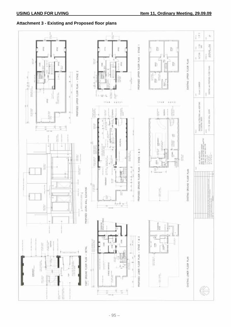
USING LAND FOR LIVING Item 11, Ordinary Meeting, 29.09.09 Attachment 3 - Existing and Proposed floor plans
- 95 –

USING LAND FOR LIVING Item 12, Ordinary Meeting, 29.09.09
- 96 -
ITEM NO: 12 SUBJECT: DEVELOPMENT APPLICATION NO. X/453/2008 FOR A CLUSTER
HOUSING DEVELOPMENT FOR TEN (10) DWELLINGS, AND A COMMUNITY TITLE SUBDIVISION, ON LOT 1 DP 875630, LOT 2 DP 875630, LOT 306 DP 751662, LOT 5 DP 234882, 3 RENWICK CLOSE, 3A RENWICK CLOSE, 115A OLD BATHURST ROAD AND 121 OLD BATHURST ROAD, BLAXLAND
FILE NO: F04905 – X/453/2008 - 09/155142 Management Plan Link
Principal Activity: Using Land for Living Service: Land Use Management Project: This report does not relate to a Management Plan project
Recommendations: That the Development Application No. X/453/2008 for a cluster housing development for ten (10) dwellings, and a community title subdivision, on Lot 1 DP 875630, Lot 2 DP 875630, Lot 306 DP 751662, Lot 5 DP 234882, 3 Renwick Close, 3A Renwick Close, 115A Old Bathurst Road and 121 Old Bathurst Road, Blaxland be determined pursuant to S.80 of the Environmental Planning and Assessment Act 1979 by the granting of consent subject to conditions shown in Attachment 1 to this report.
Disclosure Disclosure of any political donation and/or gift - No
Report by Group Manager Environmental and Customer Services: Reason for report Application has a value in excess of $1,000,000
Type of development Integrated (Rural Fires Act)
Applicant The Christian Reformed Church
Owner Reformed Church Blaxland, and
Reformed Church of Blaxland Retirement Home Ltd
Application lodged 27 May 2008
Property address 3 Renwick Close, 3A Renwick Close and 115A Old Bathurst Road and 121 Old Bathurst Road, Blaxland
USING LAND FOR LIVING Item 12, Ordinary Meeting, 29.09.09
- 97 -

USING LAND FOR LIVING Item 12, Ordinary Meeting, 29.09.09
- 98 -
Site description The site comprises four allotments of land having a total area of
approximately 21,224m2. Two allotments are vacant, one allotment contains a dwelling and one allotment contains a dwelling and a church. An aerial photo of the site is provided at Attachment 2. The site has frontage to Old Bathurst Road to the north, Renwick Close to the east, and single dwelling residential development to the south and west. Parts of the site also adjoin Major Mitchell Reserve to the east and an unnamed public reserve to the south. The landform comprises near level ground fronting Old Bathurst Road where it is proposed to locate the development. The land falls downslope in a southerly direction toward the rear of the site and the Public Recreation Reserve (adjoining Knapsack Park). Vegetation comprises exotic plantings, modified bushland and weed growth over the site. An unformed open drainage channel discharges road water from Old Bathurst Road through the site. A right-of-way access links Maraket Avenue and Renwick Close. The ROW provides access for emergency service vehicles through the south-eastern area of the site.
Proposal The application proposes a cluster housing development and associated subdivision of the land in two stages. The main features of the proposal and sequence of development are as follows: Stage 1
1. Demolition of two existing dwellings, at 121 Old Bathurst Road and 3 Renwick Close; and
2. Re-subdivision of four allotments to create two allotments:- one allotment retaining an existing church building and one allotment for the cluster housing development.
The plan of the subdivision for Stage 1 is provided at Attachment 3. Stage 2
1. Construction of 10 freestanding single storey brick veneer dwellings on the cluster housing allotment; and
2. Subdivision of the cluster housing allotment to create a community title development comprising 10 residential allotments and two community land allotments.
The plan of the subdivision for Stage 2 is provided at Attachment 4. The subdivision works involve the construction of a private cul-de-sac road, installation of service infrastructure, installation of stormwater drainage works and bushfire hazard reduction works.

USING LAND FOR LIVING Item 12, Ordinary Meeting, 29.09.09
- 99 -
The cluster housing allotment has an area of 17,960m2. The 10 residential allotments vary in size from 684m2 to 1,030m2 and have a combined area of 7,758m2. The remainder of the land comprises community property containing remnant bushland and the internal road, managed under a Community Neighbourhood scheme. A copy of the plan showing the cluster housing development is provided in Attachment 5 to this Report. An image depicting the cluster housing development superimposed on an aerial photograph of the site comprises Attachment 6.
Background
In 2003 a development application for 21 seniors living units and a 60 bed aged care facility was refused by the Council. In 2004 a development application for a residential aged care facility containing a 60 bed hostel and 7 supported dwellings was refused by the Council. In 2007 pre-development application advice was given for a community title cluster housing development for 11 dwellings. The advice given has led to the current development application. The current application was originally submitted for 11 dwellings. Negotiation with the applicant on several aspects of the proposal has led to its amendment, resulting in a reduction of the number of dwellings to 10.
Development controls Local Environmental Plan • Zoning – Part Living – Bushland Conservation and part
Environmental Protection – Private under the provisions of Local Environmental Plan 2005
• Protected Area – Escarpment Area • Protected Area – Slope Constraint Area
Development Control Plan – Better Living DCP Development Control Plan 31 – Public Infrastructure Works in Subdivisions and Developments Development Contributions Plan – February 2006 Sydney Regional Environmental Plan No 20 – Hawkesbury Nepean River
Notification and public submissions
The application was advertised for a period of 28 days from 18 June 2008 to 18 July 2008 in the Blue Mountains Gazette as well as written notification to adjoining and nearby properties. 13 submissions from 10 households were received. The application was re-advertised and re-notified following amendments to the proposal, for a period of 28 days from 17

USING LAND FOR LIVING Item 12, Ordinary Meeting, 29.09.09
- 100 -
June 2009 to 17 July 2009. 3 submissions from 3 households were received. Resident issues in the 16 submissions include –
• Over-development of site, out of character in location, impact on property values, overlooking/privacy, traffic, noise, bushfire risk, stormwater drainage, impact on watercourse, loss of bushland and wildlife.
These issues have been considered and, where relevant, are addressed under the compliance table and assessment issue headings below.
Evaluation
The application has been assessed in accordance with Section 79C (Evaluation) of the Environmental Planning and Assessment Act 1979 (“the Act”). A commentary on the assessment of the development against the Section 79C evaluation matters has been detailed in this report for the Council’s consideration. The following issues are considered relevant in the determination of the application:
1. Local Environmental Plan 2005; 2. Development Control Plan – Better Living; 3. Development Control Plan 31 – Public Infrastructure
Works in Subdivisions and Developments 4. Development Contributions Plan – February 2006 5. Sydney Regional Environmental Plan No. 20
Particular assessment issues include: 1. Development design and amenity 2. Environmental impacts 3. Vehicle access and traffic 4. Stormwater drainage 5. Church site 6. Resident issues
Compliance Table: Local Environmental Plan 2005 Clause Standard Proposed Compliance cl. 9 Considerations
before development consent
The development is consistent with the applicable LEP aims and objectives, and complies with the relevant locality management provisions, assessment requirements and development provisions.
Yes
cl. 12 Principal objectives of the plan
The development meets the relevant principal objectives of the LEP.
Yes
cl. 13 General locality management
The development complies with the zone objectives and is a permissible within the zone applying the zone.
Yes
cl. 15 Locality management
The development has been assessed in accordance with the provisions in Part 3
Yes

USING LAND FOR LIVING Item 12, Ordinary Meeting, 29.09.09
- 101 -
Clause Standard Proposed Compliance within the living zones
Schedule 2. See Schedule 2 assessment below
cl .24 Living – Bushland Conservation zone
The development meets the following relevant objectives:-
a) Allows for residential development in the form of single detached dwellings within the capacity of the environment to sustain such development and minimizes impact on environmentally sensitive areas.
b) Preserves native bushland in areas having bushland character, where consistent with protection from bushfire.
c) Ensures form and siting of buildings, colours, landscaping and building materials are appropriate for and harminise with the bushland character of the locality.
Yes
cl. 30 Environmental Protection – Private zone
The development meets the following relevant objectives:-
a) Protect land that is environmentally sensitive
b) Allow bushfire hazard reduction in a form consistent with protection of natural ecological values
c) Contribute to the maintenance of bio-diversity
Yes
cl.32 Permissibility Subdivision is permissible with consent in the Living – Bushland Conservation zone and Environmental Protection – Private zone. The initial subdivision will create an allotment that meets the LEP definition of cluster housing. Cluster housing is a permissible land use with consent in the Living – Bushland Conservation zone.
Yes
Yes
LEP Dictionary
Cluster housing definition
The development meets the definition of cluster housing, as follows:- “Development of land, containing an area of development excluded land, designed as an integrated whole and involving:-
a) Concentration of the development on the land within the development site that is most suited to development, and
b) Subdivision of land into five lots or more, and
c) Erection of dwelling houses on each lot (other than the community property lot), and
d) Consolidation of the major part of the development excluded land within a common property lot, and
e) Management measures to create and
Yes
Yes
Yes
Yes
Yes
Yes

USING LAND FOR LIVING Item 12, Ordinary Meeting, 29.09.09
- 102 -
Clause Standard Proposed Compliance maintain fire protection zones, and to protect and enhance the environmental values of the development excluded land and any other natural areas within the site, and
f) A scheme for joint ownership of the common property lot by the owners of all other lots in a neighbourhood scheme.”
Yes
cl.37 Bushfire safety authority
The whole of the land is bushfire prone. The subdivision component of the development is a special fire protection purpose. A bushfire safety authority has been issued NSW Rural Fire Service and the conditions are included in the consent conditions shown in Attachment 1.
Yes
cl.44 Environmental impact
See “Environmental Impacts” at Point 2 in Discussion of Issues below.
Yes
cl.45 Protected Area - Slope Constraint Area
The dwellings, road and stormwater drainage works are sited clear of the Protected Area. The Asset Protection Zone encroaches into the Protected Area, however the Protected Area objectives are not compromised.
Yes
cl. 47 Protected Area – Ecological Buffer Area
A deemed Ecological Buffer Area occurs to the riparian zone of the watercourse at the rear of the land. A detailed environmental assessment indicates the objectives and provisions of the Protected Area are complied with. See also “Environmental Impacts” at Point 2 in Discussion of Issues below.
Yes
cl.49 Protected Area – Escarpment Area
The land is not visually prominent within the eastern escarpment. Tree removal is limited to the portion of the site confined to the concentration of cluster housing. The dwellings will not protrude above the vegetation canopy or adjacent dwellings. Tree canopies to the rear of the site will screen the development from the south. Some trees with useful life expectancy are retained on the residential allotments.
Yes
cl.51 Watercourses Refer to cl. 47 above and also see “Environmental Impacts” at Point 2 in Discussion of Issues below.
Yes
cl.53 Retention & management of vegetation
See “Environmental Impacts” at Point 2 in Discussion of Issues below.
Yes
cl.55 Weed management
The Vegetation Management Plan contains a strategy for removal and management of environmental weeds on the site.
Yes
cl.56 Site disturbance and erosion control
The development is designed to minimize the extent of site disturbance.
Yes
cl.57 Stormwater management
See “Stormwater design” at Point 4 in Discussion of Issues below.
Yes
cl.58 Modification of land form
The dwellings have suspended timber floors and the design responds to the slope. Cut and
Yes

USING LAND FOR LIVING Item 12, Ordinary Meeting, 29.09.09
- 103 -
Clause Standard Proposed Compliance fill does not exceed 1 metre.
cl.60 Consideration of character & landscape
Form, scale, materials and location of dwellings, and the proposed landscape planting, are acceptable. See “Development design and amenity” at Point 1 in Discussion of Issues below.
Yes
cl.78-86
Bushfire protection
The application is supported by a bushfire assessment report. Protection measures include the establishment of Asset Protection Zones, a right-of-way access for emergency service vehicles, and static water supply for bushfire fighting. The dwellings and subdivision meet the construction standards for the level of risk. The NSW Rural Fire Service has issued a bushfire safety authority.
Yes
cl.87 Crime Minimisation
The development incorporates the required principles.
Yes
cl. 91 Provision of services for subdivision
The land has reticulated sewer and town water available. The applicant must obtain a s73 Certificate from Sydney Water prior to the issue of a subdivision certificate.
Yes
cl.92 Subdivision related to specific land uses
The cluster housing allotment has an area of 1.3327 hectares zoned Living – Bushland Conservation and an area of 4,632.68m2 zoned Environmental Protection – Private. (a) No more than 8 lots per hectare on the part of the land zoned Living – Bushland Conservation. (b) Access and buildings are located clear of development excluded land. (c) The dwellings are designed and located to minimise bushfire threat. (d) The management of the environmental qualities of the common property land is to be secured by means of registration an 88E restriction. (e) The development incorporates areas of bushland and native vegetation (f) The dwellings are located on previously disturbed areas and in areas of least slope. The materials, form and scale of the dwellings are compatible with neighbouring development. The development provides a suitable response to the landscape character.
Yes
Yes
Yes
Yes
Yes
Yes
cl .94 General provision of services
The land has all services available. The applicant must obtain certificates from utility service providers prior to issue of a subdivision certificate.
Yes

USING LAND FOR LIVING Item 12, Ordinary Meeting, 29.09.09
- 104 -
Clause Standard Proposed Compliance cl.98-100
Vehicle access, parking and roads
The development provides legal access from Old Bathurst Road with good intersection sight distances. The dwellings are arranged around a cul-de-sac which is part of the common property lot and is a private road. Off street car parking for 2 vehicles per dwelling is provided.
Yes
cl.103 Privacy for dwellings
Visual privacy between the cluster dwellings is afforded by window offsets, vertical height differences, building separation, landscape treatment and privacy screens.
Yes
cl.105 Energy efficiency
The dwellings are BASIX compliant
Yes
cl.108 Accessibility of dwellings
The development contains 4 dwellings designed to be fully accessible. This is more than the minimum 20% (2 dwellings) required.
Yes
cl.109 Adaptability of dwellings
Cluster housing is not required to be adaptable. The development, however, contains 4 dwellings that are adaptable.
Locality Management Provisions – Schedule 2 Sch. 2 Locality
management – Living - Bushland Conservation zone
Building height The dwellings do not exceed the maximum permitted height of 5.5 metres in a Protected Area – Escarpment Area Front building setback A 10 metre setback to Old Bathurst Road is proposed for Dwellings 1 and 10. Side building setback Dwellings 1 and 10 do not exceed 80% of the width of their respective allotments. Site coverage and pervious area Building site cover does not exceed 30% for each allotment. Soft pervious area is more than 60% for each allotment Environmental Considerations The landscaping and vegetation management plan address retention and supplementation of locally indigenous vegetation
Yes
Yes
Yes
Yes
Yes
Better Living Development Control Plan The DCP does not contain specific provisions for cluster housing. The development complies with Part C - General Principles, Part D1 - Dwelling Houses and Ancillary Structures and Part D8 - Subdivision.

USING LAND FOR LIVING Item 12, Ordinary Meeting, 29.09.09
- 105 -
Development Control Plan 31 – Public Infrastructure Works in Subdivisions and Developments Compliance with the required standards is achievable and is addressed where relevant by consent conditions. Fully detailed construction plans, demonstrating design to the required standards, will be subject to further assessment as part of a subdivision construction certificate application. Development Contributions Plan The Plan requires payment of a levy contribution for the creation of additional allotments by subdivision. The existing land has a credit of four – one for each of the existing four allotments. This reduces the levy contribution from ten residential allotments to six residential allotments. The contribution is required by consent condition to be paid prior to the issue of a subdivision construction certificate. The amount payable is $4,966.44. Sydney Regional Environmental Plan No 20 – Hawkesbury Nepean River The development addresses the relevant requirements of the SREP. The development will have a neutral effect on the catchment. Discussion of Issues 1. Development design and amenity The proposed dwellings are freestanding single storey buildings of masonry construction with pre-painted metal roofs. The dwellings have a contemporary appearance and a scale which is in keeping with the character of the established dwellings on neighbouring land. Typical elevations of the dwellings are provided at Attachment 7 and sections are provided at Attachment 8. The buildings are sited and landscaped in a manner which provides reasonable privacy between other dwellings in the development. Living rooms and adjacent courtyards are located to north and north-west and have reasonable solar access. Dwellings 1 to 4 are located in close proximity to the rear boundaries on properties in Lookout Avenue and Old Bathurst Road. Some residents in their submissions expressed concerns that their privacy would be affected. Windows in the western walls of Dwellings 1 to 4, adjacent these properties, are either bathroom windows or high set windows with no direct line of sight into neighbouring yards. The dwellings are not elevated above adjoining land and will not result in any overlooking or significant overshadowing. Boundary fencing and landscaping will also provide some privacy between yard areas. Proposed landscaping of the site retains some existing mature canopy trees on the residential allotments and provides supplementary indigenous native plantings. A copy of the landscape plan is provided at Attachment 9. It is considered that the development will not adversely impact on the privacy of adjoining premises. The dwellings and landscaping provide a well designed response to the site conditions and neighbourhood character. 2. Environmental Impacts The planning intention behind cluster housing development under LEP 2005, which is only permissible in the Living-Bushland Conservation zone, is to minimize environmental impacts and to provide mechanisms for ongoing environmental management as part of the development. The cluster housing is concentrated on land which is not “development excluded land” within the Living – Bushland Conservation zone. The site contains land zoned Environmental Protection – Private at the southern (rear) portion of the land, and Protected Area – Slope Constraint on a portion of the land zoned Living – Bushland Conservation adjacent the

USING LAND FOR LIVING Item 12, Ordinary Meeting, 29.09.09
- 106 -
Environmental Protection – Private area. The southern area of the land contains the head of an ephemeral watercourse which drains south to a larger watercourse in Mitchells Pass. The housing is not located on the Environmental Protection – Private zone or the Protected Area. The application contains a flora and fauna assessment report, tree assessment report and a vegetation management plan. The flora and fauna report identifies the presence of threatened species habitat for the red-crowned toadlet in the ephemeral drainage line and its riparian zone. The site provides the only opportunity for a biodiversity or bushland corridor between the Major Mitchell Reserve to the east of the site and the Public Recreation Reserve (adjoining Knapsack Park) to the south of the site. This has been incorporated into the development as part of the cluster housing approach. Section 5A of the Environmental Planning and Assessment Act 1979 requires the Council to consider certain factors in determining whether the proposal is likely to have a significant effect on threatened species, populations and ecological communities or their habitats. As part of the flora and fauna report, the necessary “seven-part tests” required to satisfy section 5A have been undertaken to the satisfaction of the Council’s environmental scientist. The submitted seven part test for the red-crowned toadlet acknowledges the need to protect the rocky open woodland around the drainage line as the primary habitat and recommends runoff be diverted away from the creek-line. Recovery measures for this threatened species include the following:
• Applying mosaic pattern hazard reduction techniques; • Not permitting removal of sandstone rock from bushland in escarpment areas; • Retention and protection of habitat and buffers around habitat, particularly vegetation
on upper slopes and ridges; • Protection of water quality and maintenance of natural water flows in drainage lines
below developed ridges; and • Maintenance of dense vegetation and leaf litter along drainage lines below sandstone
ridge lines. In the development as originally proposed, the extent of the lot layout, stormwater treatment pond and asset protection zones were located within the Protected Area – Slope Constraint Area and encroached upon the threatened species habitat and buffer, land zoned Environmental Protection and vegetation in the corridor linking the two reserves. Following negotiations with the applicant, the proposal has been amended to move the development further from the protected areas and to retain a bushland corridor linking the two reserves. This has been achieved by deleting one of the dwellings/allotments, relocating the stormwater treatment pond outside the buffer to the ephemeral watercourse, and reducing the depth of the allotments. Stormwater treatment has been improved in the treatment train by introducing infiltration and screening devices. Part of the bushfire asset protection zone encroaches into part of the Slope Constraint Area. The slope is moderate in this location and contains isolated rocky outcrops and sparse vegetation cover. This part of the site is located within the Community Property lot and will be managed by the owner’s corporation. A Vegetation Management Plan (VMP) has been prepared for the management of the vegetation over the site, including the vegetation within the asset protection zone. The objectives and provisions for the protected area will be met in the implementation of the VMP.

USING LAND FOR LIVING Item 12, Ordinary Meeting, 29.09.09
- 107 -
3. Vehicle Access and Traffic The development proposes the construction of a common driveway/cul-de-sac around which the dwellings will be constructed. The cul-de-sac is a private road maintained by the Owners Corporation. Its dimensions and configuration are consistent with a public road and allow access for service and passenger vehicles to Australian Standard AS2890.1 Parking Facilities – Off Street Parking. The intersection with Old Bathurst Road provides safe sight distances in all directions. Each dwelling contains a double garage and parking for visitors within each allotment. Off site parking in Old Bathurst Road is not likely to occur on any regular basis. The size of the development will not generate a significant volume of additional traffic. Old Bathurst Road has adequate capacity for the additional traffic generated. There is potential for construction traffic to cause impact on adjacent residential premises. This is for the short term only, and the proposed development consent conditions limit access and hours of construction within reasonable limits. The traffic generated by the completed development is not likely to adversely impact on the neighbouring residential area. 4. Stormwater Drainage Stormwater run-off from the site comprises discharge of road water from Old Bathurst Road, and generation of stormwater run-off on site from the hard surfaces of the buildings, driveways and cul-de-sac. The stormwater drainage concept plan aims to create post development discharge conditions that do not exceed pre-development conditions. The concept contains the following design elements:-
1. Piping of stormwater drainage from Old Bathurst Road, the cul-de-sac and ground surface run-off into on site detention tanks and on to a stormwater dispersion pond at the rear of the site;
2. The treatment train includes gross pollutant traps, below ground infiltration, and nutrient treatment in bio-swales;
3. A settlement pond allows filtering of sediment, infiltration of water and dispersed over land flow;
4. Each dwelling contains a rainwater tank for reuse of roof water with overflow to the dispersion pond or a dispersion trench. The dispersal devices allow dispersed overland flow into the upper catchment of a water course below the site;
5. Provision for overland surcharge in storm events; and 6. The entire stormwater system will be managed and maintained by the Owners
Corporation, as required in covenants registered on the land titles. The concept plan, which is Attachment 10, provides a satisfactory design solution for stormwater management in accordance with best practice. The proposal meets the required standards for stormwater management in clause 57 of LEP 2005. Stormwater run-off will not affect adjoining residential premises. 5. Church site An existing church is located at 3 Renwick Close on an allotment 4,642m2 in area. The subdivision incorporates the rear of the allotment into the cluster housing lot, thereby reducing the land area of the church site to 3,388m2. The church building and its curtilage are not affected, however the reduction in land area reduces the capacity of the land for existing and future on site disposal of stormwater. Inter-allotment drainage on the development site to allow for stormwater drainage is proposed by the applicant. The reduced allotment size remains sufficient for the continued operation of the church and retention of landscape screening. The subdivision does not affect the existing car park which is located at the front of site off Renwick Place. It is proposed to extend the right-of-

USING LAND FOR LIVING Item 12, Ordinary Meeting, 29.09.09
- 108 -
carriageway for emergency services vehicles through the car park as the ROW presently ends at an unformed section of Renwick Place. Adequate lawn areas remain on the site for overflow car parking if needed. Development consent was granted in 1983 for establishment of a school to operate in conjunction with the church. School buildings and playground areas were approved at the rear of the site which will be affected by the reduction in land area in the subdivision. The school ceased operating several years ago and the owner has verbally advised it is not intended to re-open. Playground equipment and demountable buildings have been removed. The owner will be required to surrender the consent for the school as a condition of consent for the cluster housing development. 6. Public submissions The resident issues include over-development of site, out of character in location, impact on property values, overlooking/privacy, traffic, noise, bushfire risk, stormwater drainage, impact on watercourse, loss of bushland and wildlife. These issues have been addressed in the assessment above. The development is not likely to have an adverse impact on the adjoining residential premises and neighbouring locality. Conclusion The proposal provides a suitable design response to the site by locating the development on the part of the land most suited to development, and consolidating the remainder of the land into a community lot for management under a neighbourhood scheme registered on the land title. The development provides a variety of housing options, some of which are accessible and adaptable. The density of the development is compatible with surrounding established development. The bulk, scale and single storey form of the dwellings and proposed landscape scheme are consistent with surrounding development and streetscape. Suitable management of the protected areas and vegetation on the site will be provided by the neighbourhood scheme. The development provides adequate protection from the bushfire hazard and complies with the provisions of LEP 2005 and development control plans. The applicant has been given a copy of the draft consent conditions and has provided written agreement to these. The application is therefore recommended for approval subject to these conditions. ATTACHMENTS/ENCLOSURES 1 Conditions of Consent 09/155897 Attachment 2 Aerial photo of site 09/158685 Attachment 3 Plan of subdivision Stage 1 09/155540 Attachment 4 Plan of subdivision Stage 2 09/159823 Attachment 5 Site Plan 09/155537 Attachment 6 Aerial photograph depicting Stage 2 09/158811 Attachment 7 Elevations 09/155545 Attachment 8 Section 09/155547 Attachment 9 Landscape Plan 09/155562 Attachment 10 Concept Stormwater Drainage Plan 09/155564 Attachment
* * * * * * * * * *

USING LAND FOR LIVING Item 12, Ordinary Meeting, 29.09.09 Attachment 1 - Conditions of Consent
- 109 –
Confirmation of relevant
plans 1. To confirm and clarify the terms of consent, the development shall be carried
out in accordance with the following:- • Site plan prepared by C J van Breda Architect, Job No 876, drawing no
02K, Issue K, dated 5 May 2009 • Floor plan and elevations by C J van Breda Architect, unnumbered,
undated • Section plan by C J van Breda Architect, Job No 876, drawing no 04c,
Issue C, dated 5 May 2009 • Driveway levels by C J van Breda Architect, numbered 876/10-12,
undated • Stormwater concept plan by Jones Nicholson Pty Ltd Consulting Civil and
Structural Engineers, Job No 070471, drawing no CP01, Amendment 7, dated 3 April 2009
• Church car park plan by Jones Nicholson Pty Ltd Consulting Civil and Structural Engineers, Job No 070471, drawing no CP04, Amendment 2, dated 3 April 2009
• Hydraulic Design Report by Jones Nicholson Pty Ltd Consulting Civil and Structural Engineers, reference AW070471LTR, dated 31 March 2009
• Landscape Plan by Stuart Pittendrigh Registered Landscape Architect, Job No LP01, dated April 2009, (and as required by this consent to be amended)
• Statement of Environmental Effects by Smyth Planning dated May 2008 • Bushfire Hazard Assessment Report by Building Code and Bushfire
Hazard Solutions P/L, Issue 2 dated May 2008, and as amended 31 March 2009.
• Flora and Fauna Assessment by UBM Ecological Consultants Pty Ltd dated October 2007.
• Predevelopment Tree Assessment Report by Stuart Pittendrigh Consultant Arborist dated October 2007
• Vegetation Management Plan by UBM Ecological Consultants, Revision 2 dated 12 August 2009,
and accompanying documents, unless otherwise amended by this consent.
Confirmation of approved development
2. The approved development and sequencing of works is as follows:- Development Stage 1 – • Subdivision of land to create two lots (Proposed Lots 11 and 12) Development Stage 2 – • Construction of cluster housing development comprising ten dwellings and
cul-de-sac road on Lot 12, and • Subdivision of Lot 12 to create ten residential lots and two community title
lots.
Period of development consent
3. Physical commencement of construction is required within a two (2) year period from the date on which the consent becomes operational pursuant to s.95 (Lapsing of Consent) of the Environmental Planning and Assessment Act 1979. This period may only be extended by a period of one (1) year in

USING LAND FOR LIVING Item 12, Ordinary Meeting, 29.09.09
- 110 –
accordance with s.95A of the Act. GENERAL CONDITIONS
Signage 4. To ensure that the site is easily identifiable for deliveries and provides information on the person responsible for the site, a sign displaying the following information is to be erected: + The statement “Unauthorised access to the site is not permitted”. + The names of the builder or another person responsible for the site along
with an out of hours contact number. + Lot or Street number.
Plans on site 5. A copy of the stamped and approved plans, development consent and the construction certificate are to be on the site at all times.
Site management 6. To safeguard the local amenity, reduce noise nuisance and to prevent environmental pollution during the construction period: a) Site and building works (including the delivery of materials to and from the
property) shall be carried out Monday to Friday between 7am-6pm and on Saturdays between 8am-3pm. Alteration to these hours may be possible for safety reasons but only on the approval of Council.
b) Stockpiles of topsoil, sand, aggregate, spoil or other material shall be stored clear of any drainage path or easement, natural watercourse, footpath, kerb or road surface and shall have measures in place to prevent the movement of such material off site.
c) Building operations such as brickcutting, washing tools, concreting and bricklaying shall be undertaken on the building block. The pollutants from these building operations shall be contained on site.
d) Builders waste generated under this consent (including felled trees, tree stumps and other vegetation) must not be burnt or buried on site. All waste must be contained and removed to an approved Waste Disposal Depot or in the case of vegetation, with the exception of environmental and declared noxious weeds, mulched for re-use on site.
Hoarding / fencing 7. To ensure the protection of the public and prevention of unauthorised site access, site secure fencing to be provided to the boundaries of the construction site to the requirements of NSW Workcover Authority.
Workers amenities 8. Before work starts, toilet facilities must be provided for construction personnel on the site on the basis of 1 toilet for every 20 workers. Amenities are to be installed and operated in an environmentally responsible and sanitary manner. Toilets cannot remain on site for any longer than 12 months, without the further approval of Council.
Erosion & sediment controls 9. To preserve the unique environment of the Blue Mountains and to contain soil
and sediment on the property, controls in accordance with Council’s Better Living Development Control Plan are to be implemented prior to clearing of the site vegetation and the commencement of site works. This will include: a) The installation of a sediment fence with returned ends across the low side
of the site so that all water flows through. These shall be maintained at no

USING LAND FOR LIVING Item 12, Ordinary Meeting, 29.09.09
- 111 –
less than 70% capacity at all times. Drains, gutters, roadways etc., shall be kept clean and free of sediment.
b) To prevent the movement of soil off site, a single entry/exit point to the property shall be constructed of 40mm blue metal aggregate or recycled concrete to a depth of 150mm. The length must be at least 5 metres with the width at least 3 metres.
Soil erosion fences shall remain and must be maintained until all disturbed areas are restored by turfing, paving, revegetation.
Excavations 10. All excavations are to be guarded and protected to prevent them from being dangerous to the public and surrounding properties.
Council’s Specification for
Engineering Works 11. All engineering works required by this development (including sediment and
erosion controls, road, access, footpath and drainage works) are to be in accordance with the Council’s Specification for Engineering Work for Subdivisions and Development, Part 1 – Design and Part 2 – Construction (development Control Plan No. 31), Australian Rainfall and Runoff 1987, The Australian Runoff Quality, A Guide to Water Sensitive Urban Design 2006 and other relevant Australian Standards.
DEVELOPMENT STAGE 1 CONDITIONS A. General
Construction certificate (subdivision)
12. A construction certificate is required prior to the commencement of inter-allotment drainage works and fire trail upgrading works. This certificate can be issued either by Council as the consent authority or by an accredited certifier.
Surrender of development consent for educational establishment at 3 Renwick Close
13. To limit the intensity of use on the reduced allotment size, the owner of Lot 1 DP 875630 No 3 Renwick Close shall surrender Development Consent 3256 dated 7 November 1983 for an educational establishment on the land. A notice of surrender of development consent that provides the information required by cl. 97 o the Environmental Planning and Assessment Regulation 2000 shall be submitted to Council prior to the issue of a subdivision certificate.
Certificates from authorities Early contact with these authorities is recommended
14. To ensure satisfactory effluent disposal and utility services are provided to all lots on the subdivision, you are required to submit to the Council compliance certificates from: Sydney Water A Section 73 Compliance Certificate under the Sydney Water Act 1994
must be obtained indicating all proposed lots are serviced by reticulated water and sewer systems.
The Section 73 Certificate must be submitted to the Principal Certifying Authority prior to release of the subdivision certificate for the development.
Application must be made through an authorised Water Servicing Coordinator. For details, see the Sydney Water web site at www.sydneywater.com.au or telephone 132 092.
Following application, a ‘Notice of Requirements’ will be forwarded detailed water and sewer extensions to be built and charges to be paid. Please make early contact with the Coordinator, since building of

USING LAND FOR LIVING Item 12, Ordinary Meeting, 29.09.09
- 112 –
water/sewer extensions can be time consuming and may impact on other services and building, driveway or landscape design.
Integral Energy indicating that satisfactory arrangements have been made for the provision of underground electricity supply to each lot in the subdivision. An approved telecommunications service provider stating that satisfactory arrangements have been made for underground telephone services to each lot in the subdivision. The compliance certificates are to be submitted to the Council prior to the issue of the Subdivision Certificate.
Street numbering 15. To ensure appropriate definition of the allotments the following street numbers shall apply to the proposed lots:-
Lot number Street number
Proposed Lot 11 3 Renwick Close Blaxland
Proposed Lot 12 117-121 Old Bathurst Road Blaxland
The street number for 3 Renwick Close shall be displayed at the front of the site or on the building in a visually prominent location from the street
B. Works to be carried out as part of the subdivision
Demolition of buildings
16. All buildings and associated service infrastructure on proposed Lot 12 shall be demolished and removed from the site. Reference shall be made to the separate demolition conditions in this consent. The existing dwelling at 121 Old Bathurst Road may remain on the land, if required, until the commencement of Development Stage 2.
Relocation of services
17. Service infrastructure on the land shall be relocated to ensure existing services do not encroach over the common boundary between the two lots. The applicant shall provide written certification that services have been relocated and/or do not encroach, prior to the issue of a Subdivision Certificate.
Fire trail upgrading
18. To ensure suitable access for bush fire fighting and other emergency services,
the fire trail is to be constructed 4 metres wide with a sealed 150mm thick DGB20 pavement on an approved subgrade prior to the issue of the subdivision certificate. This work is to include the following:- a) Installation of lockable farm style gates where the fire trail crosses
common boundaries between the proposed lots. The lockable gate is to be a minimum of 4 metres wide and centrally located over the fire trail. The gates are to be fitted with BF3 locks.
b) Removal of vegetation and overhanging branches within a 6 metre wide by 4 metre high corridor located centrally over the fire trail.
c) In accordance with RFS bushfire safety authority and Planning for Bushfire Protection 2006.

USING LAND FOR LIVING Item 12, Ordinary Meeting, 29.09.09
- 113 –
Weed management
19. To minimise the potential for spreading of weeds, control of all noxious and woody and climbing environmental weeds shall be commenced on the site in accordance with the approved Vegetation Management Plan and to the satisfaction of the Council’s Environmental/Landscape Assessment Officer prior to the issue of the Subdivision Certificate.
Church car park
20. To ensure efficient operation of on site parking, the church car park shall be line marked to clearly designate the parking spaces. Dimensions shall comply with AS 2890.1 – 2004 Parking facilities - off street parking. At least one space shall be dimensioned for parking for people with a disability.
Inter-allotment drainage 21. Inter-allotment drainage shall be provided on Proposed Lot 12 for the benefit of Proposed Lot 11, located generally in accordance with the concept stormwater design by Jones Nicholson Pty Ltd. The level spreader shall be repositioned parallel to the contours of the land. Full construction details shall be included in the subdivision Construction Certificate application.
Church stormwater drainage 22. The stormwater drainage from the church site (Proposed Lot 11) shall be connected to the inter-allotment drainage easement. A stormwater drainage plan, prepared by a suitably qualified person, shall be submitted with the construction certificate application. The plan shall incorporate measures for retention and reuse of stormwater on site, and for on site infiltration, prior to the easement connection point. The purpose of on site retention and infiltration is to minimise the stormwater load on the absorption area on Proposed Lot 12.
Demolition Conditions
Demolition of Buildings generally
23. The demolition work is to be supervised by a competent person with due regard to safe working practices and in accordance with the requirements of the NSW WorkCover Authority; Such work is to be carried out in accordance with the Occupational Health & Safety Regulations, 2001, and Australian Standard 2601 – 1991.
Demolition of Buildings -
notification 24. The applicant is to notify Council and adjoining residents, in writing, at least ten
(10) working days prior to demolition commencing, of their intention to commence demolition works. In the case of adjoining residents, such notification is to be a clearly written note, on at least note pad size paper, giving the date demolition will commence and be placed in the letterbox of every premises (including every residential flat or unit, if any) either side and immediately to the rear of the demolition site.
Display of signage 25. The developer will display appropriate demolition signage prior to and during demolition works.
Dust control 26. The techniques adopted for stripping out and for demolition are to minimise the release of dust into the atmosphere. Before commencing work, any existing accumulations of dust are to be collected, placed in suitable containers and removed. Selection of appropriate
USING LAND FOR LIVING Item 12, Ordinary Meeting, 29.09.09
- 114 –
collection techniques, such as vacuuming or hosing down, shall take account of the nature of the dust and the type of hazard it presents (eg., explosive, respiratory etc). Dust generated during stripping or during the breaking down of the building fabric to removable sized pieces shall be kept damp until it is removed from the site or can be otherwise contained. The use of excess water for this purpose is to be avoided. It should be borne in mind, that in certain environments and under certain stimuli, deposits of combustible dust on beams, machinery and other surfaces may be subject to flash fires, and suspensions of combustible dusts in the air can cause them to explode violently (see NFPA Handbook).
Adjoining buildings 27. In consideration of the proximity of the site’s adjoining buildings: Safe access and egress from adjoining buildings is to be maintained at all times for the duration of the demolition work. No demolition activity is to cause damage to or adversely affect the structural integrity of adjoining buildings. Consideration should be given to the use of shoring and underpinning and to changes in the soil conditions as a result of demolition and appropriate action taken. The effect of vibration and concussion on adjoining buildings and their occupants is to be minimised by selection of appropriate demolition methods and equipment.
Disposal of Asbestos 28. Any asbestos material, including asbestos cement, is to be disposed of to an approved waste management facility licensed to receive asbestos.
Removal of material 29. All demolished material and excess spoil from the site shall be disposed of at a location and in a manner approved of by Council. No material is to be burnt on site.
C. At completion of subdivision works
Subdivision certificate application
30. An application for a subdivision certificate shall be made to the Principal Certifying Authority upon completion of all conditions of Development Consent relating to Development Stage 1. The application is to include the original plan of subdivision and the draft 88B and 88E instruments, plus five (5) copies. The subdivision shall be registered at Land and Property Information prior to the development proceeding to Development Stage 2.
Completion of works 31. All works required by this consent for Development Stage 1 are to be
completed to the Principal Certifying Authority’s satisfaction prior to the issue of the Subdivision Certificate. Accordingly, the applicant is to submit a Compliance Certificate from an appropriately Accredited Certifier or the Council’s Engineer certifying that all internal works are completed in accordance with the approved plans.
Works-as-Executed Plans 32. Prior to the issue of the Subdivision Certificate, a Works as Executed Plan of all internal engineering works prepared by a registered surveyor shall be submitted to the Principal Certifying Authority for approval. The inter-allotment drainage and emergency services access/fire trail are to be

USING LAND FOR LIVING Item 12, Ordinary Meeting, 29.09.09
- 115 –
located by survey and plotted on the Works as Executed Plan.
Site stabilisation
33. All disturbed earthworks and/or batters, are to be restored, stabilised, topsoiled and turfed/revegetated to the Principal Certifying Authority’s satisfaction prior to release of the Subdivision Certificate.
Inter-allotment Stormwater Drainage System Positive covenant
34. To ensure the on site stormwater drainage system is satisfactorily maintained, a covenant under Section 88E of the Conveyancing Act, 1919 shall be prepared and registered over all proposed lots. The terms of the 88E Instrument with positive covenant shall include, but not be limited to, the following:
a) The Proprietor of the property shall agree to be responsible for keeping clear and the maintenance of all pits, pipelines, trench barriers and other structures.
The 88E Instrument shall also contain a provision that it may not be extinguished or altered except by Blue Mountains City Council. The 88E Instrument shall be submitted with the Subdivision Certificate application.
Right of Carriageway and Maintenance of Fire Trails 88B Instrument
35. To ensure suitable access for emergency vehicles an instrument setting out Terms of Restriction on the use of land intended to be created, pursuant to Section 88B of the Conveyancing Act, 1919 shall be submitted in a form acceptable to the Council indicating the following: a) A 6m wide minimum right of carriageway, centrally located over the fire
trails, shall be created. The right of carriageway shall be in favour of the Rural Fire Service and other emergency services, and
b) The fire trails are to be maintained to the satisfaction of the Rural Fire Service by the owners of the lots burdened by the right of carriageway
The 88B Instrument shall also contain a provision that it may not be extinguished or altered except by Blue Mountains City Council. The 88B Instrument shall be submitted with the Subdivision Certificate application.
Easement for existing street drainage
36. A 3 metre wide drainage easement shall be registered in favour of Blue Mountains City Council over the Council’s stormwater drainage traversing the site. The 88B Instrument shall contain a provision that the easement may not be extinguished or altered except by Blue Mountains City Council. The 88B Instrument shall be submitted with the Subdivision Certificate application.
DEVELOPMENT STAGE 2 CONDITIONS A. General
Construction certificate (subdivision)
37. A construction certificate is required prior to the commencement of road, drainage, fire trail and other civil works. This certificate can be issued either by Council as the consent authority or by an accredited certifier. Evidence of the registration at the Land and Property Information Office of the subdivision in Development Stage 1 shall be provided to the Principal

USING LAND FOR LIVING Item 12, Ordinary Meeting, 29.09.09
- 116 –
Certifying Authority prior to the issue of the construction certificate.
Construction certificate (building)
38. A construction certificate is required prior to the commencement of any building or related site works. This certificate can be issued either by Council as the consent authority or by an accredited certifier. Evidence of the registration at the Land and Property Information Office of the subdivision in Development Stage 1 shall be provided to the Principal Certifying Authority prior to the issue of the construction certificate.
Construction of access 39. To ensure adequate off street access is provided for construction traffic, the cul-de-sac shall be formed for construction access prior to the commencement of construction of the dwellings and infrastructure works.
Developer contributions Prior to issue of a subdivision certificate
40. In accordance with the Blue Mountains Development Contributions Plan February 2006, a levy contribution of $827.74 per dwelling allotment in Area 5 (Warrimoo to Lapstone) is payable. The existing development site has a credit of four allotments. Levy contributions therefore apply to the additional six residential allotments created. The contribution per lot consists of the following components:
Open Space/Recreation $115.26
Bush Fire Services $134.15
Administration $17.61
Occupancy rate x 3.1
Total per lot $827.74
The amount payable for six residential allotments is $4966.44. This amount will remain fixed for a period of twelve months from the date of this consent. After this time, the amount will be indexed in accordance with the Development Contributions Plan. The contribution is payable prior to the issue of a Subdivision Certificate.
Certificates from authorities Early contact with these authorities is recommended
41. To ensure satisfactory effluent disposal and utility services are provided to all lots on the subdivision, you are required to submit to the Council compliance certificates from: Sydney Water A Section 73 Compliance Certificate under the Sydney Water Act 1994
must be obtained indicating all proposed lots are serviced by reticulated water and sewer systems.
The Section 73 Certificate must be submitted to the Principal Certifying Authority prior to release of the subdivision certificate for the development.
Application must be made through an authorised Water Servicing Coordinator. For details, see the Sydney Water web site at www.sydneywater.com.au or telephone 132 092.
Following application, a ‘Notice of Requirements’ will be forwarded detailed water and sewer extensions to be built and charges to be paid.
USING LAND FOR LIVING Item 12, Ordinary Meeting, 29.09.09
- 117 –
Please make early contact with the Coordinator, since building of water/sewer extensions can be time consuming and may impact on other services and building, driveway or landscape design.
Integral Energy indicating that satisfactory arrangements have been made for the provision of underground electricity supply to each lot in the subdivision. An approved telecommunications service provider stating that satisfactory arrangements have been made for underground telephone services to each lot in the subdivision. The compliance certificates are to be submitted to the Council prior to the issue of the Subdivision Certificate.
Street numbering 42. The following street numbers apply to the allotments within the subdivision:-
Lot number Street number
Proposed Lot 1 1/117-121 Old Bathurst Road Blaxland
Proposed Lot 2 2/117-121 Old Bathurst Road Blaxland
Proposed Lot 3 3/117-121 Old Bathurst Road Blaxland
Proposed Lot 4 4/117-121 Old Bathurst Road Blaxland
Proposed Lot 5 5/117-121 Old Bathurst Road Blaxland
Proposed Lot 6 6/117-121 Old Bathurst Road Blaxland
Proposed Lot 7 7/117-121 Old Bathurst Road Blaxland
Proposed Lot 8 8/117-121 Old Bathurst Road Blaxland
Proposed Lot 9 9/117-121 Old Bathurst Road Blaxland
Proposed Lot 10 10/117-121 Old Bathurst Road Blaxland
Proposed Lot 11 Community Property 117-121 Old Bathurst Road Blaxland
Proposed Lot 12 Community Property 117-121 Old Bathurst Road Blaxland
The street number 117-121 shall be displayed at the entrance to the site at Old Bathurst Road.
Site identification signage 43. To ensure appropriate identification of the site and access, signage shall be provided on the Community Property at the site entrance stating:-

USING LAND FOR LIVING Item 12, Ordinary Meeting, 29.09.09
- 118 –
• The street number 117-121, and
• The private road or development name, and
• That the cul-de-sac is a no through and private road.
All required street signage shall be displayed prior to the issue of a Subdivision Certificate.
Dwelling identification 44. The dwelling number applying to each allotment shall be displayed on each dwelling or lot frontage and be visible from the cul-de-sac. All required street numbering shall be displayed prior the issue of an Occupation Certificate for each dwelling.
Letter boxes 45. On site mail delivery arrangements must be provided in accordance with the requirements of Australia Post. Should Australia Post require a single common letter box arrangement at the front of the site, this is to be architecturally integrated with the development. Details of the location, construction, materials and colours of the structure shall be submitted for approval with construction certificate application. Provision shall be made for the location of such a letter box at the site entrance within the Community Property lot.
Waste collection 46. To ensure adequate provision is made for waste collection:- a) Collection of refuse shall be undertaken in the cul-de-sac by private
contractor or by negotiation with the Council’s Waste Services Section. No refuse bins or stockpiles of rubbish shall be placed in Old Bathurst Road for collection, unless agreed to in writing by the Council.
b) Provision shall be made on each residential allotment for a screened garbage bin and recycling bin storage area.
c) Waste management arrangements shall be addressed in the Neighbourhood Management Statement.
Parking management 47. To ensure effective vehicle access and parking arrangements are maintained over the site:- a) Garages shall not be used for any purpose other than for the parking of
resident motor vehicles (excepting households without motor vehicles).
b) Visitor parking shall occur on the driveways on the residential allotments, to ensure unobstructed vehicle manoeuvrability is maintained in the cul-de-sac for all service and resident vehicles, and to prevent physical damage to the Bio-swales. The Neighbourhood Management Plan shall prohibit visitor and resident parking on the Community Property land.
c) All vehicles are required to enter and leave the site in a forward direction.
d) Parking management shall be addressed in the Neighbourhood Management Statement.
Street lighting 48. Provision is to be made for the illumination of the cul-de-sac, driveways and common pathway areas. The lighting is to be positioned as close to ground

USING LAND FOR LIVING Item 12, Ordinary Meeting, 29.09.09
- 119 –
level as possible, directed and shielded in such a manner so as to not interfere with traffic safety or cause nuisance to adjoining properties.
B. Works to be carried out as part of the subdivision Dwelling Conditions
Building Code of Australia 49. All building work must be carried out in accordance with the provisions of the Building Code of Australia.
BASIX 50. Under clause 97A(3) of the Environmental Planning & Assessment Regulation 2000, it is a condition of this development consent that all the commitments listed in each relevant BASIX Certificate for the development are fulfilled. In this condition: a) relevant BASIX Certificate means:
(i) a BASIX Certificate that was applicable to the development when this development consent was granted (or, if the development consent is modified under section 96 of the Act, a BASIX Certificate that is applicable to the development when this development consent is modified); or
(ii) if a replacement BASIX Certificate accompanies any subsequent application for a construction Certificate, the replacement BASIX Certificate; and
b) BASIX Certificate has the meaning given to that term in the Environmental Planning & Assessment Regulation 2000.
Accessibility and adaptability design statement Prior to issue of a construction certificate
51. To ensure appropriate access and facilities are provided in accordance with clause 108 of LEP 2005 and Part D5 of the Blue Mountains Better Living DCP, a statement is required from a suitably qualified Access and Mobility Specialist, certifying that the nominated accessible dwellings in the development complies with the following:
• Dwelling numbers 2, 3, 9 and 10, including their access over the site, in terms of Australian Standard 1428.1 – 2001 Design for access and mobility – General requirements for access – New building work.
This statement is to form part of the Construction Certificate documentation.
Survey report 52. To ensure that the dwellings do not encroach on the minimum required setbacks and are located within the boundaries of the property, a survey report by a registered Land Surveyor must be provided to the Principal Certifying Authority prior to the work proceeding beyond: a) footing excavation.
b) completed building on the site.
Materials & colours 53. To have regard of the amenity of the area, the external materials and colours
are to be in accordance with the approved External Colours and Materials Schedule attached to this consent. Any variation to the approved materials / colours will require the written approval of the Council.
USING LAND FOR LIVING Item 12, Ordinary Meeting, 29.09.09
- 120 –
Occupation Certificate 54. The dwellings shall not be occupied prior to the issue of an Occupation Certificate in accordance with Sections 109H and 109M of the Environmental Planning and Assessment Act 1979.
Registration of subdivision
Prior to issue of an occupation certificate
55. Prior to the issue of an occupation certificate for any of the dwellings, evidence of the registration at the Land and Property Information Office of the subdivision in Development Stage 2 shall be provided to the Building Principal Certifying Authority.
NSW Rural Fire Service Conditions – Bushfire Safety Authority
General 56. The development proposal is to comply with the layout identified on the site plan prepared by Stuart Pittendrigh numbered LP01 dated April 2009.
Asset Protection Zones 57. The intent of measures is to provide sufficient space and maintain reduced fuel loads so as to ensure radiant heat levels of buildings are below critical limits and to prevent direct flame contact with a building. a) At the commencement of building works the property around Buildings 6, 7
and 8 to a distance of 24 metres to the east, shall be maintained as an asset protection zone (APZ) as outlined within Section 4.1.3 and Appendix 5 of Planning for Bushfire Protection 2006 and the NSW rural Fire Service’s document “Standards for asset protection zones”.
b) At the commencement of building works the property around the buildings 4, 5 and 6 to distance of 45 metres to the south, shall be maintained as an asset protection zone (APZ) as outlined within Section 4.1.3 and Appendix 5 of Planning for Bushfire Protection 2006 and the NSW rural Fire Service’s document “Standards for asset protection zones”.
* The above works shall be implemented in accordance with the approved Vegetation Management Plan and the approved Landscape Plan.
Water and utilities 58. The intent of measures is to provide adequate services of water for the protection of buildings during and after the passage of a bushfire, and to locate gas and electricity so as not to contribute to the risk of fire to a building. a) Water, electricity and gas are to comply with section 4.1.3 of Planning for
Bushfire Protection 2006.
Access 59. The intent of measures for fire trails is to provide suitable access for fire management purposes and maintenance of APZs. a) Fire trails shall comply with section 4.1.3(3) of Planning for Bushfire
Protection 2006.
Design and Construction 60. The intent of measures is that buildings are designed and constructed to withstand the potential impacts of bushfire attack. a) Roller doors, tilt-a-doors and other such doors shall be sealed to prevent
the entry of embers into the building.
b) Roofing shall be gutterless or guttering and valleys are to be screened to prevent the build up of flammable material. Any materials used shall have a Flammability Index of no greater than 5 when tested in accordance with

USING LAND FOR LIVING Item 12, Ordinary Meeting, 29.09.09
- 121 –
Australian Standard AS1530.2 – 1993 “Materials for Fire Tests on Building Materials, Components and Structures – Test for Flammability of Materials”.
c) No brushwood fencing shall be used.
d) New dwellings 4 to 8 shall comply with Australian Standard AS3959 - 1999 “Construction of buildings in bushfire prone areas” Level 3 except for the northern elevations of dwellings 4 to 7 and the western elevations of dwelling 8 shall comply with Australian Standard AS3959 - 1999 “Construction of buildings in bushfire prone areas” Level 2. All other dwellings shall comply with Australian Standard AS3959 - 1999 “Construction of buildings in bushfire prone areas” Level 1.
Engineering Conditions – road works
Approval under the Roads Act 1993
61. Prior to issue of any construction certificate, detailed engineering plans and specifications of all proposed works within the Council’s road reserves are to be submitted to and approved by Blue Mountains City Council pursuant to the Roads Act 1993. Design plans and specifications are to be submitted with the Roads Act application, and are to be certified by a chartered Civil Engineer with NPER registration as complying with the Council Design and Construction Standards contained within DCP31.
Works in Old Bathurst Road 62. The following engineering works shall be constructed by the applicant at the applicant’s expense, in order to provide satisfactory access to the site: Reconstruction of the kerb and gutter and footpath over the full frontage of the site to Old Bathurst Road as determined by engineering design. The work shall include but not be limited to the following: a) construction of a new pipeline from the low point in Old Bathurst Road at
the western end of the site to, onto and through the site to discharge into the on site detention pond at the southern side of Dwelling 4.
The pipeline is to be designed for the 1:100 yr ARI storm event in accordance with ARR 2001. The low point pit in Old Bathurst Road is to be reconstructed and duplicated to provide capture of the 1:100 yr ARI storm event flows with allowances being made for blockages.
b) For the Summit Close site entrance required across the Old Bathurst Road footpath, new heavy duty concrete layback and apron crossing is to be constructed. The surface is to be a featured surface. This construction is to include any necessary alteration to existing infrastructures, drainage, signage, line markings, etc., to make the construction effective, including transition of the footpath and internal driveway, the adjustment of public utilities and regarding the driveway across the footpath to facilitate quick entry/exit movements and prevent scraping of vehicles.
The gradings are to be in accordance with AS 2890.2/2002 and AS 2890.1/2004. However, the grade is not to exceed 2.5% for the footpath area. The width of the driveway is to be 8.0m wide at the road boundary and 9.0m wide at the kerb and gutter alignment.

USING LAND FOR LIVING Item 12, Ordinary Meeting, 29.09.09
- 122 –
c) the relocation of services at no cost to Council.
d) make smooth junctions and smooth transitions with existing surfaces.
e) provision of head room for overhead power lines as required by the public utility services at no cost to Council.
f) construction shall include any necessary drainage, retaining walls and works to make the construction effective.
g) provision of existing pavement correction adjacent to the works.
h) Provision of road signage and markings.
i) The remainder of the footway is to be shaped, graded, topsoiled and turfed.
Detailed engineering plans prepared by a qualified person shall be submitted and approved by Council prior to the issue of the Subdivision Construction Certificate. Approval of engineering design by Council is subject to the payment of the prescribed Engineering Development Fees, the amount of which will be advised at time of lodgement.
Pre-construction
requirements 63. Where works are carried out on Council or public lands involving Council
infrastructure (ie. roads, easements etc.), by or on behalf of the applicant, the following conditions shall be satisfied: a) Before the issue of any Construction Certificate and before work
commences in Council’s roads, etc., plans and specifications prepared by a suitably qualified person are to be submitted to and approved by Council under the Roads Act 1993.
b) Approval of the engineering designs by Council is subject to the payment of the prescribed Engineering Development Fees at the time of lodgement. All works in Council’s road are to be at no cost to Council.
c) An on site meeting is to be arranged with Council’s Supervising Engineer prior to the commencement of any work in Council’s road for the purpose of a pre-construction meeting. Council’s inspection fee is to be paid prior to the meeting.
d) The person or company carrying out the works will be required to carry workers compensation and public liability insurance to the value of $10 million. The policy shall indemnify Council from all claims arising from the execution of the works. Proof of the policy is to be provided to Council’s Development Engineer at the pre-construction meeting.
e) The person or company carrying out the works shall submit to Council references demonstrating experience in the type of work proposed to be undertaken. The person or company shall obtain approval from Council to carry out the works prior to works commencing.
f) The applicant will be required to pay for inspections in accordance with Council’s fees and charges. The specific stages of inspection required will be advised at the pre-construction meeting.
g) A minimum of 48 hours notice shall be given to Council when arranging for

USING LAND FOR LIVING Item 12, Ordinary Meeting, 29.09.09
- 123 –
an inspection. Work is not to proceed further until the works, or activity covered by the inspection has been approved.
h) Following the preliminary final inspection, any work considered by Council as unsatisfactory shall be rectified to Council's satisfaction at no cost to Council. Council inspection and approval shall be obtained prior to the issue of the Subdivision Certificate. The applicant’s engineer must certify that the work have been constructed in accordance with the approved plans, specifications and relevant Australian Standards.
i) Prior to issue of the Roads Act approval, a Traffic Management Plan report prepared by a suitably qualified person is to be submitted to and approved by Council. The Traffic Management Plan is to address but not be limited to the following: loss of on street parking, construction vehicle travel routes, safety of the public, materials storage and handing, deliveries and construction traffic and parking.
j) A minimum of seven (7) days notice shall be given to neighbouring residents if access by residents will be affected. A copy of the letter to residents and a list of addresses notified shall be submitted to Council for approval.
k) Safety devices such as signs, barricades, barriers, warning lights, etc. shall be placed where works affect Council roads and shall be in accordance with Australian Standard No. 1742—Manual of Uniform Traffic Control Devices and Roads and Traffic Authority Manual—Traffic Control at Work Sites 1998. Details prepared by a qualified person shall be submitted to and approved by Council with the Traffic Management Plan Report.
l) The contractor shall submit to Council the names of proposed traffic controllers with a signed declaration that they are appropriately trained in the duties of traffic controllers and Roads and Traffic Authority accredited.
m) The applicant shall indicate the extent of any service adjustments necessary and submit with the design proof of approval by the relevant service authorities. The applicant shall bear all responsibility and costs associated with the proposed relocation of services.
n) A prominently displayed sign identifying the contractor responsible for the work shall be erected. A contact telephone number should be provided on the sign.
Bond 64. A performance maintenance bond to the value of five (5) percent of the engineering construction or a minimum of $10,000, whichever is the greater, is to be lodged with Council prior to the issue of the Roads Act approval. The bond is to be either an unconditional bank guarantee with no expiry date, a bank cheque or cash. The bond is to cover the safety of the public, environmental protection performance and maintenance during construction and for 12 months after the construction is completed to the satisfaction of Council's Supervising Engineer. The Bond will be released upon an application being made by the applicant and the payment of a Bond Release Inspection, and a successful inspection by

USING LAND FOR LIVING Item 12, Ordinary Meeting, 29.09.09
- 124 –
Council’s Engineer that confirms all works have performed satisfactorily.
Relocation of services 65. The applicant at the applicant’s expense shall carry out the relocation or alteration of public utilities or any existing services made necessary as a result of this development. Satisfactory arrangements shall be made with the relevant authority concerned and a certificate of clearance shall be obtained from each relevant authority and submitted to the Principal Certifying Authority prior to release of the Construction Certificate.
Repair of damage 66. The applicant shall repair or reconstruct all damages caused by construction
activity relating to the development as required by Council's Supervising Engineer prior to release of the Final Inspection Report and Subdivision Certificate.
Restore disturbed area 67. All disturbed earthworks and/or batters are to be restored, stabilised, topsoiled
and turfed/revegetated to Council's satisfaction prior to release of the Final Inspection Report and Subdivision Certificate.
Certification by Council 68. Prior to the issue of the Subdivision Certificate, a certificate shall be obtained
from Council to verify that all external works have been completed in accordance with the approved plan and to Council’s satisfaction.
Residential allotment access and driveways
69. To ensure safe and practical access to the site:- a) All vehicles are required to enter and leave the site in a forward direction.
b) The maximum sized vehicle visiting the site is limited to heavy rigid vehicles (12.5m) as per AS 2890.2 - 2002
c) Summit Close from the invert of kerb and gutter in Old Bathurst Road to the end of the cul-de-sac is to be in accordance with AS 2890.2 - 2002 and AS2890.1 - 2004, subject to engineering design. Particular attention shall be made to the design of grades at intersection.
d) All driveways and on site parking and turning areas shall conform to AS 2890.1 - 2004 and AS 2890 2 – 2002.
Internal pavement 70. Kerbs and formation paving and sealing of access driveways and car parking areas in the development site together with any necessary drainage, retaining walls and other engineering works that may be required to make the construction effective shall be provided. All driveways and sealed areas, and the cul-de-sac entrance, are to have a featured surface.
All driveways, accesses and parking areas shall be designed in accordance with Australian Standards 2890.1/2004 and AS2890 2./2004.
Water hydrant 71. To ensure adequate water supply for the fire brigade in the event of any house
fire event, a Sydney Water water hydrant is to be installed within the cul-de-sac servicing the site.
Fire trail extension
72. To ensure suitable access for bush fire fighting and other emergency services,
the fire trail extension is to be constructed 4 metres wide with a sealed 150mm thick DGB20 pavement on an approved subgrade prior to the issue of the

USING LAND FOR LIVING Item 12, Ordinary Meeting, 29.09.09
- 125 –
subdivision certificate. This work is to include the following:- a) Installation of lockable farm style gates where the fire trail crosses
common boundaries between proposed lots 4 and 12. The lockable gate is to be a minimum of 4 metres wide and centrally located over the fire trail. The gates are to be fitted with BF3 locks.
b) Removal of vegetation and overhanging branches within a 6 metre wide by 4 metre high corridor located centrally over the fire trail.
c) In accordance with RFS bushfire safety authority and Planning for bushfire protection 2006.
Structural works 73. The design of all structural works shall be certified by a chartered structural
engineer (NPER–3 Structural registered) as conforming to the relevant standards and load capacities.
Certification of structural
works 74. The construction of all structural works shall be certified by a chartered
structural engineer (NPER–3 Structural registered) as conforming to the relevant standards and load capacities.
Works as executed plans 75. Prior to the issue of the Preliminary Final Inspection Report and the Subdivision Certificate, a Works as Executed Plan of all external engineering works together with an engineer’s certification confirming that all works have been constructed in accordance with the approved plans shall be submitted to and approved by Council.
Engineering Conditions - Stormwater Drainage
Site stormwater system
76. All stormwater runoff from impervious areas of the site are to be collected and drained by an underground stormwater system. The stormwater system is to be designed by a qualified person for a 1 in 20 years ARI, 5 minutes duration storm and in accordance with ARR 2001. Provision shall be made for an emergency overland flow path capable of conveying all surcharge flows up to and including the 1 in 100 years ARI storms to the point of discharge.
100 yr ARI Surcharge path
from Old Bathurst Road 77. A 1:100 yr ARI system event surcharge path as determined in accordance with
ARR 2001 is to be provided from the low point pit in Old Bathurst Road to enter and through the site beyond the rear (southern side) of Dwellings 4, 5 and 6. All habitable floor levels are to be located a minimum of 300mm above the surcharge path’s 1:100 yr ARI top water level. Where the surcharge path is piped for the 1:100 ARI storm event, the Finished Floor Levels are to be a minimum 300mm above the finished Surface Levels and Existing Ground Level, whichever is the highest. Non-habitable floor levels are to be a minimum 100mm in lieu of 300mm above the levels mentioned above.
On site detention 78. An on site detention system to restrict post-development discharges from the site to pre-development discharges for all storms up to and including the 1:100 year ARI storm shall be provided and generally in accordance with the concept

USING LAND FOR LIVING Item 12, Ordinary Meeting, 29.09.09
- 126 –
stormwater drainage plan by Jones Nicholson Pty Ltd. The on site detention system shall be designed to incorporate the following: a) All habitable and garage floor levels are to be located a minimum 300 mm
and 100 mm above the 1 in 100 year ARI top water levels.
b) An emergency overflow facility capable of safely conveying all storms up to and including the 1 in 100 year ARI storm to the stormwater pond
c) Underground tanks to have a minimum storage depth of 800 mm.
Engineering plans prepared by a suitably qualified person together with certification verifying the above requirements have been met shall be submitted to the Principal Certifying Authority for approval prior to the issue of the Construction Certificate.
Gross pollutant trap 79. The gross pollutant trap at the head of the cul-de-sac shall also collect oils and
greases and is to have a similar or better performance criteria to a ‘Humceptor’ device. An additional gross pollutant trap is to be provided at Old Bathurst Road for the trapping of gross pollutants. The grease and oil separation treatment shall be sized for the first 5 mm (minimum) of rainfall generated over the catchment area to be treated.
Atlantis cell location 80. To ensure adequate access for maintenance, and to prevent potential
structural problems to Dwelling No 5, the Atlantis cell shall be located from beneath the garage of Dwelling 5 to adjacent driveway or fire trail.
On site stormwater
detention/water quality positive covenant
81. To ensure the site’s Stormwater System is satisfactorily maintained, a covenant under Section 88E of the Conveyancing Act, 1919 shall be prepared and registered over the subject land.
The 88E Instrument shall include, but not be limited to, positive covenants to the following effect:
a) The Proprietors of the properties and their successors must keep clear and carry out all necessary maintenance on all pits, pipelines, trench barriers, gross pollutant traps, flowpaths, and other structures etc comprising on site drainage and detention systems, the water quality treatment/infiltration devices or which convey stormwater within or from the site, to ensure the effective operation of these systems, as per the approved designs and Stormwater Management Plan (author, date) and Stormwater System Operations and Maintenance Manual (author, date).
b) The Proprietors of the properties and their successors must have the stormwater system facilities inspected annually by a qualified and experienced person and conduct water quality tests to assess the performance of the bio-retention systems. A report confirming the annual inspection and the continued effective operation of the systems, as per the approved designs, and the actions taken must be delivered to the Proprietors of the properties and made available to Council on request.
c) The Proprietors of the properties and their successors must adequately maintain the vegetative components of stormwater management devices within the site in accordance with the location, methods and standards detailed within the approved Stormwater Management Plan and

USING LAND FOR LIVING Item 12, Ordinary Meeting, 29.09.09
- 127 –
Stormwater System Operations and Maintenance Manual (authors, dates);
d) If the Proprietors of the properties or their successors do not comply with their obligations under this condition, the Council shall have the right to enter upon the sites at all reasonable times to inspect, construct, install, clean, repair and maintain in good working order all pits, pipelines, trench barriers and other structures or vegetation which comprise the on site drainage and detention systems and water quality treatment/infiltration systems or which convey stormwater within or from the site and recover the costs of any such works from the Registered Proprietors or their successors.
e) The registered Proprietor shall indemnify the Council and any adjoining landowners against damage to their land arising from the failure of any component of comprise the trunk drainage, on site drainage and detention systems, and water quality treatment/infiltration systems or which convey stormwater within or from the site systems or failure to clean, maintain and repair the latter systems.
The applicant shall bear all costs associated in the preparation of the 88E Instrument referred to in this condition. The positive covenant may not be extinguished or altered without the prior written approval of Council. The wording of the Instrument shall be submitted with the Subdivision Certificate application.
Drainage easement
dedication
82. A 3 metre and variable width drainage easement over the full width of the piping and 100 year ARI main drainage flow path between Old Bathurst Road and the boundary of Common Property Lot 12 shall be created over the site in favour of the Council and shall be drawn in terms that permit external discharges onto and through the site. A positive covenant under section 88E of the Conveyancing Act 1919 (the “88E instrument”) shall be registered over the subject land with appropriate wording requiring the Community Association and its successors to maintain at its expense the drainage systems located within the drainage easements. The wording of the 88E Instrument is to be submitted to with the Subdivision Certificate application.
Static Water Supply 88B Instrument
83. To help protect the development from bushfire risks, an instrument setting out Terms of Restriction on the use of land intended to be created, pursuant to Section 88B of the Conveyancing Act, 1919 shall be submitted in a form acceptable to the Council indicating the following: a) The static water supply shall be stored in concrete tanks complete with a
65mm outlet fitted with a ball valve and 65mm Stortz coupling, and b) The static water supply shall be fitted with a diesel powered fire fighting
pump, and c) Make-up water supply shall be drawn, via a float valve, from the mains
water supply. The 88B Instrument shall also contain a provision that it may not be extinguished or altered except by Blue Mountains City Council. The 88B Instrument shall be submitted with the Subdivision Certificate application.

USING LAND FOR LIVING Item 12, Ordinary Meeting, 29.09.09
- 128 –
Environmental Conditions – Stormwater Drainage Soil and Water Management
Plan Prior to the issue of Construction Certificate
84. A Soil and Water Management Plan (SWMP) must be prepared, for management of the site during construction activities, equal to (or above where necessary to adequately protect the receiving environment), the standards outlined within the “Blue Book” (Managing Urban Stormwater Soils and Construction Volume 1 4th Edition, March 2004, by Landcom). The SWMP must be submitted and approved by the Principal Certifying Authority prior to issue of the Construction Certificate. The Soil and Water Management Plan is to clearly set out the nature and staging of all earthworks and all necessary erosion and sediment controls required on the subject site. The Soil and Water Management Plan must be consistent with, and is to be read in conjunction with, all other relevant approved plans (i.e. the Stormwater Management Plan, Landscape Plan, and Vegetation Management Plan).
Approved Stormwater Management Concept
85. The development is to provide a stormwater treatment train comprising on-site water re-use provisions, rainwater tanks for each dwelling, gross pollutant removal, bio-retention swales for filtering and water quality treatment, infiltration devices, on-site detention devices and stormwater disposal in accordance with the approved:
a) Hydraulic Design, 115-121 Old Bathurst Road, Blaxland, Ref: AW070471LTR by Jones Nicolson Pty Ltd Consulting Engineers dated 31 March 2009, and
b) WSUD Drainage Concept and Driveway Plan Drawing CP01 Amendment 7 by Jones Nicolson Pty Ltd Consulting Engineers dated 3 April 2009, and
as amended by these conditions.
Amendments to Approved Stormwater Management Concept
86. The approved Hydraulic Design and WSUD Drainage Concept, and subsequent detailed engineering designs are to be amended to ensure:
a) The longitudinal gradient of the bio-retention swales (between 3% and 12%) as shown on the approved concept must be amended. Detailed designs and installation of all proposed bio-retention swales are to ensure the final design surface slope is between 1% and 4%. If grades steeper than 4% (but no greater than 6%) are unavoidable, then the design must demonstrate an adequate reduction of flow velocities by incorporating check dams to prevent erosion within the bio-retention swale, and
b) A transition coarse sand layer and gravel drainage layer is be incorporated into the bio-retention swale design in accordance with current best practice bio-retention swale design particularly where soil depth above bedrock is limited or where grades are mild, and
c) A saturated zone at the base of the bio-retention swale must only be incorporated in accordance with current best practice bio-retention swale design if deemed suitable for the site’s surface and climatic conditions.
d) Bio-retention swales must be designed and located to ensure any overflows avoid adverse impacts to built infrastructure by either draining towards the underlying pit and pipe network or alternatively incorporate a level spreading mechanism draining towards adequately sized stable

USING LAND FOR LIVING Item 12, Ordinary Meeting, 29.09.09
- 129 –
vegetated/landscaped areas, and
e) The area of bio-retention swales provided by the detailed design must be at least the minimum necessary to achieve the required stormwater treatment performance objectives, and
f) Should any limited area(s) of bio-retention swale be confirmed by the detailed design analysis to be greater than that required to meet the minimum stormwater treatment performance objectives, then those limited areas identified are to be replaced by a similar conveyance mechanism with an infiltration capacity such as grass swales, and
g) The stormwater disposal device located on the fire trail to disperse runoff from the church site located east of the site is to be designed as a level spreading mechanism positioned parallel to the natural surface contours, and
h) The detailed design of the Settling and Dispersion Pond it to incorporate a suitably designed spillway for the conveyance of high flows to prevent failure of the structure.
Stormwater Management Plan -
Detailed Designs, calculations and analysis
Prior to the issue of the Construction Certificate
87. A Stormwater Management Plan (SMP) including detailed engineering designs, supporting calculations and water quality analysis (for water quality treatment devices) of all proposed stormwater management devices, must be prepared by suitably qualified person and demonstrated experience in water sensitive urban design.
The SMP is to be submitted to, and approved by, the Principal Certifying Authority prior to the issue of the Construction Certificate.
The SMP and detailed engineering designs, supporting calculations and water quality analysis are to:
a) be consistent with the approved Hydraulic Design and WSUD Drainage Concept Plan, and
b) incorporate amendments and requirements of these conditions, and
c) demonstrate compliance with the condition titled “stormwater treatment performance objectives”, in part by preparing a pre and post stormwater quality analysis (i.e. provide a revised MUSIC model) calibrated to the detailed engineering designs and calculations prepared by suitably qualified person, and
d) detail suitable vegetative components of all stormwater quality and infiltration devices considering species selection preferably local macrophytes, groundcovers and small shrubs adapted to the expected high and variable nutrient and moisture conditions, density, abundance, management and maintenance requirements), and
e) be consistent with best practice guidelines such as Water Sensitive Urban Design Stormwater Engineering Procedures by Melbourne Water 2005, the latest MUSIC User Guide by the CRC for Catchment Hydrology Australia (eWater) at the time of detailed design preparation and recent research published by the Facility for Advancing Water Biofiltration at Monash University, and
f) accommodate access for the collection of relevant data required for post-

USING LAND FOR LIVING Item 12, Ordinary Meeting, 29.09.09
- 130 –
installation monitoring, and
g) specify the timeframe and staging of stormwater work required on the subject site, and
h) be consistent with, and specify how the timeframe and staging of stormwater work inter-relates with, the implementation of other approved Plans (Soil and Water Management, Landscape and Vegetation Management).
Stormwater Treatment
Performance Objectives
Prior to the issue of the Construction Certificate
88. To ensure compliance with the requirements of LEP 2005 clauses 44, 45 and 57, all devices comprising the development’s stormwater system must be designed, sized, located and implemented to ensure that for the life of the development the following performance objectives/criteria are met:
a) the quality of surface or ground water leaving the site will not be reduced in the short or long term; and
b) the pre-development quantity and flow characteristics of stormwater leaving the site will be maintained or not adversely altered, and
c) the stormwater management system is appropriate for the given soil character, hydraulic conductivities and depths, and
d) stormwater is not released as a concentrated surface flow without adequate scour protection, filtration, absorption and dissipation mechanisms, and
e) no adverse environmental impacts on the receiving environment, including slope constraint area, a watercourse and riparian ecosystem and threatened species habitat.
Implementation and
compliance – Soil and Water Management Plan Prior to construction commencing
89
.
All exposed earthworks and disturbed areas shall have suitable sediment control and water diversion devices and measures in place prior to the commencement of construction to prevent soil erosion and the transport of sediment off the site during rainfall and runoff.
An inspection of these controls to ensure their satisfactory installation must be arranged with the Principal Certifying Authority prior to construction commencing. Erosion and sediment controls are to be in place and continually monitored and maintained in accordance with the approved Soil and Water Management Plan for the duration of the works, and until all disturbed areas are stabilised and/or revegetated in accordance with the approved Soil and Water Management Plan. Prior to the issue of an Occupation Certificate, an inspection of the site must be arranged with the Principal Certifying Authority to confirm its satisfactory stabilisation and/or revegetation in accordance with the approved Soil and Water Management Plan and removal of all redundant sediment and erosion control measures.
Protection of bio-retention
device during construction phase
90
.
The bio-retention devices are not to be operational until all on-site construction activities are completed.

USING LAND FOR LIVING Item 12, Ordinary Meeting, 29.09.09
- 131 –
Prior to construction commencing
If the bio-retention devices are installed prior to or during the construction phase, all adequate measures to protect the device from clogging and sedimentation until the completion of the construction phase must be implemented (such as entirely covering the bio-retention device with geo-textile overlain by a non-invasive turf temporarily until construction works are completed).
All temporary protection measures are to be decommissioned prior to the issue of a Subdivision Certificate.
Bio-retention filter media certification Prior to installation of bio-retention media
91
.
Prior to the installation of the filter media material within the bio-retention devices, certification is to be provided to the Principal Certifying Authority from a NATA registered laboratory confirming that the bio-retention device filter media material complies with the ‘Specifications for Soil Media in Bio-retention Systems’ prepared by the Facility for Advanced Water Bio Filtration (Monash University).
Implementation and Compliance - Stormwater Management Plan
Prior to the issue of Subdivision Certificate
92
. All components of the stormwater management system are to be installed and certified by a suitably qualified person with demonstrated experience in water sensitive urban design.
Following installation, the certification is to be submitted to the Principal Certifying Authority that the works have been carried out in accordance with the approved stormwater management plan (SMP) and detailed engineering designs and conditions of consent.
All components of the stormwater system must be inspected by the Principal Certifying Authority and satisfactorily completed in accordance with the approved Stormwater Management Plan and the conditions of consent prior to issue of the Subdivision Certificate.
Stormwater Quality
Treatment Devices –Vegetation Maintenance
Before, during and after construction
93
.
A dense and continuous coverage of healthy vegetation is to be maintained across the entire surface area of all vegetated Water Sensitive Urban Design (WSUD) devices (i.e. bio-retention swales, infiltration devices) to ensure the designed water quality treatment performance is maintained for the life of the development.
If vegetation coverage declines for any reason, it is to be restored immediately it is possible to do so, by the planting (or other appropriate method of re-establishment) in accordance with the timeframes, species selection, diversity and methods outlined within the approved Stormwater Management Plan and Stormwater Management System Operation and Maintenance Manual.
Stormwater System
Operation and Maintenance Manual
From the date of issue of Subdivision Certificate
94
.
To ensure effective ongoing structural integrity and operation of all of the stormwater management devices, and to ensure that post development water quality and discharge conditions meet the required performance objectives for the life of the development, a Stormwater System Operation and Maintenance Manual for all of the approved stormwater management devices/ system is to be prepared in conjunction with the Stormwater Management Plan and implemented from the date of issue of the Subdivision Certificate.
The manual is to be prepared and implemented by consultants who are
USING LAND FOR LIVING Item 12, Ordinary Meeting, 29.09.09
- 132 –
qualified and experienced in this field.
To ensure the stormwater devices/ system remains in good working order for the life of the development the manual shall clearly specify:
a) monitoring and maintenance requirements for each device, and
b) auditing and performance assessment both for water quality, hydraulic performance and structural integrity, and
c) schedule for inspections, audits and remedial maintenance tasks to meet the performance objectives (e.g. after specified storm events and/or no less than bi-annual, timeframe for filter media replacement), and
d) monitoring and maintenance of all vegetative components of water quality/infiltration devices, and
e) nominated regular period for review of the manual.
The Stormwater System Operation and Maintenance Manual is to be kept up to date and implemented at all times. A copy shall be held by the Proprietors and their successor of the site and shall be available for inspection by Council officers upon request.
Tree Protection and Landscaping Conditions
Amended landscape plans to be submitted Prior the issue of any Construction Certificate
95. Minor amendments to the Landscape Drawing NoLP01 prepared by Stuart Pittendrigh and dated April 2009 are to be provided: the following amendments and additional details must be included.
Delete: • Pteridium esculentum due to invasive characteristics and potential
contribution to fuel loads in the Inner Protection Area • Turf from beneath retained trees. Turf/lawn grass must not be provided
within 2.5 metres from the trunk of any retained indigenous tree. Native grasses may be provided, or underplantings of approved ground covers, or mulch.
Provide: • an interpretive key for plant name abbreviations demonstrated in the
landscape. • greater clarity in the asset protection zone extent and requirements by
increasing font size of table and description of works to comply with PBP 2006
• greater complexity in the indigenous shrub and ground layer species permitted for use in the landscape. The following indigenous shrub and ground layer species may be used in the landscape to increase landscape interest and habitat value of the site;
Mid-Tall shrubs:
Lomatia myricoides
L. silaifolia
Phebalium squamulosum
Zieria fraseri

USING LAND FOR LIVING Item 12, Ordinary Meeting, 29.09.09
- 133 –
Ricinocarpos pinifolius
Hibiscus heterophyllus
Banksia marginata
Acacia rubida
Petrophile species
Small shrubs:
Correa species
Epacris species
Pultenaea villosa
Micromyrtus ciliata
Hibbertia aspera
Ground covers:
Microlaena stipoides
Dampiera stricta
Pratia purpurascens
Landscape implementation Prior to issue of Subdivision Certificate
96. Following approval of amended plans, all work and plantings indicated on the landscape plan are to be fully implemented and maintained in order to ensure successful establishment of the landscape.
During the implementation of the landscape, the contractor must have due regard for the following:
a) Prior to planting and in order to provide an appropriate soil environment for the establishment of new plantings, soil decompaction is to be undertaken within any areas subjected to machinery or vehicle operations prior to or during construction.
b) Natural regeneration and retention of existing vegetation is preferable to supplementary planting or landscape fabrication.
c) Locally indigenous natives proposed for used as minor elements within the planting beds may be purchased and planted as tube stock.
d) Due to the sensitivity of the site with regard to its landscape connectivity to significant vegetation and conservation areas, no plant listed in Part F2 of the Better Living DCP Weeds of the Blue Mountains, is to be retained or provided in the landscaping of the site.
e) There must be ongoing management of existing invasive species in all landscaped areas, particularly of persistent noxious weeds such as Genista monspessulana (Cape Broom) and Asparagus aethiopicus (Asparagus fern).
f) Any additional or replacement plantings are to be of locally indigenous species in preference to other ornamentals. ALL plantings must be non invasive.
g) Identification and conservation of landscape elements that may promote the sites continued value as a habitat area for the threatened species
USING LAND FOR LIVING Item 12, Ordinary Meeting, 29.09.09
- 134 –
Glossy Black and Gang Gang cockatoos, e.g. forage species (She-Oaks) provided that these are located no closer than 10 metres to dwellings, and do not form continuous lines.
h) All planted areas must comply with the provisions of Appendix 5 Planning for Bushfire Protection 2006, and must not compromise the provision of the asset protection zone,
i) Healthy and vigorous plants, consistent with the proposed density and species composition indicated on the approved plans must be sighted in the landscape prior to issue of the Occupation Certificate.
The landscape works must be inspected by the Principal Certifying Authority and satisfactorily completed in accordance with the approved Landscape Plan and the conditions of consent prior to issue of the Occupation Certificate
Conservation and protection of trees Prior to commencement of demolition and construction works
97. Temporary protective fencing must be provided around trees to be retained.
Trees retained on the site of development are to be protected from activities that may reduce the safe useful life expectancy (SULE) of that vegetation, including: a) damage to the tree trunks, b) severing of the critical root zone or the woody/structural root system, as
may be caused by construction of a retaining wall, laying of foundations or similar,
c) provision of hard or impervious surfaces, including driveways, that limit areas of infiltration,
d) compaction of soil over critical root zones by construction or use of heavy machinery,
e) an increase in water logging arising from stormwater management or other alteration to the existing drainage regime,
f) nutrient overloading arising from disturbance to the drainage regime, g) changes to the natural soil level,
h) Dumping of refuse,
i) Chemical run-off (including concrete wash, paint wash etc.)
j) Storage of building materials, site sheds, paving or other impervious materials,
k) Installation of underground services, e.g. plumbing, power, gas etc.
Reshaping of earth batter: Trees 83, 84 and 102 appear to be located within an area scheduled for reshaping and stabilising of a batter. This must not compromise the SULE of the retained trees, and earthworks within the critical rootzone of trees to be retained must be undertaken with the direct supervision of a qualified arborist or horticulturalist
Fencing of tree protection Zones: Prior to commencement of works a two metre high fence (chain mesh, roadside barrier webbing or similar) shall be erected around conservation zones, being the maximum possible area around the dripline of the canopy, but must be located at a distance of no less than 2.5 metres from the base of the trees. The fence shall remain intact until all construction on a site is completed.

USING LAND FOR LIVING Item 12, Ordinary Meeting, 29.09.09
- 135 –
Signage: Tree protection zone fences shall be signposted to advise all people associated with the development (eg. contractors, suppliers, developers & workers) and the general public of their purpose, eg (Tree protection area - No admittance). Signs are to be maintained and remain throughout the construction period.
An inspection of these structures must be arranged with the Principal Certifying Authority (prior to the commencement of site works/ at the first critical mandatory stage inspection). The barriers must be maintained in good order during the construction process.
Fauna habitat and tree
hollows – within the development area Prior to commencement of demolition and construction works
98. Avoid the removal of trees with hollows or substantial cavities and avoid the removal of bush rock. Trees with hollows have been identified within the VMP, and their retention should be prioritised within the asset protection zone provided that the trees have not been identified as high hazard trees, and provided that they are not located where approved works will seriously compromise their safe and useful life expectancy. Bushrock represents valuable habitat for many ground dwelling fauna species, and also assists in the maintenance of soil stability Where removal is unavoidable, removal is to be in accordance with the following requirements: a) Prior to being removed, any tree with hollows must be investigated by a
suitably qualified person for the presence of any native fauna. If any fauna are present they are to be appropriately relocated by a suitable qualified person. You are required to contact WIRES (Wildlife Rescue) on (02) 4754 2946 for assistance.
b) The tree must be removed in sections by a qualified tree surgeon. c) Hollow logs on the ground are to be retained in situ. If removal is
unavoidable, relocate to an alternative location within the site. d) Should any bushrock be removed from the building envelope, it should be
retained and relocated to alternative natural areas within the site, preferably retained/restored bushland or other landscaped areas.
Tree removal procedures 99. In order to prevent significant damage to the root zone of trees to remain, removal of adjacent trees is to be undertaken in the following manner.
a) Trees may be felled or sectionally dismantled or removed by crane b) Stumps may be retained in situ or c) ground to a depth of no more than 100mm below ground level and in a
manner so as not to damage the trees to be retained. d) Trees (and tree stumps) must not be pushed, pulled or mechanically
extracted, as doing so may cause an unacceptable level of harm to trees to remain.
Accidental damage to trees 10
0.
If, in the course of approved construction or excavation works, any tree suffers accidental damage to the critical root zone, trunk or crown, the tree shall be treated as soon as it is practicable, or within 48 hours (whichever is the lesser) by an Arborist or a qualified horticulturalist. If repair work is attempted and fails, or is impracticable, additional tree removal may be undertaken only following Council notification.

USING LAND FOR LIVING Item 12, Ordinary Meeting, 29.09.09
- 136 –
Where irreparable damage is caused to a tree proposed for retention, replacement species of the same or similar Eucalypt, Angophora or Corymbia species is to be undertaken.
Species selection must be approved by the Council Any intentional damage will be considered a breach of Council’s Tree Preservation Order and prosecuted as such.
Maintenance of trees
following construction works
10
1.
Following the completion of construction works, all retained trees shall undergo preliminary assessment and treatment by the consulting arborist, then ongoing maintenance, to include:
a) Inspection and assessment for damage and disease, b) treatment of any canopy and trunk damage, c) improvement of aeration as required through processes such as radial or
vertical aeration and mulching, d) installation of approved under-plantings or mulches e) application of an appropriate moisture regime, and f) Ongoing monitoring of all affected trees for decline and hazards. The consulting arborist shall submit a tree assessment report to Council prior to the issue of a Subdivision Certificate.
Site vegetation management
- asset protection zones Before, during and after construction
10
2.
The required bush fire asset protection zone is to be implemented in accordance with Planning for Bushfire Protection (2006), in a manner that is consistent with recommendations of the approved VMP, prepared by UBM Ecological Consultants, dated 24 April 2009, and summarised at table 3.2 as management actions for the asset protection zone. In addition to the recommendations, vegetation modification for the purpose of establishing the asset protection zones must:
a) be the absolute minimum level of disturbance to existing vegetation (ie. slashing, pruning, thinning or removal) required to comply with Planning for Bushfire Protection (2006),
b) be undertaken using hand methods without soil disturbance, damage to exposed rock outcrops or bare soil left exposed,
c) involve the pruning of selected limbs (absent of hollows) in preference to complete tree removal,
d) where tree removal is required to achieve canopy separation prefer juveniles and trees absent of hollows and retain stumps in-situ,
e) be undertaken by a qualified horticulturalist /arborist /restoration practitioner, and
f) ensure that, prior to the implementation of works, the outer boundaries of the APZ is delineated by the erection of highly visible survey markers or a similar method in order to prevent the encroachment of clearing into adjoining bushland.
g) ensure identification of any fauna occupation prior to carrying out any works,
h) ensure a minimum of fine fuel is retained at ground level whilst still retaining a continuous groundcover across steep slopes,

USING LAND FOR LIVING Item 12, Ordinary Meeting, 29.09.09
- 137 –
i) employ strategies to ensure the maintenance of soil and slope stability on lands with slope in excess of 20 per cent
j) Ensure the protection of threatened species habitat. Refer to condition “Protection of Threatened Species Habitat and Resources – asset protection zones” and to “Fauna habitat and tree hollows” conditions.
Environmental Conditions – Vegetation Management
Protection of site vegetation Before, during and after construction
10
3.
No vegetation, apart from that shown on the approved plans as vegetation to be removed or felled, may be damaged, destroyed or lopped without the written consent of Council.
Implementation of weed
control Before, during and after construction
10
4.
Weed control must be undertaken in a systematic and effective manner to control environmental and noxious weeds on the site.
Initial weed control is to be undertaken prior to the commencement of works, with follow up weed control undertaken on a regular basis to ensure eradication of mature (fruit bearing) and juvenile woody weeds, the suppression and effective control of all herbaceous noxious weeds, and the depletion of soil stored seed.
Works must be in accordance with the techniques and timeframes outlined in the approved Vegetation Management Plan.
This work must coincide with supplementary activities designed to:
j) reduce continuing opportunities for weeds to establish,
k) reduce the factors promoting the weeds on site, and
l) enhance the ecological processes operating on the site.
m) ensure the successful establishment of the landscape (if appropriate).
The following noxious weeds are to be continuously suppressed and destroyed on the subject site:
• Rubus fruiticosus spp. agg • Genista mospessulana • Lantana camara Soils on the site are likely to be contaminated with persistent seed from the latter two species, and all machinery movement on the site is likely to facilitate the spread and germination of these species. Follow up control must be provided in all areas, including regular inspections of all areas, even those not currently affected by these weeds. Primary weed control is to be completed prior to occupation. Compliance with the weed control requirements is to be determined by Council’s Environmental / Landscape Assessment Officer at this time.
A copy of this development consent condition will be forwarded to the Council Noxious Weeds Team, and these officers will be responsible for ongoing monitoring of the noxious weed control strategy.
Bushland Corridor –
Protection and Management 10
5.
The development is to maintain and restore a connective bushland corridor between Major Mitchell Reserve, located east of the site (and east of dwellings

USING LAND FOR LIVING Item 12, Ordinary Meeting, 29.09.09
- 138 –
Prior to work commencing and during and after construction
6 and 7) and the Public Recreation Reserve (adjoining Knapsack park), located south of the site.
The bushland corridor between the two above-mentioned reserves comprises two areas described below:
Area 1 - the Corridor Restoration Area,
Area 2 - the Bushland Conservation Area,
The extent of the required bushland corridor (identified in the document as “Wildlife Corridor”) and extent of Areas 1 and 2 is identified in Figure 1.3 in the approved document Vegetation Management Plan “Summit Close” cluster housing 115a-121 Old Bathurst Road, Blaxland, Revision 2, by UBM Ecological Consultants Pty Ltd, dated 12 August 2009 (herein referred to as “the approved VMP”).
This bushland corridor is to be protected, restored and maintained in accordance with the approved VMP and in accordance with the following :
a) Incorporate the bushland corridor within the exclusion zone to protect it against impacts from the proposed works and construction,
b) Permanently fence the rear and/or side boundaries of private lots adjoining the identified bushland corridor to prevent encroachment and adverse usage of the bushland corridor,
c) Install at least three permanent signs at access points to the bushland (e.g. Maraket Avenue, Renwick Close and below the fire trail access point between dwellings 4 and 5) to inform residents and protect areas identified in the approved Vegetation Management Plan to the east and south for bushland conservation, regeneration and restoration works,
d) Protect, rehabilitate and maintain the bushland in accordance with the approved Vegetation Management Plan and these consent conditions,
e) Indigenous re-vegetation (comprising enrichment planting, bush landscaping and broad-scale planting) must extend over Area 1*.
f) The maintenance and/or restoration of native vegetation within Areas 1 and 2 is to be consistent with the natural diversity, structure and density of the local vegetation community*.
g) Bush regeneration methods are to be implemented to remove weeds and maintain and/or restore the health of native bushland in accordance with the approved Vegetation Management Plan. Any areas displaying spontaneous recovery/regeneration are to be protected and their complete recovery facilitated.
h) Where natural regeneration is not feasible, locally occurring native plant species are to be selected for planting within disturbed areas in accordance with the approved Vegetation Management Plan.
i) With the exception of a soft-engineered rock level-spreading device proposed on the fire trail near Dwelling 6 to disperse runoff from church site and any areas of the fire trail where grades are steeper than 10% that are required to be sealed to ensure stability is maintained, the required fire trail surface shall by stabilised by the retention and/or establishment of

USING LAND FOR LIVING Item 12, Ordinary Meeting, 29.09.09
- 139 –
local native groundcovers in preference to compacted gravel or other engineering surface treatment.
*Plant species selection, structure and densities within bushland and rehabilitation areas affected by the required asset protection zones being (i.e. 24m to the east and 45m to the south of the development) may be appropriately reduced and maintained by the minimum amount necessary in order to provide an asset protection zone compliant with Planning for Bushfire Protection, 2006 whilst still providing a bushland corridor function.
Exclusion Zone -
Bushland Protection
Prior to work commencing and during construction
10
6.
Prior to the commencement of any work on site, including clearing and site preparation, an exclusion zone must be established and maintained around
a) the immediate perimeter of the approved residential development footprint (as identified in Figure 1.3 of the approved document Vegetation Management Plan “Summit Close” cluster housing 115a-121 Old Bathurst Road, Blaxland, Revision 2, by UBM Ecological Consultants Pty Ltd, dated 12 August 2009).
Additional exclusion zone/s are to be established and maintained around the immediate perimeter of the following features of the development which are located either fully or partially within the protected bushland corridor:
b) the fire trail,
c) the soft-engineered rock level-spreading device proposed on the fire trail near building 6 dispersing runoff from the church site, and
d) the stormwater pond
The exclusion zones are required to prevent damage to existing vegetation/site features, including all areas identified for bushland restoration and protection (i.e. the bushland corridor as defined in the condition “Bushland Corridor – Protection and Management”.
These areas are to be clearly identified by the placement of a temporary brightly coloured barrier mesh or required sediment control fencing around the perimeter of the area to be protected, and the provision of weatherproof signage to indicate that no entry into the zone or removal of the barrier is permitted.
Within these zones, there is to be:
• no placement of temporary buildings or stockpiling of material,
• no parking or movement of machinery
• no change to the soil grade or level
• no changes to soil aeration or hydrological capacity
• no open cut trenching
• no spillage/disposal of building chemicals of any description.
An inspection of these barriers must be arranged with the Principal Certifying Authority:

USING LAND FOR LIVING Item 12, Ordinary Meeting, 29.09.09
- 140 –
• prior to the commencement of site works
• at the first critical mandatory stage inspection.
Such barriers are to remain in place until construction works are completed and must be maintained in good order at all times. Rehabilitation of disturbed areas is to be undertaken immediately it is possible to do so following the completion of site works.
Protection of Threatened Species Habitat and Resources - asset protection zones
Before, during and after construction
10
7.
Ensure that the habitat and resources of threatened species known or likely to utilise the site are protected by implementing the following measures relating to asset protection zone establishment.
a) Implement recommendations contained within the document Vegetation Management Plan “Summit Close” cluster housing 115a-121 Old Bathurst Road, Blaxland, Revision 2, by UBM Ecological Consultants Pty Ltd, dated 12 August 2009.
b) Within a minimum 10m riparian zone either side of the ephemeral drainage line located within the asset protection zone minimise adverse impacts to Red-crowned Toadlet (Pseudophryne australis) habitat by ensuring fuel reduction activities:
i) Protect and minimise modification to existing bushrock, dense ground layer riparian vegetation and organic leaf litter and woody debris,
ii) Maximise the retention of unmanaged mosaic areas of trees, shrubs and groundcovers throughout the riparian zone,
iii) Achieve reduced fuel loads required within the asset protection zone as far as practicable in areas located outside the riparian zone,
iv) Limit fuel reduction activities within the riparian zone to only that necessary to ensure vegetation within the asset protection zone is discontinuous, and
v) Provide a highly visible marker during the initial establishment of the asset protection zone and then provide a permanent demarcation of the boundary of the riparian zone within the broader APZ (such as the periodic laying of fallen logs) to prevent accidental encroachment of general fuel reduction activities.
c) Ensure the existing representation of Allocasuarina littoralis and Allocasuarina torulosa trees is retained within areas of the asset protection zone located greater than 10m from the approved dwellings to ensure habitat and foraging resources for the Glossy Black-Cockatoo (Calyptorhynchus lathami) are protected and maintained.
d) Prioritise the protection of identified trees with hollows within the asset protection zone (refer to fauna habitat and tree hollow condition).
Fauna habitat, tree hollows
and bushrock – within the Community Lot
10
8.
Avoid the removal of trees with hollows or substantial cavities and avoid the removal of bush rock. Trees with hollows have been identified within the VMP, and their retention

USING LAND FOR LIVING Item 12, Ordinary Meeting, 29.09.09
- 141 –
Prior to work commencing should be prioritised within the asset protection zone provided that the trees have not been identified as high hazard trees, and provided that they are not located where approved works will seriously compromise their safe and useful life expectancy. Bushrock represents valuable habitat for many ground dwelling fauna species, and also assists in the maintenance of soil stability Where removal is unavoidable, removal is to be in accordance with the following requirements: a) Prior to being removed, any tree with hollows must be investigated by a
suitably qualified person for the presence of any native fauna. If any fauna are present they are to be appropriately relocated by a suitable qualified person. You are required to contact WIRES (Wildlife Rescue) on (02) 4754 2946 for assistance.
b) The tree must be removed in sections by a qualified tree surgeon. c) Hollow logs on the ground are to be retained in situ. If removal is
unavoidable, relocate to an alternative location within the site. d) Should any bushrock be removed from the building envelope, it should be
retained and relocated to alternative natural areas within the site, preferably retained/restored bushland or other landscaped areas.
Environmental Conditions - Prior to issue of the Subdivision Certificate Asset Protection Zone
Prior to the issue of Subdivision Certificate
10
9.
Identified areas of the property shall be managed as an ‘Asset Protection Zone’ as outlined within section 4.1.3 and Appendix 2 in Planning for Bushfire Protection 2006 as well as the RFS standards for Asset Protection Zones as follows:
The asset protection zone shall be managed in accordance with the approved VMP and shall be provided to the following extent:
• East - manage the property as an asset protection zone to a distance of 24m to the east buildings 6, 7 and 8 (inclusive of an Outer Protection Area of 10m).
• South - manage the property as an asset protection zone to a distance of 45m to the east buildings 4, 5 and 6 (inclusive of an Outer Protection Area of 25m).
• Landscaping of the property within the Asset Protection Zone is to be in accordance with Appendix 5 of Planning for Bushfire Protection 2006.
This work is to be completed prior to the issue of an Occupation Certificate.
The Asset Protection Zone is to be maintained on a permanent basis.
Implementation and Compliance -
Vegetation Management Plan
Prior to the issue of Subdivision Certificate
11
0. To ensure self sustaining locally endemic native vegetation communities are maintained for the life of the development, endemic vegetation shall be protected, rehabilitated, managed and maintained in accordance with the document Vegetation Management Plan “Summit Close” cluster housing 115a-121 Old Bathurst Road, Blaxland, Revision 2, by UBM Ecological Consultants Pty Ltd, dated 12 August 2009 (the approved VMP) and as amended/required by these conditions.
Activities outlined within the approved VMP shall be implemented and maintained in accordance with the tasks, methods, timeframes and performance targets specified in the plan and as amended and/or required by

USING LAND FOR LIVING Item 12, Ordinary Meeting, 29.09.09
- 142 –
these conditions.
This is to include: targeted weed control, indigenous seed collection and propagation of endemic species, remediation of impacts/site preparation, revegetation of all low resilience, cleared or otherwise disturbed areas, maintenance of approved plantings, in accordance with Section 4.3 of the approved VMP and the timeframes provided at Figure 7.2 , ‘Indicative Timetable of works.’
A brief and concise report addressing the progress of implementation of the approved VMP is to be submitted to Council’s Environmental and Customer Services at twelve (12) monthly intervals for a minimum period of five (5) years in order to ensure ongoing compliance with the plan.
The owners’ corporation shall implement any recommendations made by Council’s inspecting officer in order to satisfactorily implement the approved VMP and the environmental consent conditions.
Restriction as to user (88B) – Vegetation Management Plan
Prior to issue of the Subdivision Certificate
11
1. To minimise environmental impacts of the development on the natural environment, an instrument setting out Terms of Restrictions on the use of the land is to be created, pursuant to Section 88B of the Conveyancing Act, 1919 indicating that the proposed community property lot 12 containing the following bushland areas on the site: a) Area 1 - the Corridor Restoration Area (as defined by Figure 1.3 of the
approved VMP) and
b) Area 2 - the Bushland Conservation Area (as defined by Figure 1.3 of the approved VMP),
is to be protected, rehabilitated and maintained in accordance with the approved document Vegetation Management Plan “Summit Close” cluster housing 115a-121 Old Bathurst Road, Blaxland, Revision 2, by UBM Ecological Consultants Pty Ltd, dated 12 August 2009.
Any building work and ancillary structures (with the exception of the fire trail and stormwater devices approved by this consent) is to be excluded from occurring within the identified areas.
The 88B Instrument shall also contain a provision that it may not be extinguished or altered except by Blue Mountains City Council. The 88B Instrument shall be submitted with the Subdivision Certificate application.
Section 88E - Positive covenant – Vegetation Management Plan
Prior to issue of the Subdivision Certificate
11
2. To ensure the natural environment is satisfactorily protected and managed, a covenant under Section 88E of the Conveyancing Act, 1919 shall be prepared and registered over the subject land.
The terms of the 88E Instrument with positive covenant shall include, but not be limited to, positive covenants to the following effect:
a) The Proprietors of the properties and their successors must protect, maintain and rehabilitate the vegetation and land within the site in accordance with this development consent and the approved document Vegetation Management Plan “Summit Close” cluster housing 115a-121 Old Bathurst Road, Blaxland, Revision 2, by UBM Ecological Consultants Pty Ltd, dated 12 August 2009 (herein after referred to as the approved

USING LAND FOR LIVING Item 12, Ordinary Meeting, 29.09.09
- 143 –
VMP);
b) The Proprietors of the properties and their successors must maintain asset protection zones within the site in accordance with, and not in excess of, the location, methods and standards detailed within this development consent and the approved VMP;
c) If the Proprietors of the properties or their successors do not comply with their obligations under this condition, the Council shall have the right to enter upon the sites at all reasonable times to inspect the vegetation and, if the Proprietor has failed to comply with their obligations under the positive covenant, permit the Council, at the sole cost of the Proprietor, to carry out such work as may be reasonably required to ensure that the objectives of the approved VMP are met.
The positive covenant may not be extinguished or altered without the prior written approval of Council.
The wording of the Instrument shall be submitted with the Subdivision Certificate application.
C. At completion of subdivision works – general
Subdivision certificate application
11
3.
An application for a subdivision certificate shall be made with the Principal Certifying Authority upon completion of all conditions of this Development Consent. The application is to include the original plan of subdivision and the draft 88B and 88E instruments, plus five (5) copies. The subdivision shall be registered at Land and Property Information prior to the issue of an Occupation Certificate for the dwellings.
Completion of works 11
4.
All works required by this consent are to be completed to the Principal Certifying Authority’s satisfaction prior to the issue of the Subdivision Certificate. Accordingly, the applicant is to submit a Compliance Certificate from an appropriately Accredited Certifier or the Council’s Engineer certifying that all internal works are completed in accordance with the approved plans.
Neighbourhood Management Statement
11
5. The final plan of subdivision is to include a Neighbourhood Management Statement, which outlines the by-laws and other particulars governing participation in the Scheme. The Draft Neighbourhood Management Statement shall include adequate provisions for the following: a) The identification of land zoned Environmental Protection – Private under
LEP 2005 and Development Excluded Land. The Statement shall include restriction of use for the identified land in accordance with the relevant terms of LEP 2005.
b) Details of garbage collection arrangements including storage of bins and placement for collection.
c) On site parking arrangements including prohibition of visitor and resident parking on Community Property land, and limitation of use of garages to parking of resident motor vehicles only.
d) Costs involved with the required management agreements, ongoing maintenance and repairs contained within the Neighbourhood

USING LAND FOR LIVING Item 12, Ordinary Meeting, 29.09.09
- 144 –
Management Scheme. Costs shall be inferred on the “Original Proprietor” until the initial sale of each lot. The costs inferred shall be apportioned relevant to the number of lots remaining in its ownership and in accordance with other relevant terms of the Neighbourhood Management Scheme.
The Neighbourhood Management Statement shall be submitted with the Subdivision Certificate application.

USING LAND FOR LIVING Item 12, Ordinary Meeting, 29.09.09 Attachment 2 - Aerial photo of site
- 145 –

USING LAND FOR LIVING Item 12, Ordinary Meeting, 29.09.09 Attachment 3 - Plan of subdivision Stage 1
- 146 –

USING LAND FOR LIVING Item 12, Ordinary Meeting, 29.09.09 Attachment 4 - Plan of subdivision Stage 2
- 147 –

USING LAND FOR LIVING Item 12, Ordinary Meeting, 29.09.09 Attachment 5 - Site Plan
- 148 –

USING LAND FOR LIVING Item 12, Ordinary Meeting, 29.09.09 Attachment 6 - Aerial photograph depicting Stage 2
- 149 –

USING LAND FOR LIVING Item 12, Ordinary Meeting, 29.09.09 Attachment 7 - Elevations
- 150 –

USING LAND FOR LIVING Item 12, Ordinary Meeting, 29.09.09
- 151 –

USING LAND FOR LIVING Item 12, Ordinary Meeting, 29.09.09
- 152 –

USING LAND FOR LIVING Item 12, Ordinary Meeting, 29.09.09 Attachment 8 - Section
- 153 –

USING LAND FOR LIVING Item 12, Ordinary Meeting, 29.09.09 Attachment 9 - Landscape Plan
- 154 –

USING LAND FOR LIVING Item 12, Ordinary Meeting, 29.09.09 Attachment 10 - Concept Stormwater Drainage Plan
- 155 –

MOVING AROUND Item 13, Ordinary Meeting, 29.09.09
- 156 -
ITEM NO: 13 SUBJECT: TRAFFIC CALMING DEVICES FOR GREENWAY LANE, SPRINGWOOD FILE NO: F00444 - 09/146240 Management Plan Link
Principal Activity: Moving Around Service: Traffic Management Project: This report does not relate to a Management Plan project
Recommendations: 1. That the Council notes the report.; and 2. That no further action in regard to the provision of traffic calming devices on Greenway
Lane, Springwood is taken at this stage.
Report by Group Manager, Community & Corporate: Reason for report At the Council Meeting of 7 July 2009, the Council resolved: "That a report come before Council investigating the need and effectiveness of installing
a traffic calming device/s on Greenway Lane in Springwood." (Minute No: 282, 7/7/09)
Traffic conditions in Greenway Lane Greenway Lane is a local access and service lane which provides access to the Council car parks near the Post Office and the two Council car park areas running behind the shop buildings. It also provides access to private car parking areas behind shops and provides delivery and service access for the shops and businesses including a small supermarket.

MOVING AROUND Item 13, Ordinary Meeting, 29.09.09
- 157 -
Map of Greenway Lane, Springwood
The lane runs from its eastern intersection with Macquarie Road at Buckland Park to the north for 60 metres to a right angled left bend and then runs for 250 metres west beside the railway line fence to a right angled left bend and then runs 40 metres south to its western intersection with Macquarie Road at the Post Office. The laneway is kerbed and has a 6 metre wide sealed two way carriageway separated by double centre line marking. Appropriate street lighting to illuminate the laneway and car parks is in place. Sight lines are satisfactory along the laneway but are limited for drivers turning out of the post office car park into Greenway Lane. A raised platform of pavement has been provided in Greenway Lane 15 metres east of the post office car park exit in order to calm and control traffic approaching this intersection. Traffic counts undertaken in Greenway Lane opposite Buckland Park in 1999 indicate that traffic volumes are in the order of 3,300 vehicles per day on weekdays, 2,700 on Saturdays and 1,700 on Sundays. Assessment for traffic calming Pedestrian activity along the laneway is limited apart from the pedestrian crossing points along the Macquarie Road footway at the eastern and western intersections with Greenway Lane and the footway link from the post office car park to the Post Office. The location of these pedestrian activities at the intersections and at the short connection from the intersection to the right angled bend near the post office are considered to give appropriate traffic control without the need for further traffic calming. Traffic conditions were also reviewed by the Police who consider that the road geometry controls the traffic and encourages a lower speed laneway environment. The narrowed

MOVING AROUND Item 13, Ordinary Meeting, 29.09.09
- 158 -
laneway and volume of manoeuvring traffic also contribute to the reduction of speed. The Police advise that they are not aware of complaints in relation to speeding motorists during the day or night. Also, vehicle accidents that may occur in this vicinity usually occur in the car park areas, are of a minor nature and speed is not a contributing factor.. It is considered that the existing road geometry and service access laneway environment along Greenway Lane provides sufficient speed and driver controls without any higher priority for further traffic calming devices. Sustainability Assessment Effects Positive Negative Environmental No significant impact No significant impact Social None as there is no traffic safety priority
for implementation No significant impact
Economic No significant impact No significant impact Governance Complies with requirements for the
Council to appropriately monitor and assess traffic regulations and management of the local road network under the Transport Administration Act 1988, Road Transport (Safety and Traffic Management) Act 1999 and the Roads Act 1993.
No significant impact
Financial implications for the Council There are no financial implications from the recommendation of this report. Legal and risk management issues for the Council Identification and assessment of traffic issues and priority for any actions in accord with warrant, resources and funds are an appropriate response to limit any legal and risk management issues. External consultation This matter has not been formally assessed by the Local Traffic Committee (LTC) however the Police have been consulted in preparation of this report and have provided comments as documented in this report. Conclusion It is noted that the Police and Council officers are not aware of complaints in relation to speeding motorists in Greenway Lane and that the road geometry and service access laneway environment provide sufficient speed and driver controls without any higher priority for further traffic calming devices.
* * * * * * * * * *
MOVING AROUND Item 14, Ordinary Meeting, 29.09.09
- 159 -
ITEM NO: 14 SUBJECT: LOCAL TRAFFIC COMMITTEE FILE NO: F01211 - 09/146888 Management Plan Link
Principal Activity: Moving Around Service: Traffic Management Project: This report does not relate to a Management Plan project
Recommendations: 1. That the Council note the Local Traffic Committee Minutes; 2. That the Council adopt recommendations 2009.23; 2009.24 2009.25; 2009.26; and
2009.27; 3. That the Council note recommendation 2009.28; and 4. That the members of the Local Traffic Committee be notified of the decision of the
Council.
Report by Group Manager, Community & Corporate: Reason for report The attachment to this report is the Minutes of the meeting of the Local Traffic Committee (LTC) held on 28 July 2009. The recommendations of the Committee are now submitted to the Council for approval and noting. It is noted for the Council’s information that:
• Item No. 2009.26 (Grose Rd Faulconbridge – Traffic calming device north of Douglas St) in the attached LTC Minutes addresses an issue considered by the Council at its meeting of 8 September 2009 (Item 19). At this meeting the Council resolved to receive a further report on this matter. This report is tentatively scheduled for the 10 November Council meeting; and
• Item No. 2009.31 (Baths Rd Lawson, Temporary road closure and traffic diversions) in the attached LTC minutes notes that the road closure dates are from 27 July to 8 August 2009. Due to material supply delays the road closure commenced on 10 August and is scheduled to finish on 25 September 2009.
Sustainability Assessment Effects Positive Negative Environmental Improved guidance and safety for roadway
environment. Generally there are no significant negative environment affects of implementing the LTC's recommendations.
Social Improved safety and access for road users.
No significant negative social impacts.

MOVING AROUND Item 14, Ordinary Meeting, 29.09.09
- 160 -
Effects Positive Negative Economic Reduced incidence of road crashes will
reduce costs to the community for property damage, personal injury and fatalities. Improved traffic guidance will provide more cost effective accessibility.
No identified negative economic affects.
Governance Complies with requirements for the Council to obtain the advice and recommendations of the Local Traffic Committee prior to exercising delegated powers to approve traffic regulations and management of the local road network under the Transport Administration Act 1988, the Road Transport (Safety & Traffic Management) Act 1999 and the Roads Act 1993.
No identified negative governance affects.
Financial implications All actions will be covered by existing operational budgets or future Capital Works Program assessment processes. Legal and risk management issues There are no legal or risk management issues from adopting or noting the recommendations in this report. External consultation As per attendance list. Conclusion The recommendations of the Committee are now submitted to the Council for approval. ATTACHMENTS/ENCLOSURES 1 Local Traffic Committee Minutes 28 July 2009 09/132556 Attachment
* * * * * * * * * *

MOVING AROUND Item 14, Ordinary Meeting, 29.09.09 Attachment 1 - Local Traffic Committee Minutes 28 July 2009
- 161 –
MINUTES OF LOCAL TRAFFIC COMMITTEE (LTC) MEETING (09/132556) 28 July 2009 Meeting commenced 10.00 am Attendance: LTC Members Senior Constable Judith Platt Representative for the NSW Police Force Ms Helen Buckle Representative for Mr Phil Koperberg MP Mr James Suprain Representative for Roads and Traffic Authority (RTA) Mr Graham Green BMCC - Traffic and Safety Engineer (Chair) Attendance: Non LTC Members Mr Tony Moore BMCC - Program Leader, Transport & Recreation Mr Glenn Sherlock BMCC – Strategic Planning Specialist - Transport Mr Naoki Tanaka BMCC - Acting Traffic Officer Ms Lisa Macqueen BMCC - Administration Officer Ms Jessica Sommer BMCC - Administration Trainee Confirmation of Previous Minutes of the Local Traffic Committee Items of the LTC meeting of 26 May 2009 were adopted and noted at the ordinary meeting of the Council on 18 August 2009. Ward 1 Mt Tomah to Leura No items. Ward 2 Wentworth Falls to Faulconbridge 2009.23 Lawson Pool - St. Bernards Street, Lawson. Provision of Disabled Parking
space. It is proposed to provide a Disabled Parking space near the entrance to Lawson Pool. Currently Lawson Pool has no designated parking space for the people with disability and this will give them a direct safer access to the entrance to the Lawson Pool. Recommendation: That the Council approve the provision of the Disabled Parking space as shown on Attachment 1. 2009.24 Caley Lane, Linden. Provision of “NO LEFT TURN VEHICLES OVER 6m
LONG” signs. Larger vehicles travelling northbound along Glossop Road have a history of bottoming-out at the corner while manoeuvring to turn left into Caley Lane. It is proposed to install “NO LEFT TURN – VEHICLES OVER 6m LONG” restriction signs at the corner of Caley Lane and Glossop Road to restrict vehicles over six metres long from turning left from Glossop Road into Caley Lane. Consultation with the residents has been undertaken and no objection was raised. The LTC agreed to this recommendation on the condition that it receives the approval of the RTA. Approval by the RTA is required because it is a ‘conditional restriction’. Recommendation: That the Council make application to the RTA for approval to provide of a “NO LEFT TURN – VEHICLES OVER 6m LONG” restriction and signs as shown on Attachment 2.

MOVING AROUND Item 14, Ordinary Meeting, 29.09.09
- 162 –
2009.25 Honour Avenue, Lawson. Adjustments to parking and taxi zones. In conjunction with the RTA Highway works and works at Honour Avenue it is proposed to adjust the timed parking zones and taxi zone. Discussion has taken place with the Lawson Alliance, Lawson Chamber of Commerce and business operators. The taxi zone shown will be temporarily located on the eastern side of Honour Avenue until the completion of reconstruction works when it will be relocated to the zone fronting the hardware store. The site fronting the hardware store has been identified as the most appropriate ultimate location for the taxi zone as it has good passive surveillance and direct footpath access to the shops and the pedestrian underpass to the station. Delivery vehicle access has been provided to the rear of the shops. Recommendation: That the Council approve the provision of the parking zones, temporary taxi zone and final taxi zone as shown on Attachment 3. 2009.26 Grose Road, Faulconbridge. Traffic calming device north of Douglas
Street. The LTC have previously reviewed and discussed the operation of this traffic calming device following a number of letters from a local resident to the Local Member, the Police and the Council. The LTC previously noted that the existing arrangement with the gap between the raised speed cushion and the median in the shoulder has the appropriate delineation and provision for bicyclists to travel along the road shoulder. The LTC previously noted that some drivers tend to avoid the speed cushion by travelling in the gap between the speed cushion and the shoulder median and some drivers may tend to travel too quickly. However, it was considered that the traffic control device and warning signs are still generally effective in giving traffic control, driver awareness and improving driver behaviour near the intersection with Douglas Street. The LTC reviewed the option of relocating the shoulder median closer to the traffic lane edge line and leaving a gap for bicyclists to travel between the shoulder median and the kerb line. The LTC considered this option treatment and delineation was acceptable in accordance with NSW bicycle guidelines figures 5.14 and 5.15. The LTC confirmed that the adjustment of the shoulder medians, associated signposting and line marking, as shown on Attachment 4, would improve traffic control and driver behaviour at the traffic calming device. The LTC noted that the Council had requested a separate report on this matter and that this report is to be presented at the Council’s ordinary meeting of 8 September 2009. Recommendation: That the Council approves the adjustment of the shoulder median, signs and line marking as shown on Attachment 4. Ward 3 Springwood to Warrimoo 2009.27 Homedale Street, Springwood. Provision of bus zone signage at an
existing Bus Stop.

MOVING AROUND Item 14, Ordinary Meeting, 29.09.09
- 163 –
A request to investigate parking in the vicinity of the bus stop in Homedale St was received by Council. In order to better define the bus stop and control parking near the bus stop and bend here, it is proposed to provide Bus Zone signs at the existing Bus Stop in Homedale Street fronting house number 16 and extending approximately 3.5 metres into the frontage of house number 14. Consultation took place with residents and the proposal was not supported by the resident at house number 14. The resident advised that she felt that the Bus Stop was not used very often, the bus company had not had any previous issue with parking here, parking in the street is limited and any restrictions would affect her ability to safely park close to her house frontage for her two small children and elderly parents. The resident was advised that a Bus Stop currently exists fronting house number 16. This Bus Stop provides for morning and afternoon weekday bus services and several school bus services. Under the Australian Road Rules, parking at a Bus Stop is restricted for 20 metres on the approach and 10 metres on the departure, a total of 30 metres. The approach to the Bus Stop is on a bend and a driveway which should be kept clear of parking for traffic safety. The bus zone signs will more clearly delineate the bus zone and control parking on the bend and driveway. The total length of the proposed bus zone will be approximately 24.5 metres and will take up less restricted parking length than the 30 metres required at the existing Bus Stop. Enough space to park a car will remain available at the departure side of the driveway of house number 14 to allow for a car to park and suitable other parking will remain available along the street and within properties. The provision of the Bus Zone signage has been discussed with Blue Mountains Bus Company’s Operations Manager, The Police and the RTA and has their support. The LTC reaffirmed its support for the provision of the bus zone signs. Recommendation: That the Council approve provision of the Bus Zone signage as shown on Attachment 5. Ward 4 Blaxland to Lapstone 2009.28 Car Park at Blaxland Shopping Centre, Blaxland. Pedestrian access into
car park from shopping centre near Loading Zone. The LTC discussed possible signage, linemarking or other treatments to improve delineation for pedestrians walking from the shopping centre arcade into the car park near the Loading Zone. It was determined that the Loading Zone will be better delineated by sign adjustment and linemarking and the isle area fronting the arcade pedestrian exit will be marked with cross hatched yellow linemarking and a pedestrian warning sign provided in the garden bed opposite the pedestrian exit. Recommendation: That the Council note this advice. Discussion Items 2009.29 Katoomba Street intersection with Waratah Street, Katoomba. Traffic
conditions and proposed mini-roundabout.

MOVING AROUND Item 14, Ordinary Meeting, 29.09.09
- 164 –
The LTC noted the Police advice that minor crashes and traffic congestion is increasing at this intersection. The LTC were advised that Council officers have recently submitted an application to the RTA for Black Spot funding to provide a mini-roundabout at this location and that any other possible grant funding and priority for the Capital Works Funding of the Council for this project will continue to be pursued. 2009.30 Katoomba Street, Katoomba. Bus Zone in town centre fronting the Savoy. The Police have advised that the articulated bus tends to encroach into the traffic lane when stopping at this Bus Zone and asked for advice on the appropriateness of the length of the Bus Zone to accommodate the articulated bus. Council officers advised that the articulated bus is 18 metres long which is approximately 5 metres longer than a single unit bus and that the Bus Zone here is 25 metres long which is approximately 6 metres longer than a general Bus Zone. This indicates that drivers should be able to manoeuvre into the Bus Zone and not encroach into the traffic lane. It was also noted that other cars sometimes park encroaching into the Bus Zone and therefore restricting the ability of the bus to manoeuvre. Council officers will further liaise with the bus operators to ensure better compliance and the Police will monitor the situation. 2009.31 Baths Road, Lawson. Temporary road closure and traffic diversions. Council officers advised the LTC that Baths Road will be temporary closed to traffic from the 27 July 2009 until approximately 8 August 2009 to allow installation of drainage culverts. Traffic diversion signage will be in place which will require some local traffic to divert to highway intersections that currently may be congested by highway road works however this short term diversion is unavoidable. The Great Western Highway and Hawkesbury Road are RTA classified roads under the control of the RTA. These items are included for discussion and advice to the RTA. 2009.32 Great Western Highway, Lawson. The Police reported that there has been an increase in minor crashes along the Highway at intersections within the 40 kph Work Zone reconstruction areas. The RTA advised that there have been issues with vehicles speeding through the 40 kph Work Zones. The Police requested the RTA to ensure the sites were well signposted and to advise of any particular traffic matters for the Police to patrol and enforce.
The meeting closed at 11:30 am. The next Local Traffic Committee meeting is tentatively scheduled for 10 am Tuesday 29 September 2009, subject to further confirmation by Council officers.

MOVING AROUND Item 14, Ordinary Meeting, 29.09.09
- 165 –
Attachment 1 – Item No. 2009.23

MOVING AROUND Item 14, Ordinary Meeting, 29.09.09
- 166 –
Attachment 2 – Item No. 2009.24
MATERIAL SCHEDULE: Item No. “NO LEFT TURN” R2-6 A (L) 1 “VEHICLES OVER 6m LONG” (450x300) board black and white 1
Post and Bracket 1
ATTACHMENT 2 Title: Please provide regulatory signs LTC Item No. : 2009.24 Location: Caley Lane, Linden Date: 26/06/2009 Drawn: N. Tanaka Works Instruction No. : 2009-

MOVING AROUND Item 14, Ordinary Meeting, 29.09.09
- 167 –
Attachment 3 – Item No. 2009.25
Not to Scale

MOVING AROUND Item 14, Ordinary Meeting, 29.09.09
- 168 –
Attachment 4 – Item No. 2009.26
Not to Scale

MOVING AROUND Item 14, Ordinary Meeting, 29.09.09
- 169 –
Attachment 5 – Item No. 2009.27


NOTICES OF MOTION

NOTICES OF MOTION Item 15, Ordinary Meeting, 29.09.09
- 173 -
ITEM NO: 15 SUBJECT: SAFETY ENHANCEMENTS AND TRAFFIC CALMING OPTIONS AT
WILSON WAY ROUNDABOUT FILE NO: F04905 - 09/152675 Management Plan Link
Principal Activity: Providing Good Government Service: Governance Project: This report does not relate to a Management Plan project
Notice of Motion by Councillor Greenhill: That a report comes to Council canvassing safety enhancements and traffic calming options at the Wilson Way roundabout at the western entry off the Great Western Hwy at Blaxland.
Background Residents report visibility concerns at this junction that cause apprehension, particularly in the minds of older residents.
* * * * * * * * * *

NOTICES OF MOTION Item 16, Ordinary Meeting, 29.09.09
- 174 -
ITEM NO: 16 SUBJECT: KATOOMBA COLES/KMART ABANDONED SHOPPING TROLLEYS. FILE NO: F04905 - 09/161264 Management Plan Link
Principal Activity: Providing Good Government Service: Governance Project: This report does not relate to a Management Plan project
Notice of Motion by Councillor Hamilton: That Council, as soon as possible, writes to the Katoomba Coles/Kmart management strongly requesting that it ensures the regular and constant collection of its abandoned shopping trolleys from the streets in Katoomba.
* * * * * * * * * *

NOTICES OF MOTION Item 17, Ordinary Meeting, 29.09.09
- 175 -
ITEM NO: 17 SUBJECT: SUMMERHAYES PARK CLUBHOUSE FILE NO: F04905 - 09/161389 Management Plan Link
Principal Activity: Providing Good Government Service: Governance Project: This report does not relate to a Management Plan project
Notice of Motion by Councillor McLaren: 1. That the Council approve the bookings for the Springwood United Football Club at
Summerhayes Park as per the attached spreadsheet; 2. That staff provide an adequate explanation to Councillors in the Councillor Bulletin on
why the booking, outlined in Recommendation 1, was originally denied thus forcing the cancellation of the summer football competition when this competition has historically taken place;
3. That the Council note that the SUFC (previously Springwood Soccer and Sports Club)
historically operated a summer football competition; 4. That the Council note that the SUFC stopped the summer competition three years ago in
response to a request from the Council due to the impact of the drought on the fields at Summerhayes Park;
5. That the Council note that other users have since been permitted to utilise the fields in
summer; 6. That a report come to Council explaining why a booking has been approved for other
users on Fields One and Two that will take effect less than a month after new turf is laid thus risking damage to the new surface; and
7. That council in future research previous use to include usage more than a year old when
determining the historical users of the site.
ATTACHMENTS/ENCLOSURES 1 SUFC Field usage requirements 09/161488 Attachment
* * * * * * * * * *

NOTICES OF MOTION Item 17, Ordinary Meeting, 29.09.09 Attachment 1 - SUFC Field usage requirements
- 176 –

PRECIS OF SELECTED CORRESPONDENCE

PRECIS OF SELECTED CORRESPONDENCE Item 18, Ordinary Meeting, 29.09.09
- 179 -
ITEM NO: 18 SUBJECT: PRECIS OF SELECTED CORRESPONDENCE - 29 SEPTEMBER 2009 FILE NO: F04905 - 09/152985 Management Plan Link
Principal Activity: Providing Good Government Service: Governance Project: This report does not relate to a Management Plan project
Recommendation: That the Précis of Selected Correspondence be received and appropriate letters forwarded where necessary.
Correspondence Received by Council
1. 7 September 2009 – Ms Jenny Bennett, CENTROC (Minute No. 296, 28 July 2009 Council Meeting)
Email in response to Council Correspondence regarding process and costs associated with BMCC joining CENTROC (Central West Regional Organisation of Councils).
2. 7 September 2009 – Ms Annie Hearn, Electorate Officer for Mr Phil Koperberg (Minute No. 126, 14 April 2009 Council Meeting)
Letter in response to Council Correspondence regarding low impact mobile phone facilities in the Blue Mountains.
3. 8 September 2009 – Ms Samantha Munn, on behalf of members and shoppers of Blue Mountains Food Co-operative
Petition concerning Genetically Modified Foods within the Blue Mtns LGA and their affects on food security, health and ecosystems. 304 Signatures, first signature – Ms Samantha Munn.
4. 8 September 2009 – The Hon. Mr Phil Koperberg MP, Member for Blue Mountains (Minute No. 55, 17 February 2009 Council Meeting)
Letter in response to correspondence sent by Mr Phil Koperberg, on behalf of Council, from the Minister for Roads, the Hon Michael Daley, concerning upgrades to the Great Western Highway and electricity assets underground.
5. 9 September 2009 – The Hon. Ms Sonia Hornery, MP, Parliamentary Secretary for Roads (Minute No. 130, 14 April 2009 Council Meeting)
Letter in response to Council correspondence concerning proposed modification to Clarence Colliery operations.
6. 14 September 2009 – The Hon. Mr Bob Debus, MP, Member for Macquarie, (Minute No. 185, 26 May 2009 Council Meeting)
Letter in response to Council correspondence concerning mobile phone facilities in the Blue Mountains.

PRECIS OF SELECTED CORRESPONDENCE Item 18, Ordinary Meeting, 29.09.09
- 180 -
7. 16 September 2009 – Ms Penelope Price, on behalf of concerned residents of Lawson
Petition objecting to RTA demands that heritage items and urban conservation area of Lawson be removed from the draft amendment to the LEP 2005. 119 Signatures, first signature – Ms Penelope Price.
8. 17 September 2009 – Mr Richard Pearson, Deputy Director General, NSW Government, Department of Planning (Minute No. 185, 26 May 2009 Council Meeting)
Letter in response to Council correspondence concerning nominations for the Joint Regional Planning Panels.
9. 18 September 2009 – Ms Angela McCloghry, on behalf of residents of Wentworth Falls
Petition requesting footpath construction at Sinclair Crescent, Wentworth Falls, between surrounding houses and Wentworth Falls Lake. 60 Signatures, first signature – Ms Angela McCloghry. ATTACHMENTS/ENCLOSURES 1 Precis - Email in response to Council Correspondence
regarding CENTROC 09/152952 Attachment
2 Letter - Acknowledge receipt of letter re Industry codes for the control of Low Impact Mobile Phone facilities
09/152759 Attachment
3 Petition - GM Foods in BM LGA 09/156268 Attachment 4 Copy of letter from Minister for Roads regarding the
relocation of existing electricity assets underground 09/154314 Attachment
5 Response to Council's submission to proposed modification to Clarence Colliery operations
09/154305 Attachment
6 Acknowledgement of Council's letter and representations made to Senator Conroy
09/156519 Attachment
7 Petition - objections to the removal of heritage items and urban conservation area of Lawson in draft amendment to LEP 2005
09/161473 Attachment
8 Response to council letter in relation to nominations for the Joint Regional Planning Panels
09/159593 Attachment
9 Petition - Footpath at Sinclair Crescent at Wentworth Falls 09/161559 Attachment
* * * * * * * * * *

PRECIS OF SELECTED CORRESPONDENCE Item 18, Ordinary Meeting, 29.09.09 Attachment 1 - Precis - Email in response to Council Correspondence regarding CENTROC
- 181 –
From: Jenny Bennett [mailto:[email protected]] Sent: Monday, 7 September 2009 9:04 AM To: Blue Mountains Corporate E-Mail Subject: Attention Julie Bargenquast
Dear Julie, Thank you for your letter regarding the process and costs involved in becoming members of Centroc. I will send you relevant background info with advice re fees where I need info from you to feed into the process. Centroc fees are structured around our differing programs and with set formulas including capitation. In order to provide this advice I need to know the number of FTE staff at BMCC. Also, do you have a preferred population figure for your lga or shld we just use ABS or something from your website? regards Jenny 0428 690 935

PRECIS OF SELECTED CORRESPONDENCE Item 18, Ordinary Meeting, 29.09.09 Attachment 2 - Letter - Acknowledge receipt of letter re Industry codes for the control of Low Impact Mobile Phone facilities
- 182 –

PRECIS OF SELECTED CORRESPONDENCE Item 18, Ordinary Meeting, 29.09.09 Attachment 3 - Petition - GM Foods in BM LGA
- 183 –

PRECIS OF SELECTED CORRESPONDENCE Item 18, Ordinary Meeting, 29.09.09 Attachment 4 - Copy of letter from Minister for Roads regarding the relocation of existing electricity assets underground
- 184 –

PRECIS OF SELECTED CORRESPONDENCE Item 18, Ordinary Meeting, 29.09.09
- 185 –

PRECIS OF SELECTED CORRESPONDENCE Item 18, Ordinary Meeting, 29.09.09
- 186 –

PRECIS OF SELECTED CORRESPONDENCE Item 18, Ordinary Meeting, 29.09.09 Attachment 5 - Response to Council's submission to proposed modification to Clarence Colliery operations
- 187 –

PRECIS OF SELECTED CORRESPONDENCE Item 18, Ordinary Meeting, 29.09.09 Attachment 6 - Acknowledgement of Council's letter and representations made to Senator Conroy
- 188 –

PRECIS OF SELECTED CORRESPONDENCE Item 18, Ordinary Meeting, 29.09.09 Attachment 7 - Petition - objections to the removal of heritage items and urban conservation area of Lawson in draft amendment to LEP 2005
- 189 –

PRECIS OF SELECTED CORRESPONDENCE Item 18, Ordinary Meeting, 29.09.09 Attachment 8 - Response to council letter in relation to nominations for the Joint Regional Planning Panels
- 190 –

PRECIS OF SELECTED CORRESPONDENCE Item 18, Ordinary Meeting, 29.09.09
- 191 –

PRECIS OF SELECTED CORRESPONDENCE Item 18, Ordinary Meeting, 29.09.09 Attachment 9 - Petition - Footpath at Sinclair Crescent at Wentworth Falls
- 192 –

PRECIS OF SELECTED CORRESPONDENCE Item 18, Ordinary Meeting, 29.09.09
- 193 –

PRECIS OF SELECTED CORRESPONDENCE Item 18, Ordinary Meeting, 29.09.09
- 194 –

PRECIS OF SELECTED CORRESPONDENCE Item 18, Ordinary Meeting, 29.09.09
- 195 –

PRECIS OF SELECTED CORRESPONDENCE Item 18, Ordinary Meeting, 29.09.09
- 196 –
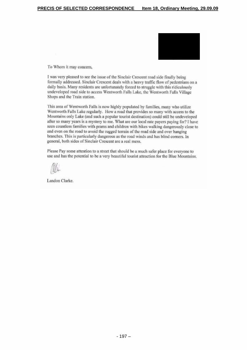
PRECIS OF SELECTED CORRESPONDENCE Item 18, Ordinary Meeting, 29.09.09
- 197 –
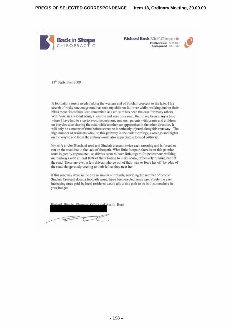
PRECIS OF SELECTED CORRESPONDENCE Item 18, Ordinary Meeting, 29.09.09
- 198 –

RESPONSE TO QUESTION WITH NOTICE


RESPONSES TO QUESTIONS WITH NOTICE Item 19, Ordinary Meeting, 29.09.09
- 201 -
ITEM NO: 19 SUBJECT: RENAISSANCE CENTRE, 10-14 CIVIC PLACE, KATOOMBA FILE NO: A76886-E - 09/152924 Management Plan Link
Principal Activity: Using Land for Living Service: Land Use Management Project: This report does not relate to a Management Plan project
Question With Notice by Councillor Brendan Luchetti: “Please advise the current situation regarding the Mount St Mary’s College and Convent site in Katoomba. Specifically, has the DA issued by Council in 2003 lapsed and what efforts are being undertaken by any authorities to protect the heritage values of this site?”
(Meeting Date: 7 July 2009)
Report by Group Manager, Environment & Customer Services: Background Mount St Mary’s College and Convent (also known as the Renaissance Centre) is listed as an item of State Significance, State Heritage Register Number 1681. The building has been vacant since the early 1990’s. Operational consent was granted for the redevelopment of the site in July 2005, valid for a 5 year period. That consent provided for the redevelopment of the site for the purposes of residential, commercial, recreational and cultural components in accordance with a Conservation Management Plan and related approvals from the NSW Heritage Council. The consent relies to a considerable extent upon the conservation incentives provided for under the local planning instrument, whereby some aspects of the development can only be approved on the basis that the heritage item is restored or maintained in accordance with the Conservation Management Plan. Crestown Pty Ltd, the previous owners of the site, have gone into liquidation and the site is currently controlled by a company on behalf of the secured creditors. Has the DA issued by Council in 2003 lapsed? Deferred commencement consent was issued by the Council on 22 December 2003 (X02/1963) and the operational consent was issued 18 July 2005. The consent is valid for a period of 5 years and lapses on 18 July 2010 unless the consent is secured by commencement of the development pursuant to that consent. What efforts are being undertaken by any authorities to protect the heritage values of the site? The NSW Heritage Act 1977 confers powers upon the NSW Heritage Council to require the maintenance of State Heritage Listed buildings to minimum standards set out in the Heritage Act (sections 118-122) and the Heritage Regulation 2005 (R 10- 18). In brief, those provisions set out standards relating to weather and fire protection, security and essential building maintenance. The power is exercised by the Heritage Council via a Notices and

RESPONSES TO QUESTIONS WITH NOTICE Item 19, Ordinary Meeting, 29.09.09
- 202 -
Orders regime and various other enforcement options if there is a failure to comply. The Council does not have equivalent powers and cannot order that works be carried out for the purpose of maintaining heritage values of a structure. Council staff have worked with the Heritage Branch of the Department of Planning since mid 2008 to encourage and assist the Heritage Branch staff to use their powers to enforce essential building maintenance. The Heritage Branch in the company of the staff of the Council, undertook an inspection of the building on 11 September 2009. Correspondence from the Heritage Branch explains that difficulties have been encountered in advancing the enforcement action due to liquidation of Crestown Pty Ltd. The Heritage Branch is currently considering the question of the enforcement of S118 (building maintenance) in the circumstances where liquidators are in control of the premises and they have undertaken to keep the Council informed of the progress in relation to the matter. In addition to the enforcement powers, the Heritage Act provides for funding and other incentives. Council’s records indicate that the NSW Heritage Office sought information about the owners in 2007, in order to promote to them the availability of funding to assist in the maintenance and protection of their State Heritage listed property. The Council has also undertaken several other enforcement actions in relation to the building and the site over the last six years. Several notices have been served in relation to noxious weed removal and in 2003 an Order was issued requiring that the roof be repaired in order to manage the threat to public safety posed by fire damage to the building. Early in 2009 the Mayor wrote to Crestown Pty Ltd, expressing concern regarding the condition of the premises and seeking advice from Crestown regarding their intentions with respect to the site. No reply was received.
* * * * * * * * * *