Embed Size (px)
Citation preview
Burt Township
Recreation Plan 2015-2019Burt Township21837 Grand Marais AvenuePO Box 430Grand Marais, MI 49839
AcknowledgementsPlanning CommissionJames Krempa
Township OfficialsJoe Venurato, Township SupervisorLori McShane, Township Clerk
Planning ConsultantCUPPAD Regional Commission
Cover Image: Chris Lawless
Table of Contents1. Introduction.......................................................................................................12. Recreation Administration...........................................................................2 2.1 Organizational Structure...............................................................2 2.2 Recreation Budget...........................................................................2 2.3 Community Groups.........................................................................33. Recreation Inventory......................................................................................3 3.1 Township Owned Facilities...........................................................3 3.2 Area Park and Recreation Facilities...........................................5 3.3 Recreational Trails and Pathways..............................................64. Planning and Public Input Process...........................................................7 4.1 Community Description.................................................................7 4.1.2 Economic Characteristics...........................................................8 4.1.3 Natural Features............................................................................8 4.2 Public Input Process........................................................................95. Goals and Objectives...................................................................................106. Implementation Plan..................................................................................11Appendix A: Maps..............................................................................................12 Map 1-1: Burt Township Location Map 1-2: Park and Recreation FacilitiesAppendix B: NRPA Standards .............................................................14Appendix C: NRPA Classification System..............................................17Appendix D: NRPA Standards for Park Acreage...................................21Appendix E: Barrier Free Guidelines.....................................................24Appendix F: Community Survey Responses.........................................26Appendix G: Public Notice of 30 Day Review Period.............................Appendix H: Public Meeting Notice......................................................
Appendix I: Plan Approval....................................................................
Burt Township Recreation Plan 2015-2019
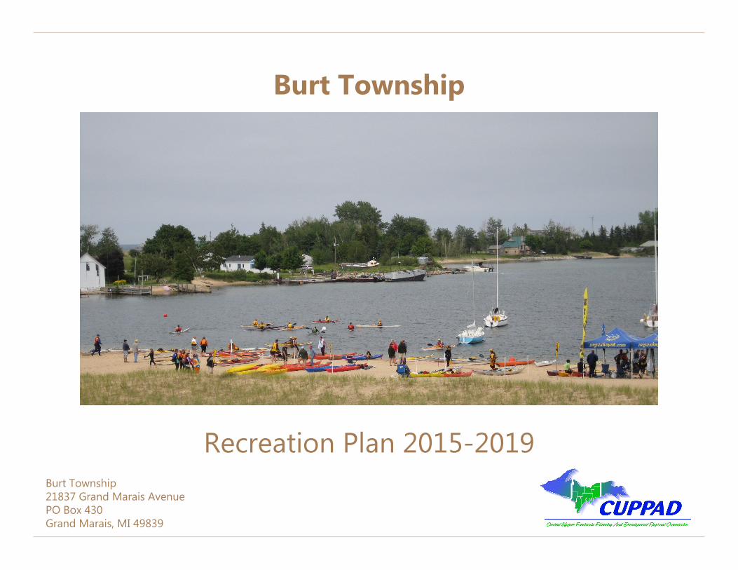
Figure 1: The Harbor at dusk. Credit: Chris Lawless
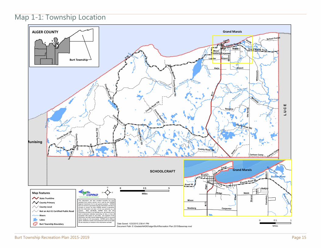
1.0 IntroductionBurt Township is a 234.4 square mile community located on the southern shore of Lake Superior in Michigan’s Upper Peninsula. The community has an array of recreational facilities and attractions. The Township is situated in a scenic, rural, and forested region that attracts residents and many seasonal visitors. Most residents live in the unincorporated community of Grand Marais, which is located in the north-east part of the Township. Grand Marais is also home to most commercial businesses in the Township as well as a marina and Harbor of Refuge. Most of the land area in the Township is occupied by the Pictured Rocks National Lakeshore (PRNL), or large corporate timber holdings. Burt Township is located in the most eastern part of Alger County and is adjacent to the PRNL, Munising Township, Seney Township, and Hiawatha Township. The location of the Township can be found on Map 1-1, found in Appendix A.
This Recreation Plan is designed to provide for the development of recreational activities, programs, and facilities within Burt Township. The plan should serve several useful purposes. It should serve as (1) a source of information, (2) a guide for correcting deficiencies, (3) an indicator of goals and policies, (4) a framework for making decisions, and (5) a means of stimulating public interest and participation in local community recreation progress.
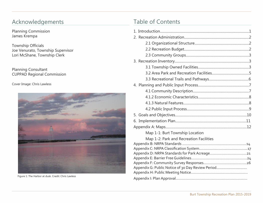
Figure 2: Splash-In, 2010. Credit: Chris Lawless
Burt Township Recreation Plan 2015-2019 Page 1
2.0 Recreation Administration
Planning Commission
Township Board
Township Employees
The Township plans and provides for recreation facilities in the community in order to promote health, tourism, and to enhance the quality of life for all residents. The Township has dedicated funding, resources, and staff to develop, operate, and maintain its parks and facilities.
Burt Township has been actively involved in the planning of recreation facilities for a number of years. Because the local economy is heavily dependent on the tourist industry, facilities for both transient visitors and local residents are a high priority. To this end, the Burt Township Board acts as the administrative body for recreation in the Township.
Burt Township employs two persons responsible for maintenance, security and operations at Township owned/operated facilities. The marina attendant is responsible for pumping gas and maintenance at the Marina. A manager at Woodland Park is responsible for its operations, assisted by part-time seasonal (summer) laborers. The Township Supervisor is responsible for supervision of these employees. The Township’s current organizational structure is detailed below.
2.1 Organizational Structure
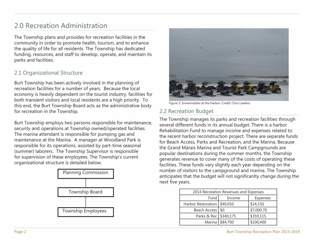
Figure 3: Snowmobiles at the Harbor. Credit: Chris Lawless
2.2 Recreation BudgetThe Township manages its parks and recreation facilities through several different funds in its annual budget. There is a harbor Rehabilitation Fund to manage income and expenses related to the recent harbor reconstruction project. There are separate funds for Beach Access, Parks and Recreation, and the Marina. Because the Grand Marais Marina and Tourist Park Campgrounds are popular destinations during the summer months, the Township generates revenue to cover many of the costs of operating these facilities. These funds vary slightly each year depending on the number of visitors to the campground and marina. The Township anticipates that the budget will not significanlty change during the next five years.
2014 Recreation Revenues and ExpensesFund Income Expenses
Harbor Restoration $40,650 $24,150Beach Access $0 $7,000.70
Parks & Rec $340,175 $359,115Marina $84,700 $100,400
Page 2 Burt Township Recreation Plan 2015-2019
2.3 Community GroupsBurt Township has many active community members and organizations that are dedicated to enhancing the quality and saftey of the community. In 2012, the Township raised funds to construct new playground equipment from local residents “adopting” pieces of new equipment. There is a local snowmobile club that provides information about trails as well as trail grooming. There is also a Coast Guard Auxilary Flotilla that works to keep the waters of the Grand Marais harbor safe for boaters.
Community groups also work to put on recreational events in the Township such as the UP 200 Sled Dog Championship, the Grand Marais Offshore Fishing Challenge, and the Grand Marais Triathalon.
Burt Township Recreation Plan 2015-2019 Page 3
3.0 Recreation Inventory
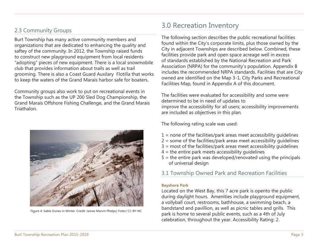
Figure 4: Sable Dunes in Winter. Credit: James Marvin Phelps/ Foter/ CC BY-NC
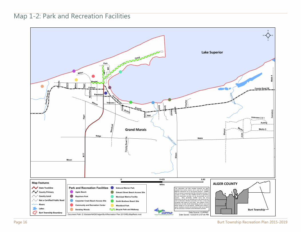
The following section describes the public recreational facilities found within the City’s corporate limits, plus those owned by the City in adjacent Townships are described below. Combined, these facilities provide park and open space acreage well in excess of standards established by the National Recreation and Park Association (NRPA) for the community’s population. Appendix B includes the recommended NRPA standards. Facilities that are City owned are identified on the Map 3-1, City Parks and Recreational Facilities Map, found in Appendix A of this document.
The facilities were evaluated for accessibility and some were determined to be in need of updates to improve the accessibility for all users; accessibility improvements are included as objectives in this plan.
The following rating scale was used:
1 = none of the facilities/park areas meet accessibility guidelines2 = some of the facilities/park areas meet accessibility guidelines3 = most of the facilities/park areas meet accessibility guidelines4 = the entire park meets accessibility guidelines5 = the entire park was developed/renovated using the principals
of universal design
3.1 Township Owned Park and Recreation Facilities
Bayshore ParkLocated on the West Bay, this 7 acre park is opento the public during daylight hours. Amenities include playground equipment, a vollyball court, restrooms, bathhouse, a swimming beach, a bandstand and pavillion, as well as picnic tables and grills. This park is home to several public events, such as a 4th of July celebration, throughout the year. Accessibility Rating: 2.
Page 4 Burt Township Recreation Plan 2015-2019
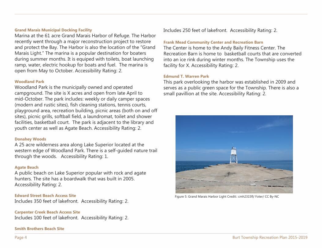
Grand Marais Municipal Docking FacilityMarina at the 61 acre Grand Marais Harbor of Refuge. The Harbor recently went through a major reconstruction project to restore and protect the Bay. The Harbor is also the location of the “Grand Marais Light.” The marina is a popular destination for boaters during summer months. It is equiped with toilets, boat launching ramp, water, electric hookup for boats and fuel. The marina is open from May to October. Accessibility Rating: 2.
Woodland ParkWoodland Park is the municipally owned and operated campground. The site is X acres and open from late April to mid-October. The park includes: weekly or daily camper spaces (modern and rustic sites), fish cleaning stations, tennis courts, playground area, recreation building, picnic areas (both on and off sites), picnic grills, softball field, a laundromat, toilet and shower facilities, basketball court. The park is adjacent to the library and youth center as well as Agate Beach. Accessibility Rating: 2.
Donahey WoodsA 25 acre wilderness area along Lake Superior located at the western edge of Woodland Park. There is a self-guided nature trail through the woods. Accessibility Rating: 1.
Agate BeachA public beach on Lake Superior popular with rock and agate hunters. The site has a boardwalk that was built in 2005. Accessibility Rating: 2.
Edward Street Beach Access SiteIncludes 350 feet of lakefront. Accessibility Rating: 2.
Carpenter Creek Beach Access Site Includes 100 feet of lakefront. Accessibility Rating: 2.
Smith Brothers Beach Site
Includes 250 feet of lakefront. Accessibility Rating: 2.
Frank Mead Community Center and Recreation BarnThe Center is home to the Andy Baily Fitness Center. The Recreation Barn is home to basketball courts that are converted into an ice rink during winter months. The Township uses the facility for X. Accessibility Rating: 2.
Edmund T. Warren ParkThis park overlooking the harbor was established in 2009 and serves as a public green space for the Township. There is also a small pavillion at the site. Accessibility Rating: 2.
Figure 5: Grand Marais Harbor Light Credit:: cmh2315fl/ Foter/ CC By-NC
Burt Township Recreation Plan 2015-2019 Page 5
Superior Pines Disc Golf CourseAn 18-hole disc golf course located within the School Forest and maintained by the Burt Township School. The project was funded in part by the Sault Tribe.
Lighthouse Keepkeeprs MuseumOwned and operated by the Historical Society and is open during summer months. The museum is located in a restored lighthouse keeper’s house at the end of the Coast Guard Point Road.
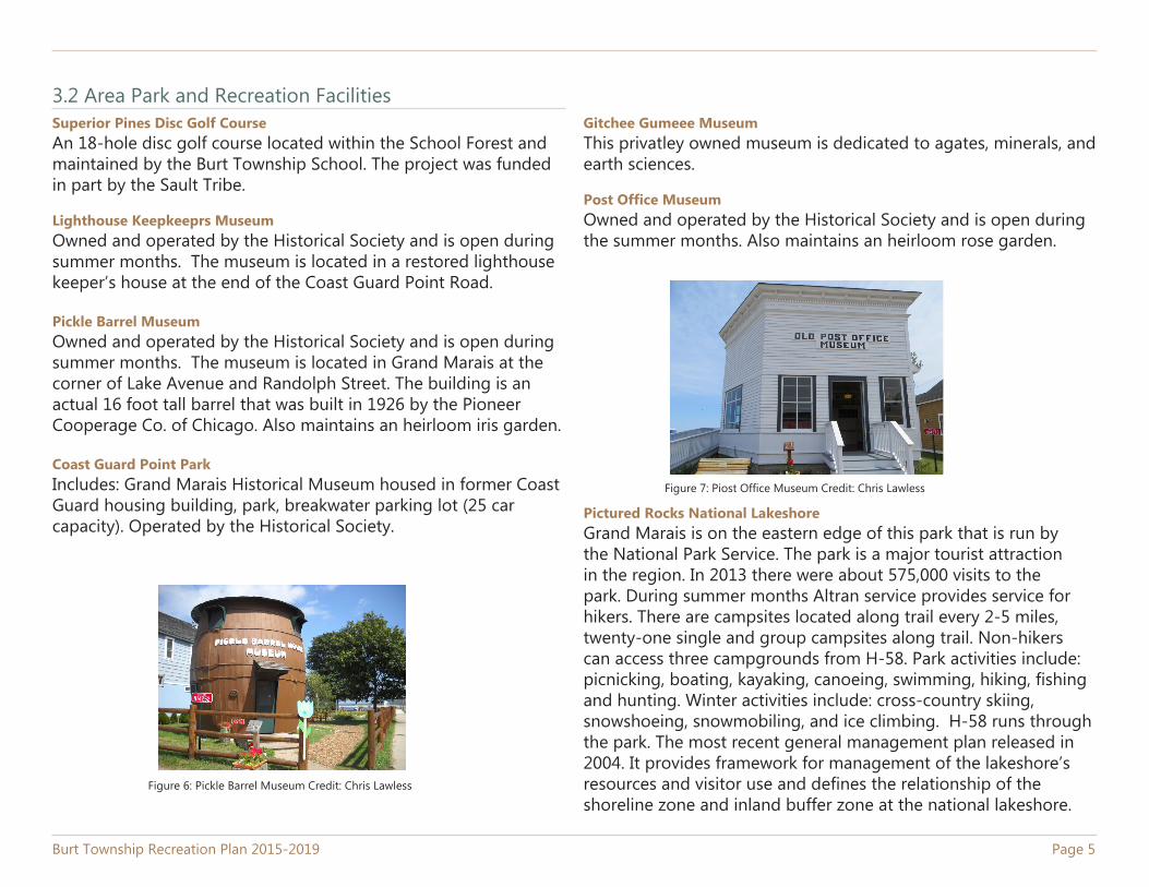
Pickle Barrel MuseumOwned and operated by the Historical Society and is open during summer months. The museum is located in Grand Marais at the corner of Lake Avenue and Randolph Street. The building is an actual 16 foot tall barrel that was built in 1926 by the Pioneer Cooperage Co. of Chicago. Also maintains an heirloom iris garden.
Coast Guard Point ParkIncludes: Grand Marais Historical Museum housed in former Coast Guard housing building, park, breakwater parking lot (25 car capacity). Operated by the Historical Society.
3.2 Area Park and Recreation FacilitiesGitchee Gumeee MuseumThis privatley owned museum is dedicated to agates, minerals, and earth sciences.
Post Office MuseumOwned and operated by the Historical Society and is open during the summer months. Also maintains an heirloom rose garden.
Pictured Rocks National LakeshoreGrand Marais is on the eastern edge of this park that is run by the National Park Service. The park is a major tourist attraction in the region. In 2013 there were about 575,000 visits to the park. During summer months Altran service provides service for hikers. There are campsites located along trail every 2-5 miles, twenty-one single and group campsites along trail. Non-hikers can access three campgrounds from H-58. Park activities include: picnicking, boating, kayaking, canoeing, swimming, hiking, fishing and hunting. Winter activities include: cross-country skiing, snowshoeing, snowmobiling, and ice climbing. H-58 runs through the park. The most recent general management plan released in 2004. It provides framework for management of the lakeshore’s resources and visitor use and defines the relationship of the shoreline zone and inland buffer zone at the national lakeshore.
Figure 6: Pickle Barrel Museum Credit: Chris Lawless
Figure 7: Piost Office Museum Credit: Chris Lawless
Bicycle Path and WalkwayThis pathway begins at the pier on the Coast Guard Point and then branches off to Agate Beach, up through Woodland Park and to the corner of Brazel Street. Accessibility Rating: 2.
Hiawatha Water TrailA 120 mile kayaking pathway along Lake Superior from Grand Marais to Big Bay. Kayakers can enter the water from the Grand Marais Boat Ramp.
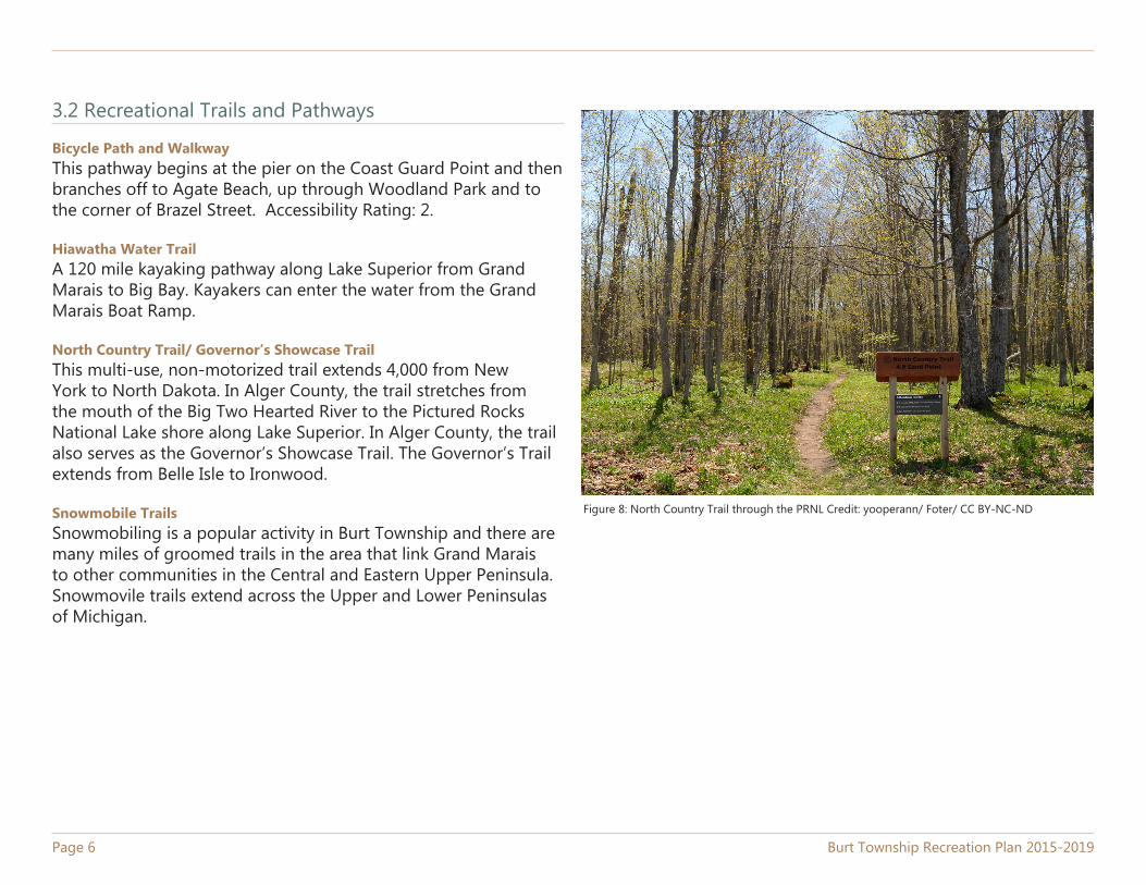
North Country Trail/ Governor’s Showcase TrailThis multi-use, non-motorized trail extends 4,000 from New York to North Dakota. In Alger County, the trail stretches from the mouth of the Big Two Hearted River to the Pictured Rocks National Lake shore along Lake Superior. In Alger County, the trail also serves as the Governor’s Showcase Trail. The Governor’s Trail extends from Belle Isle to Ironwood.
Snowmobile TrailsSnowmobiling is a popular activity in Burt Township and there are many miles of groomed trails in the area that link Grand Marais to other communities in the Central and Eastern Upper Peninsula. Snowmovile trails extend across the Upper and Lower Peninsulas of Michigan.
3.2 Recreational Trails and Pathways
Page 6 Burt Township Recreation Plan 2015-2019
Figure 8: North Country Trail through the PRNL Credit: yooperann/ Foter/ CC BY-NC-ND
4.0 Planning and Public Input Process4.1 Community Description
Examining the economic and demographic trends in a community is a necessary step in the planning process. These trends help community leaders and planners to assess the needs of the community and prepare for the future. By examining how the community has changed, the Township Board can plan for the development of recreation facilities that meet community needs.
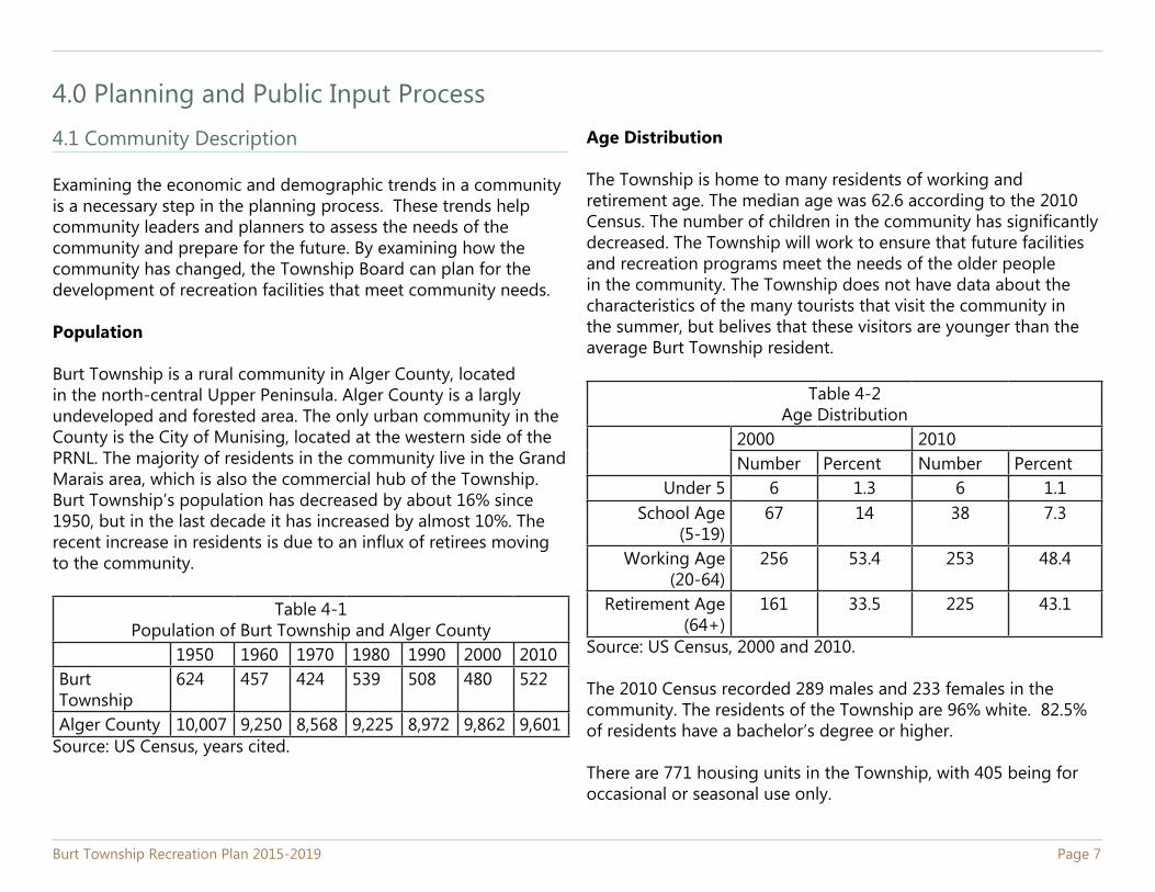
Population
Burt Township is a rural community in Alger County, located in the north-central Upper Peninsula. Alger County is a largly undeveloped and forested area. The only urban community in the County is the City of Munising, located at the western side of the PRNL. The majority of residents in the community live in the Grand Marais area, which is also the commercial hub of the Township. Burt Township’s population has decreased by about 16% since 1950, but in the last decade it has increased by almost 10%. The recent increase in residents is due to an influx of retirees moving to the community.
Table 4-1Population of Burt Township and Alger County
1950 1960 1970 1980 1990 2000 2010Burt Township
624 457 424 539 508 480 522
Alger County 10,007 9,250 8,568 9,225 8,972 9,862 9,601Source: US Census, years cited.
Burt Township Recreation Plan 2015-2019 Page 7
Age Distribution
The Township is home to many residents of working and retirement age. The median age was 62.6 according to the 2010 Census. The number of children in the community has significantly decreased. The Township will work to ensure that future facilities and recreation programs meet the needs of the older people in the community. The Township does not have data about the characteristics of the many tourists that visit the community in the summer, but belives that these visitors are younger than the average Burt Township resident.
Table 4-2Age Distribution
2000 2010Number Percent Number Percent
Under 5 6 1.3 6 1.1School Age
(5-19)67 14 38 7.3
Working Age(20-64)
256 53.4 253 48.4
Retirement Age(64+)
161 33.5 225 43.1
Source: US Census, 2000 and 2010.
The 2010 Census recorded 289 males and 233 females in the community. The residents of the Township are 96% white. 82.5% of residents have a bachelor’s degree or higher.
There are 771 housing units in the Township, with 405 being for occasional or seasonal use only.
Page 8 Burt Township Recreation Plan 2015-2019
4.1.2 Economic Characteristics
Due to the Township’s close proximity to the PRNL, the main industry in the community is tourism. In recent years tourism to the area has increased. In 2013, about 575,000 people visited the park. Many tourists are also drawn to the harbor. In addition to tourism, the local economy is dependant on natural resources based industries, such as timber production. Tourism supports retail, hotel, and restaurant jobs in the area.
The 2010 Census indicates that the per capita income of the community is $17,458, slightly lower than the per capita income of Alger Couty, $20,207. Both of these figures are lower than the per capita income for the State of Michigan, $25,172. Burt’s mean household income was $36,154 according to the 2009-2013 Ammerican Community Survey (ACS).
Unemployment in the community tends be higher than the State average and fluxuates following State and National trends The 2009-2013 ACS survey indicates that the unemployment rate for Burt Township is 6.9%.
4.1.3 Natural Features
Burt Township is renowned for its natural beauty and attracts visitors from all over the world. The Township’s 234.4 sqaure miles contain a large portion of the PRNL as well as the Lake Superior State Forest. These natrural areas not only provide recreational opprotunities for residents and visitors, but also serve to support wildlife populations and protect watersheds.
The Township has 20 miles of Lake Superior shoreline, including the harbor of refuge. The lakefront is the predominant water feature in the area, but other water features, such as waterfalls, also attract visitors. Along the lakeshore, sandy beaches, agate deposits, and sand dunes are popular summertime desinations.
The Township is also heavily forested with hardwoods as well as conifer trees. The forests provide a habitat for a wide variety of wildlife includeing beavers, otters, deer, and bears.
The topography of the Township varies from flat inland areas to tall dunes along the lakeshore. Most of the terrain can be classified as gently rolling.
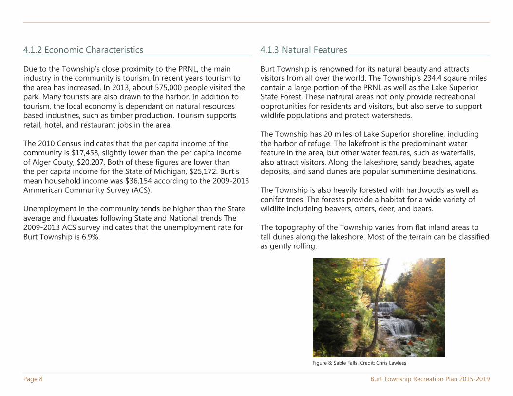
Figure 8: Sable Falls. Credit: Chris Lawless
4.2 Planning Methodology
There is no single best approach to developing a recreation plan for a community. Planners and community leaders must consider a broad number of factors in order to anticipate community needs and prepare for the future. The Township recently completed a new master plan and this plan is aligned with that document. This plan serves to provide the community with a more detailed and comprehensive plan for recreation than the information contained in the master plan.
Comparison to Recreation Standards
To determine the types of recreation areas and facilities that should be provided in any given community, it is usually necessary to follow some type of guideline or standard. The National Parks and Recreation Association (NPRA) Standards are available in Appendicies B thru D. Comparing the Township’s recreation facilities to these standards shows that the Township falls short of meeting the standards in most categories. However, recreation standards must also be tailored to specific geographic areas of the country. The National and state standards that are normally used are just a basis for local standards. Because Burt Township is rural community with a small population, and is located next to a National Park, using the standards developed for larger, more urban communities is not be the best approach for identifying gaps in local recreation facilities.
Systems Approach
In addition to considering recreation standards, the Township has also used a systems thinking approach to consider additional aspects of the community and assess its recreation needs. A systems to planning considers broad community needs, local
and regional factors, and citizen input to determine the plan for the community. In recreation planning, a system approach incorporates stakeholder opinions with considerations of how community recreational facilities meet both local and regional recreation needs.
As part of this systems approach to planning, the Township is promoting the continued development of green space as well and trails. In addition to promoting recreation, trails also provide alternative modes of transportation to area residents. Encouraging walking and biking on these trails also promotes public heath. In addition to local efforts, the State of Michigan has also been working to expand and promote hiking and biking trail development in the region.
The Township Board believes that continuing to work to develop trails in the community will also enhance the community by promoting tourism and economic development..
Criteria for Open Space and Natural Area Acquistion
The need for open space and natural areas in a community can be assessed using a variety of approaches. First, the DNR uses the NPRA open space standards that serve as a planning guidelinefor Michigan communities. The standards are listed in Appendix D. In most catagories the Township falls short of the recommended number of acres. However, because Burt Township has a very small population, the existing parks, trail networks, and National Park Services-owned open space areas are more than adequate to meet the recreation needs of the community. In addtion to creating open space for people to enjoy, the large areas of government-owned land in the community serves to protect the watershed and
Page 9
Page 10 Burt Township Recreation Plan 2015-2019
4.3 Public Input Process
The Michigan Department of Natural Resources requires that communities use a minimum of two methods of engaging the public in the planning process. At the beginning of the planning process the Township used a survey that was distributed at several points in Grand Marais to solicit public feedback. The survey was developed from public comments recieved during the 2013 master planning process. The survey was distributed at the Township hall and at X. The Township used social media and public bulletin boards to spread awareness about the survey and planning process. A copy of the survey and the results are presented in Appendix F.
The Township advertised that the draft plan was available for review on February 22nd. After a 30 day public review period, the Township held a public hearing on February XX to listen to public comments. The plan was adopted by the Township Board on February X, 2015. The resolution of adoption can be found in Appendix I.
The feedback from the Township citizens......
enhance biodiversity. The Township is not seeking to purchase any additional land for recreation at this time.
Park Accessibility Standards
The Township has esablished the goal of improving the handicap accessability of its recreation facilities. Its existing facilities are not entirely accessible to all levels of physical ability.
The Americans with Disabilities Act (ADA) identified specific standards that would insure thatpersons with disabilities have the same opportunities to fully participate, live independently and be economically self-sufficient within society. The Act is comprised of five sections: Employment, Public Accommodations, Transportation, State and Local Government Operations, and Telecommunications.
Title II of the ADA, Public Accommodations, is relevant to the level of accessibility and equal provisions of service at publicly owned outdoor recreation sites. This title states that discrimination against persons with disabilities is prohibited in all services, programs, or activities provided by public entities. The general requirements set forth under this section came into effect on January 26, 1992. Remodeling or new construction of facilities and buildings had the same deadline date to become accessible to the disabled. In existing buildings and facilities, nonstructural changes to improve accessibility were required by January 26, 1992, while all structural improvements of the facilities and buildings were required by January 26, 1995.
Burt Township Recreation Plan 2015-2019 Page 11
5.0 Recreation Goals and ObjectivesThe goals that follow were developed by assessing community trends, compiling and reviewing surveys, and with the direction of the Township’s Planning Commission. Consideration and observance of the recreation policies should ultimatley lead the Township to achieve its goals.
The specific development of projects and programs should be first evaluated with respect to the recreation goals and then in terms of the proposal’s contribution to the Township’s recreation system. Goal’s developed by the Recreation Committee are listed below.
Goal: Develop diverse recreational opprotunities to meet the needs of all ages and abilities in the community and encourage tourists to remain in town longer.
Policies: • Clear the Sucker River from H-58 to the Bay for kayaks and canoes.
• Improve basketball courts, eliminate tennis courts. • Improve cross-country ski trails. • Develop an additional public bathroom facility. • Develop maps for existing trails in School Forest and for
mountain biking trails. • Develop a bicycle path and walkway to begin east of
town at Ellen Street and continue along H-58 to the Luce County line.
• Improve the universal accessibiliy of facilities whenever possible.
Goal: Develop recreational amenities that improve the aesthetics of the community and make good use of green space.
Policies: • Improve sidewalk conditions and connect dead end
sidewalks.
• Make improvements to the bandstand. • Seek Green Communities Challenge funding for
recreational activities. Goal: To develop partnerships and cooperative arrangements
with other governmental jurisdictions.Policies: • Work with the NPS to develop a bike path to the Sable
Falls parking area. • Work with NPS to return Sable Lake back to a recreational
area by draining the south end of the lake. There is a need or more campground development and a better swimming area. There is also a need to improve the boat ramp.
• Improve fishing in the Bay by working with DNR and others.
Goal: Continue to protect the quality of the marina and harbor.
• Make improvements to the marina including installing a floating dock for small boats, a fish cleaning, and a bathhouse.
Page 12 Burt Township Recreation Plan 2015-2019
6.0 Implementation PlanThe Township’s Planning Commission, through the recreation development schedule, planned a number of necessary and valuable recreation projects to enhance the quality of life for all demographic groups. The Commission also used public input to identify and plan for recreation projects. The Committee has also recognized the need for maintenance improvements to existing facilities that are not specifically reflected in the City’scapital plan. These maintenance improvements are performed by Township staff with the volunteer assistance from the community as needed. Under ideal circumstances a plan should always result in action; however, this outcome is not always achieved.
Thus, communities need to maximize their efforts to attain the general goals defined by a particular plan. It is the Township Board’s understanding that this development schedule should be followed closley, except when extraordinary circumstances develop.
The recreation development schedule highlights the Township’s top priorities as follows:Priority Year Project Cost/Source
1 2015-2016
Marina bathhouse and improvements
$90,000 LAWCON/Local
1A 2015-2016
Floating dock for small boats (Marina)
$2,500 DNR Waterways/Local
2 2015-2017
Develop a bike part and walkway to begin east of town at Ellen St. to Luce County line
$20,000 MNRTF/ Local, MDOT
3 2015-2017
Bike path from Grand Marais to Sable Falls parking lot
NPS, MDOT Tap funds,
4 2015-2019
Improve sidewalks and connect dead end sidewalks in Grand Marias
SR2S, local funds,
5 2017 Improve trails and trail mapping at school forest
School Board, local
6 2017 Improve basketball courts local7 2017 Clear sucker river for kayaks
and canoeslocal, DNR
8 2018 Improvements to bandstand local9 2018 Improvements to Sable Lake NPS, local10 2019 Construct an additional public
restroomDNR, local
Each project listed in the schedule above is described in detail below.
1. Marina ImprovementsThe Township plans to make improvements to the Marina, including additional mooring buoys and a floating dock for small boats. The township would also like to build a bathhouse with showers at the marina to meet the needs of boaters and swimmers.
1A. Marina ImprovementsThe Township plans to purchase and install a floating dock that can be used by small boats at the marina.
2. Bike Path to Luce CountyThe Township will work with local and state partners to construct a bike path from the Grand Marias area to Luce County.
3. Bike Path to Sable FallsSable Falls is a popular destination for summer tourists and is in close proximity to Grand Marais. The Township would like to build a bike path to the Falls parking lot to provide an alternative means of travel to this location.
Burt Township Recreation Plan 2015-2019 Page 13
4. Sidewalk ImprovementsThe Township would like to improve the condition of sidewalks in the Grand Marais area. The Township also plans to construct more sidewalk in the community where needed.. This effort will help to promote walking by area residents.
5. Trail Improvements and Mapping at School ForestThe Township would like to improve the mountain biking and cross country trails at the School Forest. In addition, maps are needed of the trails in the forest to help promote use.
6. Install Basketball CourtsThe Township would like to provide more facilities to attract and retain younger residents. As part of this effort the Township plans to construct a basketball court and remove the existing tennis court. In addition, the Township will seek additional opprotunities to diversify its existing recreation amenities over the next five years in order to attract and retain younger residents.
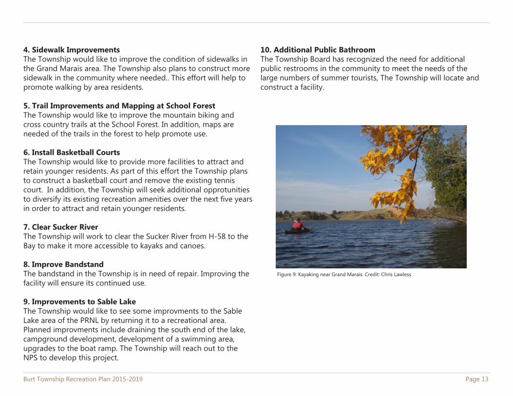
7. Clear Sucker RiverThe Township will work to clear the Sucker River from H-58 to the Bay to make it more accessible to kayaks and canoes.
8. Improve BandstandThe bandstand in the Township is in need of repair. Improving the facility will ensure its continued use.
9. Improvements to Sable LakeThe Township would like to see some improvments to the Sable Lake area of the PRNL by returning it to a recreational area. Planned improvments include draining the south end of the lake, campground development, development of a swimming area, upgrades to the boat ramp. The Township will reach out to the NPS to develop this project.
10. Additional Public BathroomThe Township Board has recognized the need for additional public restrooms in the community to meet the needs of the large numbers of summer tourists, The Township will locate and construct a facility.
Figure 9: Kayaking near Grand Marais. Credit: Chris Lawless
Page 14 Burt Township Recreation Plan 2015-2019
Appendix AMaps
Burt Township Recreation Plan 2015-2019 Page 15
Map 1-1: Township Location
Munising
LU
CE
LU
CE
SCHOOLCRAFT
Sucker River
Bake
r Cre
ek
Hurricane C
reek
Seve
n M
ile C
reek Rhody Creek
Casey Creek
Blood Creek
Soo
Cre
ek
Gra
ss C
reek
Fox
Riv
er
Sullivan Creek
Towes Creek
Loon Creek
Spring Creek
Pelic
an C
reek
De Mull Creek
Bills
Cre
ek
Lowney Creek
Porter Creek
Harve
y Cre
ek
Sucker River
Fox River
Hurricane Creek
M 7
7
Adams
H 58
Old
Sen
ey
Whi
tew
ash
Seegans
County Road 720
Ames
Mccloud
Eile
en
County Road 58
Beaver Meadow
Harju
Sandy
Airport
Lowder
County Road 721 County Road 782
Grand Marais Truck
County Road 73
0
WebbRidgeMixon
School Forest
County Road 766
Carlson Camp
County Road 731
Cou
nty
Roa
d 72
2
Canal
Newberg
Russ Lake
County R
oad 725Mahoney Lake
Carpenter
Lake
County R
oad 743
County R
oad 703
Twin
Lak
e Tr
uck
Carlson Camp
Airport
County Road 720
H 58
M 7
7
WebbRidge
Mixon Eile
en
Cem
eter
y
Canal
Newberg
Wilson
Carpenter
County Road 58
Braziel
Alg
er
Shar
on
Josi
e
Web
b 4
Audrey
County Road 58Sucker River
Baker Creek
Sucker River
0 52.5
Miles
Grand Marais
0 10.5
Miles
“The information and data provided herewith has beencompiled from various sources, and is used by the CUPPADRegional Commission for its own general purposes. CUPPADdoes not warrant or guarantee that this information and data isaccurate or current, nor does CUPPAD warrant or guaranteethat this information and data is fit for any particular use orpurpose. More specifically, CUPPAD warns that thisinformation and data is not intended to be, and should not be,used to determine individual ownership, lot lines, or lines ofoccupation with respect to real estate. Any recipient of thisinformation and data should independently verify its accuracybefore relying on it for any purpose. CUPPAD and its officers,agents, employees, boards, and commissions shall not be liablefor any inaccuracy or omission in this information and data”
Map Features
State Trunkline
County Primary
County Local
Not an Act-51 Certified Public Road
Rivers
Lakes
Burt Township Boundary
ALGER COUNTY
Burt Township
Grand Marais
Date Saved: 1/23/2015 2:58:41 PMDocument Path: E:\Gisdata\NAD83\alger\Burt\Recreation Plan 2015\Basemap.mxd
²
Page 16 Burt Township Recreation Plan 2015-2019
Map 1-2: Park and Recreation Facilities
Carpenter Creek
Chipmunk C
reek
WebbRidge
M 7
7
Eile
en
Canal
Wilson
Cem
eter
y
Mixon
Lake
County Road 58
Braziel
Carlson
Alg
er
Shar
on
EverettW
oodr
uff
Martin
Mill
Josi
e
Dock
Web
b 4
Audrey
Emm
a
Martin 5
Millen
Randolph
Park
Bell
Grand Marais
Mcm
illan
Burton
Cha
rles
Veterans
Unknown 3 2 1
Cou
nty
Roa
d 77
6
Ada
ms
Morris Edw
ard
Har
bor
Chi
solm
Alg
er
Mill
en
Cou
nty
Roa
d 58
Edward
0 0.850.425
Miles
Lake Superior
“The information and data provided herewith has beencompiled from various sources, and is used by the CUPPADRegional Commission for its own general purposes. CUPPADdoes not warrant or guarantee that this information and data isaccurate or current, nor does CUPPAD warrant or guaranteethat this information and data is fit for any particular use orpurpose. More specifically, CUPPAD warns that thisinformation and data is not intended to be, and should not be,used to determine individual ownership, lot lines, or lines ofoccupation with respect to real estate. Any recipient of thisinformation and data should independently verify its accuracybefore relying on it for any purpose. CUPPAD and its officers,agents, employees, boards, and commissions shall not be liablefor any inaccuracy or omission in this information and data”
Map FeaturesState Trunkline
County Primary
County Local
Not a Certified Public Road
Rivers
Lakes
Burt Township Boundary
ALGER COUNTY
Burt Township
Grand Marais
Date Saved: 1/23/2015 2:57:00 PMDocument Path: E:\Gisdata\NAD83\alger\Burt\Recreation Plan 2015\REcMapRedo.mxd
Park and Recreation FacilitiesAgate Beach
Bayshore Park
Carpenter Creek Beach Access Site
Community and Recreation Center
Donahey Woods
Edmund Warren Park
Edward Street Beach Access Site
Municipal Marina Facility
Smith Brothers Beach Site
Woodland Park
Bicycle Path and WalkwayData Source: CUPPAD
²
Burt Township Recreation Plan 2015-2019 Page 17
Appendix BNational Parks and
Recreation Association Standards
Page 18 Burt Township Recreation Plan 2015-2019
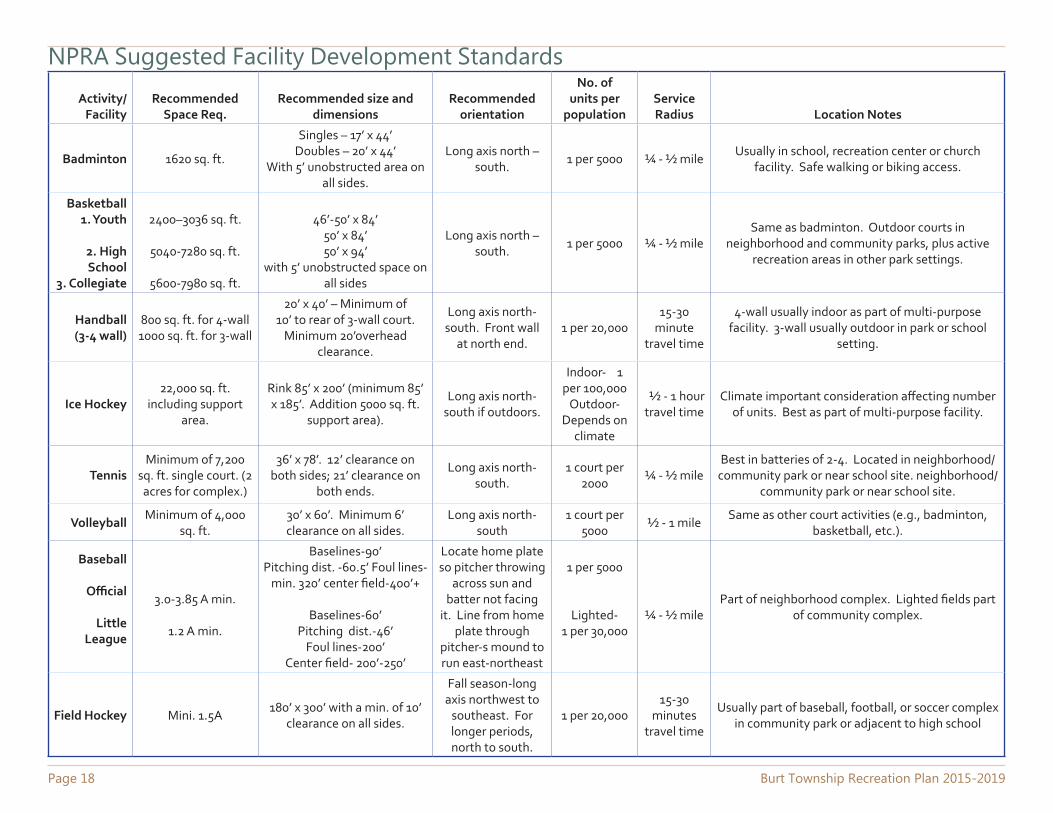
NPRA Suggested Facility Development StandardsActivity/
FacilityRecommended
Space Req.Recommended size and
dimensionsRecommended
orientation
No. of units per
populationService Radius Location Notes
Badminton 1620 sq. ft.
Singles – 17’ x 44’Doubles – 20’ x 44’
With 5’ unobstructed area on all sides.
Long axis north – south.
1 per 5000 ¼ - ½ mileUsually in school, recreation center or church
facility. Safe walking or biking access.
Basketball1. Youth
2. High School
3. Collegiate
2400–3036 sq. ft.
5040-7280 sq. ft.
5600-7980 sq. ft.
46’-50’ x 84’50’ x 84’50’ x 94’
with 5’ unobstructed space on all sides
Long axis north – south.
1 per 5000 ¼ - ½ mileSame as badminton. Outdoor courts in
neighborhood and community parks, plus active recreation areas in other park settings.
Handball (3-4 wall)
800 sq. ft. for 4-wall 1000 sq. ft. for 3-wall
20’ x 40’ – Minimum of 10’ to rear of 3-wall court.
Minimum 20’overhead clearance.
Long axis north-south. Front wall
at north end.1 per 20,000
15-30 minute
travel time
4-wall usually indoor as part of multi-purpose facility. 3-wall usually outdoor in park or school
setting.
Ice Hockey22,000 sq. ft.
including support area.
Rink 85’ x 200’ (minimum 85’ x 185’. Addition 5000 sq. ft.
support area).
Long axis north-south if outdoors.
Indoor- 1 per 100,000
Outdoor-Depends on
climate
½ - 1 hour travel time
Climate important consideration affecting number of units. Best as part of multi-purpose facility.
TennisMinimum of 7,200
sq. ft. single court. (2 acres for complex.)
36’ x 78’. 12’ clearance on both sides; 21’ clearance on
both ends.
Long axis north-south.
1 court per 2000
¼ - ½ mileBest in batteries of 2-4. Located in neighborhood/
community park or near school site. neighborhood/ community park or near school site.
VolleyballMinimum of 4,000
sq. ft.30’ x 60’. Minimum 6’ clearance on all sides.
Long axis north-south
1 court per 5000
½ - 1 mileSame as other court activities (e.g., badminton,
basketball, etc.).
Baseball
Official
Little League
3.0-3.85 A min.
1.2 A min.
Baselines-90’Pitching dist. -60.5’ Foul lines-
min. 320’ center field-400’+
Baselines-60’Pitching dist.-46’
Foul lines-200’Center field- 200’-250’
Locate home plate so pitcher throwing
across sun and batter not facing
it. Line from home plate through
pitcher-s mound to run east-northeast
1 per 5000
Lighted-1 per 30,000
¼ - ½ milePart of neighborhood complex. Lighted fields part
of community complex.
Field Hockey Mini. 1.5A180’ x 300’ with a min. of 10’
clearance on all sides.
Fall season-long axis northwest to
southeast. For longer periods, north to south.
1 per 20,00015-30
minutes travel time
Usually part of baseball, football, or soccer complex in community park or adjacent to high school
Burt Township Recreation Plan 2015-2019 Page 19
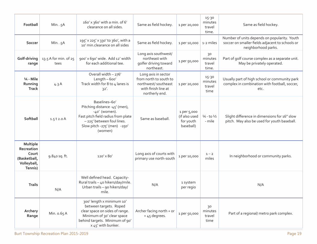
Football Min. .5A160’ x 360’ with a min. of 6’
clearance on all sides.Same as field hockey. 1 per 20,000
15-30 minutes
travel time.
Same as field hockey.
Soccer Min. .5A195’ x 225’ x 330’ to 360’, with a 10’ min.clearance on all sides
Same as field hockey. 1 per 10,000 1-2 milesNumber of units depends on popularity. Youth soccer on smaller fields adjacent to schools or
neighborhood parks.
Golf-driving range
13.5 A for min. of 25 tees
900’ x 690’ wide. Add 12’ width for each additional tee.
Long axis southwest/northeast with
golfer driving toward northeast.
1 per 50,000
30 minutes
travel time.
Part of golf course complex as a separate unit. May be privately operated.
¼ - Mile Running
Track4.3 A
Overall width – 276’Length – 600’
Track width for 8 to 4 lanes is 32’.
Long axis in sector from north to south to northwest/ southeast
with finish line at northerly end.
1 per 20,000
15-30 minutes
travel time
Usually part of high school or community park complex in combination with football, soccer,
etc.
Softball 1.5 t 2.0 A
Baselines–60’Pitching distance -45’ (men),
-40’ (women).Fast pitch field radius from plate
– 225’ between foul lines.Slow pitch -275’ (men) -250’
(women)
Same as baseball.
1 per 5,000 (if also used
for youth baseball)
¼ - to ½ - mile
Slight difference in dimensions for 16” slow pitch. May also be used for youth baseball.
Multiple Recreation
Court (Basketball,
Volleyball, Tennis)
9.840 sq. ft. 120’ x 80’Long axis of courts with primary use north-south
1 per 10,0001 – 2 miles
In neighborhood or community parks.
TrailsN/A
Well defined head. Capacity-Rural trails – 40 hikers/day/mile.
Urban trails – 90 hikers/day/mile.
N/A1 system per regio
N/A
Archery Range
Min. 0.65 A
300’ length x minimum 10’ between targets. Roped
clear space on sides of range. Minimum of 30’ clear space
behind targets. Minimum of 90’ x 45’ with bunker.
Archer facing north + or + 45 degrees.
1 per 50,000
30 minutes
travel time
Part of a regional/ metro park complex.
Page 20 Burt Township Recreation Plan 2015-2019
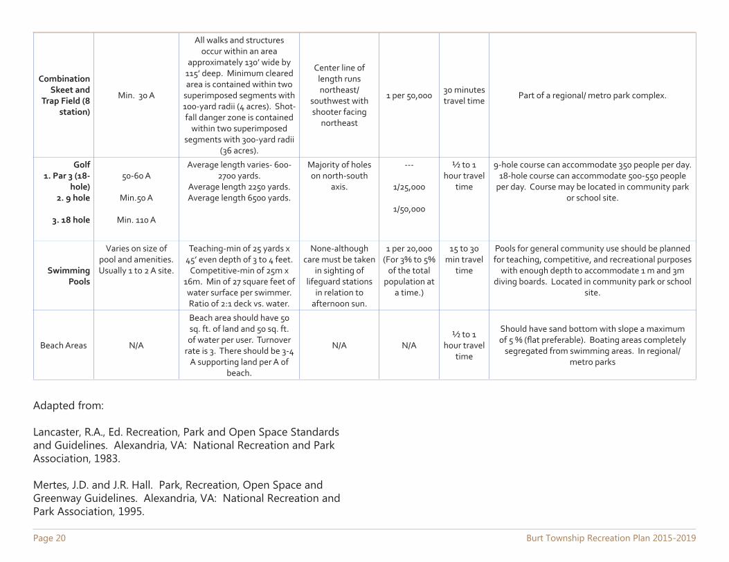
Combination Skeet and
Trap Field (8 station)
Min. 30 A
All walks and structures occur within an area
approximately 130’ wide by 115’ deep. Minimum cleared area is contained within two
superimposed segments with 100-yard radii (4 acres). Shot-fall danger zone is contained
within two superimposed segments with 300-yard radii
(36 acres).
Center line of length runs northeast/
southwest with shooter facing
northeast
1 per 50,00030 minutes travel time
Part of a regional/ metro park complex.
Golf1. Par 3 (18-
hole)2. 9 hole
3. 18 hole
50-60 A
Min.50 A
Min. 110 A
Average length varies- 600-2700 yards.
Average length 2250 yards.Average length 6500 yards.
Majority of holes on north-south
axis.
---
1/25,000
1/50,000
½ to 1 hour travel
time
9-hole course can accommodate 350 people per day. 18-hole course can accommodate 500-550 people
per day. Course may be located in community park or school site.
Swimming Pools
Varies on size of pool and amenities. Usually 1 to 2 A site.
Teaching-min of 25 yards x 45’ even depth of 3 to 4 feet.
Competitive-min of 25m x 16m. Min of 27 square feet of water surface per swimmer. Ratio of 2:1 deck vs. water.
None-although care must be taken
in sighting of lifeguard stations
in relation to afternoon sun.
1 per 20,000 (For 3% to 5%
of the total population at
a time.)
15 to 30 min travel
time
Pools for general community use should be planned for teaching, competitive, and recreational purposes
with enough depth to accommodate 1 m and 3m diving boards. Located in community park or school
site.
Beach Areas N/A
Beach area should have 50 sq. ft. of land and 50 sq. ft. of water per user. Turnover
rate is 3. There should be 3-4 A supporting land per A of
beach.
N/A N/A½ to 1
hour travel time
Should have sand bottom with slope a maximum of 5 % (flat preferable). Boating areas completely
segregated from swimming areas. In regional/ metro parks
Adapted from:
Lancaster, R.A., Ed. Recreation, Park and Open Space Standards and Guidelines. Alexandria, VA: National Recreation and Park Association, 1983.
Mertes, J.D. and J.R. Hall. Park, Recreation, Open Space and Greenway Guidelines. Alexandria, VA: National Recreation and Park Association, 1995.
Burt Township Recreation Plan 2015-2019 Page 21
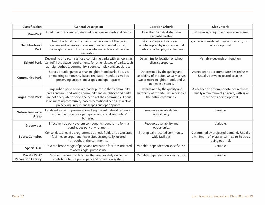
Appendix CNational Park and
Recreation Association Classification System for
Local or Regional Recreation
Page 22 Burt Township Recreation Plan 2015-2019
Classification General Description Location Criteria Size Criteria
Mini-ParkUsed to address limited, isolated or unique recreational needs. Less than ¼ mile distance in
residential setting.Between 2500 sq. ft. and one acre in size.
Neighborhood Park
Neighborhood park remains the basic unit of the park system and serves as the recreational and social focus of
the neighborhood. Focus is on informal active and passive recreation.
¼ - to ½ -mile distance and uninterrupted by non-residential roads and other physical barriers.
5 acres is considered minimum size. 5 to 10 acres is optimal.
School-ParkDepending on circumstances, combining parks with school sites can fulfill the space requirements for other classes of parks, such
as neighborhood, community, sports complex and special use.
Determine by location of school district property.
Variable-depends on function.
Community Park
Serves broader purpose than neighborhood park. Focus is on meeting community-based recreation needs, as well as
preserving unique landscapes and open spaces.
Determined by the quality and suitability of the site. Usually serves two or more neighborhoods and ½
to 3 mile distance.
As needed to accommodate desired uses. Usually between 30 and 50 acres.
Large Urban Park
Large urban parks serve a broader purpose than community parks and are used when community and neighborhood parks are not adequate to serve the needs of the community. Focus is on meeting community-based recreational needs, as well as
preserving unique landscapes and open spaces.
Determined by the quality and suitability of the site. Usually serves
the entire community.
As needed to accommodate desired uses. Usually a minimum of 50 acres, with 75 or
more acres being optimal.
Natural Resource Areas
Lands set aside for preservation of significant natural resources, remnant landscapes, open space, and visual aesthetics/
buffering.
Resource availability and opportunity.
Variable.
GreenwaysEffectively tie park system components together to form a
continuous park environment.Resource availability and
opportunity.Variable.
Sports ComplexConsolidates heavily programmed athletic fields and associated
facilities to larger and fewer sites strategically located throughout the community.
Strategically located community-wide facilities.
Determined by projected demand. Usually a minimum of 25 acres, with 40 to 80 acres
being optimal.
Special UseCovers a broad range of parks and recreation facilities oriented
toward single- purpose use.Variable-dependent on specific use. Variable.
Private Park/Recreation Facility
Parks and recreation facilities that are privately owned yet contribute to the public park and recreation system.
Variable-dependent on specific use. Variable.
Burt Township Recreation Plan 2015-2019 Page 23
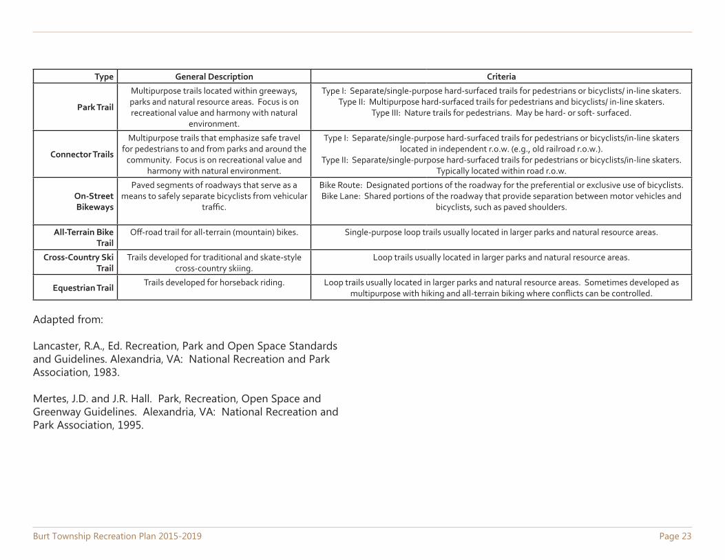
Type General Description Criteria
Park Trail
Multipurpose trails located within greeways, parks and natural resource areas. Focus is on recreational value and harmony with natural
environment.
Type I: Separate/single-purpose hard-surfaced trails for pedestrians or bicyclists/ in-line skaters.Type II: Multipurpose hard-surfaced trails for pedestrians and bicyclists/ in-line skaters.
Type III: Nature trails for pedestrians. May be hard- or soft- surfaced.
Connector Trails
Multipurpose trails that emphasize safe travel for pedestrians to and from parks and around the
community. Focus is on recreational value and harmony with natural environment.
Type I: Separate/single-purpose hard-surfaced trails for pedestrians or bicyclists/in-line skaters located in independent r.o.w. (e.g., old railroad r.o.w.).
Type II: Separate/single-purpose hard-surfaced trails for pedestrians or bicyclists/in-line skaters. Typically located within road r.o.w.
On-Street Bikeways
Paved segments of roadways that serve as a means to safely separate bicyclists from vehicular
traffic.
Bike Route: Designated portions of the roadway for the preferential or exclusive use of bicyclists.Bike Lane: Shared portions of the roadway that provide separation between motor vehicles and
bicyclists, such as paved shoulders.
All-Terrain Bike Trail
Off-road trail for all-terrain (mountain) bikes. Single-purpose loop trails usually located in larger parks and natural resource areas.
Cross-Country Ski Trail
Trails developed for traditional and skate-style cross-country skiing.
Loop trails usually located in larger parks and natural resource areas.
Equestrian TrailTrails developed for horseback riding. Loop trails usually located in larger parks and natural resource areas. Sometimes developed as
multipurpose with hiking and all-terrain biking where conflicts can be controlled.
Adapted from:
Lancaster, R.A., Ed. Recreation, Park and Open Space Standards and Guidelines. Alexandria, VA: National Recreation and Park Association, 1983.
Mertes, J.D. and J.R. Hall. Park, Recreation, Open Space and Greenway Guidelines. Alexandria, VA: National Recreation and Park Association, 1995.
Page 24 Burt Township Recreation Plan 2015-2019
Appendix DNational Park and
Recreation Association Standards for Park Acreage
Burt Township Recreation Plan 2015-2019 Page 25
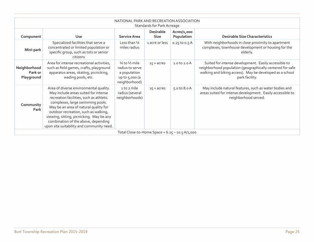
NATIONAL PARK AND RECREATION ASSOCIATIONStandards for Park Acreage
Component Use Service AreaDesirable
SizeAcres/1,000 Population Desirable Size Characteristics
Mini-park
Specialized facilities that serve a concentrated or limited population or specific group, such as tots or senior
citizens
Less than ¼ miles radius
1 acre or less 0.25 to 0.5 A With neighborhoods in close proximity to apartment complexes, townhouse development or housing for the
elderly.
Neighborhood Park or
Playground
Area for intense recreational activities, such as field games, crafts, playground
apparatus areas, skating, picnicking, wading pools, etc.
¼ to ½ mile radius to serve
a population up to 5,000 (a
neighborhood)
15 + acres 1.0 to 2.0 A Suited for intense development. Easily accessible to neighborhood population (geographically centered for safe walking and biking access). May be developed as a school
park facility.
Community Park
Area of diverse environmental quality. May include areas suited for intense recreation facilities, such as athletic complexes, large swimming pools.
May be an area of natural quality for outdoor recreation, such as walking,
viewing, sitting, picnicking. May be any combination of the above, depending
upon site suitability and community need.
1 to 2 mile radius (several
neighborhoods)
25 + acres 5.0 to 8.0 A May include natural features, such as water bodies and areas suited for intense development. Easily accessible to
neighborhood served.
Total Close-to-Home Space = 6.25 – 10.5 A/1,000
Page 26 Burt Township Recreation Plan 2015-2019
Appendix EBarrier Free Guidelines
Burt Township Recreation Plan 2015-2019 Page 27
Barrier Free Accessibility Standards for Parks
Recreational areas, facilities, and programs play an important role in the life of the community; therefore it is essential that people with disabilities have an equal opportunity to enjoy these areas and any programs provided. Federal and state laws prohibit discrimination on the basis of disability, and these laws apply to parks and other recreation lands and programs controlled and operated by local units of government. The DNR has a strong commitment to barrier free recreational opportunities in our Department-managed programs and facilities. This commitment extends to those communities that receive recreation grants.
Under the state Utilization of Public Facilities by the Physically Limited Act (1966 PA 1, as amended) all public facilities, including improved areas used for recreation, must meet the barrier free design requirements contained in the state construction code. Under this act, the administration and enforcement related to barrier free design requirements are vested in the local or state government agency responsible for issuing a building permit. If the project does not require a building permit, administration and enforcement of barrier free design requirements are vested in the Department of Labor and Economic Growth.
Any request for an exception to the barrier free design requirements of the state construction code must be submitted to the Barrier Free Design Board, within the Department of Labor and Economic Growth (517-241-9300). The Barrier Free Design Board has the responsibility to receive, review, and process requests for exceptions to barrier free design specifications; require appropriate equivalent alternatives when exceptions are granted; and receive, process, and make recommendations for barrier free design rules.
Because the state construction code does not apply to many recreation facilities, it is essential that you also be aware of and understand the existing federal guidelines covering these types of facilities. In July 2004, the federal Architectural and Transportation Barriers Compliance Board (known as the Access Board) issued updated guidelines, entitled the Americans with Disabilities Act Accessibility Guidelines (ADAAG), for new or altered facilities covered by the Americans with Disabilities Act of 1990 (Public Law 101-336) or the Architectural Barriers Act of 1968 (Public Law 90-480). These guidelines should eventually be adopted as enforceable standards. Until that occurs, the existing ADAAG standards must be followed when the two conflict.
Included in the updated ADAAG are technical provisions for a number of types of recreation facilities, including play areas, amusement rides, boating facilities, fishing piers and platforms, golf courses, miniature golf courses, shooting facilities, swimming and wading pools, and spas. Technical provisions for these recreation facilities do not exist in the current AADAG. The Access Board has also proposed guidelines for sports facilities, trails, beaches, and picnic and camping areas. While none of these guidelines has yet been adopted as federal standards, they represent the best information available on developing barrier free recreation facilities and may be upheld in a court of law. Therefore, they should be referred to when designing new or renovated recreation facilities.
Page 28 Burt Township Recreation Plan 2015-2019
Appendix FCommunity Survey
Burt Township Recreation Plan 2015-2019 Page 29
Appendix GPublic Notice

Page 30 Burt Township Recreation Plan 2015-2019
Burt Township Recreation Plan 2015-2019 Page 31
Appendix HPublic Meeting Notice

Page 32 Burt Township Recreation Plan 2015-2019
Burt Township Recreation Plan 2015-2019 Page 33
Appendix IPlan Adoption

Page 34 Burt Township Recreation Plan 2015-2019


![Kelvin-way Bathhouse [RED-PEN DRAFT]](https://img.pdfslide.us/doc/110x75/568c37901a28ab02359c06be/kelvin-way-bathhouse-red-pen-draft.jpg)