Embed Size (px)
Citation preview


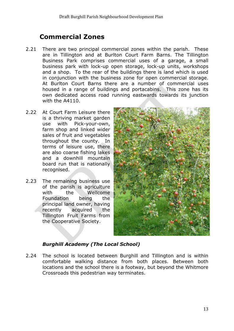
Draft Burghill Parish Neighbourhood Development Plan
2
Acknowledgements
This Neighbourhood Plan has been prepared by Burghill Parish Council in conjunction with Kirkwells
This draft development plan has been prepared in accordance with The
Localism Act of 2011 and Regulation 14 of Statutory Instrument No. 637 TOWN AND COUNTRY PLANNING, ENGLAND The Neighbourhood Planning
(General) Regulations 2012”
The Draft Burghill Parish Neighbourhood Development Plan has been produced to help deliver the requirements and aspirations of the local
community up until 2031. The views of parishioners have been taken into account in preparing the plan and the document will provide a means of
guiding, promoting and enabling balanced growth within the parish.
The Burghill Parish Council invites comments on this draft development
plan. All comments will be considered by the steering group and parish council to inform a revised version of the plan, where appropriate. The
revised plan will then be submitted to Herefordshire Council, as the local planning authority, for further consultation and examination by an
independent examiner.
Comments forms are available at the Simpson Hall, Burghill during the CAP sessions on Wednesday mornings and on the Burghill Parish websites at:
www.burghill-web.co.uk
www.burghillparishcouncil.org
Version 2.10
Copyright © 2015 Burghill Parish Council

Draft Burghill Parish Neighbourhood Development Plan
3
1 Introduction 5
Designation 5
The Neighbourhood Development Plan Process 5
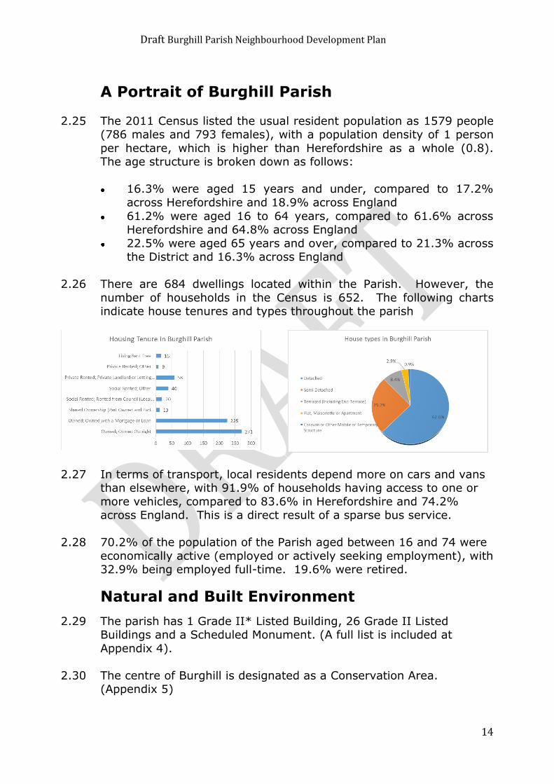
Strategic Environmental Assessment 6
2 About Burghill Parish 7
Location 7
Size 7
Character and appearance 8
Existing Housing 8
Commercial Zones 13
A Portrait of Burghill Parish 14
Natural and Built Environment 14
3 Key Issues for Burghill Parish 16
Burghill Questionnaire March/April 2014 16
Questionnaire Results 16
Employment 19
Natural and Historic Heritage 20
Community Services and Facilities 21
Transport and Roads 22
Tourism 23
Farming Businesses 23
General 24
Character 24
Options Days 24
4 Vision and objectives. 26
5 Methodology 28
6 Neighbourhood Development Plan Policies for Burghill Parish 30
6.1 Housing 30
6.2 Employment 38
6.3 Education 41
6.4 Traffic and Highways 42
6.5 Design, Natural and Historic Heritage 45
6.6 Community Facilities and Open Spaces 50
6.7 Water Management 55
6.8 Renewable Energy 57

Draft Burghill Parish Neighbourhood Development Plan
4
7 Next Steps 59
8 Monitoring and Review 60
Appendix 1: Proposals Maps 61
Map 1 – Burghill Parish Designated Neighbourhood Area 61
Map 2 Lower Burlton proposed settlement boundary (area within Burghill parish abutting
city boundary) 62
Map 3 Burghill proposed settlement boundary 63
Map 4 Tillington proposed settlement boundary including Tillington Business Park 64
Map 5 Burlton Court Farm business Zone 65
Map 6 Designated local green spaces 66
Map 7 Proposed solar energy site 67
Appendix 2: Option Days Maps 68
Appendix 3: Burghill Parish Design Guidance 70
Appendix 4: Heritage Assets 74
Appendix 5: Burghill Conservation Area 76
Appendix 6: Relevant Planning Policies 77
Draft Burghill Parish Neighbourhood Development Plan
5
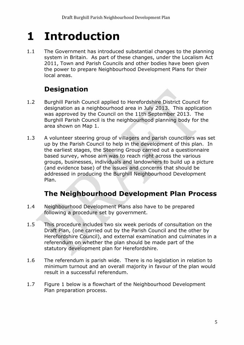
1 Introduction
1.1 The Government has introduced substantial changes to the planning system in Britain. As part of these changes, under the Localism Act
2011, Town and Parish Councils and other bodies have been given the power to prepare Neighbourhood Development Plans for their
local areas.
Designation 1.2 Burghill Parish Council applied to Herefordshire District Council for
designation as a neighbourhood area in July 2013. This application was approved by the Council on the 11th September 2013. The
Burghill Parish Council is the neighbourhood planning body for the area shown on Map 1.
1.3 A volunteer steering group of villagers and parish councillors was set
up by the Parish Council to help in the development of this plan. In
the earliest stages, the Steering Group carried out a questionnaire based survey, whose aim was to reach right across the various
groups, businesses, individuals and landowners to build up a picture (and evidence base) of the issues and concerns that should be
addressed in producing the Burghill Neighbourhood Development Plan.
The Neighbourhood Development Plan Process
1.4 Neighbourhood Development Plans also have to be prepared following a procedure set by government.
1.5 This procedure includes two six week periods of consultation on the
Draft Plan, (one carried out by the Parish Council and the other by Herefordshire Council), and external examination and culminates in a
referendum on whether the plan should be made part of the statutory development plan for Herefordshire.
1.6 The referendum is parish wide. There is no legislation in relation to
minimum turnout and an overall majority in favour of the plan would result in a successful referendum.
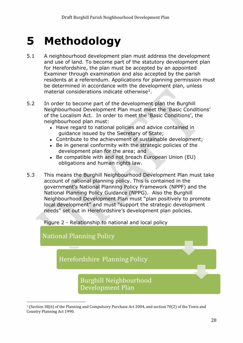
1.7 Figure 1 below is a flowchart of the Neighbourhood Development
Plan preparation process.

Draft Burghill Parish Neighbourhood Development Plan
6
Figure 1 – The Neighbourhood Development Plan Preparation Process
Strategic Environmental Assessment
1.8 In line with European legislation, there is a requirement for the Neighbourhood Development Plan to be subjected to a Strategic
Environmental Assessment (SEA) Scoping which will determine whether a full Strategic Environmental Assessment is required. This
process is a continuous process of alignment and may lead to
amendments in the plan as it is prepared to help ensure that any adverse environmental effects resulting from policies and proposals
in the plan are minimised. The “Scoping Assessment” has been undertaken by Herefordshire Council, who have consulted with the
Environment Agency, Historic England and Natural England on the decision that the Burghill Neighbourhood Development Plan will
require further environmental assessment for Habitats Regulations Assessment and Strategic Environmental Assessment.
1.9 The further assessments will be carried out before the Neighbourhood
Development Plan is publicised for its first formal consultation.
Draft Burghill Parish Neighbourhood Development Plan
7
2 About Burghill Parish
Location 2.1 The centre of the predominantly rural Parish of Burghill is about 4
miles north west of the City of Hereford and to the north of the A4103 which is on an east west alignment of the former Roman
Road, the defining northern city limit. The A4110 towards Canon Pyon and Knighton runs south to north on the eastern side of the
parish. The “C” Class road towards the black and white village of Weobley is on a roughly parallel alignment just westwards of the
central line of the parish. Aside from Hereford City to the south the other neighbouring parishes with contiguous boundaries are:
Credenhill and Brinsop and Wormsley to the west, Stretton Sugwas to the south west, Canon Pyon to the north, Wellington to the north
east together with Moreton on Lugg and Pipe and Lyde to the east and Holmer and Shelwick to the south east. The parish of Burghill
lies in the administrative council ward of Queenswood. The ward has
one serving independent county councillor.
Size
2.2 The Burghill parish has an area of 1,521 hectares, is 5.5km in length and 4.3km at its widest points on a west – east line from Hill Farm
through to Portway, on the A4110 Canon Pyon Road.
Draft Burghill Parish Neighbourhood Development Plan
8
Character and appearance
2.3 Although the parish is near to the City of Hereford it still retains an essentially rural character of open countryside in agricultural use,
including fruit growing and a thriving pick-your-own centre, as the main land use outside the housing groups. The northern fringe of
the parish is defined by the higher ground of Badnage Wood and Round Oak Hill. The southern arable lands of the parish run almost
up to the Roman Road. To both the west and east the agricultural lands of the parish run into ground of similar character and use in
adjacent parishes. Distant views to the west include the Brecon
Beacons and Black Mountains whereas those far vistas to the east have clear sight of the Malvern Hills.
Existing Housing
The Parish of Burghill
2.4 The village of Burghill is just south of the middle of the parish. Tillington and Tillington Common are to the north of the parish,
Portway is to the east and Elton's Marsh to the south east.
The Village of Burghill, its Conservation Area and other land uses.
2.5 The village of Burghill is
the main component of the developed area for
housing within the parish. Here there are
housing groups intermixed with ribbon
development along the main village roads. The
houses within the
village display a wide variety of styles from
earlier times juxtaposed with more modern
houses built within the last few years. There are traditional red brick dwellings and former farm buildings now converted to residential use
along with the occasional timber-framed structure with brick infill. There are some listed buildings and the Parish Church of St Mary's is
a fine example of well-maintained traditional stone built church architecture standing in an elevated position in the southern portion
of the main group and a splendid centre piece of the Conservation Area.
Draft Burghill Parish Neighbourhood Development Plan
9
2.6 Within the village core there is modern residential development
comprising medium sized detached houses and bungalows to suit a wide variety of tastes. These sit alongside a council housing estate
of groups of terraced dwellings, and some bungalows, where some of the individual units are in private ownership. Overall, the village
displays both a pleasant and eclectic range of village housing not untypical of any small settlement within the countryside of
Herefordshire.
2.7 The Copse Leisure Area, which is also close to the
village core, is a local initiative for the village
funded partly by a lottery grant. The land is owned
by the Herefordshire
Council and leased to the Copse Leisure Trust. The
use of the site has proved popular for local events. It
is intended that eventually a locally funded pavilion
will be built on the site for which planning permission
has been granted.
2.8 Burghill Valley Golf Club is on the fringes of the village and on the opposite side of the “C” Road from the Copse Leisure Area. The
course comprises 18 holes over about 100 acres. The club house is not for the exclusive use of members, but also provides a restaurant
and bar for non-members and caters for functions.
Other Housing groups
2.9 The other main housing groups within the parish are at Redstone and Manor Fields, Tillington, Tillington Common, Portway, Elton's Marsh,
St Mary's Park, Lodge Farm Barns, the southern fringe of the parish along the north side of Roman Road and east side of Tillington Road.
Redstone and Manor Fields
2.10 Redstone is a group of 16 red brick semi-detached well-spaced dwelling pairs set around a grassed semi-circle that fronts the public
highway. The dwellings here were built post war as council houses,
but some are now in private ownership.

Draft Burghill Parish Neighbourhood Development Plan
10
2.11 To the west of Redstone at Manor Fields is a newer group of 39 smaller terraced dwellings which were constructed as a low-cost or
shared ownership scheme. Redstone and Manor Fields comprise one of the most compact groups, in terms of number and density of
dwellings, outside the main village component and represent about 8% of the total housing within the parish.
Tillington
2.12 At Tillington there is a fairly compact housing group clustered near the highway cross at Whitmore, near the Bird Pool. The Bird Pool is
one of the designated common land areas within the Burghill Parish and has had this status since its designation in 1973. Within the
Tillington group there are also commercial uses of a garage, a small
business park with lock up storage and workshops and a shop. There is also The Bell, public house and restaurant a prominent and
attractive building which is both popular with locals and attracts customers from a wider area. It also serves its own brand of cider
made on the premises.
Tillington Common
2.13 The dwellings of
Tillington Common form no consolidated
group. The housing is mainly ribbon in
layout and is
interspersed with rural gaps and the
open land of the designated Tillington
Common. The common land here
which comprises about 17 acres of
rough grassland is one of the three designated commons within the parish. There is no
distinct housing character in this zone as once again there are both pre-war and post-war dwellings and more recent housing built within
the last 20 years.
Draft Burghill Parish Neighbourhood Development Plan
11
Portway
2.14 Portway comprises another very loosely spaced ribbon of dwellings of
mixed character and age with approximately 25 dwellings spaced along about 1 mile of highway. Back from the highway near the
Moreton – Burghill crossroads there are a few more dwellings. There is also a group of dwellings further north, about mid-way on the run
of the A4110, of sympathetically converted former barns and oast houses at St Donat's Farm
Elton's Marsh
2.15 There is a small group of older dwellings here on the eastern side of the A4110. These have been added to over the years with minor
infilling. Just further north, from Elton's Marsh, there is both old and
new housing grouped near the crossroads at the bottom of Bewdley Bank, but the major part of this group, on the eastern side of the
A4110, is within the adjoining parish of Pipe and Lyde.
St Mary's Park
2.16 St Mary's Park is an entirely new residential community in the
grounds of the former St Mary's Hospital which was in planning terms brown
field land in a countryside
location. Some of the dwellings
here are
converted former hospital
buildings which are
interspersed with newer
homes of various sizes
built in the grounds of the former medical complex. This development, completed in about 2002, added about 96 homes to
the residential housing stock of the parish. It is the single most significant block increase in housing within the parish in recent
memory. Of the approximately 196 dwellings built in the parish between 1996 and 2011, about 50% of these were at St Mary's Park
and overall it represents almost 15% of the total housing stock of the
parish.

Draft Burghill Parish Neighbourhood Development Plan
12
The Southern Fringes of the Parish.
2.17 Where the southern boundary of the parish meets the Roman Road
there is ribbon development along this highway which is matched by development on the opposite and southern side, but in a different
ward administration. From here the parish development extends northwards for a short distance along both the A4110 and Tillington
Road. However, along the A4110 there is wide spacing between the detached dwellings.
Other Small Groups
2.18 Aside from those described above there are small groups of Converted Barns at Lodge Farm Barns just off the A4110 north of
Portway and also at Burlton Court Barns to the west of Bewdley
Bank.
Scattered Housing
2.19 Throughout the parish there are houses of various sizes on the
fringes of the larger groups and also single dwellings unrelated to groups. Many of these are established existing and former
farmhouses whereas others are detached dwellings. Examples of larger houses can be seen at “Oak House” just off the A4110 to the
east of the parish, Burghill Grange, Burghill Court, Burlton Court and the Lodge on the A4110 at the northern end of the parish. There are
many other single and modest dwellings in the rural zone of the parish.
2.20 The number of dwellings in the Parish has increased significantly over the 15 years from 1996 to 2011 from 488 dwellings to 684 dwellings
(40.2%). The bar chart below shows the number of dwellings in Burghill Parish by each recorded year.
Draft Burghill Parish Neighbourhood Development Plan
13
Commercial Zones 2.21 There are two principal commercial zones within the parish. These
are in Tillington and at Burlton Court Farm Barns. The Tillington Business Park comprises commercial uses of a garage, a small
business park with lock-up open storage, lock-up units, workshops and a shop. To the rear of the buildings there is land which is used
in conjunction with the business zone for open commercial storage. At Burlton Court Barns there are a number of commercial uses
housed in a range of buildings and portacabins. This zone has its
own dedicated access road running eastwards towards its junction with the A4110.
2.22 At Court Farm Leisure there
is a thriving market garden use with Pick-your-own,
farm shop and linked wider sales of fruit and vegetables
throughout the county. In terms of leisure use, there
are also coarse fishing lakes and a downhill mountain
board run that is nationally recognised.
2.23 The remaining business use of the parish is agriculture
with the Wellcome Foundation being the
principal land owner, having recently acquired the
Tillington Fruit Farms from the Cooperative Society.
Burghill Academy (The Local School)
2.24 The school is located between Burghill and Tillington and is within
comfortable walking distance from both places. Between both
locations and the school there is a footway, but beyond the Whitmore Crossroads this pedestrian way terminates.
Draft Burghill Parish Neighbourhood Development Plan
14
A Portrait of Burghill Parish
2.25 The 2011 Census listed the usual resident population as 1579 people (786 males and 793 females), with a population density of 1 person
per hectare, which is higher than Herefordshire as a whole (0.8). The age structure is broken down as follows:
16.3% were aged 15 years and under, compared to 17.2%
across Herefordshire and 18.9% across England
61.2% were aged 16 to 64 years, compared to 61.6% across Herefordshire and 64.8% across England
22.5% were aged 65 years and over, compared to 21.3% across the District and 16.3% across England
2.26 There are 684 dwellings located within the Parish. However, the
number of households in the Census is 652. The following charts indicate house tenures and types throughout the parish
2.27 In terms of transport, local residents depend more on cars and vans than elsewhere, with 91.9% of households having access to one or
more vehicles, compared to 83.6% in Herefordshire and 74.2% across England. This is a direct result of a sparse bus service.
2.28 70.2% of the population of the Parish aged between 16 and 74 were
economically active (employed or actively seeking employment), with 32.9% being employed full-time. 19.6% were retired.
Natural and Built Environment
2.29 The parish has 1 Grade II* Listed Building, 26 Grade II Listed Buildings and a Scheduled Monument. (A full list is included at
Appendix 4).
2.30 The centre of Burghill is designated as a Conservation Area. (Appendix 5)

Draft Burghill Parish Neighbourhood Development Plan
15
2.31 The Parish is predominantly rural in character. The Herefordshire Landscape Character Assessment Supplementary Planning Guidance
(2004) identifies the landscape character type within the parish as ‘Principle Settled Farmlands’.
2.32 There are no Sites of Special Scientific Interest (SSSI) within the
parish. The area falls within the River Wye (including Lugg) Special Area of Conservation (SAC) as it is classed as a sub catchment area.
2.33 The parish contains 3 Special Wildlife Sites (SWS), and there are also
two areas of Ancient Woodland.
2.34 Within the Parish of Burghill there are many areas that have designations of Habitats of Principal Importance. These areas were
displayed at the Options Days. These areas could be: ancient
woodland; traditional orchards; deciduous woodlands; wood pasture and parkland. For sites such as these there is a presumption against
development as there is a national and local imperative to conserve this type of principal habitat and its resident principal species. The
importance of these sites as a UK priority habitat is reflected in Core Strategy policies and those in national policy, which all support the
protection of both Habitats and Species of Principal Importance. However, these land designations are not regulatory, so they do not
impose an embargo on development. With the right type of mitigation, substitute planting, land management or species
protection to ensure no net loss of biodiversity within the county, development could still be permitted.

Draft Burghill Parish Neighbourhood Development Plan
16
3 Key Issues for Burghill Parish
Burghill Questionnaire March/April 2014 3.1 In August 2013 the Neighbourhood Development Plan Steering
Group was formed to work on behalf of Burghill Parish Council to produce a Neighbourhood Development Plan.
3.2 On the 26th November 2013, a public meeting was held in the village hall. A further meeting was held on 4th March 2014 to raise
awareness of the Neighbourhood Development Plan.
3.3 To achieve as full a consultation process as possible the Parish Council decided that questionnaires should be delivered to every
dwelling and business within the neighbourhood area. The Steering Group set up a working party of about 30 volunteers who delivered
questionnaires to every dwelling, farm and business within the Neighbourhood Development Plan area over a three-week period.
About 720 questionnaires were distributed.
3.4 Approximately 440 responses were returned in total. This represented a response rate of about 63% from residents comprising
farms and dwellings. Returns from business premises alone,
excluding farms, was much lower at about 26% bringing the overall percentage down to about 60%.
3.5 A separate element of the questionnaire comprised land availability
questions for zones within the parish. Some of these land availability returns were completed by landowners who do not reside within the
parish. Two of these were the Duchy of Cornwall and the Herefordshire Council, organisations that are significant land owners
within the parish.
Questionnaire Results
Housing
3.6 With regards to the proposed growth in the parish over half of the
430 households who took part in the survey either disagree or strongly disagree that 18% growth in the parish would be an
acceptable increase.

Draft Burghill Parish Neighbourhood Development Plan
17
3.7 When asked what they viewed as an acceptable increase in the
parish 79% of households gave one of the first three answers, namely 1%-5%, 5%-10% or 10%-15%. The most common answer
was 5%-10%.
3.8 There was a clear consensus that the Neighbourhood Development Plan should identify sites for housing.

Draft Burghill Parish Neighbourhood Development Plan
18
3.9 With regard to the appropriate types of new housing the most popular answers were medium sized dwellings, small dwellings for
older/retired people, and starter homes only for local people. Fewer than 40% of respondents ticked any of the other options.
3.10 83% of respondents would be in favour of owner occupied homes but
only 27% in favour or rented. Almost half (46%) were in favour of affordable homes and just over a third (34%) in favour of shared
ownership homes.
3.11 Over three quarters of households would like to see traditional
design, traditional materials, low energy consumption, off street parking, and improved/new footways. Over half would like to see
cycle routes, linked pedestrian routes and amenity areas. Burghill Parish Design Guidance has been prepared and is included as part of
this plan at Appendix 3.
Draft Burghill Parish Neighbourhood Development Plan
19
3.12 The community considered that 4-7 dwellings per site (40% of households), was an ideal site, with 8-10 dwellings per site having a
response rate of 33%.
3.13 The majority of households (82%) think Burghill village should continue to have a settlement boundary. The majority of households
(78%) think a settlement boundary for Tillington should be defined. The majority of households (71%) think a settlement boundary for
Tillington Common should also be defined.
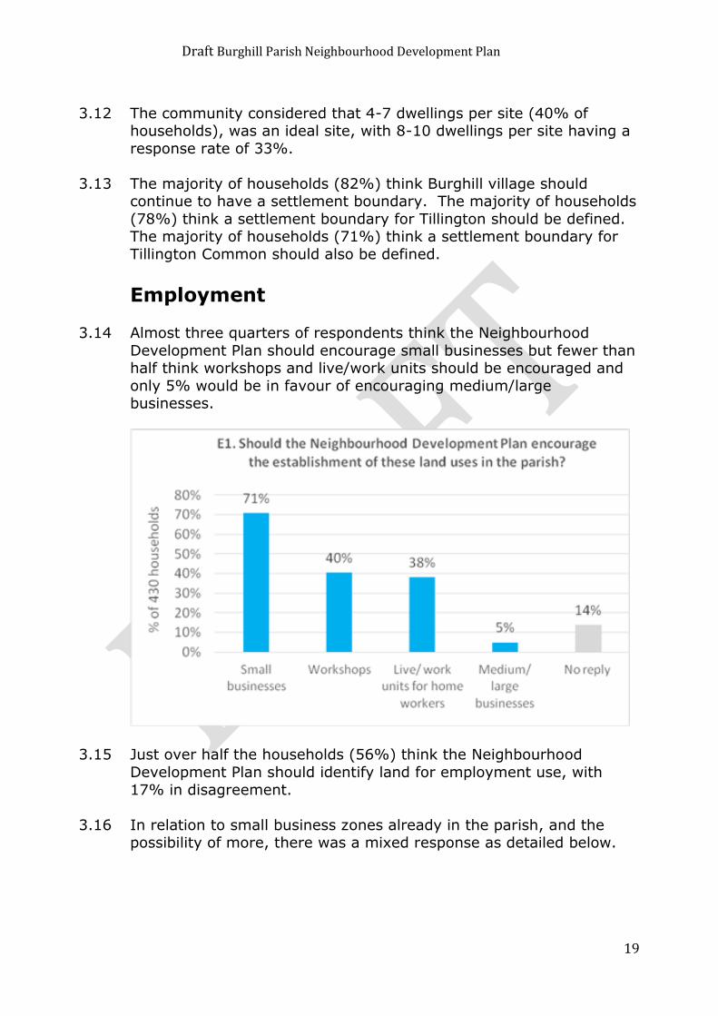
Employment 3.14 Almost three quarters of respondents think the Neighbourhood
Development Plan should encourage small businesses but fewer than half think workshops and live/work units should be encouraged and
only 5% would be in favour of encouraging medium/large businesses.
3.15 Just over half the households (56%) think the Neighbourhood
Development Plan should identify land for employment use, with
17% in disagreement.
3.16 In relation to small business zones already in the parish, and the possibility of more, there was a mixed response as detailed below.

Draft Burghill Parish Neighbourhood Development Plan
20
3.17 Around two thirds of households (66%) think better
broadband/internet services would encourage new business start-ups in the parish. 6 households mentioned roads e.g. better/easier road
access, access to main road, road networks and road conditions, while 4 said there would need to be good/better public transport e.g.
more frequent. 4 households suggested lower rent/rates and 2 said
there should be fewer planning constraints/flexibility when a plan is put forward.
Natural and Historic Heritage
3.18 In relation to the question about any buildings, places or views that
need to be protected other than those already benefiting from
statutory protection such as listed buildings, the most common answers were:
The common or commons (21 comments) with many specifically mentioning Tillington Common (14)
The church (10) Simpson Hall (8)
Green areas/spaces/sites (7) e.g. between Bakers Furlong and Leasown (2)
Orchards (6) e.g. Wellcome orchards (2) Views towards the hills (5) e.g. the black mountains (2) and
Brecon Beacons (2) (n.b. in total, 18 households mentioned views of one kind or another)
Woods (5) e.g. Badnage Woods (3)
Draft Burghill Parish Neighbourhood Development Plan
21
Community Services and Facilities
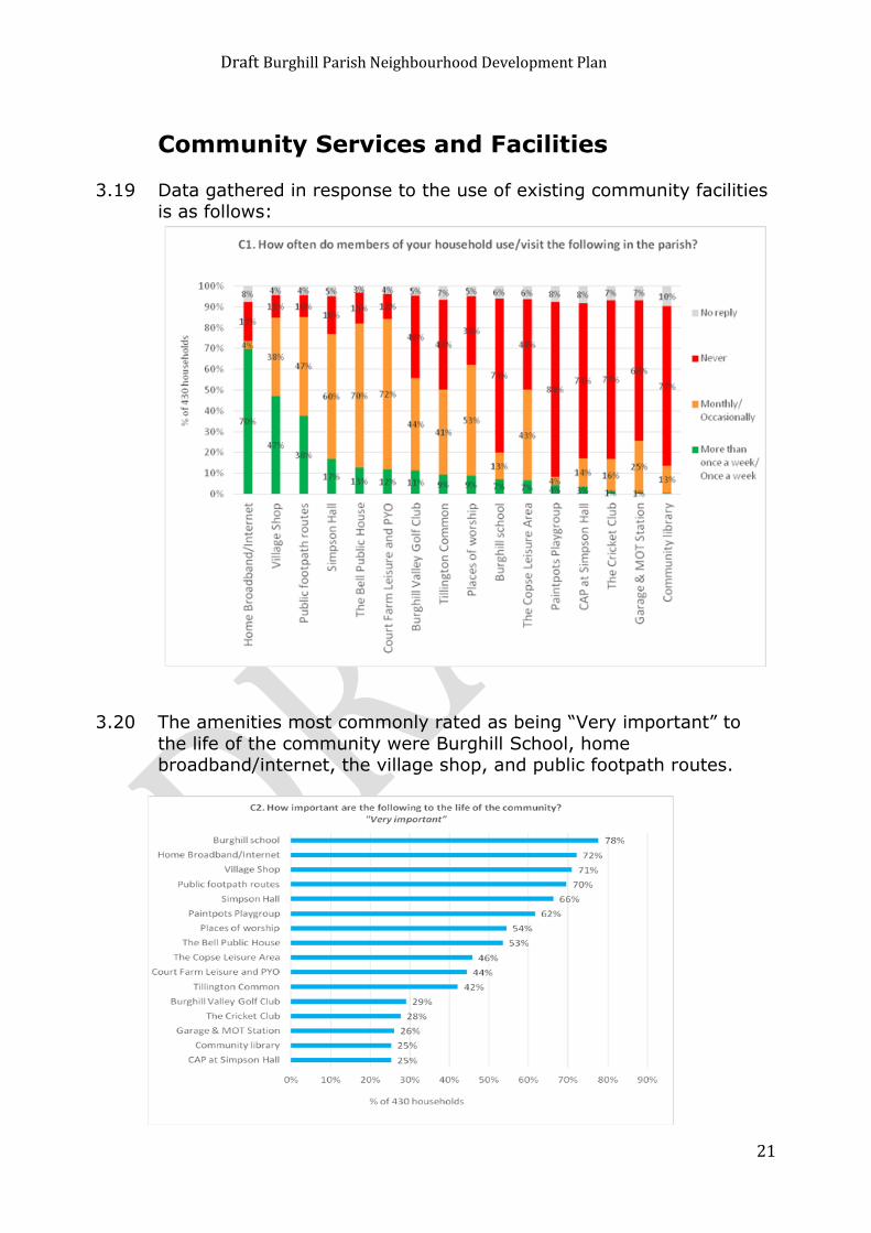
3.19 Data gathered in response to the use of existing community facilities is as follows:
3.20 The amenities most commonly rated as being “Very important” to
the life of the community were Burghill School, home broadband/internet, the village shop, and public footpath routes.
Draft Burghill Parish Neighbourhood Development Plan
22
3.21 Over half the households think leisure space and play areas should
be provided or expanded. 43% think allotments should be provided or expanded and 35% library facilities.
Transport and Roads 3.22 With regards to respondents’ views on the condition of transport
routes within the parish, the following graph identifies that many households think the ease and safety for cycling, ease of use for
disabled persons, and “C” & “U” class roads are poor or very poor, while 44% think the footways at the side of carriageway are poor or
very poor.
3.23 10% of households use public transport at least once a week and 47% monthly or occasionally, while 40% never use public transport
and 2% did not reply.
Draft Burghill Parish Neighbourhood Development Plan
23
3.24 Around half of all households (49%) either rated the bus services neutral or did not reply. 24% said they were good or very good,
while slightly more (28%) said they were poor or very poor.
3.25 The majority of households were in favour of all the measures outlined in Transport and Road questions 6-10, most commonly
encouraging more walking and cycling and discouraging HGV through.
Tourism
3.26 Over half the households (58%) think the Neighbourhood Plan should
encourage tourism, while 19% disagree.
3.27 The most common suggestion for encouraging tourism was improve footpaths/encourage walking e.g. better footpath maintenance; well-
marked routes; publicised routes; walking holidays; rambling; encourage "green routes" to increase business for pub, shop and
Court Farm. The second most common suggestion was the provision of accommodation e.g. B&Bs, a caravan site, a camping site and
holiday lets.
Farming Businesses 3.28 4 respondents are currently considering farm diversification projects,
namely conversion of farm buildings into houses, an equestrian business with a house and stables, and a camping/caravan site.

Draft Burghill Parish Neighbourhood Development Plan
24
General
3.29 The most common reason for coming to Herefordshire/Burghill Parish was that it was a pleasant place to live.
Character
3.30 There was no single dominant theme, with respondents making a diverse range of comments, many of which relate to issues raised
elsewhere in the questionnaire. However, the most common sentiments were to ensure the parish retains its rural character (4
comments) and small scale (3).
Options Days
3.31 Two option days were held on 15th and 16th November 2014 in the Village Hall. All Households received a flyer inviting residents to
participate in the event which was hosted by the members of the
Parish Council and steering group members. Displays included the sites which had come forward as a result of the Questionnaires,
existing Settlement Boundaries and Visions and objectives. An Information sheet was available for all those attending the event,
explaining the next stages in the Neighbourhood Development Plan process. In addition, copies and extracts of the questionnaire
analysis were available which provided Parishioners with details of the information collected.

Draft Burghill Parish Neighbourhood Development Plan
25
3.33 All attendees were invited to complete a series of tables, giving their written opinion on the submitted sites for development and recording
their comments together with For/Against/Neutral in respect of each site. In addition, opinions were sought on the settlement boundaries,
whether these should be amended and if so which areas should or should not be included.
3.34 The Information obtained from this exercise was collated and
analysed in order to obtain a parish wide opinion on the sites submitted for consideration, essential for the successful development
of the Neighbourhood Plan. Some 5161 pieces of information were analysed and recorded including over a 1000 comments indicating
valid concerns or alternatively support for individual sites. The analysis of the opinions expressed regarding Settlement Boundaries
was not so comprehensive and could not be used to make an
informed judgement on their appropriateness.
Draft Burghill Parish Neighbourhood Development Plan
26
4 Vision and objectives.
4.1 To address these key issues the following vision and objectives have been identified:
VISION
Our Vision for the Parish of Burghill is that
it should be a pleasant place for people of
all ages to live with amenities that allow it
to be a thriving community and with a
separate identity from the city of Hereford.
OBJECTIVES
Objective
Actions to achieve
objective
1 To try to ensure there is a
mix of housing for local
people to rent or buy, so that both first-time buyers
and the elderly can remain a part of the community.
Identify suitable sites for housing development within
the parish. Encourage developments that
include a mix of housing types.
2 To establish criteria for
new housing such as the size of developments,
sustainability, and building materials in keeping with
the local environment and in accordance with the
Burghill Parish Design Standards.
Set out criteria in the
Neighbourhood Development Plan, reflecting feedback from
questionnaire on the maximum size of any development,
building materials etc. This has been used to develop the
Burghill Parish Design Guidance in Appendix 3.
3 To preserve and where
possible enhance the natural environment
around us.
Protect Commons and open
spaces. Maintain footpaths and bridleways
4 To promote and support
our local primary school
Try to ensure that housing
development contributes to the
development of the school and that liaison takes place with the
school’s governing body over its development plans.
Draft Burghill Parish Neighbourhood Development Plan
27
5 To support local assets
such as the shop, pub and village hall for the present
and future benefit of the
community.
Try to encourage local people
to use these facilities. To give practical help, where
possible, to ensure the
continuance of these facilities.
6 To preserve and where
possible enhance leisure facilities such as the
playground and sports grounds.
To explore ways of extending
such facilities in line with local need, including allotments.
7 To maintain for the parish
a separate identity from the city.
To avoid development which
would promote the joining of Burghill with the city.
8 To try to establish safe walking, cycling and
driving routes through the parish.
To explore further traffic-calming methods on the main
roads through the parish. To improve and extend
provision of footpaths alongside
roads
9 To encourage small
businesses in the parish, and promote tourism.
Where possible to retain small
business and commercial land uses within the parish, and
promote tourism within the Parish.
10 To promote better internet
provision.
To liaise with the Local
authority and Internet providers to seek better
provision.
11 To try to provide better
public transport and lessen reliance on car usage.
Work with local council and bus
companies to ensure retention of basic bus services.
To explore other ways of providing transport that would
lessen car use.
Draft Burghill Parish Neighbourhood Development Plan
28
5 Methodology
5.1 A neighbourhood development plan must address the development and use of land. To become part of the statutory development plan
for Herefordshire, the plan must be accepted by an appointed Examiner through examination and also accepted by the parish
residents at a referendum. Applications for planning permission must
be determined in accordance with the development plan, unless material considerations indicate otherwise1.
5.2 In order to become part of the development plan the Burghill
Neighbourhood Development Plan must meet the ‘Basic Conditions’ of the Localism Act. In order to meet the ‘Basic Conditions’, the
neighbourhood plan must: Have regard to national policies and advice contained in
guidance issued by the Secretary of State; Contribute to the achievement of sustainable development;
Be in general conformity with the strategic policies of the development plan for the area; and
Be compatible with and not breach European Union (EU) obligations and human rights law.
5.3 This means the Burghill Neighbourhood Development Plan must take account of national planning policy. This is contained in the
government’s National Planning Policy Framework (NPPF) and the National Planning Policy Guidance (NPPG). Also the Burghill
Neighbourhood Development Plan must “plan positively to promote local development” and must “support the strategic development
needs” set out in Herefordshire’s development plan policies.
Figure 2 - Relationship to national and local policy
1 (Section 38(6) of the Planning and Compulsory Purchase Act 2004, and section 70(2) of the Town and Country Planning Act 1990.

Draft Burghill Parish Neighbourhood Development Plan
29
5.4 Herefordshire Council’s strategic planning policy is contained within the newly adopted Herefordshire Core Strategy (2011-2031).
5.5 The policies in the Burghill Neighbourhood Development Plan have
been developed to take account of the key issues in Burghill Parish, and to achieve the aim and objectives in Section 4.
5.6 This Neighbourhood Development Plan has been prepared to ensure
it is in “general conformity” with the policies and proposals in Herefordshire Core Strategy. A full list of relevant national and local
planning policies is included at Appendix 6.

Draft Burghill Parish Neighbourhood Development Plan
30
6 Neighbourhood Development Plan Policies for Burghill
Parish
This chapter sets out the planning policies to guide development in
Burghill to 2031. The policies have been developed to address each of the objectives identified in Chapter 4 and are grouped under a
number of themes. Whilst the policies are divided between these themes the plan should be read as a whole.
6.1 Housing
6.1.1 The housing policies and the design guidance of the Burghill
Neighbourhood Development Plan seek to deliver the following objectives:
Objective 1 - To try to ensure there is a mix of housing for local people to rent or buy, so that both
first-time buyers and the elderly can remain a part of the community.
Objective 2 - To establish criteria for new housing such as the size of developments, sustainability, and building materials in keeping with the local environment and in accordance with the Burghill Parish Design Standards.

Draft Burghill Parish Neighbourhood Development Plan
31
6.1.2 Policy RA1 of the Herefordshire Core Strategy (2011-2031) identifies the rural housing strategy and states that within the Hereford
Housing Market Area (HMA) approximately 1870 dwellings will be required over the plan period and villages should have a target of
18% growth.
6.1.3 Policy RA2 of the Herefordshire Core Strategy (2011-2031) states that the growth target will assist to inform the level of housing
development in the villages. All Neighbourhood Development Plans shall aim to provide levels of housing to proportionally meet these
targets in a locally focused way.
6.1.4 The Herefordshire Core Strategy indicates that the proportional growth is based on the number of dwellings in the Parish. This has
been identified as a figure of 684 dwellings (Census 2011 figures and
parish count).
6.1.5 Applying the housing growth target of 18% for the plan period, Burghill Parish is required to find in the region of 123 new dwellings.
Planning completions and commitments to date account for approximately 19 dwellings in total, with an additional 24 dwellings
at Pye Finch provisionally granted permission on 7th October 2015, subject to a Section 106 agreement. Deducting a figure of 20 for
windfalls over the plan period, a figure in the region of 60 dwellings is appropriate indicative growth target to plan for within this
Neighbourhood Development Plan for the Burghill Parish.
6.1.6 However, it is also realised that the commitment figure is variable and will rise in relation to planning permissions that are granted
throughout the plan period
6.1.7 The Core Strategy identifies Burghill and Tillington as being
settlements which will be the main focus of proportionate housing development.
6.1.8 Other relevant Herefordshire Core Strategy Polices are as follows:
SS1, RA3, RA4, RA5, H2, and H3.
6.1.9 The results of the Questionnaire showed that there was a clear consensus that the Neighbourhood Development Plan should identify
sites for housing, with 84% in agreement
Draft Burghill Parish Neighbourhood Development Plan
32
6.1.10 81% of households said new housing should be placed on brownfield
land but only 9% said it should be located on greenfield land with 59% against. 59% of households thought homes should be built
within existing groups and 45% on the edge of existing groups while 54% were in favour of using infill sites
6.1.11 With regard to the
appropriate types of new housing the most
popular answers were medium sized
dwellings, small dwellings for
older/retired people, and starter homes
only for local people.
Fewer than 40% of respondents ticked
any of the other options.
6.1.12 83% would be in favour of owner occupied homes but only 27% in
favour or rented. Almost half (46%) were in favour of affordable homes and just over a third (34%) in favour of shared ownership
homes.
6.1.13 Over three quarters of households would like to see traditional design, traditional materials, low energy consumption, off street
parking, and improved/new footways. Over half would like to see cycle routes, linked pedestrian routes, and amenity areas. The
Burghill Parish Design Guidance in Appendix 3 has been development
to take account of this information.
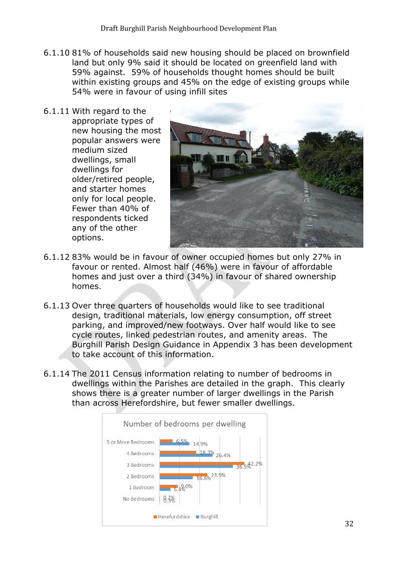
6.1.14 The 2011 Census information relating to number of bedrooms in dwellings within the Parishes are detailed in the graph. This clearly
shows there is a greater number of larger dwellings in the Parish than across Herefordshire, but fewer smaller dwellings.

Draft Burghill Parish Neighbourhood Development Plan
33
6.1.15 In terms of tenure, the following graph is relevant. (2011 Census)
Housing Requirement up to 2031 and the Core Strategy.
6.1.16 The Herefordshire Core Strategy is now adopted. The Burghill Parish
Council (BPC) took account of questionnaire returns which favoured a lower percentage of housing growth than the 18% set out in the Core
Strategy. Therefore, at the time of the Examination in Public (EIP) of the Core Strategy the BPC made representations to the Inspector on
matters of proportionate housing growth. It was claimed that the required 18% growth in dwelling numbers in the parish would be too
high and a figure of nearer 11% would be more appropriate. The BPC considered that this submission was a cogent and well-argued
case for a reduction in the growth percentage within the development plan term between 2011 and 2031. The BPC's
submission was not accepted and the Core Strategy's figure for dwelling number growth in the Hereford Market Area and in Burghill
Parish has remained at 18%. The BPC realises that it does not have the resources to seek any further changes and has decided that for
the present time the 18% growth figure should be the determining
factor for the parish in calculating growth up until 2031.
6.1.17 Figure 4.14 of the Core Strategy continues to identify both Burghill and Tillington as growth areas. The PC has previously agreed that
growth should be confined to Tillington and not Tillington Common which is perceived to be an unsustainable countryside location for
new development, as confirmed by previous planning decisions.

Draft Burghill Parish Neighbourhood Development Plan
34
6.1.18 There are about 684 dwellings in the parish, which translates into a
parish requirement of 123 new dwellings. Planning completions and commitments to date account
for approximately 19 dwellings in total, with an
additional 24 dwellings at Pye Finch provisionally granted
permission on 7th October 2015, subject to a Section
106 agreement. Deducting the Pye Finch permitted
dwelling number from the 104 requirement leaves a parish
wide obligation of about 80 dwellings up until 2031.
6.1.19 In the parish there is the potential for about 20 dwelling sites to come forward from sites known as windfalls. These are sites which
might not have been previously known, sites for single dwellings, changes in existing planning permissions or conversions to existing
buildings. Some of these sites are already under discussion or planning applications have been made.
6.1.20 Removing these 20 or so windfalls from the requirement for 80
dwellings leaves the PC with needing to identifying sites for approximately 60 units. A sufficient number of suitable sites have
come forward in the selection process to achieve this growth requirement up until 2031 at a relatively low housing density.
The Assessment Process
6.1.21 A ‘Call for Sites’ exercise was undertaken as part of the questionnaire process during May 2014. All the sites were objectively assessed
against agreed criteria.
6.1.22 The sites were displayed at the Option Days in November 2014, where residents were asked to indicate whether they were in favour
of or against the sites.
6.1.23 The sites have been independently assessed by Kirkwells, who are the appointed consultants to support the PC through the NDP
process, in line with Guidance Note 21 issued by Herefordshire Council. The sites were scored between 1 and 6, with 1 being the
most favourable and 6 being the least favourable. The NDPSG and PC performed a similar exercise. Additional information is inserted into
the tables from the Options Days scores where the sum of the %'s
both in favour and neutral is shown.

Draft Burghill Parish Neighbourhood Development Plan
35
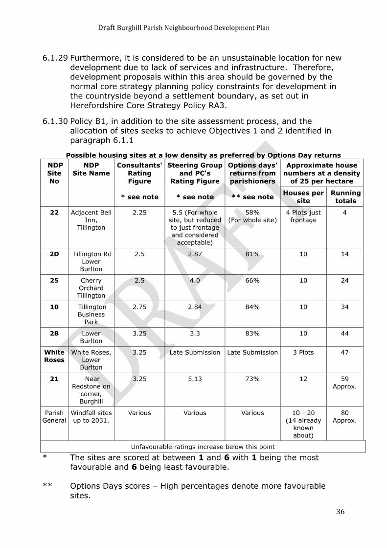
6.1.24 The result of this process is that 7 undeveloped sites and one
previously developed site came out as the most favoured. One of these was Pye Finch which has already been granted planning
permission by HC. The remaining sites which would accommodate at least 60 dwellings are:
• Site 22 Part – Frontage adjacent to the Bell
• Site 2D - Tillington Road Frontage, Lower Burlton • Site 25 - Cherry Orchard, Tillington
• Site 10 - Tillington Business Park - Brownfield • Site 2B - Lower Burlton, Near A4110
• Within curtilage of White Roses, A4110 • Site 21 - Near Redstone on the corner.
Settlement Boundaries
6.1.25 All these suggested sites are shown on plans in the appendices within
possible settlement boundaries.
6.1.26 The sites that are shown within the possible settlement boundaries at
Burghill, Tillington and Lower Burlton have the potential to meet the housing requirement imposed on the Parish by the Core Strategy and
demonstrate alignment with its policies. Furthermore, they have the potential to achieve this growth at a modest housing density, in line
with the aspirations of parishioners and which would also reflect the character and appearance of the parish.
6.1.27 The BPC notes the returns from the questionnaire
which favoured the
designation of a settlement boundary for Tillington
Common, however, it was considered that the
definition of a settlement boundary for the Tillington
Common Area would be inappropriate. The
housing layout in the Tillington Common area
has a limited identifiable core.
6.1.28 The housing here is well spread out with significant gaps between
either individual groups of dwellings or single dwellings. The Parish
Council considers the Tillington Common area is a countryside location with no defined identifiers as a village in the normal sense.
Draft Burghill Parish Neighbourhood Development Plan
36
6.1.29 Furthermore, it is considered to be an unsustainable location for new
development due to lack of services and infrastructure. Therefore, development proposals within this area should be governed by the
normal core strategy planning policy constraints for development in the countryside beyond a settlement boundary, as set out in
Herefordshire Core Strategy Policy RA3.
6.1.30 Policy B1, in addition to the site assessment process, and the
allocation of sites seeks to achieve Objectives 1 and 2 identified in paragraph 6.1.1
Possible housing sites at a low density as preferred by Options Day returns
NDP
Site
No
NDP
Site Name
Consultants'
Rating
Figure
* see note
Steering Group
and PC's
Rating Figure
* see note
Options days’
returns from
parishioners
** see note
Approximate house
numbers at a density
of 25 per hectare
Houses per
site
Running
totals
22 Adjacent Bell
Inn,
Tillington
2.25 5.5 (For whole
site, but reduced
to just frontage
and considered
acceptable)
58%
(For whole site)
4 Plots just
frontage
4
2D Tillington Rd
Lower
Burlton
2.5 2.87 81% 10 14
25 Cherry
Orchard
Tillington
2.5 4.0 66% 10 24
10 Tillington
Business
Park
2.75 2.84 84% 10 34
2B Lower
Burlton
3.25 3.3 83% 10 44
White
Roses
White Roses,
Lower
Burlton
3.25 Late Submission Late Submission 3 Plots 47
21 Near
Redstone on
corner,
Burghill
3.25 5.13 73% 12 59
Approx.
Parish
General
Windfall sites
up to 2031.
Various Various Various 10 - 20
(14 already
known
about)
80
Approx.
Unfavourable ratings increase below this point
* The sites are scored at between 1 and 6 with 1 being the most favourable and 6 being least favourable.
** Options Days scores – High percentages denote more favourable
sites.

Draft Burghill Parish Neighbourhood Development Plan
37
Policy B1 - Scale and type of new housing in
Burghill and Tillington and Lower Burlton. In order to retain the character of the Burghill parish, proposals
for new housing will be only be considered on an allocated site or within the settlement boundaries identified on Map 2 (Lower
Burlton), Map 3 (Burghill), and Map 4 (Tillington), in accordance with the Herefordshire Core Strategy and subject to the
following criteria:
(a) Maintains an appropriate density in context with the
immediate surrounding area and not exceeding 25 dwellings per hectare;
(b) Ensures appropriate and safe access; (c) Ensures adequate access to public transport facilities;
(d) Provides appropriate living conditions for existing and future occupiers (not located adjacent to noise generating
agricultural, industrial or commercial activities); (e) Is of high quality design and is in keeping with the
immediate surroundings, environment and rural landscape and in accordance with Burghill Parish Design
Guidance; (f) Demonstrates a contribution to the delivery of an
appropriate mix of dwelling tenures, types and sizes including at least 35% affordable housing and at least
15% of single storey dwellings, to meet the needs of all
sectors of the community located throughout the site; (g) Reflects the scale and function of the settlement; and
(h) Ensures appropriate parking is provided on site. (i) Minimum living space within dwellings shall be 80 square
metres
Development in open countryside including conversion of rural buildings will be in accordance with the relevant Herefordshire
planning policies.
Travellers Sites
6.1.31 It is important that the accommodation needs and requirements of all sections of the community are considered in developing planning
policies. Burghill Parish Council recognises these requirements and supports the retention of the existing traveller’s site located within
the Parish just to the west of Manor Fields.

Draft Burghill Parish Neighbourhood Development Plan
38
6.1.32 The Burghill Neighbourhood Development Plan Steering Group
(NDPSG) and Parish Council are not seeking to allocate further sites through the Burghill Parish Neighbourhood Development Plan.
6.1.33 The provision of further accommodation for the needs of travellers,
will be assessed strategically throughout the County of Herefordshire, by Herefordshire Council. In the interim period,
applications for planning permission for sites will be assessed through Policy H4 of the Herefordshire Core Strategy
6.2 Employment
6.2.1 The employment policies of the Burghill Neighbourhood Development Plan seek to deliver the following objectives:
Objective 9 - To encourage small businesses in the parish, and promote tourism.
Objective 10 - To promote better internet provision.
6.2.2 Policy E1 of the Herefordshire Core Strategy states that development proposals which enhance employment provision and help diversify
the economy of Herefordshire will be encouraged where: The proposal is appropriate in terms of its connectivity, scale,
design and size; The proposal makes better use of previously developed land or
buildings; the proposal is an appropriate extension to strengthen or
diversify an existing business operation; The proposal provides for opportunities for new office
development in appropriate locations.
The provision of viable live/work units as part of mixed use
developments will also be encouraged.
6.2.3 Policy RA6 relates to the rural economy. It states that
employment generating proposals which help
diversify the rural economy such as knowledge based
creative industries, environmental technologies,
business diversification projects and home working
will be supported.
Draft Burghill Parish Neighbourhood Development Plan
39
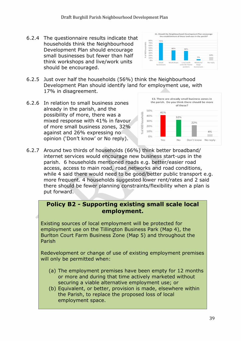
6.2.4 The questionnaire results indicate that households think the Neighbourhood
Development Plan should encourage small businesses but fewer than half
think workshops and live/work units should be encouraged.
6.2.5 Just over half the households (56%) think the Neighbourhood
Development Plan should identify land for employment use, with 17% in disagreement.
6.2.6 In relation to small business zones
already in the parish, and the possibility of more, there was a
mixed response with 41% in favour
of more small business zones, 32% against and 26% expressing no
opinion (‘Don’t know’ or No reply).
6.2.7 Around two thirds of households (66%) think better broadband/ internet services would encourage new business start-ups in the
parish. 6 households mentioned roads e.g. better/easier road access, access to main road, road networks and road conditions,
while 4 said there would need to be good/better public transport e.g. more frequent. 4 households suggested lower rent/rates and 2 said
there should be fewer planning constraints/flexibility when a plan is put forward.
Policy B2 - Supporting existing small scale local employment.
Existing sources of local employment will be protected for employment use on the Tillington Business Park (Map 4), the
Burlton Court Farm Business Zone (Map 5) and throughout the Parish
Redevelopment or change of use of existing employment premises
will only be permitted when:
(a) The employment premises have been empty for 12 months
or more and during that time actively marketed without securing a viable alternative employment use; or
(b) Equivalent, or better, provision is made, elsewhere within the Parish, to replace the proposed loss of local
employment space.
Draft Burghill Parish Neighbourhood Development Plan
40
Policy B3 - Supporting new small scale local employment.
The development of new small-scale local employment
opportunities will be permitted within the Neighbourhood Development Plan area providing that they:
(a) Are located within an existing commercial area; or (b) Give priority to the re-use of a brownfield site, or the
conversion of an existing building.
(c) Are of a scale appropriate to the immediate surroundings; (d) Do not have a detrimental impact on surrounding living
conditions; (e) Do not lead to the loss of open space or green
infrastructure; (f) Are located close to existing highways and do not have an
unacceptable impact on traffic. (g) Are in accordance with all other relevant policies of this
plan.
Policy B4 – Rural enterprise and farm diversification.
Where planning permission is required, new employment development will be permitted in existing hamlets and farmsteads
subject to the following criteria:
The conversion of traditional agricultural buildings to employment
uses will be permitted providing: (a) The building forms part of an existing group of buildings
and is not in an isolated and unsustainable location; and
(b) The proposed use will not cause unacceptable disturbance to neighbours; and
(c) There is no detrimental effect on the form, design, character and setting of the building; and
(d) The building is capable of conversion without significant extension; and
(e) The building is structurally sound and capable of conversion without the need for complete or substantial
reconstruction; and (f) The conversion would not have a detrimental impact on the
appearance or character of the landscape; and (g) The access to the site is of a safe standard or is capable of
being improved to a safe standard without harming the appearance of the area.
(h) The conversion would not be detrimental to the continued
agricultural operation of the site as a whole.

Draft Burghill Parish Neighbourhood Development Plan
41
Policy B5 – Supporting development of communications infrastructure
The development of new, high speed broadband infrastructure and mobile infrastructure to serve the Parish will be supported
where it is sympathetically designed, and significant landscape and visual effects have been adequately mitigated.
All new residential development will be required to make provision
for high speed broadband.
6.3 Education
6.3.1 The education policies of the Burghill Neighbourhood Development
Plan seek to deliver the following objectives:
Objective 4 - To promote and support our local primary school
6.3.2 Opening in 1875, the village school originally provided an education for the children of Burghill, Tillington and Huntingdon up to school
leaving age.
6.3.3 Today, Burghill Community Academy caters for up to 105 pupils (current number on roll is 92) taught in 4 mixed-age classes. Pupils
come from Burghill and Tillington but also from Credenhill and the outskirts of North Hereford. Increasingly the school caters for
families with services backgrounds and at the end of the last
academic year 33% of pupils came from this group and were supported by services premium funding.
6.3.4 The school is located north west of the village of Burghill on the road
to Tillington.
6.3.5 This Neighbourhood Development Plan seeks to support and promote the local primary school - Burghill Academy.
6.3.6 Teaching space is still a problem with the school having to rely on
temporary buildings. The Governors are seeking central funding to replace the temporary building currently housing Year 3 and 4 and to
incorporate a secure entranceway to the school with a contained area for visitors to wait in. The School Infrastructure Development Plan
proposes an initial focus on replacing the temporary classroom and
then as a secondary element to address the secure entranceway.

Draft Burghill Parish Neighbourhood Development Plan
42
6.3.7 They are also in the process of decorating and maintaining the buildings through their capital funding and working to effectively
manage and maintain the problematic sewage tank situated to the right of the main school car park.
6.3.8 In order to achieve this the Neighbourhood Development Plan seeks
to ensure that housing development contributes to the development of the school and that liaison takes place with the school’s governing
body over its development plans for the future.
Policy B6 – Education The Parish Council support the future expansion of Burghill
Academy in accordance with the policies and proposals within this Neighbourhood Development Plan.
In order to retain the existing character of the area, and to
maintain the amenity of the surrounding developments, all
expansion proposals will be expected to meet the following criteria:
(a) Ensures appropriate and safe access to the site;
(b) Does not materially harm the living conditions of neighbours;
(c) Is of high quality design and is in keeping with the immediate surroundings, environment and rural
landscape; (d) Reflects the scale and function of the school; and
(e) Ensures appropriate parking is provided on site.
6.4 Traffic and Highways 6.4.1 The traffic and highways policies of the Burghill Neighbourhood
Development Plan seek to deliver the following objectives:
Objective 8 - To try to establish safe walking, cycling and driving routes through the parish.
Objective 11 - To try to provide better public transport and lessen reliance on car usage.

Draft Burghill Parish Neighbourhood Development Plan
43
6.4.2 The NPPF states at Paragraph 29 that transport policies have an
important role to play in facilitating sustainable development, but also in contributing to wider sustainability and health objectives. It
also states at paragraph 30, that encouragement should be given to solutions which support reductions in greenhouse gas emissions and
reduce congestion.
6.4.3 Policy SS4 of the Herefordshire Core Strategy states that new
development should be designed and located to minimise the impacts on the transport network and ensure that journey times and
the efficient and safe operation of the network are not detrimentally impacted. Proposals to provide new and improve existing public
transport, walking and cycling infrastructure will be supported. Where appropriate, land and routes will also be safeguarded as
required in future local or neighbourhood development plans and
developer contributions which meet the statutory tests will be sought to assist with the delivery of new sustainable transport
infrastructure, including that required for alternative energy cars.
6.4.4 The questionnaire results indicate that around 60% of households think that the ease of use and safety for cycling (63%), disabled
persons (62%) and use of the Parish’s “C” & “U” class roads (58%) are poor or very poor. 44% of respondents think the footways at the
side of carriageway are poor or very poor. The most common response to the other routes in the question was ‘Average’.

Draft Burghill Parish Neighbourhood Development Plan
44
6.4.5 The routes most commonly rated good or very good were the public
footpaths (24%), however almost the same number (22%) think they are poor or very poor. The result here may be confused by
respondents not understanding the difference between public footpaths and roadside footways.
6.4.6 10% of households use public transport at least once a week and
47% monthly or occasionally, while 40% never use public transport and 2% did not reply.
6.4.7 Around half of all households (49%) either rated the bus services
neutral or did not reply. 24% said they were good or very good, while slightly more (28%) said they were poor or very poor.
6.4.8 The majority of households were in favour of all the measures
outlined in questions Transport and Roads questions 6-10, most
commonly encouraging more walking and cycling (75% of households) and discouraging HGV through routes (75%). Only 27%
think that existing speed limits within the parish are effective, while double this number (54%) do not think they are effective.
Policy B7 - Traffic management and transport improvements
Proposals to improve road safety and traffic management will be
fully supported. These should include combined footway and cycle ways and links between housing zones and community
services.
Developer contributions and Community Infrastructure Levy payments will be sought towards the following within the parish:
(a) Highway improvement schemes to promote the safety of pedestrians and cycle users;
(b) Traffic calming measures, pedestrian priority schemes and the reduction in traffic speeds on routes through the Parish;
(c) To Increase public and community transport, within, to and from the villages.
The parish council will work with and encourage providers of
public transport to provide as full a service as is needed to
support future development in the area.
Draft Burghill Parish Neighbourhood Development Plan
45
6.5 Design, Natural and Historic Heritage
6.5.1 The design, natural and historic heritage policies of the Burghill Neighbourhood Development Plan seek to deliver the following
objectives:
Objective 2 - To establish criteria for new housing such as the size of developments, sustainability, and building materials in keeping with the local environment. Objective 3 - To preserve and where possible enhance the natural environment around us. Objective 7 - To maintain for the parish a separate identity from the city.
6.5.2 Policy SS6 of the Herefordshire Core Strategy states that
Development proposals should conserve and enhance those environmental assets that contribute towards the county’s
distinctiveness, in particular its settlement pattern, landscape,
biodiversity and historic assets and especially those with specific environmental designations.
Draft Burghill Parish Neighbourhood Development Plan
46
6.5.3 In addition, proposals should maintain and improve the effectiveness
of those ecosystems essential to the health and wellbeing of the county’s residents and its economy. Development proposals should
be shaped through an integrated approach to planning the following environmental components from the outset, and based upon
sufficient information to determine the effect upon each where they are relevant:
landscape, townscape and local distinctiveness, especially in
Areas of Outstanding Natural Beauty; biodiversity and geodiversity especially Special Areas of
Conservation and Sites of Special Scientific Interest; historic environment and heritage assets, especially Scheduled
Monuments and Listed Buildings; the network of green infrastructure;
local amenity, including light pollution, air quality and tranquility;
agricultural and food productivity; physical resources, including minerals, soils, management of
waste, the water environment, renewable energy and energy conservation.
6.5.4 Policy LD4 of the Core Strategy states that development
proposals affecting heritage assets and the wider historic
environment should achieve the following objectives:
• the conservation, and
where appropriate enhancement of, heritage
assets and their settings
that positively contribute to the character of a site, townscape and/or wider environment,
including conservation areas; • the conservation and enhancement of heritage assets and their
settings through appropriate management, uses and sympathetic design;
• the retention, repair and sustainable use of heritage assets as a focus for wider regeneration schemes; and
• the appropriate recording of heritage assets in mitigation of development impact, in cases where agreed loss occurs.
The scope of the works required to protect, conserve and enhance
heritage assets and their settings should be proportionate to their significance. Development schemes should emphasise the original
form and function of any asset and, where appropriate, improve the
understanding of and public access to them.

Draft Burghill Parish Neighbourhood Development Plan
47
6.5.5 The questionnaire responses indicate that over three quarters of
households would like to see traditional design (80%), traditional materials (81%), low energy consumption (82%), off street parking
(82%) and improved/new footways (77%).
6.5.6 Over half of the respondents would like to see cycle routes (62%),
linked pedestrian routes (61%) and amenity areas (54%). Only 27% would like to see modern design, with 32% against.
6.5.7 Further questionnaire responses indicate that in relation to the question about any buildings, places or views that need to be
protected other than those already benefiting from statutory protection such as listed buildings, the most common answers were:
The common or commons (21 comments) with many specifically
mentioning Tillington Common (14)
The church (10) Simpson Hall (8)
Green areas/spaces/sites (7) e.g. between Bakers Furlong and Leasown (2)
Orchards (6) e.g. Wellcome orchards (2) Views towards the hills (5) e.g. the black mountains (2) and
Brecon Beacons (2) (n.b. in total, 18 households mentioned views of one kind or another)
Woods (5) e.g. Badnage Woods (3)
Policy B8 - Design of Development in Burghill Parish.
Burghill Parish has a distinctive and special character. In accordance with the Burghill Parish Design Guidance in
Appendix 3, all new development within the area will be permitted where it makes a positive contribution to that
distinctive character, and is of good design and quality. In seeking to protect and where possible enhance the unique
identity of the area, all development will be expected to take account of the following:
Local identity, and sense of place; The character and setting of the Burghill Conservation
Area, where appropriate;
Is satisfactory in terms of the overall design and appearance of the proposed development (including
size, scale, density, layout, access, lighting, street furniture, and signage) when assessed in relationship
with surrounding buildings, existing layout, spaces, vegetation, water areas and other features of the street
scene;

Draft Burghill Parish Neighbourhood Development Plan
48
It makes use of, and where appropriate re-uses local and traditional materials or suitable artificial
alternatives; It does not result in backland development which has a
detrimental impact on the character of the village; Inclusion of adequate parking, garaging and private
and public amenity space for future residents; The use of space and landscape design is appropriate;
Good relationship to the street and incorporates an active frontage
Movement to, within, around, and through the
development is acceptable Incorporates originality, innovation and initiative, where
appropriate; Includes appropriate energy efficiency and conservation
measures Uses Sustainable Drainage Systems
Provides adequate storage facilities for refuse and recycling facilities for each dwelling;
Uses appropriate lighting for the location
6.5.8 The Herefordshire Landscape Character Assessment SPG (2004) identifies the Parish as being within the landscape character type of
‘Principle Settled Farmlands’.
Character Description The rolling, lowland area of Central Herefordshire is dominated by this
Landscape Type. These are settled agricultural landscapes of dispersed, scattered farms, relic commons and small villages and
hamlets. The mixed farming land use reflects the good soils on which they are typically found. Networks of small winding lanes nestling
within a matrix of hedged fields are characteristic. Tree cover is largely restricted to thinly scattered hedgerow trees, groups of trees
around dwellings and trees along stream sides and other
watercourses. The composition of the hedgerow tree cover differs from that of Timbered Farmlands in its lower density and lack of oak
dominance. This is a landscape with a notably domestic character, defined chiefly by the scale of its field pattern, the nature and density
of its settlement and its traditional land uses. Hop fields, orchards, grazed pastures and arable fields, together make up the rich
patchwork which is typical of Principal Settled Farmlands.
6.5.9 The Parish Council and the residents of the Parish consider it important to protect the character and setting of Burghill, the other
housing groups within the parish and the surrounding landscape.

Draft Burghill Parish Neighbourhood Development Plan
49
Policy B9 - Protecting and where possible
enhancing local landscape character.
Development proposals will be required to incorporate the following landscape design principles:
(a) All development will be expected to retain the green areas between Burghill and Hereford and to maintain
the distinct and separate identity of the Parish.
(b) Development proposals should seek to preserve and
where possible enhance the character of the village and surrounding scattered rural settlements and farmsteads.
Schemes will be expected to conserve and protect the integrity and fabric of historic buildings and their
settings, particularly where new uses are proposed, through the use of appropriate styles and sustainable
locally distinctive materials.
(c) Local habitats and wildlife corridors should be preserved and where possible enhanced. Landscaping schemes will
be required to incorporate planting schemes which use traditional and locally appropriate species to support
and where possible enhance biodiversity. Species should be appropriate to the location and setting in terms of
type, height, density and the need for on-going
management. When constructing boundaries native tree species should be used. Existing hedgerows should be
retained and the establishment of new native hedges is encouraged to support and protect wildlife.
(d) Development proposals should conserve important local
landscape features and species where possible. Mature and established trees should be retained and
incorporated into landscaping schemes where possible.
(e) New residential development should protect the area’s historic settlement pattern.
(f) The conservation of traditional farm buildings through
continued and appropriate new uses is supported and
repairs and alterations should use local materials and techniques where possible.
(g) Sustainable construction, low carbon technologies and use of innovative solutions will be encouraged such as
grey water recycling, rainwater harvesting, and opportunities for local food production.

Draft Burghill Parish Neighbourhood Development Plan
50
6.6 Community Facilities and Open Spaces
6.6.1 The Burghill Neighbourhood Development Plan’s community facilities and open spaces policies seek to deliver the following objectives:
Objective 5 - To support local amenities such as the shop, pub and village hall for the present and future benefit of the community. Objective 6 - To preserve and where possible enhance leisure facilities such as the playground and sports grounds.
Objective 8 - To try to establish safe walking, cycling and driving routes through the parish.
6.6.2 Burghill has a network of footpaths and open spaces, which link facilities around the village, provide means to reach open countryside
and longer distance footpaths.
6.6.3 Burghill also has a range of community facilities that are widely used by the community, such as the school, village shop, Simpson Hall,
golf club, the public house, church, “Pick your Own”, Court Farm Leisure, Copse Leisure area and cricket club.
6.6.4 The National Planning Policy Framework (NPPF) advises at paragraph
76 that “local communities through local and neighbourhood plans should be able to identify for special protection green areas of
particular importance to them. By designating land as Local Green
Space communities will be able to rule out new development other than in very special circumstances”.
6.6.5 The questionnaire responses indicate that 70% of households use
home broadband/internet at least once a week, 47% the village shop and 38% the public footpath routes. The other amenities were less
well used on a frequent basis, with fewer than 20% using any of them at least once a week. 50% use the Copse Leisure Area (7%
weekly, 43% monthly/occasionally) and 13% use the community library (monthly/occasionally).
6.6.6 The amenities most commonly rated as being “Very important” to
the life of the community were Burghill School (78%), home broadband/internet (72%), the village shop (71%) and public
footpath routes (70%), places of worship (54%) and The Bell public
house (53%).

Draft Burghill Parish Neighbourhood Development Plan
51
6.6.7 The amenities least commonly rated as being “Very important” were
the CAP at Simpson Hall (25%), community library (25%), garage & MOT station (26%), cricket club (28%) and golf club (29%).
6.6.8 Policy SC1 of the Herefordshire Core Strategy states that
development proposals which protect, retain or enhance existing social and community infrastructure or ensure that new facilities are
available as locally as possible will be supported. Such proposals should be in or close to settlements, have considered the potential
for co-location of facilities and where possible be safely accessible by foot, by cycle and public transport.
6.6.9 Policy SC1 continues to state that new development that creates a
need for additional social and community facilities (for
example, schools, pre-schools,
children’s centres, child minding provision, youth
provision, pubs and local shops) - that cannot be met
through existing social facilities will be expected to
meet the additional requirements through new, or
extension of existing, provision or by developer
contribution where appropriate.
6.6.10 The policy also states that proposals involving the provision or expansion of social and community facilities will be expected to
provide publicly accessible toilets (including facilities for disabled
people and baby changing).
6.6.11 Existing facilities will be retained, unless it can be demonstrated that an appropriate alternative facility
is available, or can be provided to meet the needs of the community
affected; or it can be shown that the facility is no longer required,
viable or is no longer fit for purpose; and where appropriate,
it has been vacant and marketed for community use without
success. Viable alternative facilities must be equivalent to
those they replace, in terms of
size, quality and accessibility.

Draft Burghill Parish Neighbourhood Development Plan
52
6.6.12 Policy LD3 of the Herefordshire Core Strategy states that development proposals should protect, manage and plan for the
preservation of existing and delivery of new green infrastructure, and should achieve the following objectives:
identification and retention of existing green infrastructure
corridors and linkages; including the protection of valued landscapes, trees, hedgerows, woodlands, water courses and
adjoining flood plain; provision of on-site green infrastructure; and in particular
proposals will be supported where this enhances the network integration with, and connection to, the surrounding green
infrastructure network.
6.6.13 Over half the households think leisure space (56%) and play areas
(51%) should be provided or expanded. 43% think allotments should be provided or expanded and 35% library facilities. 8 households
made comments about provision for children and young people, e.g. children’s playground, more variety at park for children, skate park,
youth club.
6.6.14 Other common answers included footpaths (7), cycle paths (6), post office (4) and doctor’s surgery (3). 5 households mentioned the
Copse leisure area with suggestions including tennis courts, bowling, sports pavilion, public toilets and improved facilities for all ages. The
main concern about footways seems to be about safety, e.g. safe route needed from St Mary’s to village (2), footways too narrow to
walk safely with children, currently dangerous to walk along Tillington Road.
6.6.15 Paragraph 77 of the NPPF advises that “the Local Green Space designation will not be appropriate for most green areas or open
space. The designation should only be used:
where the green space is in reasonably close proximity to the community it serves;
where the green area is demonstrably special to a local
community and holds a particular local significance, for example because of its beauty, historic significance, recreational value
(including as a playing field), tranquility or richness of its wildlife; and
where the green area concerned is local in character and is not
an extensive tract of land.”
Draft Burghill Parish Neighbourhood Development Plan
53
Policy B10 - Protection of local green spaces The following local green spaces as shown on map 6 are designated
in accordance with paragraphs 76 and 77 of the NPPF:
1. Tillington Common
2. The Bird Pool 3. Whitmoorpool Common
4. The green areas at Leasown and Bakers Furlong 5. The green semi-circle at Redstone
6. The Deer Park and its rural surroundings at St Mary’s Park 7. The Copse leisure area
8. Possible graveyard extension St Mary’s Church
New development which impacts adversely on the openness of these sites will not be permitted except in very special
circumstances.
6.6.15 Table 3 below sets out how each of the proposed protected local green spaces meet these criteria:
Policy B11 - Protection and where possible enhancement of local community facilities
There will be a presumption in favour of the protection and where possible enhancement of existing facilities. The proposed re-use
of local community facilities such as the village hall and educational facilities will only be permitted for other health,
education or community type uses.
The change of use of existing facilities to other uses will not be permitted unless the following can be demonstrated:
a) The proposal includes alternative provision, on a site within
the locality, of equivalent or enhanced facilities. Such sites should be accessible by public transport, walking and cycling
and have adequate car parking; or
b) Satisfactory evidence is produced that there is no longer a need for the facility

Draft Burghill Parish Neighbourhood Development Plan
54
Table 3 – Local Greenspace – NPPF Criteria
Name of
site
No Distance
from Local
Community
Special Qualities/Local
Significance
Extensive tract of
land
Tillington
Common
(Ref: CL 19
Commons
Register)
1 Within the
housing zone
at Tillington
Common
Adds significant open undeveloped
and rural character to the
surrounding sporadic housing
arrangement and area in general.
Enhanced sylvan presence from a
line of mature chestnut trees along
the roadside.
Large open area of
land of about 11.28
acres owned and
subtly managed with
rural emphasis by
the Burghill Parish
Council.
The Bird Pool
(Ref: CL21
Commons
Register)
2 Within the
Tillington
Area near
Whitmoor
Cross Roads
A tree lined pool, small green,
wildlife habitat and secret tranquil
corner.
An area of about 1/3
acre owned and
managed by Burghill
Parish Council
Whitmoorpool
Common
(Ref:CL 20
Commons
Register)
3 Within the
Tillington area
between the
school and
Whitmoor
Cross Roads.
A small common next to the school
providing rural separation between
the school and a dwelling.
An area of about 1.8
acres owned and
managed by the
Burghill Parish
Council
The Green
Areas at
Leasown and
Baker's
Furlong
4 Within the
Leasown and
Baker's
Furlong
Housing area
Contiguous grassed open areas
adding significant openness and
character to a fairly compact
housing zone. Also provides
amenity area to these zones.
Owned and managed
by the Herefordshire
Housing.
The Green
Semi Circle
at Redstone
5 Fronting the
Redstone
housing
group.
The housing group is set back from
the road and surrounds the green,
separated from it by a semi-
circular access road. Emphasises
the rural character of this housing
group. Also provides amenity area
for this group.
Owned and managed
by the Herefordshire
Council
The Deer
Park and its
rural
surroundings
at St Mary's
Park
6 South of the
parish and
linked to the
housing
development
at St Mary's
Park
Significant open presence between
St Mary's Park and the land of
Hospital farm on the fringes of The
City of Hereford. Comprising Deer
park, Woodland, Parkland and
Formal Gardens
Owned by the
residents of St
Mary's Park and
managed by The St
Mary's Park
Management
Company.
The Copse
Leisure Area
7 Opposite the
Pye Finch
Triangle
Sporting facilities and play area
with two portacabins and lock up.
Planning permission for Sports
Pavilion and two courts.
Land owned by
Herefordshire
Council. Leased and
managed by the
Copse Leisure Trust.
Possible
Graveyard
Extension St
Mary's
Church/Part
Site 34
8 West of St
Mary's Church
and within the
Conservation
Area
Abuts the grounds of the church
and the present graveyard. Land
is within the conservation area and
its possible use as consecrated
ground would protect or conserve
the setting of the listed building.
Land currently
owned by Wellcome
Foundation.
Draft Burghill Parish Neighbourhood Development Plan
55
Policy B12 - Community facilities and
Community Infrastructure Levy Development will be required to support proposals for improved
community facilities and infrastructure in the parish. Priority will be given to the following proposals:
Traffic calming measures on roads within the parish.
Community Leisure activities Community services such as printing and its accommodation
Educational support for all ages
This Policy should be read in conjunction with Policy B7 of this
Neighbourhood Development Plan.
6.7 Water Management
6.7.1 The water management policies of the Burghill Neighbourhood Development Plan seek to deliver the following objectives:
Objective 2 - To establish criteria for new housing such as the size of developments, sustainability, and building materials in keeping with the local environment.
Objective 3 - To preserve and where possible enhance the natural environment around us.
6.7.2 Policy SD3 of the Herefordshire Core strategy states that measures
for sustainable water management will be required to be an integral
element of new development in order to reduce flood risk; to avoid an adverse impact on water quantity; to protect and enhance
groundwater resources and to provide opportunities to enhance biodiversity, health and recreation.
6.7.3 Policy SD4 of the Herefordshire Core Strategy states that development should not undermine the achievement of water quality
targets for rivers within the county, in particular through the treatment of wastewater.
6.7.4 In the first instance developments should seek to connect to the existing mains wastewater infrastructure network. Where this option
would result in nutrient levels exceeding conservation objectives targets, in particular additional phosphate loading within a SAC
designated river, then proposals will need to fully mitigate the
adverse effects of wastewater discharges into rivers caused by the development.

Draft Burghill Parish Neighbourhood Development Plan
56
Policy B13 - Flood Risk, Water Management and surface water run-off
All development should be located within Flood Zone 1 (Low
Risk) and accord with National Planning Policy Guidance (NPPG) and Herefordshire Council’s Core Strategy (Policy SD3 -
Sustainable Water Management). Where development is deemed acceptable within Flood Zones 2 and 3 (in accordance
with the Sequential Test) we would expect proposals to demonstrate that they are safe and will not increase flood risk
to third parties, with flood-risk betterment provided where
possible.
New development should be designed to maximise the
retention of surface water on the development site and to minimise runoff. Sustainable drainage systems (SuDS) should
be implemented where possible.
All water management schemes, for either foul or surface
water, shall be constructed to a standard capable of adoption by the relevant statutory undertaker. These works shall be
completed and the adoption agreement shall be completed before any dwellings on the linked development are occupied
The design of new buildings and infrastructure should take account of existing topography to manage the flow of water
along specific flow routes away from property and into
appropriate storage facilities. Water attenuation facilities such as lagoons, ponds and swales should be provided within
development sites.
Sustainable design of buildings which support rain water
harvesting are supported. Storage of rain water for non-drinking water purposes such as watering gardens and flushing
toilets is encouraged.
Areas of hard standing such as driveways and parking areas
should be avoided and porous materials used.
Where such opportunities arise, developments should help to
maintain, conserve and where possible, enhance culverts, watercourses and riverside habitats. Where necessary, this
should be through management and mitigation measures for
the improvement and/or enhancement of water quality and habitat of any aquatic environment in or adjoining the
development site.
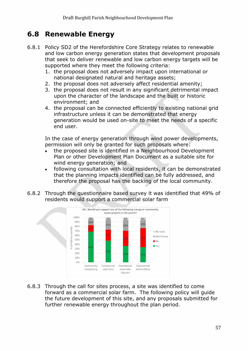
Draft Burghill Parish Neighbourhood Development Plan
57
6.8 Renewable Energy
6.8.1 Policy SD2 of the Herefordshire Core Strategy relates to renewable and low carbon energy generation states that development proposals
that seek to deliver renewable and low carbon energy targets will be supported where they meet the following criteria:
1. the proposal does not adversely impact upon international or national designated natural and heritage assets;
2. the proposal does not adversely affect residential amenity; 3. the proposal does not result in any significant detrimental impact
upon the character of the landscape and the built or historic environment; and
4. the proposal can be connected efficiently to existing national grid infrastructure unless it can be demonstrated that energy
generation would be used on-site to meet the needs of a specific
end user.
In the case of energy generation through wind power developments, permission will only be granted for such proposals where:
the proposed site is identified in a Neighbourhood Development Plan or other Development Plan Document as a suitable site for
wind energy generation; and following consultation with local residents, it can be demonstrated
that the planning impacts identified can be fully addressed, and therefore the proposal has the backing of the local community.
6.8.2 Through the questionnaire based survey it was identified that 49% of
residents would support a commercial solar farm
6.8.3 Through the call for sites process, a site was identified to come
forward as a commercial solar farm. The following policy will guide the future development of this site, and any proposals submitted for
further renewable energy throughout the plan period.

Draft Burghill Parish Neighbourhood Development Plan
58
Policy B14 - Development of Renewable Energy Facilities in Burghill Parish
The site identified on Map 7 will be supported for development as a solar farm subject to satisfying the criteria (a) – (h) within
this policy.
Further proposals for renewable energy development, including biomass, hydro, solar, landfill and biogas, will be permitted
when:
(a) any associated buildings are of appropriate size, scale, design and siting;
(b) the site is suitably located in relation to any necessary raw materials;
(c) there is no adverse impact on the character of the landscape, sites of nature conservation, archaeological
and historical value; (d) there is no detrimental impact on any neighbouring land
uses, including Listed Building or Conservation Area; (e) there is no adverse impact caused by any connection or
switching equipment; (f) the level and impact of any potentially polluting
substances is minimised; (g) there is no nuisance or disturbance caused by noise,
dust, or smells; and
(h) suitable means for disposal of waste arising are incorporated.
Draft Burghill Parish Neighbourhood Development Plan
59
7 Next Steps
7.1 This Draft Plan has been prepared by the Neighbourhood Development Plan Steering Group and Burghill Parish Council,
supported by planning consultants Kirkwells.
7.2 Hopefully, the first statutory 6-week deposit and public consultation
period on the Draft Neighbourhood Development Plan (DNDP) will commence in early 2016. This might result in amendments to the
DNDP. The amended DNDP will then be submitted to Herefordshire Council in the spring of 2016 for its second 6-week period of public
deposit. Following this the DNDP will be subjected to an Independent Examination by a jointly appointed Examiner to consider whether the
DNDP meets the basic conditions and also any outstanding objections.
7.3 It is likely that the Examiner will recommend further (hopefully
minor) changes, before the Plan is subjected to a local Referendum. A straight majority vote (50% of turnout +1) of those on the
Electoral Register will be required, before the District Council may “make” the Plan. The Neighbourhood Development Plan will then be
used to help determine planning decisions in the Parish alongside
County and National Planning Policies.

Draft Burghill Parish Neighbourhood Development Plan
60
8 Monitoring and Review
8.1 Plans are only valuable when kept up to date. The Parish Council will monitor the policies and proposals in the plan on an annual basis. A
monitoring report will be prepared on the plan and presented to the Annual General Meeting in May each year.
8.2 Where the need for change is identified the Parish Council will work with Herefordshire Council to produce updates and amendments
where necessary.
8.3 Should significant sections of the plan become out of date we will look to review the whole document by producing a new plan
following the Neighbourhood Development Planning procedure.

Draft Burghill Parish Neighbourhood Development Plan
61
Appendix 1: Proposals Maps Map 1 – Burghill Parish Designated Neighbourhood Area
@Crown copyright and database rights [2015] Ordnance Survey 100055940
Burghill Parish Council (Licensee) Licence number 100054297
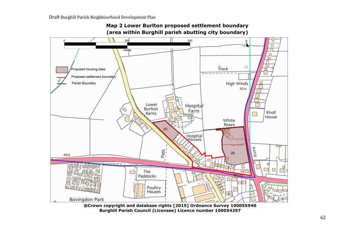
Draft Burghill Parish Neighbourhood Development Plan
62
Map 2 Lower Burlton proposed settlement boundary
(area within Burghill parish abutting city boundary)
@Crown copyright and database rights [2015] Ordnance Survey 100055940
Burghill Parish Council (Licensee) Licence number 100054297

Draft Burghill Parish Neighbourhood Development Plan
63
Map 3 Burghill proposed settlement boundary
@Crown copyright and database rights [2015] Ordnance Survey 100055940
Burghill Parish Council (Licensee) Licence number 100054297

Draft Burghill Parish Neighbourhood Development Plan
64
Map 4 Tillington proposed settlement boundary including Tillington Business Park
@Crown copyright and database rights [2015] Ordnance Survey 100055940
Burghill Parish Council (Licensee) Licence number 100054297

Draft Burghill Parish Neighbourhood Development Plan
65
Map 5 Burlton Court Farm Business Zone
@Crown copyright and database rights [2015] Ordnance Survey 100055940
Burghill Parish Council (Licensee) Licence number 100054297
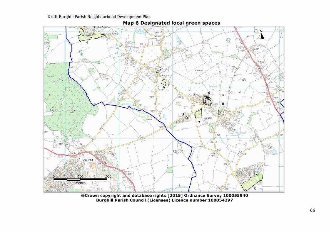
Draft Burghill Parish Neighbourhood Development Plan
66
Map 6 Designated local green spaces
@Crown copyright and database rights [2015] Ordnance Survey 100055940
Burghill Parish Council (Licensee) Licence number 100054297

Draft Burghill Parish Neighbourhood Development Plan
67
Map 7 Proposed solar energy site
@Crown copyright and database rights [2015] Ordnance Survey 100055940
Burghill Parish Council (Licensee) Licence number 100054297

Draft Burghill Parish Neighbourhood Development Plan
68
Appendix 2: Option Days Maps
@Crown copyright and database rights [2015] Ordnance Survey 100055940
Burghill Parish Council (Licensee) Licence number 100054297
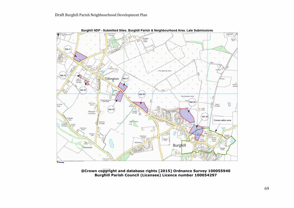
Draft Burghill Parish Neighbourhood Development Plan
69
@Crown copyright and database rights [2015] Ordnance Survey 100055940
Burghill Parish Council (Licensee) Licence number 100054297

Draft Burghill Parish Neighbourhood Development Plan
70
Appendix 3: Burghill Parish
Design Guidance
1.0 Introduction The Oxford English Dictionary definition of a plan, in the context of our
Neighbourhood Development Plan, is: A detailed proposal for doing or achieving something.
With this definition in mind our NDP should, where possible, contain not
just objectives and policy statements but also potential means of delivering these objectives.
Clause 153 in the NPPF document states that supplementary planning
documents should be prepared only where necessary. Such documents should be used where they can help applicants make successful
applications or aid infrastructure delivery, but should not be used to add unnecessarily to the financial burdens of development.
The type of development favoured by parishioners in their questionnaire
responses suggests that this is an area of concern and inclusion of design
guidance in the NDP could help to alleviate some of these concerns and help applicants make successful planning applications and infrastructure
delivery.
Proposed design standards derived from questionnaire responses and Steering Group members are set out below.
Location
The development should not:
Materially harm the living conditions of neighbours Materially harm the character or appearance of its surroundings
Cause any new hazards to pedestrians or transport systems
Cause any new risks to wildlife or habitats Affect the viability of the existing infrastructure system
Draft Burghill Parish Neighbourhood Development Plan
71
Infrastructure
Planning Applications should include details of the projected usage
of the connected utilities, an assessment of whether the existing utilities can meet the increased load and, if reinforcement is
required, then evidence that this reinforcement will be in place before dwellings are occupied
All public services and public highways shall be constructed to
adoptable standards in line with the existing published standards of statutory undertakers and the highway authority. The relevant
adoption agreement shall be completed before occupancy of the first dwelling
Where feasible traffic calming measures on access roads and village routes should be included as part of the project
Access roads within development sites shall be constructed to a minimum carriageway width of 6m plus combined cycleways and
footways of 2.0m minimum width. Dropped kerbs shall be provided at junctions between footways,
cycleways and carriageways. Development that fronts the carriageway of an existing public
highway shall have parallel 2.0m wide combined cycleways and footways along the highway
Between new dwellings and community facilities such as schools,
shops or meeting places there shall be, where possible, a designated public footway constructed to adoptable standards and
maintained as such at public expense. Where this is not achievable then a footway, to the same standard shall be constructed to the
nearest bus stop All public utilities serving new dwellings shall be provided by
underground routes Broadband access shall be provided to all new dwellings, preferably
by fibre optic lines
Amenities
Residential development sites of 5 or more dwellings should have
allocated, undeveloped, contiguous, landscaped grounds within the developed area set aside for public amenity use and these areas
shall be complete and available for use before the last property on the development site is occupied
Public amenity areas within development sites shall be subject to either public or private management agreements in perpetuity and
these agreements shall be in place before the first occupation of a dwelling on a new development
Each new dwelling shall have provision for off street storage areas
for waste collection and recycle bins

Draft Burghill Parish Neighbourhood Development Plan
72
Transport
The existing bus service through Tillington and Burghill cannot be
considered as the sole means of transport and therefore the car, or other private vehicle, is inevitably the major provider of transport.
Therefore, provisions should be made in the design for features such as:
Off road parking of a size in keeping with the size of the property and typical number of cars per household in a rural environment.
The minimum provision shall be for two vehicles and these shall be “off highway” spaces.
At least 50% of the dwellings on a development site shall be provided with lockable garages within the curtilage of the dwelling.
New dwellings shall be within safe walking distance of a bus stop.
Layout and Size of Development
Housing density shall be no more than 25 dwellings per hectare
including all works required for access, public utilities, infrastructure and vehicle parking
Housing groups within development projects shall not exceed 10 dwellings.
At least 35% of the dwellings shall be affordable housing and shall be dispersed throughout market housing
Not more than 2 affordable homes shall be either linked or neighbouring dwellings (to ensure the integration of affordable and
market housing within development projects) Not more than 3 dwellings shall be linked in a terraced layout
The arrangement and orientation of dwellings should be placed so
that their occupation and the use of the land within their residential curtilages does not materially harm the living conditions of
neighbours
Size of Dwelling
New dwellings should have a minimum internal floor area of 80 sq. m where possible.
Development sites shall comprise not more than 10% of 5 bedroom
dwellings, not more than 60% of 3 or 4 bedroom dwellings and the remainder shall be 2 or 1 bedroom dwellings
At least 15% of dwellings should be single storey ground floor buildings

Draft Burghill Parish Neighbourhood Development Plan
73
In Character with the Parish
New dwellings and their finishes should be in harmony with the
character and appearance of existing neighbouring dwellings and the surrounding groups
Dwellings shall be of traditional design, utilizing traditional materials in keeping with the wide range and character of properties in the
parish
Site Specific Features
Permitted development rights for outbuildings, extensions, additions
and conservatories shall be withdrawn on sites for new housing
Dwelling Specific Features
Dwellings shall not exceed 10m in height to the peak of the pitched
roof measured from pre-existing adjacent ground levels Dwellings should not have flat roofs
To reduce overlooking between habitable rooms of dwellings there shall be a minimum of 10.5m between the rear wall of a dwelling
and its rear boundary and 21m between the rear habitable room windows of houses which back directly onto each other
Balconies shall not provide viewing platforms for the private
gardens or windows of adjacent properties Interfacing windows on side elevations of dwellings shall have
obscured glass
Materials for Energy Generation
Where provision is made for solar energy it shall be provided by
components that are an integral part of the fabric or structure of the building.
Permitted development rights for the erection of individual wind generation equipment mounted on dwellings or within their curtilage
shall be withdrawn for new housing

Draft Burghill Parish Neighbourhood Development Plan
74
Appendix 4: Heritage Assets There are 27 Listed Buildings and 1 Scheduled Monument in Burghill
Parish.
Name Location Grade
Burghill Lodge Burghill Lodge, Burghill II
Heathwood Farmhouse Heathwood Farmhouse, Burghill II
Barn approximately 50 metres
north east of Hill Farmhouse
Barn approximately 50 metres north
east of Hill Farmhouse, Burghill
II
Barn approximately 10 metres
west of Little Burlton
Farmhouse
Barn approximately 10 metres west
of Little Burlton Farmhouse, Burghill
II
Barn approximately 20 metres
east of Lower House
Barn approximately 20 metres east
of Lower House, Burghill
II
Church of St Mary Church of St Mary, Burghill II
Dovecote approximately 50
metres south west of Burghill Grange
Dovecote approximately 50 metres
south west of Burghill Grange, Burghill
II
Church Cottage Church Cottage, Burghill II
Court Cottage Court Cottage, Burghill II
Barn approximately 30 metres
north of Lauristina
Barn approximately 30 metres north
of Lauristina, Burghill
II
Broomhill Farmhouse Broomhill Farmhouse, Burghill II
Burghill Grange Burghill Grange, Burghill II
Burghill Manor Burghill Manor, Burghill II
The Cedars The Cedars, Burghill II
Lauristina Lauristina, Burghill II
Pyefinch Farmhouse Pyefinch Farmhouse, Burghill II
Church Farmhouse Church Farmhouse, Burghill II
Barn approximately 50 metres
south west of Burghill Lodge
Barn approximately 50 metres south
west of Burghill Lodge, Burghill
II
Hill Farmhouse Hill Farmhouse, Burghill II
Lowerhouse Lowerhouse, Burghill II
Churchyard cross
approximately 15 metres south east of Church of St Mary
Churchyard cross approximately 15
metres south east of Church of St Mary, Burghill
II
Range of barns approximately 30 metres south west of
Burghill Manor
Range of barns approximately 30 metres south west of Burghill
Manor, Burghill
II
The Corner House The Corner House, Burghill II
Court End Rookwood Court End Rookwood, Burghill II
Bridge approximately 100
metres south east of Stretton Court
Bridge approximately 100 metres
south east of Stretton Court, Burghill
II

Draft Burghill Parish Neighbourhood Development Plan
75
Name Location Grade
Former house at Lion Farm Former house at Lion Farm, Burghill II
Barn adjacent to former house at Lion Farm
Barn adjacent to former house at Lion Farm, Burghill
II
Scheduled Monument
Churchyard cross in St Mary the Virgin’s churchyard

Draft Burghill Parish Neighbourhood Development Plan
76
Appendix 5:
Burghill Conservation Area
@Crown copyright and database rights [2015] Ordnance Survey 100055940
Burghill Parish Council (Licensee) Licence number 100054297

Draft Burghill Parish Neighbourhood Development Plan
77
Appendix 6: Relevant Planning Policies
National Planning Policy Framework (NPPF) Para 6: The purpose of the planning system is to contribute to the
achievement of sustainable development.
Para 7: There are three dimensions to sustainable development: economic, social and environmental. These dimensions give rise to the
need for the planning system to perform a number of roles: an economic role – contributing to building a strong, responsive
and competitive economy, by ensuring that sufficient land of the right type is available in the right places and at the right time to
support growth and innovation; and by identifying and coordinating development requirements, including the provision of infrastructure;
a social role – supporting strong, vibrant and healthy communities, by providing the supply of housing required to meet
the needs of present and future generations; and by creating a high quality built environment, with accessible local services that reflect
the community’s needs and support its health, social and cultural well-being; and
an environmental role – contributing to protecting and enhancing
our natural, built and historic environment; and, as part of this, helping to improve biodiversity, use natural resources prudently,
minimise waste and pollution, and mitigate and adapt to climate change including moving to a low carbon economy.
Delivering Sustainable Development
There are a number of elements to delivering sustainable development. These are outlined below with any specific references NPPF makes to
neighbourhood plans.
1. Building a strong, competitive economy. 2. Ensuring the vitality of town centres
3. Supporting a prosperous rural economy 4. Promoting sustainable transport
5. Supporting high quality communications infrastructure
6. Delivering a wide choice of high quality homes 7. Requiring Good Design
8. Promoting healthy communities 9. Protecting green belt land
10. Meeting the challenge of climate change, flooding and coastal change
11. Conserving and enhancing the natural environment 12. Conserving and enhancing the historic environment
13. Facilitating the sustainable use of minerals
Draft Burghill Parish Neighbourhood Development Plan
78
Neighbourhood plans
Para 183: Neighbourhood planning gives communities direct power to develop a shared vision for their neighbourhood and deliver the
sustainable development they need. Parishes and neighbourhood forums can use neighbourhood planning to:
set planning policies through neighbourhood plans to determine decisions on planning applications; and
grant planning permission through Neighbourhood Development Orders and Community Right to Build Orders for specific
development which complies with the order.
Para 184: Neighbourhood planning provides a powerful set of tools for local people to ensure that they get the right types of development for
their community. The ambition of the neighbourhood should be aligned with the strategic needs and priorities of the wider local area.
Neighbourhood plans must be in general conformity with the strategic policies of the Local Plan. To facilitate this, local planning authorities
should set out clearly their strategic policies for the area and ensure that an up-to-date Local Plan is in place as quickly as possible. Neighbourhood
plans should reflect these policies and neighbourhoods should plan
positively to support them. Neighbourhood plans and orders should not promote less development than set out in the Local Plan or undermine its
strategic policies.
Para 185: Outside these strategic elements, neighbourhood plans will be able to shape and direct sustainable development in their area. Once a
neighbourhood plan has demonstrated its general conformity with the strategic policies of the Local Plan and is brought into force, the policies it
contains take precedence over existing non-strategic policies in the Local Plan for that neighbourhood, where they are in conflict. Local planning
authorities should avoid duplicating planning processes for non-strategic policies where a neighbourhood plan is in preparation.”

Draft Burghill Parish Neighbourhood Development Plan
79
Herefordshire Core Strategy (2011-2031)
This document provides part of the strategic planning policy context for
neighbourhood planning and Burghill Neighbourhood Plan will need to have regard to the following Core Strategy Policies:
SS1 – Presumption in favour of sustainable development SS2 – Delivering new homes
SS4 – Movement and transportation SS6 – Environmental quality and local distinctiveness
SS7 - Addressing climate change
Place Shaping
RA1 – Rural housing strategy RA2 – Herefordshire’s villages
RA3 – Herefordshire’s countryside
RA4 – Agricultural Forestry and rural enterprise dwellings RA5 – Re-use of rural buildings
General Policies
H1 – Affordable housing – threshold and targets
H2 – Rural exception sites H3 – Ensuring an appropriate range and mix of housing
H4 – Traveller sites
SC1 Social and Community Facilities OS1 - Requirement for open space, sports and recreation facilities
OS2 – Meeting open space, sports and recreation needs OS3 – Loss of open space, sports or recreation facilities
MT1 – Traffic management, highway safety and promoting active travel
E1 - Employment provision
E2 – Redevelopment of existing employment land and buildings E3 - Homeworking
E4 – Tourism
LD1 – Landscape and townscape LD2 – Biodiversity and geodiversity
LD3 – Green infrastructure LD4 – Historic environment and heritage assets
SD1 – Sustainable design and energy efficiency
SD3 – Sustainable water management and water resources
SD4 Wastewater treatment and river water quality
Draft Burghill Parish Neighbourhood Development Plan
80

Draft Burghill Parish Neighbourhood Development Plan
81
Acknowledgements
This Neighbourhood Plan has been prepared by Burghill Parish Council in conjunction with Kirkwells
Version 2.10 Copyright © 2015 Burghill Parish Council

Draft Burghill Parish Neighbourhood Development Plan
82