Embed Size (px)
Citation preview

Bunker Hills Regional Park Master Plan
Anoka County Parks and Recreation Department
Prepared by: Brauer & Associates, Ltd. May 1998

Acknowledgments
Bunker Hills Regional Park Master Plan i
Acknowledgments
Overview In the fall of 1997, the Anoka County Board of Commissioners commissioned Brauer & Associates Ltd. toprepare a master plan for Bunker Hills Regional Park. This document represents the cumulative effort of theAnoka County Recreation Committee, Anoka County Board of Commissions, Anoka County Parks andRecreation staff design team, and the consultant design team. The project was completed in May of 1998.
Acknowledgments The planning team lead by Brauer & Associates, Ltd. would like to thank the Anoka County Board ofCommissioners and Anoka County staff for providing their insight and understanding of the concerns andneeds of county residents. We would also like to thank the individuals who attended the public meetings.Their participation allowed us to prepare a master plan that reflects the unique character and intrinsicqualities of the county and park.
County Board of Commissioners
Dennis Berg Margaret Langfeld Dave McCauley* Dan ErhartDick Lang* Jim Kordiak* Paul McCarron
* Member of Parks and Recreation Committee, Dave McCauley, Chair
County Staff Design Team
Ronald Cox Nick Eoloff Michael Jacobson Jim LucasBill McCann Lisa Gilliland-Herringer Peter Mott Darrell NiedertJon Oyanagi Jeff Perry Wayne Thompson
Our appreciation is especially extended to John VonDeLinde, Park Director for Anoka County Parks, whotook the time to attend many meetings and provide his insight and understanding of the site and localconditions and guidance on difficult planning issues.
Sincerely, BRAUER & ASSOCIATES, LTD.
Jeffrey A. Schoenbauer, RLA, Vice President

Acknowledgments
Bunker Hills Regional Park Master Plan ii
Consultant Team Brauer & Associates, Ltd.7301 Ohms Lane, Suite 500Minneapolis, MN 55439(612) 832-9475Project Manager: Jeff SchoenbauerProject Design: George Watson / Jeff Schoenbauer
In association with:
Applied Ecological Services Wilderness InquiryRoute 3, Smith Road, P.O. Box 256 1313 Fifth Street S.E., Box 84Brodhead, WI 53520 Minneapolis, MN 55414-1546(608) 897-8641 Project Lead: Mike PassoProject Lead Scientist: Steven I. Apfelbaum
Primary References andResources
The following identifies the primary resources used in the preparation of this document:< 2020 Vision for Anoka County Parks and Recreation< Universal Access to Outdoor Recreation: A Design Guide, PLAE, Inc. 1993< Universal Access: Guidelines for Outfitters Operating on Public lands, Wilderness Inquiry, Inc. 1995< Minnesota County Biological Survey

Summary Statement
Bunker Hills Regional Park Master Plan iii
Summary Statement
Section I – Introduction andPlanning Framework
The project focused on the preparation of a master plan for Bunker Hills Regional Park. The planning anddesign process took into consideration the history of the site, setting, needs of the surroundingcommunities, and natural and cultural resources of the site.
The master plan described in this report provides the guidelines for development of the park and a tool forpublic presentations and funding applications. The plan is only the first step in the planning, development,and managing of this unique and important resource. It should be viewed as firm enough for orderly andagreed upon development, yet flexible enough for changes to be made as time and experience dictate.
Section II – Setting / History /Recreational Demand
Setting
Anoka County Parks and Recreation Department operates and maintains 23 park units and over 8,000acres of park land throughout the county. Nine of the park units are classified as either a regional parkreserve, regional park, regional trail, or special recreation feature park. At nearly 1,600 acres, Bunker HillsRegional Park is the largest regional park in the system and second in size to Rice Creek Chain of LakesRegional Park Reserve.
History
The first land acquisition for the park took place in the early 1960's, at which time the park was calledBunker Prairie County Park. In 1974, Bunker Hills Park, along with other parks in Anoka County and theseven county metro areas, became a regional park through the Metropolitan Council's establishment byaction of the Minnesota State Legislature. This action was the start of the Metropolitan Council's Park andOpen Space Program. Thereafter, funding became available through the Metropolitan Council foracquisition and development of the regional parks – with Bunker Hills being one of them.
Recreational Demand
The demand for recreational facilities within the county is growing steadily along with the regionalpopulation. The 2020 Vision for the Anoka County Parks and Recreation System Plan provides an extensiveoverview of recreation and leisure trends, much of which was derived from studies completed by theMetropolitan Council.

Summary Statement
Bunker Hills Regional Park Master Plan iv
These recreational trends, coupled with a bourgeoning regional population, will put increasing pressure onthe facilities and amenities offered at Bunker Hills park. As one of the most heavily used parks in theregional park system, insightful development in concert with responsible land stewardship will be required ifrecreational demand is to be met without compromising the integrity of the land resource.
Section III – Natural ResourcesRestoration and ManagementFramework
Bunker Hills Regional Park displays a diverse, interesting and unique natural landscape character. The parkis also one of the only remaining sizable examples of oak barrens and prairie native plant communities,which puts land stewardship and preservation high on the priority list.
The natural resource analysis considers the various natural aspects of the park, including its geology,hydrology, and ecology. The ecological patterns and vegetative communities found within the park arethose that are adaptable to the soil conditions, hydrologic patterns, and climate. Oak savannas/barrens,prairies, and open wetlands have historically been the dominant native vegetative communities.
The impact of human activities since settlement (land and water alterations, pine planting, etc.) coupledwith the curtailment of naturally-occurring events (wildfires) have served to change the ecological balanceand character of the park. Some of these impacts will have lasting affects, while others can be addressed toforestall further degradation and help ensure a sustainable and healthy landscape for future generations.
To protect this valuable resource, developing and implementing an aggressive and comprehensiverestoration and management plan is crucial. Left unchecked, the ecological systems within the park willcontinue to decline at increasing rates, making attempts at restoration more challenging and less certain astime goes on.
Key overall restoration priorities include:< Prescribed burning of oak savanna/barrens and prairie systems – this is a fundamental requirement for
restoration.< Restore buffer wetlands and attenuate on and off-site hydrological patterns that degrade on-site wetland
systems.< Restore native plant communities in areas with extensive pine plantations.< Restore disturbed areas requiring revegetation.
Section IV – Universal DesignFramework
In recent years, extensive public debate has been focused on equal access to indoor and outdoor publicspaces for all individuals. The Americans with Disabilities Act of 1991 (ADA) turned past guidelines andstandards into law, forever changing the way accessibility issues are to be addressed. But the ADA is not anend unto itself. It is simply another step toward a design philosophy that ensures accessibility for all.

Summary Statement
Bunker Hills Regional Park Master Plan v
It has become evident that design philosophy must continue to evolve if a barrier-free environment is to berealized in the design of parks. Universal Design is an approach to design that seeks to achieve thisphilosophy by combining the basic principles of barrier-free design with a more comprehensive view ofhuman beings. By focusing attention on a broad spectrum of needs, facility design can accommodatepeople with varying degrees of abilities and disabilities.
Since universal design is still an evolving approach to design, achieving universal access is simpler in conceptthan in practice. Anticipating the needs of people with varying degrees of abilities and disabilities is aformidable task since it is often very difficult to understand the specific needs of individuals with differentabilities when one does not share those limitations. Therefore, it becomes imperative that the designprocess include individuals that represent a cross-section of people with and without disabilities. As theproject moves into design implementation phases, efforts should be made to involve representatives ofdivergent populations in the detail design of specific facilities. This approach helps to ensure that the designfor any given facility will actually serve the intended populations.
Section V – DevelopmentMaster Plan
The Development Master Plan is a direct outgrowth of the site and natural resource analysis and publicprocess. The master plan is dynamic and will continue to evolve and be fine-tuned as it moves throughimplementation steps and benefits from management and operational experiences and updatedrecreational demand research in the years to come.
Land Use Zones
Land use zones describe the park by its functional uses. In this case, four distinct land use zones emergedand include: < Ecological and Natural Resource Zone – for ecological preservation, passive outdoor recreation, and
nature interpretive/education.< Recreational Development Zone – for public recreation.< Other County Uses Zone – for existing Anoka County public facilities.< Golf Course Zone – for existing nationally recognized golf facility.
By considering the park from this broader perspective, the most appropriate use of the land resource withinthe context of its natural features and development program could be discovered.
Development Program
The development program defines the uses of the park and facilities to support those uses. The program isan outgrowth of recreational demand research, the public participation process, and an assessment of thesuccess of past park uses. The development program seeks to achieve a balance between providing facilitiesand amenities that allow the public to enjoy the park while still retaining its natural character. In general, the recreational uses shown on the master plan accommodate all of the past activities, although

Summary Statement
Bunker Hills Regional Park Master Plan vi
redesigned to better serve the public. Universal Design considerations are also defined for each programitem to ensure that access issues are considered for each park amenity.
The development program includes the following key facilities and amenities:< Main entrance features and contact stations – provide appropriate introduction to the park from the
north and south entrances.< Park roadways and drives – a simpler and less obtrusive roadway system is proposed that minimizes
roadway infrastructure while still servicing park facilities and use areas.< Internal trail system – features a more extensive hard and natural-surfaced trail system that traverses
through the park’s natural areas while avoiding roadway crossings.< Group and family picnic area, general recreation area, and Veterans Memorial – improves and
expands upon existing facilities to better serve the public. < Campground – expanded and upgraded facility blended into the natural landscape.< Activities Center – redesigned parking lot and improved pedestrian access.< Archery range – relocated to better serve the archery group and restore a key ecological area.< Wave Pool – expansion will accommodate growing demand for this facility.< Environmental Learning Center – expands outdoor educational opportunities for the local school
district.< Horse staging area and corral – relocates and consolidates these facilities to better serve the user
group while reducing ecological impacts.< Miscellaneous site amenities and Improvements – includes interpretive signage, benches, trash
receptacles, boardwalks, signage program, and demonstration flower gardens.
Future Land Exchange/Acquisition
On the southwest corner of the park adjacent to the railroad right-of-way lies a finger of land that iscurrently park property. Separated from the park by the railroad tracks and golf course, the parcel’s primaryvalue lies with it being a buffer between public and private uses. From a natural resource perspective, thearea is showing signs of decline in ecological quality. Past uses of off-road vehicles in the area has also had adetrimental impact. Directly west of this parcel the Yamaha Corporation has a test facility. Further west, theCity of Coon Rapids has an open space area that will likely be developed for a public park, with a key traillink to their and the regional trail system. Linking this property to Bunker Hills park via a trail corridor offersdesirable recreational value.
In this context, the opportunity exists to exchange about 47.5 acres of land with the Yamaha Corporation toestablish a greenway corridor between the park and city property. Given its isolation and current ecologicalstatus, the finger of land under park ownership would be exchanged for a like amount of Yamaha propertyto form the greenway corridor. The timeframe for any action remains undefined.

Summary Statement
Bunker Hills Regional Park Master Plan vii
Anoka County has also been pursuing the acquisition of about 50 acres on the east side of the park. The proposed acquisition, which has been an approved part of past acquisition plans for the park, consists of 10five acre parcels. Note that two parcels (totaling 10 acres) are no longer being actively pursued foracquisition by Anoka County. These parcels already have public utilities and an appraised value of $30,000to $32,000 each. At this price, the cost-benefit of acquiring them is not justified relative to other acquisitionand development priorities. Anoka County will, however, continue to pursue the acquisition of theremaining eight parcels as the opportunity presents itself.
Section VI – Implementationand Operations Plan
Cost Analysis
The extensive redevelopment defined in the master plan for Bunker Hills Regional Park will requiresubstantial capital investment. In all likelihood, implementation will occur over a number of years asfunding through various sources becomes available.
The cost analysis table in the report defines the potential costs associated with each component of themaster plan. The overall cost estimate for full plan implementation is $12,041,920, which includes a10% construction contingency and 10% for professional fees and charges.
Implementation Strategy (Project Phasing)
Given the overall magnitude of the potential costs, it is reasonable to expect that development of the parkwill occur over a period of time to coincide with funding opportunities. The implementation strategy suggests various groupings of master plan components into a number of implementation phases.Components were grouped in consideration of the following criteria:< Existing facility exhibits an immediate concern (i.e., safety, dysfunctional, detrimental to long-term
vitality of park).< Existing facility is worn out and no longer effectively services public need.< Existing and/or expanding demand warrants development/redevelop of a certain facility.< Facility is required to support high priority items (parking, for example).< Facility cost.
Development was divided into four phases, along with a recommendation to implement a natural resourcesrestoration and management plan. Note that phases are not linked to specific timeframes. Actual projectphasing will be a function of funding availability.

Summary Statement
Bunker Hills Regional Park Master Plan viii
Operations Plan
The operations of Bunker Hills Regional Park falls under the jurisdiction of the Anoka County Departmentof Parks and Recreation. Policy and goal setting are done through the Anoka County Parks and RecreationCommittee and the Anoka County Board of Commissioners.
The Anoka County park ordinances are enforced by the Anoka County Park Rangers. Local policedepartments and the Anoka County Sheriffs Department also respond to incidents in the park system.
The Operations and Maintenance unit of the Department of Parks and Recreation has an annual budget ofapproximately $3.2 million. There are thirty-eight permanent employees and nearly one hundred seasonalemployees ones. Volunteers also help with the Wargo Nature Center, Arbor Day plantings, park cleanups,flower bed maintenance, and a variety of other events. Area schools participate in natural resourceactivities and displays at the Banfill-Locke Center for the Arts. Contractual agreements are in place for trashremoval, Bunker Hills Stables operation, the archery club, and campground hosts.
Recreational programming presently occurs within the park and opportunities will increase with newfacilities. Natural resource seminars are offered for educating the public on a variety of seasonal topics. Thetrails through the park will offer exploration of wetlands, oak savannahs, sand plain, and native prairie.
Promotion of Bunker Hills Regional Park happens through a variety of sources. Seasonal brochures inviteeveryone to enjoy the many opportunities available. Brochures specific to shelter reservations and roomrental promote the choices available. Press releases, flyers, posters and mailings notify area residents. Mostof all, word-of-mouth advertising is the most successful method.

Table of Contents
Bunker Hills Regional Park Master Plan ix
Table of Contents
Section I - Introduction / Planning Framework 1-3
Section II - Setting / History / Recreational Demand 4-8
Section III - Natural Resources Restoration and Management Framework 9 - 35
Section IV - Universal Design Framework 36 - 40
Section V - Development Master Plan 41 - 62
Section VI - Implementation and Operations Plan 63 - 72

I - Introduction/Planning Framework
Bunker Hills Regional Park Master Plan 1
Section I Introduction / Planning Framework
Project Scope The project focused on the preparation of a master plan for Bunker Hills Regional Park. The planning anddesign process took into consideration the history of the site, setting, needs of the surroundingcommunities, and natural and cultural resources of the site.
The master plan described here provides the guidelines for development of the park and a tool for publicpresentations and funding applications. The plan is only the first step in the planning, development, andmanaging of this unique and important resource. It should be viewed as firm enough for orderly and agreedupon development, yet flexible enough for changes to be made as time and experience dictate.
Planning Framework The planning framework provided structure to the undertaking of this project. The framework consists of anumber of components:< Public involvement< Public agency involvement< Planning process
Public Involvement
The public was the primary motivating force behind the master plan for the park. Survey researchundertaken at the county and state level established a base starting point for the planning and designprocess. (Section II defines key findings)
An extensive public input process followed to allow for extensive and first-hand public input and to addressthe interests of all stakeholders. Several discussions with Anoka County staff and the Park and RecreationCommittee initiated the process in October of 1997. The following is a listing of public meetings wherecitizens had opportunities for input:< November 4, 1997 Parks and Recreation Committee Meeting < November 12, 1997 County Board Meeting< January 7, 1998 Parks and Recreation Committee Meeting< January 14, 1998 County Board Meeting< February 26, 1998 University of Minnesota Extension Staff< February 26, 1998 Andover, Blaine, Coon Rapids Parks agencies< March 3, 1998 Parks and Recreation Committee Meeting

I - Introduction/Planning Framework
Bunker Hills Regional Park Master Plan 2
< March 4, 1998 Blaine Senior High School< March 1998 Yamaha Corporation< March 10, 1998 County Board Meeting< March 26, 1998 Public Meeting on Master Plan< April 7, 1998 Parks and Recreation Meeting< April 14, 1998 County Board Meeting< May 5, 1998 Parks and Recreation Committee Final Approval< May 12, 1998 County Board Final Approval
The municipalities in and around Bunker Hills Regional Park were represented by staff and commissionmembers connected with their parks and recreation services. All parties responded favorably to theconcepts presented. Connecting the trails to their respective communities received highly favorableresponses.
Blaine Senior High School staff were informed of the plan. Science educators are excited about the area ofthe park adjoining their property. The natural features suit their purposes and the trail access presentspossibilities for physical education and athletic teams.
At the March 26, 1998 public meeting, approximately 90 people attended. Response to the master planwas favorable. The questions and comments concerned the location of the entrance stations(how close toresidential areas), improving trail access to the park from neighboring areas, timing of the plan, location ofthe stable operations, security/vandalism concerns, and the approval of reclaiming the natural resourceaspects of the park.
Public Agency Involvement
To ensure consistency with broader, county-wide planning objectives, policies, and implementationprocedures, the consultant team worked closely with Anoka County Parks and Recreation staff as acollaborative team.
Planning Process
The planning of the park followed a step-by-step process that encouraged public participation and allowedfor a series of checks and balances. This approach ensured pertinent issues were considered and addressedin the proper sequence. Figure 1.1 illustrates the planning process.

I - Introduction/Planning Framework
Bunker Hills Regional Park Master Plan 3
Figure 1.1 - Master Plan Planning Process Overview

II - Setting/History/Demand
Bunker Hills Regional Park Master Plan 4
Figure 2.1 - Park location in Anoka County
Section II Setting / History / Recreational Demand
The Setting Anoka County Parks and Recreation Department operates and maintains 23 park units and over 8,000acres of park land throughout the county. Nine of the park units are classified as either a regional parkreserve, regional park, regional trail, or special recreation feature park. At nearly 1,600 acres, Bunker HillsRegional Park is the largest regional park in the system and second in size to Rice Creek Chain of LakesRegional Park Reserve. Figure 2.1 illustrates the location of the park within Anoka County.

II - Setting/History/Demand
Bunker Hills Regional Park Master Plan 5
Figure 2.2 - Land acquisition map for Bunker Hills Regional Park
Located in west-central part of Anoka County, the park is highly accessible from the region. The park issurrounding by the fast growing communities of Andover, Blaine, Coon Rapids, and Ham Lake. Forecasts bythe Metropolitan Council project 14% of the metro area population and 15 % of the household growth overthe next three decades to occur in Anoka County – totaling 95,000 new residents in 51,500 newhouseholds. Of the four cities surrounding the park, three of them -- Andover, Blaine, and Coon Rapids –are projected to have the largest population and household growth in the county. As with the rest of themetropolitan area, the population is growing steadily older.
Historical Land Acquisition andDevelopment Perspective
The first land acquisition for the park took place in the early 1960's, at which time the park was calledBunker Prairie County Park. Figure 2.2 provides an overview of the patchwork of land acquisition thatmakes up what is now Bunker Hills Regional Park.

II - Setting/History/Demand
Bunker Hills Regional Park Master Plan 6
The following provides a historical overview of the park acquisition and development from the initial landacquisition until the Metropolitan Council was established:< Earliest land acquisition was a combination of tax forfeit parcels and private land - in the early 1960's
through the early 1970's (golf course area - west of RR tracks and center of park).< Much of the private land was acquired with LAWCON (MnDNR's Land and Water Conservation),
LCMR (MnDNR's Legislative Commission of Minnesota Resources), HUD (National Housing and UrbanDevelopment) grant funds and Anoka County funds in 60's/70's
< Rapids Archery Club developed the archery range prior to the park being established (pre-1960's).< Late in the 1960's and early 1970's, park development began with grant funds through LAWCON,
LCMR, and County funds. Development consisted of roads, parking lots, picnic facilities, picnicshelters, playground equipment, restrooms at picnic areas, campground facilities, restrooms atgroup/family camping, electric/security light, and maintenance shop by campground.
< Horse trails, facility buildings, and show ring were established in 1972.< First I 8 holes of Coon Rapids Golf Course (established by City of Coon Rapids and a County/City lease
agreement) was developed in the early 1970's.< Activities Center was built in 1974-75 to house Anoka County Park Headquarters and University of
Minnesota Extension Offices (Funded was through Federal cigarette taxes).
In 1974, Bunker Hills Park, along with other parks in Anoka County and the seven county metro areas,became a regional park through the Metropolitan Council's establishment by action of the Minnesota StateLegislature. This action was start of the Metropolitan Council's Park and Open Space Program. Thereafter,funding became available through the Metropolitan Council for acquisition and development of theregional parks – with Bunker Hills being one of them. Acquisition funds from Metropolitan Council in thelate 1970's were used to purchase parcels in the southeast corner of the park, near Blaine High School.Development funds started to become available in the 1980's, including the following developments: < 1984 - Main Maintenance Facility for entire park system (west of RR).< 1988 - Bunker Hills Wave Pool.< 1989 - five miles paved trails throughout park.
In addition to Metropolitan Council funds, a variety of other projects were funded through Anoka Countyand other funding programs in the 1970's and 1980's. Projects included:< 1975 - Compost/burn site.< 1976 - Sheriff s gun range.< 1982 - County highway maintenance garage.< 1982 - Prairie restoration.< 1983 - Metropolitan Mosquito Control building.< 1985 - Veterans Memorial and adjacent restrooms and shelter.< 1986 - Archery building (replacing old building that burned down).< 1987 - County Highway Department main facility.< 1988 - Radio communications facility.< 1996 - 1997 - Sheriff's Patrol Station and horse patrol stable building.

II - Setting/History/Demand
Bunker Hills Regional Park Master Plan 7
Figure 2.3 -Participation in outdoor recreational activities. Source: Metropolitan Council Leisure Time Survey.
As to where more funding should be spent, citizensranked parks third behind police and schools. Source: U of M, Center for Survey Research
As for concentration of effort, citizens felt that theCounty should focus on both improving existingfacilities as well as adding new ones. Source: Anoka County Vision 2020 Survey
Recreational Demand The demand for recreational facilities within the county is growing steadily along with the regionalpopulation. The 2020 Vision for the Anoka County Parks and Recreation System Plan provides an extensiveoverview of recreation and leisure trends, much of which was derived from studies completed by theMetropolitan Council. The figures on the next couple of pages summarize the key findings of the Vision2020 plan that have direct implication on the type and extent of facilities proposed for Bunker Hills Park.

Bunker Hills Regional Park Master Plan 8
Figure 2.3 - Facilities availability: To few of these facilities. Source: Metropolitan Council Leisure Time Survey
Figure 2.5 - Importance of outdoor recreation activities toAnoka County residents.
As for picnic shelters, group size was fairly evenlydistributed, with business use slightly ahead of familyand friends. Source: Anoka County Picnic ShelterUsers Survey.
As for trails, respondents clearly felt that trails are ofmajor importance. Source: Anoka County 2020Survey.
The trends shown in the figures were reflectedin comments made by citizens during thepublic process, with local park and recreationboard members and residents of the countyshowing strong support for the amenitiesproposed in the master plan.
These recreational trends, coupled with abourgeoning regional population, will putincreasing pressure on the facilities andamenities offered at Bunker Hills park. As oneof the most heavily used parks in the regionalpark system, insightful development inconcert with responsible land stewardship willbe required if recreational demand is to bemet without compromising the integrity of theland resource.

III - Natural Resources
Bunker Hills Regional Park Master Plan 9
Section III Natural Resources Restoration andManagement Framework
Overview Bunker Hills Regional Park displays a diverse, interesting and unique natural landscape character. The parkis also one of the only remaining sizable examples of oak barrens and prairie native plant communities,which puts land stewardship and preservation high on the priority list. This section provides an overview ofthe natural resources of the park and establishes a framework for restoration and management planning.
Natural Resources Analysis The natural resource analysis considers the various natural aspects of the park, including its geology,hydrology, and ecology. The following provides a brief overview of each of these natural features.
Geology
The recession of two recent glaciers created iceimpoundments that gave rise to an enormous lake fedby the Mississippi and St. Croix rivers. As the glaciersreceded and the lake evaporated, large deposits ofsand were left covering the lake basin, creating theAnoka Sandplain.
The geology of Bunker Hills Regional Park was formed billions of years ago when molten lava cooled andsettled to form a large basalt bedrock-lined basin. Subsequently, sedimentary rock formed as the sedimentstransferred by water settled into the basin and dried. The recession of two recent glaciers created iceimpoundments that gave rise to an enormous lake fed by the Mississippi and St. Croix rivers. As the glaciersreceded and the lake evaporated, large deposits of sand were left covering the lake basin, creating theAnoka Sandplain.
Soils and Slopes
The sandy soils that remained after the last of the glaciers receded cover much of the park. In low areas,basins, and drainageways, repeated cycles of recent sediment deposits and the decomposing of vegetationhave created areas of muck and peat that lie on top of sand subsoils. Figure 3.1 illustrates the soilcharacteristics of the park.

III - Natural Resources
Bunker Hills Regional Park Master Plan 10
Figure 3.1 - Soils Map (Source: U.S. Department of Agriculture and Soil Conservation Service)
The sandy soils that remained after the last of theglaciers receded cover much of the park
The fineness of the sands and open characteristics of the oak barrens and prairie systems allow wind andwater to shift the sand, creating the dune formations exhibited in numerous areas of the site. Although thesedunes contribute to the unique landscape of the park, they also underscore the erosive character of thesandy soils and the need for resource management and insightful development that minimizes impactswhile providing for human needs. Figure 3.2 illustrates the topographic characteristics of the park.

III - Natural Resources
Bunker Hills Regional Park Master Plan 11
Figure 3.2 - Slopes Map (Source: U.S. Department of Agriculture and Soil Conservation Service)
The dune formations contribute to the uniquelandscape of the park. They also underscore theerosive character of the sandy soils.
Hydrology
Since settlement, evidence of chances in the park’shydrological patterns is becoming more evident.
Site hydrology relates to the properties, distribution, and effects of water on the earth’s surface, in the soiland underling rocks, and in the atmosphere. In Bunker Hills Park, the established hydrologic patterns havea great influence on its ecology. Since settlement, evidence of chances in the park’s hydrological patterns isbecoming more evident, especially in the lowland and wetland ecological systems. Vegetative patternswithin these areas are showing various signs of degradation due to unnatural water fluctuations andexcessive nutrient loading from off and on-site sources. Attempts in the past to dredge, drain, or otherwisealter lowland areas and drainageways within and adjacent to the park have left some lasting impacts to itshydrology and ecology. These influences suggest degradation to many of the perimeter ecological systemsas measured by bio-diversity, general ecological health, and sustainability. Figure 3.3 illustrates some of theprimary hydrological patterns exhibited on the site and some of the suspected influences affecting thosepatterns.

III - Natural Resources
Bunker Hills Regional Park Master Plan 12
Figure 3.3 - Primary Hydrological Patterns
Changes to hydrologic patterns are affecting thequality and sustainability of ecological systems withinthe park.
Addressing hydrological factors as part of the comprehensive restoration and management plan is importantif healthy ecological systems are to be maintained within the park. Restoration efforts should focus onmitigating on and off-site influences where feasible to forestall continued degradation of wetland ecologicalsystems. Key reclamation initiatives include: < Comprehensive hydrologic study of park and adjacent properties to define hydrologic patterns and
changes that are occurring in these patterns. < Attenuate off-site impacts to stabilize on-site hydrologic systems.< Restore essential hydrological buffers to forestall further degradation to wetland systems within the park.< Eliminate on-site impacts to hydrologic patterns, such as relocation of the stable operation, removal of
manure piles, and stricter control of use of park land for pasturing.

III - Natural Resources
Bunker Hills Regional Park Master Plan 13
Figure 3.4 - Categorized Ecological Delineations (Minnesota County Biological Survey categories with sub-categories by Applied Ecological Services, Inc.)
Ecology
The ecological patterns and vegetative communitiesfound within the park are those that are adaptable tothe soil conditions, hydrologic patterns, and climate.Oak savannas/barrens, prairies, and open wetlandshave historically been the dominant native vegetativecommunities.
To protect this valuable resource, developing andimplementing an aggressive and comprehensiverestoration and management plan is crucial.
The ecological patterns and vegetative communities found within the park are those that are adaptable tothe soil conditions, hydrologic patterns, and climate. Oak savannas/barrens, prairies, and open wetlandshave historically been the dominant native vegetative communities. County-wide surveys completed by theMnDNR in recent years indicate that some of the highest quality remaining oak savanna/barrens systemsand prairie remnants left in this region are found in Bunker Hills Park. Clearly, the natural character of thepark remains one of its most important contributions to the regional park system. Figure 3.4 illustrates acategorized ecological delineation of the park.
To protect this valuable resource, developing and implementing an aggressive and comprehensiverestoration and management plan is crucial. Left unchecked, the ecological systems within the park willcontinue to decline at increasing rates, making attempts at restoration more challenging and less certain astime goes on. The following provides a brief overview of the ecological conditions of each major vegetativecommunity found within the park.

III - Natural Resources
Bunker Hills Regional Park Master Plan 14
Typical oak barrens system within Bunker Hills Park. Older age groups of trees with limited regenerationcapabilities and susceptibility to disease pose asignificant threat to the long-term sustainability ofthese systems.
Given their age, the oaks need to be regenerated tocreate younger cohorts and new generations toreplace the more vulnerable trees and those that aresenescing or dying.
Deciduous Woodland/Savanna
Red and Bur oak with occasional white oak dominate most of the oak systems within the park. Higher anddrier ridges exhibit primarily red oak, with some scatterings of gray dogwood. The majority of the oaks arefifty to ninety-year old multi-stemmed specimens reaching pathological maturity. Many of them are showingsigns of stress, with wind throw becoming fairly common. A July, 1997 storm, for example, blew downsignificant areas of mature oaks and weakened or topped many individual trees. Increasing vulnerability todisease, such as oak wilt, will continue to plague the oak systems in the coming years.
The ground story vegetation in some of the oak barrens areas varies from shade-suppressed needle grass,sedges, little blue stem, and other prairie plants to areas with blackberry and raspberry, with invadingpoison ivy. Quack grass and European brome grass have invaded some areas, as well. Pines are disbursedalong many of the edges of the oak barrens, some of which had been planted 30 or more years ago.Invasion of pines into the interior areas of the oak stands is also occurring, especially in areas of older oakstands with little natural regeneration occurring.
Some of the openings within the higher quality oak stands still exhibit a diversity of native plant species --big blue, little blue, Indian grasses, sedges, bush clover, black-eyed Susan, golden aster, and a myriad ofother plant species like lead plant, goats rue, purple prairie clover, and many others. Unfortunately, theseare becoming less common as invasive and regionally non-native plant species (e.g., red pine) take greaterhold on the park’s oak barrens plant community.
Given the current conditions, it is imperative to begin an aggressive management program to restore andmanage the oak systems within the park. Given their age, the oaks need to be regenerated to createyounger cohorts and new generations to replace the more vulnerable trees and those that are senescing ordying. Also, the understory plant species in many areas are declining due to dense shade suppressionresulting from an overstocked canopy and introduced shrub layer.
Prairie/Old Field
Dry prairie with savanna elements are common in some areas of the park. In a few instances, fires havebeen used to manage them, with a demonstrated response by native prairie species and forbs. Theopportunity to expand this management practice is extensive and will result in a dramatic increase in vistasof native prairie and savanna landscapes. The northwest corner of the park in particular offers pockets ofrelatively high quality prairie remnants that would respond well to management. Areas where savannasinterface with remnant prairies offer some excellent opportunities to foster restoration of productiveecotonal areas. A prairie restoration area near the entrance drive to the Activity Center is also exhibiting adramatic response to management.

III - Natural Resources
Bunker Hills Regional Park Master Plan 15
Remnant prairies within the park help define itscharacter and sense of place. Recently adoptedmanagement programs should be continued toensure that these qualities are sustained for futuregenerations.
Once managed, many of the restored prairies canserve as seed sources for restoration of other areaswithin the park.
Big bluestem, Indian grass, various sedges, little blue stem, Anemone cylindrica, large flowered Penstemongrandiflorus, bush clover, green milkweed, and a myriad of other species are present in numerous areas ofthe park and simply require management to become more productive and established. Prescribed burningwould benefit these areas by reducing invading pine cover and stimulating prairie and savanna vegetation.
Once managed, many of the restored prairies can serve as seed sources for restoration of other areas withinthe park. A myriad of other plant species already present could be easily harvested with a combine. Someof the areas adjacent to the rail line exhibit magnificent stands of needle grass and big blue stem. However,here, too, aggressive management is recommended to forestall invasive species from taking hold.
Although there is great opportunity, the challenges for restoring native prairie species in some areas of thepark are substantial. For example, the free grazing of horses is having a degrading impact on the prairie andwetland systems in the eastern part of the park. The presence of a manure piles and the correspondingimpediment to site hydrology, as well as grazing in the pasture area, have probably depauperized the areaand shifted the vegetation toward weedy species. Changes in pasture land use and manure handlingpractices is a must if these areas are to be successfully restored.
In some areas of the site, un-designated horse trails and the past use of ATV’s have greatly impacted thefragile soils and displaced native vegetation. Regrading and reseeding of these areas will be required ifnative species are to be reintroduced.
Control of invasive pine species is also an increasing concern. In some cases, seven to ten-year-old jack andred pines have already invaded. Fire should again be used to manage these invasions and stimulate nativeseed banks. A second phase of restoration could be used if the prairie system does not respond favorably. Introducing seeds like little blue stem and other prairie species will allow the prairie systems to take holdand adjacent savannas to invade and begin to break the fields up into a patchwork of savanna and prairie.Likewise, continued management will improve the diversity of the ecotone areas between the prairies andadjacent wetlands.
Open Wetlands
As with the other plant communities in the park, the wetland systems exhibit higher quality remnants andthose that show signs of degradation from on and off-site influences. While generally restorable, thewetlands on the periphery of the site exhibit varying levels of degradation, much of which is due tohydrological changes that have occurred over time as adjoining land was developed. The higher qualitywetlands tend to be in the interior of the park and are buffered by other wetlands.

III - Natural Resources
Bunker Hills Regional Park Master Plan 16
Wetland areas are particularly susceptible tohydrologic changes and increases in nutrient loadingform on and off-site influences.
Areas of high quality wetlands are one of the park’smost important natural features. Protecting thesethrough an aggressive restoration and managementprogram is critical if these qualities are to remain.
The extent to which wetland systems have been affected by changes in hydrology or lack of managementvaries greatly across the site. In some locations, remnant blue joint grass and wet prairie remnants can befound. Other areas are being invaded by poison ivy, and on some of the tussocks there is ragweeds. Inaddition, wool grass (Scirpus cyperinus) invasion has occurred and there are some areas with patches ofreed canary grass invading some of the higher quality and isolated wetland areas.
A larger historic sedge wet prairie dominated wetland can be found on the east side of the park. Sedgemeadow species found include sedges (Carex rugosperma and Carex rostrata), lobe sedge (Carex lacustris),tussock sedge ( Carex stricta and probably Carex emoryi) along with Joe Pye weed (Eupatorium perfoliatum). Areas along the periphery of the higher quality areas have been or are starting to be invaded primarily bynarrow leaved cotton (Typha angustifolia). Reed canary grass and shrub invasions (primarily alder and silkyor red osier dogwood) are also becoming more apparent.
A common example of what is happening to the wetlands on the periphery of the site is an area northwestof the high school. The hydrologic and chemical characteristics of this area have been modified due to off-site development, with the causal affect being a transition from sedge meadow species such as wire grass,tussock sedge, lake sedges, pink meadow sweet (Spiraea tomotosa), white meadow sweet (Spiraea alba),willows and so forth to an invading plume of reed canary grass. Although some isolated remnants of thismagnificent sedge meadow remain, high quality examples will become more difficult to find unlessrestoration and management is undertaken. Prescribed burning and addressing the contaminant concern inhydrologic sources, along with prescribed herbicide management strategies, will likely be required.
In some of the old fields between the high school and the wetland there is tree stock, apparently an oldnursery planted in rows. Wind rows with oak, spruce, pine, tartarian honeysuckle, and Siberian elm are alsopresent in this area. Several drainage ditches traverse this area, which underscores the fact that hydrologicchanges have occurred over the years both on and off-site.
In the area north of the stable operation remnant sedge vegetation can be found, but more prevalent areprairie grasses, weeds, and cattails. Drainage ditching adjacent to the pasture area and manure pile havebeen used to de-water and modify the southern end of this wetland area, which has resulting in canarygrass and cattails being favored over a more diverse species aspect. The use of this area for heavy pasturingand manure piles will have to be discontinued if restoration of these ecological systems is to be successful.Discontinuing or relocating and down-sizing of the stable operation is suggested. Bio-filtration techniquesshould be employed adjacent to a relocated horse staging /stable operation to prevent or at least minimizefuture impact to the wetlands within the park. Pasturing areas also need to be limited and tightly controlledto forestall future ecological problems.
The restoration of the wetland systems offer numerous opportunities for education. An example of thisrelates to demonstration of how various vegetative communities respond to chances in hydrologic andtopographic gradients from the wetland edges to the ridge tops that are high and dry with well drained sandsilt soils and oak barrens plant communities.

III - Natural Resources
Bunker Hills Regional Park Master Plan 17
Introduced pine plantations make up the uplandforest plant communities in the park.
For the long-term health and sustainability of thepark’s ecological systems, removal of some of thepine plantations and thinning of others is necessary.
Upland Forest
Introduced pine plantations make up the upland forest plant communities in the park. Planted over 30years ago in an attempt to prevent erosion and add interest to the park, the plantations are now too densefor their own sustainability and are spreading into adjacent ecological zones and out-competing nativevegetation. This presents a significant threat to the ecological balance of the park.
In many of the denser pine plantations, red along with some Jack and Scotch pine on two to eight footcenters with diameters of four to 14 inches dominate. Most of these are in the 30 to 40 year age class.There is essentially no shrub layer, except for the occasional occurrence of European buckthorn on theedges. Two to four inches of needle litter and a dense overstory precludes any opportunity for other plantlife. In a few small light gaps, weedy grasses are common – although small pockets of prairie remnant canalso be found upon occasion. Also, in locations where the pine stand is thin, oaks are present. In theseinstances, management programs can initially focus on incrementally enlarging these openings andeventually reintroducing viable stands of oaks and recreating oak barrens plant communities. In some cases,the native seed bank in these openings may remain viable and reduce the need for more intensiverestoration programs.
In a few locations, crab apple (Malus florabunda) either has been introduced or invaded. This invasivespecies can be cut and herbicide treated to reduce resprouting. There are a number of openings within thepine plantations that are dominated primarily by needle grass (Stipa spartea) with Big bluestem present,Ragweed ( Ambrosia psilostachya), goldenrod (Solidago nemoralis), and either woodland sedge (Carexfoenia, Carex pennsylvanica, and Carex muhlenbergii also present as a sparse understory.
For the long-term health and sustainability of the park’s ecological systems, removal of some of the pineplantations and thinning of others is necessary. This is especially true in areas adjacent to the higher qualityoak systems. Staged thinning and even clear-cutting will be necessary in these instances. Prescribed burningwill also be an important management tool, especially in preventing invasive spreading of pines. The highcombustibility of the needle litter underscores the need for a careful approach to the fire management.Low-intensity cool spring burning under conditions of low wind speed and high relative humidity willreduce the duff layer and combustible fuels.

III - Natural Resources
Bunker Hills Regional Park Master Plan 18
Figure 3.5 - Primary Ecological Zone Delineation
Primary Ecological ZoneDelineation
The primary ecological zone delineation permits abroader perspective on the ecological characteristicsof the park.
The ecological core encompasses the mostecologically sensitive and hence ecologicallyimportant areas of the park.
The primary ecological zone delineation in figure 3.5 permits a broader perspective on the ecologicalcharacteristics of the park. Taken together, the dominant vegetative communities within this zone definethe ecological core of the park.
As illustrated, the ecological core encompasses the most ecologically sensitive and hence ecologicallyimportant areas of the park. Land within this core area serves as the ecological underpinning for definingthe various land use and development of the master plan. In sync with the purpose of a regional park,natural resource preservation and land stewardship will be a key focus for much of this core area.
Park improvement activities within the ecological core will focus on restoration and management of thenatural resources. Development will be a secondary consideration and generally limited to areas that havebeen previously developed or disturbed. The trail system will traverse the ecological core to permit humanuse and enjoyment of the area while minimizing impacts to the surrounding plant communities. The trailswill also play an instrumental role in resource management (fire breaks and management boundaries).

III - Natural Resources
Bunker Hills Regional Park Master Plan 19
Figure 3.6 - Ecological Trend in Typical Oak Savanna System
Natural Resources Restoration andManagement Framework
For the long-term ecological health of the park, awell-defined natural resource restoration andmanagement plan must be implemented.
The impact of human activities since settlement (land and water alterations, pine planting, etc.) coupledwith the curtailment of naturally-occurring events (wildfires) have served to change the ecological balanceand character of the park. Some of these impacts will have lasting affects, while others can be addressed toforestall further degradation and help ensure a sustainable and healthy landscape for future generations.
For the long-term ecological health of the park, a well-defined natural resource restoration andmanagement plan must be implemented. The following provides an overview of the restoration andmanagement issues and a framework for plan development.
Overall Trends in Natural Resource Quality
Without human intervention, it is expected that the overall trend of the natural resources within the park istoward continued decline, as measured by bio-diversity and general ecological health. Figure 3.6graphically illustrates the ecological trend in a typical historic oak savanna system found in this and manyother midwestern regions. This example is reflective of the type of trends that are apparent to varyingdegrees in the ecological systems previously defined. Figure 3.7 graphically illustrates the current trend incumulative natural resource quality and defines the spectrum of opportunity for reversing this trend.

III - Natural Resources
Bunker Hills Regional Park Master Plan 20
Figure 3.7- Trend Analysis
Without human intervention, it is expected that theoverall trend of the natural resources within the parkis toward continued decline.
Cultural Impacts Affecting Natural Resource Quality
As stated, culture impacts both on and off-site have had an impact on the natural resources of the park. Off-site land and water alterations have changed the dynamics of the larger, regional ecology – leaving the parkas a bit of an oasis and a small remnant of the historic landscape. Pine plantings 30 or 40 years ago havesignificantly changed the character of the park. The stable operation has impacted the ecological balance inthat area of the park.
Other cultural activities have also contributed to the ecological concerns facing the park. Reckless use of off-road vehicles and ATV’s have left some areas nearly devoid of vegetation and susceptible to increasederosion, especially along the western border of the park. The high erodablity of the sandy soils have madeeven typical use of the park, such as hiking on a nature trail, cause for some concern.

III - Natural Resources
Bunker Hills Regional Park Master Plan 21
Through insightful development and management ofthe park, a reasonable balance between human useof the park and ecological sustainability is achievable.
The spectrum of opportunity for reversing the trend inthe quality and vitality of the natural resources withinthe park is quite broad.
The overall trend in ecological quality provides itsown rationale for taking action.
With certainty, human use of the park has and will continue to have an impact on its ecological systems.But through insightful development and management of the park, a reasonable balance between humanuse of the park and ecological sustainability is achievable.
Spectrum of Opportunity for Restoration of Natural Resources
The spectrum of opportunity for reversing the trend in the quality and vitality of the natural resources withinthe park is quite broad. At a minimum, a certain amount of human intervention will be required to simplyavoid continued degradation. At the other end of the spectrum, achieving a historic landscape quality canperhaps be approached -- although it is unrealistic to expect that a pre-settlement quality can be replicatedgiven the impacts to the land over the years since settlement occurred. The framework presented hereproposes that the county seek to achieve a sustainable landscape quality.
A sustainable landscape is defined as the point at which the county can indefinitely maintain a certainacceptable level of resource quality. This sustainable level is contingent upon two primary factors:< Public understanding of and support for the restoration programs< Resources committed to undertaking restoration and management of ecological systems
Individual and community values, policy-makers support, and financial resources will ultimately define theextent to which restoration and management programs are implemented.
Rationale for Undertaking Restoration and Management Programs
The overall trend in ecological quality provides its own rationale for taking action. The analysis makes itclear that the long-term prospects for preserving the quality of the natural resources within the park issuspect unless appropriate measures are taken in the near future. Further, the decline of the vegetationsystems will likely be followed closely by reductions in wildlife species richness and the health and viabilityof other organisms in the ecological system.
There are many scientific reasons for taking action. The most compelling ones include: < Oak regeneration is not occurring and existing larger oaks are in serious decline.< Avian populations and richness are predicted to decline by more than half.< Native plant species have experienced significant declines.< Introduction and proliferation by non-native plant and introduced species represents a serious threat to
soil, fauna, and native vegetation systems.< Serious erosion problems are associated with the collapse of ground cover vegetation beneath the
shade of introduced shrubs and pines. With this erosion, loss of soil seed banks, roots, and tubers isoccurring.

III - Natural Resources
Bunker Hills Regional Park Master Plan 22
A less scientific but equally compelling reason to take action is that citizens in this metropolitan region havean expectation that the natural resources that surround them will remain healthy and ecologically viableand that responsible land stewardship will remain at the forefront of our discussions and debate.
Restoration and ManagementPhilosophy
Through a well-defined restoration and managementprogram, a concerted, ongoing effort by the county,and an extensive public education campaign, acertain level of confidence can be gained that thecurrent ecological trends can be reversed and a moresustainable and higher quality landscape achieved.
Management plans need to be flexible due to thevariability exhibited by the temporal and spatialresources addressed by any plan.
Through a well-defined restoration and management program, a concerted, ongoing effort by the county,and an extensive public education campaign, a certain level of confidence can be gained that the currentecological trends can be reversed and a more sustainable and higher quality landscape achieved.
The philosophical basis of this plan is heavily reliant on careful and efficient implementation of restorationand management programs. This philosophy focuses on creating ecologically valuable biologicalcommunities within the context of a disturbed landscape. The initial study of the park provides some fundamental information that serves as a baseline for developing a comprehensive plan and assessing theeffectiveness of those plans.
Vascular vegetation in this project is being used as a surrogate for environmental quality. The assumption isthat if the vascular vegetation communities are restored, then wildlife opportunities and human enjoymentbenefits will also be realized. The restoration philosophy for this project should focus on creating andrestoring ecological systems as efficiently and effectively as possible. It should not be the intent to slavishlyre-create landscapes that were present 150 years ago. Some changes in the landscape and existingconditions simply preclude these opportunities. Therefore, it should not be a goal of this project to burdenthe residents of the region with restoration and management that would be neither practical nor achievable.The key outcome is to establish a program that reverses the current downward trend in the quality of thepark’s natural resources and achieve a sustainable landscape that can be perpetuated indefinitely.
Adaptive Management
Management plans need to be flexible due to the variability exhibited by the temporal and spatial resourcesaddressed by any plan. Plans also change over time in response to new data and derived insights unique tothe site. For these reasons, this framework should be viewed as being neither conclusive nor absolute. It is astarting point in an ongoing process that relies on monitoring to provide feedback on program effectivenessand for evaluation of the need for and justification of changes. This process of evaluation, adjustment,refinement and change is adaptive management and is fundamental to future management, maintenance,and restoration.

III - Natural Resources
Bunker Hills Regional Park Master Plan 23
Restoration and Management Phases
To some degree, the testing and education phase isalready moving forward in that the staff has alreadybegun some baseline restoration work and otherrestoration programs.
Typically, a restoration and management plan is comprised of three phases:< Phase I: Testing and Education Phase -- broadens understanding of restoration needs, options, and
opportunities. Also increases local residents’ knowledge and understanding of restoration issues.< Phase II: Remedial Phase -- involves the major restoration and management tasks and consequently is
usually the more expensive phase. Its focus is on returning the land to the biological and structuralconditions desired and sustainable.
< Phase III: Maintenance Phase -- represents the long-term management restoration program tasksassociated with this project. This should be viewed as a routine maintenance program conductedannually at strategic times to achieve and maintain specific ecological and biological objectives in thesubject properties.
Phase I - Testing and Education
To some degree, the testing and education phase is already moving forward in that the staff has alreadybegun some baseline restoration work and other restoration programs. Likewise, county-wide educationalprograms are either already being implemented or are in the development stage. New programs shouldbuild upon these successes.
Developing test plots and pilot programs and developing a comprehensive educational campaign areparallel first steps toward restoring balance to the park’s ecological systems. The former serves to helpunderstand the needs, options, and opportunities for restoration and management of declining ecosystemswithin the city. The latter serves to increase residents' knowledge and understanding of these issues andinstill a sense of importance and urgency in undertaking restoration programs. The following considers theseissues in greater detail.
Testing and Pilot Programs
Small test or demonstration plots are the backbone of the initial testing program. Testing should occur ineach ecological zone to test a cross-section of conditions found and to provide wider public exposure to theprogram. These tests will help determine which restoration practices are best suited for the setting.
It is recommended that the testing scenarios be tested in small research plots within the park. A few may betested in a greenhouse setting to control as many variables as possible. Plots can also be field located toprovide an opportunity for testing multiple research possibilities.

III - Natural Resources
Bunker Hills Regional Park Master Plan 24
Standardized ecological field sampling methods arerecommended used for undertaking each of theprograms.
Education plays a key role in the successfulimplementation of restoration programs.
There are a variety of testable scenarios and treatments that can be used. Selecting the most opportune ofthese would be done as the testing program is implemented. Likely test and demonstration plotsencompass: < Regeneration of oak forests -- to stimulate new growth.< Reduction of shrub cover -- to increase light to the ground layer and stimulated growth.< Reduction of cool season grasses (and associated duff) -- to stimulate native species soil seed banks. < Reduction of noxious weeds and woody plants -- to give competitive edge to native plant species.
instead of invasive, non-native plants (i.e., Garlic mustard, European buckthorn, Tartarian honeysuckle,and Reed canary grass).
< Reintroduction of ground cover plants and seed -- to reestablish native seeds.< Establishment of native plant nurseries and gardens -- for educational purposes.< Establishment of community outreach programs -- so residents establish a personal stake in the project.
Testing Standards
Standardized ecological field sampling methods are recommended used for undertaking each of theprograms. This ensures conformance with scientific standards and reliability of testing outcomes. Data iscollected, analyzed, and used to set the parameters for full roll-out of the restoration and management planthroughout the park system.
Effect of Testing and Pilot Programs
There are a number of visible ecological impacts of the test plots that are worth highlighting, especiallywhen prescribed burns are used. These include: < Access into plot areas will be restricted for several hours during prescribed burning treatments.< Site may appear burned for several days until grass green-up occurs if prescribed burning is conducted
in the spring.< After a short period of time, native and other rare plants will begin to benefit from prescribed burning.< Overall aesthetics of the site will be improved as new growth asserts itself.< Personal security will be improved due to increased visibility through the understory.< Creation of healthy assemblies of native species will restrict further invasion by non-native species.< Soils on the site will again be stabilized through the reintroduction of native plant species and the
reduction of non-native ones that create dense shade.< Water quality benefits will be realized with soil stabilization and nutrient entrapment.
Education Programs
Education plays a key role in the successful implementation of restoration programs. Although these programs are scientifically proven to vastly improve natural landscapes, they will change the visiblecharacteristics of the areas being restored. The public's understanding of what is happening becomesparamount to their support of the full roll-out of restoration programs.

III - Natural Resources
Bunker Hills Regional Park Master Plan 25
The remedial phase focuses on returning the land tothe biological and structural conditions desired andsustainable.
The maintenance phase focuses on long-termmanagement tasks, which are viewed as a routinemaintenance program conducted annually at strategictimes to achieve and maintain specific ecological andbiological objectives.
Although set up for research purposes, the testing and pilot programs will also serve as in-the-fieldeducational tools. Direct exposure to restoration practices and their impact on the surrounding environmentwill give residents working knowledge of restoration programs. This approach sets the stage for Phases II andIII of the restoration and management plan.
Phase II - Remedial Phase
The remedial phase focuses on returning the land to the biological and structural conditions desired andsustainable. The period of time required to conduct the remedial restoration phase depends on the level ofeffort required, condition of the ecological systems, opportunities and constraints (i.e., access, weather,biological response), and level of funding available for the program.
The remedial phase employs a variety of restoration techniques in a major effort to restore vegetation andhabitat structure and biological diversity and restore ecological and bio-geochemical functions. Tasksundertaken during this phase include reducing introduced nonnative and other undesirable trees andbrush, removal of previous debris and substrate fill areas, addressing erosion and contamination problems,and other general tasks. In some projects this phase may involve machine/mechanical planting of nativeplants, including larger trees and other plants.
Phase III - Maintenance Phase
The maintenance phase focuses on long-term management tasks, which are viewed as a routinemaintenance program conducted annually at strategic times to achieve and maintain specific ecological andbiological objectives. This phase will require an ongoing effort designed to achieve a desirable andsustainable ecological system within the context of available funding, other resources, and the public'scommitment.
After significant investments in human energy and funding in Phase II, restoration shifts to a low-intervention program during the maintenance phase. This is less costly and provides an excellentopportunity for long term citizen and student involvement.
Once established, the maintenance phase is guided by both regular management techniques and bystrategies that are implemented on a rotational basis through identified subunits. The park would bedivided into ecological units and sub-units that are convenient to manage (i.e., prescribed burning unitsdemarcated by existing and convenient hiking trails that serve as safe fire breaks, and so forth).
It is during the maintenance phase that the restoration plan would become part of the park’s generaloperations and maintenance function. Along with this comes routine training and education of maintenancestaff.

III - Natural Resources
Bunker Hills Regional Park Master Plan 26
Figure 3.8 - Restoration and management timeframes
Restoration and Management Timeframes
The restoration work tasks are consistent between the remedial and maintenance phases. The primarydistinction between the two phases lies in the intensity of the work involved to achieve a set of objectives,and the use of one restoration technique over that of another. For example, the initial thinning of denseclusters of pines in a given area may require substantial effort during the remedial phase. Under themaintenance phase, continued thinning will still be necessary, but require substantially less effort. Figure 3.8illustrates how the level of restoration effort lessens as the management plan moves from the remedial intothe long term maintenance phase.
As the figure illustrates, the remedial phase can take up to five years to complete. This timeframe is highlydependent upon the magnitude of the work involved to complete restoration tasks and the resourcescommitted to this effort. The maintenance phase begins once remedial work is completed and continues onindefinitely at a sustainable level.
Overview of Restoration Techniques
The restoration and management plan requiresimplementing specific tasks to meet performancecriteria and achieve improvements to the ecologicalsystems in the park.
The restoration and management plan requires implementing specific tasks to meet performance criteriaand achieve improvements to the ecological systems in the park. Forthcoming is an overview of specializedyet straight forward techniques used to carry out the specific restoration tasks. Of the techniques listed,prescribed burning is the single most useful and important management method required for restoration.The other restoration techniques and strategies are most often used to prepare a site for prescribed burningor as a means to reintroduce proper conditions and species into sites.

III - Natural Resources
Bunker Hills Regional Park Master Plan 27
Of the techniques listed, prescribed burning is thesingle most useful and important managementmethod required for restoration.
Weeding and brushing are the primary techniquesused where dense brush and little combustible fueloccurs.
Prescribed Burning
Prescribed burning is generally defined as: "...the highly controlled use of fire under optimal weather and environmental conditions toachieve specific ecological objectives"
Wildfire and fires started by indigenous people and natural causes have played an important role in theevolution and maintenance of many biological systems throughout North America. It is now being realizedjust how essential the role of fire is in maintaining grasslands, wetlands, savannas, barrens, and numerousforest types. It is also now realized that fire suppression can result in gross changes in the aspect,appearance, and ecological functions of natural systems.
Fire suppression is often followed by a decline in the richness and diversity of native plants and animalspecies, increased litter, shading, phytotoxin build-up in substrates, decreased availability of essentialnutrients and increased homogeneity in habitat structure and spatial heterogeneity. Reduced nutrientcycling and increasing domination by few species often results. In some ecosystems, shifts in wildlife andincreases in shade tolerant and less flammable plant species accompany fire suppression.
Prescribed burning has been the primary prairie management tool, but only recently have efforts beenmade to use fire for the maintenance and restoration of other ecological systems. No other techniquecomes close to the impact that this naturally occurring phenomenon has on restoring and preserving naturalecological systems. It is a fundamental component of the restoration program to which there is noreasonable substitute. Conducted by trained personnel, prescribed burning has proven to be safe.
Weeding and Brushing
Preparation of the site so that prescribed burning can be introduced will be necessary in some locationsgiven the extent to which invasive species have established themselves. Weeding and brushing are theprimary techniques used where dense brush and little combustible fuel occurs. Manual reduction of existingdense shrub growths will be required to open these areas. Once open, prescribed burning can be used.This will be especially successful if native ground cover vegetation regeneration responds directly to thereintroduction of fire.
If the use of fire is hampered in areas with nonnative cool season grasses, alternatives to consider tofacilitate eventual use of fire include: < Very careful and discriminate use of herbicides -- used where the evergreen growth of cool season
grasses do not carry fire. Direct plant contact with a wick applicator and the herbicide Rodeo orRoundup have provided quick and safe initial control of the grasses.
< Low mowing of the grasses (0.5 to 1 inch height) -- can reduce green foliage and, after drying, litter canbe used as fuel to carry a fire.

III - Natural Resources
Bunker Hills Regional Park Master Plan 28
Reintroduction of vegetative species will likely berequired in areas where natural seed banks arelacking or in areas offering little opportunity for self-regeneration.
Herbicide is generally applied to cool season grasses after they have reached a height of 5-8 inches anddisplay a new flush of green, actively growing foliage. It is applied at prescribed rates by trained andlicensed field specialists. On larger pieces of property, wick applicators with adjustable boom heights arevery useful for "wicking" plants.
Carefully overseeing the process is critical regardless of the method used. Although the herbicides used areincorporated within several hours after application, and wick application (in contrast to spraying) involves avery small quantity of herbicide, the areas that are treated would be field labeled and guarded to managehuman-use for the first couple hours after application. The herbicides used, such as Roundup, have verylow toxicity to humans and wildlife and will not present a threat when used properly.
Prescribed fire usually follows 5-15 days after the herbicide treatment or after the mowed grasses are dryenough to burn, which varies depending on weather conditions.
Seed Harvesting and Disbursement / Planting
Reintroduction of vegetative species will likely be required in areas where natural seed banks are lacking orin areas offering little opportunity for self-regeneration. In these instances, it is recommended thatreintroduction be generally limited to species that have historically occurred in the area.
In some cases, the use of nonnative vegetative species may be warranted. An example of this is displaygardens with plant species that may or may not have historic relevance. Another example is the use of shortlived nonnative species (i.e., annual rye grass) which may assist in stabilizing badly eroding slopes. The keypoint is to understand the use of these plant species and their propensity for getting out of control, which isthe case with buckthorn.
Plant propagation and the introduction of seeds and plants for local species should continue concurrentlywith other management and restoration strategies to achieve restoration objectives. Observations suggestsome soil seed banks are present within the park and vital to restoration programs. But to restore these andother areas, additional seeds from native species (either propagated and cultivated for seed production orwild picked seeds) should be gathered or produced in ample quantity and quality to enable promptintroduction during the early years of restoration.
For species that are no longer present in the area, appropriate locations should be identified for seedharvesting, propagation, cultivation and eventual introduction purposes. In as much as possible, seedsshould come from areas close to the site of introduction. The bounds for collection for any introductionprogram are typically limited to the physiographic province (i.e., natural area division) of the recipientlocation.

III - Natural Resources
Bunker Hills Regional Park Master Plan 29
Performance criteria establish a set of standards thatare readily understandable to the lay person yetachieve scientific objectives.
Performance Criteria
Performance criteria establish a set of standards that are readily understandable to the lay person yetachieve scientific objectives. Realizing these performance benchmarks indicates that a desirable end isbeing achieved -- namely a sustainable landscape that brings the natural resources of the park closer to theirpre-settlement qualities.
With strong public support and adequate resources, the forthcoming performance criteria are achievable inthe this setting. Generalized performance criteria includes:< Brushing -- achieve 90% mortality of all treated stems within a three to five year period (resulting in a
90% reduction in the non-native woody plants and undesirable shrub material).< Native ground cover vegetation -- achieve a cover value in meter square quadrant samples of 50-70%
grasses and sedges, and 30-50% cover of native forbs within a three year period.< Planted areas -- achieve performance comparable to the native ground cover vegetation objectives
within three years.< Light at the ground story -- achieve available light to the ground story to exceed 40% of ambient at 75%
of the stations established along the study transects (as measured using light meters held at a height of 1meter above the ground).
< Aesthetics and visibility -- achieve increased visibility within forested communities at up to 60% of allsight line positions at distances of 200-400 feet. (using a two square foot white card held at a 2 meterheight).
At appropriate times, additional standardized ecological evaluation methods should be used to ensure thatrestoration objectives are being met. This also ensures that the achievements made in restoration are in syncwith scientific parameters.
Overview of Restoration ApproachAssociated with Ecological Systems
The restoration techniques listed above, as well as other appropriate practices, will be used to achievespecific improvements to natural resources within the park. The following table provides an overview of therestoration and management approach related to the ecological systems previously defined.

III - Natural Resources
Bunker Hills Regional Park Master Plan 30
The loss of mature oaks through wind and disease is amajor ecological concern requiring aggressiverestoration and management programs to forestallfurther decline.
Under the right conditions and thoughtfulmanagement, new oak regeneration can and isoccurring in the park.
Restoration and Management Approach Framework
Ecological System Overview of Restoration and Management Approach
Deciduous Woodlands /Savanna
Lack of oak regeneration and virtual dominance by older age classes of oaksis a major ecological concern within the park. The dominant oaks arereaching pathological maturity and will begin to degenerate rapidly. This isvery problematic because older trees do not regenerate vegetatively. Theyare also increasingly susceptible to disease, such as oak wilt, as they growolder. Also, the overstocked canopy is not allowing for natural succession totake place and for new age classes of oaks to be fostered.
A precipitous decline in breeding bird use is also occurring with the declinein oak barrens systems. Recent studies document the decline from over 28native breeding bird species in quality oak systems to only 4 in seriousdegraded ones.
Managing the invasive, non-native plant species and stabilizing the soilsthrough the reintroduction of native species at the ground level andunderstory are critical to preserving the oak savanna systems.
Management /Restoration Practices: 1) Herbicide treatment and manual reduction of undesirable introduced
shrubs.2) Removal of excessive litter and fallen trees to open up the understory
and allow for prescribed burning to take place.3) Prescribed burning on a regular (1-3 year) rotation.4) Seeding with locally collected native plant seeds where native species
seed banks are not present or do not respond to the above treatments.5) Stimulation of oak regeneration through the introduction of acorns and
seeding oaks.6) Monitoring and reporting of results.

III - Natural Resources
Bunker Hills Regional Park Master Plan 31
Restoring native prairie species in the pasture landswill be one of the key restoration challenges.
Prescribed burning in recent years is proving to be anessential tool for restoring native prairies in the park.
Prairie/Old Fields The prairie remnants that remain in the park and those that have beenrestored in recent years highlight the possibilities that restoration andmanagement offer. In some areas of the park, however, a significantproportion of non-native grasses and other nonnative plants provide littleopportunity for native ground cover species to establish or persist, or toflower and reproduce and thus many species are steadily declining. Also,some of the most eroded areas of the park caused by human activities are inthe prairie areas. There is serious doubt in some of these cases that manynative species, except those with long-lived soil propagules, have muchchance for survival under current conditions.
Since non-native grasses and other aggressive perennial plant species oftenend up dominating many of these areas, establishing and spreadingdesirable native ground cover species will not occur without management.
Management /Restoration Practices: 1) Remove shrubs and stumps and other non-burnable vegetation.
Herbicide treatment to reduce existing persistent non-native grasses.Mowing will also be necessary.
2) Prescribed burning on a regular (1-3 year) rotation.3) Seeding with locally collected native plant seeds where native species
seed banks are not present or do not respond to the above treatments.4) Inter-seeding of native prairie grasses and forbs in existing old fields
conducted by no-till drilling or scattered by hand after prescribedburning. Tillage is not desirable as this could stimulate weed speciesseeds.
5) Monitoring and reporting of results.

III - Natural Resources
Bunker Hills Regional Park Master Plan 32
Restoring biodiversity within the wetland systems is akey component of the management plan for the park.
On-site factors, such as the pasture land and feed lotfor the stable, will have to be more aggressivelymanaged if wetland restoration is to be successful.
Open Wetlands As illustrated in previous figures, some of the wetlands are showing signs ofsignificant deterioration through excessive nutrient loading and hydrologychanges associated with urban storm sewer systems, the stable operation, aswell as other sources. Although not thoroughly investigated in this study, theecological changes observed suggest that the surface water hydrology andchemistry and perhaps shallow/ground water chemistry have been alteredby on and off-site development and the addition of high levels of macro-nutrients. Additional study of site hydrology and nutrient loading andremedies for these occurrences is recommended if a higher quality, morediverse wetland ecosystem is to be achieved. It is also important to maintainadequate buffers along the perimeter of the park to minimize any futuredegradation to the higher quality wetlands found on the site.
Gaining a more complete understanding of hydrologic patterns is arecommended first step in restoring the wetlands. Field observation suggeststhat there are unique hydrologic factors that can be either contributing to orpreventing changes to the site’s ecology. For example, the high qualitywetland on the southeastern side of the park appears to exhibitgroundwater up-charge characteristics, which helps sustain a healthy anddiverse wetland system in this area.
Several plant species (i.e., cattails, and reed canary grass) may requirespecial management attention. The purple loosestrife (a noxious weed)population in the region has been spreading rapidly and will definitelyrequire management as it further invades the wetlands. Management /Restoration Practices:
1) Undertake study to define overall hydrologic characteristics.2) Attenuate on and off-site impacts to historic hydrologic systems where
achievable.3) Prescribed burning on a regular (1-3 year) rotation.4) Spray herbicide treatment to reduce existing persistent non-
native/undesirable grasses.5) Seeding with locally collected native plant seeds where native species
seed banks are not present or do not respond to the above treatments.6) Monitoring and reporting of results.

III - Natural Resources
Bunker Hills Regional Park Master Plan 33
Prescribed burning is one of the key restorationtechniques that is currently being used in the park toforestall the succession of pine trees into historic oakbarrens and prairie landscapes.
Upland Forest (Pine Plantations)
Managing the pine plantations through thinning and removal shouldcontinue. Over time, many of the pine stands should be replaced with plantcommunities with more of a historical connection to the site. Also, somepine stands, such as along the “A” road, that interfere with the visual aspectsof the native landscape should be phased out and replaced with moredesirable plant species.
Management /Restoration Practices: 1) Continue managed thinning operation to improve overall health of pine
stands that are to remain.2) Remove pine stands that interfere with the native plant communities,
especially those in the core ecological zone. 3) Herbicide treatment and manual reduction of undesirable introduced
shrubs.4) Prescribed burning on a regular (1-3 year) rotation to reduce the overall
propensity for pine propagation. (Caution is advised in that the groundlayer in many locations ma be too combustible and pose a concernabout burn control.
5) Seeding with locally collected native plant seeds where native speciesseed banks are not present or do not respond to the above treatments.
6) Stimulation of oak regeneration through the introduction of acorns andseeding oaks.
7) Monitoring and reporting of results.
Summary of Ecological Restorationand Management Priorities
Summarizing the priorities for restoring the ecological systems within the park is difficult to do withexactness. In reality, many of the restoration tasks will proceed concurrently or in lock-step fashion withother tasks for practical reasons. Also, various restoration programs will be underway in different areas ofthe park at any given time. Some generalizations, however, can be made to provide direction and establisha context for undertaking restoration programs. The following defines a number of key overall restorationpriorities:< Prescribed burning of oak savanna/barrens and prairie systems – this is a fundamental requirement for
restoration.< Restore buffer wetlands and attenuate on and off-site hydrological patterns that degrade on-site wetland
systems.< Restore native plant communities in areas with extensive pine plantations.< Restore disturbed areas requiring re-vegetation.
Figure 3.9 defines these priorities on a map of the park.

III - Natural Resources
Bunker Hills Regional Park Master Plan 34
Figure 3.9 - Ecological Restoration and Management Priority Areas
Wildlife Habitat Potential The wildlife found within a landscape is a reflection of the habitat. Previous studies conducted through localuniversities and the Audubon Society and observations during field work reveal a diversity of wildlifealready present. Under the vegetative restoration plan as defined in this section, the potential for expandingthe type and number of wildlife species is extensive. This is especially true of birds species, who wouldbenefit from improved food and nesting sources associated with prairies, oak savannas, and wetlands.
The following chart provides a representative list of wildlife that can be increasingly supported within thepark as restoration programs are implemented.

III - Natural Resources
Bunker Hills Regional Park Master Plan 35
Birds:< Peewee< Black-capped chickadee< Blue jay< Gold finch< Red eye vireo< Red start < Cedar waxwing < Myrtle warble< Red-tailed hawk< Cat bird < Yellow throat< Pied-billed grebe< Great blue heron< Green heron< American bittern< Canada goose< Mallard< American widgeon < Blue-winged teal< Wood duck< Redhead< Canvasback< Lesser scaup
< Red-tailed, marsh, and sparrowhawks
< Ruffed grouse < Ringed neck pheasant< Sora< Killdeer< Woodcock< Wilson's snipe< Solitary sandpiper< Least sandpipper< Common and Black tern< Meadowlark< Rock dove< Mourning dove< Great horned owl< Belted kingfisher< Flicker< Downy and Hairy woodpecker< Robin< Barn swallow< Purple martin< Bluejay< Nuthatch< Marsh wren
Mammals:< White-tailed deer< Eastern chipmunk< Least chipmunk< Coyote< Skunk< Short-tailed screw< Little brown bat< Raccoon< Short-tailed weasel< Mink< Red and Gray fox< Woodchuck< Ground squirrel< Red and Fox squirrel< Pocket gopher< White-footed deer mouse< Meadow mouse< Muskrat< House mouse< Porcupine< Cottontail
Reptiles and Amphibians:< Eastern gartner snake< Red bellied snake< Eastern painted turtle< Common (gray) tree frog< Wood frog< Leopard frog< American toad< Spring peeper< Tiger salamander< Green frog< Chorus frog
< Red-backed salamander< Snapping turtle< Prairie skink< Hog-nosed snake – eastern and
western< Bull snake

IV - Universal Design
Bunker Hills Regional Park Master Plan 36
Section IV Universal Design Framework
Overview In recent years, extensive public debate has been focused on equal access to indoor and outdoor publicspaces for all individuals. The Americans with Disabilities Act of 1991 (ADA) turned past guidelines andstandards into law, forever changing the way accessibility issues are to be addressed.
But the ADA is not an end unto itself. It is simply another step toward a design philosophy that ensuresaccessibility for all. The challenge is to move beyond the ADA to a more encompassing approach to design.This section defines how that challenge will be addressed in this park setting.
The Principle of UniversalDesign
It becomes self evident that design philosophymust continue to evolve if a barrier-freeenvironment is to be realized in the design ofparks.
As stated in the recently published design guide Universal Access to Outdoor Recreation ( PLAE, Inc. 1993),past criteria for barrier-free design (elimination of barriers to access) were based upon the needs of averagehuman beings or the needs of the wheelchair user (which was often thought to represent the broadestspectrum of disabling conditions). In fact, the majority of people with disabilities are ambulatory and do notrequire a wheelchair. In reality, the range of abilities and disabilities goes well beyond these limiteddefinitions. It has become evident that design philosophy must continue to evolve if a barrier-freeenvironment is to be realized in the design of parks. Universal design is an approach to design that seeks toachieve this philosophy by combining the basic principles of barrier-free design with a more comprehensiveview of human beings, as expressed by the Enabler Model in figure 4.1.
The Enabler Model brings to light the broad spectrum of disability concerns that must be considered ifuniversal design is to be achieved. The model serves as a conceptual aid that helps designers and laypersons empathize with those who will actually be using a site, building, or facility, and encourages a morecomprehensive and integrated view of people with and without disabilities. As such, it forms the basis for adesign philosophy that today is becoming know as universal design. Universal Access to Outdoor Recreationestablishes a comprehensive view of this philosophy and serves as the basis for the forthcoming discussion.
By focusing attention on this broad spectrum of needs, facility design can accommodate people withvarying degrees of abilities and disabilities. This is distinctly different than simply accommodating a set ofaccessibility requirements that ensure compliance to the law but may not ensure accessibility for all peopleto a variety of outdoor settings.

IV - Universal Design
Bunker Hills Regional Park Master Plan 37
Figure 4.1 - Enabler Model.Source: Universal Access to Outdoor Recreation"(PLAE, Inc. 1993)
The Enabler Model brings to light the broad spectrumof disability concerns that must be considered ifuniversal design is to be achieved. The model servesas a conceptual aid that helps designers and laypersons empathize with the people who will actuallybe using a site, building, or facility, and encourages amore comprehensive and integrated view of peoplewith and without disabilities.
Under this paradigm, universal design attempts to consider all degrees of sensory awareness, all types oflocomotion, and all levels of physical and intellectual function. By doing so, the needs of individuals withvarying desires, abilities, and expectations can be reasonably accommodated in an appropriate setting. Theend result is that individuals with and without disabilities are accommodated in a manner that meets theirexpectations for a specific outdoor space or setting.
The philosophical underpinnings of universal design as defined by Universal Access to Outdoor Recreationincludes:< People purposely choose settings for their recreation activities.< Choices are made with the expectation of achieving specific recreation experiences.< Desirability to present as diverse a spectrum of activities and recreation setting opportunities as practical
for a given site.
The forthcoming recreation opportunity spectrum (ROS) and outdoor recreation access classifications serveas a means to achieve this end. They are flexible guidelines that set the framework for making appropriateaccessibility decisions that permit universal access within the context of the public's expectation for a certaintype of setting.

IV - Universal Design
Bunker Hills Regional Park Master Plan 38
Recreation Opportunity Spectrum(ROS)
Under the ROS framework, it is not necessary ordesirable to develop all recreation equally. Fromthe ROS perspective, each site should bedeveloped or modified in a manner thatachieves harmony between recreationexpectations and the environmental setting.Development must be tailored to complementthe setting.
Applying the principles of universal access requires a defined implementation approach and a set ofguidelines. The ROS is a recreation management approach used by the USDA Forest Service that is inkeeping with the principles of universal design. The ROS framework is based on a continuum of possiblecombinations of recreation settings, activities, and experiential opportunities, as well as the resulting benefitsthat can accrue to the individual (by improving physical and mental well-being) and society.
To be manageable, the recreation opportunity spectrum in divided into four classifications that cover thefull spectrum of outdoor recreation environments. These classifications are divided primarily in terms ofperceivable modifications to the natural environment and the related influences these modifications haveupon customer expectations. The following briefly defines the four ROS classifications:< Urban/rural areas – are highly developed and evoke expectations of easy access.< Roaded natural areas – are less developed than urban settings, but still contain a relatively high
number of modifications to the environment. These areas evoke an expectation for a moderate level ofaccessibility and a reasonable expectation for “like” experiences.
< Semi-primitive areas – are rarely developed, and evoke an expectation of difficult access.< Primitive areas – have few, if any, modifications. These evoke expectations for the most difficult access
that require specific skills and capabilities.
Under the ROS framework, it is not necessary or desirable to develop all recreation equally. From the ROSperspective, each site should be developed or modified in a manner that achieves harmony betweenrecreation expectations and the environmental setting. Development must be tailored to complement thesetting. As an example, it is a reasonable to expect that the access to the wave pool would be greater thanaccess to the less accessible natural areas within the park. What is important is that the level of access mustbe in line with what is expected by the public – whether they are able-bodied or disabled – for a particularsetting.
Outdoor Recreation Access Under the Universal Access to Outdoor Recreation framework, there are two classifications for paths inoutdoor recreation sites. The following defines the accessibility guidelines for each:< Outdoor recreation access routes – are paths that provide access to the primary developed recreation
areas and facilities within a site. These routes typically provide an easy to moderate level ofaccessibility.
< Recreation trails – are paths that provide access to other, lesser developed recreation activities andfacilities within a site. Guidelines for these trails are less stringent than those for outdoor recreationaccess routes.

IV - Universal Design
Bunker Hills Regional Park Master Plan 39
Application of Universal DesignPrinciples
Since the concept of universal design is still in its relative infancy, it has yet to become common practice inthe design professions. The challenge, then, is to consciously apply the principles of universal design to thispark setting to determine what is most appropriate given the circumstances.
At the very least, the outcome of this approach is that more people of different levels of ability will have lifeenriching experiences in the park. At the very most, the park will serve as an example for others to follow,ultimately furthering the cause of making universal access an integral part of all design processes.
Applying ROS and OutdoorRecreation Access Classifications
Of the four ROS classifications defined above, two are found to have direct application in this park:urban/rural and roaded natural. The rationale for the use of these two classification are as follows.
Urban/Rural: Considered the primary ROS classification due to the park's location within a majormetropolitan area. To varying degrees, the expectation of the user will be for relatively easy access to allmajor facilities and amenities. Development areas under this classification include:1) Entrance gate/contact station (primary site access points)2) Entrance drive and parking facilities.3) Campground facilities.4) Picnic facilities.5) Wave pool. 6) Activities Center.7) Archery range (practice range and some field ranges as appropriate for setting and intent of range).8) Environmental Study/Learning Center.9) Horse staging area.10) Trail systems (trails in recreation development zones will provide easy access to facilities while some of
the more remote trails in the Roaded Nature area will be more challenging as appropriate for thesetting.
Roaded Natural: Is the secondary ROS classification and applies to over half the site that will be lessdeveloped than the areas listed above. Under this classification, the expectation of the user will be amoderate level of access in line with the outdoor experience being encountered. In this area, site featureswould not be extensively modified to provide easier access if doing so would dramatically change theircharacter and negatively impact the experience of the user. In these instances, every attempt should bemade to provide like experiences so that all users have an opportunity to appreciate the inherent characterand quality of the park.
Providing access to site facilities and amenities essentially parallels the ROS classifications listed above.
Outdoor Recreation Access Routes: Easy to moderate access will be provided to all facilities listed underurban/rural.

Bunker Hills Regional Park Master Plan 40
Recreation Trails: Provide moderate to difficult access trails leading to and through the site's less developedareas. These trails will offer a broad spectrum of accessibility options that enable individuals of varyingability to appreciate the park at their own level of capability.
Section V - Development Master Plan considers the application of universal design principles for each of thesite development initiatives.
Involvement of RepresentativePopulations in the Design Process
Since universal design is still an evolving approach to design, achieving universal access is simpler in conceptthan in practice. Anticipating the needs of people with varying degrees of abilities and disabilities is aformidable task since it is often very difficult to understand the specific needs of individuals with differentabilities when one does not share those limitations. Therefore, it becomes imperative that the designprocess include individuals that represent a cross-section of people with and without disabilities. As theproject moves into design implementation phases, efforts should be made to involve representatives ofdivergent populations in the detail design of specific facilities. This approach helps to ensure that the designfor any given facility will actually serve the intended populations.

V - Development Master Plan
Bunker Hills Regional Park Master Plan 41
Section V Development Master Plan
Overview
The master plan is dynamic and will continue toevolve and be fine-tuned as it moves throughimplementation steps and benefits frommanagement and operational experiences andupdated recreational demand forecasts in theyears to come.
The Development Master Plan is a direct outgrowth of the site and natural resource analysis and publicprocess. The plan consists of four key components:
< Restoration and Management Plan< Land Use Zones< Development Program< Accessibility/Universal Design Plan
Land use zones and the development program are considered in this section. Natural resource restorationand management was discussed in Section III and universal design in Section IV.
Master Plan Context
The master plan is dynamic and will continue to evolve and be fine-tuned as it moves throughimplementation steps and benefits from management and operational experiences and updatedrecreational demand research in the years to come.
Land Use Zones
Land use zones describe the park by functionaluse areas.
Land use zones describe the park by its functional uses, which range from resource protection to recreation.By considering the park from this broader perspective, the most appropriate use of the land resource withinthe context of its natural features and development program can be discovered. In this case, four distinctland use zones emerge: < Ecological and Natural Resource Zone< Recreational Development Zone< Other County Uses Zone< Golf Course Zone
Figure 5.1 illustrates the land use zones on a park map.

V - Development Master Plan
Bunker Hills Regional Park Master Plan 42
Figure 5.1 - Land Use Zones Map
The Ecological and Nature Resource PreservationZone encompasses the core ecological area
Ecological and Natural Resource Preservation Zone
The Ecological and Nature Resource Preservation Zone encompasses the core ecological area as defined inSection III, which is characterized by a variety of plant communities and ecotonal areas (which refers to thetransition area between two plant communities). The program for this zone focuses on: < Ecological preservation < Passive outdoor recreation< Nature interpretation/education
Developed facilities within this zone are limited to trails, which serve both passive recreational needs andprovide avenues for management of the natural resources.

V - Development Master Plan
Bunker Hills Regional Park Master Plan 43
The Recreation Development Zone defines a varietyof areas for public recreation.
In the northwestern corner of the park there are avariety of non-park county facilities located on landacquired in 1966 through tax forfeiture.
Bunker Hills Golf Course is a nationally recognizedgolf facility built on county land acquired in 1966.
Recreational Development Zone
The Recreation Development Zone defines a variety of areas for public recreation. In general, therecreational use areas shown on the master plan accommodate all of the past activities, although redesignedto better serve the public.
As figure 5.1 illustrates, all of the recreational facilities are located along the periphery of the ecologicalzone. This allows for human access, use, and appreciation of the park while avoiding excessive andunnecessary encroachment of built facilities into the core ecological zone. It also reduces the extent of parkinfrastructure, which reduces long-term maintenance obligations.
Other County Uses Zone
In the northwestern corner of the park there are a variety of non-park county facilities located on landacquired in 1966 through tax forfeiture. Facilities in this area include:< County Compost Site< County Highway Main Facility and Maintenance Garage*< Park Maintenance Garage< Metropolitan Mosquito Control building< Radio Communications Facility*< Sheriff’s Patrol Station*(* – indicates areas that are located on 80 acres that lie outside recognized regional park boundary)
These land uses were approved through past Anoka County Board action and will continue to serve thepublic in a non-park capacity. The interrelationship of these facilities with the park will continue to beminimal. Where feasible, visually incongruent elements will be screened from the park through vegetativeand topographic buffering. The county park maintenance facilities will be linked with the park via roads andtrails to allow for ease of maintenance.
Golf Course Zone
Bunker Hills Golf Course is a nationally recognized golf facility built on county land acquired in 1966.Through a long-term lease arrangement with the County, the City of Coon Rapids operates the course as anenterprise. A portion of all receipts goes to Anoka County through the lease agreement. Although notdirectly under the County’s control, the golf course does provide a significant recreational opportunity.
The direct interrelationship of the golf course with the park will also be limited, although winter ski trails willremain a key joint facility. The redesigned “A” road will serve as a divider between the park and the golfcourse, allowing for a clear distinction to be made between the two.

V - Development Master Plan
Bunker Hills Regional Park Master Plan 44
Development Program
The development program defines the uses of thepark and facilities to support those uses.
"Leave the park natural and beautiful. Don't wreck itby overdeveloping."
"The sense of discovery is the great charm of the site.Don't lose that."
-- Comments made during a public meeting thatreflect public sentiment.
The development program defines the uses of the park and facilities to support those uses. The program isan outgrowth of recreational demand research, the public participation process, and an assessment of thesuccess of past park uses. Figure 5.2 illustrates the park master plan and identifies the primary developmentcomponents. A description of each of these components follows.
As stated in the previous section, the challenge with a resource-based park such as this is to exercise duerestraint in its development. The forthcoming development program seeks to achieve a balance betweenproviding facilities and amenities that allow the public to enjoy the park while still retaining its naturalcharacter. Universal design considerations are also defined for each program item to ensure that accessissues are considered for each park amenity.

V - Development Master Plan
Bunker Hills Regional Park Master Plan 45
Figure 5.2 - Bunker Hills Regional Park Master Plan for Development

V - Development Master Plan
Bunker Hills Regional Park Master Plan 46
Figure 5.3 - Character sketch of Park Entrance
Figure 5.4 - Park Entrance and Contact Station
Photo of new location for south park entrancefeature, which is to be located north of all existingresidential properties to create a stronger sense ofentry and avoid disruption to the nearbyneighborhood.
Main Entrance Features/ContactStations
Vehicular access to the primary use areas will belimited to a north and south entrance associated withthe new parkway
Vehicular access to the primary use areas will be limited to a north and south entrance associated with thenew parkway, currently know as “A” road. As the first visual cue, these entrances will be designed to createa sense of park entry and expectation for the visitor. Figure 5.3 provides a character sketch of the entrancefeature.
Once through the entry points,visitors will approach contactstations with attendants during peakhours of park use. These stationswill accomplish several keyobjectives: < Regulate park access and use
levels< Monitor traffic flow< Orient visitors to park facilities
and offerings< Collect feesAutomatic gates will be located near each contact station to close the park during off hours. Since thecontact stations will leave a lasting impression on the visitor, architectural style will be important and will besimilar to the other buildings in the park. Figure 5.4 illustrates the contact station layout and its relationshipto the park entrance.
Universal Access Consideration: Pedestrian access routes should be easy.

V - Development Master Plan
Bunker Hills Regional Park Master Plan 47
Figure 5.5 - Existing roadway system within Bunker Hills Park Photo of existing “A” Road alignment. The parkwayconcept would follow the same general alignment butwill create a more appealing experience as one travelsthrough the park.
Park Roadways and Drives Redesigning the internal roadway system is one of the most significant infrastructural changes proposed forthe park. By eliminating all but the “A” road, the road system will be greatly simplified and less intrusivewhile still effectively servicing the various park use areas. Figure 5.5 illustrates the current roadway systemand defines which roads are to remain and be removed.
The master plan also calls for turning the “A” road into a parkway, whereby the it will be designed inresponse to the park’s natural land features. In some areas, the parkway will be split into one-way traffic asdictated by the natural topography and vegetation patterns. These one-way separations add interest to thedrive and allow for safer and less congested access to parking lots and primary use areas, such as the wavepool and picnic facilities. Figure 5.6 illustrates a character sketch of the parkway concept for the “A” road.
As illustrated, the parkway becomes an important visual amenity by exhibiting the natural character of thepark. It also provides an appealing recreational experience for those with limited time or are less mobile.

V - Development Master Plan
Bunker Hills Regional Park Master Plan 48
Figure 5.6 - Character sketch of parkway concept for Bunker Hill Park Parkway (“A” road)
Universal Access Consideration: Pedestrian access routes to and from adjacent facilities will be easy.
Internal Park Trail System
The internal park trail system will be extensive andoffer a variety of park experiences.
Each trail type will follow alignments that respond to,rather than extensively alter, the natural contours andfeatures of the land.
The internal park trail system will be extensive and offer a variety of park experiences. The system will bedesigned for year round use and consist of two primary trail types: < Type I Park Trail (Hard-Surfaced) < Type II Park Trail (Natural-Surfaced)
Each trail type will follow alignments that respond to, rather than extensively alter, the natural contours andfeatures of the land. Trail location will also focus on enhancing the user's experience through sequential andvaried experiences, ranging from intimate settings to broad vistas.
Although the trail system will be fairly extensive, physical and visual overlap between trail types and otherpark amenities will be kept to a minimum. This will provide the visitor with a sense of solitude that is inkeeping with the character of the park. With the elimination of some of the internal roads and relocation ofexisting facilities, like the stable, the opportunity for a more extensive and appealing trail system is one ofthe highlights of the master plan. Each is considered on the following pages.

V - Development Master Plan
Bunker Hills Regional Park Master Plan 49
Landscape character for Type I Park Trail traversingthrough oak barrens. Trails will follow naturallandforms and vegetation pattens.
Landscape and trailbed character of soft-surfacedtrail.
Type I Park Trails (Hard-Surfaced)
Type I Park Trails are hard surfaced (asphalt) and serve the broadest spectrum of trail users, includingwalkers, bikers, and in-line skaters. The master plan calls for approximately 10 miles of trails loopingthrough the various natural areas and interconnecting with various facilities. Although the master planillustrates specific locations for trails, actual trail alignment will be established in the field in response totopography and vegetation. In as much as possible, existing trail alignments will be continued, althoughpoorly located trails will be phased out and replaced over time. Trail layout will also take into considerationinput from local trail groups and advocates to ensure that all user needs are accommodated and that thetrail system is safe and functional. Given recent trends, a trail width of 10 feet is recommended for theprimary trail loops, which will vary in length from less than a mile around the campground to over 5 miles.
Trail connections to the surrounding communities and neighborhoods will be extensive and in keeping withthe policy of Anoka County Parks. The master plan identifies seven defined access points that link directlyto established or planned local-level and regional trail systems. A bollard system will be used to preventnon-authorized vehicle use of the trails.
Universal Access Consideration: The Type I Park Trails (Hard-Surfaced) trails fall under two ROSclassifications: urban/rural and roaded natural, with expectations of easy to moderate access. Trails thatservice individual facilities will provide easy access. The park-wide trail system will offer loops for all levelsof ability – some offering easy access while others being more challenging yet still offering a moderate levelof accessibility.
Type II Park Trails (Natural-Surfaced)
In contrast to the hard-surfaced trails, these trails will be left as natural as possible to accommodate summertrail users that prefer a more natural and challenging setting. (Aggregate surfacing will be used on these trailsif erosion becomes a problem.) In winter, these trails will be extensively used for cross-country skiing andsnowshoeing. The master plan calls for approximately 5 to 5.5 miles of trails looping through the naturalareas of the park. In winter, these trails will link up with those traversing the golf course, forming alatticework of winter skiing opportunities. Important in this regard is that the new trails will virtuallyeliminate road crossings internal to the park, which is currently a major concern of skiers. A connection toBlaine High School will benefit their ski program and outdoor education classes.
As with the hard-surfaced trails, the master plan illustrates specific locations for natural-surfaced trails.Actual trail alignment, however, will again be established in the field in response to topography andvegetation. Trail layout will also take into consideration input from local ski groups and advocates, ensuringthat user needs are accommodated and that the trail system is safe. A trail corridor width of 14 feet isrecommended for the primary loops to suit both traditional and skate-style skiing, Note, however, that thisrepresents the clear area necessary to accommodate skiers. In the summer, a narrower trail width (6 to 8

V - Development Master Plan
Bunker Hills Regional Park Master Plan 50
feet) is recommended to create a more intimate setting and minimize erosion from a meandering foot path.Trail loop distances will range from one to six kilometers and offer a variety of challenge levels.
With marked success in other regional facilities, lighting the cross-country ski trails will become a priorityonce the trail system is established and tested over several seasons by the various user groups. The lightingsystem selected will be designed to be as unobtrusive as possible and in keeping with the park’s character.
Universal Access Consideration: The Type II Park Trails (Soft-Surfaced) trails fall under two ROSclassifications: roaded natural and semi-primitive, with expectations of moderate to difficult access. As asoft-surfaced trail, the level of difficulty will be more challenging than Type I trails, which is in keeping withuser expectation.
Natural-surfaced trails will also be used to varyingdegrees for alternative trail uses such as horsebackriding, sleigh rides, snowshoeing, skijorring (skierpulled by a dog), and dog sledding
Type II Park Trails (Natural-Surfaced) for Alternative Trail Uses
Natural-surfaced trails will also be used to varying degrees for alternative trail uses such as horseback riding,sleigh rides, snowshoeing, skijorring (skier pulled by a dog), and dog sledding Currently, the demand formost of these alternative uses is limited, with horseback riding being the only established one. This suggeststhat the trail system as master planned will effectively accommodate these emerging uses into theforeseeable future.
With respect to horseback riding, evidence suggests that the demand for public horse trails is somewhatlimited. Although an ill-defined collection of trails exist, the propensity for horse owners to bring theirhorses to the park appears relatively small. Given the limited demand, it is anticipated that portions of thenatural surfaced trail system will suffice for both pedestrian and horse use with minimal conflicts. Note,however, that environmental impacts from horses using soft surface trails will require close monitoring toavert on-going problems. Either limiting horse use of trails in certain areas of adding a more resilient surfaceto the trailbed may be required in problem areas.
With respect to mountain biking, the erodablity of the sandy soils underscores that this use is not well suitedfor this park and therefore no trails have been provided.
Observation Points, Overlooks, and Sitting Areas
In concert with the trail system, observation points, overlooks, and sitting areas will be provided throughoutthe park. The master plan suggests a couple of key overlooks offering compelling views of the park.Observation points and other sitting areas will also be provided to take advantage of dramatic views, as wellas intimate settings. The design for these will be simple in character and meant to blend into the naturalaesthetic of the park.

V - Development Master Plan
Bunker Hills Regional Park Master Plan 51
Figure 5.7 - Master plan layout for group and family picnic area, generalrecreation area, and Veterans Memorial
Group and Family Picnic Area /General Recreation Area / VeteransMemorial
The existing picnic and general recreation areas willbe extensively redeveloped to offer a wider variety ofpicnic and recreational opportunities within the park.
The existing picnic and general recreation areas will be extensively redeveloped to offer a wider variety ofpicnic and recreational opportunities within the park. Figure 5.7 illustrates the general layout of andrelationship between these use areas.
Family Picnic Facilities
Family picnic facilities consist of picnictables, grills and small open spacesadjacent to the general recreation area,parking lots, and trail system.
As the plan illustrates, a variety ofsettings – ranging from very private sitesat the end of the loop parking lot to themore public ones near the children’splay area – will be available to the parkuser.
Universal Access Consideration: Atleast half of the sites will offer easyaccess via paved access trails. The restwill be walk-up sites with no trail but amodest grade.
Small Group Picnic Shelters
Three small group picnic shelters areproposed south of the generalrecreation area and near the VeteransMemorial. Each of these will be about200 square feet in size and have acapacity of 20 people. Picnic tables,grills, water tap, and electric will beprovided.
Architectural style of each shelter will compliment the natural setting and be sited in response to the naturallandforms.
Universal Access Consideration: All shelters will offer easy access via paved access trails.

V - Development Master Plan
Bunker Hills Regional Park Master Plan 52
Figure 5.8 - Character sketch of large group picnic shelter overlooking thelake.
Photo of view overlooking lake near picnic shelterlocations.
The large group picnic shelters overlooking the lakeare expected to remain popular park amenities.
Large Group Picnic Shelters
The large group picnic shelters overlooking the lake are expected to remain popular park amenities. Thenew shelters will replace existing ones that are nearly worn-out and inadequate to meet current and futureneeds. The master plan calls for siting two large group picnic shelters to overlook the lake. Each would beabout 1,400 square feet in size and have a standard capacity ranging from 150 to 200 people. Patio anddeck spaces adjacent to these structures will allow for groups up to 300 to be occasionally accommodated.Figure 5.8 depicts a character sketch of a large group picnic area overlooking the lake.
As the sketch illustrates, each shelterwill be set into the natural landformsto create an appealing setting andsense of separation from the othernearby shelters, parking lots, andtrails. Picnic tables, grills, water tap,and electric will be provided at eachshelter. Architectural style of eachshelter will compliment the naturalsetting
Universal Access Considerations:A hard-surface trail will provide easypedestrian access to each shelter.Vehicle access will be limited tohandicap short-term parking,supplies drop-off, and caterers.
4-Season Pavilion
A 4-season picnic pavilion also overlooks the lake. In the summer months, the pavilion will be used forgroup picnics, social gatherings, and public meeting space. At about 2,000 square feet, its capacity wouldbe up to 150 people. Patio and deck spaces adjacent to the structure allows for groups of up to 300 to beoccasionally accommodated. As with the picnic shelters, the pavilion will be set into the natural landformsto create an appealing setting and sense of separation from the nearby shelters, parking lots, and trails.Restrooms, tables and chairs, cooking facilities, grills, water tap, and electric will be provided. The architectural style will again compliment the natural setting and be sited in response to the naturallandforms.
Universal Access Considerations: A hard-surface trail will provide easy pedestrian access. Vehicle accesswill be limited to handicap short-term parking, supplies drop-off, and catering service setup.

V - Development Master Plan
Bunker Hills Regional Park Master Plan 53
Three restroom buildings are envisioned to service thepicnic and general recreation area.
The cornerstone of the general recreation area is thelarge children’s play structure sized to accommodateseveral hundred children and offer extensive andvarying play value.
The centrally-located general recreation area providesrecreation space for picnickers and general parkusers.
Restroom Facilities
Three restroom buildings are envisioned to service the picnic and general recreation area. The largestrestroom structure (400 square feet) would be centrally located between the two large group picnic sheltersand the general recreation area. A second, smaller structure (200 square feet) is proposed near the smallgroup shelters and the Veterans Memorial. The third restroom would be constructed as part of the 4-seasonpavilion. The two independent restrooms will service the picnic and general use area as well as general parkand trail users passing through the area. The architectural style will compliment the natural setting and besimilar to the other buildings.
Universal Access Considerations: A hard surface trail will provide easy pedestrian access to each building.
Children’s Play Structure
The cornerstone of the general recreation area is the large children’s play structure sized to accommodateseveral hundred children and offer extensive and varying play value. By design, it will blend into the naturalland features and appear architecturally in character with the park setting. At over 8,000 square feet, thestructure will offer a variety of play values, varying levels of physical challenge, and a variety of socialsettings for children to explore. It too will be designed for universally accessibility. Sitting areas, game tables,bike racks, water fountains, and trash receptacles will also be provided near the structure.
Universal Access Considerations: A hard-surface trail will provide easy pedestrian access. The structureitself will also be designed for universal access and like experiences.
General Recreation Area and Veterans Memorial
The centrally-located general recreation area provides recreation space for picnickers and general parkusers. Development will be limited to grading the area for field games and open play. The trail andvegetation will bisect the open area to create two separate spaces to accommodate more than one group.The extent of manicured grass will be kept minimal to avoid detracting from the natural park setting. Thespace will be available on a first-come basis and will not be programmed for local sports use. Benches, bikeracks, drinking fountain, and trash receptacles will also be provided in this area.
The veterans memorial will remain in its current location. Opening up the views across the generalrecreation area will make the monument more visible to the general park user. Flower gardens will beadded to the area around the monument to improve the overall aesthetic of the area.
Universal Access Considerations: A hard-surface trail will provide easy pedestrian access to the generalrecreation area, veterans memorial, and other facilities.

V - Development Master Plan
Bunker Hills Regional Park Master Plan 54
The existing campground entrance will be relocatedand completely redesigned to be more appealing andfunctional.
Figure 5.9 - Conceptual plan for campground
As with the new parkway, parking lots will bedesigned in response to the park’s natural landfeatures.
Parking Lots and Access Drives
As with the new parkway, parking lots will be designed in response to the park’s natural land features.Although sizable (250-300 spaces), the parking lots adjacent to the large group picnic shelters will bebroken up with islands and spread out through curvelinear layouts to reduce their visual impact.
The entrance drive and parking lots servicing the small group shelters will also be designed in response tonatural land features, and to take advantage of existing road alignment where feasible. This drive andparking area (150-200 spaces) is also designed to serve general park users looking to stay away from thebusier areas of the park. With a curvelinear layout, the opportunity to find a quiet place for lunch or casualviewing of nature will be convenient and unobtrusive.
Universal Access Considerations: A hard surface trail will provide easy pedestrian access from parking lotsto the park facilities in this area. Handicap parking spaces will also be provided.
Campground
The existing campground will be redeveloped andexpanded to serve a broader cross-section ofcampers.
The existing campground will be redeveloped and expanded to serve a broader cross-section of campers.Approximately 59 sites are proposed within the three campground loops. Figure 5.9 illustrates the overalllayout concept for the campground.
Each loop, or portion thereof, offersvarying levels of utility service toindividual campsites – ranging fromprimitive walk-in to modern. Eachcampsite will be sited to retain thenatural character of the land,maintain a sense of privacy, andminimize disruption to maturevegetation. The only full-servicecampsite will be for thecampground host, where water,sanitary sewer, electricity, andtelephone will be provided. Thefollowing table highlights the typesof campsites that will be developedand provides an overview of theamenities for each type.
Several relatively small open play areas will be provided in the campground and located to be accessiblefrom each of the camp loops.

V - Development Master Plan
Bunker Hills Regional Park Master Plan 55
Approximately 59 sites are proposed within the threecampground loops. Each loop, or portion thereof, offers varying levels ofutility service to individual campsites – ranging fromprimitive walk-in to modern.
Each campsite will be sited to retain the naturalcharacter of the land, maintain a sense of privacy,and minimize disruption to mature vegetation.
Table of campsite types and typical amenities.
Type Typical Amenities Type Typical Amenities
Level I -Primitive
< Tents only< Private
andnaturalsetting
< Minimalutilitiesprovided
< Walk-in sites with primitive or rusticappeal – focus on natural setting andprivacy. Nearby parking.
< Cleared area adequate for basic siteamenities
< Level tent pad - can be open grass,timber edger, or wood platformdepending on site opportunities orconstraints
< Picnic table or other type of platformfor cooking and eating – withaggregate pad
< Small level open area for general use– may have frame structure formounting rain tarp
< Grill< Water nearby (not at individual site) < Utility post (water stand, hanging
hooks, etc.)< Site number stake
Level III -Modern
< Smallcampersand rec.vehicles
< Naturalsetting
< Electricand waterprovidedto varyingdegrees
< Spur site with rustic appeal – focus onnatural setting
< Level aggregate parking pad typ. 12'wide. Length varies from min. of 40'up to 60'
< Parking bumper at end of pad< Level tent pad - grass, minimal
improvements < Picnic table on level area – with
aggregate pad< Level open area for general use (no
structures)< Grill< Water service< 30 to 50 amp electrical service - near
center of pad< Site number stake
Level II -Semi-Modern
< Tents andsmallercampers
< Privateandnaturalsetting
< Minimalutilitiesprovided
< Spur site with primitive or rusticappeal – focus on natural setting andprivacy
< Level aggregate parking pad typ. 12'wide. Length varies from min. of 30'up to 60'
< Parking bumper at end of pad< Level tent pad - can be open grass,
timber edger, or wood platformdepending on site opportunities orconstraints
< Picnic table on level area – withaggregate pad
< Level open area for general use – mayhave frame structure for mountingrain tarp
< Grill< Water nearby (not at individual site)< Utility post (water stand, hanging
hooks, etc.)< Site number stake
GroupCamp
< Groups of50 to 60
< Tents only< Natural
setting
< Primitive or rustic appeal – focus onnatural setting
< Level tent pad area for 12 - 15 tents< Picnic tables on level area - with
aggregate pads< Level open area for general use (no
structures)< Bonfire area with wood rack and
sitting area – rustic benches< Larger grill< Water service< 50 amp electrical service< Level aggregate pad for caterer setup
area< Utility access drive < Appropriate signage
Note that a site that can accommodate 3to 4 campers will be provided in thisloop.

V - Development Master Plan
Bunker Hills Regional Park Master Plan 56
The new design for the campground calls for existingcampground roads to be reused where feasible tominimize impacts to native vegetation.
During the summer, the building will serve camperneeds, as well as general park visitors using the trailsystem. In winter, the building will be available forpublic meetings, group gatherings, and as a warmingfacility.
A sanitary dump station will be provided along the main entrance road.
Universal Access Considerations: Universal design principles will be applied throughout the campground,with accessible campsites being provided for each type of campsite listed in the previous table. Asphalt or or compacted surface trails meeting universal design and ADA requirements will provide easy pedestrianaccess to all campground facilities.
Campground Roads and Parking
A portion of the existing “B” road will be reused as the main access to the campground. At 20 to 22 feet inwidth, the main campground road will be wide enough for ease of access yet remain reasonably intimateand natural. The loops though the campground will be one-way at 12 to 14 feet in width. All roadalignments will respond to natural landforms and vegetation patterns to avoid disruption to the naturalcharacter of the site. Surfacing for the main road will be asphalt, with either asphalt or aggregate being usedfor the campground loops. Individual campsite pads will be aggregate. Visitor parking will also be providedalong each camp loop road.
A one-way drive in front of the multipurpose building allows for ease of access and parking for campgroundregistration. A 30 car parking lot is centrally located between the multipurpose building and group camparea. In summer, the lot will service the group camp, as well as provide overflow parking for themultipurpose building. In winter, it will be used more extensively for the multipurpose building activities.The lot will be designed in response to natural landforms and vegetation patterns.
Universal Access Considerations: Asphalt or compacted surface trails meeting universal design and ADArequirements will provide easy pedestrian access to all campground facilities. An number of sites will bedeveloped with accessible furnishings and direct access to restrooms via ADA accessible trail.
Multipurpose Building (Year-Round), Restrooms/Shower Buildings, Amphitheater
A year-round multipurpose building will be located off the campground entrance road. During the summer,the building will serve camper needs, as well as general park visitors using the trail system. In winter, thebuilding will be available for public meetings, group gatherings, and as a warming facility. The table on thefollowing page defines the overall building program.
In conjunction with the multipurpose building, two centrally-located restroom/shower buildings will servicethe three campground loops. All campsites will be within 400' of a restroom facility for camperconvenience.
Each of the buildings will be set into the natural landforms that surround them. The architectural style of thebuildings will be natural in character and similar to the other park buildings.

V - Development Master Plan
Bunker Hills Regional Park Master Plan 57
An amphitheater will be built near the multipurposebuilding for campground events, nature programs,and informal group use.
Table defining multipurpose building program
Space Program/Description SquareFootage
CampgroundRegistration/Office
Service counter, small concessions area, files, desk, computer station,cash register, floor safe, etc.
Registration area is separate from small office.
300 SquareFeet
Restrooms 2 unisex restrooms (one interior entrance and one exterior) forregistering campers, staff, programs, group campers, and trail users.
Each restroom will have 1 urinal, 1 toilet, hand dryer, counter, mirror,and baby changing counter.
130 squarefeet each
Storage Area General storage and stocking space for maps, literature, food beverages,picnic kits, snow shoes, skies, etc.
200 squarefeet
Multipurpose Room Gathering area for entering campers, park info display, winterconcessions or vending, fire place, small program area, winter warmingarea, general seating/lounge, etc.
700 squarefeet
Outdoor Patio/Deck Seating, small programs, fire pit, general gathering area, drinkingfountain, vending machine (summer), viewing and observationplatform, etc.
500 squarefeet
Mechanical Room Furnace, water heater, pressure tank, electrical boxes, sink, cleaningsupplies and equipment, other basic supplies, etc.
100 squarefeet
Outdoor Storage Fire wood storage area 100 squarefeet
An amphitheater will be built near the multipurpose building for campground events, nature programs, andinformal group use. It will be relatively small with a basic capacity of 30 to 40 and an overflow capacity ofup to 150 people. A small stage and some rustic seating will be built into the natural landform. Grass seatingwill used to accommodate the larger groups. A fire ring will be built into the stage area for informal groupgatherings and small group programs.
Universal Access Considerations: All of the buildings and the amphitheater will have easy access andmeet both universal design and ADA requirements.
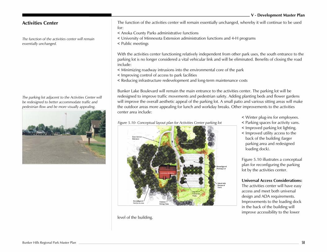
V - Development Master Plan
Bunker Hills Regional Park Master Plan 58
The parking lot adjacent to the Activities Center willbe redesigned to better accommodate traffic andpedestrian flow and be more visually appealing.
Figure 5.10- Conceptual layout plan for Activities Center parking lot
Activities Center
The function of the activities center will remainessentially unchanged.
The function of the activities center will remain essentially unchanged, whereby it will continue to be usedfor:< Anoka County Parks administrative functions< University of Minnesota Extension administration functions and 4-H programs< Public meetings
With the activities center functioning relatively independent from other park uses, the south entrance to theparking lot is no longer considered a vital vehicular link and will be eliminated. Benefits of closing the roadinclude: < Minimizing roadway intrusions into the environmental core of the park< Improving control of access to park facilities< Reducing infrastructure redevelopment and long-term maintenance costs
Bunker Lake Boulevard will remain the main entrance to the activities center. The parking lot will beredesigned to improve traffic movements and pedestrian safety. Adding planting beds and flower gardenswill improve the overall aesthetic appeal of the parking lot. A small patio and various sitting areas will makethe outdoor areas more appealing for lunch and workday breaks. Other improvements to the activitiescenter area include:
< Winter plug-ins for employees. < Parking spaces for activity vans. < Improved parking lot lighting.< Improved utility access to the
back of the building (largerparking area and redesignedloading dock).
Figure 5.10 illustrates a conceptualplan for reconfiguring the parkinglot by the activities center.
Universal Access Considerations:The activities center will have easyaccess and meet both universaldesign and ADA requirements.Improvements to the loading dockin the back of the building willimprove accessibility to the lower
level of the building.

V - Development Master Plan
Bunker Hills Regional Park Master Plan 59
Archery Range
The master plan calls for the archery range to berelocated to better serve the long-term needs of thearchers.
The master plan calls for the archery range to be relocated to better serve the long-term needs of thearchers and minimize potential conflicts with other park uses. Its current location will be restored andbecome part of the environmental core of the park. Future uses within this area will be limited to trails.
The existing building and accompanying parking lot adjacent to the “A” road will remain until a newbuilding can be constructed at the relocated archery range. Although not ideally sited nor architecturallyappealing, this building provides programming space for a variety of local groups and thus warrants beingretained, at least in the short-term.
The new range will be between 45 and 50 acres in size. Access to the site will be from Hanson Boulevard.Key program items for the new range include:< Outdoor practice range (minimum of 90 meters).< Field ranges, including animal, broadhead, and field round courses.< Multipurpose building with indoor range, restrooms, event staging area, vendor setup, storage, etc. (Note
that this structure will also be available to other groups as is the current building.).< Parking lot.< Overflow parking/informal group camping.< Picnic shelter and patio adjacent to building and practice range.< Range perimeter delineation (signage, posts, etc.
Note that the final layout for the archery range will be designed with direct input from the archery group aspart of their on-going partnership with Anoka County Parks.
Universal Access Considerations: The archery group will continue their past practice of making the rangeaccessible to their members with all levels of ability as appropriate for the challenge level of the course.Universal design principles will be applied as appropriate in this rather unique setting.
Wave Pool (Aquatic Center)
The existing wave pool has been a very successfulenterprise within the park.
The existing wave pool has been a very successful enterprise within the park since it was opened in 1988.Currently, the wave pool offers the following amenities:< Wave pool (800 capacity)< Concessions area for food vending< Deck area for sunbathing, relaxing, and picnicking (2 shelters)< Sand volleyball open games area< Restroom and shower facilities< Tube rental area
Based on strong user demand, expanding the wave pool continues to be a strong consideration. A separatemaster plan has been developed to identify expansion opportunities. Figure 5.11 illustrates a conceptualmaster plan for an expanded wave pool facility.

V - Development Master Plan
Bunker Hills Regional Park Master Plan 60
Figure5.11 - Wave pool layout with potential expansion. The list of potential new amenitiesincludes:< Lazy River< Slides (speed, flume, and tube)< Plunge pool< Splash pool< Wet play area< Maintenance building< Video games shelter< Expanded building with restrooms
and concessions
Universal Access Consideration:All wave pool activities and eventswill offer easy access and likeexperiences to all user groups.
Environmental Learning Center For a number of years, Blaine High School has been working with Anoka County Parks on developing anenvironmental learning center for ecological field study, recreational activities, demonstration of naturalsuccession, and wildlife sanctuary. The success of their teaching programs clearly warrants continuation andeven expansion of this relationship. Proposed improvements to the learning center include:< Boardwalk though wetland (replacement and expansion) – to permit greater access to learning
environments.< Dock in open water area – for water sampling.< Observation platform overlooking marsh – for wildlife observation< Nature interpretive trail – to access various ecological areas and ecotonal zones for science study.
Preference is for minimal disruption to natural area, with brush piles being left or created, no mowing,and direct access to natural resource restoration and management zones.
< Natural amphitheater – simple setting for outdoor teaching< Ropes course – for strength and confidence building
In addition to physical improvements to the learning center, school representatives from the sciencedepartment also expressed interest in expansion of student programming opportunities. As an example,developing a programmatic link between the school and county with respect to the natural resourcesrestoration and management program was considered an ideal learning opportunity.

V - Development Master Plan
Bunker Hills Regional Park Master Plan 61
Horse Staging Area and Corral
Under the new master plan, the stable operation andpasture land will be removed from the core of theenvironmental area.
Under the new master plan, the stable operation and pasture land will be removed from the core of theenvironmental area to forestall continuing degradation of the surrounding ecological systems. With theexception of the county stable, the existing facilities are in generally poor shape and substandard withrespect to accessibility and overall quality. Once the existing facilities are removed, extensive ecologicalrestoration will be undertaken to reestablish a viable natural landscape. Future uses of the area will belimited to trails.
The master plan shows the horse staging area and corral relocated to the north side of the park with directaccess from Bunker Lake Boulevard. This location improves vehicle access to the horse staging area andminimizes any conflicts with other park uses. Depending on demand, potential development for generalpublic use includes a parking lot, corral, and an outdoor riding ring with announcing booth/restroombuilding.
With respect to the existing stable operation run by a private vender, future replacement of this facility willdepend greatly on the economic viability of the operation. With the general demand for horse-ridingopportunities relatively low compared with other recreational pursuits, the viability of Anoka County Parksbeing able to fund redevelopment of the stable operation to its current level is suspect. This is not topreclude the possibility of a private vendor offering a variety of horse-related recreational opportunities,such as a bridle path or trail rides, sleigh rides, and hay rides. These activities are part of the park’s historyand can still be provided out of the horse corral area, with the vendor being responsible for providing horses to the park on an ongoing or as-needed basis.
The development timeframe for removal and relocation of the existing horse facilities and stable dependson the lease arrangement with the stable operator and funding opportunities. Relocation is also predicatedon whether or not the demand for these facilities manifests itself. With anecdotal evidence suggestinglimited overall demand for horse-related facilities for public use, a phased development approach isrecommended to avoid building facilities that may not be warranted. As more complete demandinformation for a horse staging area, corral, and trails is obtained, decisions can be made as to howextensive these facilities should actually be developed within the park. Also, given the vulnerability of thepark’s ecological systems, expansion of these facilities must be considered within the context of theirenvironmental impacts. Bio-filtration of storm runoff and other mitigation techniques must be incorporatedwith any development of horse facilities to avert environmental problems.
Maintenance Facilities The current park maintenance building located near the campground will be removed. It is in generallypoor shape and will be difficult to access once the roadway system is reconfigured. Storage and othermaintenance functions out of this building will be shifted to the park maintenance facility in the northwestcorner of the park. The trail system, the parkway, and a variety of maintenance drives proposed in themaster plan allows maintenance vehicles to service all of the facilities within the park.

V - Development Master Plan
Bunker Hills Regional Park Master Plan 62
Figure 5.12 - Park land exchange for greenway corridor.
Miscellaneous Site Amenities andImprovements
All site amenities will be in character with the settingand reflect the architectural style used for buildingand structures when appropriate.
All site amenities will be in character with the setting and reflect the architectural style used for building andstructures when appropriate. The more common site amenities include:< Interpretive signage – will be extensive throughout the site as the current nature programs evolve.< Benches.< Trash receptacles.< Bike racks.< Boardwalks – designed to blend into the natural setting. Natural looking but long-lasting materials will be
used. < Signage program – orients visitors to park facilities in a consistent, cohesive, and unobtrusive manner.< Demonstration flower gardens – provide added visual appeal to specific areas in the park, like near the
Activities Center and Veterans Memorial. Local societies, like Hosta and Iris Societies, could assist indesign and maintenance.
Future Land ExchangeOpportunity/Acquisition
On the southwest corner of the park adjacent to the railroad right-of-way lies a finger of land that iscurrently park property. Separated from the park by the railroad tracks and golf course, the parcel’s primaryvalue lies with it being a buffer between public and private uses. From a natural resource perspective, thearea is showing signs of decline in ecological quality. Past uses of off-road vehicles in the area has also had adetrimental impact.
Directly west of this parcel the YamahaCorporation has a test facility. Further west, thecity of Coon Rapids has an open space area thatwill likely be developed for a public park, with akey trail link to their and the regional trail system.Linking this property to Bunker Hills park via atrail corridor offers desirable recreational value.
In this context, the opportunity exists to exchangeabout 47.5 acres of land with the YamahaCorporation to establish a greenway corridorbetween the park and city property. Given itsisolation and current ecological status, the fingerof land under park ownership would beexchanged for a like amount of Yamaha propertyto form the greenway corridor. Figure 5.12defines the land areas being considered as part ofthe land exchange. It also illustrates how thegreenway corridor would provide an importantlink between regional parks and trails to localones.

V - Development Master Plan
Bunker Hills Regional Park Master Plan 63
Figure 5.13 - Proposed land acquisition on east side of park.Note that parcels “A” and “B” are no longer being pursued.
The timeframe for any action remains undefined. The current land owners are interested in the landexchange concept because it would give them direct access to the rail line. Unfortunately, the current useof the property for a test track precludes the owner from actively pursuing a land exchange in the short-term. However, they also do not want to preclude the possibility of doing so in the future as their land useneeds change. A continued periodic dialogue has been agreed to between Anoka County Parks and theland owner. Note that any action in this regard would require approval by the Metropolitan Council.
Anoka County has also been pursuing the acquisition of about 50 acres on the east side of the park. The proposed acquisition, which has been an approved part of past acquisition plans for the park, consists of 10five acre parcels. Figure 5.13 illustrates these parcels.
Note that parcels “A” and “B” are no longer beingactively pursued for acquisition by Anoka County.These parcels already have public utilities and anappraised value of $30,000 to $32,000 each. Atthis price, the cost-benefit of acquiring theseparcels is not justified relative to other acquisitionand development priorities. Anoka County will,however, continue to pursue the acquisition ofthe remaining eight parcels as the opportunitypresents itself.

VI - Implementation Plan
Bunker Hills Regional Park Master Plan 64
Section VI Implementation and Operations Plan
Overview The extensive redevelopment defined in the master plan for Bunker Hills Regional Park will requiresubstantial capital investment. In all likelihood, implementation will occur over a number of years asfunding through various sources becomes available. The following considers the overall costs associatedwith developing and operating the park under the new plan. Implementation strategies are also considered.
Cost Analysis
The cost analysis table defines the potential costsassociated with each component of the master plan.
The cost analysis table defines the potential costs associated with each component of the master plan. It isbased on a combination of site-specific development issues and projects of similar size and complexity. The costs are also based on having the work completed by contractors and outside specialists. It does nottake into consideration work that could be performed by County staff, volunteer groups or through othermeans. Costs associated with natural resource restoration and management are also not included.
The cost figures are intended to be used for budgeting purposes, project phasing, and comparing therelative cost of one item to that of another. The costs are in 1998 dollars. Although the intent is to beconservative, it must be recognized that actual costs will vary depending on the bidding environment wheneach aspect of the master plan is implemented.
Master Plan Component General Description of Cost Items Included in Estimate Cost Estimate(In Dollars)
Parkway (“A” road)Redevelopment
1) Removals, including existing roadbed as required to construct new roads2) Grading and roadbed preparation3) 28' wide roadbed for two-way traffic and 14' wide for one-way traffic, plus
turn and by-pass lanes. Asphalt surfaced, no curb and gutter4) 20 car parking lot. Asphalt surfaced, with curb and gutter5) 22' access drive to multipurpose building in campground (“B” road) – to
entrance to multipurpose building6) Storm sewer systems (culverts, diversions, catch basins and piping)7) Roadway striping8) Street lighting at intersections9) Landscaping and re-vegetation10) Bollards and wheel stops
630,000
Eliminate Old Park Roadsand Parking Lots (Except“A” Road)
1) Removal of existing road bed2) Grading to match surrounding landforms3) Re-vegetation
195,000

VI - Implementation Plan
Bunker Hills Regional Park Master Plan 65
Main Entrance Features andContact Stations
1) Removals, grading and site preparation2) Park entrance monuments (north and south)3) Contact station/gatehouse buildings (north and south)4) Automatic gate (north and south)5) Street/pedestrian lighting
200,000
Type I Park Trails (HardSurfaced) – 7 miles
1) Removal required for building new trails2) Grading, and trailbed preparation3) 10' wide asphalt trail with aggregate base4) Overlooks and seating areas associated with these trails5) Storm sewer systems (culverts, diversions) 6) Pedestrian lighting at road crossings7) Landscaping and re-vegetation
720,000
Type II Park Trails (SoftSurfaced) – 5 miles
1) Removal of existing hard surfaced trails as required to stabilize subgrade andgeneral removals required for building new trails
2) Grading, and trailbed preparation3) 10' wide asphalt trail with aggregate base4) Overlooks and seating areas associated with these trails5) Storm sewer systems (culverts, diversions)6) Landscaping and re-vegetation7) Trail lighting for skiing is not included
190,000
Parking Lots and AccessDrives for Picnic andGeneral Recreation Area(Except 4-Season Pavilion)
1) Removals 2) Grading and roadbed preparation3) Entrance drives and parking lots (total of 380 to 420 parking spaces). Asphalt
surfaced. Curb and gutter in parking lots.4) Storm sewer systems (culverts, diversions, catch basins and piping)5) Roadway striping6) Street lighting at intersections and access point to park facilities7) Landscaping and re-vegetation8) Bollards
410,000
Parking Lots and AccessDrives for 4-Season Pavilion
1) Removals 2) Grading and roadbed preparation3) Entrance drive and parking lot (total of 80 to 90 parking spaces). Asphalt
surfaced. Curb and gutter in parking lots. 4) Storm sewer systems (culverts, diversions, catch basins and piping)5) Roadway striping6) Street lighting at intersection and access point to pavilion 7) Landscaping and re-vegetation8) Bollards
115,000
Family Picnic Areas 1) Removals2) Grading and site preparation3) Picnic area amenities for 20 sites (picnic table, grill, trash containers, drinking
fountain/water tap nearby, etc.)4) Asphalt access trails to universally accessible sites
60,000

VI - Implementation Plan
Bunker Hills Regional Park Master Plan 66
Small Group Picnic Shelters(3 Shelters)
1) Removals2) Grading and site preparation3) 3 picnic shelters to with 20 person capacity each, including pavements4) Basic amenities (picnic tables, grills, trash containers, drinking fountain/water
tap, etc.)5) Asphalt access trails for pedestrians and vehicles6) Security lighting
170,000
Large Group Picnic Shelters(2 Shelters)
1) Removals2) Grading and site preparation3) 2 picnic shelters to with 150 person capacity each, including pavements4) Utilities (water from well near restroom and electric)5) Patio/deck adjacent to shelter6) Basic amenities (picnic tables, grills, trash containers, drinking fountain/water
tap, benches, etc.)7) Asphalt access trails for pedestrians and vehicles8) Security lighting
385,000
4-Season Pavilion 1) Removals2) Grading and site preparation3) Pavilion with 100 person capacity, including pavements 4) Utilities (well, sanitary sewer, and electric)5) Patio/deck adjacent to shelter6) Basic amenities (picnic tables, grills, trash containers, drinking fountain/water
tap, benches, etc.)7) Asphalt access trails for pedestrians and vehicles8) Security lighting
370,000
Restroom Facilities (2 Buildings)
1) Removals2) Grading and site preparation3) 2 restroom buildings 4) Utilities (well, sanitary sewer, and electric)5) Basic amenities (drinking fountain/water tap, bike rack, benches, etc.)6) Asphalt access trails for pedestrians7) Security lighting
280,000
Children’s Play Structure 1) Removals2) Grading and site preparation3) Large children’s play area (universal accessibility), with container and
sand/resilient surfacing4) Basic amenities (drinking fountain/water tap, benches, bike rack, etc.)5) Arbor structure with sitting area6) Asphalt access trails 7) Security lighting
260,000
General Recreation Areaand Veterans Memorial
1) Removals2) Grading and site preparation3) Basic amenities (drinking fountain/water tap, benches, bike rack, etc.)4) Asphalt access trails 5) Security lighting
75,000

VI - Implementation Plan
Bunker Hills Regional Park Master Plan 67
Campground Roads,Campsites, and Utilities
1) Removals 2) Grading and roadbed/camp spur preparation3) 22' entrance drive from multipurpose building to camp loops. Asphalt
surfaced, no curb and gutter4) 14' campground loops and campsite spurs. Aggregate surfaced.5) Storm water systems (culverts, diversions, catch basins and piping)6) Utilities to some campsites (water, electric) 7) Campground trails (aggregate surfaced meeting accessibility requirements)8) Basic campsite amenities (picnic tables, fire ring/grill, wheel stop, etc.)9) Landscaping and re-vegetation
575,000
Campground MultipurposeBuilding and Amphitheater
1) Removals2) Grading and site preparation3) Multipurpose building4) Patio/deck adjacent to building5) Utilities (well, sanitary sewer, and electric)6) Amphitheater (small stage and seating for 40 people, wood construction)7) Basic amenities (drinking fountain/water tap, bike rack, benches, etc.)8) Asphalt access trails for pedestrians9) Security lighting
340,000
Campground Restroom/Shower Buildings
1) Removals2) Grading and site preparation3) 2 restroom buildings4) Utilities (water from well near multipurpose building, sanitary sewer, and
electric)5) Basic amenities (drinking fountain/water tap, bike rack, benches, etc.)6) Asphalt access trails for pedestrians7) Security lighting
252,000
Improvements to ActivitiesCenter Parking Lot and Site
1) Removals 2) Grading and roadbed preparation3) Parking lot redesign and repaving. Asphalt surfaced with curb and gutter in
parking lot only4) Storm sewer systems (culverts, diversions, catch basins and piping)5) Walkways and patios 6) Roadway striping7) Street lighting at intersections and access point to park facilities8) Landscaping and re-vegetation9) Miscellaneous Improvments (Flagpoles, benches, picnic tables, loading dock
redesign, etc.)
200,000
Archery Range Relocation 1) Removals 2) Grading and roadbed preparation3) Parking lot development. Aggregate surfaced with wheel stops4) Storm sewer systems (culverts, diversions, catch basins and piping)5) New building6) Walkways and patios (concrete)7) Target range development8) Landscaping and re-vegetation9) Miscellaneous Improvments
500,000

VI - Implementation Plan
Bunker Hills Regional Park Master Plan 68
Wave Pool Expansion 1) Removals 2) Parking lot expansion3) Aquatic pool features4) Dry play areas5) Restrooms and concessions building expansion6) Picnic areas and shelter relocation7) Video games shelter8) new mechanical building
3,500,000
Environmental LearningCenter Improvements
1) Boardwalk replacement2) Miscellaneous site improvements
100,000
Horse Staging Area andCorral
1) Removals 2) Grading and site preparation3) Parking lot development. Aggregate surfaced with wheel stops to control
vehicle encroachments into natural areas4) Storm sewer systems (culverts, diversions, catch basins and piping)5) Corral, with wood fencing6) Announcing booth with restrooms7) Vender office and storage building8) Riding ring with wood fencing9) Walkways. Aggregate surfaced.10) Landscaping and re-vegetation11) Miscellaneous Improvments (benches, picnic tables, loading dock
redesign, etc.)
375,000
Miscellaneous SiteAmenities and Improvments
1) Budget figure for various park amenities not defined above 50,000
Total Master Plan Cost Estimate 9,952,000
Construction Contingency (10%) 995,200
Total Master Plan Cost Estimate with Contingency 10,947,200
Professional Fees and Charges (Surveying, Design, Engineering, Etc.) (10%) 1,094,720
Total Master Plan Cost Estimate with Contingency and Professional Fees and Charges 12,041,920
Implementation Strategy (Project Phasing)
Given the overall magnitude of the potential costs, it is reasonable to expect that development of the parkwill occur over a period of time to coincide with funding opportunities. The following implementationstrategy suggests various groupings of master plan components into a number of implementation phases.Components were grouped in consideration of the following criteria:< Existing facility exhibits an immediate concern (i.e., safety, dysfunctional, detrimental to long-term vitality
of park)< Existing facility is worn out and no longer effectively services public need< Existing and/or expanding demand warrants development/redevelop of a certain facility

VI - Implementation Plan
Bunker Hills Regional Park Master Plan 69
< Facility is required to support high priority items (parking, for example)< Facility cost
The following table groups the line items listed in the cost estimate into various phases based on theirpriority ranking relative to other items. Note that phases are not linked to specific timeframes. Actual projectphasing will be a function of funding availability.
Implementation Phase Implementation Focus and Master Plan Components Recommended Underthis Phase
Total Costs(In Dollars)
Natural ResourcesRestoration andManagement PlanImplementation
Implementing a natural resource restoration and management plan for the parkshould be a major short and long-term priority. Numerous areas of the park areexhibiting a high degree of degradation to the key ecological resources whichwarrant immediate attention.
Undefined
Phase I – InitialInfrastructureRedevelopment(Already funded)
Focus is on redeveloped of worn out infrastructural components.Recommended Components Under This Phase: < Campground renovation $1,167,000< Main entrance features and
and contact stations $200,000
Note: Use of force account equipment and labor will offset a portion of direct costs to keep Phase I development within the $1,139,000 grant fundingavailable for this phase of work.
$1,367,000
Phase II – Continued InfrastructureRedevelopment andExpansion of ExistingFacilities
Focus is on continued redeveloped of worn out infrastructural components.Focus also shifts to expansion of successful facilities.Recommended Components Under This Phase: < Parkway redevelopment $630,000< Eliminate old park roads $195,000< Trail system expansion $910,000< Family picnic area $60,000< Small group picnic shelters $170,000< One large group picnic shelter $192,000< Two restroom buildings $280,000< General recreation area $75,000< Parking and drives to support above $300,000< First phase of archery range relocation $100,000
$2,912,000

VI - Implementation Plan
Bunker Hills Regional Park Master Plan 70
Phase III – Expansion ofExisting Facilities
Focus is on continued expansion of successful facilities.Recommended Components Under This Phase: < Children’s play structure $260,000 < One large group picnic shelter $193,000< Parking and drives to support above $110,000< Environmental learning center $50,000< Miscellaneous site amenities $50,000< 4-season pavilion $370,000< Parking for 4 season pavilion $115,000< Complete archery range relocation $260,000< Activities center area $90,000< Horse staging area and corral $375,000
$2,173,000
Phase IV – Expansion ofExisting Facilities
Focus is on continued expansion of successful facilities.Recommended Components Under This Phase: < Wave pool $3,000,000
$3,500,000
Total Project Costs - All Phases 9,952,000
Contingency (not factored into above) 995,200
Total Project Costs - All Phase with Continency 10,947,200
Project Fees and Charges 1,094,720
Total Project Costs - Fees and Continency 12,041,920
Operations Plan The operations of Bunker Hills Regional Park falls under the jurisdiction of the Anoka County Departmentof Parks and Recreation. Policy and goal-setting are done through the Anoka County Parks and RecreationCommittee and the Anoka County Board of Commissioners.
Ordinances
Public use and enjoyment of the park system are controlled by the Ordinance Regulating Parks in theAnoka County Parks System. The ordinance was last revised February 11, 1997. The ordinance alsoincorporates pertinent Minnesota statutes. Issues addressed in the ordinance include:< Regulation of Public Use < General Conduct and Behavior< General Parkland Operation< Protection of Property and Natural Resources< Regulation of Activities< Enforcement

VI - Implementation Plan
Bunker Hills Regional Park Master Plan 71
The Anoka County park ordinances are enforced by the Anoka County Park Rangers. During the summermonths, park rangers are patrolling by horse, bicycle, all-terrain vehicles, golf carts, on foot and in cars. During the winter, a ski patrol unit covers the groomed cross-country ski trails.Local police departments and the Anoka County Sheriffs Department also respond to incidents in the parksystem.
General Operations
The Operations and Maintenance unit of the Department of Parks and Recreation has an annual budget ofapproximately $3.2 million. There are thirty-eight permanent employees and nearly one hundred seasonalemployees hired as gate attendants, rangers, concession workers, lifeguards, maintenance workers, andnaturalists. Volunteers also help with the Wargo Nature Center, Arbor Day plantings, park cleanups, flowerbed maintenance, and a variety of other events. Area schools participate in natural resource activities anddisplays at the Banfill-Locke Center for the Arts. Contractual agreements are in place for trash removal,Bunker Hills Stables operation, the archery club, and campground hosts.
Revenue generated from the facilities and services at Bunker Hills Regional Park, not including the WavePool, totals approximately $27,000. The contracts with the archery club and the stables’ operation bring in$11,250. Camping fees create $5700 in revenue. Rental of rooms within the Activity Center totals $3000. Picnic shelter reservations account for the final $7050
The improvements of the picnic areas, rest room buildings, and campgrounds along with the addition oftwo gate houses are expected to dramatically increase revenue. Conservative projections increase campingrevenue from $5700 to $15,000 annually. Gate income is difficult to project. The Metropolitan Councilestimated that 455,500 visitors came to Bunker Hills in 1996. Accounting for walk and bicycle traffic andmultiple visits by the same people, revenue from the parking fees could reach $75,000.
The municipal golf course is operated by the City of Coon Rapids on leased property within Bunker HillsRegional Park. The Wave Pool is operated as an enterprise unit. The annual expenses total $480,000 withrevenue projected at $500,000. Future plans call for additional features including water slides, a wet-playarea and “lazy river”. Coupled with the wave pool, this type of aquatic facility will attract more people whowill stay longer. This will also increase use for the campgrounds, trails and picnic facilities. The gate houseswill be busy while bringing in additional revenue.

VI - Implementation Plan
Bunker Hills Regional Park Master Plan 72
Maintenance
Maintenance of the facilities along with the 1600 acres within Bunker Hills Regional Park presents achallenge for the Parks and Recreation Department. The natural resources division monitors the variousecosystems, manages the wetlands, restores native species, manages disease centers and controls invasiveplants. The compost site also is operated through the natural resources division. The maintenance divisionis busy year-round with a host of regular and special duties, including:< Mowing< Plowing< Tree Work< Trail grooming< Repairs< Shelter Cleaning< Building Upkeep< Road Repairs< Trash Pick up< Construction< Vandalism< Pool Operation< Gardens< Utility Work< Landscaping< Greenhouse Operation
Waste management has become an integral part of the maintenance throughout the park system. Recycledmaterials are utilized in picnic tables, benches, playgrounds, and signs. Recycling containers are madeavailable. In selected areas, fewer trash receptacles are available with the hope to train the public to “packout” their waste. Other trash is hauled through a contractual arrangement with a private vendor whocomplies with all state and local laws.
Programming
Recreational programming presently occurs within the park and opportunities will increase with newfacilities. Anoka County Libraries sponsors entertainment during the summer. “Ski by the Light of theMoon” happens every winter. Natural resource seminars are offered educating the public on a variety ofseasonal topics. Plans are to increase interpretive programing at the improved campgrounds utilizing theyear-round building and possible amphitheater area. The trails through the park will offer exploration ofwetlands, oak savannahs, sand plain, and native prairie.

VI - Implementation Plan
Bunker Hills Regional Park Master Plan 73
Marketing and Promotion
Promotion of Bunker Hills Regional Park happens through a variety of sources. Seasonal brochures inviteeveryone to enjoy the many opportunities available. Brochures specific to shelter reservations and roomrental promote the choices available. Press releases, flyers, posters and mailings notify area residents. Mostof all, word-of-mouth advertising is the most successful method. Positive word-of-mouth advertising iscreated through staff trained to serve the public, clean buildings and grounds, quality programming,accessible features, and well-managed natural resources.