Embed Size (px)
Citation preview
Bunbury Integrated
Land Use & Transport
Vision 2030 I n t e g r a t i n g T r a n s p o r t a n d L a n d U s e
Integrated Land Use & Transport Strategy
September 2006
ESTILL & Associates
___________________________________________________________________________
Document Number: 38640 Job Number: 61/10984 Author: SMcD – TB Dec 03
Bunbury Integrated Land Use & Transport Vision 2030
Gutteridge Haskins & Davey Pty Ltd
ACN 008 488 373
GHD House, 239 Adelaide Tce. Perth, WA 6004
P.O. Box Y3106, Perth WA 6832
Telephone: 61 8 9429 6666 Facsimile: 61 8 9429 6555 Email: [email protected]
© Gutteridge Haskins & Davey Pty Ltd 2006
This document is and shall remain the property of Gutteridge Haskins & Davey Pty Ltd. The
document may only be used for the purposes for which it was commissioned and in accordance
with the Terms of Engagement for the commission. Unauthorised use of this document in any
form whatsoever is prohibited.
Document Status
Approved for Issue Rev No.
Author Reviewer Name Signature Date
0 Project Team B Hughes B Hughes B Hughes 25/11/01
1 Project Team B Hughes B Hughes B Hughes 6/6/02
2 Project Team B Hughes P Fisher P Fisher 2/8/02
3 Project Team S McDermott P Fisher P Fisher
4 Theo Naude Tony Brun
5 Council Resolution 363/03 Pursuant to Part 2 local Planning Policy Framework of Town Planning Scheme 7, that the amended Bunbury Integrated Land Use and Transport Vision 2030 report be endorsed to form part of the Local Planning Policies and be referred to the Western Australian Planning Commission for consideration.
Mayor, City of Bunbury- John Castrilli
City of Bunbury -Chief Executive Officer, Greg Trevaskis -
14/6/04
___________________________________________________________________________
Document Number: 38640 Job Number: 61/10984 Author: SMcD – TB Dec 03
Bunbury Integrated Land Use & Transport Vision 2030
Contents
1. Introduction ................................................................................................ 1
1.1 Strategy Objectives....................................................................................... 1
1.2 Strategic and Local Context .......................................................................... 2
1.3 Transport Summary ...................................................................................... 2
2. What Will Bunbury Transport Be Like In 2030? ...................................... 4
2.1 Vision............................................................................................................ 4
2.2 Directions and Objectives ............................................................................. 4
2.3 Mode Share Targets ..................................................................................... 5
2.4 How Will We Change Transport In Bunbury?................................................ 5 2.4.1 Types of Strategic Actions.............................................................................. 5 2.4.2 Criteria for Selecting Strategies...................................................................... 5 2.4.3 Strategy Overview .......................................................................................... 6
2.5 A Transport and Land Use Vision ................................................................. 6
3. A ‘Vision’ for Pedestrians and Cyclists.................................................... 8
3.1 The Challenges............................................................................................. 8
3.2 A Strategy for Pedestrians and Cyclists ........................................................ 8
3.3 Accessibility for Everyone ........................................................................... 11
4. A “Vision” for Public Transport.............................................................. 13
4.1 The Challenges........................................................................................... 13
4.2 Immediate Proposals for Change................................................................ 13
4.3 Additional Considerations ........................................................................... 16 4.3.1 CAT Bus System .......................................................................................... 16 4.3.2 Potential Bus Outer Ring (“Circle”) Route .................................................... 17 4.3.3 Regional Rail Station Terminus .................................................................... 17
4.4 The 2030 Vision for Change: An Innovative Public Transport Improvement Model.......................................................................................................... 18
5. A ‘Vision’ for Traffic Movement .............................................................. 21
5.1 The Challenges........................................................................................... 21
5.2 A Strategy for Traffic Movement and Accessibility....................................... 21
5.3 CBD Access................................................................................................ 25
6. A “Vision” for Parking ............................................................................. 27
6.1 The Challenges........................................................................................... 27
6.2 Elements of a Vision for Parking ................................................................. 28
6.3 A Strategy for Parking................................................................................. 29
7. A “Vision” for Land Use and Integration ............................................... 34
7.1 Regional Integration.................................................................................... 34
___________________________________________________________________________
Document Number: 38640 Job Number: 61/10984 Author: SMcD – TB Dec 03
Bunbury Integrated Land Use & Transport Vision 2030
7.2 Commercial Strategy .................................................................................. 35
7.3 Housing Strategy ........................................................................................ 38
7.4 A Strategy for the Integration of Transport and Land Use ........................... 39
7.5 Works Program........................................................................................... 42
7.6 Smartcard Opportunities ............................................................................. 42
8. Getting It Done ......................................................................................... 45
9. How Did We Get To This Strategy? ........................................................ 46
Apendices
A Maps
Ancillary Documents
A Works Program B Policies
___________________________________________________________________________
Document Number: 38640 Job Number: 61/10984 Author: SMcD\jr
Bunbury Integrated Land Use & Transport Visions 2030
1
1. Introduction
1.1 Strategy Objectives
Bunbury is a fast growing and vital regional centre in Western Australia. The
City of Bunbury has commenced strategic planning for major activities which
affect the community. This project provides a direction for transport in the City
to guide actions to improve transport for the next 30 years.
The results of Bunbury Transport Vision 2030 are consistent with the direction
in the 'Strategic Plan' and other reports which guide community, economic and
environmental changes to the City.
This report will be used by Council to decide planning, projects, policies,
engineering works, information, processes and other activities.
This strategy has been developed with considerable resources, community
participation and the commitment of Council and its officers.
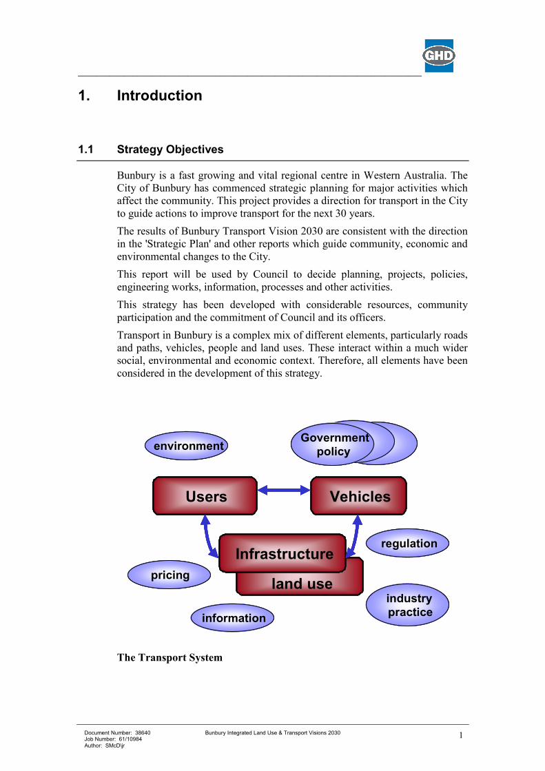
Transport in Bunbury is a complex mix of different elements, particularly roads
and paths, vehicles, people and land uses. These interact within a much wider
social, environmental and economic context. Therefore, all elements have been
considered in the development of this strategy.
The Transport System
land use
Infrastructure
VehiclesUsers
regulation
industrypractice
information
pricing
environmentGovernment
policy
land use
Infrastructure
VehiclesUsers
regulation
industrypractice
information
pricing
environmentGovernment
policy
___________________________________________________________________________
Document Number: 38640 Job Number: 61/10984 Author: SMcD\jr
Bunbury Integrated Land Use & Transport Visions 2030
2
1.2 Strategic and Local Context
The City of Bunbury has a premier role as Western Australia’s principal urban
area outside Perth. Bunbury is the principal commercial, administrative,
educational, recreation, community, tourist and industrial centre for the
burgeoning South West of WA. Its vibrant city centre, valuable port, strategic
location and healthy community, offer the best of urban living in a regional
centre surrounded by an active hinterland. As development continues, various
demands in the City result in conflicts between competing objectives, which
need to be carefully managed.
Transport is a major component to support development but its negative effects
must be minimised. Comprehensive transport planning is essential to guide the
different systems with land use to best serve the community as a whole. It is
essential that different transport systems and components are integrated to
ensure they work together as a whole.
Bunbury is one of the fastest growing areas in the State. The Greater Bunbury
area currently has a population of about 55,000 people, with around 30,500 of
this number living in the “Inner” Bunbury area. This urban area is growing at
3.4% p.a., making it the third fastest growing in all of Australia.
In addition, the Port of Bunbury is currently the ninth biggest port in Australia
by tonnage throughput and it has been identified as having the potential to
grow to be the fifth largest.
While there is an enormous amount of development happening within the City
of Bunbury at the moment it is expected that in the longer term the majority of
new households will be built in the dormitory suburbs of Eaton, Australind,
Dalyellup, etc. This urban expansion will naturally occur as the “Inner” area
progressively becomes more built out. It must be recognised, however, that this
expansion needs to be managed in such a way that it does not adversely impact
on travel demands, liveability and accessibility of the City.
The objective is to create a sustainable city. A city that is freely accessible,
vibrant and has a strong level of social cohesions, which is facilitated through
the urban design and connectivity. This can be achieved by actively striving to
create a city, which does not mirror the American urban sprawl model, but
rather seek to create a more European style compact city based on urban
villages focused on localised services and integrated public transport nodes.
1.3 Transport Summary
The City of Bunbury is the focus for many activities in the South West of
Western Australia. Therefore regional transport from the hinterland also
focuses on the City. The City serves local residents plus those in the immediate
surrounding urban areas, together with commerce and industry. As a result the
___________________________________________________________________________
Document Number: 38640 Job Number: 61/10984 Author: SMcD\jr
Bunbury Integrated Land Use & Transport Visions 2030
3
transport system serves a mixture of regional and local traffic for a variety of
purposes.
Regional transport infrastructure includes:
• main roads,
• railways and the station,
• the airport, and
• the port.
Local transport includes:
• arterial and local roads (for general, commercial and freight traffic),
• pedestrian and cycle networks,
• local bus services, and
• parking.
In Australian and international terms the City does not yet suffer major traffic
problems. However to maintain sustainable transport and contribute to
community viability there are aspects of transport and land use which should
be planned for the long term.
Key Issues
Certain important issues have been identified which need to be addressed if the
City is to achieve its transport objectives, including:
• protecting the City from potential traffic congestion in the future,
• ensuring the CBD remains commercially viable,
• connecting the roads so that routes are direct and effective,
• providing transport so that everyone has good access (not just those who can
drive and afford a car),
• minimise intrusion of trucks into residential areas and conflicts with other
road users,
• providing high quality facilities for cyclists, pedestrians, and people with
disabilities,
• minimising the negative effects of transport on the community,
• improving transport while being economically responsible,
• providing for freight and other commercial transport to support business,
• providing parking for cars which is not intrusive or wasteful,
• providing for increasing transport demand as the City expands,
• planning for a future which will be different socially and environmentally,
• integrating with and supporting the surrounding region.
• Creating an integrated and cohesive community
___________________________________________________________________________
Document Number: 38640 Job Number: 61/10984 Author: SMcD\jr
Bunbury Integrated Land Use & Transport Visions 2030
4
2. What Will Bunbury Transport Be Like In 2030?
2.1 Vision
The Bunbury Transport Vision is:
To provide an improved quality of life to the people of
The City of Bunbury through a balanced transport system
built on sustainable transport and land use options.
In realising the transport vision we will build an integrated and balanced
transport system reflecting regional needs and future growth to provide:
• Improved connectivity between local and regional destinations;
• Accessible and liveable communities;
• A range of transport options that promote an improved quality of life;
• Safe and convenient public transport for the whole community; and
• Solutions that promote commercial prosperity and maximise the region’s
natural resources.
• Creation of urban villages centred at key transport nodes, based on public
transport and walkable catchments
2.2 Directions and Objectives
Achieving this vision will require:
• more walking and cycling,
• greater use of public transport,
• trucks predominantly using identified routes,
• altered parking supply, location and operation,
• competitive alternatives to private cars,
• safety for all road users,
• economically efficient transport and Council actions,
• reduced environmental and social effects, and more consolidated and
diverse mixes of land use.
___________________________________________________________________________
Document Number: 38640 Job Number: 61/10984 Author: SMcD\jr
Bunbury Integrated Land Use & Transport Visions 2030
5
2.3 Mode Share Targets
Mode share targets in line with the Metropolitan Transport Strategy (MTS) are:
• Walk trips 12.5%
• Cycle trips 11.5%
• Public Transport Trips 12.5%
• Car Passenger 11.5%
• Car Driver 46%
• Other (taxi, motorbike etc) 2%
• Transport substitution by telework 4% more walking and cycling,
2.4 How Will We Change Transport In Bunbury?
2.4.1 Types of Strategic Actions
There are an enormous variety of actions which are possible to improve
transport systems.
The actual actions could generally include:
• provide / improve infrastructure,
• operate infrastructure,
• regulation,
• enforcement,
• education,
• information sharing,
• research,
• auditing,
• guidelines,
• policies,
• promotion,
• pilot projects,
• reviews,
• programs,
• communication,
• processes,
• pricing, and
• others.
2.4.2 Criteria for Selecting Strategies
Strategies can have many different types of effects. Desirable actions would be:
• low cost (not just financial cost),
• high benefit (not just financial benefit),
• advantage many people (do the people who benefit pay the costs?),
• disadvantage few people (do the people who suffer reap the benefits?),
• equitable,
• low risk (i.e. be robust according to the assessment criteria),
• politically / socially acceptable,
• environmentally acceptable,
• implementable quickly,
___________________________________________________________________________
Document Number: 38640 Job Number: 61/10984 Author: SMcD\jr
Bunbury Integrated Land Use & Transport Visions 2030
6
• have valued consequences which continue,
• have no undesirable side effects, and
• have no delay of effect after implementing.
These represent the criteria by which strategies should be assessed.
Transport strategies may be categorised into programs, processes and policy. It
is essential that a full range of complementary policies be implemented to
balance the whole transport system and improve a range of different results.
2.4.3 Strategy Overview
Transport strategies generally don’t target isolated users or objectives. Most
actions have varying effects across several areas and must be integrated to
ensure that all strategies work together to produce a unified effect across the
whole system.
The general Bunbury Transport Strategy Vision 2030 activities, or strategies,
are described in the following sections and specific actions are identified in the
Appendices.
2.5 A Transport and Land Use Vision
The Transport Vision has been developed in conjunction with the Housing and
Commercial Strategies, as described in Section 7. These provide a framework
for the major land uses which affect the City generally and transport in
particular.
There are several other land uses which also affect the City, including:
• the Inner and Outer Harbours of the Port,
• Schools, South West College of TAFE and the Edith Cowan University,
• industry including the expanding areas in Picton and Preston,
• Bunbury Regional and St John of God Private Hospitals, and
• recreational areas, specifically the South West Sports Centre and Hay Park
The Transport Vision has also recognised the context of other planning
including the Greater Bunbury Region Scheme and Industry 2030, Greater
Bunbury Industrial Land and Port Access Planning. Bunbury is inextricably
connected to the surrounding areas, which include:
• residential areas in Australind, Eaton, Dalyellup and others,
• further distant towns including Busselton, Collie, Dunsborough,
Bridgetown, Donnybrook, Harvey and beyond,
• industrial areas at Kemerton, Preston, Collie, Capel and elsewhere, and
• other intervening areas of farming, forestry, parks and other uses.
A Transport and Land Use Vision was developed as part of this study that is
summarised on Map 1 in Appendix A. This vision identifies land use
___________________________________________________________________________
Document Number: 38640 Job Number: 61/10984 Author: SMcD\jr
Bunbury Integrated Land Use & Transport Visions 2030
7
opportunities, which may occur or could be pursued by Council, which would
benefit transport and are consistent with other intentions of the City.
___________________________________________________________________________
Document Number: 38640 Job Number: 61/10984 Author: SMcD\jr
Bunbury Integrated Land Use & Transport Visions 2030
8
3. A ‘Vision’ for Pedestrians and Cyclists
3.1 The Challenges
Walking and cycling are two of the most efficient and fundamental forms of
transport. Both are very effective for people moving short distances. Most
travel by motorised vehicle includes some part of the journey by foot. Nearly
anyone can walk and many people without a driver’s license can ride a bicycle.
Paths and other facilities for pedestrians and cyclists are relatively inexpensive,
for the amount they can be used for.
Many people don’t know the variety of facilities such as shops, recreation,
schools and community facilities, which are within easy walking distance.
Generally Bunbury has an excellent environment and topography for walking
and cycling. Therefore improving peoples knowledge of the opportunities and
providing encouragement can result in more sustainable transport as people
change their transport habits.
Many people with disabilities cannot use motor vehicles and are reliant on
either pedestrian paths only, or in conjunction with buses.
Walking and cycling often seems unattractive except for recreation. There are
perceptions of poor paths, long distances and an uncomfortable environment,
although these can be overstated. Therefore the whole pedestrian and cycling
environment needs to be improved including, security, lighting, attractive
routes and appropriate facilities. Better information about actual walking and
cycling times and routes would overcome misconceptions.
3.2 A Strategy for Pedestrians and Cyclists
Strategies to improve walking and cycling are identified below, and a works
program is proposed in Section 9.
STRATEGY 1.1 – IMPROVE PEDESTRIAN AND CYCLING PATHS
STRATEGY 1.2 – ENCOURAGE WALKING AND CYCLING THROUGH
EDUCATION AND INFORMATION
STRATEGY 1.3 – PROVIDE TRIP FACILITIES
Actions to achieve this strategy include:
• The City of Bunbury adopt the proposed measures on Map 2, including
completion of the path network and on-road facilities as shown on the plans.
and cyclists should be guided to designated crossing points on these roads.
___________________________________________________________________________
Document Number: 38640 Job Number: 61/10984 Author: SMcD\jr
Bunbury Integrated Land Use & Transport Visions 2030
9
• Pedestrianisation of Victoria Street continued at weekends and other special
times in order to improve the pedestrian environment, promoting alfresco
dining, shopping and community activities.
• The City of Bunbury ensures that adequate pedestrian access is available
for Senior Citizens and disabled persons, developed together with
accessibility to public transport. A development policy is provided for the
provision of footpaths associated with aged persons housing, to provide a
safe link to nearby facilities including bus shelters.
• Pedestrian crossing facilities in the CBD are improved by the provision of
additional kerb extensions, handrails, paved areas and pram ramps.
• Crossing facilities are provided for cyclists and pedestrians at Eelup
Rotary, Robertson Drive near Education Campus/Underwood Street,
Bussell Highway adjacent to Hay Park. Overpasses are recommended in
view of the high traffic volumes.
• The City of Bunbury undertakes an annual audit of bicycle and pedestrian
facilities to identify safety hazards, to allow appropriate maintenance to be
undertaken.
• The City of Bunbury aims to provide footpaths on one side of all existing
access roads and new access roads with provision to construct a second
footpath if required by residents, to comply with the requirements in Guide
to Traffic Engineering Practice Part 13 Pedestrians and Liveable
Neighbourhoods.
• Install security cameras at bicycle parking locations to monitor security.
• The City of Bunbury adopt a policy requiring developers to provide lighting
for pedestrians in the CBD area (eg under awnings).
• The City of Bunbury and RoadWise Committee contact local schools and
encourage participation in the RoadWise Safe Routes to School Program
and the Walking School Bus Program.
• The City of Bunbury provides information and encouragement to promote
bike and walk paths using leaflets and local press. Provide route maps at
Libraries, recreation centres and shopping centres.
• The City of Bunbury establish links with the Bicycle User Group,
comprising members of the community to ensure that the objectives of the
bike plan are met and oversee implementation of measures.
• The City of Bunbury maintains the preparation, distribution and promotion
of a pedestrian/cyclist and facility improvement reporting system. This will
assist the continued improvement and safe condition of pedestrian and
cyclist facilities. Distribution should include libraries and schools and the
local newspaper.
• The City of Bunbury/RoadWise encourages Bicycle Education in Schools.
• The City of Bunbury should formulate an arrangement or agreement with
private landowners and businesses to provide bicycle parking on private
___________________________________________________________________________
Document Number: 38640 Job Number: 61/10984 Author: SMcD\jr
Bunbury Integrated Land Use & Transport Visions 2030
10
property, Cost sharing could be negotiated for the installation of bicycle
racks. Council may also consider free installation of the parking facilities as
an incentive to participate in the scheme.
• The City of Bunbury should provide bicycle lockers at the bus station and
rail station which would be of benefit to travellers and encourage dual
mode travel. It is recommended that bicycle lockers are installed based on
an assessment of the current demand.
• The City of Bunbury consider the provision of bicycle parking racks within
the CBD car parks, these should be well lit and maintained.
• The City of Bunbury provide 20 cycle racks at Hay Park and continue to
monitor to determine demand and increase as required.
• The City of Bunbury should incorporate the requirements of Austroads Part
14 Guide to Traffic Engineering Practice – Bicycles into the Town Planning
Scheme in respect of development applications. This identifies the number of
bicycle parking spaces that should be provided for a number of land uses.
• The location of bicycle parking should be publicised and identified by
appropriate signage.
• The City of Bunbury undertake regular monitoring of the locations of the
bicycle racks to determine requirements, maintenance and usage.
• The City of Bunbury should consider a program to target businesses to
highlight the benefit of providing ends of trip facilities. Further to
encourage staff surveys to determine requirements for showers and lockers.
• Bicycle racks should be provided at existing locations as follows:
− Neighbourhood Shopping Centres; these should be placed near building
entrances and it is suggested that three racks per block are provided,
− Business and Commercial Centres; these should be placed near building
entrances and it is suggested that three racks per block are provided,
− Deli’s/corner shops etc; provide one or two racks near the entrance to the
shop,
− District and Regional Roads; racks will be required where a row of retail
businesses face a footpath and should be installed as required,
− Local Streets; racks will be required where a row of retail businesses face
a footpath and should be installed as required.
• All new developments should consider the need for shower and changeroom
facilities. As a guide if employing 20 staff or more, 2 showers minimum or
per hundred employees (1 female and 1 male) is suggested.
• When Estuary Drive is severed pedestrian and cyclist connectivity must be
considered and maintained.
___________________________________________________________________________
Document Number: 38640 Job Number: 61/10984 Author: SMcD\jr
Bunbury Integrated Land Use & Transport Visions 2030
11
3.3 Accessibility for Everyone
Not everyone in the community has access to a car or is able to use certain
types of transport. But everyone needs to access a variety of locations and
services.
Accessibility for People without Access to Private Cars
Some people in the City cannot access private cars due to their age, physical or
intellectual capability, financial situation or other reasons. Under the current
situation of a transport system dominated by private cars, accessibility and
mobility is poor. Therefore these people have difficulty accessing goods and
services.
STRATEGY 1.4 – ENSURE TRANSPORT FACILITIES AND SERVICES
PROVIDE FOR PEOPLE WITHOUT ACCESS TO CARS.
Accessibility for People with Disabilities
People in the City with disabilities include those with intellectual or physical
disabilities, which may restrict accessibility to many services and locations,
including those via transport. Many people have disabilities that are not
obvious, but which reduce their mobility or access
STRATEGY 1.5 – PROVIDE A SAFE, CONVENIENT AND LEGIBLE
MOVEMENT NETWORK FOR PEOPLE WITH
DISABILITIES, INCLUDING THOSE USING
WHEELCHAIRS AND SIMILAR AIDS.
STRATEGY 1.6 – ENSURE ALL NEW TRANSPORT FACILITIES AND
SERVICES PROVIDE FOR PEOPLE WITHOUT ACCESS
TO CARS.
STRATEGY 1.7 – PROVIDE SPECIALISED INFORMATION ON
ACCESSING TRANSPORT FOR PEOPLE WITH
DISABILITIES.
STRATEGY 1.8 – ENSURE INFORMATION IS AVAILABLE IN A VARIETY
OF APPROPRIATE FORMATS FOR PEOPLE WITH
DISABILITIES.
___________________________________________________________________________
Document Number: 38640 Job Number: 61/10984 Author: SMcD\jr
Bunbury Integrated Land Use & Transport Visions 2030
12
Actions to achieve strategies to enhance access for everyone include:
• The City of Bunbury ensures that adequate pedestrian access is available
for Senior Citizens and disabled persons development together with
accessibility to public transport. A development policy is provided for the
provision of footpaths associated with aged persons housing, to provide a
safe link to nearby facilities including bus shelters.
• Tactile paving at bus stops and crossing points.
• Pram ramp gradients to comply with AS1428.1 and should not exceed
1:10.
• Design for Access and Mobility should comply with AS 1428 Parts 1 and
2.
• Provide strong contrast/delineation between road and pedestrian areas
in the form of physical guidance, i.e. textured paving. Guidance strips
also assist visually impaired pedestrians to avoid obstructions on a path.
• Avoid using uneven, discontinuous soft or loose surfaces as wheel chair
users have difficulty negotiating these.
• Adequate vertical clearance over footpaths of 2.4 m should be available.
• Use of audible/tactile pedestrian crossing signals where appropriate in
CBD situations.
• Provide adequate lighting of footpaths.
• Provide pram ramps at all intersections.
• Incorporate a pedestrian phase at all traffic signals.
• Provide safe road crossing places for pedestrians, cyclists and disabled
___________________________________________________________________________
Document Number: 38640 Job Number: 61/10984 Author: SMcD\jr
Bunbury Integrated Land Use & Transport Visions 2030
13
4. A “Vision” for Public Transport
4.1 The Challenges
The major challenges for significantly enhancing public transport in Bunbury
include:
• Most people in Bunbury use the private car for the great majority of trips.
• Most people are unlikely to use buses as an alternative to the car.
• Relatively easy access to cheap (or free) parking contributes to low public
transport patronage.
4.2 Immediate Proposals for Change
The following public transport enhancement strategies have been proposed and
a works program has been developed to facilitate implementation. (Section 9).
To address the public transport system planning challenges, the following bus
service improvements are recommended.
STRATEGY 2.1 – MORE DIRECT BUS ROUTES.
STRATEGY 2.2 – INTRODUCTION OF ATTRACTIVE BUS STOPS AND
SHELTERS.
STRATEGY 2.3 – REMOVAL OF EXISTING CBD BUS TERMINUS AND
REPLACEMENT WITH ON-STREET BUS STOPS.
STRATEGY 2.4 – IMPLEMENTATION OF PARK-AND-RIDE FACILITIES, INCLUDING THE INTRODUCTION OF A BUS SERVICE
FREE TRANSIT ZONE (FTZ), BASED ON EITHER A
CENTRAL AREA TRANSIT (CAT) SERVICE, IF THIS
PROVES VIABLE, OR THE RE-ORIENTATION OF
EXISTING BUS SERVICES TO LINK THE CITY
CENTRE WITH COMMUTER CAR PARKS ON THE
PERIPHERY OF THE CBD.
STRATEGY 2.5 – INTRODUCTION OF THE PUBLIC TRANSPORT
SERVICE CONCEPT.
STRATEGY 2.6 – MORE FREQUENT BUS SERVICES.
___________________________________________________________________________
Document Number: 38640 Job Number: 61/10984 Author: SMcD\jr
Bunbury Integrated Land Use & Transport Visions 2030
14
STRATEGY 2.7 – BETTER BUS SCHEDULING AND HOURS OF
OPERATION.
STRATEGY 2.8 – PUBLIC SECTOR / LAND DEVELOPER
PARTNERSHIPS TO INTRODUCE BUS SERVICES AT
DEVELOPMENT START-UP.
STRATEGY 2.9 – DEVELOP AN INTEGRATED, MULTI-MODAL
BUNBURY ACCESSIBILITY SCHEME BASED ON THE
“GO BUNBURY” MODEL.
Actions to achieve these strategies include:
• In response to community surveys that indicated many people wanted more
direct bus routes and reduced bus journey times, the existing Town Bus
route network has been rationalised. A network of proposed, more direct
routes is proposed, as shown in Map 3, Appendix A, for consideration by the
City of Bunbury, Department for Planning and Infrastructure, Bunbury City
Transit, and the Bunbury community.
• As a means of encouraging transit utilisation, attractive bus shelters should
be established at major bus stops with an attractive common design theme
that identifies Bunbury transit services. The range of bus system passenger
facilities may include:
− Standard Bus Stops
− Major Bus Stops
− Bus Transit Stations (Australind, Eaton, Hay Park Recreation Centre,
ECU/TAFE Campus, Hospital Campus, Dalyellup)
− Bus-Rail Interchange Station (co-located with regional rail terminus)
• Consistent with the recommended Strategy for Pedestrians & Cyclists, the
City of Bunbury should ensure that adequate pedestrian access is available
for Senior Citizens and people with disabilities when accessing public
transport facilities. The planning of footpaths for aged persons housing, to
ensure a safe link to nearby facilities, including bus shelters, has been
included as a “Development Policy” within the Strategy for Pedestrians &
Cyclists in this report. Tactile paving at Major Bus Stops, appropriate
Minor Bus Stops, and at pedestrian crossing points should also form part of
the strategy for addressing the needs of seniors and people with disabilities
as they relate to the public transport system.
• It is also recommended that bus services entering the Bunbury CBD should
not terminate at the existing city bus terminus. In stead, bus services should
travel through the major city streets to complete their route service. In so
doing, bus services would be brought directly to city shoppers, visitors, and
other users without the necessity for potential bus passengers to walk to a
CBD Bus Station.
___________________________________________________________________________
Document Number: 38640 Job Number: 61/10984 Author: SMcD\jr
Bunbury Integrated Land Use & Transport Visions 2030
15
• The facilities that may be selectively appropriate to this hierarchy of off-bus
passenger stop facilities could include a range of service information,
passenger convenience, and passenger security attributes with standard bus
stops having the basic attributes and Transit Stations offering higher-level
facilities.
• Park & ride facilities can reduce the demand for car access to central
Bunbury and provide a rendezvous point for ride-share partners. Park &
ride car parks should seek to intercept car commuters close to their point of
trip origin. Prospective, general locations for the introduction of park &
ride facilities include sites in the vicinity of:
− Australind
− Proposed East Australind District Centre
− Proposed Eaton Shopping Centre
− Dalyellup.
These general locations should be further discussed with the appropriate Shire
Councils to confirm their concurrence and to determine the details of
appropriate siting for Park & Ride facilities when they are being planned.
• To ensure that parking and public transport strategies are integrated and
mutually supportive, a Free Transit Zone (FTZ) bus service should be
introduced to link the city centre with free-of-charge commuter car parks on
the city periphery, for example, at locations like Stuart Street, Back Beach
and Koombana Bay. The FTZ service could be operated by a Central Area
Transit (CAT) system, if this were to prove viable in the future, or through
the re-orientation of existing bus services to ensure that routes entering the
city centre provided a linking service for peripheral commuter car parks.
• Bunbury’s public transport system of the future should be based on a
foundation of continuing service development. Fundamental transit service
types that may be relevant to Bunbury in the short- to medium-term include:
− Transit Links
Line-haul services: fairly direct all-day, all-stops services focusing on central
Bunbury and, as the Greater Bunbury Region grows, on other major sub-
regional activity centres.
Inter-suburban services: fairly direct services that link major suburban activity
centres with all-day, all-stop services focused in a cross-suburban, rather
than radial, pattern.
− Community Links
Community-based services, perhaps using small buses and potentially
operating in any suitable combination of fixed or flexible route, and on a
fixed or demand-responsive schedule. These services would focus on
local and sub-regional activity centres and would provide good area
coverage across residential catchments at the expense of route directness.
• Bus service frequency should be:
___________________________________________________________________________
Document Number: 38640 Job Number: 61/10984 Author: SMcD\jr
Bunbury Integrated Land Use & Transport Visions 2030
16
− not greater than 30 minutes during off-peak/mid-day service,
− not greater than 15 minutes during the AM and PM peak periods.
• Bus service frequency should be:
− Monday – Friday 07:00 to 19:00 hours,
− Saturday 07:00 to 19:00 hours,
− Sunday (Potential Trial Service) 09:00 to 17:00 hours.
• Plans for the early provision of effective public transport services should be
developed between major stakeholders to ensure that good quality public
transport is factored into the mode-choice decisions of people before car-
based trip-making becomes entrenched.
• A new “GO BUNBURY” total accessibility plan could be developed,
involving:
− A community “Go Bunbury” unlimited (pre-paid) Bus Pass,
− Elimination of the bus fare box,
− Major employers contributing to the cost of Bus Passes,
− Major land developers contributing to the cost of Bus Passes,
− A “guaranteed-ride-home” scheme to complement the Bus Pass,
− Ride-sharing options,
− Night-ride services,
− Access to bicycling facilities.
4.3 Additional Considerations
4.3.1 CAT Bus System
A potential CAT system would perform a combination of, the following roles:
• Tourist shuttle service linking the Bunbury CBD with major tourism
destinations, including Koombana Bay and the Dolphin Discovery Centre.
• CBD “work horse” service providing links between sites within the CBD,
and also potentially including any commuter parking facilities located on
the periphery of the CBD, for city workers, shoppers and visitors.
• Shuttle service – possibly only as required by the Australind rail schedule –
between Wollaston Rail Station (or, potentially, an alternative future
location) and the Bunbury CBD, including circulation around the CBD.
Whilst the Public Transport Context Analysis Report did not recommend a
Bunbury CAT system at this time, it would be reasonable to keep the potential
for a CAT service under review and to re-examine the concept at a later date,
perhaps at 5-year intervals.
___________________________________________________________________________
Document Number: 38640 Job Number: 61/10984 Author: SMcD\jr
Bunbury Integrated Land Use & Transport Visions 2030
17
Perhaps the CAT concept that may prove most viable at some time in the future
could involve a route linking the Bunbury CBD with major activity nodes like
Bunbury Forum, the ECU/TAFE/Hospital Campus, and Hay Park Recreation
Centre.
This service concept would be different from the CAT service that operates in
Central Perth. However, it could have the potential to offer a specialised,
higher-frequency bus link between some of the Bunbury Region’s major
concentrations of activity.
In the shorter term, the introduction of a Free Transit Zone (FTZ) for regular
bus services entering the Bunbury CBD could be introduced to promote
commuter parking on the periphery of the city area, thus permitting an
emphasis on shorter-stay, shopper/visitor parking within the CBD. The FTZ
services would link peripheral commuter car parks with the city core.
4.3.2 Potential Bus Outer Ring (“Circle”) Route
As further enhancement of bus services within the Bunbury Region, the
potential for an “outer ring route” – or “circle route” – should be examined to
provide for prospective cross-suburban links between major regional activity
nodes. For example, the “circle route” could connect Minninup Forum, Hay
Park Recreation Centre, ECU/TAFE/Hospital Campus, and Eaton Shopping
Centre.
4.3.3 Regional Rail Station Terminus
Over the course of the Bunbury Integrated Land Use & Transport Vision 2030
Study, considerations pertaining to the possible future location of the Bunbury
Rail Station have evolved. Moreover, there remains a range of views held
within the community with respect to the optimum rail terminus location to
serve Bunbury’s future development.
There is significant public support for a preferred Bunbury Railway Station at
the next adjacent to the “Plug” and the Silo’s. However the relocation of the
rail station cannot realistically be met due to the standards and practice
imposed by the Western Australian Government Railways (WAGR), for the
dimensions and segregation of railway reserves, which would result in
significant detrimental access issues on Koombana Beach and the Dolphin
Discovery Centre. It has also emerged from discussions with the Port Authority
that current line capacity (along Koombana Drive) can easily be duplication,
thereby potentially leading to considerable delays for any service seeking to
pass through the Port operations.
Following intensive investigations through the City of Three Waters Strategy,
it is recommended that the future siting of the Bunbury Railway Station be in
the vicinity of the Eelup Roundabout, near the Bunbury Forum District
Shopping Centre. Such an option would enable the integration of a rail
terminus and regional bus interchange facility in conjunction with any possible
future shopping centre development, thereby potentially leveraging private
sector financing for such works.
Eelup Roundabout is essentially located in the geographic and transport centre
of the Greater Bunbury urban area. An integrated node there could in the future
___________________________________________________________________________
Document Number: 38640 Job Number: 61/10984 Author: SMcD\jr
Bunbury Integrated Land Use & Transport Visions 2030
18
act as the terminus for an electrified rail network (extending the current
proposed Perth – Mandurah) running down the centre of the Perth – Bunbury
Highway.
The proposed location would also act as an ideal hub for a regional rail service
centred on Bunbury, which could connect to Manjimup, Collie, Busselton (and
Margaret River)
Also to be considered and allowed for in the development of road networks is
the provision of an urban based (on-road) light rail network. The network
would radiate from the proposed transit interchange along key routes:-
1. Sandridge Road and Blair Street (into the CBD);
2. Sandridge Road, Blair Street (south), Bussel Hwy, Parade Rd
(terminating at the Dalyellup District Centre); and
3. Australind Bypass, Eaton Dr, Paris Rd (connecting the urban centres
of Eaton, proposed East Australind and the Australind).
The relocation of the existing railway station would facilitate:-
• Rationalisation land use in the area to obtain community benefits.
• Re-configure east-west road connections so that the communities of Wollaston and
Carey Park achieve improved integration.
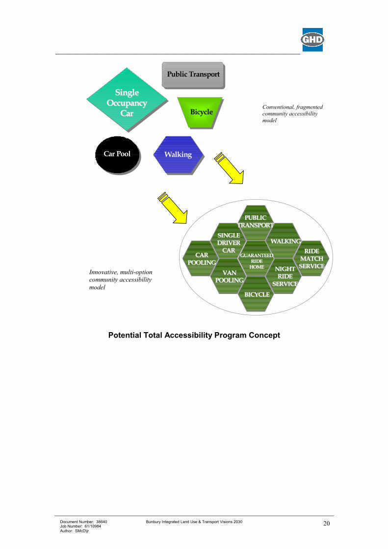
4.4 The 2030 Vision for Change: An Innovative Public Transport Improvement Model
The provision of a user-friendly public transport system and the achievement
of a significant mode-shift towards public transport will require innovation,
imagination and commitment to the unconventional.
The potential for a successful, unconventional, community-oriented, and
customer-focused approach to bus public transport provision in a non-
metropolitan urban environment is likely to hinge on a range of key elements.
Public Transport Strategy 2.9 identified the prospects for a “GO BUNBURY”
total accessibility plan. A new “GO BUNBURY” total accessibility plan would
involve:
• Breaking the mould for public transport planning.
• Developing a framework for actively involving the community in planning
its own bus public transport system.
• Becoming genuinely customer-focused.
• Implementing a community-wide “GO BUNBURY” unlimited Bus Pass.
• Eliminating the bus fare box by implementing the unlimited Bus Pass.
• Involving, and negotiating with, major employers to contribute to the cost of
Bus Passes.
___________________________________________________________________________
Document Number: 38640 Job Number: 61/10984 Author: SMcD\jr
Bunbury Integrated Land Use & Transport Visions 2030
19
• Introducing a “guaranteed-ride-home” scheme to complement the Bus
Pass.
• Involving children in the “GO BUNBURY” program to develop a long-term
culture of public transport support.
• Negotiating with land developers to introduce Bus Pass purchases for
residents in new property sub-divisions, for example, Dalyellup.
• Aiming for the Bus Pass to collect about one-third of total bus service costs
with the remainder financed by government and, potentially, through
surpluses from increased parking fees.
• Developing and implementing an encouragement, marketing, advertising
program to enlist broad-based community support.
• Developing and implementing a monitoring and improvement program to
measure success and make changes as opportunities arise.
Application of this model could result in the provision of an unlimited Bus
Pass to all Bunbury residents paid for by a levy, perhaps, on Council Rates.
The development of a “GO BUNBURY” integrated package of travel options
may hold the key to breaking the “vicious cycle” of growing car-dependence,
whilst still acknowledging the importance of car travel to the community.
Rather than penalising the car, or car travel, a new integrated, multi-modal
approach to accessibility planning may provide realistic, practical alternatives
to the car for a range of trips.
These alternatives would include a range of public transport services, walking,
cycling, ride-sharing, night-ride services, and guaranteed-ride-home options,
for example, for those who have used their GO BUNBURY Pass to travel to
work but who have encountered an urgent need to travel home, say, in an
emergency.
This integrated, multi-modal approach would require an innovative
transformation and development from the existing multi-modal, but fragmented
approach to the provision of accessibility, to resemble the following
coordinated pattern of travel options:
___________________________________________________________________________
Document Number: 38640 Job Number: 61/10984 Author: SMcD\jr
Bunbury Integrated Land Use & Transport Visions 2030
20
SingleSingle
OccupancyOccupancy
CarCar
Public Transport
Walking
Bicycle
Car Pool
NIGHTNIGHTRIDERIDE
SERVICESERVICE
SINGLESINGLE
DRIVERDRIVER
CARCAR
WALKINGWALKING
CARCAR
POOLINGPOOLING
VANVAN
POOLINGPOOLING
BICYCLEBICYCLE
GUARANTEEDGUARANTEEDRIDERIDEHOMEHOME
RIDERIDE
MATCHMATCH
SERVICESERVICE
PUBLICPUBLIC
TRANSPORTTRANSPORT
Potential Total Accessibility Program Concept
Conventional, fragmented
community accessibility
model
Innovative, multi-option
community accessibility
model
___________________________________________________________________________
Document Number: 38640 Job Number: 61/10984 Author: SMcD\jr
Bunbury Integrated Land Use & Transport Visions 2030
21
5. A ‘Vision’ for Traffic Movement
5.1 The Challenges
The City of Bunbury is going through a period of development and
enhancement. The growth of the City of Bunbury and the surrounding region
will place pressure on Local and State Government to continually improve
transport infrastructure and services.
The road system and its integrated functions provide a vital component for
sustaining future growth and efficiency.
The road network within the City of Bunbury does not currently have a
capacity problem however as the population increases the major road network
under Main Roads control will require some upgrade to include some
intersection signalisation and duplication of Old Coast Road and Collie Bridge.
Accessibility and safety, for the community could also be improved by
modifications and improvements to the local road network.
5.2 A Strategy for Traffic Movement and Accessibility
Strategies to improve traffic movement are identified below, and a works
program proposed in Section 9.
STRATEGY 3.1 – IMPROVE ACCESSIBILITY FOR THE LOCAL
COMMUNITY.
STRATEGY 3.2 – DEVELOP A ROAD NETWORK TO SAFELY
ACCOMMODATE TRUCK AND FREIGHT MOVEMENT.
STRATEGY 3.3 – PROMOTE TOURIST AND RECREATIONAL ROUTES.
STRATEGY 3.4 – IMPROVE THE SAFETY AND CAPACITY OF THE ROAD
NETWORK.
Actions to achieve these strategies include:
• The City of Bunbury adopts the road hierarchy principles adopted in
Liveable Neighbourhoods for new areas.
• The City of Bunbury adopts the proposed road hierarchy shown on Map 4,
Appendix A.
• The City of Bunbury adopt the freight routes as proposed and shown on
Map 5, Appendix A. Main Roads should be requested to sign the primary
truck routes.
___________________________________________________________________________
Document Number: 38640 Job Number: 61/10984 Author: SMcD\jr
Bunbury Integrated Land Use & Transport Visions 2030
22
• The City of Bunbury adopts the proposal to modify the existing truck permit
routes to generally restrict them to the regional roads. Main Roads
concurrence should be sought.
• Truck operators are provided with information on the approved truck
routes.
• Truck route usage is monitored to rectify non-compliance with the preferred
truck routes.
• The City of Bunbury adopts the tourist/recreational routes as shown on
Map 6, Appendix A. These routes should be signed as tourist routes. The
tourist route system should be developed connecting locations of interest
and developing facilities.
• Tourist and recreation routes are promoted through information to tourists
and local community.
• The City of Bunbury give consideration to road network changes to improve
north south and east west accessibility including:
− Brittain Road is extended to Robertson Drive/Boyanup Road associated
with works to limit effects on Brittain Road residents, including the
closure of Brittain Road at a point to be determined through further
public consultation prior to the undertaking any final works. Further,
consideration should be given to the needs of the industrial businesses at
the eastern end of Brittain Road to ensure that operational requirements
are accommodated, specifically to allow left in/out at Bovell Street.
• For the Eelup Rotary,
− reduce the size of the central island to reduce circulating speed,
− line marking the circulating lane to define two circulating lanes to
improve tracking, and modify the Koombana Drive exit to allow a two
lane exit to taper to a single lane.
− separate the left turning traffic from those entering the roundabout,
− redesign of the Eelup Rotary be safety audited.
− longer term consider the grade separation of the intersection to favour
the Australind Bypass/Sandridge Road route
• At the intersection of Robertson Drive/Bussell Highway the City of Bunbury
/Main Roads give consideration to the realignment of the approach roads
and construction of a roundabout to include access into the Health Campus.
This will address the current poor operation of the intersection and poor
access to the Hospital.
• Traffic signals are installed at the intersection of Robertson Drive and
Boyanup Road.
• The intersection of Sandridge Road/ Blair Street is modified to provide a
double left turn from Blair Street south together with extension of the turn
pocket and a double right turn from Blair Street north.
___________________________________________________________________________
Document Number: 38640 Job Number: 61/10984 Author: SMcD\jr
Bunbury Integrated Land Use & Transport Visions 2030
23
• Traffic signals are constructed at the intersection of Hennessey
Street/Sandridge Road in the next 10-20 years.
• For Washington Ave/Sommerville Drive, the City of Bunbury and MRWA
investigate options & consult with the community to solve access onto
Bussell Highway.
• Traffic management in Hudson Road between Minninup Road and Parade
Road in the next 10-20 years to reduce traffic speed.
• The speed limit in Parade Road is increased to 70km/h.
• A roundabout is constructed within 10-20 years in Ecclestone Street at the
intersection of Nuytsia Ave/Hands Ave to reduce traffic speed.
• Slow points are constructed in Hastie Street within 5 years to slow traffic
speed.
• Slow points are constructed in Symmons Street within 5 years to slow traffic
speed.
• The Ocean Dve enhancement plan to incorporate:
− a single lane in each direction with channelisation to incorporate turn
pockets,
− continuous pedestrian and cycling paths on both sides of the road,
− roundabouts at Scott St and William St,
− improved landscaping, and
− street lighting.
• The Old Coast Road is duplicated by 2011 and before Estuary Drive is
severed to accommodate forecast traffic volumes.
• The land use strategy be adopted to support transport planning.
• Council adopt “Liveable Neighbourhoods” as a guide for subdivisions and
transport planning in new subdivisions and where appropriate when
redevelopment and works occur in older areas.
• Individual road rearrangements in the City of Bunbury generally should not
occur in isolation. The best traffic arrangement for the City occurs with a
blend of desirable options, which work together. In conjunction with other
road works, the following combination of modifications for the CBD are
recommended for consultation with the Community by the City of Bunbury,
as shown on the map in Appendix A:
• Blair Street (Koombana Drive to Haley Street)
• The City of Bunbury investigate options and undertake
consultation, through the City Vision Process, in relation to
options which improve the connectivity (both perceived
impediments and actual pedestrian movement) between the
___________________________________________________________________________
Document Number: 38640 Job Number: 61/10984 Author: SMcD\jr
Bunbury Integrated Land Use & Transport Visions 2030
24
CBD and the Leschenault Inlet in the section of Blair Street
(between Hayley St and Clifton St
• open Cobblestone St, landscaping improvements including
various plantings, street furniture and artworks, and street
lighting improvements to upgrade luminaries and poles
The following three recommendations are made in conjunction with the
proposed CBD measures to promote southern access to the CBD and
accommodate future southern expansion of the CBD
• The City of Bunbury constructs Stuart Street as a two-way road throughout
its length.
• The City of Bunbury install traffic signals at the intersection of Stuart
Street/Blair Street/Mervyn Street and this route promoted as an alternative
access to the CBD.
• The City of Bunbury reopen Strickland Street at Blair Street and provide a
signalised 4 way intersection, opening of this street will be done in
conjunction with measures to limit access to Strickland Street to protect
residents, and will include channelisation and realignment at the
intersection of Forrest Ave to improve the operation of the intersection, with
a view to the possible implementation of traffic signals as traffic volumes
warrant.
• It is recommended that Stirling Street remain two-way. The developer to
provide an overpass linking the Centre Point Shopping Centre with the
Decked Car Park.
• It is recommended that the City of Bunbury consider car parking access
direct to Cornwall Street or Blair Street and remove the existing access via
Stirling Street to improve traffic congestion and safety.
• It is recommended that the on-street car parking in Victoria Street is
removed, to allow enhanced pedestrian and bicycle facilities. The street
should remain two-way. Additional on-street parking in Elliot Street,
Stephen Street and Symmons Street should be investigated and developed by
the City of Bunbury.
• It is recommended that Council investigates the proposal and consults with
the community to realign Wellington Street into Haley Street with Prinsep
Street intersecting as a ‘T’ intersection. Wellington Street becomes one-way
east bound between Victoria Street and the new intersection and Prinsep
Street becomes one-way west bound between the new intersection and
Victoria Street. This proposal has the benefit of improving traffic safety,
making land available adjacent to Centrepoint and allows for street parking
in the new one-way sections.
• It is recommended that Council investigates options and consults with the
community to consider option for southern access to the CBD to include a
roundabout at Victoria Street/Stirling Street and connection between
___________________________________________________________________________
Document Number: 38640 Job Number: 61/10984 Author: SMcD\jr
Bunbury Integrated Land Use & Transport Visions 2030
25
Cornwall Street, Edward Street, Parkfield Street and Victoria Street. The
Memorial could be included within the centre of the roundabout.
• It is recommended that City of Bunbury investigate a streetscape scheme to
include a cycle lane in Stirling Street west of Spencer Street to facilitate
cyclists.
5.3 CBD Access
A review of the public consultation response indicates opposition to CBD
measures, which impact on business and land or provide physical barriers
between retail centres. The community response has been discussed with
Council officers and the following measures are recommended for further
consideration by Council and community consultation
The following measures are recommended to promote access to the CBD and
its future southern expansion.
• The City of Bunbury investigate options and undertake consultation,
through the City Vision Process, in relation to options which improve the
connectivity (both perceived impediments and actual pedestrian movement)
between the CBD and the Leschenault Inlet in the section of Blair Street
(between Hayley St and Clifton St)
• The City of Bunbury constructs Stuart Street as a two-way road through out
its length.
• The City of Bunbury install traffic signals at the intersection of Stuart
Street/Blair Street/Mervyn Street and this route promoted as an alternative
access to the CBD.
• The City of Bunbury reopen Strickland Street at Blair Street and provide a
signalised 4 way intersection, opening of this street will be done in
conjunction with measures to limit access to Strickland Street to protect
residents, and will include channelisation and realignment at the intersection
of Forrest Ave to improve the operation of the intersection, with a view to
the possible implementation of traffic signals as traffic volumes warrant.
• It is recommended that Stirling Street remain two-way. The developer to
provide an overpass linking the Centre Point Shopping Centre with the
Decked Car Park.
• It is recommended that the City of Bunbury consider car parking access
direct to Cornwall Street or Blair Street and remove the existing access via
Stirling Street to improve traffic congestion and safety.
• It is recommended that the on-street car parking in Victoria Street is
removed, to allow enhanced pedestrian and bicycle facilities. The street
should remain two-way. Additional on-street parking in Elliot Street,
Stephen Street and Symmons Street should be investigated and developed
by the City of Bunbury.
___________________________________________________________________________
Document Number: 38640 Job Number: 61/10984 Author: SMcD\jr
Bunbury Integrated Land Use & Transport Visions 2030
26
• It is recommended that Council investigates the proposal and consults with
the community to realign Wellington Street into Haley Street with Prinsep
Street intersecting as a ‘T’ intersection. Wellington Street becomes one-way
east bound between Victoria Street and the new intersection and Prinsep
Street becomes one-way west bound between the new intersection and
Victoria Street. This proposal has the benefit of improving traffic safety,
making land available adjacent to Centrepoint and allows for street parking
in the new one-way sections.
• It is recommended that Council investigates options and consults with the
community to consider option for southern access to the CBD to include a
roundabout at Victoria Street/Stirling Street and connection between
Cornwall Street, Edward Street, Parkfield Street and Victoria Street. The
Memorial could be included within the centre of the roundabout.
___________________________________________________________________________
Document Number: 38640 Job Number: 61/10984 Author: SMcD\jr
Bunbury Integrated Land Use & Transport Visions 2030
27
6. A “Vision” for Parking
6.1 The Challenges
Within the Bunbury regional transport system, two key attributes are observed:
• There is high reliance on the car for daily trips (schools, shops, work, etc.).
• The overwhelming dominance of car travel for anyone who has a vehicle
available to them, will mean that planning for other modes of transport must
be coordinated, innovative and sustained over the long term and should be
accompanied by supportive and complementary parking controls.
The supply of parking in Bunbury has seen:
• Overall growth in the supply of parking space in the Bunbury CBD.
• A dramatic expansion of off-street, public parking facilities.
• Some reduction in the supply of tenant parking facilities – consistent with
the application of cash-in-lieu and reciprocal (shared) parking policies.
Based on feedback from the project working groups, the project Steering
Committee, and Councillors of the City of Bunbury, the future directions for
transport in the City may be summarised as follows:
• Greater use of more sustainable modes of transport (walking, cycling and
public transport) through improved environments and facilities.
• Improved choice in the availability of viable alternatives to car travel.
• Minimise the negative effects of transport (pollution, cost, crashes, etc).
• Better management of vehicle traffic and vehicle access to major centres.
• Provide for private car use, but not for unconstrained demand.
Whilst car travel is, and will remain, vitally important for Bunbury, the
determination of strategic directions, and the agreement of ultimate parking
supply targets, should occur as part of a broader regional planning process to
deliver the kind of city and region that the people of Bunbury want.
The development and implementation of a comprehensive, long-term parking
strategy represents one of the most challenging planning tasks confronting a
community. Without a consistent and supportive parking strategy, it may be
virtually impossible to achieve transport system goals and objectives: such as
the nature and magnitude of influence that parking availability and price plays
with respect to the mode-choice decisions made throughout the community.
Planning must accommodate the reasonable need for car access to central
Bunbury. However, other transport modes – walking, cycling, public transport
and multi-occupant cars – must play an increasingly significant role.
___________________________________________________________________________
Document Number: 38640 Job Number: 61/10984 Author: SMcD\jr
Bunbury Integrated Land Use & Transport Visions 2030
28
This will require change: in attitudes, in past practices, and in the provision of
attractive transport alternatives to the car. Parking policy and strategy will play
a crucial role in delivering this outcome.
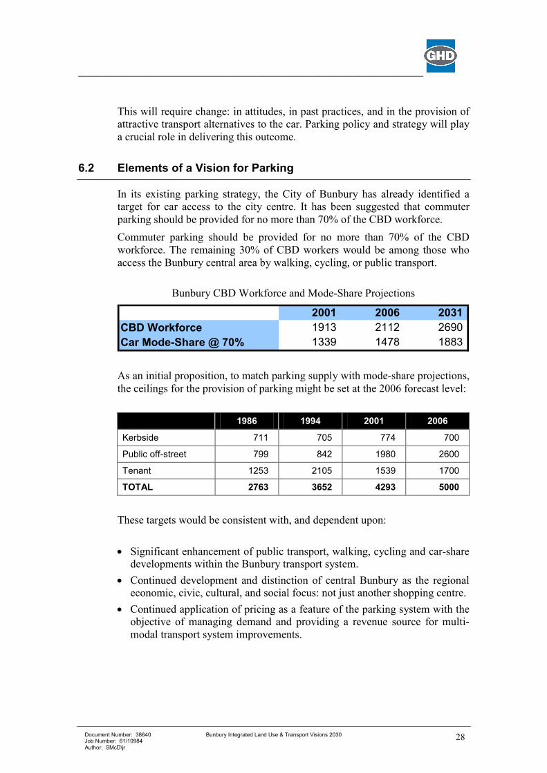
6.2 Elements of a Vision for Parking
In its existing parking strategy, the City of Bunbury has already identified a
target for car access to the city centre. It has been suggested that commuter
parking should be provided for no more than 70% of the CBD workforce.
Commuter parking should be provided for no more than 70% of the CBD
workforce. The remaining 30% of CBD workers would be among those who
access the Bunbury central area by walking, cycling, or public transport.
Bunbury CBD Workforce and Mode-Share Projections
2001 2006 2031
CBD Workforce 1913 2112 2690
Car Mode-Share @ 70% 1339 1478 1883
As an initial proposition, to match parking supply with mode-share projections,
the ceilings for the provision of parking might be set at the 2006 forecast level:
1986 1994 2001 2006
Kerbside 711 705 774 700
Public off-street 799 842 1980 2600
Tenant 1253 2105 1539 1700
TOTAL 2763 3652 4293 5000
These targets would be consistent with, and dependent upon:
• Significant enhancement of public transport, walking, cycling and car-share
developments within the Bunbury transport system.
• Continued development and distinction of central Bunbury as the regional
economic, civic, cultural, and social focus: not just another shopping centre.
• Continued application of pricing as a feature of the parking system with the
objective of managing demand and providing a revenue source for multi-
modal transport system improvements.
___________________________________________________________________________
Document Number: 38640 Job Number: 61/10984 Author: SMcD\jr
Bunbury Integrated Land Use & Transport Visions 2030
29
6.3 A Strategy for Parking
The following parking system strategies, and actions, have been proposed and
a works program has been developed to facilitate implementation. (Refer to
Section 9).
STRATEGY 4.1 – PHASED INTRODUCTION OF, OR INCREASE IN, PARKING FEES.
STRATEGY 4.2 – ALLOCATE PARKING REVENUES TO ENHANCE
ACCESSIBILITY.
STRATEGY 4.3 – ADOPT A PARKING SUPPLY CEILING OF 5,000 BAYS FOR CENTRAL BUNBURY.
STRATEGY 4.4 – PLAN FOR QUALITY MULTI-STOREY PARKING
FACILITIES IN THE FOUR QUADRANTS OF THE
BUNBURY CBD.
STRATEGY 4.5 – PROMOTE SHARED (RECIPROCAL) PARKING
ARRANGEMENTS.
STRATEGY 4.6 – CASH-IN-LIEU PARKING PROVISIONS.
STRATEGY 4.7 – INCREASE THE AMOUNT OF PARKING PROVIDED
FOR PEOPLE WITH DISABILITIES.
STRATEGY 4.8 – REVIEW TIME-RESTRICTIONS FOR KERB-SIDE
PARKING AND RATIONALISE KERB-SIDE PARKING
PROVISION IN SELECTED EAST-WEST CBD STREET.
STRATEGY 4.9 – ADOPT APPROPRIATE SEGREGATION OF SHORT
AND LONG STAY PARKING AREAS.
STRATEGY 4.10 – INTRODUCE PARK & RIDE FACILITIES.
STRATEGY 4.11 – PROMOTE HIGH-OCCUPANCY VEHICLES BY
PROVIDING THEM WITH PREFERENTIAL
TREATMENT.
___________________________________________________________________________
Document Number: 38640 Job Number: 61/10984 Author: SMcD\jr
Bunbury Integrated Land Use & Transport Visions 2030
30
STRATEGY 4.12 – COORDINATE THE PROVISION OF PUBLIC
TRANSPORT SERVICES & PARKING FACILITIES, INCLUDING THE INTRODUCTION OF A BUS SERVICE
FREE TRANSIT ZONE (FTZ) BASED ON EITHER A
CENTRAL AREA TRANSIT (CAT) SERVICE, IF THIS
PROVES VIABLE, OR THE RE-ORIENTATION OF
EXISTING BUS SERVICES TO LINK THE CITY
CENTRE WITH COMMUTER CAR PARKS ON THE
PERIPHERY OF THE CBD.
STRATEGY 4.13 – TRANSPORT IMPACT AND MANAGEMENT PLANS.
STRATEGY 4.14 – MAKE PAYING FOR PARKING EASIER.
STRATEGY 4.15 – INTRODUCE A PARKING INFORMATION & GUIDANCE
SYSTEM.
STRATEGY 4.16 – PREVENT OVERSPILL PARKING & INTRODUCE
RESIDENTS’ PARKING PERMITS.
STRATEGY 4.17 – ENHANCE CAR PARK DESIGN AND INTEGRATION.
Actions to achieve these strategies include:
• In the medium to longer term, and in today’s dollar values, it is
recommended that the following parking fee regime be introduced:
− All-day parking fees should be maintained, at least, a level comparable
with a return bus fare to the city but this should be done as part of an
integrated approach to CBD parking and access in which high-quality,
multi-deck parking facilities are established at the “quadrants” of the
CBD, with free commuter parking peripheral to the CBD, and the
operation of a bus service Free Transit Zone (FTZ) within a radius of
approximately 1 kilometre of the city centre.
• Time restrictions and enforcement should suffice as the basis for managing
on-street parking.
• The existing regime of on-street parking time restrictions, and the location
of on-street parking facilities, should be reviewed to ensure that on-street
parking provides an adequate amount and turn-over of bays to meet the
CBD’s needs. However, in the short-term, the existing kerb-side parking
time restrictions function adequately and should be retained.
• Selective changes to on-street parking arrangements should be considered
for introduction in both Victoria Street and nearby east-west oriented CBD
___________________________________________________________________________
Document Number: 38640 Job Number: 61/10984 Author: SMcD\jr
Bunbury Integrated Land Use & Transport Visions 2030
31
streets. The following changes to on-street parking provision, and CBD
streets and traffic movement, are proposed:
- Victoria Street – improvements to pedestrian environment and provision
of parking for buses, taxis, and vehicle drop-off / pick-up only;
- Eliot Street (Wittenoom Street to Victoria Street) – alter footpath and
traffic lanes to increase the availability of on-street bays for short-stay
visitors to the city;
- Prinsep Street (Wittenoom Street to Haley Street) – alter footpath and
traffic lanes to increase the availability of on-street bays for short-stay
visitors to the city;
- Stephen Street (Wittenoom Street to Arthur Street) – alter footpath and
traffic lanes to increase the availability of on-street bays for short-stay
visitors to the city
- Any works in Stephen Street and Prinsep Streets have due regard to the
Civic Precinct and Administrative Centre;
• The overall effect of the proposed changes to kerb-side parking
arrangements will be to:
- Remove some parking from Victoria Street to permit an upgrading of this
CBD spine to favour pedestrians, public transport, city service activities,
and drop-off / pick-up requirements;
- Provide up to 100 additional short-stay, kerb-side parking bays in
convenient locations in east-west city streets adjacent to the commercial
core.
• Revenues accruing to the City of Bunbury from its parking activities could
be used by the City for any purpose that would improve access to, and
within, the City of Bunbury.
• A parking supply target for central Bunbury should be adopted as an
integral component of a coordinated city accessibility strategy. For a target
year of 2006, the parking supply could be dissected as follows:
Kerb-side bays 800
Public, off-street bays 2,600
Tenant bays 1,600
Total bays 5,000
• The existing Bunbury Parking Strategy requirement for the annual average
occupancy threshold not to exceed 80% of parking capacity should be
removed, as it may impose a tendency for the over-supply of parking.
• The provision of multi-storey car parks within each of the four CBD
quadrants is proposed to a maximum height of four levels. By locating a
multi-deck parking facility in each of the CBD quadrants, the existing
___________________________________________________________________________
Document Number: 38640 Job Number: 61/10984 Author: SMcD\jr
Bunbury Integrated Land Use & Transport Visions 2030
32
spatial imbalance in the provision of parking capacity for the public would
be redressed.
• The recommended locations for establishment and/or expansion of parking
facilities to provide multi-deck parking are as follows:
− No. 1 Blair Street Car Park
− No.2 (Souths) Car Park
− Entertainment Centre Car Park
− North West Quadrant (at a site to be determined over a 10-year horizon)
− The existing restrictions on the maximum amount of required parking
for which a cash-in-lieu contribution continue.
• Increase the existing 2 on-street parking bays for people with disabilities to
at least 6 on-street bays within the CBD.
• The Bunbury city area is currently divided into two parking policy zones: an
Inner Core and an Outer Core. It may be strategically adequate to simply
identify a “pedestrian priority zone” in which public commuter parking
would not be permitted.
• Alternatively, because tenant commuter parking already permeates the CBD
core, it may be reasonable to consider the option to “vertically zone”
commuter and short-stay parking so that multi-deck public car parks
allocate the lower levels to shopper parking and confine commuter parking
to the upper car park levels.
• Prospective, general locations for the introduction of park & ride facilities
include sites in the vicinity of:
− Australind
− Proposed East Australind District Centre
− Proposed Eaton Shopping Centre
− Dalyellup.
These general locations should be further discussed with the appropriate
Shire Councils to confirm their concurrence and to determine the details of
appropriate siting for Park & Ride facilities when they are being planned.
• The Parking Strategy should embrace a range of incentives to promote
higher private vehicle occupancy, including, for example, the following
preferential treatments for high occupancy vehicles:
− Reduced parking fees,
− Preferred parking locations within car parks,
− The potential to reserve a parking space in a car park,
− Eligibility for a variety of cost-free, or subsidised, services which may
be provided regularly or periodically, such as car washing,
___________________________________________________________________________
Document Number: 38640 Job Number: 61/10984 Author: SMcD\jr
Bunbury Integrated Land Use & Transport Visions 2030
33
− Other incentives and benefits that may be appropriate to encourage
higher vehicle occupancy.
• If a proposal to implement a Central Area Transit (CAT) system proceeds in
the Bunbury central city area, the route should provide a connection
between commuter car parks on the periphery of the CBD with final
destinations within the CBD.
• Should a CAT system prove to be non-viable, regular Bunbury City Transit
bus routes should be altered, where necessary, to ensure that commuter car
parks are linked with the city “pedestrian priority zone” through the
operation of a Free Transit Zone (FTZ) within a radius of approximately 1
kilometre of the city centre.
• To provide an option for CBD accessibility to be provided with minimal
parking requirements, new developments, and major redevelopments,
should be required to furnish an accessibility plan.
• The payment of parking fees can be made easier for motorists through the
application of developing technologies for payment using Smart Card
technologies. Smart Card technologies should also be linked to other
systems, for example, payment of public transport fares.
• Effective signage and direction for motorists can improve the efficiency of
parking system operations. Recommendations include signage to distinguish
parking facilities for different types of parkers.
• In the longer term, it may be appropriate to introduce real-time parking
availability signs at key locations approaching the CBD.
• A resident’s parking permit scheme should be developed and implemented
at an appropriate time to deter long-stay, commuter parking on city streets
in proximity to the CBD core.
• The scale and physical design of off-street car parks should be compatible
with and, as far as is practicable, enhance the area in which the car park is
located.
• Opportunities should be strongly encouraged to integrate non-parking land
uses and activities within car park structures, especially at street level.
An integral component of the Bunbury Parking Strategy and recommendations
includes the need for enhanced policing and enforcement of elements of the
parking strategy to ensure that objectives are attained.
___________________________________________________________________________
Document Number: 38640 Job Number: 61/10984 Author: SMcD\jr
Bunbury Integrated Land Use & Transport Visions 2030
34
7. A “Vision” for Land Use and Integration
Transport in the city must be considered in relation to the developing land use,
community aspirations and environmental requirements. This strategy has been
developed to be consistent with the City’s strategic planning and regional
planning.
The City of Bunbury has adopted a land use structure based on the recently
adopted City of Bunbury Housing and Commercial Strategies. A land use and
transport vision has been developed incorporating the Housing and
Commercial Strategies, and other land uses, and is summarised on Map 1,
Appendix A.
7.1 Regional Integration
The City is not an island and cannot be considered in isolation of the
surrounding region, which it supports. Regional planning has reached a stage
where most regional transport requirements are protected and projects are
being planned to occur over several years into the future. These projects will
ensure that regional transport demands are met and the City will not be
unreasonably affected.
Major components of regional transport include:
• the Outer Ring Road (Bunbury Highway) - providing a bypass to Robertson
Dve and greater separation from urban areas,
• Port Access Road - providing a high standard freight route to the Port,
• Bunbury Port expansion - to provide for additional shipping capacity,
• new rail alignments to service the expanded port - including a line along the
Port Access Road Corridor.
Several key issues remain to be resolved are outside the scope of the vision for
the City itself, including:
• a high speed rail link to Perth which has been investigated previously with
no agreement on progress,
• relocation of the Bunbury Airport - to allow development of airport land,
expansion of the airport for higher standard services and possibly including
integration with rail,
• release of the Outer Harbour area for other uses (see below), although the
Port of Bunbury has no plans for such a change,
• regional rail services - to the south (Busselton, Margaret River, etc), and to
the south east (Donnybrook, Manjimup, etc.)
___________________________________________________________________________
Document Number: 38640 Job Number: 61/10984 Author: SMcD\jr
Bunbury Integrated Land Use & Transport Visions 2030
35
These regional transport components are included where appropriate on the
Transport Vision Maps. Map 8 separately identifies the regional transport
infrastructure, planning and linkages. These links generally provide:
• connections to other regional towns and the surrounding developing areas,
• bypasses for traffic not accessing the City,
• high standard road and rail freight routes, especially to access the port.
7.2 Commercial Strategy
A Vision for the Strategy was formulated as follows –
To promote and enhance the Bunbury Central Business District as the
prime retail, office, administration, entertainment, governance and civic
centre for the City of Bunbury, the Greater Bunbury Region and the
overall South West Region.
To facilitate and improve the function and development of Bunbury
Centre Business District and the Bunbury Regional centre as the
Regional Centre for the overall South West Region with provision of high
order Central Business District and Mixed Business uses and facilities.
To facilitate the Vision and Strategic Directions as defined in the current
City of Bunbury Strategic Plan and achieve the City’s goal of being the
most progressive and innovative regional City in Australia enhancing the
quality of life of its community and promoting its nautical heritage.
The retail hierarchy recommended for the City of Bunbury is as follows:
• Bunbury Regional Centre.
• Neighbourhood Centres.
• Local Centres and corner shops.
Specific recommendations are made for the Bunbury Regional Centre, the
CBD, Neighbourhood and Local Centres, the Mixed Business Area, Low Key
Businesses in Residential Areas and Interface with Residential Areas as
follows.
The Bunbury Regional Centre
The Bunbury Regional Centre, including the Bunbury CBD and the Sandridge
Park (Bunbury Forum) shopping centre, including the mixed areas on both
sides of Blair and Spencer Streets, is the highest order commercial complex
within the Bunbury-Wellington Region. It is proposed that this area remain the
focus of region-serving commercial and community activity in the future.
It is recommended that an overall plan for the Bunbury Regional Centre be
prepared.
___________________________________________________________________________
Document Number: 38640 Job Number: 61/10984 Author: SMcD\jr
Bunbury Integrated Land Use & Transport Visions 2030
36
The Regional Centre has several components, each with its own character and
role, but each contributing to the whole. The main structural components of
the Regional Centre are discussed below and include:
• The Central Business District (CBD).
• The Mixed Business area.
• Bunbury Forum Shopping Centre.
The CBD
The Bunbury Central Business District is a distinctive area, which forms the
northern pole of the Bunbury Regional Centre. The CBD is planned to remain
the dominant commercial focus in Bunbury.
The CBD will also become a focal point for higher density residential
development, such as R100+ or RIC (inner city). The unique nature of the
Bunbury CBD located on a peninsular provides opportunities for development
which has access to water views in most directions. Given the accepted nature
of higher buildings in the CBD, this should remain the primary and sole centre
and location for high rise development.
Retail activity is to be further encouraged and consolidated. This is occurring
through the deliberate actions of the City of Bunbury. It is also proposed to
encourage more intensive mixed commercial and entertainment development in
the northern areas of the CBD, supported by the medium density residential
and waterfront tourism developments.
A key issue is the need to revitalise the CBD and address parking problems and
accessibility.
A Revitalisation Plan for the Bunbury CBD should be prepared, taking account
not only of the recommendations of this Strategy, but all other current
strategies and townscape studies as well.
Neighbourhood Centres
The following Neighbourhood Centres are proposed:
• Bunbury City Plaza.
• Withers.
• Crosslands.
• Parade (Leschenault Quays).
• Glen Iris (future development).
• Usher (future development).
• Ocean Drive / William Street (future development currently site of licensed
restaurant operating as a tavern)
___________________________________________________________________________
Document Number: 38640 Job Number: 61/10984 Author: SMcD\jr
Bunbury Integrated Land Use & Transport Visions 2030
37
Local Centres
Local centres are intended as commercial and community foci, but of a more
localised nature than in neighbourhood centres. The designated Local Centres
are:
• Wollaston.
• Carey Park.
• Frankel Street.
• Beach Road.
• Mossop Street.
• College Grove (future development).
• Pelican Point (future development).
• Ocean Dr / Washington Ave (future development - site identified as part of
the land rationalisation program)
• Glen Iris (future development).
Mixed Business Areas
The Mixed Business classification will allow a broad range of commercial
activities, though it is anticipated that the area will ideally suit showrooms and
other forms of large development, which require a strategic location, but find it
impractical or uneconomic to locate within the CBD. Service and light
industrial activities will still be accommodated in the area, should they wish.
“Mixed Business” activities should be confined wherever possible to the CBD
and the single large Mixed Business Area identified in the Regional Centre.
Areas suitable for possible future expansion of the Mixed Business Area are
identified. These areas logically could provide for a rounding off of the Mixed
Business Area. These areas should be subject to further analysis in the future
after consideration of the amount of land and floorspace available in the Mixed
Business Area.
Parts of the mixed business area have narrow streets. As part of any
development, these roads should be widened and contributions gained towards
upgrading.
A proposal integrating the caravan park to the north (including Lots 1 and 2
Adam Road and Lots 28408 and 23839 Bussell Highway), Hay Park to the
south and Crosslands shopping centre has preliminary support and as such
should be considered for further investigation. The Forest Drive-In site has
potential to create a node of mixed development complementary to the
Crosslands Shopping Centre.
The Commercial Strategy provides for home-based businesses and home
offices in appropriate locations such as around shopping centres.
___________________________________________________________________________
Document Number: 38640 Job Number: 61/10984 Author: SMcD\jr
Bunbury Integrated Land Use & Transport Visions 2030
38
7.3 Housing Strategy
A Vision for the Strategy was formulated as follows –
To facilitate and encourage the provision and development of a
significant variety of housing choice, types, styles and opportunities
throughout the City of Bunbury and provide a high standard of
residential amenity and facilities for the benefit of the residents of the
City.
To facilitate the Vision and Strategic Directions as defined in the current
City of Bunbury Strategic Plan and achieve the City’s goal of being the
most progressive and innovative regional City in Australia enhancing the
quality of life of its community and promoting its nautical heritage.
The base density should be R20 (i.e. up to 20 dwelling units per hectare),
however in order to facilitate development variability, lower coding should be
provided in the areas between the urban village centres.
Immediately surrounding (eg adjacent land holding and streets) around existing
and proposed shopping centres is identified for the provision of a “Residential
Frame” zone, which permit R40/60 medium density and would allow the
discretionary placement of non-residential uses as per existing local planning
policy; medium densities R40 would be permitted in the area surrounding (out
to 300 –400 m) the “Residential Frame” zone.
All non-residential uses, except for low impact uses (i.e. bed and breakfast,
home office, etc.) are not to be permitted in the Residential Zone.
Non-residential uses currently defined as discretionary in the current TPS7 will
be encouraged in the proposed “Residential Frame” zone in recognition that
these precincts form a focal point for the urban village nodes and will be
serviced by a superior level of public transport and public paths.
Areas close to the CBD and Bunbury Forum are also identified as suitable for
up to medium densities (R30), as are areas in close proximity to the Beach to
the west of the ridge and within 100-200 metres of the Beach.
Nodes of development along Back Beach are identified as being suitable for
medium and high density residential development and development of tourist
accommodation and facilities.
Redevelopment and higher densities should be focussed on the CBD and
Bunbury Forum. Higher densities (up to R100) and mixed-use developments
should be encouraged in the CBD and R60 densities in the surrounding area
(up to 800 metres of the CBD).
New sites such as part of the Forest Drive-In site are identified as potential R40
and areas for potential for re-subdivision such as the Special Residential area
next to the racecourse have potential for densities to R20. This should only be
pursued after extensive consultation with landowners in the area.
Combining the City of Bunbury Housing and Commercial Strategies includes
concentrating intensive land uses and residential populations in nodes of
activities such as the Central Business District, around shopping centres and
___________________________________________________________________________
Document Number: 38640 Job Number: 61/10984 Author: SMcD\jr
Bunbury Integrated Land Use & Transport Visions 2030
39
neighbourhood centres and along public transport routes. A proposed plan is
shown overleaf.
It also involves optimising opportunities for walking and cycling to local
services and facilities at Community/Neighbourhood Nodes. Walkable
catchments of 400m radius were used to identify locations for
Community/Neighbourhood Activity Nodes, in accordance with the Liveable
Neighbourhood (Community Codes).
Planning for future land use should include:
• Creating a hierarchy of retail centres with localised convenience retailing
provided locally.
• Associated local community facilities such as child care centres provided
locally in central and walkable locations.
• Home based businesses and offices in centralised locations.
• Higher densities to add vitality and take advantage of
community/neighbourhood nodes and along public transport routes.
• High densities in an around the central business district to take advantage of
the mix of land uses.
• Mixed-use developments in appropriate locations such as
neighbourhood/community centres along public transport routes and in the
central business district.
It should be noted that the City of Bunbury Housing and Commercial
Strategies are prepared for the short to medium term and as such are envisaged
to be implemented for 5-10 years based on a 30-year direction to ensure
consistency with the Transport Vision.
7.4 A Strategy for the Integration of Transport and Land Use
Strategies for the integration of Transport and Land Use are identified as
follows:
STRATEGY 5.1 – ENSURE LAND USE SUPPORTS PUBLIC
TRANSPORT THROUGH DEVELOPMENT AROUND
PUBLIC TRANSPORT ROUTES.
STRATEGY 5.2 – ENSURE LAND USE SUPPORTS WALKING AND
CYCLING THROUGH MIXED USE DEVELOPMENT, SAFE ROUTES AND ATTRACTIVE PRECINCTS FOR
ACTIVITIES.
STRATEGY 5.3 – ENSURE NEW DEVELOPMENTS INCLUDE FACILITIES
FOR CYCLING AND FOR PEOPLE WITH DISABILITIES.
___________________________________________________________________________
Document Number: 38640 Job Number: 61/10984 Author: SMcD\jr
Bunbury Integrated Land Use & Transport Visions 2030
40
STRATEGY 5.4 – ENCOURAGE LOCAL EMPLOYMENT, BUSINESS AND
LEISURE ACTIVITIES IN THE CITY.
STRATEGY 5.5 – FACILITATE INTEGRATION OF LAND USE AND
TRANSPORT PLANNING.
STRATEGY 5.7 – THE MANY AGENCIES, ORGANISATIONS AND
INDIVIDUALS SHOULD WORK TOGETHER CO-OPERATIVELY TO ENSURE A BALANCED
TRANSPORT SYSTEM IS PROVIDED.
STRATEGY 5.8 – EMPLOY ADDITIONAL FINANCIAL ARRANGEMENTS
TO PROVIDE FOR FUTURE WORKS TO MEET
TRANSPORT REQUIREMENTS.
Actions to achieve these strategies are partly developed and described in the
Housing and Commercial Strategy and include:
• Review Town Planning Scheme No. 7 to incorporate the City of Bunbury
Commercial and Housing Strategies
• Prepare a policy for the Mixed Business zone which:
− Describes the desired form and character of the area,
− Co-ordinates and better regulates signs, lighting, flags, bunting and the
like,
− Facilitates the planting of street trees,
− Ensures adequate and appropriate landscaping,
− Ensures new development fronting Blair Street actually addressed the
street and is of a character which supports the Boulevard concept,
− Controls access points to commercial properties on Blair and Spencer
Streets through service roads,
− Stringently contains mixed business uses within the bounds of the zone.
• Prepare a policy for each Neighbourhood and Local Centre which defines:
− The desirable upper limit to the retail floor space to be permitted in each
centre,
− The required car parking for the retail area,
− Which community or other business uses are desirable in or near the
centre,
− Public transport services,
− Desirable landscaping treatments and other means of visual
improvement.
___________________________________________________________________________
Document Number: 38640 Job Number: 61/10984 Author: SMcD\jr
Bunbury Integrated Land Use & Transport Visions 2030
41
• Prepare a Structure Plan for the Regional Centre Area incorporating the
following principles:
− Emphasis and confirmation of the CBD at its present location,
− Emphasis of the two major retail poles within the Regional Centre,
− Identification of the large Mixed Business area comprising existing
commercial and light industrial zoned areas,
− Emphasis of the importance of Blair, Spencer and Strickland Streets, and
Koombana Drive,
− Major vehicular circulation system,
− A proposed primary pedestrian and cycle system,
− Landscape improvements,
− Signage theme and controls,
− Residential areas within which medium/high density development might
be encouraged over time, with particular emphasis on the area to the
immediate north of the CBD.
• Prepare a Revitalisation Plan for the CBD.
• Council identify precincts with high concentrations of buildings included on
the Municipal Inventory.
• Council identify nodes for high/medium density development and Tourist
accommodation and facilities along the beachfront area.
• Council adopt the “Development In Heritage Precincts Policy”.
• Council adopt the “Guidelines For Medium Density Infill Development”.
• Council adopt the Precinct Policies.
• Council amend Town Planning Scheme No. 7 to –
− Include the Housing Strategy as a “Current Policy of the Scheme” in
Schedule B,
− Include in Schedule 8 the “Guidelines For Medium Density Infill
Development”,
− Include in Schedule 8 the “Development In Heritage Precincts Policy”,
− Require for the “Development Zone – Residential” and “Development
Investigation Policies Areas” that structure planning provide for -
− R20 base coding.
− Compliance with the Community Codes,
− Medium Density (R40) around neighbourhood centres,
• Council liaise with the Ministry for Housing and Works with respect to
providing housing for groups with special needs.
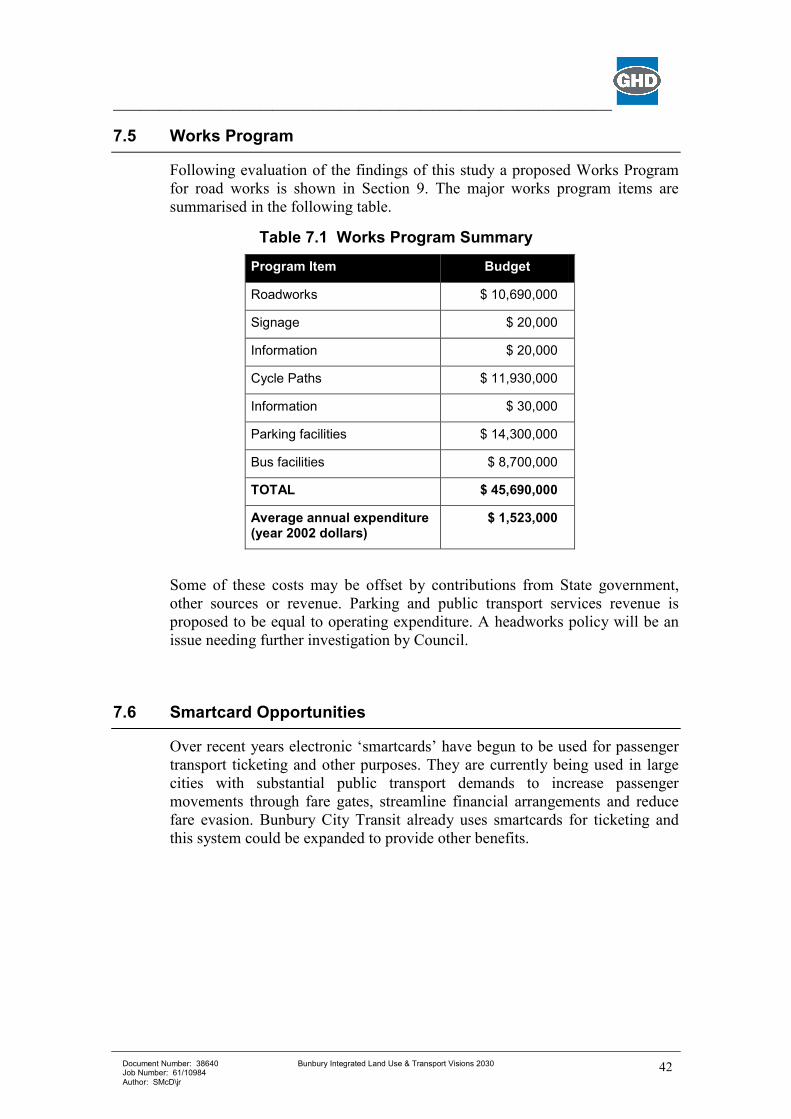
___________________________________________________________________________
Document Number: 38640 Job Number: 61/10984 Author: SMcD\jr
Bunbury Integrated Land Use & Transport Visions 2030
42
7.5 Works Program
Following evaluation of the findings of this study a proposed Works Program
for road works is shown in Section 9. The major works program items are
summarised in the following table.
Table 7.1 Works Program Summary
Program Item Budget
Roadworks $ 10,690,000
Signage $ 20,000
Information $ 20,000
Cycle Paths $ 11,930,000
Information $ 30,000
Parking facilities $ 14,300,000
Bus facilities $ 8,700,000
TOTAL $ 45,690,000
Average annual expenditure (year 2002 dollars)
$ 1,523,000
Some of these costs may be offset by contributions from State government,
other sources or revenue. Parking and public transport services revenue is
proposed to be equal to operating expenditure. A headworks policy will be an
issue needing further investigation by Council.
7.6 Smartcard Opportunities
Over recent years electronic ‘smartcards’ have begun to be used for passenger
transport ticketing and other purposes. They are currently being used in large
cities with substantial public transport demands to increase passenger
movements through fare gates, streamline financial arrangements and reduce
fare evasion. Bunbury City Transit already uses smartcards for ticketing and
this system could be expanded to provide other benefits.
___________________________________________________________________________
Document Number: 38640 Job Number: 61/10984 Author: SMcD\jr
Bunbury Integrated Land Use & Transport Visions 2030
43
Smartcards are available in several styles, but their primary functions are:
• to store the value of money prepurchased and recorded on the card
electronically, and
• to identify an individual.
In addition to the current public transport use, smartcards could be used for:
• parking machines to identify City of Bunbury residents and to pay for
parking,
• to provide entrance to the City waste disposal site, with a certain number
of allowed entries,
• for identification at the City libraries or other Council facilities,
• student identification at the TAFE and Edith Cowan University facilities
and for photocopying.
Many other stored value or identification purposes are possible. Several types
of use are possible with one card system allowing overlap of use while
minimising system costs.
The card could be provided as part of the annual Council rates program. The
recognised advantages of smartcards could be greater for the City of Bunbury
than other locations. For instance:
• a certain number of free bus trips could be provided on a card provided to
every house as part of the ‘GO BUNBURY’ program to encourage the
use of public transport,
• fees at parking stations could be reduced for City residents if they are
using the smartcard, or
• entry fees to council facilities could be reduced for residents (such as to
the Hay Park recreation centre), and entry could be automated (no
waiting for Bunbury users and reduced staff costs for the City),
• fines for overdue books could be debited when additional books are to be
borrowed.
Promoters of smartcards suggest many other uses including a general ‘purse’
for vending machines. The use of such cards is very wide and is dependent on
the requirements of the location where they are to be deployed. Critical issues
include
• the costs of deployment (cards, machines to load the values, and readers
in sites), and
• ‘business rules’ (including financial transactions, security, consequences
of lost or stolen cards, etc and contributions from various users).
Almost all smartcard systems have required a financial institution to be a major
equity partner.
___________________________________________________________________________
Document Number: 38640 Job Number: 61/10984 Author: SMcD\jr
Bunbury Integrated Land Use & Transport Visions 2030
44
To achieve this potential it is proposed that:
• The City of Bunbury investigates the use of smartcards for a variety of
transport and access purposes.
___________________________________________________________________________
Document Number: 38640 Job Number: 61/10984 Author: SMcD\jr
Bunbury Integrated Land Use & Transport Visions 2030
45
8. Getting It Done
This vision describes that transport is complex, so improving it requires many
diverse actions working together. Only by making many small separate
changes, over a long period of time, can the whole of transport be improved
significantly.
Improving transport in Bunbury will require contributions from many
individuals and organisations. Everyone must understand and accept their
responsibility, and play their part. The Council, the State government and
transport users must all make contributions, and even sacrifices in some cases.
Everyone in Bunbury will benefit from transport improvements, although some
people will suffer minor disadvantages.
The Action Plan in the Appendix summarise the actions, together with the
responsible agencies, indicative costs and approximate timing. This plan is to
be used to guide transport improvements and to check progress over the
coming years.
___________________________________________________________________________
Document Number: 38640 Job Number: 61/10984 Author: SMcD\jr
Bunbury Integrated Land Use & Transport Visions 2030
46
9. How Did We Get To This Strategy?
The study was led by Council through a Steering Committee with the major
technical tasks being undertaken by a team of consultants. The consultants
worked closely with the public, Council, government agencies and other
important stakeholders.
The City of Bunbury ensured that there were frequent opportunities for local
people to participate in the development of Bunbury Transport Vision 2030.
The community were involved through workshops, media information, an
Internet Web Page, questionnaires, focus group discussions, public displays
and other contacts.
Public comments and community survey results in relation to the advertised
Bunbury Integrated Land Use and Transport Vision 2030 have also been
considered. This Final Strategy report includes Council’s approved variations.
Several key issues were investigated during the course of the study. These were
investigated and developed the close participation of working groups which
covered specific areas including:
• Traffic Modelling.
• Transport Routes.
• Car Parking.
• Pedestrian and Cycling Networks.
• Public Transport.
• Public Consultation.
___________________________________________________________________________
Document Number: 38640 Job Number: 61/10984 Author: SMcD\jr
Bunbury Integrated Land Use & Transport Visions 2030
47
Appendix A
Maps
See Separate Document
____________________________________________________________________________
Document Number: 38640 Job Number: 61/10984 Author: SMcD\jr
Transport Strategy