Embed Size (px)
Citation preview
Bull Trout Studies in the Salmo RiverWatershed: 2001
Report Prepared For:
BC HydroKootenay Generation Area
601 18th StreetCastlegar, B.C.
V1N 4A2
Report Prepared By:
James BaxterBaxter Environmental
209 Second StreetNelson, B.C.
V1L 2K9
February 2002
ii
EXECUTIVE SUMMARY
This report summarizes the results of bull trout monitoring in the Salmo River watershedin 2001 by BC Hydro. Work conducted in 2001 included index swims and spawner andredd counts. In total, one initial watershed wide survey and six index section surveyswere conducted. Bull trout were present in high densities in early summer within thesurveyed section, but had begun their upstream spawning migrations by the end of July.In total, 28 redds and 92 spawners were enumerated in 2001. As previously documented,bull trout spawners and redds were observed in Sheep Creek, Clearwater Creek and theupper section of the Salmo River. We also observed mature bull trout and redds inStagleap Creek and the South Salmo River. Sheep Creek was the area of the highestconcentration of spawning activity, followed by the upper Salmo River, ClearwaterCreek, and the South Salmo River watershed. In general, the swimming observer sawmore bull trout and redds than the bank observer in all streams that were surveyed.These differences were significant for both fish (P<0.001) and redds (P=0.003).
iii
ACKNOWLEDGEMENTS
Field and technical support during this work was provided by a number of individualswho insured the project’s success: BC Hydro: Gary Birch, Ric Olmsted, Dave Wilson,Dean den Biesen, Clint Tarala; BC Ministry of Water, Land and Air Protection: JohnBell, Jay Hammond, Bob Lindsay, Colin Spence, Albert Chirico; Columbia-KootenayFisheries Renewal Partnership: Kenton Andreashuk, Bill Green; BaxterEnvironmental: Jeremy Baxter, Robyn Roome, John Hagen, Scott Decker; SalmoWatershed Streamkeepers Society: Gerry and Alice Nellestijn, Brian Henderson, theMaloney family.
iv
TABLE OF CONTENTS
EXECUTIVE SUMMARY ................................................................................................................... iiACKNOWLEDGEMENTS.................................................................................................................. iiiTABLE OF CONTENTS .......................................................................................................................ivLIST OF TABLES ....................................................................................................................................vLIST OF FIGURES .................................................................................................................................viLIST OF APPENDICES....................................................................................................................... vii
INTRODUCTION.....................................................................................................................................1
STUDY AREA AND BACKGROUND.............................................................................................2
METHODS..................................................................................................................................................4Snorkel Surveys .....................................................................................................................................4Redd Counts ............................................................................................................................................4
RESULTS ....................................................................................................................................................5Snorkel Surveys .................................................................................................................................5Redd Counts ........................................................................................................................................6
DISCUSSION.............................................................................................................................................8
REFERENCES.........................................................................................................................................10
v
LIST OF TABLES
Table 1. Summary of geographic information for the Salmo River study area. ...............2
Table 2. Summary of the number of fish species observed during snorkel surveys in theSalmo River in 2001......................................................................................................5
Table 3. Sightability estimates, and expanded counts of bull trout during snorkelsurveys in the Salmo River in 2001 (using previously radio tagged fish). ...................5
Table 4. Summary of the total number of bull trout and redds observed in the SalmoRiver watershed in 2001................................................................................................6
Table 5. Summary of differences in the number of bull trout and redds observed in theSalmo River watershed by a bank observer and swim observer in 2001 (SC=SheepCreek, S=Salmo River, CC=Clearwater Creek, SS=South Salmo River).....................7

vi
LIST OF FIGURES
Figure 1. The Salmo River watershed study area. ..............................................................3
Figure 2. The number of bull trout redds constructed at three sites within the SalmoRiver watershed over the past five years.......................................................................8

vii
LIST OF APPENDICES
Appendix I. Summary data from bull trout redd counts conducted in the Salmo Riverwatershed in 2001.
1
INTRODUCTION
BC Hydro has taken a proactive role in monitoring the bull trout (Salvelinus confluentus)population of the Salmo River watershed over the past five years in response to facilityupgrades at the Seven Mile Dam (see Baxter et al. 1998; Baxter 1999; Baxter andNellestijn 2000; Baxter 2001a; Baxter 2001b). Over the past four years, the projects(focussing on bull trout) that BC Hydro has undertaken, or provided funding for, haveincluded:
• juvenile density and distribution studies through electroshocking;• water temperature and water chemistry monitoring;• adult abundance monitoring through snorkel surveys;• adult escapement monitoring through redd counts; and• identification of adult movement, life-history and spawning sites through radio
telemetry.
In 2001, BC Hydro continued studies in the watershed, specifically focussing onmonitoring the abundance of adult bull trout in the drainage and contributing to anongoing bull trout radio telemetry project. The specific objectives of the work in 2001were to:
• conduct adult abundance surveys (snorkel surveys, and redd surveys) to monitor thestatus of the spawning population of bull trout in the watershed; and
• contribute funding towards aerial tracking flights of radio tagged bull trout in thewatershed.
This report summarizes the results of the adult abundance surveys, while the third year ofradio tracking results will be summarized in a separate report.
2
STUDY AREA AND BACKGROUND
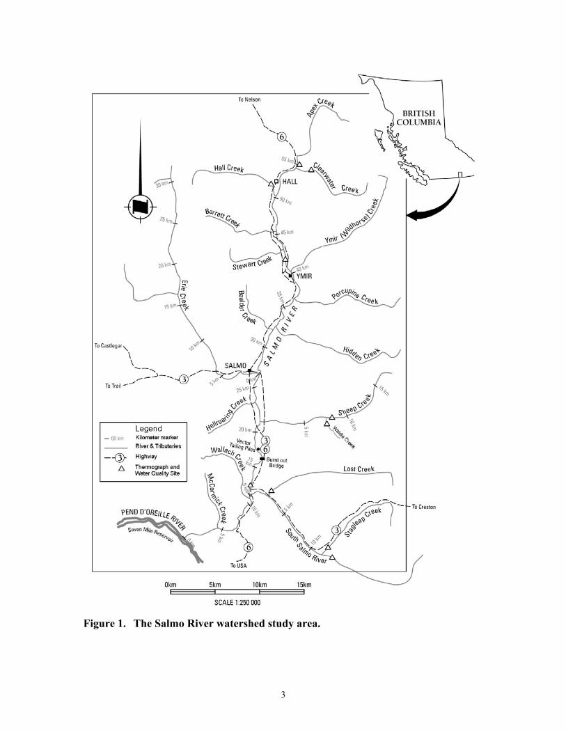
The Salmo River rises from the Selkirk Mountains 12 km southeast of Nelson, B.C.(Figure 1). The river flows in a southerly direction for approximately 60 km from itsorigin to the confluence with the Pend d’Oreille River (Seven Mile Reservoir).Geographic information is summarized in Table 1. The system is a 5th order stream, andhas a total drainage basin area of roughly 123,000 ha.
Table 1. Summary of geographic information for the Salmo River study area.
Gazetted Name Stream Length (km) Area (ha)Salmo River 60 123,000
Geographic InformationApproximate distance and direction to the nearest
town, city or landmark12 km southeast of Nelson, B.C.
MELP Region 4MELP Management Unit 4-8
DFO District Interior South East (#30)Ministry of Forests Region NelsonMinistry of Forests District Kootenay LakeNTS Base Map Reference 82 F/3 and 82 F/6
Elevation in the basin ranges from 564 meters at its confluence to 2,343 meters at theheight of land. Within this elevation range, the system comprises two biogeoclimaticzones (Braumandl and Curran 1992). At lower elevations, the valley lies within theInterior Cedar-Hemlock zone, while areas in the higher elevations are found within theEnglemann Spruce-Subalpine Fir zone. The Salmo River has a total of eight 2nd and 3rd
order tributaries (including Apex Creek, Clearwater Creek, Hall Creek, Barrett Creek,Ymir Creek, Porcupine Creek, Erie Creek, and Hidden Creek) and two 4th ordertributaries (Sheep Creek and the South Salmo River) (Figure 1). The Water Survey ofCanada maintains a gauging station on the Salmo River near the town of Salmo(Anonymous 1977). Mean annual discharge in the Salmo River (1949-1976) was 32.5m3·sec-1, with mean monthly minimum and maximum values of 7.5 and 128.5 m3·sec-1,respectively. Runoff reaches a peak in May, with the highest flows between April andJuly each year. In addition to bull trout, many other fish species are distributed in thewatershed. These include rainbow trout (Oncorhynchus mykiss), eastern brook trout (S.fontinalis), mountain whitefish (Prosopium williamsoni), largescale sucker (Catostomusmacrocheilus), longnose sucker (C. catastomus), northern pikeminnow (Ptychocheilusoregonensis), longnose dace (Rhinicthys cataractae), redside shiner (Richardsoniusbalteatus), and slimy sculpin (Cottus cognatus) (Sigma Engineering Ltd. 1996). Naturalpopulations of steelhead trout (O. mykiss) and chinook salmon (O. tshawytscha) havebeen extirpated from this system due to hydroelectric development on the lowerColumbia and Pend d’Oreille rivers.
3
Figure 1. The Salmo River watershed study area.
4
METHODS
Snorkel SurveysFor this component of the study, observations were made during one initial distributionsurvey of the mainstem Salmo River in early summer, and during repetitive snorkelsurveys in an index section over the summer in the mainstem Salmo River below thetown of Salmo. During each sampling the river was surveyed by a crew of 2-5 swimmers(depending on water levels), and an appropriate number of swimmers aligned themselvesperpendicular to stream flow to ensure adequate coverage of the stream. Each swimmerreported the total number of bull trout and other species observed in the section of riverthat was surveyed. Generally, counts were recorded every 200 to 250 m at knownlocations. This work was carried out in conjunction with a rainbow trout study beingundertaken in the watershed. Using sightability estimates derived from the ongoingrainbow trout work, I expanded the count data to give a representation of how many bulltrout (>30 cm) may have actually been in the section that was surveyed by snorkeling.Swims occurred from mid-June to the end of July.
Redd CountsBull trout redds were enumerated in September in the main spawning locations that wereidentified or suspected from previous work. The areas surveyed were Clearwater Creek,Sheep Creek, the upper mainstem of the Salmo River, Stagleap Creek and the upperSouth Salmo River. A two person crew walked (one person) and swam (one person)sections of the stream looking for spawning fish on redds or the presence of redds. Bulltrout redds were easily identified as recently disturbed areas of clean sorted substrate, andhad a typical pit and mound associated with the disturbance. The total number of reddsand the sex and estimated length of each observed bull trout were recorded during eachsurvey. Surveys were carried out between September 17 and 25. A comparison betweenobservations made by the bank observer and the swim observer was made to determinewhat method may actually provide a better estimate.
5
RESULTS
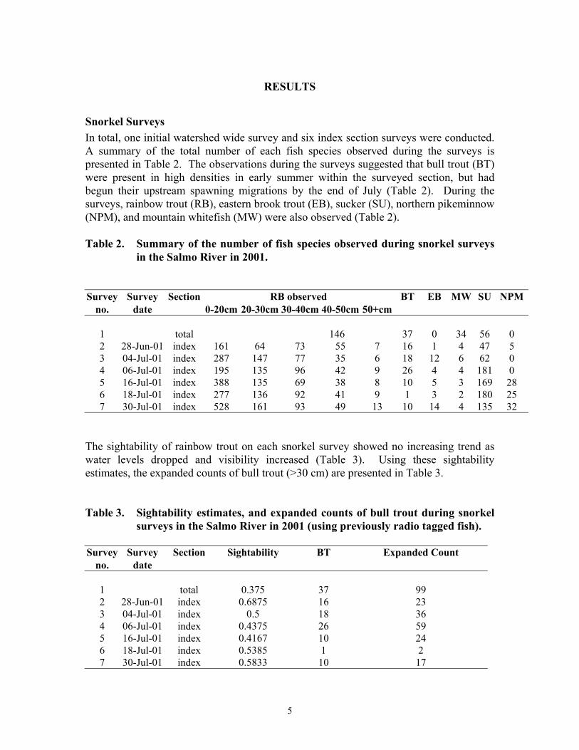
Snorkel SurveysIn total, one initial watershed wide survey and six index section surveys were conducted.A summary of the total number of each fish species observed during the surveys ispresented in Table 2. The observations during the surveys suggested that bull trout (BT)were present in high densities in early summer within the surveyed section, but hadbegun their upstream spawning migrations by the end of July (Table 2). During thesurveys, rainbow trout (RB), eastern brook trout (EB), sucker (SU), northern pikeminnow(NPM), and mountain whitefish (MW) were also observed (Table 2).
Table 2. Summary of the number of fish species observed during snorkel surveysin the Salmo River in 2001.
Survey Survey Section RB observed BT EB MW SU NPMno. date 0-20cm 20-30cm 30-40cm 40-50cm 50+cm
1 total 146 37 0 34 56 02 28-Jun-01 index 161 64 73 55 7 16 1 4 47 53 04-Jul-01 index 287 147 77 35 6 18 12 6 62 04 06-Jul-01 index 195 135 96 42 9 26 4 4 181 05 16-Jul-01 index 388 135 69 38 8 10 5 3 169 286 18-Jul-01 index 277 136 92 41 9 1 3 2 180 257 30-Jul-01 index 528 161 93 49 13 10 14 4 135 32
The sightability of rainbow trout on each snorkel survey showed no increasing trend aswater levels dropped and visibility increased (Table 3). Using these sightabilityestimates, the expanded counts of bull trout (>30 cm) are presented in Table 3.
Table 3. Sightability estimates, and expanded counts of bull trout during snorkelsurveys in the Salmo River in 2001 (using previously radio tagged fish).
Survey Survey Section Sightability BT Expanded Countno. date
1 total 0.375 37 992 28-Jun-01 index 0.6875 16 233 04-Jul-01 index 0.5 18 364 06-Jul-01 index 0.4375 26 595 16-Jul-01 index 0.4167 10 246 18-Jul-01 index 0.5385 1 27 30-Jul-01 index 0.5833 10 17
6
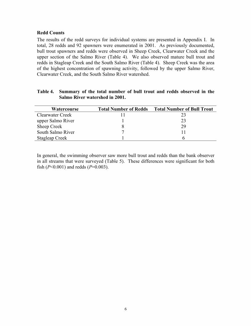
Redd CountsThe results of the redd surveys for individual systems are presented in Appendix I. Intotal, 28 redds and 92 spawners were enumerated in 2001. As previously documented,bull trout spawners and redds were observed in Sheep Creek, Clearwater Creek and theupper section of the Salmo River (Table 4). We also observed mature bull trout andredds in Stagleap Creek and the South Salmo River (Table 4). Sheep Creek was the areaof the highest concentration of spawning activity, followed by the upper Salmo River,Clearwater Creek, and the South Salmo River watershed.
Table 4. Summary of the total number of bull trout and redds observed in theSalmo River watershed in 2001.
Watercourse Total Number of Redds Total Number of Bull TroutClearwater Creek 11 23upper Salmo River 1 23Sheep Creek 8 29South Salmo River 7 11Stagleap Creek 1 6
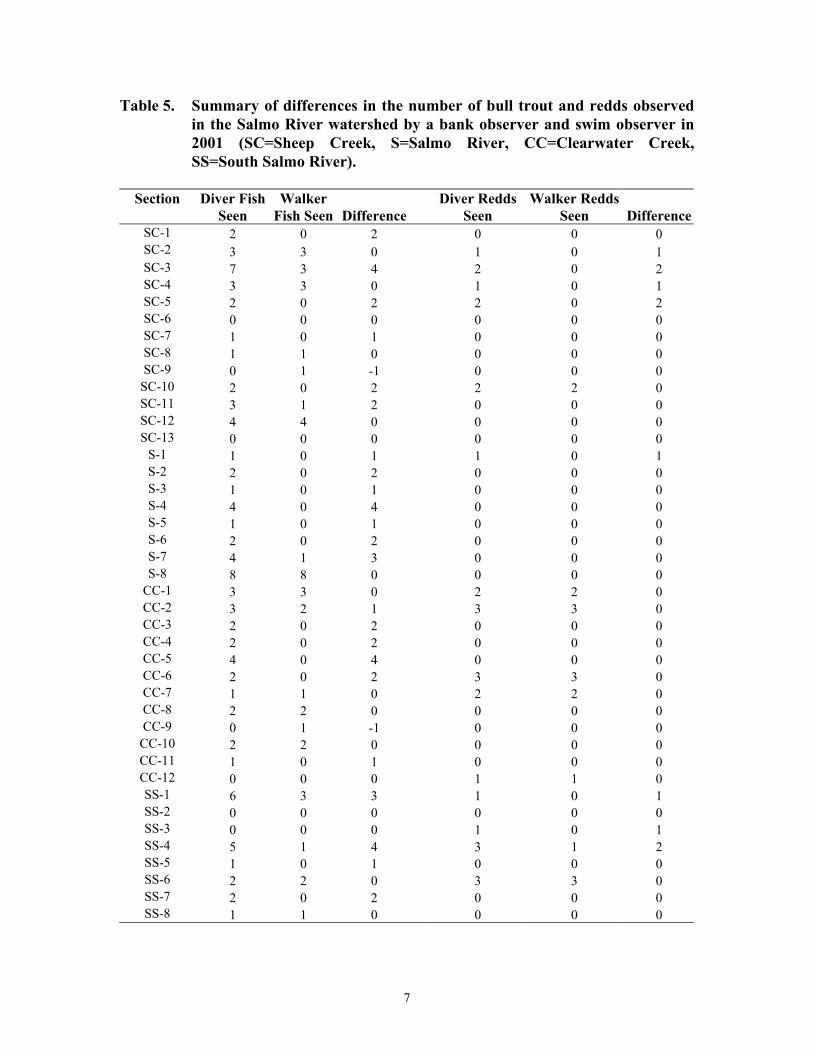
In general, the swimming observer saw more bull trout and redds than the bank observerin all streams that were surveyed (Table 5). These differences were significant for bothfish (P<0.001) and redds (P=0.003).
7
Table 5. Summary of differences in the number of bull trout and redds observedin the Salmo River watershed by a bank observer and swim observer in2001 (SC=Sheep Creek, S=Salmo River, CC=Clearwater Creek,SS=South Salmo River).
Section Diver FishSeen
WalkerFish Seen Difference
Diver ReddsSeen
Walker ReddsSeen Difference
SC-1 2 0 2 0 0 0SC-2 3 3 0 1 0 1SC-3 7 3 4 2 0 2SC-4 3 3 0 1 0 1SC-5 2 0 2 2 0 2SC-6 0 0 0 0 0 0SC-7 1 0 1 0 0 0SC-8 1 1 0 0 0 0SC-9 0 1 -1 0 0 0
SC-10 2 0 2 2 2 0SC-11 3 1 2 0 0 0SC-12 4 4 0 0 0 0SC-13 0 0 0 0 0 0
S-1 1 0 1 1 0 1S-2 2 0 2 0 0 0S-3 1 0 1 0 0 0S-4 4 0 4 0 0 0S-5 1 0 1 0 0 0S-6 2 0 2 0 0 0S-7 4 1 3 0 0 0S-8 8 8 0 0 0 0
CC-1 3 3 0 2 2 0CC-2 3 2 1 3 3 0CC-3 2 0 2 0 0 0CC-4 2 0 2 0 0 0CC-5 4 0 4 0 0 0CC-6 2 0 2 3 3 0CC-7 1 1 0 2 2 0CC-8 2 2 0 0 0 0CC-9 0 1 -1 0 0 0
CC-10 2 2 0 0 0 0CC-11 1 0 1 0 0 0CC-12 0 0 0 1 1 0SS-1 6 3 3 1 0 1SS-2 0 0 0 0 0 0SS-3 0 0 0 1 0 1SS-4 5 1 4 3 1 2SS-5 1 0 1 0 0 0SS-6 2 2 0 3 3 0SS-7 2 0 2 0 0 0SS-8 1 1 0 0 0 0
8
DISCUSSION
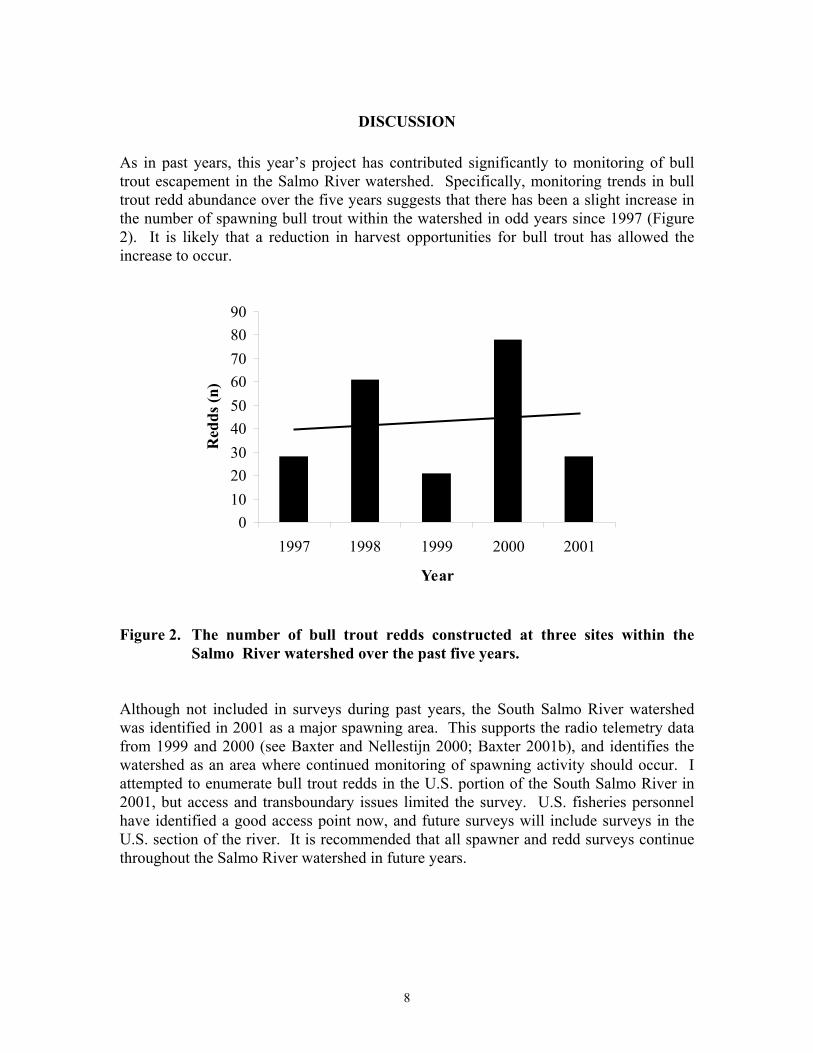
As in past years, this year’s project has contributed significantly to monitoring of bulltrout escapement in the Salmo River watershed. Specifically, monitoring trends in bulltrout redd abundance over the five years suggests that there has been a slight increase inthe number of spawning bull trout within the watershed in odd years since 1997 (Figure2). It is likely that a reduction in harvest opportunities for bull trout has allowed theincrease to occur.
0102030405060708090
1997 1998 1999 2000 2001
Year
Red
ds (n
)
Figure 2. The number of bull trout redds constructed at three sites within theSalmo River watershed over the past five years.
Although not included in surveys during past years, the South Salmo River watershedwas identified in 2001 as a major spawning area. This supports the radio telemetry datafrom 1999 and 2000 (see Baxter and Nellestijn 2000; Baxter 2001b), and identifies thewatershed as an area where continued monitoring of spawning activity should occur. Iattempted to enumerate bull trout redds in the U.S. portion of the South Salmo River in2001, but access and transboundary issues limited the survey. U.S. fisheries personnelhave identified a good access point now, and future surveys will include surveys in theU.S. section of the river. It is recommended that all spawner and redd surveys continuethroughout the Salmo River watershed in future years.
9
Another result of this years work was the documented advantage the use of acombination team (one person snorkeling and one person walking) had over moretraditional streamwalk surveys. During 2001 spawner and redd counts, the swimobserver identified significantly more bull trout and redds that would not have otherwisebeen counted if traditional ground streamwalk surveys were utilized. It is recommendedthat this technique be used for the annual index redd count program.
The snorkel surveys in the index section of the mainstem Salmo River identified that alarge portion of the bull trout population utilizes this section for holding and feedingduring the early summer prior to beginning their spawning migrations. It is likely thatthere will be further reductions to fish harvest in this section as a result of the ongoingrainbow trout project, and these regulation changes may further improve the bull troutpopulation status.
10
REFERENCES
Anonymous. 1977. Historical streamflow summary, British Columbia. Inland WatersDirectorate, Water Survey of Canada, Ottawa, Canada, 758 p.
Baxter, J.S. 1999. Bull trout studies in the Salmo River watershed: 1998 and 1999.Report to BC Hydro, Castlegar, B.C. Report by Baxter Environmental, Nelson,B.C.
Baxter, J.S. 2001a. Bull trout studies in the Salmo River watershed: 2000. Report to BCHydro, Castlegar, B.C. Report by Baxter Environmental, Nelson, B.C.
Baxter, J.S. 2001b. Aspects of the biology of bull trout (Salvelinus confluentus) in theSalmo River watershed as identified through radio telemetry (2000 and 2001 data)and a watershed management plan for the species. Report to Columbia-KootenayFisheries Renewal Partnership, Cranbrook, B.C, and BC Hydro, Burnaby andCastlegar, B.C. Report by Baxter Environmental, Nelson, B.C.
Baxter, J.S., and G. Nellestijn. 2000. Aspects of the biology of bull trout (Salvelinusconfluentus) in the Salmo River watershed as identified through radio telemetry.Report to Columbia-Kootenay Fisheries Renewal Partnership and ColumbiaBasin Trust, Cranbrook, B.C. Report by Salmo Watershed StreamkeepersSociety, Salmo, B.C. and Baxter Environmental, Nelson, B.C
Baxter, J.S., Coughlin, W.D., Pennington, B.M., and G.G. Oliver. 1998. Synopticbioreconnaissance of bull trout distribution and abundance in the Salmo Riverwatershed. Report to BC Hydro, Environmental Department, Castlegar, B.C.Report by Interior Reforestation Co. Ltd., Cranbrook, B.C.
Braumandl, T.F. and M.P. Curran [eds.]. 1992. A field guide for site identification andinterpretation for the Nelson Forest Region. British Columbia, Ministry ofForests, Land Management handbook No. 20.
Sigma Engineering Ltd. 1996. Salmo River inventory and assessment. Report toColumbia Basin Fish and Wildlife Compensation Program, Nelson, B.C. Reportby Sigma Engineering Ltd., Vancouver, B.C.

Appendix I. Summary data from bull trout redd counts conducted in the SalmoRiver watershed in 2001.
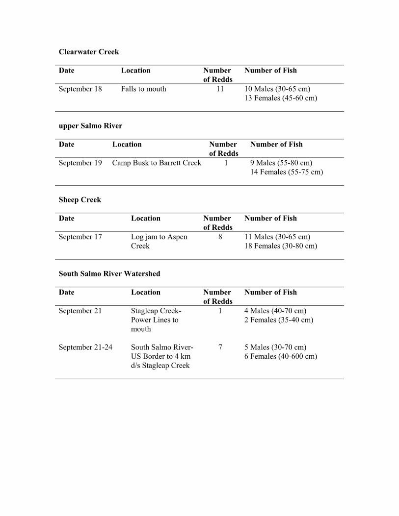
Clearwater Creek
Date Location Numberof Redds
Number of Fish
September 18 Falls to mouth 11 10 Males (30-65 cm)13 Females (45-60 cm)
upper Salmo River
Date Location Numberof Redds
Number of Fish
September 19 Camp Busk to Barrett Creek 1 9 Males (55-80 cm)14 Females (55-75 cm)
Sheep Creek
Date Location Numberof Redds
Number of Fish
September 17 Log jam to AspenCreek
8 11 Males (30-65 cm)18 Females (30-80 cm)
South Salmo River Watershed
Date Location Numberof Redds
Number of Fish
September 21 Stagleap Creek-Power Lines tomouth
1 4 Males (40-70 cm)2 Females (35-40 cm)
September 21-24 South Salmo River-US Border to 4 kmd/s Stagleap Creek
7 5 Males (30-70 cm)6 Females (40-600 cm)