Embed Size (px)
Citation preview
Bull Moose 115 kV Project eDockets No. ET2/TL-15-628
Environmental Assessment
March 3, 2016

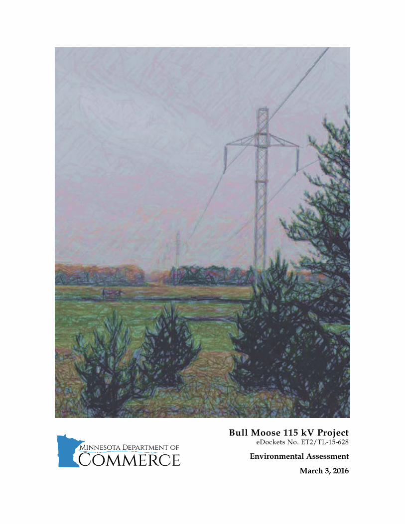
This document can be made available in alternative formats, that is, large print or audio, by calling 651-539-1530. Cover photo: View of existing Minnesota Power ±250 kV direct current electric transmission line from 48th Ave SW looking west.
Environmental Assessment Bull Moose 115 kV Project eDockets No. ET2/TL-15-628
Page | i
Responsible Government Unit Project Owner Minnesota Department of Commerce Great River Energy Energy Environmental Review and Analysis 12300 Elm Creek Boulevard 85 7th Place East, Suite 500 Maple Grove, MN 55369 Saint Paul, MN 55101-2198 Department Representatives Project Representative Andrew Levi Dan Lesher Environmental Review Specialist Great River Energy (651) 539-1840 (763) 445-5975 [email protected] [email protected] Larry Hartman Environmental Review Manager (651) 539-1839 [email protected]
Abstract Under the Minnesota Power Plant Siting Act, a route permit from the Minnesota Public Utilities Commission (Commission) is required to construct a high voltage transmission line. Great River Energy (applicant) filed an application with the Commission for a route permit to construct approximately two and one-half miles of new 115 kilovolt (kV) overhead electric transmission line in Cass County, Minnesota. The purpose of the proposed project is to provide electric service to a proposed, new crude oil pumping station to be located approximately two and three-quarter miles south/southwest of Backus, Minnesota. The applicant submitted its route permit application on August 7, 2015. The application was filed pursuant to the alternative review process outlined in Minnesota Statute 216E.04 and Minnesota Rules 7850.2800–3900. On October 13, 2015, the Commission accepted the application as complete. Minnesota Department of Commerce (Commerce), Energy Environmental Review and Analysis (EERA) staff are responsible for conducting environmental review for route permit applications submitted to the Commission. Accordingly, EERA held a scoping meeting in Backus, Minnesota, on October 12, 2015, and prepared this environmental assessment (EA). This EA addresses the issues required in Minnesota Rules 7850.3700, subpart 4, and those identified in Commerce’s December 10, 2015, scoping decision. Following release of this EA, a public hearing will be held in the project area. The hearing will be presided over by an administrative law judge (ALJ) from the Office of Administrative Hearings. Upon completion of the environmental review and hearing process, the ALJ will

Environmental Assessment Bull Moose 115 kV Project eDockets No. ET2/TL-15-628
Page | ii
compile a record of the public hearing and public comments received, and present it to the Commission for a final permit decision. This decision is anticipated by April 2016. Persons interested in this project can place their name on the project mailing list by contacting Tracy Smetana, the Commission’s public advisor, by email, [email protected], or by phone at (651) 296-0406 or toll free (800) 657-3782. Additional documents and information can be found on the EERA website at http://mn.gov/commerce/energyfacilities/Docket.html?Id=34235 or the Minnesota eDockets website at https://www.edockets.state.mn.us/EFiling/search.jsp by selecting “15” for year and “628” for number. Prepared by: Andrew Levi, EERA Environmental Review Specialist With significant contributions from: Ray Kirsch, EERA Environmental Review Manager William Storm, EERA Environmental Review Manager

Environmental Assessment Bull Moose 115 kV Project eDockets No. ET2/TL-15-628
Page | iii
Acronyms, Abbreviations and Definitions 142 Line Minnesota Power Badoura to Pine River “#142” 115 kV electric transmission line 91 Line Minnesota Power “#91” 230 kV electric transmission line ALJ administrative law judge alternative route segment Alternative Route Segment A AMA Aquatic Management Area applicant Great River Energy ATV all-terrain vehicle BMPs best management practices Commerce Minnesota Department of Commerce Commission Minnesota Public Utilities Commission dBa A-weighted sound level recorded in units of decibels DC Line Minnesota Power ±250 kV direct current electric transmission line DNR Minnesota Department of Natural Resources drumlin Smooth oval hill of glacial drift, elongated in the direction of the movement of the ice that deposited it. EA environmental assessment ECS Ecological Classification System EERA Energy Environmental Review and Analysis ELF-EMF extremely low frequency electromagnetic fields EMF electromagnetic field EPLP Enbridge Pipeline, Limited Partnership HVTL high voltage transmission line KHz kilohertz kV kilovolt or 1,000 volts lake plains One of the surfaces of the earth that represent former lake bottoms. Line 3 Project proposed Line 3 Pipeline Replacement Project (PL9/PPL-15-137) MDH Minnesota Department of Health Minn. R. Minnesota Rule Minn. Stat. Minnesota Statute mG milligauss mg/L milligrams per liter MHz megahertz MnDOT Minnesota Department of Transportation Moraine A formation composed of unsorted and unbedded rock and soil debris called till, which was deposited by a glacier.
Environmental Assessment Bull Moose 115 kV Project eDockets No. ET2/TL-15-628
Page | iv
MP Minnesota Power MPCA Minnesota Pollution Control Agency NAC noise area classification NDPC North Dakota Pipeline Company NHIS Natural Heritage Information System NPDES/SDS National Pollutant Discharge Elimination System / State Disposal System NERC North American Electric Reliability Corporation NESC National Electrical Safety Code NEV neutral-to-earth voltage NLCD National Land Cover Database NWI National Wetland Inventory OAH Minnesota Office of Administrative Hearings outwash plain A broad, outspread flat or gently sloping alluvial deposit of outwash in front of or beyond the terminal moraine of a glacier. ppm parts per million proposed project Bull Moose 115 kV Project proposed transmission line project Bull Moose 115 kV Project proposed pump station proposed, new Backus crude oil pumping station proposed substation proposed, new Enbridge-owned substation associated with the proposed pump station PWI Public Waters Inventory RGU responsible governmental unit ROI region of influence ROW right-of-way Sandpiper Project proposed Sandpiper Pipeline Project (PL-688/PPL-13-474) SNA Scientific and Natural Area SHPO State Historic Preservation Office subd. subdivision (Minnesota Statute) subp. subpart (Minnesota Rule) UHF ultra-high frequency USACE United States Army Corps of Engineers USFWS United State Fish and Wildlife Service VHF very high frequency WMA Wildlife Management Area
Environmental Assessment Bull Moose 115 kV Project eDockets No. ET2/TL-15-628
Page | v
Contents Abstract ............................................................................................................................................ i Acronyms, Abbreviations and Definitions ..................................................................................... iii Contents .......................................................................................................................................... v
1 Introduction ............................................................................................................................ 1
1.1 Project Purpose ............................................................................................................... 3
1.2 Project Description .......................................................................................................... 3
1.3 Project Location .............................................................................................................. 3
1.4 Sources ............................................................................................................................ 4
2 Regulatory Framework ........................................................................................................... 5
2.1 Certificate of Need .......................................................................................................... 6
2.2 Route Permit ................................................................................................................... 6
2.3 Environmental Review .................................................................................................... 7
2.4 Public Hearing ............................................................................................................... 10
2.5 Permit Decision ............................................................................................................. 10
2.6 Other Permits and Approvals ....................................................................................... 12
2.7 Applicable Codes ........................................................................................................... 14
2.8 Issues Outside the Scope of the EA ............................................................................. 14
3 Proposed Project and Route Alternatives........................................................................... 15
3.1 Applicant’s Proposed Route ......................................................................................... 16
3.2 Alternative Route Segment A ....................................................................................... 17
3.3 Route Width ................................................................................................................... 18
3.4 Right-of-Way Requirements .......................................................................................... 18
3.5 Right-of-Way Acquisition ............................................................................................... 18
3.5.1 Private ..................................................................................................................... 18
3.5.2 Public ...................................................................................................................... 19
3.6 Project Description ........................................................................................................ 20
3.7 Construction .................................................................................................................. 23
3.8 Operation and Maintenance ........................................................................................ 24
3.9 Cost ................................................................................................................................ 25
3.10 Schedule ........................................................................................................................ 25
4 Rejected Routes ................................................................................................................... 27
5 Potential Impacts and Mitigative Measures....................................................................... 29
5.1 Environmental Setting .................................................................................................. 32
Environmental Assessment Bull Moose 115 kV Project eDockets No. ET2/TL-15-628
Page | vi
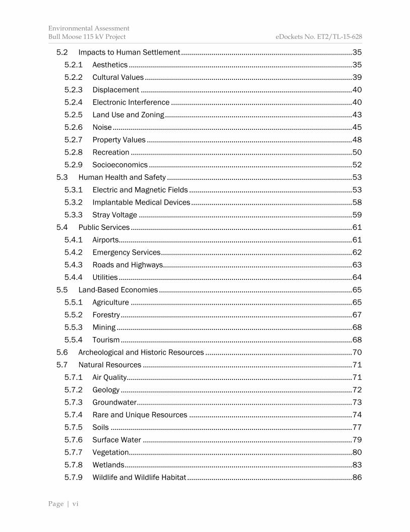
5.2 Impacts to Human Settlement ..................................................................................... 35
5.2.1 Aesthetics ............................................................................................................... 35
5.2.2 Cultural Values ....................................................................................................... 39
5.2.3 Displacement ......................................................................................................... 40
5.2.4 Electronic Interference .......................................................................................... 40
5.2.5 Land Use and Zoning ............................................................................................. 43
5.2.6 Noise ....................................................................................................................... 45
5.2.7 Property Values ...................................................................................................... 48
5.2.8 Recreation .............................................................................................................. 50
5.2.9 Socioeconomics ..................................................................................................... 52
5.3 Human Health and Safety ............................................................................................ 53
5.3.1 Electric and Magnetic Fields ................................................................................. 53
5.3.2 Implantable Medical Devices ................................................................................ 58
5.3.3 Stray Voltage .......................................................................................................... 59
5.4 Public Services .............................................................................................................. 61
5.4.1 Airports.................................................................................................................... 61
5.4.2 Emergency Services ............................................................................................... 62
5.4.3 Roads and Highways.............................................................................................. 63
5.4.4 Utilities .................................................................................................................... 64
5.5 Land-Based Economies ................................................................................................ 65
5.5.1 Agriculture .............................................................................................................. 65
5.5.2 Forestry ................................................................................................................... 67
5.5.3 Mining ..................................................................................................................... 68
5.5.4 Tourism ................................................................................................................... 68
5.6 Archeological and Historic Resources ......................................................................... 70
5.7 Natural Resources ........................................................................................................ 71
5.7.1 Air Quality ................................................................................................................ 71
5.7.2 Geology ................................................................................................................... 72
5.7.3 Groundwater ........................................................................................................... 73
5.7.4 Rare and Unique Resources ................................................................................. 74
5.7.5 Soils ........................................................................................................................ 77
5.7.6 Surface Water ........................................................................................................ 79
5.7.7 Vegetation............................................................................................................... 80
5.7.8 Wetlands ................................................................................................................. 83
5.7.9 Wildlife and Wildlife Habitat .................................................................................. 86
Environmental Assessment Bull Moose 115 kV Project eDockets No. ET2/TL-15-628
Page | vii
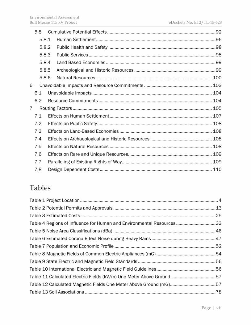
5.8 Cumulative Potential Effects ........................................................................................ 92
5.8.1 Human Settlement ................................................................................................. 96
5.8.2 Public Health and Safety ....................................................................................... 98
5.8.3 Public Services ....................................................................................................... 98
5.8.4 Land-Based Economies ......................................................................................... 99
5.8.5 Archeological and Historic Resources .................................................................. 99
5.8.6 Natural Resources .............................................................................................. 100
6 Unavoidable Impacts and Resource Commitments ....................................................... 103
6.1 Unavoidable Impacts ................................................................................................. 104
6.2 Resource Commitments ............................................................................................ 104
7 Routing Factors ................................................................................................................. 105
7.1 Effects on Human Settlement ................................................................................... 107
7.2 Effects on Public Safety ............................................................................................. 108
7.3 Effects on Land-Based Economies ........................................................................... 108
7.4 Effects on Archaeological and Historic Resources .................................................. 108
7.5 Effects on Natural Resources ................................................................................... 108
7.6 Effects on Rare and Unique Resources .................................................................... 109
7.7 Paralleling of Existing Rights-of-Way ......................................................................... 109
7.8 Design Dependent Costs ........................................................................................... 110
Tables Table 1 Project Location ................................................................................................................ 4
Table 2 Potential Permits and Approvals ................................................................................... 13
Table 3 Estimated Costs .............................................................................................................. 25
Table 4 Regions of Influence for Human and Environmental Resources ................................ 33
Table 5 Noise Area Classifications (dBa) ................................................................................... 46
Table 6 Estimated Corona Effect Noise during Heavy Rains .................................................... 47
Table 7 Population and Economic Profile .................................................................................. 52
Table 8 Magnetic Fields of Common Electric Appliances (mG) ................................................ 54
Table 9 State Electric and Magnetic Field Standards ............................................................... 56
Table 10 International Electric and Magnetic Field Guidelines ................................................ 56
Table 11 Calculated Electric Fields (kV/m) One Meter Above Ground .................................... 57
Table 12 Calculated Magnetic Fields One Meter Above Ground (mG) ..................................... 57
Table 13 Soil Associations .......................................................................................................... 78
Environmental Assessment Bull Moose 115 kV Project eDockets No. ET2/TL-15-628
Page | viii
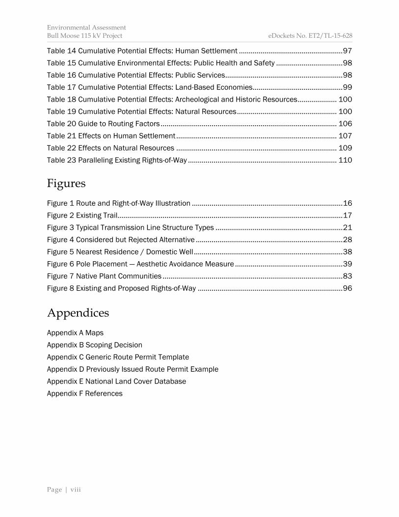
Table 14 Cumulative Potential Effects: Human Settlement ..................................................... 97
Table 15 Cumulative Environmental Effects: Public Health and Safety .................................. 98
Table 16 Cumulative Potential Effects: Public Services ............................................................ 98
Table 17 Cumulative Potential Effects: Land-Based Economies.............................................. 99
Table 18 Cumulative Potential Effects: Archeological and Historic Resources .................... 100
Table 19 Cumulative Potential Effects: Natural Resources ................................................... 100
Table 20 Guide to Routing Factors .......................................................................................... 106
Table 21 Effects on Human Settlement .................................................................................. 107
Table 22 Effects on Natural Resources .................................................................................. 109
Table 23 Paralleling Existing Rights-of-Way ............................................................................ 110
Figures Figure 1 Route and Right-of-Way Illustration ............................................................................. 16
Figure 2 Existing Trail................................................................................................................... 17
Figure 3 Typical Transmission Line Structure Types ................................................................. 21
Figure 4 Considered but Rejected Alternative ........................................................................... 28
Figure 5 Nearest Residence / Domestic Well ............................................................................ 38
Figure 6 Pole Placement — Aesthetic Avoidance Measure ....................................................... 39
Figure 7 Native Plant Communities ............................................................................................ 83
Figure 8 Existing and Proposed Rights-of-Way .......................................................................... 96
Appendices Appendix A Maps Appendix B Scoping Decision Appendix C Generic Route Permit Template Appendix D Previously Issued Route Permit Example Appendix E National Land Cover Database Appendix F References

Environmental Assessment Bull Moose 115 kV Project eDockets No. ET2/TL-15-628
Page | 1
1 Introduction

Environmental Assessment Bull Moose 115 kV Project eDockets No. ET2/TL-15-628
Page | 2
Great River Energy (applicant) filed an application with the Minnesota Public Utilities Commission (Commission) for a route permit to construct approximately two and one-half miles of new 115 kilovolt (kV) overhead electric high voltage transmission line (HVTL) in Cass County, Minnesota (proposed project or proposed transmission line project).1 The application was filed pursuant to the alternative review process outlined in Minnesota Statute 216E.04 and Minnesota Rules 7850.2800–3900. The Commission docket number for this project is ET2/TL-15-628. The Minnesota Department of Commerce (Commerce), Energy Environmental Review and Analysis (EERA) unit is responsible for conducting environmental review on applications for route permits before the Commission.2 The intent of the environmental review process is to inform the public, decision-makers, local governments, state agencies, and applicants of the potential impacts and possible mitigation measures associated with the proposed project. This document is an environmental assessment (EA). It addresses the issues required in Minnesota Rule 7850.3700, subpart 4, and those identified in the December 10, 2015, scoping decision issued by the Deputy Commissioner of Commerce (Appendix B). The EA facilitates the legislative goal—as stated in the Minnesota Power Plant Siting Act—to “minimize adverse human and environmental impact while insuring continuing electric power system reliability and integrity and insuring that electric energy needs are met and fulfilled in an orderly and timely fashion,”3 and is organized as follows: Section 1 provides an overview of this document and the proposed project. Section 2 explains the regulatory framework associated with the proposed project, including the route permitting process and other required permits and approvals. Section 3 describes the proposed project and an alternative route segment. Section 4 describes other routes considered but rejected by the applicant. Section 5 details potential impacts of the routing options to both human and natural resources; identifies measures to avoid, minimize or mitigate adverse impacts; and summarizes the cumulative potential effects of the proposed project and other projects. Section 6 describes unavoidable impacts and irreversible or irretrievable commitments of resources associated with the proposed project. Section 7 applies the information and data available in the route permit application and the EA to the factors described in Minnesota Rule 7850.4100.
1 Great River Energy (August 7, 2015) Application to the Minnesota Public Utilities Commission for a Route
Permit for the Bull Moose 115 kV Project, eDockets Nos. 20158-113086-01, 20158-113086-02 (hereinafter “Application”); A copy of the application, along with other relevant documents, can also be found on the EERA website at: http://mn.gov/commerce/energyfacilities/Docket.html?Id=34235.
2 Minnesota Statute 216E.04, subdivision 5. 3 Minn. Stat. 216E.02, subd. 1.

Environmental Assessment Bull Moose 115 kV Project eDockets No. ET2/TL-15-628
Page | 3
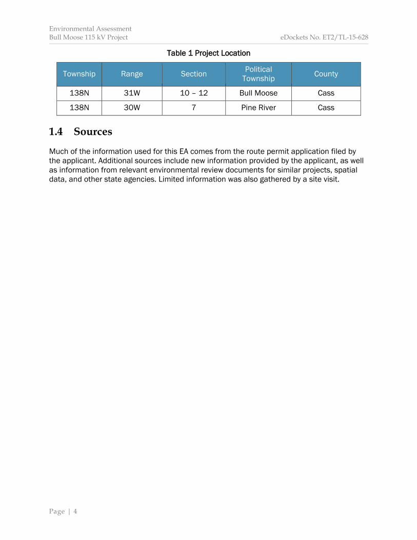
1.1 Project Purpose The applicant's stated purpose is to provide electric service to the proposed, new Backus crude oil pumping station (proposed pump station) to be located approximately two and three-quarter miles south/southwest of Backus, Minnesota. This pump station is associated with the Line 3 Pipeline Replacement Project (Line 3 Project) proposed by Enbridge Pipeline, Limited Partnership (EPLP).4 Construction of the proposed project is dependent upon approval of the Line 3 Project; that is, if the Line 3 Project is not approved or if it is approved but routed in a different location, the proposed project will not be built. 1.2 Project Description The applicant proposes to construct approximately two and one-half miles of new 115 kV overhead electric transmission line from the existing Minnesota Power (MP) Badoura to Pine River “#142” 115 kV electric transmission line (142 Line) to a proposed, new Enbridge-owned substation (proposed substation) associated with the proposed pump station (Map 1). As proposed by the applicant, the transmission line will interconnect with the 142 Line and travel northeast cross-country for approximately one-quarter mile towards an existing MP ±250 kV direct current electric transmission line (DC Line) right-of-way (ROW), and then parallel immediately adjacent to the south side of the DC Line ROW east approximately two and one-quarter miles. From this point, the proposed transmission line will turn north and cross under the DC Line to interconnect with the proposed substation. The applicant is requesting a 200 foot route width for the proposed project with a wider route width in select areas near the proposed pump station. The applicant indicates the transmission line will require a 100 foot ROW with a wider width in select locations to accommodate transmission line guy wires and anchors. This ROW will abut the south side of the existing DC Line ROW. Transmission line structures will be approximately 70 to 80 feet in height, with a span between structures of 350 to 400 feet. The applicant intends to begin construction in 2017 and energize the transmission line in spring of 2017. The proposed project is estimated to cost $2.1 million. 1.3 Project Location The proposed project is located entirely in Cass County, Minnesota. The majority of the applicant’s proposed route is in Bull Moose Township. Portions of the applicant’s proposed route cross into Pine River Township to accommodate possible routing options into the proposed substation. Table 1 summarizes the project location. Map 2 illustrates the project vicinity.
4 Commission Docket No. PL9/PPL-15-137; see Minnesota eDockets:
https://www.edockets.state.mn.us/EFiling/search.jsp (“15” for year, “137” for number); see also EERA website: mn.gov/commerce/energyfacilities/Docket.html?Id=34709.
Environmental Assessment Bull Moose 115 kV Project eDockets No. ET2/TL-15-628
Page | 4
Table 1 Project Location
Township Range Section Political Township County
138N 31W 10 – 12 Bull Moose Cass
138N 30W 7 Pine River Cass 1.4 Sources Much of the information used for this EA comes from the route permit application filed by the applicant. Additional sources include new information provided by the applicant, as well as information from relevant environmental review documents for similar projects, spatial data, and other state agencies. Limited information was also gathered by a site visit.
Environmental Assessment Bull Moose 115 kV Project eDockets No. ET2/TL-15-628
Page | 5
2 Regulatory Framework
Environmental Assessment Bull Moose 115 kV Project eDockets No. ET2/TL-15-628
Page | 6
In order to construct the proposed project, the applicant must obtain a route permit from the Commission. Additional approvals from other state and federal agencies with permitting authority for actions related to the project may also be required. 2.1 Certificate of Need In Minnesota, no person5 may construct a large energy facility without first obtaining a Certificate of Need from the Commission.6 A HVTL is considered a large energy facility if it meets the following capacity and length requirements:
200 kV or more and is greater than 1,500 feet in length 100 kV or more with more than 10 miles of its length in Minnesota 100 kV or more and crosses a state line.7
The proposed project has a capacity of more than 100 kV; however, it does not meet the definition of large energy facility because it is not more than 10 miles in length and does not cross a state line. Therefore, a Certificate of Need is not required for the project. 2.2 Route Permit In Minnesota, no person may construct a HVTL without first obtaining a route permit from the Commission.8 A HVTL is defined as “a conductor of electric energy and associated facilities designed for and capable of operation at a nominal voltage of 100 [kV] or more and is greater than 1,500 feet in length.”9 Associated facilities of a transmission line might include substations, buildings, equipment, guy wires, and other physical structures necessary for the operation of the HVTL. The proposed project will operate at 115 kV and be approximately two and one-half miles in length.10 As a result, the proposed project requires a route permit from the Commission. The applicant filed its route permit application on August 7, 2015.11 The application was filed pursuant to the alternative review process outlined in Minnesota Statute 216E.04 and Minnesota Rules 7850.2800–3900.
5 See Minn. Stat. 216E.01 (“Person” shall mean an individual, partnership, joint venture, private or public
corporation, association, firm, public service company, cooperative, political subdivision, municipal corporation, government agency, public utility district, or any other entity, public or private, however organized).
6 Minn. Stat. 216B.243. 7 Minn. Stat. 216B.2421, subd. 2. 8 Minn. Stat. 216E.03, subd. 1; Minnesota Rule 7850.1300, subpart 2. 9 Minn. Stat. 216E.01, subd. 4. 10 Application. 11 Application.
Environmental Assessment Bull Moose 115 kV Project eDockets No. ET2/TL-15-628
Page | 7
The Commission considered the completeness of the application at its September 17, 2015, agenda meeting.12, 13 On October 13, 2015, the Commission issued an order accepting the application as complete.14 After an application is accepted by the Commission, the permitting process can begin. The alternative review process requires environmental review. Once environmental review is completed, a public hearing will be held in the vicinity of the project area. The entire process generally takes six months, but can take up to nine months to complete. 2.3 Environmental Review Applications for a HVTL route permit are subject to environmental review, which is conducted by EERA staff under Minnesota Rule 7850.3700. In preparing environmental review documents, EERA functions as the responsible governmental unit (RGU) under the Minnesota Environmental Policy Act and associated regulations. In addition to preparing environmental review documents, EERA performs related tasks, including conducting scoping meetings and managing public comment periods. The alternative review process requires preparation of an EA.15 An EA is a written document that contains an overview of the resources and potential human and environmental impacts and mitigation measures associated with the proposed project.16 It also summarizes the cumulative potential effects of the proposed project and other projects where these effects coincide. This EA is the only state environmental review document required for the project.17 After the EA is complete and made publically available, a public hearing will occur in the project area. Scoping The first step in the preparation of an EA is scoping. The scoping process has three primary purposes: (1) to ensure that the public has a chance to participate in the development of the EA; (2) to focus the content of the EA on impacts and issues important to a reasoned route permit decision; and (3) to identify possible mitigation measures, including alternative routes or route segments, that mitigate potential impacts.
12 Minnesota Public Utilities Commission (September 4, 2015) Notice of Commission Meeting, eDockets No. 20159-113782-05. 13 Minnesota Public Utilities Commission (October 29, 2015) Minutes – September 17, 2015, eDockets No. 201510-115198-10. 14 Minnesota Public Utilities Commission (October 13, 2015) Order Finding Application Complete, Directing Use of Summary Report Review Process, and Granting Variance, eDockets No. 201510-114772-01. (hereinafter “Order”) 15 Minn. Stat. 216E.04, subd. 5; Minn. R. 7850.3700, subp. 1. 16 Minn. Stat. 216E.04, subd. 5; Minn. R. 7850.3700, subp. 4. 17 Minn. Stat. 216E.04, subd. 5.

Environmental Assessment Bull Moose 115 kV Project eDockets No. ET2/TL-15-628
Page | 8
EERA conducts scoping meetings in conjunction with a public comment period to allow the public an opportunity to participate in the development of the scope (or content) of the EA.18 The commissioner of Commerce or her designee determines the scope of the EA.19 The scope may include alternative routes or route segments suggested during the scoping process if it is determined the alternatives would aid the Commission in making a permit decision.20 Applicants are provided the opportunity to respond to each request that an alternative be included in the EA.21 Scoping Process On September 18, 2015, Commission staff sent notice of the place, date and time of the joint public information and scoping meeting22 to those persons on the project contact list and agency technical representative list, as well as local government units and affected landowners.23 Notice was published in The Pilot-Independent Newspaper on September 30, 2015, The Echo Journal on October 1, 2015,24 and on the Commission and EERA websites. Public Meeting Commission and EERA staff held the joint public information and scoping meeting as noticed on October 12, 2015, at Backus City Hall in Backus, Minnesota. The purpose of this meeting was to provide information to the public about the proposed project and permitting process, to answer questions about the proposed project and permitting process, and to allow the public an opportunity to suggest impacts, mitigative measures, and alternatives that should be considered in the EA. A court reporter was present at the meeting to document oral statements.25 No members of the public attended the meeting. Meeting handouts26 were left at Backus City Hall, and city staff was notified of their location. Public Comments A public comment period, ending October 26, 2015, provided the opportunity to submit written comments to EERA on the scope of the EA. The purpose of this comment period was to allow for interested persons to suggest impacts, mitigative measures, and alternatives 18 Minn. R. 7850.3700, subp. 1. 19 Minn. R. 7850.3700, subp. 3. 20 Minn. R. 7850.3700, subp. 2. 21 Minn. R. 7850.3700, subp. 2. 22 See Minn. R. 7850.3500 (requiring a public meeting be held in the project area to provide information to
the public about the proposed project and to answer questions. This meeting satisfies the requirement to hold a scoping meeting, that is, two separate meetings are not required).
23 Minnesota Public Utilities Commission and Minnesota Department of Commerce (September 18, 2015) Notice of Public Information and Environmental Assessment Scoping Meeting, eDockets Nos. 20159-114113-01, 20159-114113-02.
24 Great River Energy (October 14, 2015) Bull Moose 115 kV Project Newspaper Affidavits for 10-12-15 Scoping Meeting, eDockets No. 201510-114824-01. 25 Minnesota Department of Commerce (October 19, 2015) Scoping and Informational Meeting Summary, eDockets No. 201510-114937-01. 26 Minnesota Department of Commerce (October 6, 2015) Public Meeting Handouts, Retrieved December 8, 2015, from: http://mn.gov/commerce/energyfacilities/Docket.html?Id=34235.
Environmental Assessment Bull Moose 115 kV Project eDockets No. ET2/TL-15-628
Page | 9
that should be considered in the EA. Written comments were received from the Minnesota Department of Natural Resources (DNR) and the Minnesota Department of Transportation (MnDOT). DNR addressed a variety of issues. The agency requested the EA discuss methods to mitigate impacts to birds, specific construction and maintenance methods, pole placement, and cumulative impacts. DNR suggested a route segment alternative to be studied in the EA. MnDOT indicated that the proposed project does not abut a state trunk highway. The agency requested it be made aware of any changes to the project such that the project area would subsequently be modified to include a portion of current MnDOT ROW. MnDOT also requested that any construction work or materials delivery with potential to affect its ROW be coordinated with the agency. Scoping comments are compiled and available to view or download on the EERA website.27 Scoping Decision Minnesota Rule 7850.3700, subpart 3, requires Commerce to determine the scope of the EA within 10 days after the close of the public comment period. However, Minnesota Statute 216E.04, subdivision 5, anticipates Commission input into identifying alternative routes or route segments for inclusion in the scope of the EA. The Commission extended the 10-day timeframe to allow for Commission input.28 On November 4, 2015, EERA staff provided comments to the Commission summarizing the scoping process and public comments received.29 At its December 3, 2015, agenda meeting, the Commission considered what, if any, action it should take regarding alternative routes or route segments.30 The Commission elected to take no action, that is, the Commission neither recommended removal of the proposed alternative route segment nor recommended that additional alternative routes or route segments be studied in the EA. After considering public comments, input from the Commission, and recommendations from EERA staff, the Deputy Commissioner of Commerce issued a scoping decision on December 10, 2015 (Appendix B).31 The scoping decision identifies the issues and routes or route segments to be evaluated in this EA. EERA staff provided notice of the scoping decision to those persons on the project mailing list and posted the notice to the EERA website.32 27 Minnesota Department of Commerce (October 27, 2015) Public Comments Received on the Scope of the
EA, Retrieved December 8, 2015, from: http://mn.gov/commerce/energyfacilities//resource.html?Id=34309.
28 Order. 29 Minnesota Department of Commerce (November 4, 2015) Scoping Process and Route Alternatives, eDockets No. 201510-115443-01. 30 Minnesota Public Utilities Commission (January 29, 2016) Minutes – December 3, 2015, eDockets No. 20161-117815-06. 31 Minnesota Department of Commerce (December 14, 2015(a)) Environmental Assessment Scoping Decision, eDockets No. 201512-116422-01. (hereinafter “Scoping Decision) 32 Minnesota Department of Commerce (December 14, 2015(b)) Notice of Environmental Assessment
Environmental Assessment Bull Moose 115 kV Project eDockets No. ET2/TL-15-628
Page | 10
2.4 Public Hearing The Commission is required by Minnesota Rule 7850.3800, subpart 1, to hold a public hearing once the EA is complete and publically available. The hearing will be presided over by an administrative law judge (ALJ) from the Office of Administrative Hearings. Interested persons will have the opportunity to speak at the hearing, present evidence, ask questions, and submit comments. The ALJ will provide a report to the Commission summarizing the public hearing and any spoken or written comments received. Comments received on the EA during the hearing become part of the record in the proceeding. EERA staff will respond to questions and comments about the EA at the public hearing; however, staff is not required to revise or supplement the document.33 2.5 Permit Decision The Minnesota Legislature directed the Commission to select HVTL routes that minimize adverse human and environmental impacts while insuring continuing electric power system reliability and integrity.34 An HVTL route must be compatible with environmental preservation and the efficient use of resources while also insuring electric energy needs are met and fulfilled in an orderly and timely fashion.35 Route permits issued by the Commission include a permitted route and anticipated alignment. The route permit also outlines conditions specifying construction and operation standards. A generic route permit template is included in Appendix C. An example of a route permit previously issued by the Commission is included in Appendix D. Minnesota Statute 216E.03, subdivision 7(b) identifies 12 considerations that the Commission must take into account when designating a route for a HVTL. These considerations are further clarified and expanded by Minnesota Rule 7850.4100, which identifies 14 factors the Commission must consider when making a permit decision. These factors include:
A. effects on human settlement, including, but not limited to, displacement, noise, aesthetics, cultural values, recreation, and public services;
B. effects on public health and safety; C. effects on land-based economies, including, but not limited to, agriculture,
forestry, tourism, and mining; D. effects on archaeological and historic resources; E. effects on the natural environment, including effects on air and water quality
resources and flora and fauna;
Scoping Decision, 2015, eDockets No. 201512-116428-01. 33 Minn. R. 7850.3800, subp. 4. 34 Minn. Stat. 216E.02, subd. 1. 35 Minn. Stat. 216E.02, subd. 1.

Environmental Assessment Bull Moose 115 kV Project eDockets No. ET2/TL-15-628
Page | 11
F. effects on rare and unique natural resources; G. application of design options that maximize energy efficiencies, mitigate adverse
environmental effects, and could accommodate expansion of transmission or generating capacity;
H. use or paralleling of existing rights-of-way, survey lines, natural division lines, and agricultural field boundaries;
I. use of existing large electric power generating plant sites; J. use of existing transportation, pipeline, and electrical transmission systems or
rights-of-way; K. electrical system reliability; L. costs of constructing, operating, and maintaining the facility which are dependent
on design and route; M. adverse human and natural environmental effects which cannot be avoided; and N. irreversible and irretrievable commitments of resources.
The analysis in Sections 5 through Section 7 addresses each of these factors by evaluating the potential impacts to individual components or “elements” of each factor. For example, impacts to human settlement are assessed by evaluating nine different elements of human settlement including aesthetics, cultural values, displacement, electronic interference, land use and zoning, noise, property values, recreation, and socioeconomics. For each element, “indicators” are analyzed. For example, proximity to residences is used as an indicator of potential displacement. Similarly, the number of acres of wetlands converted by the proposed project is used as an indicator of potential impacts to wetland resources. At the time the Commission makes a final decision about the permit application, it must determine whether the EA and the record created at the public hearing address the issues identified in the scoping decision.36 The Commission must also make specific findings that it has considered locating a route for a new HVTL along an existing HVTL route or parallel to existing highway ROW, and, to the extent these are not used, the Commission must state the reason why.37 The Commission must make a final decision on the route permit within 60 days after receipt of the ALJ report.38 A final decision must be made within six months after the Commission’s determination the application is complete; however, this time limit may be extended for up
36 Minn. R. 7850.3900, subp. 2. 37 Minn. Stat. 216E.03, subd. 7(e). 38 Minn. R. 7850.3900, subp. 1.
Environmental Assessment Bull Moose 115 kV Project eDockets No. ET2/TL-15-628
Page | 12
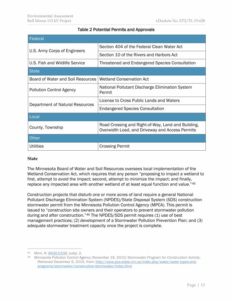
to three months for just cause or upon agreement of the applicant.39 A Commission permit decision is anticipated in April 2016. If issued a route permit by the Commission, the applicant may exercise the power of eminent domain to acquire land for the project.40 2.6 Other Permits and Approvals A route permit from the Commission is the only state permit required for the routing of the project; however, should the Commission issue a route permit, other permits might be required, for example, the applicant would need to obtain a license to cross Foot Hills State Forest from DNR. These subsequent permits are commonly referred to as “downstream” permits and must be obtained by the applicant prior to construction of the proposed project. Table 2 identifies potential permits that may be required in addition to a route permit. A route permit from the Commission supersedes local zoning, building or land use rules.41 Though zoning and land use rules are superseded, the Commission’s route permit decision must be guided, in part, by impacts to local zoning and land use in accordance with the legislative goal to “minimize human settlement and other land use conflicts.”42 A route permit also binds state agencies. Minnesota Statute 216E.10, subdivision 3, requires state agency participation in the permitting process to identify whether proposed projects—if constructed—would be “in compliance with state agency standards, rules, or policies.” That is to say: would the proposed project be permittable? Federal The United States Army Corps of Engineers (USACE) “regulates the discharge of dredged or fill material into waters of the United States, including wetlands.”43 Dredged or fill material could impact water quality. A permit is required from USACE if the potential for significant adverse impacts exists. A permit is required from the United States Fish and Wildlife Service (USFWS) for the incidental “taking”44 of any endangered species. As a result, USFWS encourages project proposers to consult with the agency to determine if a project has the potential to impact federally-listed threatened and endangered species. Additionally, consultation can lead to the identification of general mitigation measures for potential impacts associated with the project.
39 Minn. R. 7850.3900, subp. 1. 40 Minn. Stat. 216E.12. 41 Minn. Stat. 216E.10, subd. 1. 42 Minn. Stat. 216E.03, subd. 7. 43 U.S. Environmental Protection Agency (October 27, 2015) Section 404 Permit Program, Retrieved December 9, 2015, from: http://www.epa.gov/cwa-404/section-404-permit-program. 44 See U.S. Code § 1532(19) (defining “take” to mean to harass, harm, pursue, hunt, shoot, wound, kill, trap, capture, or collect, or attempt to engage in such conduct).
Environmental Assessment Bull Moose 115 kV Project eDockets No. ET2/TL-15-628
Page | 13
Table 2 Potential Permits and Approvals
Federal
U.S. Army Corps of Engineers Section 404 of the Federal Clean Water Act
Section 10 of the Rivers and Harbors Act
U.S. Fish and Wildlife Service Threatened and Endangered Species Consultation
State
Board of Water and Soil Resources Wetland Conservation Act
Pollution Control Agency National Pollutant Discharge Elimination System Permit
Department of Natural Resources License to Cross Public Lands and Waters
Endangered Species Consultation
Local
County, Township Road Crossing and Right-of-Way, Land and Building, Overwidth Load, and Driveway and Access Permits
Other
Utilities Crossing Permit State The Minnesota Board of Water and Soil Resources oversees local implementation of the Wetland Conservation Act, which requires that any person “proposing to impact a wetland to first, attempt to avoid the impact; second, attempt to minimize the impact; and finally, replace any impacted area with another wetland of at least equal function and value.”45 Construction projects that disturb one or more acres of land require a general National Pollutant Discharge Elimination System (NPDES)/State Disposal System (SDS) construction stormwater permit from the Minnesota Pollution Control Agency (MPCA). This permit is issued to “construction site owners and their operators to prevent stormwater pollution during and after construction.”46 The NPDES/SDS permit requires (1) use of best management practices; (2) development of a Stormwater Pollution Prevention Plan; and (3) adequate stormwater treatment capacity once the project is complete.
45 Minn. R. 8420.0100, subp. 2. 46 Minnesota Pollution Control Agency (November 19, 2015) Stormwater Program for Construction Activity,
Retrieved December 9, 2015, from: http://www.pca.state.mn.us/index.php/water/water-types-and-programs/stormwater/construction-stormwater/index.html.
Environmental Assessment Bull Moose 115 kV Project eDockets No. ET2/TL-15-628
Page | 14
Potential impacts to state lands and waters, as well as fish and wildlife resources are regulated by DNR. Utilities are required to obtain a license to cross state lands and waters.47 Not unlike the USFWS, DNR encourages project proposers to consult with the agency to determine if a project has the potential to impact state-listed threatened or endangered species. Additionally, consultation can lead to the identification of general mitigation measures for potential impacts associated with the project. 2.7 Applicable Codes All transmission lines, regardless of route location, must meet requirements of the National Electrical Safety Code (NESC).48 NESC standards are designed to safeguard human health “from hazards arising from the installation, operation, or maintenance of … overhead and underground electric supply and communication lines.”49 They also ensure that the transmission line and all associated structures are built from materials that will withstand the operational stresses placed upon them over the expected lifespan of the equipment, provided routine operational maintenance is performed. Utilities must also comply with North American Electric Reliability Corporation (NERC) standards.50 NERC standards define the reliability requirements for planning and operating the electrical transmission grid in North America.51 2.8 Issues Outside the Scope of the EA Consistent with the scoping decision (Appendix B), this EA does not address: Alternatives, including a no-build alternative, not identified in the scoping decision. Issues related to project need, size, type or timing. Impacts of specific energy sources. The manner in which landowners are compensated for ROW easements.
47 Minn. Stat. 84.415. 48 See Minn. Stat. 326B.35; Minn. R. 7826.0300, subp. 1 (requiring utilities to comply with the most recent
edition of the NESC when constructing new facilities or reinvesting capital in existing facilities); see also Appendix C Generic Route Permit Template, Section 4.4.1 (requiring compliance with NESC standards).
49 IEEE Standards Association (n.d.) C2-2002 – National Electrical Safety Code 2002 Edition, Retrieved December 9, 2015, from: http://standards.ieee.org/findstds/standard/C2-2002.html. 50 See Appendix C Generic Route Permit Template, Section 4.4.1 (requiring compliance with NERC standards). 51 North American Electric Reliability Corporation (n.d.) Standards, Retrieved December 8, 2015, from: http://www.nerc.com/pa/stand/Pages/default.aspx.
Environmental Assessment Bull Moose 115 kV Project eDockets No. ET2/TL-15-628
Page | 15
3 Proposed Project and Route Alternatives
Environmental Assessment Bull Moose 115 kV Project eDockets No. ET2/TL-15-628
Page | 16
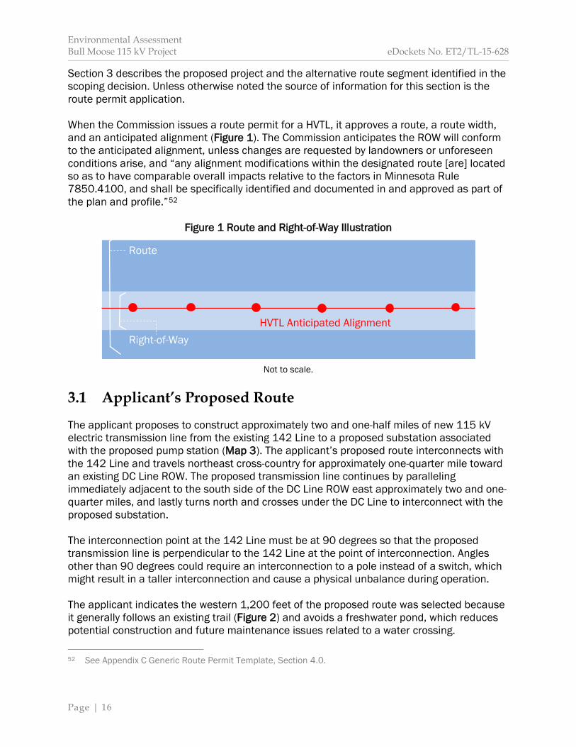
Section 3 describes the proposed project and the alternative route segment identified in the scoping decision. Unless otherwise noted the source of information for this section is the route permit application. When the Commission issues a route permit for a HVTL, it approves a route, a route width, and an anticipated alignment (Figure 1). The Commission anticipates the ROW will conform to the anticipated alignment, unless changes are requested by landowners or unforeseen conditions arise, and “any alignment modifications within the designated route [are] located so as to have comparable overall impacts relative to the factors in Minnesota Rule 7850.4100, and shall be specifically identified and documented in and approved as part of the plan and profile.”52
Figure 1 Route and Right-of-Way Illustration
Not to scale.
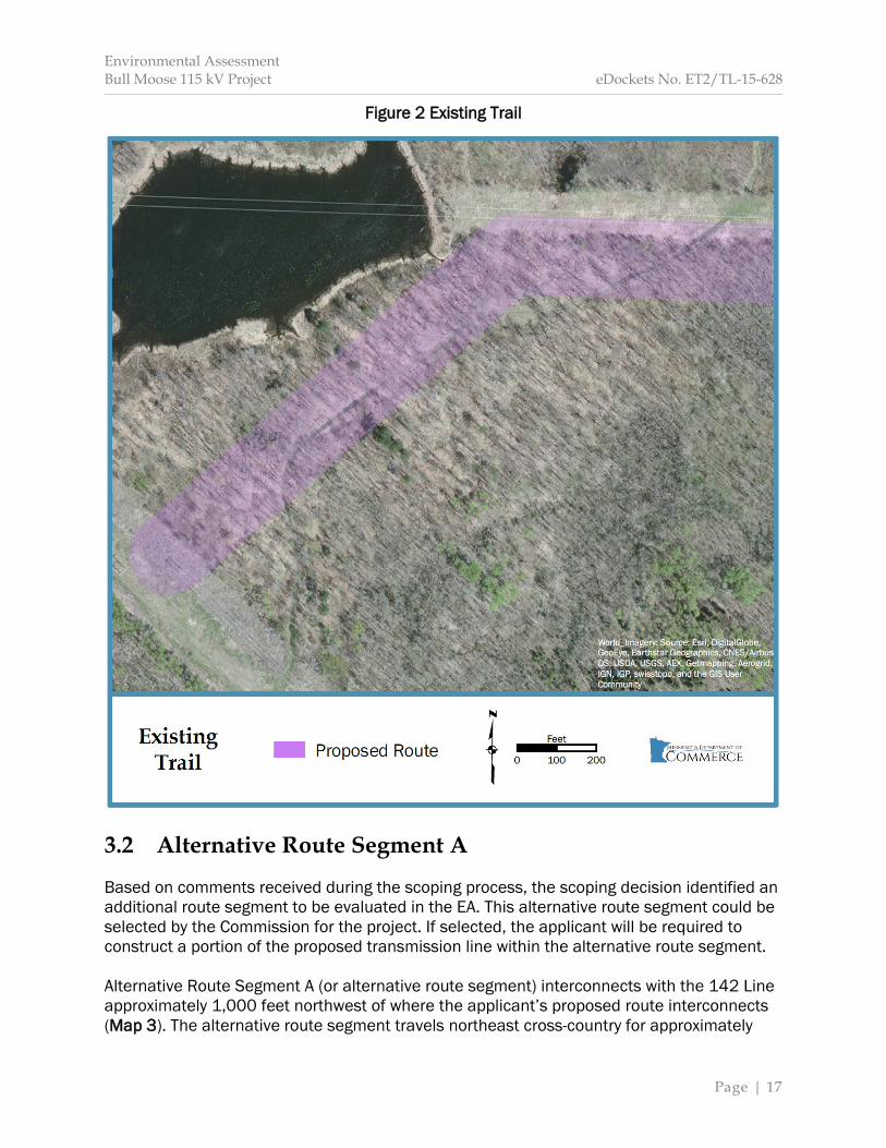
3.1 Applicant’s Proposed Route The applicant proposes to construct approximately two and one-half miles of new 115 kV electric transmission line from the existing 142 Line to a proposed substation associated with the proposed pump station (Map 3). The applicant’s proposed route interconnects with the 142 Line and travels northeast cross-country for approximately one-quarter mile toward an existing DC Line ROW. The proposed transmission line continues by paralleling immediately adjacent to the south side of the DC Line ROW east approximately two and one-quarter miles, and lastly turns north and crosses under the DC Line to interconnect with the proposed substation. The interconnection point at the 142 Line must be at 90 degrees so that the proposed transmission line is perpendicular to the 142 Line at the point of interconnection. Angles other than 90 degrees could require an interconnection to a pole instead of a switch, which might result in a taller interconnection and cause a physical unbalance during operation. The applicant indicates the western 1,200 feet of the proposed route was selected because it generally follows an existing trail (Figure 2) and avoids a freshwater pond, which reduces potential construction and future maintenance issues related to a water crossing. 52 See Appendix C Generic Route Permit Template, Section 4.0.
Route
Right-of-Way HVTL Anticipated Alignment
Environmental Assessment Bull Moose 115 kV Project eDockets No. ET2/TL-15-628
Page | 17
Figure 2 Existing Trail
3.2 Alternative Route Segment A Based on comments received during the scoping process, the scoping decision identified an additional route segment to be evaluated in the EA. This alternative route segment could be selected by the Commission for the project. If selected, the applicant will be required to construct a portion of the proposed transmission line within the alternative route segment. Alternative Route Segment A (or alternative route segment) interconnects with the 142 Line approximately 1,000 feet northwest of where the applicant’s proposed route interconnects (Map 3). The alternative route segment travels northeast cross-country for approximately
Environmental Assessment Bull Moose 115 kV Project eDockets No. ET2/TL-15-628
Page | 18
150 feet toward the existing DC Line ROW. It then parallels immediately adjacent to the south side of the DC Line ROW east approximately 1,300 feet where it merges with the applicant’s proposed route. The interconnection point at the 142 Line must remain at 90 degrees as proposed by the applicant. This is why the alternative route segment does not parallel the DC Line for its entire length, and why the 150-foot cross-country portion of the alternative necessary. Alternative Route Segment A crosses a previously impacted, nine-acre freshwater pond. 3.3 Route Width Minnesota Statute 216E.01, subdivision 8, defines “route” as “the location of a [HVTL] between two end points. The route may have a variable width of up to one and one-quarter miles.” The route width is typically wider than the actual ROW needed for the HVTL. This extra width provides flexibility in constructing the transmission line, but is not so wide that it is impossible to determine where the transmission line would be constructed. This provides predictability on-the-ground for effected landowners. The applicant is requesting a 200 foot route width for the proposed project with a 400 foot route width near the proposed pump station. The applicant’s proposed route and alternative route segment parallel immediately adjacent to existing transmission line infrastructure along a significant portion of their length.
3.4 Right-of-Way Requirements Minnesota Rule 7850.1000, subpart 15, defines “right-of-way” as the “land interest required within a route for the construction, maintenance, and operation” of a HVTL. The applicant indicates the proposed project will require a 100 foot ROW (50 feet on either side of the transmission line centerline) with a wider width in select locations to accommodate transmission line guy wires and anchors. The applicant anticipates this ROW will abut the south side of the existing DC Line ROW but not overlap it. 3.5 Right-of-Way Acquisition Should the Commission issue a route permit for the proposed project, the applicant will conduct a design survey to establish a transmission line alignment and ROW that is consistent with the Commission’s permit. This will be followed by acquisition of long-term easements for the required ROW. The project will require approximately two and one-half miles of new ROW or approximately 30 acres. This long-term ROW would cross private, tax-forfeited, and state land. 3.5.1 Private During easement acquisition landowners will be provided a number of documents, including a copy of the route permit, draft transmission line easement and offer of compensation, and information about construction practices and the project schedule. Landowners and utilities

Environmental Assessment Bull Moose 115 kV Project eDockets No. ET2/TL-15-628
Page | 19
typically negotiate easement terms that reduce negative impacts to a landowner’s property and provides just compensation for the utility’s use of the easement.53 In addition to long-term easements for the operation and maintenance of the transmission line, agreements for the use of temporary work space might be obtained from some landowners. Temporary workspace generally includes a marshalling yard(s) that is used to stage or store structures, vehicles, equipment and supplies. Marshalling yards are generally sited on previously disturbed or developed areas. In some instances a negotiated easement agreement cannot be reached between the landowner and the utility. Should this occur the applicant may use the eminent domain process to reach a settlement.54 In the eminent domain process, an independent panel of three court-appointed commissioners will determine the value of the easement, and both the landowner and the applicant are bound by this determination. If the eminent domain process is used, the applicant must obtain at least one appraisal for the property proposed to be acquired.55 3.5.2 Public The proposed project will cross both county and state land. The procedures for acquiring an easement across public land are unique. Cass County The proposed route will cross tax-forfeited land in Cass County. Cass County may grant access across its lands under the authority granted to it by Minnesota Statute 282, subdivision 4, which states “the county auditor … may grant easements … on unsold tax-forfeited land for … electric power lines….” To apply for an easement, the applicant would follow the procedure outlined in CCLD: LM-1 Easements found in Cass County Land Department: Index of Procedures.56 State of Minnesota Utility companies must follow the procedure outlined in Minnesota Statute 84.415 and Minnesota Rules 6135 to cross state-owned land. The Division of Lands and Minerals within DNR grants permission to cross state lands and waters in the form of a crossing license. The license is usually granted for 25 to 50 years and may be renewed when it expires.57 To apply 53 Minnesota Department of Commerce (August 5, 2014) Rights-of-Way and Easements for Energy Facility Construction and Operation, Retrieved December 8, 2015, from: http://mn.gov/commerce/energyfacilities/documents/Easements%20Fact%20Sheet_08.05.14.pdf. 54 See generally Minn. Stat. 117. 55 Minn. Stat. 117.036, subd. 2. 56 Cass County Land Department (August 29, 2011) Cass County Land Department: Index of Procedures, Retrieved October 21, 2015, from: http://www.co.cass.mn.us/document_center/land/Policy___Procedure_Manual.pdf. 57 Minnesota Department of Natural Resources (n.d.(a)) Utility Crossing Licenses, Retrieved October 22, 2015, from: http://dnr.state.mn.us/permits/utility_crossing/index.html.

Environmental Assessment Bull Moose 115 kV Project eDockets No. ET2/TL-15-628
Page | 20
for an easement, the applicant must file an Application for License to Cross Public Lands and Waters.58 3.6 Project Description The proposed transmission line will interconnect with the existing 142 Line using a laminated wood switch structure. The switch structure will be installed on the same alignment as the 142 Line. The applicant indicates the interconnection should be made at a 90-degree angle because interconnection at angles less than 90-degrees could require interconnecting directly to a 142 Line pole structure itself, which could result in a taller switch structure and cause a physical unbalance during operation.59 Figure 3 provides an illustration of a switch structure, along with the other structures the applicant indicates may be necessary for construction of the proposed transmission line. Typically, switch structures are 80 to 100 feet tall; however, in this instance, the height of the structure will depend upon the terrain and existing pole height of the 142 Line. Since the switch structure will be taller than the 142 Line, structures along a portion of the 142 Line might need to be replaced to ensure proper vertical alignment. Outages on the 142 Line will be required to install the switch structure and, if necessary, to replace existing structures. The applicant proposes to use primarily single pole wood structures. Structures will be approximately 70 to 80 feet tall and spaced 350 to 400 feet apart. Structure height and span is dependent upon several factors including topography and environmental constraints, for example, stream crossings. Structures will be equipped with guy wires for support as necessary. In areas where topography or environmental constraints limit the use of single pole structures, H-Frame structures will be used. H-Frame structures provide for longer span lengths of 600 to 800 feet on average, with 1,000 foot spans possible. Structures are 60 to 90 feet high, with taller structures necessary for longer spans. The proposed project will cross underneath the existing DC Line using H-Frame or multiple single-pole structures called three-pole dead-end.60 These structures will be used because they use a horizontal, rather than a vertical, conductor alignment, which allows the transmission line to be lower to the ground. Three-pole dead-end structures will also be used to change direction, for example, turning a corner. These structures are generally larger in size so that proper tension is maintained on the transmission line. Structures will be equipped with guy wires for support.
58 Minnesota Department of Natural Resources (June 13, 2015) Application for License to Cross Public
Lands and Waters, Retrieved October 22, 2015 from: http://files.dnr.state.mn.us/lands_minerals/utility/utility_crossing_application.pdf.
59 Great River Energy. 60 “Dead-end” means that the conductor is stopped and started again where increased tension is necessary or present along a transmission line. A dead-end can occur at a corner or in-line.
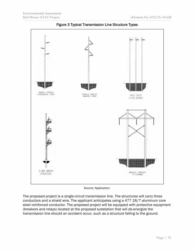
Environmental Assessment Bull Moose 115 kV Project eDockets No. ET2/TL-15-628
Page | 21
Figure 3 Typical Transmission Line Structure Types
Source: Application.
The proposed project is a single-circuit transmission line. The structures will carry three conductors and a shield wire. The applicant anticipates using a 477 26/7 aluminum core steel reinforced conductor. The proposed project will be equipped with protective equipment (breakers and relays) located at the proposed substation that will de-energize the transmission line should an accident occur, such as a structure falling to the ground.
Environmental Assessment Bull Moose 115 kV Project eDockets No. ET2/TL-15-628
Page | 22
Pentachlorophenol is used on all wood pole structures—including the switch structure—to repel water, improve dimensional stability, and reduce checking and splitting.61 The design of the transmission line will meet or exceed NESC clearance and strength requirements. Any outages along existing transmission lines would comply with NERC transmission grid reliability requirements, and be coordinated with MISO, the region’s independent transmission system operator, and MP, the operator of the 142 Line and the DC Line. Alternative Route Segment A The alternative route segment would also interconnect with the existing 142 Line using a laminated wood switch structure. The switch structure will be installed on the same alignment as the 142 Line. The interconnection point at the 142 Line must remain at 90 degrees as proposed by the applicant. The height of the switch structure will depend upon the terrain and existing pole height of the 142 Line. Since the switch structure will be taller than the 142 Line, structures along a portion of the 142 Line might need to be replaced to ensure proper vertical alignment. Additionally, one or two dead-end structures along the 142 Line might need to be installed north of the interconnection point and close to the DC Line to properly “grade” the existing 142 Line underneath the DC Line. Upon reaching the existing DC Line ROW, the alternative route segment continues east immediately adjacent to the south of the ROW until it merges with the applicant’s proposed route. In process, the alternative route segment crosses a freshwater pond that is approximately 800 to 850 feet across near the route centerline. The applicant indicates they would span this pond. This is because the presence of open water makes use of matting infeasible, and in order to place a pole in the pond during frozen ground conditions, extreme ice conditions would be necessary to support heavy equipment. Spanning the wetland will require an approximately 1,000 foot span between structures, and could be accomplished using an anchored H-Frame structure approximately 100 feet tall (or taller) on each end of the crossing. The conductor would be dead-end at each structure to allow for increased conductor tension and reduced sag across the span. It might also be necessary to use a larger conductor that can be pulled at a higher tension than the conductor currently proposed. If used, the alternative conductor would only be used to span the freshwater pond. General construction practices would be similar to those outlined below.
61 Great River Energy.

Environmental Assessment Bull Moose 115 kV Project eDockets No. ET2/TL-15-628
Page | 23
3.7 Construction Construction will not begin until all approvals are obtained and land rights secured. The applicant indicates that landowners will be notified before construction starts and provided an update on the project schedule and construction activities. The applicant will use best management practices (BMPs) designed specifically for the proposed project to minimize and mitigate impacts while clearing vegetation, installing structures, and stringing the conductors. These BMPs are based on industry-specific standards and experience with previous projects. Before any ground disturbance occurs, the transmission line centerline and ROW boundary will be surveyed and staked. Prior to structure installation, the transmission line centerline may again be surveyed and marked to guarantee proper placement of structures. All construction activities, for example, vegetation removal, must comply with easement agreements. The applicant anticipates it will employ up to 20 workers at a time during construction. Vegetation Removal Construction begins by removing trees and other vegetation from the ROW that will interfere with the safe operation of the transmission line. Low growing vegetation (including certain tree species) within the ROW that does not interfere with the safe operation of the transmission line or impede construction or maintenance activities will remain. Limited clearing of “danger trees” may also occur outside the ROW if allowed by easement agreements with individual landowners. Danger trees are dead, diseased, weak or leaning trees that have the potential to fall on the energized conductors. Cleared vegetation will be stacked for use by landowners, chipped and spread on the ROW, or removed and disposed off-site. The Commission requires that applicants minimize tree removal to the maximum extent practicable and leave undisturbed low growing species that will not interfere with operation or construction of the transmission line.62 Structure Installation This phase begins by marking underground utilities. Underground utilities will be identified using the Gopher State One Call process. Transmission line structures will be installed directly into the ground at or near the existing grade. As a result, structure locations will not be graded or leveled unless it is necessary for
62 See Appendix C Generic Route Permit Template, Section 5.2.8.
Environmental Assessment Bull Moose 115 kV Project eDockets No. ET2/TL-15-628
Page | 24
construction activities. Grading might also be necessary to ensure safe access for construction vehicles. Upon completion of necessary grading, holes will be augured or excavated. These holes will range from eight to 15 feet deep and two to five feet in diameter depending on soil conditions. The average depth that a structure will need to be buried is approximately nine feet. Structures are then set and holes backfilled. Excess soil will be spread evenly near the structure or removed and disposed off-site. In poor soil conditions galvanized steel culverts will be buried vertically surrounding the structure or concrete foundations will be used. Once structures are installed, conductors will be strung along the line. Setup areas approximately one-third of an acre in size will be established approximately every two miles along the route. At this time, the applicant anticipates a single setup area on the east end of the proposed project. Conductors and a shield wire will be strung and, once appropriate tension is obtained, secured to each structure. Temporary guard or clearance structures will be used to provide adequate clearance over roads, existing transmission lines or other potential obstructions, as well as to protect the transmission line. Stringing activities will only occur after necessary notifications are made and permits obtained. The proposed transmission line will cross wetlands and waterways. The applicant indicates that should equipment need to be driven across these features it will be done only as necessary and after consultation with appropriate resource agencies. The applicant anticipates that construction will occur during frozen conditions and will use BMPs to minimize soil erosion. Restoration The applicant indicates that disturbed sections of the ROW or temporary work area(s) will be restored to pre-construction conditions to the greatest extent practicable. Soil compaction will be alleviated unless otherwise negotiated with the landowner. Restoration also includes removal of debris and all temporary facilities, using erosion control measures, and reseeding with appropriate seed mixes, that is, similar types of vegetation that are certified free of noxious weeds and invasive species. Wildlife-friendly mesh will be used when netting is necessary for erosion control on DNR-administered lands. After construction is complete, a ROW agent will contact landowners to determine if restoration has been completed to their satisfaction and to identify damages that may have occurred during construction. The applicant indicates it will compensate landowners for any damages or hire a contractor to restore damaged property, for example, a fence. 3.8 Operation and Maintenance Once the transmission line is constructed, the applicant will use the ROW to perform regular (yearly) inspections to identify needed maintenance and repairs. The applicant will inspect the transmission line using snowmobile, all-terrain vehicle, pickup truck or by foot. Maintenance activities and repairs will be performed as needed to ensure the continued integrity of the transmission line.

Environmental Assessment Bull Moose 115 kV Project eDockets No. ET2/TL-15-628
Page | 25
The applicant indicates that vegetative surveys will be conducted on a two-year cycle. Vegetation that will interfere with the safe operation of the transmission line will be removed by hand-clearing or mechanical means. Herbicides will also be used if consistent with easement conditions and landowner agreements. Native vegetation that will not interfere with the safe operation of the transmission line will be allowed to reestablish. 3.9 Cost The applicant indicates the proposed project will cost approximately $2.1 million (Table 3). Annual operation and maintenance costs, including ROW maintenance, are anticipated to be $2,000 per mile. The applicant anticipates that construction costs for the alternative route segment would be approximately $275,000. This includes use of H-Frame structures, an alternative conductor, bird diverters, guy wires, anchors, “grading” the existing 142 Line to cross underneath the DC Line, and other miscellaneous equipment. Given a portion of the applicant’s proposed route would no longer be constructed if the alternative route segment is selected, the total cost of the proposed project would increase approximately $150,000.
Table 3 Estimated Costs
Project Component Estimated Cost
Planning / Permitting $145,735
Land Acquisition / Permits $283,955
Design $185,119
Procurement $506,703
Construction $905,794
Close Out $49,287
Total $2,076,593
Total (if Alternative Route Segment A is selected)
$2,226,593
Source: Great River Energy. 3.10 Schedule Assuming all permits are acquired, the applicant indicates that construction will begin in early 2017. Construction of the project should take four months and the transmission line is anticipated to be energized in spring of 2017.

Environmental Assessment Bull Moose 115 kV Project eDockets No. ET2/TL-15-628
Page | 26
This page intentionally left blank.
Environmental Assessment Bull Moose 115 kV Project eDockets No. ET2/TL-15-628
Page | 27
4 Rejected Routes
Environmental Assessment Bull Moose 115 kV Project eDockets No. ET2/TL-15-628
Page | 28
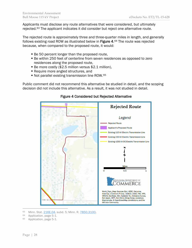
Applicants must disclose any route alternatives that were considered, but ultimately rejected.63 The applicant indicates it did consider but reject one alternative route. The rejected route is approximately three and three-quarter miles in length, and generally follows existing road ROW as illustrated below in Figure 4.64 The route was rejected because, when compared to the proposed route, it would:
Be 50 percent longer than the proposed route, Be within 250 feet of centerline from seven residences as opposed to zero
residences along the proposed route, Be more costly ($2.5 million versus $2.1 million), Require more angled structures, and Not parallel existing transmission line ROW.65
Public comment did not recommend this alternative be studied in detail, and the scoping decision did not include this alternative. As a result, it was not studied in detail.
Figure 4 Considered but Rejected Alternative
63 Minn. Stat. 216E.04, subd. 5; Minn. R. 7850.3100. 64 Application, page 5-1. 65 Application, page 5-1.
Environmental Assessment Bull Moose 115 kV Project eDockets No. ET2/TL-15-628
Page | 29
5 Potential Impacts and Mitigative Measures

Environmental Assessment Bull Moose 115 kV Project eDockets No. ET2/TL-15-628
Page | 30
Section 5 provides an overview of the environmental setting, affected resources and potential impacts and mitigation measures associated with the proposed transmission line. More specifically, this section discusses and analyzes:
The environmental setting, Human and environmental resources affected by the project, Potential impacts to human and environmental resources, Opportunities to avoid, minimize, or mitigate potential impacts, and Cumulative potential effects.
Routing Options The inclusion of Alternative Route Segment A for study functionally divides the applicant’s proposed route into two distinct route segments: the portion that could potentially be replaced (Proposed Route Segment) and the portion that is unaffected (Proposed Route). As such, for analysis purposes, this EA will study three route segments or routing options: Proposed Route Segment, Alternative Route Segment A, and Proposed Route (Map 4). Analysis Background A potential impact is the anticipated change to an existing condition caused either directly or indirectly by the construction and operation of a proposed project. Potential impacts can be positive or negative, short- or long-term, and, in certain circumstances, can accumulate incrementally. Impacts vary in duration and size, by resource, and across locations. Direct impacts are caused by the proposed action and occur at the same time and place as the proposed action. An indirect impact is caused by the proposed action, but is further removed in distance or occurs later in time. Both direct and indirect impacts must be reasonably foreseeable, which means a reasonable person would anticipate or predict the impact. Cumulative potential effects are the result of the incremental effects of the proposed action in addition to other projects in the environmentally relevant area. Potential Impacts and Mitigation Sections 5.2 through 5.7 explain the potential direct and indirect impacts to various resources caused by the routing options. The following terms and concepts are used to describe and analyze potential impacts, that is, to put impacts into a consistent context:
Duration Impacts vary over time. Short-term impacts are generally associated with project construction. Long-term impacts are associated with the operational life of the project and usually end with project decommissioning and reclamation. Permanent impacts extend beyond the decommissioning stage of the project. Size Impacts vary by size. Size is a measure of how big something is. To the extent possible, potential impacts are described quantitatively, for example, the number of impacted acres or the percentage of affected individuals in a population.
Environmental Assessment Bull Moose 115 kV Project eDockets No. ET2/TL-15-628
Page | 31
Location Impacts are location dependent. For example, noise impacts decrease as distance from the source increases, or common resources in one location might be uncommon in another. Uniqueness Resources are different. Common resources occur frequently, while uncommon resources are not ordinarily encountered.
The context of an impact—in combination with its anticipated on-the-ground effect—is used to determine an impact intensity level, which can range from highly beneficial to highly harmful. Impact intensity levels are described using a qualitative scale, which is explained below. These terms are not intended to be value judgments, but rather a means to ensure a common understanding among readers and to compare impacts between alternatives.
Minimal impacts do not considerably alter an existing resource condition or function. Minimal impacts might, for some resources and at some locations, be noticeable to an average observer. These impacts generally affect common resources over the short-term.
Moderate impacts alter an existing resource condition or function, and are generally noticeable or predictable to the average observer. Effects might be spread out over a large area making them difficult to observe, but can be estimated by modeling. Moderate impacts might be long-term or permanent to common resources, but generally short- to long-term to uncommon resources.
Significant impacts alter an existing resource condition or function to the extent that the resource is impaired or cannot function. Significant impacts are likely noticeable or predictable to the average observer. Effects might be spread out over a large area making them difficult to observe, but can be estimated by modeling. Significant impacts can be of any duration, and affect common or uncommon resources.
In instances where the potential effects of other projects coincide with the potential effects of the proposed project in the environmentally relevant area, these effects are cumulative. Cumulative potential effects may or may not change the impact intensity level. Section 5.8 discusses cumulative potential effects in detail. Sections 5.2 through 5.7 discuss opportunities to avoid, minimize, or mitigate an impact. These actions are collectively referred to as mitigation.
To avoid an impact means it is eliminated altogether, for example, by not undertaking parts or all of a project, or relocating the project. To minimize an impact means to limit its intensity, for example, by reducing project size or moving a portion of the project within the route width. To mitigate an impact means fixing it by repairing, rehabilitating or restoring the affected resource, or compensating for it by replacing it or providing a substitute
Environmental Assessment Bull Moose 115 kV Project eDockets No. ET2/TL-15-628
Page | 32
resource elsewhere. Mitigating an impact is often used when it cannot be avoided or further minimized.
Some impacts are avoidable or can be minimized; some might be unavoidable but can be minimized; others might be unavoidable and unable to be minimized, but can be mitigated. Regions of Influence Potential impacts to human and environmental resources are analyzed in this EA within specific spatial bounds or regions of influence (ROI). The ROI for each resource is the geographic area within which a particular impact may exert some influence. The ROI will vary between impacts and resources, and, moreover, from project to project given differences in environmental settings, for example, an urban or rural setting. This EA uses the ROI concept as the basis for assessing the potential impacts to each resource as a result of the proposed transmission line. Table 4 summarizes and Map 4 illustrates the ROIs for the resources analyzed in this EA. The ROW, in this case 100 feet, is used to analyze potential impacts to resources within the ROW. The route width, in this case 200 feet with a wider width near the proposed pump station, is used to analyze potential impacts to resources outside the ROW that diminish quickly beyond the route width. A distance of 1,500 feet is used to analyze potential impacts to resources beyond the route width that diminish quickly beyond 1,500 feet. A distance of one mile is used to analyze potential impacts to resources beyond 1,500 feet that diminish quickly beyond one mile. The project area is used to analyze potential impacts to resources throughout Cass County. As necessary, this EA will discuss resources, potential impacts and mitigation measures beyond the ROI to provide appropriate context. 5.1 Environmental Setting The proposed project is located approximately two and three-quarter miles south/southwest of the city of Backus, Minnesota, and is located entirely within Cass County (Map 2). Regional Setting The project area was affected by glaciation, and, because of this, a “complex pattern of moraines, outwash plains, drumlins, lake plains, and drainages characterize the area.”66
66 U.S. Department of Agriculture, Natural Resources Conservation Service (2006) U.S. Department of
Agriculture Handbook 296: Land Resource Regions and Major Land Resource Areas of the United States, the Caribbean, and the Pacific Basin, Retrieved December 15, 2015, from: http://www.nrcs.usda.gov/Internet/FSE_DOCUMENTS/nrcs142p2_050898.pdf.
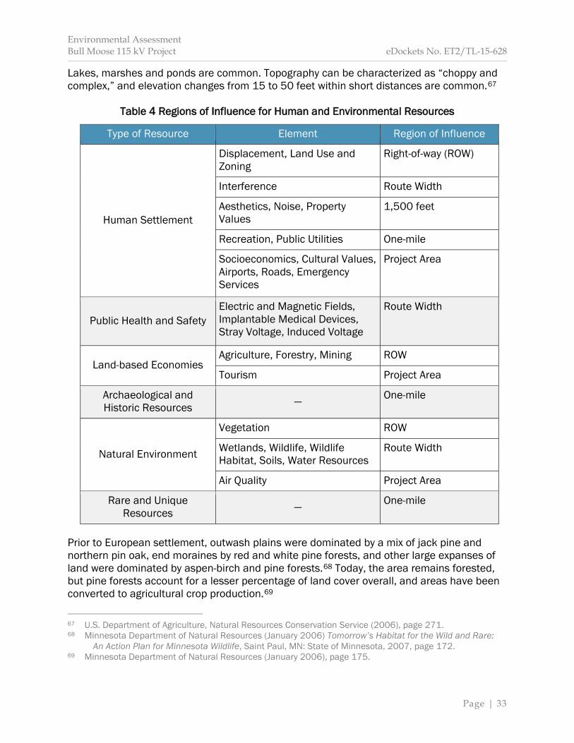
Environmental Assessment Bull Moose 115 kV Project eDockets No. ET2/TL-15-628
Page | 33
Lakes, marshes and ponds are common. Topography can be characterized as “choppy and complex,” and elevation changes from 15 to 50 feet within short distances are common.67
Table 4 Regions of Influence for Human and Environmental Resources
Type of Resource Element Region of Influence
Human Settlement
Displacement, Land Use and Zoning
Right-of-way (ROW)
Interference Route Width
Aesthetics, Noise, Property Values
1,500 feet
Recreation, Public Utilities One-mile
Socioeconomics, Cultural Values, Airports, Roads, Emergency Services
Project Area
Public Health and Safety Electric and Magnetic Fields, Implantable Medical Devices, Stray Voltage, Induced Voltage
Route Width
Land-based Economies Agriculture, Forestry, Mining ROW
Tourism Project Area
Archaeological and Historic Resources — One-mile
Natural Environment
Vegetation ROW
Wetlands, Wildlife, Wildlife Habitat, Soils, Water Resources
Route Width
Air Quality Project Area
Rare and Unique Resources — One-mile
Prior to European settlement, outwash plains were dominated by a mix of jack pine and northern pin oak, end moraines by red and white pine forests, and other large expanses of land were dominated by aspen-birch and pine forests.68 Today, the area remains forested, but pine forests account for a lesser percentage of land cover overall, and areas have been converted to agricultural crop production.69
67 U.S. Department of Agriculture, Natural Resources Conservation Service (2006), page 271. 68 Minnesota Department of Natural Resources (January 2006) Tomorrow’s Habitat for the Wild and Rare: An Action Plan for Minnesota Wildlife, Saint Paul, MN: State of Minnesota, 2007, page 172. 69 Minnesota Department of Natural Resources (January 2006), page 175.
Environmental Assessment Bull Moose 115 kV Project eDockets No. ET2/TL-15-628
Page | 34
National Land Cover Database The National Land Cover Database (NLCD) provides “spatial reference and descriptive data for characteristics of the land surface” nation-wide.70 Land cover types within one-mile of the project area are approximately 50 percent forested and 25 percent wetlands. Agriculture accounts for 7 percent of land cover types. Appendix E summarizes current land cover by ROI, and provides classification descriptions. These descriptions are color coded to coincide with Map 5, which illustrates land cover in the project vicinity. The NLCD is based on a 30 meter resolution, which provides an accurate interpretation of land cover types at a landscape scale. However, as a result, smaller parcels may be classified the same as larger, surrounding cover types. Therefore, when reviewing projects at a localized scale, the NLCD may not accurately depict all parcels. Satellite imagery was used to verify NLCD land cover classifications. Land cover classifications for the proposed route and proposed route segment appear accurate, and their use is reasonable. However, land cover classifications within the ROW and route width of the alternative route segment do not appear accurate; therefore, their use is not reasonable. Instead, EERA staff analyzed satellite imagery to provide a more reasonable estimate of cover types in this area. This information is found in Appendix E and is used throughout this EA. Project Setting The proposed project begins within the exterior boundary of Foot Hills State Forest. Moving west to east, the proposed route segment interconnects with the 142 Line in a forested area, and continues through deciduous forest and shrub land cover types until it merges with the proposed route. The alternative route segment also interconnects with the 142 Line in a forested area, but continues over a freshwater pond before merging with the applicant’s proposed route (Map 3). Both of these interconnection points are within the Foot Hills State Forest. The proposed route travels through deciduous forest and shrub cover types as it parallels the south side of the DC Line ROW east. It then descends approximately 80 feet downhill into an area of predominately wetland cover types. As the proposed route slowly regains elevation (approximately 10 to 20 feet), it transitions from wetland to agricultural land cover types. Built features include one residence with miscellaneous outbuildings to the north on the eastern edge of the project. A gravel road (48th Ave SW) is perpendicular to the eastern edge of the proposed project. This road may or may not be crossed by the proposed route. At this time, the applicant anticipates a crossing will not be necessary. An electric distribution line parallels 48th Ave SW on the east side of the road.
70 U.S. Geological Survey (February 2012) The National Land Cover Database, Retrieved December 21, 2015, from: http://pubs.usgs.gov/fs/2012/3020/fs2012-3020.pdf.

Environmental Assessment Bull Moose 115 kV Project eDockets No. ET2/TL-15-628
Page | 35
There are three existing electric transmission lines in the project area.71 These transmission lines are owned and operated by MP. There are two transmission lines that travel northwesterly along the western edge of the proposed project. Furthest west is the MP #91 Line (91 Line). This transmission line is a 230 kV line. It has an average height of 74 feet, and an average span length of 856 feet. The 142 Line is adjacent to the 91 Line to the east. This 115 kV transmission line has an average height of 61 feet, and an average span length of 709 feet. The 142 Line and the 91 Line share a corridor. The existing DC Line travels west to east through the area. The DC Line is a ±250 kV is, on average, 73 feet tall and spans 717 feet. 5.2 Impacts to Human Settlement Construction and operation of new transmission lines have the potential to impact human settlement. These impacts might be short-term, for example, an influx of construction jobs during construction, or long-term, for example, changes to land cover. 5.2.1 Aesthetics Aesthetics refers to the visual quality of an area as perceived by the viewer, and forms the overall impression an observer has of an area, that is, the individual’s concern with, or appreciation of, beauty. Aesthetics are subjective, meaning their relative value depends upon the perception and philosophical or psychological responses unique to individual viewers. Impacts to aesthetics are equally subjective, and depend upon the sensitivity and exposure of an individual. The relative value of aesthetics, as well as perceived impacts to visual resources, can vary greatly between individuals. A viewshed includes the natural landscape and built features visible from a specific location. Natural landscapes can include wetlands, surface waters, distinctive landforms, and vegetation patterns. Buildings, roads, bridges and transmission lines are examples of built features on the landscape. Generally, a harmonious viewshed is considered by many to be more aesthetically pleasing. Viewer sensitivity is an individual’s interest or concern for the quality of a viewshed and varies depending upon the activities viewers are engaged in, their values and expectations related to the viewshed, and their level of concern for potential changes to the viewshed. For example, high viewer sensitivity is generally associated with individuals engaged in recreational activities; traveling scenic routes for pleasure and to or from recreational, protected, natural, cultural or historic areas; or experiencing viewsheds from resorts, road-side pull-outs, or residences. Low viewer sensitivity is generally associated with individuals working or commuting. Viewer exposure refers to variables associated with observing a viewshed, and can include the number of viewers, frequency and duration of views, and view location. For example, a high exposure viewshed would be observed frequently by large numbers of people for long 71 See Application, page 7-1.

Environmental Assessment Bull Moose 115 kV Project eDockets No. ET2/TL-15-628
Page | 36
periods. These variables, as well as other factors such as viewing angle or time of day, affect the overall aesthetic impact. The natural landscape within 1,500 feet of the proposed route consists of gently rolling topography and multiple land cover types typical of the area, including forests, wetlands, shrubs and agriculture. Lakes and other water features exist. Built features include one residence with miscellaneous outbuildings. 48th Ave SW is perpendicular the eastern edge of the proposed route. A distribution line parallels 48th Ave SW. Three existing transmission lines are within 1,500 feet of the proposed project. The proposed route and alternative route segment parallel the DC Line for nearly their entire length. The DC Line, on average, is 73 feet in height and spans 717 feet. It is visible along 48th Ave SW. Views of the proposed transmission line will most likely occur along 48th Ave SW; however, the line will also be visible to recreationalists within Foot Hills State Forest. Trails utilize existing transmission line ROWs within 1,500 feet of all routing options. DNR maintains a shapefile regarding visual sensitivity classifications “where timber and tourism interests are a very important part of the life and economy.”72 “County Visual Quality Committees were formed to classify travel routes within their counties. The county committees were made up of county residents that represented tourism and forest products industries and interests. Three factors were used in the classification process:
The perceived degree of sensitivity of users of a travel route or recreation area concerning landscape aesthetics. The volume and type of use a travel route or recreation area receives. The speed of travel within a route or area.”73
According to this classification system, 48th Ave SW is moderately sensitive. “Moderately sensitive applies to travel routes or recreation areas, not included in [most sensitive], where visual quality is of moderate concern to typical users. Examples of these routes and areas may include public highways and local roads, recreational lakes and rivers, and designated recreational trails that provide moderate to high scenic quality but less significant public use.”74 Potential Impacts Potential impacts specific to the identified routing option are as follows:
72 Minnesota Department of Natural Resources (October 6, 2014) Visual Sensitivity Classifications, Retrieved
March 2, 2016, from: ftp://ftp.gisdata.mn.gov/pub/gdrs/data/pub/us_mn_state_dnr/env_visual_sensitivity/metadata/metadata.html.
73 Minnesota Department of Natural Resources (October 6, 2014). 74 Minnesota Department of Natural Resources (October 6, 2014).
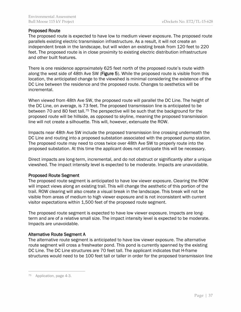
Environmental Assessment Bull Moose 115 kV Project eDockets No. ET2/TL-15-628
Page | 37
Proposed Route The proposed route is expected to have low to medium viewer exposure. The proposed route parallels existing electric transmission infrastructure. As a result, it will not create an independent break in the landscape, but will widen an existing break from 120 feet to 220 feet. The proposed route is in close proximity to existing electric distribution infrastructure and other built features. There is one residence approximately 625 feet north of the proposed route’s route width along the west side of 48th Ave SW (Figure 5). While the proposed route is visible from this location, the anticipated change to the viewshed is minimal considering the existence of the DC Line between the residence and the proposed route. Changes to aesthetics will be incremental. When viewed from 48th Ave SW, the proposed route will parallel the DC Line. The height of the DC Line, on average, is 73 feet. The proposed transmission line is anticipated to be between 70 and 80 feet tall.75 The perspective will be such that the background for the proposed route will be hillside, as opposed to skyline, meaning the proposed transmission line will not create a silhouette. This will, however, extenuate the ROW. Impacts near 48th Ave SW include the proposed transmission line crossing underneath the DC Line and routing into a proposed substation associated with the proposed pump station. The proposed route may need to cross twice over 48th Ave SW to properly route into the proposed substation. At this time the applicant does not anticipate this will be necessary. Direct impacts are long-term, incremental, and do not obstruct or significantly alter a unique viewshed. The impact intensity level is expected to be moderate. Impacts are unavoidable. Proposed Route Segment The proposed route segment is anticipated to have low viewer exposure. Clearing the ROW will impact views along an existing trail. This will change the aesthetic of this portion of the trail. ROW clearing will also create a visual break in the landscape. This break will not be visible from areas of medium to high viewer exposure and is not inconsistent with current visitor expectations within 1,500 feet of the proposed route segment. The proposed route segment is expected to have low viewer exposure. Impacts are long-term and are of a relative small size. The impact intensity level is expected to be moderate. Impacts are unavoidable. Alternative Route Segment A The alternative route segment is anticipated to have low viewer exposure. The alternative route segment will cross a freshwater pond. This pond is currently spanned by the existing DC Line. The DC Line structures are 70 feet tall. The applicant indicates that H-frame structures would need to be 100 feet tall or taller in order for the proposed transmission line
75 Application, page 4-3.
Environmental Assessment Bull Moose 115 kV Project eDockets No. ET2/TL-15-628
Page | 38
to span the pond. As a result, this routing option would result in an enlarged vertical visual disturbance.
Figure 5 Nearest Residence / Domestic Well
The alternative route segment is expected to have low viewer exposure. Direct impacts are long-term, of a relative small size, and do not substantially alter a unique viewshed. The impact intensity level is expected to be moderate. Impacts are unavoidable.
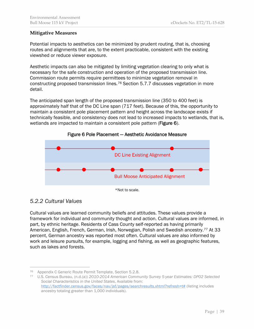
Environmental Assessment Bull Moose 115 kV Project eDockets No. ET2/TL-15-628
Page | 39
Mitigative Measures Potential impacts to aesthetics can be minimized by prudent routing, that is, choosing routes and alignments that are, to the extent practicable, consistent with the existing viewshed or reduce viewer exposure. Aesthetic impacts can also be mitigated by limiting vegetation clearing to only what is necessary for the safe construction and operation of the proposed transmission line. Commission route permits require permittees to minimize vegetation removal in constructing proposed transmission lines.76 Section 5.7.7 discusses vegetation in more detail. The anticipated span length of the proposed transmission line (350 to 400 feet) is approximately half that of the DC Line span (717 feet). Because of this, the opportunity to maintain a consistent pole placement pattern and height across the landscape exists if technically feasible, and consistency does not lead to increased impacts to wetlands, that is, wetlands are impacted to maintain a consistent pole pattern (Figure 6).
Figure 6 Pole Placement — Aesthetic Avoidance Measure
*Not to scale. 5.2.2 Cultural Values Cultural values are learned community beliefs and attitudes. These values provide a framework for individual and community thought and action. Cultural values are informed, in part, by ethnic heritage. Residents of Cass County self-reported as having primarily American, English, French, German, Irish, Norwegian, Polish and Swedish ancestry.77 At 33 percent, German ancestry was reported most often. Cultural values are also informed by work and leisure pursuits, for example, logging and fishing, as well as geographic features, such as lakes and forests.
76 Appendix C Generic Route Permit Template, Section 5.2.8. 77 U.S. Census Bureau, (n.d.(a)) 2010-2014 American Community Survey 5-year Estimates: DP02 Selected
Social Characteristics in the United States, Available from: http://factfinder.census.gov/faces/nav/jsf/pages/searchresults.xhtml?refresh=t# (listing includes ancestry totaling greater than 1,000 individuals).
DC Line Existing Alignment
Bull Moose Anticipated Alignment
Environmental Assessment Bull Moose 115 kV Project eDockets No. ET2/TL-15-628
Page | 40
Cass County hosts the Fourth of July traditional Pow Wows, the Lake Bluegrass Festival, and the Eel Pout Festival.78 These events are tied to ethnic heritage, geographic features, national holidays, and seasonal and municipal events. Potential Impacts The proposed transmission line will not impact the work and leisure pursuits of residents, or geographic features in such a way as to impact the underlying culture of the project area. As a result, impacts to cultural values are not anticipated. Mitigative Measures Impacts to cultural resources are not anticipated; therefore, mitigation is not proposed. 5.2.3 Displacement Displacement is the forced removal of a residence or building to facilitate the safe operation of a transmission line.79 The NESC requires, and the applicant maintains, clearances between transmission lines and residences and other buildings. Displacement occurs when these clearances cannot be met.80 Displacement is relatively uncommon, and is most likely to occur in more populated areas. There are no residences or other buildings within the ROW of any routing option. The final routing of the proposed transmission line will meet necessary NESC requirements for interconnecting to the proposed substation. Potential Impacts Displacement will not occur because there are no residences or buildings within the ROW of any routing option. Mitigative Measures Displacement will not occur within any routing option; therefore, mitigation is not proposed. 5.2.4 Electronic Interference Transmission lines have the potential to interfere with radio, television and cellular signals, and wireless internet. Transmission line structures might block line-of-sight communications.
78 Application, page 7-10. 79 American Heritage Dictionary of the English Language, Fifth Edition (2011) displacing, Retrieved
December 22, 2015, from: http://www.thefreedictionary.com/displacing (defining “displace” as “to move, shift, or force from the usual place or position” and “to force to leave a place of residence”).
80 Application, page 7-4.

Environmental Assessment Bull Moose 115 kV Project eDockets No. ET2/TL-15-628
Page | 41
Interference can also result from a phenomenon known as corona, which is common to all transmission lines. Corona is the result of small electrical discharges at discrete locations along the surface of the conductor that ionize surrounding air molecules. These discharges generate audible noise and radio frequency noise. If this noise is excessive it can interfere with signal reception. Interference, however, is largely dependent on the magnitude of the corona-induced radio frequency noise relative to the strength of the broadcast signals.81 Corona noise is dependent upon many variables, such as the size of the conductor coupled with its surface condition, transmission line geometry, weather and, most importantly, operating voltage.82 Radio frequency noise related to corona is “typically not a concern for power lines with operating voltages below 161 kV, because the electric field intensity is too low to produce significant corona.”83 Radio frequency noise from corona diminishes in magnitude as it increases in frequency. Radio Signals The frequency generated by corona noise predominantly ranges from 500 to 1,500 kilohertz (KHz). AM radio broadcasts are in frequencies from 535 to 1705 KHz.84 Interference to AM radio broadcasts typically occur directly underneath transmission lines and result in a crackling sound. Any interference dissipates rapidly on either side of the transmission line. FM radio broadcasts are in very high frequencies (VHF) and vary from 88 to 108 megahertz (MHz) or 88,000 to 108,000 KHz. Interference rejection properties inherent in FM radio systems make them virtually immune to electromagnetic noise. Emergency services also broadcast in VHF. Rural Minnesota will move to an 800 MHz system already in place in the metropolitan area.85 Currently, Cass County emergency service broadcasts are in frequencies ranging from 151 to 159 MHz.86 Potential Impacts Radio interference, if any, will occur in the AM frequency range directly underneath the transmission line conductors or in close proximity to them within the ROW. The applicant does not anticipate crossing 48th Ave SW; therefore, impacts are not anticipated.
81 Application, page 6-11. 82 Application, page 6-11. 83 Application, page 6-11. 84 National Telecommunications and Information Administration (August 2011) United States Frequency
Allocations: The Radio Spectrum, Retrieved December 31, 2015, from: https://www.ntia.doc.gov/files/ntia/publications/spectrum_wall_chart_aug2011.pdf.
85 Emergency Medical Services Board (n.d.) EMS Radio Project, Retrieved January 8, 2016, from: https://mn.gov/boards/emsrb/grantprojects/projects/ems-radio-project.jsp. 86 Radio Reference.com (2016) Cass County Minnesota, Retrieved January 8, 2016, from: https://www.radioreference.com/apps/db/?ctid=1320.
Environmental Assessment Bull Moose 115 kV Project eDockets No. ET2/TL-15-628
Page | 42
Should final design require the transmission line to cross 48th Ave SW in order to route into the proposed substation, vehicles will pass underneath the transmission line twice. Direct impacts will be long-term, affect a relatively small number of vehicles, and not significantly alter the current condition (the DC Line crosses 48th Ave SW in this location). Should this crossing occur, impacts will dissipate rapidly on either side of the transmission line. Impacts are expected to be minimal and unavoidable. Impacts to FM radio and emergency services are not anticipated. Mitigation Impacts to radio frequencies can be avoided by increasing the distance between the receiver and the transmission line. Impacts can be minimized increasing signal strength through antenna modifications.87 Television Signals It is possible to receive television broadcasts through a digital antenna, satellite dish, or from a local cable provider. How an individual receives their television broadcast dictates the potential interference that might occur from a transmission line. “Broadcast television stations in the United States have switched from analog to digital transmissions,” and to receive these transmission an antenna must be able to receive VHF or ultra-high frequency (UHF) signals.88 These frequencies are higher than frequencies generated by corona noise. Additionally, digital broadcasts use packets of binary information as opposed to waveforms to transfer content. These binary signals are less susceptible to corruption and can be corrected for errors. Digital broadcasts are susceptible to freezing and pixilation due to multipath reflections or low signal strength. Satellite television is broadcast at frequencies ranging from 12 to 18 gigahertz.89 These signals are also higher than corona generated noise. Satellite television is susceptible to line-of-sight interference, for example, falling snow can result in signal loss. Cable broadcasts are redistributed satellite broadcasts and are generally not susceptible to interference due to the use of shielded coaxial cable. Potential Impacts No residences are within the route width of any routing option; therefore, impacts to television signals are not anticipated. Mitigation Impacts are not anticipated; therefore, mitigation is not proposed. 87 Commission permits address interference with communication devices; see Appendix C Generic Route Permit Template, Section 5.3.3. 88 U.S. Federal Communications Commission (n.d.) Antennas and Digital Television, Retrieved January 8, 2016, from: https://www.fcc.gov/consumers/guides/antennas-and-digital-television. 89 National Telecommunications and Information Administration (August 2011).
Environmental Assessment Bull Moose 115 kV Project eDockets No. ET2/TL-15-628
Page | 43
Wireless Internet and Cellular Phones Wireless internet and cellular phones use frequencies in the UHF range, and vary based on phone service provider. UHF signals begin at 900 MHz, and are higher than frequencies generated by corona noise. Potential Impacts Impacts to wireless internet and cellular phone signals are not anticipated to occur for any routing option. Mitigation Impacts are not anticipated; therefore, mitigation is not proposed. 5.2.5 Land Use and Zoning Land use is the use of land by humans, such as residential, commercial or agricultural uses, and often refers to zoning. Zoning is a regulatory tool used by local governments (cities, counties, and some townships) to promote or restrict certain land uses within specific geographic areas. HVTLs have the potential to impede current and future land use. A route permit from the Commission supersedes local zoning, building or land use rules.90 Though zoning and land use rules are superseded, the Commission’s route permit decision must be guided, in part, by impacts to local zoning and land use in accordance with the legislative goal to “minimize human settlement and other land use conflicts.”91 ROW within the different routing options intersects lands zoned by Cass County as Agricultural/Forestry and Shoreland, Public Land/Natural Environment (Abel Lake ID# 11044300 and an unnamed pond ID# 11063600) (Map 7).92 Ordinance #2005-01 Land Use Ordinance for Cass County and Incorporated Amendments provides descriptions regarding these zoning districts.93 Agricultural/Forestry “The purpose of this district is to promote and protect those portions of the county where agricultural and/or forestry activities are dominant and are expected to continue to be vital elements of the local economy or where there is a pattern of large tract ownership or extensive recreational use of property…. This zone has been created to promote the orderly development of agriculture/livestock/forestry and to reduce the risk of pollution and damages to natural resources, and to maintain and improve the quality of this county.”94
90 Minn. Stat. 216E.10, subd. 1. 91 Minn. Stat. 216E.03, subd. 7. 92 Cass County (n.d.) Cass County Maps: Cass County’s Interactive Web Mapping, Retrieved December 30, 2015, from: http://www.co.cass.mn.us/services/land/maps/index.php. 93 Cass County (2005) Ordinance # 2005-01 Land Use Ordinance for Cass County, Minnesota and
Incorporated Amendments, Retrieved December 30,2015, from: http://www.co.cass.mn.us/document_center/ordinances/200501_landuse.pdf.
94 Cass County (2005), page 26.

Environmental Assessment Bull Moose 115 kV Project eDockets No. ET2/TL-15-628
Page | 44
Shoreland “The shoreland district is intended to allow low to medium density seasonal and year-round residential uses on lands suitable for such uses within the shoreland zone. It is also intended to prevent establishment of commercial, industrial, and other uses in these areas that cause conflicts or problems for residential uses. Some non-residential uses are allowed if properly managed under conditional use procedures.”95 “Natural Environment lakes are generally small, often shallow lakes with limited capacities for assimilating the impacts of development and recreational use. They often have adjacent lands with substantial constraints for development such as high water tables, exposed bedrock, and unsuitable soils. These lakes, particularly in rural areas, usually do not have much existing development or recreational use.”96 The proposed project will required approximately two and one-half miles of new ROW, or approximately 30 acres. The applicant will need to acquire easement rights across certain parcels to accommodate construction, operation and maintenance of the proposed project. Potential Impacts The existence of a transmission line easement restricts certain uses of a property. Most commonly these restrictions include planting trees that might grow into the transmission line or erecting permanent structures. Planting agricultural crops or using the ROW for pasture land is not generally precluded. Potential impacts specific to the identified routing options are as follows: Proposed Route The proposed transmission line will not significantly obstruct or alter current farming practices in the ROW. Removal of trees from the ROW will preclude future timber harvest on approximately six noncontiguous acres along the proposed route. This impact will be long-term and significant within the ROW; however, within a regional context, this impact is minimal. The proposed route will not create a new opening within a shoreland district. Direct impacts to land use and zoning will be long-term. Impacts are of relative small size and do not impact a unique resource. The impact intensity level is expected to be minimal. Impacts are unavoidable, but can be minimized. Proposed Route Segment Removal of trees from the ROW will preclude future timber harvest on approximately two and one-half acres. This impact will be long-term and significant within the ROW; however, within a regional context, this impact is minimal. Clearing the ROW will impact an existing trail. This will change the aesthetic of the trail. It will not preclude future use of the trail. The proposed route segment will not create a new opening within a shoreland district.
95 Cass County (2005), page 24. 96 Cass County (2005), page 106.
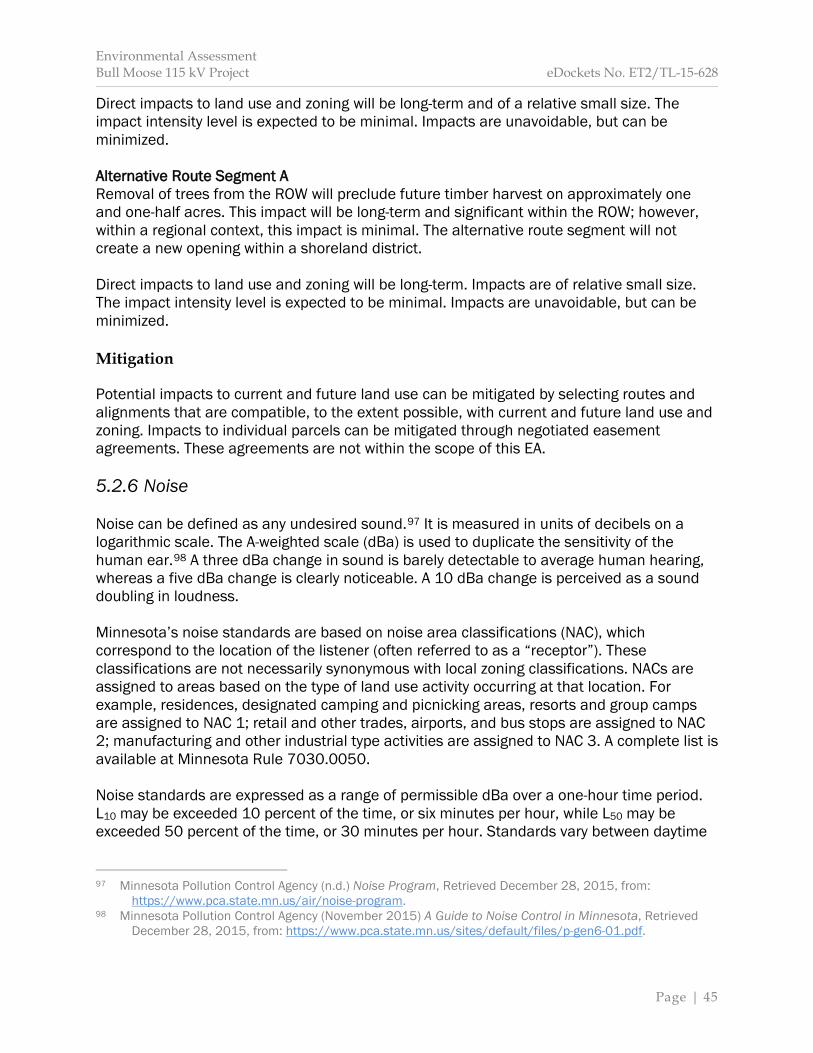
Environmental Assessment Bull Moose 115 kV Project eDockets No. ET2/TL-15-628
Page | 45
Direct impacts to land use and zoning will be long-term and of a relative small size. The impact intensity level is expected to be minimal. Impacts are unavoidable, but can be minimized. Alternative Route Segment A Removal of trees from the ROW will preclude future timber harvest on approximately one and one-half acres. This impact will be long-term and significant within the ROW; however, within a regional context, this impact is minimal. The alternative route segment will not create a new opening within a shoreland district. Direct impacts to land use and zoning will be long-term. Impacts are of relative small size. The impact intensity level is expected to be minimal. Impacts are unavoidable, but can be minimized. Mitigation Potential impacts to current and future land use can be mitigated by selecting routes and alignments that are compatible, to the extent possible, with current and future land use and zoning. Impacts to individual parcels can be mitigated through negotiated easement agreements. These agreements are not within the scope of this EA. 5.2.6 Noise Noise can be defined as any undesired sound.97 It is measured in units of decibels on a logarithmic scale. The A-weighted scale (dBa) is used to duplicate the sensitivity of the human ear.98 A three dBa change in sound is barely detectable to average human hearing, whereas a five dBa change is clearly noticeable. A 10 dBa change is perceived as a sound doubling in loudness. Minnesota’s noise standards are based on noise area classifications (NAC), which correspond to the location of the listener (often referred to as a “receptor”). These classifications are not necessarily synonymous with local zoning classifications. NACs are assigned to areas based on the type of land use activity occurring at that location. For example, residences, designated camping and picnicking areas, resorts and group camps are assigned to NAC 1; retail and other trades, airports, and bus stops are assigned to NAC 2; manufacturing and other industrial type activities are assigned to NAC 3. A complete list is available at Minnesota Rule 7030.0050. Noise standards are expressed as a range of permissible dBa over a one-hour time period. L10 may be exceeded 10 percent of the time, or six minutes per hour, while L50 may be exceeded 50 percent of the time, or 30 minutes per hour. Standards vary between daytime
97 Minnesota Pollution Control Agency (n.d.) Noise Program, Retrieved December 28, 2015, from: https://www.pca.state.mn.us/air/noise-program. 98 Minnesota Pollution Control Agency (November 2015) A Guide to Noise Control in Minnesota, Retrieved December 28, 2015, from: https://www.pca.state.mn.us/sites/default/files/p-gen6-01.pdf.
Environmental Assessment Bull Moose 115 kV Project eDockets No. ET2/TL-15-628
Page | 46
and nighttime hours. There is no limit to the maximum loudness of a noise.99 Table 5 provides current Minnesota noise standards. The proposed project is in a rural area. Ambient noise levels in these locations are generally between 30 and 40 dBa during daytime hours. Noise levels will increase sporadically with passing vehicle traffic on 48th Ave SW and high winds, or use of farm equipment and all-terrain vehicles (ATVs).
Table 5 Noise Area Classifications (dBa)
Noise Area Classification
(NAC)
Daytime (7:00 a.m. to 10:00 p.m.)
Nighttime (10:00 p.m. to 7:00 a.m.)
L10 L50 L10 L50 1 65 60 55 50 2 70 65 70 65 3 80 75 80 75
Source: Minnesota Pollution Control Agency (2015). The primary noise receptors within 1,500 feet of the proposed project are a single residence approximately 665 feet to the north of the proposed project (Figure 5) and individuals recreating within Foot Hills State Forest. These land use activities are assigned to NAC 1. Potential Impacts Noise impacts will be associated with construction and operation, and will be similar for all routing options. Construction Noise from heavy equipment and increased vehicle traffic will be intermittent and occur during daytime hours. Noise associated with heavy equipment can range between 80 and 90 dBa at full power 50 feet away from the source.100 Heavy equipment generally runs at full power up to 50 percent of the time.101 Point source sounds decrease six dBa at each doubling of distance.102 This means an 80 dBa sound at 50 feet is perceived as a 50 dBa sound at 1,600 feet. Any exceedance of noise standards would be short-term and confined to daytime hours. Direct impacts from noise due to construction of the proposed project will be short-term. The size of the impact will vary depending upon the distance between the source and the receptor. The impact intensity level is expected to be minimal; however, intermittent 99 Minnesota Pollution Control Agency (November 2015), page 2. 100 Federal Highway Administration (November 30, 2015) Highway Traffic Noise: Construction Noise
Handbook, Retrieved December 29, 2015, from: https://www.fhwa.dot.gov/environment/noise/construction_noise/handbook/handbook09.cfm.
101 Federal Highway Administration (November 30, 2015). 102 Minnesota Pollution Control Agency (November 2015), page 10.

Environmental Assessment Bull Moose 115 kV Project eDockets No. ET2/TL-15-628
Page | 47
moderate impacts may occur. These impacts may or may not surpass MPCA noise standards. Impacts are unavoidable, but can be minimized. Operation Audible noise from transmission lines is due to small electrical discharges at specific locations along the surface of the conductor that ionize surrounding air molecules. This phenomenon, known as corona, is common to all transmission lines. In general, any imperfection on the surface of the conductor might be a source for corona. Examples include dust and dirt, or nicks and burrs from construction. Resulting noise levels are dependent upon voltage level (corona noise increases as voltage increases) and weather conditions. In foggy, damp or rainy conditions, audible corona noise—a subtle crackling sound caused by water droplets striking a transmission line—is common. In light rain, dense fog, snow or other relative moist conditions, corona noise might be higher than rural background levels. In heavy rain, corona noise increases, but because of the increased background noise associated with heavy rain, the corona noise is undetectable. During dry weather, corona noise is imperceptible. The applicants modeled estimated corona noise using the Bonneville Power Administration Corona and Field Effects Program. The model indicated that, during heavy rains, corona noise will be 17.7 dBa at the edge of the ROW and 18.8 dBa directly underneath the proposed transmission line (Table 6). These noise levels are below ambient noise levels in the project area. As a result, noise impacts due to the operation of the proposed transmission are not anticipated for any routing option.
Table 6 Estimated Corona Effect Noise during Heavy Rains
Location Noise Level in A-weighted
Decibels (dBa) L5 L50
Right-of-Way Edge
17.7 14.2
Directly Underneath the Proposed
Transmission Line 18.8 15.3
Source: Application, page 7-8. Mitigation Construction noise is not anticipated to exceed state noise standards; however, this does not mean that direct noise impacts will not occur from construction related activities. The applicant indicates that construction will be conducted, to the greatest extent possible,

Environmental Assessment Bull Moose 115 kV Project eDockets No. ET2/TL-15-628
Page | 48
during daytime hours.103 Heavy equipment will be equipped with noise attenuation equipment such as mufflers. Noise impacts during operation of the proposed project are not anticipated; therefore, no mitigation is proposed. 5.2.7 Property Values The impacts to property values that result from the construction of HVTLs have been studied for over half a century. These studies have focused primarily on residential, agricultural and undeveloped properties as opposed to commercial or industrial properties. While the research demonstrates that property value impacts vary, the majority indicate that HVTLs have “no significant impact or a slight negative impact on residential properties.”104 In sum, impacts from HVTLs on property values depend upon “many factors, including market condition, location, and personal preference.”105 The impact to property values from the presence of a HVTL can be measured in three ways: sale price, marketing time and sales volume.106 These measures are influenced by a complex interaction of factors. A majority of these factors are parcel specific, and can include: condition, size, improvements, acreage and neighborhood characteristics; the proximity to schools, parks and other amenities; and the presence of existing infrastructure, for example, highways or railways. In addition to property-specific factors, local and national market trends, as well as interest rates can affect all three measures. The presence of a HVTL becomes one of many interacting factors that could affect a specific property value. Generally, impacts to property values resulting from the existence of an HVTL are based on individual perceptions relating to “aesthetic concerns about the effect of overhead wires and supporting towers on views [and] concerns about the possible adverse health impacts associated with exposure to electromagnetic fields (EMFs).”107 Whether or not an HVTL would encumber future land uses is also reported as a consideration.108 Researchers have used survey-based techniques and statistical analyses to draw conclusions about the relationship between HVTLs and property values. In general, surveys
103 Previously issued route permits have required that construction be limited to daytime hours. For example, see Section 4.2.5 Noise in Appendix C Previously Issued Route Permit Example. 104 Pitts, Jennifer, and Jackson, Thomas (2007) Power Lines and Property Values Revisited, The Appraisal Journal 75(4):323-325, Retrieved December 24, 2015, from: http://www.real-analytics.com/. 105 Pitts and Jackson (2007). 106 Kinnard, William and Dickey, Sue Ann (April 1995) A Primer on Proximity Impact Research: Residential
Values Near High-Voltage Transmission Lines, Real Estate Issues 20(1):23-29, Retrieved December 23, 2015, from: http://www.cre.org/memberdata/pdfs/high_voltage_transmission.pdf.
107 Roddewig, Richard and Brigden, Charles (2014) Power Lines and Property Prices, Real Estate Issues 39(2):15-33, Retrieved December 24, 2015, from: http://www.cre.org/memberdata/pdfs/Power_Lines_and_Property_Prices.pdf.
108 For example Chalmers, James and Voorvaart, Frank (2009) High-Voltage Transmission Lines: Proximity, Visibility, and Encumbrance Effects, The Appraisal Journal 77(3):227-245, Retrieved December 28, 2015, from: http://www.myappraisalinstitute.org/webpac/pdf/TAJ2009/TAJSU09pg.227-245.pdf.
Environmental Assessment Bull Moose 115 kV Project eDockets No. ET2/TL-15-628
Page | 49
provide useful insights into buyer behavior based on stated preferences or when market data is not available.109 However, survey research presents inherent disadvantages; for example, respondents might not give realistic or truthful responses.110 Additionally, conducting a survey regarding the relationship between HVTLs and property values in and of itself might trigger negative responses from respondents.111 The results of survey studies are generally consistent, and can be summarized as follows:
A high proportion of the residents were aware of the HVTLs at the time of purchase. Between one-half and three-fourths of the respondents have negative feelings about
the HVTLs. The negative feelings center on fear of health effects, aesthetics, and property-value
effects. Of those who have negative feelings about the HVTLs, the vast majority (67 percent
to 80 percent) report that the purchase decision and the price they offered to pay were not affected by the HTVLs.112
The use of multiple regression statistical analysis is generally accepted as the current professional and academic standard for evaluating potential property value impacts, as it reflects the actual behavior of property buyers and sellers in terms of recorded sales prices, while controlling for other factors, for example, home size.113 This type of analysis allows researchers to identify “revealed preferences” or what people actually did, in contrast to survey research, which identifies what people say they would do.114 This type of research requires large data sets; therefore, it is less subjective and more reliable than paired sales studies.115 The results are often reported as an average change over a number of properties; however, the effect to individual properties can vary—increase or decrease—widely.116 The results of these studies can be summarized, generally, as follows:
Over time, there is a consistent pattern with about half of the studies finding negative property value effects and half finding none.
109 See Jackson, Thomas and Pitts, Jennifer (2010) The Effects of Electric Transmission Lines on Property
Values: A Literature Review, Journal of Real Estate Literature 18(2):239-259, Retrieved December 24, 2015, from: http://www.real-analytics.com/; see also Kinnard and Dickey (1995).
110 Electric Power Research Institute (November 2003) Transmission Lines and Property Values: State of the Science, Retrieved December 23, 2015, from: http://www.epri.com/abstracts/Pages/ProductAbstract.aspx?ProductId=000000000001005546.
111 See Electric Power Research Institute (November 2003), page 2-1 (stating “It is the nature of a questionnaire that by asking a question on a topic, the importance of that topic is highlighted”). 112 Chalmers and Voorvaart (2009), page 229-230. 113 Kinnard and Dickey (April 1995), page 25; Chalmers and Voorvaart (2009), page 228. 114 See Kinnard and Dickey (April 1995); see also Jackson and Pitts (2010). 115 Chalmers and Voorvaart (2009), page 228; Kinnard and Dickey (April 1995), page 25 (a paired sales
study involves an appraiser comparing the value of two similar properties, one of which is not impacted by an HVTL).
116 Electric Power Research Institute (November 2003).
Environmental Assessment Bull Moose 115 kV Project eDockets No. ET2/TL-15-628
Page | 50
When effects have been found, they tend to be small; almost always less than 10 percent and usually in the range of 3 percent to 6 percent. Where effects are found, they decay rapidly as distance to the lines increases and
usually disappear at about 200 feet to 300 feet. Two studies investigating the behavior of the effect over time find that, where there
are effects, they tended to dissipate over time.117 Potential Impacts The proposed project is in an area previously impacted by electric transmission infrastructure. The impact to property values from these existing transmission lines is unknown. The proposed transmission line will change aesthetics in the area. This change will be incremental. The proposed project will not significantly encumber future land uses, such as agriculture or forestry operation, that is, timber harvest. Direct impacts to property values within 1,500 feet of the proposed project could occur; however, any specific change to a property’s value is difficult to determine. Impacts are anticipated to be minimal. Long-term impacts may or may not occur. Mitigation Impacts to property values can be mitigated by reducing aesthetic impacts, perceived health risks, and encumbrances to future land use. Property values can also be mitigated through inclusion of specific conditions in individual easement agreements with landowners along the proposed route. These agreements are not within the scope of this EA. 5.2.8 Recreation Transmission lines have the potential to impact recreational activities. Impacts might be negative if the transmission line interferes with the natural resources that provide these activities, for example, changing the aesthetic of a recreational destination in a way that reduces visitor use. Alternatively, a transmission line might increase recreational opportunities, for example, clearing of a ROW might provide increased opportunities for hunting or wildlife viewing. The proposed route segment and alternative route segment transect the Foot Hills State Forest. A portion of the proposed route is also within the state forest. The proposed transmission line is not within one-mile of other DNR classified lands, such as State Parks, State Trails, Wildlife Management Areas (WMA), Aquatic Management Areas (AMA), or Scientific and Natural Areas (SNA). No federal or county parks, or federal forests or refuges are within one mile of the proposed project. Outdoor recreational opportunities in the project area include fishing, hunting, wildlife-viewing, berry-picking, water sports, hiking, biking, camping, cross-country skiing, as well as
117 Chalmers and Voorvaart (2009).
Environmental Assessment Bull Moose 115 kV Project eDockets No. ET2/TL-15-628
Page | 51
ATV and snowmobile riding.118 A designated snowmobile trail is within one-half mile of the proposed route, but follows 46th Ave SW south and away from the project when travelling east to west. Satellite imagery shows multiple undesignated trails within one mile of the proposed project.119 Potential Impacts Potential impacts specific to the identified routing options are as follows: Proposed Route Noise impacts from project construction are anticipated to be short-term and intermittent. Operational noise will be below ambient noise levels. The proposed route parallels existing electric transmission infrastructure and does not obstruct or significantly alter a unique viewshed. Multiple trails follow existing electric transmission ROW within one-mile of the proposed route; therefore, the proposed transmission line is consistent with visitor expectations in this area. Impacts to recreational activities along the proposed route will be long-term. Impacts are of relative small size and do not significantly impact a unique resource. The impact intensity level is expected to be minimal. Impacts can be minimized. Proposed Route Segment Noise impacts from project construction are anticipated to be short-term and intermittent. Operational noise will be below ambient noise levels. Construction will require clearing approximately two and one-half acres of forested vegetation, altering the viewshed of an existing ATV trail (Figure 1). This trail is not a designated trail. Multiple trails follow existing electric transmission ROW within one-mile of the proposed route segment; therefore, the proposed route segment is consistent with visitor expectations in this area. Impacts to recreational activities along the proposed route segment will be long-term. Impacts are of relative small size and do not significantly impact a unique resource. The impact intensity level is expected to be moderate. Impacts are unavoidable, but can be minimized. Alternative Route Segment A Noise impacts from project construction are anticipated to be short-term and intermittent. Operational noise will be below ambient noise levels. The alternative route segment parallels existing electric transmission infrastructure. This routing option would result in an enlarged visual disturbance. Impacts to recreational activities along the alternative route segment will be long-term. Impacts are of relative small size. The impact intensity level is expected to be minimal, and can be minimized. 118 Application, page 7-18. 119 Google, Inc. (2013) Google Earth Version 7.1.2.2041, Available from: https://www.google.com/earth/.
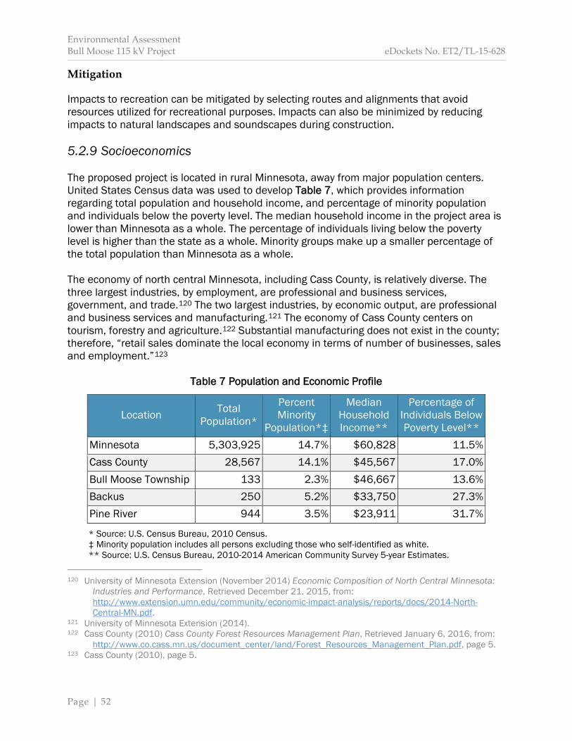
Environmental Assessment Bull Moose 115 kV Project eDockets No. ET2/TL-15-628
Page | 52
Mitigation Impacts to recreation can be mitigated by selecting routes and alignments that avoid resources utilized for recreational purposes. Impacts can also be minimized by reducing impacts to natural landscapes and soundscapes during construction. 5.2.9 Socioeconomics The proposed project is located in rural Minnesota, away from major population centers. United States Census data was used to develop Table 7, which provides information regarding total population and household income, and percentage of minority population and individuals below the poverty level. The median household income in the project area is lower than Minnesota as a whole. The percentage of individuals living below the poverty level is higher than the state as a whole. Minority groups make up a smaller percentage of the total population than Minnesota as a whole. The economy of north central Minnesota, including Cass County, is relatively diverse. The three largest industries, by employment, are professional and business services, government, and trade.120 The two largest industries, by economic output, are professional and business services and manufacturing.121 The economy of Cass County centers on tourism, forestry and agriculture.122 Substantial manufacturing does not exist in the county; therefore, “retail sales dominate the local economy in terms of number of businesses, sales and employment.”123
Table 7 Population and Economic Profile
Location Total Population*
Percent Minority
Population*‡
Median Household Income**
Percentage of Individuals Below Poverty Level**
Minnesota 5,303,925 14.7% $60,828 11.5% Cass County 28,567 14.1% $45,567 17.0% Bull Moose Township 133 2.3% $46,667 13.6% Backus 250 5.2% $33,750 27.3% Pine River 944 3.5% $23,911 31.7%
* Source: U.S. Census Bureau, 2010 Census. ‡ Minority population includes all persons excluding those who self-identified as white. ** Source: U.S. Census Bureau, 2010-2014 American Community Survey 5-year Estimates. 120 University of Minnesota Extension (November 2014) Economic Composition of North Central Minnesota:
Industries and Performance, Retrieved December 21, 2015, from: http://www.extension.umn.edu/community/economic-impact-analysis/reports/docs/2014-North-Central-MN.pdf.
121 University of Minnesota Extension (2014). 122 Cass County (2010) Cass County Forest Resources Management Plan, Retrieved January 6, 2016, from: http://www.co.cass.mn.us/document_center/land/Forest_Resources_Management_Plan.pdf, page 5. 123 Cass County (2010), page 5.
Environmental Assessment Bull Moose 115 kV Project eDockets No. ET2/TL-15-628
Page | 53
Construction of the proposed project will generate up to 20 temporary jobs at any given time. It is unknown if any of these jobs will be local jobs. No permanent jobs will result from construction and operation of the project. Nearby communities and businesses can expect a short-term increase in revenues due to project construction. Construction will not disrupt these communities and businesses. Cass County and, in particular, the cities of Backus and Pine River have a higher number of residents living below poverty level. The proposed project will not displace any of these individuals. Bull Moose Township and the cities of Backus and Pine River have, as a percentage of the total population, minority populations less than the state average. Potential Impacts Positive economic impacts include increased expenditures, for example, food and fuel, at local businesses during project construction. The applicant indicates that some materials may be purchased locally. The proposed project will not disrupt local communities or businesses and does not disproportionately impact low-income or minority populations. As a result, adverse socioeconomic impacts are not anticipated. Direct impacts will be short-term and positive. These impacts will be minimal. Mitigation Adverse impacts are not expected; therefore, mitigation is not proposed. 5.3 Human Health and Safety Construction and operation of transmission lines has the potential to impact human health and safety. 5.3.1 Electric and Magnetic Fields Electric and magnetic fields (EMF) are invisible forces that result from the presence of electricity. EMF occurs naturally and is caused by weather or the geomagnetic field. EMF is also caused by all electrical devices and is found wherever people use electricity. Table 8 provides examples of EMF associated with common electric household appliances. EMF are characterized and distinguished by their frequency, that is, the rate at which the field changes direction each second. Electrical lines in the United States have a frequency of 60 cycles per second or 60 hertz. EMF at this frequency level is known as extremely low frequency EMF (ELF-EMF). Voltage on a conductor creates an electric field that surrounds and extends from the wire. Using a garden hose as an analogy, voltage is equivalent to the pressure of the water
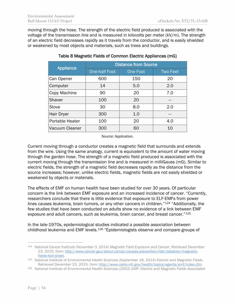
Environmental Assessment Bull Moose 115 kV Project eDockets No. ET2/TL-15-628
Page | 54
moving through the hose. The strength of the electric field produced is associated with the voltage of the transmission line and is measured in kilovolts per meter (kV/m). The strength of an electric field decreases rapidly as it travels from the conductor, and is easily shielded or weakened by most objects and materials, such as trees and buildings.
Table 8 Magnetic Fields of Common Electric Appliances (mG)
Appliance Distance from Source
One-half Foot One Foot Two Feet Can Opener 600 150 20 Computer 14 5.0 2.0 Copy Machine 90 20 7.0 Shaver 100 20 — Stove 30 8.0 2.0 Hair Dryer 300 1.0 — Portable Heater 100 20 4.0 Vacuum Cleaner 300 60 10
Source: Application. Current moving through a conductor creates a magnetic field that surrounds and extends from the wire. Using the same analogy, current is equivalent to the amount of water moving through the garden hose. The strength of a magnetic field produced is associated with the current moving through the transmission line and is measured in milliGauss (mG). Similar to electric fields, the strength of a magnetic field decreases rapidly as the distance from the source increases; however, unlike electric fields, magnetic fields are not easily shielded or weakened by objects or materials. The effects of EMF on human health have been studied for over 30 years. Of particular concern is the link between EMF exposure and an increased incidence of cancer. “Currently, researchers conclude that there is little evidence that exposure to ELF-EMFs from power lines causes leukemia, brain tumors, or any other cancers in children.”124 “Additionally, the few studies that have been conducted on adults show no evidence of a link between EMF exposure and adult cancers, such as leukemia, brain cancer, and breast cancer.”125 In the late-1970s, epidemiological studies indicated a possible association between childhood leukemia and EMF levels.126 “Epidemiologists observe and compare groups of
124 National Cancer Institute (November 3, 2014) Magnetic Field Exposure and Cancer, Retrieved December
23, 2015, from: http://www.cancer.gov/about-cancer/causes-prevention/risk/radiation/magnetic-fields-fact-sheet.
125 National Institute of Environmental Health Sciences (September 18, 2014) Electric and Magnetic Fields, Retrieved December 23, 2015, from: http://www.niehs.nih.gov/health/topics/agents/emf/index.cfm. 126 National Institute of Environmental Health Sciences (2002) EMF: Electric and Magnetic Fields Associated
Environmental Assessment Bull Moose 115 kV Project eDockets No. ET2/TL-15-628
Page | 55
people who have had or have not had certain diseases and exposures to see if the risk of disease is different between the exposed and unexposed groups, but does not control the exposure and cannot experimentally control all the factors that might affect the risk of disease.”127 Ever since, researchers have examined possible links between EMF exposure and health effects through epidemiological, animal, clinical and cellular studies. Scientific panels and commissions have been appointed by, among others, the National Institute of Environmental Health Sciences, the World Health Organization, and the Scientific Committee on Emerging and Newly Identified Health Risks to study potential health impacts. In 2002, the Minnesota State Interagency Working Group on EMF Issues comprised of members of the Minnesota Department of Commerce, Department of Health, the Pollution Control Agency, the Public Utilities Commission, and the Environmental Quality Board and tasked to study issues related to EMF published A White Paper on Electric and Magnetic Field Policy and Mitigation Options, and concluded the following:
Some epidemiological results do show a weak but consistent association between childhood leukemia and increasing exposure to EMF…. However, epidemiological studies alone are considered insufficient for concluding that a cause and effect relationship exists, and the association must be supported by data from laboratory studies. Existing laboratory studies have not substantiated this relationship…, nor have scientists been able to understand the biological mechanism of how EMF could cause adverse effects. In addition, epidemiological studies of various other diseases, in both children and adults, have failed to show any consistent pattern of harm from EMF. The Minnesota Department of Health concludes that the current body of evidence is insufficient to establish a cause and effect relationship between EMF and adverse health effects. However, as with many other environmental health issues, the possibility of a health risk from EMF cannot be dismissed.128
Currently, there are no federal regulations regarding allowable EMF produced by transmission lines in the United States; however, state governments have developed state-specific regulations (Table 9). Additionally, international organizations have adopted standards for exposure to electric and magnetic fields (Table 10). The Commission limits the maximum electric field under all transmission lines in Minnesota to 8.0 kV/m. A standard for magnetic fields has not been adopted.
with the Use of Electric Power, Retrieved February 8, 2016, from: https://www.niehs.nih.gov/health/materials/electric_and_magnetic_fields_associated_with_the_use_of_electric_power_questions_and_answers_english_508.pdf.
127 National Institute of Environmental Health Sciences (2002). 128 State of Minnesota, State Interagency Working Group on EMF Issues (2002) A White Paper on Electric and
Magnetic Field (EMF) Policy and Mitigation Options, Retrieved January 8, 2016, from: http://www.capx2020.com/Images/EMFWhitePaper2002.pdf.

Environmental Assessment Bull Moose 115 kV Project eDockets No. ET2/TL-15-628
Page | 56
Table 9 State Electric and Magnetic Field Standards
State Electric Field (kV/m) Magnetic Field (mg)
Within Right-of-Way
Edge of Right-of-Way
Edge of Right-of-Way
Florida 8.0a 2.0 150a (max load)
10.0b — 200b (max load) — — 250c (max load)
Massachusetts — — 85g Montana 7.0d 1.0e — New Jersey — 3.0 —
New York 11.8 1.6 200 11.0f — — 7.0d — —
Oregon 9.0 — — a 69 kV to 230 kV transmission lines b 500 kV transmission lines c 500 kV transmission lines on certain existing Rights-of-Way d Maximum for highway crossing e May be waived by landowner f Maximum for private road crossings g A level above 85 mG is not prohibited, buy may trigger a more extensive review of alternatives
Source: National Institute of Environmental Health Sciences (2002).
Table 10 International Electric and Magnetic Field Guidelines
Organization Electric Field (kV/m) Magnetic Field (mG)
General Public Occupational General Public Occupational Institute of Electrical and Electronics Engineers 5.0 20 9,040 27,100
International Commission on Non-Ionizing Radiation Protection
4.2 8.3 2,000 4,200
American Conference of Industrial Hygienists — 25 — 10,000/
1,000a National Radiological Protection Board 4.2 — 830 4,200
a For persons with cardiac pacemakers or other medical electronic devices
Source: Minnesota Department of Commerce (2015).
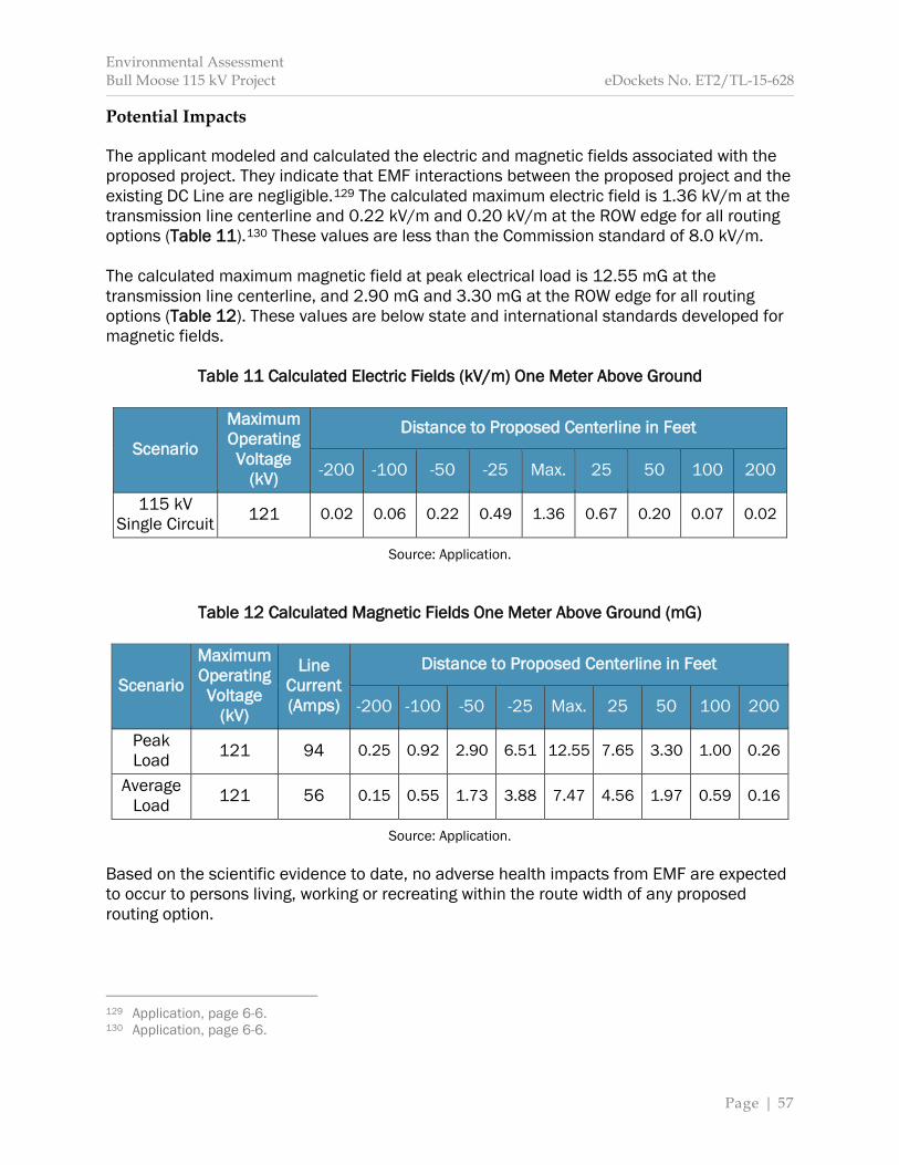
Environmental Assessment Bull Moose 115 kV Project eDockets No. ET2/TL-15-628
Page | 57
Potential Impacts The applicant modeled and calculated the electric and magnetic fields associated with the proposed project. They indicate that EMF interactions between the proposed project and the existing DC Line are negligible.129 The calculated maximum electric field is 1.36 kV/m at the transmission line centerline and 0.22 kV/m and 0.20 kV/m at the ROW edge for all routing options (Table 11).130 These values are less than the Commission standard of 8.0 kV/m. The calculated maximum magnetic field at peak electrical load is 12.55 mG at the transmission line centerline, and 2.90 mG and 3.30 mG at the ROW edge for all routing options (Table 12). These values are below state and international standards developed for magnetic fields.
Table 11 Calculated Electric Fields (kV/m) One Meter Above Ground
Scenario
Maximum Operating Voltage
(kV)
Distance to Proposed Centerline in Feet
-200 -100 -50 -25 Max. 25 50 100 200
115 kV Single Circuit 121 0.02 0.06 0.22 0.49 1.36 0.67 0.20 0.07 0.02
Source: Application.
Table 12 Calculated Magnetic Fields One Meter Above Ground (mG)
Scenario
Maximum Operating Voltage
(kV)
Line Current (Amps)
Distance to Proposed Centerline in Feet
-200 -100 -50 -25 Max. 25 50 100 200
Peak Load 121 94 0.25 0.92 2.90 6.51 12.55 7.65 3.30 1.00 0.26
Average Load 121 56 0.15 0.55 1.73 3.88 7.47 4.56 1.97 0.59 0.16
Source: Application. Based on the scientific evidence to date, no adverse health impacts from EMF are expected to occur to persons living, working or recreating within the route width of any proposed routing option.
129 Application, page 6-6. 130 Application, page 6-6.

Environmental Assessment Bull Moose 115 kV Project eDockets No. ET2/TL-15-628
Page | 58
Mitigation The Commission has adopted a prudent avoidance approach in routing transmission lines and, on a case-by-case basis, considers and may require (through permits) mitigation strategies for minimizing EMF exposure levels associated with transmission lines. No health impacts due to EMF are anticipated within the route width of any proposed routing option; therefore, no mitigation is proposed. 5.3.2 Implantable Medical Devices EMF may interfere with implantable electromechanical medical devices, such as pacemakers, defibrillators, neurostimulators and insulin pumps. Most of the research on electromagnetic interference and medical devices relates to pacemakers. Laboratory tests indicate that interference from magnetic fields in pacemakers is not observed until 2,000 mG—a field strength greater than that associated with high voltage transmission lines.131 Therefore, the research has focused on electric field impacts. Electric fields may interfere with a pacemaker’s ability to sense normal electrical activity in the heart. In the unlikely event a pacemaker is impacted, the effect is typically a temporary asynchronous pacing (commonly referred to as reversion mode or fixed rate pacing). The pacemaker returns to its normal operation when the person moves away from the source of the interference. “While the present-day units are better shielded against EMF interference than their earlier counterparts, sensitivity to electric field exposure is inevitable.”132 Interference in unipolar pacemakers that results in inappropriate pacing may occur with electric fields ranging from 1.2 to 1.7 kV/m; however, other units are unaffected at 8.0 kV/m.133 In general, electric interference must be at levels above 5.0 kV/m to interfere with modern, bipolar pacemaker behavior.134 Some models appear unaffected at 20 kV/m.135 There are no residences, businesses, or sensitive receptors such as hospitals or nursing homes located within the route width of any routing option, therefore the regular presence of implantable medical devices is not expected.
131 Electric Power Research Institute (1997) Susceptibility of Implanted Pacemakers and Defibrillators to
Interference by Power-Frequency Electric and Magnetic Fields, Retrieved February 8, 2016, from: http://www.epri.com/abstracts/Pages/ProductAbstract.aspx?ProductId=TR-108893, page 8-1.
132 Electric Power Research Institute (1997), page 8-1. 133 Electric Power Research Institute (1997), page 7-9. 134 Pinski, Sergio L. and Trohman, Richard G. (2002) Interference in Implanted Cardiac Devices, Part 1,
Journal of Pacing and Clinical Electrophysiology (25)9:1,367-1,381, Retrieved February 8, 2016, from: http://www.pacericd.com/documents/ARTICLES/EMI%20Part%201%20JPCE%202002.pdf.
135 Electric Power Research Institute (1997), page 8-2.
Environmental Assessment Bull Moose 115 kV Project eDockets No. ET2/TL-15-628
Page | 59
Potential Impacts The calculated maximum electric field strength directly underneath the proposed transmission line is 1.36 kV/m. This field strength is below the 5.0 kV/m interaction level for modern, bipolar pacemakers, but above the range of interaction for older, unipolar pacemakers. Therefore, impacts to unipolar pacemakers might occur directly underneath the proposed transmission line. Moving away from the transmission line centerline would return the pacemaker to normal operation. The calculated maximum electric field strength at 100 feet from the proposed centerline and the edge of the route width for all routing options is 0.06 kV/m and 0.07 kV/m. These values are below the expected range of interference to pacemakers. Mitigation Impacts to implantable medical devices and persons using these devices are expected to be minimal; therefore, no mitigation is proposed. 5.3.3 Stray Voltage In general terms, stray voltage can be defined as “voltage caused by an electric current in the earth, or in groundwater, resulting from the grounding of electrical equipment or an electrical distribution system.”136 Stray voltage encompasses two phenomena: neutral-to-earth (NEV) voltage and induced voltage. Neutral-to-Earth Voltage NEV is a type of stray voltage that can occur where distribution lines enter structures. “Electrical systems—farm systems and utility distribution systems—are grounded to the earth to ensure safety and reliability…. Inevitably, some current flows through the earth at each point where the electrical system is grounded and a small voltage develops.”137 This extraneous voltage appears on metal surfaces in buildings, barns and other structures. NEV is typically experienced by livestock that contact one or more metal objects on a farm, for example, feeders, waterers, or stalls. Metal objects on a farm are grounded to earth through electrical connections. Livestock, by virtue of standing on the ground, are also grounded to earth. If an animal touches two points at different voltages (one at neutral voltage and the other near true ground),138 a small current will flow through the livestock to the ground because the animal completes the electrical circuit.139
136 Edison Electric Institute (April 2005) Glossary of Electric Industry Terms, Washington, DC: Edison Electric Institute (2005). 137 Wisconsin Public Service Corporation (2011) Answers to Your Stray Voltage Questions: Backed by
Research, Retrieved January 11, 2016, from: http://www.wisconsinpublicservice.com/business/pdf/farm_voltage.pdf, page 1.
138 North Dakota State University Agricultural Engineering Department (1986) Extension Publication #108:
Environmental Assessment Bull Moose 115 kV Project eDockets No. ET2/TL-15-628
Page | 60
Despite metal objects and livestock both being grounded to the earth there are a number of factors that affect the effectiveness of their respective ground, that is, a good or poor ground. In metal objects these include the wire size and length, quality of connections, number and resistance of ground rods, and electrical current being grounded.140 Likewise, a number of factors also determine the extent to which livestock are grounded, for example, if the animal is standing on wet or dry ground.141 Stray voltage results from this difference in the effectiveness of grounding and on the resulting electrical currents. It can exist at any farm, house or business that uses electricity, independent of a nearby transmission line. If NEV is prevalent in an agricultural operation it can affect livestock health. This concern has primarily been raised on dairy farms because of its potential to affect milk production and quality. NEV is by and large an issue associated with electrical distribution lines and electrical service at a residence or on a farm. Transmission lines do not create NEV stray voltage as they do not directly connect to businesses, residences, or farms. Potential Impacts The proposed transmission line is a 115 kV transmission line that does not interconnect to businesses or residences within the route width of any routing option, and does not change local electrical service. As a result, impacts to residences or farming operations resulting from NEV are not anticipated. Mitigation Impacts from NEV as a result of the proposed project are not anticipated; therefore, no mitigation is proposed. The applicant indicates that if a person has a question or concern about stray voltage on their property they should contact their electrical service provider to discuss the situation and the possibility of an on-site investigation.142 Induced Voltage The electric field from a transmission line can extend to nearby conductive objects, for example, metal fence posts, and induce a voltage upon them. This phenomenon is dependent on many factors, including the shape, size, orientation, capacitance and location of the object along the ROW. If the objects upon which a voltage is induced are insulated or semi-insulated from the ground and a person touches them, a small current will pass through the person’s body to the ground. This may be accompanied by a spark discharge and mild shock similar to what can occur when an individual walks across a carpet and touches a grounded object or another person.
Stray Voltage, Retrieved January 11, 2016, from: https://www.ag.ndsu.edu/extension-aben/epq/files/epq108.pdf.
139 Michigan Agricultural Electric Council (October 2008) Stray Voltage: Questions and Answers, Retrieved January 11, 2016, from: http://maec.msu.edu/Stray%20Voltage%20Brochure%202008.pdf. 140 North Dakota State University Agricultural Engineering Department (1986). 141 North Dakota State University Agricultural Engineering Department (1986). 142 Application, page 6-9.
Environmental Assessment Bull Moose 115 kV Project eDockets No. ET2/TL-15-628
Page | 61
The primary concern with induced voltage is not the voltage, but rather the current that flows through a person to the ground when touching the object. To ensure the safety of persons in the proximity of transmission lines, the NESC requires that any discharge be less than five milliAmperes. In addition, the Commission’s electric field limit of 8 kV/m is designed to prevent serious shock hazards due to induced voltage. Proper grounding of metal objects under or adjacent to transmission lines is the best method of avoiding these shocks. Transmission lines may cause additional current to flow on distribution lines where these lines parallel. When distribution lines are properly wired and grounded, these additional currents are not significant. However, if distribution lines are not properly wired and grounded, these additional currents could create induced voltage impacts. Potential Impacts The proposed project may induce a voltage on insulated metal objects within the route width of any routing option; however, the Commission requires that transmission lines be constructed and operated to meet NESC standards as well as the Commission’s own electric field limit of 8 kV/m reducing these impacts. As a result, impacts due to induced voltage are not anticipated to occur. Mitigation Potential impacts as a result of induced voltage are avoided or minimized by Commission permit requirements.143 As a result, potential impacts are not anticipated and further mitigation is not proposed. 5.4 Public Services Transmission lines have the potential to impact public services, such as roads or airports. These impacts are usually temporary, for example, road closures or restrictions associated with stringing conductors. Impacts can be long-term if they change the area in a way that precludes or limits public services. 5.4.1 Airports Airports have different safety zones, which are based on several characteristics, including runway dimensions, the type of aircraft intended to use the runway, and the type of approach procedures used by the aircraft.144 These characteristics determine necessary setback distances for transmission line structures. Transmission line structures and conductors have the potential to interfere with safe operation of an airport if they are too tall for the applicable safety zone. There are no airports within one mile of the proposed project (Map 2). The Backus Municipal Airport (7Y3) is approximately three and one-quarter miles northeast of the proposed route.
143 See Appendix C Generic Route Permit Template, Section 5.3. 144 See generally Minn. R. 8800.

Environmental Assessment Bull Moose 115 kV Project eDockets No. ET2/TL-15-628
Page | 62
The Pine River Regional Airport (KPWC) is approximately eight miles southeast of the proposed route. Potential Impacts The applicant contacted the Office of Aeronautics within MnDOT regarding the potential for the proposed project to affect airport operations at either the Backus Municipal or Pine River Regional Airport. In a July 9, 2015, email, MnDOT indicated that the proposed project will not impact operations at either airport.145 Based on the height of the transmission line structures and, more importantly, the distance from the airports, no impacts to airport operations are anticipated. Mitigation No impacts to airport operations are anticipated; therefore, no mitigation is proposed. 5.4.2 Emergency Services Transmission lines have the potential to impact access to emergency services, for example, through interference with electronic communication systems. Emergency services in the project area are provided by multiple entities. Fire service is provided by the Backus Fire Department; ambulance service is provided by North Ambulance – Pine River; law enforcement is provided by the Cass County Sheriff’s Department.146 Potential Impacts Potential impacts to communication systems are discussed in Section 5.2.4. No impacts to communication systems are anticipated; therefore, impacts to emergency communications are not expected. Impacts to roads and highways are discussed in Section 5.4.3. During project construction short-term impacts to traffic along 48th Ave SW could occur due to localized traffic delays and possible re-routes. These traffic interruptions or reroutes could delay emergency vehicles. These impacts will be intermittent and short-term. The impact intensity level will be minimal and can be mitigated. No long-term impacts are expected once the proposed transmission line is operational. Mitigation Potential short-term impacts can be mitigated by notifying emergency responders of traffic interruptions. No long-term impacts are anticipated; therefore, no mitigation is proposed.
145 Application, page 7-12. 146 Cass County (n.d.) Cass County Maps: Cass County’s Interactive Web Mapping, Retrieved December 30, 2015, from: http://www.co.cass.mn.us/services/land/maps/index.php.
Environmental Assessment Bull Moose 115 kV Project eDockets No. ET2/TL-15-628
Page | 63
5.4.3 Roads and Highways In its October 26, 2015, comment letter, MnDOT indicated the proposed project “does not directly abut a state trunk highway.”147 The trunk highway system includes “the interstate and U.S. highway systems as well as other state highways.”148 The road primarily impacted is 48th Ave SW. The proposed route encompasses this county road on its eastern boundary (Map 1). If necessary from an engineering standpoint, the proposed transmission line could be routed east across the road, turn to the north and cross underneath the DC Line, and re-cross the road west to the proposed substation. If this is necessary the applicant indicates that structures would be placed outside the road ROW. Potential Impacts During construction short-term impacts to traffic along 48th Ave SW due to localized delays and possible traffic re-routes may occur. Delays are associated with material delivery and worker transportation.149 Direct impacts to 48th Ave SW or local traffic will be short-term and can be mitigated. The impact intensity level will be minimal and can be mitigated. Long-term impacts are not anticipated. Mitigation Impacts to roads and vehicular traffic can be mitigated through coordination with appropriate state and local authorities, as well as by selecting routes, alignments and pole placements that minimize interference with roadways. The applicant indicates the following practices will be used during construction:
Safety requirements for maintaining the flow of traffic will be met; If necessary, pilot vehicles will accompany the movement of heavy equipment; Deliveries will be timed to avoid traffic congestion and reduce dangerous situations
on the roadway; Traffic control barriers and warning devices will be used as necessary; and Should the transmission line cross 48th Ave SW, temporary guard structures will be
used to support the conductor above vehicle traffic.150
147 Minnesota Department of Transportation (October 26, 2015) Comments on the Scope of the EA, eDockets No. 201510-115093-01. 148 Minnesota House Research Department (October 2014) Short Subjects: Trunk Highway System, Retrieved January 4, 2016, from: http://www.house.leg.state.mn.us/hrd/pubs/ss/ssthf.pdf. 149 Application, page 7-13. 150 Application, page 7-13.
Environmental Assessment Bull Moose 115 kV Project eDockets No. ET2/TL-15-628
Page | 64
5.4.4 Utilities Transmission lines have the potential to damage or interfere with public utilities. The presence of a transmission line could also preclude construction and operation of new utility infrastructure. Utilities within one-mile of the project area are typical of rural areas across Minnesota. Exceptions include the relatively extensive electric transmission infrastructure to the west of the proposed transmission line. The applicant indicates that all existing utilities, for example, existing distribution lines, and site improvements, for example, wells or septic systems, will be identified prior to project construction. The applicant indicates that if a utility is identified within the ROW of any routing option, a transmission line structure or the utility itself may need to be relocated. This activity would be coordinated with the affected utility. Typically, these issues do not result in significant modification to the proposed transmission line or affected utility. Water Utilities The proposed project is in a rural area and is not serviced by city water supply or sanitary sewer. No residences are within the route width of any routing option. Potential Impacts No impacts to water utilities are anticipated for any routing option. Mitigation No impacts to water utilities are anticipated; therefore, no mitigation is proposed. Electric Utilities Electrical service in the project vicinity is provided by Crow Wing Power electric cooperative. A distribution line parallels 48th Ave SW to the east. Several planned outages would need to occur along the 142 Line and DC Line in order to construct the proposed transmission line. Potential Impacts Outages on existing transmission lines will be necessary to construct the proposed project. The applicant indicates that an outage on the distribution line would not be necessary to make these crossings. Clearances associated with existing transmission lines will be code compliant. If it is necessary to cross 48th Ave SW in order to route the proposed transmission line into the proposed substation all clearances will be code compliant. Direct impacts to electric utilities, that is, power supply, will be short-term and minimal. No person is expected to lose electrical service as a result of project construction. Impacts are unavoidable but can be minimized and mitigated. No long-term impacts are anticipated.

Environmental Assessment Bull Moose 115 kV Project eDockets No. ET2/TL-15-628
Page | 65
Mitigation Short-term, minor impacts to existing electric utilities will occur as a result of outages necessary for project construction. Outages will be minimized by using the minimum number necessary. Further mitigation, as indicated by the applicant, is as follows:
All necessary outages will be coordinated through MISO business practices that are established and followed by all MISO members to meet personnel safety and NERC transmission grid reliability requirements. Coordination is accomplished through well-defined outage scheduling procedures that utilize web-based tools, allow for study affirmation and ultimately approval of the submitted outage. Once approved, detailed switching orders are developed and shared with all parties involved using well-defined processes to ensure safety of personnel performing the work and transmission grid reliability.151
No long-term impacts to electric utilities are anticipated; therefore, mitigation is not proposed. Natural Gas Utilities The majority of residents within one-mile of the proposed project utilize propane. The applicant does not anticipate identifying a natural gas pipeline when conducting the necessary Gopher State One-Call. Potential Impacts No impacts to natural gas utilities are anticipated. Mitigation No impacts to natural gas utilities are anticipated; therefore, mitigation is not proposed. 5.5 Land-Based Economies Transmission line structures and conductors have the potential to impact land-based economies by precluding or limiting land use for other purposes. 5.5.1 Agriculture Distinct impacts to agricultural lands and operations occur during the construction and operation phases of a transmission line project. Construction impacts are short-term and limit land use generally, for example, marshalling yards, or impact crops or soils, for example, soil compaction. Impacts from the operation of a transmission line involve the long-term presence of structures and conductors. Impacts can remain within the immediate footprint, or may extend beyond it if the transmission line impedes the use of farm or irrigation equipment or interferes with aerial spraying.
151 Application, page 4-4.
Environmental Assessment Bull Moose 115 kV Project eDockets No. ET2/TL-15-628
Page | 66
Farming occurs throughout Cass County. In 2012, there were 546 individual farms using 157,215 acres of farmland—a slight decrease in overall numbers and acres from 2007.152 Farmers raise a variety of commodities, including crops like grains, oil seeds, fruits, berries, and hay, as well as livestock.153 The proposed route will transect approximately five and one-quarter acres of agricultural cover types, divided nearly evenly between pasture/hay land and crop land. Potential Impacts Agricultural lands are not present within the proposed or alternative route segments. Potential impacts along the proposed route are as follows: Proposed Route Construction impacts include soil rutting and compaction as a result of repeated access to the ROW. Lands within the route width may not be available for agricultural use during construction. Lands within the marshaling yard or set-up area will not be available for agricultural use during construction. Impacts will be short-term, of a small size, and do not affect a unique resource. The overall impact intensity level will be minimal. Impacts will be unavoidable, and can be minimized. Operational impacts include the placement of structures that will preclude farming operations or grazing within their immediate footprint (0.05 acre per pole). Direct impacts will be long-term, of a small size, and do not affect a unique resource. Impacts will be minimal and unavoidable. Mitigation Impacts to agricultural lands and operations can be avoided or minimized by prudent routing and placement of structures within the route. This includes selecting routes and pole placements that avoid agricultural fields; follow existing infrastructure or property lines; or parallel field lines. Impacts can also be minimized through appropriate construction and remediation practices. The applicant indicates the following mitigation measures will be used for the proposed project:
Limiting movement of crews and equipment to the ROW to the greatest extent possible. Scheduling construction during periods when agricultural activities will be minimally
affected to the extent possible. Compensating the landowner for any crop or property damage. Repairing ruts that are hazardous to agricultural operations
152 U.S. Department of Agriculture (2012) 2012 Census of Agriculture: Cass County, Minnesota
Profile, Retrieved January 7, 2016, from: http://www.agcensus.usda.gov/Publications/2012/Online_Resources/County_Profiles/Minnesota/cp27021.pdf.
153 U.S. Department of Agriculture (2012).
Environmental Assessment Bull Moose 115 kV Project eDockets No. ET2/TL-15-628
Page | 67
Restoring the land and facilities as nearly as practicable to their original conditions. Promptly repairing or replacing fences, gates, and similar improvements that are
removed or damaged.154 Additionally, the Commission requires permittees to compensate landowners for damage to crops and drain tile.155 5.5.2 Forestry Impacts to forested areas and forestry operations, including timber harvest, result from the removal of tall-growing trees within the ROW in order to facilitate the safe operation of a transmission line. Timber harvest occurs throughout Cass County (66 percent of the county is commercial forested land)156 and within one-mile of the proposed project—the most recent cut being approximately 1,000 feet to the northwest of the proposed route in 2011 or 2012.157 On the Foot Hills State Forest, more than 5,000 cords of wood are harvested annually from publically owned land in the forest.158 This timber is used for industrial and personal uses. Cass County manages timber resources to “make progress toward the desired future condition of the forest and not specific near-term resource output targets. The primary management tool and source of revenue for the Cass County Land Department is the sale of timber harvest rights.”159 The DNR Division of Forestry promotes the conservation, enjoyment and use of Minnesota’s forests by providing a long-term, sustainable yield of forest resources from state forest lands; improving the health and productivity of other public, private and community forest lands; and protecting life, property, and natural resources from wildfires.160 Potential Impacts Clearing the ROW of tall-growing woody vegetation will impact approximately six and three-quarter acres of deciduous forest cover types along the proposed route; two and one-half acres of deciduous forested cover types along the proposed route segment; and one and one-half acres of deciduous forested cover types along the alternative route segment. As a result, timber harvest will be precluded. Impacts to forestry operations will be long-term and significant within the ROW for all routing options.
154 Application, pages 7-16, 7-17. 155 See Appendix C Generic Route Permit Template, Section 5.2.17. 156 Application, page 7-17. 157 Google, Inc. (2013). 158 Minnesota Department of Natural Resources (n.d.(b)) Foot Hills State Forest, Retrieved January 6, 2016, from: http://www.dnr.state.mn.us/state_forests/sft00019/about.html. 159 Cass County (2010), page 54-55. 160 Minnesota Department of Natural Resources (n.d.(c)) Division of Forestry, Retrieved January 7, 2016, from: http://dnr.state.mn.us/forestry/index.html.
Environmental Assessment Bull Moose 115 kV Project eDockets No. ET2/TL-15-628
Page | 68
There are approximately 2,800 acres of forested cover types within one-mile of the proposed project; therefore, within a regional context, impacts to forestry operations will be minimal. Impacts are unavoidable, but can be minimized. Mitigation Impacts to forestry operations, including timber harvest, can be avoided or minimized by prudent routing and placement of structures within the route. The applicant indicates that compensation for the removal of vegetation within the ROW will be offered to landowners during easement negotiations, and landowners will be given the option to keep the timber cut within the easement area on their property.161 5.5.3 Mining Impacts to mining operations can occur if transmission lines interfere with access to, or the removal of, sand, gravel or mineral resources. There are no known gravel pits or other mining activity within the ROW of any routing option. Potential Impacts Since no known mining operations exist in the ROW within any routing option, impacts to mining economies will not occur. Mitigation Impacts to mining operations will not occur; therefore, mitigation is not proposed. 5.5.4 Tourism Tourist activities within one-mile of the proposed project are most generally associated with Foot Hills State Forest and the recreational activities described in Section 5.2.8. Transmission lines can impact tourism if they affect the experiences of visitors at tourism sites, through aesthetic impacts, noise, or degradation of the natural or man-made resources that provide for tourist-type activities. Tourism is responsible for approximately 40 percent of total employment in Cass County and over one-quarter of state sales/use tax generated in the county are from tourism related businesses.162 The proposed project transects the Foot Hills State Forest, a popular tourist destination. The forest was established in 1933. It is 46,896 acres in size and is managed for timber harvest, reforestation, wildlife habitat improvement, wildfire protection, and recreational
161 Application, page 7-18. 162 Cass County (2010), page 5.

Environmental Assessment Bull Moose 115 kV Project eDockets No. ET2/TL-15-628
Page | 69
opportunities.163 “DNR manages 40 percent of the area, Cass County manages 25 percent, and 35 percent of land within forest boundaries is privately owned.”164 Visitor-use opportunities in Foot Hills State Forest are concentrated near the Spider Lake OHV Trails in the southern portion of the forest. Foot Hills State Forest maintains a “limited” off-highway vehicle classification. This means that ATVs and snowmobiles may only be operated on trails posted as “open”. The proposed project does not transect any designated trails. A “Proposed Line ORV Trail” near the proposed project appears on the Foot Hills State Forest map. This trail is marked as proposed to be built in 2008. It was not constructed.165 Potential Impacts Potential impacts specific to identified routing options are as follows: Proposed Route Direct impacts include clearing approximately 14 acres of public recreational land within the Foot Hills State Forest. Of these 14 acres, two and one-half acres are owned and managed by the DNR Division of Forestry. The remaining acres are tax-forfeited lands administered by Cass County. Additionally, approximately two and three-quarters of land administered by Cass County as public land would be directly impacted. These impacts are not anticipated to preclude future tourism activities. Impacts to recreation are expected to be minimal. Aesthetic impacts are moderate. The impact intensity level to tourism is expected to be minimal. Proposed Route Segment Direct impacts include clearing approximately two and one-half acres of public recreational land within the Foot Hills State Forest. These impacts are not anticipated to preclude future tourism activities. Impacts to recreation are expected to be moderate. Aesthetic impacts are moderate. The impact intensity level to tourism is expected to be minimal. Alternative Route Segment A Direct impacts include clearing approximately two acres of public recreational land within the Foot Hills State Forest. These impacts are not anticipated to preclude future tourism activities. Impacts to recreation are expected to be minimal. Aesthetic impacts are moderate. The impact intensity level to tourism is expected to be minimal. 163 Minnesota Department of Natural Resources (n.d.(b)). 164 Minnesota Department of Natural Resources (n.d.(b)). 165 Minnesota Department of Natural Resources (December 22, 2015).
Environmental Assessment Bull Moose 115 kV Project eDockets No. ET2/TL-15-628
Page | 70
Mitigation Impacts to tourism can be mitigated by selecting routes and alignments that avoid natural and man-made resources utilized for recreational purposes. Impacts can also be mitigated by reducing impacts to natural landscapes during construction. Impacts to tourism are expected to be minimal; therefore, no mitigation is proposed. 5.6 Archeological and Historic Resources Archeological resources are locations where objects or other evidence of archaeological interest exist, and can include aboriginal mounds and earthworks, ancient burial grounds, prehistoric ruins, or historical remains.166 Historic resources are sites, buildings, structures or other antiquities of state or national significance.167 Transmission lines have the potential to impact these resources. Project construction can disrupt or remove archeological resources. Construction of a transmission line near historic resources has the potential to impair or decrease their value. To identify potential impacts to archaeological or historic resources, the applicant conducted a cultural resource literature review that focused on a one-mile buffer surrounding the proposed project. The applicant determined that “there are no previously recorded archaeological sites and no previously recorded standing historic structures within the study area.” The applicant also contacted the State Historic Preservation Office (SHPO). SHPO concurred that “there are no properties listed in the National or State Registers of Historic Places, and no known or suspected archaeological properties in the area that will be [impacted by the proposed project].”168 Potential Impacts Based on the cultural resource literature review and SHPO concurrence, impacts to archaeological or historic resources are not anticipated. Mitigation Impacts to archaeological and historic resources can be mitigated by prudent routing, that is, by avoiding these resources. If previously unidentified archaeological sites are found, the applicant indicates they will stop construction and contact SHPO to determine how best to proceed.169 Should human remains be discovered, ground disturbing activity will stop and local law enforcement will be notified.170
166 See Minn. Stat. 138.31, subd. 14. 167 See Minn. Stat. 138.51. 168 Application, Appendix D. 169 Application, page 7-19. 170 Application, page 7-19.
Environmental Assessment Bull Moose 115 kV Project eDockets No. ET2/TL-15-628
Page | 71
Impacts to archeological and historic resources are not anticipated; therefore, mitigation is not proposed. 5.7 Natural Resources Transmission lines have the potential to impact the natural environment. These impacts are dependent upon many factors, such as how the transmission line is designed, constructed and maintained. Other factors, for example, the environmental setting, must be considered. Impacts can and do vary significantly both within, and across, projects. 5.7.1 Air Quality “Air quality in Minnesota has generally improved over the past 20 years, but current levels of air pollution still contribute to health impacts.”171 According to the MnRiskS model developed by the MPCA, “non-cancer health risks from air pollutants released by permitted and non-permitted sources in Cass County are relatively low.”172 Impacts to air quality from transmission lines occur during construction and operation of the line. During construction fugitive dust and equipment exhaust will be emitted. Operation of a transmission line results in the emission of ozone and nitrous oxide. Construction Fugitive dust is a particulate air pollutant. Construction activities along the proposed route, such as clearing vegetation and driving utility poles, may create exposed areas susceptible to wind erosion. Construction vehicles will emit exhaust and also have potential to generate fugitive dust. Dust emissions associated with project construction are dependent upon weather conditions and the specific activity occurring. For example, traveling to a construction site on a dry gravel road will result in more fugitive dust than traveling to the same location on a wet gravel road. Potential Impacts The applicant intends to construct the project during winter. As a result, frozen ground conditions will reduce levels of fugitive dust; however, some dust may be emitted into the air—mostly along gravel roads during worker and material transport. Vegetation will be cleared increasing potential for erosion. Exhaust will be emitted from construction equipment. Construction impacts to air quality along all routing options will be short-term. Impacts are of relative small size and do not impact a unique resource. The impact intensity level is expected to be minimal. Emissions are unavoidable, but can be minimized.
171 Minnesota Pollution Control Agency (January 2015) Air Quality in Minnesota: 2015 Report to the
Legislature, Retrieved January 12, 2016, from: https://www.pca.state.mn.us/sites/default/files/lraq-1sy15.pdf, page 1.
172 Minnesota Pollution Control Agency (January 2015), page 9.
Environmental Assessment Bull Moose 115 kV Project eDockets No. ET2/TL-15-628
Page | 72
Mitigation Impacts to air quality are expected to be minimal; therefore, no mitigation is proposed. The applicant indicates that appropriate dust control measures will be implemented to reduce potential fugitive dust emissions. Operation Transmission lines produce ozone and nitrous oxide through the corona effect—the ionization of air molecules surrounding the conductor. These compounds contribute to smog and adverse health effects.173 The State of Minnesota has an ozone standard of 0.080 parts per million (ppm) measured over a daily eight-hour average of the annual fourth-highest daily maximum.174 The national ozone standard is 0.070 ppm over a 3-year average of the annual fourth highest daily maximum eight-hour average concentration.175 Potential Impacts Impacts to air quality resulting from ozone and nitrous oxide emissions through the corona effect are expected to meet state and federal standards for ozone and nitrous oxide release. Impacts will be long-term and small. The impact intensity level will be minimal. Mitigation Impacts to air quality from operation of the proposed transmission line are expected to be minimal; therefore, no mitigation is proposed. 5.7.2 Geology Precambrain bedrock within the project area is covered by an outspread flat or gently sloping alluvial deposit of glacial outwash that varies between 200 and 600 feet deep.176 “Glacial outwash is sand and gravel deposited by running water from the melting ice of a glacier.”177 Potential Impacts Given transmission structures will be buried to an approximate depth of nine feet, impacts to geologic resources will not occur. Mitigation No impacts to geologic resources will occur; therefore, no mitigation is proposed.
173 U.S. Environmental Protection Agency (September 18, 2015) Six Common Air Pollutants, Retrieved January 13, 2016, from: http://www3.epa.gov/airquality/urbanair/. 174 Minn. R. 7009.0080. 175 U.S. Environmental Protection Agency (January 7, 2016) National Ambient Air Quality Standards (NAAQS), Retrieved January 13, 2016, from: http://www3.epa.gov/ttn/naaqs/criteria.html. 176 Application, page 7-30. 177 Karl E. Limper Geology Museum (September 16, 2010) Local Geology: Glacial Outwash, Retrieved February 16, 2016, from: http://www.cas.miamioh.edu/limpermuseum/students/outwash.html.
Environmental Assessment Bull Moose 115 kV Project eDockets No. ET2/TL-15-628
Page | 73
5.7.3 Groundwater The proposed project is located in the Central Groundwater Province, a province that is “characterized by buried sand aquifers and relatively extensive surficial sand plains as part of a thick layer of unconsolidated sediments deposited by glaciers overlying the bedrock.”178 According to Ground Water Contamination Susceptibility in Minnesota, the project area contains areas of both high and medium susceptibility. These regional maps are “adequate for large scale appraisals,” but are not to be used for county or local “zoning, siting, regulation and other activities that require more detailed mapping.”179 Transmission line structures have the potential to impact groundwater directly. These impacts are generally associated with project construction, for example, construction may require “drilling to depths that can penetrate shallow water tables or open access channels to deeper aquifers.”180 Indirect impacts to groundwater can also occur through direct impacts to surface water. Pentachlorophenol is used on wood pole structures to repel water, improve dimensional stability, and reduce checking and splitting. This nonflammable and noncorrosive chemical has limited solubility in water,181 and lasts for hours or days in air, soil and water.182 “In considering the total amount of pentachlorophenol available for leaching from utility poles per area while in use, the relatively moderate mobility through the soil profile… and the moderate degradation under aerobic and aerobic conditions (half lives of 1-2 months), contamination of water by pentachlorophenol and its metabolites should not be a concern.”183 There are no wells within the route width. Well No. 794514 is a domestic use well approximately 665 feet north of the propose route width (Figure 5).184 This well is 52-feet deep, and is the nearest verified well to the proposed project.
178 Minnesota Department of Natural Resources (n.d.(d)) Groundwater Provinces, Retrieved January 13 2016, from: http://dnr.state.mn.us/groundwater/provinces/index.html. 179 Minnesota Pollution Control Agency (June 29, 1989) Ground Water Contamination Susceptibility in
Minnesota, Retrieved January 14 2016, from: http://files.dnr.state.mn.us/waters/groundwater_section/mapping/sensitivity/docs/porcher1989.pdf.
180 Maryland Department of Natural Resources (n.d.) Impacts of Power Generation and Transmission: Water Resources, Retrieved January 14, 2016, from: http://pprp.info/ceir17/HTML/Chapter4-2-2.html. 181 U.S. Environmental Protection Agency (September 2010) Toxicological Review of Pentachlorophenol,
Retrieved January 29, 2016, from: http://cfpub.epa.gov/ncea/iris/iris_documents/documents/toxreviews/0086tr.pdf, page 3.
182 Centers for Disease Control and Prevention, Agency for Toxic Substances & Disease Registry (January 21, 2015) Toxic Substances Portal – Pentachlorophenol, Retrieved February 10, 2016, from: http://www.atsdr.cdc.gov/PHS/PHS.asp?id=400&tid=70.
183 U.S. Environmental Protection Agency (September 30, 2004) EPA-HQ-OPP-2004-0402-0015 Pentachlorophenol: Environmental Exposure/Modeling, Retrieved February 9, 2016, from: http://www.regulations.gov/#!documentDetail;D=EPA-HQ-OPP-2004-0402-0015, page 2, 3.
184 Minnesota Department of Health (n.d.) Minnesota Well Index, Retrieved January 29, 2016, from: https://apps.health.state.mn.us/cwi/.
Environmental Assessment Bull Moose 115 kV Project eDockets No. ET2/TL-15-628
Page | 74
Potential Impacts The applicant intends to construct the project during frozen ground conditions, as a result, de-watering during pole embedding is not anticipated to be necessary. Impacts to water tables, if any, would not affect hydrologic resources and will be localized and short-term.185 Concrete foundations may be used near 48th Ave SW if it is necessary to raise the DC Line. While soluble components of the concrete may leach into groundwater prior to the setting and hardening of the concrete, this is not anticipated as these foundations should not come into direct contact with groundwater. Structure poles will be imbedded directly into the ground to depths of eight to 15 feet. Some of these poles will come into direct contact with groundwater. Pentachlorophenol may reach groundwater from direct contact or from the soil by runoff and leaching.186 “Degradation of pentachlorophenol will reduce the likelihood of groundwater contamination and indications [are] that pentachlorophenol [does] not move significantly to lower depths in contaminated soils from utility poles. In addition, the amount leaching out of utility poles/square area/time is very small to pose risks to ground water.”187 “Groundwater contamination should not occur from usage in utility poles.”188 Direct impacts to groundwater along all routing options, if they occur, are expected to be minimal. Indirect impacts can be avoided and minimized. Mitigation Impacts to groundwater are not anticipated. Should impacts occur, they will be minimal. Indirect impacts to groundwater can be mitigated by avoiding or minimizing impacts to surface waters. Section 5.7.6 discusses surface waters. 5.7.4 Rare and Unique Resources Transmission lines have the potential to impact rare and unique resources. These impacts can occur during construction and operation. Adverse impacts include the taking or displacement of individual plants or animals, invasive species introduction, habitat loss, and, for avian species, collision with transmission line conductors. Impacts to rare and unique resources are not necessarily adverse. In some limited cases, transmission line ROWs can be managed to provide habitat for rare and unique resources, for example, nesting platforms can be built on top of transmission structures for use by rare avian species. 185 Application, page 7-23. 186 U.S. Department of Health and Human Services (September 2001) Toxicological Profile for
Pentachlorophenol, Retrieved February 9, 2016, from: http://www.atsdr.cdc.gov/ToxProfiles/TP.asp?id=402&tid=70.
187 U.S. Environmental Protection Agency (September 30, 2004), page 1. 188 U.S. Environmental Protection Agency (September 30, 2004), page 2, 3.
Environmental Assessment Bull Moose 115 kV Project eDockets No. ET2/TL-15-628
Page | 75
The Division of Ecological and Water Resources within DNR manages the Natural Heritage Information System (NHIS). “The NHIS provides information on Minnesota's rare plants, animals, native plant communities, and other rare features. The NHIS is continually updated as new information becomes available, and is the most complete source of data on Minnesota's rare or otherwise significant species, native plant communities, and other natural features. Its purpose is to foster better understanding and conservation of these features.”189 In some areas surveys have not been conducted extensively or recently making the NHIS database a source of information, but not the sole source for identifying these resources. The applicant requested DNR staff query the NHIS to identify rare and unique natural resources within one mile of the proposed project. The results of this search were provided to the applicant by letter on July 9, 2015. DNR indicated the following:
Trumpeter swans (Cygnus buccinator), a state‐listed species of special concern, have been documented nesting in the vicinity of the proposed project. These rare birds may be at risk for colliding with or being electrocuted by overhead transmission lines. The DNR recommends the use of bird diverters on overhead lines near lakes and rivers, or other areas that may attract large concentrations of waterfowl.
The Northern long‐eared bat (Myotis septentrionalis), a state‐listed species of special concern, can be found throughout Minnesota. During the winter this species hibernates in caves and mines, and during the active season (approximately April‐October) it roosts underneath bark, in cavities, or in crevices of both live and dead trees. Activities that may impact this species include, but are not limited to, wind farm operation, any disturbance to hibernacula, and destruction/degradation of habitat (including tree removal). The NHIS does not contain any known occurrences of Northern long‐eared bat roosts or hibernacula within an approximate one‐mile radius of the proposed project. It is my understanding that acoustic and mist net surveys conducted for this project were also negative.
The proposed line crosses a Northern Mesic Hardwood Forest within the Foot Hills State Forest in T138N R31W Section 10. This type of native plant community is uncommon but not rare in Minnesota.190
The NHIS database also shows a rare natural feature of special concern (zoological) approximately 1,000 feet south of the proposed route near Abel Lake. This feature is associated with Trumpeter swans,191 and could be indirectly impacted through direct impacts to the South Fork of the Pine River. The applicant made a similar request of the USFWS regarding federally listed or proposed species, and designated critical habitat in the area. USFWS staff responded to the applicant via email on June 15, 2015, indicating that it has “no known records for federally listed or proposed species and/or designated or proposed critical habitat within the action area. The proposed transmission line is also not within a quarter mile of any known roost trees or
189 Minnesota Department of Natural Resources (n.d.(e)) Natural Heritage Information System, Retrieved January 21, 2016, from: http://www.dnr.state.mn.us/nhnrp/nhis.html. 190 Application, Appendix D. 191 Application, Appendix D.
Environmental Assessment Bull Moose 115 kV Project eDockets No. ET2/TL-15-628
Page | 76
hibernacula for the Northern long-eared bat.”192 The USFWS also indicated that several threatened species may exist within Cass County including the Canada Lynx (Lynx canadenis), Gray Wolf (Canis lupus), and the Northern long-eared bat (Myotis septentrionalis). Potential Impacts Impacts to rare and unique resources at the population level are anticipated to be minimal. Potential impacts specific to identified resources along all routing options are as follows: Gray Wolf and Canada Lynx Individuals are expected to relocate during project construction due to increased noise and human activity. Animals would likely return to the area after construction; however, others might be permanently displaced. On whole, population level impacts will not occur. Impacts to the Gray wolf and Canada lynx, should they occur, will be short-term and minimal. Northern Long-eared Bat Three acoustic surveys conducted in 2014 at sites near the proposed project did not detect the Northern long-eared bat; however, habitat in the area appears to be suitable for the species and any tree removal that may occur during the species’ active season (April 1 to September 30) has the potential to take the Northern long-eared bat.193 Impacts to Northern long-eared bats are anticipated to be minimal given the winter construction schedule. Trumpeter Swan While individuals may collide with, or be electrocuted by, overhead transmission lines, population level impacts are not anticipated. Given that bird diverters will be used along water crossings or other openings—and placed in consultation with DNR—impacts to trumpeter swans are anticipated to be minimal. Northern Mesic Hardwood Forest The Northern Mesic Hardwood forest will be impacted by the proposed and alternative route segments. This resource is not classified as “rare.” As a result, impacts to this native plant community are not impacts to rare and unique resources. Further discussion regarding the Northern Mesic Hardwood Forest is provided in Section 5.7.7. Mitigation Potential impacts to rare and unique resources can be avoided by selecting routes, alignments, and pole placements away from these resources and their habitats to the extent practicable. If these resources cannot be avoided, impacts can be minimized by placing transmission structures or alignments away from rare and unique resources; spanning these resources; or using seasonal construction practices within the selected route. Upon
192 Application, Appendix D. 193 Application, Appendix D.

Environmental Assessment Bull Moose 115 kV Project eDockets No. ET2/TL-15-628
Page | 77
determination of a final route, biological surveys may be required as a permit condition should resource agencies deem it necessary. The applicant indicates they will continue to coordinate with DNR and USFWS “to ensure sensitive species near the proposed route are not impacted by construction” activities.194 The applicant intends to use the following mitigation measures to avoid or minimize impacts to rare and unique resources:
Minimize tree felling and shrub removal that are important to area wildlife. Tree clearing is currently scheduled for winter months when the Northern long-eared bat is not anticipated to be present in the area. Utilize BMPs to prevent erosion of the soils in the areas of impact. Implement sound water and soil conservation practices during construction and
operation of the proposed project to protect topsoil and adjacent water resources and minimize soil erosion by containing excavated material, protecting exposed soil, and stabilizing restored soil. Re-vegetate disturbed areas with native species and wildlife conservation species
where applicable. Implement raptor protection measures. Place bird flight diverters on the line at water crossings after consultation with local
wildlife management staff.195
The applicant also indicates the following regarding Northern long-eared bat:
If a USACE permit is required for the Project, informal consultation between the USACE and the USFWS will be required regarding the Northern long-eared bat. The current Project construction schedule calls for tree clearing during winter months, when the Northern long-eared bat is not anticipated to be present in the area. If an USACE permit is not required for the Project, the Project would be covered under the USFWS Interim 4(d) Rule, in which an incidental take of the Northern long-eared bat would not be prohibited provided conservation measures (activities occur more than one-quarter mile from a known, occupied hibernacula; known, occupied roost trees not removed from June 1 to July 31; clear cuts within one-quarter mile of known, occupied roost trees avoided from June 1 to July 31) are followed.196
5.7.5 Soils Transmission lines have the potential to directly and indirectly impact soils. Direct impacts to soils result from movement or compaction. Removal of vegetative cover can cause indirect impacts to soils through increased susceptibility to erosion. There are two soil “associations” along the proposed route (Table 13). “A soil association has a distinctive pattern of soils, relief and drainage, and is a unique natural landscape.”197
194 Application, page 7-29. 195 Application, page 7-29. 196 Application, page 7-29. 197 Application, page 7-30.

Environmental Assessment Bull Moose 115 kV Project eDockets No. ET2/TL-15-628
Page | 78
Approximately two-thirds of the project area is within the Mahtomedi-DeMontreville-Cushing soil association. These soils are on the western side of the project. To the east, the remaining one-third is within the Menahga-Chetek-Bergkeller soil association. Pentachlorophenol is used on wood pole structures to repel water, improve dimensional stability, and reduce checking and splitting.
Table 13 Soil Associations
Soil Association Description
Menahga-Chetek-Bergkeller
These soils are very deep, nearly level to hilly, excessively to well drained soils (loamy sands and sandy loams) that formed in sandy glacial outwash or loamy alluvium/till; found on outwash plains, stream terraces, moraines and drumlins.
Mahtomedi-DeMontreville-Cushing
These soils are very deep, nearly level to hilly, excessively drained to well drained soils (loamy sands, loamy fine sands, fine sandy loams) that formed in sandy outwash or glacial till; found on moraines and outwash plains.
Source: Application. Potential Impacts Soil compaction will occur from movement of construction vehicles along the transmission line route. Installing pole structures requires removing and handling soils; this, along with minor grading, will expose soils to wind and water erosion. Structure poles will be imbedded directly into the ground to depths of eight to 15 feet. Pentachlorophenol reaches soils through leaching out of the structure. Generally, leaching is greatest in the first year.198 Leached pentachlorophenol is rapidly “metabolized by acclimated microbes, under both aerobic and anaerobic conditions, or is absorbed.”199, 200 Direct impacts to soils due to the proposed project will be short-term. Impacts are of small size and do not impact a unique resource. The impact intensity level is expected to be minimal. Impacts can be minimized. Mitigation Using BMPs can mitigate impacts to soils. The applicant indicates that soils will be revegetated as soon as possible to minimize erosion, and a MPCA NPDES permit will be 198 U.S. Environmental Protection Agency (September 30, 2004), page 3. 199 U.S. Department of Health and Human Services (September 2001), page 159 200 U.S. Department of Health and Human Services (September 2001), page 152.
Environmental Assessment Bull Moose 115 kV Project eDockets No. ET2/TL-15-628
Page | 79
obtained if an acre of soil is disturbed. Other common mitigation measures used to avoid or minimize soil erosion include:
Using mulch to form a temporary and protective cover on exposed soils to retain moisture in the soil, promote vegetative growth, reduce evaporation, insulate the soil, and reduce erosion. Common mulch materials include weed free hay or straw. Erecting or using sediment control fences that are intended to impede water flow,
filter runoff, and promote the settling of sediment out of runoff via ponding. Using wildlife-friendly201 erosion control blankets and turf reinforcement mats to
provide structural stability to bare surfaces and slopes. Soil erosion mitigation measures are standard Commission permit conditions.202 5.7.6 Surface Water Transmission lines have the potential to impact surface waters. These impacts, mostly indirect impacts, result from vegetation removal that changes runoff and water flow patterns, or soil erosion that increases water turbidity through increased sedimentation. The proposed project is within the Pine River watershed, which is part of the Upper Mississippi River Basin.203 Waterbodies within one-mile of the proposed project include Scribner Lake and Abel Lake, as well as several unnamed waterbodies—including the approximately nine-acre freshwater pond spanned by the alternative route segment. Abel Lake is about 380 feet south of the proposed route.204 The proposed route crosses the South Fork of the Pine River. None of these waters are classified as public waters by Minnesota Statute 103G; therefore, a permit from DNR is not required to cross these waterbodies or watercourses.205 Potential Impacts The proposed transmission line would span all surface water crossings; therefore, no impacts are anticipated. The project is proposed to be constructed during frozen ground conditions reducing the likelihood of increased sedimentation to surface waters from soil erosion. Impacts to surface waters are expected to be minimal. Mitigation Potential impacts to surface waters can be avoided by selecting routes, alignments and pole placements outside of surface waters. Additionally, spanning waterbodies avoids direct impacts to surface waters within the selected route. Other mitigation measures include 201 See Minnesota Department of Natural Resources (2013) Wildlife-friendly Erosion Control, Retrieved February 4, 2016, from: http://files.dnr.state.mn.us/eco/nongame/wildlife-friendly-erosion-control.pdf. 202 See Appendix D Previously Issued Route Permit Example, Section 4.2.10. 203 Application, page 7-19. 204 Application, page 7-21. 205 Application, page 7-21.
Environmental Assessment Bull Moose 115 kV Project eDockets No. ET2/TL-15-628
Page | 80
using BMPs to protect top soil and reduce soil erosion. Temporary bridges can be used to span watercourses, if necessary, to avoid driving vehicles in a stream bed. ROW maintenance during frozen ground conditions would minimize impacts to surface waters. Standard mitigation measures regarding water resources are part of Commission permit conditions.206 5.7.7 Vegetation Transmission lines have the potential to impact vegetation. Vegetation may be removed or disturbed during project construction. Landscape changes might impact plant growth. Tall-growing plant species are cleared and generally not allowed to revegetate in the ROW once a project has been constructed. Additionally, invasive plant species may be introduced during construction or maintenance activities. Prior to European settlement, Cass County was dominated by a mix of jack pine and northern pin oak forests, red and white pine forests, and other large expanses of land were covered by aspen-birch and pine forests.207 Today, the area remains forested, but pine forests account for a lesser percentage of land cover types overall, and areas have been converted to agricultural production.208 Currently, land cover types within one-mile of the project area are approximately 50 percent forested cover types. Vegetation includes: white and red pine, jack pine barrens, jack pine woodlands, lack spruce, tamarack, white cedar and black ash,209 along with various other low-growing vegetation, such as hazelnut, chokecherry, dogwood, honeysuckle, and balsam fir.210 Wetlands account for 25 percent of land cover types. Vegetation includes: grasses, sedges, heath shrubs, sphagnum mosses, leatherleaf, Labrador tea, cranberry, cottongrass, stunted black spruce and tamarack, bulrush, spikerush, cattail, arrowhead, pickerelweed, and smartweed.211 Impacts to wetlands are discussed in Section 5.7.8. Agriculture accounts for 7 percent of land cover types. Vegetation includes pasture lands and grasslands, and some row crops.
206 See Appendix C Generic Route Permit Template, Section 5.2.12. 207 Minnesota Department of Natural Resources (January 2006), page 172. 208 Minnesota Department of Natural Resources (January 2006), page 175. 209 Application, page 7-24. 210 Minnesota Department of Natural Resources (n.d.(f)) Ecological System Summaries and Class Fact
Sheets: Upland Forests and Woodlands, Retrieved January 15, 2016, from: http://www.dnr.state.mn.us/npc/uplandforest.html.
211 Minnesota Department of Natural Resources (n.d.(g)) Types of Wetlands, Retrieved January 15, 2016, from: http://www.dnr.state.mn.us/wetlands/types.html.
Environmental Assessment Bull Moose 115 kV Project eDockets No. ET2/TL-15-628
Page | 81
Potential Impacts Construction activities would cause both short- and long-term impacts to vegetation. Short-term impacts will result from grading and other physical disturbances. Long-term impacts include removal of woody vegetation within portions of the ROW that are currently covered by forest or other tall-growing woody vegetation. The ROW will be converted to low-stature vegetation (shrubs and grasses) throughout its length. The potential for introduction and spread of invasive plant species exists; however, this is expected to be minimal given construction is anticipated during frozen ground conditions. Potential impacts specific to identified routing options are as follows: Proposed Route Construction and operation of the proposed transmission line along the proposed route will impact approximately 28 acres of vegetation within the ROW. Of these 28 acres, approximately seven acres are forested, three and one-half acres are woody wetlands, and six acres are shrub/scrub lands. The remaining acres are emergent herbaceous wetlands or agricultural cover types (Appendix E). The proposed route crosses a Northern Mesic Hardwood Forest—an uncommon but not rare—native plant community (Figure 7). Native plant communities are “groups of native plants that interact with each other and with their environment in ways not greatly altered by modern human activity over space and time.”212 Direct impacts include clearing tall-growing woody vegetation. This will include the forested and woody wetland cover types, and shrub/scrub lands depending upon plant height. These cover types will be converted to low-stature vegetation and will not be allowed to revegetate. This impact will be long-term and significant within the ROW. Forested, woody wetlands and shrub/scrub cover types account for approximately 77 percent of land cover types within one-mile of the proposed project; therefore, within a regional context, impacts to these cover types will be minimal. Impacts to an uncommon native plant community will be long-term and significant within the ROW. These impacts are anticipated to be minimal considering the entire native plant community. Impacts are unavoidable, but can be minimized. Long-term impacts to other vegetative types within the ROW are not expected because these cover types typically do not require vegetative clearing and, in many instances, can be spanned. Proposed Route Segment Construction and operation of the proposed transmission line along the proposed route segment will impact approximately two and one-half acres of vegetation within the ROW. Of
212 Minnesota Department of Natural Resources (n.d.(e)).
Environmental Assessment Bull Moose 115 kV Project eDockets No. ET2/TL-15-628
Page | 82
these two and one-half acres, the overwhelming majority are forested. The proposed route segment divides the Northern Mesic Hardwood Forest native plant community (Figure 7). Direct impacts include clearing forested areas. This cover type will be converted to low-stature vegetation and will not be allowed to revegetate. Impacts to an uncommon native plant community will be long-term and significant within the ROW. These impacts are anticipated to be moderate considering the entire native plant community. Impacts are unavoidable. Long-term impacts to other vegetative types within the ROW are not anticipated. Alternative Route Segment A Construction and operation of the proposed transmission line will impact approximately one and three-quarter acres of vegetation along the alternative route segment within the ROW. The proposed route segment crosses the Northern Mesic Hardwood Forest native plant community (Figure 7), but does not divide the native plant community. Direct impacts include clearing forested areas. This cover type will be converted to low-stature vegetation and will not be allowed to revegetate. Impacts to an uncommon native plant community will be long-term and significant within the ROW. These impacts are anticipated to be minimal considering the entire native plant community. Impacts are unavoidable. Long-term impacts to other vegetative types within the ROW are not expected because these cover types typically do not require vegetative clearing and, in many instances, can be spanned. Mitigation Impacts to vegetation can be avoided or minimized by selecting routes or alignments within selected routes that avoid important vegetation resources. Additionally, new plantings within the ROW of compatible cover types, or planting of tall-growing trees in areas outside the ROW can mitigate impacts. The applicant indicates the following BMPs will be used during project construction to minimize the potential for the introduction or spread of invasive species:
All disturbed areas will be revegetated using weed-free seed mixes. If practicable, native plant species will be used to revegetate disturbed areas. Weed-free straw or weed-free hay will be used for erosion control; Herbicidal or manual vegetation removal may be implemented to minimize the
spread of invasive species where such removal is consistent with easement conditions or landowner restrictions; Construction vehicles will be cleaned and inspected to remove dirt, mud, plants, and
debris from vehicles and equipment prior to arriving at, and leaving from, construction sites; The Construction Field Representative will oversee BMP installation and
effectiveness, and
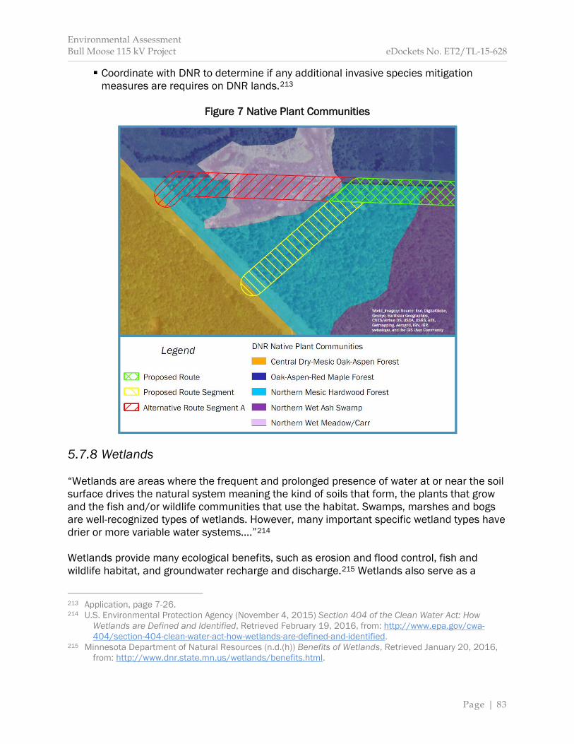
Environmental Assessment Bull Moose 115 kV Project eDockets No. ET2/TL-15-628
Page | 83
Coordinate with DNR to determine if any additional invasive species mitigation measures are requires on DNR lands.213
Figure 7 Native Plant Communities
5.7.8 Wetlands “Wetlands are areas where the frequent and prolonged presence of water at or near the soil surface drives the natural system meaning the kind of soils that form, the plants that grow and the fish and/or wildlife communities that use the habitat. Swamps, marshes and bogs are well-recognized types of wetlands. However, many important specific wetland types have drier or more variable water systems….”214 Wetlands provide many ecological benefits, such as erosion and flood control, fish and wildlife habitat, and groundwater recharge and discharge.215 Wetlands also serve as a
213 Application, page 7-26. 214 U.S. Environmental Protection Agency (November 4, 2015) Section 404 of the Clean Water Act: How
Wetlands are Defined and Identified, Retrieved February 19, 2016, from: http://www.epa.gov/cwa-404/section-404-clean-water-act-how-wetlands-are-defined-and-identified.
215 Minnesota Department of Natural Resources (n.d.(h)) Benefits of Wetlands, Retrieved January 20, 2016, from: http://www.dnr.state.mn.us/wetlands/benefits.html.

Environmental Assessment Bull Moose 115 kV Project eDockets No. ET2/TL-15-628
Page | 84
“natural filter” by trapping and absorbing sedimentation and some pollutants. Approximately 10.62 million acres of wetlands are found across Minnesota.216 They vary by soil, hydrology, and vegetation, and are typically seasonal in their extent. Certain wetlands are protected federally under Section 404 of the Clean Water Act. In Minnesota, wetlands are also protected by the Wetland Conservation Act. Impacts to wetlands generally result from construction of a transmission line, for example, access roads may result in soil compaction, which can cause changes in water flow to the wetland, or soil erosion runoff, which can increase water turbidity levels. Impacts that influence the hydrology in the area may significantly impair the function of the wetland. Wetlands consist of organic soils comprised of layers of decomposed plant material that formed very slowly; as a result, disturbed wetlands are not easily repaired.217 When construction of a transmission line requires activity near or across a wetland, the potential to impact wetlands exists. However, a transmission line crossing does not necessarily mean a wetland will be impacted as wetlands can be spanned. Wetlands are present along the proposed transmission line (Map 8). The National Wetland Inventory (NWI) indicates several undelineated wetlands intersecting the route width of all routing options—types include: wet meadows, shrub swamps, bogs, shallow marshes, and shallow ponds.218 Potential Impacts The potential for the introduction and spread of invasive plant species exists; however, this is expected to be minimal given construction is anticipated during frozen ground conditions. Frozen ground conditions will also reduce the potential for impacts to wetlands soils; however, any impact that does occur will be long-term due to the nature of wetland soils. The applicant indicates dewatering will not be required; as a result, impacts to local hydrology should not occur. Impacts to wetlands specific to the identified routing options are as follows: Proposed Route According to NLCD land cover data, the route width of the proposed route spans approximately seven and three-quarter acres of woody wetlands and 10.5 acres of emergent herbaceous wetlands. NWI data indicates these wetlands are seasonally flooded palustrine scrub/shrub broad-leaved deciduous wetlands (PSS1C), palustrine forested broad-leaved deciduous/needle-leaved evergreen affected by beaver (PF01/4b), seasonally saturated palustrine forested needle-leaved deciduous (PF02B), seasonally flooded palustrine emergent (PEMC), and seasonally saturated palustrine emergent (PEMB). 216 Minnesota Department of Natural Resources (n.d.(i)) Wetlands, Retrieved January 20, 2016, from: http://www.dnr.state.mn.us/wetlands/index.html. 217 Public Service Commission of Wisconsin (July 2013). 218 Minnesota Department of Natural Resources (n.d.(j)) Types of Wetlands, Retrieved January 15, 2016, from: http://www.dnr.state.mn.us/wetlands/types.html.
Environmental Assessment Bull Moose 115 kV Project eDockets No. ET2/TL-15-628
Page | 85
Satellite imagery indicates the NWI-identified PEMB wetland on the eastern edge of the proposed route are utilized as agricultural land and have likely been degraded by agricultural drainage and plowing. Other wetlands, including PEMB and PEMC are previously impacted by the existing DC Line. Approximately three and one-half acres of woody wetland cover types will be cleared within the ROW. Removing woody vegetation within these areas will not reduce overall wetland acreage, but will convert the wetland to a different vegetation community and wetland type. Conversion of woody wetlands would be permanent and may change wetland functions within the ROW, for example, by altering wildlife habitat. Impacts to woody wetlands within the ROW are significant and permanent. Woody wetlands account for approximately 17 percent of land cover types within one-mile of the proposed project; therefore, within this regional context, impacts to woody wetlands are minimal. Impacts are unavoidable, but can be minimized. Impacts resulting from structure placement would occur if structures are needed to be placed in wetlands. At this time, it is anticipated that two poles may need to be placed within wetland areas. This would require excavation in the wetland. Frozen ground conditions would minimize construction impacts to wetland soils and dewatering is not anticipated. Long-term impacts include structures and anchors in the wetland. The impact intensity level is anticipated to be minimal. Impacts can be mitigated. Proposed Route Segment According to NLCD land cover data, the proposed route segment does not transect wetland cover types. NWI data indicates a one-tenth of an acre seasonally flooded palustrine forested broad-leaved deciduous wetland (PFO1C) is located within the route width of the proposed route segment. Approximately 43 square feet of this wetland may intersect the ROW. Flexibility exists within the route width to avoid this wetland; therefore, no impacts are anticipated. Should the wetland be unavoidable, forested wetlands within the ROW will be cleared. This will convert forested wetlands to shrub-type wetlands. Direct impacts will be significant and long-term with the ROW. Woody wetlands account for approximately 17 percent of land cover types within one-mile of the proposed project; therefore, within this regional context, impacts to woody wetlands are minimal. Alternative Route Segment A The alternative route segment would span two freshwater ponds. NWI data indicates these ponds are intermittently exposed palustrine wetlands with unconsolidated bottoms. It is anticipated these ponds can be spanned, and placement of structures in wetlands is not anticipated. Constructing the project during frozen ground conditions would minimize wetland soil impacts.
Environmental Assessment Bull Moose 115 kV Project eDockets No. ET2/TL-15-628
Page | 86
Because wetlands along the alternative route segment can be spanned, direct impacts to wetlands are not anticipated. Mitigation Potential impacts to wetlands can be avoided by selecting routes, alignments, and pole placements outside of wetlands. If wetlands cannot be avoided, impacts can be minimized by a variety of strategies including: use of construction mats and silt tubes, conducting construction and maintenance activities during winter months when the ground is frozen, spreading spoils from structure placement outside the wetland, assembling structures on upland areas prior to site installation, and transporting crews and equipment, to the extent possible, over improved roads and via routes which minimize transit over wetlands. A regional general permit from the USACE, under Section 404 of the Clean Water Act, may be required for the project. The applicants indicate they will restore all wetlands in accordance with USACE requirements and with the requirements of the Minnesota Wetland Conservation Act. Commission route permits require permittees to avoid and minimize wetland impacts.219 5.7.9 Wildlife and Wildlife Habitat Construction and operation of transmission lines has the potential to impact wildlife. Examples include: permanent or temporary displacement, habitat modification or degradation, and, for avian species, collision with energized transmission line conductors. The route width along the different routing options contain habitat for openland, woodland, and wetland wildlife.
Habitat for openland wildlife consists of cropland, pasture, meadows, and areas that are overgrown with grasses, herbs, shrubs, and vines. These areas produce grain and seed crops, grasses and legumes, and wild herbaceous plants. Habitat for woodland wildlife consists of areas of deciduous plants or coniferous plants or both and associated grasses, legumes, and wild herbaceous plants. Habitat for wetland wildlife consists of open, marshy or swampy shallow water areas.220
Wildlife attracted to these areas include ruffed and sharptail grouse, Hungarian partridge, meadowlark, field sparrow, woodcock, thrushes, woodpeckers, ducks, geese, herons, shore birds, cottontail, red fox, squirrels, gray fox, raccoon, deer, bear, muskrat, mink, and beaver.221 Other wildlife within the route width includes a variety of reptiles and amphibians, 219 See Appendix C Generic Route Permit Template, Section 5.2.12. 220 U.S. Department of Agriculture, Natural Resource Conservation Service and U.S. Forest Service (October
1997) Soil Survey of Cass County Minnesota, Retrieved January 22, 2016, from: http://www.nrcs.usda.gov/Internet/FSE_MANUSCRIPTS/minnesota/MN021/0/Cass_MN.pdf.
221 U.S. Department of Agriculture, Natural Resource Conservation Service and U.S. Forest Service (October 1997), page 123.

Environmental Assessment Bull Moose 115 kV Project eDockets No. ET2/TL-15-628
Page | 87
such as turtles, snakes, frogs and toads. Rare and unique wildlife species are discussed in Section 5.7.4. There are no DNR-managed WMAs, AMAs or SNAs, or USFWS Waterfowl Production Areas within one-mile of proposed project. Potential Impacts to Wildlife Impacts to wildlife across all routing options are similar, except with regard to avian species. Terrestrial and Aquatic Species Wildlife using the route width are expected to relocate during construction due to increased noise and human activity. The majority of wildlife would likely return to the area after construction; however, others might be permanently displaced. Because streams and ponds will be spanned, which will result in no structures being placed within fish habitat, and construction will occur during winter months, impacts to water species, such as fish, are not anticipated to occur. Reptiles, such as snakes, move underground below the frost line and become inactive or hibernate over winter months.222 Turtles and amphibians generally hibernate under pond bottoms, but will also hibernate on land underneath the frost line. Impacts to individual species might occur during transmission structure placement, that is, individuals might be crushed, should placement occur at their place of hibernation. Direct impacts to terrestrial and aquatic wildlife across all routing options will be short-term. Impacts are of relative small size and are not anticipated to impact unique resources. While direct significant impacts may occur to individuals, population level impacts are not anticipated. The impact intensity level is expected to be minimal. Impacts can be avoided and minimized. Avian Species During winter, many avian species, such as waterfowl and song birds, seasonally migrate out of the project area. As a result, direct impacts to avian species during construction are anticipated to be minimal. Once the transmission line is constructed, avian species might collide with conductors. Collisions are more likely for large-bodied birds with long wing spans, such as swans, geese and ducks. Additionally, if the wingspan of a species is of sufficient length that it can simultaneously contact two conductors or a conductor and a grounding wire, the species could be electrocuted. The frequency of birds colliding with conductors depends upon the number of birds crossing through the area and the likelihood that they will utilize the area for food, water or resting. 222 Minnesota Department of Natural Resources (2010) Snakes and Lizards of Minnesota, Retrieved January
22, 2016, from: http://files.dnr.state.mn.us/natural_resources/animals/reptiles_amphibians/snake_lizard_mn.pdf.

Environmental Assessment Bull Moose 115 kV Project eDockets No. ET2/TL-15-628
Page | 88
Habitat within one mile of the proposed transmission line is relatively good for avian species, particularly for waterfowl. Impacts to avian species specific to the identified routing options are as follows: Proposed Route The existing DC Line is, on average, 73 feet tall. The proposed transmission line is anticipated to be of similar height, with structures anticipated to range from 70 and 80 feet tall.223 As a result, the addition of the proposed transmission line along the proposed route is not anticipated to create a new vertical barrier across the landscape for avian species. The potential for avian species to strike conductors will be long-term. Direct adverse impacts to individuals may occur. Population level impacts are not anticipated. The impact intensity level is expected to be minimal along the proposed route. Proposed Route Segment The proposed route segment will effectively surround a nine-acre pond with transmission line conductors. Existing tall-growing trees will remain on the southern side of the pond buffering it from the proposed route segment (Map 3). Conductors are not anticipated to extend vertically a significant distance beyond existing deciduous forest, and, as a result, the proposed transmission is not anticipated to create a significant vertical barrier to avian species along the proposed route segment. The potential for avian species to strike conductors will be long-term. Direct adverse impacts to individuals may occur. Population level impacts are not anticipated. The impact intensity level is expected to be minimal along the proposed route segment. Alternative Route Segment A The alternative route segment spans an approximately nine-acre pond. This pond is currently spanned by the existing DC Line. The DC Line structures are 70 feet tall. In order to span the pond, the applicant indicates that H-frame structures would be needed. These structures would be 100 feet tall or taller. As a result, the alternative route segment would enlarge the vertical barrier for avian species crossing the pond north and south. The potential for avian species to strike conductors will be long-term. Direct adverse impacts to individuals may occur. Population level impacts are not anticipated. Impacts along the alternative route segment are expected to be moderate. Impacts can be minimized using bird diverters (discussed in greater detail below). After mitigation is employed impacts are anticipated to be minimal. The likelihood of collision is greater for the alternative route segment than the other routing options.
223 Application, page 4-3.
Environmental Assessment Bull Moose 115 kV Project eDockets No. ET2/TL-15-628
Page | 89
Wildlife Mitigation Potential impacts to wildlife can be avoided by routing transmission lines away from habitat or migratory corridors. Impacts can be minimized by spanning quality habitats and minimizing the number of structures to the extent practicable. Impacts to avian species can be minimized by diverting bird flights away from transmission lines through the use of bird flight diverters placed on transmission line conductors. Diverters can be used over open water and wetland areas, or near natural breaks in tall-growing vegetation, that is, natural openings and funnels within forested areas near habitats used by avian species, especially waterfowl species. The applicants indicate that they will work with DNR to identify areas where bird flight diverters are needed. Impacts to avian species caused by electrocution can be mitigated by the use of BMPs for conductor spacing and shielding. These practices are codified in Avian Power Line Interaction Committee standards. Adherence to these standards is a standard Commission route permit condition.224 The applicant indicates the following mitigation measures will be used:
Minimize tree felling and shrub removal that are important to area wildlife. Tree clearing is currently scheduled for winter months when the Northern long-eared bat is not anticipated to be present in the area. Re-vegetate disturbed areas with native species and wildlife conservation species
where applicable. Implement raptor protection measures, including placement of bird flight diverters on
the line at water crossings after consultation with local wildlife management staff.225 Potential Impacts to Wildlife Habitat Clearing vegetation within the ROW will widen existing corridors or bisect “greenfield” areas to establish new ROW. The composition and structure of vegetation—and, as a result, wildlife habitat—will be altered in these areas. Habitat loss has a consistent negative affect on biodiversity and can adversely impact species richness, population growth rates, reductions in habitat specialist species, and breeding success, among other measures.226 The potential for the introduction and spread of invasive plant species exists; however, this is expected to be minimal given construction is anticipated during frozen ground conditions. Impacts to wildlife habitat specific to the identified routing options are as follows: 224 Appendix C Generic Route Permit Template, Section 5.2.14. 225 Application, page 7-29. 226 See Fahrig, Lenore (2003) Effects of Habitat Fragmentation on Biodiversity, Annual Review of Ecology and
Systematics 2003(34):487-515, Retrieved February 3, 2016, from: http://www.montana.edu/hansenlab/documents/bio515_13/farhig%202003.pdf.
Environmental Assessment Bull Moose 115 kV Project eDockets No. ET2/TL-15-628
Page | 90
Proposed Route Approximately nine and one-half acres of woodland and woody wetland habitat will be impacted along the proposed route. These habitat types will be cleared and not allowed to revegetate. As a result, impacts to these habitat types within the ROW will be significant and long-term. Forested, woody wetlands and shrub/scrub vegetation types account for approximately 77 percent of land cover types within one-mile of the proposed project; therefore, within a regional context, impacts to wildlife habitats associated with these vegetation types will be minimal. Impacts are unavoidable, but can be minimized. Impacts to other habitats are not expected because these habitat types typically do not require vegetative clearing and, in most instances, can be spanned. Proposed Route Segment Approximately two and one-half acres of woodland habitat will be impacted by the proposed project. This habitat type will be cleared and not allowed to revegetate. As a result, impacts to woodland habitat within the ROW will be significant and long-term. Forested and shrub/scrub cover types account for approximately 60 percent of land cover types within one-mile of the proposed project; therefore, within a regional context, impacts to wildlife habitat associated with these cover types will be minimal. Impacts are unavoidable, but can be minimized. Alternative Route Segment A Approximately one and one-half acres of woodland habitat will be impacted along the alternative route segment. This habitat type will be cleared and not allowed to revegetate. As a result, impacts to woodland habitat within the ROW will be long-term and significant. Forested and shrub/scrub cover types account for approximately 60 percent of land cover types within one-mile of the proposed project; therefore, within a regional context, impacts to wildlife habitat associated with these cover types will be minimal. Impacts are unavoidable, but can be minimized. Impacts to wetland habitat (a freshwater pond) are not expected because this habitat type can be spanned in this location. Habitat Fragmentation Habitat fragmentation is “usually defined as a landscape-scale process involving both habitat loss and the breaking apart of habitat.”227 This definition, however, does not isolate the impact of fragmentation independent of habitat loss. The potential impact from habitat fragmentation—when controlled for habitat loss—is “generally much weaker than the effects of habitat loss,” and is “at least as likely to be positive as negative.”228 Negative impacts
227 Fahrig, Lenore (2003), page 487. 228 Fahrig, Lenore (2003), page 502.

Environmental Assessment Bull Moose 115 kV Project eDockets No. ET2/TL-15-628
Page | 91
associated with habitat fragmentation include 1) an increased number of smaller habitat patches interspersed among larger areas of non-suitable habitat, and 2) increased “edge for a given amount of habitat.”229 “An ‘edge’ is the boundary, or interface, between two biological communities or between different landscape elements.”230 Edge effects may alter habitats that are important to interior forest dwellers through microclimate changes to these areas. Additionally, increased predation, competition, and parasitism from plants and animals intruding on interior forest environments can become more prevalent, as well as interior forest species increasingly moving through and along edges, that is, habitat transition areas.231, 232 In locations where the proposed transmission line will parallel existing ROW, edge effects will be limited to one side of the ROW. As a result, edge effects are expected to intensify in locations where new ROW will be created and lessen where existing ROW is expanded. Direct impacts to wildlife due to habitat fragmentation will be long-term, of a relative small size, and are not expected to significantly impact rare or unique resources. Impacts to wildlife habitat as a result of habitat fragmentation specific to the identified routing options are as follows: Proposed Route The proposed route parallels existing ROW for the majority of its length. Other areas include open, agricultural land. As a result, increased habitat edge or an increase in the number of habitat patches will not occur. The existing habitat transition area will be enlarged. Impacts will be long-term of a relatively small size. The impact intensity level is anticipated to be minimal. Proposed Route Segment The proposed route segment crosses woodland habitat. This area is impacted by an existing trail. This trail may already create minimal edge effects within the existing environment, but does not create a microclimate with the ability to impact vegetation types. The proposed route segment would create new—or further emphasize any existing—edge effects. A habitat transition area will be created. The proposed route will create a habitat patch approximately 11 acres in size. This ‘patch’ is not so isolated or small that impacts beyond those generally associated with habitat loss are expected. Impacts will be long-term and of a relatively small size. The impact intensity level is anticipated to be moderate. Alternative Route Segment A The proposed route segment crosses woodland habitat, and further emphasizes existing edge effect in the area. The proposed route will create a habitat patch approximately one-tenth of an acre in size. Larger wildlife species are not anticipated to use this area; however,
229 Fahrig, Lenore (2003), page 505. 230 British Columbia Ministry of Forests Research Program (June 1998) Biodiversity and Interior Habitats: The
Need to Minimize Edge Effects, Retrieved February 4, 2016, from: https://www.for.gov.bc.ca/hfd/pubs/Docs/En/En21.pdf.
231 British Columbia Ministry of Forests Research Program (June 1998). 232 Fahrig, Lenore (2003), page 505.
Environmental Assessment Bull Moose 115 kV Project eDockets No. ET2/TL-15-628
Page | 92
this patch is not so isolated that smaller wildlife species, such as songbirds or squirrels, will not use the area. The existing habitat transition area will be enlarged. Impacts will be long-term and of a relatively small size. The impact intensity level is anticipated to be minimal. Wildlife Habitat Mitigation Use of existing ROWs can minimize habitat loss, and paralleling existing ROWs can minimize habitat fragmentation. The applicant indicates that disturbed areas will be re-vegetated with native species and wildlife conservation species where applicable.233 During scoping, DNR proposed the wire/border zone method of ROW management and maintenance be used to minimize impacts to wildlife habitat and edge effects.234 The applicant did not object to this recommendation.235 Therefore, EERA staff recommends this method of ROW maintenance be used for all routing options. The wire/border zone method allows for different types and heights of vegetation based on whether the vegetation is directly underneath the conductor (wire zone) or elsewhere in the ROW (border zone). This “softens” the edge of the habitat transition zone.
Wire Zone: Area directly underneath the conductors, including potential conductor sway. Vegetation in this zone consists of low-growing forbs and grasses. Border Zone: Area that begins at the outside edge of the wire zone and extends to the edge of the ROW. This zone may contain additional low-growing woody plants and trees.236
5.8 Cumulative Potential Effects Minnesota Rule 4410.0200, subpart 11a, defines “cumulative potential effects,” in part, as the “effect on the environment that results from the incremental effects of a project in addition to other projects in the environmentally relevant area that might reasonably be expected to affect the same environmental resources, including future projects … regardless of what person undertakes the other projects or what jurisdictions have authority over the project.” The “environmentally relevant area” includes locations where the potential effects of the proposed project coincide with the potential effects of other projects to impact the elements studied in Section 5.2 through Section 5.7. In general, this area includes the land between the 142 Line and 48th Ave SW.
233 Application, page 7-29. 234 Minnesota Department of Natural Resources (October 26, 2015) Scoping Comments, eDockets No. 201510-115104-01. 235 Great River Energy. 236 Minnesota Department of Natural Resources (October 26, 2015).
Environmental Assessment Bull Moose 115 kV Project eDockets No. ET2/TL-15-628
Page | 93
The RGU determines what projects are “reasonably likely to occur.”237 When making this determination, the RGU considers “whether any applications for permits have been filed with any units of government or whether detailed plans and specifications have been prepared for the project, among other considerations.238 A project need not be permitted to be reasonably likely to occur. In this instance, several permit applications have been filed with the Commission for projects that would occur in the environmentally relevant area. Enbridge Pipeline, Limited Partnership (EPLP) filed an application for a pipeline routing permit with the Commission for the Line 3 Project on April 24, 2015. This proposed transmission line project is intended to provide electrical power to a pump station associated with the Line 3 Project. On November 8, 2013, North Dakota Pipeline Company, LLC (NDPC) filed an application for a pipeline routing permit with the Commission for the Sandpiper Pipeline Project (Sandpiper Project).239 NDPC’s preferred route abuts the existing DC Line ROW to the north within the environmentally relevant area. As proposed by EPLP, the Line 3 Project would share ROW with the Sandpiper Project in this location. The following section analyses the cumulative potential effects of the proposed transmission line project and the proposed pipeline projects where potential effects coincide. EERA staff is evaluating both pipeline projects even though the final determination on the need or route for the proposed pipeline projects is unknown. In making this evaluation, EERA staff is not indicating these projects will be built. Rather, EERA is indicating their potential to be permitted and constructed based on the guidance of Minnesota Rule 4410.0200. The Line 3 Project and the Sandpiper Project are currently being analyzed under separate regulatory processes, and will have independent environmental reviews. The decisions regarding these pipeline routing permits are not anticipated to occur in 2016. The Line 3 Project and the Sandpiper Project may or may not be permitted. If permitted, they may be permitted but routed in locations other than the EPLP or NDPC preferred route location. Proposed Pipeline Projects The sole purpose of the proposed transmission line project is to provide electrical power to a proposed pump station associated with the Line 3 Project. The proposed transmission line project will not be needed unless the Line 3 Project is permitted and constructed along EPLP’s preferred route and the proposed pump station is also permitted as an associated facility at EPLP’s preferred location. As a result, the proposed transmission line project is a connected action to the Line 3 Project.240
237 Minn. R. 4410.0200, subp. 11a. 238 Minn. R. 4410.0200, subp. 11a. 239 Commission Docket No. PL-6668/PPL-13-474; see Minnesota eDockets:
https://www.edockets.state.mn.us/EFiling/search.jsp (“13” for year, “474” for number); see also EERA website: http://mn.gov/commerce/energyfacilities/Docket.html?Id=33599.
240 The opposite is not the case. For example, should the Line 3 Project be permitted but routed in a
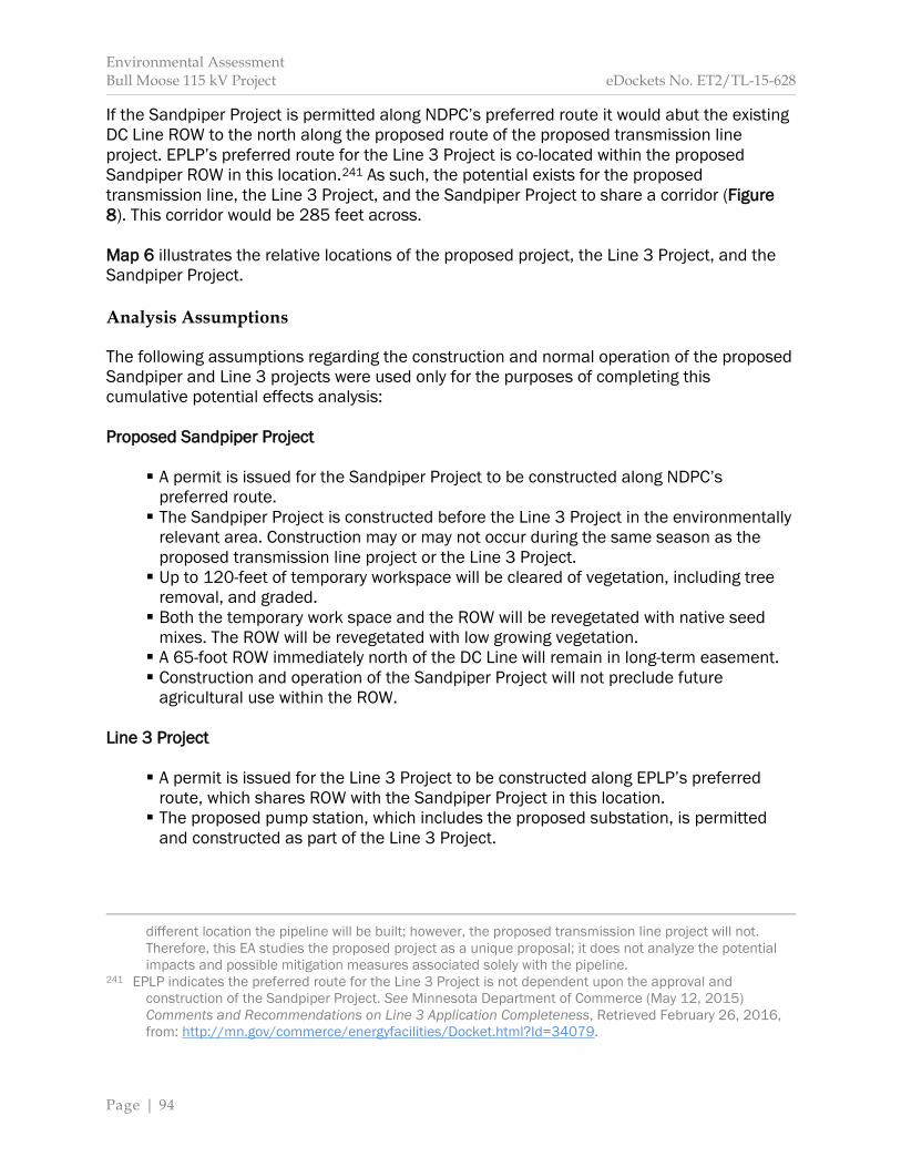
Environmental Assessment Bull Moose 115 kV Project eDockets No. ET2/TL-15-628
Page | 94
If the Sandpiper Project is permitted along NDPC’s preferred route it would abut the existing DC Line ROW to the north along the proposed route of the proposed transmission line project. EPLP’s preferred route for the Line 3 Project is co-located within the proposed Sandpiper ROW in this location.241 As such, the potential exists for the proposed transmission line, the Line 3 Project, and the Sandpiper Project to share a corridor (Figure 8). This corridor would be 285 feet across. Map 6 illustrates the relative locations of the proposed project, the Line 3 Project, and the Sandpiper Project. Analysis Assumptions The following assumptions regarding the construction and normal operation of the proposed Sandpiper and Line 3 projects were used only for the purposes of completing this cumulative potential effects analysis: Proposed Sandpiper Project
A permit is issued for the Sandpiper Project to be constructed along NDPC’s preferred route. The Sandpiper Project is constructed before the Line 3 Project in the environmentally
relevant area. Construction may or may not occur during the same season as the proposed transmission line project or the Line 3 Project. Up to 120-feet of temporary workspace will be cleared of vegetation, including tree
removal, and graded. Both the temporary work space and the ROW will be revegetated with native seed
mixes. The ROW will be revegetated with low growing vegetation. A 65-foot ROW immediately north of the DC Line will remain in long-term easement. Construction and operation of the Sandpiper Project will not preclude future
agricultural use within the ROW. Line 3 Project
A permit is issued for the Line 3 Project to be constructed along EPLP’s preferred route, which shares ROW with the Sandpiper Project in this location. The proposed pump station, which includes the proposed substation, is permitted
and constructed as part of the Line 3 Project.
different location the pipeline will be built; however, the proposed transmission line project will not. Therefore, this EA studies the proposed project as a unique proposal; it does not analyze the potential impacts and possible mitigation measures associated solely with the pipeline.
241 EPLP indicates the preferred route for the Line 3 Project is not dependent upon the approval and construction of the Sandpiper Project. See Minnesota Department of Commerce (May 12, 2015) Comments and Recommendations on Line 3 Application Completeness, Retrieved February 26, 2016, from: http://mn.gov/commerce/energyfacilities/Docket.html?Id=34079.
Environmental Assessment Bull Moose 115 kV Project eDockets No. ET2/TL-15-628
Page | 95
The Sandpiper Project ROW and temporary workspace will be used; therefore, further clearing of vegetation is not anticipated (except for the pump station site, which includes the proposed substation, and access roads to the pump station).242 Construction of the Line 3 Project may or may not occur during the same season as
the proposed transmission line project or the Sandpiper Project in the environmentally relevant area.
Additionally, this analysis assumes the Line 3 and Sandpiper Projects will be in operation for 50 years. These pipeline projects could be in operation beyond that time. Upon reaching the end of their operational life, it is assumed pipelines and associated infrastructure will remain in place and the ROWs maintained. Analysis Background The ROI for cumulative potential effects varies across elements, includes the proposed transmission line project, the Line 3 Project, and the Sandpiper Project, and is consistent with the ROI identified in Section 5.0. For example, the ROI for vegetation is limited to a discrete location: the ROW for the proposed transmission line project and the ROWs for the proposed pipeline projects within the environmentally relevant area. The ROI for aesthetic resources includes a variety of visual vantage points and is the area within 1,500 feet of all three proposed projects within the environmentally relevant area. Cumulative potential effects—where they coincide—increase the breadth of the impact to the elements studied in Sections 5.2 through 5.7. This may or may not change the impact intensity level assigned to the element in Sections 5.2 through 5.7. Sections 5.8.1 through 5.8.6 provide graphics illustrating the potential for cumulative potential effects across the elements studied in Section 5.2 through 5.7. Where cumulative effects are anticipated, a written description is provided. Where cumulative potential effects are not anticipated, no further analysis is provided. The following graphics are used to illustrate cumulative potential effects:
Cumulative potential effects are anticipated.
Cumulative potential effects are NOT anticipated.
Cumulative potential effects are uncertain. For the purposes of this EA, actions that have occurred in the past and their associated impacts are considered part of the existing environment and are included in the affected environment described in Section 5 and the analysis conducted in Sections 5.2 through 5.7
242 See Enbridge Energy, Limited Partnership (April 2015) Route Permit Application for the Minnesota Public
Utilities Commission, eDockets Nos. 20154-109660 to 20154-109663, page 5-5, Appendices G and N.
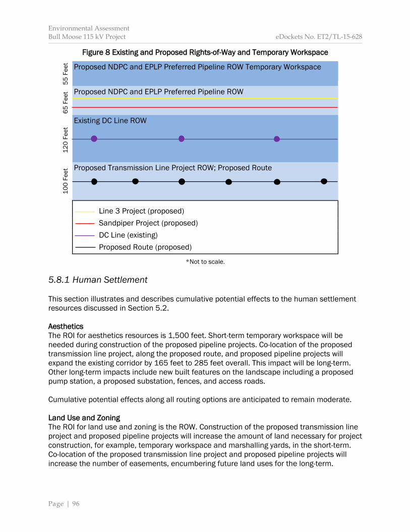
Environmental Assessment Bull Moose 115 kV Project eDockets No. ET2/TL-15-628
Page | 96
Figure 8 Existing and Proposed Rights-of-Way and Temporary Workspace
Proposed NDPC and EPLP Preferred Pipeline ROW Temporary Workspace
Proposed NDPC and EPLP Preferred Pipeline ROW Existing DC Line ROW Proposed Transmission Line Project ROW; Proposed Route
Line 3 Project (proposed) Sandpiper Project (proposed) DC Line (existing) Proposed Route (proposed)
*Not to scale. 5.8.1 Human Settlement This section illustrates and describes cumulative potential effects to the human settlement resources discussed in Section 5.2. Aesthetics The ROI for aesthetics resources is 1,500 feet. Short-term temporary workspace will be needed during construction of the proposed pipeline projects. Co-location of the proposed transmission line project, along the proposed route, and proposed pipeline projects will expand the existing corridor by 165 feet to 285 feet overall. This impact will be long-term. Other long-term impacts include new built features on the landscape including a proposed pump station, a proposed substation, fences, and access roads. Cumulative potential effects along all routing options are anticipated to remain moderate. Land Use and Zoning The ROI for land use and zoning is the ROW. Construction of the proposed transmission line project and proposed pipeline projects will increase the amount of land necessary for project construction, for example, temporary workspace and marshalling yards, in the short-term. Co-location of the proposed transmission line project and proposed pipeline projects will increase the number of easements, encumbering future land uses for the long-term.
100
Feet
12
0 Fe
et
6
5 Fe
et
55
Feet

Environmental Assessment Bull Moose 115 kV Project eDockets No. ET2/TL-15-628
Page | 97
Cumulative potential effects along all routing options are anticipated to remain minimal.
Table 14 Cumulative Potential Effects: Human Settlement
Element / Resource
Region of Influence
Potential for Cumulative Effects Short-term Long-term Permanent
Aesthetics 1,500 Feet Cultural Values Project Area Displacement ROW Interference Route Width Land Use ROW Noise 1,500 Feet Property Values 1,500 Feet Recreation One-mile Socioeconomics Project Area
Noise The ROI for noise impacts is 1,500 feet. Construction of the proposed project and proposed pipeline projects will increase noise impacts. Should construction schedules coincide, noise impacts will be additive. Long-term noise impacts include a pump station anticipated to generate 40 dBa of sound at 50 feet from the nearest structure;243 increasing ambient noise levels. Cumulative potential effects along all routing options are anticipated to remain minimal. Property Values The ROI for potential impacts to property values is 1,500 feet. Based on the literature, co-location of the proposed project and proposed pipeline projects may negatively impact property values over the short-term. Any change to a specific property’s value is difficult to determine. Long-term impacts may or may not occur. Cumulative potential effects along all routing options are anticipated to remain minimal. Recreation The ROI for recreation is one-mile. Construction of the proposed project and proposed pipeline projects will generate noise. Short-term noise impacts may or may not occur at the same time. Short- and long-term aesthetic impacts will occur. The proposed pump station will not be built within the Foot Hills State Forest.
243 Line 3 Project Application, page 7-33.

Environmental Assessment Bull Moose 115 kV Project eDockets No. ET2/TL-15-628
Page | 98
Cumulative potential effects are anticipated to remain minimal, except along the proposed route segment where potential effects are expected to remain moderate. Socioeconomics The ROI for socioeconomics is the project area. To the extent workers are hired locally, construction wages and salaries in the project will increase. Expenditures will increase over the short-term at local businesses. Over the long-term, Cass County will receive tax revenue associated with the Line 3 Project. Cumulative potential effects for all routing options are anticipated to remain positive and minimal. 5.8.2 Public Health and Safety This section illustrates cumulative potential effects to human health and safety discussed in Section 5.3.
Table 15 Cumulative Environmental Effects: Public Health and Safety
Element / Resource Region of Influence
Potential for Cumulative Effects Short-term Long-term Permanent
Electric and Magnetic Fields Route Width Implantable Medical Devices Route Width Stray Voltage Route Width
5.8.3 Public Services This section illustrates and describes cumulative potential effects to the public services discussed in Section 5.4.
Table 16 Cumulative Potential Effects: Public Services
Element / Resource Region of Influence
Potential for Cumulative Effects Short-term Long-term Permanent
Airports Project Area Emergency Services Project Area Roads and Highways Project Area Utilities Project Area
Emergency Services The ROI for emergency services is the project area. Construction of the proposed project and proposed pipeline projects may increase delays to emergency vehicles. Long-term impacts are not anticipated.
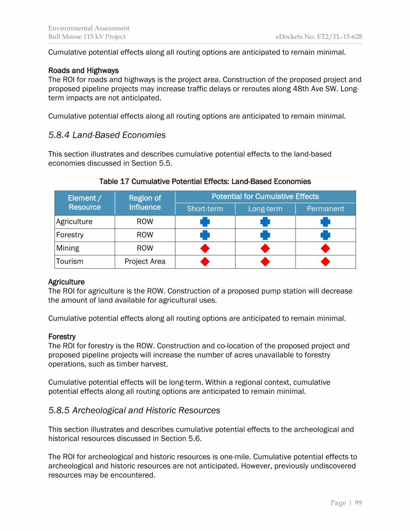
Environmental Assessment Bull Moose 115 kV Project eDockets No. ET2/TL-15-628
Page | 99
Cumulative potential effects along all routing options are anticipated to remain minimal. Roads and Highways The ROI for roads and highways is the project area. Construction of the proposed project and proposed pipeline projects may increase traffic delays or reroutes along 48th Ave SW. Long-term impacts are not anticipated. Cumulative potential effects along all routing options are anticipated to remain minimal. 5.8.4 Land-Based Economies This section illustrates and describes cumulative potential effects to the land-based economies discussed in Section 5.5.
Table 17 Cumulative Potential Effects: Land-Based Economies
Element / Resource
Region of Influence
Potential for Cumulative Effects Short-term Long-term Permanent
Agriculture ROW Forestry ROW Mining ROW Tourism Project Area
Agriculture The ROI for agriculture is the ROW. Construction of a proposed pump station will decrease the amount of land available for agricultural uses. Cumulative potential effects along all routing options are anticipated to remain minimal. Forestry The ROI for forestry is the ROW. Construction and co-location of the proposed project and proposed pipeline projects will increase the number of acres unavailable to forestry operations, such as timber harvest. Cumulative potential effects will be long-term. Within a regional context, cumulative potential effects along all routing options are anticipated to remain minimal. 5.8.5 Archeological and Historic Resources This section illustrates and describes cumulative potential effects to the archeological and historical resources discussed in Section 5.6. The ROI for archeological and historic resources is one-mile. Cumulative potential effects to archeological and historic resources are not anticipated. However, previously undiscovered resources may be encountered.
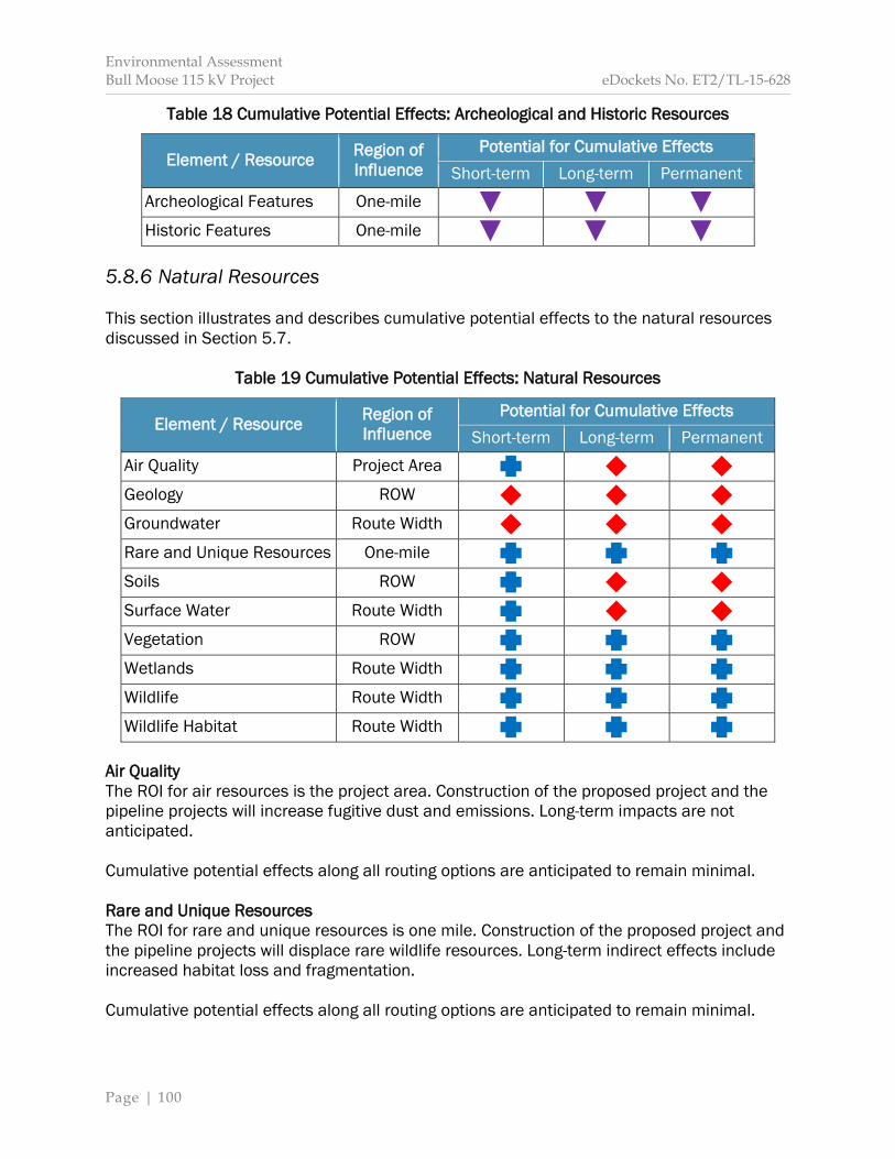
Environmental Assessment Bull Moose 115 kV Project eDockets No. ET2/TL-15-628
Page | 100
Table 18 Cumulative Potential Effects: Archeological and Historic Resources
Element / Resource Region of Influence
Potential for Cumulative Effects Short-term Long-term Permanent
Archeological Features One-mile Historic Features One-mile
5.8.6 Natural Resources This section illustrates and describes cumulative potential effects to the natural resources discussed in Section 5.7.
Table 19 Cumulative Potential Effects: Natural Resources
Element / Resource Region of Influence
Potential for Cumulative Effects Short-term Long-term Permanent
Air Quality Project Area Geology ROW Groundwater Route Width Rare and Unique Resources One-mile Soils ROW Surface Water Route Width Vegetation ROW Wetlands Route Width Wildlife Route Width Wildlife Habitat Route Width
Air Quality The ROI for air resources is the project area. Construction of the proposed project and the pipeline projects will increase fugitive dust and emissions. Long-term impacts are not anticipated. Cumulative potential effects along all routing options are anticipated to remain minimal. Rare and Unique Resources The ROI for rare and unique resources is one mile. Construction of the proposed project and the pipeline projects will displace rare wildlife resources. Long-term indirect effects include increased habitat loss and fragmentation. Cumulative potential effects along all routing options are anticipated to remain minimal.
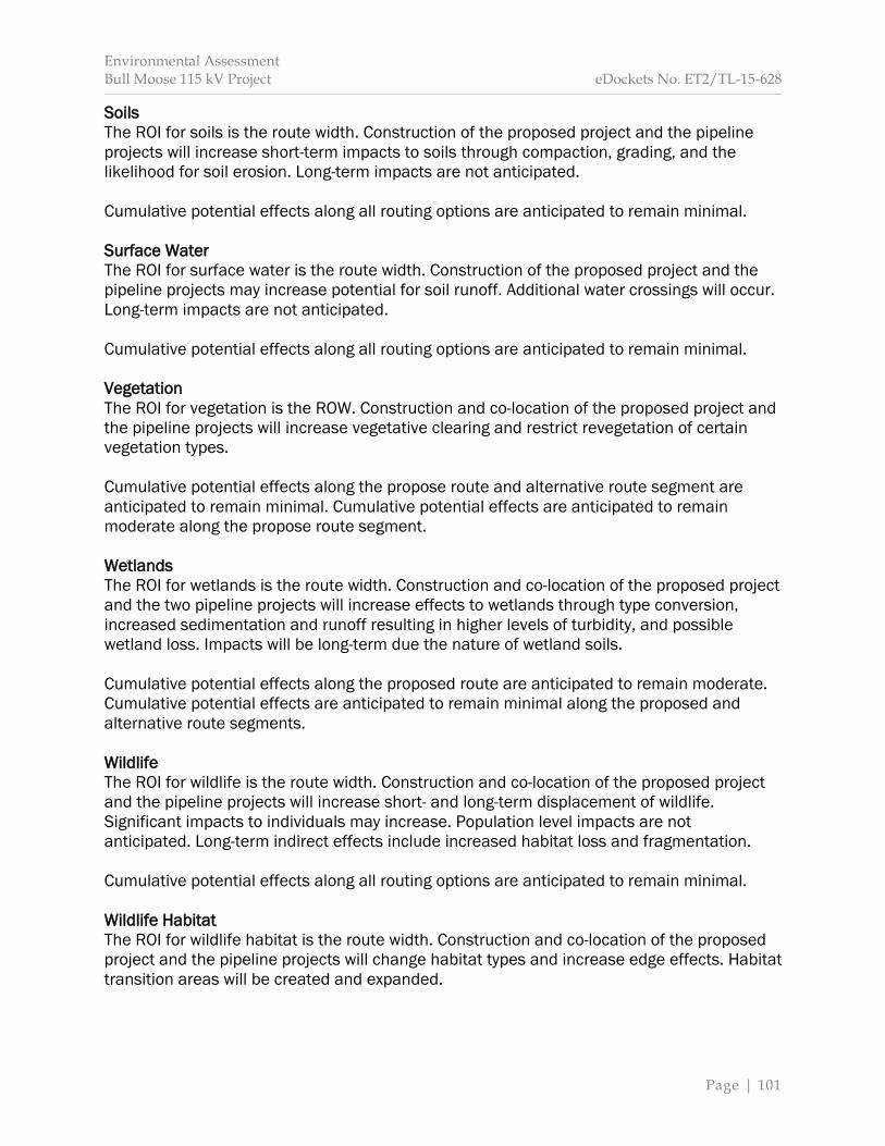
Environmental Assessment Bull Moose 115 kV Project eDockets No. ET2/TL-15-628
Page | 101
Soils The ROI for soils is the route width. Construction of the proposed project and the pipeline projects will increase short-term impacts to soils through compaction, grading, and the likelihood for soil erosion. Long-term impacts are not anticipated. Cumulative potential effects along all routing options are anticipated to remain minimal. Surface Water The ROI for surface water is the route width. Construction of the proposed project and the pipeline projects may increase potential for soil runoff. Additional water crossings will occur. Long-term impacts are not anticipated. Cumulative potential effects along all routing options are anticipated to remain minimal. Vegetation The ROI for vegetation is the ROW. Construction and co-location of the proposed project and the pipeline projects will increase vegetative clearing and restrict revegetation of certain vegetation types. Cumulative potential effects along the propose route and alternative route segment are anticipated to remain minimal. Cumulative potential effects are anticipated to remain moderate along the propose route segment. Wetlands The ROI for wetlands is the route width. Construction and co-location of the proposed project and the two pipeline projects will increase effects to wetlands through type conversion, increased sedimentation and runoff resulting in higher levels of turbidity, and possible wetland loss. Impacts will be long-term due the nature of wetland soils. Cumulative potential effects along the proposed route are anticipated to remain moderate. Cumulative potential effects are anticipated to remain minimal along the proposed and alternative route segments. Wildlife The ROI for wildlife is the route width. Construction and co-location of the proposed project and the pipeline projects will increase short- and long-term displacement of wildlife. Significant impacts to individuals may increase. Population level impacts are not anticipated. Long-term indirect effects include increased habitat loss and fragmentation. Cumulative potential effects along all routing options are anticipated to remain minimal. Wildlife Habitat The ROI for wildlife habitat is the route width. Construction and co-location of the proposed project and the pipeline projects will change habitat types and increase edge effects. Habitat transition areas will be created and expanded.

Environmental Assessment Bull Moose 115 kV Project eDockets No. ET2/TL-15-628
Page | 102
Cumulative potential effects along all routing options are anticipated to remain, or increase, to moderate.
Environmental Assessment Bull Moose 115 kV Project eDockets No. ET2/TL-15-628
Page | 103
6 Unavoidable Impacts and Resource Commitments
Environmental Assessment Bull Moose 115 kV Project eDockets No. ET2/TL-15-628
Page | 104
Section 6 discusses the unavoidable impacts and irreversible or irretrievable commitments of resources associated with the proposed project. These impacts and commitments are similar across all alternatives. 6.1 Unavoidable Impacts Transmission lines are infrastructure projects that have unavoidable adverse human and environmental impacts. These potential impacts and the possible ways to mitigate against them are discussed in Section 5. However, even with mitigation strategies, certain impacts cannot be avoided. Unavoidable adverse impacts associated with construction of the proposed project include:
Possible traffic delays. Visual and noise disturbance to nearby residents and recreationalists. Soil compaction and erosion. Vegetative clearing, including forested areas and woody wetlands. Disturbance and displacement of wildlife, as well as direct impacts to wildlife
inadvertently struck or crushed during pole placement or other activities. Habitat loss. Increased habitat edge, patches and transition area.
Unavoidable adverse impacts associated with the operation of the proposed project include:
Visual impact of transmission line structures and conductors. Loss of land use for other purposes, such as agriculture, where structures are placed. Direct impacts to avian species that collide with conductors. Interference with AM radio signals if necessary to cross 48th Ave SW. Loss of opportunity to harvest timber within the ROW. Potential decrease in neighboring property values. Continued maintenance of tall-growing vegetation, that is, continued cutting of trees.
6.2 Resource Commitments Resource commitments are irreversible when it is impossible or very difficult to redirect that resource to a different future use. Irreversible impacts include the land required to construct the transmission line. While it is possible that the structures and conductors could be removed and the ROW restored to previous conditions, this is unlikely to happen in the reasonably foreseeable future. The loss of forested wetlands is considered irreversible, because replacing these wetlands would take a significant amount of time. Certain land uses within the ROW will no longer be able to occur. Impacts to native plant communities results in an irreversible impact. An irretrievable commitment of resources means the resource is not recoverable for later use by future generations. These impacts are primarily related to project construction, including the use of water, aggregate, hydrocarbons, steel, concrete, and other consumable resources. The commitment of labor and fiscal resources is also considered irretrievable.
Environmental Assessment Bull Moose 115 kV Project eDockets No. ET2/TL-15-628
Page | 105
7 Routing Factors
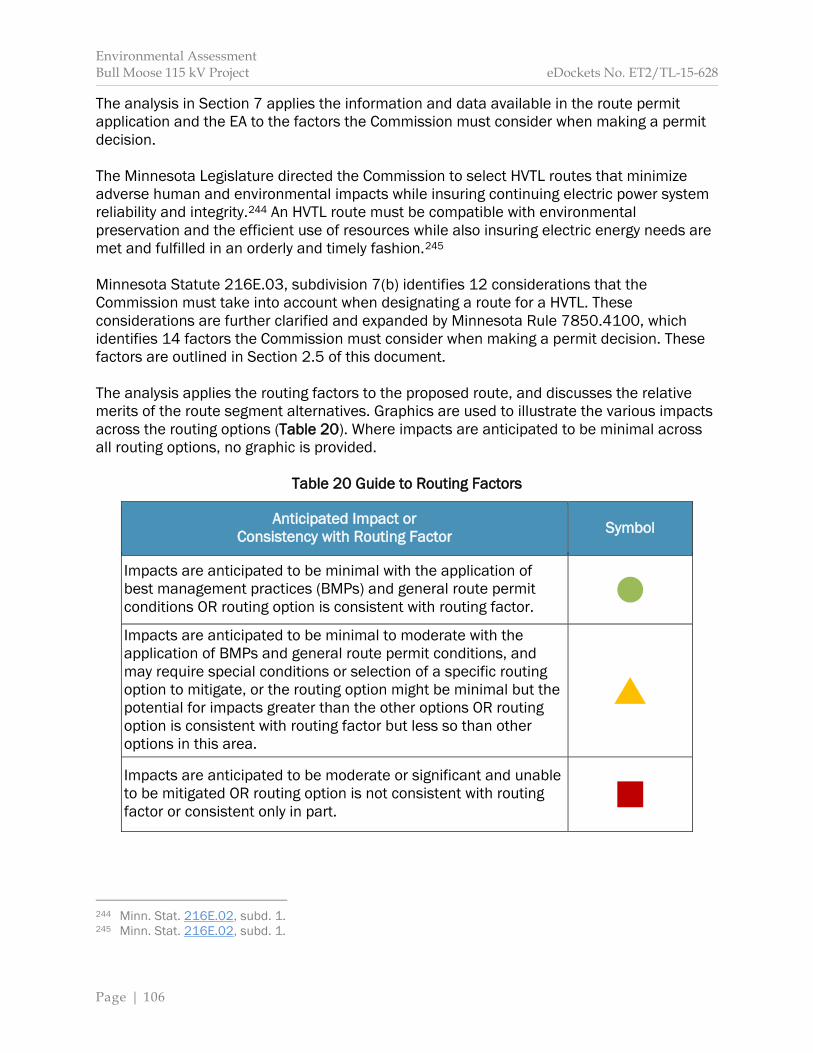
Environmental Assessment Bull Moose 115 kV Project eDockets No. ET2/TL-15-628
Page | 106
The analysis in Section 7 applies the information and data available in the route permit application and the EA to the factors the Commission must consider when making a permit decision. The Minnesota Legislature directed the Commission to select HVTL routes that minimize adverse human and environmental impacts while insuring continuing electric power system reliability and integrity.244 An HVTL route must be compatible with environmental preservation and the efficient use of resources while also insuring electric energy needs are met and fulfilled in an orderly and timely fashion.245 Minnesota Statute 216E.03, subdivision 7(b) identifies 12 considerations that the Commission must take into account when designating a route for a HVTL. These considerations are further clarified and expanded by Minnesota Rule 7850.4100, which identifies 14 factors the Commission must consider when making a permit decision. These factors are outlined in Section 2.5 of this document. The analysis applies the routing factors to the proposed route, and discusses the relative merits of the route segment alternatives. Graphics are used to illustrate the various impacts across the routing options (Table 20). Where impacts are anticipated to be minimal across all routing options, no graphic is provided.
Table 20 Guide to Routing Factors
Anticipated Impact or Consistency with Routing Factor Symbol
Impacts are anticipated to be minimal with the application of best management practices (BMPs) and general route permit conditions OR routing option is consistent with routing factor.
Impacts are anticipated to be minimal to moderate with the application of BMPs and general route permit conditions, and may require special conditions or selection of a specific routing option to mitigate, or the routing option might be minimal but the potential for impacts greater than the other options OR routing option is consistent with routing factor but less so than other options in this area.
Impacts are anticipated to be moderate or significant and unable to be mitigated OR routing option is not consistent with routing factor or consistent only in part.
244 Minn. Stat. 216E.02, subd. 1. 245 Minn. Stat. 216E.02, subd. 1.
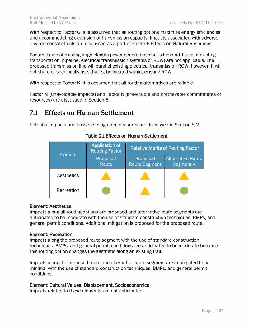
Environmental Assessment Bull Moose 115 kV Project eDockets No. ET2/TL-15-628
Page | 107
With respect to Factor G, it is assumed that all routing options maximize energy efficiencies and accommodating expansion of transmission capacity. Impacts associated with adverse environmental effects are discussed as a part of Factor E Effects on Natural Resources. Factors I (use of existing large electric power generating plant sites) and J (use of existing transportation, pipeline, electrical transmission systems or ROW) are not applicable. The proposed transmission line will parallel existing electrical transmission ROW; however, it will not share or specifically use, that is, be located within, existing ROW. With respect to Factor K, it is assumed that all routing alternatives are reliable. Factor M (unavoidable impacts) and Factor N (irreversible and irretrievable commitments of resources) are discussed in Section 6. 7.1 Effects on Human Settlement Potential impacts and possible mitigation measures are discussed in Section 5.2.
Table 21 Effects on Human Settlement
Element
Application of Routing Factor Relative Merits of Routing Factor
Proposed Route
Proposed Route Segment
Alternative Route Segment A
Aesthetics
Recreation Element: Aesthetics Impacts along all routing options are proposed and alternative route segments are anticipated to be moderate with the use of standard construction techniques, BMPs, and general permit conditions. Additional mitigation is proposed for the proposed route. Element: Recreation Impacts along the proposed route segment with the use of standard construction techniques, BMPs, and general permit conditions are anticipated to be moderate because this routing option changes the aesthetic along an existing trail. Impacts along the proposed route and alternative route segment are anticipated to be minimal with the use of standard construction techniques, BMPs, and general permit conditions. Element: Cultural Values, Displacement, Socioeconomics Impacts related to these elements are not anticipated.
Environmental Assessment Bull Moose 115 kV Project eDockets No. ET2/TL-15-628
Page | 108
Element: Electronic Interference, Land Use and Zoning, Noise, Property Values For all routing options impacts related to these elements are anticipated to be minimal with the use of standard construction techniques, BMPs, and general permit conditions. 7.2 Effects on Public Safety Potential impacts and possible mitigation measures are discussed in Section 5.3. Element: Electronic and Magnetic Fields, Implantable Medical Devices, Stray Voltage For all routing options impacts related to these elements are anticipated to be minimal with the use of standard construction techniques, BMPs, and general permit conditions. 7.3 Effects on Land-Based Economies Potential impacts and possible mitigation measures are discussed in Section 5.5. Element: Agriculture, Forestry, Tourism For all routing options impacts related to these elements are anticipated to be minimal with the use of standard construction techniques, BMPs, and general permit conditions. Element: Mining Impacts related to this element are not anticipated. 7.4 Effects on Archaeological and Historic Resources Potential impacts and possible mitigation measures are discussed in Section 5.6. Element: Archeological Resources, Historic Resources For all routing options impacts related to these elements are anticipated to be minimal with the use of standard construction techniques, BMPs, and general permit conditions. 7.5 Effects on Natural Resources Potential impacts and possible mitigation measures are discussed in Section 5.7. Element: Air Quality, Groundwater, Soils, Surface Water, Wetlands For all routing options impacts related to these elements are anticipated to be minimal with the use of standard construction techniques, BMPs, and general permit conditions. Element: Geology Impacts related to this element are not anticipated. Element: Vegetation All routing options cross a Northern Mesic Hardwood Forest—an uncommon but not rare—native plant community. These impacts are anticipated to be long-term. The proposed route
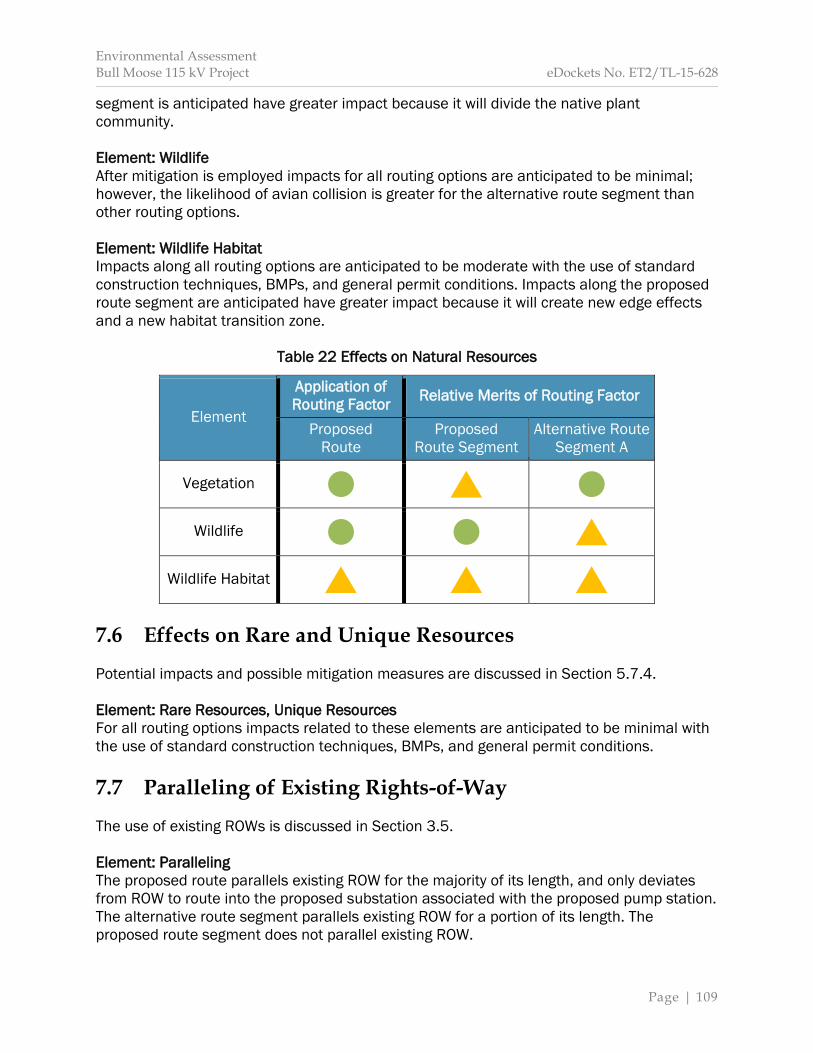
Environmental Assessment Bull Moose 115 kV Project eDockets No. ET2/TL-15-628
Page | 109
segment is anticipated have greater impact because it will divide the native plant community. Element: Wildlife After mitigation is employed impacts for all routing options are anticipated to be minimal; however, the likelihood of avian collision is greater for the alternative route segment than other routing options. Element: Wildlife Habitat Impacts along all routing options are anticipated to be moderate with the use of standard construction techniques, BMPs, and general permit conditions. Impacts along the proposed route segment are anticipated have greater impact because it will create new edge effects and a new habitat transition zone.
Table 22 Effects on Natural Resources
Element
Application of Routing Factor Relative Merits of Routing Factor
Proposed Route
Proposed Route Segment
Alternative Route Segment A
Vegetation
Wildlife
Wildlife Habitat 7.6 Effects on Rare and Unique Resources Potential impacts and possible mitigation measures are discussed in Section 5.7.4. Element: Rare Resources, Unique Resources For all routing options impacts related to these elements are anticipated to be minimal with the use of standard construction techniques, BMPs, and general permit conditions. 7.7 Paralleling of Existing Rights-of-Way The use of existing ROWs is discussed in Section 3.5. Element: Paralleling The proposed route parallels existing ROW for the majority of its length, and only deviates from ROW to route into the proposed substation associated with the proposed pump station. The alternative route segment parallels existing ROW for a portion of its length. The proposed route segment does not parallel existing ROW.
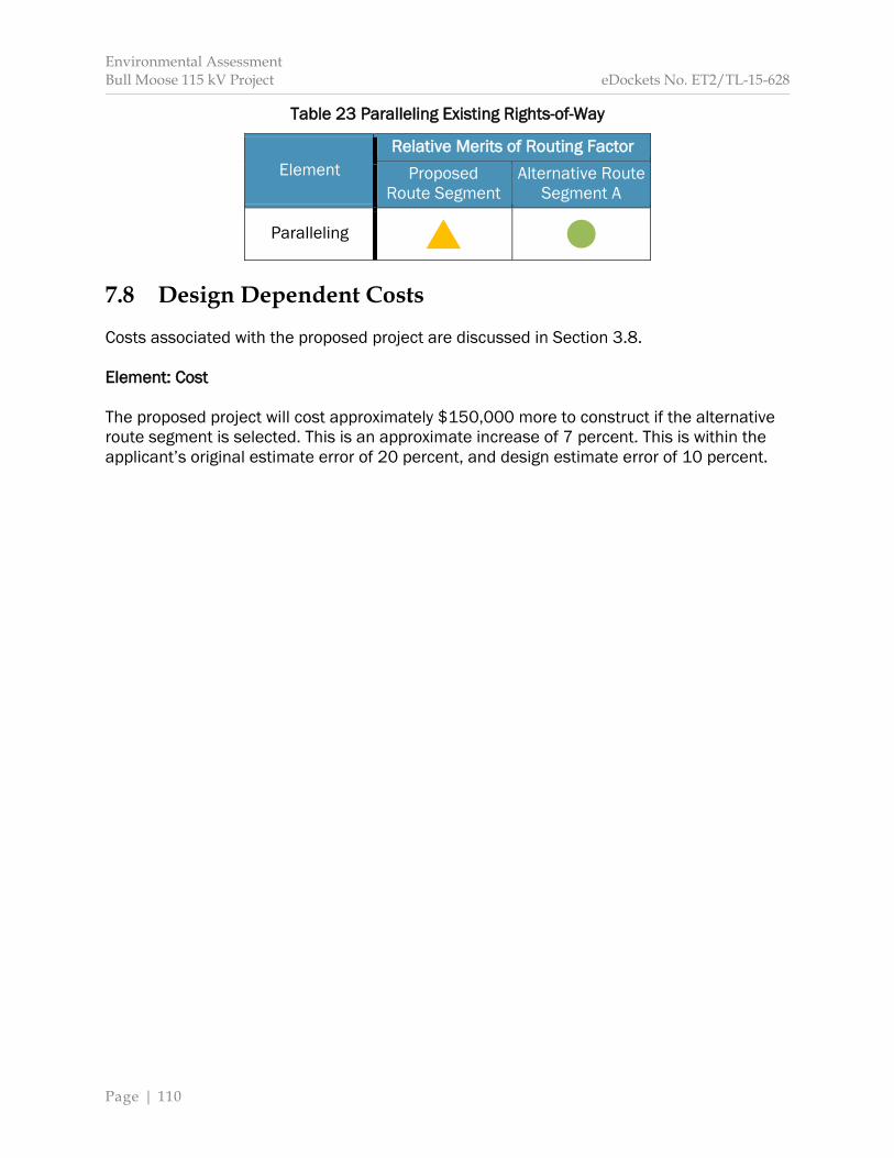
Environmental Assessment Bull Moose 115 kV Project eDockets No. ET2/TL-15-628
Page | 110
Table 23 Paralleling Existing Rights-of-Way
Element Relative Merits of Routing Factor
Proposed Route Segment
Alternative Route Segment A
Paralleling 7.8 Design Dependent Costs Costs associated with the proposed project are discussed in Section 3.8. Element: Cost The proposed project will cost approximately $150,000 more to construct if the alternative route segment is selected. This is an approximate increase of 7 percent. This is within the applicant’s original estimate error of 20 percent, and design estimate error of 10 percent.