Embed Size (px)
Citation preview
BASIC ASSESSMENT REPORT
Coastal & Environmental Services 1 Ndlambe Bulk Water Supply Scheme
NDLAMBE BULK WATER SUPPLY SCHEME, EASTERN CAPE PROVINCE OF SOUTH
AFRICA
BULK POTABLE WATER SUPPLY PIPELINE FROM CANNON ROCKS TO ALEXANDRIA , EASTERN CAPE
DEA Reference:
Prepared for:
Amatola Water Private Bag X3
Vincent 5217
Prepared by:
Coastal & Environmental ServicesEAST LONDON
2 Marine Terrace, Hampton Court East London, 5201
043 742 3302 Also in Grahamstown and Durban
www.cesnet.co.za
September 2012
BASIC ASSESSMENT REPORT
Coastal & Environmental Services 1 Ndlambe Bulk Water Supply Scheme
(For official use only) File Reference Number: Application Number: Date Received: Basic assessment report in terms of the Environmental Impact Assessment Regulations, 2010, promulgated in terms of the National Environmental Management Act, 1998 (Act No. 107 of 1998), as amended. Kindly note that: 1. This basic assessment report is a standard report that may be required by a competent authority in terms of the EIA
Regulations, 2010 and is meant to streamline applications. Please make sure that it is the report used by the particular competent authority for the activity that is being applied for.
2. The report must be typed within the spaces provided in the form. The size of the spaces provided is not necessarily
indicative of the amount of information to be provided. The report is in the form of a table that can extend itself as each space is filled with typing.
3. Where applicable tick the boxes that are applicable in the report. 4. An incomplete report may be returned to the applicant for revision. 5. The use of “not applicable” in the report must be done with circumspection because if it is used in respect of material
information that is required by the competent authority for assessing the application, it may result in the rejection of the application as provided for in the regulations.
6. This report must be handed in at offices of the relevant competent authority as determined by each authority. 7. No faxed or e-mailed reports will be accepted. 8. The report must be compiled by an independent environmental assessment practitioner. 9. Unless protected by law, all information in the report will become public information on receipt by the competent
authority. Any interested and affected party should be provided with the information contained in this report on request, during any stage of the application process.
10. A competent authority may require that for specified types of activities in defined situations only parts of this report
need to be completed.
BASIC ASSESSMENT REPORT
Coastal & Environmental Services 3 Ndlambe Bulk Water Supply Scheme
SECTION A: ACTIVITY INFORMATION
Has a specialist been consulted to assist with the completion of this section?
YES NO
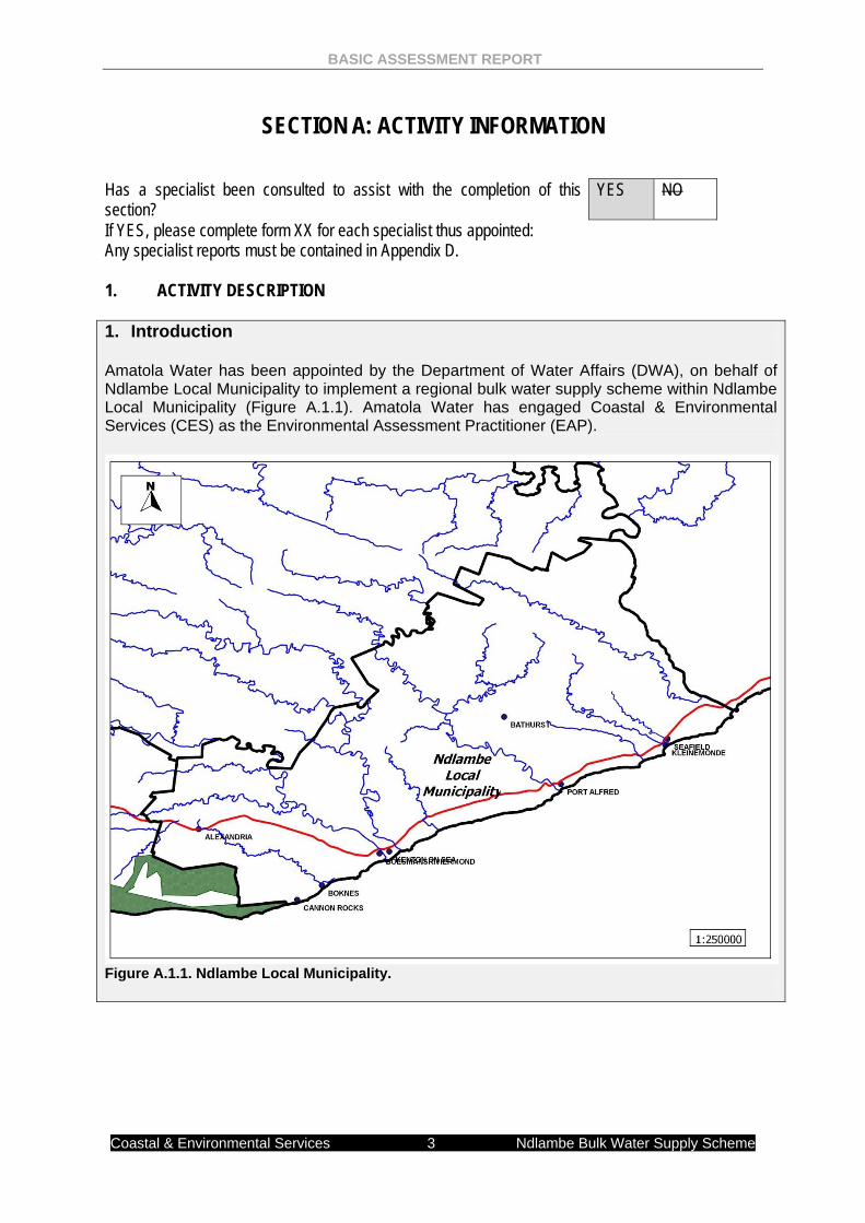
If YES, please complete form XX for each specialist thus appointed: Any specialist reports must be contained in Appendix D. 1. ACTIVITY DESCRIPTION 1. Introduction Amatola Water has been appointed by the Department of Water Affairs (DWA), on behalf of Ndlambe Local Municipality to implement a regional bulk water supply scheme within Ndlambe Local Municipality (Figure A.1.1). Amatola Water has engaged Coastal & Environmental Services (CES) as the Environmental Assessment Practitioner (EAP).
Figure A.1.1. Ndlambe Local Municipality.
BASIC ASSESSMENT REPORT
Coastal & Environmental Services 4 Ndlambe Bulk Water Supply Scheme
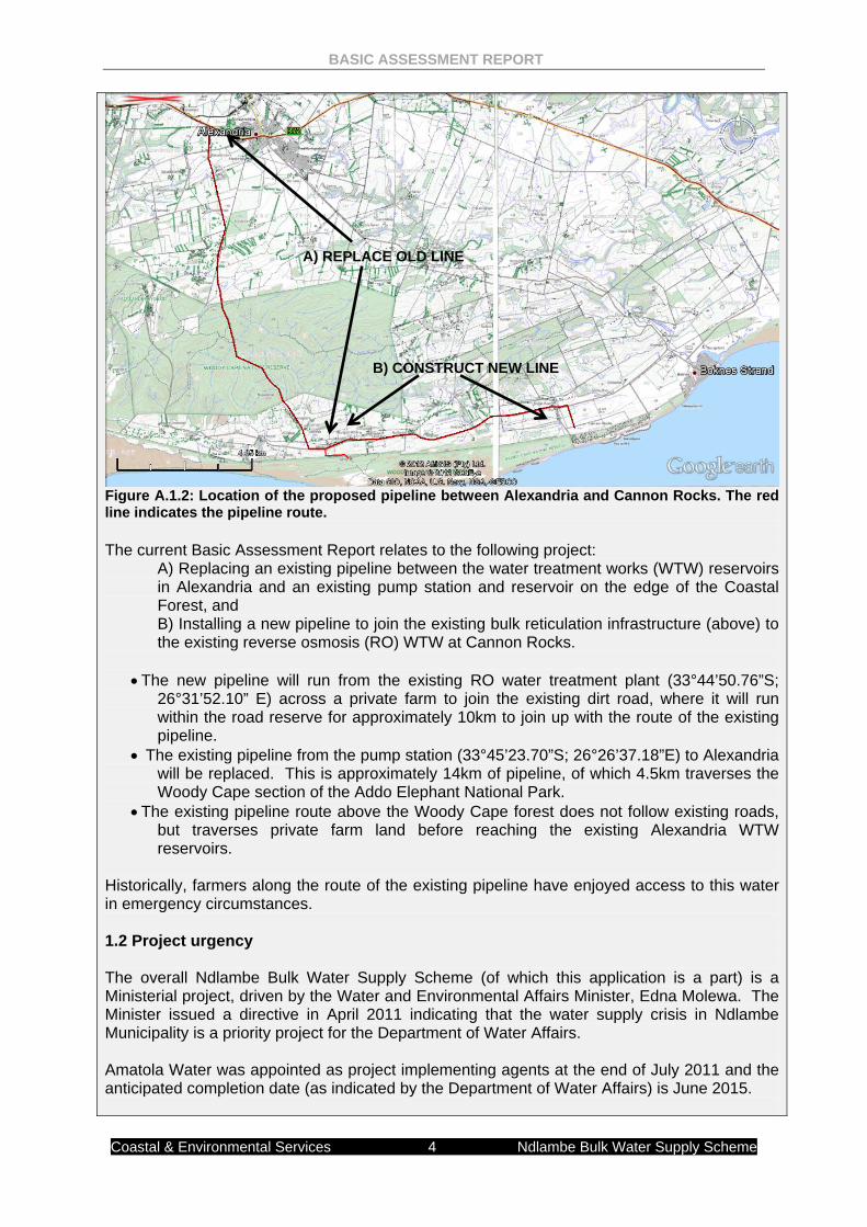
Figure A.1.2: Location of the proposed pipeline between Alexandria and Cannon Rocks. The red line indicates the pipeline route. The current Basic Assessment Report relates to the following project:
A) Replacing an existing pipeline between the water treatment works (WTW) reservoirs in Alexandria and an existing pump station and reservoir on the edge of the Coastal Forest, and B) Installing a new pipeline to join the existing bulk reticulation infrastructure (above) to the existing reverse osmosis (RO) WTW at Cannon Rocks.
• The new pipeline will run from the existing RO water treatment plant (33°44’50.76”S; 26°31’52.10” E) across a private farm to join the existing dirt road, where it will run within the road reserve for approximately 10km to join up with the route of the existing pipeline.
• The existing pipeline from the pump station (33°45’23.70”S; 26°26’37.18”E) to Alexandria will be replaced. This is approximately 14km of pipeline, of which 4.5km traverses the Woody Cape section of the Addo Elephant National Park.
• The existing pipeline route above the Woody Cape forest does not follow existing roads, but traverses private farm land before reaching the existing Alexandria WTW reservoirs.
Historically, farmers along the route of the existing pipeline have enjoyed access to this water in emergency circumstances. 1.2 Project urgency The overall Ndlambe Bulk Water Supply Scheme (of which this application is a part) is a Ministerial project, driven by the Water and Environmental Affairs Minister, Edna Molewa. The Minister issued a directive in April 2011 indicating that the water supply crisis in Ndlambe Municipality is a priority project for the Department of Water Affairs. Amatola Water was appointed as project implementing agents at the end of July 2011 and the anticipated completion date (as indicated by the Department of Water Affairs) is June 2015.
A) REPLACE OLD LINE
B) CONSTRUCT NEW LINE
BASIC ASSESSMENT REPORT
Coastal & Environmental Services 5 Ndlambe Bulk Water Supply Scheme
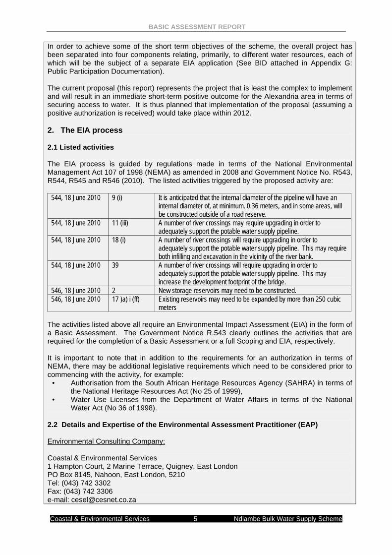
In order to achieve some of the short term objectives of the scheme, the overall project has been separated into four components relating, primarily, to different water resources, each of which will be the subject of a separate EIA application (See BID attached in Appendix G: Public Participation Documentation). The current proposal (this report) represents the project that is least the complex to implement and will result in an immediate short-term positive outcome for the Alexandria area in terms of securing access to water. It is thus planned that implementation of the proposal (assuming a positive authorization is received) would take place within 2012. 2. The EIA process 2.1 Listed activities The EIA process is guided by regulations made in terms of the National Environmental Management Act 107 of 1998 (NEMA) as amended in 2008 and Government Notice No. R543, R544, R545 and R546 (2010). The listed activities triggered by the proposed activity are:
544, 18 June 2010 9 (i) It is anticipated that the internal diameter of the pipeline will have an internal diameter of, at minimum, 0.36 meters, and in some areas, will be constructed outside of a road reserve.
544, 18 June 2010 11 (iii) A number of river crossings may require upgrading in order to adequately support the potable water supply pipeline.
544, 18 June 2010 18 (i) A number of river crossings will require upgrading in order to adequately support the potable water supply pipeline. This may require both infilling and excavation in the vicinity of the river bank.
544, 18 June 2010 39 A number of river crossings will require upgrading in order to adequately support the potable water supply pipeline. This may increase the development footprint of the bridge.
546, 18 June 2010 2 New storage reservoirs may need to be constructed. 546, 18 June 2010 17 )a) i (ff) Existing reservoirs may need to be expanded by more than 250 cubic
meters The activities listed above all require an Environmental Impact Assessment (EIA) in the form of a Basic Assessment. The Government Notice R.543 clearly outlines the activities that are required for the completion of a Basic Assessment or a full Scoping and EIA, respectively. It is important to note that in addition to the requirements for an authorization in terms of NEMA, there may be additional legislative requirements which need to be considered prior to commencing with the activity, for example:
• Authorisation from the South African Heritage Resources Agency (SAHRA) in terms of the National Heritage Resources Act (No 25 of 1999),
• Water Use Licenses from the Department of Water Affairs in terms of the National Water Act (No 36 of 1998).
2.2 Details and Expertise of the Environmental Assessment Practitioner (EAP) Environmental Consulting Company: Coastal & Environmental Services 1 Hampton Court, 2 Marine Terrace, Quigney, East London PO Box 8145, Nahoon, East London, 5210 Tel: (043) 742 3302 Fax: (043) 742 3306 e-mail: [email protected]
BASIC ASSESSMENT REPORT
Coastal & Environmental Services 6 Ndlambe Bulk Water Supply Scheme
In fulfillment of the above-mentioned legislative requirements, provided below are the details of the Environmental Assessment Practitioner (EAP) that prepared this Basic Assessment Report (BAR) as well as the expertise of the individual members of the study team. Environmental Assessment Practitioners working on this project include: • Dr Alan Carter • Dr Cherie-Lynn Mack • Dr Greer Hawley • Mr Roy de Kock • Mr Lungisa Bosman • Ms Nikita Steele • Ms Nande Suka In fulfillment of this requirement Coastal and Environmental Services (CES) wishes to point to the following expertise of the study team: CES has considerable experience in terrestrial, marine and freshwater ecology, the Social Impact Assessment (SIA) process, and state of environment reporting (SOER), Integrated Waste Management Plans (IWMP), Spatial Development Frameworks (SDF), public participation, as well as the management and co-ordination of all aspects of the Environmental Impact Assessment (EIA) and Strategic Environmental Assessment (SEA) processes. CES has been active in all of the above fields, and in so doing have made a positive contribution to towards environmental management and sustainable development in the Eastern Cape, South Africa and many other African countries. Dr Alan Carter Is a Director at CES holds a PhD in Marine Biology and is a certified Public Accountant, with extensive training and experience in both financial accounting and environmental science disciplines with international accounting firms in South Africa and the USA. He has 15 years of experience in environmental management and has specialist skills in sanitation, coastal environments and industrial waste. Dr Carter is registered as a Professional Natural Scientist under the South African Council for Natural Scientific Professions and is registered with EAPSA. Dr Cherie-Lynn Mack, (Senior Environmental Consultant), holds a PhD and MSc (with distinction) degrees in Environmental Biotechnology, with a BSc degree in Microbiology and Biochemistry. She has postgraduate research experience in industrial and domestic wastewater treatment technologies, with particular emphasis on the coal and platinum mining industries. Her interests lie in the water sector, with experience in ecological reserve determination and water quality monitoring and analysis. She has experience in water quality analysis and industrial wastewater treatment research. She is currently employed in the East London office of CES as a senior environmental consultant. Dr Greer Hawley, a Principal Environmental Consultant, has a BSc degree in Botany and Zoology and a BSc Honours in Botany from the University of Cape Town. She completed her PhD thesis (Microbiology) at Rhodes University. Greer has been involved in a number of diverse activities. The core academic focus has been directed in the field of taxonomy both in the plant and fungal kingdom. Greer’s research ranges from studying fresh and marine algae, estuarine diatoms, Restio species classification in the fynbos and forest vegetation and fungal species identification and ecology. Greer’s study of fungi have also contributed towards an understanding of soil ecology and “below ground” ecology. She is currently working on numerous impact assessments at the East London branch. Registration: South African Association of Botany. Mr Lungisa Bosman (Senior Environmental Consultant) holds a Bachelor of Social Science
BASIC ASSESSMENT REPORT
Coastal & Environmental Services 7 Ndlambe Bulk Water Supply Scheme
(1993) from UCT, with majors in Public Administration & Sociology, and a Post Graduate Diploma in Organisation and Management. Lungisa has gained considerable experience in social facilitation and community education and has been involved in a number of projects where he has brought his facilitation skills to bear. These include the ADM and Chris Hani State of Environment studies. Mr Roy de Kock (Environmental Consultant) holds a BSc in Botany and Geology and a BSc Honours in Geology from the Nelson Mandela Metropolitan University in Port Elizabeth. He is currently completing his MSc thesis in Rehabilitation Ecology with the focus on Mine Rehabilitation. His Masters thesis titled; Bushclump Rehabilitation Within Couga Bontveld After Strip Mining focused on rehabilitation of mined Bontveld vegetation on limestones of the Nanaga Formation where he attempts to ıocusingı the evolutionary path of the present landscape, as well as ıocusing on primary ecological processes such as hydrology, energy capture and nutrient cycling and the impact of mining on change in diversity and ecosystem health. Currently he is working on numerous impact assessments at the East London branch. Ms Nikita Steele (Environmental Consultant) holds a BSc degree in Zoology and Ichthyology and a BSc Honours in Marine Biology from Rhodes University. Nikita is currently doing her M.Sc in Marine Biology focusing on the grazing effects on community structures between upwelling and non-upwelling rocky shores along the South African coastline. Nikita has been involved in a number of diverse activities. Her interests lay within a broad range of marine studies, namely conservation, fisheries management, predator-prey interactions and ecology. She is currently working in the East London branch. Ms Nande Suka (Environmental Consultant) holds a B.Sc. degree with majors in Botany and Zoology (2010) and B.Sc. Honours in Terrestrial Botany (2011), both obtained at the Nelson Mandela Metropolitan University in Port Elizabeth. Her academic focus was in the broad field of Environmental Management and with great interest on impact assessments, environmental planning and conservation. 2.3 The Proponent The proponent in this application is: Amatola Water Private Bag X3 Vincent East London 5217 Contact Person: Mr Casper Brink Tel:+27 (0)43 721 0260 Fax: +27 (0)43 707 3701 E-mail: [email protected] 2.4 Relevant Authorities The proposed activity will take place within the Ndlambe Local Municipality in the Cacadu District of the Eastern Cape Province. The competent authority that must consider and adjudicate on the application for authorization in respect of the proposed activities is the national Department Environmental Affairs (DEA) as the proponent is an “organ of state” as defined in the Water Services Act (108 of 1997), the Public Finance Management Act (1 of 1999) and the Constitution of South Africa (108 of 1996). Department of Environmental Affairs (DEA):
BASIC ASSESSMENT REPORT
Coastal & Environmental Services 8 Ndlambe Bulk Water Supply Scheme
Ms Lize McCourt (Chief Director: Environmental Impact Evaluation) Private Bag X447 Pretoria 0001 Contact: Mr Reggy Nkosi Tel: 012 395 1771 Email: [email protected] Department of Economic Development and Environmental Affairs (DEDEA – Eastern Cape): Mr Siyabonga Gqalangile Department of Economic Development & Environmental Affairs Private Bag X9060 East London 5200 E-mail: [email protected] 2.5 Nature and Structure of this Report In accordance with the EIA Regulations (2010), a basic assessment report must contain all the information that is necessary for the competent authority to consider the application and to reach a decision. The structure of this report is based on section 22 of GN No.543, of the Environmental Impact Assessment Regulations (2010), which clearly specifies the required content of a BAR. 2.6 Assumptions and Limitations The following limitations and assumptions are implicit in this report –
• The primary assumption underpinning this EIA and the individual specialist studies upon which this report is based is that all information received from Amatola Water and other stakeholders including registered I&APs was correct and valid at the time of the study.
• To ensure that the significance of impacts was not under-estimated, the specialists assessed impacts under the worst-case scenario.
• There is a limitation in terms of alternatives to be assessed as significant portions of the project represent either upgrades of existing infrastructure or links that need to be made with existing infrastructure.
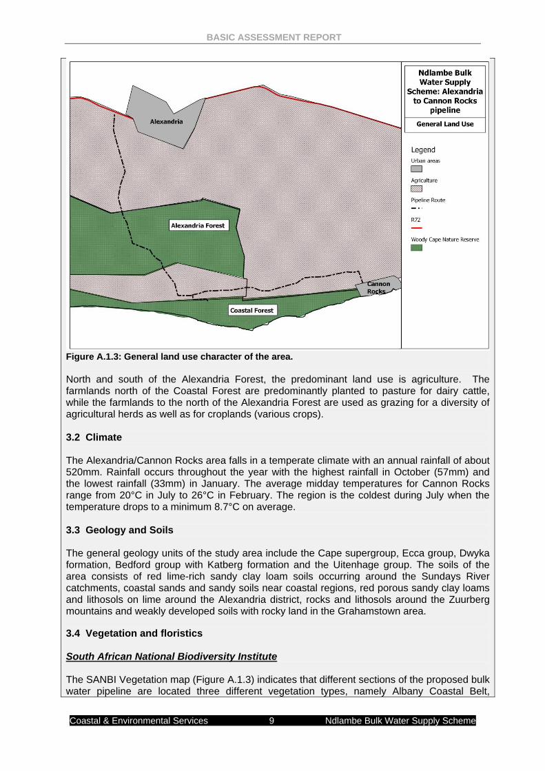
3. Biophysical environment 3.1 Current Land Use The general area can be split into two distinct land uses; agriculture and conservation (Figure A.1.3). For the purposes of this report, the Woody Cape Nature Reserve has been split into two sections; the Alexandria Forest and the Coastal Forest.
BASIC ASSESSMENT REPORT
Coastal & Environmental Services 9 Ndlambe Bulk Water Supply Scheme
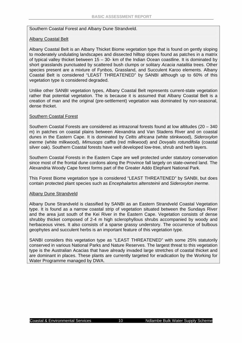
Figure A.1.3: General land use character of the area. North and south of the Alexandria Forest, the predominant land use is agriculture. The farmlands north of the Coastal Forest are predominantly planted to pasture for dairy cattle, while the farmlands to the north of the Alexandria Forest are used as grazing for a diversity of agricultural herds as well as for croplands (various crops). 3.2 Climate The Alexandria/Cannon Rocks area falls in a temperate climate with an annual rainfall of about 520mm. Rainfall occurs throughout the year with the highest rainfall in October (57mm) and the lowest rainfall (33mm) in January. The average midday temperatures for Cannon Rocks range from 20°C in July to 26°C in February. The region is the coldest during July when the temperature drops to a minimum 8.7°C on average. 3.3 Geology and Soils The general geology units of the study area include the Cape supergroup, Ecca group, Dwyka formation, Bedford group with Katberg formation and the Uitenhage group. The soils of the area consists of red lime-rich sandy clay loam soils occurring around the Sundays River catchments, coastal sands and sandy soils near coastal regions, red porous sandy clay loams and lithosols on lime around the Alexandria district, rocks and lithosols around the Zuurberg mountains and weakly developed soils with rocky land in the Grahamstown area. 3.4 Vegetation and floristics South African National Biodiversity Institute The SANBI Vegetation map (Figure A.1.3) indicates that different sections of the proposed bulk water pipeline are located three different vegetation types, namely Albany Coastal Belt,
BASIC ASSESSMENT REPORT
Coastal & Environmental Services 10 Ndlambe Bulk Water Supply Scheme
Southern Coastal Forest and Albany Dune Strandveld. Albany Coastal Belt Albany Coastal Belt is an Albany Thicket Biome vegetation type that is found on gently sloping to moderately undulating landscapes and dissected hilltop slopes found as patches in a matrix of typical valley thicket between 15 – 30- km of the Indian Ocean coastline. It is dominated by short grasslands punctuated by scattered bush clumps or solitary Acacia natalitia trees. Other species present are a mixture of Fynbos, Grassland, and Succulent Karoo elements. Albany Coastal Belt is considered “LEAST THREATENED” by SANBI although up to 60% of this vegetation type is considered degraded. Unlike other SANBI vegetation types, Albany Coastal Belt represents current-state vegetation rather that potential vegetation. The is because it is assumed that Albany Coastal Belt is a creation of man and the original (pre-settlement) vegetation was dominated by non-seasonal, dense thicket. Southern Coastal Forest Southern Coastal Forests are considered as intrazonal forests found at low altitudes (20 – 340 m) in patches on coastal plains between Alexandria and Van Stadens River and on coastal dunes in the Eastern Cape. It is dominated by Celtis africana (white stinkwood), Sideroxylon inerme (white milkwood), Mimusops caffra (red milkwood) and Dovyalis rotundifolia (coastal silver oak). Southern Coastal forests have well developed low-tree, shrub and herb layers. Southern Coastal Forests in the Eastern Cape are well protected under statutory conservation since most of the frontal dune cordons along the Province fall largely on state-owned land. The Alexandria Woody Cape forest forms part of the Greater Addo Elephant National Park. This Forest Biome vegetation type is considered “LEAST THREATENED” by SANBI, but does contain protected plant species such as Encephalartos altensteinii and Sideroxylon inerme. Albany Dune Strandveld Albany Dune Strandveld is classified by SANBI as an Eastern Strandveld Coastal Vegetation type. It is found as a narrow coastal strip of vegetation situated between the Sundays River and the area just south of the Kei River in the Eastern Cape. Vegetation consists of dense shrubby thicket composed of 2-4 m high sclerophyllous shrubs accompanied by woody and herbaceous vines. It also consists of a sparse grassy understory. The occurrence of bulbous geophytes and succulent herbs is an important feature of this vegetation type. SANBI considers this vegetation type as “LEAST THREATENED” with some 25% statutorily conserved in various National Parks and Nature Reserves. The largest threat to this vegetation type is the Australian Acacias that have already invaded large stretches of coastal thicket and are dominant in places. These plants are currently targeted for eradication by the Working for Water Programme managed by DWA.
Coastal
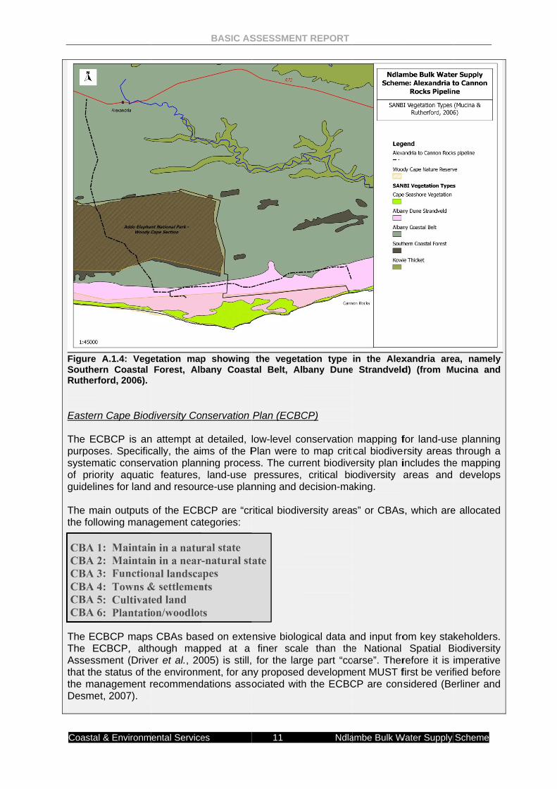
Figure SoutherRutherf Eastern The ECpurposesystemaof priorguidelin The mathe follo CBA 1 CBA 2 CBA 3 CBA 4 CBA 5 CBA 6 The ECThe ECAssessthat thethe manDesmet
& Environm
A.1.4: Vegern Coastal ford, 2006).
n Cape Biod
CBCP is anes. Specificatic conservrity aquaticnes for land
ain outputs owing mana
1: Maintain2: Maintain3: Function4: Towns &5: Cultivat6: Plantatio
CBCP mapsCBCP, althment (Drive
e status of thnagement rt, 2007).
ental Service
etation mapForest, Alb
diversity Co
n attempt atcally, the aivation planc features, and resour
of the ECBagement ca
n in a natun in a nearnal landsca& settlemented land on/woodlot
s CBAs bashough maper et al., 20he environmrecommend
BASIC AS
es
p showing bany Coast
onservation
t detailed, lms of the Pning proces
land-use rce-use plan
BCP are “crtegories:
ral state -natural st
apes nts
ts
sed on extepped at a 005) is still,ment, for andations asso
SSESSMEN
11
the vegetatal Belt, Al
Plan (ECBC
low-level coPlan were tss. The curpressures,
nning and d
ritical biodiv
tate
nsive biologfiner scal
for the larny proposedociated with
T REPORT
Ndla
ation type bany Dune
CP)
onservationto map critirrent biodive
critical bidecision-ma
versity area
gical data ale than therge part “cod developmeh the ECBC
ambe Bulk W
in the Alexe Strandveld
n mapping fcal biodive
ersity plan iodiversity a
aking.
s” or CBAs
and input froe National
oarse”. Therent MUST fCP are con
Water Supply
xandria ared) (from M
for land-useersity areas includes theareas and
s, which are
om key staSpatial B
refore it is first be verifsidered (Be
Scheme
ea, namely Mucina and
e planning through a
e mapping develops
e allocated
keholders. Biodiversity imperative fied before erliner and
BASIC ASSESSMENT REPORT
Coastal & Environmental Services 12 Ndlambe Bulk Water Supply Scheme
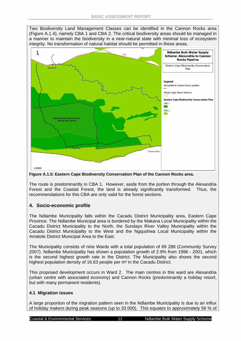
Two Biodiversity Land Management Classes can be identified in the Cannon Rocks area (Figure A.1.4), namely CBA 1 and CBA 2. The critical biodiversity areas should be managed in a manner to maintain the biodiversity in a near-natural state with minimal loss of ecosystem integrity. No transformation of natural habitat should be permitted in these areas.
Figure A.1.5: Eastern Cape Biodiversity Conservation Plan of the Cannon Rocks area. The route is predominantly in CBA 1. However, aside from the portion through the Alexandria Forest and the Coastal Forest, the land is already significantly transformed. Thus, the recommendations for this CBA are only valid for the forest sections. 4. Socio-economic profile The Ndlambe Municipality falls within the Cacadu District Municipality area, Eastern Cape Province. The Ndlambe Municipal area is bordered by the Makana Local Municipality within the Cacadu District Municipality to the North, the Sundays River Valley Municipality within the Cacadu District Municipality to the West and the Ngqushwa Local Municipality within the Amatole District Municipal Area to the East. The Municipality consists of nine Wards with a total population of 69 288 (Community Survey 2007). Ndlambe Municipality has shown a population growth of 2.9% from 1996 - 2001, which is the second highest growth rate in the District. The Municipality also shows the second highest population density of 16.63 people per m² in the Cacadu District. This proposed development occurs in Ward 2. The main centres in this ward are Alexandria (urban centre with associated economy) and Cannon Rocks (predominantly a holiday resort, but with many permanent residents). 4.1 Migration issues A large proportion of the migration pattern seen in the Ndlambe Municipality is due to an influx of holiday makers during peak seasons (up to 33 000). This equates to approximately 56 % of
BASIC ASSESSMENT REPORT
Coastal & Environmental Services 13 Ndlambe Bulk Water Supply Scheme
the permanent resident population. This influx places significant pressure on local infrastructure. This is felt more in Cannon Rocks than in Alexandria. Alexandria is subject to migration pressure relating to rural and farm workers moving into the more urbanised centres seeking better job opportunities. This places increasing pressure on housing and service delivery as well as hampering municipal efforts to eradicate informal settlements. 4.2 Water During the Census of 2001, 3 713 households in Ndlambe LM did not have access to potable water closer than 200m to their homesteads. This represents 23.9% of all households. The Ndlambe Municipality IDP (2011-2012) has prioritized important development/service delivery issues and rated them in terms of levels of urgency in terms of securing funding. Those related to BULK water supply are” MOST URGENT
• Water and sanitation is hampered by limited bulk supply.
URGENT • There is not enough storage capacity for bulk water; • Infrastructure is unable to meet the water demands in holiday seasons – households
have to rely on rain water; NECESSARY TO DO
• The maintenance of water and sanitation infrastructure requires more resources than the available budget;
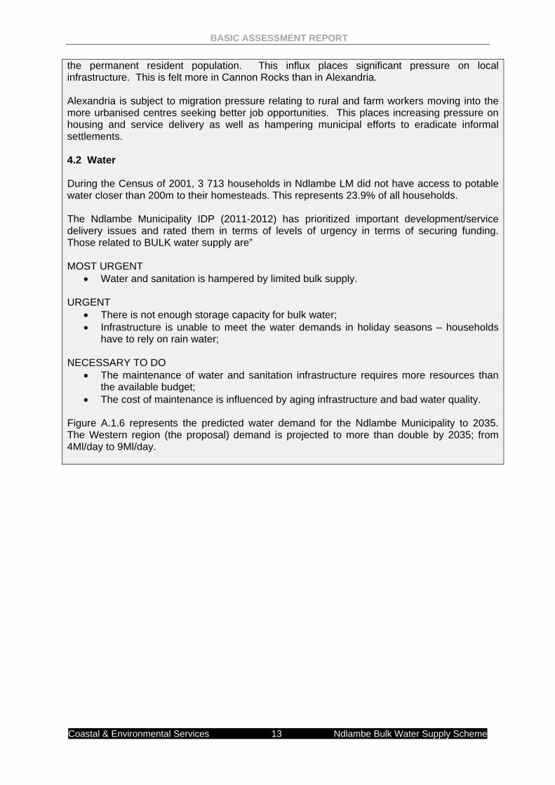
• The cost of maintenance is influenced by aging infrastructure and bad water quality. Figure A.1.6 represents the predicted water demand for the Ndlambe Municipality to 2035. The Western region (the proposal) demand is projected to more than double by 2035; from 4Ml/day to 9Ml/day.
Coastal
Figure A 2. “alternapurpose (a) (b) (c) (d) (e) (f) Describeof all posthe specmust in aother altprocesseand its eto assesactivity if The NEproposarequiremI&APs. In the differeninclude
& Environm
A.1.6: Predic
FEASIBLE A
atives”, in re and requiremthe property the type of athe design othe technolothe operationthe option of
e alternativesssible meanscific instance all cases be ternatives aes etc.) or boenvironment.ss additional f it is clear th
EMA guideals as part ment of an
NEMA EIAnt means of
alternatives
ental Service
cted water d
AND REASO
elation to a pments of the on which or
activity to be ur layout of thgy to be usenal aspects of not impleme
s that are cons by which th taking accouincluded in tre assessedoth is approp After receip alternatives hat realistic a
elines requiof the EIA
EIA as it p
A Regulatiof meeting ths to—
BASIC AS
es
demand for
ONABLE ALT
roposed activ activity, whic location wheundertaken; e activity; d in the activ
of the activityenting the ac
nsidered in thhe purpose aunt of the inthe assessme
d. The detepriate needs tpt of this repo
that could polternatives ha
re the conA process. rovides a b
ons, “alternhe general p
SSESSMEN
14
the Ndlamb
TERNATIVE
vity, means dch may includere it is propo
vity; y; and ctivity.
his applicatioand need of thterest of the aent phase asermination ofto be informeort the compeossibly accoave not been
nsideration The consid
basis for com
atives”, in purpose and
T REPORT
Ndla
be Municipa
ES
different meade alternativeosed to unde
on. Alternativhe proposedapplicant in ts the baselinef whether sied by the speetent authorimplish the pn considered
of various deration of mparison by
relation tod requireme
ambe Bulk W
lity to 2035
ans of meetines to— rtake the act
ves should inc activity coulthe activity. Te against whiite or activityecific circumsty may also urpose and n to a reasona
developmeproject alt
y the comp
a proposeents of the
Water Supply
ng the genera
tivity;
clude a consd be accompThe no-go aich the impaty (including stances of threquest the need of the pable extent.
ent alternaternatives i
petent autho
ed activity,activity, wh
Scheme
al
sideration plished in lternative cts of the different
he activity applicant proposed
atives or s a key
ority and
means hich may
BASIC ASSESSMENT REPORT
Coastal & Environmental Services 15 Ndlambe Bulk Water Supply Scheme
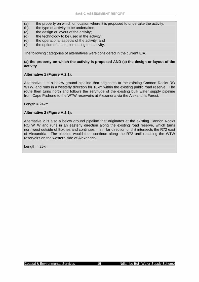
(a) the property on which or location where it is proposed to undertake the activity; (b) the type of activity to be undertaken; (c) the design or layout of the activity; (d) the technology to be used in the activity; (e) the operational aspects of the activity; and (f) the option of not implementing the activity. The following categories of alternatives were considered in the current EIA. (a) the property on which the activity is proposed AND (c) the design or layout of the activity Alternative 1 (Figure A.2.1): Alternative 1 is a below ground pipeline that originates at the existing Cannon Rocks RO WTW, and runs in a westerly direction for 10km within the existing public road reserve. The route then turns north and follows the servitude of the existing bulk water supply pipeline from Cape Padrone to the WTW reservoirs at Alexandria via the Alexandria Forest. Length = 24km Alternative 2 (Figure A.2.1): Alternative 2 is also a below ground pipeline that originates at the existing Cannon Rocks RO WTW and runs in an easterly direction along the existing road reserve, which turns northwest outside of Boknes and continues in similar direction until it intersects the R72 east of Alexandria. The pipeline would then continue along the R72 until reaching the WTW reservoirs on the western side of Alexandria. Length = 25km
BASIC ASSESSMENT REPORT
Coastal & Environmental Services 16 Ndlambe Bulk Water Supply Scheme
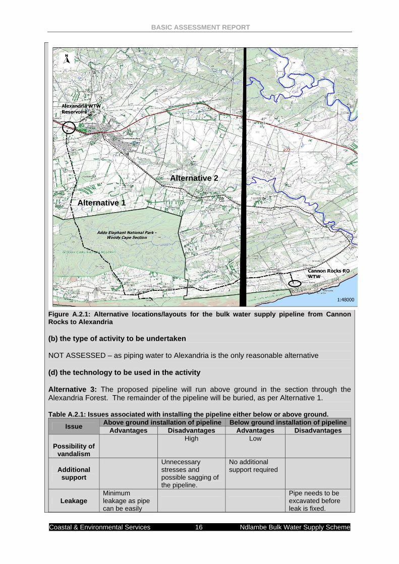
Figure A.2.1: Alternative locations/layouts for the bulk water supply pipeline from Cannon Rocks to Alexandria (b) the type of activity to be undertaken NOT ASSESSED – as piping water to Alexandria is the only reasonable alternative (d) the technology to be used in the activity Alternative 3: The proposed pipeline will run above ground in the section through the Alexandria Forest. The remainder of the pipeline will be buried, as per Alternative 1. Table A.2.1: Issues associated with installing the pipeline either below or above ground.
Issue Above ground installation of pipeline Below ground installation of pipeline Advantages Disadvantages Advantages Disadvantages
Possibility of
vandalism
High Low
Additional support
Unnecessary stresses and possible sagging of the pipeline.
No additional support required
Leakage Minimum leakage as pipe can be easily
Pipe needs to be excavated before leak is fixed.
Alternative 2
Alternative 1
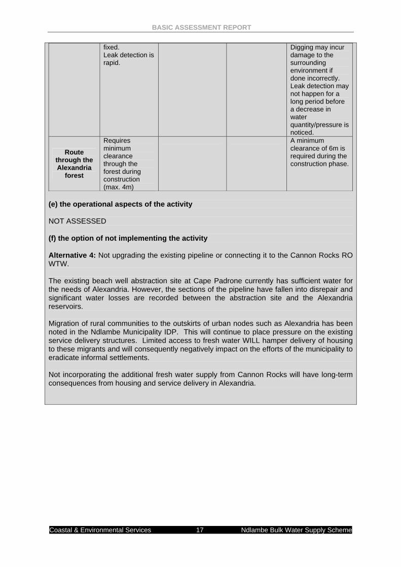
BASIC ASSESSMENT REPORT
Coastal & Environmental Services 17 Ndlambe Bulk Water Supply Scheme
fixed. Leak detection is rapid.
Digging may incur damage to the surrounding environment if done incorrectly. Leak detection may not happen for a long period before a decrease in water quantity/pressure is noticed.
Route through the Alexandria
forest
Requires minimum clearance through the forest during construction (max. 4m)
A minimum clearance of 6m is required during the construction phase.
(e) the operational aspects of the activity NOT ASSESSED (f) the option of not implementing the activity Alternative 4: Not upgrading the existing pipeline or connecting it to the Cannon Rocks RO WTW. The existing beach well abstraction site at Cape Padrone currently has sufficient water for the needs of Alexandria. However, the sections of the pipeline have fallen into disrepair and significant water losses are recorded between the abstraction site and the Alexandria reservoirs. Migration of rural communities to the outskirts of urban nodes such as Alexandria has been noted in the Ndlambe Municipality IDP. This will continue to place pressure on the existing service delivery structures. Limited access to fresh water WILL hamper delivery of housing to these migrants and will consequently negatively impact on the efforts of the municipality to eradicate informal settlements. Not incorporating the additional fresh water supply from Cannon Rocks will have long-term consequences from housing and service delivery in Alexandria.
BASIC ASSESSMENT REPORT
Coastal & Environmental Services 18 Ndlambe Bulk Water Supply Scheme
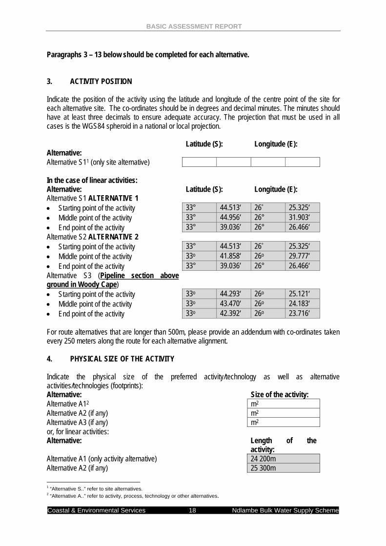
Paragraphs 3 – 13 below should be completed for each alternative. 3. ACTIVITY POSITION Indicate the position of the activity using the latitude and longitude of the centre point of the site for each alternative site. The co-ordinates should be in degrees and decimal minutes. The minutes should have at least three decimals to ensure adequate accuracy. The projection that must be used in all cases is the WGS84 spheroid in a national or local projection. Alternative:
Latitude (S):
Longitude (E):
Alternative S11 (only site alternative) In the case of linear activities: Alternative: Latitude (S): Longitude (E): Alternative S1 ALTERNATIVE 1 • Starting point of the activity 33° 44.513‘ 26° 25.325‘ • Middle point of the activity 33° 44.956‘ 26° 31.903‘ • End point of the activity 33° 39.036’ 26° 26.466‘ Alternative S2 ALTERNATIVE 2 • Starting point of the activity 33° 44.513‘ 26° 25.325‘ • Middle point of the activity 33o 41.858‘ 26o 29.777‘ • End point of the activity 33° 39.036’ 26° 26.466‘ Alternative S3 (Pipeline section above ground in Woody Cape)
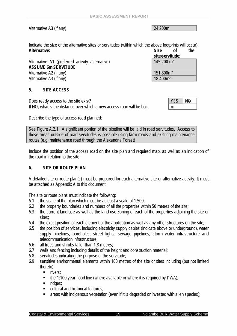
• Starting point of the activity 33o 44.293‘ 26o 25.121‘ • Middle point of the activity 33o 43.470‘ 26o 24.183‘ • End point of the activity 33o 42.392‘ 26o 23.716‘ For route alternatives that are longer than 500m, please provide an addendum with co-ordinates taken every 250 meters along the route for each alternative alignment. 4. PHYSICAL SIZE OF THE ACTIVITY Indicate the physical size of the preferred activity/technology as well as alternative activities/technologies (footprints): Alternative: Size of the activity: Alternative A12 m2 Alternative A2 (if any) m2 Alternative A3 (if any) m2 or, for linear activities: Alternative: Length of the
activity: Alternative A1 (only activity alternative) 24 200m Alternative A2 (if any) 25 300m 1 “Alternative S..” refer to site alternatives. 2 “Alternative A..” refer to activity, process, technology or other alternatives.
BASIC ASSESSMENT REPORT
Coastal & Environmental Services 19 Ndlambe Bulk Water Supply Scheme
Alternative A3 (if any) 24 200m Indicate the size of the alternative sites or servitudes (within which the above footprints will occur): Alternative: Size of the
site/servitude: Alternative A1 (preferred activity alternative) ASSUME 6m SERVITUDE
145 200 m2
Alternative A2 (if any) 151 800m2 Alternative A3 (if any) 18 400m2 5. SITE ACCESS Does ready access to the site exist? YES NO If NO, what is the distance over which a new access road will be built m Describe the type of access road planned:
See Figure A.2.1. A significant portion of the pipeline will be laid in road servitudes. Access to those areas outside of road servitudes is possible using farm roads and existing maintenance routes (e.g. maintenance road through the Alexandria Forest) Include the position of the access road on the site plan and required map, as well as an indication of the road in relation to the site. 6. SITE OR ROUTE PLAN
A detailed site or route plan(s) must be prepared for each alternative site or alternative activity. It must be attached as Appendix A to this document. The site or route plans must indicate the following: 6.1 the scale of the plan which must be at least a scale of 1:500; 6.2 the property boundaries and numbers of all the properties within 50 metres of the site; 6.3 the current land use as well as the land use zoning of each of the properties adjoining the site or
sites; 6.4 the exact position of each element of the application as well as any other structures on the site; 6.5 the position of services, including electricity supply cables (indicate above or underground), water
supply pipelines, boreholes, street lights, sewage pipelines, storm water infrastructure and telecommunication infrastructure;
6.6 all trees and shrubs taller than 1.8 metres; 6.7 walls and fencing including details of the height and construction material; 6.8 servitudes indicating the purpose of the servitude; 6.9 sensitive environmental elements within 100 metres of the site or sites including (but not limited
thereto): rivers; the 1:100 year flood line (where available or where it is required by DWA); ridges; cultural and historical features; areas with indigenous vegetation (even if it is degraded or invested with alien species);
BASIC ASSESSMENT REPORT
Coastal & Environmental Services 20 Ndlambe Bulk Water Supply Scheme
6.9 for gentle slopes the 1 metre contour intervals must be indicated on the plan and whenever the slope of the site exceeds 1:10, the 500mm contours must be indicated on the plan; and
6.10 the positions from where photographs of the site were taken. 7. SITE PHOTOGRAPHS Colour photographs from the centre of the site must be taken in at least the eight major compass directions with a description of each photograph. Photographs must be attached under Appendix B to this form. It must be supplemented with additional photographs of relevant features on the site, if applicable. 8. FACILITY ILLUSTRATION A detailed illustration of the activity must be provided at a scale of 1:200 as Appendix C for activities that include structures. The illustrations must be to scale and must represent a realistic image of the planned activity. The illustration must give a representative view of the activity. DESIGN DETAIL FOR THE PROJECT IS NOT YET AVAILABLE. HOWEVER, STRUCTURES SUCH AS THOSE ILLUSTRATED IN APPENDIX B REPRESENT THE TYPE OF FACILITY PROPOSED (RESERVOIRS, PIPES, VALVES, AIR CHAMBERS, RISING MAINS, ETC.) 9. ACTIVITY MOTIVATION 9(a) Socio-economic value of the activity What is the expected capital value of the activity on completion? Not
determined What is the expected yearly income that will be generated by or as a result of the activity?
Not determined
Will the activity contribute to service infrastructure? YES NO Is the activity a public amenity? YES NO How many new employment opportunities will be created in the development phase of the activity?
Not determined
What is the expected value of the employment opportunities during the development phase?
Not determined
What percentage of this will accrue to previously disadvantaged individuals? Not determined
How many permanent new employment opportunities will be created during the operational phase of the activity?
Not determined
What is the expected current value of the employment opportunities during the first 10 years?
Not determined
What percentage of this will accrue to previously disadvantaged individuals? Not determined
The socio-economic values noted as “not determined” were due to the urgency of the project and the need to get water to Alexandria. 9(b) Need and desirability of the activity Motivate and explain the need and desirability of the activity (including demand for the activity):
BASIC ASSESSMENT REPORT
Coastal & Environmental Services 21 Ndlambe Bulk Water Supply Scheme
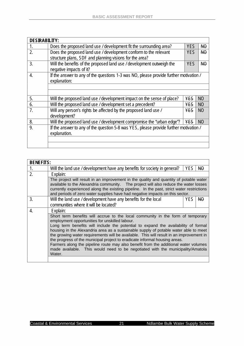
DESIRABILITY: 1. Does the proposed land use / development fit the surrounding area? YES NO 2. Does the proposed land use / development conform to the relevant
structure plans, SDF and planning visions for the area? YES NO
3. Will the benefits of the proposed land use / development outweigh the negative impacts of it?
YES NO
4. If the answer to any of the questions 1-3 was NO, please provide further motivation / explanation:
5. Will the proposed land use / development impact on the sense of place? YES NO 6. Will the proposed land use / development set a precedent? YES NO 7. Will any person’s rights be affected by the proposed land use /
development? YES NO
8. Will the proposed land use / development compromise the “urban edge”? YES NO 9. If the answer to any of the question 5-8 was YES, please provide further motivation /
explanation.
BENEFITS: 1. Will the land use / development have any benefits for society in general? YES NO 2. Explain:
The project will result in an improvement in the quality and quantity of potable water available to the Alexandria community. The project will also reduce the water losses currently experienced along the existing pipeline. In the past, strict water restrictions and periods of zero water supplies have had negative impacts on this sector.
3. Will the land use / development have any benefits for the local communities where it will be located?
YES NO
4. Explain: Short term benefits will accrue to the local community in the form of temporary employment opportunities for unskilled labour. Long term benefits will include the potential to expand the availability of formal housing in the Alexandria area as a sustainable supply of potable water able to meet the growing water requirements will be available. This will result in an improvement in the progress of the municipal project to eradicate informal housing areas. Farmers along the pipeline route may also benefit from the additional water volumes made available. This would need to be negotiated with the municipality/Amatola Water.
BASIC ASSESSMENT REPORT
Coastal & Environmental Services 22 Ndlambe Bulk Water Supply Scheme
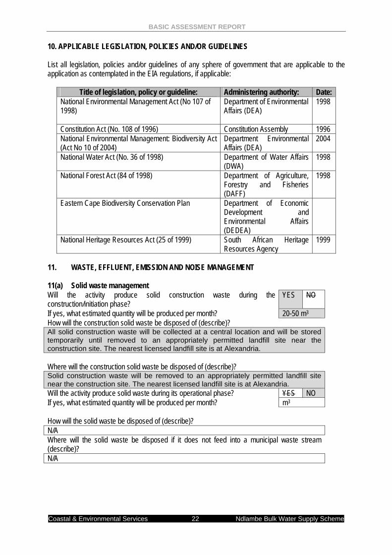
10. APPLICABLE LEGISLATION, POLICIES AND/OR GUIDELINES List all legislation, policies and/or guidelines of any sphere of government that are applicable to the application as contemplated in the EIA regulations, if applicable:
Title of legislation, policy or guideline: Administering authority: Date: National Environmental Management Act (No 107 of 1998)
Department of Environmental Affairs (DEA)
1998
Constitution Act (No. 108 of 1996) Constitution Assembly 1996 National Environmental Management: Biodiversity Act (Act No 10 of 2004)
Department Environmental Affairs (DEA)
2004
National Water Act (No. 36 of 1998) Department of Water Affairs (DWA)
1998
National Forest Act (84 of 1998) Department of Agriculture, Forestry and Fisheries (DAFF)
1998
Eastern Cape Biodiversity Conservation Plan Department of Economic Development and Environmental Affairs (DEDEA)
National Heritage Resources Act (25 of 1999) South African Heritage Resources Agency
1999
11. WASTE, EFFLUENT, EMISSION AND NOISE MANAGEMENT 11(a) Solid waste management Will the activity produce solid construction waste during the construction/initiation phase?
YES NO
If yes, what estimated quantity will be produced per month? 20-50 m3 How will the construction solid waste be disposed of (describe)? All solid construction waste will be collected at a central location and will be stored temporarily until removed to an appropriately permitted landfill site near the construction site. The nearest licensed landfill site is at Alexandria. Where will the construction solid waste be disposed of (describe)?
Solid construction waste will be removed to an appropriately permitted landfill site near the construction site. The nearest licensed landfill site is at Alexandria. Will the activity produce solid waste during its operational phase? YES NO If yes, what estimated quantity will be produced per month? m3 How will the solid waste be disposed of (describe)?
N/A Where will the solid waste be disposed if it does not feed into a municipal waste stream (describe)? N/A
BASIC ASSESSMENT REPORT
Coastal & Environmental Services 23 Ndlambe Bulk Water Supply Scheme
If the solid waste (construction or operational phases) will not be disposed of in a registered landfill site or be taken up in a municipal waste stream, then the applicant should consult with the competent authority to determine whether it is necessary to change to an application for scoping and EIA. Can any part of the solid waste be classified as hazardous in terms of the relevant legislation?
YES NO
If yes, inform the competent authority and request a change to an application for scoping and EIA. Is the activity that is being applied for a solid waste handling or treatment facility?
YES NO
If yes, then the applicant should consult with the competent authority to determine whether it is necessary to change to an application for scoping and EIA. 11(b) Liquid effluent Will the activity produce effluent, other than normal sewage, that will be disposed of in a municipal sewage system?
YES NO
If yes, what estimated quantity will be produced per month? m3 Will the activity produce any effluent that will be treated and/or disposed of on site?
Yes NO
If yes, the applicant should consult with the competent authority to determine whether it is necessary to change to an application for scoping and EIA. Will the activity produce effluent that will be treated and/or disposed of at another facility?
YES NO
If yes, provide the particulars of the facility: Facility name: N/A Contact person:
Postal address:
Postal code: Telephone: Cell: E-mail: Fax: Describe the measures that will be taken to ensure the optimal reuse or recycling of waste water, if any: 11(c) Emissions into the atmosphere Will the activity release emissions into the atmosphere? YES NO If yes, is it controlled by any legislation of any sphere of government? YES NO If yes, the applicant should consult with the competent authority to determine whether it is necessary to change to an application for scoping and EIA.
If no, describe the emissions in terms of type and concentration: Possible dust as a result of construction activities 11(d) Generation of noise Will the activity generate noise? YES NO
BASIC ASSESSMENT REPORT
Coastal & Environmental Services 24 Ndlambe Bulk Water Supply Scheme
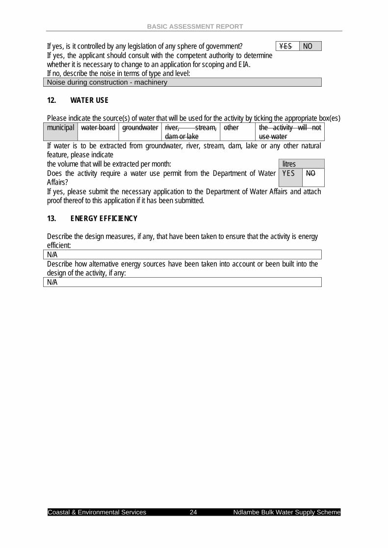
If yes, is it controlled by any legislation of any sphere of government? YES NO If yes, the applicant should consult with the competent authority to determine whether it is necessary to change to an application for scoping and EIA.
If no, describe the noise in terms of type and level: Noise during construction - machinery 12. WATER USE Please indicate the source(s) of water that will be used for the activity by ticking the appropriate box(es) municipal water board groundwater river, stream,
dam or lake other the activity will not
use water If water is to be extracted from groundwater, river, stream, dam, lake or any other natural feature, please indicate the volume that will be extracted per month: litres Does the activity require a water use permit from the Department of Water Affairs?
YES NO
If yes, please submit the necessary application to the Department of Water Affairs and attach proof thereof to this application if it has been submitted. 13. ENERGY EFFICIENCY Describe the design measures, if any, that have been taken to ensure that the activity is energy efficient: N/A Describe how alternative energy sources have been taken into account or been built into the design of the activity, if any: N/A
Coastal
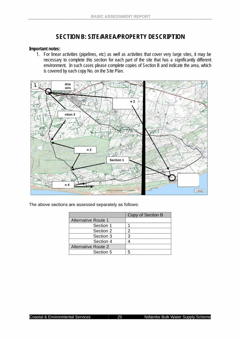
Importa
1.
The abo
& Environm
SEC
ant notes: For linear acnecessary toenvironmentis covered by
ove section
Sec
AlexandReservo
Section
ental Service
CTION B:
ctivities (pipeo complete tt. In such cay each copy
s are asses
Alternati
Alternati
ction 3
Sectio
dria oirs
n 4
BASIC AS
es
SITE/AR
elines, etc) athis section ases please c No. on the S
ssed separa
ive Route 1 Section Section Section Section ive Route 2 Section
n 2
SSESSMEN
25
REA/PROP
as well as acfor each parcomplete cop
Site Plan.
ately as follo
C 1 12 23 34 4
2 5 5
Section 1
AlternativSection 5
T REPORT
Ndla
PERTY D
ctivities that rt of the sitepies of Sectio
ows:
Copy of Sec
ve 2
ambe Bulk W
ESCRIPT
cover very le that has a on B and ind
tion B
Water Supply
TION
arge sites, it significantly dicate the are
Cannon Rocks RO WTW
Scheme
t may be different ea, which
BASIC ASSESSMENT REPORT
Coastal & Environmental Services 26 Ndlambe Bulk Water Supply Scheme
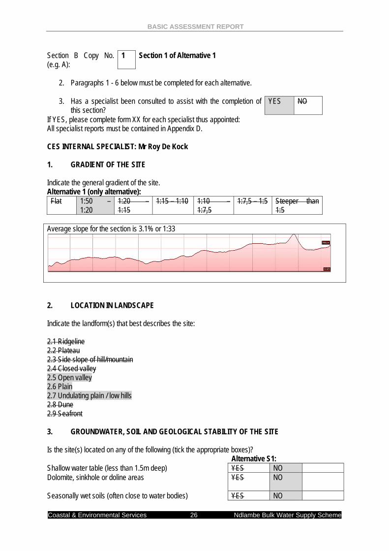
Section B Copy No. (e.g. A):
1 Section 1 of Alternative 1
2. Paragraphs 1 - 6 below must be completed for each alternative.
3. Has a specialist been consulted to assist with the completion of
this section? YES NO
If YES, please complete form XX for each specialist thus appointed: All specialist reports must be contained in Appendix D. CES INTERNAL SPECIALIST: Mr Roy De Kock 1. GRADIENT OF THE SITE Indicate the general gradient of the site. Alternative 1 (only alternative): Flat 1:50 –
1:20 1:20 – 1:15
1:15 – 1:10 1:10 – 1:7,5
1:7,5 – 1:5 Steeper than 1:5
Average slope for the section is 3.1% or 1:33
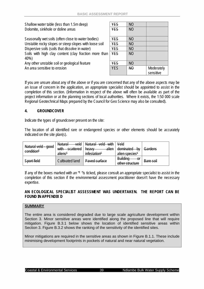
2. LOCATION IN LANDSCAPE Indicate the landform(s) that best describes the site: 2.1 Ridgeline 2.2 Plateau 2.3 Side slope of hill/mountain 2.4 Closed valley 2.5 Open valley 2.6 Plain 2.7 Undulating plain / low hills 2.8 Dune 2.9 Seafront 3. GROUNDWATER, SOIL AND GEOLOGICAL STABILITY OF THE SITE Is the site(s) located on any of the following (tick the appropriate boxes)? Alternative S1: Shallow water table (less than 1.5m deep) YES NO Dolomite, sinkhole or doline areas
YES NO
Seasonally wet soils (often close to water bodies) YES NO
BASIC ASSESSMENT REPORT
Coastal & Environmental Services 27 Ndlambe Bulk Water Supply Scheme
Unstable rocky slopes or steep slopes with loose soil YES NO Dispersive soils (soils that dissolve in water) YES NO Soils with high clay content (clay fraction more than 40%) YES NO Any other unstable soil or geological feature YES NO An area sensitive to erosion
YES NO
If you are unsure about any of the above or if you are concerned that any of the above aspects may be an issue of concern in the application, an appropriate specialist should be appointed to assist in the completion of this section. (Information in respect of the above will often be available as part of the project information or at the planning sections of local authorities. Where it exists, the 1:50 000 scale Regional Geotechnical Maps prepared by the Council for Geo Science may also be consulted). 4. GROUNDCOVER Indicate the types of groundcover present on the site: The location of all identified rare or endangered species or other elements should be accurately indicated on the site plan(s).
Natural veld - good conditionE
Natural veld with scattered aliensE
Natural veld with heavy alien infestationE
Veld dominated by alien speciesE
Gardens
Sport field Cultivated land Paved surface Building or other structure Bare soil
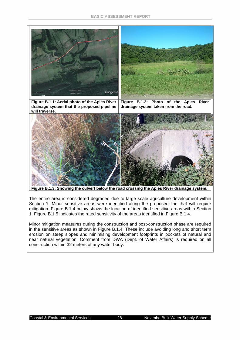
If any of the boxes marked with an “E “is ticked, please consult an appropriate specialist to assist in the completion of this section if the environmental assessment practitioner doesn’t have the necessary expertise. AN ECOLOGICAL SPECIALIST ASSESSMENT WAS UNDERTAKEN. THE REPORT CAN BE FOUND IN APPENDIX D SUMMARY An old riverbed (called the Apies River by the local community) was identified (GPS: 33o 44.846’S 26o 29.926’E; Figure 3.5 & Plates 3.2 & 3.3 below). This riverbed will be traversed by the pipeline. The river does not currently contain any water. Conversations with the surrounding landowners indicate that the river acts more as a stormwater channel, where it flows heavily for two to three days and then dries up again. It was estimated that such events happen every 20 – 25 years, with the last occurrence 4 - 5 years ago. The existing road across the river bed is installed with a single 600mm pipe culvert. The riverbed has been converted to kikuyu pasture for dairy cattle.
BASIC ASSESSMENT REPORT
Coastal & Environmental Services 28 Ndlambe Bulk Water Supply Scheme
Figure B.1.1: Aerial photo of the Apies River drainage system that the proposed pipeline will traverse.
Figure B.1.2: Photo of the Apies River drainage system taken from the road.
Figure B.1.3: Showing the culvert below the road crossing the Apies River drainage system. The entire area is considered degraded due to large scale agriculture development within Section 1. Minor sensitive areas were identified along the proposed line that will require mitigation. Figure B.1.4 below shows the location of identified sensitive areas within Section 1. Figure B.1.5 indicates the rated sensitivity of the areas identified in Figure B.1.4. Minor mitigation measures during the construction and post-construction phase are required in the sensitive areas as shown in Figure B.1.4. These include avoiding long and short term erosion on steep slopes and minimising development footprints in pockets of natural and near natural vegetation. Comment from DWA (Dept. of Water Affairs) is required on all construction within 32 meters of any water body.
BASIC ASSESSMENT REPORT
Coastal & Environmental Services 29 Ndlambe Bulk Water Supply Scheme
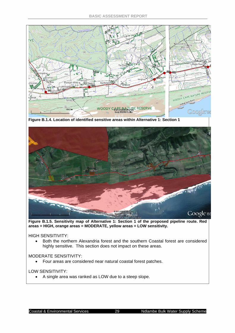
Figure B.1.4. Location of identified sensitive areas within Alternative 1: Section 1
Figure B.1.5. Sensitivity map of Alternative 1: Section 1 of the proposed pipeline route. Red areas = HIGH, orange areas = MODERATE, yellow areas = LOW sensitivity. HIGH SENSITIVITY:
• Both the northern Alexandria forest and the southern Coastal forest are considered highly sensitive. This section does not impact on these areas.
MODERATE SENSITIVITY:
• Four areas are considered near natural coastal forest patches.
LOW SENSITIVITY: • A single area was ranked as LOW due to a steep slope.

BASIC ASSESSMENT REPORT
Coastal & Environmental Services 30 Ndlambe Bulk Water Supply Scheme
5. LAND USE CHARACTER OF SURROUNDING AREA Indicate land uses and/or prominent features that currently occur within a 500m radius of the site and give description of how this influences the application or may be impacted upon by the application: 5.1 Natural area 5.2 Low density residential 5.3 Medium density residential 5.4 High density residential 5.5 Informal residential 5.6 Retail commercial & warehousing 5.7 Light industrial 5.8 Medium industrial AN 5.9 Heavy industrial AN 5.10 Power station 5.11 Office/consulting room 5.12 Military or police base/station/compound 5.13 Spoil heap or slimes damA 5.14 Quarry, sand or borrow pit 5.15 Dam or reservoir 5.16 Hospital/medical centre 5.17 School 5.18 Tertiary education facility 5.19 Church 5.20 Old age home 5.21 Sewage treatment plantA 5.22 Train station or shunting yard N 5.23 Railway line N 5.24 Major road (4 lanes or more) N 5.25 Airport N 5.26 Harbour 5.27 Sport facilities 5.28 Golf course 5.29 Polo fields 5.30 Filling station H 5.31 Landfill or waste treatment site 5.32 Plantation 5.33 Agriculture 5.34 River, stream or wetland 5.35 Nature conservation area 5.36 Mountain, koppie or ridge 5.37 Museum 5.38 Historical building 5.39 Protected Area 5.40 Graveyard 5.41 Archaeological site 5.42 Other land uses (describe) If any of the boxes marked with an “N “are ticked, how will this impact / be impacted upon by the proposed activity.
BASIC ASSESSMENT REPORT
Coastal & Environmental Services 31 Ndlambe Bulk Water Supply Scheme
If any of the boxes marked with an "An" are ticked, how will this impact / be impacted upon by the proposed activity. If YES, specify and explain: N/A If YES, specify: N/A If any of the boxes marked with an "H" are ticked, how will this impact / be impacted upon by the proposed activity. If YES, specify and explain: N/A If YES, specify: N/A 6. CULTURAL/HISTORICAL FEATURES Are there any signs of culturally or historically significant elements, as defined in section 2 of the National Heritage Resources Act, 1999, (Act No. 25 of 1999), including
YES NO
Archaeological or palaeontological sites, on or close (within 20m) to the site?
Uncertain
If YES, explain:
N/A
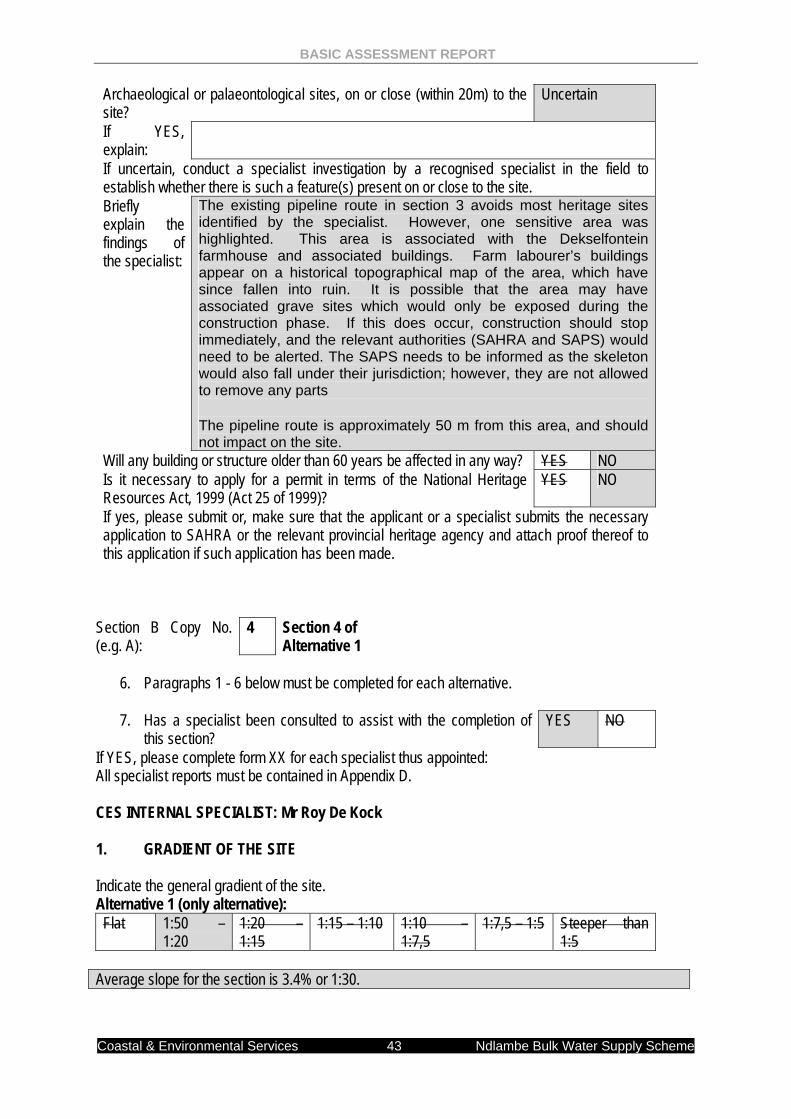
If uncertain, conduct a specialist investigation by a recognised specialist in the field to establish whether there is such a feature(s) present on or close to the site. Briefly explain the findings of the specialist:
An HIA was undertaken by a specialist. NO heritage resources were identified in Section 1.
Will any building or structure older than 60 years be affected in any way? YES NO Is it necessary to apply for a permit in terms of the National Heritage Resources Act, 1999 (Act 25 of 1999)?
YES NO
If yes, please submit or, make sure that the applicant or a specialist submits the necessary application to SAHRA or the relevant provincial heritage agency and attach proof thereof to this application if such application has been made.
BASIC ASSESSMENT REPORT
Coastal & Environmental Services 32 Ndlambe Bulk Water Supply Scheme
Section B Copy No. (e.g. A):
2 Section 2 of Alternative 1
4. Paragraphs 1 - 6 below must be completed for each alternative.
5. Has a specialist been consulted to assist with the completion of
this section? YES NO
If YES, please complete form XX for each specialist thus appointed: All specialist reports must be contained in Appendix D. CES INTERNAL SPECIALIST: Mr Roy De Kock 1. GRADIENT OF THE SITE Indicate the general gradient of the site. Alternative 1 (only alternative): Flat 1:50 –
1:20 1:20 – 1:15
1:15 – 1:10 1:10 – 1:7,5
1:7,5 – 1:5 Steeper than 1:5
Average slope for the section is 13.2% or 1:7,5
2. LOCATION IN LANDSCAPE Indicate the landform(s) that best describes the site: 2.1 Ridgeline 2.2 Plateau 2.3 Side slope of hill/mountain 2.4 Closed valley 2.5 Open valley 2.6 Plain 2.7 Undulating plain / low hills 2.8 Dune 2.9 Seafront 3. GROUNDWATER, SOIL AND GEOLOGICAL STABILITY OF THE SITE Is the site(s) located on any of the following (tick the appropriate boxes)? Alternative S2: Comment
BASIC ASSESSMENT REPORT
Coastal & Environmental Services 33 Ndlambe Bulk Water Supply Scheme
Shallow water table (less than 1.5m deep) YES NO Dolomite, sinkhole or doline areas
YES NO
Seasonally wet soils (often close to water bodies) YES NO Unstable rocky slopes or steep slopes with loose soil YES NO Dispersive soils (soils that dissolve in water) YES NO Soils with high clay content (clay fraction more than 40%) YES NO Any other unstable soil or geological feature YES NO An area sensitive to erosion
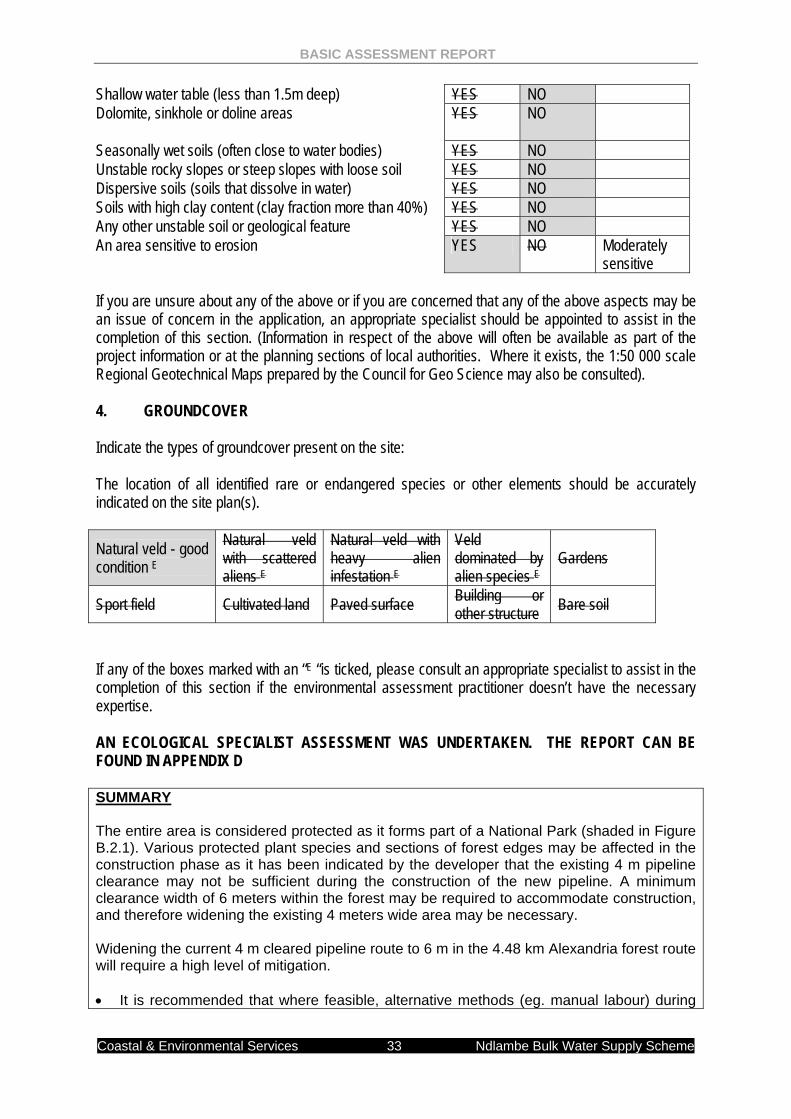
YES NO Moderately sensitive
If you are unsure about any of the above or if you are concerned that any of the above aspects may be an issue of concern in the application, an appropriate specialist should be appointed to assist in the completion of this section. (Information in respect of the above will often be available as part of the project information or at the planning sections of local authorities. Where it exists, the 1:50 000 scale Regional Geotechnical Maps prepared by the Council for Geo Science may also be consulted). 4. GROUNDCOVER Indicate the types of groundcover present on the site: The location of all identified rare or endangered species or other elements should be accurately indicated on the site plan(s).
Natural veld - good condition E
Natural veld with scattered aliens E
Natural veld with heavy alien infestation E
Veld dominated by alien species E
Gardens
Sport field Cultivated land Paved surface Building or other structure Bare soil
If any of the boxes marked with an “E “is ticked, please consult an appropriate specialist to assist in the completion of this section if the environmental assessment practitioner doesn’t have the necessary expertise. AN ECOLOGICAL SPECIALIST ASSESSMENT WAS UNDERTAKEN. THE REPORT CAN BE FOUND IN APPENDIX D SUMMARY The entire area is considered protected as it forms part of a National Park (shaded in Figure B.2.1). Various protected plant species and sections of forest edges may be affected in the construction phase as it has been indicated by the developer that the existing 4 m pipeline clearance may not be sufficient during the construction of the new pipeline. A minimum clearance width of 6 meters within the forest may be required to accommodate construction, and therefore widening the existing 4 meters wide area may be necessary. Widening the current 4 m cleared pipeline route to 6 m in the 4.48 km Alexandria forest route will require a high level of mitigation. • It is recommended that where feasible, alternative methods (eg. manual labour) during
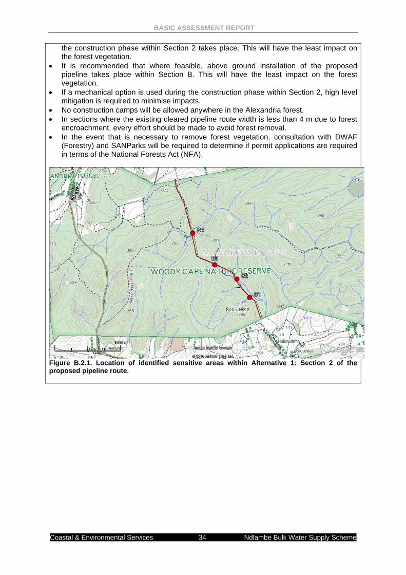
BASIC ASSESSMENT REPORT
Coastal & Environmental Services 34 Ndlambe Bulk Water Supply Scheme
the construction phase within Section 2 takes place. This will have the least impact on the forest vegetation.
• It is recommended that where feasible, above ground installation of the proposed pipeline takes place within Section B. This will have the least impact on the forest vegetation.
• If a mechanical option is used during the construction phase within Section 2, high level mitigation is required to minimise impacts.
• No construction camps will be allowed anywhere in the Alexandria forest. • In sections where the existing cleared pipeline route width is less than 4 m due to forest
encroachment, every effort should be made to avoid forest removal. • In the event that is necessary to remove forest vegetation, consultation with DWAF
(Forestry) and SANParks will be required to determine if permit applications are required in terms of the National Forests Act (NFA).
Figure B.2.1. Location of identified sensitive areas within Alternative 1: Section 2 of the proposed pipeline route.
BASIC ASSESSMENT REPORT
Coastal & Environmental Services 35 Ndlambe Bulk Water Supply Scheme
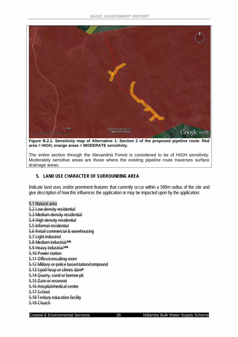
Figure B.2.1. Sensitivity map of Alternative 1: Section 2 of the proposed pipeline route. Red area = HIGH, orange areas = MODERATE sensitivity. The entire section through the Alexandria Forest is considered to be of HIGH sensitivity. Moderately sensitive areas are those where the existing pipeline route traverses surface drainage areas.
5. LAND USE CHARACTER OF SURROUNDING AREA Indicate land uses and/or prominent features that currently occur within a 500m radius of the site and give description of how this influences the application or may be impacted upon by the application: 5.1 Natural area 5.2 Low density residential 5.3 Medium density residential 5.4 High density residential 5.5 Informal residential 5.6 Retail commercial & warehousing 5.7 Light industrial 5.8 Medium industrial AN 5.9 Heavy industrial AN 5.10 Power station 5.11 Office/consulting room 5.12 Military or police base/station/compound 5.13 Spoil heap or slimes damA 5.14 Quarry, sand or borrow pit 5.15 Dam or reservoir 5.16 Hospital/medical centre 5.17 School 5.18 Tertiary education facility 5.19 Church
BASIC ASSESSMENT REPORT
Coastal & Environmental Services 36 Ndlambe Bulk Water Supply Scheme
5.20 Old age home 5.21 Sewage treatment plantA 5.22 Train station or shunting yard N 5.23 Railway line N 5.24 Major road (4 lanes or more) N 5.25 Airport N 5.26 Harbour 5.27 Sport facilities 5.28 Golf course 5.29 Polo fields 5.30 Filling station H 5.31 Landfill or waste treatment site 5.32 Plantation 5.33 Agriculture 5.34 River, stream or wetland 5.35 Nature conservation area 5.36 Mountain, koppie or ridge 5.37 Museum 5.38 Historical building 5.39 Protected Area 5.40 Graveyard 5.41 Archaeological site 5.42 Other land uses (describe) If any of the boxes marked with an “N “are ticked, how will this impact / be impacted upon by the proposed activity. If any of the boxes marked with an "An" are ticked, how will this impact / be impacted upon by the proposed activity. If YES, specify and explain: N/A If YES, specify: N/A If any of the boxes marked with an "H" are ticked, how will this impact / be impacted upon by the proposed activity. If YES, specify and explain: N/A If YES, specify: N/A 6. CULTURAL/HISTORICAL FEATURES Are there any signs of culturally or historically significant elements, as defined in section 2 of the National Heritage Resources Act, 1999, (Act No. 25 of 1999), including
YES NO
Archaeological or palaeontological sites, on or close (within 20m) to the site?
Uncertain
If YES, explain:
N/A
BASIC ASSESSMENT REPORT
Coastal & Environmental Services 37 Ndlambe Bulk Water Supply Scheme
If uncertain, conduct a specialist investigation by a recognised specialist in the field to establish whether there is such a feature(s) present on or close to the site. Briefly explain the findings of the specialist:
While shell middens do occur in this area, they would all be subsurface, only to be exposed during construction activities. The Alexandria Forest has a limited existing cleared area and the existing line is unlikely to uncover sites. If the line route will replace the existing pipeline, then no mitigation is required. However, if the line is to run parallel to the existing route then certain areas need to be monitored for potential archaeological sites. The area that will require monitoring during construction, if a new line is chosen, are as follows:
S33°42'22.46"; E26°23'42.69" to S33°44'17.28"; E26°25'7.08”
Will any building or structure older than 60 years be affected in any way? YES NO Is it necessary to apply for a permit in terms of the National Heritage Resources Act, 1999 (Act 25 of 1999)?
YES NO
If yes, please submit or, make sure that the applicant or a specialist submits the necessary application to SAHRA or the relevant provincial heritage agency and attach proof thereof to this application if such application has been made.
BASIC ASSESSMENT REPORT
Coastal & Environmental Services 38 Ndlambe Bulk Water Supply Scheme
Section B Copy No. (e.g. A):
3 Section 3 of Alternative 1
6. Paragraphs 1 - 6 below must be completed for each alternative.
7. Has a specialist been consulted to assist with the completion of
this section? YES NO
If YES, please complete form XX for each specialist thus appointed: All specialist reports must be contained in Appendix D. CES INTERNAL SPECIALIST: Mr Roy De Kock 1. GRADIENT OF THE SITE Indicate the general gradient of the site. Alternative 1 (only alternative): Flat 1:50 –
1:20 1:20 – 1:15
1:15 – 1:10 1:10 – 1:7,5
1:7,5 – 1:5 Steeper than 1:5
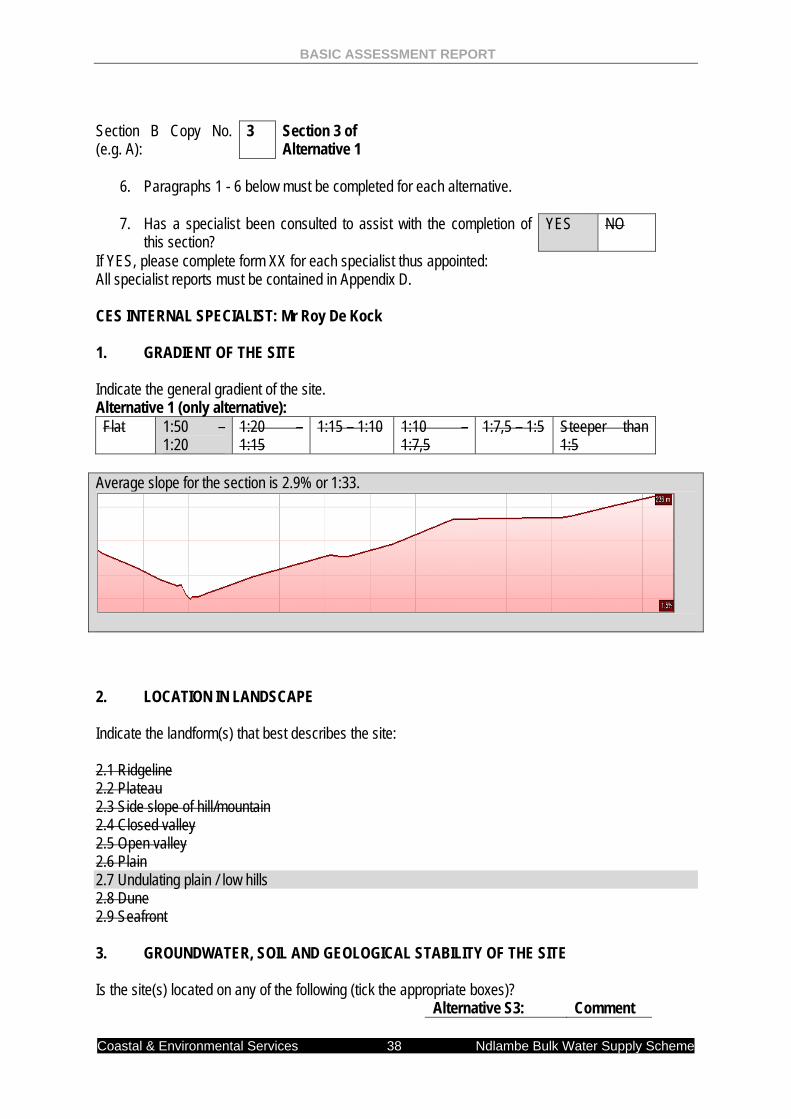
Average slope for the section is 2.9% or 1:33.
2. LOCATION IN LANDSCAPE Indicate the landform(s) that best describes the site: 2.1 Ridgeline 2.2 Plateau 2.3 Side slope of hill/mountain 2.4 Closed valley 2.5 Open valley 2.6 Plain 2.7 Undulating plain / low hills 2.8 Dune 2.9 Seafront 3. GROUNDWATER, SOIL AND GEOLOGICAL STABILITY OF THE SITE Is the site(s) located on any of the following (tick the appropriate boxes)? Alternative S3: Comment
BASIC ASSESSMENT REPORT
Coastal & Environmental Services 39 Ndlambe Bulk Water Supply Scheme
Shallow water table (less than 1.5m deep) YES NO Dolomite, sinkhole or doline areas
YES NO
Seasonally wet soils (often close to water bodies) YES NO Unstable rocky slopes or steep slopes with loose soil YES NO Dispersive soils (soils that dissolve in water) YES NO Soils with high clay content (clay fraction more than 40%)
YES NO
Any other unstable soil or geological feature YES NO An area sensitive to erosion
YES NO Moderately sensitive
If you are unsure about any of the above or if you are concerned that any of the above aspects may be an issue of concern in the application, an appropriate specialist should be appointed to assist in the completion of this section. (Information in respect of the above will often be available as part of the project information or at the planning sections of local authorities. Where it exists, the 1:50 000 scale Regional Geotechnical Maps prepared by the Council for Geo Science may also be consulted). 4. GROUNDCOVER Indicate the types of groundcover present on the site: The location of all identified rare or endangered species or other elements should be accurately indicated on the site plan(s).
Natural veld - good conditionE
Natural veld with scattered aliensE
Natural veld with heavy alien infestationE
Veld dominated by alien speciesE
Gardens
Sport field Cultivated land Paved surface Building or other structure Bare soil
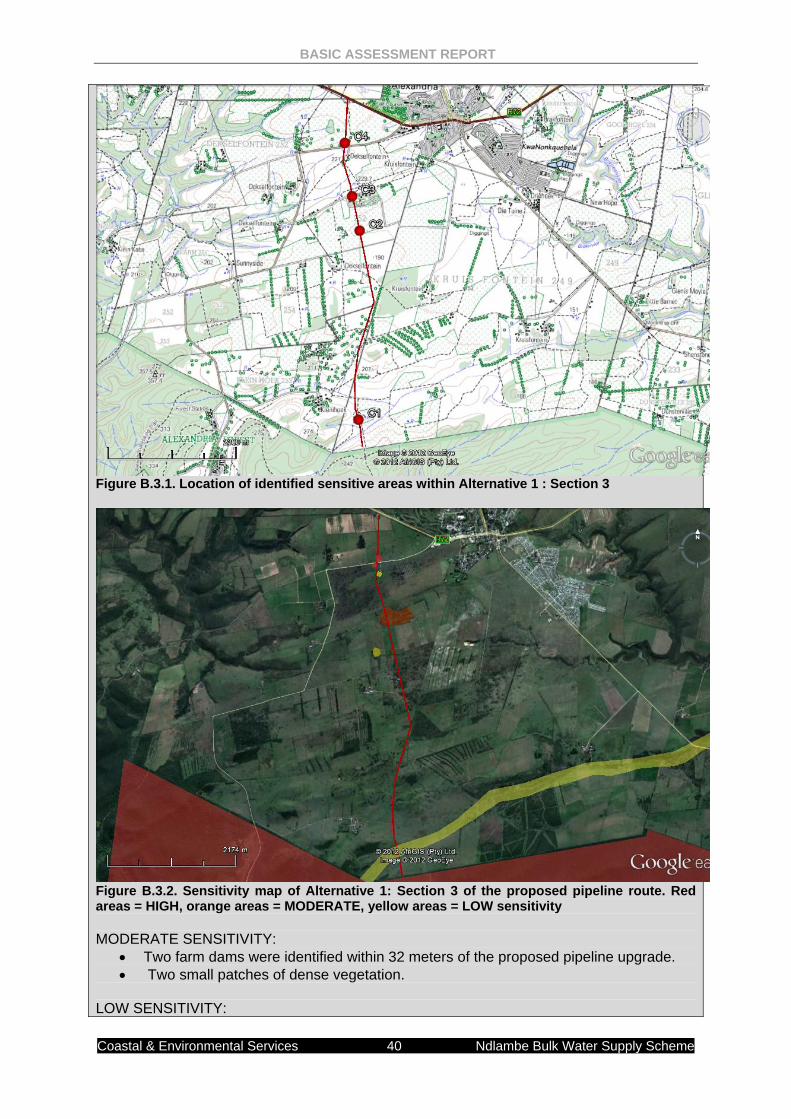
If any of the boxes marked with an “E “is ticked, please consult an appropriate specialist to assist in the completion of this section if the environmental assessment practitioner doesn’t have the necessary expertise. AN ECOLOGICAL SPECIALIST ASSESSMENT WAS UNDERTAKEN. THE REPORT CAN BE FOUND IN APPENDIX D SUMMARY The entire area is considered degraded due to large scale agriculture development within Section 3. Minor sensitive areas were identified along the proposed line that will require mitigation. Figure B.3.1 below shows the location of identified sensitive areas within Section 3. Figure B.3.2 shows the ranking of the sensitivity of the identified sites. Minor mitigations are required in the sensitive areas as shown in Figure B.1.1. These include minimising development footprints in pockets of natural and near natural vegetation.
BASIC ASSESSMENT REPORT
Coastal & Environmental Services 40 Ndlambe Bulk Water Supply Scheme
Figure B.3.1. Location of identified sensitive areas within Alternative 1 : Section 3
Figure B.3.2. Sensitivity map of Alternative 1: Section 3 of the proposed pipeline route. Red areas = HIGH, orange areas = MODERATE, yellow areas = LOW sensitivity MODERATE SENSITIVITY:
• Two farm dams were identified within 32 meters of the proposed pipeline upgrade. • Two small patches of dense vegetation.
LOW SENSITIVITY:
BASIC ASSESSMENT REPORT
Coastal & Environmental Services 41 Ndlambe Bulk Water Supply Scheme
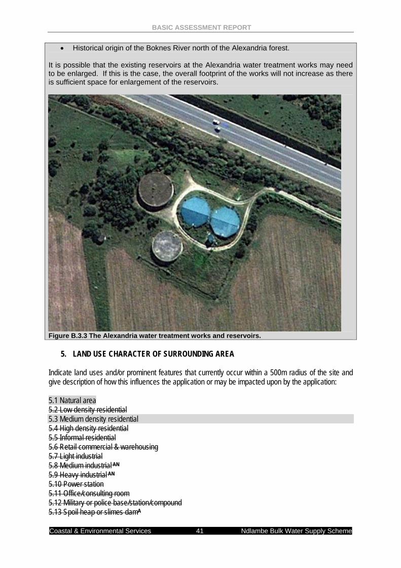
• Historical origin of the Boknes River north of the Alexandria forest. It is possible that the existing reservoirs at the Alexandria water treatment works may need to be enlarged. If this is the case, the overall footprint of the works will not increase as there is sufficient space for enlargement of the reservoirs.
Figure B.3.3 The Alexandria water treatment works and reservoirs.
5. LAND USE CHARACTER OF SURROUNDING AREA Indicate land uses and/or prominent features that currently occur within a 500m radius of the site and give description of how this influences the application or may be impacted upon by the application: 5.1 Natural area 5.2 Low density residential 5.3 Medium density residential 5.4 High density residential 5.5 Informal residential 5.6 Retail commercial & warehousing 5.7 Light industrial 5.8 Medium industrial AN 5.9 Heavy industrial AN 5.10 Power station 5.11 Office/consulting room 5.12 Military or police base/station/compound 5.13 Spoil heap or slimes damA
BASIC ASSESSMENT REPORT
Coastal & Environmental Services 42 Ndlambe Bulk Water Supply Scheme
5.14 Quarry, sand or borrow pit 5.15 Dam or reservoir 5.16 Hospital/medical centre 5.17 School 5.18 Tertiary education facility 5.19 Church 5.20 Old age home 5.21 Sewage treatment plantA 5.22 Train station or shunting yard N 5.23 Railway line N 5.24 Major road (4 lanes or more) N 5.25 Airport N 5.26 Harbour 5.27 Sport facilities 5.28 Golf course 5.29 Polo fields 5.30 Filling station H 5.31 Landfill or waste treatment site 5.32 Plantation 5.33 Agriculture 5.34 River, stream or wetland 5.35 Nature conservation area 5.36 Mountain, koppie or ridge 5.37 Museum 5.38 Historical building 5.39 Protected Area 5.40 Graveyard 5.41 Archaeological site 5.42 Other land uses (describe) If any of the boxes marked with an “N “are ticked, how will this impact / be impacted upon by the proposed activity. If any of the boxes marked with an "AN" are ticked, how will this impact / be impacted upon by the proposed activity. If YES, specify and explain: N/A If YES, specify: N/A If any of the boxes marked with an "H" are ticked, how will this impact / be impacted upon by the proposed activity. If YES, specify and explain: N/A If YES, specify: N/A 6. CULTURAL/HISTORICAL FEATURES Are there any signs of culturally or historically significant elements, as defined in section 2 of the National Heritage Resources Act, 1999, (Act No. 25 of 1999), including
YES NO
BASIC ASSESSMENT REPORT
Coastal & Environmental Services 43 Ndlambe Bulk Water Supply Scheme
Archaeological or palaeontological sites, on or close (within 20m) to the site?
Uncertain
If YES, explain:
If uncertain, conduct a specialist investigation by a recognised specialist in the field to establish whether there is such a feature(s) present on or close to the site. Briefly explain the findings of the specialist:
The existing pipeline route in section 3 avoids most heritage sites identified by the specialist. However, one sensitive area was highlighted. This area is associated with the Dekselfontein farmhouse and associated buildings. Farm labourer’s buildings appear on a historical topographical map of the area, which have since fallen into ruin. It is possible that the area may have associated grave sites which would only be exposed during the construction phase. If this does occur, construction should stop immediately, and the relevant authorities (SAHRA and SAPS) would need to be alerted. The SAPS needs to be informed as the skeleton would also fall under their jurisdiction; however, they are not allowed to remove any parts The pipeline route is approximately 50 m from this area, and should not impact on the site.
Will any building or structure older than 60 years be affected in any way? YES NO Is it necessary to apply for a permit in terms of the National Heritage Resources Act, 1999 (Act 25 of 1999)?
YES NO
If yes, please submit or, make sure that the applicant or a specialist submits the necessary application to SAHRA or the relevant provincial heritage agency and attach proof thereof to this application if such application has been made.
Section B Copy No. (e.g. A):
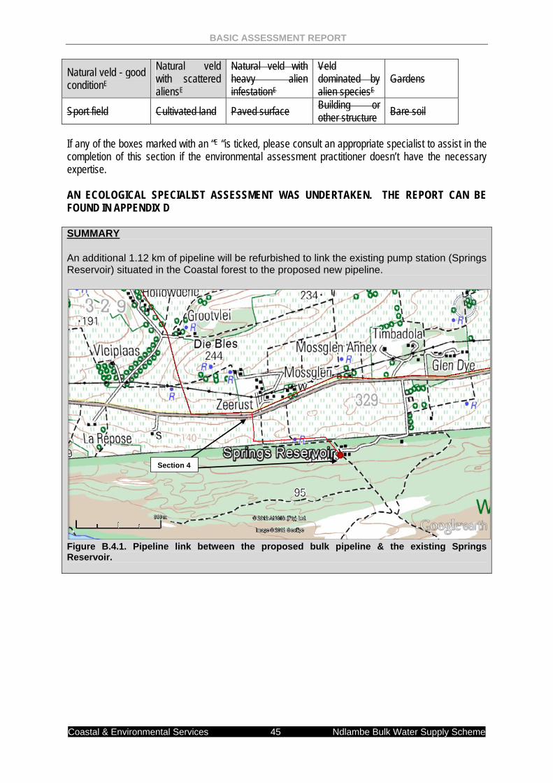
4 Section 4 of Alternative 1
6. Paragraphs 1 - 6 below must be completed for each alternative.
7. Has a specialist been consulted to assist with the completion of
this section? YES NO
If YES, please complete form XX for each specialist thus appointed: All specialist reports must be contained in Appendix D. CES INTERNAL SPECIALIST: Mr Roy De Kock 1. GRADIENT OF THE SITE Indicate the general gradient of the site. Alternative 1 (only alternative): Flat 1:50 –
1:20 1:20 – 1:15
1:15 – 1:10 1:10 – 1:7,5
1:7,5 – 1:5 Steeper than 1:5
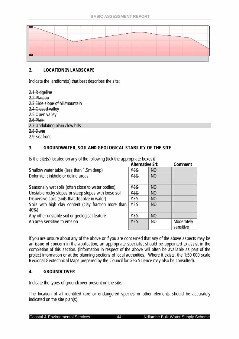
Average slope for the section is 3.4% or 1:30.
BASIC ASSESSMENT REPORT
Coastal & Environmental Services 44 Ndlambe Bulk Water Supply Scheme
2. LOCATION IN LANDSCAPE Indicate the landform(s) that best describes the site: 2.1 Ridgeline 2.2 Plateau 2.3 Side slope of hill/mountain 2.4 Closed valley 2.5 Open valley 2.6 Plain 2.7 Undulating plain / low hills 2.8 Dune 2.9 Seafront 3. GROUNDWATER, SOIL AND GEOLOGICAL STABILITY OF THE SITE Is the site(s) located on any of the following (tick the appropriate boxes)? Alternative S1: Comment Shallow water table (less than 1.5m deep) YES NO Dolomite, sinkhole or doline areas
YES NO
Seasonally wet soils (often close to water bodies) YES NO Unstable rocky slopes or steep slopes with loose soil YES NO Dispersive soils (soils that dissolve in water) YES NO Soils with high clay content (clay fraction more than 40%)
YES NO
Any other unstable soil or geological feature YES NO An area sensitive to erosion
YES NO Moderately sensitive
If you are unsure about any of the above or if you are concerned that any of the above aspects may be an issue of concern in the application, an appropriate specialist should be appointed to assist in the completion of this section. (Information in respect of the above will often be available as part of the project information or at the planning sections of local authorities. Where it exists, the 1:50 000 scale Regional Geotechnical Maps prepared by the Council for Geo Science may also be consulted). 4. GROUNDCOVER Indicate the types of groundcover present on the site: The location of all identified rare or endangered species or other elements should be accurately indicated on the site plan(s).
BASIC ASSESSMENT REPORT
Coastal & Environmental Services 45 Ndlambe Bulk Water Supply Scheme
Natural veld - good conditionE
Natural veld with scattered aliensE
Natural veld with heavy alien infestationE
Veld dominated by alien speciesE
Gardens
Sport field Cultivated land Paved surface Building or other structure Bare soil
If any of the boxes marked with an “E “is ticked, please consult an appropriate specialist to assist in the completion of this section if the environmental assessment practitioner doesn’t have the necessary expertise. AN ECOLOGICAL SPECIALIST ASSESSMENT WAS UNDERTAKEN. THE REPORT CAN BE FOUND IN APPENDIX D SUMMARY An additional 1.12 km of pipeline will be refurbished to link the existing pump station (Springs Reservoir) situated in the Coastal forest to the proposed new pipeline.
Figure B.4.1. Pipeline link between the proposed bulk pipeline & the existing Springs Reservoir.
Section 4
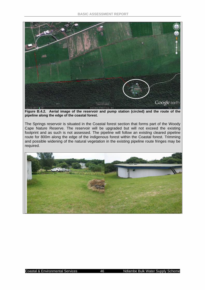
BASIC ASSESSMENT REPORT
Coastal & Environmental Services 46 Ndlambe Bulk Water Supply Scheme
Figure B.4.2. Aerial image of the reservoir and pump station (circled) and the route of the pipeline along the edge of the coastal forest. The Springs reservoir is situated in the Coastal forest section that forms part of the Woody Cape Nature Reserve. The reservoir will be upgraded but will not exceed the existing footprint and as such is not assessed. The pipeline will follow an existing cleared pipeline route for 800m along the edge of the indigenous forest within the Coastal forest. Trimming and possible widening of the natural vegetation in the existing pipeline route fringes may be required.
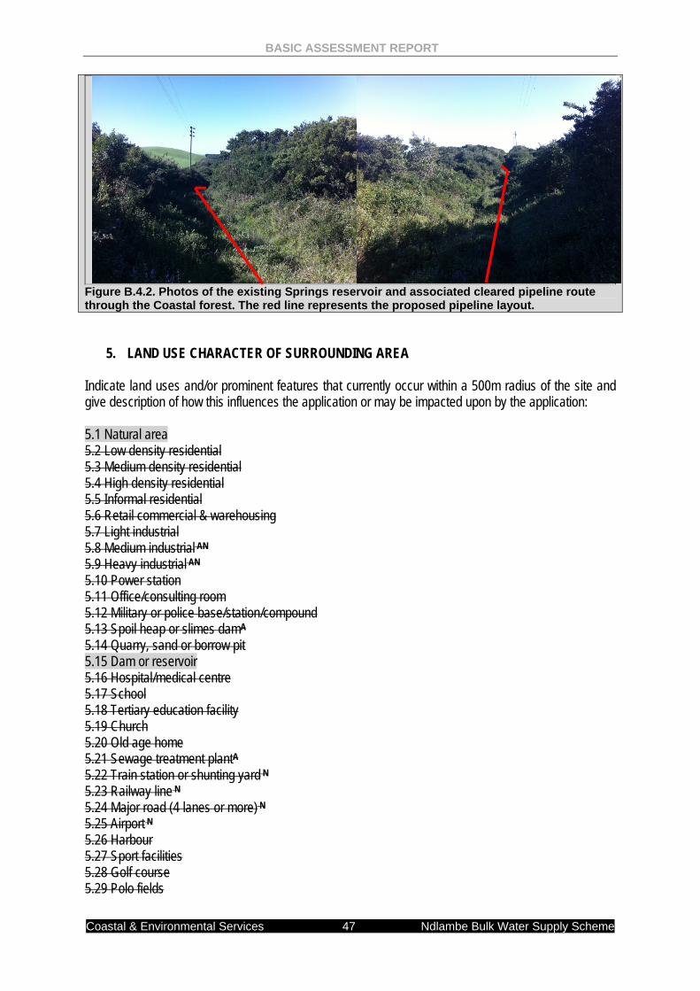
BASIC ASSESSMENT REPORT
Coastal & Environmental Services 47 Ndlambe Bulk Water Supply Scheme
Figure B.4.2. Photos of the existing Springs reservoir and associated cleared pipeline route through the Coastal forest. The red line represents the proposed pipeline layout.
5. LAND USE CHARACTER OF SURROUNDING AREA Indicate land uses and/or prominent features that currently occur within a 500m radius of the site and give description of how this influences the application or may be impacted upon by the application: 5.1 Natural area 5.2 Low density residential 5.3 Medium density residential 5.4 High density residential 5.5 Informal residential 5.6 Retail commercial & warehousing 5.7 Light industrial 5.8 Medium industrial AN 5.9 Heavy industrial AN 5.10 Power station 5.11 Office/consulting room 5.12 Military or police base/station/compound 5.13 Spoil heap or slimes damA 5.14 Quarry, sand or borrow pit 5.15 Dam or reservoir 5.16 Hospital/medical centre 5.17 School 5.18 Tertiary education facility 5.19 Church 5.20 Old age home 5.21 Sewage treatment plantA 5.22 Train station or shunting yard N 5.23 Railway line N 5.24 Major road (4 lanes or more) N 5.25 Airport N 5.26 Harbour 5.27 Sport facilities 5.28 Golf course 5.29 Polo fields
BASIC ASSESSMENT REPORT
Coastal & Environmental Services 48 Ndlambe Bulk Water Supply Scheme
5.30 Filling station H 5.31 Landfill or waste treatment site 5.32 Plantation 5.33 Agriculture 5.34 River, stream or wetland 5.35 Nature conservation area 5.36 Mountain, koppie or ridge 5.37 Museum 5.38 Historical building 5.39 Protected Area 5.40 Graveyard 5.41 Archaeological site 5.42 Other land uses (describe) If any of the boxes marked with an “N “are ticked, how will this impact / be impacted upon by the proposed activity. If any of the boxes marked with an "AN" are ticked, how will this impact / be impacted upon by the proposed activity. If YES, specify and explain: N/A If YES, specify: N/A If any of the boxes marked with an "H" are ticked, how will this impact / be impacted upon by the proposed activity. If YES, specify and explain: N/A If YES, specify: N/A 6. CULTURAL/HISTORICAL FEATURES Are there any signs of culturally or historically significant elements, as defined in section 2 of the National Heritage Resources Act, 1999, (Act No. 25 of 1999), including
YES NO
Archaeological or palaeontological sites, on or close (within 20m) to the site?
Uncertain
If YES, explain:
If uncertain, conduct a specialist investigation by a recognised specialist in the field to establish whether there is such a feature(s) present on or close to the site. Briefly explain the findings of the specialist:
While shell middens do occur in this area, they would all be subsurface, only to be exposed during construction activities. The Woody Cape Nature Reserve has a limited servitude and the existing line is unlikely to uncover sites. If the line route will replace the existing pipeline, then no mitigation is required. However, if the line is to run parallel to the existing route then certain areas need to be monitored for potential archaeological sites.
Will any building or structure older than 60 years be affected in any way? YES NO Is it necessary to apply for a permit in terms of the National Heritage Resources Act, 1999 (Act 25 of 1999)?
YES NO
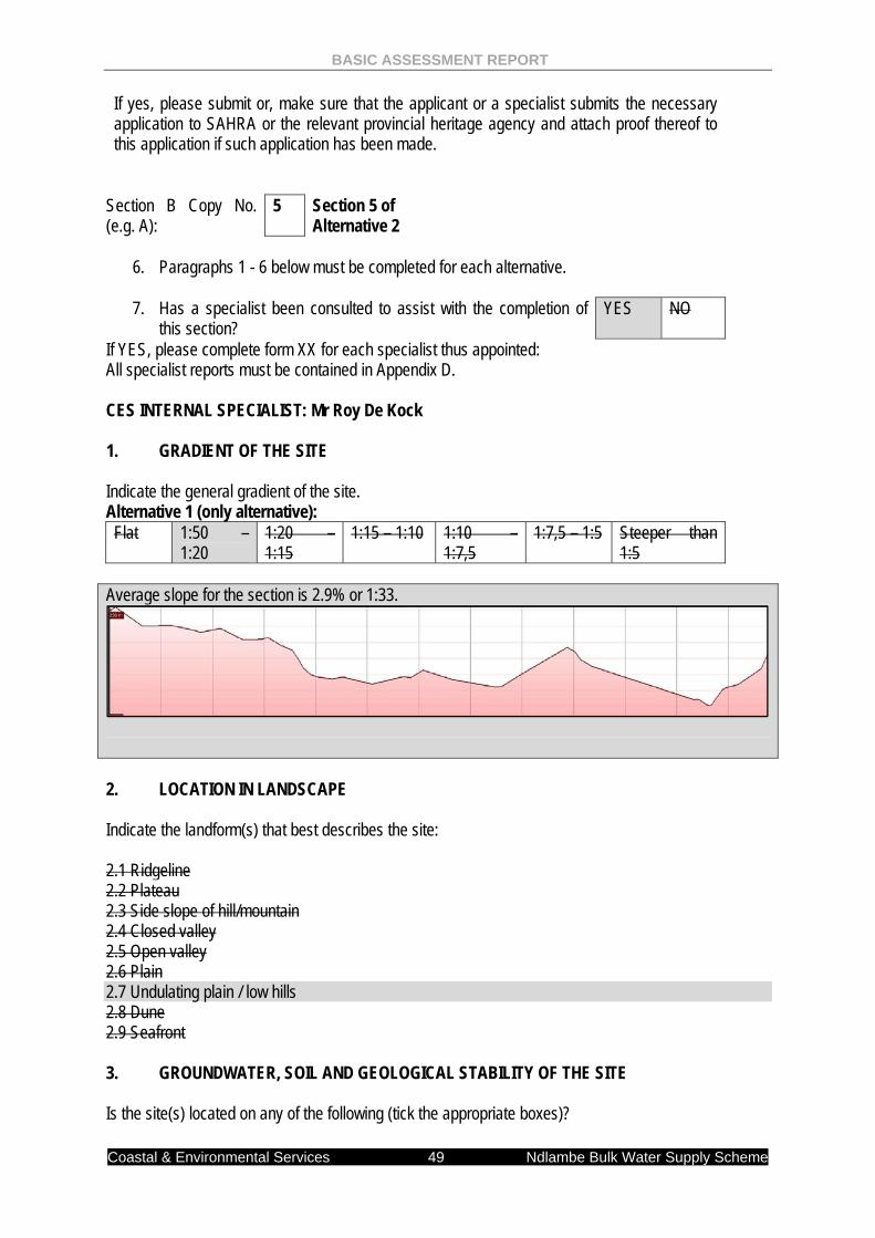
BASIC ASSESSMENT REPORT
Coastal & Environmental Services 49 Ndlambe Bulk Water Supply Scheme
If yes, please submit or, make sure that the applicant or a specialist submits the necessary application to SAHRA or the relevant provincial heritage agency and attach proof thereof to this application if such application has been made.
Section B Copy No. (e.g. A):
5 Section 5 of Alternative 2
6. Paragraphs 1 - 6 below must be completed for each alternative.
7. Has a specialist been consulted to assist with the completion of
this section? YES NO
If YES, please complete form XX for each specialist thus appointed: All specialist reports must be contained in Appendix D. CES INTERNAL SPECIALIST: Mr Roy De Kock 1. GRADIENT OF THE SITE Indicate the general gradient of the site. Alternative 1 (only alternative): Flat 1:50 –
1:20 1:20 – 1:15
1:15 – 1:10 1:10 – 1:7,5
1:7,5 – 1:5 Steeper than 1:5
Average slope for the section is 2.9% or 1:33.
2. LOCATION IN LANDSCAPE Indicate the landform(s) that best describes the site: 2.1 Ridgeline 2.2 Plateau 2.3 Side slope of hill/mountain 2.4 Closed valley 2.5 Open valley 2.6 Plain 2.7 Undulating plain / low hills 2.8 Dune 2.9 Seafront 3. GROUNDWATER, SOIL AND GEOLOGICAL STABILITY OF THE SITE Is the site(s) located on any of the following (tick the appropriate boxes)?
BASIC ASSESSMENT REPORT
Coastal & Environmental Services 50 Ndlambe Bulk Water Supply Scheme
Alternative S1: Comment Shallow water table (less than 1.5m deep) YES NO Dolomite, sinkhole or doline areas
YES NO
Seasonally wet soils (often close to water bodies) YES NO Unstable rocky slopes or steep slopes with loose soil YES NO Dispersive soils (soils that dissolve in water) YES NO Soils with high clay content (clay fraction more than 40%)
YES NO
Any other unstable soil or geological feature YES NO An area sensitive to erosion
YES NO Moderately sensitive
If you are unsure about any of the above or if you are concerned that any of the above aspects may be an issue of concern in the application, an appropriate specialist should be appointed to assist in the completion of this section. (Information in respect of the above will often be available as part of the project information or at the planning sections of local authorities. Where it exists, the 1:50 000 scale Regional Geotechnical Maps prepared by the Council for Geo Science may also be consulted). 4. GROUNDCOVER Indicate the types of groundcover present on the site: The location of all identified rare or endangered species or other elements should be accurately indicated on the site plan(s).
Natural veld - good conditionE
Natural veld with scattered aliensE
Natural veld with heavy alien infestationE
Veld dominated by alien speciesE
Gardens
Sport field Cultivated land Paved surface Building or other structure Bare soil
If any of the boxes marked with an “E “is ticked, please consult an appropriate specialist to assist in the completion of this section if the environmental assessment practitioner doesn’t have the necessary expertise. NO ECOLOGICAL SPECIALIST ASSESSMENT WAS UNDERTAKEN AS THIS SECTION FOLLOWS AN EXISTING ROAD RESERVE. SUMMARY The pipeline would follow the existing road reserve in order to limit the impact on farm lands and other private properties. The entire area is considered degraded due to agriculture development within Alternative 2: Section 5. The main areas of sensitivity identified were three river/stream crossings (Figure B.5.1). The northernmost crossing is the Brak River, a large tributary of the Boknes River, while the two southern crossings are over small tributaries to the Boknes River.
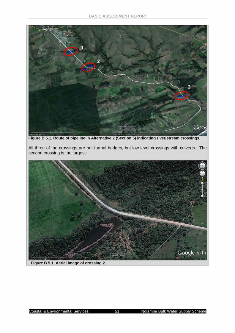
BASIC ASSESSMENT REPORT
Coastal & Environmental Services 51 Ndlambe Bulk Water Supply Scheme
Figure B.5.1. Route of pipeline in Alternative 2 (Section 5) indicating river/stream crossings. All three of the crossings are not formal bridges, but low level crossings with culverts. The second crossing is the largest:
Figure B.5.1. Aerial image of crossing 2.
1
2
3
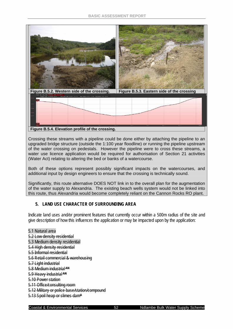
BASIC ASSESSMENT REPORT
Coastal & Environmental Services 52 Ndlambe Bulk Water Supply Scheme
Figure B.5.2. Western side of the crossing. Figure B.5.3. Eastern side of the crossing
Figure B.5.4. Elevation profile of the crossing. Crossing these streams with a pipeline could be done either by attaching the pipeline to an upgraded bridge structure (outside the 1:100 year floodline) or running the pipeline upstream of the water crossing on pedestals. However the pipeline were to cross these streams, a water use licence application would be required for authorisation of Section 21 activities (Water Act) relating to altering the bed or banks of a watercourse. Both of these options represent possibly significant impacts on the watercourses, and additional input by design engineers to ensure that the crossing is technically sound. Significantly, this route alternative DOES NOT link in to the overall plan for the augmentation of the water supply to Alexandria. The existing beach wells system would not be linked into this route, thus Alexandria would become completely reliant on the Cannon Rocks RO plant.
5. LAND USE CHARACTER OF SURROUNDING AREA Indicate land uses and/or prominent features that currently occur within a 500m radius of the site and give description of how this influences the application or may be impacted upon by the application: 5.1 Natural area 5.2 Low density residential 5.3 Medium density residential 5.4 High density residential 5.5 Informal residential 5.6 Retail commercial & warehousing 5.7 Light industrial 5.8 Medium industrial AN 5.9 Heavy industrial AN 5.10 Power station 5.11 Office/consulting room 5.12 Military or police base/station/compound 5.13 Spoil heap or slimes damA
BASIC ASSESSMENT REPORT
Coastal & Environmental Services 53 Ndlambe Bulk Water Supply Scheme
5.14 Quarry, sand or borrow pit 5.15 Dam or reservoir 5.16 Hospital/medical centre 5.17 School 5.18 Tertiary education facility 5.19 Church 5.20 Old age home 5.21 Sewage treatment plantA 5.22 Train station or shunting yard N 5.23 Railway line N 5.24 Major road (4 lanes or more) N 5.25 Airport N 5.26 Harbour 5.27 Sport facilities 5.28 Golf course 5.29 Polo fields 5.30 Filling station H 5.31 Landfill or waste treatment site 5.32 Plantation 5.33 Agriculture 5.34 River, stream or wetland 5.35 Nature conservation area 5.36 Mountain, koppie or ridge 5.37 Museum 5.38 Historical building 5.39 Protected Area 5.40 Graveyard 5.41 Archaeological site 5.42 Other land uses (describe) If any of the boxes marked with an “N “are ticked, how will this impact / be impacted upon by the proposed activity. If any of the boxes marked with an "AN" are ticked, how will this impact / be impacted upon by the proposed activity. If YES, specify and explain: N/A If YES, specify: N/A If any of the boxes marked with an "H" are ticked, how will this impact / be impacted upon by the proposed activity. If YES, specify and explain: N/A If YES, specify: N/A 6. CULTURAL/HISTORICAL FEATURES Are there any signs of culturally or historically significant elements, as defined in section 2 of the National Heritage Resources Act, 1999, (Act No. 25 of 1999), including
YES NO
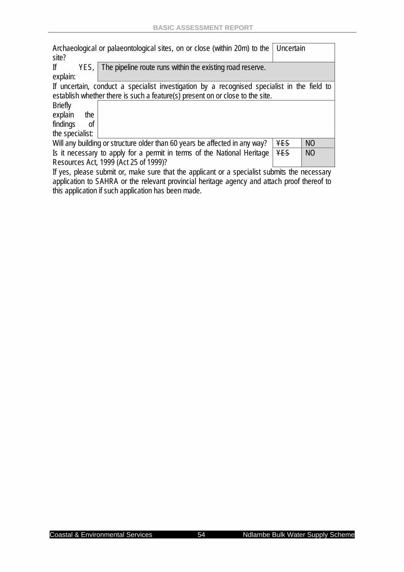
BASIC ASSESSMENT REPORT
Coastal & Environmental Services 54 Ndlambe Bulk Water Supply Scheme
Archaeological or palaeontological sites, on or close (within 20m) to the site?
Uncertain
If YES, explain:
The pipeline route runs within the existing road reserve.
If uncertain, conduct a specialist investigation by a recognised specialist in the field to establish whether there is such a feature(s) present on or close to the site. Briefly explain the findings of the specialist:
Will any building or structure older than 60 years be affected in any way? YES NO Is it necessary to apply for a permit in terms of the National Heritage Resources Act, 1999 (Act 25 of 1999)?
YES NO
If yes, please submit or, make sure that the applicant or a specialist submits the necessary application to SAHRA or the relevant provincial heritage agency and attach proof thereof to this application if such application has been made.
BASIC ASSESSMENT REPORT
Coastal & Environmental Services 55 Ndlambe Bulk Water Supply Scheme
SECTION C: PUBLIC PARTICIPATION
ALL PUBLIC PARTICIPATION DOCUMENTATION CAN BE FOUND IN APPENDIX G 1. ADVERTISEMENT The person conducting a public participation process must take into account any guidelines applicable to public participation as contemplated in section 24J of the Act and must give notice to all potential interested and affected parties of the application which is subjected to public participation by— (a) fixing a notice board (of a size at least 60cm by 42cm; and must display the required
information in lettering and in a format as may be determined by the competent authority) at a place conspicuous to the public at the boundary or on the fence of— (i) the site where the activity to which the application relates is or is to be undertaken; and
(ii) any alternative site mentioned in the application; (b) giving written notice to—
(i) the owner or person in control of that land if the applicant is not the owner or person in control of the land;
(ii) the occupiers of the site where the activity is or is to be undertaken or to any alternative site where the activity is to be undertaken;
(iii) owners and occupiers of land adjacent to the site where the activity is or is to be undertaken or to any alternative site where the activity is to be undertaken;
(iv) the municipal councillor of the ward in which the site or alternative site is situated and any organisation of ratepayers that represent the community in the area;
(v) the municipality which has jurisdiction in the area; (vi) any organ of state having jurisdiction in respect of any aspect of the activity; and (vii) any other party as required by the competent authority;
(c) placing an advertisement in— (i) one local newspaper; or
(ii) any official Gazette that is published specifically for the purpose of providing public notice of applications or other submissions made in terms of these Regulations;
(d) placing an advertisement in at least one provincial newspaper or national newspaper, if the activity has or may have an impact that extends beyond the boundaries of the metropolitan or local municipality in which it is or will be undertaken: Provided that this paragraph need not be complied with if an advertisement has been placed in an official Gazette referred to in subregulation 54(c)(ii); and
(e) using reasonable alternative methods, as agreed to by the competent authority, in those instances where a person is desiring of but unable to participate in the process due to— (i) illiteracy; (ii) disability; or (iii) any other disadvantage.
2. CONTENT OF ADVERTISEMENTS AND NOTICES A notice board, advertisement or notices must:
(a) indicate the details of the application which is subjected to public participation; and (b) state—
BASIC ASSESSMENT REPORT
Coastal & Environmental Services 56 Ndlambe Bulk Water Supply Scheme
(i) that the application has been submitted to the competent authority in terms of these Regulations, as the case may be; (ii) whether basic assessment or scoping procedures are being applied to the
application, in the case of an application for environmental authorisation;
(iii) the nature and location of the activity to which the application relates; (iv) where further information on the application or activity can be obtained; and (iv) the manner in which and the person to whom representations in respect of the
application may be made. 3. PLACEMENT OF ADVERTISEMENTS AND NOTICES Where the proposed activity may have impacts that extend beyond the municipal area where it is located, a notice must be placed in at least one provincial newspaper or national newspaper, indicating that an application will be submitted to the competent authority in terms of these regulations, the nature and location of the activity, where further information on the proposed activity can be obtained and the manner in which representations in respect of the application can be made, unless a notice has been placed in any Gazette that is published specifically for the purpose of providing notice to the public of applications made in terms of the EIA regulations. Advertisements and notices must make provision for all alternatives. 4. DETERMINATION OF APPROPRIATE MEASURES The practitioner must ensure that the public participation is adequate and must determine whether a public meeting or any other additional measure is appropriate or not based on the particular nature of each case. Special attention should be given to the involvement of local community structures such as Ward Committees, ratepayers associations and traditional authorities where appropriate. Please note that public concerns that emerge at a later stage that should have been addressed may cause the competent authority to withdraw any authorisation it may have issued if it becomes apparent that the public participation process was inadequate. 5. COMMENTS AND RESPONSE REPORT The practitioner must record all comments and respond to each comment of the public before the application is submitted. The comments and responses must be captured in a comments and response report as prescribed in the EIA regulations and be attached to this application. The comments and response report must be attached under Appendix E. 6. AUTHORITY PARTICIPATION Authorities are key interested and affected parties in each application and no decision on any application will be made before the relevant local authority is provided with the opportunity to give input. The planning and the environmental sections of the local authority must be informed of the application at least 30 (thirty) calendar days before the submission of the application. List of authorities informed:
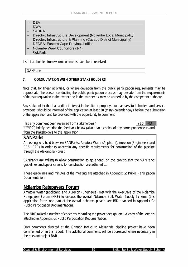
BASIC ASSESSMENT REPORT
Coastal & Environmental Services 57 Ndlambe Bulk Water Supply Scheme
− DEA − DWA − SAHRA − Director: Infrastructure Development (Ndlambe Local Municipality) − Director: Infrastructure & Planning (Cacadu District Municipality) − DEDEA: Eastern Cape Provincial office − Ndlambe Ward Councillors (1-4) − SANParks
List of authorities from whom comments have been received: SANParks 7. CONSULTATION WITH OTHER STAKEHOLDERS Note that, for linear activities, or where deviation from the public participation requirements may be appropriate, the person conducting the public participation process may deviate from the requirements of that subregulation to the extent and in the manner as may be agreed to by the competent authority. Any stakeholder that has a direct interest in the site or property, such as servitude holders and service providers, should be informed of the application at least 30 (thirty) calendar days before the submission of the application and be provided with the opportunity to comment. Has any comment been received from stakeholders? YES NO If “YES”, briefly describe the feedback below (also attach copies of any correspondence to and from the stakeholders to this application): SANParks A meeting was held between SANParks, Amatola Water (Applicant), Aurecon (Engineers), and CES (EAP) in order to ascertain any specific requirements for construction of the pipeline through the Alexandria Forest. SANParks are willing to allow construction to go ahead, on the proviso that the SANParks guidelines and specifications for construction are adhered to. These guidelines and minutes of the meeting are attached in Appendix G: Public Participation Documentation. Ndlambe Ratepayers Forum Amatola Water (applicant) and Aurecon (Engineers) met with the executive of the Ndlambe Ratepayers Forum (NRF) to discuss the overall Ndlambe Bulk Water Supply Scheme (this application forms one part of the overall scheme, please see BID attached in Appendix G: Public Participation Documentation). The NRF raised a number of concerns regarding the project design, etc. A copy of the letter is attached in Appendix G: Public Participation Documentation. Only comments directed at the Cannon Rocks to Alexandria pipeline project have been commented on in this report. The additional comments will be addressed where necessary in the relevant project BAR.
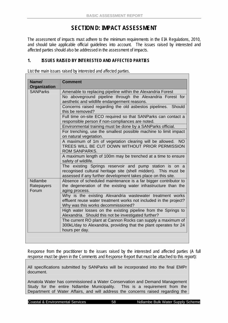
BASIC ASSESSMENT REPORT
Coastal & Environmental Services 58 Ndlambe Bulk Water Supply Scheme
SECTION D: IMPACT ASSESSMENT The assessment of impacts must adhere to the minimum requirements in the EIA Regulations, 2010, and should take applicable official guidelines into account. The issues raised by interested and affected parties should also be addressed in the assessment of impacts. 1. ISSUES RAISED BY INTERESTED AND AFFECTED PARTIES List the main issues raised by interested and affected parties.
Name/ Organization
Comment
SANParks Amenable to replacing pipeline within the Alexandria Forest No aboveground pipeline through the Alexandria Forest for aesthetic and wildlife endangerment reasons. Concerns raised regarding the old asbestos pipelines. Should this be removed? Full time on-site ECO required so that SANParks can contact a responsible person if non-compliances are noted. Environmental training must be done by a SANParks official. For trenching, use the smallest possible machine to limit impact on natural vegetation. A maximum of 1m of vegetation clearing will be allowed. NO TREES WILL BE CUT DOWN WITHOUT PRIOR PERMISSION ROM SANPARKS. A maximum length of 100m may be trenched at a time to ensure safety of wildlife. The existing Springs reservoir and pump station is on a recognised cultural heritage site (shell midden). This must be assessed if any further development takes place on this site.
Ndlambe Ratepayers Forum
Absence of scheduled maintenance is a far bigger contributor to the degeneration of the existing water infrastructure than the aging process. Why is the existing Alexandria wastewater treatment works effluent reuse water treatment works not included in the project? Why was this works decommissioned? High water losses on the existing pipeline from the Springs to Alexandria. Should this not be investigated further? The current RO plant at Cannon Rocks can supply a maximum of 300kL/day to Alexandria, providing that the plant operates for 24 hours per day.
Response from the practitioner to the issues raised by the interested and affected parties (A full response must be given in the Comments and Response Report that must be attached to this report):
All specifications submitted by SANParks will be incorporated into the final EMPr document. Amatola Water has commissioned a Water Conservation and Demand Management Study for the entire Ndlambe Municipality. This is a requirement from the Department of Water Affairs, and will address the concerns raised regarding the
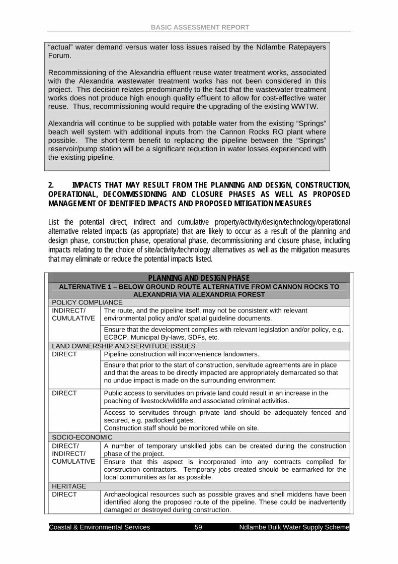
BASIC ASSESSMENT REPORT
Coastal & Environmental Services 59 Ndlambe Bulk Water Supply Scheme
“actual” water demand versus water loss issues raised by the Ndlambe Ratepayers Forum. Recommissioning of the Alexandria effluent reuse water treatment works, associated with the Alexandria wastewater treatment works has not been considered in this project. This decision relates predominantly to the fact that the wastewater treatment works does not produce high enough quality effluent to allow for cost-effective water reuse. Thus, recommissioning would require the upgrading of the existing WWTW. Alexandria will continue to be supplied with potable water from the existing “Springs” beach well system with additional inputs from the Cannon Rocks RO plant where possible. The short-term benefit to replacing the pipeline between the “Springs” reservoir/pump station will be a significant reduction in water losses experienced with the existing pipeline.
2. IMPACTS THAT MAY RESULT FROM THE PLANNING AND DESIGN, CONSTRUCTION, OPERATIONAL, DECOMMISSIONING AND CLOSURE PHASES AS WELL AS PROPOSED MANAGEMENT OF IDENTIFIED IMPACTS AND PROPOSED MITIGATION MEASURES List the potential direct, indirect and cumulative property/activity/design/technology/operational alternative related impacts (as appropriate) that are likely to occur as a result of the planning and design phase, construction phase, operational phase, decommissioning and closure phase, including impacts relating to the choice of site/activity/technology alternatives as well as the mitigation measures that may eliminate or reduce the potential impacts listed.
PLANNING AND DESIGN PHASE ALTERNATIVE 1 – BELOW GROUND ROUTE ALTERNATIVE FROM CANNON ROCKS TO
ALEXANDRIA VIA ALEXANDRIA FOREST POLICY COMPLIANCE INDIRECT/ CUMULATIVE
The route, and the pipeline itself, may not be consistent with relevant environmental policy and/or spatial guideline documents.
Ensure that the development complies with relevant legislation and/or policy, e.g. ECBCP, Municipal By-laws, SDFs, etc.
LAND OWNERSHIP AND SERVITUDE ISSUES DIRECT Pipeline construction will inconvenience landowners.
Ensure that prior to the start of construction, servitude agreements are in place and that the areas to be directly impacted are appropriately demarcated so that no undue impact is made on the surrounding environment.
DIRECT Public access to servitudes on private land could result in an increase in the poaching of livestock/wildlife and associated criminal activities.
Access to servitudes through private land should be adequately fenced and secured, e.g. padlocked gates. Construction staff should be monitored while on site.
SOCIO-ECONOMIC DIRECT/ INDIRECT/ CUMULATIVE
A number of temporary unskilled jobs can be created during the construction phase of the project. Ensure that this aspect is incorporated into any contracts compiled for construction contractors. Temporary jobs created should be earmarked for the local communities as far as possible.
HERITAGE DIRECT Archaeological resources such as possible graves and shell middens have been
identified along the proposed route of the pipeline. These could be inadvertently damaged or destroyed during construction.
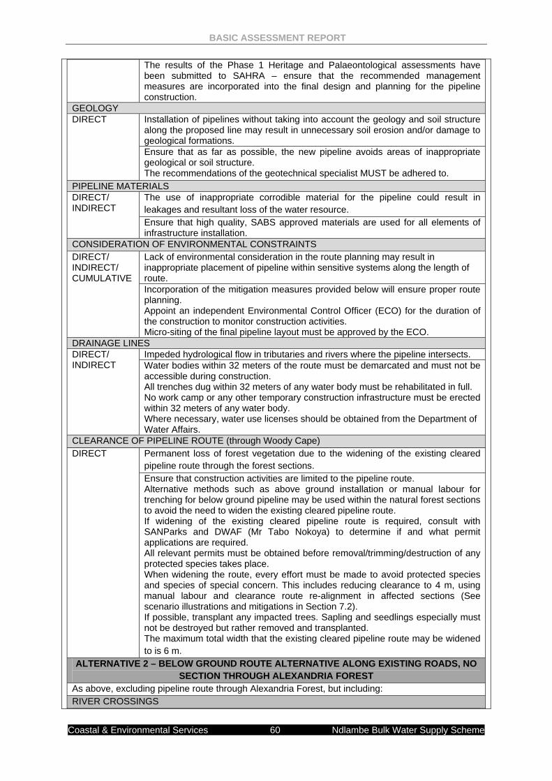
BASIC ASSESSMENT REPORT
Coastal & Environmental Services 60 Ndlambe Bulk Water Supply Scheme
The results of the Phase 1 Heritage and Palaeontological assessments have been submitted to SAHRA – ensure that the recommended management measures are incorporated into the final design and planning for the pipeline construction.
GEOLOGY DIRECT Installation of pipelines without taking into account the geology and soil structure
along the proposed line may result in unnecessary soil erosion and/or damage to geological formations. Ensure that as far as possible, the new pipeline avoids areas of inappropriate geological or soil structure. The recommendations of the geotechnical specialist MUST be adhered to.
PIPELINE MATERIALS DIRECT/ INDIRECT
The use of inappropriate corrodible material for the pipeline could result in leakages and resultant loss of the water resource. Ensure that high quality, SABS approved materials are used for all elements of infrastructure installation.
CONSIDERATION OF ENVIRONMENTAL CONSTRAINTS DIRECT/ INDIRECT/ CUMULATIVE
Lack of environmental consideration in the route planning may result in inappropriate placement of pipeline within sensitive systems along the length of route. Incorporation of the mitigation measures provided below will ensure proper route planning. Appoint an independent Environmental Control Officer (ECO) for the duration of the construction to monitor construction activities. Micro-siting of the final pipeline layout must be approved by the ECO.
DRAINAGE LINES DIRECT/ INDIRECT
Impeded hydrological flow in tributaries and rivers where the pipeline intersects. Water bodies within 32 meters of the route must be demarcated and must not be accessible during construction. All trenches dug within 32 meters of any water body must be rehabilitated in full. No work camp or any other temporary construction infrastructure must be erected within 32 meters of any water body. Where necessary, water use licenses should be obtained from the Department of Water Affairs.
CLEARANCE OF PIPELINE ROUTE (through Woody Cape) DIRECT Permanent loss of forest vegetation due to the widening of the existing cleared
pipeline route through the forest sections. Ensure that construction activities are limited to the pipeline route. Alternative methods such as above ground installation or manual labour for trenching for below ground pipeline may be used within the natural forest sections to avoid the need to widen the existing cleared pipeline route. If widening of the existing cleared pipeline route is required, consult with SANParks and DWAF (Mr Tabo Nokoya) to determine if and what permit applications are required. All relevant permits must be obtained before removal/trimming/destruction of any protected species takes place. When widening the route, every effort must be made to avoid protected species and species of special concern. This includes reducing clearance to 4 m, using manual labour and clearance route re-alignment in affected sections (See scenario illustrations and mitigations in Section 7.2). If possible, transplant any impacted trees. Sapling and seedlings especially must not be destroyed but rather removed and transplanted. The maximum total width that the existing cleared pipeline route may be widened to is 6 m.
ALTERNATIVE 2 – BELOW GROUND ROUTE ALTERNATIVE ALONG EXISTING ROADS, NO SECTION THROUGH ALEXANDRIA FOREST
As above, excluding pipeline route through Alexandria Forest, but including: RIVER CROSSINGS
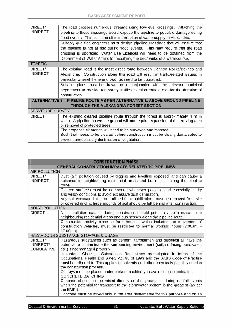
BASIC ASSESSMENT REPORT
Coastal & Environmental Services 61 Ndlambe Bulk Water Supply Scheme
CONSTRUCTION PHASE GENERAL CONSTRUCTION IMPACTS RELATED TO PIPELINES
AIR POLLUTION DIRECT/ INDIRECT
Dust (air) pollution caused by digging and levelling exposed land can cause a nuisance to neighbouring residential areas and businesses along the pipeline route. Cleared surfaces must be dampened whenever possible and especially in dry and windy conditions to avoid excessive dust generation. Any soil excavated, and not utilised for rehabilitation, must be removed from site or covered and no large mounds of soil should be left behind after construction.
NOISE POLLUTION DIRECT Noise pollution caused during construction could potentially be a nuisance to
neighbouring residential areas and businesses along the pipeline route. Construction activity close to farm houses, which includes the movement of construction vehicles, must be restricted to normal working hours (7:00am – 17:00pm).
HAZARDOUS SUBSTANCE STORAGE & USAGE DIRECT/ INDIRECT/ CUMULATIVE
Hazardous substances such as cement, tar/bitumen and diesel/oil all have the potential to contaminate the surrounding environment (soil, surface/groundwater, etc.) if not managed properly. Hazardous Chemical Substances Regulations promulgated in terms of the Occupational Health and Safety Act 85 of 1993 and the SABS Code of Practise must be adhered to. This applies to solvents and other chemicals possibly used in the construction process. Oil trays must be placed under parked machinery to avoid soil contamination. CONCRETE BATCHING Concrete should not be mixed directly on the ground, or during rainfall events when the potential for transport to the stormwater system is the greatest (as per the EMPr). Concrete must be mixed only in the area demarcated for this purpose and on an
DIRECT/ INDIRECT
The road crosses numerous streams using low-level crossings. Attaching the pipeline to these crossings would expose the pipeline to possible damage during flood events. This could result in interruption of water supply to Alexandria. Suitably qualified engineers must design pipeline crossings that will ensure that the pipeline is not at risk during flood events. This may require that the road crossing is upgraded. Water Use Licences will need to be obtained from the Department of Water Affairs for modifying the bed/banks of a watercourse.
TRAFFIC DIRECT/ INDIRECT
The existing road is the most direct route between Cannon Rocks/Boknes and Alexandria. Construction along this road will result in traffic-related issues; in particular when/if the river crossings need to be upgraded. Suitable plans must be drawn up in conjunction with the relevant municipal department to provide temporary traffic diversion routes, etc. for the duration of construction.
ALTERNATIVE 3 – PIPELINE ROUTE AS PER ALTERNATIVE 1, ABOVE GROUND PIPELINE THROUGH THE ALEXANDRIA FOREST SECTION
SERVITUDE SURVEY DIRECT The existing cleared pipeline route through the forest is approximately 4 m in
width. A pipeline above the ground will not require expansion of the existing area or removal of protected trees. The proposed clearance will need to be surveyed and mapped. Bush that needs to be cleared before construction must be clearly demarcated to prevent unnecessary destruction of vegetation.
BASIC ASSESSMENT REPORT
Coastal & Environmental Services 62 Ndlambe Bulk Water Supply Scheme
impermeable substratum. All areas affected during the Construction Phase should be rehabilitated. HAZARDOUS CHEMICAL SPILLS The individual responsible for or who discovers the spill must report the incident to the Project Coordinator, ECO and or Contractor as soon as reasonably possible. The problem must be assessed and the necessary actions required will be undertaken. The immediate response must be to contain the spill. Depending on the nature and extent of the spill, contaminated soil must be either excavated or treated on-site. The ECO must determine the precise method of treatment of polluted soil. This could involve the application of soil absorbent materials or oil-digestive powders to the contaminated soil. If a spill occurs on an impermeable surface such as cement or concrete, the surface spill must be contained using oil absorbent materials. Contaminated remediation materials must be carefully removed from the area of the spill so as to prevent further release of petrochemicals to the environment, and stored in adequate containers until appropriate disposal. HAZARDOUS CHEMICAL STORAGE Staff that will be handling hazardous materials must be trained to do so. All hazardous chemicals must be properly stored in a secure, bunded and contained area.
WORKER HEALTH AND SAFETY DIRECT/ INDIRECT
Inadequate attention to fire safety awareness and fire safety equipment could result in unsafe working environment and loss of property. Fire fighting equipment should be present on site at all times as per Occupational Health and Safety Act. All construction foremen must be trained in fire hazard control and fire fighting techniques. All flammable substances must be stored in dry areas which do not pose an ignition risk to the said substances. No open fires will be allowed on site unless in a demarcated area identified by the ECO. No smoking near flammable substance. All cooking shall be done in demarcated areas that are safe in terms of runaway or uncontrolled fires. The Contractor shall have operational fire-fighting equipment available on site at all times. The level of fire fighting equipment must be assessed and evaluated thorough a typical risk assessment process.
DIRECT/ INDIRECT
Failure to provide adequate onsite sanitation and clean drinking water may result in runoff transferring contaminants into the surrounding environment. Adequate sanitary and ablutions facilities must be provided for construction workers The facilities must be regularly serviced to reduce the risk of surface or groundwater pollution. Contaminated wastewater must be managed by the Contractor to ensure existing water resources on the site are not contaminated. All wastewater from general activities in the camp shall be collected and removed from the site for appropriate disposal at a licensed commercial facility.
WASTE MANAGMENT DIRECT/ INDIRECT
Littering on site may attract vermin, detract from the visual appeal of the area, and pollute the surrounding areas. Littering by the employees of the Contractor shall not be allowed under any circumstances. The ECO shall monitor the neatness of the work sites as well as the Contractor campsite. All waste must be removed from the site and transported to a licensed landfill site.
DIRECT/ INDIRECT
Hazardous waste e.g. used oils, offcuts, etc., could pollute surface and groundwater resources if not properly contained.
BASIC ASSESSMENT REPORT
Coastal & Environmental Services 63 Ndlambe Bulk Water Supply Scheme
All waste hazardous materials must be carefully stored as advised by the ECO, and then disposed of offsite at the licensed hazardous landfill site in Mt Frere. Contaminants must be stored safely to avoid spillage Machinery must be properly maintained to keep oil leaks in check.
SOCIO-ECONOMIC DIRECT/ INDIRECT/ CUMULATIVE
Temporary job creation during the construction phase. If manual labour is used for the section of pipeline to be replaced through the Alexandria Forest, this benefit would increase in significance.
RIVERS & STREAMS DIRECT/ INDIRECT/ CUMULATIVE
Potential negative impacts (e.g. Bulldozers, rubble etc.) on the various rivers and streams at pipeline crossing. All construction rubble must be removed from all rivers and streams after completion of work. The river/stream must be returned to its natural state after construction.
STORM WATER MANAGEMENT DIRECT/ INDIRECT/ CUMULATIVE
Runoff of stormwater containing contaminants, silt, sand and litter may contaminate the surrounding environment. The site must be managed in a manner that prevents pollution of drains, downstream watercourses or groundwater, due to suspended solids, silt or chemical pollutants. Temporary cut-off drains and berms may be required to capture storm water and promote infiltration. The area must be monitored by an ECO on a regular basis as described in the EMPr.
HERITAGE DIRECT The increase of heavy duty equipment would increase the potential for risks for
heritage sites along the pipeline route.
Any shell middens that are exposed during the course of construction, need to be reported to the heritage Impact assessor, the ECO and SAHRA immediately. If any graves or remains are exposed during construction phase, then all work in that area needs to be stopped and SAHRA needs to be informed immediately.
ALTERNATIVE 1 - BELOW GROUND ROUTE ALTERNATIVE FROM CANNON ROCKS TO ALEXANDRIA VIA ALEXANDRIA FOREST
General impacts as above, including: REMOVAL OF TREES TO WIDEN SERVITUDE DIRECT/ CUMULATIVE
Permanent loss of forest vegetation due to the widening of the existing cleared pipeline route through the forest sections. Ensure that construction activities are limited to the pipeline route. Alternative methods such as above ground installation or manual labour for trenching for below ground pipeline may be used within the natural forest sections to avoid the need to widen the existing cleared pipeline route. If widening of the existing cleared pipeline route is required, consult with SANParks and DWAF (Mr Tabo Nokoya) to determine if and what permit applications are required. All relevant permits must be obtained before removal/trimming/destruction of any protected species takes place. When widening the route, every effort must be made to avoid protected species and species of special concern. This includes reducing clearance to 4 m, using manual labour and clearance route re-alignment in affected sections (See scenario illustrations and mitigations in Section 7.2). If possible, transplant any impacted trees. Sapling and seedlings especially must not be destroyed but rather removed and transplanted. The maximum total width that the existing cleared pipeline route may be widened to is 6 m.
BIODIVERSITY DIRECT Excessive damage to surrounding biodiversity due to unrestricted construction
activities and vehicular movement within the Alexandria forest section. Construction activities must be restricted within the existing pipeline cleared route within the Alexandria forest.
BASIC ASSESSMENT REPORT
Coastal & Environmental Services 64 Ndlambe Bulk Water Supply Scheme
An ECO must be on site twice a week or more during construction in the Alexandria forest to monitor construction activities.
DIRECT Site, site camps, storage facilities and ablution facilities may impact on vulnerable Alexandria forest through inappropriate waste management (litter, sewage and hydrocarbon pollution) and potential break-away fires. Camps and ablution facilities are to be placed in currently impacted areas, at least 100 meters away from any forest area. An appropriate waste management programme must be implemented throughout the construction phase. Fires for cooking must be located within an enclosed, demarcated area. No fires will be allowed in the Alexandria forest. Fire-fighting equipment must be kept onsite in order to contain an accidental fire.
SOIL EROSION DIRECT/ INDIRECT
Soil erosion on steep slopes due to disturbance of highly erosive soils and poor rehabilitation. Ensure that construction sites are stabilised and soil is prevented from unnecessary exposure. Implement vegetation re-establishment as part of a detailed Rehabilitation Plan.
INDIRECT Building unnecessary access roads may result in high level surface erosion of these tracks. Ensure that current road infrastructure is used to access remote areas of the pipeline layout.
INDIRECT Cut and fill of soil on steep slopes within the Alexandria forest section may affect protected trees. Avoid cut and fill of soil on steep slopes within the Alexandria forest where protected trees will be affected.
COMPLIANCE WITH THE EMPr DIRECT/ INDIRECT/ CUMULATIVE
Non-compliance with the EMPr in this section of the forest could result in significant environmental degradation in terms of forest biodiversity, etc. An ECO MUST be on site a minimum of two days per week while construction occurs within the forest. The ECO will determine the extent to which bush is cleared and will clearly demarcate which plants/trees are to be avoided.
ALTERNATIVE 2 – ROUTE ALTERNATIVE ALONG EXISTING ROADS General impacts as above, including STREAM CROSSINGS DIRECT/ INDIRECT/ CUMULATIVE
Inappropriate disturbance and modification to the streams during construction of upgraded stream crossings at various (3) locations may lead to significant changes to the hydrology of the stream systems. This could have negative consequences on the entire Boknes River system. Construction of any river crossings MUST comply with an EMPr approved by the Department of Water Affairs and by the Department of Environmental Affairs Use MUST be made of ecologically acceptable temporary diversion methods if necessary. Construction of stream crossings MUST be done under supervision of the ECO.
ALTERNATIVE 3 – PIPELINE ROUTE AS PER ALTERNATIVE 1, ABOVE GROUND PIPELINE THROUGH THE ALEXANDRIA FOREST SECTION
General impacts as above, including PIPELINE ANCHORING DIRECT/ INDIRECT
Underlying soil structure may result in a need to anchor pipeline infrastructure using concrete pedestals. Batching of concrete within the forest section could result in contamination of the surrounding surface water environment. All concrete MUST be mixed on a suitably bunded temporary area. Contaminated water from concrete mixing should be collected and disposed of according to the instructions of the ECO
SOIL EROSION INDIRECT Soil erosion on steep slopes due to disturbance of highly erosive soils and poor
rehabilitation. Ensure that construction sites are stabilised and soil is prevented from
BASIC ASSESSMENT REPORT
Coastal & Environmental Services 65 Ndlambe Bulk Water Supply Scheme
unnecessary exposure. Implement vegetation re-establishment as part of a detailed Rehabilitation Plan.
INDIRECT Cut and fill of soil on steep slopes within the Alexandria forest section may affect protected trees. Avoid cut and fill of soil on steep slopes within the Alexandria forest where protected trees will be affected.
COMPLIANCE WITH THE EMPr DIRECT/ INDIRECT/ CUMULATIVE
Non-compliance with the EMPr in this section of the forest could result in significant environmental degradation in terms of forest biodiversity, etc. An ECO MUST be on site a minimum of two days per week while construction occurs within the forest. The ECO will determine the extent to which bush is cleared and will clearly demarcate which plants/trees are to be avoided.
OPERATIONAL PHASE MAINTENANCE DIRECT Non-compliance to a pipeline maintenance schedule would result in the pipeline
becoming overgrown and perhaps incurring damage. Regular inspection of the pipeline must take place to monitor its operational status.
DIRECT/ INDIRECT
Disturbance of vegetation due to on-going utilisation of service roads could initiate erosion events. Service roads should remain within the servitude as much as possible. Avoid creating permanent tracks. Monitor for erosion and rehabilitate if necessary.
DIRECT/ INDIRECT/ CUMULATIVE
Non-compliance with a pipeline maintenance schedule could result in leaks going undetected. Pipelines MUST be regularly monitored for leaks. If these are identified or reported by the public, immediate actions must be taken to remedy the situation.
SOCIO-ECONOMIC DIRECT/ INDIRECT/ CUMULATIVE
Availability of water will result in increased housing development and increased confidence in the tourism industry.
No mitigation provided
ALTERNATIVE 4 – NO GO WATER SUPPLY DIRECT/ CUMULATIVE
Alexandria will continue to be water-scarce due to the current state of disrepair of the existing pipeline. This will continue to hamper formal growth of the urban node and slow eradication of the informal housing sector. No mitigation
FOREST CLEARANCE DIRECT A further routing will not need to be cleared through the Woody Cape Nature
Reserve. This will ensure the continued protection of the indigenous tree species surrounding the existing pipeline. No mitigation
3. ENVIRONMENTAL IMPACT STATEMENT Taking the assessment of potential impacts into account, please provide an environmental impact statement that summarises the impact that the proposed activity and its alternatives may have on the environment after the management and mitigation of impacts have been taken into account, with

BASIC ASSESSMENT REPORT
Coastal & Environmental Services 66 Ndlambe Bulk Water Supply Scheme
specific reference to types of impact, duration of impacts, likelihood of potential impacts actually occurring and the significance of impacts.
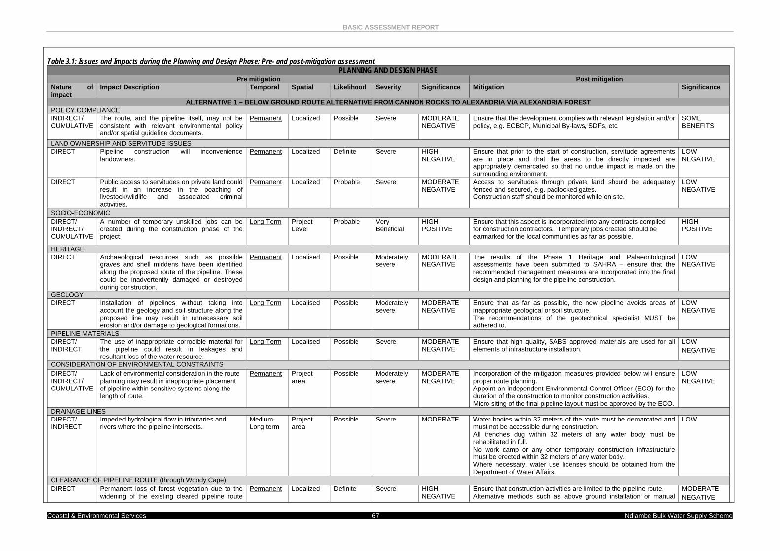
BASIC ASSESSMENT REPORT
Coastal & Environmental Services 67 Ndlambe Bulk Water Supply Scheme
Table 3.1: Issues and Impacts during the Planning and Design Phase: Pre- and post-mitigation assessment
PLANNING AND DESIGN PHASE Pre mitigation Post mitigation
Nature of impact
Impact Description Temporal Spatial Likelihood Severity Significance Mitigation Significance
ALTERNATIVE 1 – BELOW GROUND ROUTE ALTERNATIVE FROM CANNON ROCKS TO ALEXANDRIA VIA ALEXANDRIA FOREST POLICY COMPLIANCE INDIRECT/ CUMULATIVE
The route, and the pipeline itself, may not be consistent with relevant environmental policy and/or spatial guideline documents.
Permanent Localized Possible Severe MODERATE NEGATIVE
Ensure that the development complies with relevant legislation and/or policy, e.g. ECBCP, Municipal By-laws, SDFs, etc.
SOME BENEFITS
LAND OWNERSHIP AND SERVITUDE ISSUES DIRECT Pipeline construction will inconvenience
landowners. Permanent Localized Definite Severe HIGH
NEGATIVE Ensure that prior to the start of construction, servitude agreements are in place and that the areas to be directly impacted are appropriately demarcated so that no undue impact is made on the surrounding environment.
LOW NEGATIVE
DIRECT Public access to servitudes on private land could result in an increase in the poaching of livestock/wildlife and associated criminal activities.
Permanent Localized Probable Severe MODERATE NEGATIVE
Access to servitudes through private land should be adequately fenced and secured, e.g. padlocked gates. Construction staff should be monitored while on site.
LOW NEGATIVE
SOCIO-ECONOMIC DIRECT/ INDIRECT/ CUMULATIVE
A number of temporary unskilled jobs can be created during the construction phase of the project.
Long Term Project Level
Probable Very Beneficial
HIGH POSITIVE
Ensure that this aspect is incorporated into any contracts compiled for construction contractors. Temporary jobs created should be earmarked for the local communities as far as possible.
HIGH POSITIVE
HERITAGE DIRECT Archaeological resources such as possible
graves and shell middens have been identified along the proposed route of the pipeline. These could be inadvertently damaged or destroyed during construction.
Permanent Localised Possible Moderately severe
MODERATE NEGATIVE
The results of the Phase 1 Heritage and Palaeontological assessments have been submitted to SAHRA – ensure that the recommended management measures are incorporated into the final design and planning for the pipeline construction.
LOW NEGATIVE
GEOLOGY DIRECT Installation of pipelines without taking into
account the geology and soil structure along the proposed line may result in unnecessary soil erosion and/or damage to geological formations.
Long Term Localised Possible Moderately severe
MODERATE NEGATIVE
Ensure that as far as possible, the new pipeline avoids areas of inappropriate geological or soil structure. The recommendations of the geotechnical specialist MUST be adhered to.
LOW NEGATIVE
PIPELINE MATERIALS DIRECT/ INDIRECT
The use of inappropriate corrodible material for the pipeline could result in leakages and resultant loss of the water resource.
Long Term Localised Possible Severe MODERATE NEGATIVE
Ensure that high quality, SABS approved materials are used for all elements of infrastructure installation.
LOW NEGATIVE
CONSIDERATION OF ENVIRONMENTAL CONSTRAINTS DIRECT/ INDIRECT/ CUMULATIVE
Lack of environmental consideration in the route planning may result in inappropriate placement of pipeline within sensitive systems along the length of route.
Permanent Project area
Possible Moderately severe
MODERATE NEGATIVE
Incorporation of the mitigation measures provided below will ensure proper route planning. Appoint an independent Environmental Control Officer (ECO) for the duration of the construction to monitor construction activities. Micro-siting of the final pipeline layout must be approved by the ECO.
LOW NEGATIVE
DRAINAGE LINES DIRECT/ INDIRECT
Impeded hydrological flow in tributaries and rivers where the pipeline intersects.
Medium-Long term
Project area
Possible Severe MODERATE Water bodies within 32 meters of the route must be demarcated and must not be accessible during construction. All trenches dug within 32 meters of any water body must be rehabilitated in full. No work camp or any other temporary construction infrastructure must be erected within 32 meters of any water body. Where necessary, water use licenses should be obtained from the Department of Water Affairs.
LOW
CLEARANCE OF PIPELINE ROUTE (through Woody Cape) DIRECT Permanent loss of forest vegetation due to the
widening of the existing cleared pipeline route Permanent Localized Definite Severe HIGH
NEGATIVE Ensure that construction activities are limited to the pipeline route. Alternative methods such as above ground installation or manual
MODERATE NEGATIVE
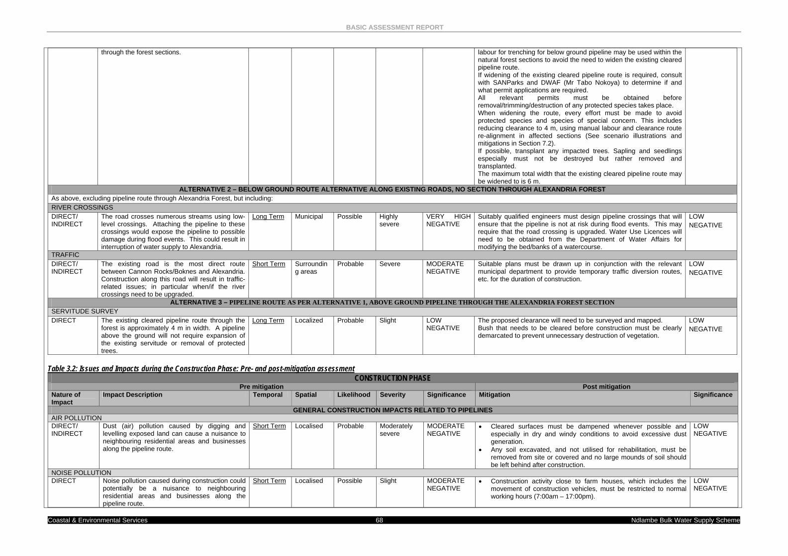
BASIC ASSESSMENT REPORT
Coastal & Environmental Services 68 Ndlambe Bulk Water Supply Scheme
Table 3.2: Issues and Impacts during the Construction Phase: Pre- and post-mitigation assessment
CONSTRUCTION PHASE Pre mitigation Post mitigation
Nature of Impact
Impact Description Temporal Spatial Likelihood Severity Significance Mitigation Significance
GENERAL CONSTRUCTION IMPACTS RELATED TO PIPELINES AIR POLLUTION DIRECT/ INDIRECT
Dust (air) pollution caused by digging and levelling exposed land can cause a nuisance to neighbouring residential areas and businesses along the pipeline route.
Short Term Localised Probable Moderately severe
MODERATE NEGATIVE
• Cleared surfaces must be dampened whenever possible and especially in dry and windy conditions to avoid excessive dust generation.
• Any soil excavated, and not utilised for rehabilitation, must be removed from site or covered and no large mounds of soil should be left behind after construction.
LOW NEGATIVE
NOISE POLLUTION DIRECT Noise pollution caused during construction could
potentially be a nuisance to neighbouring residential areas and businesses along the pipeline route.
Short Term Localised Possible Slight MODERATE NEGATIVE
• Construction activity close to farm houses, which includes the movement of construction vehicles, must be restricted to normal working hours (7:00am – 17:00pm).
LOW NEGATIVE
through the forest sections. labour for trenching for below ground pipeline may be used within the natural forest sections to avoid the need to widen the existing cleared pipeline route. If widening of the existing cleared pipeline route is required, consult with SANParks and DWAF (Mr Tabo Nokoya) to determine if and what permit applications are required. All relevant permits must be obtained before removal/trimming/destruction of any protected species takes place. When widening the route, every effort must be made to avoid protected species and species of special concern. This includes reducing clearance to 4 m, using manual labour and clearance route re-alignment in affected sections (See scenario illustrations and mitigations in Section 7.2). If possible, transplant any impacted trees. Sapling and seedlings especially must not be destroyed but rather removed and transplanted. The maximum total width that the existing cleared pipeline route may be widened to is 6 m.
ALTERNATIVE 2 – BELOW GROUND ROUTE ALTERNATIVE ALONG EXISTING ROADS, NO SECTION THROUGH ALEXANDRIA FOREST As above, excluding pipeline route through Alexandria Forest, but including: RIVER CROSSINGS DIRECT/ INDIRECT
The road crosses numerous streams using low-level crossings. Attaching the pipeline to these crossings would expose the pipeline to possible damage during flood events. This could result in interruption of water supply to Alexandria.
Long Term Municipal Possible Highly severe
VERY HIGH NEGATIVE
Suitably qualified engineers must design pipeline crossings that will ensure that the pipeline is not at risk during flood events. This may require that the road crossing is upgraded. Water Use Licences will need to be obtained from the Department of Water Affairs for modifying the bed/banks of a watercourse.
LOW NEGATIVE
TRAFFIC DIRECT/ INDIRECT
The existing road is the most direct route between Cannon Rocks/Boknes and Alexandria. Construction along this road will result in traffic-related issues; in particular when/if the river crossings need to be upgraded.
Short Term Surrounding areas
Probable Severe MODERATE NEGATIVE
Suitable plans must be drawn up in conjunction with the relevant municipal department to provide temporary traffic diversion routes, etc. for the duration of construction.
LOW NEGATIVE
ALTERNATIVE 3 – PIPELINE ROUTE AS PER ALTERNATIVE 1, ABOVE GROUND PIPELINE THROUGH THE ALEXANDRIA FOREST SECTION SERVITUDE SURVEY DIRECT The existing cleared pipeline route through the
forest is approximately 4 m in width. A pipeline above the ground will not require expansion of the existing servitude or removal of protected trees.
Long Term Localized Probable Slight LOW NEGATIVE
The proposed clearance will need to be surveyed and mapped. Bush that needs to be cleared before construction must be clearly demarcated to prevent unnecessary destruction of vegetation.
LOW NEGATIVE
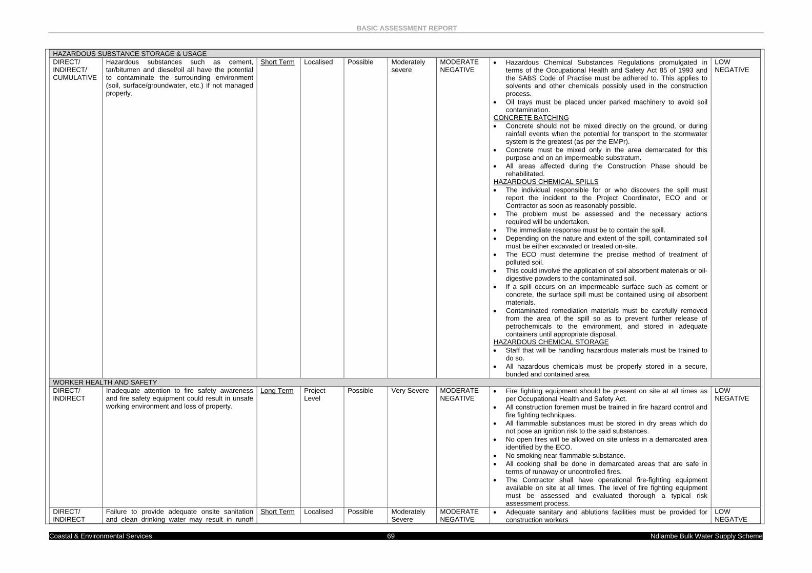
BASIC ASSESSMENT REPORT
Coastal & Environmental Services 69 Ndlambe Bulk Water Supply Scheme
HAZARDOUS SUBSTANCE STORAGE & USAGE DIRECT/ INDIRECT/ CUMULATIVE
Hazardous substances such as cement, tar/bitumen and diesel/oil all have the potential to contaminate the surrounding environment (soil, surface/groundwater, etc.) if not managed properly.
Short Term Localised Possible Moderately severe
MODERATE NEGATIVE
• Hazardous Chemical Substances Regulations promulgated in terms of the Occupational Health and Safety Act 85 of 1993 and the SABS Code of Practise must be adhered to. This applies to solvents and other chemicals possibly used in the construction process.
• Oil trays must be placed under parked machinery to avoid soil contamination.
CONCRETE BATCHING • Concrete should not be mixed directly on the ground, or during
rainfall events when the potential for transport to the stormwater system is the greatest (as per the EMPr).
• Concrete must be mixed only in the area demarcated for this purpose and on an impermeable substratum.
• All areas affected during the Construction Phase should be rehabilitated.
HAZARDOUS CHEMICAL SPILLS • The individual responsible for or who discovers the spill must
report the incident to the Project Coordinator, ECO and or Contractor as soon as reasonably possible.
• The problem must be assessed and the necessary actions required will be undertaken.
• The immediate response must be to contain the spill. • Depending on the nature and extent of the spill, contaminated soil
must be either excavated or treated on-site. • The ECO must determine the precise method of treatment of
polluted soil. • This could involve the application of soil absorbent materials or oil-
digestive powders to the contaminated soil. • If a spill occurs on an impermeable surface such as cement or
concrete, the surface spill must be contained using oil absorbent materials.
• Contaminated remediation materials must be carefully removed from the area of the spill so as to prevent further release of petrochemicals to the environment, and stored in adequate containers until appropriate disposal.
HAZARDOUS CHEMICAL STORAGE • Staff that will be handling hazardous materials must be trained to
do so. • All hazardous chemicals must be properly stored in a secure,
bunded and contained area.
LOW NEGATIVE
WORKER HEALTH AND SAFETY DIRECT/ INDIRECT
Inadequate attention to fire safety awareness and fire safety equipment could result in unsafe working environment and loss of property.
Long Term Project Level
Possible Very Severe MODERATE NEGATIVE
• Fire fighting equipment should be present on site at all times as per Occupational Health and Safety Act.
• All construction foremen must be trained in fire hazard control and fire fighting techniques.
• All flammable substances must be stored in dry areas which do not pose an ignition risk to the said substances.
• No open fires will be allowed on site unless in a demarcated area identified by the ECO.
• No smoking near flammable substance. • All cooking shall be done in demarcated areas that are safe in
terms of runaway or uncontrolled fires. • The Contractor shall have operational fire-fighting equipment
available on site at all times. The level of fire fighting equipment must be assessed and evaluated thorough a typical risk assessment process.
LOW NEGATIVE
DIRECT/ INDIRECT
Failure to provide adequate onsite sanitation and clean drinking water may result in runoff
Short Term Localised Possible Moderately Severe
MODERATE NEGATIVE
• Adequate sanitary and ablutions facilities must be provided for construction workers
LOW NEGATVE
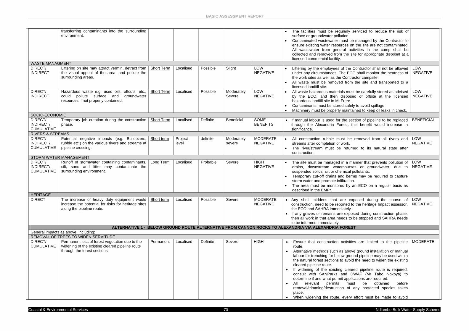
BASIC ASSESSMENT REPORT
Coastal & Environmental Services 70 Ndlambe Bulk Water Supply Scheme
transferring contaminants into the surrounding environment.
• The facilities must be regularly serviced to reduce the risk of surface or groundwater pollution.
• Contaminated wastewater must be managed by the Contractor to ensure existing water resources on the site are not contaminated. All wastewater from general activities in the camp shall be collected and removed from the site for appropriate disposal at a licensed commercial facility.
WASTE MANAGMENT DIRECT/ INDIRECT
Littering on site may attract vermin, detract from the visual appeal of the area, and pollute the surrounding areas.
Short Term Localised Possible Slight LOW NEGATIVE
• Littering by the employees of the Contractor shall not be allowed under any circumstances. The ECO shall monitor the neatness of the work sites as well as the Contractor campsite.
• All waste must be removed from the site and transported to a licensed landfill site.
LOW NEGATIVE
DIRECT/ INDIRECT
Hazardous waste e.g. used oils, offcuts, etc., could pollute surface and groundwater resources if not properly contained.
Short Term Localised Possible Moderately Severe
LOW NEGATIVE
• All waste hazardous materials must be carefully stored as advised by the ECO, and then disposed of offsite at the licensed hazardous landfill site in Mt Frere.
• Contaminants must be stored safely to avoid spillage • Machinery must be properly maintained to keep oil leaks in check.
LOW NEGATIVE
SOCIO-ECONOMIC DIRECT/ INDIRECT/ CUMULATIVE
Temporary job creation during the construction phase.
Short Term Localised Definite Beneficial SOME BENEFITS
• If manual labour is used for the section of pipeline to be replaced through the Alexandria Forest, this benefit would increase in significance.
BENEFICIAL
RIVERS & STREAMS DIRECT/ INDIRECT/ CUMULATIVE
Potential negative impacts (e.g. Bulldozers, rubble etc.) on the various rivers and streams at pipeline crossing.
Short term Project level
definite Moderately severe
MODERATE NEGATIVE
• All construction rubble must be removed from all rivers and streams after completion of work.
• The river/stream must be returned to its natural state after construction.
LOW NEGATIVE
STORM WATER MANAGEMENT DIRECT/ INDIRECT/ CUMULATIVE
Runoff of stormwater containing contaminants, silt, sand and litter may contaminate the surrounding environment.
Long Term Localised Probable Severe HIGH NEGATIVE
• The site must be managed in a manner that prevents pollution of drains, downstream watercourses or groundwater, due to suspended solids, silt or chemical pollutants.
• Temporary cut-off drains and berms may be required to capture storm water and promote infiltration.
• The area must be monitored by an ECO on a regular basis as described in the EMPr.
LOW NEGATIVE
HERITAGE DIRECT The increase of heavy duty equipment would
increase the potential for risks for heritage sites along the pipeline route.
Short term Localised Possible Severe MODERATE NEGATIVE
• Any shell middens that are exposed during the course of construction, need to be reported to the heritage Impact assessor, the ECO and SAHRA immediately.
• If any graves or remains are exposed during construction phase, then all work in that area needs to be stopped and SAHRA needs to be informed immediately.
LOW NEGATIVE
ALTERNATIVE 1 - BELOW GROUND ROUTE ALTERNATIVE FROM CANNON ROCKS TO ALEXANDRIA VIA ALEXANDRIA FOREST General impacts as above, including: REMOVAL OF TREES TO WIDEN SERVITUDE DIRECT/ CUMULATIVE
Permanent loss of forest vegetation due to the widening of the existing cleared pipeline route through the forest sections.
Permanent Localised Definite Severe HIGH • Ensure that construction activities are limited to the pipeline route.
• Alternative methods such as above ground installation or manual labour for trenching for below ground pipeline may be used within the natural forest sections to avoid the need to widen the existing cleared pipeline route.
• If widening of the existing cleared pipeline route is required, consult with SANParks and DWAF (Mr Tabo Nokoya) to determine if and what permit applications are required.
• All relevant permits must be obtained before removal/trimming/destruction of any protected species takes place.
• When widening the route, every effort must be made to avoid
MODERATE
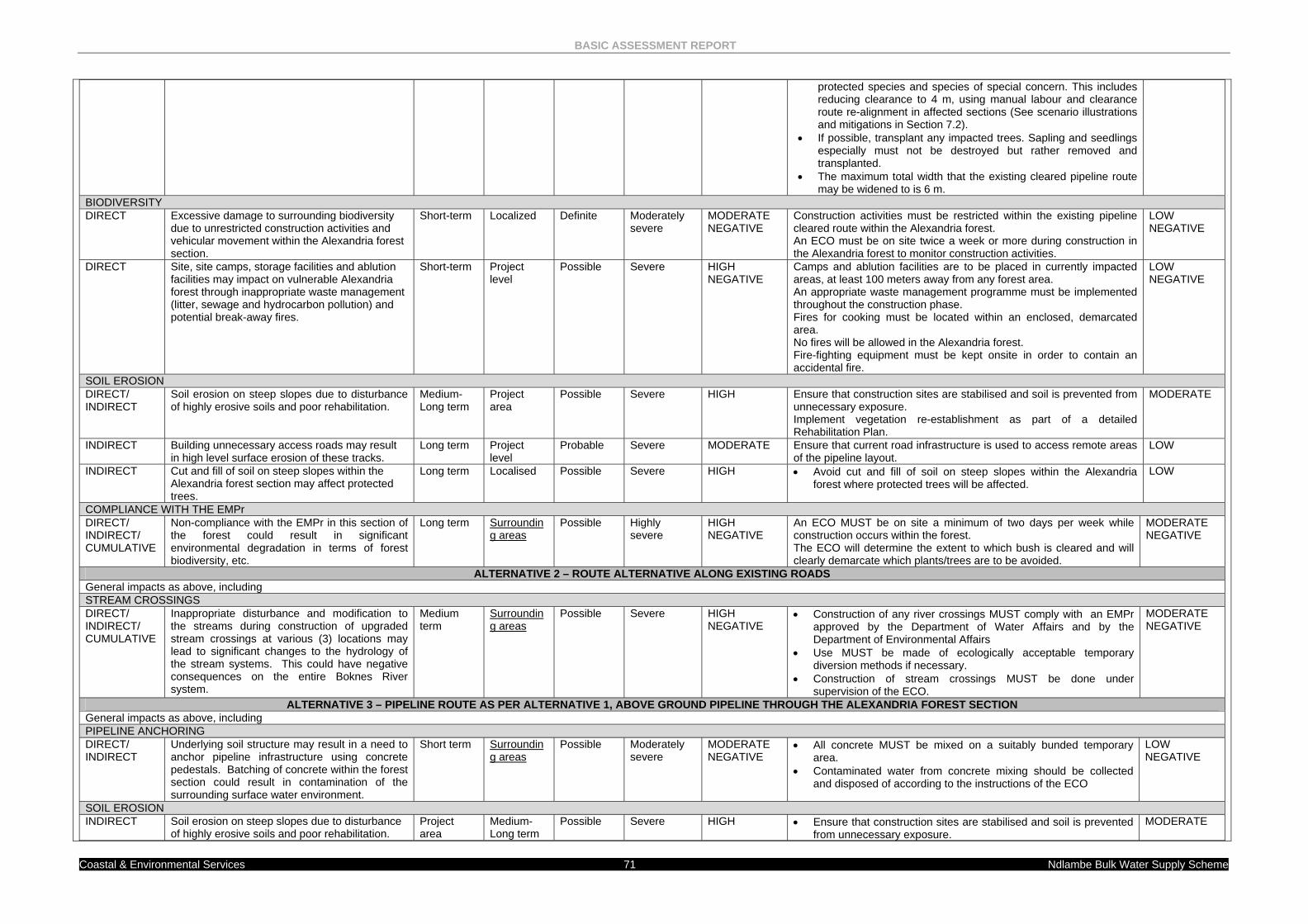
BASIC ASSESSMENT REPORT
Coastal & Environmental Services 71 Ndlambe Bulk Water Supply Scheme
protected species and species of special concern. This includes reducing clearance to 4 m, using manual labour and clearance route re-alignment in affected sections (See scenario illustrations and mitigations in Section 7.2).
• If possible, transplant any impacted trees. Sapling and seedlings especially must not be destroyed but rather removed and transplanted.
• The maximum total width that the existing cleared pipeline route may be widened to is 6 m.
BIODIVERSITY DIRECT Excessive damage to surrounding biodiversity
due to unrestricted construction activities and vehicular movement within the Alexandria forest section.
Short-term Localized Definite Moderately severe
MODERATE NEGATIVE
Construction activities must be restricted within the existing pipeline cleared route within the Alexandria forest. An ECO must be on site twice a week or more during construction in the Alexandria forest to monitor construction activities.
LOW NEGATIVE
DIRECT Site, site camps, storage facilities and ablution facilities may impact on vulnerable Alexandria forest through inappropriate waste management (litter, sewage and hydrocarbon pollution) and potential break-away fires.
Short-term Project level
Possible Severe HIGH NEGATIVE
Camps and ablution facilities are to be placed in currently impacted areas, at least 100 meters away from any forest area. An appropriate waste management programme must be implemented throughout the construction phase. Fires for cooking must be located within an enclosed, demarcated area. No fires will be allowed in the Alexandria forest. Fire-fighting equipment must be kept onsite in order to contain an accidental fire.
LOW NEGATIVE
SOIL EROSION DIRECT/ INDIRECT
Soil erosion on steep slopes due to disturbance of highly erosive soils and poor rehabilitation.
Medium-Long term
Project area
Possible Severe HIGH Ensure that construction sites are stabilised and soil is prevented from unnecessary exposure. Implement vegetation re-establishment as part of a detailed Rehabilitation Plan.
MODERATE
INDIRECT Building unnecessary access roads may result in high level surface erosion of these tracks.
Long term Project level
Probable Severe MODERATE Ensure that current road infrastructure is used to access remote areas of the pipeline layout.
LOW
INDIRECT Cut and fill of soil on steep slopes within the Alexandria forest section may affect protected trees.
Long term Localised Possible Severe HIGH • Avoid cut and fill of soil on steep slopes within the Alexandria forest where protected trees will be affected.
LOW
COMPLIANCE WITH THE EMPr DIRECT/ INDIRECT/ CUMULATIVE
Non-compliance with the EMPr in this section of the forest could result in significant environmental degradation in terms of forest biodiversity, etc.
Long term Surrounding areas
Possible Highly severe
HIGH NEGATIVE
An ECO MUST be on site a minimum of two days per week while construction occurs within the forest. The ECO will determine the extent to which bush is cleared and will clearly demarcate which plants/trees are to be avoided.
MODERATE NEGATIVE
ALTERNATIVE 2 – ROUTE ALTERNATIVE ALONG EXISTING ROADS General impacts as above, including STREAM CROSSINGS DIRECT/ INDIRECT/ CUMULATIVE
Inappropriate disturbance and modification to the streams during construction of upgraded stream crossings at various (3) locations may lead to significant changes to the hydrology of the stream systems. This could have negative consequences on the entire Boknes River system.
Medium term
Surrounding areas
Possible Severe HIGH NEGATIVE
• Construction of any river crossings MUST comply with an EMPr approved by the Department of Water Affairs and by the Department of Environmental Affairs
• Use MUST be made of ecologically acceptable temporary diversion methods if necessary.
• Construction of stream crossings MUST be done under supervision of the ECO.
MODERATE NEGATIVE
ALTERNATIVE 3 – PIPELINE ROUTE AS PER ALTERNATIVE 1, ABOVE GROUND PIPELINE THROUGH THE ALEXANDRIA FOREST SECTION General impacts as above, including PIPELINE ANCHORING DIRECT/ INDIRECT
Underlying soil structure may result in a need to anchor pipeline infrastructure using concrete pedestals. Batching of concrete within the forest section could result in contamination of the surrounding surface water environment.
Short term Surrounding areas
Possible Moderately severe
MODERATE NEGATIVE
• All concrete MUST be mixed on a suitably bunded temporary area.
• Contaminated water from concrete mixing should be collected and disposed of according to the instructions of the ECO
LOW NEGATIVE
SOIL EROSION INDIRECT Soil erosion on steep slopes due to disturbance
of highly erosive soils and poor rehabilitation. Project area
Medium-Long term
Possible Severe HIGH • Ensure that construction sites are stabilised and soil is prevented from unnecessary exposure.
MODERATE
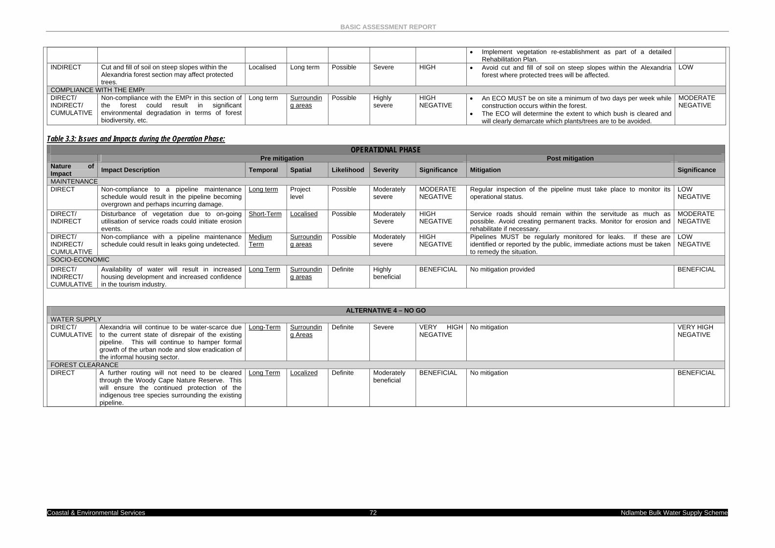
BASIC ASSESSMENT REPORT
Coastal & Environmental Services 72 Ndlambe Bulk Water Supply Scheme
• Implement vegetation re-establishment as part of a detailed Rehabilitation Plan.
INDIRECT Cut and fill of soil on steep slopes within the Alexandria forest section may affect protected trees.
Localised Long term Possible Severe HIGH • Avoid cut and fill of soil on steep slopes within the Alexandria forest where protected trees will be affected.
LOW
COMPLIANCE WITH THE EMPr DIRECT/ INDIRECT/ CUMULATIVE
Non-compliance with the EMPr in this section of the forest could result in significant environmental degradation in terms of forest biodiversity, etc.
Long term Surrounding areas
Possible Highly severe
HIGH NEGATIVE
• An ECO MUST be on site a minimum of two days per week while construction occurs within the forest.
• The ECO will determine the extent to which bush is cleared and will clearly demarcate which plants/trees are to be avoided.
MODERATE NEGATIVE
Table 3.3: Issues and Impacts during the Operation Phase:
OPERATIONAL PHASE Pre mitigation Post mitigation Nature of Impact Impact Description Temporal Spatial Likelihood Severity Significance Mitigation Significance
MAINTENANCE DIRECT Non-compliance to a pipeline maintenance
schedule would result in the pipeline becoming overgrown and perhaps incurring damage.
Long term Project level
Possible Moderately severe
MODERATE NEGATIVE
Regular inspection of the pipeline must take place to monitor its operational status.
LOW NEGATIVE
DIRECT/ INDIRECT
Disturbance of vegetation due to on-going utilisation of service roads could initiate erosion events.
Short-Term Localised Possible Moderately Severe
HIGH NEGATIVE
Service roads should remain within the servitude as much as possible. Avoid creating permanent tracks. Monitor for erosion and rehabilitate if necessary.
MODERATE NEGATIVE
DIRECT/ INDIRECT/ CUMULATIVE
Non-compliance with a pipeline maintenance schedule could result in leaks going undetected.
Medium Term
Surrounding areas
Possible Moderately severe
HIGH NEGATIVE
Pipelines MUST be regularly monitored for leaks. If these are identified or reported by the public, immediate actions must be taken to remedy the situation.
LOW NEGATIVE
SOCIO-ECONOMIC DIRECT/ INDIRECT/ CUMULATIVE
Availability of water will result in increased housing development and increased confidence in the tourism industry.
Long Term Surrounding areas
Definite Highly beneficial
BENEFICIAL No mitigation provided BENEFICIAL
ALTERNATIVE 4 – NO GO WATER SUPPLY DIRECT/ CUMULATIVE
Alexandria will continue to be water-scarce due to the current state of disrepair of the existing pipeline. This will continue to hamper formal growth of the urban node and slow eradication of the informal housing sector.
Long-Term Surrounding Areas
Definite Severe VERY HIGH NEGATIVE
No mitigation VERY HIGH NEGATIVE
FOREST CLEARANCE DIRECT A further routing will not need to be cleared
through the Woody Cape Nature Reserve. This will ensure the continued protection of the indigenous tree species surrounding the existing pipeline.
Long Term Localized Definite Moderately beneficial
BENEFICIAL No mitigation BENEFICIAL
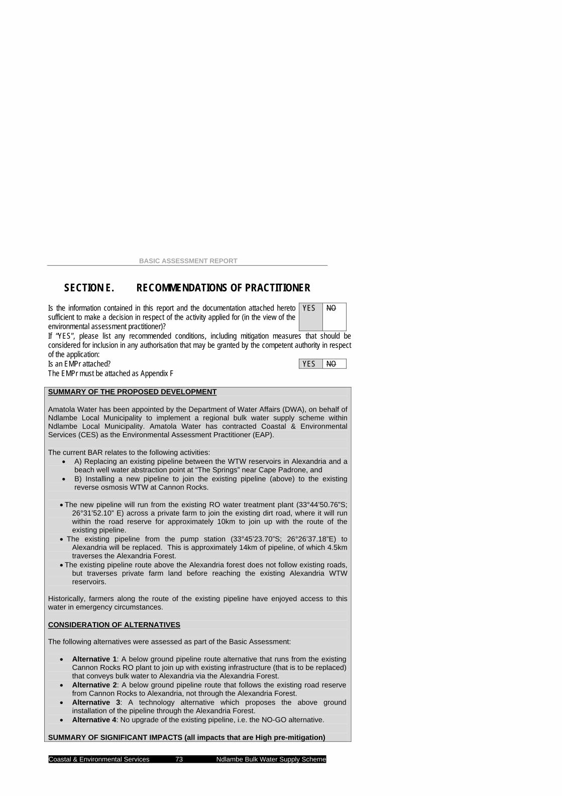
BASIC ASSESSMENT REPORT
Coastal & Environmental Services 73 Ndlambe Bulk Water Supply Scheme
SECTION E. RECOMMENDATIONS OF PRACTITIONER Is the information contained in this report and the documentation attached hereto sufficient to make a decision in respect of the activity applied for (in the view of the environmental assessment practitioner)?
YES NO
If “YES”, please list any recommended conditions, including mitigation measures that should be considered for inclusion in any authorisation that may be granted by the competent authority in respect of the application: Is an EMPr attached? YES NO The EMPr must be attached as Appendix F SUMMARY OF THE PROPOSED DEVELOPMENT Amatola Water has been appointed by the Department of Water Affairs (DWA), on behalf of Ndlambe Local Municipality to implement a regional bulk water supply scheme within Ndlambe Local Municipality. Amatola Water has contracted Coastal & Environmental Services (CES) as the Environmental Assessment Practitioner (EAP). The current BAR relates to the following activities:
• A) Replacing an existing pipeline between the WTW reservoirs in Alexandria and a beach well water abstraction point at “The Springs” near Cape Padrone, and
• B) Installing a new pipeline to join the existing pipeline (above) to the existing reverse osmosis WTW at Cannon Rocks.
• The new pipeline will run from the existing RO water treatment plant (33°44’50.76”S;
26°31’52.10” E) across a private farm to join the existing dirt road, where it will run within the road reserve for approximately 10km to join up with the route of the existing pipeline.
• The existing pipeline from the pump station (33°45’23.70”S; 26°26’37.18”E) to Alexandria will be replaced. This is approximately 14km of pipeline, of which 4.5km traverses the Alexandria Forest.
• The existing pipeline route above the Alexandria forest does not follow existing roads, but traverses private farm land before reaching the existing Alexandria WTW reservoirs.
Historically, farmers along the route of the existing pipeline have enjoyed access to this water in emergency circumstances. CONSIDERATION OF ALTERNATIVES The following alternatives were assessed as part of the Basic Assessment:
• Alternative 1: A below ground pipeline route alternative that runs from the existing Cannon Rocks RO plant to join up with existing infrastructure (that is to be replaced) that conveys bulk water to Alexandria via the Alexandria Forest.
• Alternative 2: A below ground pipeline route that follows the existing road reserve from Cannon Rocks to Alexandria, not through the Alexandria Forest.
• Alternative 3: A technology alternative which proposes the above ground installation of the pipeline through the Alexandria Forest.
• Alternative 4: No upgrade of the existing pipeline, i.e. the NO-GO alternative. SUMMARY OF SIGNIFICANT IMPACTS (all impacts that are High pre-mitigation)
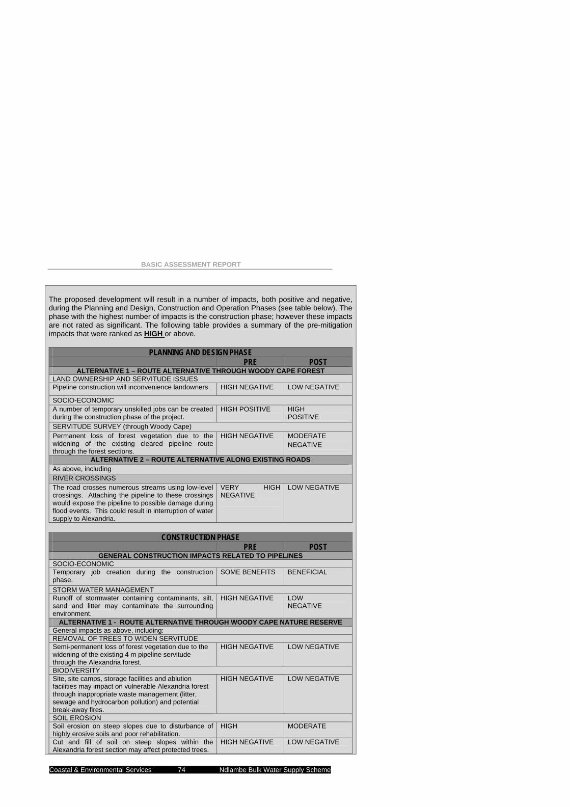
BASIC ASSESSMENT REPORT
Coastal & Environmental Services 74 Ndlambe Bulk Water Supply Scheme
The proposed development will result in a number of impacts, both positive and negative, during the Planning and Design, Construction and Operation Phases (see table below). The phase with the highest number of impacts is the construction phase; however these impacts are not rated as significant. The following table provides a summary of the pre-mitigation impacts that were ranked as HIGH or above.
CONSTRUCTION PHASE
PRE POST GENERAL CONSTRUCTION IMPACTS RELATED TO PIPELINES
SOCIO-ECONOMIC Temporary job creation during the construction phase.
SOME BENEFITS
BENEFICIAL
STORM WATER MANAGEMENT Runoff of stormwater containing contaminants, silt, sand and litter may contaminate the surrounding environment.
HIGH NEGATIVE
LOW NEGATIVE
ALTERNATIVE 1 - ROUTE ALTERNATIVE THROUGH WOODY CAPE NATURE RESERVE General impacts as above, including: REMOVAL OF TREES TO WIDEN SERVITUDE Semi-permanent loss of forest vegetation due to the widening of the existing 4 m pipeline servitude through the Alexandria forest.
HIGH NEGATIVE
LOW NEGATIVE
BIODIVERSITY Site, site camps, storage facilities and ablution facilities may impact on vulnerable Alexandria forest through inappropriate waste management (litter, sewage and hydrocarbon pollution) and potential break-away fires.
HIGH NEGATIVE LOW NEGATIVE
SOIL EROSION Soil erosion on steep slopes due to disturbance of highly erosive soils and poor rehabilitation.
HIGH
MODERATE
Cut and fill of soil on steep slopes within the Alexandria forest section may affect protected trees.
HIGH NEGATIVE LOW NEGATIVE
PLANNING AND DESIGN PHASE PRE POST
ALTERNATIVE 1 – ROUTE ALTERNATIVE THROUGH WOODY CAPE FOREST LAND OWNERSHIP AND SERVITUDE ISSUES Pipeline construction will inconvenience landowners. HIGH NEGATIVE LOW NEGATIVE
SOCIO-ECONOMIC A number of temporary unskilled jobs can be created during the construction phase of the project.
HIGH POSITIVE
HIGH POSITIVE
SERVITUDE SURVEY (through Woody Cape) Permanent loss of forest vegetation due to the widening of the existing cleared pipeline route through the forest sections.
HIGH NEGATIVE
MODERATE NEGATIVE
ALTERNATIVE 2 – ROUTE ALTERNATIVE ALONG EXISTING ROADS As above, including RIVER CROSSINGS The road crosses numerous streams using low-level crossings. Attaching the pipeline to these crossings would expose the pipeline to possible damage during flood events. This could result in interruption of water supply to Alexandria.
VERY HIGH NEGATIVE
LOW NEGATIVE
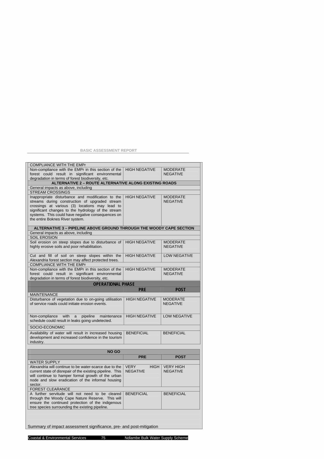
BASIC ASSESSMENT REPORT
Coastal & Environmental Services 75 Ndlambe Bulk Water Supply Scheme
COMPLIANCE WITH THE EMPr Non-compliance with the EMPr in this section of the forest could result in significant environmental degradation in terms of forest biodiversity, etc.
HIGH NEGATIVE
MODERATE NEGATIVE
ALTERNATIVE 2 – ROUTE ALTERNATIVE ALONG EXISTING ROADS General impacts as above, including STREAM CROSSINGS Inappropriate disturbance and modification to the streams during construction of upgraded stream crossings at various (3) locations may lead to significant changes to the hydrology of the stream systems. This could have negative consequences on the entire Boknes River system.
HIGH NEGATIVE
MODERATE NEGATIVE
ALTERNATIVE 3 – PIPELINE ABOVE GROUND THROUGH THE WOODY CAPE SECTION General impacts as above, including SOIL EROSION Soil erosion on steep slopes due to disturbance of highly erosive soils and poor rehabilitation.
HIGH NEGATIVE
MODERATE NEGATIVE
Cut and fill of soil on steep slopes within the Alexandria forest section may affect protected trees.
HIGH NEGATIVE LOW NEGATIVE
COMPLIANCE WITH THE EMPr Non-compliance with the EMPr in this section of the forest could result in significant environmental degradation in terms of forest biodiversity, etc.
HIGH NEGATIVE
MODERATE NEGATIVE
Summary of impact assessment significance, pre- and post-mitigation
OPERATIONAL PHASE PRE POST
MAINTENANCE Disturbance of vegetation due to on-going utilisation of service roads could initiate erosion events.
HIGH NEGATIVE
MODERATE NEGATIVE
Non-compliance with a pipeline maintenance schedule could result in leaks going undetected.
HIGH NEGATIVE
LOW NEGATIVE
SOCIO-ECONOMIC Availability of water will result in increased housing development and increased confidence in the tourism industry.
BENEFICIAL
BENEFICIAL
NO GO PRE POST
WATER SUPPLY Alexandria will continue to be water-scarce due to the current state of disrepair of the existing pipeline. This will continue to hamper formal growth of the urban node and slow eradication of the informal housing sector.
VERY HIGH NEGATIVE
VERY HIGH NEGATIVE
FOREST CLEARANCE A further servitude will not need to be cleared through the Woody Cape Nature Reserve. This will ensure the continued protection of the indigenous tree species surrounding the existing pipeline.
BENEFICIAL
BENEFICIAL
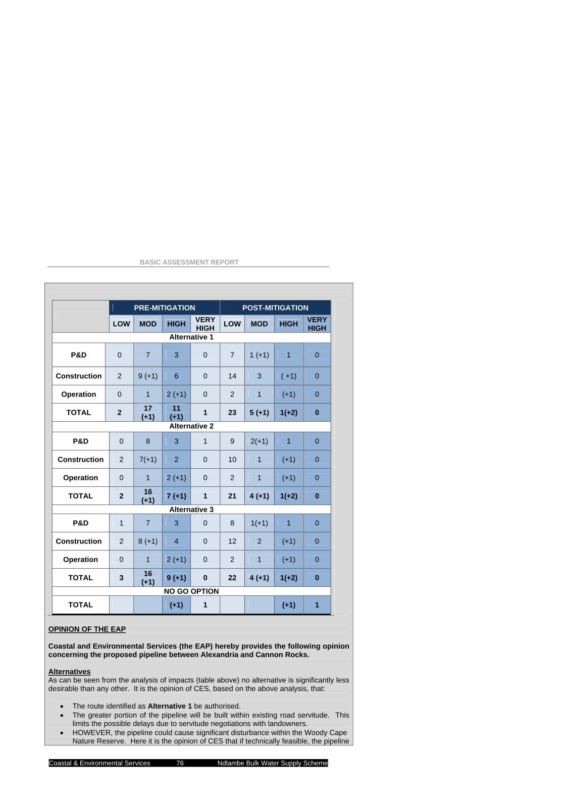
BASIC ASSESSMENT REPORT
Coastal & Environmental Services 76 Ndlambe Bulk Water Supply Scheme
PRE-MITIGATION POST-MITIGATION
LOW MOD HIGH VERY HIGH LOW MOD HIGH VERY
HIGH Alternative 1
P&D 0 7 3 0 7 1 (+1) 1 0
Construction 2 9 (+1) 6 0 14 3 ( +1) 0
Operation 0 1 2 (+1) 0 2 1 (+1) 0
TOTAL 2 17 (+1)
11 (+1) 1 23 5 (+1) 1(+2) 0
Alternative 2
P&D 0 8 3 1 9 2(+1) 1 0
Construction 2 7(+1) 2 0 10 1 (+1) 0
Operation 0 1 2 (+1) 0 2 1 (+1) 0
TOTAL 2 16 (+1) 7 (+1) 1 21 4 (+1) 1(+2) 0
Alternative 3
P&D 1 7 3 0 8 1(+1) 1 0
Construction 2 8 (+1) 4 0 12 2 (+1) 0
Operation 0 1 2 (+1) 0 2 1 (+1) 0
TOTAL 3 16 (+1) 9 (+1) 0 22 4 (+1) 1(+2) 0
NO GO OPTION
TOTAL (+1) 1 (+1) 1
OPINION OF THE EAP Coastal and Environmental Services (the EAP) hereby provides the following opinion concerning the proposed pipeline between Alexandria and Cannon Rocks. Alternatives As can be seen from the analysis of impacts (table above) no alternative is significantly less desirable than any other. It is the opinion of CES, based on the above analysis, that:
• The route identified as Alternative 1 be authorised. • The greater portion of the pipeline will be built within existing road servitude. This
limits the possible delays due to servitude negotiations with landowners. • HOWEVER, the pipeline could cause significant disturbance within the Woody Cape
Nature Reserve. Here it is the opinion of CES that if technically feasible, the pipeline
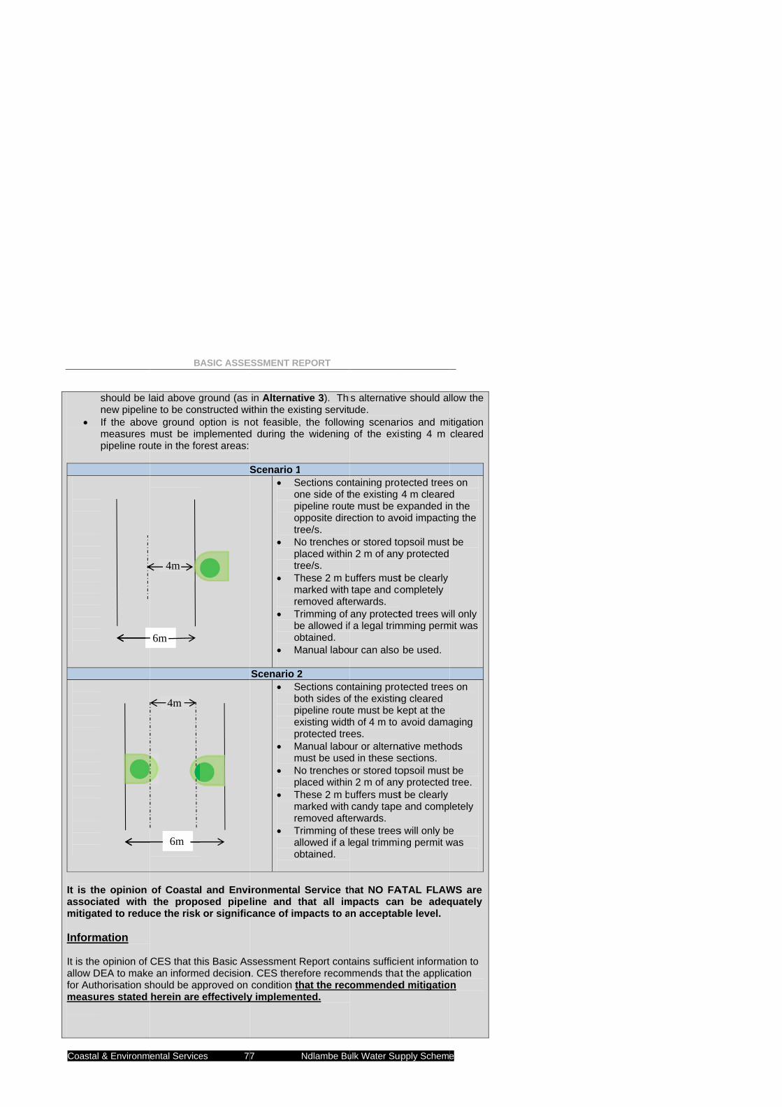
Coastal
•
It is thassociamitigat Inform It is the allow Dfor Authmeasu
& Environm
should be lnew pipelinIf the abovmeasures pipeline rou
e opinion ated with ted to redu
mation
opinion of DEA to makehorisation sres stated
B
ental Service
laid above gne to be conve ground omust be imute in the fo
of Coastathe propo
ce the risk
CES that the an informehould be apherein are
6m
4m
6m
4m
ASIC ASSE
es 77
ground (as nstructed wioption is no
mplementedorest areas:
S
l and Enviosed pipel
k or signific
his Basic Ased decisionpproved on effectively
ESSMENT RE
7
in Alternatithin the exiot feasible,
d during the
Scenario 1• S
opotr
• Nptr
• Tmre
• Tbo
• M
Scenario 2• S
bpexp
• Mm
• Np
• Tmre
• Tao
ironmentalline and tcance of im
ssessment n. CES there
condition thy implemen
EPORT
Ndlambe Bu
tive 3). Thiisting servit, the followe widening
Sections con
ne side of tipeline routpposite dire
ree/s. No trenches
laced withinree/s.
These 2 m bmarked with emoved afte
Trimming of e allowed ifbtained.
Manual labo
2 Sections con
oth sides ofipeline routxisting widtrotected tre
Manual labomust be useNo trenches
laced withinThese 2 m bmarked with emoved afte
Trimming of llowed if a lbtained.
Service ththat all im
mpacts to a
Report contefore recomhat the recnted.
ulk Water Su
s alternativude.
wing scenarof the exis
ntaining prohe existing e must be e
ection to avo
or stored ton 2 m of any
uffers musttape and co
erwards. any protectf a legal trim
ur can also
ntaining prof the existine must be kh of 4 m to
ees. ur or alternad in these sor stored to
n 2 m of anyuffers mustcandy tape
erwards. these treesegal trimmi
hat NO FAmpacts can
n acceptab
tains sufficiemmends tha
ommended
upply Scheme
ve should al
rios and misting 4 m
otected trees4 m cleared
expanded inoid impactin
opsoil must y protected
t be clearly ompletely
ted trees wimming perm
be used.
otected treesng cleared kept at the avoid dama
ative methosections. opsoil must y protected t be clearly e and comp
s will only beng permit w
ATAL FLAWn be adeqble level.
ent informaat the applicd mitigatio
e
llow the
itigation cleared
s on d n the ng the
be
ill only mit was
s on
aging
ods
be tree.
letely
e was
WS are quately
ation to ation n
BASIC ASSESSMENT REPORT
Coastal & Environmental Services 78 Ndlambe Bulk Water Supply Scheme
MITIGATION MEASURES
PLANNING AND DESIGN PHASE ALTERNATIVE 1 – BELOW GROUND ROUTE ALTERNATIVE FROM CANNON ROCKS TO
ALEXANDRIA VIA ALEXANDRIA FOREST POLICY COMPLIANCE
• Ensure that the development complies with relevant legislation and/or policy, e.g. ECBCP, Municipal By-laws, SDFs, etc.
LAND OWNERSHIP AND SERVITUDE ISSUES
• Ensure that prior to the start of construction, servitude agreements are in place and that the areas to be directly impacted are appropriately demarcated so that no undue impact is made on the surrounding environment.
• Public access to servitudes on private land could result in an increase in the poaching of livestock/wildlife and associated criminal activities.
• Access to servitudes through private land should be adequately fenced and secured, e.g. padlocked gates.
• Construction staff should be monitored while on site. SOCIO-ECONOMIC
• Ensure that this aspect is incorporated into any contracts compiled for construction contractors. Temporary jobs created should be earmarked for the local communities as far as possible.
HERITAGE
• The results of the Phase 1 Heritage and Palaeontological assessments have been submitted to SAHRA – ensure that the recommended management measures are incorporated into the final design and planning for the pipeline construction.
GEOLOGY
• Ensure that as far as possible, the new pipeline avoids areas of inappropriate geological or soil structure.
• The recommendations of the geotechnical specialist MUST be adhered to. PIPELINE MATERIALS
• Ensure that high quality, SABS approved materials are used for all elements of infrastructure installation.
CONSIDERATION OF ENVIRONMENTAL CONSTRAINTS
• Incorporation of the mitigation measures provided below will ensure proper route planning. • Appoint an independent Environmental Control Officer (ECO) for the duration of the
construction to monitor construction activities. • Micro-siting of the final pipeline layout must be approved by the ECO.
DRAINAGE LINES
• Water bodies within 32 meters of the route must be demarcated and must not be accessible during construction.
• All trenches dug within 32 meters of any water body must be rehabilitated in full. • No work camp or any other temporary construction infrastructure must be erected within 32
meters of any water body.
BASIC ASSESSMENT REPORT
Coastal & Environmental Services 79 Ndlambe Bulk Water Supply Scheme
• Where necessary, water use licenses should be obtained from the Department of Water Affairs.
CLEARANCE OF PIPELINE ROUTE (through Woody Cape)
• Ensure that construction activities are limited to the pipeline route. • Alternative methods such as above ground installation or manual labour for trenching for
below ground pipeline may be used within the natural forest sections to avoid the need to widen the existing cleared pipeline route.
• If widening of the existing cleared pipeline route is required, consult with SANParks and DWAF (Mr Tabo Nokoya) to determine if and what permit applications are required.
• All relevant permits must be obtained before removal/trimming/destruction of any protected species takes place.
• When widening the route, every effort must be made to avoid protected species and species of special concern. This includes reducing clearance to 4 m, using manual labour and clearance route re-alignment in affected sections (See scenario illustrations and mitigations in Section 7.2).
• If possible, transplant any impacted trees. Sapling and seedlings especially must not be destroyed but rather removed and transplanted.
• The maximum total width that the existing cleared pipeline route may be widened to is 6 m.
ALTERNATIVE 2 – BELOW GROUND ROUTE ALTERNATIVE ALONG EXISTING ROADS, NO SECTION THROUGH ALEXANDRIA FOREST
As above, excluding pipeline route through Alexandria Forest, but including: RIVER CROSSINGS
• Suitably qualified engineers must design pipeline crossings that will ensure that the pipeline is not at risk during flood events. This may require that the road crossing is upgraded. Water Use Licences will need to be obtained from the Department of Water Affairs for modifying the bed/banks of a watercourse.
TRAFFIC
• Suitable plans must be drawn up in conjunction with the relevant municipal department to provide temporary traffic diversion routes, etc. for the duration of construction.
ALTERNATIVE 3 – PIPELINE ROUTE AS PER ALTERNATIVE 1, ABOVE GROUND PIPELINE
THROUGH THE ALEXANDRIA FOREST SECTION SERVITUDE SURVEY
• The proposed clearance will need to be surveyed and mapped. • Bush that needs to be cleared before construction must be clearly demarcated to prevent
unnecessary destruction of vegetation.
CONSTRUCTION PHASE GENERAL CONSTRUCTION IMPACTS RELATED TO PIPELINES
AIR POLLUTION
• Cleared surfaces must be dampened whenever possible and especially in dry and windy conditions to avoid excessive dust generation.
• Any soil excavated, and not utilised for rehabilitation, must be removed from site or covered and no large mounds of soil should be left behind after construction.
BASIC ASSESSMENT REPORT
Coastal & Environmental Services 80 Ndlambe Bulk Water Supply Scheme
NOISE POLLUTION
• Construction activity close to farm houses, which includes the movement of construction vehicles, must be restricted to normal working hours (7:00am – 17:00pm).
HAZARDOUS SUBSTANCE STORAGE & USAGE
• Hazardous Chemical Substances Regulations promulgated in terms of the Occupational Health and Safety Act 85 of 1993 and the SABS Code of Practise must be adhered to. This applies to solvents and other chemicals possibly used in the construction process.
• Oil trays must be placed under parked machinery to avoid soil contamination. CONCRETE BATCHING
• Concrete should not be mixed directly on the ground, or during rainfall events when the potential for transport to the stormwater system is the greatest (as per the EMPr).
• Concrete must be mixed only in the area demarcated for this purpose and on an impermeable substratum.
• All areas affected during the Construction Phase should be rehabilitated. HAZARDOUS CHEMICAL SPILLS
• The individual responsible for or who discovers the spill must report the incident to the Project Coordinator, ECO and or Contractor as soon as reasonably possible.
• The problem must be assessed and the necessary actions required will be undertaken. • The immediate response must be to contain the spill. • Depending on the nature and extent of the spill, contaminated soil must be either excavated
or treated on-site. • The ECO must determine the precise method of treatment of polluted soil. • This could involve the application of soil absorbent materials or oil-digestive powders to the
contaminated soil. • If a spill occurs on an impermeable surface such as cement or concrete, the surface spill
must be contained using oil absorbent materials. • Contaminated remediation materials must be carefully removed from the area of the spill so
as to prevent further release of petrochemicals to the environment, and stored in adequate containers until appropriate disposal.
HAZARDOUS CHEMICAL STORAGE • Staff that will be handling hazardous materials must be trained to do so. • All hazardous chemicals must be properly stored in a secure, bunded and contained area.
WORKER HEALTH AND SAFETY
• Fire fighting equipment should be present on site at all times as per Occupational Health and Safety Act.
• All construction foremen must be trained in fire hazard control and fire fighting techniques. • All flammable substances must be stored in dry areas which do not pose an ignition risk to
the said substances. • No open fires will be allowed on site unless in a demarcated area identified by the ECO. • No smoking near flammable substance. • All cooking shall be done in demarcated areas that are safe in terms of runaway or
uncontrolled fires. • The Contractor shall have operational fire-fighting equipment available on site at all times.
The level of fire fighting equipment must be assessed and evaluated thorough a typical risk assessment process.
• Failure to provide adequate onsite sanitation and clean drinking water may result in runoff transferring contaminants into the surrounding environment.
• Adequate sanitary and ablutions facilities must be provided for construction workers • The facilities must be regularly serviced to reduce the risk of surface or groundwater
pollution. • Contaminated wastewater must be managed by the Contractor to ensure existing water
resources on the site are not contaminated. All wastewater from general activities in the camp shall be collected and removed from the site for appropriate disposal at a licensed
BASIC ASSESSMENT REPORT
Coastal & Environmental Services 81 Ndlambe Bulk Water Supply Scheme
commercial facility. WASTE MANAGMENT
• Littering by the employees of the Contractor shall not be allowed under any circumstances. The ECO shall monitor the neatness of the work sites as well as the Contractor campsite.
• All waste must be removed from the site and transported to a licensed landfill site. • Hazardous waste e.g. used oils, offcuts, etc., could pollute surface and groundwater
resources if not properly contained. • All waste hazardous materials must be carefully stored as advised by the ECO, and then
disposed of offsite at the licensed hazardous landfill site in Mt Frere. • Contaminants must be stored safely to avoid spillage • Machinery must be properly maintained to keep oil leaks in check.
SOCIO-ECONOMIC
• If manual labour is used for the section of pipeline to be replaced through the Alexandria Forest, this benefit would increase in significance.
RIVERS & STREAMS
• All construction rubble must be removed from all rivers and streams after completion of work. • The river/stream must be returned to its natural state after construction.
STORM WATER MANAGEMENT
• The site must be managed in a manner that prevents pollution of drains, downstream watercourses or groundwater, due to suspended solids, silt or chemical pollutants.
• Temporary cut-off drains and berms may be required to capture storm water and promote infiltration.
• The area must be monitored by an ECO on a regular basis as described in the EMPr. HERITAGE
• Any shell middens that are exposed during the course of construction, need to be reported to the heritage Impact assessor, the ECO and SAHRA immediately.
• If any graves or remains are exposed during construction phase, then all work in that area needs to be stopped and SAHRA needs to be informed immediately.
ALTERNATIVE 1 - BELOW GROUND ROUTE ALTERNATIVE FROM CANNON ROCKS TO
ALEXANDRIA VIA ALEXANDRIA FOREST General impacts as above, including: REMOVAL OF TREES TO WIDEN SERVITUDE
• Ensure that construction activities are limited to the pipeline route. • Alternative methods such as above ground installation or manual labour for trenching for
below ground pipeline may be used within the natural forest sections to avoid the need to widen the existing cleared pipeline route.
• If widening of the existing cleared pipeline route is required, consult with SANParks and DWAF (Mr Tabo Nokoya) to determine if and what permit applications are required.
• All relevant permits must be obtained before removal/trimming/destruction of any protected species takes place.
• When widening the route, every effort must be made to avoid protected species and species of special concern. This includes reducing clearance to 4 m, using manual labour and clearance route re-alignment in affected sections (See scenario illustrations and mitigations in Section 7.2).
• If possible, transplant any impacted trees. Sapling and seedlings especially must not be destroyed but rather removed and transplanted.
BASIC ASSESSMENT REPORT
Coastal & Environmental Services 82 Ndlambe Bulk Water Supply Scheme
• The maximum total width that the existing cleared pipeline route may be widened to is 6 m. BIODIVERSITY
• Construction activities must be restricted within the existing pipeline cleared route within the Alexandria forest.
• An ECO must be on site twice a week or more during construction in the Alexandria forest to monitor construction activities.
• Site, site camps, storage facilities and ablution facilities may impact on vulnerable Alexandria forest through inappropriate waste management (litter, sewage and hydrocarbon pollution) and potential break-away fires.
• Camps and ablution facilities are to be placed in currently impacted areas, at least 100 meters away from any forest area.
• An appropriate waste management programme must be implemented throughout the construction phase.
• Fires for cooking must be located within an enclosed, demarcated area. • No fires will be allowed in the Alexandria forest. • Fire-fighting equipment must be kept onsite in order to contain an accidental fire.
SOIL EROSION
• Ensure that construction sites are stabilised and soil is prevented from unnecessary exposure.
• Implement vegetation re-establishment as part of a detailed Rehabilitation Plan. • Building unnecessary access roads may result in high level surface erosion of these tracks. • Ensure that current road infrastructure is used to access remote areas of the pipeline layout. • Cut and fill of soil on steep slopes within the Alexandria forest section may affect protected
trees. • Avoid cut and fill of soil on steep slopes within the Alexandria forest where protected trees
will be affected. COMPLIANCE WITH THE EMPr
• An ECO MUST be on site a minimum of two days per week while construction occurs within the forest.
• The ECO will determine the extent to which bush is cleared and will clearly demarcate which plants/trees are to be avoided.
ALTERNATIVE 2 – ROUTE ALTERNATIVE ALONG EXISTING ROADS
General impacts as above, including STREAM CROSSINGS
• Construction of any river crossings MUST comply with an EMPr approved by the Department of Water Affairs and by the Department of Environmental Affairs
• Use MUST be made of ecologically acceptable temporary diversion methods if necessary. • Construction of stream crossings MUST be done under supervision of the ECO.
ALTERNATIVE 3 – PIPELINE ROUTE AS PER ALTERNATIVE 1, ABOVE GROUND PIPELINE
THROUGH THE ALEXANDRIA FOREST SECTION General impacts as above, including PIPELINE ANCHORING
• All concrete MUST be mixed on a suitably bunded temporary area. • Contaminated water from concrete mixing should be collected and disposed of according to
the instructions of the ECO
BASIC ASSESSMENT REPORT
Coastal & Environmental Services 83 Ndlambe Bulk Water Supply Scheme
SOIL EROSION
• Ensure that construction sites are stabilised and soil is prevented from unnecessary exposure.
• Implement vegetation re-establishment as part of a detailed Rehabilitation Plan. • Cut and fill of soil on steep slopes within the Alexandria forest section may affect protected
trees. • Avoid cut and fill of soil on steep slopes within the Alexandria forest where protected trees
will be affected. COMPLIANCE WITH THE EMPr
• An ECO MUST be on site a minimum of two days per week while construction occurs within the forest.
• The ECO will determine the extent to which bush is cleared and will clearly demarcate which plants/trees are to be avoided.
OPERATIONAL PHASE
MAINTENANCE
• Regular inspection of the pipeline must take place to monitor its operational status. • Disturbance of vegetation due to on-going utilisation of service roads could initiate erosion
events. • Service roads should remain within the servitude as much as possible. Avoid creating
permanent tracks. Monitor for erosion and rehabilitate if necessary. • Pipelines MUST be regularly monitored for leaks. If these are identified or reported by the
public, immediate actions must be taken to remedy the situation.
BASIC ASSESSMENT REPORT
Coastal & Environmental Services 84 Ndlambe Bulk Water Supply Scheme
SECTION F: APPENDICES The following appendixes must be attached as appropriate: Appendix A: Site plan(s) Appendix B: Photographs Appendix C: Facility illustration(s) Appendix D: Specialist reports Appendix E: Comments and responses report Appendix F: Environmental Management Programme (EMPr) Appendix G: Other information – PUBLIC PARTICIPATION DOCUMENTATION


![Untitled-1 []€¦ · dyeing/designing, water supply, effluent treatment and bulk processing and (iv) a rest room for accommodation of the designer/bulk buyer from urban area, who](https://img.pdfslide.us/doc/110x75/5f50be8318678617dc1562b7/untitled-1-dyeingdesigning-water-supply-effluent-treatment-and-bulk-processing.jpg)