Embed Size (px)
Citation preview
Restricted Technical Report RP/1986-1987/XI.1.3 MALAYSIA
Operational action for the safeguarding of the immovable cultural heritage and its reintegration into modern life.
Bujang Valley and Kuala Kedah Fort - Proposals for a Masterplan
by John Sanday
Serial N o . : F M R / C C / C H / 8 7 / 1 3 1
United Nations Educational, ¡ [ | Scientific and ^ = . Cultural Organization
Paris, 1987
M A L A Y S I A
BUJANG VALLEY AND KUALA KEDAH FORT - PROPOSALS FOR A MASTERPLAN
by John Sanday
Report prepared for the Government of Malaysia by the United Nations Educational, Scientific and Cultural Organization (Unesco)
U N E S C O

Technical Report RP/1986-1987/XI.I.3 FMR/CC/CH/87/131(Sanday)
30 October 1987 © Unesco 1987 Printed in France
The designations employed and the presentation of material throughout the publication do not imply the expression of any opinion whatsoever on the part of Unesco concerning the legal status of any country, territory, city or area or of its authorities, or concerning its frontiers or boundaries.
(i)
TABLE OF CONTENTS
page
PREFACE (iii)
I. INTRODUCTION 1
II. MAIN FINDINGS AND CONCLUSIONS 1
A. Existing situation 1
B. Objectives 3
C. The Bujang Valley - an appraisal 4
D. Sites visited during the mission 5
E. The Kuala Kedah Fort - an appraisal 13
III. RECOMMENDATIONS 17
A. A masterplan for the preservation of the monuments of the Bujang Valley National Historical Park 17
B. A masterplan for the preservation of the Kuala Kedah Fort 20
ANNEXES
ANNEX I - Action Plan - Request for assistance 23
ANNEX II - List of persons consulted during the mission 27
Annex III - Selected bibliography 28
ANNEX IV - Travel programme for mission to Malaysia 29
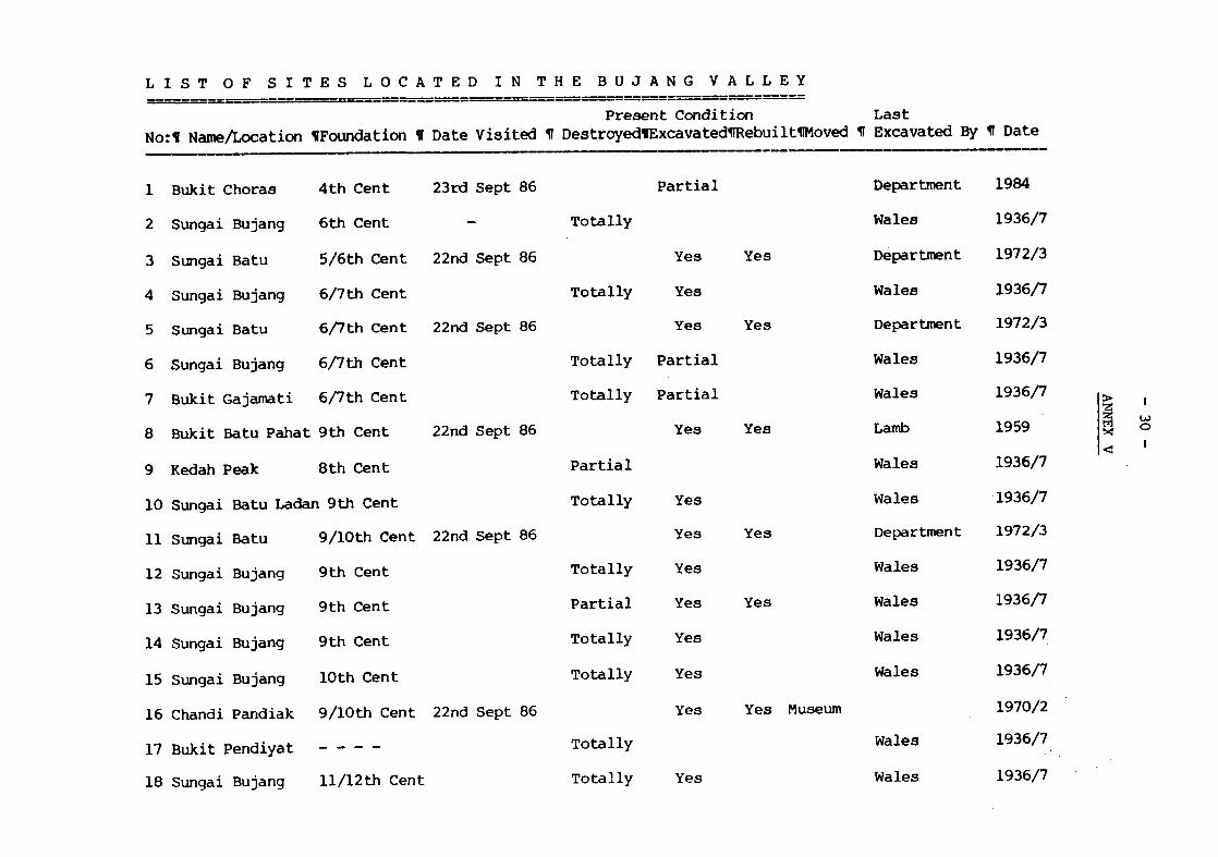
ANNEX V - List of sites located in the Bujang Valley 30
ANNEX VI - List of maps and plans 32
ANNEX VII - List of photographs 41
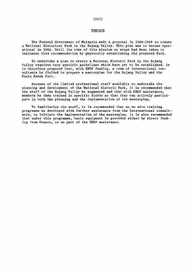
(iü)
PREFACE
The Federal Government of Malaysia made a proposal in 1968-1969 to create a National Historical Park in the Bujang Valley. This plan was to become operational in 1986. Until the time of this mission no steps had been taken to implement this recommendation by physically establishing the proposed Park.
To undertake a plan to create a National Historic Park in the Bujang Valley requires very specific guidelines which have yet to be established. It is therefore proposed that, with UNDP funding, a team of international consultants be fielded to prepare a masterplan for the Bujang Valley and the Kuala Kedah Fort.
Because of the limited professional staff available to undertake the planning and development of the National Historic Park, it is recommended that the staff of the Bujang Valley be augmented and that with UNDP assistance, members be then trained in specific fields so that they can actively participate in both the planning and the implementation of the masterplan.
To familiarize the staff, it is recommended that an on site training programme be developed with further assistance from the international consultants, to initiate the implementation of the masterplan. It is also recommended that under this programme, basic equipment be provided either by direct funding from Unesco, or as part of the UNDP assistance.
I. INTRODUCTION
1. The mission described in the present report was carried out from 15 September to 4 October 1986 at the request of the Government of Malaysia, and was funded by Unesco under its regular programme for 1986-1987. The terms of reference were as follows:
to undertake a three-week mission to Malaysia in order to prepare, in close co-ordination with the national authorities and the United Nations Development Programme (UNDP) project proposals for the preservation and conservation of the monuments of the Bujang Valley National Historic Park and the Kuala Kedah Fort.
2. The Consultant was accompanied on the initial stages of the field trip to the Bujang Valley by the Director of Antiquities, Encik Kamarul Baharin bin Byong and was then handed over to the staff of the Bujang Valley Museum, headed by the curator Encik Kamaruddin Zakaria. During the site visits in the Bujang Valley, the consultant was accompanied by Encik Sayuddin - Archaeologist, Puan Rohani - Draughtsman, Encik Sabri - Conservation Assistant, and Encik Yeoh Guan Cheong, the Administrative Officer who acted as interpreter on all visits. For the visit to the Kuala Kedah Fort the consultant was accompanied by Encik Ahmad Harun, a Conservation Assistant in charge of the Monuments, while Encik Yeoh acted as interpreter there also.
3. During the mission the sites were examined for their archaeological importance, their physical condition, and their potential as tourist and educational destinations. Within the terms of reference it has been possible to draw up a series of outline recommendations based on these criteria and these have been identified within this report. As a result of the Department of Museums' desire for a masterplan to be developed for both sites and the agreement of the Federal Government to request the UNDP to finance a small scale project for the training of professional staff and the funding of a multi-disciplinary mission to prepare the masterplan, a draft action plan has been prepared and is enclosed as Annex I to this report.
II. MAIN FINDINGS AND CONCLUSIONS
A. EXISTING SITUATION
The cultural heritage of Malaysia
4. Malaysia's cultural heritage has not received the wide publicity both nationally and internationally that it deserves. It is true that, in comparison with its neighbours, the size and extent of its early historic monuments and archaeological sites is small and most of these are hidden in dense jungle or have been destroyed as a result of agrarian development. However in later centuries, mostly resulting from its differing periods of colonization, there are numerous buildings and sites of considerable importance which are related to the historical development of Malaysia. The historic town of Malacca, with its early forts, its Christian churches, its town hall and its unique Chinese street, is one example of an historic centre. Elsewhere there are prominent palaces, some of which have been converted into museums, and forts guarding the river entrances. However, the most important archaeological sites are located in an area loosely described as the Bujang Valley in Kedah State, where the remains of shrines and small palaces have been discovered dating from the Hindu-Buddhist era between the sixth and sixteenth centuries.
- 2 -
5. Although the Federal Government of Malaysia made a proposal for establishing a National Historical Park in the Bujang Valley as far back as 1968-1989, as a start to their programme for developing a cultural heritage policy, little has been done to bring this proposal to realization. The main reason for this is the lack of qualified staff within the Department of Museums and the lack of specific guidelines to develop and implement a masterplan.
6. Essentially the Department of Museums' Antiquities Division needs to be expanded and properly trained and equipped to undertake the conservation and the maintenance of the historic buildings and archaeological sites. In order to develop a policy and to provide a foundation for the development of a conservation programme it seems wise to concentrate the limited support available on the preparation of a masterplan for the Bujang Valley and the Kuala Kedah Fort and to develop a training programme both on site as well as abroad. These sites would act as a model for future activities in Malaysia as well as serving as useful training grounds for the local museum staff. They would also become the first two centres for the development of cultural tourism in Malaysia.
A review of the cultural heritage programme in Kedah State
7. Within the Department of Museums, activities in the field of building conservation and repair are limited. This is partly due to the lack of finance but mainly the result of the lack of professional staff both at headquarters as well as in the field.
8. The general policy is for all sites to be monitored from the Directorate under the control of the Director of Antiquities. As an exception, because of the number of historic sites in Kedah, a museum assistant (special grade) has been posted to the Bujang Valley Museum to look after the neighbouring sites although he is not directly connected to the Bujang Valley project which is under the direct control of the curator.
9. Only in March 1976 was the Antiquities Act given Royal Assent and published in the Gazette. This Act, which has a very broad spectrum, aims at providing for the control and preservation of, and the research into, ancient and historical monuments, archaeological sites and remains, and antiquities and historical objects and to regulate dealings in and export of antiquities and historical objects and for matters connected therewith. The Act provides some protection against theft or illicit trade in antiquities but does not offer the necessary protection of the actual historic site and its environment.
10. There are between 40 and 50 monuments of historic importance in Kedah of which only one is gazetted under the 1976 Antiquities Act. At present a further ten monuments are under consideration for gazetting. Monuments come under the direct control of the Central Government, but the land upon which the monuments are built is the responsibility of the State Government as the Central Government cannot own land as such. Before a site can be gazetted the land on which it stands must belong to the State Government. In the case of Bukit Choras in the Bujang Valley (see paras. 65-67 below) the Central Government, through the Department of Museums, prepared a detailed case history of the site and presented it to the State Government for its action. The State Government of Kedah is now actively involved in acquiring the hillock on which the site is located in preparation for the gazetting and protection of the site.
- 3 -
Future strategy - a need to present and promote cultural heritage
11. As the intention of establishing a conservation programme has been established, the question of the presentation of the cultural heritage of Malaysia assumes a greater importance. In most countries, the division of responsibilities for presentation and promotion lies respectively with the authorities responsible for preserving historical monuments and sites and those responsible for the development of tourism. Presentation of a monument or site to visitors in an interesting and informative way cannot easily be divorced from its conservation. Indeed, one of the intrinsic purposes of conserving the monument and its environment is to present it to visitors be they tourists or students, and consequently this should be the responsibility of the Department of Museums. However the arousing of interest in the general public to visit and to facilitate access to the monuments is the responsibility of other divisions.
12. The responsibility for the presentation of monuments and sites throughout Malaysia seems to fall between the Federal Government and the State Governments, with some responsibility falling on the Tourist Development Corporation. Very little promotion of the Historical Sites in the Bujang Valley and elsewhere in Malaysia has actually taken place, partly as a result of the lack of knowledge amongst the potential promoters and partly due to the lack of anything to see when one actually reaches the Bujang Valley. The authorities are obviously aware of this dilemma and as far back as 1968-1969 made the proposal to create the Bujang Valley National Historical Park.
B. OBJECTIVES
Criteria
13. Although the consultant is a specialist in the conservation of historic buildings, it became obvious that in the time that he had available, it would not be possible to draw up comprehensive recommendations on a repair programme for either the Bujang Valley sites or the Kuala Kedah Fort. It was therefore agreed, after preliminary discussions with the Director of the Division of Antiquities, that recommendations would be made for both short- and long-term situations as follows:
Long-term objectives;
(a) For the Bujang Valley: to establish a National Historical Park within the Bujang Valley with a view to protecting, preserving and presenting the archaeological sites found therein and thereby creating a national as well as an international tourist destination.
(b) For the Kuala Kedah Fort: to undertake the excavation, conservation and presentation of the Kuala Kedah Fort as a national and international tourist destination.
Short-term objectives:
(i) to prepare a masterplan for the excavation, conservation and presentation of the monuments of the Bujang Valley National Historical Park and the Kuala Kedah Fort;
(ii) to augment and train professional staff in the present Bujang Valley Museum;
(iii) to expand the existing museum and visitor facilities at the Bujang Valley Museum complex;
- 4 -
(iv) to develop suitable museum and visitor facilities at the Kuala Kedah Fort.
C. THE BUJANG VALLEY - AN APPRAISAL
The Bujang Valley - its location and setting
14. The Gunung Jerai, or Kedah Peak as it was formerly known, is the highest landmark, at an altitude of 1,220 metres, in North West Malaysia. Ships, a millennium ago, dependent on guidance through the elements to their trade centres, used it as their beacon to the Bujang Valley. The peak still stands sentinel over the sleeping Valley which has somewhat changed in appearance since its halcyon days of seafaring trade. Today the sea has regressed, the rivers have silted up and the land has been put to fairly intensive agrarian use, save where the mangrove swamps have taken a stranglehold. There are large rubber plantations, banana plantations, and paddies throughout the Valley. Closer to the peak there is the spoil of open cast tin mines. The peak itself, however, is still covered with dense jungle.
15. The Bujang Valley today is merely a reference to its historical past. Under the terms of a recommendation by the Federal Government of Malaysia to create a National Historical Park in the Bujang Valley, it is defined as an area of 400 square kilometres between the site of Bukit Choras in the North (which is about 20 kilometres south of Alor Setar) to Bukit Merjam in the south (which is on a level with Penang). The western boundary is the Straits of Malacca and the eastern boundary is the railway running from Alor Setar to Butterworth. Within this area there are said to be about 50 or 60 archaelogi-cal sites, many of which have yet to be identified.
The Bu.iang Valley in history
16. The old Malay kingdom of the Bujang Valley is thought to have existed since about the sixth century A.D. It developed and flourished into an important trade and commercial centre which survived up to the thirteenth century. Because of its geographical location along the trade route between the Mediterranean and China, it played an important role and as a result its fame spread to countries both to the east and the west. Travellers and writers from India, Sri Vijaya and Khmer visited Bujang during this period and the Valley thus had contact with people of different cultural origins and backgrounds. Some of their cultural features were introduced to Bujang and these have influenced its cultural development.
17. Indian writers named the kingdom the State of Kataha which in Sanscrit is translated into Katahnagara, which is recalled in the Sanskrit drama Kaumudinahotsava, written in the seventh century A.D.
18. Buddhist and Hindu merchants, travellers and missionaries travelled back and forth between India and China in those times and many used to stop over in Kataha. The renowned Buddhist Monk of Chinese origin, I-Tsin, visited the kingdom whilst on his travels from China to India in the year 671 A.D. and later on his return journey. The Chinese name for the kingdom was Chieh-Cha which means Kedah.
19. The old Kedah State (Katah or Chieh-Cha) may have been one of the original states governed by a local political body. However some historians are of the opinion that during the seventh century it became part of the Sri Vijayan Empire. Later, in 1025 A.D. Rajendra I the King of Chola is said to have attacked the Sri Vajayan Empire and the kingdom of the Bujang Valley as well. The seat of the Sri Vijayan Empire was weakened by this attack but the
- 5 -
Go ernment of the Bujang Valley survived. Later in 1068 the Government of the Bujang Valley befriended the Chola king Birarajendra and sought his help to frue it from the Sri Vijayan Empire - a request that was favourably met.
20. Archaeological research undertaken in the Bujang Valley in the region of Pengkalan Bujang has indicated that this was a great trading port between the ninth and the thirteenth centuries A.D. Large amounts of various bits of pottery and porcelain as well as other trade material has been collected from the area. It has also been established that during this period Pengkalan Bujang was on the coast and there were excellent anchorage and harbour facilities in the bay. After the thirteenth century however, Pengkalan Bujang declined as a port and another area just to the south, in the vicinity of the Muda River became the new port and the seat of Government of the old Kedah kingdom.
The Empire of Sri Vijaya - A brief history
21. Between the late seventh century and the thirteenth century A.D. it appears that the Malay Peninsula formed part of the Empire of Sri Vijaya, a State that achieved both wealth and power because it controlled the maritime trade through the Straits of Malacca. During its height Sri Vijaya was visited by merchants from as far afield as Egypt, Persia and China and it is mentioned in many early Islamic and Chinese texts. The rulers of Sri Vijaya were considerably influenced by the religions and culture of India and it seems that they encouraged the building of Hindu and Buddhist Temples in the Kingdom. In its period of great prosperity between the ninth and twelfth centuries A.D., the Kingdom of Sri Vijaya was in close contact with such great Indian Buddhist centres of learning as Nalanda in Bengal where a Sri Vijaya ruler caused a monastery to be built. The Pala Dynasty of north east India - a great sponsor of the famous Pala art - provided models for much of the art and architecture of Sri Vijaya, traces of which have been discovered in the Malaya Peninsula.
22. The main centres of Sri Vijaya in the Peninsula of Malaya, as archaeology indicates, were located in the States of Kedah, Perak and Perils. In Perak a number of bronze statues have been found, most of which can be related to similar finds in Sumatra and south Thailand and which also show many traces of Pala influence. Kedah has revealed the remains of a number of Hindu and Buddhist temples, models and photographs of which are displayed in the Bujang Valley Museum. Many of these temples are evidently very similar to structures from Sumatra and other regions of the Sri Vijaya Empire.
D. SITES VISITED DURING THE MISSION
Site 31 - Matang Pasir
23. The site known as Matang Pasir was discovered by Dr Quaritch Wales in 1941 and the results of minor excavations by his wife are described in his report to the Journal of the Malaysian Branch of the Royal Asiatic Society published in 1947. The present site consisting of the remains of an ancient structure of latérite blocks and fragments of bricks was excavated in 1957 by Sullivan with the help of the University of Malaya Archaeological Society. Further excavations and research were undertaken in 1961 by Lamb who also prepared a short report and some drawings which were published in the Federation Museums Journal (Vol. VI New Series).
24. Research indicates that this shrine is typical of the other temple shrines in the Bujang Valley consisting of a solid base with probably a timber superstructure. It is uncertain whether it was a Hindu or Buddhist structure but its probable dating is between the twelfth and fifteenth centuries.
- 6 -
25. The site has remained unrestored but is protected by a pitched asbestos sheet roof set with timber trusses, open below the roof. The roof is leaking badly in several places as several sheets have been damaged. The site is enclosed by a chain link fence a few metres wider than the actual excavations. The site is looked after by a resident caretaker who owns the shop nearby.
26. At the moment there is no building development to threaten the site as, to the north, there is agricultural land up to the road and, to the south, there is a Muslim graveyard, beyond which there is a fairly large mosque.
27. The ownership of the site lies with the mosque as it was formerly discovered within the boundaries of the graveyard. This poses a problem for the official gazetting of this site which has not yet taken place. Close by, to the south, there is the river Sungai Muda which formerly must have been the means of access to this site.
Recommended future activities
delineation of the full boundary of the site;
acquisition of the site including a reasonable curtilage around it;
official gazetting and protection of the site;
further excavation and conservation of the site;
presentation and landscaping of the site.
Thp SmwiRaj Mas Site - Site Hos. 33 and 34
(a) Site 33
28. This site was studied and partially excavated by the specialists of the Southeast Asian Ministers of Education Organization's Project in Archaeology and Fine Arts (SEAMEO-SPAFA) in 1985. The tentative site is surrounded by private dwellings and one dwelling is actually built from archaeological remains. There are about five different properties within the curtilage of the archaeological site. During the recent excavations much of the site was excavated and backfilled after recording the structures.
29. This site poses a major problem of how to handle an archaeological site under multiple occupancy. At the moment, because the buildings are set on pile foundations, a minimum amount of damage has been done to the old structures.
30. Slightly to the north-east of the site there is a canal which was dug previously and at that time an important stone inscription was discovered which has now been placed in the Museum. During these excavations other remains consisting mainly of pottery shards were also found. The canal is located about 100 yards to the north of the site. (Site 27).
31. Access to the Sungai Muda Site is directly off a metalled road just beyond the village of Kuala Muda to the north and it is approximately 5 kilometres from the Matang Pasir Site.
(b) Site 34
32. This site which is part of the Sungai Muda Group is located in two private compounds a few hundred yards to the south of Site 33. The majority of the archaeological remains are within the most southerly of the compounds and extend its full 25 metres. There is evidence of further archaeological remains within the same compound.
- 7 -
33. To date there have been no scientific archaeological excavations carried out on this site, but when digging the ground the owner happened upon brickwork and shards. A granite pounder was also found.
Recommended future activities
delineation of the extent of the archaeological sites in this area and the establishment of a site boundary;
acquisition of the main site and subsidiary sites, including a reasonable curtilage around them;
official gazetting and protection of the main and subsidiary sites;
further excavation and conservation of the main and subsidiary sites;
presentation and landscaping of the whole site.
Sites within the Museum compound
34. There is a group of archaeological sites, some of which have been relocated within the museum compound, which form part of the Museum's display.
(a) Site 16 Chandi Pendiat
35. This site is the lowest of the group and nearest to the museum building. The archaeological remains have been moved from their original site and have been reconstructed on the existing site as one of the Museum exhibits. It was originally built between the ninth and tenth centuries and was formerly located in the swampy area known as Kampong Pendiat beyond Merbok. It was built of latérite stone and the structure is somewhat different to the typical format as the Vimana and the Mandapa are separated slightly. During excavations several potshards were found as well as an iron pot and a bronze lamp. Excavations were carried out in 1970 and the Chandi was removed to its present site in 1972. The temple base has been reconstructed to a height of about 1.25 metres and is very regular in appearance. It is uncertain what the measurements for the reconstruction were actually based on as no records of the relocation were available.
36. The temple base is set beneath a timber trussed asbestos sheet pitched roof which is open at the sides. It has a span of approximately 10 metres and is about 15 metres long. It is enclosed by iron railings to prevent visitors climbing over the structure.
(b) Site 8 - Chandi Bukit Batu Pahat
37. The literal translation of this name is 'The Temple of Cut Stone'. This structure, which has been reconstructed on its correct and original site is slightly above Site 16 at a distance of 50 metres. The site is on a plateau and has been landscaped with formal gardens around it. The temple which was probably constructed around the ninth century, was totally restored in the autumn of 1959. The work of excavation and reconstruction was undertaken by Dr Alastair Lamb from Kuala Lumpur and Mr N. Louis Content from Angkor, Cambodia and was financed by the Department of Museums.
38. The structure is of granite, quarried from near by, cut to the size of bricks with very little decoration, - hence its name. The lower platform to the sanctuary is set back a few courses from the lower platform about 2" and rises to the circumambulatory. The interesting column bases, recessed to take timber columns, emphasize that there was originally an open circumambulatory
- 8 -
probably roofed over with a traditional roof such as thatch or leaves. There are some diagonal braces to strengthen this structure set up against the sanctuary wall. The structure certainly appears very typical of the south Indian shrines. The temple has been reconstructed to a height of about 1 metre and the general appearance of the structure seems very regular which makes the coursing and jointing somewhat questionable in comparison with the original structure. Nevertheless the site is well presented and it is an impressive structure.
(c) Site 21
39. This brick temple was founded between the eleventh and twelfth centuries A.D. it was originally located in Kampong Penkalang Bujang, but was recently relocated during the time of excavation in 1976 to its new site in the museum compound. The temple has now been reconstructed about 30 metres beyond and to the north-west of Site No. 8. It is a brick structure of regular pattern and symetrical plan form built in a simple cruciform shape which has been elaborated with projections at the re-entrants. The shrine has been rebuilt to a height of about 1.5 metres above ground level.
40. The centre of the structure is hollow down to the same level as the plain brickwork. On the northern side there is a flight of three steps which gives access to the floor level. The purpose of these steps as well as the method of access to the shrine, if indeed there was one, is not clear. In the north-east corner, and set slightly apart from the main structure on its own plinth, is a further much smaller structure, measuring about 1 metre square.
41. The site is protected from the rain by a timber trussed pitched roof with an asbestos sheet covering similar to those previously described.
(d) Site 50
42. This is the third of the three sites that have been relocated to the museum compound. It consists of two temples, one with a fairly extensive platform towards the north and a second to the west set on a small pedestal. Both the structures are all built in latérite blocks measuring about 22 cm square and 10 cm in depth and both have granite pillar bases to take a timber superstructure, set regularly around the structure.
43. The central temple with an opening to the north has been reconstructed to a height of about 1.20 metres and is fairly simple in its design. At the base of the sanctuary which is set on a raised platform, the lower course of latérite seems to have been simply moulded and then there are three regressing steps before the plain walling of the structure. At either corner just 15 cm from the main sanctuary are circular granite column bases. The rest which are set out at regular 2 metre intervals are square.
44. The second structure is to the west of the main temple with a door facing east. This is a slightly more elaborate structure than the former. The main sanctuary is set on a platform about 60 cm above ground level and accessible up a small flight of steps, leading directly to the sanctuary. Within the sanctuary there is a raised pedestal on the western wall upon which there must have been some image.
(e) Site 49 - Chandi Pelagan Sembilan
45. This site is located about 2 kilometres to the east of the museum complex, on the edge of an old rubber plantation. It lies on the east bank of the river Sungai Batu Pahat and its name is derived from the nine pools formed in the river as it tumbles down the hillside in a series of rapids.
- 9 -
46. The siting of this temple is on exposed rock close to the river. Round about lie scattered the granite building blocks and three or four cut granite square pillar bases measuring 60 cm in height. There are also some sizeable slabs of stone. In general the site has been badly disturbed, especially by local picnickers as this is a popular tourist spot. Its siting and location are typical as it is close to a water source and the access to the shrine faces south-east overlooking the Valley.
47. The site is kept clear by a caretaker who lives close by and works on the rubber plantation.
(f) Site 51
48. There is evidence of another site just to the north-west of the Museum which was only recently discovered by the former Curator of the Museum. So far no excavation, even of an exploratory nature has been undertaken. However from a cursory investigation of the location it appears to be quite a large site.
Recommended future activities
49. Most of the recommendations will be included within the proposed master-plan programme. However the following recommendations are listed to identify the scope of the activities.
delineation of the full boundary of the proposed new museum compound including all sites from Site 49 in the east to Site 51 in the west;
acquisition of the land within the museum compound;
official gazetting and protection of each of the sites;
further excavation and conservation of the sites not already excavated;
presentation and landscaping of the museum compound;
extension and expansion of the museum compound to create a tourist destination. This will include elements such as:
extension of the Museum; development of sites and their proper presentation; development of a traditional craft centre; tourist facilities - restaurant, cafeteria, souvenir and book shops; picnic spots along the rivers; and nature walks in the jungle.
The PenekalaTi Rnjang Sites - Sites 19 f 20f 21, 22 f 23
50. This is a group of archaeological sites that are located close together to the north of the Sungai (River) Merbok. They could form an important monument group if the land around and adjoining them could be acquired.
(a) Site 19 - Chandi Penekalan Buiang
51. This site was found in 1936-1937 and excavated by Mr Quaritch Wales and later re-excavated and rebuilt in 1974 by the Department of Museums under the direction of the then Curator of the Museum. It is understood to have been constructed between the tenth and twelfth centuries. The temple was dedicated to the Hindu divinity of Shiva as several finds consisting of a bronze Lingam, a Ganesh and a stone casket can vouch. The site is approximately a double square measuring about 4.85 metres by 9.70 metres. The interior consists of
- l o
an outer and an inner chamber which are both square and similar in size. The inner chamber has an offset of brickwork about 1 metre above floor level whereas the outer chamber has four offsets. The structure has been constructed and reconstructed in brickwork - the bricks are very thin measuring only four cm in depth 12 cm wide and 24 cm long. The walls are approximately four and á half bricks wide.
52. The site is protected by an asbestos sheet roof with timber trusses as previously described, spanning 6 metres and about 12 metres in length. The site is enclosed by a chain link fence with barbed wire as a protection and in general it is well maintained. Staff from the Museum are responsible for maintaining this site and visit it regularly to cut the grass and keep it clean.
53. The site which is on private land, is adjacent to Sites 21, 22 and 23. It is located on raised ground but is close to paddy fields. At the moment there is only one small house close by.
(b) Site 22
54. This site dates from the eleventh and twelfth centuries and is identified as being a Hindu site with Buddhist connections. The structure consists of two brick platforms set close to one another with a brick pavement around them. The larger of the two which has a 60 cm square hollow in its centre has steps on its southern side. The structure is built of bricks which are larger in size than those used at Site 19. The brickwork is generally plain, except there is a simple moulding which is reiterated on the base of both structures. This structure was rebuilt in 1976 on its original site, after being excavated by the Department. During reconstruction the whole structure was placed on a concrete raft because the previous structure had been greatly disturbed by settlement. This site was said to have been closely linked with Site 21 and there was an earlier proposal to move this site to the museum compound as well.
55. The site has been protected by a corrugated asbestos pitched roof on timber trusses which spans about 7.5 metres and measures in length about 15 metres.
(c) Site 23
56. This site is planned to be used as a practical training ground for university students from Kuala Lumpur for a period of two weeks from the end of September 1986. The group will consist of about 30 students and for whom accommodation will be found in Merbok.
57. Previously, the site was partially excavated in 1985 by the Department and students in a similar exercise. According to the Curator of the Bujang Valley Museum, this site was used as a burial ground during the Second World War. It was only at this time that the site was located and established as belonging to this group.
58. The information on this site is limited. It is slightly raised and there are bricks on the surface. Some wall foundations have been discovered in some during limited excavation but these have been badly disturbed by tree roots.
Recommended future activities
delineation of the full boundary of the monument zone;
acquisition of the land within the monument zone, including a reasonable curtilage around each site;
- 11 -
official gazetting and protection of each of the sites;
further excavation and conservation of the sites not already excavated;
preservation and landscaping of the monument zone.
Sites 11/3 and 5
59. Another group of sites located close to one another in the Ladang Batu area are the two juxtaposed sites of No. 11 and No. 3. Associated with these two is Site 5 which is about 500 metres to the east on the other side of the access road.
(a) Site 11/3
60. This site is hidden in the cultivated fields of what was formerly a rubber plantation. Now it is surrounded by palm oil trees and a cash crop of chillis. There is no direct access to this site and it is on privately owned land.
61. The site consists of three separate structures. The larger one measuring approximately 9 metres square, is accessible from the eastern side by a path linking it with the second structure. The main structure is built with small boulders - an unusual feature - and has a sunken interior, with distinctive steps forming seats about 35 cm wide and about 25 cm in depth at two levels. The basement is constructed in latérite. The other complex to the east has no obvious access and has been constructed to a height of about 60 cm above ground level whereas the upper structure has been built to a height of about 1 metre. In the north-east corner there is another platform in stone measuring about 3 metres by 4.5 metres.
62. The temple was built between the eighth and ninth centuries from river boulders and is located in the Sungai Batu Rubber Estate. It is of Hindu origin and was excavated in 1972 and rebuilt in 1973 in its original location. The nearest adjacent site is Site 5, about 500 metres to the west. The site is totally unprotected with neither roof nor boundary fencing. Nevertheless it is in good condition and it is maintained directly by the Museum staff.
(b) Site 5
63. This site is located in the middle of a banana plantation which was formerly a rubber estate and is close to Sites 11 and 3. The structure, which is built of latérite stone, is believed to be of Hindu origin. It is enclosed within a chain link boundary fence but no longer has a protective roofing, as this fell into disrepair and was removed two years previously.
64. The site was excavated by the Department in 1972 and was reconstructed in its original location in 1973. There have been questions raised concerning the validity of this reconstruction.
Recommended future activities
delineation of the full boundary of each of the sites;
acquisition of the land within the delineated boundaries including a reasonable curtilage around each site;
official gazetting and protection of each of the sites;
presentation and landscaping of the monument zones.
- 12 -
A threatened site - Bukit Choras
Site 1 - Chandi Bukit Choras
65. On a hill to the east of the Alor Setar/Butterworth highway, 25 kilometres beyond Gurun, about 45 kilometres from the Museum and 20 kilometres from Alor Setar is located the Chandi Bukit Choras. Access is by a secondary road to the east from the village of Kota Sarang Semut which leads to a large well established Chinese graveyard on the western slopes of the hillock. Access to the site at a height of 58 metres, is by foot up the side of the hill through the graveyard. The actual site is located on the eastern side of two mounds. A further access route can be reached from the north-east up a steep slope.
66. The site was discovered by Mr Quaritch Wales in 1936 and he carried out some exploratory excavations in 1940. The excavations at this time uncovered a temple foundation built in latérite and probably of Buddhist origin. To date no other archaeological remains have been found on the extensive hillside. Around the archaeological remains there is evidence of treasure hunters' excavations.
67. During field research it was discovered that, as the site is privately owned, the owner proposed to sell part of the hillock for quarrying ballast to build roads. However, after considerable publicity from the local press, the State government refused permission for the quarrying to take place and they are now in the process of acquiring the land to protect the monument which has not yet been gazetted.
Recommended future activities
delineation of the full boundary of the monument zone;
acquisition of the land within the monument zone including a reasonable curtilage around the site;
official gazetting and protection of the site;
presentation and landscaping of the monument zone.
Recommendations to create a National Historical Park
68. Proposals were initiated over 15 years ago by the government to establish the National Park. In the Museum there is a written summary of the government's intentions which reads as follows:
'A preliminary survey of the possibility of developing a National Park in the Bujang Valley was initiated in 1968/1969. Concrete proposals were then advanced to the Central Government and the Project is now under operation on a five year basis to run concurrently with the Malaysian Plan. The first five year programme was designed to provide archaeological investigation, reconstruction and subsequent maintenance to a group of ancient monuments ranging in dates from the sixth century to the fourteenth century A.D. in the Sungai Merbok and Sungai Muda region of Southern Kedah. The first season of archaeological work revealed new evidence which calls for a new interpretation and further research has thus become urgent and necessary not only for the elucidation of Malaysian proto-history but also for the better understanding of the process of Indianization of South-East Asia.
- 13 -
Secondly and perhaps more important, is the fact that the restoration and landscaping of the sites excavated can create significant resources for public education and cultural tourism. The Bujang Valley on the mountain slopes includes a series of waterfalls and other natural scenic beauty areas which implement the idea of developing this area as a recreation park. The historical potentiality of the region plus the natural scenic background provides a strong base for the Department of Museums to undertake the archaeological work in the region. This Museum was built at the foot of the Bukit Batu Pahat to exhibit major finds that have been excavated in the area. In this way visitors could have a better understanding because of the direct link of the exhibits with the environment. The ultimate aim of the Department of Museums is to transform the region into a National Historical Park where all the sites have been fully excavated, reconstructed and landscaped'.
E. THE KUALA KEDAH FORT - AN APPRAISAL
The Fort - its location and environment
69. The Kuala Kedah Fort is located in the northern State of Kedah on the west coast of Malaysia. It is approximately 10 kilometres from the State capital of Alor Setar and about 50 kilometres to the north of the Bujang Valley Museum. The actual location of the Fort is on the north bank of the Sungai (river) Kedah estuary which is on the opposite side to the township of Kuala Kedah, and at the mouth of the estuary where it leads out into the Straits of Malacca. The banks of the estuary in this area are mostly of mud, leading into mangrove swamps. The land is mostly very low.
The history of the Kuala Kedah Fort
70. The Fort of Kuala Kedah (Kuala Kedah Kota) is the sole surviving Fort built by the Malays in the eighteenth century. It was built under the guidance of the enterprising Sultan Abdullah Mukurram Shah to protect the State of Kedah from invasion by its powerful neighbours in Thailand. Earlier forts had been built on the same site, the first of which was built by the Portuguese in the sixteenth century. Work started on the construction of the present fort in 1771 using skilled masons imported from India whose first task was to make the bricks. The mortar for the walls is reputed to be a mixture of sand, egg whites and honey. Extensive plans were prepared by the Mufti of Kedah to include within the two-acre compound a number of handsome buildings. The Fort was completed in 1880 and heavy cannons were acquired from England and installed - the most notable of which are a pair of 3 metre long cannons known as Batak Berendam (the Rhinoceros) and Katak Puru (the Toad). During the construction period a moat or river was dug to complete the water protection along the north end. Along the southern portion of the Fort there is a 6 metre wide raised section, enclosed by a brick retaining wall with infill. The earth fill is said to have been from the excavations to form the moat.
71. Access to the Fort was through the original East Gate or Pitu Malim, which possibly derived its name from 'Malik' or 'Chief*. At a later date the new or British Gate was opened. It is believed that there was also another gate in the west wall. Originally around the inner perimeter of the Fort trees were planted at a distance of 15 metres. Later the raised Audience Hall was constructed which became also the Court and it was from here that, in the latter half of the nineteenth century, the business of Kedah State was carried out.
- 14 -
72. The existing sea wall was built fairly recently, after the old wall had been breached by the sea. It was built to the same height as the former wall using boulders and granite brought from the nearby island, Pulau Paya.
The Kuala Kedah Fort today
(a) General description
73. Over the decades the Kuala Kedah Fort has been abandoned, forgotten and vandalized. The sea has encroached and breached the walls and the population has invaded the compound slowly destroying what little of the history of the Fort remained. Being public land as such, a lighthouse was erected and a school was built. Through lack of consistent maintenance, bricks from the original walls have been used by the local villagers who have built right up against the outer walls. It is only very recently that the site has been protected and gazetted as an Historic Site and that some attempts have been made to remove the activities within the Fort.
(b) West wall
74. The southern half of the west wall is exposed directly to the Malacca Straits and as a result the original wall has collapsed and has been replaced by a new wall constructed of boulders and cement. The remains of the old brick wall which fell outwards, are still lying along the beach. From rough measurements taken off the original, the wall measured about 5 metres in height and about 1 metre in width at its base. The wall was built of narrow bricks (25 cm x 12 cm x 5 cm), set with a fairly thick joint of mortar using broken shells for lime. In some places about 1 metre of the old wall is still standing. At the northern end there has been considerable upheaval and a lot of earth has wedged itself between the old and the new wall.
75. A new wall has been constructed where the west wall is exposed to the sea and it continues also the full length of the south wall as well. The foundations of this new wall have been constructed directly on the inside of the original wall whose mean height is about 3 metres from beach level and its overall width ranges from about 1.2 metres at its base, to about 75 cm at its top. It has been built out of granite blocks, boulders, and bits of brick with a fairly coarse aggregate for the cement sand mortar.
76. It would appear that at mean high tide level the south eastern corner of the Fort is about 1.2 metres above the beach level. Where the wall leaves the shoreline there is now quite a large gap between the old standing section of the wall and the new. The southernmost end of the old wall has been supported by shoring which was undertaken by the Department in 1980. The condition of the wall is pretty poor. Not only is there the expected salt action and general erosion, but the wall is being torn asunder by vegetation growing along the top of the wall, where shrubs have taken root in fissures and are splitting open the structure. From about mid-point along the wall where it returns to the west, there are further breaches and some sections have caved inwards. Much of the original brickwork has been taken away and used by the local people. In the north-western corner only a very small part of the wall remains and what must have been the corner bastion has been occupied by local people. On the exterior, along this section of wall there are dwellings right up to the boundary beyond a small drain about 1 metre wide at approximately 80 cm below the internal mean ground level of the Fort.
- 15 -
(c) North wall
77. The original brickwork of the first third of the wall is still standing to a height of 3 metres. Beyond and to the east it has mostly collapsed but there are sections still standing to a height of about 1 metre. Again there are dwellings built right up to the boundary. Formerly there was a moat protecting the north side but this has silted up. In the north-east corner there is another corner bastion which follows the same line as that of the eastern wall but projects 5 metres beyond the line of the northern wall. Very little of the bastion remains above ground.
(d) East wall
78. Of the east wall between the north bastion and the original gate, which is about one third along the length of the wall, there is nothing standing, except for some bricks at the northern end. The original gate itself collapsed in 1972 but much of the debris still remains.
79. A later gate known as the 'British Gate' was opened during the British period about 50 metres from the southern end. At this point, there has been some alteration to the original wall as a small section of about 25 metres has been built up attaching itself to the north side of the new gate. The new gate is built in good quality brickwork about 60 cm in thickness with finely cut granite dressings measuring 80 cm. There is some decoration in brickwork, consisting of a pair of pilasters framing the gateway and a projecting curved cornice with crenallation above. Within the gate and on a line with the pilasters, walls at right angles form a three sided enclosure about 6 metres square. The gate stands about 8 metres to the top of the crenallations. The present condition of the brickwork is rather poor. There has been considerable patching and adding and there seems to have been a projecting curved cornice set in between the keystones in cut brickwork. Directly above the archway there is a brick moulded cornice. On the left of the southern pillar, an opening has been cut for drainage. To the south of the gate the line and the structure of the external wall changes somewhat. It is probable that the outer wall was added with the new gateway, as it is about 6 metres beyond what must have been the original line of the wall which in fact is the line of the present inner wall, constructed on the original foundation. This is apparent at the southern end of the wall where there is still the remains of the original brick rubble.
(e) South wall
80. This wall has been entirely reconstructed to its full length. Its projecting bastions jut out into the river for about 3 metres. Where the bastions have been rebuilt, it is possible to see the remains of the earlier wall inside the later wall, consisting of some fine quality 'battered' brickwork on top of which rests one of the large cannons (the Rhinoceros). The foundations of the old wall are just visible beyond the new wall and it is interesting to note that the line of the original wall is as much as 1.1 metres beyond the later wall. Along this section was originally set the battery of seven cannons and the two special cannons, known as the Rhinoceros and the Tortoise, which were placed in the corner bastions and which measured about 3 metres in length. The cannon in the south-west bastion has fallen from the rampart and is lying amongst the old brick rubble on the west shore.
81. Little remains of the original brickwork along the shoreline and the cannons have obviously been repositioned. However, there is sufficient information to work out the details of the wall, including its 'batter' and details of the cannon emplacements and the brickwork around them. Also the missing cannons should be traceable.
- 16 -
82. There is an inner retaining wall which was constructed to act as a raised section of ground to enable people to work the cannons. This inner wall, which is about 80 cm thick, is in brickwork about 80 cm and is badly disturbed by the thrust of the earth behind it.
83. The later wall has suffered considerably due to the subsidence of its foundations, is leaning seawards and is on the point of collapse again and the condition of both the southern bastions is equally bad, with the outer walls falling outwards and on the point of collapse due to the undermining of the foundations, causing settlement.
Buildings within the Fort
(a) The Court and Audience Hall
84. This building is set roughly in the centre of the compound and follows the standard Malay pattern of construction, with supporting brick columns of 1.5 metres in height carrying timber wall plates spanning between the columns to support the timber framed structure above. The wall structure is infilled with panels and shutters. A roof span of 3.25 metres is made up of halved and bolted 'A' frame trusses. The lower part of the truss, from the cross member, is exposed and creates a cove for the ceiling below. The A-frames support purlins and vertical battens into which the Roman tiles are laid. It is a simple and pleasing structure, however, its present condition is that of a vandalized shell. The structure has been virtually stripped to a skeleton and much of it is on the point of collapse.
Archaeological sites
(a) General
85. There are three sites that have been exposed and which are cordonned off and referred to as Sites A, B, C. Site A was in the south-west corner about 15 metres from the south and west walls respectively where the Armoury is said to have been discovered. Site B was a small excavation in the south-west corner right against the wall and Site C, in the central north part of the compound, is the Palace Site. Sites A and B revealed very little information of importance (although no report on the excavations was available) as little was visible. However Site C provides some interesting information with reference to the history and layout of the former palace.
(b) The palace site
86. The archaeological excavations exposing the site of the old Palace or 'Istana' is proof of quite a complicated structure. It is basically rectangular in shape with a central core of about 3 rooms with a verandah running around the perimeter of the structure. It is constructed of brickwork similar to the outer rampart and using similar sized bricks. The walls are approximately 75 cm thick.
Other later structures
87. There are several other structures which have grown up over recent years, one of which is now an integral part of the compound. This is the still functioning lighthouse in the south-west corner, which was erected in the British Period. Other buildings such as the school, the Department of Museums' temporary office and some earlier dwellings (now in ruins) have no place in this compound.
- 17 --
Previous recommendations
88. A set of recommendations have been prepared in a report entitled 'The Conservation Project of the Kuala Kedah Fort - First Stage' prepared by Piaman Bin Keromo, Assistant Conservator in the Department of Museums in 1980-1981. In this report, written in Bhasa Malaysia, most of the problems were identified, but the recommendations were either very costly, impractical or ineffective. At one time it was recommended that the ground level in the compound should be raised to prevent flooding; the budget allocated for such work was set originally, in 1981, as 1 million Malaysian dollars. Recent estimates have reached 4 million Malaysian dollars which has meant the shelving of the proposal. Other proposals have been to construct a protective wall around the Fort to prevent further destruction by the sea as well as the consolidation of the existing wall using resin or silane imported from abroad. Both such recommendations are extremely costly and neither would be effective.
Recommended future activities
establishment of a curtilage around the site to prevent encroachment;
protection, conservation and restoration of the ramparts to the Fort;
drainage of the Fort;
archaeological excavation and presentation of the structures within the Fort;
establishment of a site museum in the existing Audience Hall.
III. RECOMMENDATIONS
A. A MASTERPLAN FOR THE PRESERVATION OF THE MONUMENTS OF THE BUJANG VALLEY NATIONAL HISTORICAL PARK
A proposal
89. It is recommended that a detailed masterplan be drawn up for the preservation of the monuments of the Bujang Valley National Historical Park. In this masterplan the recommendations set out below would be analysed and developed to enable specific guidelines to be established and an action plan and budget to be developed.
Recommendations for a National Park
90. The long-term objective of establishing a National Historical Park is an important proposal, but its practical achievement will be difficult unless the scope of the Park is identified. It is recommended that, within the stated 400 sq. kilometre area classified as the National Park (delineated as the area from Bukit Choras in the north to Bukit Mertajam in the south and between the coastline to the west and the railway line to the east) the following zones be clearly established:
(a) The National Historical Park Centre: This will be an area centred around the present museum complex. The area will be designated to include the existing land owned by the Museum and the land identified in the Museum expansion programme. It is recommended that extra land be acquired to enable picnic sites to be established at the waterfalls at the two nearby rivers and that a tract of land be acquired to link the existing museum land with land held by the
- 18 -
Department of Forests. At the Centre, it is proposed that the following activities be planned to augment those of the Museum and archaeological sites as potential revenue centres, with a view to expanding and developing tourism in the State of Kedah:
(i) picnic areas; (ii) recreational facilities; (iii) accommodation in traditional buildings (iv) nature walks (v) a traditional craft centre.
(b) Monument zones: Where two or more monuments or archaeological sites are close to one another, it is recommended that a parcel of land be acquired surrounding the sites to enable a suitable environment to be created. The sites can then be properly protected and gazetted.
(c) Individual historic sites: It is recommended that for individual sites, sufficient land be acquired to protect the monument and to enable it to be properly gazetted. If the site is of sufficient importance, enough land should be acquired to enable the surrounding area to be landscaped.
Recommendations for the extension of the Museum
(a) The existing condition
91. The present small museum, which is well set out with interesting displays, will certainly be inadequate if the National Historical Park is created. Outline proposals together with a budget have been submitted to the Federal Government for consideration and approval within the present 1986-1990 Five Year Plan. The following recommendations for the extension of the museum are only preliminary, therefore further technical justification should be provided by the consultants' mission under the proposed UNDP/Unesco Project.
(b) Recommendations for display areas
92. The display areas should be expanded to enable the proper display of excavated objects. It is also recommended that, when planning the new extensions, due consideration be given to the relationship of the archaeological site and to the related finds to be displayed. It may be considered necessary for the display rooms to be much larger and for some of the existing sites within the compound to be physically incorporated within the Museum.
(c) Recommendations for conservation laboratory
93. Many of the archaeological objects need proper cleaning and conservation. It is therefore essential to establish a conservation laboratory within the new Museum. It is recommended that it be planned and equipped to undertake the repair and conservation of stone and brick objects only. It is not necessary to have, at the moment an extensive laboratory capable of undertaking all aspects of conservation.
(d) Recommendations for office facilities
94. There is a shortage of office space in the present Museum and there are proposals in hand for further office facilities to be provided under the Development Plan. It is recommended that, if it is decided that the present galleries are unsuitable, the present Museum be given over to offices and that new galleries be built as recommended above.
- 19 -
Recommendations for staffing the Museum
(a) Present staff
95. The Museum was established in 1980. At present it is run by a very limited staff consisting of the following:
Curator Assistant Curator (vacant) Senior Museum Assistant (vacant) Museum Assistant-Conservation (trained in Rome) Museum Assistant - Archaeology (on study leave) Museum Assistant - Archaeology (no training) Draughtsman (no training) Administration Clerk (no training) Guards (4) Watchmen (2) Driver (vacant) Labour (7 permanent, 4 temporary)
This staff would certainly be unable to handle any major expansion plans in the field of development or research.
(b) Proposed staff expansion
96. To establish a competent staff to undertake the development of the National Historical Park in the Bujang Valley as well as to look after the Kuala Kedah Fort complex, it is recommended that the Museum staff be augmented as follows:
Conservation laboratory
Assistant Curator (chemist) Museum Assistants (3)
Archaeological research unit
Assistant Curator (Archaeologist) Research Assistant Senior Museum Assistant Surveyor/Draughtsman (shared) Photographer Labourers/Excavators (12)
Building conservation unit
Technical Officer (building conservation) Surveyor/Draftsman (shared) Photographer (shared) Masons (5)
Administration unit
Museum Assistant (administration) Clerk Peon Gardeners (3) Watchmen/Guards (6) Maintenance Staff (2) Driver
- 20 -
97. It is understood that there is, at present, a government embargo on appointing new staff. However, further justification of the necessary staff should be provided by the consultants' mission under the proposed UNDP/Unesco Project.
(c) Staff training programme
98. Not only is the present staff insufficient in number to run the Museum smoothly, but it is also lacking proper training to follow any scientific research or conservation programmes. Therefore, to undertake any major developments in the Bujang Valley, properly trained staff is essential. It is recommended that training be provided in the following fields:
(i) museology for a museologist; (ii) conservation of museum objects for a chemist; (iii) building conservation for an engineer; (iv) surveying and drafting techniques for a draughtsman; (v) photography and photogrammetry for a photographer; and (vi) field archaeology for an archaeologist.
99. It is recommended that, as well as formal training in the above fields which may be taken at special training centres abroad, on site training in the Bujang Valley and the Kuala Kedah Fort be also undertaken as an important element in the training experience.
Equipment for the Museum and laboratory
(a) Present equipment
100. The equipment within the small laboratory is very minimal, consisting mostly of chemicals. It is understood that most of the equipment is provided from the National Museum as and when necessary.
(b) Recommendations to provide equipment
101. The Museum should be provided with the essential laboratory and field equipment sufficient to enable it to run efficiently. As the selection of suitable equipment is the work of a specialist, it is recommended that this list should be prepared during the research period for the preparation of the masterplan.
B. A MASTERPLAN FOR THE PRESERVATION OF THE KUALA KEDAH FORT
A proposal
102. Similar to the recommendation set out for the Bujang Valley, it is recommended that a detailed masterplan be drawn up for the establishment of the Kuala Kedah Fort as a National Site. In this masterplan the recommendations set out below would be analysed and developed to enable specific guidelines to be established and an action plan and budget to be developed for the protection, drainage, conservation and presentation of the Fort. In this masterplan the recommendations identified below will be analysed and developed to enable a full scale conservation programme to be undertaken when national funds are made available.
The conservation and presentation of the Kuala Kedah Fort
(a) The drainage and protection of the site
103. Based on the evidence and information provided during the site visits, the drainage of the site is less of a problem than first thought. It is
- 21 -
reí ommended that a detailed analysis be made of the flood conditions of the site from which a simple but practical drainage scheme can be developed. At the same time proposals should also be made for flood and wave control from the sea by the installation of a simple series of breakwaters or groins.
(b) Archaeological excavations
104. A detailed plan should be drawn up for the complete excavation, conservation and presentation of the area within the perimeter of the Fort. Such research should also be extended to just beyond the walls to establish accurate information about the walls themselves. This work can only be undertaken after the flooding has been brought under control.
(c) Repair and conservation of the perimeter walls
105. A detailed analysis of all the archaeological finds as well as the remains of the original wall should be made in order to prepare detailed recommendations for the repair and consolidation of the original perimeter wall. It is recommended that all new construction be removed and only be replaced according to the archaeological and historical evidence available.
(d) Establishment of a site museum and office
106. The old Court Building is in an advanced stage of dilapidation. Because of its historical importance and equally because it must have been a structure of considerable beauty, it is recommended that it be rehabilitated and converted into a small Site Museum and offices for the Department.
(e) Staff training
107. It is recommended that the training of staff be carried out in conjunction with the recommendations set out in the Bujang Valley section. (See paras. 95-99).
(f) Staffing of site and museum office
108. In conjunction with the expansion of the staff for the Bujang Valley Museum, it is recommended that a skeleton staff be appointed to the Kuala Kedah Site Museum and that the research and conservation units be shared.
- 23 -
ANNEX I
ACTION PLAN - REQUEST FOR ASSISTANCE
A. UNDP/UNESCO SUPPORT
It is proposed to initiate the activities set out in the objectives established in the sections above by requesting financial assistance from UNDP, through Unesco as an Executing Agency to collaborate with the Muzium Negara (National Museum) in the following activities. It is proposed that, on receiving confirmation from the Federal Government of Malaysia, a Project Document be prepared for possible financing by UNDP and for execution by Unesco based on the following elements:
(i) the preparation of a masterplan for the preservation of the monuments of the Bujang Valley National Historical Park and the Kuala Kedah Fort and the undertaking of the necessary technical research;
(ii) the training of technical staff;
(iii) the equipping of the Bujang Valley Museum with essential equipment for field and laboratory work;
(iv) follow-up on-site training of staff to initiate the masterplan proposals;
(v) development of promotional materials.
(a) Technical assistance
To prepare the masterplan for the preservation of the monuments of the Bujang Valley Historical Park and the Kuala Kedah Fort, it is recommended that a team of consultants be financed under the above-mentioned UNDP/Unesco Project to undertake, in collaboration with the national authorities, the necessary technical research for the preparation and publication of a detailed report, which will be submitted to the government for its consideration. The research should include, among others, the studies of the economical and environmental feasibility, the strategy for the promotion and fund-raising and the development of the promotional materials. The following consultants should make up the team:
Architect restorer Field archaeologist Museologist Economist Promotion specialist Drainage engineer
2.5 months 1.5 months 1.5 months 1.5 months 1.5 months 1.5 months
(team leader)
The period allocated will allow the team one full month in the field and two weeks for the preparation and writing up of their sections in the report. The team leader will be allocated an extra month for the finalization of the report and for the assessment of the further necessary arrangements of the government.
- 24 -
(b) Training of technical staff
It is recommended that staff from the Department of Museums, seconded to the Bujang Valley Museum, should be selected for the training of each one in the following fields:
Museology Field archaeology Conservâtion/chemistry Survey and recording Building conservation Photography
These courses will be short term, specially selected fellowships abroad. The staff will be seconded to the masterplan mission prior to their training and return after their courses to participate in on-site training during the initial stages of the implementation of the masterplan. After their training the trained staff should be responsible for the completion of the masterplan proposals.
(c) On-site training
In order to initiate the preparation of the masterplan proposals, it is recommended that a team of consultants, if possible members of the masterplan mission, be chosen to carry out on-site training in their specialized fields following the recommendations set out in the masterplan report. The following specialists are proposed:
Architect restorer 2 months
Field archaeologist 2 months
Drainage engineer 1 month
Chemist (conservation laboratory) 1 month
Museologist 1 month
This on-site training can only commence once funds are made available to the project by the Federal Government.
(d) Equipment
It is recommended that the following essential survey and photographic equipment necessary for the essential technical research and the preparation of the masterplan be supplied to the Bujang Valley Museum under the UNDP/ Unesco Project:
1. Theodolite and accessories 2. 35mm camera and accessories 3. 120mm camera and accessories 4. Dark room equipment for black and white processing 5. Photocopying machine 6. Dyeline printing machine
This equipment will be handed over to the Bujang Valley National Historical Park once the implementation of the masterplan has been approved.
25 -
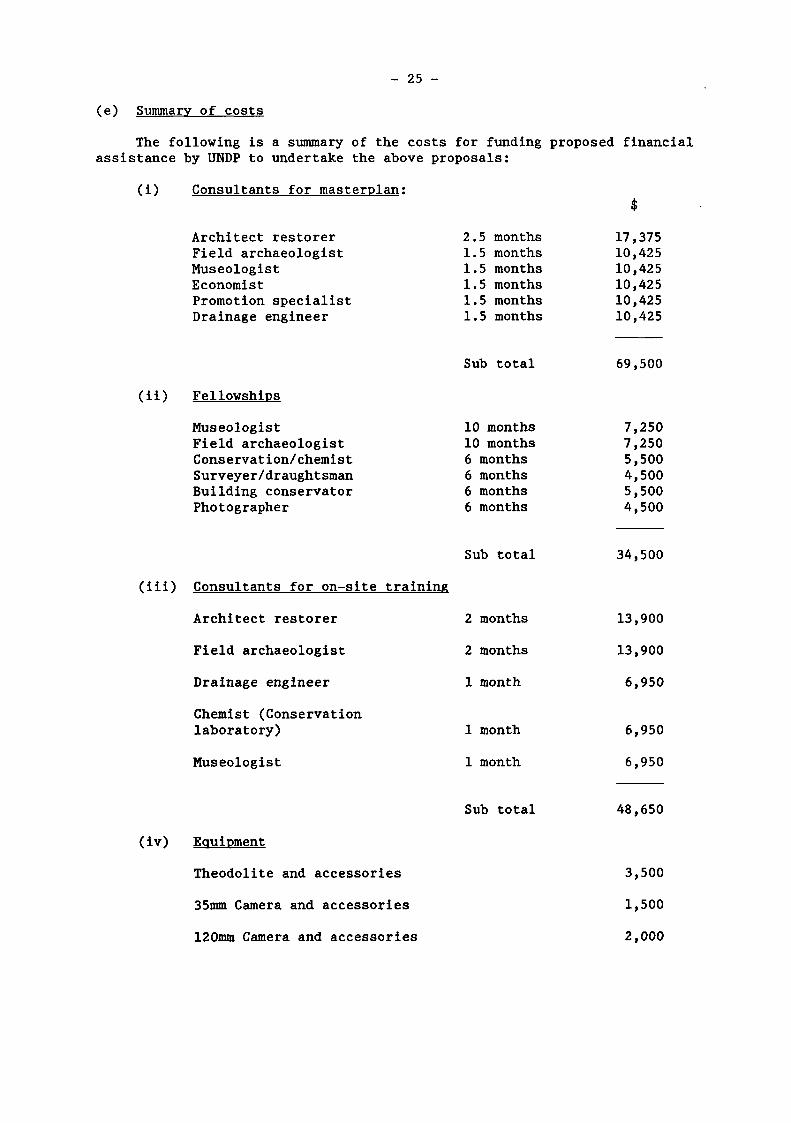
(e) Summary of costs
The following is a summary of the costs for funding proposed financial assistance by UNDP to undertake the above proposals:
(i) Consultants for masterplan:
Architect restorer Field archaeologist Museologist Economist Promotion specialist Drainage engineer
(ii) Fellowships
Museologist Field archaeologist Conservâtion/chemist Surveyer/draughtsman Building conservator Photographer
(iii) Consultants for on-site training
Architect restorer
Field archaeologist
Drainage engineer
Chemist (Conservation laboratory)
Museologist
(iv) Equipment
Theodolite and accessories
35mm Camera and accessories
2.5 1.5 1.5 1.5 1.5 1.5
Sub
months months months months months months
total
$
17,375 10,425 10,425 10,425 10,425 10,425
69,500
10 months 10 months 6 months 6 months 6 months 6 months
Sub total
7,250 7,250 5,500 4,500 5,500 4,500
34,500
2 months
2 months
1 month
1 month
1 month
Sub total
13,900
13,900
6,950
6,950
6,950
48,650
3,500
1,500
120mm Camera and accessories 2,000
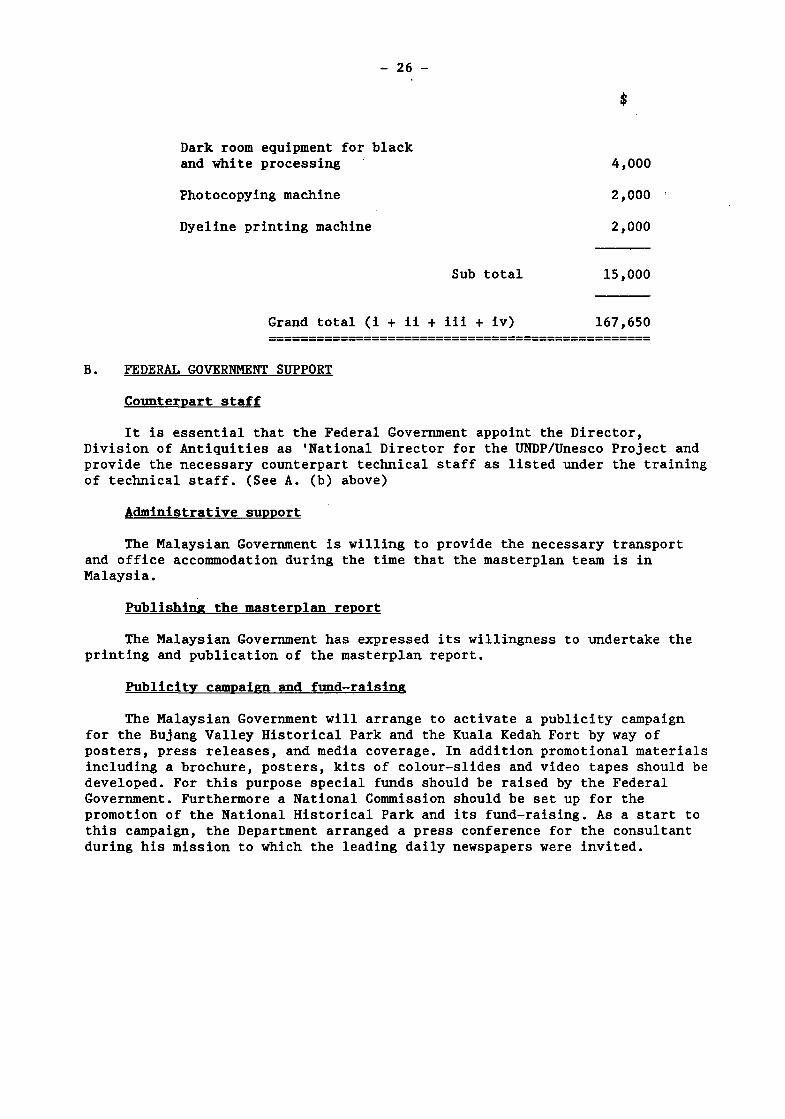
- 26 -
Dark room equipment for black
and white processing 4,000
Photocopying machine 2,000
Dyeline printing machine 2,000
Sub total 15,000
Grand total (i + ii + iii + iv) 167,650
B. FEDERAL GOVERNMENT SUPPORT
Counterpart staff
It is essential that the Federal Government appoint the Director, Division of Antiquities as 'National Director for the UNDP/Unesco Project and provide the necessary counterpart technical staff as listed under the training of technical staff. (See A. (b) above)
Administrative support
The Malaysian Government is willing to provide the necessary transport and office accommodation during the time that the masterplan team is in Malaysia.
Publishing the masterplan report
The Malaysian Government has expressed its willingness to undertake the printing and publication of the masterplan report.
Publicity campaign and fund-raising
The Malaysian Government will arrange to activate a publicity campaign for the Bujang Valley Historical Park and the Kuala Kedah Fort by way of posters, press releases, and media coverage. In addition promotional materials including a brochure, posters, kits of colour-slides and video tapes should be developed. For this purpose special funds should be raised by the Federal Government. Furthermore a National Commission should be set up for the promotion of the National Historical Park and its fund-raising. As a start to this campaign, the Department arranged a press conference for the consultant during his mission to which the leading daily newspapers were invited.
- 27 -
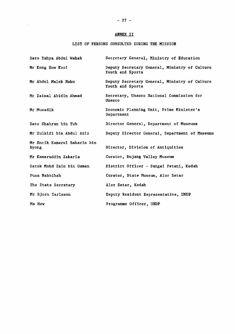
ANNEX II
LIST OF PERSONS CONSULTED DURING THE MISSION
Dato Yahya Abdul Wahab
Mr Kong How Kooi
Mr Abdul Malek Nahu
Mr Zainal Abidin Ahmad
Mr Musadik
Dato Shahrun bin Yub
Mr Zulkifi bin Abdul Aziz
Mr Encik Kamarul Baharin bin Byong
Mr Kamaruddin Zakaria
Datok Mohd Zain bin Osman
Puan Nabbihah
The State Secretary
Mr Bjorn Carlsson
Ms Hew
Secretary General, Ministry of Education
Deputy Secretary General, Ministry of Culture Youth and Sports
Deputy Secretary General, Ministry of Culture Youth and Sports
Secretary, Unesco National Commission for Unesco
Economic Planning Unit, Prime Minister's Department
Director General, Department of Museums
Deputy Director General, Department of Museums
Director, Division of Antiquities
Curator, Bujang Valley Museum
District Officer - Sungai Petani, Kedah
Curator, State Museum, Alor Setar
Alor Setar, Kedah
Deputy Resident Representative, UNDP
Programme Officer, UNDP
- 28 -
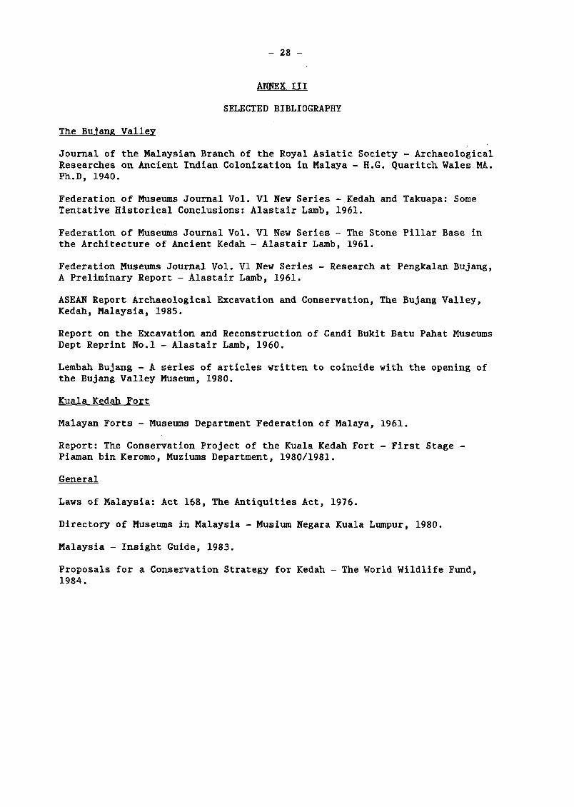
ANNEX III
SELECTED BIBLIOGRAPHY
The Bujang Valley
Journal of the Malaysian Branch of the Royal Asiatic Society - Archaeological Researches on Ancient Indian Colonization in Malaya - H.G. Quaritch Wales MA. Ph.D, 1940.
Federation of Museums Journal Vol. VI New Series - Kedah and Takuapa: Some Tentative Historical Conclusions: Alastair Lamb, 1961.
Federation of Museums Journal Vol. VI New Series - The Stone Pillar Base in the Architecture of Ancient Kedah - Alastair Lamb, 1961.
Federation Museums Journal Vol. VI New Series - Research at Pengkalan Bujang, A Preliminary Report - Alastair Lamb, 1961.
ASEAN Report Archaeological Excavation and Conservation, The Bujang Valley, Kedah, Malaysia, 1985.
Report on the Excavation and Reconstruction of Candi Bukit Batu Pahat Museums Dept Reprint No.l - Alastair Lamb, 1960.
Lembah Bujang - A series of articles written to coincide with the opening of the Bujang Valley Museum, 1980.
Kuala Kedah Fort
Malayan Forts - Museums Department Federation of Malaya, 1961.
Report: The Conservation Project of the Kuala Kedah Fort - First Stage -Piaman bin Keromo, Muziums Department, 1980/1981.
General
Laws of Malaysia: Act 168, The Antiquities Act, 1976.
Directory of Museums in Malaysia - Musium Negara Kuala Lumpur, 1980.
Malaysia - Insight Guide, 1983.
Proposals for a Conservation Strategy for Kedah - The World Wildlife Fund, 1984.
- 29 -
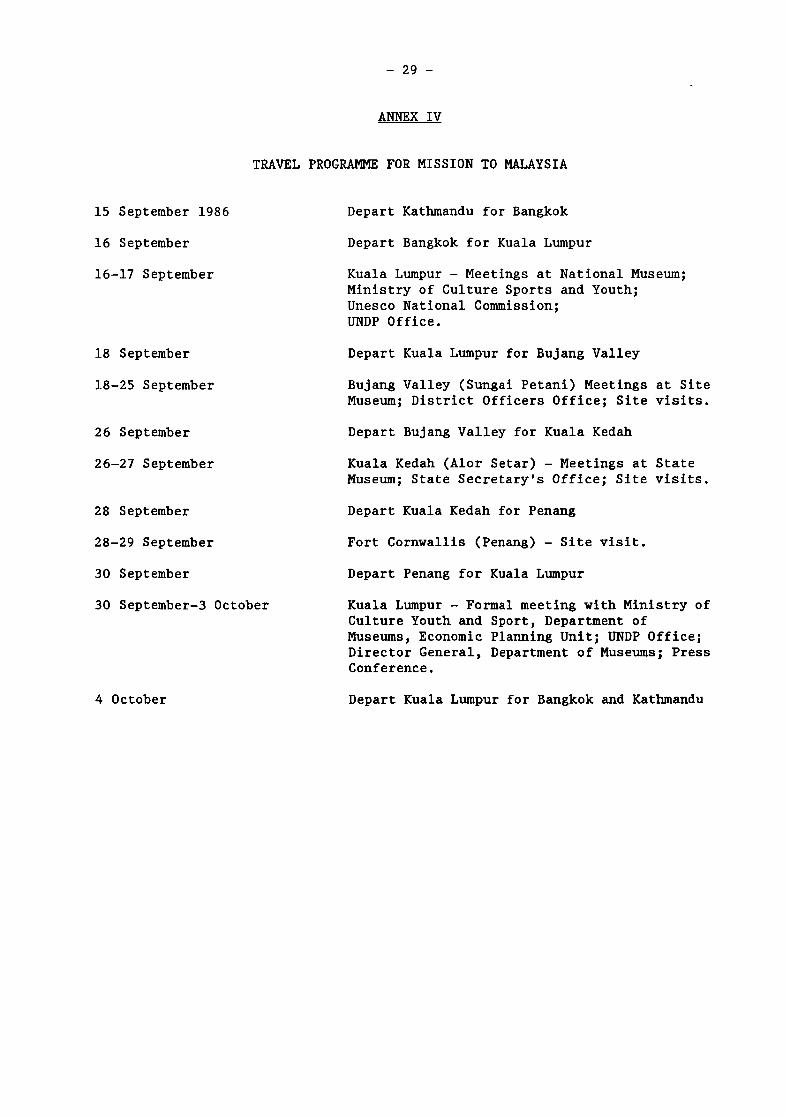
ANNEX IV
TRAVEL PROGRAMME FOR MISSION TO MALAYSIA
15 September 1986
16 September
16-17 September
18 September
18-25 September
26 September
26-27 September
28 September
28-29 September
30 September
30 September-3 October
Depart Kathmandu for Bangkok
Depart Bangkok for Kuala Lumpur
Kuala Lumpur - Meetings at National Museum; Ministry of Culture Sports and Youth; Unesco National Commission; UNDP Office.
Depart Kuala Lumpur for Bujang Valley
Bujang Valley (Sungai Petani) Meetings at Site Museum; District Officers Office; Site visits.
Depart Bujang Valley for Kuala Kedah
Kuala Kedah (Alor Setar) - Meetings at State Museum; State Secretary's Office; Site visits.
Depart Kuala Kedah for Penang
Fort Cornwallis (Penang) - Site visit.
Depart Penang for Kuala Lumpur
Kuala Lumpur - Formal meeting with Ministry of Culture Youth and Sport, Department of Museums, Economic Planning Unit; UNDP Office; Director General, Department of Museums; Press Conference.
4 October Depart Kuala Lumpur for Bangkok and Kathmandu
- 30
-
ANNEX V
rü Q
0\
VO
m cn
m CM
cn vo m
cn
vo cn
vo cn cn
cn in
cn
VO
CO
cn
vo m cn
CM
VO co CT»
VO
m (Ti
vo m O
l vo ro Cn
CM
o
Cn vO
ro
en
vo ro
cn
fr
4J ro
m u
IC
X •J
Cd 1 ! u
3. p
J a> i-i
to
dl
4 F m
j
n
0) •H
.•" £
ta
0>
r-t
.•0
s
Q d) rH
rO
n
1 n a»
5 I
n 01
•-H
m ro 3
1
O
3 X
i Ç
0)
.se 4J
TJ
o
4J
X
ai a» u
>,
eu
p
•U
a
a» Q
<0 •
H
4J
u (0 eu
o
(0
a>
ÎH
n
0) X
«0
ai
*
n
a>
>H
n
ai
*
"3 •H
4J Par
rH
(0
•H
4-1 Par
0]
ai
* n
0) ÎH
3 o
(0 -U
O
EH
3 O
Yes
Yes Yes
Yes
Yes Yes
Yes
Yes
Yes M Yes
ro
U r0 CU
5 o
EH
4J
O
En
(0 •
H
4J
U
Cu
ro 4-1
O En
5 O
En O En
«—I
r0 4
J
O E
H
•8 4-1
•i-t
Q •
H
>
ai 4-1
ro
Q
vO C
0
a 0)
(N
4J
c
ai u
JZ 4
J
m 8 o
o
4J
•
H
•s CQ
4J
C O)
u
VO
Cn
c
ro •
n
S rO
Cn
W
CM
VO
00
J-i
a
-o
c
CM
C
M
4-1
C
«
fi VO
\ m
ro C0
&
w
n
c ai
5
r» vo
I rO
W
VO
CO
4J
a ai w
c
CM
C
M
4J
c
3
JZ 4
J
VO
«
CQ
•H
ro
W
in
4J
C
ai
vo
c
ai
u
vo 00
Û4
a> w •o c C
M
CM
4->
C
ai o
fi en
vo
co
4J
c
ai u co
%
eu JZ ro
"8
CM
»O Cn
CO
O
VO
CO
4-1
a 01
co
C
CM
C
M
4-1
C
4-1
C
01
c;
5
en
ai
u
£ 4J
O
f-t
4-1
C
01
o
5
en c
-s 3 D
D
4->
4J
en
co
cri
en c ro -r-i 3
ca •
H
<0 en
CO
CM
C
ai u sz 4-1
en
•n
ro
en
CO
4-1
c ai
u <S
\
I ro
Cn
CO
C 0)
u
4-1
o
VO
00
4J
a ai co
c
CM
C
M
4-1
c
0> u
I
Ë •
en i
4J
c
u
fi C
M
en
c
<0
•n
3
CQ
•H
ro
en
S co
M
ro
•H
'D
'1
Cu
•H
T3
C
ro S
Z
U
4J
ro
>.
•H
••o
c
01
eu 4J
•«H
•s
CQ
en
C
(O
•n
3
CQ
•H ffl
en
co
m
vo
co
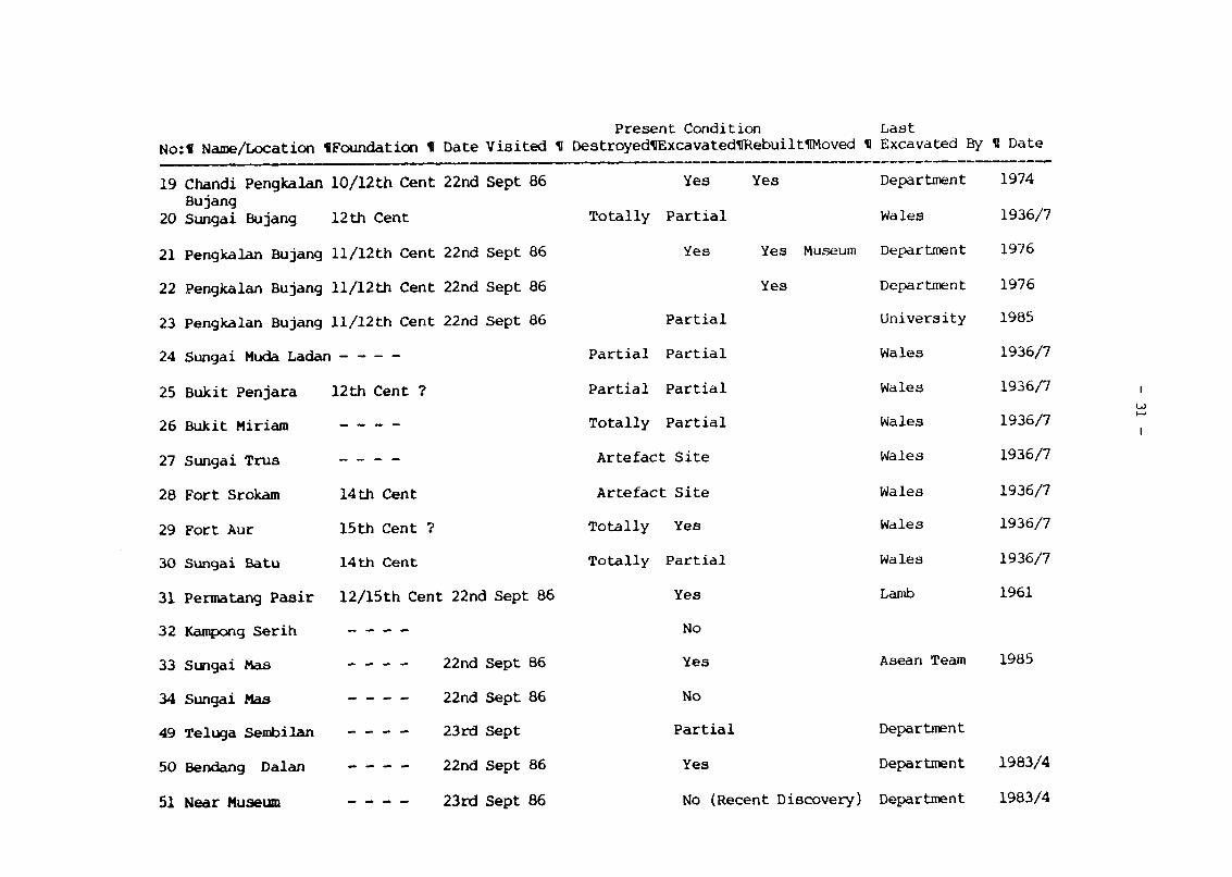
- 31
-
fl i
r-
Q I
2
a* i
I
4-1
a
TD I
(V I
4J I
.13 I
> I
4-)
fl I
(0
CJ I
ig
x i
o
j j
w i
o
i
I
0]
>H
0}
cu
KO CO
4J
a a» CO
"g C
N
CM
C
<u
CJ
4J
CN
J3 cn
C
a) cu
m
a»
CO
0)
i—i
fl
fl
•H
4-1
14
fl
04
o
4J
C (V
CJ
CN
CJ
Ol
cn c fl
•n
á C
P-f-t
c
A
fl
C"
?§
CQ CO
O CN
ai
CO
cu
CO
4J
«
CO
TJ c
CM
c 9) U J
= 4-1
C
a» c Cu
CN
KO
CO cu
oo
4J
a a> co
C
CN
C
M
C
CJ
CM
I a» c CU
C
u C
N
CN
m
CO
cJi
•H
co CU >
•H
c 3 U
fl
Cu
kO
CO
Q.
CU CO
T5 C
C
N
CN
C (V
CJ
4J
C
N
Ol
3 CQ
C
J3 5
5 cn c 4) Cu m
C
N
U5
en to eu
-H
fl
ss fl
u fl
Cu fl CT>
CO
T <N
m
Ol
01
a» fl
3 fl
4J
4-1
u u
fl (0
Cu Cu
4->
u fl Cu
4J
c <V
CJ
5
CM
I fl fl
1 •?
•3 CQ
in
C
N
KO
Ol
U3
CI
Ol
CO
(1) •
H fl
3
co
u fl Cu
fl i-l
o EH
01
4-1
CO
fl
< fl
CJ>
CO
CN
KD <n O
l
CO CD
fl
2 CU 4J
•H
CO
4-1
U
fl
KU
¿I < c
IV
CJ
cn O
l
co
I CO
cu
J3 o EH
C
4) C
J
.C
4-)
m lu
u o CU ai
CN
KO en oí co
a» 2 fl
Cu
i-I
r-i
o EH
C cu CJ
5 3
r2 fl cn
CO
8
KO O
l
CQ CU
>H
o Z
CO
cu co
c C
N
CN
C CU
o
4-1
m
r-H
\ CN
un co O
Í
CU É
H
c
fl
cu CO
< CO
CU
O
>H
Z
10
C0
4J
a cu co
c C
N
CN
I
I
I
I
I
I
I
I
«43 CO
4J
a
'S C
N
CN
4J
U fl Cu
a cu co
en C
N
i
i
i
i
i
i
i
i
i-t
<v
m
oo
Ol
CO
cu
KO co
a cu CO
'S C
N
CN
I fl fl
Q O»
A o
m
en
oo
en
â
CU a 2 o u CO
4J
C
cu CJ cu cd
o z CO
a cu to
en
C
N
3
m
- 32 -
ANNEX VI
LIST OF MAPS AND PLANS
Fig. 1 - Location map of Peninsular of Malaysia
Fig. 2 - Diagram of proposed National Historical Park Bujang Valley - Kedah - Malaysia
Fig. 3 - Bujang Valley Museum Land Acquisition
Fig. 4 - Historical Sites in Kedah
Fig. 5 - Proposed extensions to Bujang Valley Museum
Fig. 6 - Kuala Kedah Fort - Bird's Eye View
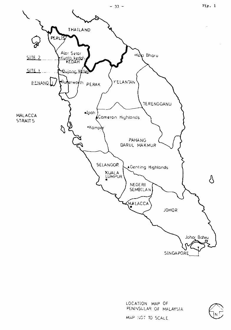
Fig. 1
MALACCA STRAITS
SINGAPORE
LOCATION MAP OF PENINSULAR OF MALAYSIA
MAP NOT TO SCALE
- 34 -
DATE: OCTOBER 1986
NOT TO SCALE
.DIAGRAM OF PROPOSED NATIONAL HISTORICAL PARK BUJANG VALLEY - KEDÄH - MALAYSIA
Ü UJ
•= UJ
? It
33 2694
- 35 Fig. 3
2693 SITE &o D
SITE 21 • 2695
SITE 8 D
SITE 16 O
SITE 51
533,
544
545
.EGENDr
LAND O W N E D BY M U S R I M | |
•AND UNDER NEGOTIATION £7/
DATE:-
Sungoi Merbok Kechil
546
BUJANG VALLEY DWG No MUSEUM
S C A L E D 130Approx LAND AQU1SIT10N
SIM PANG AM POT 15 m A LOR STAR 9m. LANCEAR Um
dm«
| LEGEND • .1:._£XISTJNG . UN EXCAVATED. SITE •
..2...DESTR0YED SITE... .._ . . . O
3: REBUILT IN SITU . . •
4 REBUILT ON N E W SITE H
tviiaa
JOHN SANDAY CONSULTANTS INTERNATIONAL
•c/o I? J3 JLQX_i242 KATHMANDU NEPAL
TEL 4U885 TLX 2216_.TI.CL TOP NP
DATE HISTORICAL SITES
IN KEDAH
DWG No
SCALE ;-
1 Inch = .1 Mile
BASED ON ._MA_P-..PROVIDED ..BY THE NATIONAL MUSEUM
tsm^*^>i»ä^^^H&^mmm^ms»^^f!ix^a^ies»
'0 Chi AN Di BUKIT BATü PAHAT
>
\
1 \
\
a
BATU PAH Ar RiVf»..
m
*-v
ms,
\
Fig. 5 |
- -O
10 MERBOK 2 5 km
.Mtrssis^ rü&ÜX^T KAT-HMA-NOü- HEPüt
mmMm y^t^mu^füp*^ w
*f*
DATE
SCALE
<?'- 25' S0>... » ö ' '
PROPOSED EXTENSIONS TO BUJANG VALLEY MUSEUM
Ó
JÇOPiÊ0l__FRpM..
DEPARTMENT MUSEUMS DRAWING
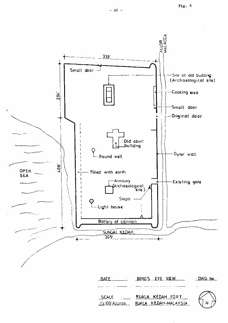
- 40 -Fig. 6
Site of old building I \ (Archaeological site)
—Cooking urea
—Small door
— Original door
DATE BIRD'S EYE VIEW DWG. No
KUALA KEDAH FORT .SCALE
r=iOO'Approx. KUALA KEDAH-MALAYS1A
- Al -
AKKEX VII
LIST OF PHOTOGRAPHS
THE BUJAMG VALLEY
General view towards Kedah Peak from across Merbok Estuary
A typical Hindu Shrine recently constructed in Bujang Valley by Indians working on plantations
Matang Pasir - Site 31
Matang Pasir - Site 31 - Museum
Interior of Museum
Bukit Batu Pahat - Site 8
Conjectural Model of Candi Bukit Batu Bahat - Site 8
- Bujang Valley (State Museum - Alor Setar)
Chandi Pendiak - Site 16
Site 21
Site 50
Teluga Sembilan - Site 49
- Pengkalan Bujang - Site 19
Site 22
Site 23
Site 5
Location of Bukit Choras - Site 1
Bukit Choras - Site 1
KUALA KEDAH FORT
Conjectural Model of the Kuala Kedah Fort
English Gate - Main Entrance
British Gate - East Wall -
British Gate - ¿ast Wall
- West Wall
West Wall - Collapsed Old Wall - Note cannon in rubble
- North East Bastion
- South East Bastion
- South Wall - Seawards
- South Wall - Seawards
Foundation of original wall (South)
- Damage by Vegetation
Audience Hall
Audience Hall - Detail
- British Gate from Inside
Remains of Old Gate
General View Towards North
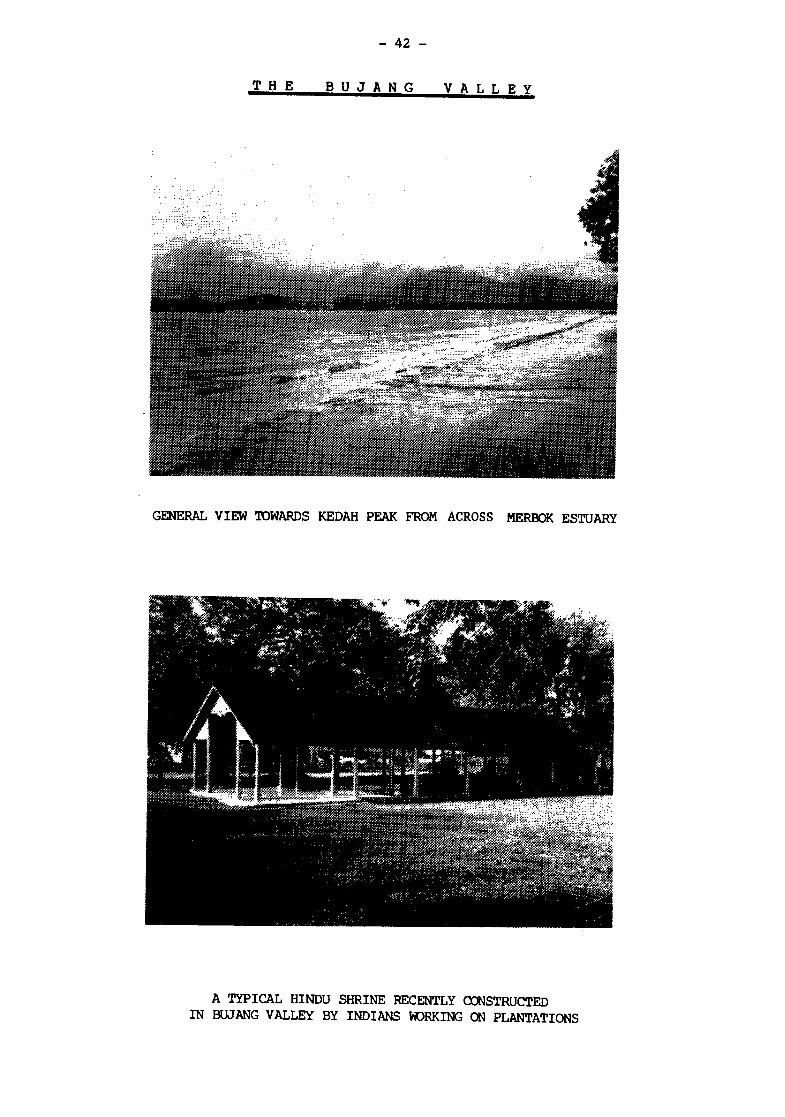
- 42 -
T H E B U J A N G V A L L E Y
—TP~
1/
GENERAL VIEW TOWARDS KEDAH PEAK FROM ACROSS MERBOK ESTUARY
• IPS**»"«
^ ^ iK ;>;. J?-" - - :
iitiSiflliiiiifliiii
A TYPICAL HINDU SHRINE RECENTLY CONSTRUCTED IN BUJANG VALLEY BY INDIANS WORKING ON PLANTATIONS
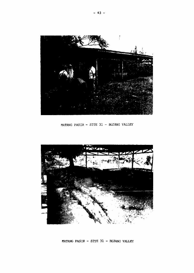
- 43 -
¡yç***** ;
MATANG PASIR - SITE 31 - BUJANG VALLEY
•wntetr^m*
MATANG PASIR - SITE 31 - BUJANG VALLEY
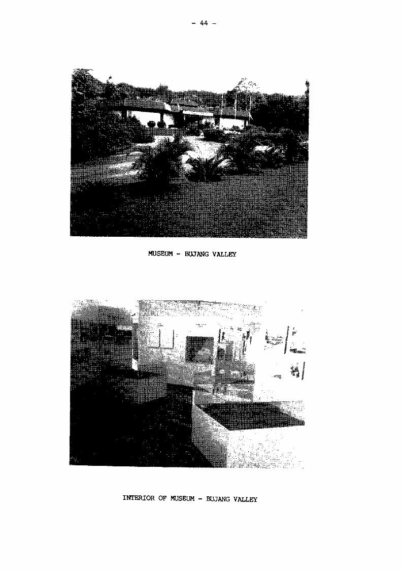
- 44 -
MUSEUM - BUJANG VALLEY
. .**5Çi»
*##***.
\^MfcJÇfcfl&1
INTERIOR OF MUSEUM - BUJANG VALLEY
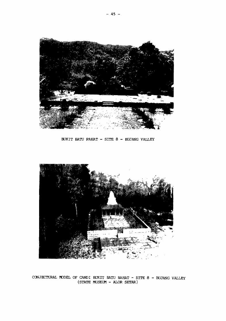
- 45 -
• > & ' * • * % , •
BUKIT BATU PAHAT - SITE 8 - BUJANG VALLEY
CONJECTURAL MODEL OF CANDI BUKIT BATU BAHAT - SITE 8 - BUJANG VALLEY (STATE MUSEUM - ALOR SETAR)
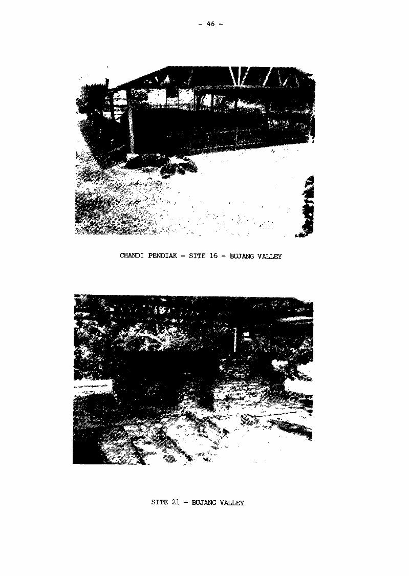
- 46 -
CHANDI PENDIAK - SITE 16 - BUJANG VALLEY
SITE 21 - BUJANG VALLEY

- 47 -
•*r.:
• "'it » • &
"*' í i 'I-JÉ . • .•. • ' ¡ S Í
SITE 50 - BUJANG VALLEY
TELUGA SEMBILAN - SITE 49 - BUJANG VALLEY
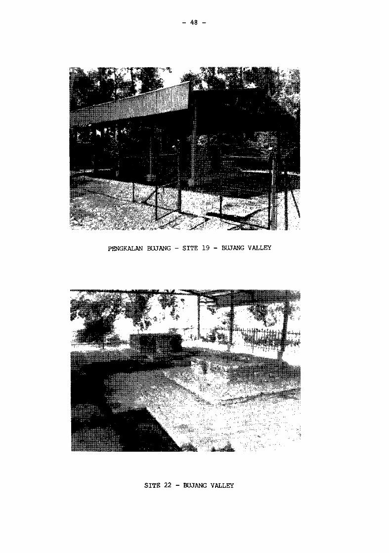
- 48 -
•'¿í'/''
¡nsx - '*,,
PENGKALAN BUJANG - SITE 19 - BUJANG VALLEY
',?
SITE 22 - BUJANG VALLEY
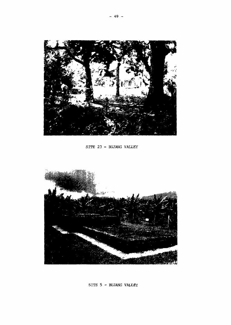
- 49 -
-«Hf
SITE 23 - BUJANG VALLEY
SITE 5 - BUJANG VALLEY
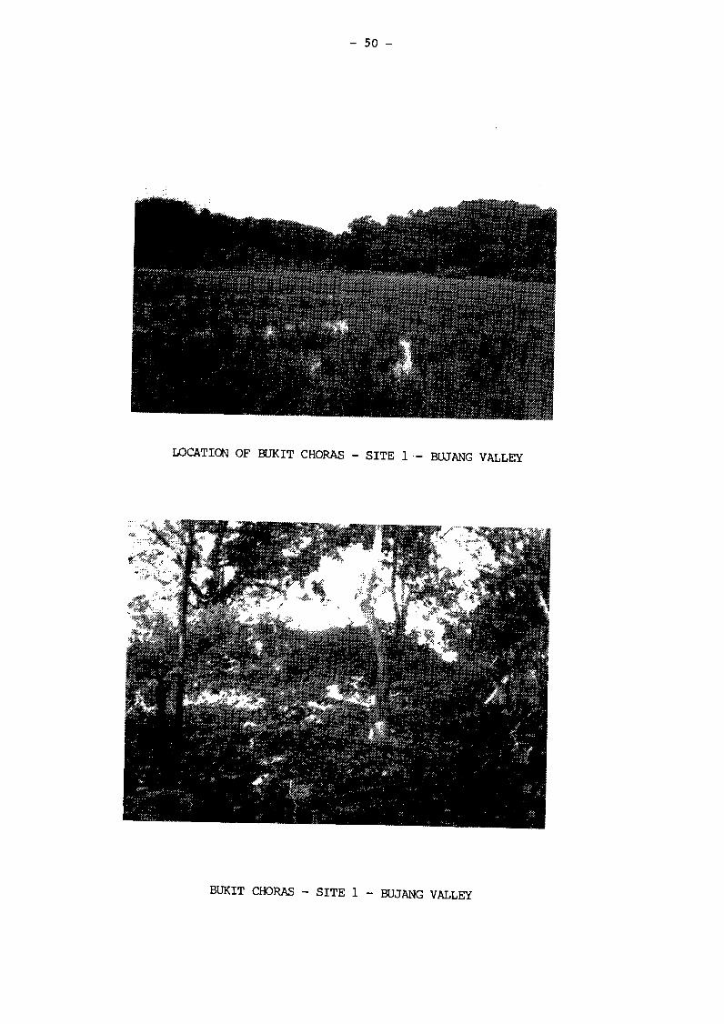
- 50 -
LOCATION OF BUKIT CHORAS - SITE 1 - BUJANG VALLEY
. :•: ^ Í Í Í S P K Í - : - 1 ' . '?.' r;.... '••;••••::•—••• . . •&••.&. S ? & » ¿ ' & " ' ~ ' • i : ••>:--
"":" , ' ™ - •••,. •..i'̂ ;.;:ï:,. "••='' .,•:::;::•'-.,: / :=5:::^ :-./.rf:^^ii|g^]:t-'
BUKIT CHORAS - SITE 1 - BUJANG VALLEY
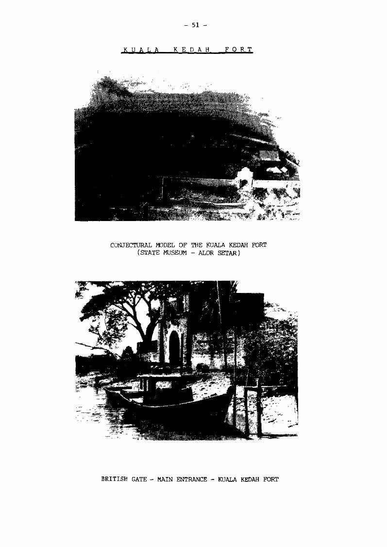
- 51 -
K U A L A K E D A H F O R T
CONJECTURAL MODEL OF THE KUALA KEDAH FORT (STATE MUSEUM - ALOR SETAR)
^mÊ
BRITISH GATE - MAIN ENTRANCE - KUALA KEDAH FORT
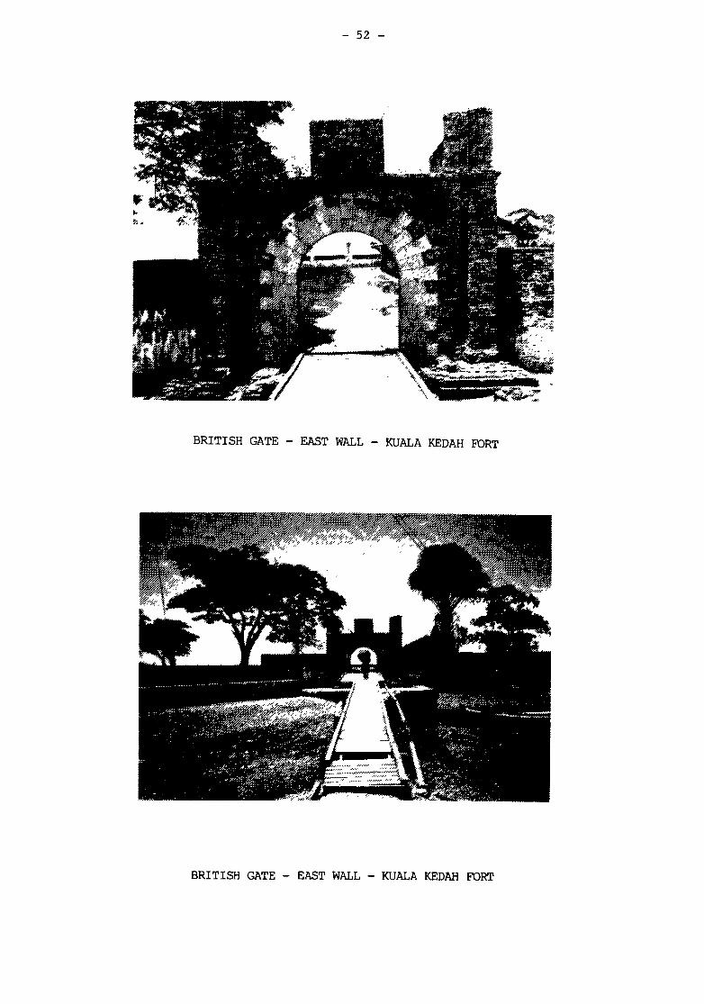
- 52 -
BRITISH GATE - EAST WALL - KUALA KEDAH FORT
í •
:^*&ñí
- - fVtf'ii ÊÊÊÊBÊ
: * ' * > •
BRITISH GATE - EAST WALL - KUALA KEDAH FORT
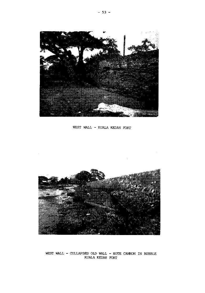
- 53 -
w
5î+* J L .
î£fif
« , * * * • * * • « . *
iJri r >d • s * ? * ' . 1
WEST WALL - KUALA KEDAH FORT
«rï*tt
, * •«> • * v
lünSsäiffl-
• ; J * •
.,:,: ̂ 2Í|¡Í'*"*" |ï
WEST WALL - COLLAPSED OLD WALL - NOTE CANNON IN RUBBLE KUALA KEDAH FORT
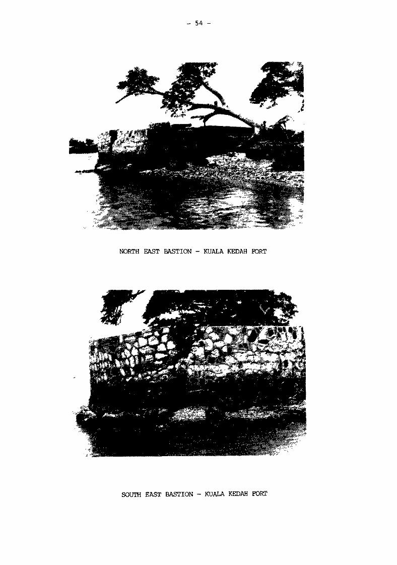
- 54 -
NORTH EAST BASTION - KUALA KEDAH FORT
SOUTH EAST BASTION - KUALA KEDAH FORT
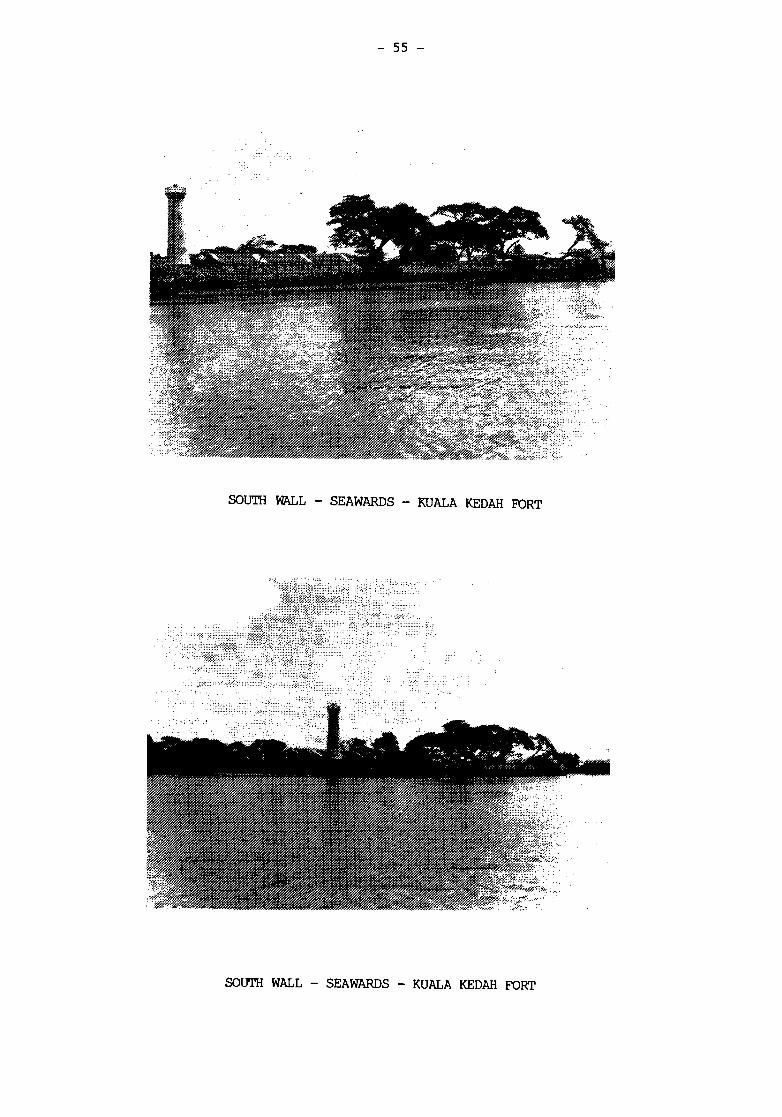
- 55 -
it
if« .3>*?„ \ ' **•
SOUTH WALL - SEAWARDS - KUALA KEDAH FORT
Wa&^é::<r::%¿"
•'mfíms&i
* J K . y«*?».., :
* $ > * • *
* • ' * * * * H
*•*
^ *<*+
SOUTH WALL - SEAWARDS - KUALA KEDAH FORT
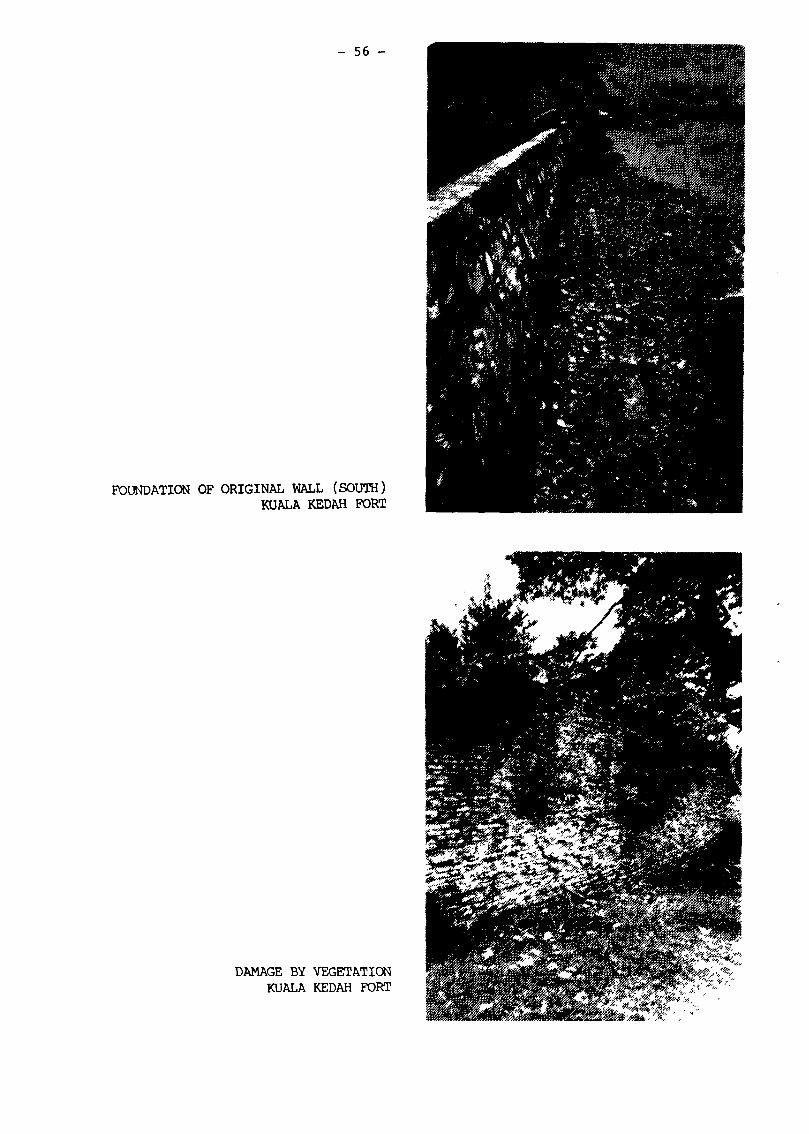
- 56 -
FOUNDATION OF ORIGINAL WALL (SOUTH) KUALA KEDAH FORT
DAMAGE BY VEGETATION KUALA KEDAH FORT
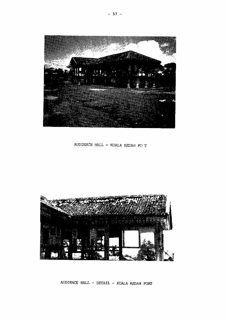
- 57 -
AUDIENCE HALL - KUALA KEDAH FD'T
*^*
AUDIENCE HALL - DETAIL - KUALA KEDAH FORT
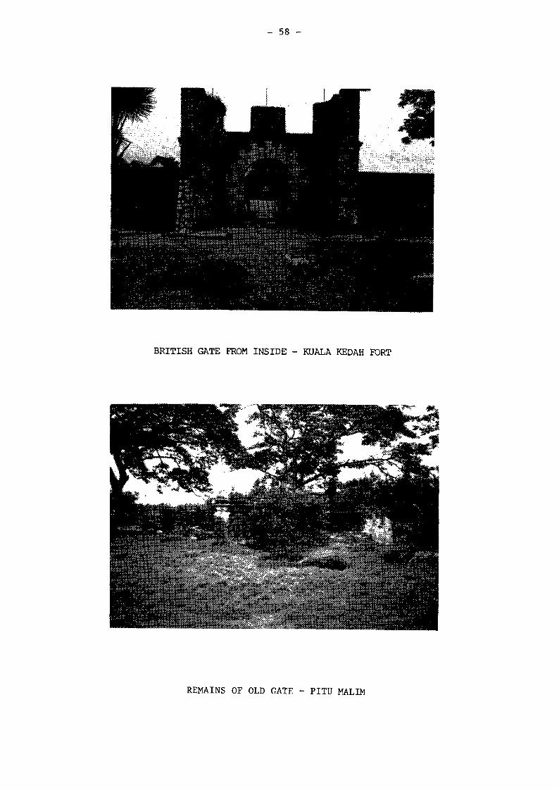
- 58 -
BRITISH GATE FROM INSIDE - KUALA KEDAH PORT
REMAINS OF OLD GATE - PITU MALIM
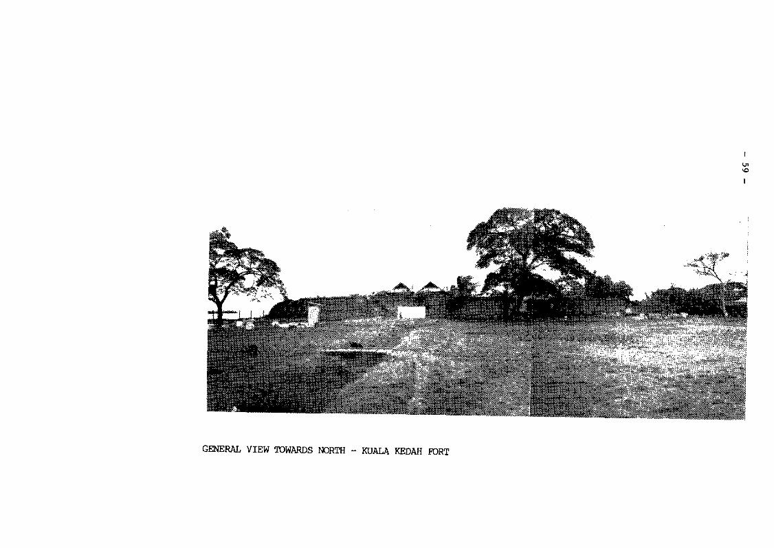
- 59
-
EH
£ <
g
s
CO
s w
M
>
u
- 6
0
-M
-Ä
i •Jrf m
T
it.,
"ï •" 'A1
.1^
• V
S
i».
I«
••.t. <r í Í
# "»
/ Ht .iH
»fc, I .i
•M
»"j
•Si
;#
I« •I
ft .Vi>! ,:v
:
v *; fc'
WM
^ * »:
14
fM
*}\