Embed Size (px)
Citation preview
Built Environment Resources Technical Report, Regional Connector Transit Corridor Project, Los Angeles County, California
(SWCA Environmental Consultants 2009)
Los Angeles Civic Center Historic District
State of California The Resources Agency Primary # DEPARTMENT OF PARKS AND RECREATION HRI # DISTRICT RECORD Trinomial Page 1 of 39 *NRHP Status Code: 3B, 3CB *Resource Name or # (Assigned by recorder): Los Angeles Civic Center Historic District (Nos. 5-1 to 5-13, 6-1 to 6-7, 6-12) D1. Historic Name: Los Angeles Civic Center D2. Common Name: Los Angeles Civic Center
*D3. Detailed Description The Los Angles Civic Center is a closely built, informally organized complex of government buildings, structures, and landscapes (formal urban spaces integral to those buildings and structures) located downtown, between West 1st, Figueroa, Temple and San Pedro streets. Its organization is along the southeast-northwest (SE-NW) axis that extends through City Hall from the southeast to the Department of Water and Power Building (DWP) at the northwest. Early 20th century planners sited four Civic Center buildings prior to World War II—the Hall of Justice (1925), City Hall (1928), State Office Building (1932, razed), and the United States Courthouse and Federal Building (1940)— to anchor an unrealized axis,90 degrees to the east. Construction of the Hollywood Freeway (US 101) extension immediately after the war necessitated realignment of the Civic Center configuration to be southeast-northwest, extending northwest to meet the new Harbor Freeway (US-110). Construction of new civic buildings followed: City Health Building (1954), City Police Headquarters(1955), county Hall of Administration (1956-1961), Central Heating and Refrigeration Plant (1958), County Courthouse (1958), county Hall of Records (1962), Music Center (including tree buildings, 1964-69), and terminating the northwest end of the axis, the city DWP building (1964); with a new Federal Building (1966) extended Civic Center east along the Santa Ana Freeway (Interstate 5). The Criminal Justice Center (1972) largely finished the Civic Center, along with extensive landscape architecture of el Paseo de los Pobladores (1966) and its extensions, and Civic Center’s labyrinth of parking garages, underground storage and utilities, and connecting tunnels. See associated Primary Records, BSO forms, and mapping for additional descriptions and significance of contributing elements in the district.
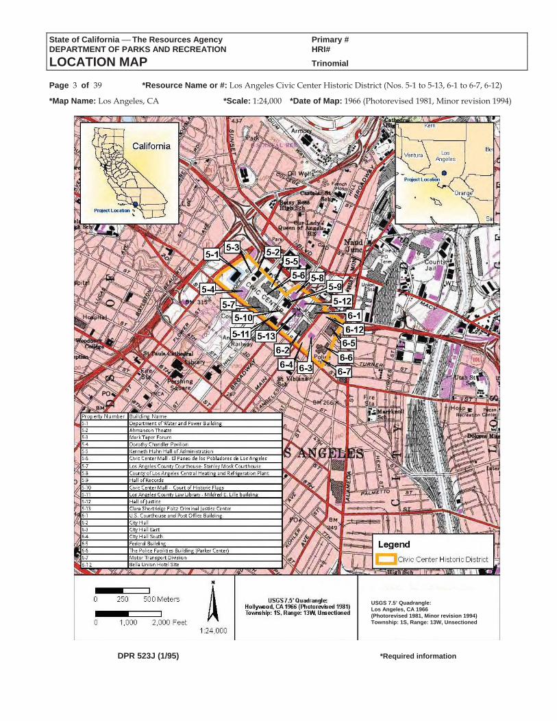
*D4. Boundary Description (Describe limits of district and attach map showing boundary and district elements.): Bounded by West 1st Street on the southwest, Figueroa Street on the northwest, Temple Street on the northeast, San Pedro Street on the southeast. See attached Location Map for boundaries and keyed resources.
*D5. Boundary Justification: The Los Angeles Civic Center Historic District includes the formal partíi of city, county, and federal governmental services planned just before and immediately following World War II. It was planned and built primarily along a formal SE-NW axis running from City Hall at the southeast to the DWP Building at the northwest. The district boundary includes all parcels holding those buildings, above and underground structures, and associated landscapes that encompass city, county and federal services in what is formally known as the Civic Center.
*D6. Significance: Theme: Civic Center for City and County Governments Area: Los Angeles Period of Significance: 1925-1972 Applicable Criteria: A/1, C/3 State and county officials proposed a “Civic Center” for Los Angeles as early as 1911, and public commissions in the 1920s projected plans for a City Beautiful complex that sited today’s City Hall, city/county Hall of Justice, and Federal Courthouse in a grouping intended to anchor an unrealized SW-NE axis toward and partly consuming the Old Plaza area. Interrupted by World War II, the new city and county Civic Center Authority resumed projections in 1945, but with construction of the Santa Ana Freeway to the northeast, the intended City Beautiful axis was irretrievably interrupted. In the mid 1950s with construction of the new City Health Building and Police Headquarters, city planners ignored the previous axial configuration, in favor of a City Hall cluster. By 1956, however, the county revived the axis-based development—now SE-NW centered on City Hall’s alternate orientation—with its own dispersed services through separate courts and administration buildings. Fear of nuclear attack during the Cold War led the authority to build facilities with massive underground parking garages that would double as bomb and fallout shelters for the combined governments, dressed largely as the multi-level public landscape of Paseo de los Pobladores along the gentle northwesterly slope from City Hall. In 1969, the Civic Center was defined and largely complete, with the Music/Performing Arts Center along the axis, the city’s Department of Water and Power Building terminating the axis at the northwest near Harbor Freeway, and the new Federal Building extending the complex two blocks east. Addition of the combined city/county Criminal Justice Center in 1972 and demolition of the earthquake-damaged State Office Building in 1976 resulted in the current appearance and configuration of the Los Angeles Civic Center Historic District. The district, with slightly different boundaries, was found eligible for California Register listing in 2006 (“Grand Avenue”), although no evidence was found regarding Office of Historic Preservation concurrence for that finding. Los Angeles Civic Center is eligible for listing in the California and National Registers under Criteria A/1 and C/3 at the local level of significance.
*D7. References (Give full citations including the names and addresses of any informants, where possible.): Gebhard, David and Robert Winter, Architecture in Los Angeles. (Salt Lake City: Gibbs M. Smith, Inc., 2003): 256-261. Los Angeles Grand Avenue Authority, “The Grand Avenue Project Draft Environmental Impact Report” 2006: 434-443. Los Angeles Times. various articles 1939-1979. Moore, Charles with Peter Becker, and Regula Campbell, The City Observed: Los Angeles. (New York: Vintage Books, 1984): 11-15.
*D8. Evaluator: Jim Steely, Francesca Smith, and Kip Harper Date: May 26, 2009 Affiliation and Address: SWCA Environmental Consultants, 625 Fair Oaks Avenue, Suite 190, South Pasadena, CA 91030
DPR 523D (1/95) *Required information
State of California The Resources Agency Primary #DEPARTMENT OF PARKS AND RECREATION HRI #PRIMARY RECORD Trinomial NRHP Status Code 3B, 3CB Other Listings
Review Code Reviewer DatePage 2 of 39 *Resource Name or #: Los Angeles Civic Center Historic District (Nos. 5-1 to 5-13, 6-1 to 6-7, 6-12)P1. Other Identifier: Civic Center
*P2. Location: Not for Publication Unrestricted *a. County: Los Angeles and (P2b and P2c or P2d. Attach a Location Map as necessary.)
*b. USGS 7.5' Quad: Los Angeles, CA Date: 1966 (photorevised 1981, minor revision 1994) T 1S R 13W Sec. Unsectioned B.M. San Bernardinoc. Address: various City: Los Angeles Zip: 90012 d. UTM: Zone: ; mE/ mN (G.P.S.) e. Other Locational Data: (e.g., parcel #, directions to resource, elevation, etc., as appropriate) Elevation:
Bounded by West 1st Street on the southwest, Figueroa Street on the northwest, Temple Street on the northeast and San Pedro Street on the southeast.
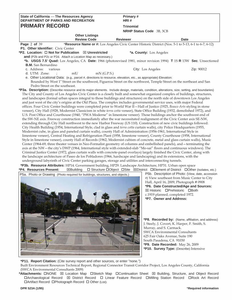
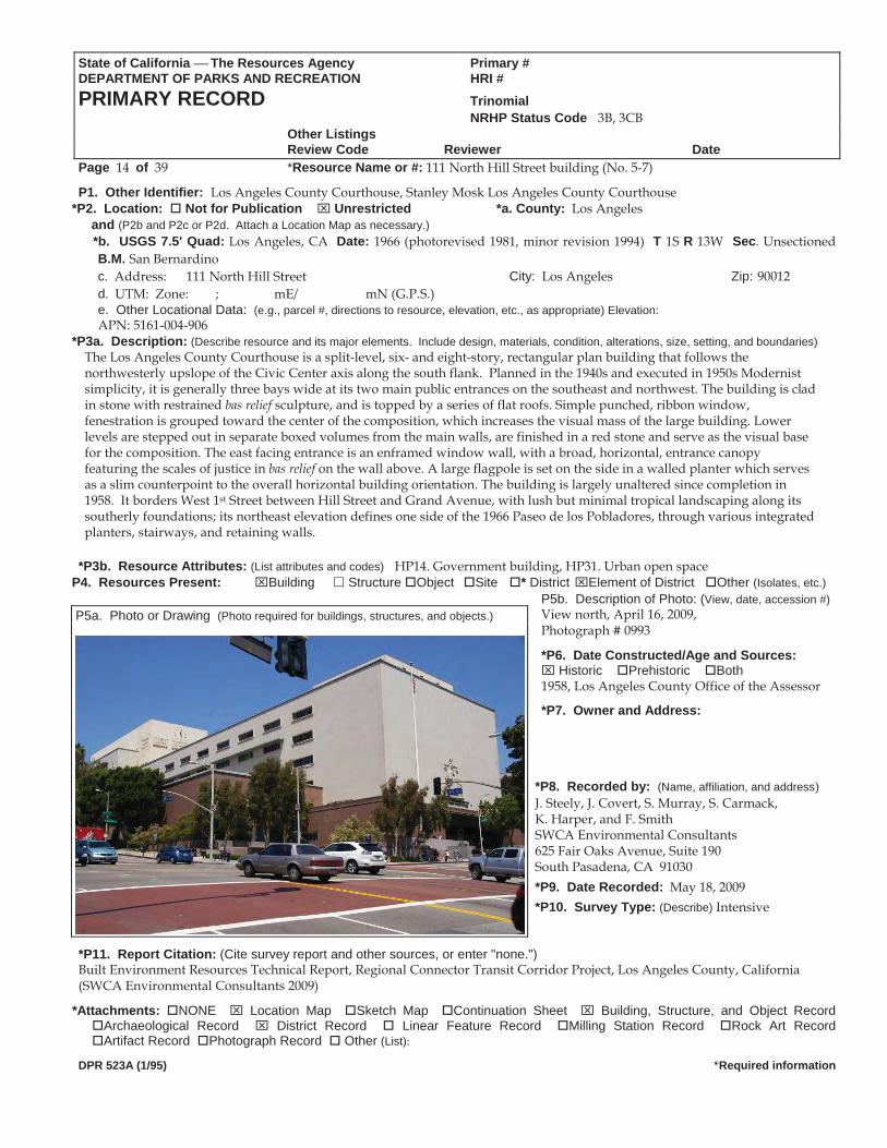
*P3a. Description: (Describe resource and its major elements. Include design, materials, condition, alterations, size, setting, and boundaries)The City and County of Los Angeles Civic Center is a closely built and somewhat organized complex of buildings, structures, and landscapes (formal urban spaces integral to those buildings and structures) on the north side of downtown Los Angeles and just west of the city’s origins at the Old Plaza. The complex includes governmental service uses, with major Federal offices. Four Civic Center buildings were completed prior to World War II—Hall of Justice (1925, Beaux-Arts styling in stone veneer), City Hall (1928, Modernist Classicism in white terra cotta veneer), State Office Building (1932, demolished 1972), and U.S. Post Office and Courthouse (1940, “PWA Moderne” in limestone veneer). Those buildings anchor the southwest end of the SW-NE axis. Freeway construction immediately after the war necessitated realignment of the Civic Center axis SE-NW, extending through City Hall northwest to the new Harbor Freeway (US 110). Construction of new civic buildings followed: City Health Building (1954, International Style, clad in glass and terra cotta curtain walls), city Police Headquarters (1955, Modernist cube, in glass and paneled curtain walls), county Hall of Administration (1956-1961, International Style in limestone veneer), Central Heating and Refrigeration Plant (1958, limestone veneer), County Courthouse (1958, International Style in limestone veneer), county Hall of Records (1962, Modernist cubism of concrete, metal and glass curtain walls), Music Center (1964-69, three theater venues in Neo-Formalist geometry of columns and embellished panels), and—terminating the axis at the NW—the city’s DWP (1964, International style with extended-slab “Mo-sai” floors and continuous windows). The Criminal Justice Center (1972, glass curtain walls with concrete-panel overlays) largely finished the Civic Center, along with the landscape architecture of Paseo de los Pobladores (1966, hardscape and landscaping) and its extensions, with the underground labyrinth of Civic Center parking garages, storage and utilities and interconnecting tunnels.
*P3b. Resource Attributes: HP14. Government building, HP29. Landscape Architecture, HP31. Urban open space *P4. Resources Present: Building Structure Object Site District Element of District Other (Isolates, etc.)
P5b. Description of Photo: (View, date, accession #) View southeast from Music Center to City Hall, April 16, 2009, Photograph # 0908
P5a. Photo or Drawing (Photo required for buildings, structures, and objects.)
*P6. Date Constructed/Age and Sources: Historic Prehistoric Both
c.1919 planned, completed 1972. *P7. Owner and Address:
*P8. Recorded by: (Name, affiliation, and address)J. Steely, J. Covert, K. Harper, F. Smith, S. Murray, and S. Carmack. SWCA Environmental Consultants 625 Fair Oaks Avenue, Suite 190 South Pasadena, CA 91030 *P9. Date Recorded: May 26, 2009 *P10. Survey Type: (Describe) Intensive
*P11. Report Citation: (Cite survey report and other sources, or enter "none.") Built Environment Resources Technical Report, Regional Connector Transit Corridor Project, Los Angeles County, California (SWCA Environmental Consultants 2009)
*Attachments: NONE Location Map Sketch Map Continuation Sheet Building, Structure, and Object Record Archaeological Record District Record Linear Feature Record Milling Station Record Rock Art Record Artifact Record Photograph Record Other (List):
DPR 523A (1/95) *Required information
State of California The Resources Agency Primary # DEPARTMENT OF PARKS AND RECREATION HRI#
LOCATION MAP Trinomial
Page 3 of 39 *Resource Name or #: Los Angeles Civic Center Historic District (Nos. 5-1 to 5-13, 6-1 to 6-7, 6-12)
*Map Name: Los Angeles, CA *Scale: 1:24,000 *Date of Map: 1966 (Photorevised 1981, Minor revision 1994)
USGS 7.5’ Quadrangle: Los Angeles, CA 1966 (Photorevised 1981, Minor revision 1994) Township: 1S, Range: 13W, Unsectioned
DPR 523J (1/95) *Required information
State of California The Resources Agency Primary #DEPARTMENT OF PARKS AND RECREATION HRI #PRIMARY RECORD Trinomial NRHP Status Code 3B, 3CB Other Listings
Review Code Reviewer DatePage 4 of 39 *Resource Name or #: 111 North Hope Street building (No. 5-1)
P1. Other Identifier: Department of Water and Power Building; John Ferraro Office Building (2001) *P2. Location: Not for Publication Unrestricted *a. County: Los Angeles
and (P2b and P2c or P2d. Attach a Location Map as necessary.) *b. USGS 7.5' Quad: Los Angeles, CA Date: 1966 (photorevised 1981, minor revision 1994) T 1S R 13W Sec. Unsectioned
B.M. San Bernardinoc. Address: 111 North Hope Street Building City: Los Angeles Zip: 90012 d. UTM: Zone: ; mE/ mN (G.P.S.) e. Other Locational Data: (e.g., parcel #, directions to resource, elevation, etc., as appropriate) Elevation: APN: 5161-003-910
*P3a. Description: (Describe resource and its major elements. Include design, materials, condition, alterations, size, setting, and boundaries)
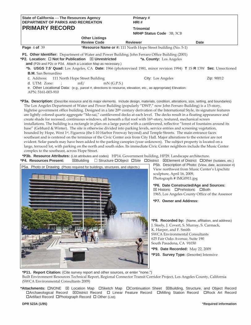
The Los Angeles Department of Water and Power Building (popularly “DWP,” now John Ferraro Building) is a 15-story, highrise government office building. Designed in a late 20th century derivation of the International Style, its signature features are lightly colored quartz aggregate “Mo-sai,” cantilevered decks at each level. The decks result in a floating appearance and create shade for recessed, continuous windows, all beneath a flat roof with 16th-story, textured, mechanical screen installations. The building is a rectangle in plan on a large parcel with a cantilevered, reflective “forest of fountains around its base” (Gebhard & Winter). The site is otherwise divided into parking levels, service entries and screening vegetation, bounded by Hope, West 1st, Figueroa (the I-10 Harbor Freeway beyond) and Temple Streets. The main entrance faces southeast and is centered on the terminus of the Civic Center axis from City Hall. Major alterations to the exterior are not evident. Solar panels may have been added to the parking canopies (year unknown). The subject property is located on a large, terraced lot, with parking on the north and south sides. Its immediate Civic Center neighbors include the Music Center complex to the southeast, across Hope Street.
*P3b. Resource Attributes: (List attributes and codes) HP14. Government building, HP29. Landscape architecture. *P4. Resources Present: Building Structure Object Site District Element of District Other (Isolates, etc.)
P5b. Description of Photo: (View, date, accession #)View northwest from Music Center’s Lipschitz sculpture, April 16, 2009,
P5a. Photo or Drawing (Photo required for buildings, structures, and objects.)
Photograph # IMG0911.jpg
*P6. Date Constructed/Age and Sources: Historic Prehistoric Both
1965, Los Angeles County Office of the Assessor
*P7. Owner and Address:
*P8. Recorded by: (Name, affiliation, and address) J. Steely, J. Covert, S. Murray, S. Carmack, K. Harper, and F. Smith SWCA Environmental Consultants 625 Fair Oaks Avenue, Suite 190 South Pasadena, CA 91030 *P9. Date Recorded: May 22, 2009 *P10. Survey Type: (Describe) Intensive
*P11. Report Citation: (Cite survey report and other sources, or enter "none.") Built Environment Resources Technical Report, Regional Connector Transit Corridor Project, Los Angeles County, California (SWCA Environmental Consultants 2009)
*Attachments: NONE Location Map Sketch Map Continuation Sheet Building, Structure, and Object Record Archaeological Record District Record Linear Feature Record Milling Station Record Rock Art Record Artifact Record Photograph Record Other (List):
DPR 523A (1/95) *Required information
State of California The Resources Agency Primary # DEPARTMENT OF PARKS AND RECREATION HRI#
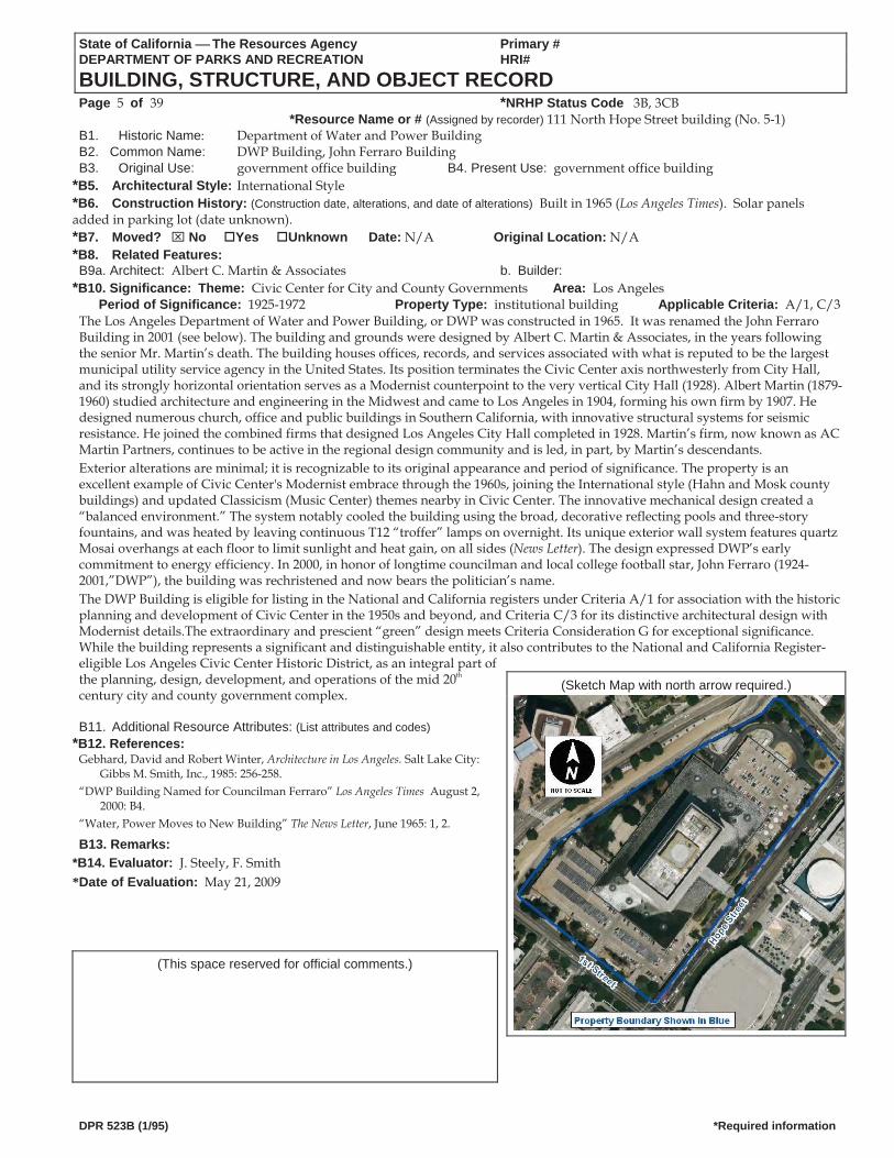
BUILDING, STRUCTURE, AND OBJECT RECORD Page 5 of 39 *NRHP Status Code 3B, 3CB
*Resource Name or # (Assigned by recorder) 111 North Hope Street building (No. 5-1) B1. Historic Name: Department of Water and Power Building B2. Common Name: DWP Building, John Ferraro Building B3. Original Use: government office building B4. Present Use: government office building
*B5. Architectural Style: International Style *B6. Construction History: (Construction date, alterations, and date of alterations) Built in 1965 (Los Angeles Times). Solar panels added in parking lot (date unknown). *B7. Moved? No Yes Unknown Date: N/A Original Location: N/A *B8. Related Features: B9a. Architect: Albert C. Martin & Associates b. Builder:
*B10. Significance: Theme: Civic Center for City and County Governments Area: Los AngelesPeriod of Significance: 1925-1972 Property Type: institutional building Applicable Criteria: A/1, C/3
The Los Angeles Department of Water and Power Building, or DWP was constructed in 1965. It was renamed the John Ferraro Building in 2001 (see below). The building and grounds were designed by Albert C. Martin & Associates, in the years following the senior Mr. Martin’s death. The building houses offices, records, and services associated with what is reputed to be the largest municipal utility service agency in the United States. Its position terminates the Civic Center axis northwesterly from City Hall, and its strongly horizontal orientation serves as a Modernist counterpoint to the very vertical City Hall (1928). Albert Martin (1879-1960) studied architecture and engineering in the Midwest and came to Los Angeles in 1904, forming his own firm by 1907. He designed numerous church, office and public buildings in Southern California, with innovative structural systems for seismic resistance. He joined the combined firms that designed Los Angeles City Hall completed in 1928. Martin’s firm, now known as AC Martin Partners, continues to be active in the regional design community and is led, in part, by Martin’s descendants. Exterior alterations are minimal; it is recognizable to its original appearance and period of significance. The property is an excellent example of Civic Center's Modernist embrace through the 1960s, joining the International style (Hahn and Mosk county buildings) and updated Classicism (Music Center) themes nearby in Civic Center. The innovative mechanical design created a “balanced environment.” The system notably cooled the building using the broad, decorative reflecting pools and three-story fountains, and was heated by leaving continuous T12 “troffer” lamps on overnight. Its unique exterior wall system features quartz Mosai overhangs at each floor to limit sunlight and heat gain, on all sides (News Letter). The design expressed DWP’s early commitment to energy efficiency. In 2000, in honor of longtime councilman and local college football star, John Ferraro (1924-2001,”DWP”), the building was rechristened and now bears the politician’s name. The DWP Building is eligible for listing in the National and California registers under Criteria A/1 for association with the historic planning and development of Civic Center in the 1950s and beyond, and Criteria C/3 for its distinctive architectural design with Modernist details.The extraordinary and prescient “green” design meets Criteria Consideration G for exceptional significance. While the building represents a significant and distinguishable entity, it also contributes to the National and California Register- eligible Los Angeles Civic Center Historic District, as an integral part of the planning, design, development, and operations of the mid 20th century city and county government complex.
(Sketch Map with north arrow required.)
B11. Additional Resource Attributes: (List attributes and codes)
*B12. References: Gebhard, David and Robert Winter, Architecture in Los Angeles. Salt Lake City:
Gibbs M. Smith, Inc., 1985: 256-258. “DWP Building Named for Councilman Ferraro” Los Angeles Times August 2,
2000: B4. “Water, Power Moves to New Building” The News Letter, June 1965: 1, 2.
B13. Remarks: *B14. Evaluator: J. Steely, F. Smith *Date of Evaluation: May 21, 2009
(This space reserved for official comments.)
DPR 523B (1/95) *Required information
State of California The Resources Agency Primary #DEPARTMENT OF PARKS AND RECREATION HRI #PRIMARY RECORD Trinomial NRHP Status Code 3B, 3CB Other Listings HABS CA-2780
Review Code Reviewer DatePage 6 of 39 *Resource Name or #: 135 North Grand Avenue buildings, structures and landscape (No. 5-2)
P1. Other Identifier: Los Angeles Music Center for the Performing Arts, Music Center *P2. Location: Not for Publication Unrestricted *a. County: Los Angeles
and (P2b and P2c or P2d. Attach a Location Map as necessary.) *b. USGS 7.5' Quad: Los Angeles, CA Date: 1966 (photorevised 1981, minor revision 1994) T 1S R 13W Sec. Unsectioned
B.M. San Bernardinoc. Address: 135 North Grand Avenue City: Los Angeles Zip: 90012 d. UTM: Zone: ; mE/ mN (G.P.S.) e. Other Locational Data: (e.g., parcel #, directions to resource, elevation, etc., as appropriate) Elevation: APN: 5161-004-907
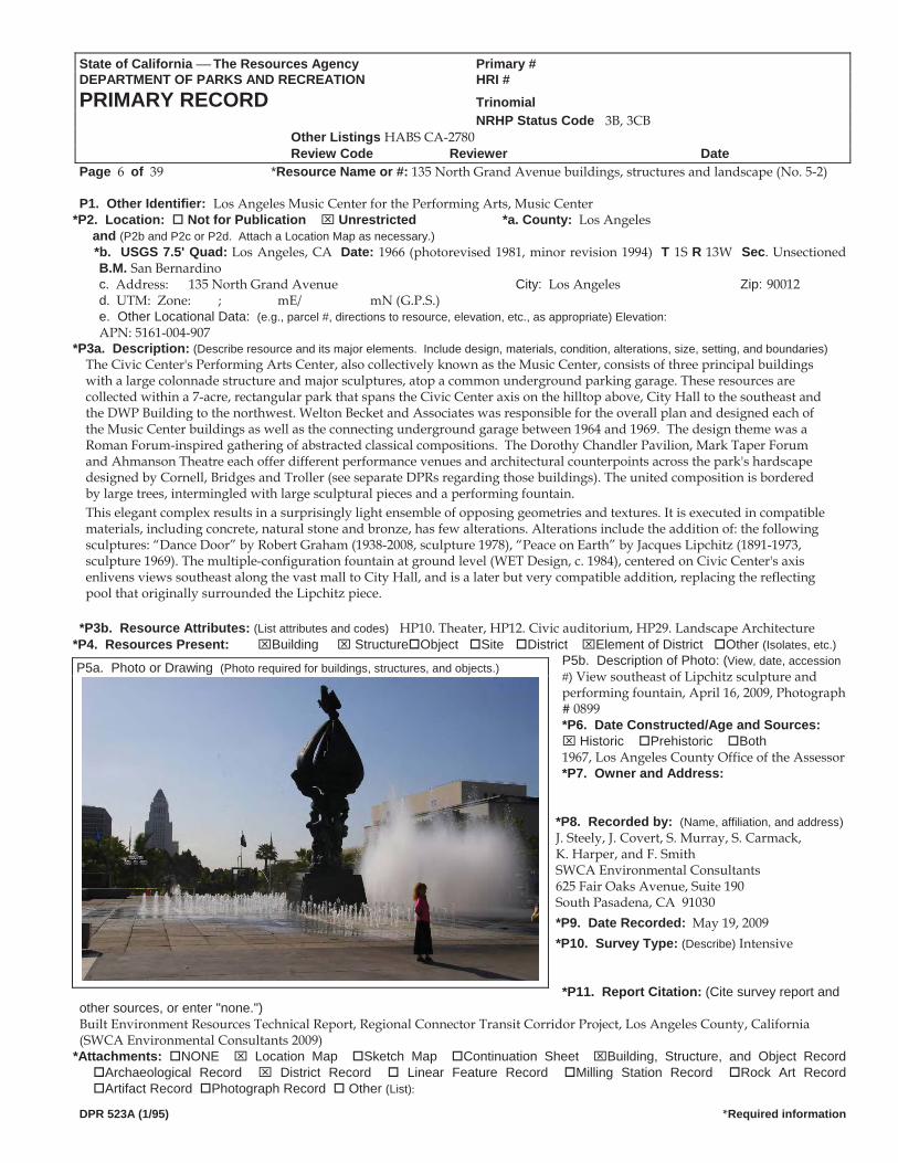
*P3a. Description: (Describe resource and its major elements. Include design, materials, condition, alterations, size, setting, and boundaries)The Civic Center's Performing Arts Center, also collectively known as the Music Center, consists of three principal buildings with a large colonnade structure and major sculptures, atop a common underground parking garage. These resources are collected within a 7-acre, rectangular park that spans the Civic Center axis on the hilltop above, City Hall to the southeast and the DWP Building to the northwest. Welton Becket and Associates was responsible for the overall plan and designed each of the Music Center buildings as well as the connecting underground garage between 1964 and 1969. The design theme was a Roman Forum-inspired gathering of abstracted classical compositions. The Dorothy Chandler Pavilion, Mark Taper Forum and Ahmanson Theatre each offer different performance venues and architectural counterpoints across the park's hardscape designed by Cornell, Bridges and Troller (see separate DPRs regarding those buildings). The united composition is bordered by large trees, intermingled with large sculptural pieces and a performing fountain. This elegant complex results in a surprisingly light ensemble of opposing geometries and textures. It is executed in compatible materials, including concrete, natural stone and bronze, has few alterations. Alterations include the addition of: the following sculptures: “Dance Door” by Robert Graham (1938-2008, sculpture 1978), “Peace on Earth” by Jacques Lipchitz (1891-1973, sculpture 1969). The multiple-configuration fountain at ground level (WET Design, c. 1984), centered on Civic Center's axis enlivens views southeast along the vast mall to City Hall, and is a later but very compatible addition, replacing the reflecting pool that originally surrounded the Lipchitz piece.
*P3b. Resource Attributes: (List attributes and codes) HP10. Theater, HP12. Civic auditorium, HP29. Landscape Architecture *P4. Resources Present: Building Structure Object Site District Element of District Other (Isolates, etc.)
P5b. Description of Photo: (View, date, accession #) View southeast of Lipchitz sculpture and performing fountain, April 16, 2009, Photograph # 0899 *P6. Date Constructed/Age and Sources:
Historic Prehistoric Both1967, Los Angeles County Office of the Assessor *P7. Owner and Address:
*P8. Recorded by: (Name, affiliation, and address) J. Steely, J. Covert, S. Murray, S. Carmack, K. Harper, and F. Smith SWCA Environmental Consultants 625 Fair Oaks Avenue, Suite 190 South Pasadena, CA 91030 *P9. Date Recorded: May 19, 2009 *P10. Survey Type: (Describe) Intensive
*P11. Report Citation: (Cite survey report and other sources, or enter "none.")
P5a. Photo or Drawing (Photo required for buildings, structures, and objects.)
Built Environment Resources Technical Report, Regional Connector Transit Corridor Project, Los Angeles County, California (SWCA Environmental Consultants 2009)
*Attachments: NONE Location Map Sketch Map Continuation Sheet Building, Structure, and Object Record Archaeological Record District Record Linear Feature Record Milling Station Record Rock Art Record Artifact Record Photograph Record Other (List):
DPR 523A (1/95) *Required information
State of California The Resources Agency Primary # DEPARTMENT OF PARKS AND RECREATION HRI#
BUILDING, STRUCTURE, AND OBJECT RECORD Page 7 of 39 *NRHP Status Code 3B, 3CB
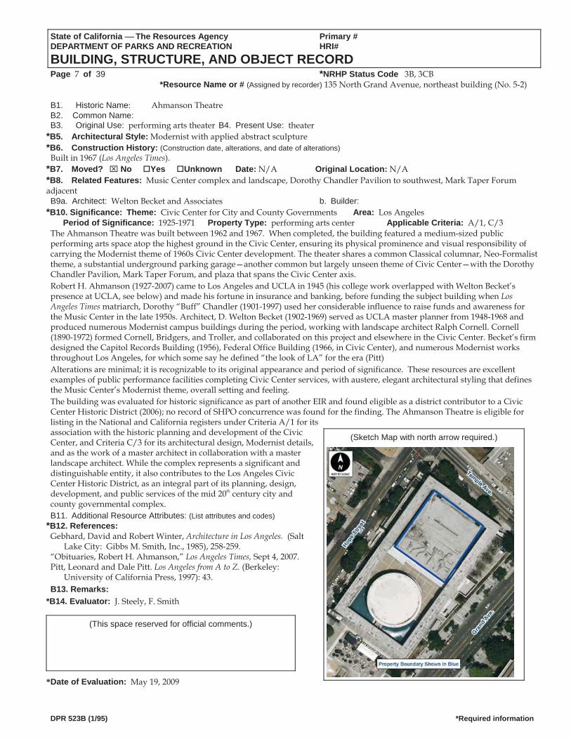
*Resource Name or # (Assigned by recorder) 135 North Grand Avenue, northeast building (No. 5-2) B1. Historic Name: Ahmanson Theatre B2. Common Name: B3. Original Use: performing arts theater B4. Present Use: theater
*B5. Architectural Style: Modernist with applied abstract sculpture *B6. Construction History: (Construction date, alterations, and date of alterations)
Built in 1967 (Los Angeles Times). *B7. Moved? No Yes Unknown Date: N/A Original Location: N/A *B8. Related Features: Music Center complex and landscape, Dorothy Chandler Pavilion to southwest, Mark Taper Forum adjacent B9a. Architect: Welton Becket and Associates b. Builder:
*B10. Significance: Theme: Civic Center for City and County Governments Area: Los AngelesPeriod of Significance: 1925-1971 Property Type: performing arts center Applicable Criteria: A/1, C/3
The Ahmanson Theatre was built between 1962 and 1967. When completed, the building featured a medium-sized public performing arts space atop the highest ground in the Civic Center, ensuring its physical prominence and visual responsibility of carrying the Modernist theme of 1960s Civic Center development. The theater shares a common Classical columnar, Neo-Formalist theme, a substantial underground parking garage—another common but largely unseen theme of Civic Center—with the Dorothy Chandler Pavilion, Mark Taper Forum, and plaza that spans the Civic Center axis. Robert H. Ahmanson (1927-2007) came to Los Angeles and UCLA in 1945 (his college work overlapped with Welton Becket’s presence at UCLA, see below) and made his fortune in insurance and banking, before funding the subject building when Los Angeles Times matriarch, Dorothy “Buff” Chandler (1901-1997) used her considerable influence to raise funds and awareness for the Music Center in the late 1950s. Architect, D. Welton Becket (1902-1969) served as UCLA master planner from 1948-1968 and produced numerous Modernist campus buildings during the period, working with landscape architect Ralph Cornell. Cornell (1890-1972) formed Cornell, Bridgers, and Troller, and collaborated on this project and elsewhere in the Civic Center. Becket’s firm designed the Capitol Records Building (1956), Federal Office Building (1966, in Civic Center), and numerous Modernist works throughout Los Angeles, for which some say he defined “the look of LA” for the era (Pitt) Alterations are minimal; it is recognizable to its original appearance and period of significance. These resources are excellent examples of public performance facilities completing Civic Center services, with austere, elegant architectural styling that defines the Music Center’s Modernist theme, overall setting and feeling. The building was evaluated for historic significance as part of another EIR and found eligible as a district contributor to a Civic Center Historic District (2006); no record of SHPO concurrence was found for the finding. The Ahmanson Theatre is eligible for listing in the National and California registers under Criteria A/1 for its association with the historic planning and development of the Civic Center, and Criteria C/3 for its architectural design, Modernist details, and as the work of a master architect in collaboration with a master landscape architect. While the complex represents a significant and distinguishable entity, it also contributes to the Los Angeles Civic Center Historic District, as an integral part of its planning, design, development, and public services of the mid 20th century city and county governmental complex.
(Sketch Map with north arrow required.)
B11. Additional Resource Attributes: (List attributes and codes) *B12. References:
Gebhard, David and Robert Winter, Architecture in Los Angeles. (Salt Lake City: Gibbs M. Smith, Inc., 1985), 258-259.
“Obituaries, Robert H. Ahmanson,” Los Angeles Times, Sept 4, 2007. Pitt, Leonard and Dale Pitt. Los Angeles from A to Z. (Berkeley:
University of California Press, 1997): 43. B13. Remarks:
*B14. Evaluator: J. Steely, F. Smith
(This space reserved for official comments.)
*Date of Evaluation: May 19, 2009
DPR 523B (1/95) *Required information
State of California The Resources Agency Primary # DEPARTMENT OF PARKS AND RECREATION HRI#
BUILDING, STRUCTURE, AND OBJECT RECORD Page 8 of 39 *NRHP Status Code 3B, 3CB
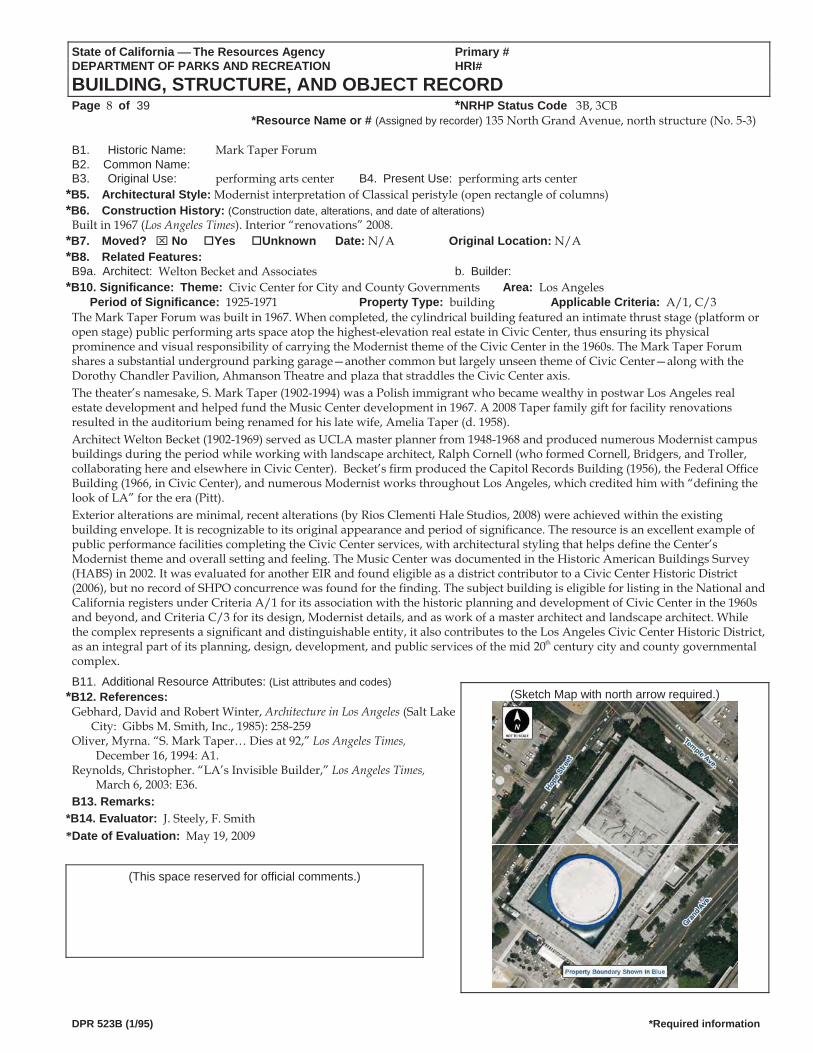
*Resource Name or # (Assigned by recorder) 135 North Grand Avenue, north structure (No. 5-3) B1. Historic Name: Mark Taper Forum B2. Common Name: B3. Original Use: performing arts center B4. Present Use: performing arts center
*B5. Architectural Style: Modernist interpretation of Classical peristyle (open rectangle of columns) *B6. Construction History: (Construction date, alterations, and date of alterations)
Built in 1967 (Los Angeles Times). Interior “renovations” 2008. *B7. Moved? No Yes Unknown Date: N/A Original Location: N/A *B8. Related Features: B9a. Architect: Welton Becket and Associates b. Builder:
*B10. Significance: Theme: Civic Center for City and County Governments Area: Los AngelesPeriod of Significance: 1925-1971 Property Type: building Applicable Criteria: A/1, C/3
The Mark Taper Forum was built in 1967. When completed, the cylindrical building featured an intimate thrust stage (platform or open stage) public performing arts space atop the highest-elevation real estate in Civic Center, thus ensuring its physical prominence and visual responsibility of carrying the Modernist theme of the Civic Center in the 1960s. The Mark Taper Forum shares a substantial underground parking garage—another common but largely unseen theme of Civic Center—along with the Dorothy Chandler Pavilion, Ahmanson Theatre and plaza that straddles the Civic Center axis. The theater’s namesake, S. Mark Taper (1902-1994) was a Polish immigrant who became wealthy in postwar Los Angeles real estate development and helped fund the Music Center development in 1967. A 2008 Taper family gift for facility renovations resulted in the auditorium being renamed for his late wife, Amelia Taper (d. 1958). Architect Welton Becket (1902-1969) served as UCLA master planner from 1948-1968 and produced numerous Modernist campus buildings during the period while working with landscape architect, Ralph Cornell (who formed Cornell, Bridgers, and Troller, collaborating here and elsewhere in Civic Center). Becket’s firm produced the Capitol Records Building (1956), the Federal Office Building (1966, in Civic Center), and numerous Modernist works throughout Los Angeles, which credited him with “defining the look of LA” for the era (Pitt). Exterior alterations are minimal, recent alterations (by Rios Clementi Hale Studios, 2008) were achieved within the existing building envelope. It is recognizable to its original appearance and period of significance. The resource is an excellent example of public performance facilities completing the Civic Center services, with architectural styling that helps define the Center’s Modernist theme and overall setting and feeling. The Music Center was documented in the Historic American Buildings Survey (HABS) in 2002. It was evaluated for another EIR and found eligible as a district contributor to a Civic Center Historic District (2006), but no record of SHPO concurrence was found for the finding. The subject building is eligible for listing in the National and California registers under Criteria A/1 for its association with the historic planning and development of Civic Center in the 1960s and beyond, and Criteria C/3 for its design, Modernist details, and as work of a master architect and landscape architect. While the complex represents a significant and distinguishable entity, it also contributes to the Los Angeles Civic Center Historic District, as an integral part of its planning, design, development, and public services of the mid 20th century city and county governmental omplex. c
B11. Additional Resource Attributes: (List attributes and codes) (Sketch Map with north arrow required.) *B12. References:
Gebhard, David and Robert Winter, Architecture in Los Angeles (Salt Lake City: Gibbs M. Smith, Inc., 1985): 258-259
Oliver, Myrna. “S. Mark Taper… Dies at 92,” Los Angeles Times, December 16, 1994: A1.
Reynolds, Christopher. “LA’s Invisible Builder,” Los Angeles Times, March 6, 2003: E36.
B13. Remarks: *B14. Evaluator: J. Steely, F. Smith *Date of Evaluation: May 19, 2009
(This space reserved for official comments.)
DPR 523B (1/95) *Required information
State of California The Resources Agency Primary # DEPARTMENT OF PARKS AND RECREATION HRI#
BUILDING, STRUCTURE, AND OBJECT RECORD Page 9 of 39 *NRHP Status Code 3B, 3CB
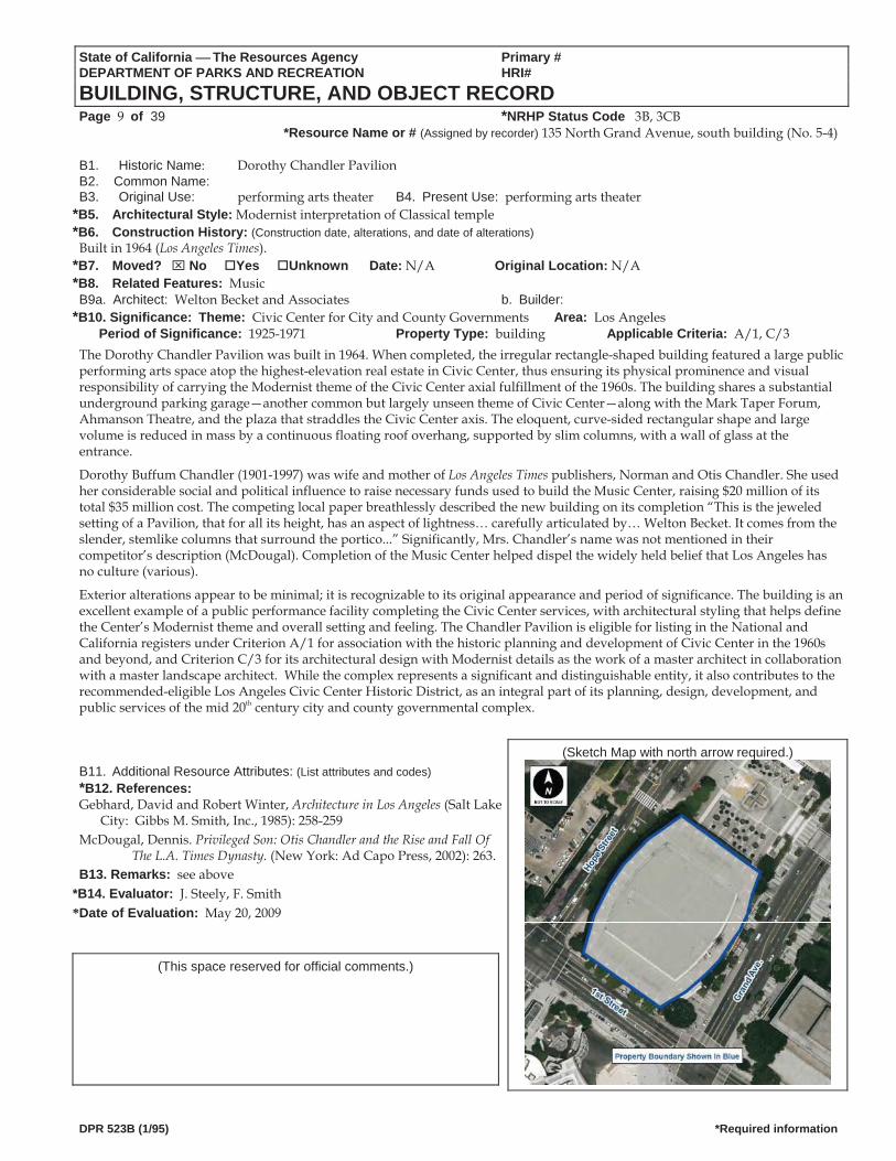
*Resource Name or # (Assigned by recorder) 135 North Grand Avenue, south building (No. 5-4) B1. Historic Name: Dorothy Chandler Pavilion B2. Common Name: B3. Original Use: performing arts theater B4. Present Use: performing arts theater
*B5. Architectural Style: Modernist interpretation of Classical temple *B6. Construction History: (Construction date, alterations, and date of alterations)
Built in 1964 (Los Angeles Times). *B7. Moved? No Yes Unknown Date: N/A Original Location: N/A *B8. Related Features: Music B9a. Architect: Welton Becket and Associates b. Builder:
*B10. Significance: Theme: Civic Center for City and County Governments Area: Los AngelesPeriod of Significance: 1925-1971 Property Type: building Applicable Criteria: A/1, C/3
The Dorothy Chandler Pavilion was built in 1964. When completed, the irregular rectangle-shaped building featured a large public performing arts space atop the highest-elevation real estate in Civic Center, thus ensuring its physical prominence and visual responsibility of carrying the Modernist theme of the Civic Center axial fulfillment of the 1960s. The building shares a substantial underground parking garage—another common but largely unseen theme of Civic Center—along with the Mark Taper Forum, Ahmanson Theatre, and the plaza that straddles the Civic Center axis. The eloquent, curve-sided rectangular shape and large volume is reduced in mass by a continuous floating roof overhang, supported by slim columns, with a wall of glass at the entrance.
Dorothy Buffum Chandler (1901-1997) was wife and mother of Los Angeles Times publishers, Norman and Otis Chandler. She used her considerable social and political influence to raise necessary funds used to build the Music Center, raising $20 million of its total $35 million cost. The competing local paper breathlessly described the new building on its completion “This is the jeweled setting of a Pavilion, that for all its height, has an aspect of lightness… carefully articulated by… Welton Becket. It comes from the slender, stemlike columns that surround the portico...” Significantly, Mrs. Chandler’s name was not mentioned in their competitor’s description (McDougal). Completion of the Music Center helped dispel the widely held belief that Los Angeles has no culture (various).
Exterior alterations appear to be minimal; it is recognizable to its original appearance and period of significance. The building is an excellent example of a public performance facility completing the Civic Center services, with architectural styling that helps define the Center’s Modernist theme and overall setting and feeling. The Chandler Pavilion is eligible for listing in the National and California registers under Criterion A/1 for association with the historic planning and development of Civic Center in the 1960s and beyond, and Criterion C/3 for its architectural design with Modernist details as the work of a master architect in collaboration with a master landscape architect. While the complex represents a significant and distinguishable entity, it also contributes to the recommended-eligible Los Angeles Civic Center Historic District, as an integral part of its planning, design, development, and public services of the mid 20th century city and county governmental complex.
(Sketch Map with north arrow required.) B11. Additional Resource Attributes: (List attributes and codes) *B12. References: Gebhard, David and Robert Winter, Architecture in Los Angeles (Salt Lake
City: Gibbs M. Smith, Inc., 1985): 258-259 McDougal, Dennis. Privileged Son: Otis Chandler and the Rise and Fall Of
The L.A. Times Dynasty. (New York: Ad Capo Press, 2002): 263. B13. Remarks: see above
*B14. Evaluator: J. Steely, F. Smith *Date of Evaluation: May 20, 2009
(This space reserved for official comments.)
DPR 523B (1/95) *Required information
State of California The Resources Agency Primary # DEPARTMENT OF PARKS AND RECREATION HRI #PRIMARY RECORD Trinomial NRHP Status Code 3B, 3CB Other Listings
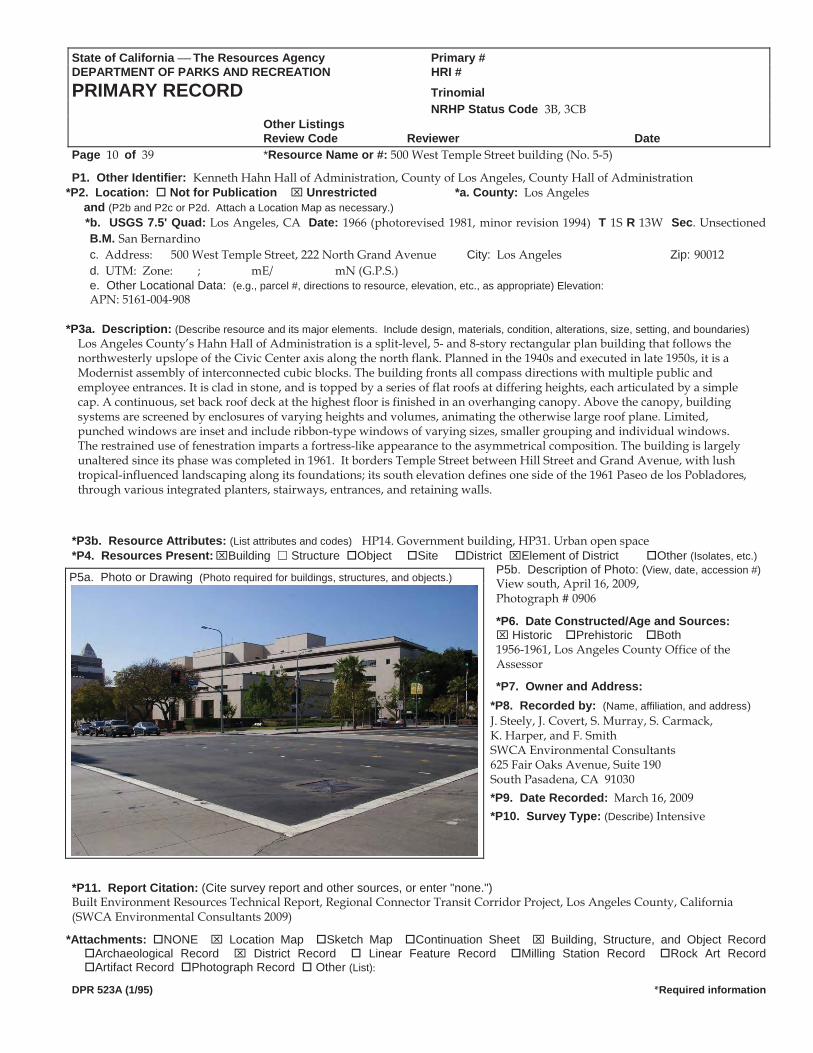
Review Code Reviewer DatePage 10 of 39 *Resource Name or #: 500 West Temple Street building (No. 5-5)
P1. Other Identifier: Kenneth Hahn Hall of Administration, County of Los Angeles, County Hall of Administration *P2. Location: Not for Publication Unrestricted *a. County: Los Angeles
and (P2b and P2c or P2d. Attach a Location Map as necessary.) *b. USGS 7.5' Quad: Los Angeles, CA Date: 1966 (photorevised 1981, minor revision 1994) T 1S R 13W Sec. Unsectioned
B.M. San Bernardinoc. Address: 500 West Temple Street, 222 North Grand Avenue City: Los Angeles Zip: 90012 d. UTM: Zone: ; mE/ mN (G.P.S.) e. Other Locational Data: (e.g., parcel #, directions to resource, elevation, etc., as appropriate) Elevation: APN: 5161-004-908
*P3a. Description: (Describe resource and its major elements. Include design, materials, condition, alterations, size, setting, and boundaries)
Los Angeles County’s Hahn Hall of Administration is a split-level, 5- and 8-story rectangular plan building that follows the northwesterly upslope of the Civic Center axis along the north flank. Planned in the 1940s and executed in late 1950s, it is a Modernist assembly of interconnected cubic blocks. The building fronts all compass directions with multiple public and employee entrances. It is clad in stone, and is topped by a series of flat roofs at differing heights, each articulated by a simple cap. A continuous, set back roof deck at the highest floor is finished in an overhanging canopy. Above the canopy, building systems are screened by enclosures of varying heights and volumes, animating the otherwise large roof plane. Limited, punched windows are inset and include ribbon-type windows of varying sizes, smaller grouping and individual windows. The restrained use of fenestration imparts a fortress-like appearance to the asymmetrical composition. The building is largely unaltered since its phase was completed in 1961. It borders Temple Street between Hill Street and Grand Avenue, with lush tropical-influenced landscaping along its foundations; its south elevation defines one side of the 1961 Paseo de los Pobladores, through various integrated planters, stairways, entrances, and retaining walls.
*P3b. Resource Attributes: (List attributes and codes) HP14. Government building, HP31. Urban open space*P4. Resources Present: Building Structure Object Site District Element of District Other (Isolates, etc.)
P5b. Description of Photo: (View, date, accession #)View south, April 16, 2009, P5a. Photo or Drawing (Photo required for buildings, structures, and objects.)
Photograph # 0906
*P6. Date Constructed/Age and Sources: Historic Prehistoric Both
1956-1961, Los Angeles County Office of the Assessor
*P7. Owner and Address: *P8. Recorded by: (Name, affiliation, and address) J. Steely, J. Covert, S. Murray, S. Carmack, K. Harper, and F. Smith SWCA Environmental Consultants 625 Fair Oaks Avenue, Suite 190 South Pasadena, CA 91030 *P9. Date Recorded: March 16, 2009 *P10. Survey Type: (Describe) Intensive
*P11. Report Citation: (Cite survey report and other sources, or enter "none.") Built Environment Resources Technical Report, Regional Connector Transit Corridor Project, Los Angeles County, California (SWCA Environmental Consultants 2009)
*Attachments: NONE Location Map Sketch Map Continuation Sheet Building, Structure, and Object Record Archaeological Record District Record Linear Feature Record Milling Station Record Rock Art Record Artifact Record Photograph Record Other (List):
DPR 523A (1/95) *Required information
State of California The Resources Agency Primary # DEPARTMENT OF PARKS AND RECREATION HRI#
BUILDING, STRUCTURE, AND OBJECT RECORD Page 11 of 39 *NRHP Status Code 3B, 3CB
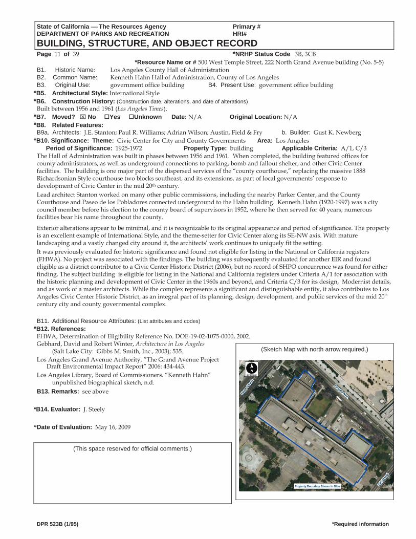
*Resource Name or # 500 West Temple Street, 222 North Grand Avenue building (No. 5 5)B1. Historic Name: Los Angeles County Hall of Administration B2. Common Name: Kenneth Hahn Hall of Administration, County of Los AngelesB3. Original Use: government office building B4. Present Use: government office building
*B5. Architectural Style: International Style *B6. Construction History: (Construction date, alterations, and date of alterations)
Built between 1956 and 1961 (Los Angeles Times). *B7. Moved? No Yes Unknown Date: N/A Original Location: N/A *B8. Related Features: B9a. Architects: J.E. Stanton; Paul R. Williams; Adrian Wilson; Austin, Field & Fry b. Builder: Gust K. Newberg
*B10. Significance: Theme: Civic Center for City and County Governments Area: Los AngelesPeriod of Significance: 1925-1972 Property Type: building Applicable Criteria: A/1, C/3
The Hall of Administration was built in phases between 1956 and 1961. When completed, the building featured offices for county administrators, as well as underground connections to parking, bomb and fallout shelter, and other Civic Center facilities. The building is one major part of the dispersed services of the “county courthouse,” replacing the massive 1888 Richardsonian Style courthouse two blocks southeast, and its extensions, as part of local governments’ response to development of Civic Center in the mid 20th century. Lead architect Stanton worked on many other public commissions, including the nearby Parker Center, and the County Courthouse and Paseo de los Pobladores connected underground to the Hahn building. Kenneth Hahn (1920-1997) was a city council member before his election to the county board of supervisors in 1952, where he then served for 40 years; numerous facilities bear his name throughout the county.
Exterior alterations appear to be minimal, and it is recognizable to its original appearance and period of significance. The property is an excellent example of International Style, and the theme-setter for Civic Center along its SE-NW axis. With mature landscaping and a vastly changed city around it, the architects’ work continues to uniquely fit the setting. It was previously evaluated for historic significance and found not eligible for listing in the National or California registers (FHWA). No project was associated with the findings. The building was subsequently evaluated for another EIR and found eligible as a district contributor to a Civic Center Historic District (2006), but no record of SHPO concurrence was found for either finding. The subject building is eligible for listing in the National and California registers under Criteria A/1 for association with the historic planning and development of Civic Center in the 1960s and beyond, and Criteria C/3 for its design, Modernist details, and as work of a master architects. While the complex represents a significant and distinguishable entity, it also contributes to Los Angeles Civic Center Historic District, as an integral part of its planning, design, development, and public services of the mid 20th century city and county governmental complex.
B11. Additional Resource Attributes: (List attributes and codes) *B12. References:
FHWA, Determination of Eligibility Reference No. DOE-19-02-1075-0000, 2002. Gebhard, David and Robert Winter, Architecture in Los Angeles
(Salt Lake City: Gibbs M. Smith, Inc., 2003); 535. (Sketch Map with north arrow required.)
Los Angeles Grand Avenue Authority, “The Grand Avenue Project Draft Environmental Impact Report” 2006: 434-443.
Los Angeles Library, Board of Commissioners. “Kenneth Hahn” unpublished biographical sketch, n.d.
B13. Remarks: see above
*B14. Evaluator: J. Steely *Date of Evaluation: May 16, 2009
(This space reserved for official comments.)
DPR 523B (1/95) *Required information
State of California The Resources Agency Primary # DEPARTMENT OF PARKS AND RECREATION HRI #PRIMARY RECORD Trinomial NRHP Status Code 3D, 3CD Other Listings
Review Code Reviewer DatePage 12 of 39 *Resource Name or #: 224 Grand Avenue structure and landscape (No. 5-6)
P1. Other Identifier: El Paseo de los Pobladores de Los Angeles *P2. Location: Not for Publication Unrestricted *a. County: Los Angeles
and (P2b and P2c or P2d. Attach a Location Map as necessary.) *b. USGS 7.5' Quad: Date: T R ¼ of ¼ of Sec. B.M.
c. Address: 224 Grand Avenue City: Los Angeles Zip: 90012 d. UTM: Zone: ; mE/ mN (G.P.S.) e. Other Locational Data: (e.g., parcel #, directions to resource, elevation, etc., as appropriate) bounded by Grand Ave., Hill St., Hahn
Administration Building, and Mosk Courthouse. Elevation: APN: 5161-004-908
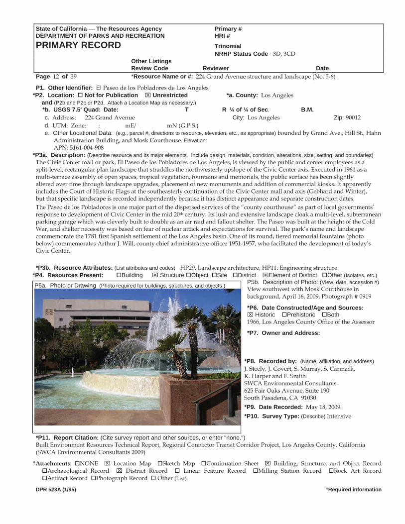
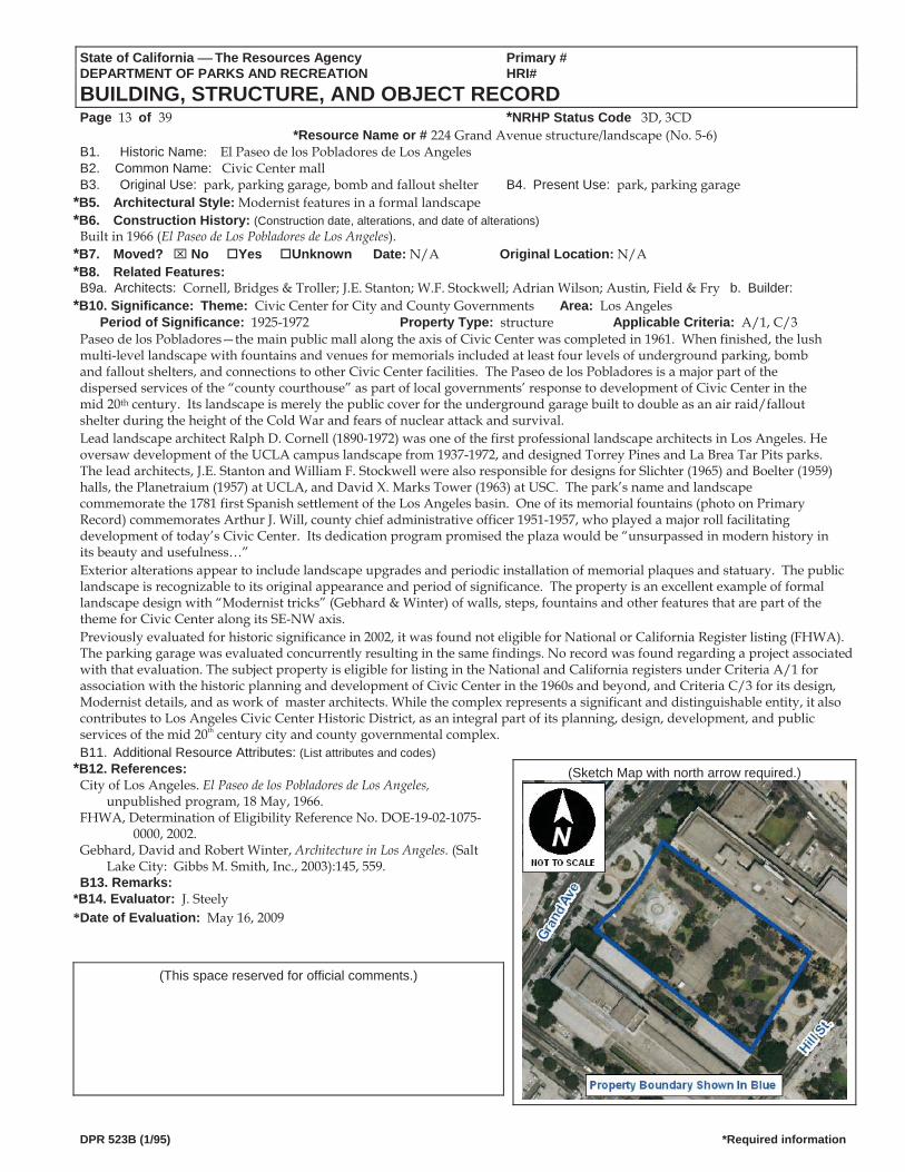
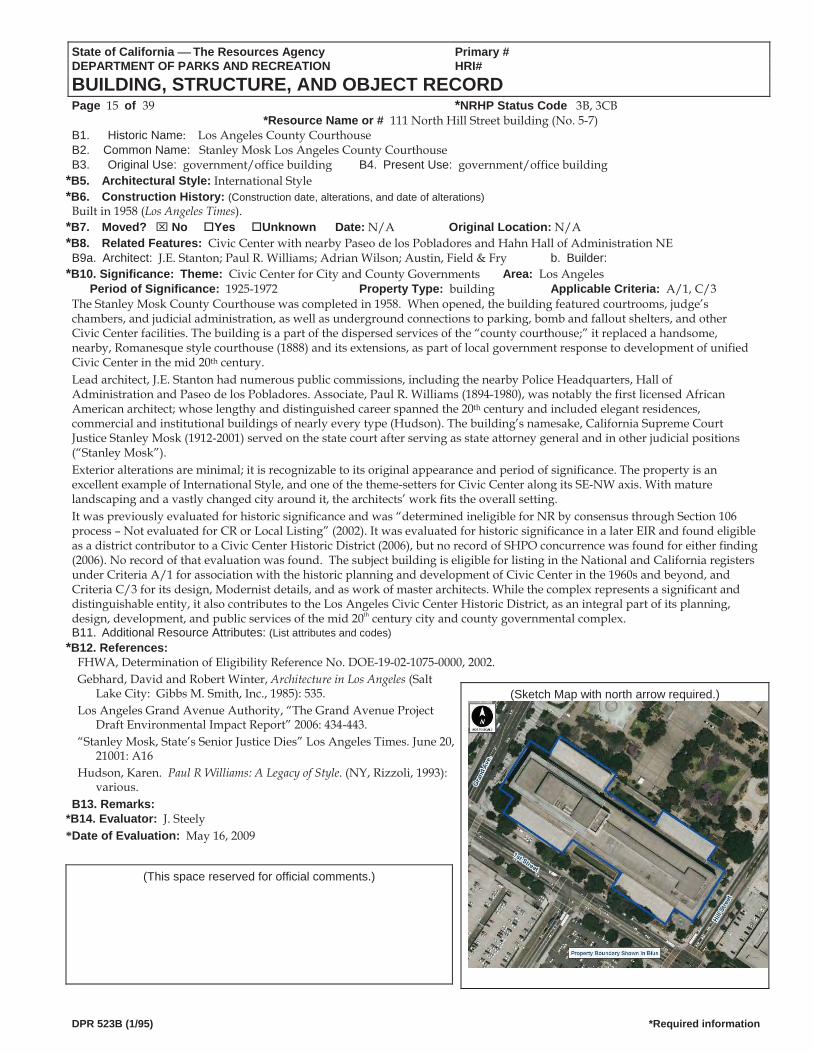
*P3a. Description: (Describe resource and its major elements. Include design, materials, condition, alterations, size, setting, and boundaries)The Civic Center mall or park, El Paseo de los Pobladores de Los Angeles, is viewed by the public and center employees as a split-level, rectangular plan landscape that straddles the northwesterly upslope of the Civic Center axis. Executed in 1961 as a multi-terrace assembly of open spaces, tropical vegetation, fountains and memorials, the public surface has been slightly altered over time through landscape upgrades, placement of new monuments and addition of commercial kiosks. It apparently includes the Court of Historic Flags at the southeasterly continuation of the Civic Center mall and axis (Gebhard and Winter), but that specific landscape is recorded independently because it has distinct appearance and separate construction dates. The Paseo de los Pobladores is one major part of the dispersed services of the “county courthouse” as part of local governments’ response to development of Civic Center in the mid 20th century. Its lush and extensive landscape cloak a multi-level, subterranean parking garage which was cleverly built to double as an air raid and fallout shelter. The Paseo was built at the height of the Cold War, and shelter necessity was based on fear of nuclear attack and expectations for survival. The park’s name and landscape commemorate the 1781 first Spanish settlement of the Los Angeles basin. One of its round, tiered memorial fountains (photo below) commemorates Arthur J. Will, county chief administrative officer 1951-1957, who facilitated the development of today’s Civic Center. *P3b. Resource Attributes: (List attributes and codes) HP29. Landscape architecture, HP11. Engineering structure
*P4. Resources Present: Building Structure Object Site District Element of District Other (Isolates, etc.)P5b. Description of Photo: (View, date, accession #)View southwest with Mosk Courthouse in background, April 16, 2009, Photograph # 0919
*P6. Date Constructed/Age and Sources: Historic Prehistoric Both
1966, Los Angeles County Office of the Assessor
*P7. Owner and Address: *P8. Recorded by: (Name, affiliation, and address) J. Steely, J. Covert, S. Murray, S. Carmack, K. Harper and F. Smith SWCA Environmental Consultants 625 Fair Oaks Avenue, Suite 190 South Pasadena, CA 91030 *P9. Date Recorded: May 18, 2009 *P10. Survey Type: (Describe) Intensive
*P11. Report Citation: (Cite survey report and other sources, or enter "none.")
P5a. Photo or Drawing (Photo required for buildings, structures, and objects.)
Built Environment Resources Technical Report, Regional Connector Transit Corridor Project, Los Angeles County, California (SWCA Environmental Consultants 2009)
*Attachments: NONE Location Map Sketch Map Continuation Sheet Building, Structure, and Object Record Archaeological Record District Record Linear Feature Record Milling Station Record Rock Art Record Artifact Record Photograph Record Other (List):
DPR 523A (1/95) *Required information
State of California The Resources Agency Primary # DEPARTMENT OF PARKS AND RECREATION HRI#
BUILDING, STRUCTURE, AND OBJECT RECORD Page 13 of 39 *NRHP Status Code 3D, 3CD
*Resource Name or # 224 Grand Avenue structure/landscape (No. 5 6) B1. Historic Name: El Paseo de los Pobladores de Los Angeles B2. Common Name: Civic Center mall B3. Original Use: park, parking garage, bomb and fallout shelter B4. Present Use: park, parking garage
*B5. Architectural Style: Modernist features in a formal landscape *B6. Construction History: (Construction date, alterations, and date of alterations)
Built in 1966 (El Paseo de Los Pobladores de Los Angeles). *B7. Moved? No Yes Unknown Date: N/A Original Location: N/A *B8. Related Features: B9a. Architects: Cornell, Bridges & Troller; J.E. Stanton; W.F. Stockwell; Adrian Wilson; Austin, Field & Fry b. Builder:
*B10. Significance: Theme: Civic Center for City and County Governments Area: Los AngelesPeriod of Significance: 1925-1972 Property Type: structure Applicable Criteria: A/1, C/3
Paseo de los Pobladores—the main public mall along the axis of Civic Center was completed in 1961. When finished, the lush multi-level landscape with fountains and venues for memorials included at least four levels of underground parking, bomb and fallout shelters, and connections to other Civic Center facilities. The Paseo de los Pobladores is a major part of the dispersed services of the “county courthouse” as part of local governments’ response to development of Civic Center in the mid 20th century. Its landscape is merely the public cover for the underground garage built to double as an air raid/fallout shelter during the height of the Cold War and fears of nuclear attack and survival. Lead landscape architect Ralph D. Cornell (1890-1972) was one of the first professional landscape architects in Los Angeles. He oversaw development of the UCLA campus landscape from 1937-1972, and designed Torrey Pines and La Brea Tar Pits parks. The lead architects, J.E. Stanton and William F. Stockwell were also responsible for designs for Slichter (1965) and Boelter (1959) halls, the Planetraium (1957) at UCLA, and David X. Marks Tower (1963) at USC. The park’s name and landscape commemorate the 1781 first Spanish settlement of the Los Angeles basin. One of its memorial fountains (photo on Primary Record) commemorates Arthur J. Will, county chief administrative officer 1951-1957, who played a major roll facilitating development of today’s Civic Center. Its dedication program promised the plaza would be “unsurpassed in modern history in its beauty and usefulness…” Exterior alterations appear to include landscape upgrades and periodic installation of memorial plaques and statuary. The public landscape is recognizable to its original appearance and period of significance. The property is an excellent example of formal landscape design with “Modernist tricks” (Gebhard & Winter) of walls, steps, fountains and other features that are part of the theme for Civic Center along its SE-NW axis. Previously evaluated for historic significance in 2002, it was found not eligible for National or California Register listing (FHWA). The parking garage was evaluated concurrently resulting in the same findings. No record was found regarding a project associated with that evaluation. The subject property is eligible for listing in the National and California registers under Criteria A/1 for association with the historic planning and development of Civic Center in the 1960s and beyond, and Criteria C/3 for its design, Modernist details, and as work of master architects. While the complex represents a significant and distinguishable entity, it also contributes to Los Angeles Civic Center Historic District, as an integral part of its planning, design, development, and public services of the mid 20th century city and county governmental complex. B11. Additional Resource Attributes: (List attributes and codes)
*B12. References: (Sketch Map with north arrow required.) City of Los Angeles. El Paseo de los Pobladores de Los Angeles,
unpublished program, 18 May, 1966. FHWA, Determination of Eligibility Reference No. DOE-19-02-1075-
0000, 2002. Gebhard, David and Robert Winter, Architecture in Los Angeles. (Salt
Lake City: Gibbs M. Smith, Inc., 2003):145, 559. B13. Remarks:
*B14. Evaluator: J. Steely *Date of Evaluation: May 16, 2009
(This space reserved for official comments.)
DPR 523B (1/95) *Required information
State of California The Resources Agency Primary # DEPARTMENT OF PARKS AND RECREATION HRI #PRIMARY RECORD Trinomial NRHP Status Code 3B, 3CB Other Listings
Review Code Reviewer DatePage 14 of 39 *Resource Name or #: 111 North Hill Street building (No. 5-7)
P1. Other Identifier: Los Angeles County Courthouse, Stanley Mosk Los Angeles County Courthouse *P2. Location: Not for Publication Unrestricted *a. County: Los Angeles
and (P2b and P2c or P2d. Attach a Location Map as necessary.) *b. USGS 7.5' Quad: Los Angeles, CA Date: 1966 (photorevised 1981, minor revision 1994) T 1S R 13W Sec. Unsectioned
B.M. San Bernardinoc. Address: 111 North Hill Street City: Los Angeles Zip: 90012 d. UTM: Zone: ; mE/ mN (G.P.S.) e. Other Locational Data: (e.g., parcel #, directions to resource, elevation, etc., as appropriate) Elevation: APN: 5161-004-906
*P3a. Description: (Describe resource and its major elements. Include design, materials, condition, alterations, size, setting, and boundaries)The Los Angeles County Courthouse is a split-level, six- and eight-story, rectangular plan building that follows the northwesterly upslope of the Civic Center axis along the south flank. Planned in the 1940s and executed in 1950s Modernist simplicity, it is generally three bays wide at its two main public entrances on the southeast and northwest. The building is clad in stone with restrained bas relief sculpture, and is topped by a series of flat roofs. Simple punched, ribbon window, fenestration is grouped toward the center of the composition, which increases the visual mass of the large building. Lower levels are stepped out in separate boxed volumes from the main walls, are finished in a red stone and serve as the visual base for the composition. The east facing entrance is an enframed window wall, with a broad, horizontal, entrance canopy featuring the scales of justice in bas relief on the wall above. A large flagpole is set on the side in a walled planter which serves as a slim counterpoint to the overall horizontal building orientation. The building is largely unaltered since completion in 1958. It borders West 1st Street between Hill Street and Grand Avenue, with lush but minimal tropical landscaping along its southerly foundations; its northeast elevation defines one side of the 1966 Paseo de los Pobladores, through various integrated planters, stairways, and retaining walls.
*P3b. Resource Attributes: (List attributes and codes) HP14. Government building, HP31. Urban open spaceP4. Resources Present: Building Structure Object Site * District Element of District Other (Isolates, etc.)
P5b. Description of Photo: (View, date, accession #)View north, April 16, 2009, P5a. Photo or Drawing (Photo required for buildings, structures, and objects.) Photograph # 0993
*P6. Date Constructed/Age and Sources: Historic Prehistoric Both
1958, Los Angeles County Office of the Assessor
*P7. Owner and Address:
*P8. Recorded by: (Name, affiliation, and address) J. Steely, J. Covert, S. Murray, S. Carmack, K. Harper, and F. Smith SWCA Environmental Consultants 625 Fair Oaks Avenue, Suite 190 South Pasadena, CA 91030 *P9. Date Recorded: May 18, 2009 *P10. Survey Type: (Describe) Intensive
*P11. Report Citation: (Cite survey report and other sources, or enter "none.") Built Environment Resources Technical Report, Regional Connector Transit Corridor Project, Los Angeles County, California (SWCA Environmental Consultants 2009)
*Attachments: NONE Location Map Sketch Map Continuation Sheet Building, Structure, and Object Record Archaeological Record District Record Linear Feature Record Milling Station Record Rock Art Record Artifact Record Photograph Record Other (List):
DPR 523A (1/95) *Required information
State of California The Resources Agency Primary # DEPARTMENT OF PARKS AND RECREATION HRI#
BUILDING, STRUCTURE, AND OBJECT RECORD Page 15 of 39 *NRHP Status Code 3B, 3CB
*Resource Name or # 111 North Hill Street building (No. 5-7) B1. Historic Name: Los Angeles County Courthouse B2. Common Name: Stanley Mosk Los Angeles County CourthouseB3. Original Use: government/office building B4. Present Use: government/office building
*B5. Architectural Style: International Style *B6. Construction History: (Construction date, alterations, and date of alterations)
Built in 1958 (Los Angeles Times). *B7. Moved? No Yes Unknown Date: N/A Original Location: N/A *B8. Related Features: Civic Center with nearby Paseo de los Pobladores and Hahn Hall of Administration NE B9a. Architect: J.E. Stanton; Paul R. Williams; Adrian Wilson; Austin, Field & Fry b. Builder:
*B10. Significance: Theme: Civic Center for City and County Governments Area: Los AngelesPeriod of Significance: 1925-1972 Property Type: building Applicable Criteria: A/1, C/3
The Stanley Mosk County Courthouse was completed in 1958. When opened, the building featured courtrooms, judge’s chambers, and judicial administration, as well as underground connections to parking, bomb and fallout shelters, and other Civic Center facilities. The building is a part of the dispersed services of the “county courthouse;” it replaced a handsome, nearby, Romanesque style courthouse (1888) and its extensions, as part of local government response to development of unified Civic Center in the mid 20th century. Lead architect, J.E. Stanton had numerous public commissions, including the nearby Police Headquarters, Hall of Administration and Paseo de los Pobladores. Associate, Paul R. Williams (1894-1980), was notably the first licensed African American architect; whose lengthy and distinguished career spanned the 20th century and included elegant residences, commercial and institutional buildings of nearly every type (Hudson). The building’s namesake, California Supreme Court Justice Stanley Mosk (1912-2001) served on the state court after serving as state attorney general and in other judicial positions (“Stanley Mosk”). Exterior alterations are minimal; it is recognizable to its original appearance and period of significance. The property is an excellent example of International Style, and one of the theme-setters for Civic Center along its SE-NW axis. With mature landscaping and a vastly changed city around it, the architects’ work fits the overall setting. It was previously evaluated for historic significance and was “determined ineligible for NR by consensus through Section 106 process – Not evaluated for CR or Local Listing” (2002). It was evaluated for historic significance in a later EIR and found eligible as a district contributor to a Civic Center Historic District (2006), but no record of SHPO concurrence was found for either finding (2006). No record of that evaluation was found. The subject building is eligible for listing in the National and California registers under Criteria A/1 for association with the historic planning and development of Civic Center in the 1960s and beyond, and Criteria C/3 for its design, Modernist details, and as work of master architects. While the complex represents a significant and distinguishable entity, it also contributes to the Los Angeles Civic Center Historic District, as an integral part of its planning, design, development, and public services of the mid 20th century city and county governmental complex. B11. Additional Resource Attributes: (List attributes and codes)
*B12. References: FHWA, Determination of Eligibility Reference No. DOE-19-02-1075-0000, 2002. Gebhard, David and Robert Winter, Architecture in Los Angeles (Salt
Lake City: Gibbs M. Smith, Inc., 1985): 535. (Sketch Map with north arrow required.) Los Angeles Grand Avenue Authority, “The Grand Avenue Project
Draft Environmental Impact Report” 2006: 434-443. “Stanley Mosk, State’s Senior Justice Dies” Los Angeles Times. June 20,
21001: A16 Hudson, Karen. Paul R Williams: A Legacy of Style. (NY, Rizzoli, 1993):
various. B13. Remarks:
*B14. Evaluator: J. Steely *Date of Evaluation: May 16, 2009
(This space reserved for official comments.)
DPR 523B (1/95) *Required information
State of California The Resources Agency Primary #DEPARTMENT OF PARKS AND RECREATION HRI #PRIMARY RECORD Trinomial NRHP Status Code 3D, 3CD Other Listings
Review Code Reviewer DatePage 16 of 39 *Resource Name or #: 301 North Broadway building and structure (No. 5-8)
P1. Other Identifier: County of Los Angeles Central Heating and Refrigeration Plant *P2. Location: Not for Publication Unrestricted *a. County: Los Angeles
and (P2b and P2c or P2d. Attach a Location Map as necessary.) *b. USGS 7.5' Quad: Los Angeles, CA Date: 1966 (photorevised 1981, minor revision 1994) T 1S R 13W Sec. Unsectioned
B.M. San Bernardinoc. Address: 301 North Broadway City: Los Angeles Zip: 90012 d. UTM: Zone: ; mE/ mN (G.P.S.) e. Other Locational Data: (e.g., parcel #, directions to resource, elevation, etc., as appropriate) Elevation: APN: 5161-005-904
*P3a. Description: (Describe resource and its major elements. Include design, materials, condition, alterations, size, setting, and boundaries)
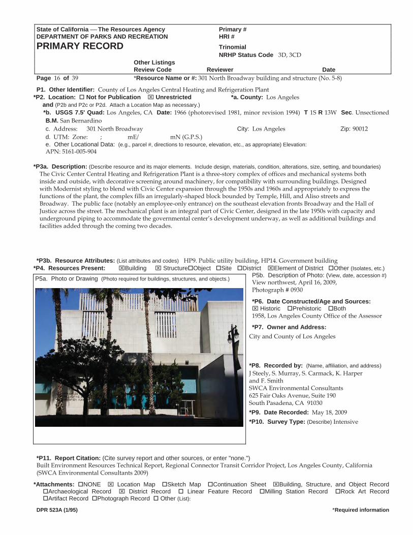
The Civic Center Central Heating and Refrigeration Plant is a three-story complex of offices and mechanical systems both inside and outside, with decorative screening around machinery, for compatibility with surrounding buildings. Designed with Modernist styling to blend with Civic Center expansion through the 1950s and 1960s and appropriately to express the functions of the plant, the complex fills an irregularly-shaped block bounded by Temple, Hill, and Aliso streets and Broadway. The public face (notably an employee-only entrance) on the southeast elevation fronts Broadway and the Hall of Justice across the street. The mechanical plant is an integral part of Civic Center, designed in the late 1950s with capacity and underground piping to accommodate the governmental center’s development underway, as well as additional buildings and facilities added through the coming two decades.
*P3b. Resource Attributes: (List attributes and codes) HP9. Public utility building, HP14. Government building
*P4. Resources Present: Building Structure Object Site District Element of District Other (Isolates, etc.)P5b. Description of Photo: (View, date, accession #)View northwest, April 16, 2009, P5a. Photo or Drawing (Photo required for buildings, structures, and objects.)
Photograph # 0930
*P6. Date Constructed/Age and Sources: Historic Prehistoric Both
1958, Los Angeles County Office of the Assessor
*P7. Owner and Address: City and County of Los Angeles *P8. Recorded by: (Name, affiliation, and address) J Steely, S. Murray, S. Carmack, K. Harper and F. Smith SWCA Environmental Consultants 625 Fair Oaks Avenue, Suite 190 South Pasadena, CA 91030 *P9. Date Recorded: May 18, 2009 *P10. Survey Type: (Describe) Intensive
*P11. Report Citation: (Cite survey report and other sources, or enter "none.") Built Environment Resources Technical Report, Regional Connector Transit Corridor Project, Los Angeles County, California (SWCA Environmental Consultants 2009)
*Attachments: NONE Location Map Sketch Map Continuation Sheet Building, Structure, and Object Record Archaeological Record District Record Linear Feature Record Milling Station Record Rock Art Record Artifact Record Photograph Record Other (List):
DPR 523A (1/95) *Required information
State of California The Resources Agency Primary # DEPARTMENT OF PARKS AND RECREATION HRI#
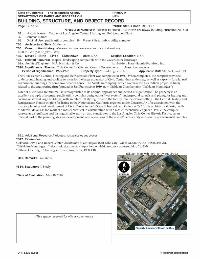
BUILDING, STRUCTURE, AND OBJECT RECORD Page 17 of 39 *NRHP Status Code 3D, 3CD
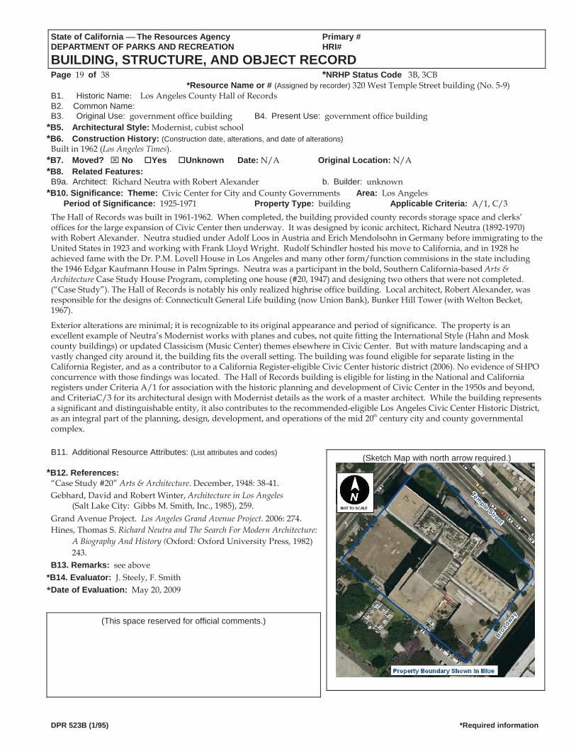
*Resource Name or # (Assigned by recorder) 301 North Broadway building, structure (No. 5-8) B1. Historic Name: County of Los Angeles Central Heating and Refrigeration Plant B2. Common Name: B3. Original Use: public utility complex B4. Present Use: public utility complex
*B5. Architectural Style: Modernist *B6. Construction History: (Construction date, alterations, and date of alterations)
Built in 1958 (Los Angeles Times). *B7. Moved? No Yes Unknown Date: N/A Original Location: N/A *B8. Related Features: Tropical landscaping compatible with the Civic Center landscape B9a. Architect/Engineer: M.A. Nishkian & Co. b. Builder: Haas-Haynie-Frandsen, Inc.
*B10. Significance: Theme: Civic Center for City and County Governments Area: Los AngelesPeriod of Significance: 1925-1972 Property Type: building, structure Applicable Criteria: A/1, and C/3
The Civic Center’s Central Heating and Refrigeration Plant was completed in 1958. When completed, the complex provided underground heating and cooling services for the large expansion of Civic Center then underway, as well as capacity for planned government buildings for some two decades hence. The Nishkian company, which oversaw the $3.5 million project, is likely related to the engineering firm founded in San Francisco in 1919, now Nishkian Chamberlain (“Nishkian-Menninger”).
Exterior alterations are minimal; it is recognizable to its original appearance and period of significance. The property is an excellent example of a central public utility complex designed for “wet system” underground tunnels and piping for heating and cooling of several large buildings, with architectural styling to blend the facility into the overall setting. The Central Heating and Refrigeration Plant is eligible for listing in the National and California registers under Criterion A/1 for association with the historic planning and development of Civic Center in the 1950s and beyond, and Criterion C/3 for its architectural design with Modernist details as the work of a master architect in collaboration with a master mechanical engineer. While the complex represents a significant and distinguishable entity, it also contributes to the Los Angeles Civic Center Historic District, as an integral part of the planning, design, development, and operations of the mid 20th century city and county governmental complex.
B11. Additional Resource Attributes: (List attributes and codes) *B12. References: Gebhard, David and Robert Winter, Architecture in Los Angeles (Salt Lake City: Gibbs M. Smith, Inc., 1985), 255-261. “Nishkian-Menninger…” electronic document: <http://www.nishkian.com>, accessed May 21, 2009. “Official Opening…” Los Angeles Times, August 17, 1958: F18.
(Sketch Map with north arrow required.) B13. Remarks: see above
*B14. Evaluator: J. Steely *Date of Evaluation: May 18, 2009
(This space reserved for official comments.)
DPR 523B (1/95) *Required information
State of California The Resources Agency Primary #DEPARTMENT OF PARKS AND RECREATION HRI #PRIMARY RECORD Trinomial NRHP Status Code 3B, 3CB Other Listings
Review Code Reviewer DatePage 18 of 38 *Resource Name or #: 320 West Temple Street building (No. 5-9)
P1. Other Identifier: Los Angeles County Hall of Records *P2. Location: Not for Publication Unrestricted *a. County: Los Angeles
and (P2b and P2c or P2d. Attach a Location Map as necessary.) *b. USGS 7.5' Quad: Los Angeles, CA Date: 1966 (photorevised 1981, minor revision 1994) T 1S R 13W Sec. Unsectioned
B.M. San Bernardinoc. Address: 320 West Temple Street City: Los Angeles Zip: 90012 d. UTM: Zone: ; mE/ mN (G.P.S.) e. Other Locational Data: (e.g., parcel #, directions to resource, elevation, etc., as appropriate) Elevation: APN: 5161-005-910
*P3a. Description: (Describe resource and its major elements. Include design, materials, condition, alterations, size, setting, and boundaries)
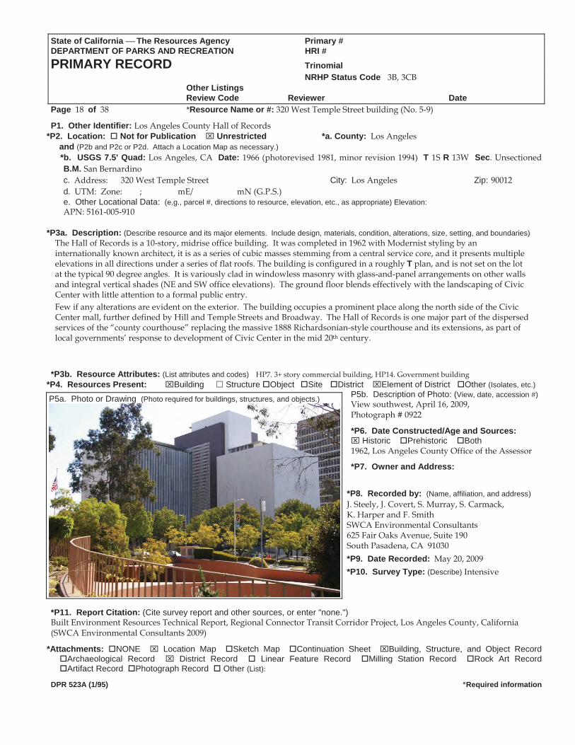
The Hall of Records is a 10-story, midrise office building. It was completed in 1962 with Modernist styling by an internationally known architect, it is as a series of cubic masses stemming from a central service core, and it presents multiple elevations in all directions under a series of flat roofs. The building is configured in a roughly T plan, and is not set on the lot at the typical 90 degree angles. It is variously clad in windowless masonry with glass-and-panel arrangements on other walls and integral vertical shades (NE and SW office elevations). The ground floor blends effectively with the landscaping of Civic Center with little attention to a formal public entry. Few if any alterations are evident on the exterior. The building occupies a prominent place along the north side of the Civic Center mall, further defined by Hill and Temple Streets and Broadway. The Hall of Records is one major part of the dispersed services of the “county courthouse” replacing the massive 1888 Richardsonian-style courthouse and its extensions, as part of local governments’ response to development of Civic Center in the mid 20th century.
*P3b. Resource Attributes: (List attributes and codes) HP7. 3+ story commercial building, HP14. Government building
*P4. Resources Present: Building Structure Object Site District Element of District Other (Isolates, etc.)P5b. Description of Photo: (View, date, accession #)View southwest, April 16, 2009, Photograph # 0922
*P6. Date Constructed/Age and Sources: Historic Prehistoric Both
1962, Los Angeles County Office of the Assessor
*P7. Owner and Address: *P8. Recorded by: (Name, affiliation, and address) J. Steely, J. Covert, S. Murray, S. Carmack, K. Harper and F. Smith SWCA Environmental Consultants 625 Fair Oaks Avenue, Suite 190 South Pasadena, CA 91030 *P9. Date Recorded: May 20, 2009 *P10. Survey Type: (Describe) Intensive
*P11. Report Citation: (Cite survey report and other sources, or enter "none.") Built Environment Resources Technical Report, Regional Connector Transit Corridor Project, Los Angeles County, California (SWCA Environmental Consultants 2009)
*Attachments: NONE Location Map Sketch Map Continuation Sheet Building, Structure, and Object Record Archaeological Record District Record Linear Feature Record Milling Station Record Rock Art Record Artifact Record Photograph Record Other (List):
DPR 523A (1/95) *Required information
P5a. Photo or Drawing (Photo required for buildings, structures, and objects.)
DPR 523B (1/95) *Required information
State of California The Resources Agency Primary # DEPARTMENT OF PARKS AND RECREATION HRI#
BUILDING, STRUCTURE, AND OBJECT RECORD Page 19 of 38 *NRHP Status Code 3B, 3CB
*Resource Name or # (Assigned by recorder) 320 West Temple Street building (No. 5-9) B1. Historic Name: Los Angeles County Hall of Records B2. Common Name: B3. Original Use: government office building B4. Present Use: government office building
*B5. Architectural Style: Modernist, cubist school *B6. Construction History: (Construction date, alterations, and date of alterations)
Built in 1962 (Los Angeles Times). *B7. Moved? No Yes Unknown Date: N/A Original Location: N/A *B8. Related Features: B9a. Architect: Richard Neutra with Robert Alexander b. Builder: unknown
*B10. Significance: Theme: Civic Center for City and County Governments Area: Los AngelesPeriod of Significance: 1925-1971 Property Type: building Applicable Criteria: A/1, C/3
The Hall of Records was built in 1961-1962. When completed, the building provided county records storage space and clerks’ offices for the large expansion of Civic Center then underway. It was designed by iconic architect, Richard Neutra (1892-1970) with Robert Alexander. Neutra studied under Adolf Loos in Austria and Erich Mendolsohn in Germany before immigrating to the United States in 1923 and working with Frank Lloyd Wright. Rudolf Schindler hosted his move to California, and in 1928 he achieved fame with the Dr. P.M. Lovell House in Los Angeles and many other form/function commisions in the state including the 1946 Edgar Kaufmann House in Palm Springs. Neutra was a participant in the bold, Southern California-based Arts & Architecture Case Study House Program, completing one house (#20, 1947) and designing two others that were not completed. (“Case Study”). The Hall of Records is notably his only realized highrise office building. Local architect, Robert Alexander, was responsible for the designs of: Connecticult General Life building (now Union Bank), Bunker Hill Tower (with Welton Becket, 1967).
Exterior alterations are minimal; it is recognizable to its original appearance and period of significance. The property is an excellent example of Neutra’s Modernist works with planes and cubes, not quite fitting the International Style (Hahn and Mosk county buildings) or updated Classicism (Music Center) themes elsewhere in Civic Center. But with mature landscaping and a vastly changed city around it, the building fits the overall setting. The building was found eligible for separate listing in the California Register, and as a contributor to a California Register-eligible Civic Center historic district (2006). No evidence of SHPO concurrence with those findings was located. The Hall of Records building is eligible for listing in the National and California registers under Criteria A/1 for association with the historic planning and development of Civic Center in the 1950s and beyond, and CriteriaC/3 for its architectural design with Modernist details as the work of a master architect. While the building represents a significant and distinguishable entity, it also contributes to the recommended-eligible Los Angeles Civic Center Historic District, as an integral part of the planning, design, development, and operations of the mid 20th century city and county governmental complex.
B11. Additional Resource Attributes: (List attributes and codes)
*B12. References: “Case Study #20” Arts & Architecture. December, 1948: 38-41. Gebhard, David and Robert Winter, Architecture in Los Angeles
(Salt Lake City: Gibbs M. Smith, Inc., 1985), 259. Grand Avenue Project. Los Angeles Grand Avenue Project. 2006: 274.Hines, Thomas S. Richard Neutra and The Search For Modern Architecture:
A Biography And History (Oxford: Oxford University Press, 1982)243.
B13. Remarks: see above *B14. Evaluator: J. Steely, F. Smith *Date of Evaluation: May 20, 2009
(Sketch Map with north arrow required.)
(This space reserved for official comments.)
State of California The Resources Agency Primary # 19-170974 (Update) DEPARTMENT OF PARKS AND RECREATION HRI #PRIMARY RECORD Trinomial NRHP Status Code 3D, 3CD, 5S2 Other Listings
Review Code Reviewer DatePage 20 of 39 *Resource Name or #: 224 North Hill Street landscape, 100 Block Hill Street (No. 5-10)
P1. Other Identifier: Court of Historic American Flags, Court of Historic Flags, “Court of Flags, Civic Center Mall” (1982 DPR) *P2. Location: Not for Publication Unrestricted *a. County: Los Angeles
and (P2b and P2c or P2d. Attach a Location Map as necessary.) *b. USGS 7.5' Quad: Los Angeles, CA Date: 1966 (photorevised 1981, minor revision 1994) T 1S R 13W Sec. Unsectioned
B.M. San Bernardinoc. Address: 224 North Hill Street, 100 Block Hill Street City: Los Angeles Zip: 90012 d. UTM: Zone: ; mE/ mN (G.P.S.) e. Other Locational Data: (e.g., parcel #, directions to resource, elevation, etc., as appropriate) Elevation: APN: 5161-005-916
*P3a. Description: (Describe resource and its major elements. Include design, materials, condition, alterations, size, setting, and boundaries)
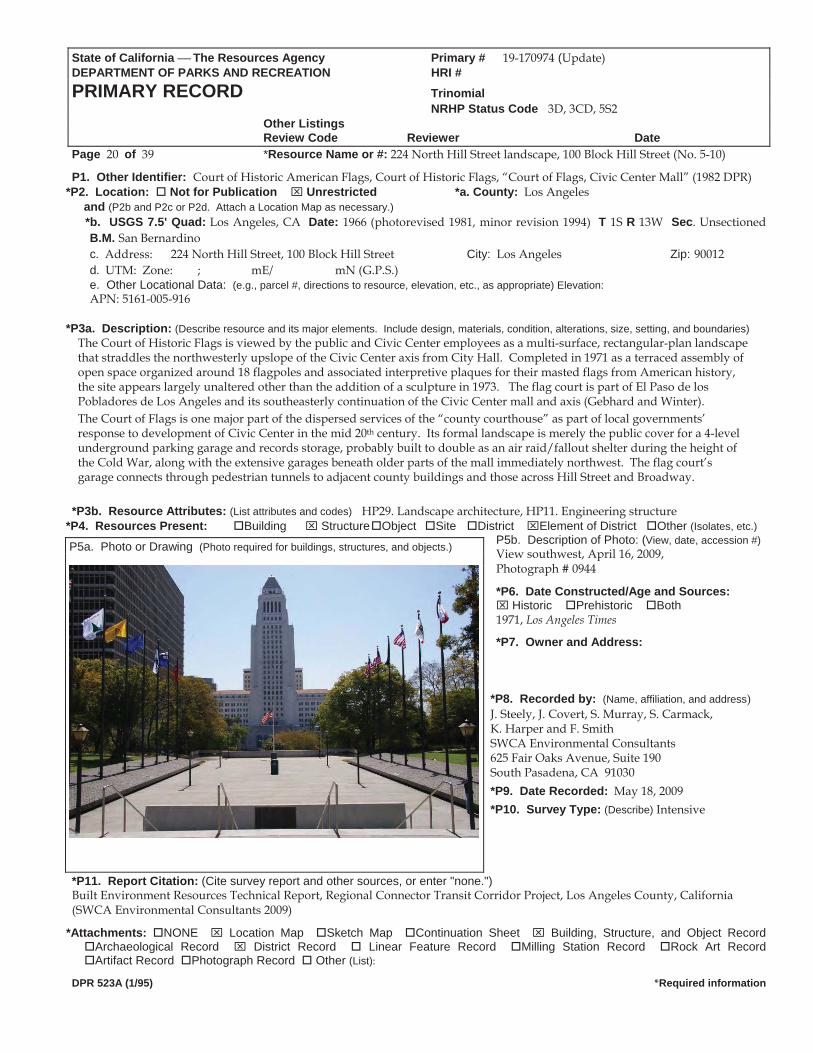
The Court of Historic Flags is viewed by the public and Civic Center employees as a multi-surface, rectangular-plan landscape that straddles the northwesterly upslope of the Civic Center axis from City Hall. Completed in 1971 as a terraced assembly of open space organized around 18 flagpoles and associated interpretive plaques for their masted flags from American history, the site appears largely unaltered other than the addition of a sculpture in 1973. The flag court is part of El Paso de los Pobladores de Los Angeles and its southeasterly continuation of the Civic Center mall and axis (Gebhard and Winter). The Court of Flags is one major part of the dispersed services of the “county courthouse” as part of local governments’ response to development of Civic Center in the mid 20th century. Its formal landscape is merely the public cover for a 4-level underground parking garage and records storage, probably built to double as an air raid/fallout shelter during the height of the Cold War, along with the extensive garages beneath older parts of the mall immediately northwest. The flag court’s garage connects through pedestrian tunnels to adjacent county buildings and those across Hill Street and Broadway.
*P3b. Resource Attributes: (List attributes and codes) HP29. Landscape architecture, HP11. Engineering structure
*P4. Resources Present: Building Structure Object Site District Element of District Other (Isolates, etc.)P5b. Description of Photo: (View, date, accession #)View southwest, April 16, 2009, Photograph # 0944
*P6. Date Constructed/Age and Sources: Historic Prehistoric Both
1971, Los Angeles Times
*P7. Owner and Address: *P8. Recorded by: (Name, affiliation, and address) J. Steely, J. Covert, S. Murray, S. Carmack, K. Harper and F. Smith SWCA Environmental Consultants 625 Fair Oaks Avenue, Suite 190 South Pasadena, CA 91030 *P9. Date Recorded: May 18, 2009 *P10. Survey Type: (Describe) Intensive
*P11. Report Citation: (Cite survey report and other sources, or enter "none.")
P5a. Photo or Drawing (Photo required for buildings, structures, and objects.)
Built Environment Resources Technical Report, Regional Connector Transit Corridor Project, Los Angeles County, California (SWCA Environmental Consultants 2009)
*Attachments: NONE Location Map Sketch Map Continuation Sheet Building, Structure, and Object Record Archaeological Record District Record Linear Feature Record Milling Station Record Rock Art Record Artifact Record Photograph Record Other (List):
DPR 523A (1/95) *Required information
State of California The Resources Agency Primary # 19 170974 (Update)DEPARTMENT OF PARKS AND RECREATION HRI#
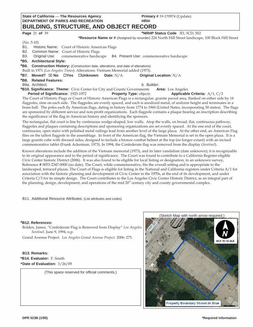
BUILDING, STRUCTURE, AND OBJECT RECORD Page 21 of 39 *NRHP Status Code 3D, 3CD, 5S2
*Resource Name or # (Assigned by recorder) 224 North Hill Street landscape, 100 Block Hill Street (No. 5-10) B1. Historic Name: Court of Historic American Flags B2. Common Name: Court of Historic FlagsB3. Original Use: commemorative hardscape B4. Present Use: commemorative hardscape
*B5. Architectural Style: *B6. Construction History: (Construction date, alterations, and date of alterations)
Built in 1971 (Los Angeles Times). Alterations: Vietnam Memorial added (1973). *B7. Moved? No Yes Unknown Date: N/A Original Location: N/A *B8. Related Features: B9a. Architect: b. Builder:
*B10. Significance: Theme: Civic Center for City and County Governments Area: Los AngelesPeriod of Significance: 1925-1972 Property Type: objects Applicable Criteria: A/1, C/3
The Court of Historic Flags or Court of Historic American Flags is a rectangular, granite paved area, flanked on either side by 18flagpoles, nine on each side. The flagpoles are evenly spaced, and each is anodized metal, of uniform height and terminates in abrass ball. The poles each fly American flags, dating in history from 1774 to 1960 (United States, incorporating 50 states). The flagsare sponsored by different service and non profit organizations. Each flagpole contains a plaque bearing an inscription describingthe significance of the flag in American history and identifying the sponsors.The rectangular, flat court is line by continuous wedge shaped, low walls. Atop the walls, on broad, flat, continuous pathway,flagpoles and plaques containing descriptions and sponsoring organizations are set evenly spaced. At the one end of the court,continuous, open stairs with polished metal railings lead from another level of the large plaza. At the other end, an American Flagflies on the tallest flagpole in the assemblage. In front of the American flag, the Vietnam Memorial is set in the open plaza. It is alarge granite cube with dressed sides, designed to include a bronze combat helmet at the top (no longer extant) with an incisedcommemorative tablet (Frank Ackerman, 1973). In 1994, the Confederate flag was removed from the display (Sentinel).
Known alterations include the addition of the Vietnam memorial (1973), and its later vandalism (date unknown); it is recognizable to its original appearance and to the period of significance. The Court was found to contribute to a California Register-eligible Civic Center historic District (2006). It was also found to be eligible for local listing or designation, in an unknown survey, Reference # 0053-2347-0000 (no date). The Court, while commemorative, fits the overall setting and is appropriate to the landscaped, terraced plazas. The Court of Flags is eligible for listing in the National and California registers under Criteria A/1 for association with the historic planning and development of Civic Center in the 1970s, at the end of its development, and under Criteria C/3 for its simple design. The Court contributes to the Los Angeles Civic Center Historic District, as an integral part of the planning, design, development, and operations of the mid 20th century city and county governmental complex.
B11. Additional Resource Attributes: (List attributes and codes)
(Sketch Map with north arrow required.)
*B12. References: Bolden, James. “Confederate Flag is Removed from Display” Los Angeles
Sentinel. June 9, 1994, n.p.Grand Avenue Project. Los Angeles Grand Avenue Project. 2006: 275.
B13. Remarks:
*B14. Evaluator: F. Smith *Date of Evaluation: 3/26/09
(This space reserved for official comments.)
DPR 523B (1/95) *Required information
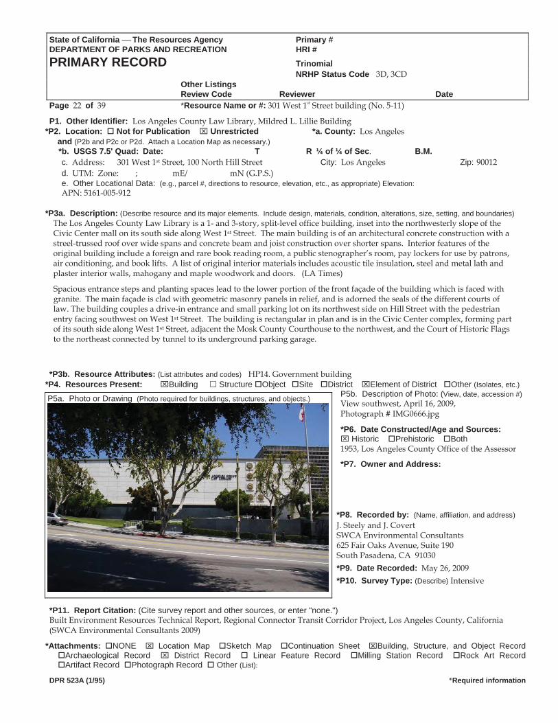
State of California The Resources Agency Primary #DEPARTMENT OF PARKS AND RECREATION HRI #PRIMARY RECORD Trinomial NRHP Status Code 3D, 3CD Other Listings
Review Code Reviewer DatePage 22 of 39 *Resource Name or #: 301 West 1st Street building (No. 5-11)
P1. Other Identifier: Los Angeles County Law Library, Mildred L. Lillie Building *P2. Location: Not for Publication Unrestricted *a. County: Los Angeles
and (P2b and P2c or P2d. Attach a Location Map as necessary.) *b. USGS 7.5' Quad: Date: T R ¼ of ¼ of Sec. B.M.
c. Address: 301 West 1st Street, 100 North Hill Street City: Los Angeles Zip: 90012 d. UTM: Zone: ; mE/ mN (G.P.S.) e. Other Locational Data: (e.g., parcel #, directions to resource, elevation, etc., as appropriate) Elevation: APN: 5161-005-912
*P3a. Description: (Describe resource and its major elements. Include design, materials, condition, alterations, size, setting, and boundaries)
The Los Angeles County Law Library is a 1- and 3-story, split-level office building, inset into the northwesterly slope of the Civic Center mall on its south side along West 1st Street. The main building is of an architectural concrete construction with a streel-trussed roof over wide spans and concrete beam and joist construction over shorter spans. Interior features of the original building include a foreign and rare book reading room, a public stenographer’s room, pay lockers for use by patrons, air conditioning, and book lifts. A list of original interior materials includes acoustic tile insulation, steel and metal lath and plaster interior walls, mahogany and maple woodwork and doors. (LA Times)
Spacious entrance steps and planting spaces lead to the lower portion of the front façade of the building which is faced with granite. The main façade is clad with geometric masonry panels in relief, and is adorned the seals of the different courts of law. The building couples a drive-in entrance and small parking lot on its northwest side on Hill Street with the pedestrian entry facing southwest on West 1st Street. The building is rectangular in plan and is in the Civic Center complex, forming part of its south side along West 1st Street, adjacent the Mosk County Courthouse to the northwest, and the Court of Historic Flags to the northeast connected by tunnel to its underground parking garage.
*P3b. Resource Attributes: (List attributes and codes) HP14. Government building
*P4. Resources Present: Building Structure Object Site District Element of District Other (Isolates, etc.)P5b. Description of Photo: (View, date, accession #)View southwest, April 16, 2009, P5a. Photo or Drawing (Photo required for buildings, structures, and objects.)
Photograph # IMG0666.jpg
*P6. Date Constructed/Age and Sources: Historic Prehistoric Both
1953, Los Angeles County Office of the Assessor
*P7. Owner and Address:
*P8. Recorded by: (Name, affiliation, and address) J. Steely and J. Covert SWCA Environmental Consultants 625 Fair Oaks Avenue, Suite 190 South Pasadena, CA 91030 *P9. Date Recorded: May 26, 2009 *P10. Survey Type: (Describe) Intensive
*P11. Report Citation: (Cite survey report and other sources, or enter "none.") Built Environment Resources Technical Report, Regional Connector Transit Corridor Project, Los Angeles County, California (SWCA Environmental Consultants 2009)
*Attachments: NONE Location Map Sketch Map Continuation Sheet Building, Structure, and Object Record Archaeological Record District Record Linear Feature Record Milling Station Record Rock Art Record Artifact Record Photograph Record Other (List):
DPR 523A (1/95) *Required information
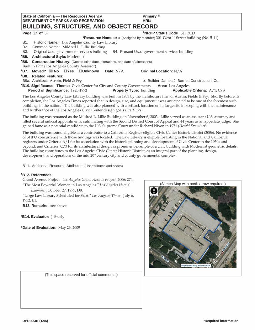
State of California The Resources Agency Primary # DEPARTMENT OF PARKS AND RECREATION HRI#
BUILDING, STRUCTURE, AND OBJECT RECORD Page 23 of 39 *NRHP Status Code 3D, 3CD
*Resource Name or # (Assigned by recorder) 301 West 1st Street building (No. 5-11) B1. Historic Name: Los Angeles County Law Library B2. Common Name: Mildred L. Lillie BuildingB3. Original Use: government services building B4. Present Use: government services building
*B5. Architectural Style: Modernist *B6. Construction History: (Construction date, alterations, and date of alterations)
Built in 1953 (Los Angeles County Assessor). *B7. Moved? No Yes Unknown Date: N/A Original Location: N/A *B8. Related Features: B9a. Architect: Austin, Field & Fry b. Builder: James J. Barnes Construction, Co.
*B10. Significance: Theme: Civic Center for City and County Governments Area: Los AngelesPeriod of Significance: 1925-1972 Property Type: building Applicable Criteria: A/1, C/3
The Los Angeles County Law Library building was built in 1953 by the architecture firm of Austin, Fields & Fry. Shortly before its completion, the Los Angeles Times reported that in design, size, and equipment it was anticipated to be one of the foremost such buildings in the nation. The building was also planned with a setback location on its large site in keeping with the maintenance and furtherance of the Los Angeles Civic Center design goals (LA Times).
The building was renamed as the Mildred L. Lillie Building on November 6, 2003. Lillie served as an assistant U.S. attorney and filled several judicial appointments, culminating with the Second District Court of Appeal and 44 years as an appellate judge. She gained fame as a potential candidate to the U.S. Supreme Court under Richard Nixon in 1971 (Herald Examiner).
The building was found eligible as a contributor to a California Register-eligible Civic Center historic district (2006). No evidence of SHPO concurrence with those findings was located. The Law Library is eligible for listing in the National and California registers under Criteria A/1 for its association with the historic planning and development of Civic Center in the 1950s and beyond, and Criterion C/3 for its architectural design as prominent example of a civic building with Modernist geometric details. The building contributes to the Los Angeles Civic Center Historic District, as an integral part of the planning, design, development, and operations of the mid 20th century city and county governmental complex.
B11. Additional Resource Attributes: (List attributes and codes)
*B12. References: Grand Avenue Project. Los Angeles Grand Avenue Project. 2006: 274.
(Sketch Map with north arrow required.) “The Most Powerful Women in Los Angeles.” Los Angeles Herald Examiner. October 27, 1977, D8.
“Large Law Library Scheduled for Start.” Los Angeles Times. July 6, 1952, E1. B13. Remarks: see above
*B14. Evaluator: J. Steely *Date of Evaluation: May 26, 2009
(This space reserved for official comments.)
DPR 523B (1/95) *Required information
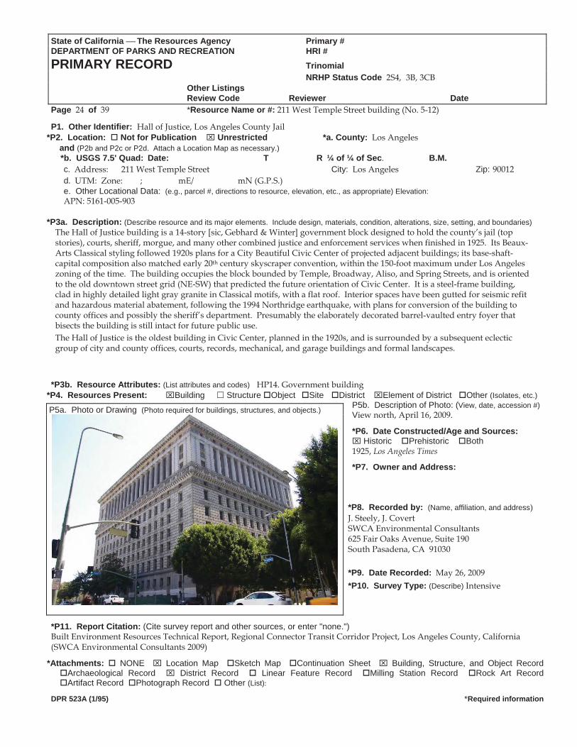
State of California The Resources Agency Primary #DEPARTMENT OF PARKS AND RECREATION HRI #PRIMARY RECORD Trinomial NRHP Status Code 2S4, 3B, 3CB Other Listings
Review Code Reviewer DatePage 24 of 39 *Resource Name or #: 211 West Temple Street building (No. 5-12)
P1. Other Identifier: Hall of Justice, Los Angeles County Jail *P2. Location: Not for Publication Unrestricted *a. County: Los Angeles
and (P2b and P2c or P2d. Attach a Location Map as necessary.) *b. USGS 7.5' Quad: Date: T R ¼ of ¼ of Sec. B.M.
c. Address: 211 West Temple Street City: Los Angeles Zip: 90012 d. UTM: Zone: ; mE/ mN (G.P.S.) e. Other Locational Data: (e.g., parcel #, directions to resource, elevation, etc., as appropriate) Elevation: APN: 5161-005-903
*P3a. Description: (Describe resource and its major elements. Include design, materials, condition, alterations, size, setting, and boundaries)
The Hall of Justice building is a 14-story [sic, Gebhard & Winter] government block designed to hold the county’s jail (top stories), courts, sheriff, morgue, and many other combined justice and enforcement services when finished in 1925. Its Beaux-Arts Classical styling followed 1920s plans for a City Beautiful Civic Center of projected adjacent buildings; its base-shaft-capital composition also matched early 20th century skyscraper convention, within the 150-foot maximum under Los Angeles zoning of the time. The building occupies the block bounded by Temple, Broadway, Aliso, and Spring Streets, and is oriented to the old downtown street grid (NE-SW) that predicted the future orientation of Civic Center. It is a steel-frame building, clad in highly detailed light gray granite in Classical motifs, with a flat roof. Interior spaces have been gutted for seismic refit and hazardous material abatement, following the 1994 Northridge earthquake, with plans for conversion of the building to county offices and possibly the sheriff’s department. Presumably the elaborately decorated barrel-vaulted entry foyer that bisects the building is still intact for future public use. The Hall of Justice is the oldest building in Civic Center, planned in the 1920s, and is surrounded by a subsequent eclectic group of city and county offices, courts, records, mechanical, and garage buildings and formal landscapes.
*P3b. Resource Attributes: (List attributes and codes) HP14. Government building *P4. Resources Present: Building Structure Object Site District Element of District Other (Isolates, etc.)
P5b. Description of Photo: (View, date, accession #)View north, April 16, 2009. P5a. Photo or Drawing (Photo required for buildings, structures, and objects.)
*P6. Date Constructed/Age and Sources: Historic Prehistoric Both
1925, Los Angeles Times
*P7. Owner and Address: *P8. Recorded by: (Name, affiliation, and address) J. Steely, J. Covert SWCA Environmental Consultants 625 Fair Oaks Avenue, Suite 190 South Pasadena, CA 91030 *P9. Date Recorded: May 26, 2009 *P10. Survey Type: (Describe) Intensive
*P11. Report Citation: (Cite survey report and other sources, or enter "none.") Built Environment Resources Technical Report, Regional Connector Transit Corridor Project, Los Angeles County, California (SWCA Environmental Consultants 2009)
*Attachments: NONE Location Map Sketch Map Continuation Sheet Building, Structure, and Object Record Archaeological Record District Record Linear Feature Record Milling Station Record Rock Art Record Artifact Record Photograph Record Other (List):
DPR 523A (1/95) *Required information
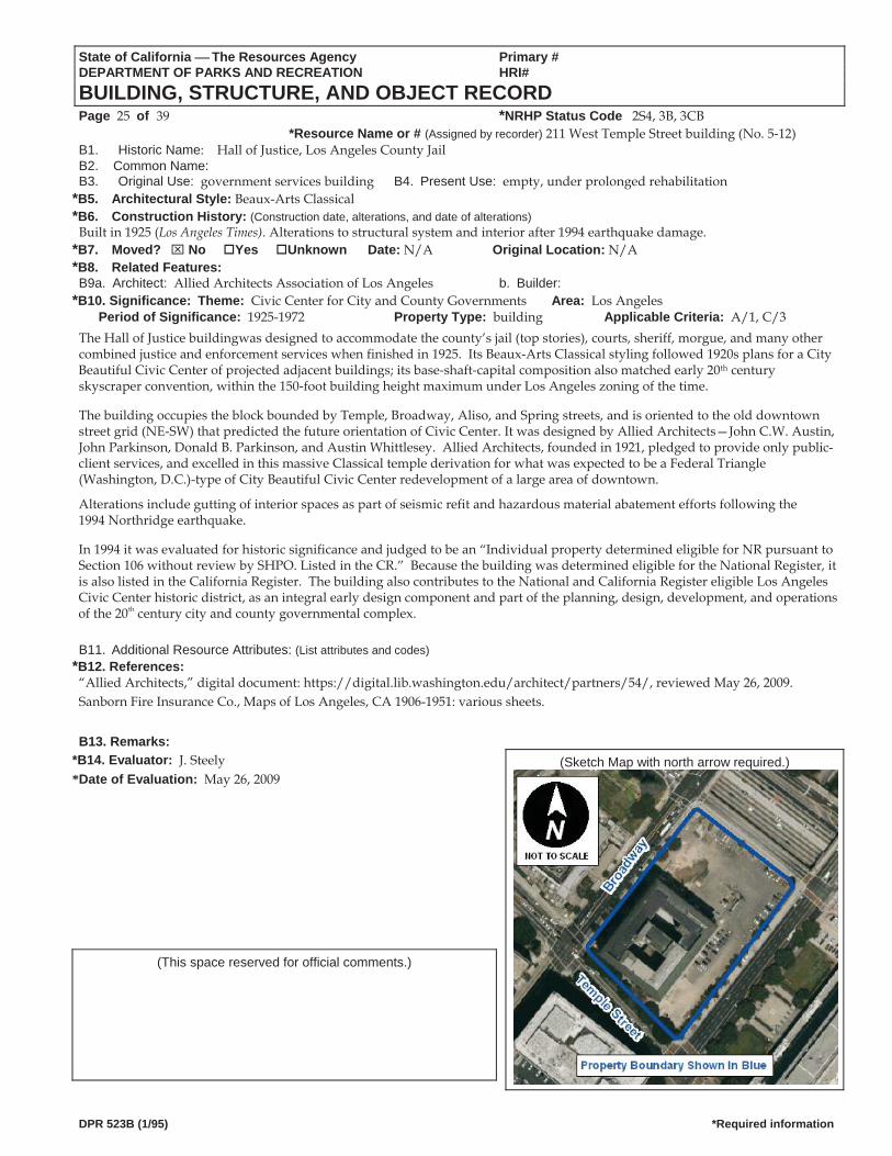
State of California The Resources Agency Primary # DEPARTMENT OF PARKS AND RECREATION HRI#
BUILDING, STRUCTURE, AND OBJECT RECORD Page 25 of 39 *NRHP Status Code 2S4, 3B, 3CB
*Resource Name or # (Assigned by recorder) 211 West Temple Street building (No. 5 12)B1. Historic Name: Hall of Justice, Los Angeles County Jail B2. Common Name: B3. Original Use: government services building B4. Present Use: empty, under prolonged rehabilitation
*B5. Architectural Style: Beaux-Arts Classical *B6. Construction History: (Construction date, alterations, and date of alterations)
Built in 1925 (Los Angeles Times). Alterations to structural system and interior after 1994 earthquake damage. *B7. Moved? No Yes Unknown Date: N/A Original Location: N/A *B8. Related Features: B9a. Architect: Allied Architects Association of Los Angeles b. Builder:
*B10. Significance: Theme: Civic Center for City and County Governments Area: Los AngelesPeriod of Significance: 1925-1972 Property Type: building Applicable Criteria: A/1, C/3
The Hall of Justice buildingwas designed to accommodate the county’s jail (top stories), courts, sheriff, morgue, and many othercombined justice and enforcement services when finished in 1925. Its Beaux Arts Classical styling followed 1920s plans for a CityBeautiful Civic Center of projected adjacent buildings; its base shaft capital composition also matched early 20th centuryskyscraper convention, within the 150 foot building height maximum under Los Angeles zoning of the time.
The building occupies the block bounded by Temple, Broadway, Aliso, and Spring streets, and is oriented to the old downtownstreet grid (NE SW) that predicted the future orientation of Civic Center. It was designed by Allied Architects—John C.W. Austin, John Parkinson, Donald B. Parkinson, and Austin Whittlesey. Allied Architects, founded in 1921, pledged to provide only public-client services, and excelled in this massive Classical temple derivation for what was expected to be a Federal Triangle (Washington, D.C.)-type of City Beautiful Civic Center redevelopment of a large area of downtown.
Alterations include gutting of interior spaces as part of seismic refit and hazardous material abatement efforts following the1994 Northridge earthquake.
In 1994 it was evaluated for historic significance and judged to be an “Individual property determined eligible for NR pursuant toSection 106 without review by SHPO. Listed in the CR.” Because the building was determined eligible for the National Register, itis also listed in the California Register. The building also contributes to the National and California Register eligible Los Angeles Civic Center historic district, as an integral early design component and part of the planning, design, development, and operations of the 20th century city and county governmental complex.
B11. Additional Resource Attributes: (List attributes and codes) *B12. References:
“Allied Architects,” digital document: https://digital.lib.washington.edu/architect/partners/54/, reviewed May 26, 2009. Sanborn Fire Insurance Co., Maps of Los Angeles, CA 1906-1951: various sheets.
B13. Remarks: (Sketch Map with north arrow required.) *B14. Evaluator: J. Steely
*Date of Evaluation: May 26, 2009
(This space reserved for official comments.)
DPR 523B (1/95) *Required information
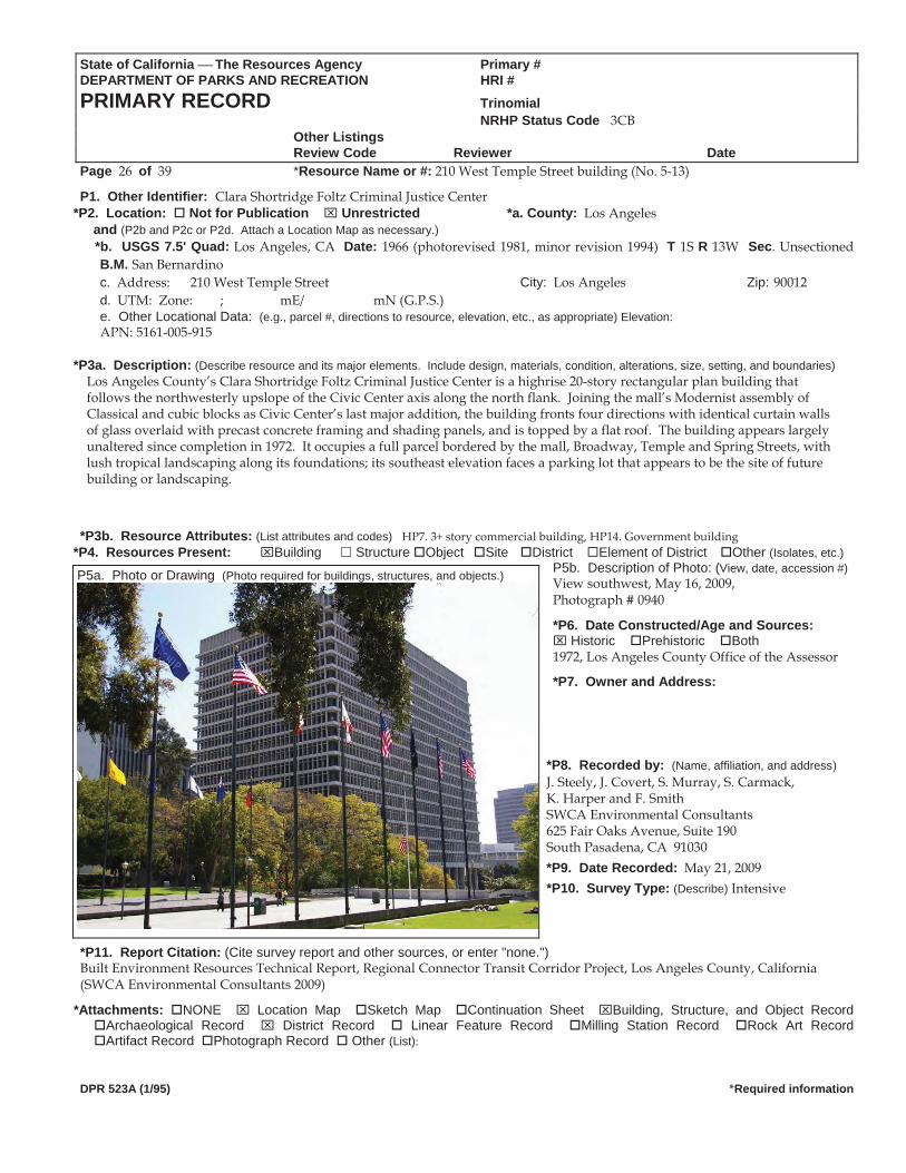
State of California The Resources Agency Primary #DEPARTMENT OF PARKS AND RECREATION HRI #PRIMARY RECORD Trinomial NRHP Status Code 3CB Other Listings
Review Code Reviewer DatePage 26 of 39 *Resource Name or #: 210 West Temple Street building (No. 5-13)
P1. Other Identifier: Clara Shortridge Foltz Criminal Justice Center *P2. Location: Not for Publication Unrestricted *a. County: Los Angeles
and (P2b and P2c or P2d. Attach a Location Map as necessary.) *b. USGS 7.5' Quad: Los Angeles, CA Date: 1966 (photorevised 1981, minor revision 1994) T 1S R 13W Sec. Unsectioned
B.M. San Bernardinoc. Address: 210 West Temple Street City: Los Angeles Zip: 90012 d. UTM: Zone: ; mE/ mN (G.P.S.) e. Other Locational Data: (e.g., parcel #, directions to resource, elevation, etc., as appropriate) Elevation: APN: 5161-005-915
*P3a. Description: (Describe resource and its major elements. Include design, materials, condition, alterations, size, setting, and boundaries)
Los Angeles County’s Clara Shortridge Foltz Criminal Justice Center is a highrise 20-story rectangular plan building that follows the northwesterly upslope of the Civic Center axis along the north flank. Joining the mall’s Modernist assembly of Classical and cubic blocks as Civic Center’s last major addition, the building fronts four directions with identical curtain walls of glass overlaid with precast concrete framing and shading panels, and is topped by a flat roof. The building appears largely unaltered since completion in 1972. It occupies a full parcel bordered by the mall, Broadway, Temple and Spring Streets, with lush tropical landscaping along its foundations; its southeast elevation faces a parking lot that appears to be the site of future building or landscaping.
*P3b. Resource Attributes: (List attributes and codes) HP7. 3+ story commercial building, HP14. Government building
*P4. Resources Present: Building Structure Object Site District Element of District Other (Isolates, etc.)P5b. Description of Photo: (View, date, accession #)View southwest, May 16, 2009, P5a. Photo or Drawing (Photo required for buildings, structures, and objects.)
Photograph # 0940
*P6. Date Constructed/Age and Sources: Historic Prehistoric Both
1972, Los Angeles County Office of the Assessor
*P7. Owner and Address:
*P8. Recorded by: (Name, affiliation, and address) J. Steely, J. Covert, S. Murray, S. Carmack, K. Harper and F. Smith SWCA Environmental Consultants 625 Fair Oaks Avenue, Suite 190 South Pasadena, CA 91030 *P9. Date Recorded: May 21, 2009 *P10. Survey Type: (Describe) Intensive
*P11. Report Citation: (Cite survey report and other sources, or enter "none.") Built Environment Resources Technical Report, Regional Connector Transit Corridor Project, Los Angeles County, California (SWCA Environmental Consultants 2009)
*Attachments: NONE Location Map Sketch Map Continuation Sheet Building, Structure, and Object Record Archaeological Record District Record Linear Feature Record Milling Station Record Rock Art Record Artifact Record Photograph Record Other (List):
DPR 523A (1/95) *Required information
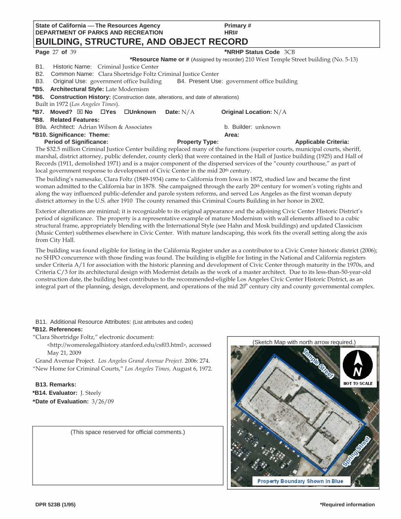
State of California The Resources Agency Primary # DEPARTMENT OF PARKS AND RECREATION HRI#
BUILDING, STRUCTURE, AND OBJECT RECORD Page 27 of 39 *NRHP Status Code 3CB
*Resource Name or # (Assigned by recorder) 210 West Temple Street building (No. 5-13) B1. Historic Name: Criminal Justice Center B2. Common Name: Clara Shortridge Foltz Criminal Justice CenterB3. Original Use: government office building B4. Present Use: government office building
*B5. Architectural Style: Late Modernism *B6. Construction History: (Construction date, alterations, and date of alterations)
Built in 1972 (Los Angeles Times). *B7. Moved? No Yes Unknown Date: N/A Original Location: N/A *B8. Related Features: B9a. Architect: Adrian Wilson & Associates b. Builder: unknown
*B10. Significance: Theme: Area: Period of Significance: Property Type: Applicable Criteria:
The $32.5 million Criminal Justice Center building replaced many of the functions (superior courts, municipal courts, sheriff, marshal, district attorney, public defender, county clerk) that were contained in the Hall of Justice building (1925) and Hall of Records (1911, demolished 1971) and is a major component of the dispersed services of the “county courthouse,” as part of local government response to development of Civic Center in the mid 20th century. The building’s namesake, Clara Foltz (1849-1934) came to California from Iowa in 1872, studied law and became the first woman admitted to the California bar in 1878. She campaigned through the early 20th century for women’s voting rights and along the way influenced public-defender and parole system reforms, and served Los Angeles as the first woman deputy district attorney in the U.S. after 1910 The county renamed this Criminal Courts Building in her honor in 2002.
Exterior alterations are minimal; it is recognizable to its original appearance and the adjoining Civic Center Historic District’s period of significance. The property is a representative example of mature Modernism with wall elements affixed to a cubic structural frame, appropriately blending with the International Style (see Hahn and Mosk buildings) and updated Classicism (Music Center) subthemes elsewhere in Civic Center. With mature landscaping, this work fits the overall setting along the axis from City Hall.
The building was found eligible for listing in the California Register under as a contributor to a Civic Center historic district (2006); no SHPO concurrence with those finding was found. The building is eligible for listing in the National and California registers under Criteria A/1 for association with the historic planning and development of Civic Center through maturity in the 1970s, and Criteria C/3 for its architectural design with Modernist details as the work of a master architect. Due to its less-than-50-year-old construction date, the building best contributes to the recommended-eligible Los Angeles Civic Center Historic District, as an integral part of the planning, design, development, and operations of the mid 20th century city and county governmental complex.
B11. Additional Resource Attributes: (List attributes and codes) *B12. References: “Clara Shortridge Foltz,” electronic document:
<http://womenslegalhistory.stanford.edu/csf03.html>, accessedMay 21, 2009
(Sketch Map with north arrow required.)
Grand Avenue Project. Los Angeles Grand Avenue Project. 2006: 274.“New Home for Criminal Courts,” Los Angeles Times, August 6, 1972. B13. Remarks:
*B14. Evaluator: J. Steely *Date of Evaluation: 3/26/09
(This space reserved for official comments.)
DPR 523B (1/95) *Required information
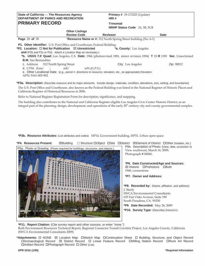
State of California The Resources Agency Primary # 19-173225 (Update) DEPARTMENT OF PARKS AND RECREATION HRI #PRIMARY RECORD Trinomial NRHP Status Code 1S, 3B, 3CB Other Listings
Review Code Reviewer DatePage 28 of 38 *Resource Name or #: 312 North Spring Street building (No. 6-1)
P1. Other Identifier: U.S. Post Office and Courthouse; Federal Building *P2. Location: Not for Publication Unrestricted *a. County: Los Angeles
and (P2b and P2c or P2d. Attach a Location Map as necessary.) *b. USGS 7.5' Quad: Los Angeles, CA Date: 1966 (photorevised 1981, minor revision 1994) T 1S R 13W Sec. Unsectioned
B.M. San Bernardinoc. Address: 312 North Spring Street City: Los Angeles Zip: 90012 d. UTM: Zone: ; mE/ mN (G.P.S.) e. Other Locational Data: (e.g., parcel #, directions to resource, elevation, etc., as appropriate) Elevation: APN: 5161-005-902
*P3a. Description: (Describe resource and its major elements. Include design, materials, condition, alterations, size, setting, and boundaries)
The U.S. Post Office and Courthouse, also known as the Federal Building was listed in the National Register of Historic Places and California Register of Historical Resources in 2006.
Refer to National Register Registration Form for description, significance, and mapping.
The building also contributes to the National and California Register eligible Los Angeles Civic Center Historic District, as an integral part of the planning, design, development, and operations of the early 20th century city and county governmental complex. *P3b. Resource Attributes: (List attributes and codes) HP14. Government building, HP31. Urban open space
*P4. Resources Present: Building Structure Object Site District Element of District Other (Isolates, etc.)P5b. Description of Photo: (View, date, accession #)View southwest, March 16, 2009, Photograph # 06066.
*P6. Date Constructed/Age and Sources: Historic Prehistoric Both
1940, cornerstone.
*P7. Owner and Address: *P8. Recorded by: (Name, affiliation, and address) J. Steely SWCA Environmental Consultants 625 Fair Oaks Avenue, Suite 190 South Pasadena, CA 91030 *P9. Date Recorded: May 26, 2009 *P10. Survey Type: (Describe) Intensive
*P11. Report Citation: (Cite survey report and other sources, or enter "none.") Built Environment Resources Technical Report, Regional Connector Transit Corridor Project, Los Angeles County, California (SWCA Environmental Consultants 2009)
*Attachments: NONE Location Map Sketch Map Continuation Sheet Building, Structure, and Object Record Archaeological Record District Record Linear Feature Record Milling Station Record Rock Art Record Artifact Record Photograph Record Other (List):
DPR 523A (1/95) *Required information
P5a. Photo or Drawing (Photo required for buildings, structures, and objects.)
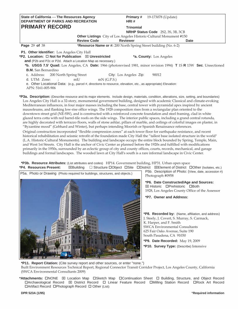
State of California The Resources Agency Primary # 19-173078 (Update) DEPARTMENT OF PARKS AND RECREATION HRI #PRIMARY RECORD Trinomial NRHP Status Code 2S2, 3S, 3B, 3CB Other Listings City of Los Angeles Historic-Cultural Monument #150
Review Code Reviewer DatePage 29 of 38 *Resource Name or #: 200 North Spring Street building (No. 6-2)
P1. Other Identifier: Los Angeles City Hall *P2. Location: Not for Publication Unrestricted *a. County: Los Angeles
and (P2b and P2c or P2d. Attach a Location Map as necessary.) *b. USGS 7.5' Quad: Los Angeles, CA Date: 1966 (photorevised 1981, minor revision 1994) T 1S R 13W Sec. Unsectioned
B.M. San Bernardinoc. Address: 200 North Spring Street City: Los Angeles Zip: 90012 d. UTM: Zone: ; mE/ mN (G.P.S.) e. Other Locational Data: (e.g., parcel #, directions to resource, elevation, etc., as appropriate) Elevation: APN: 5161-005-906
*P3a. Description: (Describe resource and its major elements. Include design, materials, condition, alterations, size, setting, and boundaries)
Los Angeles City Hall is a 32-story, monumental government building, designed with academic Classical and climate-evoking Mediterranean influences, in four major masses including the base, central tower with pyramidal apex inspired by ancient mausoleums, and flanking low-rise office wings. The 1928 composition rises from a rectangular plan oriented to the downtown street grid (NE-SW), and is constructed with a reinforced concrete foundation and steel framing, clad in white glazed terra cotta with red barrel-tile roofs on the side wings. The interior public spaces, including a grand central rotunda, are highly decorated with terrazzo floors, walls of stone ashlar, pillars of marble, and ceilings of colorful images on plaster, in “Byzantine mood” (Gebhard and Winter), but perhaps intending Moorish or Spanish Renaissance references. Original construction incorporated “flexible compression zones” at each tower floor for earthquake resistance, and recent historical rehabilitation and seismic retrofit of the foundation made City Hall the “tallest base isolated structure in the world" (L.A. Historic-Cultural Monuments). The building and landscape occupy the entire block bounded by Spring, Temple, Main, and West 1st Streets. City Hall is the anchor of Civic Center as planned before the 1920s and fulfilled with modifications primarily in the 1950s, surrounded by an eclectic group of city and county offices, courts, records, mechanical, and garage buildings and formal landscapes. The wooded lawn at City Hall's south is a rare informal landscape in Civic Center.
*P3b. Resource Attributes: (List attributes and codes) HP14. Government building, HP31. Urban open space
*P4. Resources Present: Building Structure Object Site District Element of District Other (Isolates, etc.)P5b. Description of Photo: (View, date, accession #)Photograph #0958
*P6. Date Constructed/Age and Sources: Historic Prehistoric Both
1928, Los Angeles County Office of the Assessor
*P7. Owner and Address: *P8. Recorded by: (Name, affiliation, and address) J. Steely, J. Covert, S. Murray, S. Carmack, K. Harper, and F. Smith SWCA Environmental Consultants 625 Fair Oaks Avenue, Suite 190 South Pasadena, CA 91030 *P9. Date Recorded: May 19, 2009 *P10. Survey Type: (Describe) Intensive
*P11. Report Citation: (Cite survey report and other sources, or enter "none.") Built Environment Resources Technical Report, Regional Connector Transit Corridor Project, Los Angeles County, California (SWCA Environmental Consultants 2009)
*Attachments: NONE Location Map Sketch Map Continuation Sheet Building, Structure, and Object Record Archaeological Record District Record Linear Feature Record Milling Station Record Rock Art Record Artifact Record Photograph Record Other (List):
DPR 523A (1/95) *Required information
P5a. Photo or Drawing (Photo required for buildings, structures, and objects.)
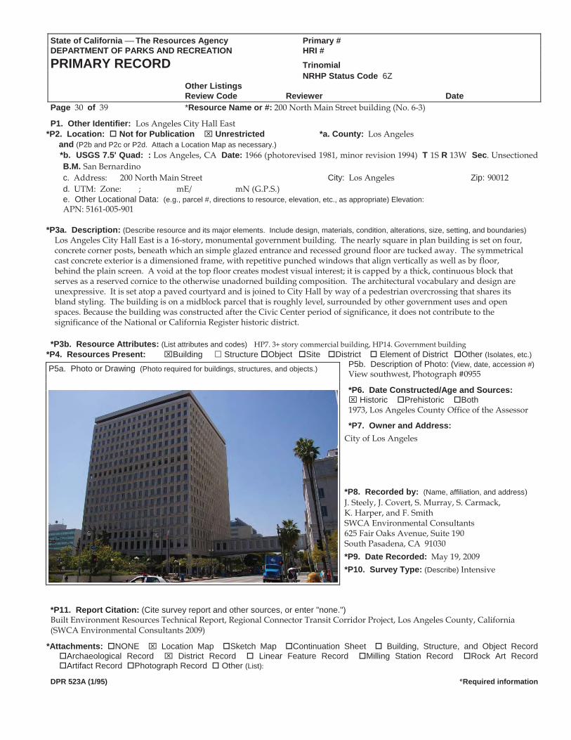
State of California The Resources Agency Primary # DEPARTMENT OF PARKS AND RECREATION HRI #PRIMARY RECORD Trinomial NRHP Status Code 6Z Other Listings
Review Code Reviewer DatePage 30 of 39 *Resource Name or #: 200 North Main Street building (No. 6-3)
P1. Other Identifier: Los Angeles City Hall East *P2. Location: Not for Publication Unrestricted *a. County: Los Angeles
and (P2b and P2c or P2d. Attach a Location Map as necessary.) *b. USGS 7.5' Quad: : Los Angeles, CA Date: 1966 (photorevised 1981, minor revision 1994) T 1S R 13W Sec. Unsectioned
B.M. San Bernardinoc. Address: 200 North Main Street City: Los Angeles Zip: 90012 d. UTM: Zone: ; mE/ mN (G.P.S.) e. Other Locational Data: (e.g., parcel #, directions to resource, elevation, etc., as appropriate) Elevation: APN: 5161-005-901
*P3a. Description: (Describe resource and its major elements. Include design, materials, condition, alterations, size, setting, and boundaries)
Los Angeles City Hall East is a 16-story, monumental government building. The nearly square in plan building is set on four, concrete corner posts, beneath which an simple glazed entrance and recessed ground floor are tucked away. The symmetrical cast concrete exterior is a dimensioned frame, with repetitive punched windows that align vertically as well as by floor, behind the plain screen. A void at the top floor creates modest visual interest; it is capped by a thick, continuous block that serves as a reserved cornice to the otherwise unadorned building composition. The architectural vocabulary and design are unexpressive. It is set atop a paved courtyard and is joined to City Hall by way of a pedestrian overcrossing that shares its bland styling. The building is on a midblock parcel that is roughly level, surrounded by other government uses and open spaces. Because the building was constructed after the Civic Center period of significance, it does not contribute to the significance of the National or California Register historic district.
*P3b. Resource Attributes: (List attributes and codes) HP7. 3+ story commercial building, HP14. Government building *P4. Resources Present: Building Structure Object Site District Element of District Other (Isolates, etc.)
P5b. Description of Photo: (View, date, accession #)View southwest, Photograph #0955 P5a. Photo or Drawing (Photo required for buildings, structures, and objects.)
*P6. Date Constructed/Age and Sources: Historic Prehistoric Both
1973, Los Angeles County Office of the Assessor
*P7. Owner and Address: City of Los Angeles *P8. Recorded by: (Name, affiliation, and address) J. Steely, J. Covert, S. Murray, S. Carmack, K. Harper, and F. Smith SWCA Environmental Consultants 625 Fair Oaks Avenue, Suite 190 South Pasadena, CA 91030 *P9. Date Recorded: May 19, 2009 *P10. Survey Type: (Describe) Intensive
*P11. Report Citation: (Cite survey report and other sources, or enter "none.") Built Environment Resources Technical Report, Regional Connector Transit Corridor Project, Los Angeles County, California (SWCA Environmental Consultants 2009)
*Attachments: NONE Location Map Sketch Map Continuation Sheet Building, Structure, and Object Record Archaeological Record District Record Linear Feature Record Milling Station Record Rock Art Record Artifact Record Photograph Record Other (List):
DPR 523A (1/95) *Required information
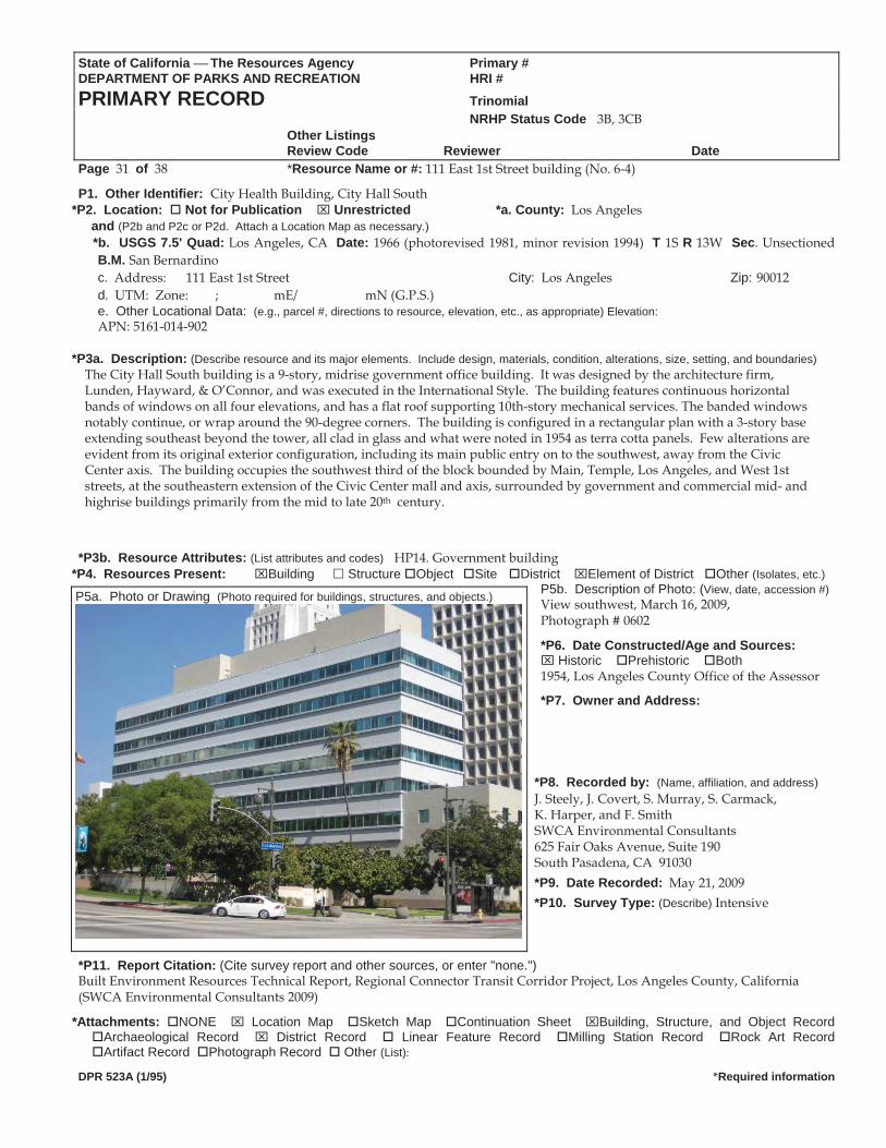
State of California The Resources Agency Primary #DEPARTMENT OF PARKS AND RECREATION HRI #PRIMARY RECORD Trinomial NRHP Status Code 3B, 3CB Other Listings
Review Code Reviewer DatePage 31 of 38 *Resource Name or #: 111 East 1st Street building (No. 6-4)
P1. Other Identifier: City Health Building, City Hall South *P2. Location: Not for Publication Unrestricted *a. County: Los Angeles
and (P2b and P2c or P2d. Attach a Location Map as necessary.) *b. USGS 7.5' Quad: Los Angeles, CA Date: 1966 (photorevised 1981, minor revision 1994) T 1S R 13W Sec. Unsectioned
B.M. San Bernardinoc. Address: 111 East 1st Street City: Los Angeles Zip: 90012 d. UTM: Zone: ; mE/ mN (G.P.S.) e. Other Locational Data: (e.g., parcel #, directions to resource, elevation, etc., as appropriate) Elevation: APN: 5161-014-902
*P3a. Description: (Describe resource and its major elements. Include design, materials, condition, alterations, size, setting, and boundaries)
The City Hall South building is a 9-story, midrise government office building. It was designed by the architecture firm, Lunden, Hayward, & O’Connor, and was executed in the International Style. The building features continuous horizontal bands of windows on all four elevations, and has a flat roof supporting 10th-story mechanical services. The banded windows notably continue, or wrap around the 90-degree corners. The building is configured in a rectangular plan with a 3-story base extending southeast beyond the tower, all clad in glass and what were noted in 1954 as terra cotta panels. Few alterations are evident from its original exterior configuration, including its main public entry on to the southwest, away from the Civic Center axis. The building occupies the southwest third of the block bounded by Main, Temple, Los Angeles, and West 1st streets, at the southeastern extension of the Civic Center mall and axis, surrounded by government and commercial mid- and highrise buildings primarily from the mid to late 20th century.
*P3b. Resource Attributes: (List attributes and codes) HP14. Government building
*P4. Resources Present: Building Structure Object Site District Element of District Other (Isolates, etc.)P5b. Description of Photo: (View, date, accession #)View southwest, March 16, 2009, Photograph # 0602
*P6. Date Constructed/Age and Sources: Historic Prehistoric Both
1954, Los Angeles County Office of the Assessor
*P7. Owner and Address:
*P8. Recorded by: (Name, affiliation, and address) J. Steely, J. Covert, S. Murray, S. Carmack, K. Harper, and F. Smith SWCA Environmental Consultants 625 Fair Oaks Avenue, Suite 190 South Pasadena, CA 91030 *P9. Date Recorded: May 21, 2009 *P10. Survey Type: (Describe) Intensive
*P11. Report Citation: (Cite survey report and other sources, or enter "none.") Built Environment Resources Technical Report, Regional Connector Transit Corridor Project, Los Angeles County, California (SWCA Environmental Consultants 2009)
*Attachments: NONE Location Map Sketch Map Continuation Sheet Building, Structure, and Object Record Archaeological Record District Record Linear Feature Record Milling Station Record Rock Art Record Artifact Record Photograph Record Other (List):
DPR 523A (1/95) *Required information
P5a. Photo or Drawing (Photo required for buildings, structures, and objects.)
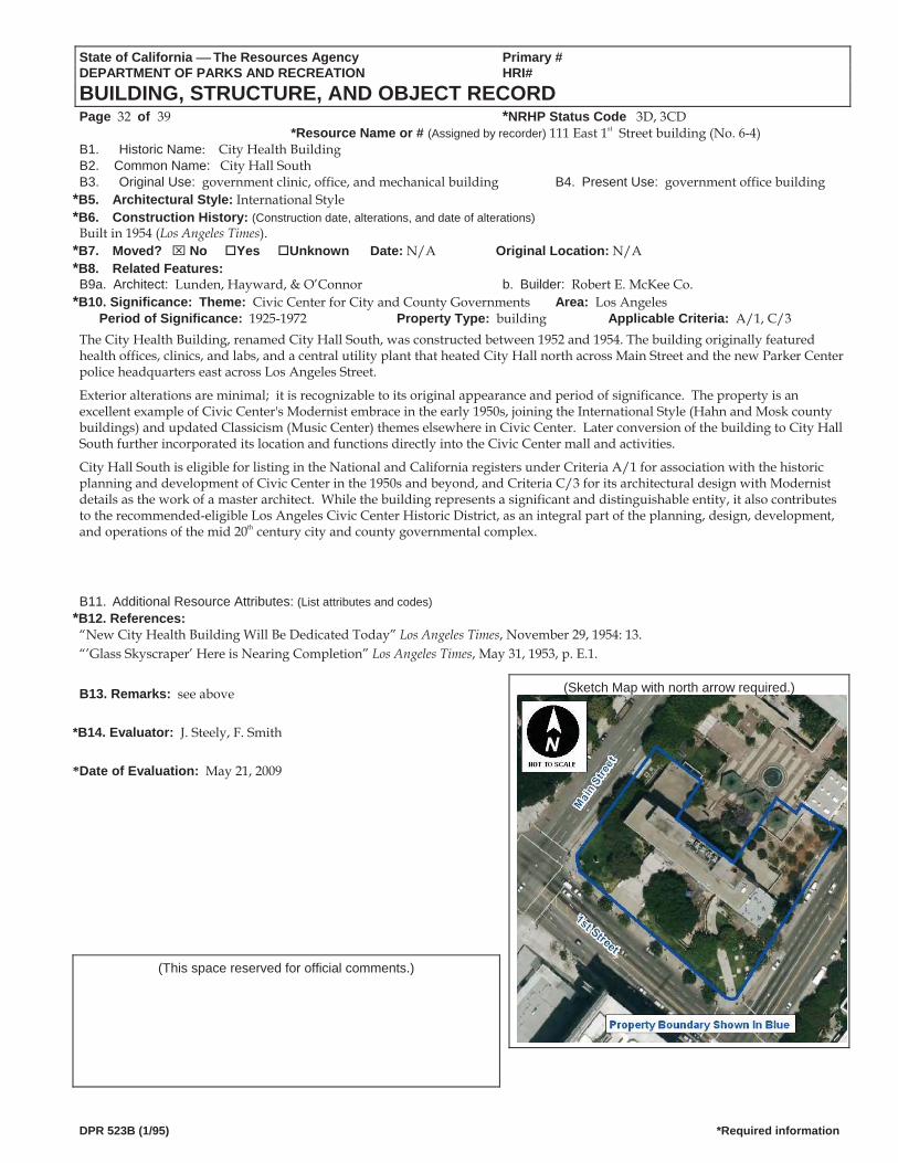
State of California The Resources Agency Primary # DEPARTMENT OF PARKS AND RECREATION HRI#
BUILDING, STRUCTURE, AND OBJECT RECORD Page 32 of 39 *NRHP Status Code 3D, 3CD
*Resource Name or # (Assigned by recorder) 111 East 1st Street building (No. 6-4) B1. Historic Name: City Health Building B2. Common Name: City Hall South B3. Original Use: government clinic, office, and mechanical building B4. Present Use: government office building
*B5. Architectural Style: International Style *B6. Construction History: (Construction date, alterations, and date of alterations)
Built in 1954 (Los Angeles Times). *B7. Moved? No Yes Unknown Date: N/A Original Location: N/A *B8. Related Features: B9a. Architect: Lunden, Hayward, & O’Connor b. Builder: Robert E. McKee Co.
*B10. Significance: Theme: Civic Center for City and County Governments Area: Los AngelesPeriod of Significance: 1925-1972 Property Type: building Applicable Criteria: A/1, C/3
The City Health Building, renamed City Hall South, was constructed between 1952 and 1954. The building originally featured health offices, clinics, and labs, and a central utility plant that heated City Hall north across Main Street and the new Parker Center police headquarters east across Los Angeles Street.
Exterior alterations are minimal; it is recognizable to its original appearance and period of significance. The property is an excellent example of Civic Center's Modernist embrace in the early 1950s, joining the International Style (Hahn and Mosk county buildings) and updated Classicism (Music Center) themes elsewhere in Civic Center. Later conversion of the building to City Hall South further incorporated its location and functions directly into the Civic Center mall and activities.
City Hall South is eligible for listing in the National and California registers under Criteria A/1 for association with the historic planning and development of Civic Center in the 1950s and beyond, and Criteria C/3 for its architectural design with Modernist details as the work of a master architect. While the building represents a significant and distinguishable entity, it also contributes to the recommended-eligible Los Angeles Civic Center Historic District, as an integral part of the planning, design, development, and operations of the mid 20th century city and county governmental complex.
B11. Additional Resource Attributes: (List attributes and codes) *B12. References:
“New City Health Building Will Be Dedicated Today” Los Angeles Times, November 29, 1954: 13. “’Glass Skyscraper’ Here is Nearing Completion” Los Angeles Times, May 31, 1953, p. E.1.
(Sketch Map with north arrow required.) B13. Remarks: see above
*B14. Evaluator: J. Steely, F. Smith *Date of Evaluation: May 21, 2009
(This space reserved for official comments.)
DPR 523B (1/95) *Required information
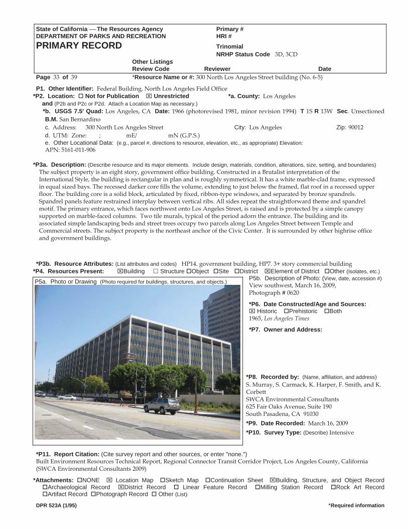
State of California The Resources Agency Primary #DEPARTMENT OF PARKS AND RECREATION HRI #PRIMARY RECORD Trinomial NRHP Status Code 3D, 3CD Other Listings
Review Code Reviewer DatePage 33 of 39 *Resource Name or #: 300 North Los Angeles Street building (No. 6-5)
P1. Other Identifier: Federal Building, North Los Angeles Field Office *P2. Location: Not for Publication Unrestricted *a. County: Los Angeles
and (P2b and P2c or P2d. Attach a Location Map as necessary.) *b. USGS 7.5' Quad: Los Angeles, CA Date: 1966 (photorevised 1981, minor revision 1994) T 1S R 13W Sec. Unsectioned
B.M. San Bernardinoc. Address: 300 North Los Angeles Street City: Los Angeles Zip: 90012 d. UTM: Zone: ; mE/ mN (G.P.S.)
e. Other Locational Data: (e.g., parcel #, directions to resource, elevation, etc., as appropriate) Elevation: APN: 5161-011-906
*P3a. Description: (Describe resource and its major elements. Include design, materials, condition, alterations, size, setting, and boundaries)
The subject property is an eight story, government office building. Constructed in a Brutalist interpretation of the International Style, the building is rectangular in plan and is roughly symmetrical. It has a white marble-clad frame, expressed in equal sized bays. The recessed darker core fills the volume, extending to just below the framed, flat roof in a recessed upper floor. The building core is a solid block, articulated by fixed, ribbon-type windows, and separated by bronze spandrels. Spandrel panels feature restrained interplay between vertical ribs. All sides repeat the straightforward theme and spandrel motif. The primary entrance, which faces northwest onto Los Angeles Street, is raised and is protected by a simple canopy supported on marble-faced columns. Two tile murals, typical of the period adorn the entrance. The building and its associated simple landscaping beds and street trees occupy two parcels along Los Angeles Street between Temple and Commercial streets. The subject property is the northeast anchor of the Civic Center. It is surrounded by other highrise office and government buildings.
*P3b. Resource Attributes: (List attributes and codes) HP14. government building, HP7. 3+ story commercial building
*P4. Resources Present: Building Structure Object Site District Element of District Other (Isolates, etc.)P5b. Description of Photo: (View, date, accession #)View southwest, March 16, 2009, P5a. Photo or Drawing (Photo required for buildings, structures, and objects.)
Photograph # 0620
*P6. Date Constructed/Age and Sources: Historic Prehistoric Both
1965, Los Angeles Times
*P7. Owner and Address: *P8. Recorded by: (Name, affiliation, and address) S. Murray, S. Carmack, K. Harper, F. Smith, and K. Corbett SWCA Environmental Consultants 625 Fair Oaks Avenue, Suite 190 South Pasadena, CA 91030 *P9. Date Recorded: March 16, 2009 *P10. Survey Type: (Describe) Intensive
*P11. Report Citation: (Cite survey report and other sources, or enter "none.") Built Environment Resources Technical Report, Regional Connector Transit Corridor Project, Los Angeles County, California (SWCA Environmental Consultants 2009)
*Attachments: NONE Location Map Sketch Map Continuation Sheet Building, Structure, and Object Record Archaeological Record District Record Linear Feature Record Milling Station Record Rock Art Record Artifact Record Photograph Record Other (List):
DPR 523A (1/95) *Required information
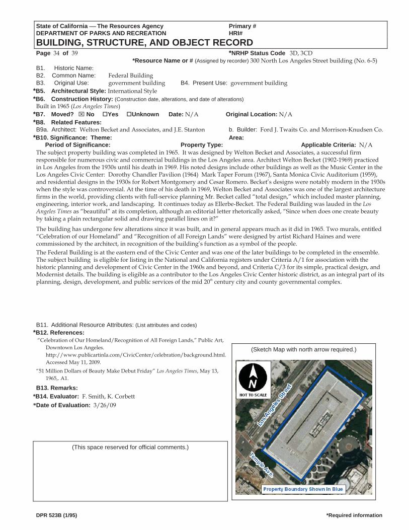
State of California The Resources Agency Primary # DEPARTMENT OF PARKS AND RECREATION HRI#
BUILDING, STRUCTURE, AND OBJECT RECORD Page 34 of 39 *NRHP Status Code 3D, 3CD
*Resource Name or # (Assigned by recorder) 300 North Los Angeles Street building (No. 6-5) B1. Historic Name: B2. Common Name: Federal BuildingB3. Original Use: government building B4. Present Use: government building
*B5. Architectural Style: International Style *B6. Construction History: (Construction date, alterations, and date of alterations)
Built in 1965 (Los Angeles Times) *B7. Moved? No Yes Unknown Date: N/A Original Location: N/A *B8. Related Features: B9a. Architect: Welton Becket and Associates, and J.E. Stanton b. Builder: Ford J. Twaits Co. and Morrison-Knudsen Co.
*B10. Significance: Theme: Area: Period of Significance: Property Type: Applicable Criteria: N/A
The subject property building was completed in 1965. It was designed by Welton Becket and Associates, a successful firm responsible for numerous civic and commercial buildings in the Los Angeles area. Architect Welton Becket (1902-1969) practiced in Los Angeles from the 1930s until his death in 1969. His noted designs include other buildings as well as the Music Center in the Los Angeles Civic Center: Dorothy Chandler Pavilion (1964) Mark Taper Forum (1967), Santa Monica Civic Auditorium (1959), and residential designs in the 1930s for Robert Montgomery and Cesar Romero. Becket’s designs were notably modern in the 1930s when the style was controversial. At the time of his death in 1969, Welton Becket and Associates was one of the largest architecture firms in the world, providing clients with full-service planning Mr. Becket called “total design,” which included master planning, engineering, interior work, and landscaping. It continues today as Ellerbe-Becket. The Federal Building was lauded in the Los Angeles Times as “beautiful” at its completion, although an editorial letter rhetorically asked, “Since when does one create beauty by taking a plain rectangular solid and drawing parallel lines on it?”
The building has undergone few alterations since it was built, and in general appears much as it did in 1965. Two murals, entitled “Celebration of our Homeland” and “Recognition of all Foreign Lands” were designed by artist Richard Haines and were commissioned by the architect, in recognition of the building’s function as a symbol of the people. The Federal Building is at the eastern end of the Civic Center and was one of the later buildings to be completed in the ensemble. The subject building is eligible for listing in the National and California registers under Criteria A/1 for association with the historic planning and development of Civic Center in the 1960s and beyond, and Criteria C/3 for its simple, practical design, and Modernist details. The building is eligible as a contributor to the Los Angeles Civic Center historic district, as an integral part of its planning, design, development, and public services of the mid 20th century city and county governmental complex.
B11. Additional Resource Attributes: (List attributes and codes) *B12. References:
“Celebration of Our Homeland/Recognition of All Foreign Lands,” Public Art, Downtown Los Angeles. http://www.publicartinla.com/CivicCenter/celebration/background.html. Accessed May 11, 2009.
(Sketch Map with north arrow required.)
“51 Million Dollars of Beauty Make Debut Friday” Los Angeles Times, May 13, 1965,. A1.
B13. Remarks: *B14. Evaluator: F. Smith, K. Corbett *Date of Evaluation: 3/26/09
(This space reserved for official comments.)
DPR 523B (1/95) *Required information
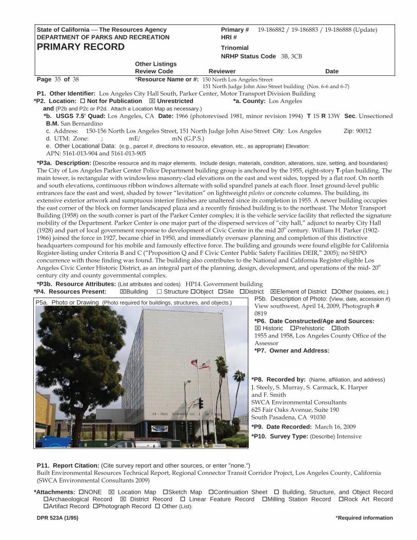
State of California The Resources Agency Primary # 19-186882 / 19-186883 / 19-186888 (Update) DEPARTMENT OF PARKS AND RECREATION HRI #PRIMARY RECORD Trinomial NRHP Status Code 3B, 3CB Other Listings
Review Code Reviewer DatePage 35 of 38 *Resource Name or #: 150 North Los Angeles Street 151 North Judge John Aiso Street building (Nos. 6-6 and 6-7) P1. Other Identifier: Los Angeles City Hall South, Parker Center, Motor Transport Division Building
*P2. Location: Not for Publication Unrestricted *a. County: Los Angeles and (P2b and P2c or P2d. Attach a Location Map as necessary.)
*b. USGS 7.5' Quad: Los Angeles, CA Date: 1966 (photorevised 1981, minor revision 1994) T 1S R 13W Sec. Unsectioned B.M. San Bernardinoc. Address: 150-156 North Los Angeles Street, 151 North Judge John Aiso Street City: Los Angeles Zip: 90012 d. UTM: Zone: ; mE/ mN (G.P.S.) e. Other Locational Data: (e.g., parcel #, directions to resource, elevation, etc., as appropriate) Elevation: APN: 5161-013-904 and 5161-013-905
*P3a. Description: (Describe resource and its major elements. Include design, materials, condition, alterations, size, setting, and boundaries)The City of Los Angeles Parker Center Police Department building group is anchored by the 1955, eight-story T-plan building. The main tower, is rectangular with windowless masonry-clad elevations on the east and west sides, topped by a flat roof. On north and south elevations, continuous ribbon windows alternate with solid spandrel panels at each floor. Inset ground-level public entrances face the east and west, shaded by tower “levitation” on lightweight pilotes or concrete columns. The building, its extensive exterior artwork and sumptuous interior finishes are unaltered since its completion in 1955. A newer building occupies the east corner of the block on former landscaped plaza and a recently finished building is to the northeast. The Motor Transport Building (1958) on the south corner is part of the Parker Center complex; it is the vehicle service facility that reflected the signature mobility of the Department. Parker Center is one major part of the dispersed services of “city hall,” adjunct to nearby City Hall (1928) and part of local government response to development of Civic Center in the mid 20th century. William H. Parker (1902-1966) joined the force in 1927, became chief in 1950, and immediately oversaw planning and completion of this distinctive headquarters compound for his mobile and famously effective force. The building and grounds were found eligible for California Register-listing under Criteria B and C (“Proposition Q and F Civic Center Public Safety Facilities DEIR,” 2005); no SHPO concurrence with those finding was found. The building also contributes to the National and California Register eligible Los Angeles Civic Center Historic District, as an integral part of the planning, design, development, and operations of the mid- 20th century city and county governmental complex. *P3b. Resource Attributes: (List attributes and codes) HP14. Government building
*P4. Resources Present: Building Structure Object Site District Element of District Other (Isolates, etc.)P5b. Description of Photo: (View, date, accession #)View southwest, April 14, 2009, Photograph # 0819 *P6. Date Constructed/Age and Sources:
Historic Prehistoric Both1955 and 1958, Los Angeles County Office of the Assessor *P7. Owner and Address:
*P8. Recorded by: (Name, affiliation, and address) J. Steely, S. Murray, S. Carmack, K. Harper and F. Smith SWCA Environmental Consultants 625 Fair Oaks Avenue, Suite 190 South Pasadena, CA 91030 *P9. Date Recorded: March 16, 2009 *P10. Survey Type: (Describe) Intensive
P11. Report Citation: (Cite survey report and other sources, or enter "none.") Built Environmental Resources Technical Report, Regional Connector Transit Corridor Project, Los Angeles County, California (SWCA Environmental Consultants 2009)
*Attachments: NONE Location Map Sketch Map Continuation Sheet Building, Structure, and Object Record Archaeological Record District Record Linear Feature Record Milling Station Record Rock Art Record Artifact Record Photograph Record Other (List):
DPR 523A (1/95) *Required information
P5a. Photo or Drawing (Photo required for buildings, structures, and objects.)
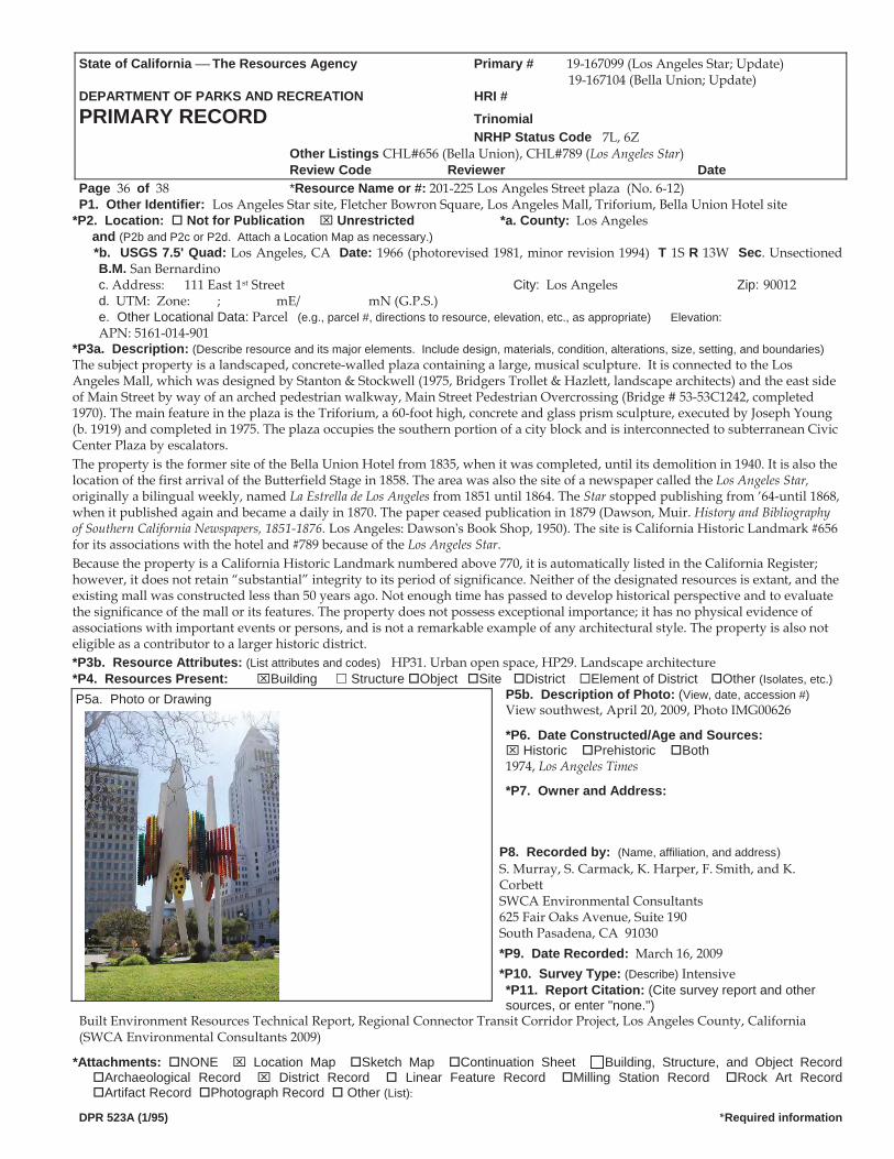
State of California The Resources Agency Primary # 19-167099 (Los Angeles Star; Update) 19-167104 (Bella Union; Update)
DEPARTMENT OF PARKS AND RECREATION HRI #PRIMARY RECORD Trinomial NRHP Status Code 7L, 6Z Other Listings CHL#656 (Bella Union), CHL#789 (Los Angeles Star)
Review Code Reviewer DatePage 36 of 38 *Resource Name or #: 201-225 Los Angeles Street plaza (No. 6-12)P1. Other Identifier: Los Angeles Star site, Fletcher Bowron Square, Los Angeles Mall, Triforium, Bella Union Hotel site
*P2. Location: Not for Publication Unrestricted *a. County: Los Angeles and (P2b and P2c or P2d. Attach a Location Map as necessary.)
*b. USGS 7.5' Quad: Los Angeles, CA Date: 1966 (photorevised 1981, minor revision 1994) T 1S R 13W Sec. Unsectioned B.M. San Bernardinoc. Address: 111 East 1st Street City: Los Angeles Zip: 90012 d. UTM: Zone: ; mE/ mN (G.P.S.) e. Other Locational Data: Parcel (e.g., parcel #, directions to resource, elevation, etc., as appropriate) Elevation: APN: 5161-014-901
*P3a. Description: (Describe resource and its major elements. Include design, materials, condition, alterations, size, setting, and boundaries)The subject property is a landscaped, concrete-walled plaza containing a large, musical sculpture. It is connected to the Los Angeles Mall, which was designed by Stanton & Stockwell (1975, Bridgers Trollet & Hazlett, landscape architects) and the east side of Main Street by way of an arched pedestrian walkway, Main Street Pedestrian Overcrossing (Bridge # 53-53C1242, completed 1970). The main feature in the plaza is the Triforium, a 60-foot high, concrete and glass prism sculpture, executed by Joseph Young (b. 1919) and completed in 1975. The plaza occupies the southern portion of a city block and is interconnected to subterranean Civic Center Plaza by escalators. The property is the former site of the Bella Union Hotel from 1835, when it was completed, until its demolition in 1940. It is also the location of the first arrival of the Butterfield Stage in 1858. The area was also the site of a newspaper called the Los Angeles Star, originally a bilingual weekly, named La Estrella de Los Angeles from 1851 until 1864. The Star stopped publishing from ’64 until 1868,when it published again and became a daily in 1870. The paper ceased publication in 1879 (Dawson, Muir. History and Bibliographyof Southern California Newspapers, 1851 1876. Los Angeles: Dawson s Book Shop, 1950). The site is California Historic Landmark #656for its associations with the hotel and #789 because of the Los Angeles Star. Because the property is a California Historic Landmark numbered above 770, it is automatically listed in the California Register; however, it does not retain “substantial” integrity to its period of significance. Neither of the designated resources is extant, and the existing mall was constructed less than 50 years ago. Not enough time has passed to develop historical perspective and to evaluate the significance of the mall or its features. The property does not possess exceptional importance; it has no physical evidence of associations with important events or persons, and is not a remarkable example of any architectural style. The property is also not eligible as a contributor to a larger historic district. *P3b. Resource Attributes: (List attributes and codes) HP31. Urban open space, HP29. Landscape architecture*P4. Resources Present: Building Structure Object Site District Element of District Other (Isolates, etc.)
P5b. Description of Photo: (View, date, accession #)View southwest, April 20, 2009, Photo IMG00626
*P6. Date Constructed/Age and Sources: Historic Prehistoric Both
1974, Los Angeles Times
*P7. Owner and Address:
P8. Recorded by: (Name, affiliation, and address) S. Murray, S. Carmack, K. Harper, F. Smith, and K. Corbett SWCA Environmental Consultants 625 Fair Oaks Avenue, Suite 190 South Pasadena, CA 91030 *P9. Date Recorded: March 16, 2009 *P10. Survey Type: (Describe) Intensive *P11. Report Citation: (Cite survey report and other sources, or enter "none.")
Built Environment Resources Technical Report, Regional Connector Transit Corridor Project, Los Angeles County, California (SWCA Environmental Consultants 2009)
*Attachments: NONE Location Map Sketch Map Continuation Sheet Building, Structure, and Object Record Archaeological Record District Record Linear Feature Record Milling Station Record Rock Art Record Artifact Record Photograph Record Other (List):
DPR 523A (1/95) *Required information
P5a. Photo or Drawing
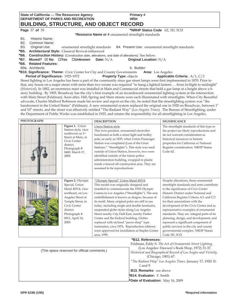
State of California The Resources Agency Primary # DEPARTMENT OF PARKS AND RECREATION HRI#
BUILDING, STRUCTURE, AND OBJECT RECORD Page 37 of 39 *NRHP Status Code 6Z, 3D, 3CD
*Resource Name or # ornamental streetlight standardsB1. Historic Name: B2. Common Name: B3. Original Use: ornamental streetlight standards B4. Present Use: ornamental streetlight standards
*B5. Architectural Style: Classical Revival-influenced *B6. Construction History: (Construction date, alterations, and date of alterations) See below. *B7. Moved? No Yes Unknown Date: N/A Original Location: N/A *B8. Related Features: B9a. Architects: b. Builder:
*B10. Significance: Theme: Civic Center for City and County Governments Area: Los AngelesPeriod of Significance: 1925-1972 Property Type: objects Applicable Criteria: A/1, C/3
Street lighting in Los Angeles has been a part of the community since gas street lamps were first implemented in 1870. Prior to that, any house on a major street with more than two rooms was required “to hang a lighted lantern … from twilight to midnight” (Historical). In 1882, an enormous mast was installed at Main and Commercial streets that held a gas lamp at a height above a 6-story building. By 1905, Broadway has the city’s first example of an incandescent ornamental lighting system at the intersection with Main Street (Feldman). Soon after, Hill, Spring and Main streets were each illuminated with streetlights. When City Beautiful advocate, Charles Mulford Robinson made his review and report on the city, he noted that the streetlighting system was “the handsomest in the United States” (Feldman). A new ornamental system replaced the original one in 1920 on Broadway, between 1st and 10th streets, and the street was effusively entitled “The Radiant Way” (Los Angeles Times). The Bureau of Streetlighting, under the Department of Public Works was established in 1925, and retains the responsibility for all streetlighting in Los Angeles.
DPR 523B (1/95) *Required information
PHOTOGRAPH DESCRIPTION SIGNIFICANCE
Figure 1. Union Station style, view northwest on 1st Street at Main, in Civic Center district. Photograph # 0400, March 17, 2009.
Union Station style This twin pendant, ornamental electrolier functioned as both a street light and trolley pole, as early as 1939, when Union Passenger Station was completed (Last of the Great Stations,” “Streetlights”). This style was used outside of Union Station, however, two were identified outside of the future police administration building, wrapped in plastic inside a fenced off construction area. They are assumed to be reproductions.
The streetlight standards of this type in the project are likely reproductions and do not warrant consideration as historical resources or historic properties for California or National Register consideration. NRHP Status Code 6Z.
Figure 2. Olympic Special, Union Metal 40314, view northeast, on Los Angeles Street at Temple Street, in Civic Center district. Photograph # 0811, April 14, 2009.
“Olympic Special” Union Metal 40314 This model was originally designed and installed to commemorate the 1932 Olympic Games in Los Angeles (“Streetlights”). The arm embellishment is known as dragon, because of its motif. Many original poles are still in use today, including single and double luminaire, suspended globe styles along Los Angeles Street nearby City Hall East, nearby Parker Center and the Federal building. Globes replaced with stylized “pawn shop” type luminaires, circa 1974. Reproduction editions were approved for installation at Staples Center area, 1999.
Despite alterations, these ornamentalstreetlight standards and arms contributeto the significance of Civic CenterHistoric District under National andCalifornia Register Criteria A/1 and C/1for their associations with thedevelopment of the Civic Center and asrepresentative examples of ornamentalstandards. They are integral parts of its planning, design, and development, and represent a significant component of public services in the city and county governmental complex. NRHP Status Code 3D, 3CD.
*B12. References: Feldman, Eddy S. The Art of Ornamental Street Lighting. (Los Angeles: Dawson’s Book Shop, 1972) 31-37. Historical and Biographical Record of Los Angles and Vicinity.
(Chicago, 1901) 67. “The Radiant Way” Los Angeles Times. January 17, 1920: II-
1 and 9. B13. Remarks: see above
*B14. Evaluator: F. Smith *Date of Evaluation: May 16, 2009
(This space reserved for official comments.)
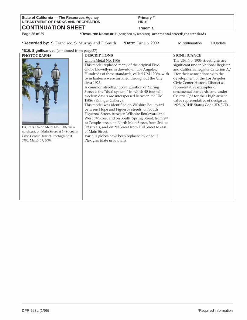
State of California The Resources Agency Primary # DEPARTMENT OF PARKS AND RECREATION HRI#
CONTINUATION SHEET Trinomial Page 38 of 39 *Resource Name or # (Assigned by recorder) ornamental streetlight standards
*Recorded by: S. Francisco, S. Murray and F. Smith *Date: June 6, 2009 Continuation Update
DPR 523L (1/95) *Required information
*B10. Significance: (continued from page 37) PHOTOGRAPHS DESCRIPTIONS SIGNIFICANCE
Figure 3. Union Metal No. 1906, view northeast, on Main Street at 1st Street, in Civic Center District. Photograph # 0390, March 17, 2009.
Union Metal No. 1906 This model replaced many of the original Five-Globe Llewellyns in downtown Los Angeles. Hundreds of these standards, called UM 1906s, with twin lanterns were installed throughout the City circa 1925. A common streetlight configuration on Spring Street is the “dual system,” in which 40-foot tall modern davits are interspersed between the UM 1906s (Eslinger Gallery). This model was identified on Wilshire Boulevard between Hope and Figueroa streets, on South Figueroa Street, between Wilshire Boulevard and West 5th Street and on South Spring Street, from 2nd to Temple street, on North Main Street, from 2nd to 3rd streets, and on 2nd Street from Hill Street to east of Main Street. Various globes have been replaced by opaque Plexiglas (date unknown).
The UM No. 1906 streetlights are significant under National Register and California register Criterion A/ 1 for their associations with the development of the Los Angeles Civic Center Historic District as representative examples of ornamental standards, and under Criteria C/3 for their high artistic value representative of design ca. 1925. NRHP Status Code 3D, 3CD.
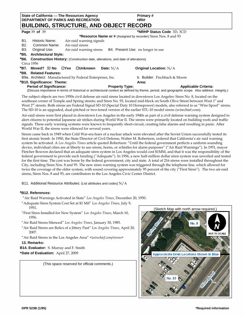
State of California ⎯ The Resources Agency Primary # DEPARTMENT OF PARKS AND RECREATION HRI# BUILDING, STRUCTURE, AND OBJECT RECORD Page 39 of 39 *NRHP Status Code 3D, 3CD *Resource Name or # (Assigned by recorder) Siren Nos. 8 and 93 B1. Historic Name: Air-raid warning signals B2. Common Name: Air-raid sirens B3. Original Use: Air-raid warning sirens B4. Present Use: no longer in use
*B5. Architectural Style: *B6. Construction History: (Construction date, alterations, and date of alterations)
Circa 1956 *B7. Moved? ⌧ No Yes Unknown Date: N/A Original Location: N/A *B8. Related Features: B9a. Architect: Manufactured by Federal Enterprises, Inc. b. Builder: Fischbach & Moore
*B10. Significance: Theme: Area: Period of Significance: Property Type: Applicable Criteria: (Discuss importance in terms of historical or architectural context as defined by theme, period, and geographic scope. Also address integrity.)
The subject objects are two 1950s civil defense air-raid sirens located in downtown Los Angeles: Siren No. 8, located on the southeast corner of Temple and Spring streets; and Siren No. 93, located mid-block on South Olive Street between West 1st and West 2nd streets. Both sirens are Federal Signal SD-10 (Special Duty 10 Horsepower) models, also referred to as “Wire Spool” sirens. The SD-10 is an upgraded, dual-pitched or two-toned version of the earlier STL-10 model sirens (wirechief.com). Air-raid sirens were first placed in downtown Los Angeles in the early 1940s as part of a civil defense warning system designed to alert citizens to potential Japanese air strikes during World War II. The sirens were primarily located on building roofs and traffic signals. These early warning systems were known to frequently short-circuit, creating false alarms and resulting in panic. After World War II, the sirens were silenced for several years. Sirens came back in 1949 when Cold War-era fears of a nuclear attack were elevated after the Soviet Union successfully tested its first atomic bomb. In 1950, the State Director of Civil Defense, Walter M. Robertson, ordered that California’s air raid warning system be activated. A Los Angeles Times article quoted Robertson: “Until the federal government perfects a uniform sounding device, individual cities are at liberty to use sirens, horns, or whistles for alarm purposes” (”Air Raid Warnings”). In 1951, mayor Fletcher Bowron declared that an adequate siren system in Los Angeles would cost $1MM, and that it was the responsibility of the federal government to provide such funding (”Adequate”). In 1956, a new half-million dollar siren system was unveiled and tested for the first time. The cost was borne by the federal government, city and state. A total of 216 sirens were installed throughout the City, including Siren Nos. 8 and 93. The new siren warning system was triggered through the telephone line, which allowed for twice the coverage of the older system, with sound covering approximately 95 percent of the city (”First Siren”). The two air-raid sirens, Siren Nos. 8 and 93, are contributors to the Los Angeles Civic Center District. B11. Additional Resource Attributes: (List attributes and codes) N/A
*B12. References:
“Air Raid Warnings Activated in State” Los Angeles Times, December 20, 1950. “Adequate Siren System Cost Set at $1 Mil” Los Angeles Times, July 9,
1951. (Sketch Map with north arrow required.)
“First Siren Installed for New System” Los Angeles Times, March 10, 1956.
“Air Raid Sirens Silenced” Los Angeles Times, January 30, 1985. “Air Raid Sirens are Relics of a Jittery Past” Los Angeles Times, April 20,
2007. “Air Raid Sirens in the Los Angeles Area” <wirechief.com/sirens> 13. Remarks:
B14. Evaluator: S. Murray and F. Smith *Date of Evaluation: April 27, 2009
(This space reserved for official comments.)
DPR 523B (1/95) *Required information