Embed Size (px)
Citation preview

Jane Schafer-Kramer: CA DWR: Technical Lead, National Hydrography Dataset Stewardship Program
Joel Osuna: CGS: Project Manager
Drew Decker: USGS: National Map Liaison
Building Partnerships for Data StewardshipThe California National Hydrography Dataset Program
CalGIS ConferenceMay 23, 2017

We’ll be talking about…
• Introduction to NHD and State Stewardship Program
• How the NHD is Used
• Maintenance and Upkeep
• NHD for California
• California has an NHD Steward!

National Geospatial Program
NHD Introduction
National Geospatial Program
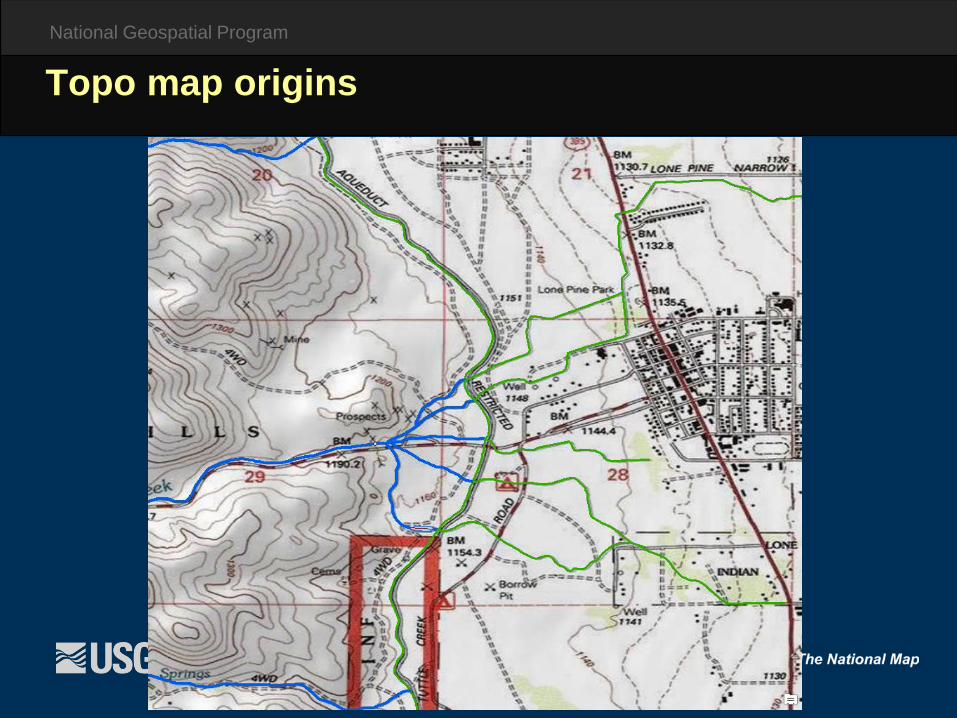
Topo map origins

National Geospatial Program
NHD features at a glance

National Geospatial Program
Swan Creek
Perennial
Intermittent
Ephemeral
Attributes provide basic intelligence

National Geospatial Program
Flow Direction – a key piece of intelligence

National Geospatial Program
1988 - USGS completes national coverage of 100k (Medium Resolution) DLGs
1992 - Environmental Protection Agency (EPA) completes national RF3 coverage,
1997 - USGS / EPA cooperative effort to combine elements of DLG and RF3,
2001 - National coverage of 100k (Medium Resolution) NHD completed, 2002 - USGS, USFS, and others begin work to produce 24k (High
Resolution) NHD, 2003 - Feature Operational Database (FOD) is retired and Geodatabase
comes online, 2006 – First NHD Stewardship Agreement signed, 2007 - National coverage of 24K (High Resolution) NHD completed, 2015 – 24K NHDPlus effort begins. Value Added Attribute Table being
populated.
History of the National Hydrography Dataset

National Geospatial Program
USGS DLGs: a. Standardized Feature Classification,b. Spatial Accuracy at 100K scale
EPA RF3s: a. Flow Direction (based on from/to node),b. Upstream/Downstream Navigation,c. Reach Codes (unique identification),d. Nationally Consistent Hydrography Network
USGS GNIS: a. Names and ID Unique Numbers for Named Features
Important to remember the NHD is in 1:100,000-scale at this point!
History of the NHD The following datasets were used to create particular characteristics in the NHD:

National Geospatial Program
DLGs are vector files containing point, line, and polygon data (such as springs, buildings, roads, streams, lakes, contours, boundaries, woodland areas) digitized from USGS 1:100,000-scale and 1:24,000-scale topographic maps
DLGs offer a full range of attribute codes, are highly accurate, are topologically structured, which makes them ideal for use in geographic information systems (GIS)
How the 1:24,000-Scale NHD was CreatedWhat is a Digital Line Graph (DLG) ?
National Geospatial Program
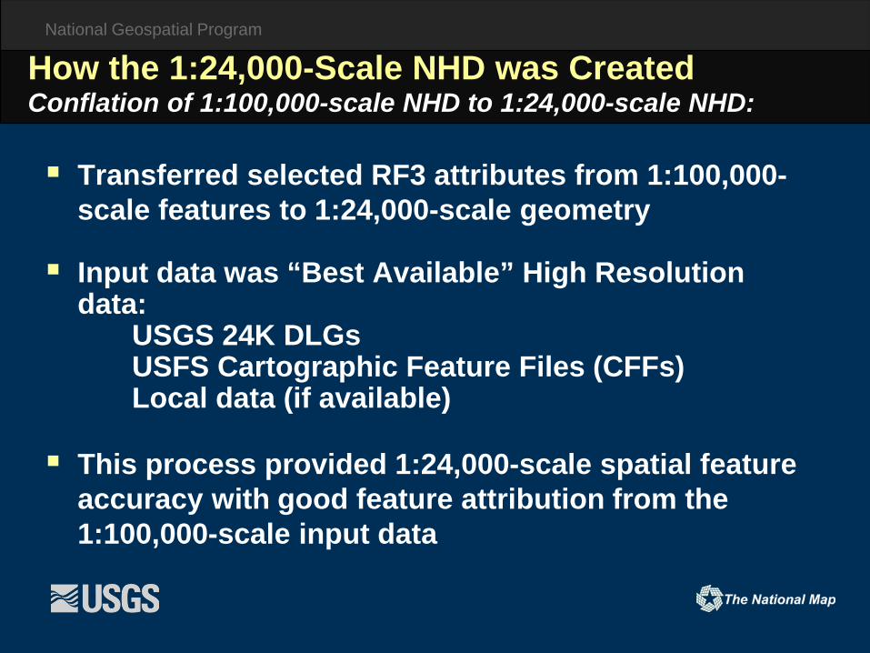
Transferred selected RF3 attributes from 1:100,000-scale features to 1:24,000-scale geometry
Input data was “Best Available” High Resolution data:
USGS 24K DLGsUSFS Cartographic Feature Files (CFFs)Local data (if available)
This process provided 1:24,000-scale spatial feature accuracy with good feature attribution from the 1:100,000-scale input data
How the 1:24,000-Scale NHD was CreatedConflation of 1:100,000-scale NHD to 1:24,000-scale NHD:
National Geospatial Program
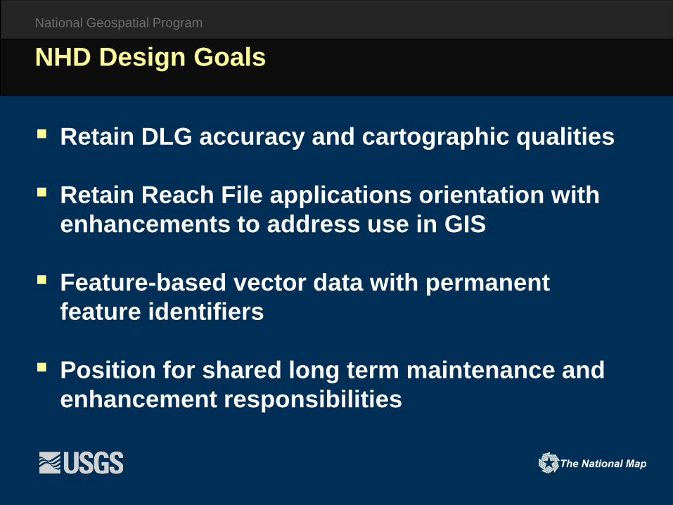
Retain DLG accuracy and cartographic qualities
Retain Reach File applications orientation with enhancements to address use in GIS
Feature-based vector data with permanent feature identifiers
Position for shared long term maintenance and enhancement responsibilities
NHD Design Goals

National Geospatial Program
NHD Stewardship

National Geospatial Program
The NHD is a ‘living’ database, ever changing and requiring constant maintenance
Quality revisions will always be needed to keep the NHD current and useful
Organizations closest to the Hydrography are most aware of ground truth
Such Organizations have the unique opportunity to serve as Stewards
USGS will assist in anyway possible to achieve goals of NHD Maintenance program
Stewardship of the NHD
What is Stewardship of the NHD?

National Geospatial Program
Distributed Maintenance: a. Typically on a State-by-State basisb. Suited to regional needs
Identifying a Primary Steward:a. Each State will typically have one NHD Principal
Stewardb. Acts as single POC between State and USGSc. Coordinates all NHD Maintenance activities within
their State
Stewardship of the NHD
What is Stewardship (Cont)?

National Geospatial Program
The Principal Steward agrees to:
a. Acts as a single POC to USGS for their particular State,
b. Represent the interests of the entire State-wide user community,
c. Coordinate with all others for the maintenance of the NHD for theirState,
d. Accept input, adjudicate, and report any decision publicly
Stewardship of the NHD
Partner: Responsibilities and Procedures

National Geospatial Program
The Principal Steward agrees to:
e. Be responsive to all NHD Users in their State,f. Maintains an awareness of the activities of all others
in their State,g. Provide contact information for management and
technical issues,h. Provide publicly available information on status of
data stewardship activities,i. Provide updates back to USGS in the agreed upon
format
Stewardship of the NHD
Partner: Responsibilities and Procedures (Cont.)

National Geospatial Program
USGS agrees to:
a. Process transactions/updates in timely manner ,b. Provide assistance/guidance to State Stewardship
programs,c. Provide Maintenance tools, documentation, and
training,d. Develop solutions to incorporate State hydrographic
data,e. Communicate Transaction status
Stewardship of the NHD
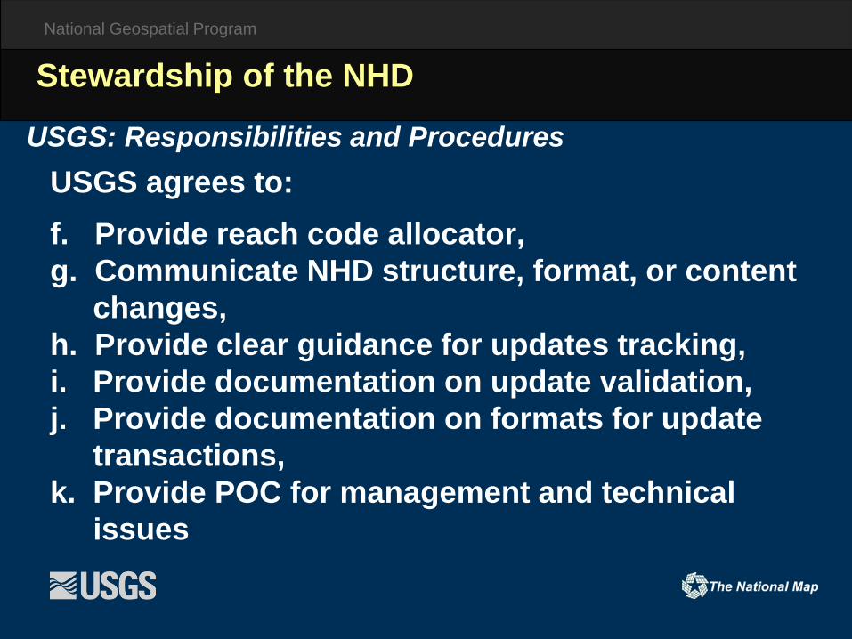
USGS: Responsibilities and Procedures
National Geospatial Program
USGS agrees to: f. Provide reach code allocator,g. Communicate NHD structure, format, or content
changes,h. Provide clear guidance for updates tracking,i. Provide documentation on update validation,j. Provide documentation on formats for update
transactions,k. Provide POC for management and technical
issues
Stewardship of the NHD
USGS: Responsibilities and Procedures
National Geospatial Program
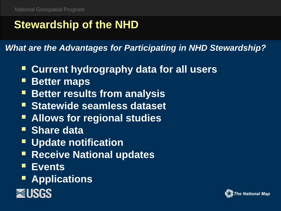
Current hydrography data for all users Better maps Better results from analysis Statewide seamless dataset Allows for regional studies Share data Update notification Receive National updates Events Applications
Stewardship of the NHD
What are the Advantages for Participating in NHD Stewardship?

National Geospatial Program
Production Database
Edits, updates, and QC are carried out
NHD job checked Out
NHD job checked back in
NHD Stewardship Process

National Geospatial Program
NHD Stewardship and Updating
USGS
State Steward
Regional POC
State Sub-Stewards

National Geospatial Program
nhd.usgs.gov

National Geospatial Program
usgs-mrs.cr.usgs.gov/usgssteward/

National Geospatial Program
NHD resources and tools
National Geospatial Program
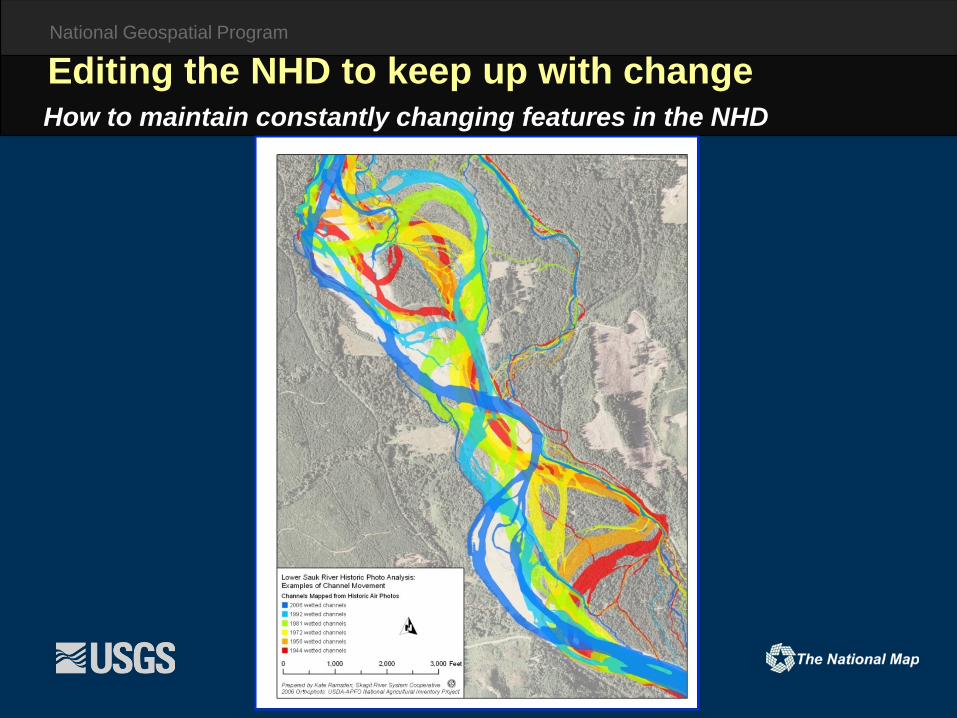
How to maintain constantly changing features in the NHDEditing the NHD to keep up with change

National Geospatial Program
How to maintain constantly changing features in the NHDEditing the NHD to keep up with change

National Geospatial Program
NHD data and feature types

National Geospatial Program
NHD Data Introduction
NHD Feature Class Name Vector Type Feature Examples
NHDPoint Point Springs, Wellls, Gates, Water Intakes
NHDFlowline Line Steams, Rivers, Canals, Ditches, Pipelines
NHDLine Line Flumes, Tunnels, Dams, Bridges
NHDWaterbody Polygon Lakes, Ponds, Reservoirs, Estuaries, Swamps
NHDArea Polygon Washes, Sea/Ocean, Foreshore, Rapids, 2D Streams

National Geospatial Program
NHD Waterbodies – lake/pond

National Geospatial Program
Completing the network through waterbodieswith artificial paths

National Geospatial Program
NHD – points, lines, and polygons
National Geospatial Program
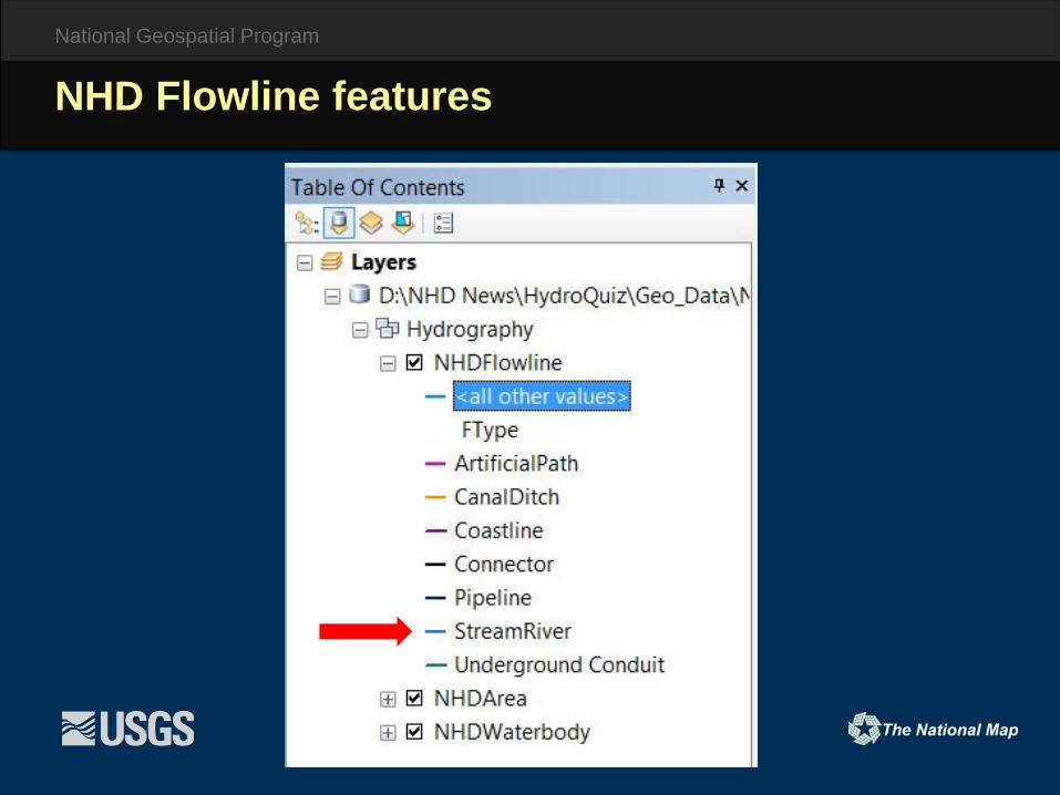
NHD Flowline features
National Geospatial Program
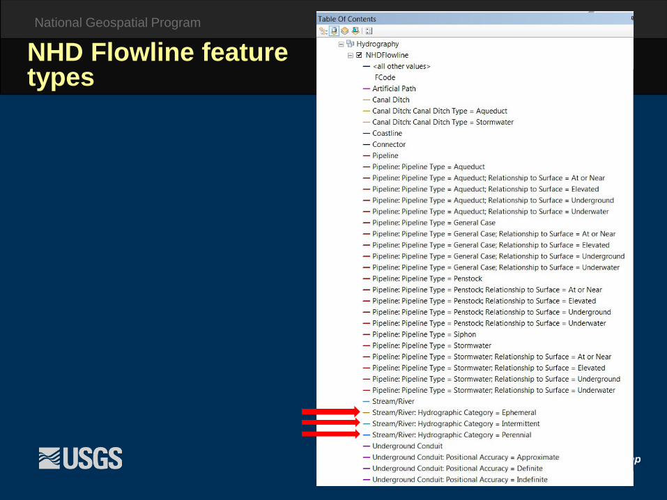
NHD Flowline feature types

National Geospatial Program
Perennial Intermittent Ephemeral
Stream classification

National Geospatial Program
PerennialIntermittent
Ephemeral
Double-Line

National Geospatial Program
Feature codes

National Geospatial Program
NHDArea - detail

National Geospatial Program
NHDAreaStream/River
NHDFlowlineArtificial Path

National Geospatial Program
NHDWaterbody - detail

National Geospatial Program
Feature codes

National Geospatial Program
NHDLine - detail

National Geospatial Program
NHDPoint - detail

National Geospatial Program
NHD attribution – NHDFlowline

National Geospatial Program
NHD attribution – NHDWaterbody

NHD Utility and UseNetwork Analysis and Event Creation:
• Upstream/downstream tracing on the flow network• Flow analysis• Linear Referencing: Creating spatial events by using
the NHD. Meant to be maintained by the end user to fit their needs.o Gauging/Monitoring stationso Fish spawning extents along a rivero Hazardous/polluted extent of a streamo Portion of a pond that allows for recreational
use
NHD Utilities:• Build Flow• Build Network• M-Value Utilities• Subset by Polygon

NHD Utility and UseNHD for Water Quality Assessment CA Basin Plan Mapping Project: Create a more efficient and intuitive system for tracking water quality policies in the State of California by incorporating most components of the CA Basin Plans and other related Water Quality Control Plans into the National Hydrography Dataset (NHD) geodatabase.
• Regional & Statewide Water Quality Objectives• Beneficial Uses• Applicable TMDL’s• Statewide and regional policies (CTR, NTR, NRWQC, Ocean Plan, and
Thermal Plan)

NHD Utility and UseNHDPlus:
• Value added attributes that tie to the NHDo Stream Ordero Path Lengtho Flow VolumeoArbolate Sum
• NHDPlus High Resolutiono In Progresso Beta version produced first for testing/reviewo Sequential refresheso Production First Requires: Repair of NHD flow network issues Correction of NHD severity 1 errors Correction of NHD/WBD errors at the HUC4
level

NHD Utility and UseNHDPlus High Res:
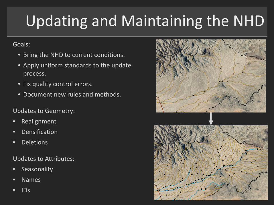
Updating and Maintaining the NHDGoals:
• Bring the NHD to current conditions.• Apply uniform standards to the update
process.• Fix quality control errors.• Document new rules and methods.
Updates to Geometry:• Realignment• Densification• Deletions
Updates to Attributes:• Seasonality• Names• IDs

Updating and Maintaining the NHDReference Data: Provides a guide to decision making in the update process.• Most Recent Aerial Photos: NAIP• Regional and Local Hydro Datasets
NHD Quality Control: Identifies errors in the NHD before and after editing.• Topology• Database Integrity• Feature to Feature Relationships• Flow Checks• Reachcode Continuity• Name Continuity

NHD in California• The NHD in many areas of the state is inaccurate.• There is a demand for updated NHD data across multiple agencies, organizations,
etc. in California.• In the past, some sub-stewards have made some smaller scale updates to select
areas.• Various independent updates to the NHD not associated with the stewardship
system have been made.o Geometry updateso Attribution updateso Name additions
• Update work within the State has recentlyinitiated, leading to stewardship by CA DWR.
• Ongoing and future work on improving the NHD in CA will require major resources.

NHD in CaliforniaMain Goal: Produce a uniform product serving as a common denominator that can be maintained and used across multiple agencies and groups.
• Comprehensive Updateso Brining updates to all NHD componentso Avoiding a piecemealed approach when
possible
• Scaleo 1:24,000 to start
• Mapping and Interpretation Business Ruleso Standardizing how features are interpreted
and mapped in NHD.o Setting limitations.
• Metadatao Setting metadata standards for the state.
Outdated NHDSanta Clara River, Ventura CO, CA

NHD Stewardship in California• Approximate CA State Area:
o 163,696 mi²o 423,971 km²
• 140 HUC8’s intersect California• Spans WBD Regions 15, 16, 17, 18• Contains a large variety of hydro and
land cover types:o Mountainouso Valleyo Arido Semi-Arido Coastalo Agriculturalo Urbanized

Previous and Current NHD WorkPrevious/Current Work• NHD Topo Update Pilot: 2014-2015
o USGS/CGSo 5 Full HUC8’s Updatedo 2 Partial HUC8’s Updated
• NHD State Update Project: Ongoingo CA DFW/CGS/GICo ~45 HUC8’s to be Updatedo DFW-Based Lake and Reservoir
Updates for Entire Stateo Provisional Name Integration
• NHD DLCC Project: Ongoingo USGS/USFWS/DLCC/CGSo 1 Full HUC8 in CA/AZ Updated
This equals about 30% of the State.
Note: USFS Lands have not received NHD updates in watersheds currently undergoing NHD updates.

Future NHD WorkFuture Work• Legal Delta NHD Update Project:
o CA DWR/GIC/CGSo NHD updates at a finer scaleo Specific requirements that go
beyond standard scope
• NHD/WBD State Stewardship: o State Stewardship: DWRo In partnership with USGS, CGS,
GIC, USFS, CA Tribes, neighboring states, and others.
o WBD updates to NHD-completed watersheds
o NHD/WBD updates to additional watersheds
o Keeping NHDPlus HR timing in perspective
Note: USFS Lands have not received NHD updates in watersheds currently undergoing NHD updates.

California NHD Stewardship
DWR as the State Steward – Year 1
Memorandum of Understanding: USGS and DWR
Coordination and Outreach –Participation by Local Hydrology Experts is Welcome!

“• Fund and revive the National Hydrological (sic) Dataset for California to improve high-quality framework geospatial data and the precision and accuracy of mapping and scientific studies.”

California NHD Stewardship
DWR as the State Steward – Year 1
Memorandum of Understanding: USGS and DWRNo funding transfer
Describes roles and responsibilitiesFormalizes the Steward Program

California NHD StewardshipThe Outlook for NHD in California –• Updating all Subbasins to 1:24K • Utilize High Resolution Elevation Data (LiDAR)
for NHD including WBD• NHD Status Map • Other Priorities