Embed Size (px)
DESCRIPTION
The Build Up London Bridge Team Final Report June 2010
Citation preview
1
URBAN TRACK
URBAN TRACK
The ArCollaborative
WITH THE KIND SUPPORTPREPARED BY: CLIENT:
Copyright © 2010
URBAN TRACK
2
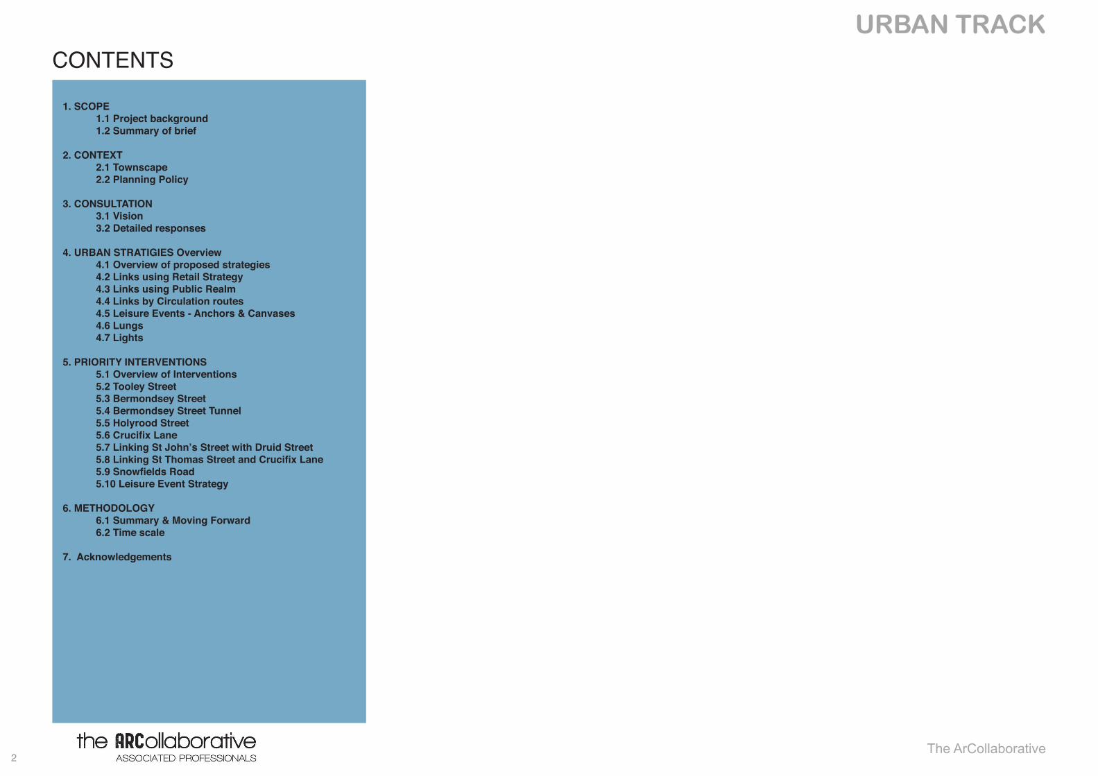
CONTENTS
1. SCOPE 1.1 Project background 1.2 Summary of brief
2. CONTEXT 2.1 Townscape 2.2 Planning Policy
3. CONSULTATION 3.1 Vision 3.2 Detailed responses
4. URBAN STRATIGIES Overview 4.1 Overview of proposed strategies 4.2 Links using Retail Strategy 4.3 Links using Public Realm 4.4 Links by Circulation routes 4.5 Leisure Events - Anchors & Canvases 4.6 Lungs 4.7 Lights 5. PRIORITY INTERVENTIONS 5.1 Overview of Interventions 5.2 Tooley Street 5.3 Bermondsey Street 5.4 Bermondsey Street Tunnel 5.5 Holyrood Street 5.6CrucifixLane 5.7 Linking St John’s Street with Druid Street 5.8LinkingStThomasStreetandCrucifixLane 5.9SnowfieldsRoad 5.10 Leisure Event Strategy
6. METHODOLOGY 6.1 Summary & Moving Forward 6.2 Time scale
7. Acknowledgements
The ArCollaborative

3
URBAN TRACK 1. SCOPE
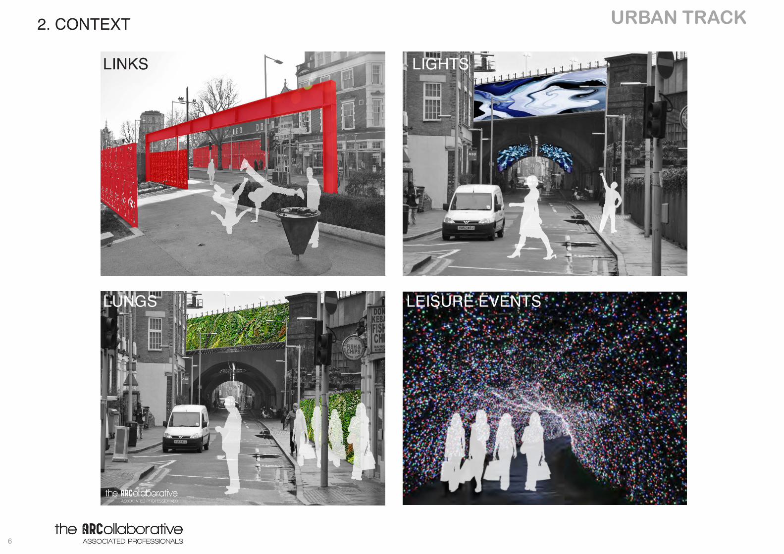
EVENTS
LINKS LIGHTS
LUNGS LEISURE EVENTS
URBAN TRACK
4
1.1 Project BackgroundUNIVERSITY OF WESTMINSTER
The University of Westminster’s Build Up project is a programme aimed at London’s built environment and related professionals who are unemployed or are significantly underemployed in their chosen field.
ARCOLLABORATIVE
This project has been developed by a number of professionals who have come together from a diverse cultural and profession-al experience background.
This breadth and depth of experience within the group has resulted in a creative, vibrant project that encompasses the group’s professional acumen, knowledge and experience working within the built up environment and regeneration issues.
TEAM LONDON BRIDGE
In November 2005, rate-paying organisations based in the Lon-don Bridge – Tower Bridge area voted to create a Business Im-provement District and pay annual contributions towards a fund used for services, projects and events that benefit businesses and employees located in the London Bridge area.
Business-led & fully independent, Team London Bridge has been set up to manage the area and look after this fund.
1. SCOPE
5
URBAN TRACK 1.1 Summary of Brief
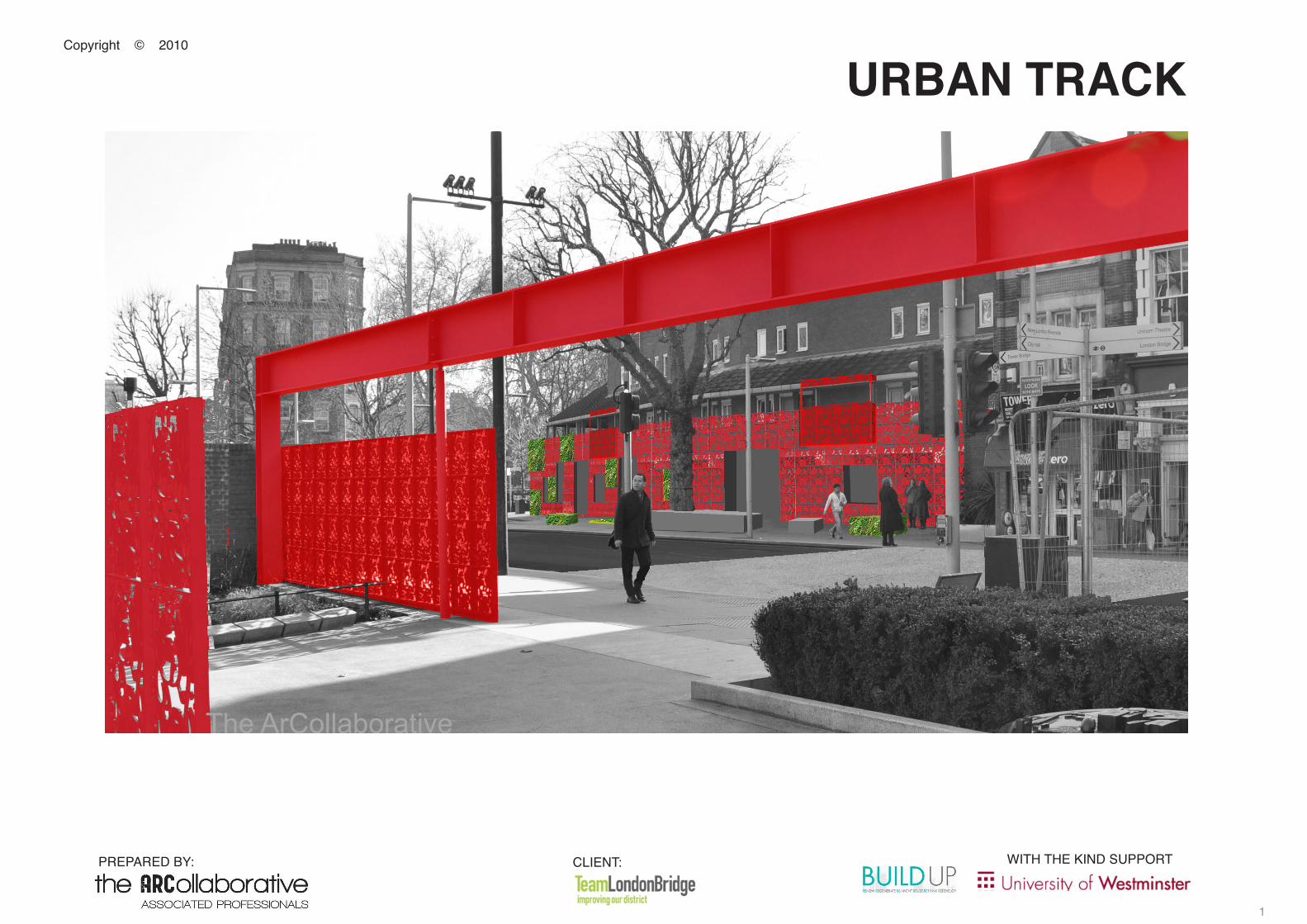
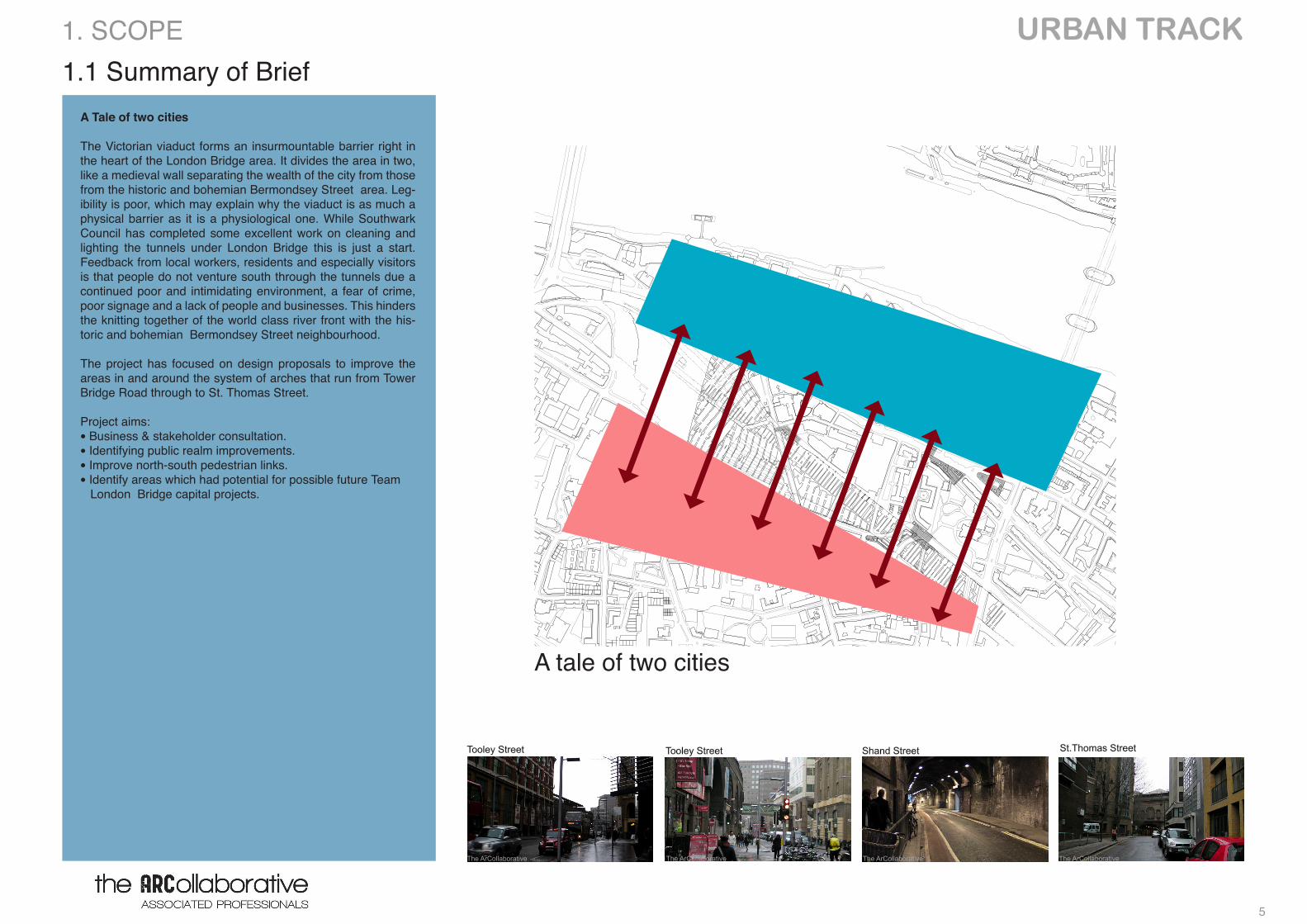
A Tale of two cities
The Victorian viaduct forms an insurmountable barrier right in the heart of the London Bridge area. It divides the area in two, like a medieval wall separating the wealth of the city from those from the historic and bohemian Bermondsey Street area. Leg-ibility is poor, which may explain why the viaduct is as much a physical barrier as it is a physiological one. While Southwark Council has completed some excellent work on cleaning and lighting the tunnels under London Bridge this is just a start. Feedback from local workers, residents and especially visitors is that people do not venture south through the tunnels due a continued poor and intimidating environment, a fear of crime, poor signage and a lack of people and businesses. This hinders the knitting together of the world class river front with the his-toric and bohemian Bermondsey Street neighbourhood.
The project has focused on design proposals to improve the areas in and around the system of arches that run from Tower Bridge Road through to St. Thomas Street.
Project aims:• Business & stakeholder consultation.• Identifying public realm improvements.• Improve north-south pedestrian links.• Identify areas which had potential for possible future Team London Bridge capital projects.
1. SCOPE
A tale of two cities
The ArCollaborative
The ArCollaborative The ArCollaborative The ArCollaborative The ArCollaborative
Tooley Street Shand Street St.Thomas StreetTooley Street
URBAN TRACK
6
2. CONTEXT
LINKS LIGHTS
LUNGS LEISURE EVENTS
7
URBAN TRACK
Crucifix Lane
2.1 Townscape
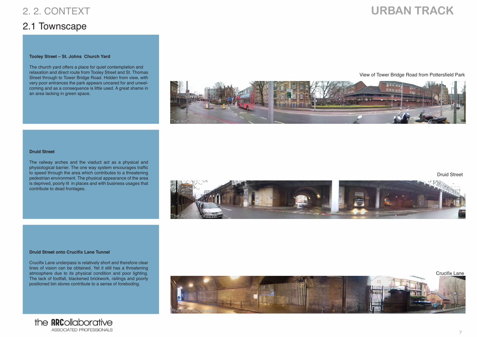
Tooley Street – St. Johns Church Yard
The church yard offers a place for quiet contemplation and relaxation and direct route from Tooley Street and St. Thomas Street through to Tower Bridge Road. Hidden from view, with very poor entrances the park appears uncared for and unwel-coming and as a consequence is little used. A great shame in an area lacking in green space.
Druid Street
The railway arches and the viaduct act as a physical and physiological barrier. The one way system encourages traffic to speed through the area which contributes to a threatening pedestrian environment. The physical appearance of the area is deprived, poorly lit in places and with business usages that contribute to dead frontages.
DruidStreetontoCrucifixLaneTunnel
Crucifix Lane underpass is relatively short and therefore clear lines of vision can be obtained. Yet it still has a threatening atmosphere due to its physical condition and poor lighting. The lack of footfall, blackened brickwork, railings and poorly positioned bin stores contribute to a sense of foreboding.
2. 2. CONTEXT
View of Tower Bridge Road from Pottersfield Park
The ArCollaborative
The ArCollaborative
Druid Street
The ArCollaborative
URBAN TRACK
8
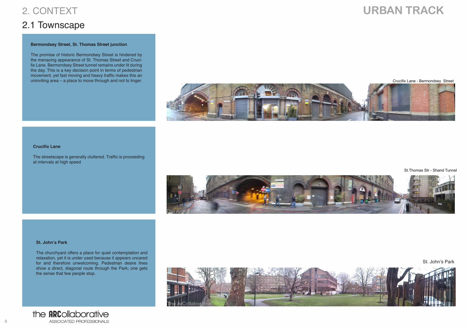
Bermondsey Street, St. Thomas Street junction
The promise of historic Bermondsey Street is hindered by the menacing appearance of St. Thomas Street and Cruci-fix Lane. Bermondsey Street tunnel remains under lit during the day. This is a key decision point in terms of pedestrian movement, yet fast moving and heavy traffic makes this an uninviting area – a place to move through and not to linger.
2.1 Townscape 2. CONTEXT
St. John’s Park
The ArCollaborative
The ArCollaborative
CrucifixLane
The streetscape is generally cluttered. Traffic is proceeding at intervals at high speed
St. John’s Park
The churchyard offers a place for quiet contemplation and relaxation, yet it is under used because it appears uncared for and therefore unwelcoming. Pedestrian desire lines show a direct, diagonal route through the Park; one gets the sense that few people stop.
St.Thomas Str - Shand Tunnel
Crucifix Lane - Bermondsey Street
The ArCollaborative
The ArCollaborative
9
URBAN TRACK 2.2 Planning policy2. CONTEXT
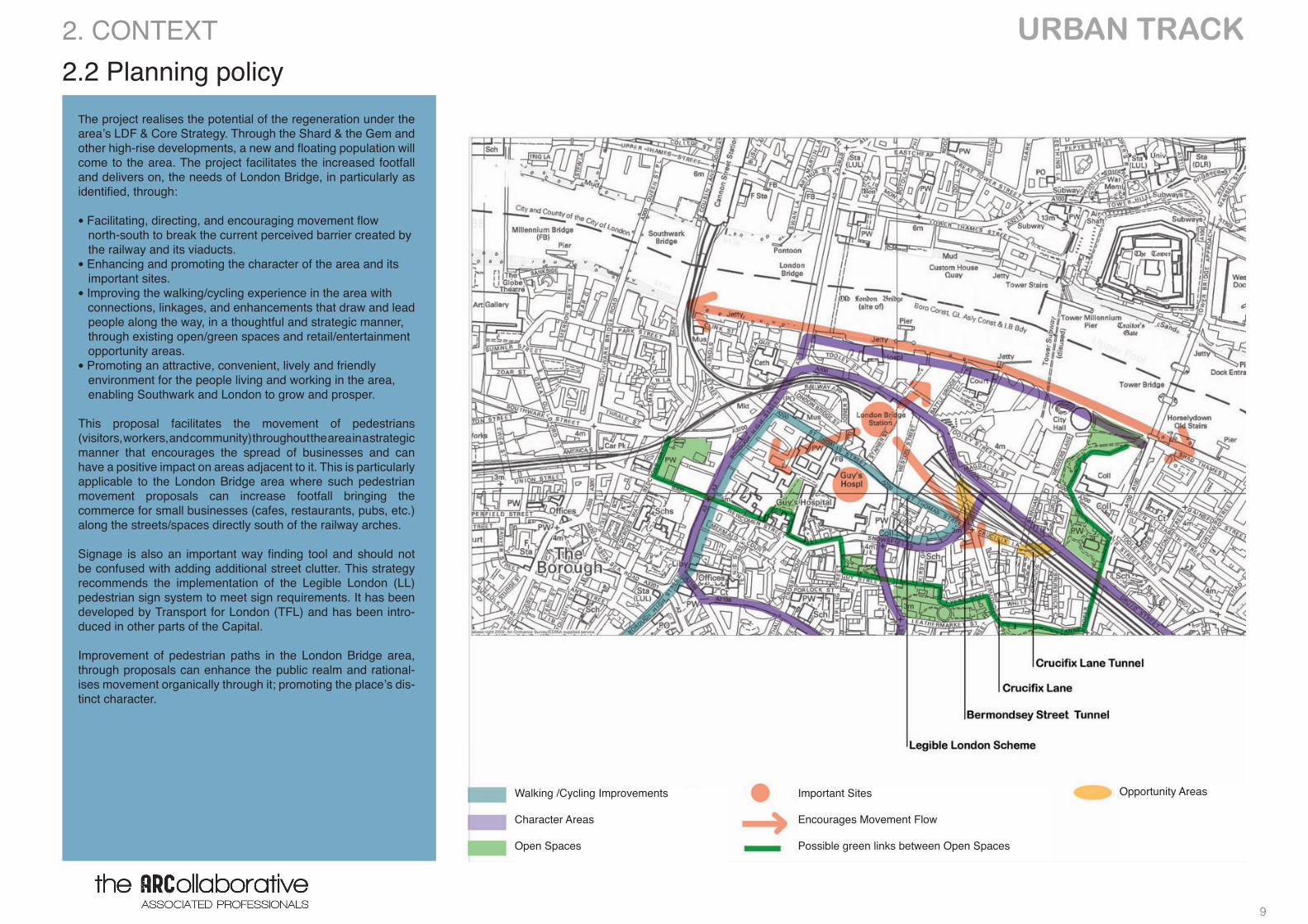
The project realises the potential of the regeneration under the area’s LDF & Core Strategy. Through the Shard & the Gem and other high-rise developments, a new and floating population will come to the area. The project facilitates the increased footfall and delivers on, the needs of London Bridge, in particularly as identified, through:
• Facilitating, directing, and encouraging movement flow north-south to break the current perceived barrier created by the railway and its viaducts.• Enhancing and promoting the character of the area and its important sites.• Improving the walking/cycling experience in the area with connections, linkages, and enhancements that draw and lead people along the way, in a thoughtful and strategic manner, through existing open/green spaces and retail/entertainment opportunity areas.• Promoting an attractive, convenient, lively and friendly environment for the people living and working in the area, enabling Southwark and London to grow and prosper.
This proposal facilitates the movement of pedestrians (visitors, workers, and community) throughout the area in a strategic manner that encourages the spread of businesses and can have a positive impact on areas adjacent to it. This is particularly applicable to the London Bridge area where such pedestrian movement proposals can increase footfall bringing the commerce for small businesses (cafes, restaurants, pubs, etc.) along the streets/spaces directly south of the railway arches.
Signage is also an important way finding tool and should not be confused with adding additional street clutter. This strategy recommends the implementation of the Legible London (LL) pedestrian sign system to meet sign requirements. It has been developed by Transport for London (TFL) and has been intro-duced in other parts of the Capital.
Improvement of pedestrian paths in the London Bridge area, through proposals can enhance the public realm and rational-ises movement organically through it; promoting the place’s dis-tinct character.
Walking /Cycling Improvements
Character Areas
Open Spaces
Important Sites
Encourages Movement Flow
Possible green links between Open Spaces
Opportunity Areas
URBAN TRACK
10
3. CONSULTATION
LINKS LIGHTS
LUNGS LEISURE EVENTS
11
URBAN TRACK 3.1 Vision3. CONSULTATION
n
new bicycle path ?
the
fenc
e w
all i
s an
obs
olet
e re
mna
nt o
f a lo
ng a
go
chur
chya
rd s
patia
l artic
ulat
ion
the new building has negotiated its placeyet it is up to park side to negotiate relation with the corner building unnecessary park wall that protects
nothing at all, hard edge separatingthe street pavement and the lawn
Fai
r Stree
t , v
ery
low
veh
icul
ar tr
afic
rat
e an
d no
t muc
h of
nec
esity
can
it be
com
e pe
dest
riani
zed
and
turn
ed to
a h
andf
ul ti
me
a ye
ar
fair
site
?
the surgery’s exclusivesiting is got to be exploitedin narrating this corner of the park
c o r r e
s p
o n
d e
n c
e
c o r r e s p o n d e n c e
acquiring the territory before the wall
and assigning it to Poterfields park
demolition of the wall
pedestrian crossing ?
at the moment it may look like that the triangular place around the figure is remoted to the St John’s and Potersfield park assemblybut the soon the corner is developed there will be need to integrate Tower Bridge pedestrian routes with the inner Tooley St when it will be required to look into the triangle.
nearly 50M long plain brick wall without any openings right along the line of correspondence of the two parks. This wall is a potential feature in this placein a way that could be used as a side by guiding device between the two parks. How?
pave
ment on b
oth
sid
es
of th
e T
oole
y S
treet to
be g
iven
som
e o
f both
park
s
site for new children playground?
hard
bou
ndar
y to
the
stre
et
with
a s
pace
of n
o m
eani
ng a
t all
rem
ovin
g, o
peni
ng u
p th
e pa
rk?
acci
dent
ally
it c
reat
es s
hifts
of v
isio
ns in
fiel
ds
movi
ng the entr
ance
to the p
ark
few
mete
rs d
ow
n the r
oad
Consultees
Southwark councillors
Southwark council Parks
Fair housing services tenant management organisation
London businesses ,Residents and TRAs
Potters Field park management trust
More London(residents)
Managers
London borough of Southwark
Clients
Southwark council Parks
Southwark diocese
Complement the provision of amenity and facilities
Enhance visual and recreational appeal of St john’s
permeability and ecological issues within Park
Hydrology Report
Soil Analysis
Site Preparation
Plant selection and installation
Signage selection and installation
Play equipment selection and installation
After care and maintenance solution
New site plan(providing for greater play area
Lightning Systems selection and solutions
Provision for a floating park
Recreation
Rest and Relaxation
Pedestrian Route
Children's play
Existing Facilities
Shrubs and herbaceous planting
Seating
Play Equipment
Paths Surfaces
Entrance facilities
Art works
St. John’s Park links
SECTION 106
SPD
LOCAL POLICIES
TOOLEY STREET
URBAN FOREST
SHAREHOLDERS
SHAREHOLDERS
The ArCollaborative
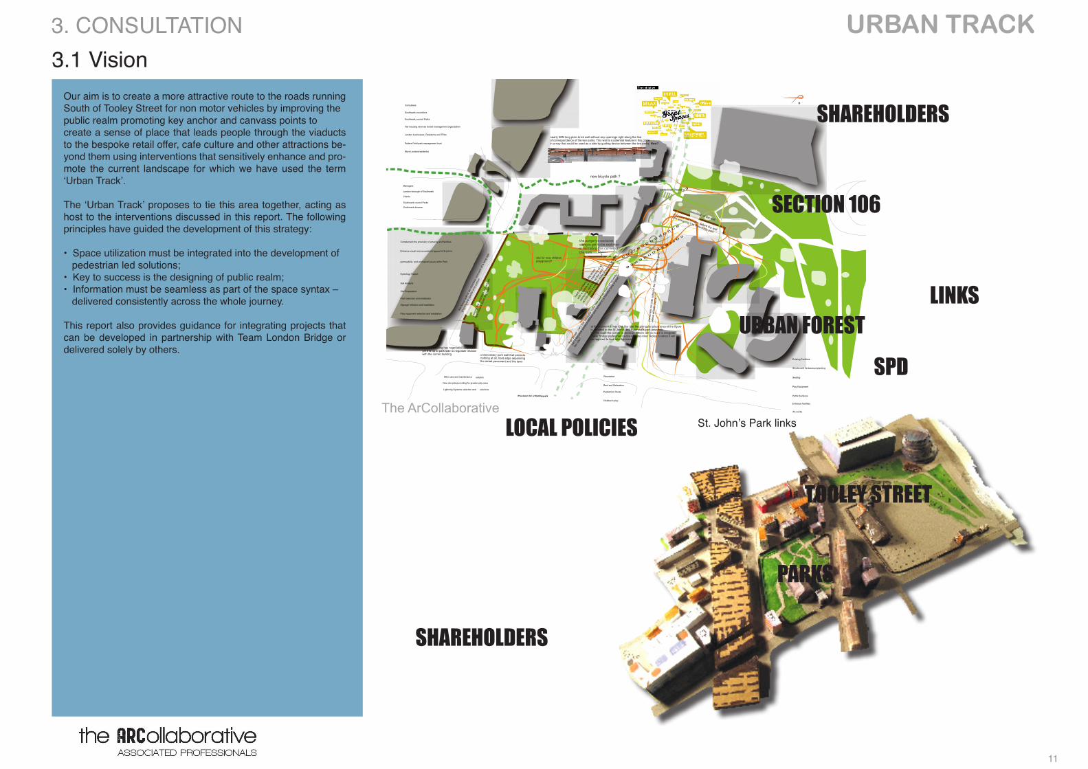
Our aim is to create a more attractive route to the roads running South of Tooley Street for non motor vehicles by improving the public realm promoting key anchor and canvass points to create a sense of place that leads people through the viaducts to the bespoke retail offer, cafe culture and other attractions be-yond them using interventions that sensitively enhance and pro-mote the current landscape for which we have used the term ‘Urban Track’.
The ‘Urban Track’ proposes to tie this area together, acting as host to the interventions discussed in this report. The following principles have guided the development of this strategy:
• Space utilization must be integrated into the development of pedestrian led solutions;• Key to success is the designing of public realm;• Information must be seamless as part of the space syntax – delivered consistently across the whole journey.
This report also provides guidance for integrating projects that can be developed in partnership with Team London Bridge or delivered solely by others.
PARKS
LINKS
URBAN TRACK
12
3.2 Overview
Stakeholder Overview
3. CONSULTATION
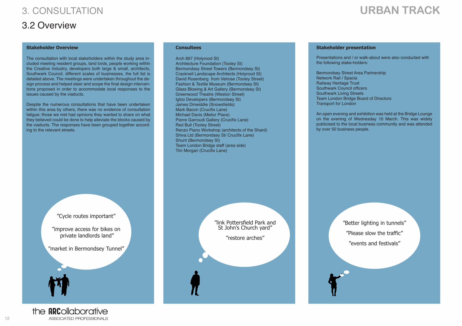
The consultation with local stakeholders within the study area in-cluded meeting resident groups, land lords, people working within the Creative Industry, developers both large & small, architects, Southwark Council, different scales of businesses, the full list is detailed above. The meetings were undertaken throughout the de-sign process and helped steer and scope the final design interven-tions proposed in order to accommodate local responses to the issues caused by the viaducts.
Despite the numerous consultations that have been undertaken within this area by others, there was no evidence of consultation fatigue; those we met had opinions they wanted to share on what they believed could be done to help alleviate the blocks caused by the viaducts. The responses have been grouped together accord-ing to the relevant streets.
”Cycle routes important”
”improve access for bikes on private landlords land”
”market in Bermondsey Tunnel”
Consultees
Arch 897 (Holyrood St)Architecture Foundation (Tooley St)Bermondsey Street Towers (Bermondsey St)Cracknell Landscape Architects (Holyrood St)David Rosenberg from Velrose (Tooley Street)Fashion & Textile Museum (Bermondsey St)Glass Blowing & Art Gallery (Bermondsey St)Greenwood Theatre (Weston Street)Igloo Developers (Bermondsey St)James Dinwiddie (Snowsfields)Mark Bacon (Crucifix Lane)Michael Davis (Melior Place)Pierre Garroudi Gallery (Crucifix Lane)Red Bull (Tooley Street)Renzo Piano Workshop (architects of the Shard) Shiva Ltd (Bermondsey St/ Crucifix Lane)Shunt (Bermondsey St)Team London Bridge staff (area side)Tim Morgan (Crucifix Lane)
”Better lighting in tunnels”
”Please slow the traffic”
”events and festivals”
Stakeholder presentation
Presentations and / or walk-about were also conducted with the following stake-holders:
Bermondsey Street Area PartnershipNetwork Rail / SpaciaRailway Heritage Trust Southwark Council officers Southwark Living StreetsTeam London Bridge Board of DirectorsTransport for London
An open evening and exhibition was held at the Bridge Lounge on the evening of Wednesday 10 March. This was widely publicised to the local business community and was attended by over 50 business people.
”link Pottersfield Park and St John’s Church yard”
”restore arches”
13
URBAN TRACK 4. URBAN STRATEGIES
LINKS LIGHTS
LUNGS LEISURE EVENTS
URBAN TRACK
14
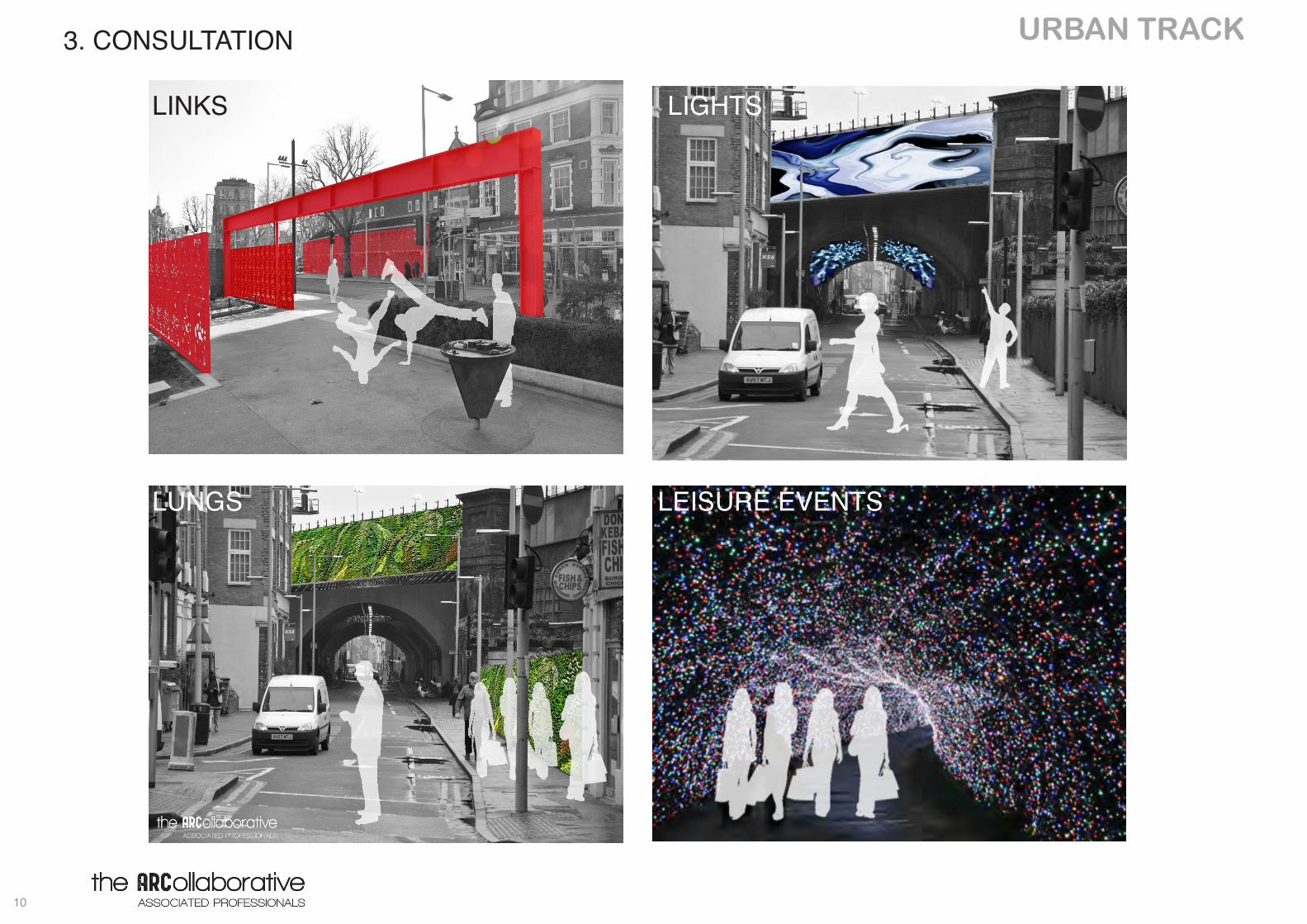
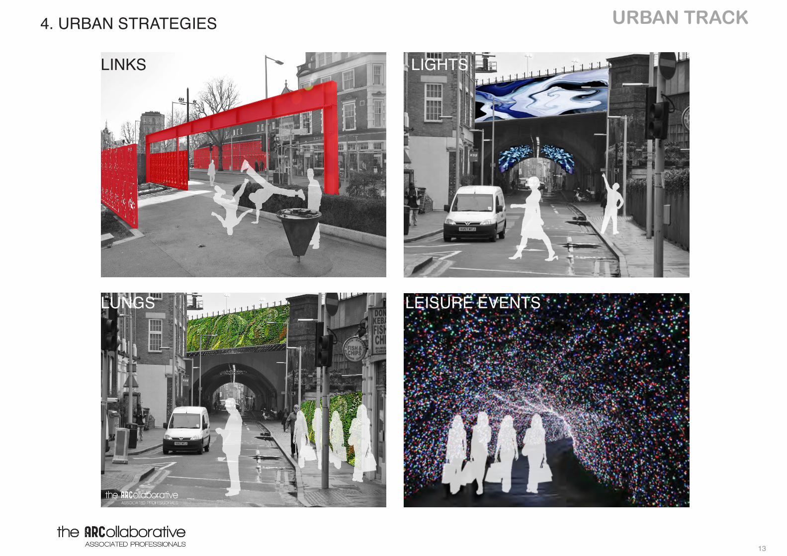
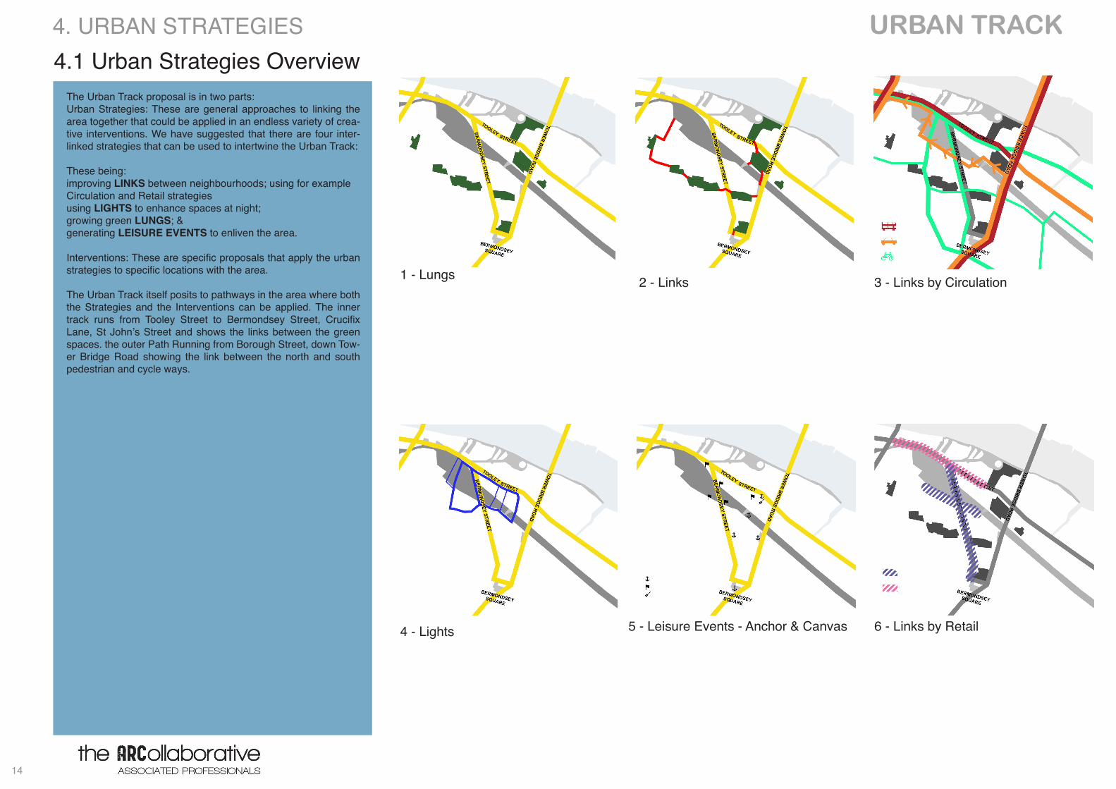
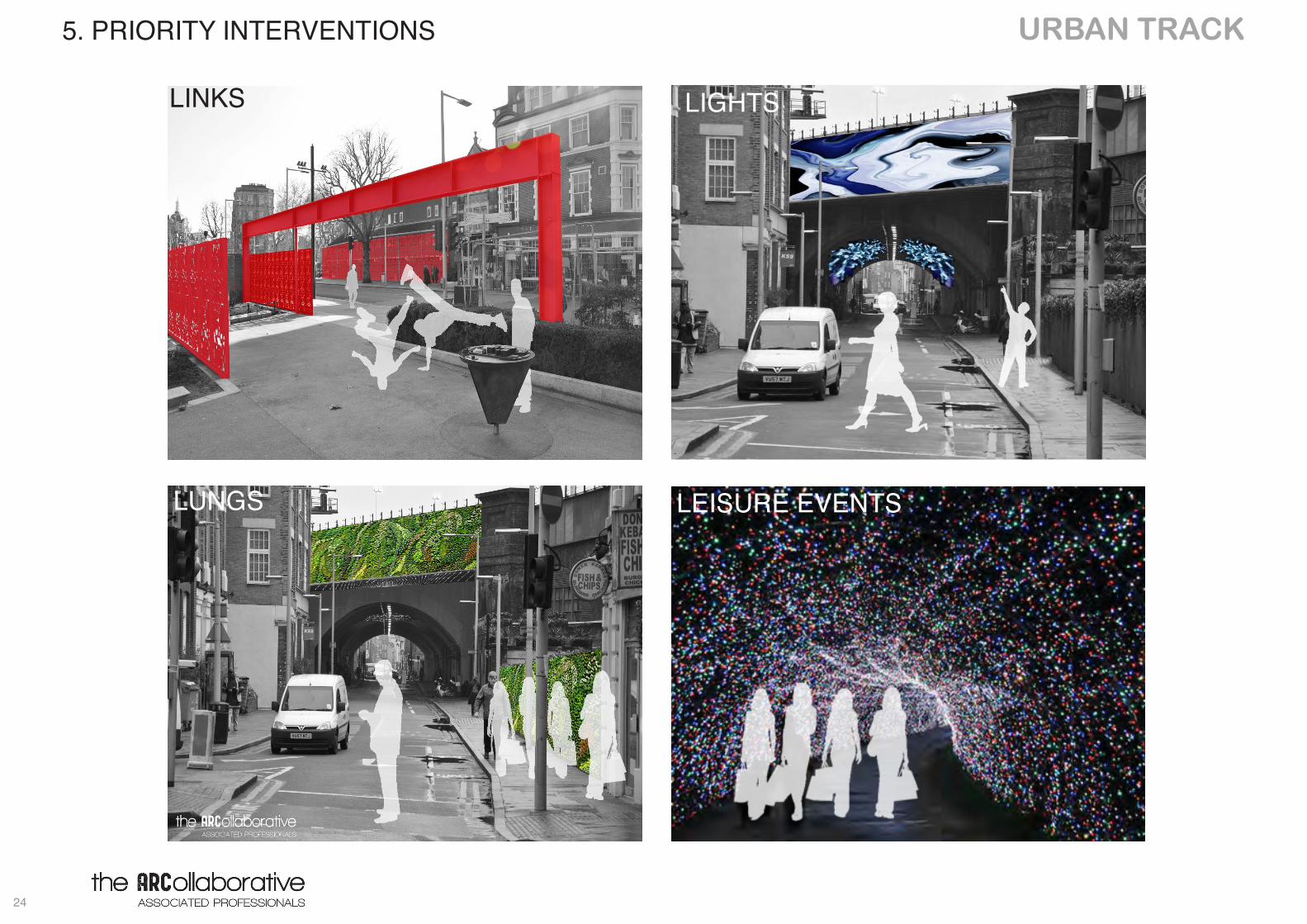
4.1 Urban Strategies OverviewThe Urban Track proposal is in two parts: Urban Strategies: These are general approaches to linking the area together that could be applied in an endless variety of crea-tive interventions. We have suggested that there are four inter-linked strategies that can be used to intertwine the Urban Track:
These being:improving LINKS between neighbourhoods; using for example Circulation and Retail strategiesusing LIGHTS to enhance spaces at night; growing green LUNGS; & generating LEISURE EVENTS to enliven the area.
Interventions: These are specific proposals that apply the urban strategies to specific locations with the area.
The Urban Track itself posits to pathways in the area where both the Strategies and the Interventions can be applied. The inner track runs from Tooley Street to Bermondsey Street, Crucifix Lane, St John’s Street and shows the links between the green spaces. the outer Path Running from Borough Street, down Tow-er Bridge Road showing the link between the north and south pedestrian and cycle ways.
4. URBAN STRATEGIES
3 - Links by Circulation2 - Links1 - Lungs
4 - Lights 5 - Leisure Events - Anchor & Canvas 6 - Links by Retail
15
URBAN TRACK
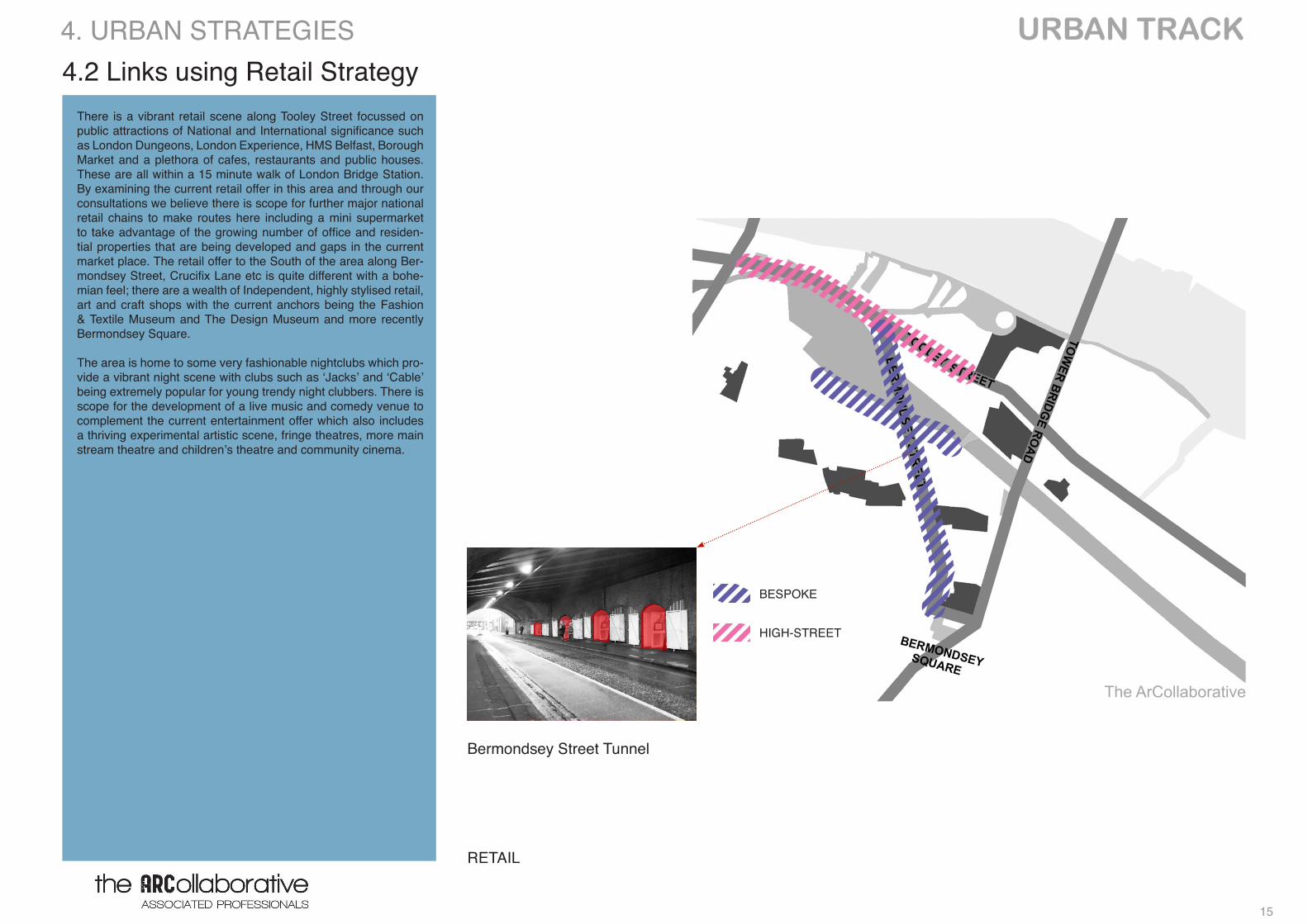
RETAIL
4.2 Links using Retail StrategyThere is a vibrant retail scene along Tooley Street focussed on public attractions of National and International significance such as London Dungeons, London Experience, HMS Belfast, Borough Market and a plethora of cafes, restaurants and public houses. These are all within a 15 minute walk of London Bridge Station. By examining the current retail offer in this area and through our consultations we believe there is scope for further major national retail chains to make routes here including a mini supermarket to take advantage of the growing number of office and residen-tial properties that are being developed and gaps in the current market place. The retail offer to the South of the area along Ber-mondsey Street, Crucifix Lane etc is quite different with a bohe-mian feel; there are a wealth of Independent, highly stylised retail, art and craft shops with the current anchors being the Fashion & Textile Museum and The Design Museum and more recently Bermondsey Square.
The area is home to some very fashionable nightclubs which pro-vide a vibrant night scene with clubs such as ‘Jacks’ and ‘Cable’ being extremely popular for young trendy night clubbers. There is scope for the development of a live music and comedy venue to complement the current entertainment offer which also includes a thriving experimental artistic scene, fringe theatres, more main stream theatre and children’s theatre and community cinema.
BESPOKE
HIGH-STREET
4. URBAN STRATEGIES
Bermondsey Street Tunnel
The ArCollaborative
URBAN TRACK
16
LINKS THROUGH PUBLIC REALM
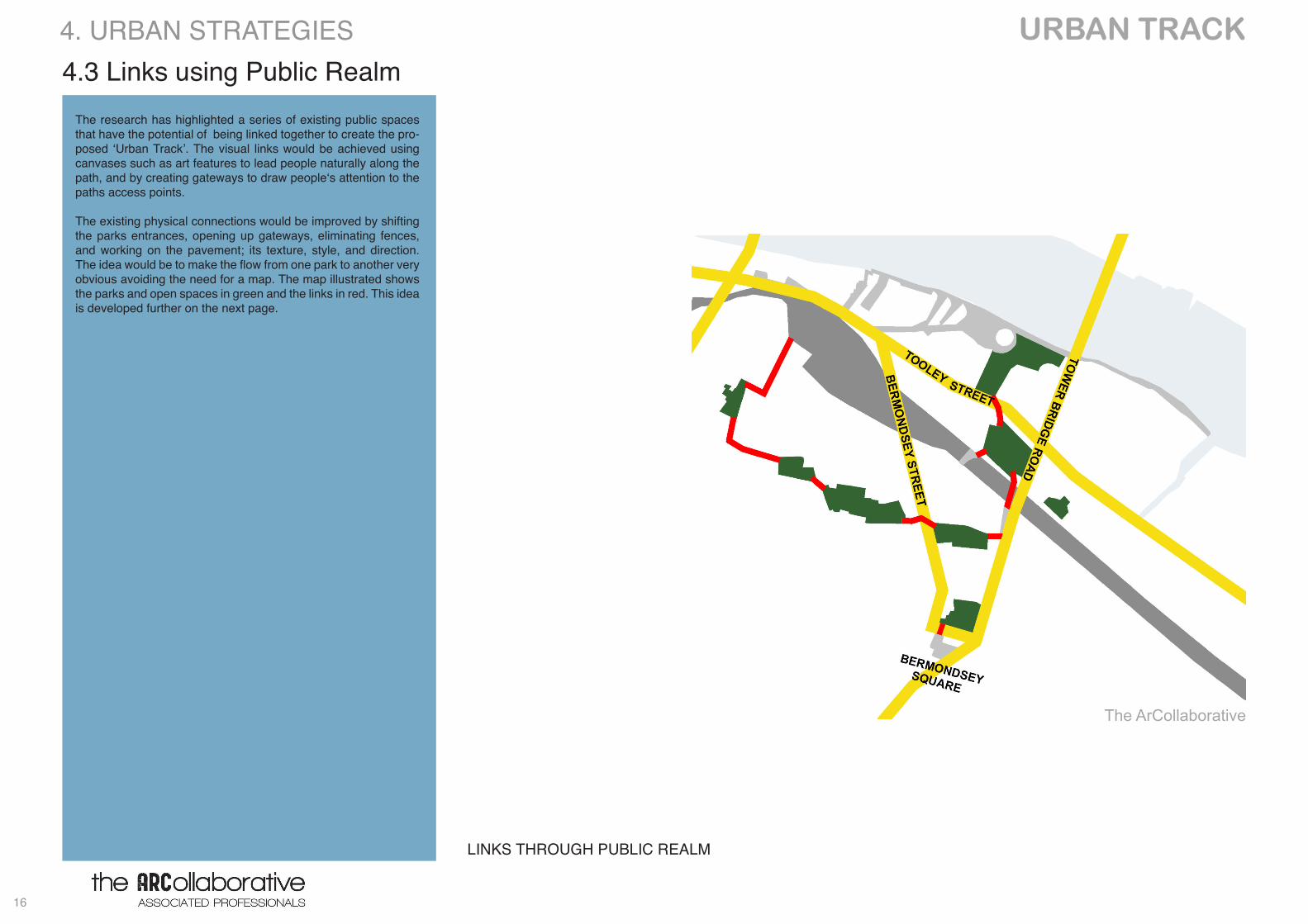
4.3 Links using Public RealmThe research has highlighted a series of existing public spaces that have the potential of being linked together to create the pro-posed ‘Urban Track’. The visual links would be achieved using canvases such as art features to lead people naturally along the path, and by creating gateways to draw people‘s attention to the paths access points.
The existing physical connections would be improved by shifting the parks entrances, opening up gateways, eliminating fences, and working on the pavement; its texture, style, and direction. The idea would be to make the flow from one park to another very obvious avoiding the need for a map. The map illustrated shows the parks and open spaces in green and the links in red. This idea is developed further on the next page.
4. URBAN STRATEGIES
The ArCollaborative
17
URBAN TRACK
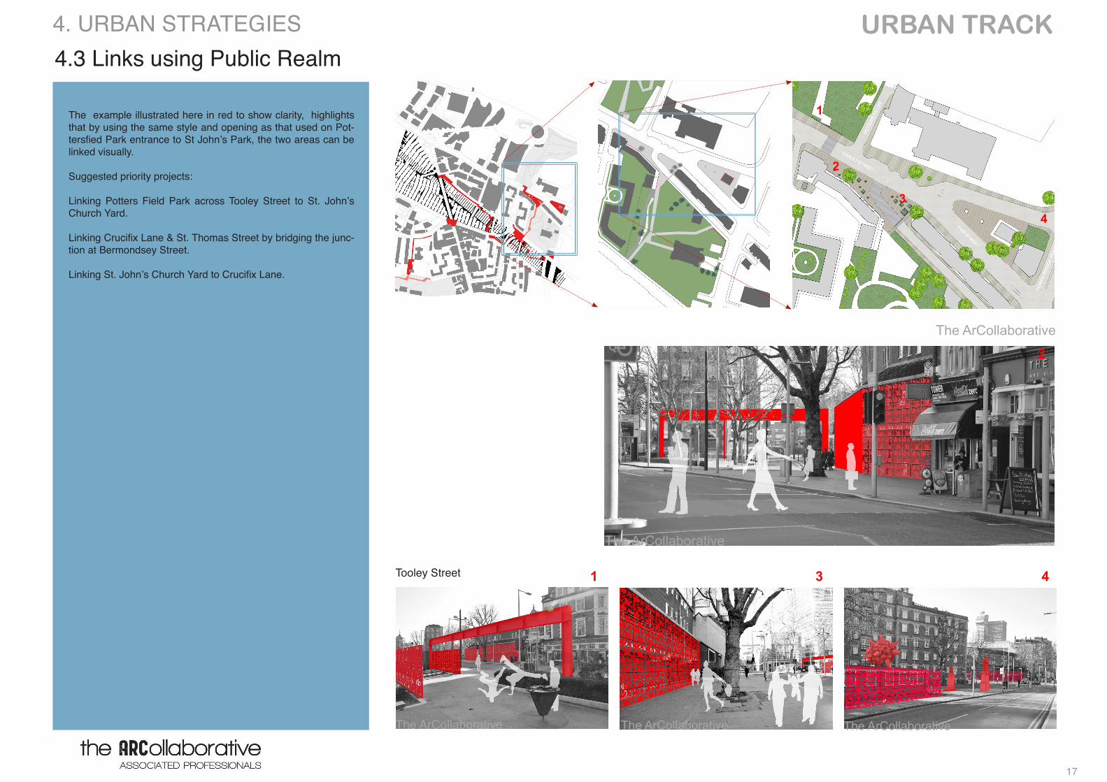
The example illustrated here in red to show clarity, highlights that by using the same style and opening as that used on Pot-tersfied Park entrance to St John’s Park, the two areas can be linked visually.
Suggested priority projects:
Linking Potters Field Park across Tooley Street to St. John’s Church Yard.
Linking Crucifix Lane & St. Thomas Street by bridging the junc-tion at Bermondsey Street.
Linking St. John’s Church Yard to Crucifix Lane.
Tooley Street
4.3 Links using Public Realm4. URBAN STRATEGIES
The ArCollaborative
The ArCollaborative The ArCollaborative The ArCollaborative
The ArCollaborative
1
2
3 4
3
2
1
4
URBAN TRACK
18
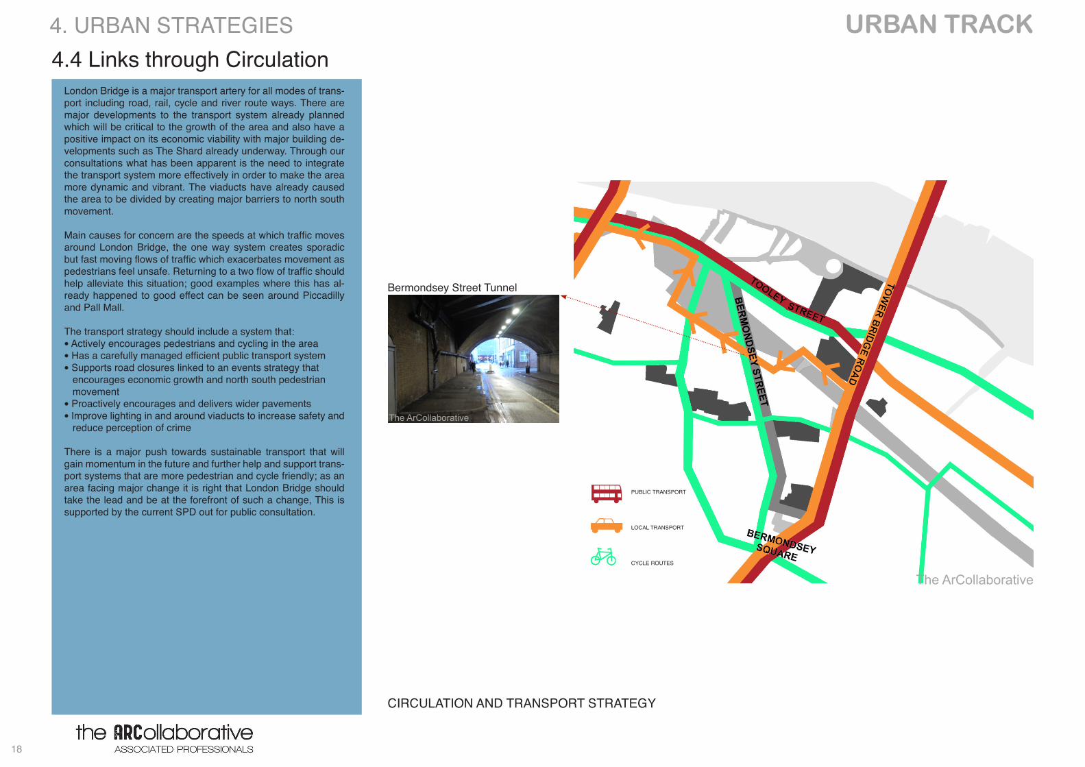
4.4 Links through Circulation
CIRCULATION AND TRANSPORT STRATEGY
London Bridge is a major transport artery for all modes of trans-port including road, rail, cycle and river route ways. There are major developments to the transport system already planned which will be critical to the growth of the area and also have a positive impact on its economic viability with major building de-velopments such as The Shard already underway. Through our consultations what has been apparent is the need to integrate the transport system more effectively in order to make the area more dynamic and vibrant. The viaducts have already caused the area to be divided by creating major barriers to north south movement.
Main causes for concern are the speeds at which traffic moves around London Bridge, the one way system creates sporadic but fast moving flows of traffic which exacerbates movement as pedestrians feel unsafe. Returning to a two flow of traffic should help alleviate this situation; good examples where this has al-ready happened to good effect can be seen around Piccadilly and Pall Mall.
The transport strategy should include a system that: • Actively encourages pedestrians and cycling in the area • Has a carefully managed efficient public transport system • Supports road closures linked to an events strategy that encourages economic growth and north south pedestrian movement• Proactively encourages and delivers wider pavements• Improve lighting in and around viaducts to increase safety and reduce perception of crime
There is a major push towards sustainable transport that will gain momentum in the future and further help and support trans-port systems that are more pedestrian and cycle friendly; as an area facing major change it is right that London Bridge should take the lead and be at the forefront of such a change, This is supported by the current SPD out for public consultation.
PUBLIC TRANSPORT
LOCAL TRANSPORT
CYCLE ROUTES
4. URBAN STRATEGIES
Bermondsey Street Tunnel
The ArCollaborative
The ArCollaborative
19
URBAN TRACK 4.5 Leisure Events - Anchors & Canvases
The consultation flagged up the desire for events promoting the diverse and bohemian nature of the retail outlets on Bermondsey Street and suggested a ‘what’s on’ guide linking the north and south to promote further footfall movement across the area.
Artistic, physical and visual interventions on buildings and in the public realm could act as ‘anchors’ and ‘canvases’ to help draw people through the area and reinforce its character as a creative neighbourhood of gal-leries and artists.
Suggested priority projects:
The Bermondsey Street Partnership would like more events and have suggested hosting:
• a four day Christmas Fayre located under Bermondsey Tunnel to take advantage of the protection it affords from the elements;
• a monthly weekend fair that celebrates the design and fashion in the area linking with the events organised in and around Bermondsey Square.
ANCHORS & CANVASES
ANCHOR and LEGIBLE LONDON
CANVAS
-Canvases (short term/ long term) us-ing art, imaginative lighting and verti-cal gardens, on blank flank walls could create a sense of place that would lead people through the paths.
-Anchors (short term) places that can draw attention, attract people and work as markers to the urban track
4. URBAN STRATEGIES
Tooley Street / Weston Tunnel
Weston Street
Weston Street / Snowfields
The ArCollaborative
The ArCollaborative
The ArCollaborative
The ArCollaborative
Tooley StreetThe ArCollaborative
Crucifix Lane
The ArCollaborative
Crucifix Lane
The ArCollaborative
URBAN TRACK
20
Green Spaces - LUNGS
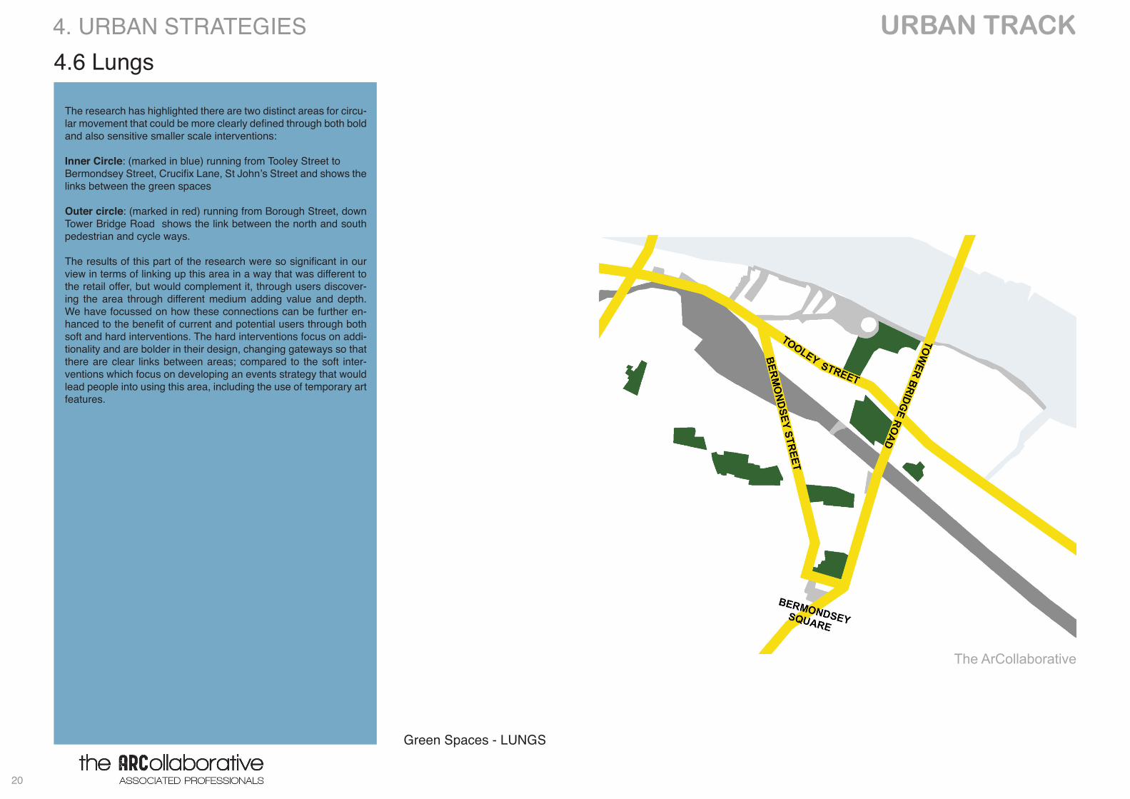
4.6 Lungs
The research has highlighted there are two distinct areas for circu-lar movement that could be more clearly defined through both bold and also sensitive smaller scale interventions:
Inner Circle: (marked in blue) running from Tooley Street to Bermondsey Street, Crucifix Lane, St John’s Street and shows the links between the green spaces
Outer circle: (marked in red) running from Borough Street, down Tower Bridge Road shows the link between the north and south pedestrian and cycle ways.
The results of this part of the research were so significant in our view in terms of linking up this area in a way that was different to the retail offer, but would complement it, through users discover-ing the area through different medium adding value and depth. We have focussed on how these connections can be further en-hanced to the benefit of current and potential users through both soft and hard interventions. The hard interventions focus on addi-tionality and are bolder in their design, changing gateways so that there are clear links between areas; compared to the soft inter-ventions which focus on developing an events strategy that would lead people into using this area, including the use of temporary art features.
4. URBAN STRATEGIES
The ArCollaborative
21
URBAN TRACK
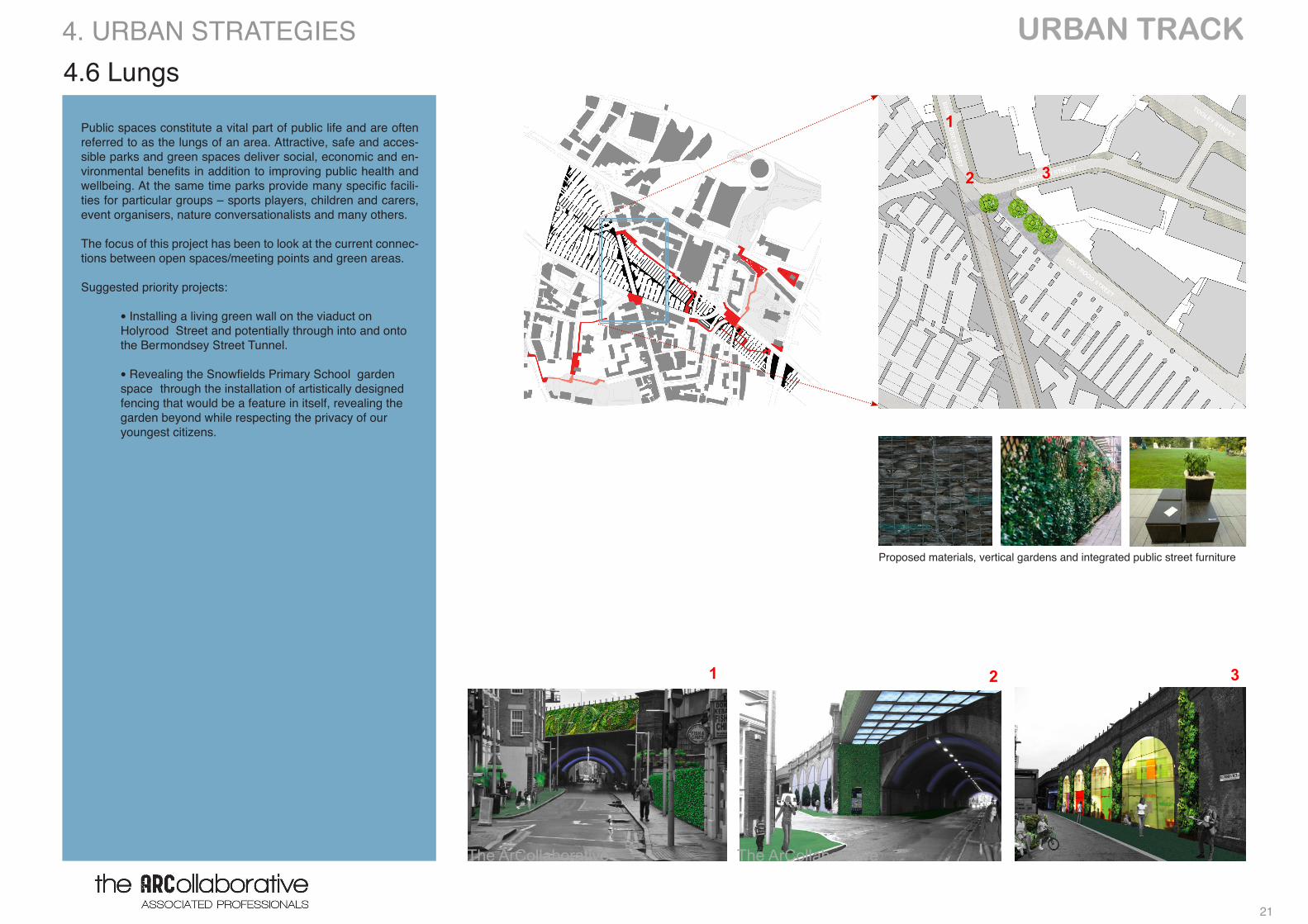
Public spaces constitute a vital part of public life and are often referred to as the lungs of an area. Attractive, safe and acces-sible parks and green spaces deliver social, economic and en-vironmental benefits in addition to improving public health and wellbeing. At the same time parks provide many specific facili-ties for particular groups – sports players, children and carers, event organisers, nature conversationalists and many others.
The focus of this project has been to look at the current connec-tions between open spaces/meeting points and green areas.
Suggested priority projects:
• Installing a living green wall on the viaduct on Holyrood Street and potentially through into and onto the Ber mondsey Street Tunnel.
• Revealing the Snowfields Primary School garden space through the installation of artistically designed fencing that would be a feature in itself, revealing the garden beyond while respecting the privacy of our youngest citizens.
Proposed materials, vertical gardens and integrated public street furniture
4.6 Lungs4. URBAN STRATEGIES
The ArCollaborative The ArCollaborative
1
2
1 2 3
3
URBAN TRACK
22
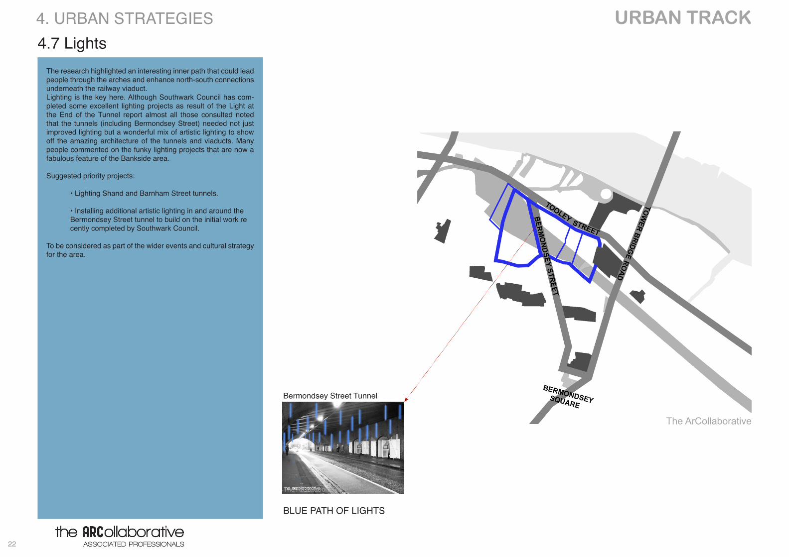
BLUE PATH OF LIGHTS
4.7 Lights
Bermondsey Street Tunnel
4. URBAN STRATEGIES
The research highlighted an interesting inner path that could lead people through the arches and enhance north-south connections underneath the railway viaduct. Lighting is the key here. Although Southwark Council has com-pleted some excellent lighting projects as result of the Light at the End of the Tunnel report almost all those consulted noted that the tunnels (including Bermondsey Street) needed not just improved lighting but a wonderful mix of artistic lighting to show off the amazing architecture of the tunnels and viaducts. Many people commented on the funky lighting projects that are now a fabulous feature of the Bankside area.
Suggested priority projects:
• Lighting Shand and Barnham Street tunnels.
• Installing additional artistic lighting in and around the Bermondsey Street tunnel to build on the initial work re cently completed by Southwark Council.
To be considered as part of the wider events and cultural strategy for the area.
The ArCollaborative
The ArCollaborative
23
URBAN TRACK
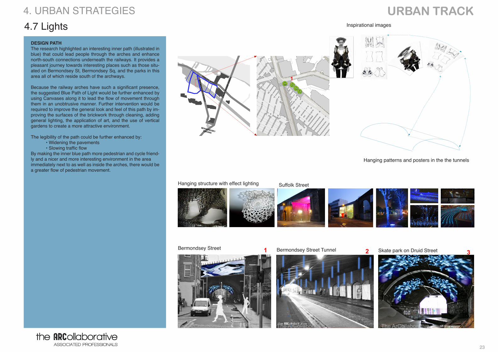
DESIGN PATHThe research highlighted an interesting inner path (illustrated in blue) that could lead people through the arches and enhance north-south connections underneath the railways. It provides a pleasant journey towards interesting places such as those situ-ated on Bermondsey St, Bermondsey Sq, and the parks in this area all of which reside south of the archways.
Because the railway arches have such a significant presence, the suggested Blue Path of Light would be further enhanced by using Canvases along it to lead the flow of movement through them in an unobtrusive manner. Further intervention would be required to improve the general look and feel of this path by im-proving the surfaces of the brickwork through cleaning, adding general lighting, the application of art, and the use of vertical gardens to create a more attractive environment.
The legibility of the path could be further enhanced by: • Widening the pavements • Slowing traffic flow By making the inner blue path more pedestrian and cycle friend-ly and a nicer and more interesting environment in the area immediately next to as well as inside the arches, there would be a greater flow of pedestrian movement.
Skate park on Druid StreetBermondsey Street TunnelBermondsey Street
Inspirational images
Hanging structure with effect lighting Suffolk Street
2
London Bridge Railway Arches Project
The ArCollaborative Kathy Basheva Sofia Bouceddour Luis Caicedo Pier-Luigi Cavedine Julie Greer Matteo Mazzola Sam McCaffrey Adeola Oni Zoran Radivojevic Andrew Siddall
URBAN TRACK The Archways
Indicative map of the area
CONCEPT
PROPOSED ARTWORK & LIGHTING ON TUNNELSEXISTING
‘DESIGN PATH’ MAP
Hanging patterns and posters in the the tunnelsLondon Bridge Railway Arches Project
The ArCollaborative Kathy Basheva Sofia Bouceddour Luis Caicedo Pier-Luigi Cavedine Julie Greer Matteo Mazzola Sam McCaffrey Adeola Oni Zoran Radivojevic Andrew Siddall
URBAN TRACK The Archways
Indicative map of the area
CONCEPT
PROPOSED ARTWORK & LIGHTING ON TUNNELSEXISTING
‘DESIGN PATH’ MAP
4.7 Lights 4. URBAN STRATEGIES
London Bridge Railway Arches Project
The ArCollaborative Kathy Basheva Sofia Bouceddour Luis Caicedo Pier-Luigi Cavedine Julie Greer Matteo Mazzola Sam McCaffrey Adeola Oni Zoran Radivojevic Andrew Siddall
URBAN TRACK The Archways
Indicative map of the area
CONCEPT
PROPOSED ARTWORK & LIGHTING ON TUNNELSEXISTING
‘DESIGN PATH’ MAP
The ArCollaborative The ArCollaborative The ArCollaborative
21 3
1
URBAN TRACK
24
5. PRIORITY INTERVENTIONS
LINKS LIGHTS
LUNGS LEISURE EVENTS
25
URBAN TRACK
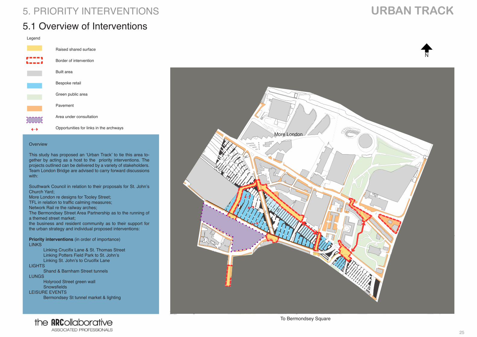
Legend
Raised shared surface
Border of intervention
Built area
Bespoke retail
Green public area
Pavement
Area under consultation
Opportunities for links in the archways
5.1 Overview of Interventions
Overview
This study has proposed an ‘Urban Track’ to tie this area to-gether by acting as a host to the priority interventions. The projects outlined can be delivered by a variety of stakeholders. Team London Bridge are advised to carry forward discussions with:
Southwark Council in relation to their proposals for St. John’s Church Yard;More London re designs for Tooley Street;TFL in relation to traffic calming measures; Network Rail re the railway arches; The Bermondsey Street Area Partnership as to the running of a themed street market; the business and resident community as to their support for the urban strategy and individual proposed interventions:
Priority interventions (in order of importance)LINKS Linking Crucifix Lane & St. Thomas Street Linking Potters Field Park to St. John’s Linking St. John’s to Crucifix LaneLIGHTS Shand & Barnham Street tunnels LUNGS Holyrood Street green wall SnowsfieldsLEISURE EVENTS Bermondsey St tunnel market & lighting
Scale 1:5000To Bermondsey Square
More London
N
5. PRIORITY INTERVENTIONS
URBAN TRACK
26
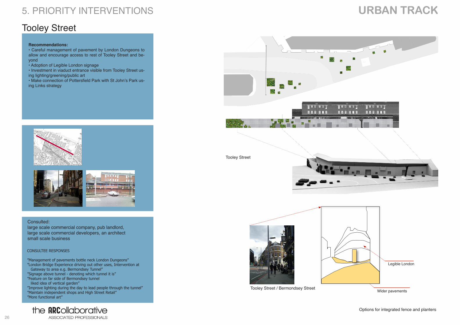
Tooley Street
Options for integrated fence and planters
Recommendations:• Careful management of pavement by London Dungeons to allow and encourage access to rest of Tooley Street and be-yond• Adoption of Legible London signage• Investment in viaduct entrance visible from Tooley Street us-ing lighting/greening/public art• Make connection of Pottersfield Park with St John’s Park us-ing Links strategy
Wider pavements
Legible London
Tooley Street
Tooley Street / Bermondsey Street
Consulted: large scale commercial company, pub landlord, large scale commercial developers, an architectsmall scale business
CONSULTEE RESPONSES
”Management of pavements bottle neck London Dungeons””London Bridge Experience driving out other uses, Intervention at Gateway to area e.g. Bermondsey Tunnel””Signage above tunnel - denoting which tunnel it is””Feature on far side of Bermondsey tunnel liked idea of vertical garden””Improve lighting during the day to lead people through the tunnel””Maintain independent shops and High Street Retail””More functional art”
5. PRIORITY INTERVENTIONS
27
URBAN TRACK
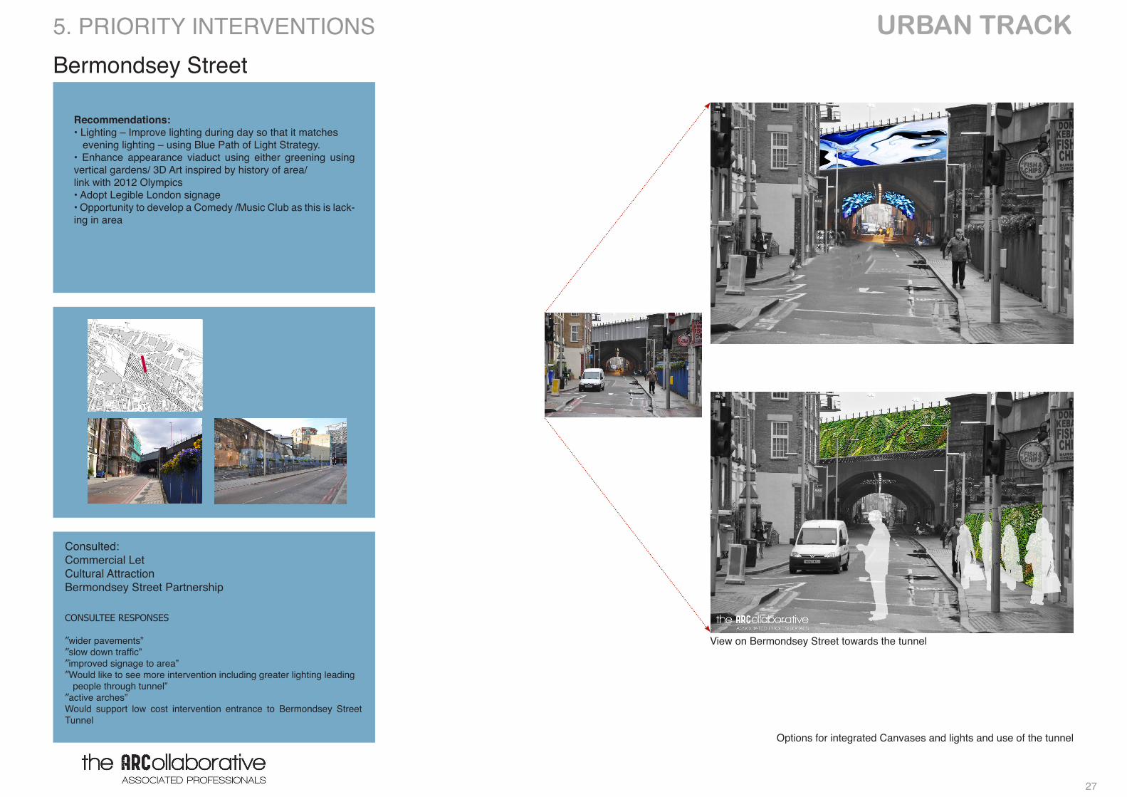
Bermondsey Street
Options for integrated Canvases and lights and use of the tunnel
Recommendations: • Lighting – Improve lighting during day so that it matches evening lighting – using Blue Path of Light Strategy. • Enhance appearance viaduct using either greening using vertical gardens/ 3D Art inspired by history of area/link with 2012 Olympics • Adopt Legible London signage • Opportunity to develop a Comedy /Music Club as this is lack-ing in area
5. PRIORITY INTERVENTIONS
View on Bermondsey Street towards the tunnel
Consulted: Commercial LetCultural Attraction Bermondsey Street Partnership
CONSULTEE RESPONSES
”wider pavements””slow down traffic””improved signage to area””Would like to see more intervention including greater lighting leading people through tunnel””active arches”Would support low cost intervention entrance to Bermondsey Street Tunnel
URBAN TRACK
28
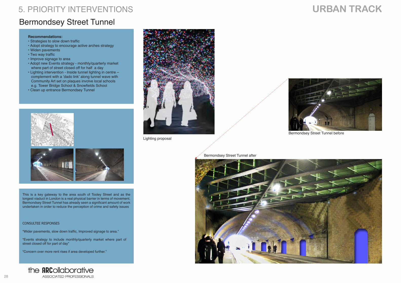
Bermondsey Street TunnelRecommendations:• Strategies to slow down traffic• Adopt strategy to encourage active arches strategy• Widen pavements• Two way traffic• Improve signage to area• Adopt new Events strategy - monthly/quarterly market where part of street closed off for half a day• Lighting intervention - Inside tunnel lighting in centre – complement with a ’dado link’ along tunnel wave with Community Art set on plaques involve local schools e.g. Tower Bridge School & Snowfields School• Clean up entrance Bermondsey Tunnel
Bermondsey Street Tunnel before
Bermondsey Street Tunnel after
Lighting proposal
This is a key gateway to the area south of Tooley Street and as the longest viaduct in London is a real physical barrier in terms of movement. Bermondsey Street Tunnel has already seen a significant amount of work undertaken in order to reduce the perception of crime and safety issues
5. PRIORITY INTERVENTIONS
CONSULTEE RESPONSES
“Wider pavements, slow down traffic, Improved signage to area.”
“Events strategy to include monthly/quarterly market where part of street closed off for part of day”
“Concern over more rent rises if area developed further.”
29
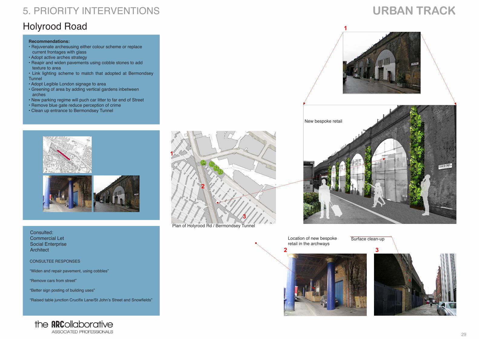
URBAN TRACK Holyrood Road
Location of new bespoke retail in the archways
Surface clean-up
Recommendations:• Rejuvenate archesusing either colour scheme or replace current frontages with glass• Adopt active arches strategy• Reapir and widen pavements using cobble stones to add texture to area• Link lighting scheme to match that adopted at Bermondsey Tunnel• Adopt Legible London signage to area• Greening of area by adding vertical gardens inbetween arches• New parking regime will puch car litter to far end of Street• Remove blue gate reduce perception of crime• Clean up entrance to Bermondsey Tunnel
New bespoke retail
Plan of Holyrood Rd / Bermondsey TunnelConsulted: Commercial Let Social EnterpriseArchitect
5. PRIORITY INTERVENTIONS
CONSULTEE RESPONSES
“Widen and repair pavement, using cobbles” “Remove cars from street” “Better sign posting of building uses”
“Raised table junction Crucifix Lane/St John’s Street and Snowfields”
1
2 3
1
3
2
URBAN TRACK
30
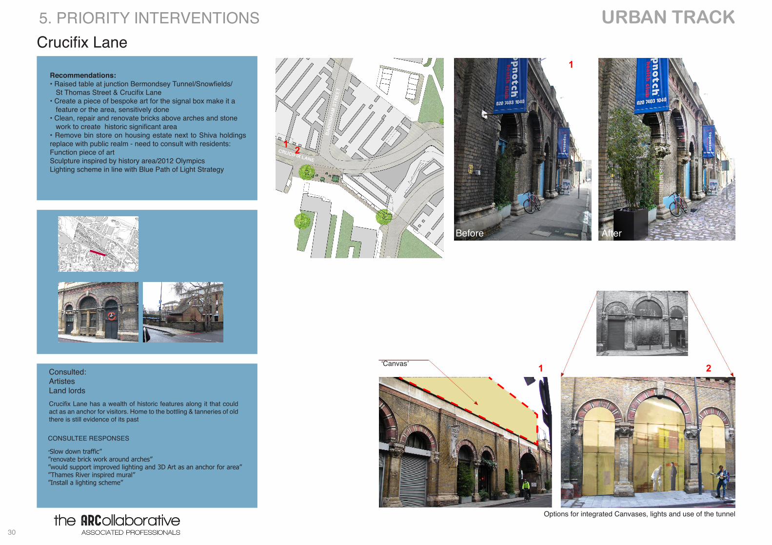
Crucifix Lane
Options for integrated Canvases, lights and use of the tunnel
Recommendations:• Raised table at junction Bermondsey Tunnel/Snowfields/ St Thomas Street & Crucifix Lane• Create a piece of bespoke art for the signal box make it a feature or the area, sensitively done• Clean, repair and renovate bricks above arches and stone work to create historic significant area • Remove bin store on housing estate next to Shiva holdings replace with public realm - need to consult with residents: Function piece of art Sculpture inspired by history area/2012 Olympics Lighting scheme in line with Blue Path of Light Strategy
Before After
‘Canvas’
5. PRIORITY INTERVENTIONS
2
2
1
1
Crucifix Lane has a wealth of historic features along it that could act as an anchor for visitors. Home to the bottling & tanneries of old there is still evidence of its past
1
CONSULTEE RESPONSES
”Slow down traffic””renovate brick work around arches””would support improved lighting and 3D Art as an anchor for area” ”Thames River inspired mural””Install a lighting scheme”
Consulted: Artistes Land lords
31
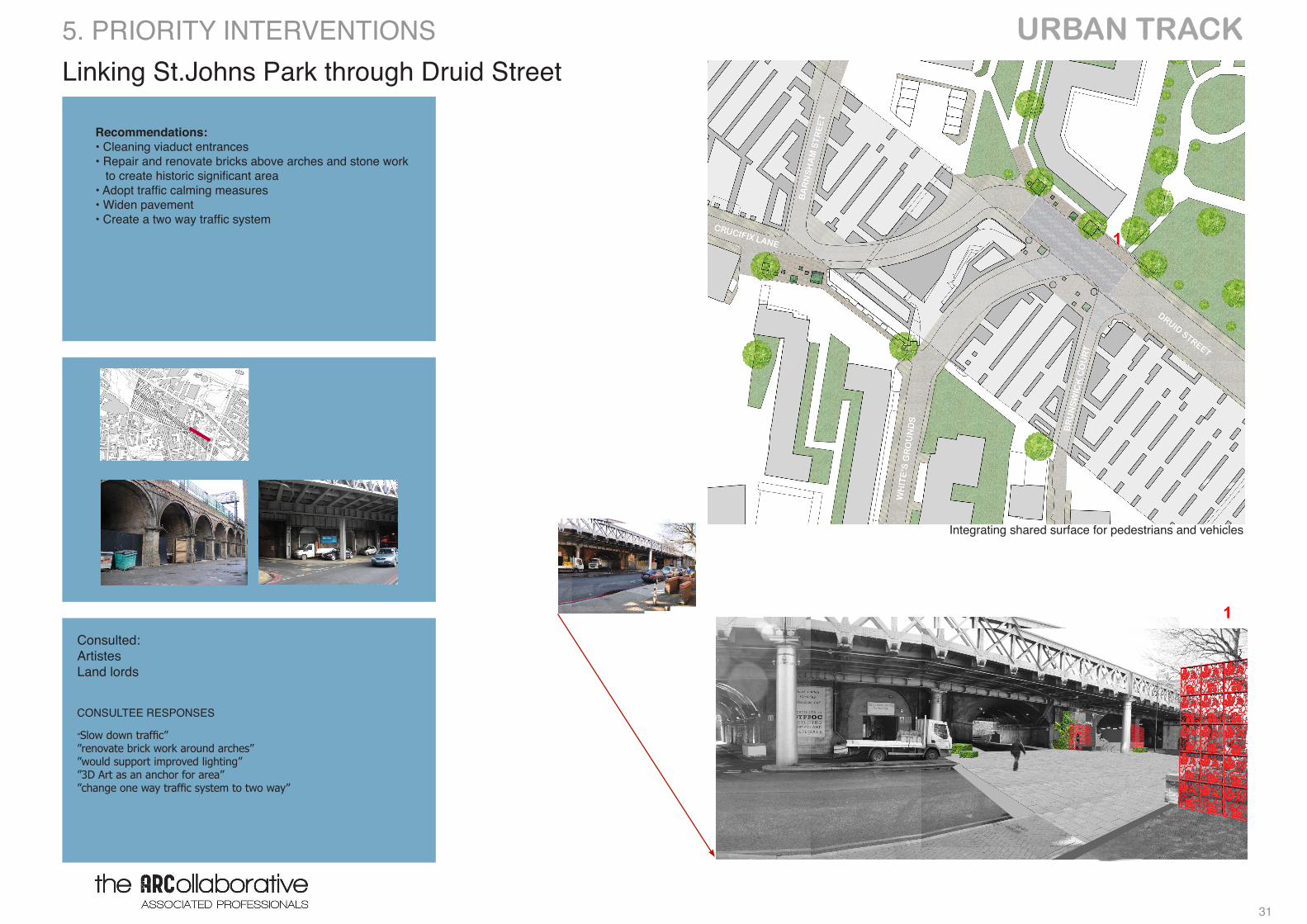
URBAN TRACK Linking St.Johns Park through Druid Street
Integrating shared surface for pedestrians and vehicles
Recommendations:• Cleaning viaduct entrances • Repair and renovate bricks above arches and stone work to create historic significant area • Adopt traffic calming measures• Widen pavement• Create a two way traffic system
5. PRIORITY INTERVENTIONS
1
1Consulted: ArtistesLand lords
CONSULTEE RESPONSES
”Slow down traffic””renovate brick work around arches””would support improved lighting””3D Art as an anchor for area” ”change one way traffic system to two way”
URBAN TRACK
32
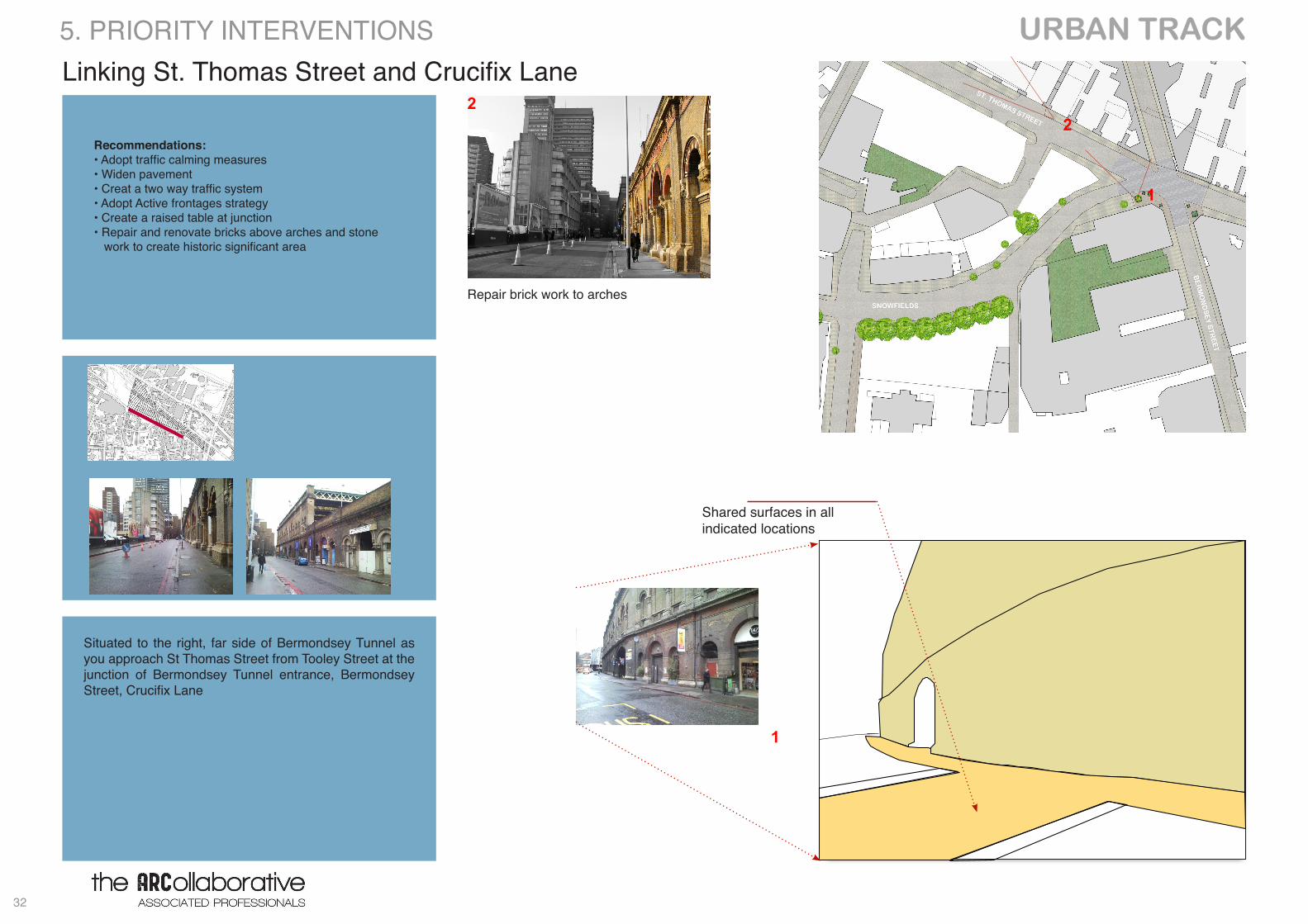
Linking St. Thomas Street and Crucifix Lane
Recommendations:• Adopt traffic calming measures• Widen pavement• Creat a two way traffic system• Adopt Active frontages strategy• Create a raised table at junction • Repair and renovate bricks above arches and stone work to create historic significant area
5. PRIORITY INTERVENTIONS
Shared surfaces in all indicated locations
1
1
22
Repair brick work to arches
Situated to the right, far side of Bermondsey Tunnel as you approach St Thomas Street from Tooley Street at the junction of Bermondsey Tunnel entrance, Bermondsey Street, Crucifix Lane
33
URBAN TRACK Snowfields Road
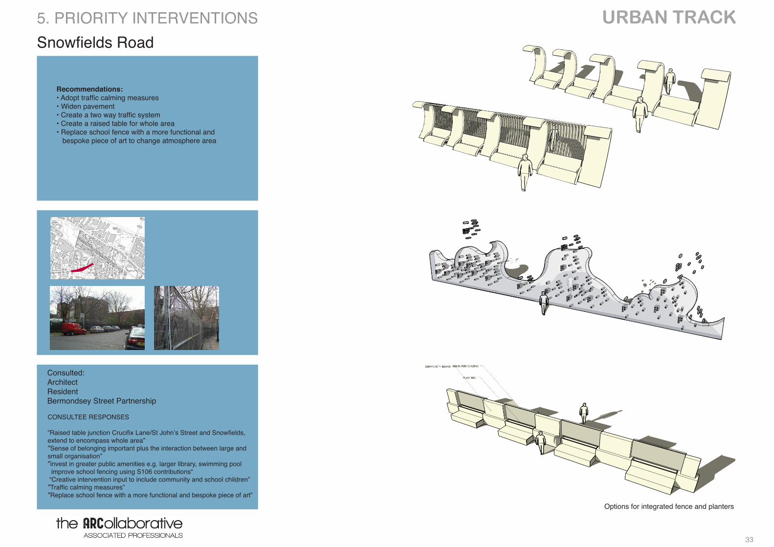
Options for integrated fence and planters
Recommendations:• Adopt traffic calming measures• Widen pavement• Create a two way traffic system• Create a raised table for whole area • Replace school fence with a more functional and bespoke piece of art to change atmosphere area
5. PRIORITY INTERVENTIONS
Consulted: Architect Resident Bermondsey Street Partnership
CONSULTEE RESPONSES
”Raised table junction Crucifix Lane/St John’s Street and Snowfields, extend to encompass whole area””Sense of belonging important plus the interaction between large and small organisation””invest in greater public amenities e.g. larger library, swimming pool improve school fencing using S106 contributions“ “Creative intervention input to include community and school children””Traffic calming measures””Replace school fence with a more functional and bespoke piece of art”
URBAN TRACK
34
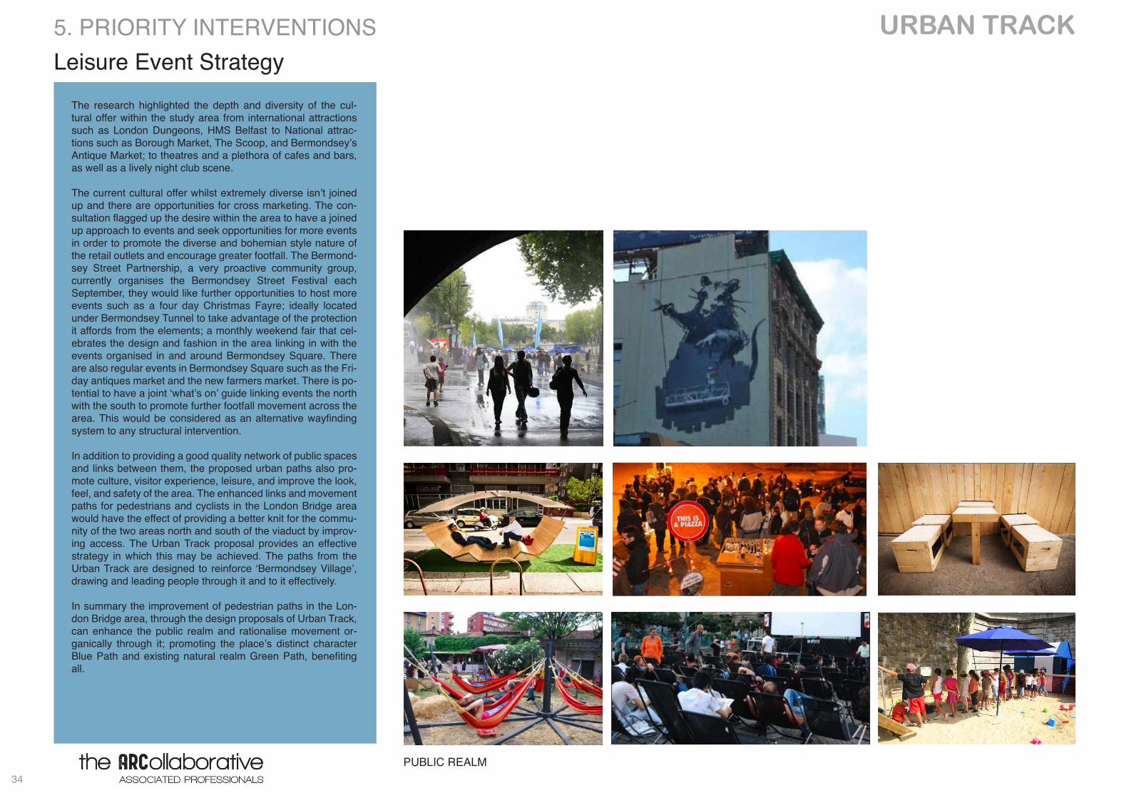
Leisure Event Strategy5. PRIORITY INTERVENTIONS
PUBLIC REALM
The research highlighted the depth and diversity of the cul-tural offer within the study area from international attractions such as London Dungeons, HMS Belfast to National attrac-tions such as Borough Market, The Scoop, and Bermondsey’s Antique Market; to theatres and a plethora of cafes and bars, as well as a lively night club scene.
The current cultural offer whilst extremely diverse isn’t joined up and there are opportunities for cross marketing. The con-sultation flagged up the desire within the area to have a joined up approach to events and seek opportunities for more events in order to promote the diverse and bohemian style nature of the retail outlets and encourage greater footfall. The Bermond-sey Street Partnership, a very proactive community group, currently organises the Bermondsey Street Festival each September, they would like further opportunities to host more events such as a four day Christmas Fayre; ideally located under Bermondsey Tunnel to take advantage of the protection it affords from the elements; a monthly weekend fair that cel-ebrates the design and fashion in the area linking in with the events organised in and around Bermondsey Square. There are also regular events in Bermondsey Square such as the Fri-day antiques market and the new farmers market. There is po-tential to have a joint ‘what’s on’ guide linking events the north with the south to promote further footfall movement across the area. This would be considered as an alternative wayfinding system to any structural intervention.
In addition to providing a good quality network of public spaces and links between them, the proposed urban paths also pro-mote culture, visitor experience, leisure, and improve the look, feel, and safety of the area. The enhanced links and movement paths for pedestrians and cyclists in the London Bridge area would have the effect of providing a better knit for the commu-nity of the two areas north and south of the viaduct by improv-ing access. The Urban Track proposal provides an effective strategy in which this may be achieved. The paths from the Urban Track are designed to reinforce ‘Bermondsey Village’, drawing and leading people through it and to it effectively.
In summary the improvement of pedestrian paths in the Lon-don Bridge area, through the design proposals of Urban Track, can enhance the public realm and rationalise movement or-ganically through it; promoting the place’s distinct character Blue Path and existing natural realm Green Path, benefiting all.
35
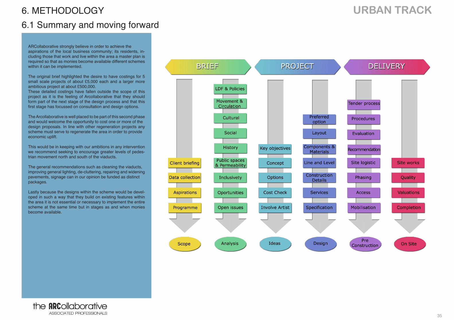
URBAN TRACK
ARCollaborative strongly believe in order to achieve the aspirations of the local business community; its residents, in-cluding those that work and live within the area a master plan is required so that as monies become available different schemes within it can be implemented.
The original brief highlighted the desire to have costings for 5 small scale projects of about £5,000 each and a larger more ambitious project at about £500,000. These detailed costings have fallen outside the scope of this project as it is the feeling of Arcollaborative that they should form part of the next stage of the design process and that this first stage has focussed on consultation and design options.
The Arcollaborative is well placed to be part of this second phase and would welcome the opportunity to cost one or more of the design proposals. In line with other regeneration projects any scheme must serve to regenerate the area in order to provide economic uplift.
This would be in keeping with our ambitions in any intervention we recommend seeking to encourage greater levels of pedes-trian movement north and south of the viaducts. The general recommendations such as cleaning the viaducts, improving general lighting, de-cluttering, repairing and widening pavements, signage can in our opinion be funded as distinct packages.
Lastly because the designs within the scheme would be devel-oped in such a way that they build on existing features within the area it is not essential or necessary to implement the entire scheme at the same time but in stages as and when monies become available.
6. METHODOLOGY 6.1 Summary and moving forward
URBAN TRACK
36
6. METHODOLOGY
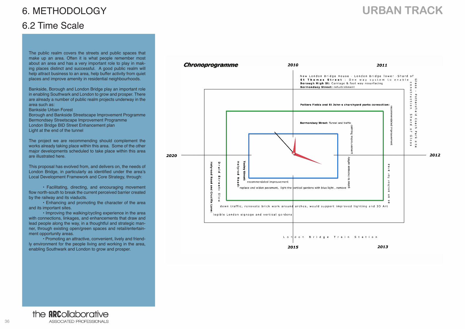
The public realm covers the streets and public spaces that make up an area. Often it is what people remember most about an area and has a very important role to play in mak-ing places distinct and successful. A good public realm will help attract business to an area, help buffer activity from quiet places and improve amenity in residential neighbourhoods.
Bankside, Borough and London Bridge play an important role in enabling Southwark and London to grow and prosper. There are already a number of public realm projects underway in the area such as: Bankside Urban Forest Borough and Bankside Streetscape Improvement ProgrammeBermondsey Streetscape Improvement Programme London Bridge BID Street Enhancement planLight at the end of the tunnel
The project we are recommending should complement the works already taking place within this area. Some of the other major developments scheduled to take place within this area are illustrated here.
This proposal has evolved from, and delivers on, the needs of London Bridge, in particularly as identified under the area’s Local Development Framework and Core Strategy, through:
• Facilitating, directing, and encouraging movement flow north-south to break the current perceived barrier created by the railway and its viaducts. • Enhancing and promoting the character of the area and its important sites. • Improving the walking/cycling experience in the area with connections, linkages, and enhancements that draw and lead people along the way, in a thoughtful and strategic man-ner, through existing open/green spaces and retail/entertain-ment opportunity areas. • Promoting an attractive, convenient, lively and friend-ly environment for the people living and working in the area, enabling Southwark and London to grow and prosper.
6.2 Time Scale
37
URBAN TRACK
This project has been developed by a number of professionals who have come together from a diverse cultural and profes-sional experience background through Westminster Univer-sity’s Build Up Programme. This breadth and depth of ex-perience within the group has resulted in a creative, vibrant project that encompasses the group’s professional acumen, knowledge and experience working within the built up environ-ment and regeneration issues.
Thanks toTeam London BridgeRailway Heritage Trust Construction Support Group Red Bull,More LondonSpacia/Network RailArchitecture FoundationIgloo DevelopersCracknell Landscape ArchitectsSouthwark Council Officers including Heads of Public Realm and PlanningThe ShardGreenwood TheatreArch 897James DinwiddieMark BaconPierre Garroudi GalleryShiva LtdSouthwark Living StreetsTim MorganShuntBermondsey Street Area PartnershipMichael DavisDavid RosenbergGlass Blowing & Art GalleryFashion & Textile MuseumBermondsey Street Towers
7. ACKNOWLEDGEMENTS
LUIS M.CAICEDO SARDI – Researcher – Develop-ment Policy & Strategy Role: With Julie Greer, Luis developed the team’s response to the current planning policies for London Bridge, advising on the area’s Local Development Framework (LDF), Core Strategy, and Supplemen-tary Planning Document (SPDs). Experience and Qualifications: ICIOB, LEED AP, MSc Bldg Constr, BDes in Arch, Mnr BA. Luis brings eight years work experience in project management roles with reputable firms in the UK and abroad, in-cluding Bovis Lend Lease and Canary Wharf Group, exercising due diligence and delivering on projects from design to turnover. Luis is also project develop-er for the Eco-Health Pavilions proposal in London.
KATHY BASHEVA - Project Co-ordinator and archi-tectural consultant and designer – Design BriefRole: Kathy has led on the creative designs for the project, co-ordinating and developing the final project and supporting the consultation process.Experience and Qualifications: Masters Degree in Sustainable Architecture, B.Arch. from Tel-Aviv uni-versity.Kathy brings 15 years of international experience in architecture,a third of which has been in the field of green construction in UK. Kathy has led a multi-mil-lion pound private residential development and took part of the refurbishment of the East London Line. Kathy has experience in variety of projects, among others including a public buildings, master plans and urban regeneration proposals, residnetial and com-mercial schemese in Israel, China, Germany and the US.
ANDREW SIDDALL - Part II Architectural AssistantRole: Andrew contributed to the Movement & Circu-lation analysis; coordinated and produced the site analysis document and early presentation graphics; and was involved in the design process and the crea-tion of orthographic and rendered graphics. Experience and Qualifications: Master of Architec-ture (M. Arch) from the University of Calgary. An-drew’s UK work experience includes projects of varying scales from large-scale mixed use schemes to small interior projects, all located within greater London. In Canada, he worked on several propos-als for University and Government institutions and was involved though all of the stages of the building process for an office building.
SAM MCCAFFREY – Project Coordinator – Busi-ness ConsultationsRole: Sam has led the business consultations, scop-ing and delivering the report and been the main con-tact for businesses and Team London Bridge. Experience and Qualifications: MBA, MA Leisure & Tourism, BSc HONs Geography. Sam has a wealth of knowledge in respect of the Creative Industries having worked within Entertainment, Event and Theatre Management for over eighteen years in lo-cal authority, not for profit, student union and com-mercial settings. Sam also has experience of writing tenders, project instigation and management, along with fundraising experience. Sam brings compe-tence in ‘Place Making’ acquired through the HCA which supports regeneration and the development of sustainable communities.
MATTEO MAZZOLA - Architect - Project designerRole: Matteo has brought his contribution on several aspects of the project, leading on the Movement and Circulation analysis, on the TFL consultation and working on the design and graphics.Experience and Qualifications: MSc Arch – ARB - OAPPC MI. Matteo has gained a solid all round experience in over 11 years of work both in UK and in Italy in variety of projects and sectors. He has a keen interest in Sustainable Architecture and has completed a two years course held by ANAB Milano.
PIERLUIGI CAVEDINE – Architect ARB, Role: Project DesignerExperience and Qualification: Masters Degree in Ar-chitecture.PierLuigi worked in Italy in residential and urban projects and competitions, gained experience as tutor at Venice University of Architecture IUAV, and have been recently invoved in international projects.
ZORAN RADIVOJEVIC – Project DesignerRole: Ideas, planning and design team member Experience and Qualifications: BSc (HONs) Dip Arch RIBA II worked in several London based practices.
With kind thanks to Yen Nguyen, Sofia Bouceddour and Adeola Oni
JULIE A GREER - Researcher – Wayfinding, Conser-vation & Listed Building Policy,Role: With Luis Caicedo Sardi, Julie researched the integration of emerging major developments and the assessment of Southwark Policy, in particular the Supplementary Planning Policy and Conservation policy.Experience and Qualifications: DipTP, AA (Build’g Cons) RTPI, IHBC, Julie brings 20 years of experi-ence in town planning and urban design as principal design advisor to the Olympic Delivery Authority; Head of Design at Southwark Council and Senior Officer at Westminster Council. She led on major regeneration developments such as the Olympic Vil-lage, Olympic Park Wayfinding Strategy, the Shard, Bankside and Tate Modern. Julie is Director of Greer Pritchard, a design-led town planning consultancy.
RESEARCH AND SUPPORT
RESE
ARCH
AN
D D
ESIG
N
CON
SULT
ATIO
N A
ND
DES
IGN
URBAN TRACK
38
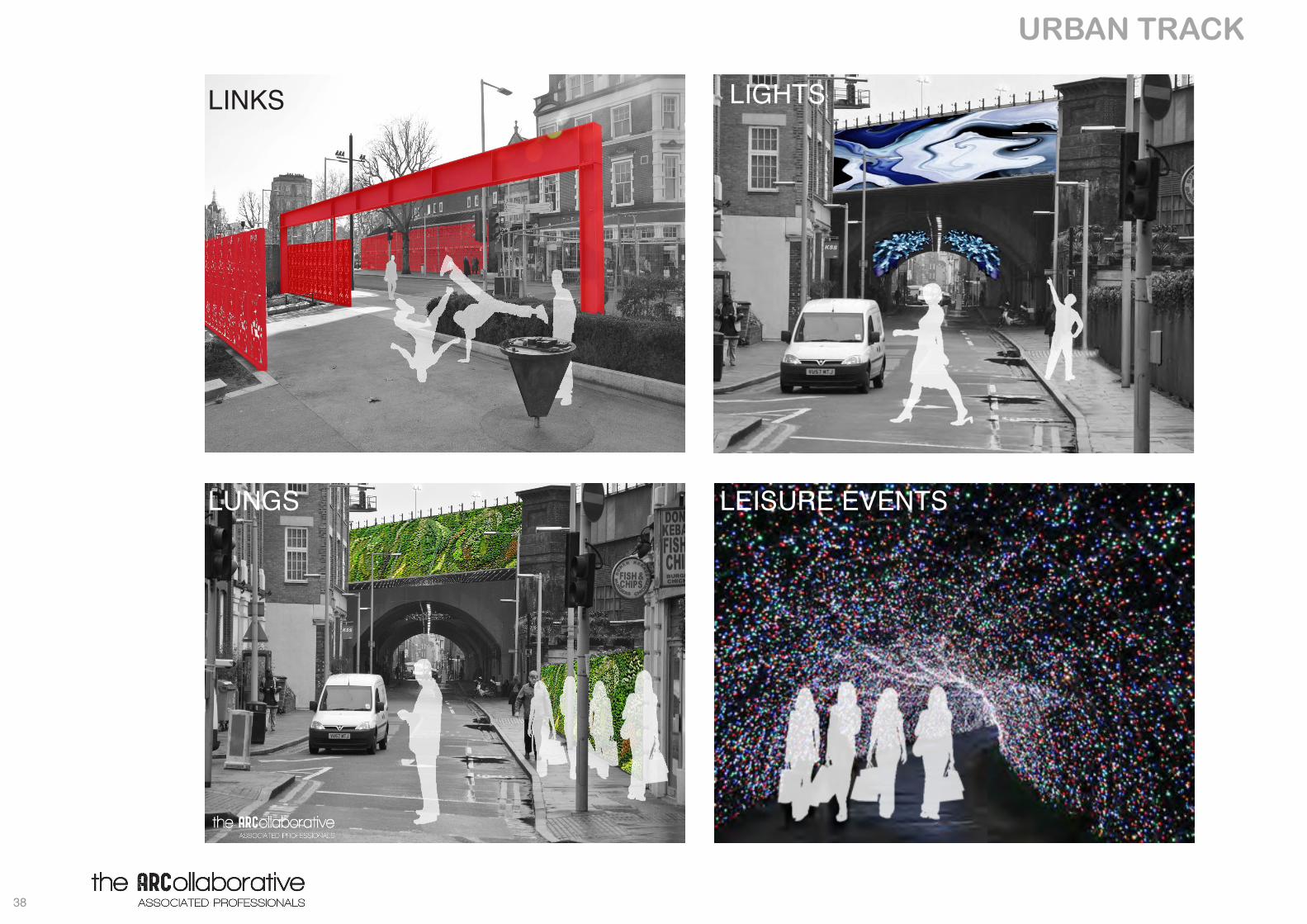
EVENTS
LINKS LIGHTS
LUNGS LEISURE EVENTS