Embed Size (px)
Citation preview
GETTING STARTED Your RO will give you the grid reference of your 1-km BBS square and will provide forms and instructions. The Field Recording Sheets and Habitat Recording Form are for taking notes in the field, to be submitted via the BBS-Online recording system. The Count Summary and Mammal Summary forms, if sent, are to be used if you submit data on paper.
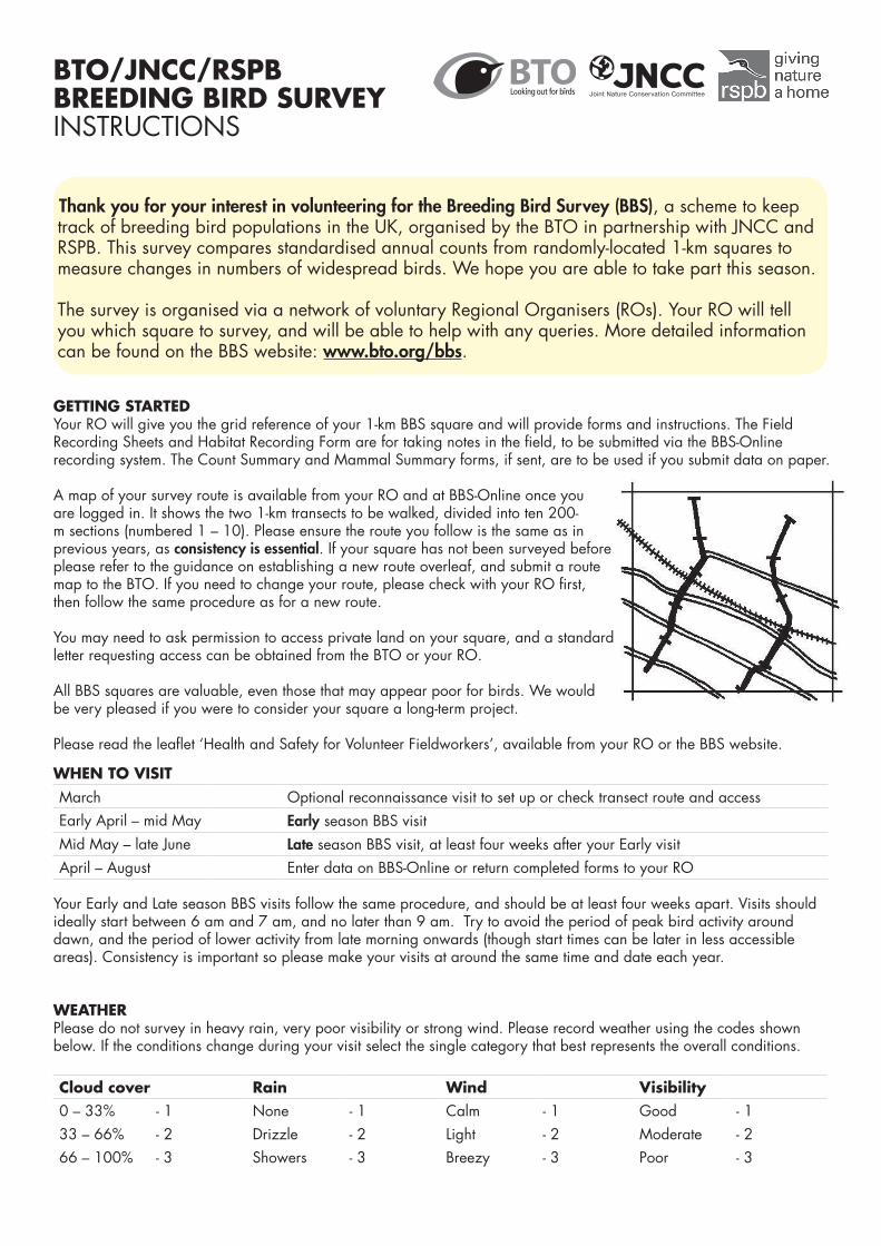
A map of your survey route is available from your RO and at BBS-Online once you are logged in. It shows the two 1-km transects to be walked, divided into ten 200-m sections (numbered 1 – 10). Please ensure the route you follow is the same as in previous years, as consistency is essential. If your square has not been surveyed before please refer to the guidance on establishing a new route overleaf, and submit a route map to the BTO. If you need to change your route, please check with your RO first, then follow the same procedure as for a new route.
You may need to ask permission to access private land on your square, and a standard letter requesting access can be obtained from the BTO or your RO.
All BBS squares are valuable, even those that may appear poor for birds. We would be very pleased if you were to consider your square a long-term project.
Please read the leaflet ‘Health and Safety for Volunteer Fieldworkers’, available from your RO or the BBS website.
Thank you for your interest in volunteering for the Breeding Bird Survey (BBS), a scheme to keep track of breeding bird populations in the UK, organised by the BTO in partnership with JNCC and RSPB. This survey compares standardised annual counts from randomly-located 1-km squares to measure changes in numbers of widespread birds. We hope you are able to take part this season.
The survey is organised via a network of voluntary Regional Organisers (ROs). Your RO will tell you which square to survey, and will be able to help with any queries. More detailed information can be found on the BBS website: www.bto.org/bbs.
WHEN TO VISITMarch Optional reconnaissance visit to set up or check transect route and accessEarly April – mid May Early season BBS visitMid May – late June Late season BBS visit, at least four weeks after your Early visitApril – August Enter data on BBS-Online or return completed forms to your RO
Your Early and Late season BBS visits follow the same procedure, and should be at least four weeks apart. Visits should ideally start between 6 am and 7 am, and no later than 9 am. Try to avoid the period of peak bird activity around dawn, and the period of lower activity from late morning onwards (though start times can be later in less accessible areas). Consistency is important so please make your visits at around the same time and date each year.
WEATHERPlease do not survey in heavy rain, very poor visibility or strong wind. Please record weather using the codes shown below. If the conditions change during your visit select the single category that best represents the overall conditions.
Cloud cover Rain Wind Visibility0 – 33% - 1 None - 1 Calm - 1 Good - 133 – 66% - 2 Drizzle - 2 Light - 2 Moderate - 266 – 100% - 3 Showers - 3 Breezy - 3 Poor - 3
BTO/JNCC/RSPB BREEDING BIRD SURVEYINSTRUCTIONS
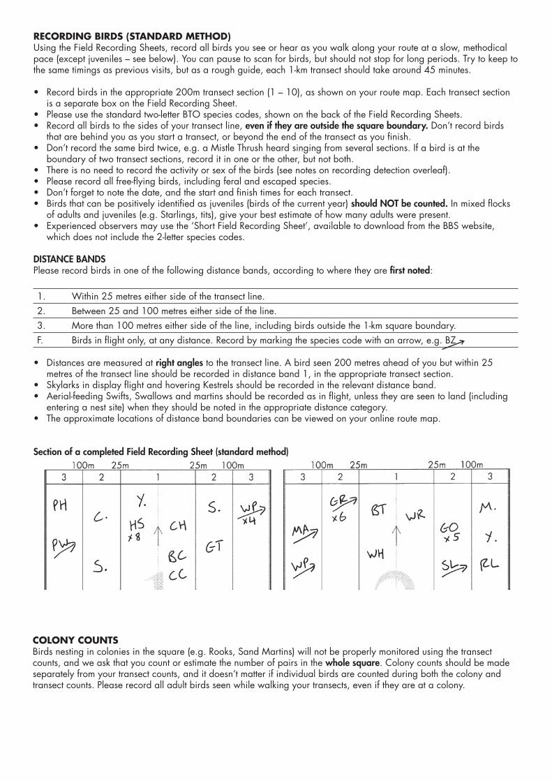
RECORDING BIRDS (STANDARD METHOD)Using the Field Recording Sheets, record all birds you see or hear as you walk along your route at a slow, methodical pace (except juveniles – see below). You can pause to scan for birds, but should not stop for long periods. Try to keep to the same timings as previous visits, but as a rough guide, each 1-km transect should take around 45 minutes.
• Record birds in the appropriate 200m transect section (1 – 10), as shown on your route map. Each transect section is a separate box on the Field Recording Sheet.
• Please use the standard two-letter BTO species codes, shown on the back of the Field Recording Sheets. • Record all birds to the sides of your transect line, even if they are outside the square boundary. Don’t record birds
that are behind you as you start a transect, or beyond the end of the transect as you finish.• Don’t record the same bird twice, e.g. a Mistle Thrush heard singing from several sections. If a bird is at the
boundary of two transect sections, record it in one or the other, but not both.• There is no need to record the activity or sex of the birds (see notes on recording detection overleaf).• Please record all free-flying birds, including feral and escaped species.• Don’t forget to note the date, and the start and finish times for each transect.• Birds that can be positively identified as juveniles (birds of the current year) should NOT be counted. In mixed flocks
of adults and juveniles (e.g. Starlings, tits), give your best estimate of how many adults were present. • Experienced observers may use the ‘Short Field Recording Sheet’, available to download from the BBS website,
which does not include the 2-letter species codes.
DISTANCE BANDSPlease record birds in one of the following distance bands, according to where they are first noted:
1. Within 25 metres either side of the transect line.2. Between 25 and 100 metres either side of the line.3. More than 100 metres either side of the line, including birds outside the 1-km square boundary.F. Birds in flight only, at any distance. Record by marking the species code with an arrow, e.g. BZ
• Distances are measured at right angles to the transect line. A bird seen 200 metres ahead of you but within 25 metres of the transect line should be recorded in distance band 1, in the appropriate transect section.
• Skylarks in display flight and hovering Kestrels should be recorded in the relevant distance band. • Aerial-feeding Swifts, Swallows and martins should be recorded as in flight, unless they are seen to land (including
entering a nest site) when they should be noted in the appropriate distance category.• The approximate locations of distance band boundaries can be viewed on your online route map.
Section of a completed Field Recording Sheet (standard method)
COLONY COUNTSBirds nesting in colonies in the square (e.g. Rooks, Sand Martins) will not be properly monitored using the transect counts, and we ask that you count or estimate the number of pairs in the whole square. Colony counts should be made separately from your transect counts, and it doesn’t matter if individual birds are counted during both the colony and transect counts. Please record all adult birds seen while walking your transects, even if they are at a colony.
RECORDING DETECTION TYPE (OPTIONAL)While the standard BBS counts are the main aim of the survey, as an optional extra you can record how birds were detected (only if submitting data online). The categories are Song, Call and Visual. This can help analysts to work out actual numbers of birds present, as there are differences in detectability between singing males, birds detected by call and birds seen.
• Record the way you first detected the bird (or group). If a bird is detected by sight, but later starts to sing, record this as a visual detection. You are NOT aiming to record evidence of breeding.
• While optional, if you choose to record detection type it should be recorded for ALL birds on a visit.• Take care not to spend more than a few seconds recording detection type. There is no need to ascertain and record
whether birds are male or female, since this could add significantly more time to the survey.• Record your data on your field sheets by circling a singing bird ( R. ), underlining a calling bird (R.) or leaving a
record unmarked if you detected a bird visually. You can also use the codes S for song, C for call and V for visual.
Defining songs and calls. For the purpose of recording detection type, a song is a sound normally made only by males, while a call is made by males and females. In general, sounds made by passerines (songbirds) are easily distinguished as songs or calls, while sounds made by non-passerines (including wildfowl, birds of prey and seabirds) are calls. However, there are many exceptions, and some of the most relevant to the BBS are mentioned below:
• Non-passerine ‘songs’ that you may hear include the ‘crow’ of a Pheasant, cooing or purring of pigeons or doves, the ‘cuckoo’ of a male Cuckoo, displaying grouse, and display flights by breeding waders including Curlew, Lapwing, Dunlin and Redshank.
• Most sounds made by corvids (crow family) are calls. Swift screams and Green Woodpecker ‘yaffles’ are calls. While the males of some ducks make different sounds to the females, these should be recorded as calls.
• Non-vocal noises. Woodpigeons wing clattering and woodpeckers drumming should be recorded as calls, as with most other non-vocal noises. The exception is drumming Snipe, which should be recorded as detected by song.
• Some songbirds have songs that are simple or rarely heard, e.g. Long-tailed Tit, Bullfinch, House Sparrow and Nuthatch.
• If in doubt, consult a reference (e.g. Collins Bird Guide) to see if the sound you heard is defined as call or song. The library of songs and calls at www.xeno-canto.org may also be useful. If still in doubt, record as call.
HABITAT RECORDINGHabitat recording is an essential part of the BBS. Please make a note of the habitat in your square every year using the categories shown on the back of the Habitat Recording Form.
• We advise that habitat details are recorded on a reconnaissance visit OR following a count – please do not record birds and habitat at the same time.
• Habitat is recorded separately for each of the ten 200m sections, for the area within 25m either side of the transect line, forming a recording area of 200m long (the sector length) by 50m wide.
• If a section contains more than one main habitat type (e.g. woodland next to an arable field), you can enter details of both habitats. These are described as First Habitat and Second Habitat, but in many cases there will be two habitats of equal importance, in which case the order in which they are entered does not matter.
• Please record the habitat in as much detail as you feel able, but note that Levels 1 and 2 are essential. If you can, record the most appropriate Level 3 and 4 codes, but do not worry about leaving these blank.
For each transect section you can enter:
• One Level 1 code (A – J), for the main habitat type, e.g. A: woodland.• One Level 2 code, for a particular category of the main habitat type, e.g. after A: woodland, you can enter
1: broadleaved.• Two Level 3 and two Level 4 codes. Levels 3 and 4 denote features of the main habitat type. For example, you can
specify that the broadleaved woodland is coppiced, has low disturbance from people, has a dense shrub layer and dead wood present, choosing from the options in Levels 3 and 4.
Submitting your habitat data. When entering data online you can choose from the drop-down menus to enter the relevant habitat codes in each transect section. If you made a reconnaissance visit, keep your notes and input them with the bird records from your Early visit.
If major habitat change occurs on your square during the season, submit new habitat codes when entering the bird records from your Late visit. If submitting data on paper, enter the changed codes in the ‘Changed habitat’ table.
MAMMAL RECORDING (OPTIONAL)Although the main aim of the BBS is to record birds and habitats, it would be useful if you could also record sightings or signs of mammals on your BBS square, as these are used to produce mammal population trends.
• While carrying out your bird surveys, please count all live mammals seen during your Early and Late BBS visits, and make notes of any signs of mammals.
• Any estimate of the numbers of a particular species on your survey visits (no matter how rough), is more useful than recording ‘too many to count’, ‘present’, etc.
• Note down mammal records on your Field Recording Sheets alongside your bird records. • There is no need to make special visits to count mammals, nor to record them in distance bands.• The main species of interest are the easily-observable mammals listed below. There is no need to make a special
effort to look for small mammals, bats, etc.
Did you look out for mammals? Recording mammals is optional. Please enter ‘Y’ if you looked out for mammals/signs (even if you saw none), or enter ‘N’ if you did not participate in mammal recording (i.e. indicating that you may have seen mammals or signs that you did not record).
Species codes. Please enter the following species codes on your Mammal Summary Sheet if submitting data on paper.
Brown Hare 01 Roe Deer 08 Stoat 16Mountain/Irish Hare 02 Fallow Deer 09 Weasel 17Rabbit 03 Muntjac 10 Mink 57Red Squirrel 04 Hedgehog 11 Otter 58Grey Squirrel 05 Mole 13 Domestic Cat 61Fox 06 Brown Rat 14
For other species, enter name but leave code blank
Red Deer 07 Badger 15
Presence codes. Please indicate the method(s) by which the species was recorded, using one or more (up to all five) of the following codes:
• C Counts of live animals during your Early or Late BBS visit (please count all live mammals seen). • D Dead animals recorded during any visit this season (no counts).• F Field signs recorded during any visit this season, e.g. tracks, droppings, molehills (no counts).• L Local knowledge of presence (during this season only), e.g. from a landowner (no counts).• S Sightings of live animals from additional visits to your square during this season (no counts).
‘This season’ denotes the period from January to July of the year in which you complete the survey. Field signs must be current, including active setts, dreys and fox dens. For example, for Badger setts, use the ‘F’ (field signs) code only if there are definite signs of recent activity, such as a clear sett entrance and spoil heap.
Counts should always made when using code C, and only when using code C. Do not count dead animals, field signs, or of live animals seen on additional visits to your square. Do not use code S for live animals seen while carrying out your BBS visits (since these should always be counted).
Submitting your mammal data. • Submit your counts online, or via the Mammal Summary Sheet if you submit your data on paper. • When entering data online, if you state that you did not look for mammals you will not be able to input mammal
records for that visit, and this cannot be edited at a later stage.• The paper summary sheet covers both your Early and Late visits, and additional visits. • For observations made on additional visits to your square, enter the records on the first section of either core visit.
RETURN OF DATA
Submitting data online. Please enter your data online, if possible, as this reduces errors and makes processing data more efficient. There are video tutorials available on the BBS website under ‘Taking Part’ on the ‘BBS Online’ page.
• You can access the online system by going to www.bto.org/bbs and clicking ‘login’.• Please enter your records as soon as possible after completing each visit.• You will be able to use your normal BTO username and password, but your RO will first need to set you up with your
square online.• You can enter, and edit, bird, habitat, mammal and colony data, and you can view all data submitted for your
square (including by previous observers). • You can view, print and submit an electronic map of your transect route.• You should enter your records directly from your Field Recording Sheets, and you do not have to summarise any
counts – the system will add together counts automatically. • Detection type (optional). Before inputting your data, you need to specify whether you were recording detection
type. If you say you were, the system will require detection type for every record; you cannot switch while entering data.
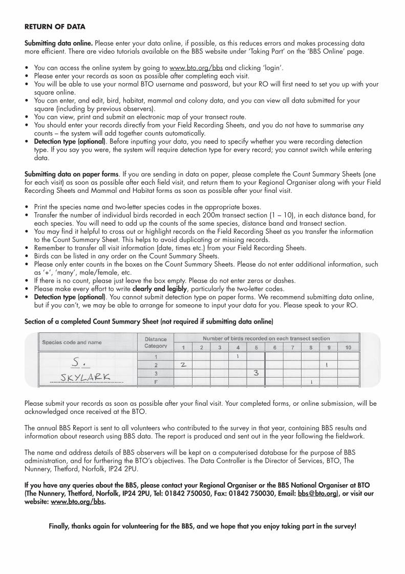
Submitting data on paper forms. If you are sending in data on paper, please complete the Count Summary Sheets (one for each visit) as soon as possible after each field visit, and return them to your Regional Organiser along with your Field Recording Sheets and Mammal and Habitat forms as soon as possible after your final visit.
• Print the species name and two-letter species codes in the appropriate boxes.• Transfer the number of individual birds recorded in each 200m transect section (1 – 10), in each distance band, for
each species. You will need to add up the counts of the same species, distance band and transect section.• You may find it helpful to cross out or highlight records on the Field Recording Sheet as you transfer the information
to the Count Summary Sheet. This helps to avoid duplicating or missing records.• Remember to transfer all visit information (date, times etc.) from your Field Recording Sheets. • Birds can be listed in any order on the Count Summary Sheets.• Please only enter counts in the boxes on the Count Summary Sheets. Please do not enter additional information, such
as ‘+’, ‘many’, male/female, etc.• If there is no count, please just leave the box empty. Please do not enter zeros or dashes.• Please make every effort to write clearly and legibly, particularly the two-letter codes. • Detection type (optional). You cannot submit detection type on paper forms. We recommend submitting data online,
but if you can’t, we may be able to arrange for someone to input your data for you. Please speak to your RO.
Section of a completed Count Summary Sheet (not required if submitting data online)
Please submit your records as soon as possible after your final visit. Your completed forms, or online submission, will be acknowledged once received at the BTO.
The annual BBS Report is sent to all volunteers who contributed to the survey in that year, containing BBS results and information about research using BBS data. The report is produced and sent out in the year following the fieldwork.
The name and address details of BBS observers will be kept on a computerised database for the purpose of BBS administration, and for furthering the BTO’s objectives. The Data Controller is the Director of Services, BTO, The Nunnery, Thetford, Norfolk, IP24 2PU.
If you have any queries about the BBS, please contact your Regional Organiser or the BBS National Organiser at BTO (The Nunnery, Thetford, Norfolk, IP24 2PU, Tel: 01842 750050, Fax: 01842 750030, Email: [email protected]), or visit our website: www.bto.org/bbs.
Finally, thanks again for volunteering for the BBS, and we hope that you enjoy taking part in the survey!
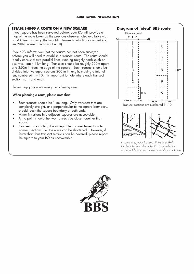
ESTABLISHING A ROUTE ON A NEW SQUAREIf your square has been surveyed before, your RO will provide a map of the route taken by the previous observer (also available via BBS-Online), showing the two 1-km transects which are divided into ten 200m transect sections (1 – 10).
If your RO informs you that the square has not been surveyed before, you will need to establish a transect route. The route should ideally consist of two parallel lines, running roughly north-south or east-west, each 1 km long. Transects should be roughly 500m apart and 250m in from the edge of the square. Each transect should be divided into five equal sections 200 m in length, making a total of ten, numbered 1 – 10. It is important to note where each transect section starts and ends.
Please map your route using the online system.
When planning a route, please note that:
• Each transect should be 1-km long. Only transects that are completely straight, and perpendicular to the square boundary, should touch the square boundary at both ends.
• Minor intrusions into adjacent squares are acceptable.• At no point should the two transects be closer together than
200m.• If access is restricted, it is acceptable to cover fewer than ten
transect sections (i.e. the route can be shortened). However, if fewer than four transect sections can be covered, please report the square to your RO as uncoverable.
Distance bands
Diagram of ‘ideal’ BBS route
Transect sections are numbered 1 - 10
In practice, your transect lines are likely to deviate from the ‘ideal’. Examples of acceptable transect routes are shown above.
ADDITIONAL INFORMATION