Embed Size (px)
Citation preview

\\Eu.Aecomnet.Com\Euprojectvol\Uksta1-Tp-Planning\Projects\Transport Planning - Hcc_Comet\03Execution\15 Applications\201703_Broxbourne\8. Reports\Final Tn\Final Broxbourne TransportStrategy 2017-08-10 - Appendix.Docx 1/6
Broxbourne Transport Strategy ModellingAssumptions - Appendix
Client nameBroxbourne Borough Council
Project nameCOMET Applications - BroxbourneTransport Strategy and Local PlanMitigation Assessment
Date10th August 2017
Prepared byAY/FG

SpecificationBroxbourne Transport Strategy & Local Plan Mitigation Assessment - Appendix
AECOM\\Eu.Aecomnet.Com\Euprojectvol\Uksta1-Tp-Planning\Projects\Transport Planning - Hcc_Comet\03Execution\15 Applications\201703_Broxbourne\8. Reports\Final Tn\Final Broxbourne TransportStrategy 2017-08-10 - Appendix.Docx 2/6
Appendix A – Highway ImprovementsTable 1 Highway Mitigation Measures
Location Ref Scheme
M25 J25 HS.01 Capacity improvement at M25 J25, through the provision of a dedicated left turn lane for northboundtraffic off the M25 and the widening of the A10 southbound on its approach to the junction.
Park Plaza HS.02 A10: Modify existing 3-arm junction on A10 to provide an at-grade 4-arm junction for access intoPark Plaza North & West.
Park Plaza HS.03 A10: Provide a ‘hamburger’ style signalised junction with N/S priority at the intersection of the A10junction with the A121 Monarch’s Way and B198 Lieutenant Ellis Way (Park Plaza junction).
Park Plaza HS.04 Lieutenant Ellis Way: New 4-arm junction on Lieutenant Ellis Way to the north of Park Plaza.
Cheshunt HS.05College Road: At grade improvement at College Road / A10 junction, providing additionalnorthbound and southbound lanes at the junction and increased length of northbound left filter intoCollege Road, and banning all right turns.
Cheshunt HS.06Church Lane: At grade highway capacity improvement at Church Lane / A10 junction, providing anadditional north-south lane through the junction and banning all right turns and left turns onto theA10.
Cheshunt HS.07 Church Lane: Reconfiguration of Church Lane / High Street, Cheshunt roundabout to providesignalised junction and crossing points for pedestrians.
Cheshunt HS.08 Church Lane: Reconfiguration of Church Lane / Flamstead End Road roundabout to providesignalised junction and crossing points for pedestrians.
Brookfield HS.09 Brookfield: Construction of a Halfhide Lane to Turnford Interchange Link Road, together withprovision of a new western arm at the A10 Turnford Interchange.
Brookfield HS.10Brookfield: Reconfiguration of 4-arm signalised junction on Halfhide Lane at junction with The Linksand the access road into Brookfield Retail Park, by removing access to/from The Links and allowingonly movements into (and not out of) the Retail Park.
Brookfield HS.11Brookfield: Construction of new link road immediately to the west of the A10 providing a link fromHalfhide Lane north to Hells Wood, where it turns westwards to connect to the Turnford Link Roadvia a new roundabout.
Brookfield HS.12 Brookfield: Construction of new link road immediately to the west of the A10 providing a link fromHalfhide Lane south to 'The Links' to provide access into Tesco car park.
Brookfield HS.13 Brookfield: Provision of additional capacity at Marriott Roundabout.
Brookfield HS.14 Brookfield: Provision of new distributor road to serve the new Brookfield development.
Waltham Cross HS.15 Fishpools: Reconfiguration of Fishpools junction to provide signalised junction and crossing pointsfor pedestrians.
Goffs Oak HS.16 Goffs Lane: Reconfiguration of Newgatestreet Road / Cuffley Hill / Goffs Lane junction give way toprovide signalised junction with crossing points for pedestrians.
Hoddesdon HS.17 Dinant Link Road: New roundabout on Dinant Link Road to permit access into High Leighdevelopment.
Hoddesdon HS.18 Dinant Link Road: Sun roundabout improvements (junction of Dinant Link Road and Ware Road) toprovide additional lane on eastbound arm of roundabout.
Hoddesdon HS.19 Hertford Road: Hertford Road / Ware Road roundabout improvements to provide additionaleastbound and southbound lanes at respective arms of the junction.
Hoddesdon HS.20 Essex Road: Provision of new Essex Road Bridge.
Hoddesdon HS.21 Essex Road: Improvements to roundabout at junction with Dinant Link Road.
Authority Wide HS.22 Speed limit: Provision of traffic calming, footway widening measures etc. on the Old A10 which hasbeen modelled as a 20mph limit to reflect the change in conditions for motorists.
Authority Wide HS.23 Signage: Update the network signage across the Borough to reflect the new access arrangementson/off the A10 at Church Lane.
Brookfield HS 24 Secondary school site southern access
Brookfield HS.25 Secondary School site northern access

SpecificationBroxbourne Transport Strategy & Local Plan Mitigation Assessment - Appendix
AECOM\\Eu.Aecomnet.Com\Euprojectvol\Uksta1-Tp-Planning\Projects\Transport Planning - Hcc_Comet\03Execution\15 Applications\201703_Broxbourne\8. Reports\Final Tn\Final Broxbourne TransportStrategy 2017-08-10 - Appendix.Docx 3/6
Appendix B – Bus Improvements
Table 2 New and Revised Bus Services
No. Origin Destination Service Frequency
New Services
1 High Leigh Broxbourne Station Every 15 mins
2 Waltham Cross Station Hertford Regional College Every 20 mins
3 Park Plaza North Waltham Cross Bus Station Every 15 mins
Revised Service
4 Waltham Cross Potters Bar Every 30 mins
Table 3 Bus Infrastructure Improvements
Bus Infrastructure
a.
Interchange: New multi-modal bus/rail interchange at Waltham Cross Station.Extent of investment subject to the availability of funds from:(i) Lower cost intervention at Church Lane(ii) Potential sale of existing bus station site (t.b.c.)
b.Broxbourne Station: Access improvements, particularly for buses at Broxbourne Station through the replacement ofpriority give way junction with signalised junction incorporating pedestrian crossing facilities.
c. Brookfield: Provide bus interchange facilities as part of the Brookfield development.
d. Bus stops: Bus stop improvement programme across the authority, to provide shelters, raised kerbs, seating, lighting andtimetables.
e.
Bus priority: Introduce Selective Vehicle Detection systems to provide priority for buses along the old A10:i. Junction of Station Road / High Road, Broxbourneii. Vancouver Road/A1170 (Selective Vehicle Detection System at signals)iii. Church Lane / Turners Hill, Cheshuntiv. Old Pond , Cheshunt.
Other Measures
a. Real time information provision at both bus stops and in key trip generators including retail, commercial and employmentcentres
b. Development of an integrated BUSnet ticket for Broxbourne
c. Promotion of the existing Intalink mobile app

SpecificationBroxbourne Transport Strategy & Local Plan Mitigation Assessment - Appendix
AECOM\\Eu.Aecomnet.Com\Euprojectvol\Uksta1-Tp-Planning\Projects\Transport Planning - Hcc_Comet\03Execution\15 Applications\201703_Broxbourne\8. Reports\Final Tn\Final Broxbourne TransportStrategy 2017-08-10 - Appendix.Docx 4/6
Appendix C – Rail Improvements
Table 4 Rail Service changes
Rail Services
a. Increased capacity on the West Anglia Main Line arising from 4-tracking (from 2026)
b. New stations at Turnford and Park Plaza
Table 5 Rail Service Frequency Changes
WAML (Post – STARscheme)*
Crossrail 2*
Broxbourne 8 trains per hour in peak 20 trains per hour in peak
Cheshunt 10 trains per hour in peak 20 – 22 trains per hour in peak
Waltham Cross 5 trains per hour in peak 14 trains per hour in peak
* All trains – fast and slow – stopping at station

SpecificationBroxbourne Transport Strategy & Local Plan Mitigation Assessment - Appendix
AECOM\\Eu.Aecomnet.Com\Euprojectvol\Uksta1-Tp-Planning\Projects\Transport Planning - Hcc_Comet\03Execution\15 Applications\201703_Broxbourne\8. Reports\Final Tn\Final Broxbourne TransportStrategy 2017-08-10 - Appendix.Docx 5/6
Appendix D – Cycling Improvements
Table 6 Cycle Infrastructure
Cycling Interventions
a.Development of a cycle network providing 10-20km ofdedicated cycle lanes
b. Increase cycle parking capacity at Broxbourne, Cheshunt andWaltham Cross Stations
Figure 1 Proposed Cycling Routes – Type of Route Segregation

SpecificationBroxbourne Transport Strategy & Local Plan Mitigation Assessment - Appendix
AECOM\\Eu.Aecomnet.Com\Euprojectvol\Uksta1-Tp-Planning\Projects\Transport Planning - Hcc_Comet\03Execution\15 Applications\201703_Broxbourne\8. Reports\Final Tn\Final Broxbourne TransportStrategy 2017-08-10 - Appendix.Docx 6/6
Appendix E – Modelling Assumptions Technical Note

\\Eu.Aecomnet.Com\Euprojectvol\Uksta1-Tp-Planning\Projects\Transport Planning - Hcc_Comet\03Execution\15 Applications\201703_Broxbourne\8. Reports\Modelling Assumptions Tn\BroxbourneTransport Strategy Modelling Assumptions 2017-06-08_Final.Docx 1/13
Broxbourne Transport Strategy Modelling Assumptions
Client nameBroxbourne Borough Council
Project nameCOMET Applications - BroxbourneTransport Strategy and Local PlanMitigation Assessment
DateJune 08 2017
Prepared byAY/FG
1. Introduction
1.1 This technical note discusses assumptions made by AECOM for the Broxbourne Transport Strategy and LocalPlan Mitigation Assessment COMET application. The purpose of this note is to document how the highwayand sustainable transport schemes will be coded in the 2031 COMET Broxbourne Do Something Scenario,ensuring consistency between the WYG and AECOM forecast scenarios in regards to the highway coding.The WYG Broxbourne SATURN model is highway only, therefore does not include the sustainable transportschemes. . An additional Appendix document has been produced to show the Planning Data to be used in thisCOMET scenario for Broxbourne Borough (employment and housing data).
1.2 AECOM have received the Broxbourne Forecast Growth Methodology note, which describes the WYGprocess for forecasting future traffic in Broxbourne in the Broxbourne Highway SATURN model. Whilst it is feltthis methodology is appropriate for the Broxbourne Highway SATURN model, it is not appropriate to use thismethodology for COMET. Planning data for all Hertfordshire districts need to be processed in the same way toensure consistency across the model. In addition, as COMET is a multi-modal model and the processing ofplanning data produces trips for all modes, whereas the WYG methodology produces highway trips only. It isrecommended the planning data is processed using standard COMET practice and WYG have commentedthat they are content with this.
2. Planning Data
2.1 AECOM has been provided with the planning data used in WYG’s Broxbourne Highway SATURN model inorder to ensure the planning data used for the COMET run is consistent. Table 1 summarises the differencesin planning data. Table 2 and Table 4 show the planning data previously used for the Broxbourne Borough inthe original COMET 2031 Local Plan Do Minimum run. Table 3 and Table 5 show the revised planning data asreceived from WYG.
2.2 The completed and committed dwellings and jobs have been updated by BBC and provided back to AECOM.These can be seen in Appendix A and B in the supporting document.
2.3 For Local Plan jobs, planning data has been received in a format containing floor space and land use type. Wehave used the COMET planning data process to convert floor space and land use type into jobs. The factorsused can be seen in Table 3, in the “Area per FTE (Full Time Equivalent) (m2)” column. BBC was providedwith these figures and in some cases jobs have been adjusted and provided back to AECOM. These adjustedjobs are highlighted in green. The resulting jobs are in the final column.
2.4 It is noted the planning data received includes Primary Schools, a Secondary School and a Care Home. WhilstCOMET does model educational and other trips, the employment type split comes from NTEM forecasts andis not explicitly derived from the planning data. The number of educational and other type trips are based onthese proportions
2.5 The revised planning data to be used shows an increase in Local Plan jobs from 5,450 to 14,965. Abreakdown of jobs can be found in Table 2 and Table 3.
2.6 The list of Local Plan dwellings has been taken from the planning data received from WYG with no furtherprocessing applied. Overall dwellings increase from 4,152 to 6,246 in Local Plan growth. The breakdown ofdwellings can be found in Table 4 and Table 5.

SpecificationHighway Scheme Modelling Assumptions
AECOM\\Eu.Aecomnet.Com\Euprojectvol\Uksta1-Tp-Planning\Projects\Transport Planning - Hcc_Comet\03Execution\15 Applications\201703_Broxbourne\8. Reports\Modelling Assumptions Tn\BroxbourneTransport Strategy Modelling Assumptions 2017-06-08_Final.Docx 2/13
Table 1. Original vs Revised Planning Data Local Plan Differences
Local Plan Original Revised Difference
Jobs 5,450 14,965 9,515 (175%)
Dwellings 4,152 6,246 2,094 (50%)
Source: Tables 2-5
Table 2. Original COMET Local Plan Planning Data - Jobs
Type Location COMET Local Plan(Jobs)
Completed 495
Committed1 1,512
Local Plan 5,450
Broxbourne 0
Broxbourne School 0
Cheshunt 0
Delamare Road/Cheshunt Lakeside -2,300
East of Dark Lane, Bury Green 0
Goffs Oak -50
Northern High Street Waltham Cross 0
Theobalds Brook Field 0
West of A10 0
Greater Brookfield - Office and civic development 2,150
Greater Brookfield Retail and Leisure Development 1,250
Park Plaza North Development, Promotion of small / mediumenterprises on existing employment site
3,000
Park Plaza West - Release of Green Belt Land to meet medium andlong term employment needs
1,400
Source: Hertfordshire County Council 16rd October 2016 (via email)
Table 3. WYG Revised Planning Data – Jobs (Local Plan Only)
Location Code Land Use Type Floor Space (m2) Area per FTE (m2) Jobs
Completed -126
Committed 496
Local Plan14,965
High Leigh Garden Village HOD5 A1 465 18 26
High Leigh Garden Village HOD5 B1(a) 1860 10 50
Brookfield Riverside BR1 A1 33500 18 1,861
Brookfield Riverside BR1 D2 10000 75 133
Brookfield Riverside BR1/ED2 B1(b) 50000 10 3,500
New River Trading Estate Relocation A1 -13200 18 -733
1 See Appendix A for full details.
SpecificationHighway Scheme Modelling Assumptions
AECOM\\Eu.Aecomnet.Com\Euprojectvol\Uksta1-Tp-Planning\Projects\Transport Planning - Hcc_Comet\03Execution\15 Applications\201703_Broxbourne\8. Reports\Modelling Assumptions Tn\BroxbourneTransport Strategy Modelling Assumptions 2017-06-08_Final.Docx 3/13
Location Code Land Use Type Floor Space (m2) Area per FTE (m2) Jobs
Cheshunt Lakeside CH1 B1(a) 15559 10 1,000
Cheshunt Lakeside Relocation CH1 B1-B8 -15559 42.5 -2,666
Cheshunt Football Club CH5 B1(a) 7013 10 200
Park Plaza West PP1 B1(a) 80000 10 8,000
Park Plaza North PP2 B1-B2 34441 25.75 1,338
Plot D, Park Plaza PP3 B1(a) 12500 10 200
Plot D, Park Plaza PP3 B1(b) 12500 10 200
Waltham Cross Northern High StreetRelocation
A1 -8000 18 -444
Source: WYG 12th May 2017 (via email)
Table 4. Original COMET Local Plan Planning Data - Dwellings
Type Location COMET Local Plan(Jobs)
Completed 422
Committed 2,423
Local Plan 4,152
East of Dark Lane, Bury Green 60
Northern High Street Waltham Cross 300
Theobalds Brook Field 100
Broxbourne (Rosedale Park) 715
Broxbourne School 153
Cheshunt 120
Delamare Road/Cheshunt Lakeside 1,000
Goffs Oak 204
West of A10 1,500
Source: Hertfordshire County Council 3rd October 2016 (via email)
Table 5. WYG Revised Planning Data - Dwellings
Site Name Local Plan Reference Number Dwellings
Completed 390
Committed2 1,515
Local Plan6,246
High Leigh Garden Village 07/13/0899/O 523
Turnford Surfacing Site HOD2 44
Land at Dinant Link Road No Policy (SLA Reference NumberHOD-UC-08)
50
Rye Park HOD3 60
Brookfield Riverside BR1 250
Brookfield Garden Village BR1 1,250
2 See Appendix B for full details

SpecificationHighway Scheme Modelling Assumptions
AECOM\\Eu.Aecomnet.Com\Euprojectvol\Uksta1-Tp-Planning\Projects\Transport Planning - Hcc_Comet\03Execution\15 Applications\201703_Broxbourne\8. Reports\Modelling Assumptions Tn\BroxbourneTransport Strategy Modelling Assumptions 2017-06-08_Final.Docx 4/13
Site Name Local Plan Reference Number Dwellings
Cheshunt Lakeside CH1 1,990
Rosedale Park CH2 65
Rosedale Park CH2 310
Rosedale Park CH2 340
Cheshunt Football Club CH5 186
East of Dark Lane, Bury Green CH7 60
Theobalds Brook Field CH7 100
V&E Club CH7 150
Former St Mary's east playingfields
CH7 75
Council offices/Whit Hern CH7 100
South of Hammondstreet Road CH9 44
Broxbourne School BX3 153
North of Goffs Lane GO2 80
South of Goffs Lane GO3 45
Newgatestreet Road GO4 25
North of Cuffley Hill GO5 46
Waltham Cross Northern HighStreet
WC2 300
Source: WYG 12th May 2017 (via email)
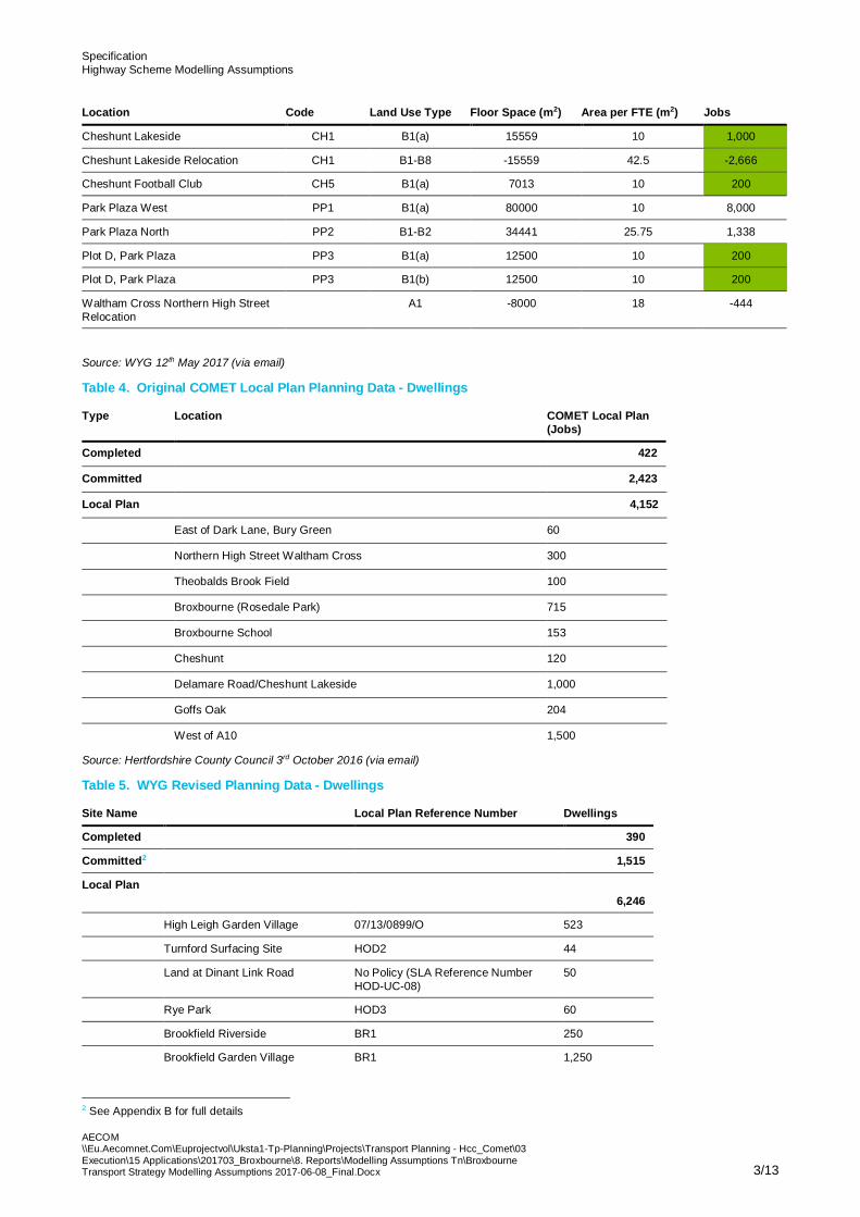
3. Highway Schemes
3.1 AECOM has been provided by WYG with a list of highway scheme detailing assumptions for each of the 24total highway schemes proposed for the development of the forecast scenario. Table 6 below shows theschemes coded in the WYG model that have to be replicated in the COMET scenario.
3.2 Based on further information and scheme details provided by WYG, Table 6 details the assumptions made byAECOM for the coding of each of the highway schemes in the COMET scenario.
Table 6. Highway Schemes to be included in COMET Model Run
Location Ref Scheme AECOM actuation
M25 J25 HS.01
Capacity improvement at M25 J25, throughthe provision of a dedicated left turn lane fornorthbound traffic off the M25 and thewidening of the A10 southbound on itsapproach to the junction.
- Coded as presented in Option 2 drawingfrom Highways England consultation inJanuary-February 2017
Park Plaza HS.02A10: Modify existing 3-arm junction on A10 toprovide an at-grade 4-arm junction for accessinto Park Plaza North & West.
- Based on Option 1 scheme instead ofrecently sent via email Option 2. Number oflanes and movements taken from the WYGmodel – No straight ahead movementsfrom East and West arms.
Park Plaza HS.03
A10: Provide a ‘hamburger’ style signalisedjunction with N/S priority at the intersection ofthe A10 junction with the A121 Monarch’sWay and B198 Lieutenant Ellis Way (ParkPlaza junction).
- 3 lanes for circulatory flow- 3 lanes southbound through hamburger
going into 5 lanes. Including lane gain fromthe left as per WYG comment. WYGmodel is coded with a merge marker atthe point of the lane gain reducing thecapacity. We will code as a lane gain
SpecificationHighway Scheme Modelling Assumptions
AECOM\\Eu.Aecomnet.Com\Euprojectvol\Uksta1-Tp-Planning\Projects\Transport Planning - Hcc_Comet\03Execution\15 Applications\201703_Broxbourne\8. Reports\Modelling Assumptions Tn\BroxbourneTransport Strategy Modelling Assumptions 2017-06-08_Final.Docx 5/13
Location Ref Scheme AECOM actuation
without the merge marker.
Park Plaza HS.04Lieutenant Ellis Way: New 4-arm junction onLieutenant Ellis Way to the north of ParkPlaza.
- Just 3 arms due to COMET zoning system- Flares will be replicated as per WYG model
with enhanced approaches.
Cheshunt HS.05
College Road: At grade improvement atCollege Road / A10 junction, providingadditional northbound and southbound lanesat the junction and increased length ofnorthbound left filter into College Road, andbanning all right turns.
- Remove right turns from junction- 4 lanes for the A10 northbound entry and
exit. 4 lanes on northbound exit to reduceto 3 before Church Lane.
- 3 lanes for the A10 southbound entry andexit, reducing to 2 south of junction.
- Eastbound and westbound exits will becoded as 2 lanes reducing to 1.
Cheshunt HS.06
Church Lane: At grade highway capacityimprovement at Church Lane / A10 junction,providing an additional north-south lanethrough the junction and banning all rightturns and left turns onto the A10.
- 3 lanes for north-south movements throughthe junction
- Ban right turn movements on all arms.- Ban left turn movements onto the A10- Code Church Lane as one-lane road both
directions.- IA10 Southbound entry is a flared
approach with left turn coded as a filterlane.
Cheshunt HS.07
Church Lane: Reconfiguration of ChurchLane / High Street, Cheshunt roundabout toprovide signalised junction and crossingpoints for pedestrians.
- Code as is in WYG model.
Cheshunt HS.08
Church Lane: Reconfiguration of ChurchLane / Flamstead End Road roundabout toprovide signalised junction and crossingpoints for pedestrians.
- Code as in WYG model
Brookfield HS.09
Brookfield: Construction of a Halfhide Lane toTurnford Interchange Link Road, togetherwith provision of a new western arm at theA10 Turnford Interchange.
- Already coded in the COMET 2031 DoMinimum scenario
Brookfield HS.10
Brookfield: Reconfiguration of 4-armsignalised junction on Halfhide Lane atjunction with The Links and the access roadinto Brookfield Retail Park, by removingaccess to/from The Links and allowing onlymovements into (and not out of) the RetailPark.
- Code exit access from the A10 northboundfor the Tesco parking
- Code new roundabout West of A10 onHalfhide lane, connecting it to the previousoff slip
- Code new roundabout northbound of theprevious one of Halfhide lane, connecting itwith the new A10 Turnford interchange.
Brookfield HS.11
Brookfield: Construction of new link roadimmediately to the west of the A10 providinga link from Halfhide Lane north to HellsWood, where it turns westwards to connect tothe Turnford Link Road via a newroundabout.
Brookfield HS.12
Brookfield: Construction of new link roadimmediately to the west of the A10 providinga link from Halfhide Lane south to 'The Links'to provide access into Tesco car park.
Brookfield HS.13 Brookfield: Provision of additional capacity atMarriott Roundabout.
- Add new lane at the junction fromwestbound approach (Flared approach).
Brookfield HS.14 Brookfield: Provision of new distributor roadto serve the new Brookfield development.
- Code 2 spigot connections to theBrookfield development for access to thescheme
Waltham Cross HS.15Fishpools: Reconfiguration of Fishpoolsjunction to provide signalised junction andcrossing points for pedestrians.
- Code as in WYG model- Left only give way junction for Sturlas Way
onto A121 WB- No right turns allowed from Monarchs Way
NB to Swanfield Rd.
Goffs Oak HS.16 Goffs Lane: Reconfiguration of - Code as in WYG model

SpecificationHighway Scheme Modelling Assumptions
AECOM\\Eu.Aecomnet.Com\Euprojectvol\Uksta1-Tp-Planning\Projects\Transport Planning - Hcc_Comet\03Execution\15 Applications\201703_Broxbourne\8. Reports\Modelling Assumptions Tn\BroxbourneTransport Strategy Modelling Assumptions 2017-06-08_Final.Docx 6/13
Location Ref Scheme AECOM actuation
Newgatestreet Road / Cuffley Hill / GoffsLane junction give way to provide signalisedjunction with crossing points for pedestrians.
Hoddesdon HS.17Dinant Link Road: New roundabout on DinantLink Road to permit access into High Leighdevelopment.
- Coded as in COMET 2031 Local Plan DoMinimum scenario, new coding will nothave an impact
- Update link between roundabouts to 2lanes in both directions
Hoddesdon HS.18
Dinant Link Road: Sun roundaboutimprovements (junction of Dinant Link Roadand Ware Road) to provide additional lane oneastbound arm of roundabout.
- Code as WYG model.
Hoddesdon HS.19
Hertford Road: Hertford Road / Ware Roadroundabout improvements to provideadditional eastbound and southbound lanesat respective arms of the junction.
- 3 arm roundabout (missing western arm)due to the COMET level of detail
- Additional eastbound and southboundlanes at respective arms of the junction
Hoddesdon HS.20 Essex Road: Provision of new Essex RoadBridge.
- This scheme will not be coded as changeswill not affect modelling.
Hoddesdon HS.21 Essex Road: Improvements to roundabout atjunction with Dinant Link Road. - Include flare for westbound movement only
Authority Wide HS.22
Speed limit: Provision of traffic calming,footway widening measures etc. on the OldA10 which has been modelled as a 20mphlimit to reflect the change in conditions formotorists.
- Coding of 20 mph free flow speed on thesuggested route
Authority Wide HS.23Signage: Update the network signage acrossthe Borough to reflect the new accessarrangements on/off the A10 at Church Lane.
- No coding required, as model assignmentassumes perfect driver knowledge
Brookfield HS 24 Secondary school site southern access
- Left in, left out access to secondary school.- Flared left turn into site.- Wide single lane, left turn give way to exit
the site.
Brookfield HS.25 Secondary School site northern access
- Current COMET zoning for this zone hasaccess onto Church Lane. Church lane isonly used as a zone loading point onto theA1170 – High Road.
Source: WYG
4. Sustainable Transport Interventions
4.1 Sustainable transport interventions have been incorporated into the modelling based on scheme detailsreceived from BBC and WYG. New and revised bus services have been included alongside new businfrastructure (Table 7 with supporting Figures Figure 1 to Figure 4, and
4.2 Table 8). Assumptions for new rail services including two proposed new stations at Turnford and Park Plazacan be seen in Table 9. Proposed rail service frequencies have been added in Table 10 and cyclinginterventions have also been added in Table 11 with further details on the schemes included in Figure 5.
Table 7. Bus Services
No. Origin Destination AECOM Coding
New Services
1 High Leigh Broxbourne Station New route added
2 Waltham Cross Station Hertford Regional College New route added
3 Park Plaza North Waltham Cross Bus Station New route added
Revised Service
SpecificationHighway Scheme Modelling Assumptions
AECOM\\Eu.Aecomnet.Com\Euprojectvol\Uksta1-Tp-Planning\Projects\Transport Planning - Hcc_Comet\03Execution\15 Applications\201703_Broxbourne\8. Reports\Modelling Assumptions Tn\BroxbourneTransport Strategy Modelling Assumptions 2017-06-08_Final.Docx 7/13
No. Origin Destination AECOM Coding
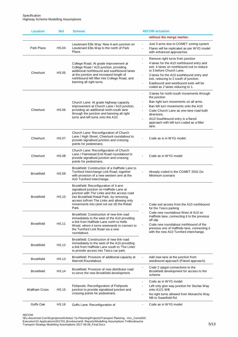
4 Waltham Cross Potters Bar Route has been updated
Source: 170405_Broxbourne COMET Model Run_Bus Schemes.docx (From WYG via email)
4.2.1 Bus Route Drawings
Figure 1 High Leigh to Broxbourne Station
= Bus stop (existing or proposed)

SpecificationHighway Scheme Modelling Assumptions
AECOM\\Eu.Aecomnet.Com\Euprojectvol\Uksta1-Tp-Planning\Projects\Transport Planning - Hcc_Comet\03Execution\15 Applications\201703_Broxbourne\8. Reports\Modelling Assumptions Tn\BroxbourneTransport Strategy Modelling Assumptions 2017-06-08_Final.Docx 8/13
Figure 2 Waltham Cross Station to Brookfield

SpecificationHighway Scheme Modelling Assumptions
AECOM\\Eu.Aecomnet.Com\Euprojectvol\Uksta1-Tp-Planning\Projects\Transport Planning - Hcc_Comet\03Execution\15 Applications\201703_Broxbourne\8. Reports\Modelling Assumptions Tn\BroxbourneTransport Strategy Modelling Assumptions 2017-06-08_Final.Docx 9/13
Figure 3 Park Plaza North to Waltham Cross
SpecificationHighway Scheme Modelling Assumptions
AECOM\\Eu.Aecomnet.Com\Euprojectvol\Uksta1-Tp-Planning\Projects\Transport Planning - Hcc_Comet\03Execution\15 Applications\201703_Broxbourne\8. Reports\Modelling Assumptions Tn\BroxbourneTransport Strategy Modelling Assumptions 2017-06-08_Final.Docx 10/13
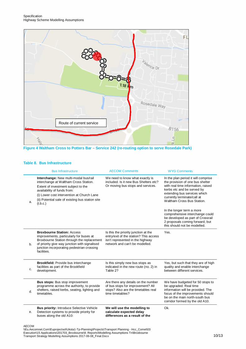
Figure 4 Waltham Cross to Potters Bar – Service 242 (re-routing option to serve Rosedale Park)
Table 8. Bus Infrastructure
Bus Infrastructure AECOM Comments WYG Comments
a.
Interchange: New multi-modal bus/railinterchange at Waltham Cross Station.Extent of investment subject to theavailability of funds from:(i) Lower cost intervention at Church Lane(ii) Potential sale of existing bus station site(t.b.c.)
We need to know what exactly isincluded. Is it new Bus Shelters etc?Or moving bus stops and services.
In the plan period it will comprisethe provision of one bus shelterwith real time information, raisedkerbs etc and be served byextending bus services whichcurrently terminate/call atWaltham Cross Bus Station.
In the longer term a morecomprehensive interchange couldbe developed as part of Crossrail2 proposals coming forward, butthis should not be modelled.
b.
Broxbourne Station: Accessimprovements, particularly for buses atBroxbourne Station through the replacementof priority give way junction with signalisedjunction incorporating pedestrian crossingfacilities.
Is this the priority junction at theentry/exit of the station? This accessisn’t represented in the highwaynetwork and can’t be modelled.
Yes.
c.
Brookfield: Provide bus interchangefacilities as part of the Brookfielddevelopment.
Is this simply new bus stops asindicated in the new route (no. 2) inTable 2?
Yes, but such that they are of highquality and enable interchangebetween different services.
d.
Bus stops: Bus stop improvementprogramme across the authority, to provideshelters, raised kerbs, seating, lighting andtimetables.
Are there any details on the numberof bus stops for improvement? Allstops? Also are the timetables realtime timetables?
We have budgeted for 50 stops tobe upgraded. Real timeinformation will be provided. Thefocus of the improvements shouldbe on the main north-south buscorridor formed by the old A10.
e.Bus priority: Introduce Selective VehicleDetection systems to provide priority forbuses along the old A10:
We will use the modelling tocalculate expected delaydifferences as a result of the
Ok.
Route of current service

SpecificationHighway Scheme Modelling Assumptions
AECOM\\Eu.Aecomnet.Com\Euprojectvol\Uksta1-Tp-Planning\Projects\Transport Planning - Hcc_Comet\03Execution\15 Applications\201703_Broxbourne\8. Reports\Modelling Assumptions Tn\BroxbourneTransport Strategy Modelling Assumptions 2017-06-08_Final.Docx 11/13
Bus Infrastructure AECOM Comments WYG Comments
i. Junction of Station Road / High Road,Broxbourneii. Vancouver Road/A1170 (Selective VehicleDetection System at signals)iii. Church Lane / Turners Hill, Cheshuntiv. Old Pond , Cheshunt.
measures from the bus prioritymeasures and apply these journeytime savings to the relevant routes.
Other Measures
a.Real time information provision at both busstops and in key trip generators includingretail, commercial and employment centres
n/a
b. Development of an integrated BUSnet ticketfor Broxbourne
As advised previously, this cannot bemodelled in COMET.
That’s a pity!
c. Promotion of the existing Intalink mobile app This cannot be modelled in COMET Ditto!
Source: 170405_Broxbourne COMET Model Run_Bus Schemes.docx (From WYG via email)
Table 9. Rail Services
Rail Services AECOM Comments WYG Comments AECOM Coding
a.
Increased capacity on the WestAnglia Main Line arising from 4-tracking (from 2026)
Information received is simplya frequency per hour for twoscenarios at the existingstations (Broxbourne,Cheshunt and WalthamCross). We need to know:Which scenario are wetesting? WAML (Post STARscheme) or Crossrail 2?Is there an overall frequencyincrease?How many trains per hour aregoing to stop at each stationand in each direction?If station to station traveltimes are available, thatwould be useful.
TurnfordServed by Crossrail 2 trainsonly i.e. not served by currentGreater Anglia services.Hence station would not beoperational until Crossrail2opens in 2033 at the earliest.Service would be fromBroxbourne via TottenhamHale to central London andbeyond using new Crossrail2tunnels. Trains will call at allstations. Frequency would be10 – 12 trains per hour ineach direction in the peak.
Park PlazaWould be served by existingLondon Overground servicesfrom Cheshunt to LiverpoolStreet. The current timetableis 2 tph in off-peak, with a fewadditional trains in the peaks.A new station would fit intothis timetable.
b.
New stations at Turnford andPark Plaza
We are awaiting the fulldetails of these proposedstations and potentialService schedules,frequencies etc.
Source: 170405_Broxbourne COMET Model Run_Bus Schemes.docx (From WYG via email)
Table 10. Rail Service Frequencies
WAML (Post – STAR scheme)* Crossrail 2*
Broxbourne 8 trains per hour in peak 20 trains per hour in peak
Cheshunt 10 trains per hour in peak 20 – 22 trains per hour in peak
Waltham Cross 5 trains per hour in peak 14 trains per hour in peak
* All trains – fast and slow – stopping at station
Source: TPH table.xlsx (From WYG and Network Rail via email)
Table 11. Cycling Interventions
Cycling Interventions AECOM Comments WYG Comments AECOM Coding
a. Development of a cycle network Just to confirm, are these Martin to provide. (Received)

SpecificationHighway Scheme Modelling Assumptions
AECOM\\Eu.Aecomnet.Com\Euprojectvol\Uksta1-Tp-Planning\Projects\Transport Planning - Hcc_Comet\03Execution\15 Applications\201703_Broxbourne\8. Reports\Modelling Assumptions Tn\BroxbourneTransport Strategy Modelling Assumptions 2017-06-08_Final.Docx 12/13
Cycling Interventions AECOM Comments WYG Comments AECOM Coding
providing 10-20km of dedicatedcycle lanes
completely segregated offroad cycle lanes?
b.
Increase cycle parking capacityat Broxbourne, Cheshunt andWaltham Cross Stations
There is an ability to modelthe introduction of securecycle parking facilitieshowever not an increase inthe cycle parking capacity.
Please apply this factor assecure parking will beprovided.
Source: 170405_Broxbourne COMET Model Run_Bus Schemes.docx (From WYG via email) and Cycle Routes COMET 09.05.1974.pdf(From BCC via email)
·

SpecificationHighway Scheme Modelling Assumptions
AECOM\\Eu.Aecomnet.Com\Euprojectvol\Uksta1-Tp-Planning\Projects\Transport Planning - Hcc_Comet\03Execution\15 Applications\201703_Broxbourne\8. Reports\Modelling Assumptions Tn\BroxbourneTransport Strategy Modelling Assumptions 2017-06-08_Final.Docx 13/13
4.2.2 Proposed Cycling Routes
Figure 5 Proposed Cycling Routes – Type of Route Segregation
Source: Cycle Routes COMET 09.05.1974.pdf (From BCC via email)