Embed Size (px)
Citation preview
B r o w n f i e l d O p p o r t u n i t yA r e a
Erwin Pa inted Post R ivers ideTown of Vi l lage of Vi l lage of
S t e p 2Nominat ion
Prepared by:Southern Tier CentralRegional Planning & Development Board
peter j. smith & company, inc.HUNT Architects, Engineers & Surveyors
*This project was prepared for the Town of Erwin, the New York State Department of State, and the New York State Department of Environmental Conservation with state funds provided through the Brown�eld Opportunity Area program.

Town of Erwin • Village of Painted Post • Village of Riverside
Southern Tier Central (STC) Regional Planning & Development Board
Acknowledgments Steering Committee Members Jack Benjamin, Three Rivers Development William Cornell, Village of Riverside Roswell Crozier Jr., Village of Painted Post Rick Davis, Crystal Cleaners Ted DeVoe, Corning-Painted Post School District Dave Erwin, Town of Erwin Carol Ferratella, Steuben County Nancy Foster, Painted Post Forward Ralph Phoster, Painted Post Planning Board James C. Johnson, Steuben County IDA Vincent Krystof, Village Mini Mart Diane Lantz, REDEC/RRC Greg MacLean, NYSDEC Tom Magnusen, Painted Post Board of Trade Mike Manzari, Pyramid Brokerage Mike McCaig, Dresser-Rand Rita McCarthy, Town of Erwin Christina Mucci, Pyramid Brokerage Emily Northrup, Painted Post Forward Ernie Northrup, Painted Post Forward Phil Palmesano, NYS Assembly William Piatt, NYSDOT Bart Putzig, NYSDEC Pamela L. Rogers, Painted Post Forward Meg Scheidweiler, Painted Post Planning Board Julie Sweet, NYSDOS Janet Thigpen, Steuben County EMC Amy Tryron, Painted Post Planning Board Lyle Wasson, Resident Marcia Weber, Painted Post Planning Board
Consultant Team Southern Tier Central Regional Planning & Development Board peter j. smith & company, inc. HUNT Engineers, Architects & Surveyors

DRAFT Brownfield Opportunity Area (BOA) Step 2 Nomination Study
peter j. smith & company, inc. • HUNT Engineers, Architects & Land Surveyors P a g e | iii
Table of Contents
1. EXECUTIVE SUMMARY 1
LEAD PROJECT SPONSORS 1 PROJECT OVERVIEW & DESCRIPTION 2 COMMUNITY VISION, GOALS, & OBJECTIVES 3 PROJECT BOUNDARY DESCRIPTION & JUSTIFICATION 7
2. PUBLIC PARTICIPATION PLAN & TECHNIQUES TO ENLIST PARTNERS 9
COMMUNITY PARTICIPATION PROCESS & TECHNIQUES(4.1E) 9 TECHNIQUES TO ENLIST PARTNERS 10
3. ANALYSIS OF THE BOA 13
INTRODUCTION 13 COMMUNITY & REGIONAL SETTING 14 LAND USE 26 ZONING 31 TRANSPORTATION & INFRASTRUCTURE 35 TRAFFIC & PARKING ANALYSIS 39 BROWNFIELD, ABANDONED & VACANT SITES 49 STRATEGIC SITES 53 STRATEGIC SITE C – ACCESS FEASIBILITY STUDY 65 LAND OWNERSHIP PATTERNS 79 PARKS & OPEN SPACE 83 BUILDING INVENTORY 87 HISTORIC OR ARCHEOLOGICALLY SIGNIFICANT AREAS 93 NATURAL RESOURCES & ENVIRONMENTAL RESOURCES 97 ECONOMIC & MARKET TRENDS ANALYSIS 109 SUMMARY ANALYSIS, FINDINGS, AND RECOMMENDATIONS OF THE BOA AND STRATEGIC SITES 121 IMPLEMENTATION 147 PRELIMINARY FUNDING MATRIX 150

Town of Erwin • Village of Painted Post • Village of Riverside
iv | P a g e Southern Tier Central (STC) Regional Planning & Development Board
List of Tables TABLE 1: COMMUNITY IDENTIFIED GOALS 3 TABLE 2: PROJECT STEERING COMMITTEE 10 TABLE 3: POPULATION CHANGE IN THE STUDY AREA 14 TABLE 4: MEDIAN INCOME 17 TABLE 5: PER CAPITA PERSONAL INCOME 19 TABLE 6: EDUCATIONAL ATTAINMENT 20 TABLE 7: AVERAGE ANNUAL WAGES 21 TABLE 8: STEUBEN COUNTY MAJOR EMPLOYERS (2008) 22 TABLE 9: EMPLOYMENT BY SECTOR 22 TABLE 11: LAND USE BY ACRES 28 TABLE 12: ZONING BY ACRES 31 TABLE 13: LOS BENCHMARKS 41 TABLE 14: TRAFFIC COUNT TIMES 41 TABLE 16: BASE ESTIMATES 42 TABLE 15: LAND USES CONSIDERED 42 TABLE 17: EXISTING AM PEAK HOUR LOS ANALYSIS (SECONDS OF DELAY) 43 TABLE 18: EXISTING PM PEAK HOUR LOS ANALYSIS (SECONDS OF DELAY) 44 TABLE 19: EXISTING+20 YEARS (2032) AM PEAK HOUR LOS ANALYSIS (SECONDS OF DELAY) 45 TABLE 20: EXISTING+20 YEARS (2032) PM PEAK HOUR LOS ANALYSIS (SECONDS OF DELAY) 45 TABLE 21: BROWNFIELD, UNDERUTILIZED & VACANT SITES BY MUNICIPALITY 49 TABLE 22: LAND OWNERSHIP BY MUNICIPALITY 79 TABLE 23: BROWNFIELD, UNDERUTILIZED & VACANT SITES BY OWNERSHIP 79 TABLE 24: PARKS, RECREATION & OPEN SPACE 84 TABLE 25: PROPERTY CLASS BY PERCENT OF LAND AREA 111 TABLE 26: HOUSING AGE 112 TABLE 27: HOUSING TYPES 112 TABLE 28: HOUSING RENTAL RATES 113 TABLE 29: HOUSING TENURE 113 TABLE 30: HOUSING VALUE 114 TABLE 31: BOA RESIDENTIAL SALES 114 TABLE 32: COMMERCIAL SPACE SALE RATES 115 TABLE 33: COMMERCIAL LEASE RATES 115 TABLE 34: COMMERCIAL CONSTRUCTION RATES 116 TABLE 35: RETAIL GAP ANALYSIS 117

DRAFT Brownfield Opportunity Area (BOA) Step 2 Nomination Study
peter j. smith & company, inc. • HUNT Engineers, Architects & Land Surveyors P a g e | v
TABLE 36: INDUSTRIAL SALES RATES 119 TABLE 37: INDUSTRIAL LEASE RATES 119 TABLE 38: INDUSTRIAL CONSTRUCTION RATES 119 TABLE 39: BOA STEP 1 RECOMMENDATIONS 122 TABLE 40: BOA STEP 1 ACTION STEPS 123 TABLE 41: MAJOR FINDINGS 127 TABLE 42: MAJOR FINDINGS (CONT.) 128 TABLE 43: FURTHER INVESTIGATION RECOMMENDATIONS 129 TABLE 44: IMPLEMENTATION MATRIX 148 TABLE 45: IMPLEMENTATION MATRIX (CONT.) 149 TABLE 46: FINANCIAL ASSISTANCE MATRIX 150
List of Figures FIGURE 1: PROJECT BOUNDARY 7 FIGURE 2: POPULATION & DENSITY BY CENSUS BLOCK 16 FIGURE 3: BLOCK GROUPS IN THE BOA 16 FIGURE 4: TRAFFIC COUNTS IN THE BOA 36
Town of Erwin • Village of Painted Post • Village of Riverside
vi | P a g e Southern Tier Central (STC) Regional Planning & Development Board

DRAFT Brownfield Opportunity Area (BOA) Step 2 Nomination
peter j. smith & company, inc. • HUNT Engineers, Architects & Land Surveyors, P.C. P a g e | 1
1. Executive Summary LEAD PROJECT SPONSORS The Town of Erwin, the Village of Painted Post and the Village of Riverside, with the assistance of the Southern Tier Regional Planning and Development Board, were awarded a grant through the New York State Department of State (NYSDOS) and the New York State Department of Environmental Conservation (NYSDEC) to initiate a Brownfield Opportunity Area Study. The purpose of the study was to assess the status and long term potential of former industrial lands and related adjacent areas to establish a long term vision and identify strategies for change. These communities, assisted by Southern Tier Regional Planning and Development Board have worked to seek the input of the local public and regional stakeholders as well as planning and engineering consultants to develop a Brownfield Opportunity Area (BOA) program that represents an achievable community vision.
The Step 2 Nomination Document, including a Master Plan for the Brownfield Opportunity area, was prepared in accordance with the guidelines established by NYSDOS and NYS DEC for the Nomination Study (Step 2) and Implementation Strategy (Step 3) phases of the BOA program. Several representatives from community and public sector based organizations sat on the Erwin, Painted Post, Riverside BOA Steering Committee and made significant contributions to the development of the Nomination Document Following the completion of the Step 2 Nomination Study, the communities and the Southern Tier Central Regional Planning and Development Board will enter Step 3, defining steps for implementation of recommendations and the Master Plan that were developed during Step 2. Ultimately, the BOA program will help achieve economic and physical revitalization of the project area.
Town of Erwin • Village of Painted Post • Village of Riverside
2 | P a g e Southern Tier Central (STC) Regional Planning & Development Board
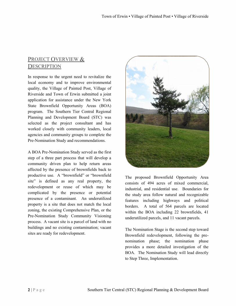
PROJECT OVERVIEW & DESCRIPTION In response to the urgent need to revitalize the local economy and to improve environmental quality, the Village of Painted Post, Village of Riverside and Town of Erwin submitted a joint application for assistance under the New York State Brownfield Opportunity Areas (BOA) program. The Southern Tier Central Regional Planning and Development Board (STC) was selected as the project consultant and has worked closely with community leaders, local agencies and community groups to complete the Pre-Nomination Study and recommendations. A BOA Pre-Nomination Study served as the first step of a three part process that will develop a community driven plan to help return areas affected by the presence of brownfields back to productive use. A “brownfield” or “brownfield site” is defined as any real property, the redevelopment or reuse of which may be complicated by the presence or potential presence of a contaminant. An underutilized property is a site that does not match the local zoning, the existing Comprehensive Plan, or the Pre-Nomination Study Community Visioning process. A vacant site is a parcel of land with no buildings and no existing contamination; vacant sites are ready for redevelopment.
The proposed Brownfield Opportunity Area consists of 494 acres of mixed commercial, industrial, and residential use. Boundaries for the study area follow natural and recognizable features including highways and political borders. A total of 564 parcels are located within the BOA including 22 brownfields, 41 underutilized parcels, and 11 vacant parcels. The Nomination Stage is the second step toward Brownfield redevelopment, following the pre-nomination phase; the nomination phase provides a more detailed investigation of the BOA. The Nomination Study will lead directly to Step Three, Implementation.

DRAFT Brownfield Opportunity Area (BOA) Step 2 Nomination
peter j. smith & company, inc. • HUNT Engineers, Architects & Land Surveyors, P.C. P a g e | 3
COMMUNITY VISION, GOALS, & OBJECTIVES Interested landowners met with members of the BOA Working Group and Steering Committee on September 10 and September 22 to work together to build a community vision for the BOA. After a presentation about the BOA program, a review of the history of planning in the three communities, a detailed discussion of the BOA boundaries and sites and a “virtual tour” of the main transportation corridor, the participants wrote up their ideas and concerns on each of the following topics suggested in the BOA scope of work. A complete list of the ideas raised during the public meeting is in Appendix 3. The group then worked together to develop goals which reflect the desires of the communities for each topic. The Community Identified Goals are as follows: Table 1: Community Identified Goals
Rank BOA Topic Goal
1 Ideal businesses & industries Attract businesses and industry that would support local needs without placing strain on community infrastructure.
2 Zoning Coordinate zoning to meet community goals and community needs
3 Housing: variety & cost Attract a wide variety of housing types that will support local businesses
4 Future community involvement Keep taxes low and keep people involved/informed in the community
5 Compact building design Encourage higher density housing and mixed-uses 6 Physical Infrastructure Encourage an attractive, small-town atmosphere in the community 7 Encouraging the re-use of land Recycle the urban landscape
8 Walk-ability Develop a coordinated system of sidewalks, bike paths and trails. (the intersections of E. High/Hamel and E. High/Hart were identified as needing improvement)
9 Distinctive and attractive community
Try to re-create Main Street USA
10 Natural resources and open space
Maintain the existing green space
11 Mixing land uses Facilitate the mixing of compatible land uses
12 Recreation and community facilities
Encourage the people-oriented use of green space
13 Variety of transportation choices Improve alternative transportation connections in the communities
14 Predictable development process Achieve understanding between developers and communities regarding the community vision

Town of Erwin • Village of Painted Post • Village of Riverside
4 | P a g e Southern Tier Central (STC) Regional Planning & Development Board
After the community goals were established, each attendee was given three stickers and asked to place each of their dots on their three most important goals. Objectives were developed as a group that would meet the four most important goals. The top four goals and objectives were: GOAL #1) Attract businesses and industry that would support local needs without placing strain on community infrastructure in the BOA. OBJECTIVES:
a) Attract all types of companies, both chains and small businesses
b) Identify businesses which will suit local needs
c) Use the “Gateway to the Finger Lakes” as a marketing label
d) Identify the special flavor of the BOA for marketing purposes
e) Attract I-86 and I-99 travelers to spend time in the BOA GOAL #2) Coordinate zoning to meet community goals and community needs OBJECTIVES:
a) Coordinate zoning between the Village of Painted Post and the Village of Riverside.
b) Update existing zoning as necessary
c) Update the West Water Street site transportation links (a bridge west to Route 415) GOAL #3) Attract a wide variety of housing types that will support local businesses OBJECTIVES:
a) Zone to permit important mixed-use developments
b) Trigger mixed-use development
c) Prove and promote the local desire for mixed-use housing of all types GOAL #4) Keep taxes low and keep people involved/informed in the community OBJECTIVES:
a) Encourage social networking in the community
b) Plan events to increase knowledge and awareness of local concerns and projects
c) Increase media coverage
DRAFT Brownfield Opportunity Area (BOA) Step 2 Nomination
peter j. smith & company, inc. • HUNT Engineers, Architects & Land Surveyors, P.C. P a g e | 5
Finally, the entire group worked to create a unified community vision by filling in “who, what, when, where, why and how:”
Who: Residents, business owners and tourists
What: Develop underutilized properties to meet the needs and requirements in a coordinated way
When: On-going
Where: 500 BOA acres
Why: Take advantage of the opportunities from I-99 and I- 86 interchange (to expand the tax base)
How: Become a BOA as soon as possible, with the involvement of the community Staff used the information to create this draft vision statement: To take full advantage of the opportunity created by the I-86 & I-99 interchange, now and in the future, the proposed 500 acre BOA in our three communities (Erwin, Painted Post and Riverside) should be developed to meet the needs and requirements of the residents, business owners and tourists in a coordinated way by becoming an official BOA as soon as possible with the involvement of the community. The following vision was developed as part of the community participation process: “A well developed and balanced community exists inside the Brownfield Opportunity Area of the Town of Erwin, Village of Painted Post, and the Village of Riverside. The community is ideally suited to everyday living; providing a walkable environment, public transportation, and convenient services. These three vibrant communities include mixed land uses and socio-economically diverse residents. This area has a rich history of manufacturing and a growing technological base. Located at the I-86 and I-99 interchange, “the Gateway to the Finger Lakes”, this area attracts and maintains business and industry that support the local economy, neighborhoods, and visitors.”

Town of Erwin • Village of Painted Post • Village of Riverside
6 | P a g e Southern Tier Central (STC) Regional Planning & Development Board

DRAFT Brownfield Opportunity Area (BOA) Step 2 Nomination
peter j. smith & company, inc. • HUNT Engineers, Architects & Land Surveyors, P.C. P a g e | 7
PROJECT BOUNDARY DESCRIPTION & JUSTIFICATION Boundary Description The easternmost border of the BOA is along Townsend Ave. and down the Village of Riverside-City of Corning municipal line to Rt. 352. The BOA follows Rt. 352 into I-86 from the eastern most Painted Post border through Erwin until the B&H Railroad Company parcel (0.1 mile south of Rt. 415. The BOA boundary line follows the railroad parcel until Robert Dann Drive. The BOA boundary captures the five (5) parcels north of Rt. 415 between Robert Dann Drive and I-86. The BOA outline follows I-86 southbound and then captures two (2) parcels north of Rt. 415 by the interstate on-ramp.
The BOA outline then follows Rt. 415 from the Town of Erwin to the intersection of Victory Highway with West Hill Road. The BOA boundary extends north east, up the hillside to capture a large wooded parcel. The BOA includes several residences on the southwest side of Fairview Ave., before Fairview intersects with the community bike path. The bike path becomes the BOA boundary for .06 miles, and then the boundary follows N. Hamilton Street southwest to Platt St. The boundary follows Platt until the estimated ‘intersection’ with Stull Lane. At the end of Stull Lane, Dennison Street becomes the boundary. The final portion of the BOA boundary bisects the Village of Riverside with a line from the end of Dennison Street through Alley Five, to end at the City of Corning/Village of Riverside border (where the BOA began).
Justification The justification for these boundaries was to collect major portions of the town and villages that have road frontage on Rt. 415 or sections of the community located between I-86 and Rt. 415. A more detailed description is available in Appendix 1. Several land uses are affected by BOA sites, several of the largest sites are adjacent to residentially zoned land and existing homes.
Figure 1: Project Boundary

Town of Erwin • Village of Painted Post • Village of Riverside
8 | P a g e Southern Tier Central (STC) Regional Planning & Development Board
Necessary Areas/Land Uses Affected by the BOA Areas necessary to achieve the goals of the Town of Erwin, Village of Painted Post, and Village of Riverside BOA are the parcels along Rt. 415 and the larger parcels within the BOA along I-86. The study area includes a mix of residential, commercial, industrial, and service related land uses, the focus of the BOA program in this area is to develop vacant and underutilized land for beneficial uses. The Chemung River Valley is a natural resource used as an aquifer within the BOA. Although the river is just outside the BOA boundary, both the Cohocton and Chemung rivers are used for recreation by members of the community at large. The Dresser Rand manufacturing facility in Painted Post is an important industrial asset located in the BOA. This is an advanced engineering and manufacturing facility which employs 740 local workers and is located at 100 Chemung Street. Continued operations at Dresser Rand are vital to the local economy, including the area inside the BOA. Dresser Rand produces components and systems to satisfy a variety of production contracts with private firms and with the Department of Defense. The backlog of contracts at Dresser Rand is substantial; these accumulated contracts will allow the facility to operate through tough economic times. Corning Community College and the Corning Hospital are social and educational land uses that may be affected by development in the
BOA. If re-development efforts in the BOA succeed, local population loss will cease and the demand for these service industries will increase. In the region surrounding the BOA, tourism is a growing industry. The Corning Museum of Glass attracts thousands of visitors to the region each year. Finger Lakes Tourism has worked diligently to promote Finger Lakes wine in New York and beyond. Attracting tourists to the local area is one of the primary goals of this BOA. Tourists may be able to utilize the EPPR BOA as a base to explore the wine country or the region’s Aviation History (Glen Curtis Museum, Wings of Eagles Museum, and Local Aviation pioneer Joe Costa). Existing transportation infrastructure (both near the BOA and in the BOA) is a key land use. The transportation infrastructure is an excellent selling point for sites within the BOA. Re-utilizing the existing infrastructure should reduce long-term road maintenance costs to local and state governments, compared to the maintenance cost on a larger road network- built to accommodate greenfield development. The I-86/I-99 transportation/trade corridor, the Erwin-Painted Post Airport, the Elmira-Corning Regional Airport, and the Bath & Hammondsport Railroad line will all experience increased use as a result of successful development in the BOA.
DRAFT Brownfield Opportunity Area (BOA) Step 2 Nomination
peter j. smith & company, inc. • HUNT Engineers, Architects & Land Surveyors, P.C. P a g e | 9
2. Public Participation Plan & Techniques to Enlist Partners
COMMUNITY PARTICIPATION PROCESS & TECHNIQUES(4.1E) In Late 2011, the project team invited community supervisors, mayors, and their selected board members; Painted Post Forward representatives; NYSDEC; NYSDOS; and STC staff to discuss the BOA Nomination study and the W. Water Street access bridge Feasibility Study. The Steering Committee from the pre-nomination process remained in place during the nomination process. The project team decided to move forward with an efficient project schedule. The consultants, Peter J. Smith & co. began a public participation outreach. The consultants prepared press releases to notify the public of the Community Visioning workshop, prepared posters and materials for the public, and planned the public un-veiling of the draft and final reports. Peter J. Smith & co. has expertly interacted with both the media and the public on topics relating to the E/PP/R BOA.
Comments on the visions and goals were solicited from the public via a public meeting held March 22, 2012. Additional public meetings will be held to educate the public about the BOA process and the results of the E/PP/R BOA Nomination Study. Any additional public comments on nomination study, will be collected by STC staff, logged, and incorporated into the study as appropriate.
Community Participation Summary From the beginning of the BOA process, public participation in the E/PP/R BOA has been a key component of the project. STC staff has provided regular progress reports to the Painted Post Planning Board and Painted Post Forward. The March 22, 2012 public meeting was an excellent working session on potential land use throughout the E/PP/R BOA. The public workshop also allowed the consultant team to educate the public on the activities of the BOA process. The draft plan has been made available to the public in three distinct ways: executive summary through the media, printed copies in municipal offices, and digital versions will be available online.

Town of Erwin • Village of Painted Post • Village of Riverside
10 | P a g e Southern Tier Central (STC) Regional Planning & Development Board
TECHNIQUES TO ENLIST PARTNERS Building strong partnerships is one of the key elements of the BOA process. The final study illustrates an economically vital and stable community; local organizations and involved civic partners will be necessary to implement the recommendations of the E/PP/R Nomination Study.
Project participants have worked diligently to build strong relationships among the project participants. This project has included the following thirty organizations. Attendance at E/PP/R BOA Steering Committee meetings has been good, these groups are well represented. The ongoing E/PP/R BOA process has provided ample opportunities for communication between members of these groups. The steering committee remained relatively stable between
the pre-nomination phase and the nomination phase; this project is building on a history of cooperation, forged in a three year pre-nomination process. The group activities and discussions have prompted steering committee members to discuss inter-municipal issues and the effects of New York State governance on residents/communities. The relationships established through this process will be vital for E/PP/R to succeed with a BOA Implementation project. The project team has maintained close communication with the Steering Committee, local governments, and involved agencies throughout the entire BOA process. Members received an invitation by mail and email in December 2011, January 2012 and March 2012. Participants were emailed regarding project activities in March 2012, May 2012, July 2012.
Full Name COMPANY
Jack Benjamin Three Rivers Dev. Foundation Inc.
William Cornell Village of Riverside
Roswell Crozier Village of Painted Post
Rick Davis Crystal Cleaners
Ted DeVoe Corning-Painted Post School District
Dave Erwin Town of Erwin
Carol Ferratella Steuben County/Village of Riverside
Nancy Foster Painted Post Forward
Ralph Foster Painted Post Planning Board
James C. Johnson Steuben County IDA
Vincent Krystof Painted Post Laser Wash & Village Mini-Market
Diane Lantz REDEC/RRC
Greg MacLean NYSDEC Region 8
Tom Magnusen Painted Post Board of Trade
Mike Manzari Pyramid Brokerage
Ted Pawlik Dresser-Rand
Doug Rich Dresser-Rand
Rita McCarthy Town of Erwin
Christina Mucci Pyramid Brokerage
Emily & Ernie Northrup Painted Post Forward
Phil Palmesano NYS Assembly
Bill Piatt NYS DOT Planning Section
Bart Putzig NYSDEC
Pamela L. Rogers Painted Post Forward
Meg Scheidweiler Village of Painted Post
Julie Sweet NYSDOS
Janet Thigpen Steuben County EMC
Amy Tryron Village of Painted Post
Lyle Wasson Village of Riverside
Marcia Weber Village of Painted Post
Table 2: Project Steering Committee

DRAFT Brownfield Opportunity Area (BOA) Step 2 Nomination
peter j. smith & company, inc. • HUNT Engineers, Architects & Land Surveyors, P.C. P a g e | 11
A BOA survey/brochure was sent to all businesses in the BOA area in early 2012; non-responders received a follow-up mailing and a personal phone call. The project team received many survey responses from local businesses. The March 22, 2012 public meeting was an excellent working session on potential land use throughout the E/PP/R BOA. The public workshop also allowed the consultant team to educate the public on the activities of the BOA process. The Nomination Study will be made available to the public in three distinct ways: an executive summary through the media, printed copies in municipal offices, and digital versions will be available online.
Community involvement efforts on this project have been strong. The print, radio, and TV media has been invited to the kick-off meetings, and all the public meetings. The media response to this project has been relatively good, several articles and TV segments have helped to raise awareness about this project. Information regarding this process has been distributed through the media, Painted Post Forward, local planning boards, Facebook, and a poster campaign. Community volunteers were utilized for traffic counts, which provided an outreach opportunity for the volunteers and for members of the community (as they were being counted).
E/PP/R BOA Project Steering Committee

Town of Erwin • Village of Painted Post • Village of Riverside
12 | P a g e Southern Tier Central (STC) Regional Planning & Development Board

DRAFT Brownfield Opportunity Area (BOA) Step 2 Nomination
peter j. smith & company, inc. • HUNT Engineers, Architects & Land Surveyors, P.C. P a g e | 13
3. Analysis of the BOA INTRODUCTION The Brownfield Opportunity Area program provides municipalities with financial assistance to complete area-wide planning approaches to brownfield redevelopment. Completion of the program leads to a New York State designation as a Brownfield Opportunity Area. The second step in the program is the Nomination, which provides an in-depth description and analysis of economic and market trends, existing conditions, opportunities, reuse potential and recommendations. This section, the analysis of the proposed BOA, is the third of the Step 2 Nomination Document for the Erwin/Painted Post/Riverside Brownfield Opportunity area. The analysis is a comprehensive inventory of the existing conditions of the BOA, concerning the following investigative areas:
Community & Regional Setting
Existing Land Use
Existing Zoning
Brownfield, Abandoned & Vacant Sites
Strategic Sites
Land Ownership Patterns
Parks & Open Space
Building Inventory
Historic or Archeologically Significant Areas
Transportation Systems
Infrastructure
Natural Resources & Environmental
Features
Economic & Market Trends
Summary Analysis, Findings, and Recommendations of the BOA & Strategic Sites

Town of Erwin • Village of Painted Post • Village of Riverside
14 | P a g e Southern Tier Central (STC) Regional Planning & Development Board
1980 1990 2000 2010
T. Erwin (TOV)* 4,252 4,813 5,385 6,228
V. Painted Post 2,193 1,950 1,842 1,809
V. Riverside 684 585 594 497
Combined 7,129 7,348 7,821 8,534
Steuben County 99,217 99,088 98,726 98,990
STC Region 214,559 212,945 209,020 206,163
0
1,000
2,000
3,000
4,000
5,000
6,000
7,000
8,000
9,000
10,000
Population Change in the Study Area
COMMUNITY & REGIONAL SETTING The Brownfield Opportunity Area is located in the Corning, New York Metropolitan Statistical Area in Steuben County. The proposed BOA is centrally located within the central Southern Tier counties of New York State. The BOA is divided among the Town of Erwin and the Villages of Painted Post and Riverside; almost two-thirds (63%) of BOA properties and acreage are located within the Village of Painted Post. The remaining one-third is divided equally between Riverside and Erwin. See Figure 1 for more detail on the BOA location. Looking at the BOA in relation to the total area of the three communities, about half of the Village of Riverside and almost 40% of the Village of Painted Post (311 acres out of approx. 830 acres) are located in the BOA. Only about 4 % of Erwin’s 39.5 square miles is located in the BOA.
A variety of indicators were used to provide a description and analysis of demographic, social, economic, and employment characteristics of the communities. This data provides a valuable analysis tool to examine the area’s trends and potential for future growth and development. Original sources of information have been used including US Census, NYS Department of Labor, US Bureau of Economic Analysis, and Cornell University Socio-economic Trends and Well Being Indicators 2000.
Table 3: Population Change in the Study Area
The project area lies within the rolling hills of the Finger Lakes
DRAFT Brownfield Opportunity Area (BOA) Step 2 Nomination
peter j. smith & company, inc. • HUNT Engineers, Architects & Land Surveyors, P.C. P a g e | 15
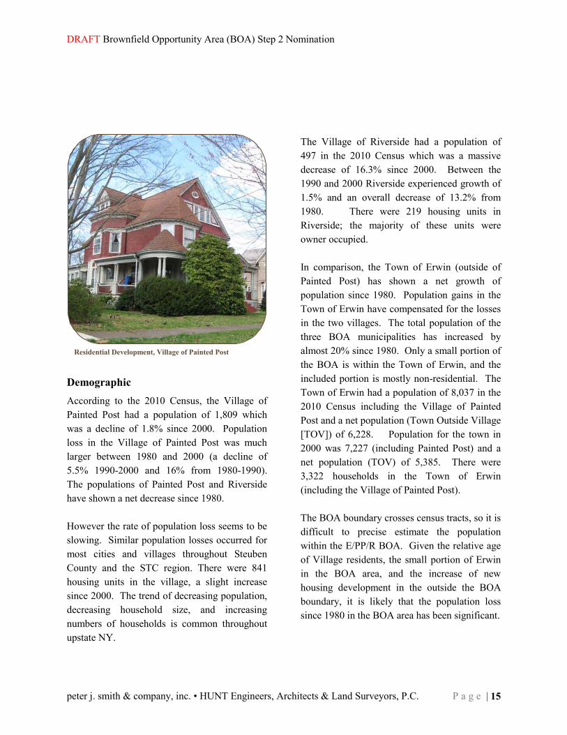
Demographic According to the 2010 Census, the Village of Painted Post had a population of 1,809 which was a decline of 1.8% since 2000. Population loss in the Village of Painted Post was much larger between 1980 and 2000 (a decline of 5.5% 1990-2000 and 16% from 1980-1990). The populations of Painted Post and Riverside have shown a net decrease since 1980. However the rate of population loss seems to be slowing. Similar population losses occurred for most cities and villages throughout Steuben County and the STC region. There were 841 housing units in the village, a slight increase since 2000. The trend of decreasing population, decreasing household size, and increasing numbers of households is common throughout upstate NY.
The Village of Riverside had a population of 497 in the 2010 Census which was a massive decrease of 16.3% since 2000. Between the 1990 and 2000 Riverside experienced growth of 1.5% and an overall decrease of 13.2% from 1980. There were 219 housing units in Riverside; the majority of these units were owner occupied. In comparison, the Town of Erwin (outside of Painted Post) has shown a net growth of population since 1980. Population gains in the Town of Erwin have compensated for the losses in the two villages. The total population of the three BOA municipalities has increased by almost 20% since 1980. Only a small portion of the BOA is within the Town of Erwin, and the included portion is mostly non-residential. The Town of Erwin had a population of 8,037 in the 2010 Census including the Village of Painted Post and a net population (Town Outside Village [TOV]) of 6,228. Population for the town in 2000 was 7,227 (including Painted Post) and a net population (TOV) of 5,385. There were 3,322 households in the Town of Erwin (including the Village of Painted Post). The BOA boundary crosses census tracts, so it is difficult to precise estimate the population within the E/PP/R BOA. Given the relative age of Village residents, the small portion of Erwin in the BOA area, and the increase of new housing development in the outside the BOA boundary, it is likely that the population loss since 1980 in the BOA area has been significant.
Residential Development, Village of Painted Post
Town of Erwin • Village of Painted Post • Village of Riverside
16 | P a g e Southern Tier Central (STC) Regional Planning & Development Board
Town of Erwin • Village of Painted Post • Village of Riverside
Figure 2: Population & Density by Census Block
Figure 2: Population & Density by Census Block
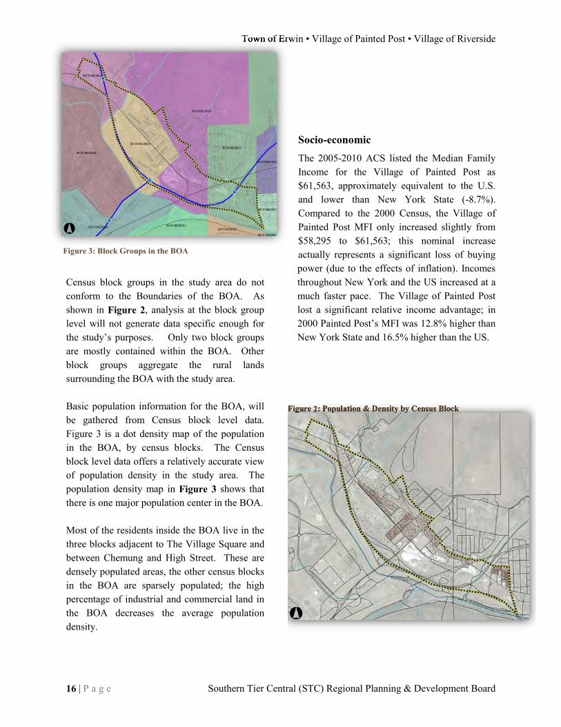
Census block groups in the study area do not conform to the Boundaries of the BOA. As shown in Figure 2, analysis at the block group level will not generate data specific enough for the study’s purposes. Only two block groups are mostly contained within the BOA. Other block groups aggregate the rural lands surrounding the BOA with the study area. Basic population information for the BOA, will be gathered from Census block level data. Figure 3 is a dot density map of the population in the BOA, by census blocks. The Census block level data offers a relatively accurate view of population density in the study area. The population density map in Figure 3 shows that there is one major population center in the BOA. Most of the residents inside the BOA live in the three blocks adjacent to The Village Square and between Chemung and High Street. These are densely populated areas, the other census blocks in the BOA are sparsely populated; the high percentage of industrial and commercial land in the BOA decreases the average population density.
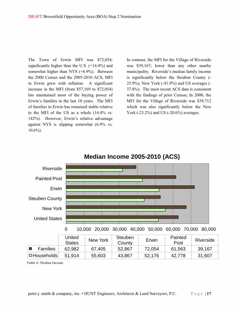
Socio-economic The 2005-2010 ACS listed the Median Family Income for the Village of Painted Post as $61,563, approximately equivalent to the U.S. and lower than New York State (-8.7%). Compared to the 2000 Census, the Village of Painted Post MFI only increased slightly from $58,295 to $61,563; this nominal increase actually represents a significant loss of buying power (due to the effects of inflation). Incomes throughout New York and the US increased at a much faster pace. The Village of Painted Post lost a significant relative income advantage; in 2000 Painted Post’s MFI was 12.8% higher than New York State and 16.5% higher than the US.
Figure 3: Block Groups in the BOA
DRAFT Brownfield Opportunity Area (BOA) Step 2 Nomination
peter j. smith & company, inc. • HUNT Engineers, Architects & Land Surveyors, P.C. P a g e | 17
0 10,000 20,000 30,000 40,000 50,000 60,000 70,000 80,000
United States
New York
Steuben County
Erwin
Painted Post
Riverside
United States
New York Steuben County
Erwin Painted
Post Riverside
Families 62,982 67,405 52,867 72,054 61,563 39,167
Households 51,914 55,603 43,867 52,176 42,778 31,607
Median Income 2005-2010 (ACS)
The Town of Erwin MFI was $72,054; significantly higher than the U.S. (+14.4%) and somewhat higher than NYS (+6.9%). Between the 2000 Census and the 2005-2010 ACS, MFI in Erwin grew with inflation. A significant increase in the MFI (from $57,169 to $72,054) has maintained most of the buying power of Erwin’s families in the last 10 years. The MFI of families in Erwin has remained stable relative to the MFI of the US as a whole (14.4% vs. 142%). However, Erwin’s relative advantage against NYS is slipping somewhat (6.9% vs. 10.6%).
In contrast, the MFI for the Village of Riverside was $39,167; lower than any other nearby municipality. Riverside’s median family income is significantly below the Steuben County (-25.9%), New York (-41.9%) and US averages (-37.8%). The most recent ACS data is consistent with the findings of prior Census; In 2000, the MFI for the Village of Riverside was $39,712 which was also significantly below the New York (-23.2%) and US (-20.6%) averages.
Table 4: Median Income

Town of Erwin • Village of Painted Post • Village of Riverside
18 | P a g e Southern Tier Central (STC) Regional Planning & Development Board
Median Household Income (MHI) is commonly used to measure private income within a household and is one of the most widely accepted descriptive measures of income. Income is made up of pre-tax receipts of all residents in the household over 15 years of age and includes not only wages and salaries but also unemployment insurance, disability and child support. Individuals within the household do not have to be related and the measure does not take into account the size of the household. According to the 2010 American Community Survey, households in the Village of Painted Post had a median household income (MHI) of $42,778; a nominal increase from the 2000 Census. Household income for the Village of Riverside was significantly lower with a MHI of $31,607; household incomes in Riverside actually fell, 2000-2010. As discussed earlier, there is only a small portion of the Town of Erwin is within the BOA study area. However, MHI in the Town of Erwin including the Village of Painted Post was $52,176; an increase of several thousand dollars from the 2000 Census. These results show there is a significant income disparity between the municipalities in the BOA. Furthermore, households within the core urbanized area are significantly disadvantaged.
Median Family Income (MFI) takes into account only households where two or more persons are related by birth, marriage or adoption. It is used by the US Department of Housing and Urban Development (HUD) to determine eligibility for housing levels and is directly dependent on family size. MFI helps to show income disparity and economic stress as well as to help determine eligibility for Community Development Block Grants (CDBG), housing, water & sewer, and other grant and loan programs. The National Association of Realtors also uses the measure to determine the affordability of housing for a “typical” family. Per Capita Personal Income (PCPI) indicates a community’s standard of living and is often used to compare economic conditions between geographic areas. It is calculated by taking personal income from all sources and dividing it by the resident population of the area. The 2000 Census and 2005-2010 ACS, showed a similar distribution of income for the communities of the BOA. The Town of Erwin had a higher per capita income compared to the Village of Painted Post, Village of Riverside, Steuben County, New York and the United States. On the other hand, the Village of Riverside had a PCPI which was significantly lower than the other two BOA communities and lower than Steuben County, New York State and the United States.
DRAFT Brownfield Opportunity Area (BOA) Step 2 Nomination
peter j. smith & company, inc. • HUNT Engineers, Architects & Land Surveyors, P.C. P a g e | 19
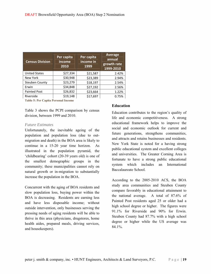
Table 5: Per Capita Personal Income Table 3 shows the PCPI comparison by census division, between 1999 and 2010.
Future Estimates
Unfortunately, the inevitable ageing of the population and population loss (due to out-migration and death) in the BOA area is likely to continue in a 15-20 year time horizon. As illustrated in the population pyramid, the ‘childbearing’ cohort (20-39 years old) is one of the smallest demographic groups in the community; these municipalities cannot rely on natural growth or in-migration to substantially increase the population in the BOA. Concurrent with the aging of BOA residents and slow population loss, buying power within the BOA is decreasing. Residents are earning less and have less disposable income; without outside intervention, only businesses serving the pressing needs of aging residents will be able to thrive in this area (physicians, drugstores, home health aides, prepared meals, driving services, and housekeepers).
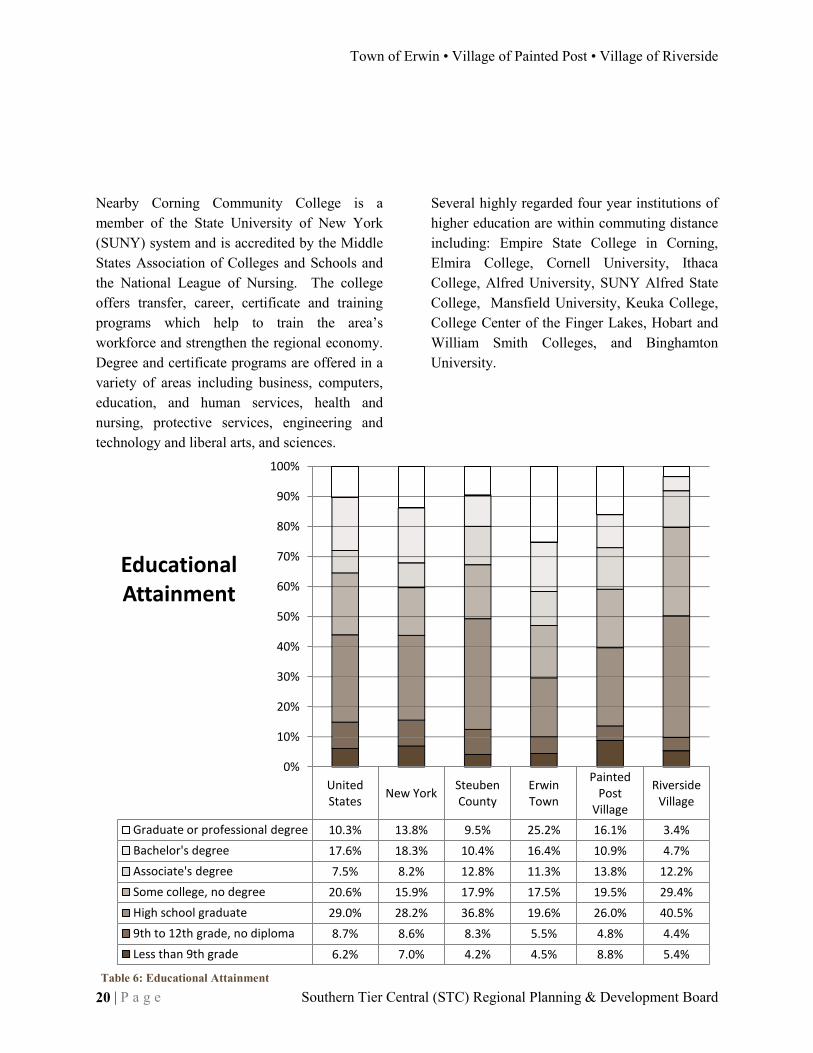
Education Education contributes to the region’s quality of life and economic competitiveness. A strong educational framework helps to improve the social and economic outlook for current and future generations, strengthens communities, and attracts and retains businesses and residents. New York State is noted for a having strong public educational system and excellent colleges and universities. The Greater Corning Area is fortunate to have a strong public educational system which includes an International Baccalaureate School. According to the 2005-2010 ACS, the BOA study area communities and Steuben County compare favorably in educational attainment to the national average. A total of 87.6% of Painted Post residents aged 25 or older had a high school degree or higher. The figures were 91.1% for Riverside and 90% for Erwin. Steuben County had 87.7% with a high school degree or higher while the US average was 84.1%.
Census Division Per capita
income 2010
Per capita income in
1999
Average annual
growth rate 1999-2010
United States $27,334 $21,587 2.42%
New York $30,948 $23,389 2.94%
Steuben County $23,279 $18,197 2.54%
Erwin $34,848 $27,192 2.56%
Painted Post $26,832 $23,664 1.22%
Riverside $19,148 $17,697 0.75%
Town of Erwin • Village of Painted Post • Village of Riverside
20 | P a g e Southern Tier Central (STC) Regional Planning & Development Board
United States
New York Steuben County
Erwin Town
Painted Post
Village
Riverside Village
Graduate or professional degree 10.3% 13.8% 9.5% 25.2% 16.1% 3.4%
Bachelor's degree 17.6% 18.3% 10.4% 16.4% 10.9% 4.7%
Associate's degree 7.5% 8.2% 12.8% 11.3% 13.8% 12.2%
Some college, no degree 20.6% 15.9% 17.9% 17.5% 19.5% 29.4%
High school graduate 29.0% 28.2% 36.8% 19.6% 26.0% 40.5%
9th to 12th grade, no diploma 8.7% 8.6% 8.3% 5.5% 4.8% 4.4%
Less than 9th grade 6.2% 7.0% 4.2% 4.5% 8.8% 5.4%
0%
10%
20%
30%
40%
50%
60%
70%
80%
90%
100%
Educational Attainment
Nearby Corning Community College is a member of the State University of New York (SUNY) system and is accredited by the Middle States Association of Colleges and Schools and the National League of Nursing. The college offers transfer, career, certificate and training programs which help to train the area’s workforce and strengthen the regional economy. Degree and certificate programs are offered in a variety of areas including business, computers, education, and human services, health and nursing, protective services, engineering and technology and liberal arts, and sciences.
Several highly regarded four year institutions of higher education are within commuting distance including: Empire State College in Corning, Elmira College, Cornell University, Ithaca College, Alfred University, SUNY Alfred State College, Mansfield University, Keuka College, College Center of the Finger Lakes, Hobart and William Smith Colleges, and Binghamton University.
Table 6: Educational Attainment

DRAFT Brownfield Opportunity Area (BOA) Step 2 Nomination
peter j. smith & company, inc. • HUNT Engineers, Architects & Land Surveyors, P.C. P a g e | 21
$14,369 $22,433 $22,621 $23,011
$31,666 $32,786 $33,809 $34,590 $35,365
$41,411 $42,459
$51,456 $56,653 $59,528
$68,166 $76,018
$133,057
$0 $40,000 $80,000 $120,000
Accommodation and Food Services Retail Trade
Agriculture, Forestry, Fishing Hunting Other Services
Health and Education Transportation and Warehousing
Information Arts, Entertainment, and Recreation
Construction Government
Wholesale Trade Administrative and Waste Services
Mining Manufacturing
FIRE Utilities
Management and Professional
Steuben County Average Annual Wages
Economic Environment The greater Corning area is unique in the “post-industrial” northeast. Major manufacturing companies retain strong operations in this area. Specifically, Dresser-Rand has prospered in this financial climate. The location of Dresser-Rand, Sitel, and Corning Incorporated in the vicinity of the BOA are examples of the economic opportunities available to industry in this area. Larger retail operations (such as Wal-Mart, Home Depot, and Wegmans) are not only contributing to the local economy, but these businesses are benefiting from the skills of local workers and the consumer demand of local residents.
According to the New York State Department of Labor, average annual wages in 2010 for Steuben County for all industries was $48,733. New York State averaged $60,263 for the same period. Through 2010 the highest paid category of employees in Steuben County was Management and Professional, with an average annual wage of $133,057. Utility employees/workers were the second highest paid group of employees in the county at $76,018 annually. These jobs require skills and experience, the high wage is a reflection of the value added by the labor of these workers.
Table 7: Average Annual Wages
Town of Erwin • Village of Painted Post • Village of Riverside
22 | P a g e Southern Tier Central (STC) Regional Planning & Development Board
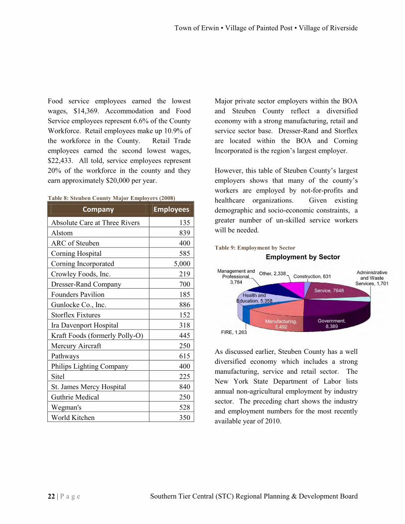
Food service employees earned the lowest wages, $14,369. Accommodation and Food Service employees represent 6.6% of the County Workforce. Retail employees make up 10.9% of the workforce in the County. Retail Trade employees earned the second lowest wages, $22,433. All told, service employees represent 20% of the workforce in the county and they earn approximately $20,000 per year. Table 8: Steuben County Major Employers (2008)
Company Employees
Absolute Care at Three Rivers 135 Alstom 839 ARC of Steuben 400 Corning Hospital 585 Corning Incorporated 5,000 Crowley Foods, Inc. 219 Dresser-Rand Company 700 Founders Pavilion 185 Gunlocke Co., Inc. 886 Storflex Fixtures 152 Ira Davenport Hospital 318 Kraft Foods (formerly Polly-O) 445 Mercury Aircraft 250 Pathways 615 Philips Lighting Company 400 Sitel 225 St. James Mercy Hospital 840 Guthrie Medical 250 Wegman's 528 World Kitchen 350
Major private sector employers within the BOA and Steuben County reflect a diversified economy with a strong manufacturing, retail and service sector base. Dresser-Rand and Storflex are located within the BOA and Corning Incorporated is the region’s largest employer. However, this table of Steuben County’s largest employers shows that many of the county’s workers are employed by not-for-profits and healthcare organizations. Given existing demographic and socio-economic constraints, a greater number of un-skilled service workers will be needed. Table 9: Employment by Sector
As discussed earlier, Steuben County has a well diversified economy which includes a strong manufacturing, service and retail sector. The New York State Department of Labor lists annual non-agricultural employment by industry sector. The preceding chart shows the industry and employment numbers for the most recently available year of 2010.

DRAFT Brownfield Opportunity Area (BOA) Step 2 Nomination
peter j. smith & company, inc. • HUNT Engineers, Architects & Land Surveyors, P.C. P a g e | 23
Steuben County Employment for 2010 shows a pattern of diversified employment. The service and government sectors are the largest with 20.9% and 22.9% of employees, respectively. Manufacturing (15%) and health and education (14.6%) are also significant in the local economy. Management and professional workers represent 10.3% of workers in the County. Combined employment in the smaller sectors of Finance, Insurance and Real Estate (FIRE) (3.5%), construction (1.8%), administrative and waste services (4.6%), other (6.4%) amounts to approximately 16.3 % of employment.
Employment Indicators In the State of NY, 63.7% of the population claimed to be a part of the labor force, and 7.5% claimed to be unemployed. In Steuben County, 61.3% of residents were a part of the labor force and 8.0% self-reported as un-employed. Within the Town of Erwin 6,140 people were of working age; approximately 56% reported being in the labor force and only 5.1% reported being unemployed. In the Village of Painted Post, a total of 1539 individuals were of working age; only 65.9% are in the labor force and 4.5% self-reported as unemployed. A total of 328 individuals from the Village of Riverside were of working age with approximately 64.6% are in the labor force; the unemployment rate in Riverside is highest, at 11.0%.
Dresser Rand Facility, Village of Painted Post

Town of Erwin • Village of Painted Post • Village of Riverside
24 | P a g e Southern Tier Central (STC) Regional Planning & Development Board
Certain conclusions can be drawn about the E/PP/R BOA, based upon the 2005-2010 ACS. A high proportion of the population is not participating in the workforce (due to age, injury, education, or lack of opportunity). Attempts should be made to attract bolster the existing workforce and to attract young migrants.
Current Community Features/Conditions There are several defining features of this community, both physical and social. Physically, the central location of this area (relative to the surrounding rural towns) was a key to the development of the town of Erwin and the Villages of Painted Post and Riverside. The river was a developmental asset before the 1940’s because it was used for transportation of goods and people; now the practical feature of the River is in water availability to industry.
The designation of Rt. 17 into I-86, and Rt. 15 and into I-99 is an outstanding asset to the community. The road networks intersecting in the BOA are a strong community feature. The Villages of Painted Post and Riverside and the Town of Erwin are strategically located adjacent to the Interstate 86 and U.S. Route 15 (future I-99) interchange which is part of the New York State Trade Corridor. Interstate 86 serves as a major east-west corridor along New York’s Southern Tier. The New York State portion of I-99 is in the final design phase and is expected to increase north-south trade and economic development opportunities between Canada to the north and all points south of New York. The major physical features in the Brownfield Opportunity Area include: the new interstate junction and the Dresser-Rand manufacturing facility. Other features of note are an active railway, the Storflex manufacturing facility, an International Baccalaureate High School (Corning-Painted Post West High School).
Former Painted Post High School
DRAFT Brownfield Opportunity Area (BOA) Step 2 Nomination
peter j. smith & company, inc. • HUNT Engineers, Architects & Land Surveyors, P.C. P a g e | 25
Only one small steep patch of hillside remains a greenfield in the BOA. Redevelopment efforts have been limited to the repair of existing buildings and expansions on existing buildings. The social features of this community include strong community groups like Painted Post Forward and the Painted Post Rotary. Residents have active involvement in the American Red Cross, the United Way, the Salvation Army, Habitat for Humanity, and Steuben Church People Against Poverty. Pipeline for Progress and the Association of University Women work to involve members in the community. This area shares a rich history with fraternal organizations like: The Loyal Order of Moose, The Benevolent and Protective Order of Elks, the Knights of Columbus, and the Lions Clubs International. Arts organizations are thriving in the greater Corning area; organizations like the ARTS of the Southern Finger Lakes, the Orchestra of the Southern Finger Lakes, and the Erwin Painted Post Museum. Local residents practice ideals such as hard work, frugality, and service to the community. Conditions in the community are comparable for municipalities formed between 1820 and 1950. The housing stock and the population are aging.
Workers within the community have generally short commutes, on average between fifteen and twenty minutes (14.9 min. for the Village of Painted Post, 19 min. for the Town of Erwin and, 20.1 minutes for the Village of Riverside). The commute for residents in the study area is substantially shorter than for residents in the county (21.6 minutes), New York State (31.4 minutes), and significantly below the national average (25.5 minutes). The short commute saves time and lowers fuel costs for local residents. This community is attractive for homebuyers due to the shorter commute.
Economic Trends Corning Incorporated and Dresser-Rand Company are the two largest local employers with a combined workforce of 5,700 employees. Although manufacturing employment peaked in the 1960’s the region continues to maintain comparatively high manufacturing employment when benchmarked with state and national levels. During the period of 2001 through 2003, the greater Corning area and Steuben County area experienced economic and job cutbacks. Corning Incorporated’s Photonics Division located in the Town of Erwin was particularly impacted, final retrenchment figures for the photonics plant were greater than 2000 and cut employees. Recent positive employment trends have aided the expansion of the Corning Diesel Filter Plant and the addition of Sitel, a global call center company.

Town of Erwin • Village of Painted Post • Village of Riverside
26 | P a g e Southern Tier Central (STC) Regional Planning & Development Board
LAND USE Development Trends The Brownfield Opportunity Area is located in the Corning, New York Metropolitan Statistical Area in Steuben County. The proposed BOA is centrally located within the Southern Tier of central New York State. On a local level, the BOA is divided among the Town of Erwin and the Villages of Painted Post and Riverside; the majority of properties and acreage are located within the Village of Painted Post. See Figure 1 for more detail on the BOA location. The identified BOA has already been developed; current development trends are taking place in the suburbs, away from the urbanized core of the Village of Painted Post. All three municipal governments have prioritized attracting new development. The involved municipalities are partnering with local development organizations to attract to retain complementary businesses. Three Rivers Development Corporation is attempting to focus compatible developments to this region. Local community groups have worked through prior development concerns and these community groups have identified several forms of redevelopment that match their long term vision of the BOA. Groups like Painted Post Forward have been involved with the BOA from the beginning, and are seriously pursuing a variety of economic development opportunities. Local leaders have identified several key areas in the community that are ripe for redevelopment.
Within the BOA there is ample space to locate or expand new businesses. Strong community ties and local pride in this area would help to support any future commercial endeavors. Steuben county residents are extremely cost conscious, and would relish any opportunity to “do business” closer to home. Two strong land use development trends exist within the defined BOA study area. The first trend is the adaptive re-use of existing properties. Commercial landowners are the main proponents of adaptive re-use. Structurally-sound buildings located in the developed urban area are re-purposed to suit the needs of the new owners. This trend is strongest where the building is in good condition. For example, the former Pizza Hut in the Cinema Plaza (near Site #7) is being renovated as a Moose Lodge; Site #7 was formerly Jamison’s Marine and is being redeveloped as Lucky’s Auto; the former Trixie’s Restaurant (Brownfield, Site #52) is now the Crystal Cleaners. To understand which buildings have re-development potential and which parcels are potential ‘shovel-ready sites’, an assessment and condition study of the structures, buildings and facilities on the project sites will be conducted. The other strong land development pattern is the renovation of existing uses. Residential landowners are the most common renovators. Residential buildings are the most common type of building in the BOA, comprising 156 acres of land within the 494 acre BOA.

DRAFT Brownfield Opportunity Area (BOA) Step 2 Nomination
peter j. smith & company, inc. • HUNT Engineers, Architects & Land Surveyors, P.C. P a g e | 27
There are no buildable greenfields within the BOA boundary. Without any incentives in place, development demand on brownfields in the BOA is limited. In the existing economic environment, developers are very likely to generate highway oriented sprawl on the rural lands surrounding the dense Brownfield Opportunity Area. The Brownfield Opportunity Area is primed for re-construction. Roadways and utilities are in place. Large sites adjacent to population clusters are available. Creating a new trend centered on brownfield re-development would be an ideal way to incorporate the pockets of adaptive re-use with the vacant, underutilized and brownfield sites in the EPPR BOA, where utility service is already provided.
Land Use The existing land use pattern in the Erwin/Painted Post/Riverside BOA has evolved out of the Native American past of New York’s Southern Tier. The Cohocton River flowing east joins the Tioga River flowing north from Pennsylvania at the site of the “Painted Post” which begins the Chemung River. Early settlers followed the Chemung River and Native American trails and founded small settlements at this prime location. Soon the area was dominated by farming in the floodplains and forestry on the steep hills surrounding the busy commercial centers along the rivers. As the population in the area grew, easily developed areas with good soils and little slope along transportation routes became more densely settled. Marginal land on steep slopes and in
poorly drained wetlands was not put to use for residential or commercial use and the beautiful hillsides surrounding the Erwin/Painted Post/Riverside BOA remained undeveloped. Large tracts of industrial land in Painted Post were devoted to manufacturing; all of that land is included in the BOA. In 1899 the Rand Drill Company, later merging with Ingersoll-Sargeant Company to form Ingersoll-Rand, began manufacturing compressors in Painted Post, New York This thriving company continued to expand and workers lived in the surrounding dense residential neighborhoods. The village center prospered providing the needed support businesses and services. Schools, parks and community buildings were built and a close-knit community was created.
This picture shows the extent of urban development in the village by 1916. Densely clustered multi-use buildings line the major transportation corridors, and vast fields spread out toward the low hills.
1916 Photo overlooking Painted Post's Village Square, courtesy of Mr. Erwin
Town of Erwin • Village of Painted Post • Village of Riverside
28 | P a g e Southern Tier Central (STC) Regional Planning & Development Board
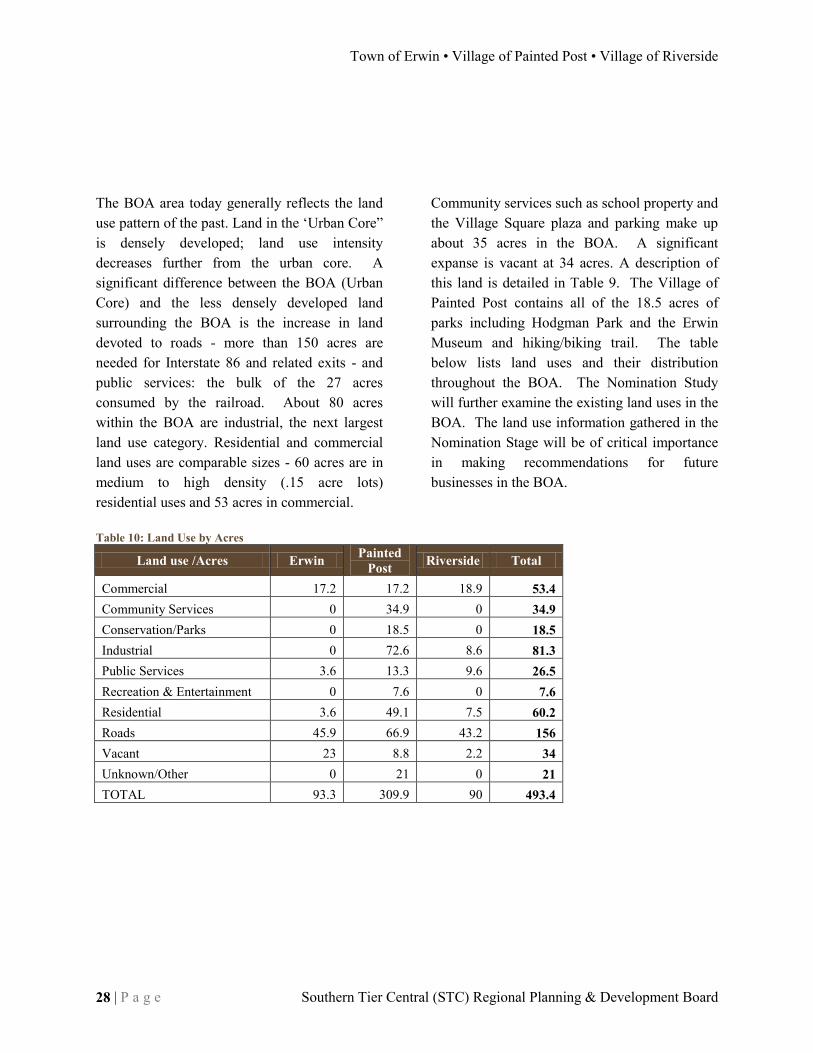
The BOA area today generally reflects the land use pattern of the past. Land in the ‘Urban Core” is densely developed; land use intensity decreases further from the urban core. A significant difference between the BOA (Urban Core) and the less densely developed land surrounding the BOA is the increase in land devoted to roads - more than 150 acres are needed for Interstate 86 and related exits - and public services: the bulk of the 27 acres consumed by the railroad. About 80 acres within the BOA are industrial, the next largest land use category. Residential and commercial land uses are comparable sizes - 60 acres are in medium to high density (.15 acre lots) residential uses and 53 acres in commercial. Table 10: Land Use by Acres
Community services such as school property and the Village Square plaza and parking make up about 35 acres in the BOA. A significant expanse is vacant at 34 acres. A description of this land is detailed in Table 9. The Village of Painted Post contains all of the 18.5 acres of parks including Hodgman Park and the Erwin Museum and hiking/biking trail. The table below lists land uses and their distribution throughout the BOA. The Nomination Study will further examine the existing land uses in the BOA. The land use information gathered in the Nomination Stage will be of critical importance in making recommendations for future businesses in the BOA.
Land use /Acres Erwin Painted
Post Riverside Total
Commercial 17.2 17.2 18.9 53.4 Community Services 0 34.9 0 34.9 Conservation/Parks 0 18.5 0 18.5 Industrial 0 72.6 8.6 81.3 Public Services 3.6 13.3 9.6 26.5 Recreation & Entertainment 0 7.6 0 7.6 Residential 3.6 49.1 7.5 60.2 Roads 45.9 66.9 43.2 156 Vacant 23 8.8 2.2 34 Unknown/Other 0 21 0 21 TOTAL 93.3 309.9 90 493.4

DRAFT Brownfield Opportunity Area (BOA) Step 2 Nomination
peter j. smith & company, inc. • HUNT Engineers, Architects & Land Surveyors, P.C. P a g e | 29
Land Use Map

Town of Erwin • Village of Painted Post • Village of Riverside
30 | P a g e Southern Tier Central (STC) Regional Planning & Development Board

DRAFT Brownfield Opportunity Area (BOA) Step 2 Nomination
peter j. smith & company, inc. • HUNT Engineers, Architects & Land Surveyors, P.C. P a g e | 31
ZONING Existing zoning regulations in the three BOA communities have their roots in zoning laws adopted in the 1960’s that segregate “sensitive” uses, such as residential, from “incompatible” uses such as commercial and industrial. It made sense to protect neighborhoods from heavy industrial uses and the noise, traffic and pollution that accompanied industry in those days. Since then, as a response to the destruction caused by Tropical Storm Agnes Flood in 1972 to the downtown, Painted Post created planned commercial and planned urban center districts which allowed more flexibility in layout and uses for the Village of Painted Post downtown area.
In Erwin and Painted Post, a “mixed-use” category was added in the 1990’s to permit any zoning district to allow two or more land uses to exist on one property, thus expanding development options. Erwin also adopted development standards for urban landscapes which encourage infill development to match the classic village center. Riverside has made small changes to its original zoning law, but intends to make updates based on information and policy guidance provided by the BOA project. The current zoning laws for each BOA community can be found on the STC webpage: www.stcplanning.org then click on “Local Laws and Plans.”
Table 11: Zoning by Acres Zoning Description Acres Rural Residential Mixed-use Commercial Industrial Utilities/Roads
Erw
in
Business 3 - Neighborhood Services 46 46
Regional Service 21.7 21.7
Multi-Use District 3.2 3.2
Rural District 20.1 20.1
Erwin Total 91 20.1 0 3.2 67.7 0 0
Pai
nte
d P
ost
Urban Center Residential 93.6 93.6
Industrial 55.4 55.4
Planned Residential District 13.6 13.6
Planned Commercial District 14.5 14.5
Business 3.2 3.2
Industrial 65.4 65.4
Route 17 15.9 15.9
Flood Plain Protection District 0
Urban Center 3.7 3.7
Medium Density Residential 45.1 45.1
Painted Post Total 310.5 0 152.4 3.7 17.7 120.8 15.9
Riv
ersi
de Residential 35.9 35.9
Commercial 12.2 12.2
Industrial 42.9 42.9
Riverside Total 91 0 35.9 0 12.2 42.9 0
TOTAL 493.4 20.1 188.3 6.9 97.6 164.7 15.9

Town of Erwin • Village of Painted Post • Village of Riverside
32 | P a g e Southern Tier Central (STC) Regional Planning & Development Board
Commercially-zoned areas inside the BOA are concentrated at the east and west intersections of I-86 and Rt. 415. About 70 acres of the 91 acres of Erwin in the BOA are zoned various types of commercial. Almost all of the Village of Painted Post’s and Riversides’ commercially zoned land, (about 20 and 12 acres respectively) is located in the BOA. The areas zoned industrial in the BOA are located in the center of the community in Painted Post and Riverside. This totals about 120 acres in Painted Post and 43 acres in Riverside. In the BOA there exists one primary residential area along Rt. 415 beginning at the western edge of Riverside and continuing toward the western border of Painted Post. In the center of the BOA, southwest of Rt. 415, a densely populated residential area dominates the landscape. There is also an isolated residential area surrounded by the highway and commercial/industrial zones in Riverside. Residentially-zoned land makes up almost 200 acres. See Table 7 for the acreage breakdown and Figure 19 for the zoning district map.
Special Districts In the past, local economic development activities have not focused on the Brownfield Opportunity Area. This BOA was deprived of some of the special districting opportunities available to larger or less productive communities. The Painted Post area is now in need of concentrated revitalization efforts which may include the creation of a special improvement district.
In the surrounding area there are several existing development districts. The City of Corning is the home of most of the local development districts: the Gaffer District, CIDMA, and many NYS Empire Zone parcels. The Gaffer District is the City of Corning’s Business improvement District; the gaffer district is an organization centered in corning, responsible for business recruitment, event promotion, and branding in Corning’s Downtown. CIDMA is the Corning In-town District Management Agency, primarily responsible for physical maintenance in the Gaffer District. In spite of other local communities’ development efforts, there are no existing economic development districts inside the BOA. Only BOA parcel #18 is in an Empire Zone. There is little potential in the EPPR BOA for the creation of a special district. The BOA project is the joint framework for making/implementing recommendations in the three municipalities. The creation of a special district would face three major fronts of resistance: funding, authority, and scope. Local government budgets cannot afford funding the creation of a new organization. Even if funding became available, disagreement would exist on the percent of funding provided by each municipality. Attempting to create an organization with intra-jurisdictional power is highly infeasible. Finally, it is unlikely that the municipalities would agree on the scope (goals) of a BOA wide organization, given that the steps necessary to improve conditions in each community differ.

DRAFT Brownfield Opportunity Area (BOA) Step 2 Nomination
peter j. smith & company, inc. • HUNT Engineers, Architects & Land Surveyors, P.C. P a g e | 33
Zoning Map

Town of Erwin • Village of Painted Post • Village of Riverside
34 | P a g e Southern Tier Central (STC) Regional Planning & Development Board

DRAFT Brownfield Opportunity Area (BOA) Step 2 Nomination
peter j. smith & company, inc. • HUNT Engineers, Architects & Land Surveyors, P.C. P a g e | 35
TRANSPORTATION & INFRASTRUCTURE Water All properties within the BOA are served by Village of Painted Post public water. The Village of Painted Post uses three wells to supply water: Well #2 has a capacity of 500 gallons per minute (GPM), Well #3 pumps about 500 GPM (capacity is 750 GPM) and Well #4 is permitted at 1000 GPM though pumps from 800 to 900 GPM on average. They were constructed in 1941, 1956 and 1975 respectively. The Village also has two water storage tanks: a 1.5 million gallon tank on Reservoir Road and a 50,000 gallon tank to on West Hill Terrace. The distribution system is adequate to provide water to customers. The Village of Riverside is served by the Village of Painted Post with back-up interconnection with the City of Corning. Painted Post serves the Town of Erwin to the Victory Highway Wesleyan Church on Route 415 though it is expected that the Coopers Plains Water District project will be complete by the end of 2009, providing water to the Erwin BOA and beyond from the Morningside Heights wells in Gang Mills. However, the new water service will be interconnected with Painted Post as emergency back-up.
In the fall of 2002 the City of Corning, Village of Painted Post, Village of Riverside, Town of Erwin, and the Town of Corning undertook the Valley Water Supply Study to identify cost effective ways of providing water service throughout the communities, to explore new administrative options, and to create a Drought Management Plan to protect critical drinking water and industrial needs during dry seasons such as the one experienced in 1999-2001. Results of the study show a long term advantage to the communities to consider new ways to provide water to the Chemung Valley. The oversight committee continued to study the matter. Most recently, with the economic downturn, interest in shared services has increased and the idea of a regional water supply system may become a priority again.
Sewers The entire BOA is served by public sewer service. The Village of Painted Post owns and operates a wastewater treatment plant (WWTP) with a capacity of 500,000 gallons per day (GPD). The average daily load is approximately one half of capacity, leaving approximately 250,000 gallons/day for future growth. A 2.0 million dollar upgrade of the Painted Post WWTP, completed in 2001, brought the plant into compliance with its state discharge permit. The City of Corning provides sewer service to the Village of Riverside. The BOA portion of the Town of Erwin is served by the Village of Painted Post.

Town of Erwin • Village of Painted Post • Village of Riverside
36 | P a g e Southern Tier Central (STC) Regional Planning & Development Board
Roads The Erwin/Painted Post/Riverside BOA was formed around the intersection of I-99, I-86, and Rt. 415. These local roadways see a great deal of daily traffic and are a fundamental connection between Erwin/Painted Post/Riverside. SR 415 within the BOA is classified as an Urban Minor Arterial. The function of this highway is intended to distribute traffic between the larger Interstate System and the lower Local system. Preserving/enhancing mobility along this corridor is important because it serves as the preeminent link between the BOA and the interstate via Exits 43, 44, 45, and 46.
The level of service for a given section of highway can be calculated using traffic volumes, lane widths, travel speeds, signal timing, and a variety of other data inputs. Those computations have not been generated at this time. Traffic volumes indicate the demand placed on a given facility. SR 415 has traffic volumes of 11,000 + vehicles per day (VPD) to 6,000+ vehicles per day (see figure 9). Note the larger volumes occur on the 4-lane facilities. During the pre-nomination phase, basic traffic information was collected. An assessment and condition of transportation/ circulation systems will be a component of the Nomination stage. The traffic assessment will study those roadways that may face increased use after re-development in the BOA.
Figure 4: Traffic Counts in the BOA

DRAFT Brownfield Opportunity Area (BOA) Step 2 Nomination
peter j. smith & company, inc. • HUNT Engineers, Architects & Land Surveyors, P.C. P a g e | 37
Transportation Map

Town of Erwin • Village of Painted Post • Village of Riverside
38 | P a g e Southern Tier Central (STC) Regional Planning & Development Board
DRAFT Brownfield Opportunity Area (BOA) Step 2 Nomination
peter j. smith & company, inc. • HUNT Engineers, Architects & Land Surveyors, P.C. P a g e | 39
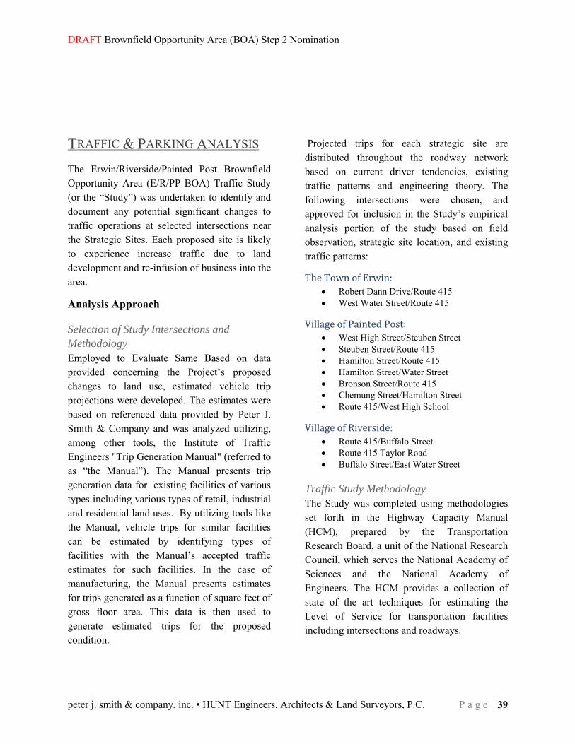
TRAFFIC & PARKING ANALYSIS The Erwin/Riverside/Painted Post Brownfield Opportunity Area (E/R/PP BOA) Traffic Study (or the “Study”) was undertaken to identify and document any potential significant changes to traffic operations at selected intersections near the Strategic Sites. Each proposed site is likely to experience increase traffic due to land development and re-infusion of business into the area.
Analysis Approach
Selection of Study Intersections and
Methodology
Employed to Evaluate Same Based on data provided concerning the Project’s proposed changes to land use, estimated vehicle trip projections were developed. The estimates were based on referenced data provided by Peter J. Smith & Company and was analyzed utilizing, among other tools, the Institute of Traffic Engineers "Trip Generation Manual" (referred to as “the Manual”). The Manual presents trip generation data for existing facilities of various types including various types of retail, industrial and residential land uses. By utilizing tools like the Manual, vehicle trips for similar facilities can be estimated by identifying types of facilities with the Manual’s accepted traffic estimates for such facilities. In the case of manufacturing, the Manual presents estimates for trips generated as a function of square feet of gross floor area. This data is then used to generate estimated trips for the proposed condition.
Projected trips for each strategic site are distributed throughout the roadway network based on current driver tendencies, existing traffic patterns and engineering theory. The following intersections were chosen, and approved for inclusion in the Study’s empirical analysis portion of the study based on field observation, strategic site location, and existing traffic patterns:
The Town of Erwin:
Robert Dann Drive/Route 415 West Water Street/Route 415
Village of Painted Post:
West High Street/Steuben Street Steuben Street/Route 415 Hamilton Street/Route 415 Hamilton Street/Water Street Bronson Street/Route 415 Chemung Street/Hamilton Street Route 415/West High School
Village of Riverside:
Route 415/Buffalo Street Route 415 Taylor Road Buffalo Street/East Water Street
Traffic Study Methodology
The Study was completed using methodologies set forth in the Highway Capacity Manual (HCM), prepared by the Transportation Research Board, a unit of the National Research Council, which serves the National Academy of Sciences and the National Academy of Engineers. The HCM provides a collection of state of the art techniques for estimating the Level of Service for transportation facilities including intersections and roadways.

Town of Erwin • Village of Painted Post • Village of Riverside
40 | P a g e Southern Tier Central (STC) Regional Planning & Development Board
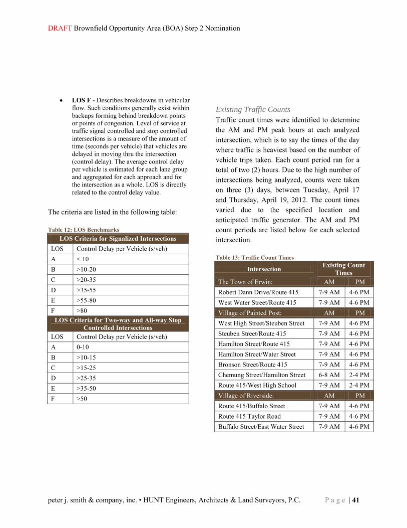
The portion of the Study where empirical data was collected evaluated each intersection’s capacity and Level of Service (LOS). The capacity of an intersection or facility is the maximum hourly rate at which vehicles can reasonably be expected to traverse a point or section of roadway. Level of Service is a quality measure used to describe operational conditions within a traffic stream, generally in terms of such criteria as speed and travel time; freedom to maneuver; traffic interruptions; comfort and convenience. Six (6) LOS categories are recognized for each type of facility that has analysis procedures available. LOS are designated with the letters A thru F with LOS A representing the best operating conditions and LOS F representing the worst. Generally speaking, the various levels of service are defined as follows:
LOS A - Describes free-flow operations. Free-flow speeds prevail. Vehicles are almost completely unimpeded in their ability to maneuver within the traffic stream. The effects of incidents or point breakdowns are easily absorbed at this level.
LOS B - Represents reasonably free-flow with free-flow speeds being maintained. The ability to maneuver within the traffic stream is only slightly restricted, and the general level of physical and psychological comfort provided to drivers is still high. The effects of minor incidents and breakdowns are still easily absorbed.
LOS C - Provides for flow with speeds at or near free-flow conditions. Freedom to maneuver within the traffic stream is noticeably restricted; lane changes require more care and vigilance on the part of the driver. Minor incidents may still be absorbed, but the local deterioration in service will be substantial. Queues may be expected to form behind significant blockage.
LOS D - Is the level at which speeds begin
to decline slightly with increasing flows and density begins to increase somewhat more quickly. Freedom to maneuver within the traffic stream is more noticeably limited, and the driver experiences reduced physical and psychological comfort levels. Even minor incidents can be expected to create queuing, because the traffic stream has little space to absorb disruptions. LOS D is the LOS that is considered acceptable during peak traffic hours in urban areas.
LOS E - Describes operation at capacity.
Operations at this level are volatile, because there are virtually no usable gaps in the traffic stream. Vehicles are closely spaced, leaving little room to maneuver within the traffic stream. Any disruption of the traffic stream, such as vehicles entering from a ramp or a vehicle changing lanes, can establish a disruption wave that propagates throughout the upstream traffic flow. At capacity, the traffic stream has no ability to dissipate even the most minor disruption, and any incident can be expected to produce a serious breakdown with extensive queuing. Maneuverability within the traffic stream is extremely limited, and the level of physical and psychological comfort afforded the driver is poor.
DRAFT Brownfield Opportunity Area (BOA) Step 2 Nomination
peter j. smith & company, inc. • HUNT Engineers, Architects & Land Surveyors, P.C. P a g e | 41
LOS F - Describes breakdowns in vehicular flow. Such conditions generally exist within backups forming behind breakdown points or points of congestion. Level of service at traffic signal controlled and stop controlled intersections is a measure of the amount of time (seconds per vehicle) that vehicles are delayed in moving thru the intersection (control delay). The average control delay per vehicle is estimated for each lane group and aggregated for each approach and for the intersection as a whole. LOS is directly related to the control delay value.
The criteria are listed in the following table: Table 12: LOS Benchmarks
Existing Traffic Counts
Traffic count times were identified to determine the AM and PM peak hours at each analyzed intersection, which is to say the times of the day where traffic is heaviest based on the number of vehicle trips taken. Each count period ran for a total of two (2) hours. Due to the high number of intersections being analyzed, counts were taken on three (3) days, between Tuesday, April 17 and Thursday, April 19, 2012. The count times varied due to the specified location and anticipated traffic generator. The AM and PM count periods are listed below for each selected intersection. Table 13: Traffic Count Times
Intersection
Existing Count
Times
The Town of Erwin: AM PM
Robert Dann Drive/Route 415 7-9 AM 4-6 PM
West Water Street/Route 415 7-9 AM 4-6 PM
Village of Painted Post: AM PM
West High Street/Steuben Street 7-9 AM 4-6 PM
Steuben Street/Route 415 7-9 AM 4-6 PM
Hamilton Street/Route 415 7-9 AM 4-6 PM
Hamilton Street/Water Street 7-9 AM 4-6 PM
Bronson Street/Route 415 7-9 AM 4-6 PM
Chemung Street/Hamilton Street 6-8 AM 2-4 PM
Route 415/West High School 7-9 AM 2-4 PM
Village of Riverside: AM PM
Route 415/Buffalo Street 7-9 AM 4-6 PM
Route 415 Taylor Road 7-9 AM 4-6 PM
Buffalo Street/East Water Street 7-9 AM 4-6 PM
LOS Criteria for Signalized Intersections LOS Control Delay per Vehicle (s/veh) A < 10 B >10-20 C >20-35 D >35-55 E >55-80 F >80
LOS Criteria for Two-way and All-way Stop Controlled Intersections
LOS Control Delay per Vehicle (s/veh) A 0-10 B >10-15 C >15-25 D >25-35 E >35-50 F >50

Town of Erwin • Village of Painted Post • Village of Riverside
42 | P a g e Southern Tier Central (STC) Regional Planning & Development Board
Table 14: Land Uses Considered Section AM Trips PM Trips
Section 140 – Manufacturing 37 37 Section 230 – Residential Condominium/Townhouse 21 26 Section 844 – Gasoline/Service Station 98 117 Section 815 – Free-Standing Discount Store 5 19 Section 816 – Hardware/Paint Store 5 20 Section 832 – High-Turnover (Sit-Down) Restaurant 42 49 Section 833 – Fast-Food Restaurant without Drive-Through Window 197 118 Section 843 – Automobile Parts Sales 10 27 Section 845 – Gasoline Service Station with Convenience Market 350 434 Section 870 – Apparel Store 0 17
Traffic Projections
Growth Rate
A 1.0% per year growth rate has been applied to the existing traffic counts to project traffic volumes to the estimated full build out year of 2032. In the past 5-7 years New York State began shrinking in population and a 0.5% per year growth rate became the accepted value. In this case, due to the location and recent interest in Marcellus shale, we have spoken with NYSDOT planners and verified the usage of the above mentioned 1.0% growth rate.
Trip Generations
Estimated vehicle trip generations were developed based on expected land use data for each strategic site. From these potential land uses, the Institute of Traffic Engineers “Trip Generation Manual” provides expected additional trips for facilities with similar characteristics. In this case, the Manual presents trip generation data for existing facilities of various types including industrial, residential and many types of retail land uses.
The proposed land uses included in these Brownfield Opportunity Areas correspond to the following sections within the Trip Generation Manual: The above trip generation information was then combined, where applicable, to determine general averages for use within the parameters of this study. From this point forward each land use, depending on size, will generate the following amount of trips: Table 15: Base Estimates
Development Type AM PM
Commercial 87 trips/1000 SF 98 trips/1000 SF
Industrial 37 trips/1000 SF 37 trips/1000 SF
Residential 21 trips 26 trips
Truck Stop 98 trips 117 trips
Mixed Use 9 trips/1000 SF 9 trips/1000 SF
Future LOS was determined based upon a moderate projected build-out as defined in the Urban Design Plan within the Summary Analysis, Findings and Recommendations section of this document. See the Traffic Analysis Appendix for additional Trip Generation information.

DRAFT Brownfield Opportunity Area (BOA) Step 2 Nomination
peter j. smith & company, inc. • HUNT Engineers, Architects & Land Surveyors, P.C. P a g e | 43
Table 16: Existing AM Peak Hour LOS Analysis (Seconds of Delay)
Node/Intersection Approach
Overall EB WB NB SB
1. Robert Dann and Route 415 B (10.9) A (4.6) B (10.8) - A (8.6) 4. West Water Street and Route 415 A (3.9) A (3.5) B (12.9) A (0.1) A (3.7) 40. Route 415 and West High School B (15.9) B (11.8) C (27.2) B (12.4) B (16.8) 8. Route 415 and Steuben Street C (23.8) C (20.3) A (2.0) A (0.3) A (4.9) 11. Steuben Street and West High Street A (2.4) A (0.0) - B (10.2) A (4.9) 12. Route 415 and North Hamilton Street C (28.8) C (35.0) B (16.6) B (15.9) C (21.5) 21. North Hamilton Street and Chemung Street A (0.4) A (0.3) B (12.3) B (11.8) A (1.0) 18. North Hamilton Street and West Water Street A (3.5) A (8.1) - B (12.5) A (6.1) 15. Route 415 and Bronson Street A (0.1) A (0.0) C (22.3) C (18.3) A (0.4) 26. Route 415 and Buffalo Street C (22.4) B (14.8) B (18.8) B (17.4) B (13.7) 27. Route 415 and Taylor Street A (0.0) A (0.3) B (14.6) C (16.0) A (0.4) 31. Buffalo Street and East Water Street B (13.7) C (18.5) A (0.2) A (0.1) A (0.7)
Trip Assignments
The newly generated trips were then assigned to the appropriate arriving and/or departing direction for each intersection during the AM and PM peak hour using existing traffic patterns and engineering judgment. Appendix C contains the assumptions which were made for the directional splits of said arriving and departing traffic.
LOS Analysis
The level of service analysis was completed using Synchro by Trafficware. Synchro is traffic analysis software that incorporates the methodologies set forth in the Highway Capacity Manual. This software is accepted and used by state and local governments for traffic analysis, including the New York State Department of Transportation (NYSDOT).
The existing LOS analysis is based on traffic counts taken over a three day period, April 17-19, 2012. The 2032 LOS analysis has a 1.0% growth rate applied uniformly over the approach movements, as well as the distributed trip generations described above.
Existing LOS
The existing AM LOS analysis shows no significant concern areas for the intersections with each intersection and individual movement operating at LOS C or better. The following table summarizes the analyzed intersections, approach LOS, and intersection LOS during their respective AM peak hours:

Town of Erwin • Village of Painted Post • Village of Riverside
44 | P a g e Southern Tier Central (STC) Regional Planning & Development Board
Table 17: Existing PM Peak Hour LOS Analysis (Seconds of Delay)
Node/Intersection Approach
Overall EB WB NB SB
1. Robert Dann and Route 415 B (11.0) A (6.4) B (13.1) - B (10.3) 4. West Water Street and Route 415 A (3.8) A (3.9) B (10.4) A (7.6) A (4.2) 40. Route 415 and West High School B (10.2) A (6.3) C (22.10) B (17.0) B (12.0) 8. Route 415 and Steuben Street B (11.4) B (12.7) A (1.2) A (0.6) A (2.5) 11. Steuben Street and West High Street A (1.7) A (0.0) - A (9.3) A (5.0) 12. Route 415 and North Hamilton Street C (27.8) C (29.4) B (13.6) B (14.8) C (20.7) 21. North Hamilton Street and Chemung Street A (0.6) A (0.1) C (16.8) B (13.9) A (2.5) 18. North Hamilton Street and West Water Street C (26.6) A (8.2) - B (16.0) B (18.4) 15. Route 415 and Bronson Street A (0.1) A (0.0) A (0.0) C (16.4) A (0.4) 26. Route 415 and Buffalo Street B (18.6) C (26.0) B (14.2) C (30.2) C (20.7) 27. Route 415 and Taylor Street A (0.3) A (0.1) B (12.9) C (17.5) A (0.5) 31. Buffalo Street and East Water Street B (14.2) C (23.6) A (0.6) A (0.2) A (2.8)
Traffic counts taken during the existing PM peak hour showed similar results to the AM for each intersection. There were no LOS concerns, with each intersection again operating at LOS C or better. The following table summarizes the analyzed intersections, approach LOS, and intersection LOS during their respective PM peak hours:

DRAFT Brownfield Opportunity Area (BOA) Step 2 Nomination
peter j. smith & company, inc. • HUNT Engineers, Architects & Land Surveyors, P.C. P a g e | 45
Table 18: Existing+20 Years (2032) AM Peak Hour LOS Analysis (Seconds of Delay)
Node/Intersection Approach
Overall EB WB NB SB
1. Robert Dann and Route 415 B (13.2) A (5.1) B (10.9) - B (10.0) 4. West Water Street and Route 415 A (3.8) A (3.6) B (13.8) A (0.1) A (3.7) 40. Route 415 and West High School B (18.5) B (16.8) C (28.7) B (11.9) B (19.9) 8. Route 415 and Steuben Street A (1.7) A (0.3) C (22.1) D (26.6) A (4.6) 11. Steuben Street and West High Street A (2.4) A (0.0) - B (10.1) A (4.9) 12. Route 415 and North Hamilton Street C (22.4) D (38.5) C (24.6) C (28.1) C (27.1) 21. North Hamilton Street and Chemung Street A (0.3) A (0.2) B (12.9) B (12.6) A (0.8) 18. North Hamilton Street and West Water Street A (6.0) A (8.8) - B (15.3) A (7.5) 15. Route 415 and Bronson Street A (0.1) A (4.1) F (82.2) F (62.0) A (3.0) 26. Route 415 and Buffalo Street C (22.8) B (15.8) B (19.2) B (17.4) B (13.0) 27. Route 415 and Taylor Street A (0.0) A (1.4) C (19.2) C (22.1) A (0.9) 31. Buffalo Street and East Water Street C (18.2) D (34.5) A (0.1) A (2.4) A (1.7)
Table 19: Existing+20 Years (2032) PM Peak Hour LOS Analysis (Seconds of Delay)
Node/Intersection Approach
Overall EB WB NB SB
1. Robert Dann and Route 415 B (20.0) A (7.2) B (13.0) - B (14.2) 4. West Water Street and Route 415 B (14.0) B (14.2) A (9.6) A (6.8) B (13.5) 40. Route 415 and West High School B (12.2) A (7.0) C (23.2) B (16.8) B (13.0) 8. Route 415 and Steuben Street B (12.2) B (13.7) A (1.2) A (0.8) A (2.5) 11. Steuben Street and West High Street A (1.7) A (0.0) - A (9.3) A (5.0) 12. Route 415 and North Hamilton Street D (36.0) D (36.7) C (28.3) C (25.0) C (30.3) 21. North Hamilton Street and Chemung Street A (0.6) A (0.1) C (17.3) B (14.1) A (2.6) 18. North Hamilton Street and West Water Street D (35.7) A (9.2) - B (19.9) C (23.1) 15. Route 415 and Bronson Street A (0.1) A (0.0) F (326) E (48.2) F (100) 26. Route 415 and Buffalo Street C (22.2) C (32.8) C (22.3) C (31.9) C (26.2) 27. Route 415 and Taylor Street A (0.3) A (0.1) F (107) C (20.0) C (23.3) 31. Buffalo Street and East Water Street C (15.8) F (328) A (0.6) A (0.2) F (109)
An analysis was performed to estimate the LOS for the study intersections a date 20 years beyond the study date to simulate a full build out condition.
The 1.0% growth rate was applied to each movement at the study intersections as well the application of engineering assumptions which can be found in the Appendix B of this report. The tables below show the results of this future 2032 analysis:

Town of Erwin • Village of Painted Post • Village of Riverside
46 | P a g e Southern Tier Central (STC) Regional Planning & Development Board
This analysis shows that there are a few study intersections which have some LOS related concerns under the full build out condition. During the AM peak hour there are no significant concerns. The PM peak hour does show a few areas which may not presently be equipped to handle the potential increase in traffic due to the redevelopment of each strategic site. The intersection of Route 415 and Bronson Street will need to be modified. An analysis of the intersection with the installation of an actuated signal reveals the LOS can be improved to C (20.4) seconds. Additionally, the intersections of Route 415 and Taylor Street and Buffalo Street and East Water Street, each which service the plaza containing Site G, will be significantly affected. The significant amount of additional trips, combined with the close proximity to interstate I-86 and large amount of traffic traversing Buffalo Street is going to provide for a difficult situation for these sites. Installation of a signal at the Route 415 and Taylor Street intersection along with coordination with the signal at Buffalo Street will help the flow of traffic through this area. Once one direction is progressing, drivers will adjust by nature to the area where they perceive the least amount of delay.
Parking Analysis
Strategic Site A
Currently Site “A” is an undeveloped gravel lot operating as a bus depot. There are three (3) 4,500 square foot commercial buildings proposed for Site “A”. According to the Trip Generations that were derived from our analysis there are 87 AM trips and 98 PM trips per commercial building to be generated by this development. This translates into a total of 261 AM trips and 294 PM trips for the site. Currently there are no approved parking spaces for the site. We cannot make a solid recommendation for parking on Site “B” and since there are no parking spaces for this site a feasibility study should be completed to determine if full development is feasible.
Strategic Site B
Site “B” is an undeveloped gravel lot. There are multiple buildings proposed for this site, six (6) 4,500 square foot commercial buildings. . According to the Trip Generations derived from our analysis there are 87 AM trips and 98 PM trips per commercial building. This translates into a total of 359 AM trips and 411 PM trips for the entire developed site. Currently there are no approved parking spaces for the site. We cannot make a solid recommendation for parking on Site “B” and since there are no parking spaces for this site a feasibility study should be completed to determine if full development of Site “B” is feasible.

DRAFT Brownfield Opportunity Area (BOA) Step 2 Nomination
peter j. smith & company, inc. • HUNT Engineers, Architects & Land Surveyors, P.C. P a g e | 47
Strategic Site C
Currently Site “C” is an undeveloped mix of asphalt parking lot, woods and open green space. There are five (5) 50,000 square foot industrial buildings proposed for Site “C”. According to the Trip Generations that were derived from our analysis this accounts for 37 newly generated AM trips and 37 newly generated PM trips per industrial building. This translates into a total of 185 AM trips and 185 PM trips for the proposed site. Currently there are no approved parking spaces for the site. It does not appear as though parking will not be an issue at this location due to the size of the property. However, as previously stated, no current parking is available on this site.
Strategic Sites E and F
Currently Sites “E” and “F” are a mix of asphalt parking lot, and open green space and an abandoned industrial site. There are twenty-five (25) 12,000 square foot Mixed-Use buildings, sixteen (16) Townhouse Buildings that total 48,000 square feet and four (4) 50,000 square foot Industrial buildings proposed for Site “E”. According to the Trip Generations derived from our analysis this will account for 9 AM trips and 9 PM trips per Mixed-Use building, 1.31 AM trips and 1.62 PM trips per townhouse building and 37 AM trips and 37 PM trips per industrial building. This translates into a total of 394 AM trips and 399 PM trips for the proposed site. Currently there are 40 approved parking spaces for Site “E” and 14 approved parking spaces for Site “F”. Based on the approved parking, the size of the property and the volume of development proposed for Sites “E” and “F” there is a parking concern. The recommendation for these sites would be to complete a feasibility study to determine what other parking options are available in the immediate area.

Town of Erwin • Village of Painted Post • Village of Riverside
48 | P a g e Southern Tier Central (STC) Regional Planning & Development Board
Strategic Site G
Currently Site “G” is an open green space lot surrounded by a strip mall, and a few other private businesses. There are (6) six 4,500 square foot commercial buildings proposed for Site “G”. According to the Trip Generations derived from our analysis there are 87 AM trips and 98 PM trips per commercial building, which translates into a total of 522 newly generated AM trips and 588 newly generated PM trips for the site. Currently there are 265 approved parking spaces on and surrounding Site “F”. Of the 265 approved parking spaces it appears that approximately one-third of the parking would actually be dedicated for the project site. This would be approximately 88 parking spaces dedicated for Site “G”. The actual number of parking spaces dedicated to Site “G” would require more research into the parking rights. Based on the approved parking, the size of the property and the volume of development proposed for Site “G” there is reason to believe parking could be accommodated in the area. Even-though it appears as though parking accommodations could be made this would need to be verified through a feasibility study. The recommendation for Site “G” would be to complete a feasibility study to determine if adjacent parking options are available to the potential development.
Additional Traffic Analysis Beyond that
Performed for this Study
An existing conditions survey was completed to determine the existing pavement conditions, current speed limits and any other pertinent traffic related information which presented itself during the field survey. New York Route 415 (Victory Highway) is 45mph through Erwin and 30mph within the Towns of Painted Post and Riverside. Overall the roadway pavement seems to be in good condition, while the striping is faded, but visible. The crosswalks markings are typically worn and non-compliance with current FHWA standards. Several areas have outdated striping, no detectable warning strips and some intersections have no crosswalk markings at all. The pavement markings along Buffalo Street need to be replaced, while the pavement condition along Route 415 east of the I-86 overpass is poor. Remington Boulevard (exit from parking lot) also displays areas of poor pavement condition.

DRAFT Brownfield Opportunity Area (BOA) Step 2 Nomination
peter j. smith & company, inc. • HUNT Engineers, Architects & Land Surveyors, P.C. P a g e | 49
BROWNFIELD, ABANDONED & VACANT SITES In order to complete a thorough and detailed analysis of the Erwin/Painted Post/Riverside BOA, the project team devised property inventory. The parcel inventory was designed to meet all of the New York State BOA requirements. The inventory was also designed to be a functional tool for local development, outside of the BOA process. Each page of the parcel inventory is dedicated to a single BOA parcel. With input from the public, local governments, the pre-nomination working group, and the steering committee 74 BOA parcels were identified for inclusion in the inventory.
The inventory process began by digitizing the individual parcels identified by the public process; each parcel was given an identifying number and a preliminary category (brownfield, underutilized, or vacant). STC continued with an overview of available GIS data and historical records. The recently updated Steuben County Tax Parcel layer was the source of tax parcel number, parcel address, and the owner’s name. Based on the Tax Parcel data, project staff classified each tax parcel in the BOA by owner (public/private). STC staff used the parcel layer and GIS tools to calculate the approximate acreage for each inventory parcel. STC had access to local zoning layers for The Town of Erwin, The Village of Painted Post, and The Village of Riverside; using the local zoning layers STC staff was able to determine the zoning for each parcel in the inventory. All of this data was exported to a Microsoft Access database. An Access form was used to extract this information from the database.
Community Brownfield Underutilized Vacant Unselected Total
Erwin Number of Acres 14.60 acres 2.30 acres 6.85 acres 68.01 91.79 acres Parcels 4 parcel 2 parcels 2 parcel 41 parcels 49 parcels Avg. parcel size 3.65 1.15 3.42 1.66 1.87
Painted Post Number of Acres 4.7 acres 65.09 acres 5.01 acres 236.49 311.29 acres Parcels 6 parcels 12 parcels 2 parcels 385 parcels 405 parcels Avg. parcel size 0.79 5.42 2.5 0.61 0.77
Riverside Number of Acres 4.4 acres 20.11 acres 1.66 acres 64.56 90.73 acres Parcels 12 parcels 27 parcels 7 parcels 51 parcels 97 parcels Avg. parcel size 0.37 0.74 0.23 1.26 0.93
Total Number of Acres 23.69 acres 87.5 acres 13.52 acres 369.06 485.31 acres Parcels 22 parcels 41 parcels 11 parcels 477 parcels 551 parcels Avg. parcel size 1.08 2.13 1.23 0.77 0.88
Table 20: Brownfield, Underutilized & Vacant Sites by Municipality
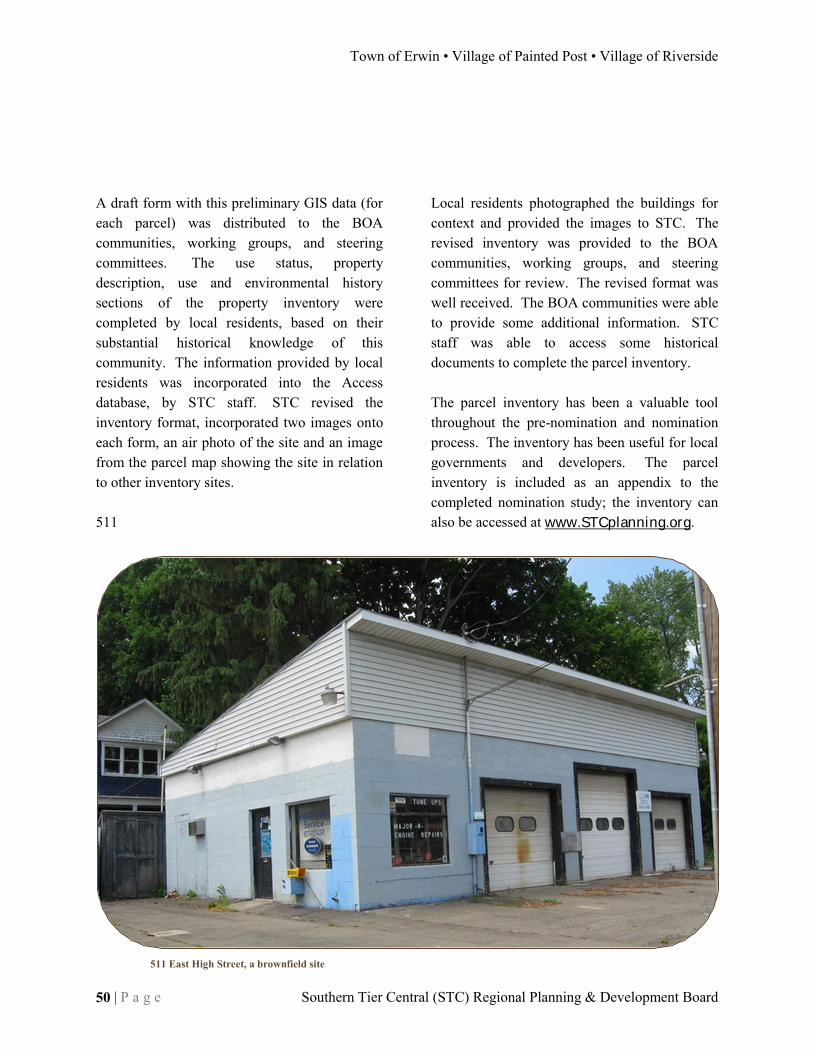
Town of Erwin • Village of Painted Post • Village of Riverside
50 | P a g e Southern Tier Central (STC) Regional Planning & Development Board
A draft form with this preliminary GIS data (for each parcel) was distributed to the BOA communities, working groups, and steering committees. The use status, property description, use and environmental history sections of the property inventory were completed by local residents, based on their substantial historical knowledge of this community. The information provided by local residents was incorporated into the Access database, by STC staff. STC revised the inventory format, incorporated two images onto each form, an air photo of the site and an image from the parcel map showing the site in relation to other inventory sites. 511
Local residents photographed the buildings for context and provided the images to STC. The revised inventory was provided to the BOA communities, working groups, and steering committees for review. The revised format was well received. The BOA communities were able to provide some additional information. STC staff was able to access some historical documents to complete the parcel inventory. The parcel inventory has been a valuable tool throughout the pre-nomination and nomination process. The inventory has been useful for local governments and developers. The parcel inventory is included as an appendix to the completed nomination study; the inventory can also be accessed at www.STCplanning.org.
511 East High Street, a brownfield site
DRAFT Brownfield Opportunity Area (BOA) Step 2 Nomination
peter j. smith & company, inc. • HUNT Engineers, Architects & Land Surveyors, P.C. P a g e | 51
Brownfield, Abandoned & Vacant Sites Map

Town of Erwin • Village of Painted Post • Village of Riverside
52 | P a g e Southern Tier Central (STC) Regional Planning & Development Board
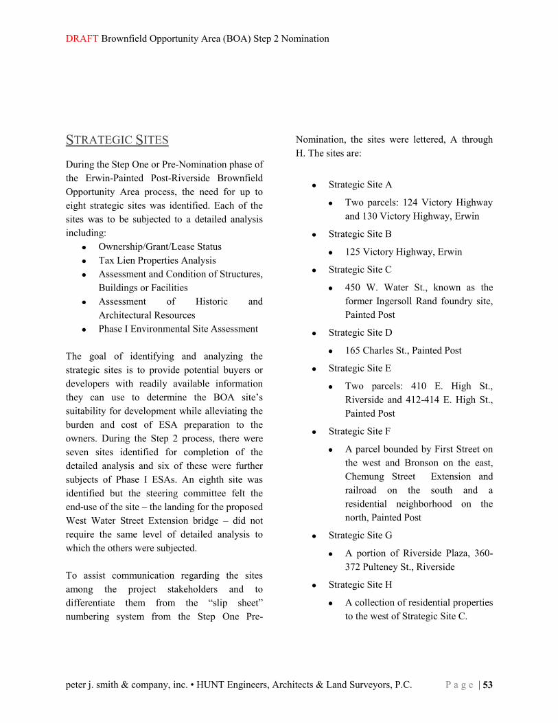
DRAFT Brownfield Opportunity Area (BOA) Step 2 Nomination
peter j. smith & company, inc. • HUNT Engineers, Architects & Land Surveyors, P.C. P a g e | 53
STRATEGIC SITES During the Step One or Pre-Nomination phase of the Erwin-Painted Post-Riverside Brownfield Opportunity Area process, the need for up to eight strategic sites was identified. Each of the sites was to be subjected to a detailed analysis including:
Ownership/Grant/Lease Status Tax Lien Properties Analysis Assessment and Condition of Structures,
Buildings or Facilities Assessment of Historic and
Architectural Resources Phase I Environmental Site Assessment
The goal of identifying and analyzing the strategic sites is to provide potential buyers or developers with readily available information they can use to determine the BOA site’s suitability for development while alleviating the burden and cost of ESA preparation to the owners. During the Step 2 process, there were seven sites identified for completion of the detailed analysis and six of these were further subjects of Phase I ESAs. An eighth site was identified but the steering committee felt the end-use of the site – the landing for the proposed West Water Street Extension bridge – did not require the same level of detailed analysis to which the others were subjected. To assist communication regarding the sites among the project stakeholders and to differentiate them from the “slip sheet” numbering system from the Step One Pre-
Nomination, the sites were lettered, A through H. The sites are:
Strategic Site A
Two parcels: 124 Victory Highway and 130 Victory Highway, Erwin
Strategic Site B
125 Victory Highway, Erwin
Strategic Site C
450 W. Water St., known as the former Ingersoll Rand foundry site, Painted Post
Strategic Site D
165 Charles St., Painted Post
Strategic Site E
Two parcels: 410 E. High St., Riverside and 412-414 E. High St., Painted Post
Strategic Site F
A parcel bounded by First Street on the west and Bronson on the east, Chemung Street Extension and railroad on the south and a residential neighborhood on the north, Painted Post
Strategic Site G
A portion of Riverside Plaza, 360-372 Pulteney St., Riverside
Strategic Site H
A collection of residential properties to the west of Strategic Site C.

Town of Erwin • Village of Painted Post • Village of Riverside
54 | P a g e Southern Tier Central (STC) Regional Planning & Development Board
The following is a brief summary of the findings of the analyses.
Strategic Site A A Phase I ESA was performed on Strategic Site A by Hunt EAS. Strategic Site A was selected because of its location proximate to the highway interchange. The site is comprised of two parcels, 124 Victory Highway, owned by T&K Realty and 130 Victory Highway, owned by GBR Three AC LLC. Tax map ids are 280.00-1-12 and 280.00-1-56. The two parcels, which are a total of 8.06 acres, are located on the north side of Victory Highway just west of I-86 Exit 43 in the Town of Erwin.
124 Victory Highway has a 37,359 square foot commercial building with an asphalt parking lot. There is a drainage swale at the back of the property. The building is currently being used as a bus garage and dispatch facility by Birnie Transportation Services. There is a 10,000-gallon diesel fuel tank and a 1,000-gallon gasoline tank on site; containment measures are in place on both. Volatile organic compounds were once detected on the site, leading to the removal of an underground fuel tank; the degreaser trichloroethylene has been detected on site and several spills reported. 130 Victory Highway is a vacant site. There are no known environmental liens, deed restrictions or use limitations on either site. However, the site’s own history and the location
of nearby sites environmental records at a greater elevation than Strategic Site A warrant additional investigation and it should be the subject of a Phase II ESA to determine what, if any, contaminants are present, how serious the contamination is and to develop a remediation plan. Hunt EAS performed a building condition survey and made multiple recommendations for safety and accessibility renovations and to allow the building to meet current standards and needs. A structural evaluation of the building should be performed if the building is to be reused.
Strategic Site A
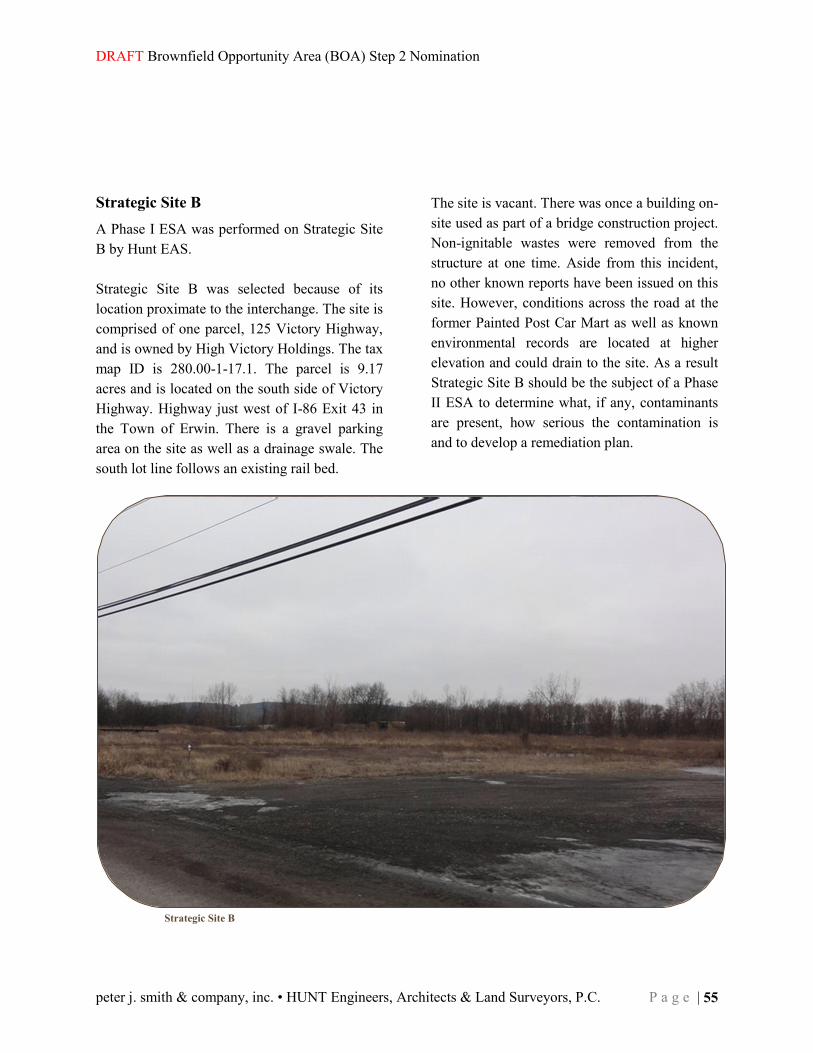
DRAFT Brownfield Opportunity Area (BOA) Step 2 Nomination
peter j. smith & company, inc. • HUNT Engineers, Architects & Land Surveyors, P.C. P a g e | 55
Strategic Site B A Phase I ESA was performed on Strategic Site B by Hunt EAS. Strategic Site B was selected because of its location proximate to the interchange. The site is comprised of one parcel, 125 Victory Highway, and is owned by High Victory Holdings. The tax map ID is 280.00-1-17.1. The parcel is 9.17 acres and is located on the south side of Victory Highway. Highway just west of I-86 Exit 43 in the Town of Erwin. There is a gravel parking area on the site as well as a drainage swale. The south lot line follows an existing rail bed.
The site is vacant. There was once a building on-site used as part of a bridge construction project. Non-ignitable wastes were removed from the structure at one time. Aside from this incident, no other known reports have been issued on this site. However, conditions across the road at the former Painted Post Car Mart as well as known environmental records are located at higher elevation and could drain to the site. As a result Strategic Site B should be the subject of a Phase II ESA to determine what, if any, contaminants are present, how serious the contamination is and to develop a remediation plan.
Strategic Site B

Town of Erwin • Village of Painted Post • Village of Riverside
56 | P a g e Southern Tier Central (STC) Regional Planning & Development Board
Strategic Site C A Phase I ESA was not performed on Strategic Site C. Strategic Site C was selected because of its potential to become a catalytic development that will transform the economy of Painted Post. The site, with a street address of 450 West Water Street, is owned by the Village of Painted Post. The tax map ID numbers are 298.12-01-018 and 299.13-01-74. The parcel is 57.4 acres. The site is vacant. Strategic Site C is the site of the former Ingersoll Rand Foundry. Because of the wealth of information that is known about the site and its environmental status, a modified examination of the site was conducted to gather a synopsis of this information consistent with that done for the ESAs on the other sites. The foundry site is an inactive waste disposal site. The foundry was used to produce gray iron castings for the company’s compressor plant. The foundry was shut down in 1985 and an environmental evaluation and cleanup done by Ingersoll Rand as part of the closure.
As part of the cleanup process, the site was declared by the NYS Department of Environmental Conservation to be a Class 4 Inactive Waste Disposal Site. This classification indicates that the site is properly closed but requires continuous management. Deed restrictions on the site placed by Dresser Rand, successor to Ingersoll Rand, prohibit most uses including residential, retail, commercial, parks, schools, etc. The site remains feasible for an industrial reuse. A portion of the site, 11.48 acres, is being redeveloped as a rail siding for a transloading facility the village will use to ship water to Pennsylvania for use in the gas industry. For that project, enhanced storm water management capacity and increased water service will be developed. Any developer of Strategic Site C will need to be aware of, and work within, the framework for development set forth in the deed restrictions. No additional remediation or environmental studies are deemed necessary at this time, but they may become necessary at the time of development, when a specific use has been identified.
Strategic Site C

DRAFT Brownfield Opportunity Area (BOA) Step 2 Nomination
peter j. smith & company, inc. • HUNT Engineers, Architects & Land Surveyors, P.C. P a g e | 57
Strategic Site D A Phase I ESA was performed on Strategic Site D by Hunt EAS. Strategic Site D was selected because it has the potential to become a centerpiece redevelopment in the BOA. The building on the site, the former Corning School District Offices, was once the Painted Post High School. Strategic Site D is located at 165Charles St. in the Village of Painted Post. The tax map ID number is 299.13-1-026.The parcel and building are owned by the Corning Painted Post School District Strategic Site D is 4.3 acres and consists of the original 1800s school building interconnected with several more recently constructed additions which vary from one to three stories. There are three asphalt parking lots comprising about 40% of the parcel. About 40% of the parcel is mowed lawn. There is one environmental report on the site involving materials stored in barrels or drums. Two underground tanks on site were removed by December 2010. There are no known environmental liens, deed restrictions or use limitations on this site.
Hunt EAS performed a building condition survey and made multiple recommendations for safety and accessibility renovations and to allow the building to meet current standards and needs. A structural evaluation of the building may be warranted and the building should be evaluated for the presence of asbestos insulation – asbestos floor tile is present. The building, interior and exterior, and the grounds have some serious signs of deterioration. The recommended residential reuse for this building would entail and should require a total rehabilitation.
Strategic Site D

Town of Erwin • Village of Painted Post • Village of Riverside
58 | P a g e Southern Tier Central (STC) Regional Planning & Development Board
Strategic Site E A Phase I ESA was performed on Strategic Site E by Hunt EAS. Strategic Site E was selected because it is adjacent to Strategic Site F and together they present the potential to create a big enough development opportunity as to be catalytic. Strategic Site E is a high visibility site with known and suspected environmental challenges. The site is comprised of multiple parcels and is located in the Village of Painted Post and the Village of Riverside. The tax IDs are 299.13-05-023.00, 299.13-05-021.00, 299.18-01-011.00, 299.18-01-012.00 and 299.18-01-014.00. It is located on East High Street between Hart and Bronson streets. It is approximately 2.68 acres. Strategic Site E is owned by High Victory Holdings. The Painted Post portion of the property is a vacant gravel lot; an auto parts store located on the site burned to the ground many years ago and all evidence of the building was removed. It has been vacant since. The Riverside portion of the site is occupied by Crystal Cleaners.
Strategic Site E is located in a densely developed area and no on-site environmental hazards were noted during Hunt’s on-site observation. Among its former uses is as a used car mart. The site is adjacent to or near five sites with environmental records and four listed sites. The listed sites are at a higher elevation of Strategic Site E, so they could have an impact on the site. Strategic Site E should be the subject of a Phase II ESA to determine what, if any, contaminants are present, how serious the contamination is and to develop a remediation plan. Hunt recommends a series of rehabilitative measures to bring the Crystal Cleaners building to ADA accessibility, and to meet current standards and needs. However, a better and more likely future use of the site would probably require demolition of the building.
Strategic Site E

DRAFT Brownfield Opportunity Area (BOA) Step 2 Nomination
peter j. smith & company, inc. • HUNT Engineers, Architects & Land Surveyors, P.C. P a g e | 59
Strategic Site F A Phase I ESA was performed on Strategic Site E by Hunt EAS. Strategic Site F was selected because it is adjacent to Strategic Site E and together they present the potential to create a big enough development opportunity as to be catalytic. Strategic Site F is a high visibility site with known and suspected environmental challenges. The 2.78-acre site is comprised of three concrete block storage buildings, a gravel parking area and some lawn all contained by a chain link fence and is located between Bronson and First streets in the Village of Painted Post on the Chemung Street Extension. The tax parcel ID number is 299.13-05-39 and the property belongs to Dresser Rand.
Strategic Site E is located in a densely developed area and no on-site environmental hazards were noted during Hunt’s on-site observation. The site is adjacent to or near five sites with environmental records and five sites within one quarter-mile of Strategic Site F are listed. The listed sites are at a higher elevation of Strategic Site F, so they could have an impact on the site. Strategic Site E should be the subject of a Phase II ESA to determine what, if any, contaminants are present, how serious the contamination is and to develop a remediation plan. Hunt recommends a series of rehabilitative measures for the three concrete block buildings including new roofs for each of them at substantial cost. However, a better and more likely future use of the site would require demolition of the buildings.
Strategic Site F

Town of Erwin • Village of Painted Post • Village of Riverside
60 | P a g e Southern Tier Central (STC) Regional Planning & Development Board
Strategic Site G A Phase I ESA was performed on Strategic Site G by Hunt EAS. Strategic Site G was selected because of its proximity to an I-86 exit and the potential this highly visible site has to be transformed from dreary and underutilized Riverside Plaza to an attractive and productive commercial service center for local residents and travelers through. The entire site is 7.75 acres, but the strategic portion of the parcel is not the built portion of the site but the area that remains undeveloped, especially on the east side where a Ponderosa restaurant and a gas station were once located. The tax ID is 299.18-1-049 and it is located on Pulteney Street in the Village of Riverside. he owner of Riverside Plaza, Pulteney Plaza Corp., is motivated and interested in upgrading the property and expanding business there. It has recently purchased the verge fronting the property from NYS DOT.
Existing outparcels adjacent to the site include tourism and business traveler amenities including lodging and food establishments. More of these kinds of services would add to and diversify the mix of tourist and traveler amenities with high visibility from Route I-86. There were no spills or contaminants visible when Hunt did its site inspection. However, numerous environmental records were noted west and northwest of the site from which water would drain toward this site. The records include underground tanks that have been removed, a spill at a nearby gas station and known contaminants at the nearby Foundry site – Strategic Site C. Additionally, numerous sites with environmental records are located nearby and at higher elevation including a former dry cleaning establishment, gas stations and auto repair shop. Strategic Site G should be the subject of a Phase II ESA to determine what, if any, contaminants are present, how serious the contamination is and to develop a remediation plan if needed.
Strategic Site G
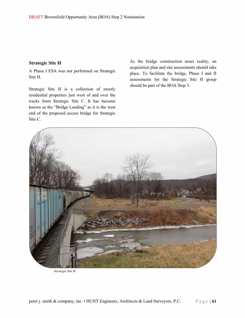
DRAFT Brownfield Opportunity Area (BOA) Step 2 Nomination
peter j. smith & company, inc. • HUNT Engineers, Architects & Land Surveyors, P.C. P a g e | 61
Strategic Site H A Phase I ESA was not performed on Strategic Site H. Strategic Site H is a collection of mostly residential properties just west of and over the tracks form Strategic Site C. It has become known as the “Bridge Landing” as it is the west end of the proposed access bridge for Strategic Site C.
As the bridge construction nears reality, an acquisition plan and site assessments should take place. To facilitate the bridge, Phase I and II assessments for the Strategic Site H group should be part of the BOA Step 3.
Strategic Site H

Town of Erwin • Village of Painted Post • Village of Riverside
62 | P a g e Southern Tier Central (STC) Regional Planning & Development Board

DRAFT Brownfield Opportunity Area (BOA) Step 2 Nomination
peter j. smith & company, inc. • HUNT Engineers, Architects & Land Surveyors, P.C. P a g e | 63
Strategic Sites Map

Town of Erwin • Village of Painted Post • Village of Riverside
64 | P a g e Southern Tier Central (STC) Regional Planning & Development Board
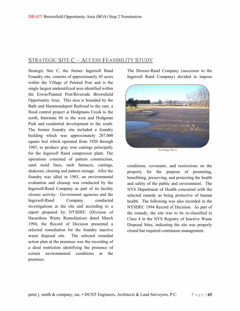
DRAFT Brownfield Opportunity Area (BOA) Step 2 Nomination
peter j. smith & company, inc. • HUNT Engineers, Architects & Land Surveyors, P.C. P a g e | 65
STRATEGIC SITE C – ACCESS FEASIBILITY STUDY Strategic Site C, the former Ingersoll Rand Foundry site, consists of approximately 45 acres within the Village of Painted Post and is the single largest underutilized area identified within the Erwin/Painted Post/Riverside Brownfield Opportunity Area. This area is bounded by the Bath and Hammondsport Railroad to the east, a flood control project at Hodgmans Creek to the north, Interstate 86 to the west and Hodgman Park and residential development to the south. The former foundry site included a foundry building which was approximately 287,000 square feet which operated from 1920 through 1985, to produce gray iron castings principally for the Ingersoll Rand compressor plant. The operations consisted of pattern construction, sand mold lines, melt furnaces, castings, shakeout, clearing and pattern storage. After the foundry was idled in 1985, an environmental evaluation and cleanup was conducted by the Ingersoll-Rand Company as part of its facility closure activity. Government agencies and the Ingersoll-Rand Company conducted investigations at the site and according to a report prepared by NYSDEC (Division of Hazardous Waste Remediation) dated March 1994, the Record of Decision presented a selected remediation for the foundry inactive waste disposal site. The selected remedial action plan at the premises was the recording of a deed restriction identifying the presence of certain environmental conditions at the premises.
The Dresser-Rand Company (successor to the Ingersoll Rand Company) decided to impose
conditions, covenants, and restrictions on the property for the purpose of promoting, benefitting, preserving, and protecting the health and safety of the public and environment. The NYS Department of Health concurred with the selected remedy as being protective of human health. The following was also recorded in the NYSDEC 1994 Record of Decision: As part of the remedy, the site was to be re-classified to Class 4 in the NYS Registry of Inactive Waste Disposal Sites, indicating the site was properly closed but required continuous management.
Existing Site C

Town of Erwin • Village of Painted Post • Village of Riverside
66 | P a g e Southern Tier Central (STC) Regional Planning & Development Board
The construction of a railroad siding which will be parallel and adjacent to the existing Bath and Hammondsport Railroad and which will run for nearly the entire length of Site C, is currently under construction. The purpose of this siding is to load tanker cars with water for use in the gas exploration industry in northern Pennsylvania. This siding will use nearly 12 acres of Site C, leaving approximately 33 acres available for future development. This study addresses access to those remaining 33 acres of Site C. The sole highway access to Site C is from Hamilton Street to West Water Street, into the southern portion of the site. This route traverses the Painted Post village center, makes a right angle turn and then passes through a residential area alongside Hodgman Park; as a result, it may not be suitable for a large amount of truck traffic. It was determined that a second access route should be developed to accommodate a variety of proposed land uses for this site, particularly those uses resulting in a significant amount of heavy truck traffic. Several alternatives were developed for providing this second access route. These alternatives are described below and shown on the attached map. (Note that there is one “West Water Street” north of Site C and a second “West Water Street” south of Site C, both of which are currently dead end streets. To avoid confusion, they are referred to as West Water Street (north) and West Water Street (south).) The six alternatives were:
Hamilton St. at W. Water St.
W. Water St. at Hamilton St.
W. Water St. at Charles St

DRAFT Brownfield Opportunity Area (BOA) Step 2 Nomination
peter j. smith & company, inc. • HUNT Engineers, Architects & Land Surveyors, P.C. P a g e | 67
Alternative 1: Access from Route 415 southeast of its
interchange with I-86 using West Water Street (north). This would require construction of a new bridge over Hodgmans Creek, the B&H Railroad and the flood control dike south of Hodgmans Creek to a touchdown point in the northerly section of Site C.
Alternative 2: Access from Route 415 and West Water Street (north), also requiring a new (but
lower-profile) bridge constructed only over Hodgmans Creek and the flood control dike south of the creek. The proposed road would then connect with High Street. Access to Site C would be via a second road with an at-grade railroad crossing south of the dike, which would intersect with the West Water Street (north)/High Street connection just south of the dike.
W. Water St. at Rte 415
W. Water St. Looking South
Touchdown Area Site C
Approx. Bridge Alignment
Approx. Bridge Alignment
Tie in with High St.

Town of Erwin • Village of Painted Post • Village of Riverside
68 | P a g e Southern Tier Central (STC) Regional Planning & Development Board
Alternative 3: Access from Route 415 south of the bridge carrying Route 415 over Hodgmans Creek. A new roadway would be constructed from Route 415, parallel to Hodgmans Creek near Corning-Painted Post West High School. This road would utilize an at-grade railroad crossing south of the dike to access Site C.
Alternative 4: A new road constructed parallel to Chemung Street from Hamilton Street to the
southeast section of Site C.
Alternative 5: A new road constructed from the southern portion of Site C, parallel to West
Water Street (south). It would tie into existing West Water Street (south) near the Village Square and continue to Hamilton Street.
Proposed Intersection at Rte 415
Alignment Along Creek
At-Grade Rail Crossing Location
Chemung St. at Hamilton St.
Chemung St. at Steuben St.
Chemung St. at Charles St.
W. Water St. near Village Square
W. Water St. at Steuben St.
W. Water St. at Site C
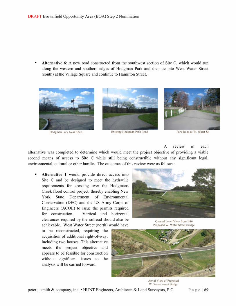
DRAFT Brownfield Opportunity Area (BOA) Step 2 Nomination
peter j. smith & company, inc. • HUNT Engineers, Architects & Land Surveyors, P.C. P a g e | 69
Ground Level View from I-86 Proposed W. Water Street Bridge
Aerial View of Proposed W. Water Street Bridge
Alternative 6: A new road constructed from the southwest section of Site C, which would run
along the western and southern edges of Hodgman Park and then tie into West Water Street (south) at the Village Square and continue to Hamilton Street.
A review of each alternative was completed to determine which would meet the project objective of providing a viable second means of access to Site C while still being constructible without any significant legal, environmental, cultural or other hurdles. The outcomes of this review were as follows:
Alternative 1 would provide direct access into Site C and be designed to meet the hydraulic requirements for crossing over the Hodgmans Creek flood control project, thereby enabling New York State Department of Environmental Conservation (DEC) and the US Army Corps of Engineers (ACOE) to issue the permits required for construction. Vertical and horizontal clearances required by the railroad should also be achievable. West Water Street (north) would have to be reconstructed, requiring the acquisition of additional right-of-way, including two houses. This alternative meets the project objective and appears to be feasible for construction without significant issues so the analysis will be carried forward.
Hodgman Park Near Site C
Park Road at W. Water St.
Existing Hodgman Park Road

Town of Erwin • Village of Painted Post • Village of Riverside
70 | P a g e Southern Tier Central (STC) Regional Planning & Development Board
Alternative 2 would provide a second access into Site C. It would not be as direct as Alternative 1, since an at-grade railroad crossing would be utilized and an intersection between the access road and the West Water Street (north)/High Street Connection would be introduced. As with Alternative 1, the bridge would be designed to meet hydraulic requirements for the crossing of the flood control project (in order to obtain permits from DEC and the ACOE). West Water Street (north) would require reconstruction and the acquisition of right-of-way would be required along both West Water Street and High Street including several homes. Regarding the proposed rail crossing, a major concern exists in that if a new at-grade railroad crossing is approved for construction with public funds, one expected condition of such approval is a requirement that two other existing at-grade crossings be removed. We know of no existing crossings that could be sacrificed to justify the construction of this proposed new crossing. Therefore, it is likely that the at-grade crossing and the access road that would utilize it would not be feasible for this or any publicly-funded project. If a developer is interested in pursuing this option in the future, he or she would need to negotiate with the railroad regarding the private construction of the at-grade crossing and access road. A successful outcome for such negotiations cannot be guaranteed. For this reason, this alternative will be dropped from consideration.
Alternative 3 avoids the issue of the flood control project along Hodgmans Creek but retains the
same concerns regarding construction of an at-grade railroad crossing as Alternative 2. Construction of an acceptable intersection between Route 415 and the access road would also bring about several issues. First, a significant difference in elevation exists between Route 415
and the area south of the dike where the access road would be constructed. Second, an intersection between the proposed access road and Route 415 could not be constructed very close to the Route 415 bridge over Hodgmans Creek because the acute angle between Route 415 and the proposed access road could not be negotiated by trucks arriving from I-86 or other points north.
Affected Houses, Alternative 2
Elevation Difference at Rte 415 Bridge

DRAFT Brownfield Opportunity Area (BOA) Step 2 Nomination
peter j. smith & company, inc. • HUNT Engineers, Architects & Land Surveyors, P.C. P a g e | 71
This would force the intersection farther to the south and closer to the driveway into Corning-Painted Post West High School. The combination of horizontal geometry and elevation differences may actually force the access road to merge with the driveway into school or to cause the driveway to be relocated farther to the south. The access road would also cause the displacement of some of the on-campus roadways and parking at the school. Due to the concerns over the impacts to the school and the need for an at-grade railroad crossing, this alternative will be dropped from consideration.
Alternative 4 would require trucks to pass through the
Painted Post village center, similar to the existing access from West Water Street (south). Much of the right-of-way needed for this alignment would need to be acquired from the railroad, which may not be possible as the line is active. In addition, a rail siding is planned for construction parallel to the existing line in the near future. This siding will run nearly the full length of Site C, forcing the access road to shift to the west into a residential area as it approaches Site C from the south. For these reasons, this alternative will be dropped from consideration.
Alternative 5 does not provide a second access into Site C; rather, it modifies the existing access,
bringing traffic through the Painted Post village center and taking the right angle turn from Hamilton Street onto West Water Street (south). As this alternative does not meet the project objective of a second access route, it will be dropped from consideration.
Alternative 6 uses a portion of the existing access from Hamilton Street to West Water Street
(south), including the right angle turn, so it is not a fully separate access route. It then introduces another intersection with the turn into the Hodgman Park area and the route would continue along the perimeter of the park into the southwest corner of Site C. Construction of this route would require the acquisition of park lands which were created with the assistance of federal funding. Justification of this acquisition would be very difficult since another feasible option exists.
School Parking and Drive
Affected Houses, Alternative 4
W. Water St. at Hodgman Park

Town of Erwin • Village of Painted Post • Village of Riverside
72 | P a g e Southern Tier Central (STC) Regional Planning & Development Board
Even if it is determined that this alternative is the preferred option, the actual acquisition process for the park land would be a very lengthy procedure with no guarantee of a successful outcome. This alternative will be dropped from consideration due to the need to acquire this park land.
In summary, Alternative 1, which calls for access to the north end of Site C from Route 415 and West Water Street (north) with a bridge over the Hodgmans Creek flood control project and the B&H railroad is the only alternative for a second access route to Site C that will continue to be considered. Design criteria for this access road were obtained from the NYSDOT Highway Design Manual and Bridge Manual using a design speed of 30 miles per hour and a roadway classification of local urban street for an industrial area. The recommended design parameters are as follows:
Travel lane width 12’ Shoulder width 5’ minimum (no parking lane and no
accommodations for breakdowns) Grade 8% maximum Stopping sight distance 200’ minimum Curve radius 250’ minimum Superelevation 4% maximum Travel lane cross slope 1.5% minimum, 2% maximum Bridge width Highway width Bridge Structural Capacity HL-93
In addition to the above design criteria, the required vertical clearance for the railroad was assumed to be 22’ based on the existing clearance over the same railroad under the I-86 bridge located just north of the project site. It was also assumed that the proposed bridge would need to minimize any impact to the Hodgmans Creek flood plain and pass over the top of the dike but may have an abutment encroaching into the landward side of the dike. A roadway alignment and profile meeting all of the above criteria was then developed as shown on the attached plan and elevation views. The resulting bridge is expected to be a three span continuous, steel multigirder structure with a span arrangement of 90’- 120’- 90’ with the center span crossing over the main creek channel and railroad. The northerly span will cross the flood plain north of the channel and help to minimize the placement of fill material within that area. The southerly span will cross over the dike. The piers and abutments of the bridge will be supported on pile foundations to protect them from scour and to prevent settlement from occurring. The roadway width of the bridge will be 34’ – 0” and the barriers on either side of the bridge may be either steel railing on curbs or concrete barrier in order to control the surface drainage on the bridge and direct it away from the railroad. No sidewalks or bicycle lanes are planned to be carried across the bridge. Lighting is considered optional and is not currently included in the estimate.
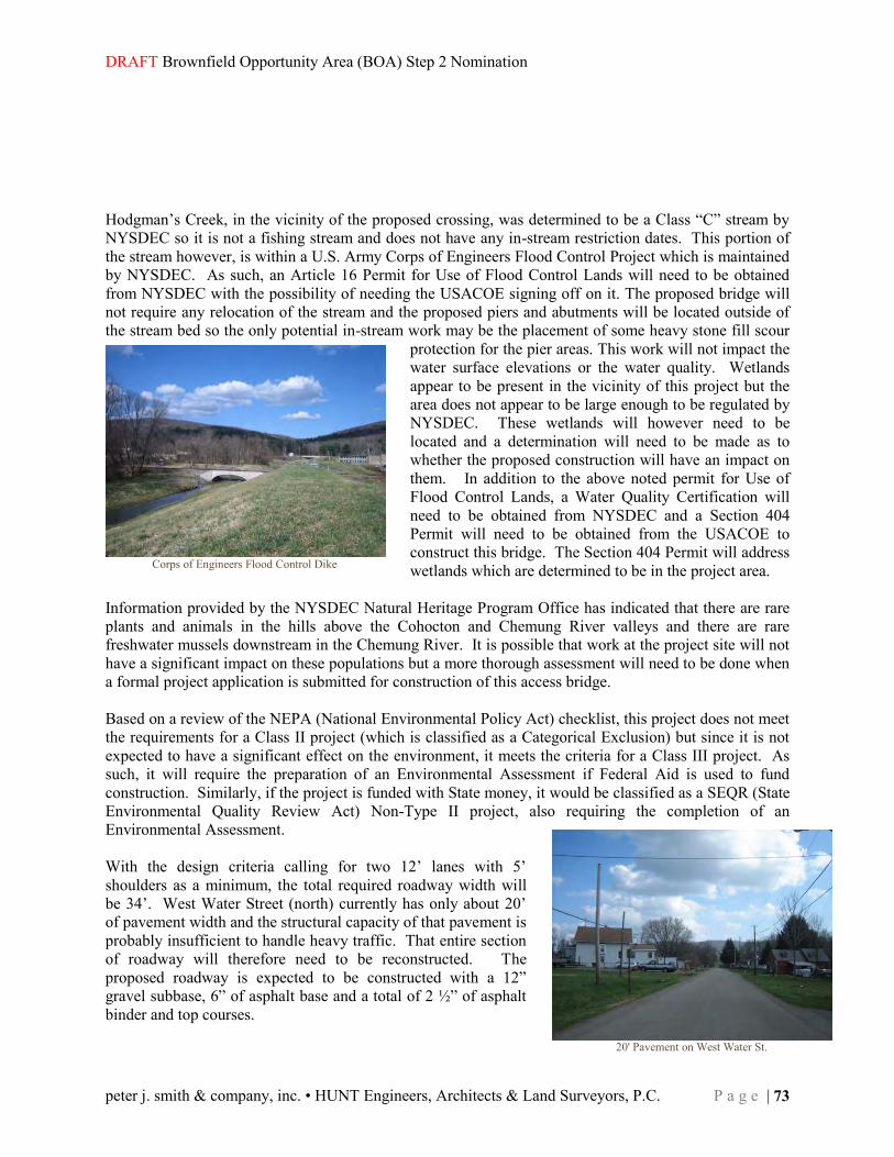
DRAFT Brownfield Opportunity Area (BOA) Step 2 Nomination
peter j. smith & company, inc. • HUNT Engineers, Architects & Land Surveyors, P.C. P a g e | 73
Hodgman’s Creek, in the vicinity of the proposed crossing, was determined to be a Class “C” stream by NYSDEC so it is not a fishing stream and does not have any in-stream restriction dates. This portion of the stream however, is within a U.S. Army Corps of Engineers Flood Control Project which is maintained by NYSDEC. As such, an Article 16 Permit for Use of Flood Control Lands will need to be obtained from NYSDEC with the possibility of needing the USACOE signing off on it. The proposed bridge will not require any relocation of the stream and the proposed piers and abutments will be located outside of the stream bed so the only potential in-stream work may be the placement of some heavy stone fill scour
protection for the pier areas. This work will not impact the water surface elevations or the water quality. Wetlands appear to be present in the vicinity of this project but the area does not appear to be large enough to be regulated by NYSDEC. These wetlands will however need to be located and a determination will need to be made as to whether the proposed construction will have an impact on them. In addition to the above noted permit for Use of Flood Control Lands, a Water Quality Certification will need to be obtained from NYSDEC and a Section 404 Permit will need to be obtained from the USACOE to construct this bridge. The Section 404 Permit will address wetlands which are determined to be in the project area.
Information provided by the NYSDEC Natural Heritage Program Office has indicated that there are rare plants and animals in the hills above the Cohocton and Chemung River valleys and there are rare freshwater mussels downstream in the Chemung River. It is possible that work at the project site will not have a significant impact on these populations but a more thorough assessment will need to be done when a formal project application is submitted for construction of this access bridge. Based on a review of the NEPA (National Environmental Policy Act) checklist, this project does not meet the requirements for a Class II project (which is classified as a Categorical Exclusion) but since it is not expected to have a significant effect on the environment, it meets the criteria for a Class III project. As such, it will require the preparation of an Environmental Assessment if Federal Aid is used to fund construction. Similarly, if the project is funded with State money, it would be classified as a SEQR (State Environmental Quality Review Act) Non-Type II project, also requiring the completion of an Environmental Assessment. With the design criteria calling for two 12’ lanes with 5’ shoulders as a minimum, the total required roadway width will be 34’. West Water Street (north) currently has only about 20’ of pavement width and the structural capacity of that pavement is probably insufficient to handle heavy traffic. That entire section of roadway will therefore need to be reconstructed. The proposed roadway is expected to be constructed with a 12” gravel subbase, 6” of asphalt base and a total of 2 ½” of asphalt binder and top courses.
Corps of Engineers Flood Control Dike
20' Pavement on West Water St.

Town of Erwin • Village of Painted Post • Village of Riverside
74 | P a g e Southern Tier Central (STC) Regional Planning & Development Board
The estimated construction cost for this alternative including the bridge, the embankments required to reach the elevations necessary for the rail crossing, the reconstruction of West Water Street (north) to the intersection with Route 415 and paving of the roadway to the point where the profile of the proposed roadway touches down to existing ground south of the proposed bridge is nearly $5,550,000. As may be seen on the Engineer’s Estimate on the following sheet, the bridge alone accounts for $3,160,000 of this total. The placement of embankment material needed to construct the approaches to the bridge to reach the height needed to cross over the railroad is estimated to be $620,000. The removal of the existing West Water Street (north), removal of top soil under the new roadway areas, construction of a gravel roadway subbase and placement of the new asphalt roadway from Route 415 to the touchdown point south of the bridge, which is nearly 0.5 miles south of Route 415, totals about $660,000. Other items of work listed under contingencies in the estimate, include guide railing, signs, landscaping, drainage, pavement striping, engineer’s office and other miscellaneous construction needs. Remediation has previously been completed for hazardous wastes found at the former foundry site within Site C but excavation activities during future construction may encounter additional contaminated materials which would add to construction costs.
ENGINEER’S ESTIMATE, ALTERNATIVE 1 Item Description Unit Quantity Unit Price Cost
Complete Bridge LS 1 $3,160,000.00 $3,160,000.00 Unclassified Excavation and Disposal CY 6970 $15.00 $104,550.00 Embankment in Place CY 62000 $10.00 $620,000.00 Subbase Course, Optional Type CY 3520 $45.00 $158,400.00 Hot Mix Asphalt - Type 1 Base Course TON 2784 $95.00 $264,480.00 Hot Mix Asphalt - Type 3 Binder Course TON 686 $100.00 $68,600.00 Hot Mix Asphalt - Type 7 F3 Top Course TON 458 $110.00 $50,380.00 Tack Coat GAL 1019 $10.00 $10,190.00 Sawcutting Asphalt Pavement LF 100 $7.00 $700.00 Survey and Stakeout LS NEC $5,000.00 $5,000.00 Contingencies $888,460.00 Subtotal $5,330,760.00 Mobilization (4%) LS NEC $213,230.40
TOTAL
$5,543,990

DRAFT Brownfield Opportunity Area (BOA) Step 2 Nomination
peter j. smith & company, inc. • HUNT Engineers, Architects & Land Surveyors, P.C. P a g e | 75
The cost of right-of-way for this access road is not included in the above Engineer’s Estimate. These costs will include the cost of the property that the new portion of the roadway and its embankments will be constructed upon and the additional width of property needed to construct the widened and realigned West Water Street (north). It is expected that this right-of-way need will include the acquisition of two houses located on the west side of West Water Street (north) at the southerly end of the existing road. Additional easements or acquisitions will also be necessary for drainage purposes and along the southern portion of West Water Street (north) to allow for the proposed highway embankments to be blended into the existing ground or parking lot elevations. Due to the fact that the proposed access roadway is located in both the Town of Erwin and the Village of Painted Post, it is expected that both entities will be involved in the right-of-way acquisition process, each within their own jurisdiction. Similarly, ownership of the road may be based on the border between the Town and the Village. These municipalities may also negotiate other scenarios for the needed acquisition and ownership if they so choose. Ownership and maintenance responsibility of the bridge may also be the subject of negotiations. Typically, for roadways under local jurisdiction, a bridge over a railroad has split responsibilities with the railroad being responsible for the framework of the bridge and its abutments and the municipality responsible for the roadway over the bridge and its approaches. With a three span bridge having only one span over a railroad it is not unusual for the railroad to have responsibility for only the span crossing over the rails and for the supporting piers. With the remaining responsible parties being a Village and a Town, the Town quite often takes the responsibility of the portions of the bridge outside of the railroad’s jurisdiction, especially if the Village is not heavily populated. One additional scenario would be to have an agreement in place whereby the County of Steuben assumes responsibility for the bridge outside of those areas under railroad responsibility. Please review the following Map, Strategic Site C - Potential Access Routes, for a diagram and point by point evaluation of each of the six alternatives.
Affected Houses – W. Water St.
Town of Erwin • Village of Painted Post • Village of Riverside
76 | P a g e Southern Tier Central (STC) Regional Planning & Development Board

DRAFT Brownfield Opportunity Area (BOA) Step 2 Nomination
peter j. smith & company, inc. • HUNT Engineers, Architects & Land Surveyors, P.C. P a g e | 77
Access Alternatives Map

Town of Erwin • Village of Painted Post • Village of Riverside
78 | P a g e Southern Tier Central (STC) Regional Planning & Development Board

DRAFT Brownfield Opportunity Area (BOA) Step 2 Nomination
peter j. smith & company, inc. • HUNT Engineers, Architects & Land Surveyors, P.C. P a g e | 79
LAND OWNERSHIP PATTERNS The majority of land in the surrounding communities is privately owned. Many of the largest parcels in the communities are publicly owned and used to provide valuable public services (transportation, public education and other municipal services). The historical distribution of land in these communities follows the classic colonial pattern where large tracts were slowly subdivided over the many generations that this area has been occupied.
The BOA is situated across three municipalities (host communities). Across the host communities 2,575 acres (5%) of land is designated as roadways. Within the BOA however, the land distribution pattern changes. Road right-of-ways consume 156 acres of land within the BOA. This amounts to roughly 30% of the total land area. This relationship is similar for community facilities (such as schools, fire, and municipal parking) that are centrally located in the Brownfield Opportunity Area (276 acres of the BOA is publicly owned). This skews the land distribution pattern slightly toward public landowners (23%) for the BOA versus the three host communities where only 5% of the total land is publicly owned. Private owners control 218 acres of the BOA or 44%.
Table 22: Brownfield, Underutilized & Vacant Sites by Ownership
Brownfield Under-utilized Vacant Unselected Total
Public Total Acres 3.39 acres 56.3 acres 1.1 acres 215.83 acres 276.6acres Parcels 3 parcel 4 parcels 3 parcel 42 parcels 52 parcels Avg. parcel size 1.13 14.07 0.36 5.1 20.66
Private Total Acres 20.43 acres 31.21 acres 12.42 acres 153.98 acres 218 acres Parcels 19 parcels 37 parcels 8 parcels 421 parcels 485 parcels Avg. parcel size 1.07 0.84 1.55 0.036 3.82
Total Total Acres 23.82 acres 87.51 acres 13.52 acres 369.81 acres 494.6acres Parcels 22 parcels 41 parcels 11 parcels 463 parcels 537 parcels Avg. parcel size 1.08 2.13 1.22 0.8 0.92
Table 21: Land Ownership by Municipality
Erwin
Painted Post Riverside Total
Public Acres 1,108.1 146.2 45.9 1,300.2 Parcels 90.0 21.0 16.0 127.0 Avg. Parcel Size 12.3 6.9 2.8 10.2
Private Acres 22,216.2 366.1 35.8 22,618.1 Parcels 2,421.0 314.0 160.0 2,895.0 Avg. Parcel Size 9.2 1.2 0.2 7.8

Town of Erwin • Village of Painted Post • Village of Riverside
80 | P a g e Southern Tier Central (STC) Regional Planning & Development Board

DRAFT Brownfield Opportunity Area (BOA) Step 2 Nomination
peter j. smith & company, inc. • HUNT Engineers, Architects & Land Surveyors, P.C. P a g e | 81
Land Ownership Map

Town of Erwin • Village of Painted Post • Village of Riverside
82 | P a g e Southern Tier Central (STC) Regional Planning & Development Board

DRAFT Brownfield Opportunity Area (BOA) Step 2 Nomination
peter j. smith & company, inc. • HUNT Engineers, Architects & Land Surveyors, P.C. P a g e | 83
PARKS & OPEN SPACE The Town of Erwin, Village of Painted Post, and Village of Riverside BOA is a well developed mixed-use area, complete with parks, community centers, and recreational opportunities. Through the BOA program, the existing facilities may become more attractive to local residents. The existing facilities will be updated to meet changing levels of activity and projected types of uses.
There are three distinct parks in Painted Post: Craig Park, Hodgeman Park, and the Painted Post Trail. Craig Park and the Painted Post Trail are very well integrated into the community. Hodgeman park is somewhat isolated from village residents by W. Water Street and the W. Water Street Site. Hodgeman park is rich in amenities and has excellent parking, but additional community connections could increase the usage of this park. There are many major parks in the Town of Erwin: Erwin Hollow State Forest, Erwin Mountain State Forest, McCarthy Hill State Forest, Indian Hills, and several river-side boat launches. Unfortunately, none of these parks are in the BOA area.
Painted Post Multi-Use Path

Town of Erwin • Village of Painted Post • Village of Riverside
84 | P a g e Southern Tier Central (STC) Regional Planning & Development Board
The Village of Riverside has two connected park areas, the Painted Post Trail and the Edward P. Hanshaw Memorial Park. These two parks occupy the far north side of the Village, and are easily accessed by most residents in the town. The Village of Painted Post contains most of the 18.5 acres of parks in the BOA (including Hodgman Park, the Erwin Museum, and hiking/biking trail. The table below lists recreational land uses and their distribution throughout the BOA.
Agricultural Lands, Locally, State, Federally Designated Resources and Open Space Areas. Because the BOA is urbanized, there is no significant wildlife habitat or agricultural land within its borders. However, a landscaped walking/hiking trail on a former railroad right-of-way is a “green corridor” for public enjoyment. A number of municipal parks also create a pattern of open space. The Erwin Hollow State Forest is to the north of the BOA in the Town of Erwin as part of the steep,
wooded hillsides which flank the BOA to the north and south.
Table 23: Parks, Recreation & Open Space
Land use /Acres Erwin Painted Post Riverside Total
Recreation & Entertainment 0 7.6 0 7.6 Community Services 0 34.9 0 34.9 Conservation/Parks 0 18.5 0 18.5 BOA Total 93.3 309.9 90 493.4
Hodgeman Park

DRAFT Brownfield Opportunity Area (BOA) Step 2 Nomination
peter j. smith & company, inc. • HUNT Engineers, Architects & Land Surveyors, P.C. P a g e | 85
Parks & Open Space Map

Town of Erwin • Village of Painted Post • Village of Riverside
86 | P a g e Southern Tier Central (STC) Regional Planning & Development Board
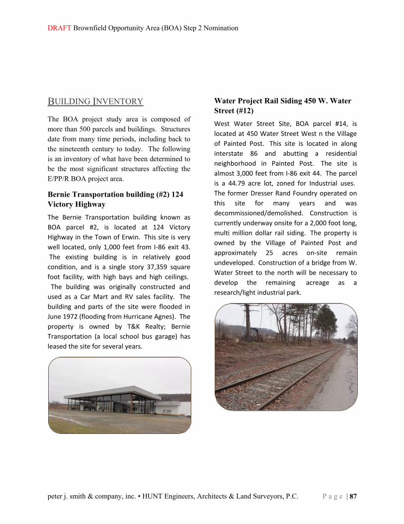
DRAFT Brownfield Opportunity Area (BOA) Step 2 Nomination
peter j. smith & company, inc. • HUNT Engineers, Architects & Land Surveyors, P.C. P a g e | 87
BUILDING INVENTORY The BOA project study area is composed of more than 500 parcels and buildings. Structures date from many time periods, including back to the nineteenth century to today. The following is an inventory of what have been determined to be the most significant structures affecting the E/PP/R BOA project area.
Bernie Transportation building (#2) 124 Victory Highway The Bernie Transportation building known as
BOA parcel #2, is located at 124 Victory
Highway in the Town of Erwin. This site is very
well located, only 1,000 feet from I-86 exit 43.
The existing building is in relatively good
condition, and is a single story 37,359 square
foot facility, with high bays and high ceilings.
The building was originally constructed and
used as a Car Mart and RV sales facility. The
building and parts of the site were flooded in
June 1972 (flooding from Hurricane Agnes). The
property is owned by T&K Realty; Bernie
Transportation (a local school bus garage) has
leased the site for several years.
Water Project Rail Siding 450 W. Water Street (#12) West Water Street Site, BOA parcel #14, is
located at 450 Water Street West n the Village
of Painted Post. This site is located in along
interstate 86 and abutting a residential
neighborhood in Painted Post. The site is
almost 3,000 feet from I-86 exit 44. The parcel
is a 44.79 acre lot, zoned for Industrial uses.
The former Dresser Rand Foundry operated on
this site for many years and was
decommissioned/demolished. Construction is
currently underway onsite for a 2,000 foot long,
multi million dollar rail siding. The property is
owned by the Village of Painted Post and
approximately 25 acres on-site remain
undeveloped. Construction of a bridge from W.
Water Street to the north will be necessary to
develop the remaining acreage as a
research/light industrial park.

Town of Erwin • Village of Painted Post • Village of Riverside
88 | P a g e Southern Tier Central (STC) Regional Planning & Development Board
C/PP School Board building (#14) 165 Charles Street The C/PP School Board building known as BOA
parcel #14, is located at 165 Charles Street in
the Village of Painted Post. This site is located
in the center of the BOA; located in the heart of
a residential neighborhood. The site is almost
equidistant from I-86 exits 43, 44, and 45. The
parcel is a 4.3 acre lot, zoned for Urban Center
Residential. The existing building is in ‘normal’
condition for a building constructed in 1925.
The School Board building is a three story,
19,000 square foot, former middle school. The
property is owned by Corning-Painted Post
School District and is currently used as the
School Board office building. Due to changes in
school building assignments, the current C/PP
school board building is likely to become
available for re-use in the next few years.
Significant improvements would be necessary
to facilitate constructive re-use of the building
and surrounding site.
Krog Building 222 N. Hamilton (#18) The Krog building known as BOA parcel #18, is
located at 222 N. Hamilton Street in the Village
of Painted Post. This site is very well located,
less than 2,000 feet from I-86. The parcel is
almost 2 acres and is zoned Industrial. The
building was constructed in 1970 by Dresser
Rand and used as office space. The existing
building is a two story 42,000 square foot
facility, in decent condition. The building and
parts of the site may have been flooded in June
1972 (from Hurricane Agnes). The property is
owned by North Hamilton 208 LLC, is vacant,
and available for lease.

DRAFT Brownfield Opportunity Area (BOA) Step 2 Nomination
peter j. smith & company, inc. • HUNT Engineers, Architects & Land Surveyors, P.C. P a g e | 89
Former Erwin Town Hall The Former Erwin Town Hall building is not
technically a BOA parcel, but this building is
significant within the BOA boundary and larger
community. It is located at 117 W. Water Street
in the Village of Painted Post. This site is very
well located, approximately 1,000 feet from I-86
exit 44. The parcel is only .18 acres and is
zoned commercial. The building was
constructed in 1921 and was used as the Erwin
Town hall until 2011. The Town Court
continues to occupy a portion of the first floor.
The existing building is a three story 23,000
square foot facility, in decent condition. The
building and parts of the site may have been
flooded in June 1972 (from Hurricane Agnes).
The property is owned by the Town of Erwin
and is available for sale.
Immaculate Heart of Mary Church (#82) 121 E. High Street The Immaculate Heart of Mary Church known
as BOA parcel #82, is located at 121 E. High
Street in the Village of Painted Post. This site is
located in the mixed-use center of the BOA, the
site has road frontage along the well-used rt.
415. The parcel is a 1.2 acre lot, zoned for
Urban Center Residential. The existing building
is in ‘normal’ condition for an older building.
The parcel has several buildings of varying
heights. The parcel has approximately 2,500
square feet of church space, 19,000 sf of school
space, and a 2,000 sf rectory. The property is
owned by the immaculate Heart of Mary and
has been used as a Catholic Church. Due to
changes in the diocese, the building is likely to
become available for re-use in the next few
years. Significant improvements would be
necessary to facilitate constructive re-use of the
building and surrounding site.

Town of Erwin • Village of Painted Post • Village of Riverside
90 | P a g e Southern Tier Central (STC) Regional Planning & Development Board
Crystal Cleaners (#52) 508 E. High The Crystal Cleaners also known as BOA parcel
#82, is located at 508 E. High Street in the
Village of Riverside. This site is located in the
mixed-use neighborhood of Riverside. The site
has road frontage along the well-used rt. 415.
The parcel is a 0.8 acre lot, zoned for
Commercial use. The existing building is a 1
story structure in ‘normal’ condition. The
parcel has approximately 7,500 square feet of
‘rentable space’. The property is owned by Mr.
Bennett and has been used as a dry cleaning
facility.
Storflex (#55) 392 Pulteney Street The Storflex building known as BOA parcel #55,
is located at 392 Pulteney Street in the Village
of Riverside. This site is very well located, less
than 500 feet from I-86 exit 45. The existing
building is in good condition; the building has
been maintained and expanded by the owner.
It is a single story 159,000 square foot facility,
with high bays and high ceilings. The building
has been used as a manufacturing facility. The
property is owned by and operated by Storflex;
and has been manufacturing fixtures at this
location for more than 10 years. The building
was formerly owned and used by Corning Glass
Works.

DRAFT Brownfield Opportunity Area (BOA) Step 2 Nomination
peter j. smith & company, inc. • HUNT Engineers, Architects & Land Surveyors, P.C. P a g e | 91
Building Inventory Map

Town of Erwin • Village of Painted Post • Village of Riverside
92 | P a g e Southern Tier Central (STC) Regional Planning & Development Board
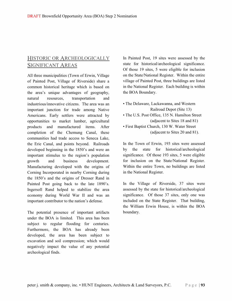
DRAFT Brownfield Opportunity Area (BOA) Step 2 Nomination
peter j. smith & company, inc. • HUNT Engineers, Architects & Land Surveyors, P.C. P a g e | 93
HISTORIC OR ARCHEOLOGICALLY SIGNIFICANT AREAS All three municipalities (Town of Erwin, Village of Painted Post, Village of Riverside) share a common historical heritage which is based on the area’s unique advantages of geography, natural resources, transportation and industrious/innovative citizens. The area was an important junction for trade among Native Americans. Early settlers were attracted by opportunities to market lumber, agricultural products and manufactured items. After completion of the Chemung Canal, these communities had trade access to Seneca Lake, the Erie Canal, and points beyond. Railroads developed beginning in the 1850’s and were an important stimulus to the region’s population growth and business development. Manufacturing developed with the origins of Corning Incorporated in nearby Corning during the 1850’s and the origins of Dresser Rand in Painted Post going back to the late 1890’s. Ingersoll Rand helped to stabilize the area economy during World War II and was an important contributor to the nation’s defense. The potential presence of important artifacts under the BOA is limited. This area has been subject to regular flooding for centuries. Furthermore, the BOA has already been developed, the area has been subject to excavation and soil compression; which would negatively impact the value of any potential archeological finds.
In Painted Post, 19 sites were assessed by the state for historical/archeological significance. Of those 19 sites, 5 were eligible for inclusion on the State/National Register. Within the entire village of Painted Post, three buildings are listed in the National Register. Each building is within the BOA Boundary. • The Delaware, Lackawanna, and Western Railroad Depot (Site 13) • The U.S. Post Office, 135 N. Hamilton Street (adjacent to Sites 18 and 81) • First Baptist Church, 130 W. Water Street (adjacent to Sites 20 and 81). In the Town of Erwin, 193 sites were assessed by the state for historical/archeological significance. Of those 193 sites, 5 were eligible for inclusion on the State/National Register. Within the entire Town, no buildings are listed in the National Register. In the Village of Riverside, 37 sites were assessed by the state for historical/archeological significance. Of those 37 sites, only one was included on the State Register. That building, the William Erwin House, is within the BOA boundary.
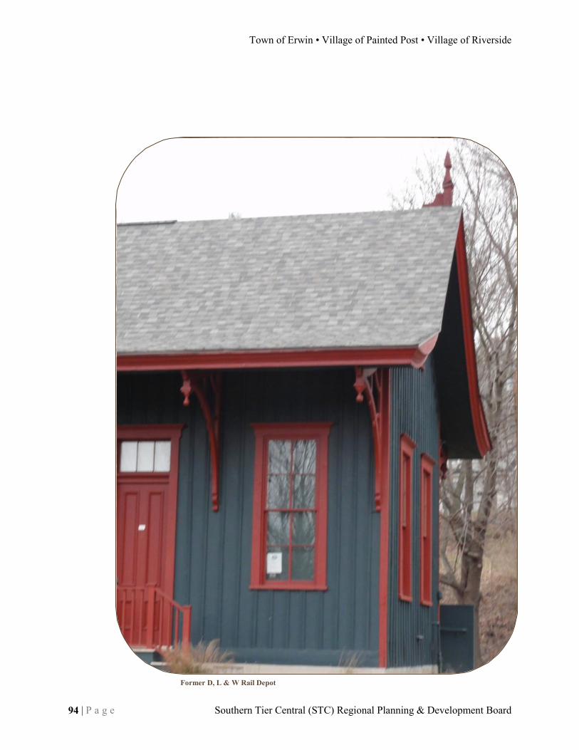
Town of Erwin • Village of Painted Post • Village of Riverside
94 | P a g e Southern Tier Central (STC) Regional Planning & Development Board
Former D, L & W Rail Depot

DRAFT Brownfield Opportunity Area (BOA) Step 2 Nomination
peter j. smith & company, inc. • HUNT Engineers, Architects & Land Surveyors, P.C. P a g e | 95
Historic Sites Map

Town of Erwin • Village of Painted Post • Village of Riverside
96 | P a g e Southern Tier Central (STC) Regional Planning & Development Board

DRAFT Brownfield Opportunity Area (BOA) Step 2 Nomination
peter j. smith & company, inc. • HUNT Engineers, Architects & Land Surveyors, P.C. P a g e | 97
NATURAL RESOURCES & ENVIRONMENTAL RESOURCES Natural Resources (4.2d) An overall analysis of local ecosystems and water quality shows a high quality of life within the BOA. Environmental conditions are not deteriorating in this area. Local, state and federal efforts are underway to maintain or improve environmental conditions. The isolated instances of contamination are not causing negative heath impacts, although the contamination is impacting the vitality of the local economy.
Groundwater Use and Condition The BOA is located entirely on the valley floor underlain by the water-rich Chemung River Aquifer. The Water Resources Map shows the extent of the confined and unconfined aquifers. Water quality is excellent and is the source of public drinking water for each of the BOA communities. The three Village of Painted Post wells are located in the BOA. Well #2 was built in 1941 and yields 500 gallons per minute (GPM). Well #3 was built in 1956 and has a rate of 726 GPM. The largest producing well, Well #4, was built in 1975 and can produce 1000 GPM. Because of concerns about groundwater contamination migrating offsite from the former foundry site, a series of monitoring wells were installed in 1991 to monitor for potential contaminants. To date, groundwater quality meets drinking water standards.
Surface Water and Tributaries, Fish and Wildlife Habitats The Cohocton River flows along the southern boundary of the BOA joining with the Tioga River to form the Chemung River. Tributaries (including Cutler Creek, Bill Smith Creek, and Meads Creek) flow through the BOA. Both rivers are part of the Chemung Basin River Trail with boat launch sites at Kinsella Park on the Cohocton just outside the BOA and in the City of Corning. Additional river access sites are anticipated as more and more people enjoy boating or fishing on the rivers. Water quality has steadily improved over the past forty years since the adoption of strict water quality protection laws. The Painted Post Village Wastewater Treatment Plant discharges to the Chemung River and meets discharge standards. The Canisteo River is host to both the Cowanesque Dam and Alfred-Almond Dam, upstream of the BOA.
Wetlands, Floodplains and Erosion Hazard Areas There is one NYS Designated Wetland near the BOA, it is located in Gang Mills, Town of Erwin, and is part of a natural stormwater management system. Another small wetland appears to be located within the BOA near Hodgman Park and the NYSDOT right-of-way. There are small areas of 100 year floodplain located along Meads Creek and a tributary in the western portion of the BOA. The Cohocton and Chemung floodplains are to the south of the BOA boundary.

Town of Erwin • Village of Painted Post • Village of Riverside
98 | P a g e Southern Tier Central (STC) Regional Planning & Development Board
The Tioga – Hammond Dam complex built after the 1972 flood on the Tioga River help protect Chemung Valley and the BOA. Because the slope is so flat in the BOA there are no significant erosion hazard areas. Soils are generally good for development. However, significant portions of the areas closest to the rivers are built-up fill, so detailed soil analysis is recommended for new construction. The BOA area has experienced a few significant floods in the last 50 years. The 1972 Agnes Flood caused widespread economic hardship throughout the region, as evidenced by the above photo. The Tioga Hammond dams provide additional protection for the region and have prevented millions of dollars of damage since they were constructed in 1979. These communities have been able to rebuild while maintaining a high quality of life.
Air Maintenance Areas The BOA is not located within a state designated Air Maintenance Area. Air quality meets state standards. Agricultural Lands, Locally, State, Federally Designated Resources and Open Space Areas. Because the BOA is urbanized, there is no significant wildlife habitat or agricultural land within its borders. However, a landscaped walking/hiking trail on a former railroad right-of-way is a “green corridor” for public enjoyment. A number of municipal parks also create a pattern of open space. The Erwin
Hollow State Forest is to the north of the BOA in the Town of Erwin as part of the steep, wooded hillsides which flank the BOA to the north and south.
Geology, Soils, and Topography The BOA is primarily situated over an unconfined sand and gravel aquifer that fills the valleys where the Cohocton River meets the Chemung River. According to the Soil Survey of Steuben County published by the US Department of Agriculture in 1978, the overlying native soils make up the “Howard-Chenango-Middlebury association which are deep soils that formed in glacial outwash deposits and recent alluvium” throughout the major river corridors in Steuben County. The BOA specifically consists of Tioga silt loam (Tg) and Chenango channery silt loams (Ch) with very limited areas of Bath channery silt loam (BaD) and Bath soils (BBE) with smaller areas of Middlebury (Mp) , Scio (Sc)and Unadilla silt loam (Un). Their characteristics are as follows as excerpted from the Soils Survey: Bath soils and Bath channery silt loam (BaD) Soil Classification #2: The Bath series consists of deep, well drained soils that formed in glacial till that was derived mainly from sandstone and siltstone…They have a very firm, brittle fragipan at a dept of 26 to 36 inches…The available water capacity is moderate above the fragipan. The water table is perched above the slowly permeable fragipan for brief periods in the spring. Suitability for small commercial buildings is limited due to steep slope.
DRAFT Brownfield Opportunity Area (BOA) Step 2 Nomination
peter j. smith & company, inc. • HUNT Engineers, Architects & Land Surveyors, P.C. P a g e | 99
Chenango channery silt loam, fan (Ch ) Soil Classification #2: This is a gently sloping soil that formed in fan-shaped, alluvial areas where streams from the uplands poured out onto nearly level valley floors. The alluvium is mainly rounded gravelly and channery fragments…The fan slopes toward the valley floor and spreads laterally along the foot slope of the hill. It is steeper and drier near the apex and is wettest from seepage where the deposit is thinnest…The soil is easy to work with, and it warms up early in the spring…Flooding is a continuous hazard and should be considered in planning any non-farm use. Middlebury silt loam(Mp) Soil Classification #2: This nearly level soil is in slight depressions on floodplains throughout the county. These areas are parallel to the streams and are subject to flooding mostly in the spring. Scio (Sc) Soil Classification #2: The Scio series consists of deep, moderately well drained soils that formed in water-deposited silt and very find sand. These soils are on nearly level stream terraces...The available water capacity is high. Permeability is moderate above a depth of 40 inches and very rapid to slow below that depth. In spring and other wet periods, a temporary high water table is present. Suitability for small commercial buildings is moderate due to wetness. Tioga silt loam (Tg) Soil Classification #1: The Tioga series consists of deep, well drained soils that formed in recent deposits of alluvium.
These soils are on nearly level floodplains along major streams and tributaries throughout the county; they are subject to periodic flooding…The available water capacity is high. Permeability is moderate. In spring, season high water table is present in the substratum for brief periods. Suitability for small commercial buildings is limited due to flooding. Unadilla (Un) Soil Classification #1: The Unadilla series consists of deep, well drained soils that formed in water-laid deposits of silt and very find sand. These soils are on nearly level terraces in the valleys along rivers and major tributaries throughout the county. There are slight concerns for the construction of small commercial buildings. Much of this soil is already in residential and commercial use. There is a long swath of “cut and fill” soils along the rivers which is historically attributed to highway construction and debris disposal from the Agnes Flood.

Town of Erwin • Village of Painted Post • Village of Riverside
100 | P a g e Southern Tier Central (STC) Regional Planning & Development Board

DRAFT Brownfield Opportunity Area (BOA) Step 2 Nomination
peter j. smith & company, inc. • HUNT Engineers, Architects & Land Surveyors, P.C. P a g e | 101
Flood, Wetlands, Slopes Map

Town of Erwin • Village of Painted Post • Village of Riverside
102 | P a g e Southern Tier Central (STC) Regional Planning & Development Board

DRAFT Brownfield Opportunity Area (BOA) Step 2 Nomination
peter j. smith & company, inc. • HUNT Engineers, Architects & Land Surveyors, P.C. P a g e | 103
Water Resources Map

Town of Erwin • Village of Painted Post • Village of Riverside
104 | P a g e Southern Tier Central (STC) Regional Planning & Development Board

DRAFT Brownfield Opportunity Area (BOA) Step 2 Nomination
peter j. smith & company, inc. • HUNT Engineers, Architects & Land Surveyors, P.C. P a g e | 105
Soils Map
Town of Erwin • Village of Painted Post • Village of Riverside
106 | P a g e Southern Tier Central (STC) Regional Planning & Development Board
DRAFT Brownfield Opportunity Area (BOA) Step 2 Nomination
peter j. smith & company, inc. • HUNT Engineers, Architects & Land Surveyors, P.C. P a g e | 107
Tree Canopy Map

Town of Erwin • Village of Painted Post • Village of Riverside
108 | P a g e Southern Tier Central (STC) Regional Planning & Development Board

DRAFT Brownfield Opportunity Area (BOA) Step 2 Nomination
peter j. smith & company, inc. • HUNT Engineers, Architects & Land Surveyors, P.C. P a g e | 109
ECONOMIC & MARKET TRENDS ANALYSIS This chapter provides an overview of the market and real estate conditions affecting the Brownfield Opportunity Area (BOA). The goal of this analysis is to inform the Step 2 Nomination Document of likely redevelopments that may occur as well as physical and/or circumstantial improvements that should be made to the BOA to create a more marketable environment
Local Market Trends The regional economy surrounding the BOA and participating municipalities has a history of industry and innovation. Much of the regions fortunes have long hinged on the presence of Corning Incorporated, a Fortune 500 Company located in the neighboring municipality of the City of Corning. More locally, the Dresser Rand corporation has served as a stalwart industrial employer, as it continues to do so. The Painted Post factory manufactures compressors for various industries; current reports indicate that the local operation has a stable workload. Economic development strategies in the BOA should focus upon diversifying the local employment base, targeting new industry and commercial office growth.
Employment and Labor
Regional employment trends in the Corning region indicate a heavy reliance on the services industry, where nearly 50% of the labor force finds employment. This sector experiences an annual growth rate of approximately 1% in employment. Other major employers for the area include retail at just more than 20% of the local employment base and manufacturing which holds just below 10% of local employment. An evaluation of the available labor force indicates that manufacturing has the largest base of employees qualified and available for work. The second largest base is in the retail trade, followed by the service industry and construction.
Transportation-Related Growth
The recent upgrades to Interstates 86 and 99, which intersect directly adjacent to the BOA provide significant opportunity for new economic growth. Many industries require highway access and, often, those that depend heavily upon transportation and shipping, require the intersection of two highways According to a 2009 study of the Interstate 86/99 Corridor, the improvements to local expressways projects have significant impacts upon local industry. By 2025, it is expected that local employment could grow by nearly 14%. In terms of sheer numbers, the service industry would experience the greatest level of employment expansion. The transportation and utilities industries would experience upwards of 16% in new employment by 2025, capitalizing

Town of Erwin • Village of Painted Post • Village of Riverside
110 | P a g e Southern Tier Central (STC) Regional Planning & Development Board
upon a strategic location at the nexus of two major transportation arterials. A number of major impacts are cited to be the result of the transportation improvements. The highways will improve connections to outside areas, effectively expanding the labor market from which employees can be sourced. The highways also extend the radius of delivery service from the BOA, allowing for a one-day service radius expansion of approximately 250 miles. The highways also significantly reduce transportation costs, facilitation more efficient movement throughout the highway corridors.
Tourism
Tourism continues to be a major industry in the Corning Region. The area serves as the southern gateway for Finger Lakes Wine Country. Travelers coming from the south arrive on Interstate 99 and many from places east and west arrive via Interstate 86, both of which intersect in the BOA. The Corning Museum of Glass (CMOG), located just down Pulteney Street from the BOA, is the second most visited tourist attraction in Upstate New York, outside of Niagara Falls. Local tourism officials cite the intersection of the two highways as a major asset that literally puts the area on the map. It has been suggested that this is especially true of motor coach companies who desire predicable, limited access highway corridors to reach their destinations.
The Interstate 86/99 Corridor Economic Development Blueprint identified opportunities for new tourism growth, calling for the development of nationally-branded hotels to capitalize upon the Finger Lakes tourism traffic, locally. The report also recommends expansion of outdoor recreational opportunities, providing better amenities and linkages to the developed residential areas, which would include the BOA.
Industry Growth Recommendations
With a consideration of existing strengths of the area’s labor force, as well as projections for industries which can capitalize upon the improvements that have been made to the area’s transportation infrastructure, the following industries were recommended as best suited for new growth in the BOA and surrounding region:
Professional Service Manufacturing Transportation & Utilities Finance, Insurance and Real Estate Highway Service & Retail
The Urban Design Master Plan should consider these industry recommendations when planning for land use and spatial needs for the BOA.

DRAFT Brownfield Opportunity Area (BOA) Step 2 Nomination
peter j. smith & company, inc. • HUNT Engineers, Architects & Land Surveyors, P.C. P a g e | 111
Real Estate Overview The Brownfield Opportunity Area spans 495 acres of land in the Town of Erwin, Village of Painted Post and Village of Riverside. Within the boundary, there are 517 individual parcels of land which encompass just more than 356 acres. The remaining acreage are road, highway and environmental rights of way. The vast majority of the parcels (347) are residential. This includes single-family homes, two-family homes and multi-family properties. Public services account for the largest acreage within the BOA, with just 11 parcels making up more than 111 acres, primarily in railroad rights of way. More than 16 percent, nearly 60 acres of land, is industrial. Much of this land is owned by the Dresser Rand, a multi-national manufacturing company with a significant and major local employer, specializing in the fabrication of air compression units. Other land uses found throughout the BOA include commercial areas, parklands, municipal facilities, community services and vacant land.
The development history of the BOA is reflected in the general conditions of properties found throughout the area. Most residential units were constructed pre-war during the first half of the 20th century. Generally, properties have been well maintained and are in good condition; however, there exist small residential pockets where physical deterioration is more evident. The BOA lacks modern commercial space, most existing commercial space was constructed between 1950 and 1975. The area also contains a collection of industrial properties with active manufacturing and storage operations. The aesthetics of these properties are industrial in nature; they continue to be well within their useful lives.
Table 24: Property Class by Percent of Land Area
Property Class Properties Acres % of Land Area Agriculture - - - Residential 347 11.06 3.10% Vacant 47 49.39 13.90% Commercial 77 47.51 13.30% Recreation & Entertainment 1 7.45 2.10% Community Services 14 46.49 13.10% Industrial 11 59.37 16.70% Public Services 11 111.19 31.20% Wild, Parks & Open Spaces 9 23.74 6.70%
Total Parcels 517 356.2 100.00%
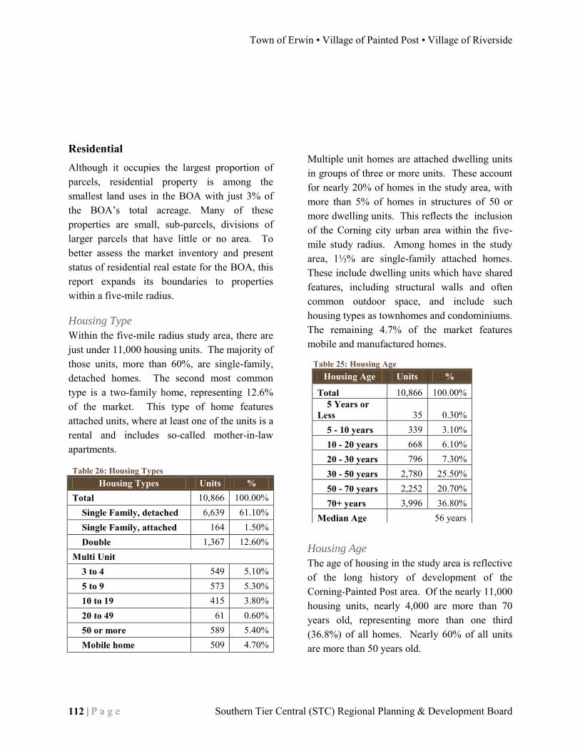
Town of Erwin • Village of Painted Post • Village of Riverside
112 | P a g e Southern Tier Central (STC) Regional Planning & Development Board
Table 26: Housing Types Housing Types Units %
Total 10,866 100.00% Single Family, detached 6,639 61.10% Single Family, attached 164 1.50% Double 1,367 12.60%
Multi Unit 3 to 4 549 5.10% 5 to 9 573 5.30% 10 to 19 415 3.80% 20 to 49 61 0.60% 50 or more 589 5.40% Mobile home 509 4.70%
Table 25: Housing Age Housing Age Units %
Total 10,866 100.00% 5 Years or
Less 35 0.30% 5 - 10 years 339 3.10% 10 - 20 years 668 6.10% 20 - 30 years 796 7.30% 30 - 50 years 2,780 25.50% 50 - 70 years 2,252 20.70% 70+ years 3,996 36.80%
Median Age 56 years
Residential Although it occupies the largest proportion of parcels, residential property is among the smallest land uses in the BOA with just 3% of the BOA’s total acreage. Many of these properties are small, sub-parcels, divisions of larger parcels that have little or no area. To better assess the market inventory and present status of residential real estate for the BOA, this report expands its boundaries to properties within a five-mile radius.
Housing Type
Within the five-mile radius study area, there are just under 11,000 housing units. The majority of those units, more than 60%, are single-family, detached homes. The second most common type is a two-family home, representing 12.6% of the market. This type of home features attached units, where at least one of the units is a rental and includes so-called mother-in-law apartments.
Multiple unit homes are attached dwelling units in groups of three or more units. These account for nearly 20% of homes in the study area, with more than 5% of homes in structures of 50 or more dwelling units. This reflects the inclusion of the Corning city urban area within the five-mile study radius. Among homes in the study area, 1½% are single-family attached homes. These include dwelling units which have shared features, including structural walls and often common outdoor space, and include such housing types as townhomes and condominiums. The remaining 4.7% of the market features mobile and manufactured homes.
Housing Age
The age of housing in the study area is reflective of the long history of development of the Corning-Painted Post area. Of the nearly 11,000 housing units, nearly 4,000 are more than 70 years old, representing more than one third (36.8%) of all homes. Nearly 60% of all units are more than 50 years old.

DRAFT Brownfield Opportunity Area (BOA) Step 2 Nomination
peter j. smith & company, inc. • HUNT Engineers, Architects & Land Surveyors, P.C. P a g e | 113
Table 28: Housing Tenure Housing Units by
Occupancy Status and Tenure (within five
miles)
2000 2010 2015
Units % Units % Units %
Total Housing Units 10,855 100% 11,382 100% 11,389 100% Occupied 10,012 92.20% 9,976 87.60% 9,898 86.90%
Owner 6,393 58.90% 6,404 56.30% 6,324 55.50% Renter 3,619 33.30% 3,573 31.40% 3,574 31.40%
Vacant 849 7.80% 1,406 12.40% 1,491 13.10%
Table 27: Housing Rental Rates Housing Rental Rates Units % With cash rent 3,494 95.50%
Less than $300 486 13.30% $300 to $399 423 11.60% $400 to $499 746 20.40% $500 to $599 755 20.60% $600 to $699 482 13.20% $700 to $799 189 5.20% $800 to $899 303 8.30% $900 to $999 11 0.30% $1,000 to $1,499 15 0.40% $1,250 to $1,499 0 0.00% $1,500 to $1,999 17 0.50% $2,000 or more 67 1.80%
No cash rent 165 4.50%
Home building in recent years has not continued at the pace seen in the past, however reports are that the market remains robust. In the past 10 years, nearly 400 new homes have been constructed in the study area. Going back to 1990, that number stretches over 1,000 homes. The median age for units in the area is 56.
Occupancy
With the decline in manufacturing and overall employment in Corning-Painted Post and an associated decrease in population there has been an increase in housing vacancy. In 2000, 7.8% of homes in the study are were reported as vacant. By 2010, that number has increased to 12.4% and is presently projected to continue to increase through 2015. The increase in vacancy rates is being experienced in both owner-occupied and rental units, however, more significantly in owner-occupied homes. The ratio of owner-occupied housing units to rentals is just below 2:1 in the study area. In 2010, 56.3% of occupied housing units were occupied by the owner. The remaining 31.4% are rental units. It is expected that the percentage of owner-occupied units will decrease slightly through 2015, while rental unit occupancy will remain relatively constant.
Rental Rates
Rental rates in the study area cover a wide range. Of the more than 3,600 rental units in the five-mile radius, 95.5% receive cash rent. The remaining number of units have different rental agreements, including in-kind services or familial arrangements, where cash is not
accepted for rent. More than 40% of units rent for between $400 and $600 per month for rent. Approximately one quarter rent for less than $400/month and just more than one quarter are between $600 and $1,000 a
month for rent. Finally, a small handful, approximately 100 units, command rents of more than $1,000 per month; and 70% of those garner in excess of $2,000/month.
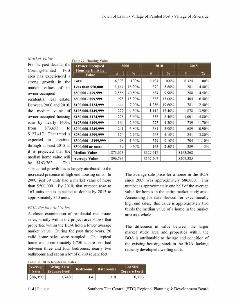
Town of Erwin • Village of Painted Post • Village of Riverside
114 | P a g e Southern Tier Central (STC) Regional Planning & Development Board
Table 29: Housing Value Owner Occupied Housing Units by
Value
2000 2010 2015
# % # % # %
Total 6,393 100% 6,404 100% 6,324 100% Less than $50,000 1,164 18.20% 372 5.80% 281 4.40% $50,000 - $79,999 2,588 40.50% 634 9.90% 288 4.50% $80,000 - $99,999 975 15.20% 833 13.00% 404 6.40% $100,000-$124,999 444 7.00% 1,256 19.60% 781 12.40% $125,000-$149,999 277 4.30% 1,112 17.40% 878 13.90% $150,000-$174,999 228 3.60% 535 8.40% 1,001 15.80% $175,000-$199,999 164 2.60% 275 4.30% 739 11.70% $200,000-$249,999 241 3.80% 381 5.90% 689 10.90% $250,000-$299,999 174 2.70% 265 4.10% 241 3.80% $300,000 - $499,999 98 1.60% 579 9.10% 704 11.10% $500,000 or more 39 0.60% 163 2.50% 339 5% Median Value $73,653 $127,417 $163,262 Average Value $96,793 $167,207 $209,385
Market Value
For the past decade, the Corning-Painted Post area has experienced a strong growth in the market values of its owner-occupied residential real estate. Between 2000 and 2010, the median value of owner-occupied housing rose by nearly 140%, from $73,653 to $127,417. That trend is expected to continue through at least 2015 as it is projected that the median home value will be $163,262. This substantial growth has is largely attributed to the increased presence of high end housing units. In 2000, just 39 units had a market value of more than $500,000. By 2010, that number rose to 163 units and is expected to double by 2015 to approximately 340 units.
BOA Residential Sales
A closer examination of residential real estate sales, strictly within the project area shows that properties within the BOA hold a lower average market value. During the past three years, 20 valid home sales were sampled. The typical home was approximately 1,750 square feet, had between three and four bedrooms, nearly two bathrooms and sat on a lot of 6,700 square feet.
The average sale price for a home in the BOA since 2009 was approximately $86,000. This number is approximately one half of the average value for homes in the entire market study area. Accounting for data skewed for exceptionally high end sales, this value is approximately two thirds the median value of a home in the market area as a whole. The difference in value between the larger market study area and properties within the BOA is attributable to the age and condition of the existing housing stock in the BOA, lacking recently developed dwelling units.
Table 30: BOA Residential Sales Average
Sales Living Area
(Square Feet) Bedrooms Bathrooms Lot Size (Square Feet)
$86,350 1,743 3.4 1.8 6,705

DRAFT Brownfield Opportunity Area (BOA) Step 2 Nomination
peter j. smith & company, inc. • HUNT Engineers, Architects & Land Surveyors, P.C. P a g e | 115
Commercial Office Space
Sales
Cost Per Square
Foot Class A $75.00 Class B $55.00 Class C $40.00
Table 32: Commercial Lease Rates
Classification Low
Rental Rates
High Rental Rates
Effective Average Rental Rates
Downtown Office Full Service Rates Class A (prime) $9.00 $21.00 $15.00 Class B (secondary) $6.00 $11.50 $8.75
Suburban Office Full Service Rates Class A (prime) $9.00 $21.00 $15.00 Class B (secondary) $7.00 $11.50 $9.25
These trends follow national growth in housing values that was experienced through the first half of the 2000s, however the project area has faired better, when compared nationally, as housing values have continued to rise, and are expected to rise further, at robust growth rates, while nationally, much of the housing market has busted. The strong residential market suggests that new residential units may be a viable development in the project area, especially the potential for such units that cater to those priced out of the growing housing markets, such as senior citizens.
Commercial The commercial real estate market in the BOA has experienced less resiliency when compared with area housing. The market is mixed with aged commercial buildings/units, largely outdated in terms of both office and retail space. Recent office development has occurred outside of the BOA area, in the Town of Erwin such as the Corning Inc. research facilities, as well as in downtown Corning, where several older buildings have been renovated and modernized.
Office
Much of the existing stock of office space within and adjacent to the BOA was constructed prior to 1980, with little modernized space. This includes a total of eight buildings, four of which are branch bank locations, while four others are more traditional professional office buildings; one being a municipally-owned building and the other offices for Dresser Rand.
Outside of traditional offices, the area also features converted
office spaces from preexisting residential properties. Within the past 10 years, the BOA and vicinity have had few sales in the office space market. Of the commercial office space sales that have occurred since 2000, the best conditioned properties are selling for approximately $75.00 per square foot, while less desirable, Class C space sells for $40.00 per square foot. It must be noted that these sales are based upon an extremely limited sample size of area sales during the past decade and will likely vary significantly depending upon a variety of factors including access, location and amenities.
Lease Rates
The region’s commercial real estate market has strong lease rates that are, reportedly, getting stronger. According to an area real estate company, office lease rates are as much as $21.00 per square foot for Class A space, both suburban and downtown. For the secondary, Class B market, the area pulls in up to $11.50 per square foot.
Table 31: Commercial Space Sale Rates
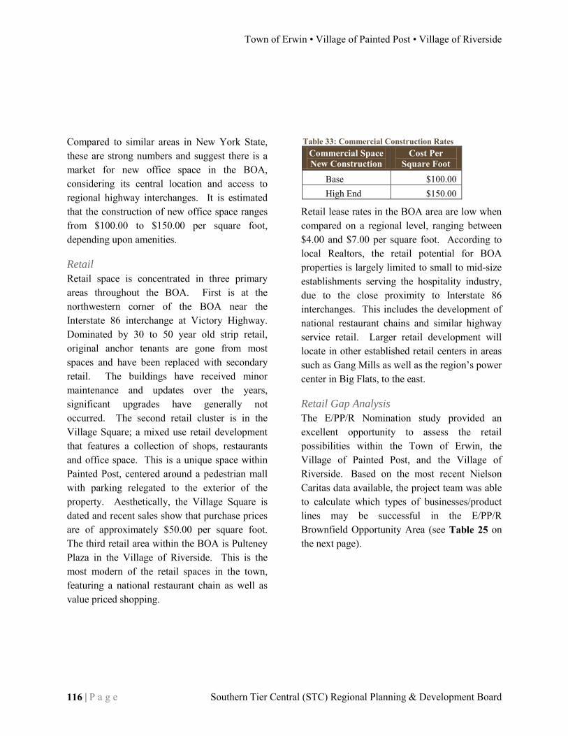
Town of Erwin • Village of Painted Post • Village of Riverside
116 | P a g e Southern Tier Central (STC) Regional Planning & Development Board
Table 33: Commercial Construction Rates Commercial Space New Construction
Cost Per Square Foot
Base $100.00 High End $150.00
Compared to similar areas in New York State, these are strong numbers and suggest there is a market for new office space in the BOA, considering its central location and access to regional highway interchanges. It is estimated that the construction of new office space ranges from $100.00 to $150.00 per square foot, depending upon amenities.
Retail
Retail space is concentrated in three primary areas throughout the BOA. First is at the northwestern corner of the BOA near the Interstate 86 interchange at Victory Highway. Dominated by 30 to 50 year old strip retail, original anchor tenants are gone from most spaces and have been replaced with secondary retail. The buildings have received minor maintenance and updates over the years, significant upgrades have generally not occurred. The second retail cluster is in the Village Square; a mixed use retail development that features a collection of shops, restaurants and office space. This is a unique space within Painted Post, centered around a pedestrian mall with parking relegated to the exterior of the property. Aesthetically, the Village Square is dated and recent sales show that purchase prices are of approximately $50.00 per square foot. The third retail area within the BOA is Pulteney Plaza in the Village of Riverside. This is the most modern of the retail spaces in the town, featuring a national restaurant chain as well as value priced shopping.
Retail lease rates in the BOA area are low when compared on a regional level, ranging between $4.00 and $7.00 per square foot. According to local Realtors, the retail potential for BOA properties is largely limited to small to mid-size establishments serving the hospitality industry, due to the close proximity to Interstate 86 interchanges. This includes the development of national restaurant chains and similar highway service retail. Larger retail development will locate in other established retail centers in areas such as Gang Mills as well as the region’s power center in Big Flats, to the east.
Retail Gap Analysis
The E/PP/R Nomination study provided an excellent opportunity to assess the retail possibilities within the Town of Erwin, the Village of Painted Post, and the Village of Riverside. Based on the most recent Nielson Caritas data available, the project team was able to calculate which types of businesses/product lines may be successful in the E/PP/R Brownfield Opportunity Area (see Table 25 on the next page).
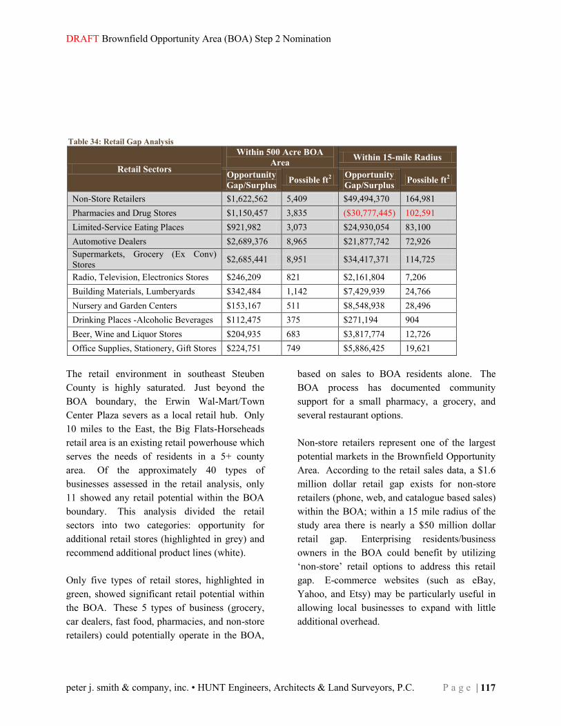
DRAFT Brownfield Opportunity Area (BOA) Step 2 Nomination
peter j. smith & company, inc. • HUNT Engineers, Architects & Land Surveyors, P.C. P a g e | 117
Table 34: Retail Gap Analysis
Retail Sectors
Within 500 Acre BOA
Area Within 15-mile Radius
Opportunity
Gap/Surplus Possible ft
2
Opportunity
Gap/Surplus Possible ft
2
Non-Store Retailers $1,622,562 5,409 $49,494,370 164,981 Pharmacies and Drug Stores $1,150,457 3,835 ($30,777,445) 102,591 Limited-Service Eating Places $921,982 3,073 $24,930,054 83,100 Automotive Dealers $2,689,376 8,965 $21,877,742 72,926 Supermarkets, Grocery (Ex Conv) Stores $2,685,441 8,951 $34,417,371 114,725
Radio, Television, Electronics Stores $246,209 821 $2,161,804 7,206 Building Materials, Lumberyards $342,484 1,142 $7,429,939 24,766 Nursery and Garden Centers $153,167 511 $8,548,938 28,496 Drinking Places -Alcoholic Beverages $112,475 375 $271,194 904 Beer, Wine and Liquor Stores $204,935 683 $3,817,774 12,726 Office Supplies, Stationery, Gift Stores $224,751 749 $5,886,425 19,621
The retail environment in southeast Steuben County is highly saturated. Just beyond the BOA boundary, the Erwin Wal-Mart/Town Center Plaza severs as a local retail hub. Only 10 miles to the East, the Big Flats-Horseheads retail area is an existing retail powerhouse which serves the needs of residents in a 5+ county area. Of the approximately 40 types of businesses assessed in the retail analysis, only 11 showed any retail potential within the BOA boundary. This analysis divided the retail sectors into two categories: opportunity for additional retail stores (highlighted in grey) and recommend additional product lines (white). Only five types of retail stores, highlighted in green, showed significant retail potential within the BOA. These 5 types of business (grocery, car dealers, fast food, pharmacies, and non-store retailers) could potentially operate in the BOA,
based on sales to BOA residents alone. The BOA process has documented community support for a small pharmacy, a grocery, and several restaurant options. Non-store retailers represent one of the largest potential markets in the Brownfield Opportunity Area. According to the retail sales data, a $1.6 million dollar retail gap exists for non-store retailers (phone, web, and catalogue based sales) within the BOA; within a 15 mile radius of the study area there is nearly a $50 million dollar retail gap. Enterprising residents/business owners in the BOA could benefit by utilizing ‘non-store’ retail options to address this retail gap. E-commerce websites (such as eBay, Yahoo, and Etsy) may be particularly useful in allowing local businesses to expand with little additional overhead.

Town of Erwin • Village of Painted Post • Village of Riverside
118 | P a g e Southern Tier Central (STC) Regional Planning & Development Board
There may be an opportunity for some small business growth of pharmacies/drugstores within the BOA. According to the retail gap data, there is more than $1 million in unmet retail demand for pharmacies/drugstores within the BOA boundary; BOA residents have expressed a preference for a local pharmacy/drugstore. However, when the 15 mile radius retail data is analyzed, there is an over-supply of drugstores outside the BOA. An oversupply in the surrounding area does limit the potential of a traditional pharmacy/drugstore, there may be potential for a small drugstore that provides additional services (prescription delivery, clinic). Limited Service Eating places are under-represented in the BOA and in a 15 mile radius around the BOA. There is $900,000 in unmet demand for ‘fast food’ within the BOA boundary. In the region surrounding the BOA, there is nearly $25 million in unmet demand for these types of restaurants. The location of the E/PP/R BOA, at the intersection of Rt. 15 and I-86, makes this community very attractive for limited-service eating places. For the past 10-15 years, residents have consistently shown a preference for additional restaurants in this community.
According to the retail data, automotive dealers are underrepresented in the BOA. Given the $2.6 million dollar retail gap within the BOA and the $20 million retail gap outside the BOA, there is ample opportunity for car dealerships. One or two used car dealerships could operate in the community provided adequate sites are available. There is a significant opportunity for a supermarket or grocery within the BOA. There is $2.6 million in unmet demand within the BOA and $34 million of unmet demand in the region surrounding the BOA. Within a 5 mile radius, there are: a Wegmans, a Wal-Mart, and an Aldi. Any small grocery or supermarket within the BOA would need to address a market niche un-satisfied by existing grocery options. Residents have expressed strong support for a grocery/supermarket in the BOA; a grocery with home-delivery service might succeed in this business environment. The remaining six types of retail options (electronics, building materials, nursery/garden, office supplies, wine/liquor, and drinking places) have a small but significant gap in the E/PP/R Brownfield Opportunity Area and a much larger retail gap in the 15 mile area surrounding the BOA. Each of these product lines represents an opportunity to expand product offerings in existing retail stores.

DRAFT Brownfield Opportunity Area (BOA) Step 2 Nomination
peter j. smith & company, inc. • HUNT Engineers, Architects & Land Surveyors, P.C. P a g e | 119
Table 36: Industrial Lease Rates
Classification Low
Rental Rates
High Rental Rates
Effective Average Rental Rates
Bulk Warehouse $2.50 $5.00 $3.75 Industrial Manufacturing $3.00 $4.00 $2.75
Table 35: Industrial Sales Rates
Industrial Space Sales
Cost Per Square Foot
Class A $7.00 Class B $5.00 Class C N/A
Table 37: Industrial Construction Rates Industrial Space
New Construction Cost Per
Square Foot
Base $50.00 High End $70.00
Industrial Industrial space within the BOA and the entire Corning-Painted Post area is in high demand and considered to be at a premium. Within the project area and near vicinity, there is little industrial space available. Most is either occupied and operational, or it has been demolished as it has reached the end of its useful life. Industrial space that does remain available is not up to modern standards and, according to local Realtors, will likely be demolished rather than reused.
Lease Rates
Rental rates for industrial space in the area are on par with rates found in other regions of New York State. For bulk warehouse space, rates range between $2.50 and $5.00 per square foot. For industrial manufacturing facilities, the range is tighter at $3.00 to $4.00 per square foot. While these rates have remained steady over recent years, local real estate professionals with insight into the market say that rates may be beginning to spike due to expanding gas extraction in neighboring regions to the south in Pennsylvania.
Similar to the lease rates for industrial space, purchase prices have remained consistent, presently ranging between $5.00 and $7.00 per square foot. Demand is increasing due to the expanding gas industries in Pennsylvania, which requires substantial industrial space for storage as well as manufacturing and maintenance facilities, therefore forcing rents above the rate their condition would otherwise warrant. Considering the mounting pressures for new industrial space in the project area, there is a market for new industrial, manufacturing and warehouse space. Construction of such space to modern day standards will range in cost from $50.00 to $70.00 per square foot.

Town of Erwin • Village of Painted Post • Village of Riverside
120 | P a g e Southern Tier Central (STC) Regional Planning & Development Board
Real Estate Outlook The expanding hydraulic fracturing gas industry in northern Pennsylvania is beginning to have significant impacts upon commercial office space and especially industrial space in the Corning-Painted Post area. As noted previously, industrial space comes at a premium and any reasonably usable space in the area is occupied. New industrial development will be constructed to house storage for hydraulic fracturing equipment and materials, such as sand, as well as for the fabrication and maintenance of machinery used in the extraction process. Office space is also experiencing demand from the industry. Williamsport, PA, has had an explosion of new gas company headquarters, with more than 120 individual gas companies now located there. Spin-off impacts are being felt in the southern tier of New York State. Several gas companies have located in Horseheads, proximate to the local airport. Ancillary to the industry, the region has seen new engineering firms open offices, largely to conduct environmental work related to the gas industry in Pennsylvania.
New facilities related to the gas industry range depending upon the specific use. Among the potential demands are storage warehouses for sand. The demand is for buildings of 100,000 to 200,000 square feet, or more. A significant opportunity for the BOA is the demand for free standing industrial facilities with between 5,000 and 15,000 square feet. These facilities would house maintenance and manufacturing operations for hydraulic fracturing equipment, as well as equipment storage. The BOA area could support a “flex” park that includes space easily adaptable to either industrial and commercial uses. Typically, flex parks lease for $5 to $6 per square foot. However, due to present demand and a shortage of supply, similar spaces proximate to Williamsport have recently leased for $18 to $20 per square foot. These rates are significantly above the common industry market.

DRAFT Brownfield Opportunity Area (BOA) Step 2 Nomination
peter j. smith & company, inc. • HUNT Engineers, Architects & Land Surveyors, P.C. P a g e | 121
SUMMARY ANALYSIS, FINDINGS, AND RECOMMENDATIONS OF THE BOA AND STRATEGIC SITES Overview With increasingly limited land and financial resources, locally and across the State, economic development efforts should be seeking investment and revitalization opportunities in sustainable locations that take advantage of existing infrastructure and provide growth opportunities that maximize spin-off impact opportunities and enhance local quality of life. The Erwin/Painted Post/Riverside Brownfield Opportunity Area (E/PP?R BOA) offers tremendous redevelopment potential for the urban cores of three municipalities in the Southern Tier region of New York State. As a three community study area, the BOA provides a special advantage of intermunicipal cooperation, shared vision, and priority consideration for state and federal grant resources which will make the EPPR BOA very attractive for future investment. State funding for the Erwin/Painted Post/Riverside Brownfield Opportunity Area will make significant improvements in three cooperating municipalities.
The Step 2 BOA Nomination project will facilitate urban re-development in an existing population cluster. The EPPR BOA is an excellent candidate for further, Step 3 funding under the BOA Program. This study satisfies the criteria set forth by our project work plan and the New York State Department of State. The inventory and analysis coupled a multi-faceted community participation process of the BOA has informed the Step 2 Nomination Study of the major challenges and opportunities facing the BOA, as well as the potentials for new growth. These recommendations will form the basis for moving forward into Step 3 of the BOA program.
Pre-Nomination Recommendations
The recommendations in this chapter build upon the previous findings of the Step 1, pre-nomination study. Completed in March, 2009, the pre-nomination document is an overview study of BOA, with analysis of its basic, readily available conditions. These recommendations are preliminary and provide direction for Steps two and three of the BOA program. As will be demonstrated in the final recommendations of the Step 2 Nomination Study, each recommendation of the pre-nomination has been provided for or accomplished.
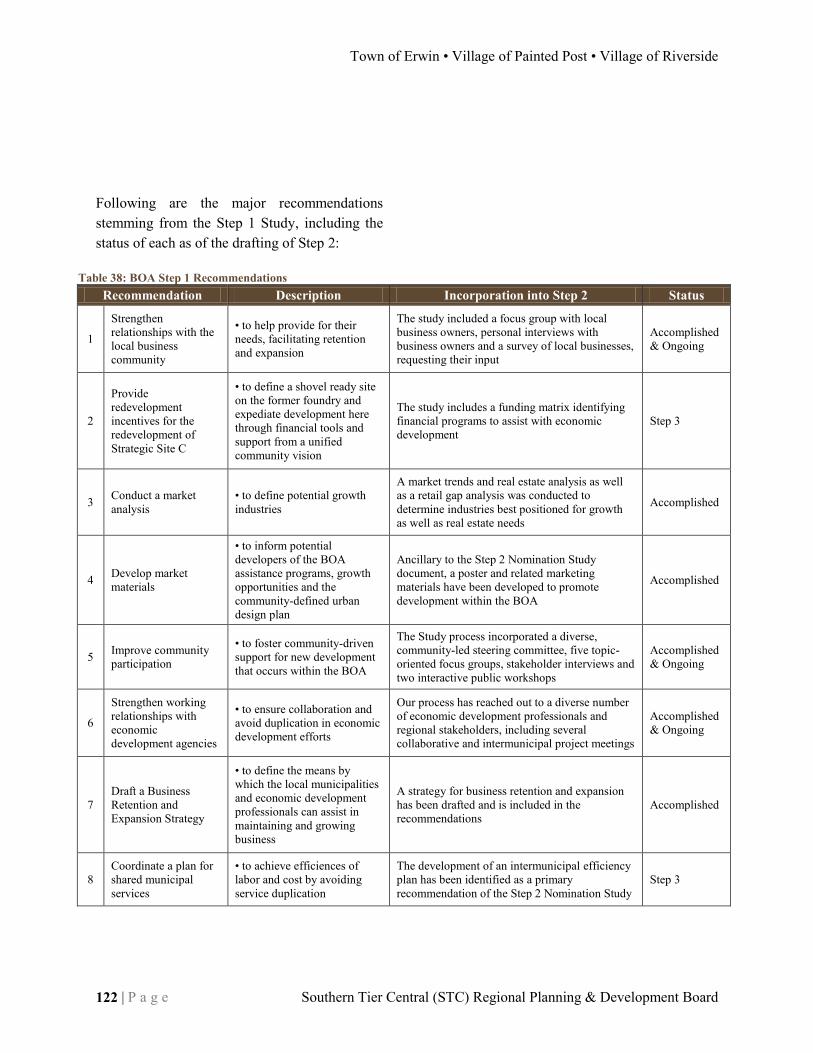
Town of Erwin • Village of Painted Post • Village of Riverside
122 | P a g e Southern Tier Central (STC) Regional Planning & Development Board
Table 38: BOA Step 1 Recommendations Recommendation Description Incorporation into Step 2 Status
1
Strengthen relationships with the local business community
• to help provide for their needs, facilitating retention and expansion
The study included a focus group with local business owners, personal interviews with business owners and a survey of local businesses, requesting their input
Accomplished & Ongoing
2
Provide redevelopment incentives for the redevelopment of Strategic Site C
• to define a shovel ready site on the former foundry and expediate development here through financial tools and support from a unified community vision
The study includes a funding matrix identifying financial programs to assist with economic development
Step 3
3 Conduct a market analysis
• to define potential growth industries
A market trends and real estate analysis as well as a retail gap analysis was conducted to determine industries best positioned for growth as well as real estate needs
Accomplished
4 Develop market materials
• to inform potential developers of the BOA assistance programs, growth opportunities and the community-defined urban design plan
Ancillary to the Step 2 Nomination Study document, a poster and related marketing materials have been developed to promote development within the BOA
Accomplished
5 Improve community participation
• to foster community-driven support for new development that occurs within the BOA
The Study process incorporated a diverse, community-led steering committee, five topic-oriented focus groups, stakeholder interviews and two interactive public workshops
Accomplished & Ongoing
6
Strengthen working relationships with economic development agencies
• to ensure collaboration and avoid duplication in economic development efforts
Our process has reached out to a diverse number of economic development professionals and regional stakeholders, including several collaborative and intermunicipal project meetings
Accomplished & Ongoing
7 Draft a Business Retention and Expansion Strategy
• to define the means by which the local municipalities and economic development professionals can assist in maintaining and growing business
A strategy for business retention and expansion has been drafted and is included in the recommendations
Accomplished
8 Coordinate a plan for shared municipal services
• to achieve efficiences of labor and cost by avoiding service duplication
The development of an intermunicipal efficiency plan has been identified as a primary recommendation of the Step 2 Nomination Study
Step 3
Following are the major recommendations stemming from the Step 1 Study, including the status of each as of the drafting of Step 2:

DRAFT Brownfield Opportunity Area (BOA) Step 2 Nomination
peter j. smith & company, inc. • HUNT Engineers, Architects & Land Surveyors, P.C. P a g e | 123
Table 39: BOA Step 1 Action Steps Action Step Incorporation into Step 2
1 Attract Highway-Oriented Retail & Service
Up to 55,500 square feet of highway-oriented retail and service has been planned for at strategic sites A and G in the Urban Design Plan
2 Attract a Research/Light Industrial Facility/Software Campus
A 350,000 square foot light industrial/high tech/commercial flex space campus has been planned for at strategic site C of the Urban Design Plan
3 Attract & Concentrate Local Retail
Up to 31,500 of neighborhood commercial development has been planned for at strategic site B of the Urban design Plan, in addition to 300,000 of mixed use space planned for strategic sites D, E & F
4 Attract Professional Services & Offices
Up to 300,000 square feet of mixed use space, including commercial office, has been planned for at strategic sites D, E & F of the Urban Design Plan
5 Implement Community Beautification & Community Use
Streetscape improvements, pedestrian amenities and beautification projects have been recommended throughout the BOA, with special concentrations around strategic sites C, D, E and F
6 Encourage High Density Residential
48 1,000 square foot urban townhouses have been planned for at strategic sites D, E & F of the Urban Design Plan, in addition to up to 300,000 square feet of mixed use space, including residential at strategic sites D, E & F
7 Encourage Health Care & Assistance
A senior housing complex has been planned for at strategic site D of the Urban Design Plan
Furthermore, the pre-nomination provides a series of preliminary action steps for the development of the BOA. Each of these items has been considered in the Step 2 Nomination Study and incorporated into the Urban Design Plan, accordingly. Following are the seven major action steps identified in the pre-nomination:
As the E/PP/R BOA program moves into Step 3, these action steps continue to be of relevance and should be a focus for implementation. The urban design plan, described later in this section, will serve as the primary vision for redevelopment of the BOA. Efforts to attract new development should be conducted within the context of that plan.

Town of Erwin • Village of Painted Post • Village of Riverside
124 | P a g e Southern Tier Central (STC) Regional Planning & Development Board
Summary of Step 2 Nomination Analysis & Findings The Step 2 Nomination Study includes a comprehensive investigation of the Brownfield Opportunity Area across 13 topic areas. These analyses have culminated to inform the BOA project team of the major obstacles and opportunities that the project area faces. They have influenced the drafting of project recommendations as well as the development of a land use plan and the urban design plan. It is with this factual basis that the BOA project sponsor can feel confident in pursuing the recommendations of the Step 2 Nomination.
Summary Overview of Findings
The Erwin/Painted Post/Riverside Brownfield Opportunity Area is an urban project area, primarily composed of industrial factories, residential neighborhoods, highway retail centers, education and recreation. Unlike many BOA projects throughout New York State, this project boundary is not mostly composed of several large swaths of land and a few remaining industrial employers on an otherwise abandoned landscape, rather, the E/PP/R BOA project is situated in the midst of active urban neighborhoods. The mixed-use nature of development found throughout the project area gives the E/PP/R BOA specific challenges and opportunities for redevelopment. There is much to build upon, with a stable residential population, existing large employers and major transportation access. However, the close proximity of the many elements call the need for sensitivity to adjacent land uses and require creative means to identify infill development
opportunities or to assemble lands for larger urban development projects. The most significant challenges facing the project area are land constraints and contamination. The largest strategic site in the BOA is 45 acres, Strategic Site C. Approximately 11 acres of that is already being developed for a new rail siding. Each of the remaining strategic sites are less than 10 acres. This presents a challenge for accommodating major “campus-style” developments within the BOA. It will be imperative for the Urban Design plan to conceptualize potential assembly of multiple parcels to enable larger developments. The plan will also identify opportunities for small infill development that can serve the needs of the local community and enhance the physical conditions of the community. Contamination has also been identified as a potential significant issue for several parcels. Of the eight identified strategic sites, six have been recommended for phase 2 environmental investigations as a part of the BOA Step 3. A seventh site, Strategic Site C, has already been remediated to the point that it can accommodate industrial development. The last site, Strategic Site D does not recommend a phase 2 investigation, however there will be asbestos abatement required for any changes to the historic structures on the property.

DRAFT Brownfield Opportunity Area (BOA) Step 2 Nomination
peter j. smith & company, inc. • HUNT Engineers, Architects & Land Surveyors, P.C. P a g e | 125
The BOA also presents many positive opportunities for potential development. The most significant strength of the study area is its transportation and access infrastructure. The project area is located directly adjacent to the intersection of two major highways, Interstate 86, which travels across southern New York State, and Interstate 99, which is presently under construction, traveling south into Pennsylvania. The BOA is served by three interchanges to the highways, one at each end and one in the center, perhaps making the project area the most highly accessible development area in the entire southern tier. The historic development patterns of the BOA offer the opportunity to build upon existing development, taking advantage of presently available roadways, infrastructure and services. According to the infrastructure report, there exists excess capacity for both water and sewer to accommodate new growth. New development will have a nearby population to function as a consumer market as well as to serve as a source for employees. The historic qualities of the BOA also extend to the structures. Several buildings throughout the project area have potential for adaptive reuse, sustainably giving historic and non-historic buildings new function. The current Corning-Painted Post School Board building located at 165 Charles Street is a beautiful red brick, neo-classical structure that, given changes in facility needs in the school district, may be in line for a new use. Such a structure would lend itself well to a residential, office or mixed use conversion.
The building’s presence within a dense residential neighborhood make it an ideal candidate for multi-unit adaptive reuse. The urban design plan and project recommendations will identify a preferred future for the structure. The E/PP/R BOA is also home to a diverse collection of public landscapes, including schoolyards, sports fields, recreational parkland and pocket parks. The presence of these recreational spaces enhances the local quality of life and provide amenities to both residents and employees of the area’s companies. They should be considered a significant asset and any new development or public improvements should strengthen the communities’ landscapes. A review of economic and market trends has provided insight into the potential for new growth in the BOA. The analysis has cited a robust housing market throughout the Corning region, with home values expected to double from the year 2000 to 2015. However, examining more locally within the BOA project boundary, home sales are approximately 50% the value of sales throughout the region. This is due to the presence of deteriorating conditions prevalent in an older housing stock. Very little new residential development has occurred within the BOA has occurred to offset these numbers. A means to strengthen the residential market within the project area may be to provide new housing that diversifies the existing stock of units, while enhancing the area’s quality of life by beautifying streetscapes and public spaces.

Town of Erwin • Village of Painted Post • Village of Riverside
126 | P a g e Southern Tier Central (STC) Regional Planning & Development Board
The commercial and industrial markets within the BOA offer contrasts to one another. The analysis suggests that the current state the commercial office and retail space shows signs of saturation, with sales and lease rates lower than markets elsewhere. However, it must be noted that the majority of both the office and retail stock within and adjacent to the BOA is dated, providing little modernized space for either. According to the retail gap analysis, there is limited potential for growth in a few sectors, including automotive, pharmacies and supermarkets. However, given the recent transportation improvements to Interstates 86 and 99, it is plausible that the study area could be well positioned for new growth, should land and/or modernized space become available. \ Conversely, the industrial space market, locally, is in demand. This is largely due to the emerging natural gas industry in northern-central Pennsylvania. Within the BOA project area and nearby vicinity, there is very little industrial and warehouse space available; newly constructed spaces throughout the region are quickly occupied by natural-gas related industry. The gas industry is also creating a need for flex space that can accommodate a combination of industrial and commercial tenants. Much of the spin-off impact of the gas industry is in related services, such as engineering, surveying and logistics. Nearby Chemung County has experienced substantial growth in its service industries, related to the industrial growth in Pennsylvania.
Tourism remains a growing industry for the Southern Tier and Finger Lakes region. It is suggested that the BOA provides opportunity to offer tourism support amenities, such as national restaurants and retail as well as some nationally branded accommodations. The project area will not become a significant destination for tourists, but providing for some support amenities at the three interchanges in the project area will allow the local communities to capture portions of the larger tourism economy.
Section Findings
The matrix provided on the following pages provides a brief overview of the findings of each of the investigative sections of the Step 2 BOA Nomination. Each of the 13 sections are listed, with the challenges and opportunities with which each is faced in light of the potential redevelopment of the BOA. This section is mean to provide a quick understanding of the conditions of the BOA, given the exhaustive nature of the rest of the document. This matrix will be useful as a reference as the project moves into Step 3 and further to redevelopment.

DRAFT Brownfield Opportunity Area (BOA) Step 2 Nomination
peter j. smith & company, inc. • HUNT Engineers, Architects & Land Surveyors, P.C. P a g e | 127
Table 40: Major Findings Inventory
Section Challenges Opportunities
Community & Regional Setting
· Continued population decline, albeit slowing · Population growth in the Town of Erwin · Painted Post & Riverside lag behind state & national economic indicators
· Town of Erwing shows stronger economic than Statewide and National economies
· Riverside's educational attainment is significantly lower than Painted Post and Erwin
· Dresser Rand is among the County's largest employers · Corning Incorporated employs 7,000
Land Use N/A
· Almost 20% of the land is devoted to industrial use · 45 acres of land is devoted to parks & public purposes · 34 acres of vacant land · more than 50 acres of commercial land · Painted Post accounts for more than 60% of the BOA land area
Zoning N/A
· 190 acres zoned residential · 165 acres zoned industrial · 7 acres zoned mixed-use · 100 acres zoned commercial
Transportation · Unimproved streetscapes · Two major interstates · Three interchanges serving the BOA · Minimal traffic congestion
Infrastructure · Utility infrastructure for the project area has not been mapped
· Sewer system is presently operating at just 50% of its total capacity · Water system is operating under capacity
Traffic & Parking Analysis
· Route 415 & Bronson St. intersection will need improvements to accommodate full build out of the urban design plan
· No present congestion issues at any intersection
· Route 415 & Taylor St. intersection will need improvements to accommodate full build out of the urban design plan
· No significant parking issues are cited within the BOA study area
Brownfield, Abandoned & Vacant Sites
· Nearly 25 acres of brownfields · Nearly 90 acres have been identified as underutilized
· Nearly 15 acres have been identified as vacant
Strategic Sites
· Strategic Sites A, B, E, F, G recommended for a Phase II Environmental Site Assessment in step 3 · Eight strategic sites identified · Strategic Site H recommended for a Phase I and a Phase II Environmental Site Assessment in step 3
· Strategic Site C is considered remediated to the point where industrial development may occur
· Buildings on Strategic Site D have been identified as having significant structural concerns and the presence of asbestos
· A Strategic Site C access alternatives analysis has determined that the preferred access to spur new development at the site is the construction of a bridge connecting the northwest section of the property to W. Water Street.
· Deed restrictions on Strategic Site C allow for industrial development only at the discretion of the Dresser Rand Company

Town of Erwin • Village of Painted Post • Village of Riverside
128 | P a g e Southern Tier Central (STC) Regional Planning & Development Board
Table 41: Major Findings (cont.) Inventory
Section Challenges Opportunities
Land Ownership Patterns
· 3.5 acres of brownfiels are privately owned · 21.5 acres of brownfields are publicly owned · 31 acres of underutilized sites are privately owned · 56 acres of underutilized sites are publicly owned · 12 acres of vacant sites are privately owned · 1.1 acres of vacant lands are publicly owned
Parks & Open Space N/A
· All parks & open space lands in the BOA are within the Village of Painted Post · 35 acres devoted to community service · 8 acres devoted to recreation & entertainment · 18.5 acres devoted to conservation/parks
Building Inventory
N/A
· Eight significant buildings/sites in the BOA have been chosen for a more detailed description. These include: a former car dealership, the former dresser rand foundry site, the Corning-Painted Post School Board building, the Krog building, the former Erwin Town Hall, the Immaculate Heart of Mary church, Crystal Cleaners and Storflex. These sites have been identified as pivotal to the BOA's redevelopment
Historic or Archeologically Significant Areas
N/A
· Due to flooding, there is a low likelihood for the presence of historic artifacts · Three properties are listed on the National Register of Historic Places
Natural Resources & Environmental Resources
· Due to the presence of fill in areas proximate to the Chemung River, detailed soil analysis is recommended for new construction
· Groundwater is monitored for potential contamination and has continued to meet safe drinking standards
· Generally, soil is good for construction throughout the BOA
· Water quality of the Chemung River has continually improved over the past 40 years
· Flood control is present throughout the BOA due to previous flooding events and must not be disturbed by new development · Air quality standards are met throughout the BOA area
Economic & Market Trends Analysis
· Saturated market for commercial space · Industrial space in high demand · BOA features dated commercial space · Growth expected in transportation-related industries
· Local area lacks modern housing & variety · Growth expected in gas industry support sectors · Potential for traveler support retail & restaurants · Strong housing market in surrounding region

DRAFT Brownfield Opportunity Area (BOA) Step 2 Nomination
peter j. smith & company, inc. • HUNT Engineers, Architects & Land Surveyors, P.C. P a g e | 129
Recommendations As a conclusion of the exhaustive analysis of the Brownfield Opportunity Area, a number of recommendations have been made that are determined to be the best course of action moving into the Step 3 section of the program and to spur redevelopment of the project area.
Further Environmental Investigation
Several properties within the BOA have been recommended for more extensive environmental investigation in Step 3 in the form of Phase I and Phase II Environmental Site Assessments. These are in addition to the six Phase I Environmental Site Assessments and one summary assessment conducted in Step 2. The following matrix identifies the appropriate investigative actions, indicating additional investigations to be undertaken in Step 3: Table 42: Further Investigation Recommendations Property/Strategic
Site Phase I Phase II
A Completed Step 3
B Completed Step 3
E Completed Step 3
F Completed Step 3
G Completed Step 3
H Step 3 Step 3
511 East High St. Step 3 Step 3
Zoning Revisions
A review of the zoning ordinances of each of the BOA municipalities has identified a number of inconsistencies in development visions of adjacent and adjoining parcels across municipal boundaries. The primary inconsistencies occur at the Village of Painted Post and Village of Riverside border, within and adjacent to Strategic Site F. Properties at this location, considered a single development site are divided into three separate zoning districts, residential and industrial within Painted Post, commercial within Riverside. Furthermore, properties to the south, surrounding the Hart Street Area also find themselves in a mix of residential, industrial and commercial zones. To maintain a cohesive vision for the redevelopment of the BOA, it is important that lands within the BOA are regulated by consistent development codes. It is recommended that each of the three municipalities, under the guidance of Southern Tier Central, engage in a collaborative rezoning process to update their respective zoning codes according to the Future Land Use Concept for the Brownfield Opportunity Area. The most significant revision will include the introduction of a mixed use district into the Villages of Painted Post and Riverside. It is recommended that the Town of Erwin’s Zoning code be used as a model starting point for the redrafting of the zones.

Town of Erwin • Village of Painted Post • Village of Riverside
130 | P a g e Southern Tier Central (STC) Regional Planning & Development Board
W. Water Street Bridge Project
A major project recommendation of the BOA is to improve access to the study area’s largest development site, Strategic Site C, the former Dresser Rand Foundry. A total of six options were evaluated in a Strategic Site C access report. Each was considered based upon the quality of access it provided, feasibility, potential costs and impacts to surrounding land uses. It was the recommendation of the report that a Bridge should be constructed in the northwest portion of the site, connecting Strategic Site C to West Water Street and, indirectly, to the interchange of Interstate 86. This option provides the greatest level of access with minimal impacts to the surrounding established neighborhoods. The estimated cost for this project is $5.5 million. However, this cost should be considered in light of its potential to stimulate a substantial private sector investment into Strategic Site C. It is recommended that Southern Tier Central, Three Rivers Development Corporation, the Steuben County IDA and the Village of Painted Post pursue funding for this project as a catalytic infrastructure improvement for the local economy. A project white paper should be submitted to the Regional Economic Development Council identifying the potential benefits of such a project and requesting funding for its pursuit.
Intersection Improvements
Based upon the Traffic and Parking Analysis, two intersections have been identified as in need of improvement by 2032 should the urban design plan reach full build-out potential. The intersection of Route 415 and Bronson Street will need to be modified. An analysis of the intersection with the installation of an actuated signal reveals the LOS can be improved to C (20.4) seconds. Additionally, the intersections of Route 415 and Taylor Street and Buffalo Street and East Water Street, each which service the plaza containing Site G, will be significantly affected. Installation of a signal at the Route 415 and Taylor Street intersection along with coordination with the signal at Buffalo Street will help the flow of traffic through this area.
Streetscape Projects
Local municipalities should also focus on streetscape improvements, to improve the marketability, appeal and quality of life within the BOA. Priorities for streetscape improvements are Victory Highway/Pulteney Street as well as North Hamilton Street. Each of These are the primary east-west and north-south thoroughfares in the BOA. Improvements should include a reduction of curb-cut access points to improve traffic flow, introduction of traffic calming tools such as bump-outs and raised crosswalks as well as greater pedestrian signal controls. These streetscapes will provide identity to the project area and enhancing the local quality of life by encouraging healthy lifestyles.

DRAFT Brownfield Opportunity Area (BOA) Step 2 Nomination
peter j. smith & company, inc. • HUNT Engineers, Architects & Land Surveyors, P.C. P a g e | 131
Beautification
The project municipalities should employ a series of beautification initiatives to achieve immediate improvement to the project area. These initiatives should focus upon low-cost ($5,000 or less), near-term project aimed at providing “quick-wins” for the BOA program, improving the image of the local communities and building enthusiasm and support for the project. Following are potential beautification projects:
Hanging Flower Baskets on N. Hamilton Street
Streetlight Banners along Victory Highway/Pulteney Street identifying each of the municipalities in the BOA
Wayfinding signage at the corner of Victory Highway & N. Hamilton Street
Community Garden at the D, L & W Rail Depot
Enhanced “welcome” signage to each of the communities adjacent to each Interstate 86 Exit
Pedestrian Connectivity
Develop enhanced pedestrian connectivity within the heart of the BOA, adjacent to N. Hamilton Street. The pathways identified in the Urban Design Plan will enhance connectivity between the local residential community, Village Square retail, commercial services and employment. They also promote healthy lifestyles and enhance viewsheds within the community, especially to the landmark Corning-Painted Post School Board building. These connections build upon existing public rights of way and will require the acquisition of two properties on Charles Street and two properties on Steuben Street.
Property Acquisition
Local economic development entities should pursue the acquisition of several properties within the BOA for future development. These properties include those within Strategic Site H to accommodate the future bridge connection as well as redevelopment of the site. Future acquisition of residential properties in the Hart Street area may also be considered for future industrial, should Site C reach build-out.
165 Charles Street Redevelopment
The Corning-Painted Post School Board Building at 165 Charles Street is among the most important landmarks in the BOA. The building is expected to no longer meet the facilities needs of the school district and requires an adaptive reuse. The building should be redeveloped as senior multi-unit housing with community facilities for events and recreation. The Village of Painted Post and local economic development organizations should establish a public-private partnership for the redevelopment of the structure sharing in the costs of public amenities.
Marketing
Project sponsors should develop marketing materials targeted towards prospective developers, aimed at attracting them to a location in the BOA. Materials should consist of a large scale plot of the Urban Design Plan for display in local municipal and economic development offices as well as a brochure detailing the Urban Design Plan, the BOA’s major amenities and suggesting potential redevelopment assistance programs.

Town of Erwin • Village of Painted Post • Village of Riverside
132 | P a g e Southern Tier Central (STC) Regional Planning & Development Board
Business Retention & Expansion Strategy
Business leaders make location decisions based upon their ability to cut their costs, availability of a quality workforce and access to training and educational resources for their workers as well as financing and incentives. Business location decisions are also made on the basis of proximity to transportation resources, competitors, suppliers and customers. Additional important elements of the decision to move or stay put include how supportive is the business atmosphere – is there a Chamber of Commerce, Small Business Development Center, business alliance or other organizations, how helpful and prompt is the municipality in processing requests or issuing permits. Quality of life is also an important aspect to help the business attract and retain employees – are there good schools, nice parks, friendly people and good retail? Will employees and be happy and productive here? An attraction and retention strategy is needed to help make the case for businesses to locate in Erwin, Painted Post and Riverside and it requires a team effort. In the BOA partners such as the Erwin and Steuben County IDAs and Three Rivers Development Corp. would appropriately take the lead in attraction and retention of larger-scale businesses such as manufacturers and industry. To attract and retain the small businesses that form the backbone of the economy, local residents and small business leaders have a central role. These stakeholders can form a team – or reignite a team that has already been empowered – to call on prospects and make the case for locating in the BOA.
This team’s focus should also be on existing businesses as an important aspect of the overall strategy. These businesses may be looking for expansion opportunities in real estate or into new business sectors, they may need to identify partner organizations and allies in their clusters for customers and clients and to identify partners in economies of scale. Often these existing businesses watch new businesses receive incentives for which they are not eligible – unless they move to another community. It’s important to call on them, make sure they know there are sources of assistance for them and thank them for their loyalty. The business attraction and retention strategy is based on the results of the retail gap analysis, business survey, real estate analysis, regional economic indicators, and input from the consultant team. The business environment within the Brownfield Opportunity Area is relatively good and improving. Some tools the team will need are probably already available such as a factsheet summarizing the area’s demographics, workforce statistics including education, and quality of life facts and figures. The Step One pre-nomination study includes a real estate “slip sheet” on almost every property in the BOA . that can be used as a starting point for development of an inventory of available properties.
DRAFT Brownfield Opportunity Area (BOA) Step 2 Nomination
peter j. smith & company, inc. • HUNT Engineers, Architects & Land Surveyors, P.C. P a g e | 133
According to the retail gap analysis, there is an un-met need in the BOA for two small restaurants, a small drugstore, a small grocery, and one or two used car dealerships. Also, the retail gap analysis showed a significant growth opportunity for non-store retailers (phone, web, and catalogue based sales). Within a 15 mile radius of the study area there is nearly a $50 million dollar un-met need for non-store retailers; home based businesses in the BOA could access this vast market. According to the business survey, one-half of businesses started in the BOA and the other half moved into the BOA. This indicates that the economic environment is strong enough to attract businesses. Approximately 92% percent of survey respondents believe that this location is ideal; that is high praise for the E/PP/R BOA. Only a few businesses in the BOA operated during the weekend; which demonstrates there is room for growth of existing businesses in the evenings or during the weekends. After reviewing the retail gap analysis, the business survey results, and the I-86/I-99 Corridor Blueprint Study there appear to be growth opportunities within the E/PP/R BOA for four distinct types of businesses. Together, these four strategies will result in a diversification of the local economy, an increase in local employment, and a significant increase in local spending due to the multiplier effect:
1) I-86/I-99 interchange based development (fast food and vehicle service)
2) 2) Growth within the existing businesses of the BOA (additional products/services and longer hours of operation) 3) Start-up growth, from a strong partnership with existing regional incubators 4) Growth in the non-retail home business sector of the economy. Action by local government will be necessary to attract and retain vital businesses within the BOA. Local zoning and planning board involvement are fundamental for community approved business developments. Planning/zoning can vary dramatically between communities; community supported zoning laws are an important element for attracting development. The existing zoning is a particular area of concern for two communities in the BOA; outdated master plans are a barrier to business friendly zoning in Painted Post/Riverside. These five steps will allow local governments to create a more attractive business environment.
Town of Erwin • Village of Painted Post • Village of Riverside
134 | P a g e Southern Tier Central (STC) Regional Planning & Development Board
Creating strong partnerships with the Corning Chamber of Commerce, Three Rivers Development, and The Steuben County IDA may result in additional business growth. The Village of Riverside should work with residents to create a Comprehensive Plan and revised Zoning map; good zoning is vital for development in the Village. The Painted Post Board of trade should expand the scope of their activities in the community. Throughout the BOA, village staff should work with the Planning board to streamline all aspects of the planning and zoning process. The Village of Painted Post has an aging master plan; a revised master plan may result in some important changes to village zoning.

DRAFT Brownfield Opportunity Area (BOA) Step 2 Nomination
peter j. smith & company, inc. • HUNT Engineers, Architects & Land Surveyors, P.C. P a g e | 135
Future Land Use Concept
The Future Land Use Concept serves as the basis for organization of future development within the Brownfield Opportunity Area. The concept is also the blueprint for how each of the Municipalities should update or amend their respective zoning codes in anticipation of the BOA’s redevelopment. It is recommended that the three municipalities work together to draft their zoning code updates, to ensure consistencies in development regulation across municipal boundaries. The Future Land Use Concept is developed around a central theme of identifying opportunities for infill development in the BOA that will not only support new economic growth, but will also enhance the existing quality of life for those who live and work in the area. This approach is sustainable, planning for new development that will utilize existing transportation and utility infrastructure and take advantage of an available workforce. A historic urban development pattern and expanding transportation infrastructure form the basis upon which the land use concept is defined. With an interstate exit at each end of the study area, the BOA will be anchored by neighborhood and highway-oriented commercial centers. Taking advantage of growing traffic volumes, these areas will offer restaurant, retail, accommodations and services that can serve both the local population as well as the many travelers who move throughout the area. These developments should follow good design standards, fronting the street, limiting curb cuts with coordinated access and orienting parking to the rear of the site.
The concept preserves existing residential neighborhoods in the boa, with the most significant population bound by High, Steuben and Chemung Streets in Painted post. This neighborhood is flanked by significant public parkland to the north and south, providing substantial sports and leisure recreation opportunities. The plan identifies locations to enhance pedestrian and recreational linkages, using bicycle lanes, sidewalks and trails to better integrate the residential population with the area’s parks. East of Steuben Street it is proposed that largely commercial and industrial land uses be transitioned into a new mixed-use neighborhood. This dense development pattern will build off of and strengthen the N. Hamilton Street urban core, providing a mix of commercial space with townhouse and apartment living opportunities. This development will be pedestrian oriented and will occur as presently industrial lands slowly transition out of their present use. The BOA will find its economic strength in its two major industrial and commercial/industrial flex space campuses. Located at Strategic Sites C and H as well as stretching from the current Ingersol Rand Plan, through the Hart Street Area to Storflex at Victory Highway, these areas will provide significant opportunity for employment growth in the BOA, functioning as the economic generator for the development of surrounding lands. The Future Land Use Concept is presented on the following page:

Town of Erwin • Village of Painted Post • Village of Riverside
136 | P a g e Southern Tier Central (STC) Regional Planning & Development Board

DRAFT Brownfield Opportunity Area (BOA) Step 2 Nomination
peter j. smith & company, inc. • HUNT Engineers, Architects & Land Surveyors, P.C. P a g e | 137
Future Land Use Concept Map

Town of Erwin • Village of Painted Post • Village of Riverside
138 | P a g e Southern Tier Central (STC) Regional Planning & Development Board

DRAFT Brownfield Opportunity Area (BOA) Step 2 Nomination
peter j. smith & company, inc. • HUNT Engineers, Architects & Land Surveyors, P.C. P a g e | 139
Urban Design Plan The principle concept for the Urban Design Plan is to provide the physical conditions for the development of a diversified economy. The plan is organized with a systematic approach that unifies and strengthens the urban layout of the BOA project area. The future of the BOA will see new economic growth that sustainably revitalizes previously developed areas and supports social and community growth within each of the municipalities.
Commercial Retail
The Brownfield Opportunity Area, is anchored at the east and west by Interstate 86 interchanges. Likewise, lands adjacent to the interchanges is primed to take greater advantage of the heavy traffic volumes which serve as a natural base for commercial retail development.
Development to the west of Interchange 43, at the northwest area of the BOA, is designated as new 45,000 square feet of neighborhood commercial retail. The focus of this development will be to provide necessary retail and services the local population, as well as some traveler accommodations, such as a hotel for visitors to the Corning and Finger Lakes areas. Important physical improvements that have been incorporated into this site is a new drive into Strategic Site A off of Victory Highway at the intersection of Robert Dann Drive. This will provide the development safe, signalized access and also provide ancillary egress to the neighboring church property, presently experiencing traffic congestion moving in and out of its property.
Neighborhood Commercial Development at Strategic Sites A & B

Town of Erwin • Village of Painted Post • Village of Riverside
140 | P a g e Southern Tier Central (STC) Regional Planning & Development Board
These facilities will be complementary to highway retail development at the other end of the BOA, including Strategic Site G. This area’s strategic location along Pulteney Street, between Exit 45 and the Corning Museum of Glass, provides an opportunity to capture the tourism market with national restaurant and some retail opportunities.
The development of this site is designed to be more respectful of the urban nature of the Village, bringing the built environment up to Pulteney Street and locating parking facilities to the interior of the development sites via a new connector street within the site. These structures may also be developed as 27,000 square feet of urban commercial office buildings, expanding local facilities for a growing service industry.
Highway Commercial Development at Strategic Site G

DRAFT Brownfield Opportunity Area (BOA) Step 2 Nomination
peter j. smith & company, inc. • HUNT Engineers, Architects & Land Surveyors, P.C. P a g e | 141
Commercial Mixed-Use
A measure of success for the Brownfield Opportunity Area will be a strengthened downtown core along and adjacent to Hamilton Street. This area is presently the vibrant corridor of the BOA, with industry, offices, restaurants, retail and parks space. A pedestrian-friendly scale and layout contributes an active and diverse streetscape. The Commercial Mixed-Use development area aims to strengthen these characteristics, further diversifying local land uses and expanding pedestrian connectivity. A new mid-block east-west roadway between W. High and Chemung Streets will be constructed from Steuben to Bronson Streets. This road will be the spine serving new commercial office and mixed-use development in the core of the BOA. Buildings will reflect existing development patterns, with a series of “courts” centering new development nodes. This development has a
potential of up to 300,000 mixed-use space and 48 1,000 square foot townhomes.
The new street will feature strong multimodal and pedestrian amenities, branching off of Hamilton Street, including sidewalks, landscaping and bicycle lanes. A strictly pedestrian connector will extend the new street from Steuben to Charles Street, terminating at the historic school building, serving as a visual and community anchor.
Mixed-Use & Townhouse Infill Development at Strategic Sites E & F
Walkable Urban Infill & Vistas

Town of Erwin • Village of Painted Post • Village of Riverside
142 | P a g e Southern Tier Central (STC) Regional Planning & Development Board
Industrial & Flex
Surrounding the new Commercial Mixed-Use are opportunities to continue the BOA legacy of industry and manufacturing. An industrial development corridor will stretch from one of the BOA to the other, centered around Hamilton Street and Hodgeman Park. The southern end of the corridor, below the present Dresser Rand facilities, will be devoted to new industrial development. Existing pockets of residential development should be land-banked to create larger development sites for future industrial growth. Strategic Site C, the former Foundry site, will provide for more flex space than can accommodate a mix of 350,000 square feet of industrial and office development.
This area will be accessed by an upgraded W. Water Street through the site, with a possible connecting bridge at the northwest corner of Site C, linking into the northern section of Water Street and Victory Highway. The central location of the industrial corridor will provide similar support for commercial development in the downtown core, similar to the benefits experienced in the Village from the presence of Dresser Rand.
Industrial/Flex-Space Campus at Strategic Site C

DRAFT Brownfield Opportunity Area (BOA) Step 2 Nomination
peter j. smith & company, inc. • HUNT Engineers, Architects & Land Surveyors, P.C. P a g e | 143
Residential, Parks & Open Space
The Urban Design Plan aims to maintain the existing residential development found throughout the BOA. The former school building on Charles Street, Strategic Site D, provides an opportunity for a new residential anchor for the BOA as market-rate apartments. Residences in the BOA will be enhanced through new quality of life developments. The existing multi-use trail system will be expanded to provide better linkages between the residential base, the school campus, Craig Park and Hodgeman Park.
Pedestrian access along core roadways within the downtown will be enhanced, connecting residents to employment, commercial and retail development. Building upon the existing quality of life amenities in the BOA, providing a great place to live and raise a family, will be essential to attracting new companies and sparking new economic growth.
Developing Infrastructure for a vibrant, healthy walkable live-work community

Town of Erwin • Village of Painted Post • Village of Riverside
144 | P a g e Southern Tier Central (STC) Regional Planning & Development Board

DRAFT Brownfield Opportunity Area (BOA) Step 2 Nomination
peter j. smith & company, inc. • HUNT Engineers, Architects & Land Surveyors, P.C. P a g e | 145
Urban Design Plan Map

Town of Erwin • Village of Painted Post • Village of Riverside
146 | P a g e Southern Tier Central (STC) Regional Planning & Development Board
DRAFT Brownfield Opportunity Area (BOA) Step 2 Nomination
peter j. smith & company, inc. • HUNT Engineers, Architects & Land Surveyors, P.C. P a g e | 147
IMPLEMENTATION This section discusses the methodology for moving forward and implementing the E/PP/R BOA Preliminary Step 2 Nomination Study. The central tool to this section is an Implementation Matrix, which identifies the plan’s recommendations and provides directives of who is responsible for each item, its timeframe and a potential cost.
Implementation Guidelines As the project communities seeks to implement the actions necessary to move forward the redevelopment of the E/PP/R BOA, a set of guidelines should be followed, designed to provide a framework for addressing the recommended actions in the plan, as well as actions that are proposed and implemented in the future: Guideline 1 The appropriate boards and
commissions should be assigned the responsibility of developing strategies and actions to implement the BOA Program
Guideline 2 The municipalities should support thorough environmental review under the State Environmental Quality Review Act in considering new development proposals
Guideline 3 The Town should expedite review and approval of development proposals deemed consistent with the recommendations of the Nomination Study as well as local comprehensive planning
Implementation Matrix As Erwin, Painted Post and Riverside move forward into redevelopment of the BOA program as a guiding document for the future, the most important phase becomes the actual implementation. It is essential to establish strategies to ensure that implementation occurs and the vision developed in the Nomination Study comes to life. The implementation matrix on the following page is a series of action-oriented tactics to bring the plan into reality. The Strategy is organized in a way that is straightforward, useful and comprehensive as the plan itself. For each action, a timeframe and, if available, an estimated cost are given for completing the item. Responsibility is assigned for each recommendation, designating the parties that must carry out the action.

Town of Erwin • Village of Painted Post • Village of Riverside
148 | P a g e Southern Tier Central (STC) Regional Planning & Development Board
Table 43: Implementation Matrix
Action Item Responsible Party Potential Cost Timeframe
1 Municipal acceptance of the Nomination Study and Urban Design Plan TE, VPP, VR N/A Immediate
2 Complete SEQRA STC N/A Immediate 3 Prepare Application for Project Advancement STC N/A Immediate
4 Coordinated updates to zoning law for all three municipalities
STC, TE, VPP, VR $5,000 - $10,000 0 - 3 years
5 Draft a sample RFP to solicit potential developers for redevelopment of BOA properties
STC N/A Immediate
6 Seek funding for detailed design of the Strategic Site C/W. Water Street access bridge
STC, TRD, SCIDA, VPP N/A 0 - 3 years
7 Seek funding for streetscape improvements of N. Hamilton Street and Victory Highway/Pulteney Street
STC, TE, VPP, VR N/A 5+ years
8 Install actuated traffic signal at the intersection of Route 415 and Bronson Street NYS DOT $40,000 -
$80,000 3 - 5 years
9 Install a traffic signal at the intersection of Taylor Street and Route 415, coordinated with adjacent signals
NYS DOT $40,000 - $80,000 3 - 5 years
10 Coordinate a plan for shared municipal services TE, VPP, VR $5,000 - $15,000 3 - 5 years
11 Form a partnership with private developer for the redevleopment of 165 Charles Street VPP N/A 0 - 3 years
12 Pursue asbestos abatement funding for 165 Charles Street
STC, TRD, SCIDA, VPP, Private Developer
N/A 0 - 3 years
13 Collaborate with municipalities and economic development organizations to pursue acquisition of properties within the BOA
STC, TRD, SCIDA, TE, VPP, VR
N/A 0 - 3 years
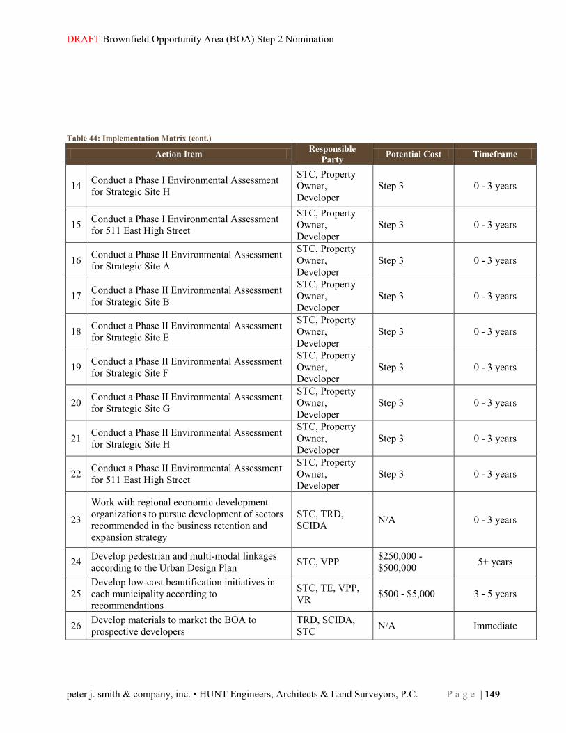
DRAFT Brownfield Opportunity Area (BOA) Step 2 Nomination
peter j. smith & company, inc. • HUNT Engineers, Architects & Land Surveyors, P.C. P a g e | 149
Table 44: Implementation Matrix (cont.)
Action Item Responsible Party Potential Cost Timeframe
14 Conduct a Phase I Environmental Assessment for Strategic Site H
STC, Property Owner, Developer
Step 3 0 - 3 years
15 Conduct a Phase I Environmental Assessment for 511 East High Street
STC, Property Owner, Developer
Step 3 0 - 3 years
16 Conduct a Phase II Environmental Assessment for Strategic Site A
STC, Property Owner, Developer
Step 3 0 - 3 years
17 Conduct a Phase II Environmental Assessment for Strategic Site B
STC, Property Owner, Developer
Step 3 0 - 3 years
18 Conduct a Phase II Environmental Assessment for Strategic Site E
STC, Property Owner, Developer
Step 3 0 - 3 years
19 Conduct a Phase II Environmental Assessment for Strategic Site F
STC, Property Owner, Developer
Step 3 0 - 3 years
20 Conduct a Phase II Environmental Assessment for Strategic Site G
STC, Property Owner, Developer
Step 3 0 - 3 years
21 Conduct a Phase II Environmental Assessment for Strategic Site H
STC, Property Owner, Developer
Step 3 0 - 3 years
22 Conduct a Phase II Environmental Assessment for 511 East High Street
STC, Property Owner, Developer
Step 3 0 - 3 years
23
Work with regional economic development organizations to pursue development of sectors recommended in the business retention and expansion strategy
STC, TRD, SCIDA N/A 0 - 3 years
24 Develop pedestrian and multi-modal linkages according to the Urban Design Plan STC, VPP $250,000 -
$500,000 5+ years
25 Develop low-cost beautification initiatives in each municipality according to recommendations
STC, TE, VPP, VR $500 - $5,000 3 - 5 years
26 Develop materials to market the BOA to prospective developers
TRD, SCIDA, STC N/A Immediate
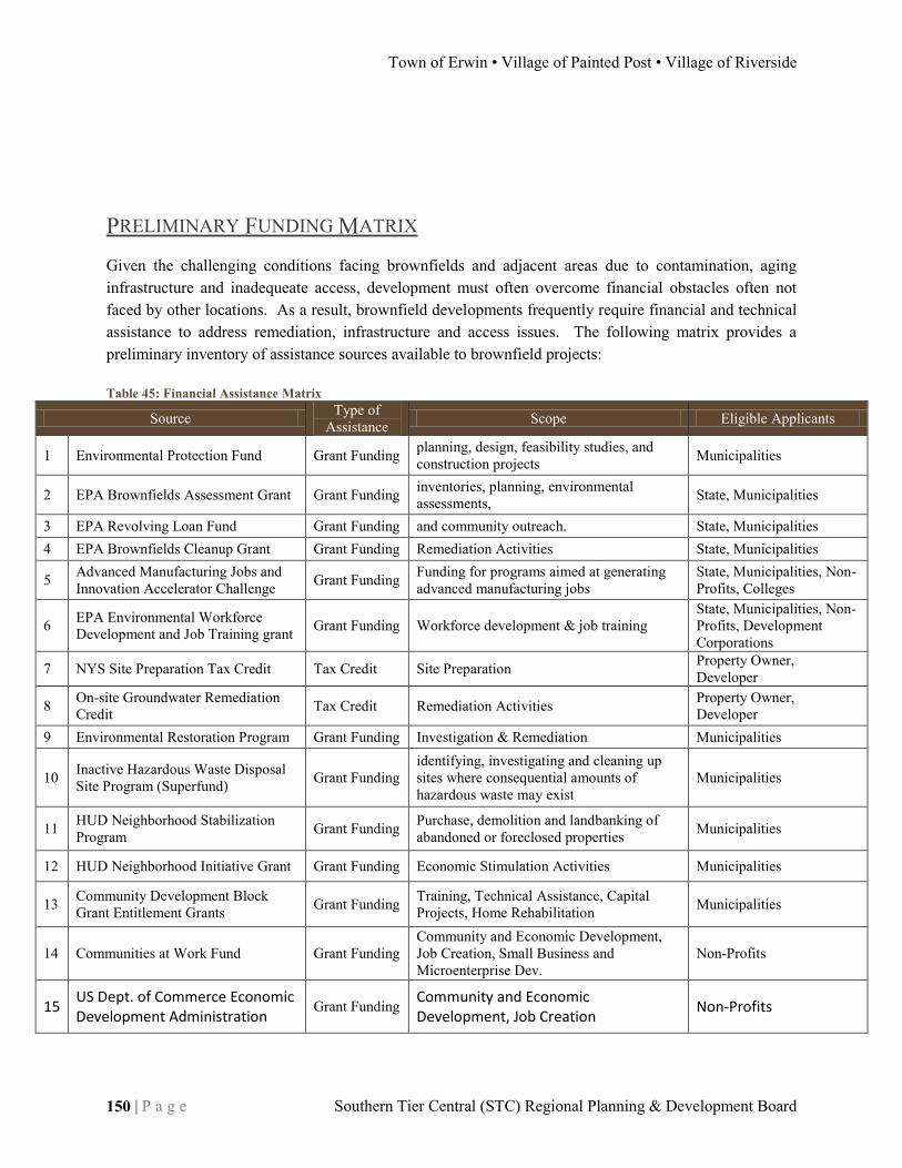
Town of Erwin • Village of Painted Post • Village of Riverside
150 | P a g e Southern Tier Central (STC) Regional Planning & Development Board
PRELIMINARY FUNDING MATRIX Given the challenging conditions facing brownfields and adjacent areas due to contamination, aging infrastructure and inadequeate access, development must often overcome financial obstacles often not faced by other locations. As a result, brownfield developments frequently require financial and technical assistance to address remediation, infrastructure and access issues. The following matrix provides a preliminary inventory of assistance sources available to brownfield projects: Table 45: Financial Assistance Matrix
Source Type of Assistance Scope Eligible Applicants
1 Environmental Protection Fund Grant Funding planning, design, feasibility studies, and construction projects Municipalities
2 EPA Brownfields Assessment Grant Grant Funding inventories, planning, environmental assessments, State, Municipalities
3 EPA Revolving Loan Fund Grant Funding and community outreach. State, Municipalities 4 EPA Brownfields Cleanup Grant Grant Funding Remediation Activities State, Municipalities
5 Advanced Manufacturing Jobs and Innovation Accelerator Challenge Grant Funding Funding for programs aimed at generating
advanced manufacturing jobs State, Municipalities, Non-Profits, Colleges
6 EPA Environmental Workforce Development and Job Training grant Grant Funding Workforce development & job training
State, Municipalities, Non-Profits, Development Corporations
7 NYS Site Preparation Tax Credit Tax Credit Site Preparation Property Owner, Developer
8 On-site Groundwater Remediation Credit Tax Credit Remediation Activities Property Owner,
Developer 9 Environmental Restoration Program Grant Funding Investigation & Remediation Municipalities
10 Inactive Hazardous Waste Disposal Site Program (Superfund) Grant Funding
identifying, investigating and cleaning up sites where consequential amounts of hazardous waste may exist
Municipalities
11 HUD Neighborhood Stabilization Program Grant Funding Purchase, demolition and landbanking of
abandoned or foreclosed properties Municipalities
12 HUD Neighborhood Initiative Grant Grant Funding Economic Stimulation Activities Municipalities
13 Community Development Block Grant Entitlement Grants Grant Funding Training, Technical Assistance, Capital
Projects, Home Rehabilitation Municipalities
14 Communities at Work Fund Grant Funding Community and Economic Development, Job Creation, Small Business and Microenterprise Dev.
Non-Profits
15 US Dept. of Commerce Economic Development Administration
Grant Funding Community and Economic Development, Job Creation
Non-Profits

DRAFT Brownfield Opportunity Area (BOA) Step 2 Nomination
peter j. smith & company, inc. • HUNT Engineers, Architects & Land Surveyors, P.C. P a g e | 151