Embed Size (px)
Citation preview

Brownf ields Road Map to Understanding Options for Site Investigation and Cleanup
Sixth Edition
O�ce of Land and Emergency ManagementEPA 542-R-17-003
Site ReuseDesign and Implement
the Cleanup
Assess and SelectCleanup Options
Investigate the Site
Assess the Site
Learn the Basics
www.epa.gov/brownfields/brownfields-roadmap

[This page is intentonally left blank]

Table of Contents Brownfields Road Map
i
Table of Contents Introduction ........................................................................................................................ 1
Follow the Brownfields Road Map ...................................................................................... 6
Learn the Basics .................................................................................................................. 9
Assess the Site ................................................................................................................... 20
Investigate the Site ........................................................................................................... 26
Assess and Select Cleanup Options ................................................................................... 36
Design and Implement the Cleanup ................................................................................. 43
Spotlights 1 Innovations in Contracting ................................................................................... 18
2 Supporting Tribal Revitalization ........................................................................... 19
3 Project Life Cycle Conceptual Site Model ............................................................ 25
4 Vapor Intrusion .................................................................................................... 34
5 Mining Site Redevelopment ................................................................................. 35
6 In Situ Technologies ............................................................................................. 40
7 Greener Cleanup Best Practices ........................................................................... 41
8 Understanding the Role of Institutional Controls at Brownfields Sites ............... 42
9 Optimization Best Practices for Challenging Cleanups ........................................ 47
10 Resilient Revitalization ......................................................................................... 48
Appendices A CSM and General Cleanup Steps .......................................................................... 49
B List of Acronyms ................................................................................................... 50
C References and Additional Information ............................................................... 52
D Guide to Contaminants and Technologies ........................................................... 56
Brownfields Road Map Introduction
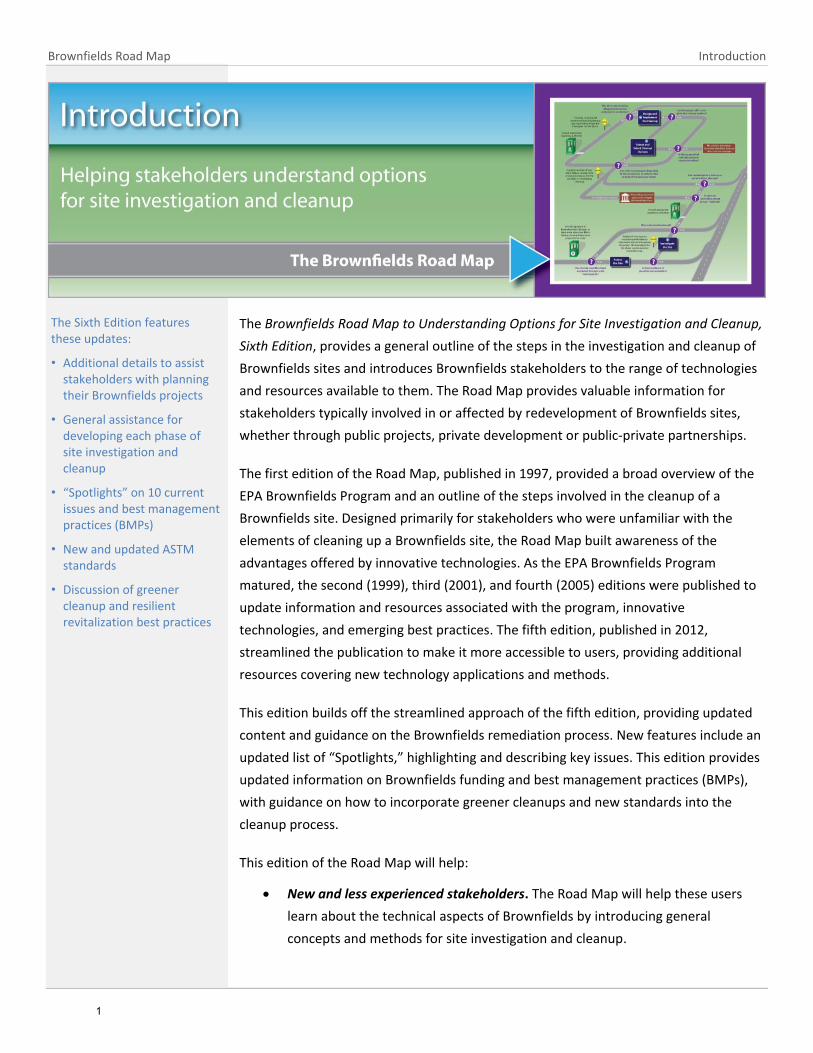
The Brownfields Road Map to Understanding Options for Site Investigation and Cleanup,
Sixth Edition, provides a general outline of the steps in the investigation and cleanup of
Brownfields sites and introduces Brownfields stakeholders to the range of technologies
and resources available to them. The Road Map provides valuable information for
stakeholders typically involved in or affected by redevelopment of Brownfields sites,
whether through public projects, private development or public-private partnerships.
The first edition of the Road Map, published in 1997, provided a broad overview of the
EPA Brownfields Program and an outline of the steps involved in the cleanup of a
Brownfields site. Designed primarily for stakeholders who were unfamiliar with the
elements of cleaning up a Brownfields site, the Road Map built awareness of the
advantages offered by innovative technologies. As the EPA Brownfields Program
matured, the second (1999), third (2001), and fourth (2005) editions were published to
update information and resources associated with the program, innovative
technologies, and emerging best practices. The fifth edition, published in 2012,
streamlined the publication to make it more accessible to users, providing additional
resources covering new technology applications and methods.
This edition builds off the streamlined approach of the fifth edition, providing updated
content and guidance on the Brownfields remediation process. New features include an
updated list of “Spotlights,” highlighting and describing key issues. This edition provides
updated information on Brownfields funding and best management practices (BMPs),
with guidance on how to incorporate greener cleanups and new standards into the
cleanup process.
This edition of the Road Map will help:
New and less experienced stakeholders. The Road Map will help these users
learn about the technical aspects of Brownfields by introducing general
concepts and methods for site investigation and cleanup.
The Sixth Edition features these updates:
• Additional details to assist stakeholders with planning their Brownfields projects
• General assistance for developing each phase of site investigation and cleanup
• “Spotlights” on 10 current issues and best management practices (BMPs)
• New and updated ASTM standards
• Discussion of greener cleanup and resilient revitalization best practices
1

Introduction Brownfields Road Map
Decision-makers who are familiar with the EPA Brownfields Program but are
also interested in obtaining more detailed information. The Road Map provides
these users with up-to-date information about the applicability of technologies
and access to the latest resources that can assist them in making technology
decisions. In addition, it highlights BMPs that have emerged in recent years.
Community members. The Road Map helps to encourage community members
to participate in the decision making process by providing information about the
general site cleanup process and tools and alternatives to site cleanup, as well
as guidelines and mechanisms to promote community involvement.
Tribal leaders. The Road Map offers information on technical and financial
assistance specific to tribes for implementing cleanup and restoration activities
on tribal lands, as well as successful remediation examples highlighting the
potential community restoration opportunities associated with Section 128(a)
Response Program funding.
Stakeholders who hire or oversee site cleanup professionals. The Road Map
includes information to help stakeholders coordinate with many different
cleanup practitioners, such as environmental professionals, cleanup service
providers, technology vendors or staff of analytical laboratories. The Road Map
provides these stakeholders with a detailed understanding of each phase in a
typical Brownfields site cleanup and presents information about the roles that
environmental practitioners play in the process.
Regulators. The Road Map will increase the understanding by regulatory
personnel of site characterization and cleanup technologies and approaches.
The Road Map also serves as a resource that regulators can use to provide site
owners, service providers and other stakeholders with useful information about
the EPA Brownfields Program. The Road Map also provides links and pointers to
additional information on specific technologies, approaches, and issues.
Other potential Brownfields stakeholders. The Road Map helps other
stakeholders, such as financial institutions and insurance agencies, by providing
information for their use in assessing and minimizing financial risks associated
with Brownfields redevelopment.
2

Brownfields Road Map Introduction
Disclaimer
The Road Map draws on the EPA’s experiences with Brownfields sites, as well as
Superfund sites, corrective action sites under the Resource Conservation and Recovery
Act (RCRA), and underground storage tank (UST) sites to provide technical information
useful to Brownfield stakeholders. Specific conditions—such as the nature and extent of
contamination, the proposed reuses of the property, the financial resources available,
and the level of support from neighboring communities—vary from site to site. Readers
of the Road Map are encouraged to explore opportunities to use the BMPs described in
the following pages in accordance with applicable regulatory program requirements.
The use of BMPs and site characterization and cleanup technologies may require site
specific decisions to be made with input from state, tribal, and/or local regulators and
other oversight bodies.
This document provides general information and guidance regarding facilitating reuse of
properties. The information in this document is pertinent to sites that meet the
definition of a Brownfield site and focuses on providing information to Brownfields
stakeholders. Users of this document should determine whether their site meets the
definition of a Brownfield site before using this document (the term "brownfield site"
means real property, the expansion, redevelopment or reuse of which may be
complicated by the presence or potential presence of a hazardous substance, pollutant
or contaminant). Sites that fall under other regulatory programs such as RCRA corrective
action sites or Superfund sites are subject to the requirements of those programs. While
some of the information in this document may be helpful to them, they should rely
primarily on information sources focused on those types of sites.
This document does not address all information, factors or considerations that may be
relevant. This document is not legally binding. The word “should” and other similar
terms used in this document are intended as general recommendations or suggestions
that might be generally applicable or appropriate and should not be taken as providing
legal, technical, financial or other advice regarding a specific situation or set of
circumstances. This document may be revised at any time without public notice. Any
references to private entities, products or services are strictly for informational
purposes and do not constitute an endorsement of that entity, product or service.
This document describes and summarizes statutory provisions, regulatory requirements
and policies. The document is not a substitute for these provisions, regulations or
policies, nor is it a regulation or EPA guidance document itself. In the event of a conflict
between the discussion in this document and any statute, regulation or policy, this
document would not be controlling and cannot be relied on to contradict or argue
against any EPA position taken administratively or in court. It does not impose legally
3

Introduction Brownfields Road Map
binding requirements on the EPA or the regulated community and might not apply to a
particular situation based on the specific circumstances. This document does not modify
or supersede any existing EPA guidance document or affect the Agency’s enforcement
discretion in any way.
About the EPA Brownfields Program
Brownfields sites are defined as “real property, the expansion, redevelopment
or reuse of which may be complicated by the presence or potential presence of
a hazardous substance, pollutant or contaminant” (Comprehensive
Environmental Response, Compensation, and Liability Act of 1980, as amended
by the Small Business Liability Relief and Brownfields Revitalization Act of 2002,
§101(39)). The cleanup of Brownfields sites improves and protects the
environment and may result in many benefits for the local community.
The EPA established its Brownfields Economic Revitalization Initiative in 1995 to
empower states, communities and other stakeholders in economic revitalization
to work together to accomplish the redevelopment of Brownfields sites. The
enactment of the Small Business Liability Relief and Brownfields Revitalization
Act in 2002 expanded EPA assistance to provide greater support for Brownfields
cleanup and reuse. Many states and local jurisdictions also help communities
adapt environmental cleanup programs to the special needs of Brownfields
sites.
Revitalizing Brownfields sites has the potential to create benefits throughout the
community, including community involvement in the project, job creation, and an
increase in residential property values once a nearby Brownfields site is assessed or
cleaned up.
How to Submit Comments How to Obtain Additional Copies
The EPA invites comments from members of the Brownfields community to help ensure that any future versions of the Road Map meet their needs. Please submit comments to:
Carlos Pachon U.S. Environmental Protection Agency Office of Superfund Remediation and Technology Innovation [email protected] (703) 603-9904
A printed or hard copy version of this document can be obtained from the following source:
National Service Center for Environmental Publications U.S. Environmental Protection Agency P.O. Box 42419 Cincinnati, OH 45242-0419 Phone: (800) 490-9198 Fax: (301) 604-3408 Email: [email protected]
When you order the Road Map, please refer to document number 542-R-17-003.
Summary of Brownfields Program Accomplishments
as of May 2017
Thousands of properties have been assessed and cleaned up with the support of grants and funding from the EPA Brownfields Program.
Measure Cumulative
Results
Properties Assessed 26,722
Cleanups Completed 117,000
Direct and Indirect Jobs Created
124,760
Acres Made Ready for Reuse
67,419
Source: www.epa.gov/brownfields/brownfields-program-accomplishments-and-benefits
4

Brownfields Road Map Introduction
Small Business Liability Relief and Brownfields Revitalization Act
Since its inception in 1995, EPA's Brownfields Program has grown into a proven, results-oriented program that has changed the way contaminated property is perceived, addressed and managed. EPA's Brownfields Program is designed to empower states, communities and other stakeholders in economic redevelopment to work together in a timely manner to prevent, assess, safely clean up and sustainably reuse brownfields.
In January 2002, the Small Business Liability Relief and Brownfields Revitalization Act ("The Brownfields Law," Public Law 107-118; H.R. 2869) was signed. The Brownfields Law amended the Comprehensive Environmental Response, Compensation, and Liability Act (CERCLA or Superfund) by providing funds to assess and clean up Brownfields, clarified CERCLA liability protections and provided funds to enhance state and tribal response programs. Other related laws and regulations impact Brownfields cleanup and reuse through financial incentives and regulatory requirements.
Key changes to the EPA Brownfields program as a result of the Brownfields Law included:
Improvements to EPA's existing Brownfields grants and technical assistance program by:
Increasing available grant funding to approximately $100 million annually in recent years
Providing grants for assessments, revolving loan funds, direct cleanups, area-wide planning and environmental workforce development and job training
Expanding the entities, properties and activities eligible for Brownfields grants, including sites such as mine-scarred lands
Expanding applicability to sites with petroleum contamination such as abandoned gasoline stations
Providing authority for Brownfields training, research and technical assistance
Allowing local government entities up to 10 percent of the grant funds to be used to monitor the health of exposed populations and enforce any institutional controls
Creation of a strong, balanced relationship between the federal government and state and tribal programs that:
Authorized up to $50 million per year for building and enhancing state and tribal response programs and expanded the activities eligible for funding
Provided protection from Superfund liability at sites cleaned up under a state or tribal program
Preserved the federal safety net by detailing the circumstances in which the EPA can revisit a cleanup
Clarified the state role in adding sites to the Superfund National Priorities List (NPL)
Additional information on the Brownfields Law is available at www.epa.gov/brownfields/brownfields-laws-and-regulations.
5

Follow the Brownfields Road Map Brownfields Road Map
The document the d
The Sixth Edition of the Road Map presents the general phases involved in the
investigation and cleanup of a Brownfields site, introduces the reader to a range of
considerations and activities and provides links to online technical resources and tools.
Overview of the Road Map
The Road Map follows the process illustrated in the Brownfields Road Map graphic (see
page 8). The first section, Introduction, discusses important factors that set the stage for
the investigation and cleanup of Brownfields sites. Sections 2 (Follow the Road Map)
and 3 (Learn the Basics) introduce concepts, strategies and methods that can be applied
to efficiently and effectively prepare sites for reuse. The remaining sections correspond
to the general phases of site characterization and cleanup, from site assessment
through implementation of cleanup remedies. The Road Map identifies examples of
regulatory considerations to take into account and discusses technologies within the
overall framework of site characterization and cleanup.
Spotlights – The Road Map “spotlights” focus the reader’s attention on key issues,
processes and initiatives. They provide a quick look at topics relevant to Brownfields
projects and identify how readers can obtain additional information.
Appendices – Provided at the end of the Road Map document:
Appendix A, CSM and General Cleanup Steps: A Crosswalk of Regulatory Program Stages and Life Cycle Phases, is a crosswalk of specific terms used in different cleanup programs to identify cleanup stages. It puts these terms into the context of the Road Map.
Appendix B, Acronyms, defines acronyms used in discussing and describing Brownfields cleanup efforts.
Appendix C, References and Additional Information, provides a list of references used to develop the document and additional resources.
Understanding the typical progression of the site investigation and cleanup process ensures that the proper groundwork is laid for future phases.
Site investigation and cleanup typically do not occur in the linear sequence outlined in the Road Map. At many sites, several activities may be undertaken concurrently, while others recur throughout the process. Similarly, many technologies that are used to characterize sites during the investigation phase may also be used during the cleanup phase to monitor performance and help reduce uncertainties related to site conditions.
6

Brownfields Road Map Follow the Brownfields Road Map
Appendix D, Guide to Contaminants and Technologies, is a guide to contaminants commonly found at types of Brownfields sites and the types of technologies that may be appropriate for their analysis and treatment.
7


Brownfields Road Map Learn the Basics
Brownfields projects may be initiated for a number of reasons. A landowner may want
to sell a property to a prospective purchaser for development. A municipality may want
to clean up a parcel or area that has become a public hazard or eyesore, create space
for business development or build a park. A local comprehensive plan may call for infill
development of a certain type in a Brownfields area. In these cases, the Brownfields
process will be tailored to the specific end use envisioned for the property re-purposing.
Preparing a Brownfields site for reuse involves more than the investigation and cleanup
of a property. The interests of many stakeholders must be integrated into the overall
redevelopment process. Cleanup strategies vary from site to site, depending on factors
such as intended end use, available funding, liability considerations, regulatory
requirements, the type and extent of contamination present and the technologies
available for cleanup. At some sites, cleanup will be completed before the properties
are transferred to new owners. At other sites, cleanup may take place simultaneously
with construction and redevelopment.
Regardless of when and how cleanups are accomplished, a key challenge to Brownfields
projects is to clean up sites in accordance with reuse goals and appropriate laws and
regulations, including changes which might occur during the cleanup process. It is
essential that stakeholders become familiar with factors that play a significant role in
the success of a Brownfields project, such as understanding applicable regulations,
engaging members of the community, identifying funding and obtaining professional
support.
The Road Map outlines a general cleanup process and the names of the steps in this
process are specific to the cleanup of Brownfields sites. The overall process, however,
applies to other cleanup programs as well. Refer to Appendix A (CSM and General
Cleanup Steps: A Crosswalk of Regulatory Program Stages and CSM Life Cycle Phases) at
the end of this document for more information on other cleanup program steps and
terminology.
Begin here to learn about factors and considerations that affect cleanup at a Brownfields site. These “basics” are integral to the cleanup process and the overall success of the Brownfields project.
General concepts and terms related to the investigation and cleanup of Brownfields sites are introduced here and reinforced throughout the publication.
Brownfields Stakeholders
A stakeholder is typically considered to be an individual who can influence decisions or is impacted by decisions regarding sites. Stakeholders for Brownfields projects may include:
- Federal, state, tribal and local agencies
- Local elected officials
- Local and regional community development agencies
- Developers
- Community members
- Tribes
- Property owners
- Academia
- Potentially responsible parties (PRPs)
- Private business and industry
- Non-profit organizations
9

Learn the Basics Brownfields Road Map
State Underground Storage Tank/Leaking Underground Storage Tank
(UST-LUST) programs have tailored tools to meet site-specific
investigation and cleanup needs. For more information, visit the
applicable state UST/LUST implementing agency and
www.epa.gov/ust/state-underground-storage-tank-ust-programs.
Setting Reuse Goals and Planning
From the outset, it is important to consider potential reuse goals. A
reuse plan based on those goals will govern most Brownfields projects,
from identifying site investigation and cleanup standards that will
prepare the site for the reuse plan, to obtaining competitive financing
potentially critical to the ultimate affordability of the project. Keep in
mind, however, that new information about contamination or cleanup
needs may require that reuse plans be altered. Be prepared to develop a
flexible project plan that will evolve as information is collected,
community input is received and decisions are made about the cleanup
approach.
Establishing reuse goals for a Brownfields project also helps the project
team define the specific decisions to be made throughout the project.
This is fundamental to selecting appropriate technologies for site
investigation and cleanup which enable those responsible for the
Brownfields project to collect the data necessary to support those
decisions and accomplish the established goals.
The most efficient way to use resources is to identify a redevelopment
goal at the beginning of the project. If reuse goals are not known from
the outset, Brownfield funds can best be harnessed by establishing a
clear redevelopment objective. The stakeholders should at a minimum
make every attempt to identify the general type of desired development,
whether open space/recreational, industrial, commercial, residential or
mixed-use. Without that information, the most conservative assumptions
might be applied at every stage of the Brownfields project. While this can
provide greater flexibility later in the redevelopment process, it can also
significantly increase the time and expense of the project.
State and Tribal Response Programs
State and Tribal response programs—to provide liability clarity or support cleanup at specific sites—continue to be at the forefront of Brownfields cleanup and redevelopment.
State and Tribal Response Program Highlights describe recent progress the states and tribes are making to address contaminated land in their communities.
Further information is available in Spotlight 2 and online at www.epa.gov/brownfields/state-and-tribal-brownfield-response-programs
Understand Previous and Current Planning Activities that Involve and Affect the Site
Stakeholders should take into account how the Brownfield site fits within the broader planning efforts for the community.
Read the community’s master plan.What are its broad themes (make thecommunity more sustainable orresilient, increase economic growth,increase open space)?
Determine how the Brownfield site cancontribute to one or more of thesethemes.
Look at the zoning for the site. Whatuses are permitted? Would that zoningneed to be changed?
Read the redevelopment plans for thearea. How can redevelopment of thesite contribute to them?
Are there any market studies for thearea indicating the types of uses thatthe market would bear?
Have there been other plans thatinvolved this site in the past? Whathappened? What lessons can belearned?
With this information, stakeholders can create a planning framework for the site.
10

Brownfields Road Map Learn the Basics
Understanding Regulations, Regulatory Guidelines and Liability Concerns
The redevelopment of Brownfields sites may be subject to various federal, state, tribal
and local laws, regulations, policies and guidelines with respect to the characterization
and cleanup of the site. The standard practices of other government, nongovernment
and private institutions may also govern these sites.
The applicable laws, regulations, policies and guidelines will vary by site,
depending on the regulatory authorities that have oversight authority for
cleanup. Therefore, it is important to research this information at the outset
and to work closely with the regulatory authorities throughout the cleanup
process. For example, state, tribal or local regulatory authorities usually
oversee the cleanup of Brownfields sites. These agencies should be consulted
to determine what, if any, site-specific requirements, reviews, approvals or
permits are applicable.
At the EPA, the Office of Site Remediation Enforcement (OSRE) supports
cleanup and revitalization by issuing enforcement discretion guidance
documents, model enforcement documents, responses to frequently asked
questions, fact sheets and other documents. OSRE works with the EPA regional
offices to provide guidance on relevant enforcement tools to potential
developers and owners of contaminated land. These documents, along with current
Superfund enforcement and Brownfields policy and guidance documents, are available
on the EPA’s website at www.epa.gov/enforcement/brownfields-and-land-
revitalization-cleanup-enforcement. The EPA also can be a valuable resource for
Brownfields stakeholders by providing regulatory and policy support to facilitate the
selection of technologies.
Many of the standard practices are designed to help Brownfields redevelopment
projects obtain financing from public programs and private banks and institutions.
Guidance and standards are issued by government and nongovernment organizations,
such as ASTM International (formerly the American Society for Testing and Materials),
the Federal Deposit Insurance Corporation (FDIC), state, tribal and local economic
development authorities and private lenders.
Subsequent sections of this Road Map identify regulatory considerations at relevant
phases of investigation and cleanup. Stakeholders are encouraged to regularly consult
with appropriate regulatory agencies to ensure that requirements are properly
addressed throughout the project.
Example of Regulatory Requirement
If the proposed end use for a Brownfields site calls for construction of a light industrial facility, it may be appropriate, depending on state and local regulatory requirements, to compare the relevant cleanup standards for industrial as well as commercial or residential reuse standards. If the more stringent standard required for commercial or residential reuse is used, additional cleanup and costs may be required initially, but doing so provides greater flexibility and avoids future delays if the proposed reuse is likely to change. The required standards need to be considered throughout the project.
11

Learn the Basics Brownfields Road Map
Engaging the Community
Encouraging active participation by members of the community who
are most likely to be affected by site cleanup and reuse plans
contributes to the success of the project. Engage the community to
raise awareness, identify community concerns and build support for
cleanup efforts that will lead to redevelopment and revitalization of
their community. To maximize chances for success, plan early for
how the community stakeholders will be identified and encouraged
to participate for the duration of the Brownfields project, from the
investigation phases through cleanup.
It is important that Brownfields decision-makers encourage
acceptance of reuse plans and cleanup alternatives by involving
members of the community through multiple outreach methods
such as public meetings, newsletters, publications, websites and
social networks. For an individual site, consider how the people living
in or near the site might be affected by cleanup activities and the
intended reuse of the property; plan early and appropriately for how
cleanup decisions and their potential impact will be shared with the
community. For example, the community should be informed about
how the use of a proposed technology might affect redevelopment
plans or the adjacent neighborhood.
Brownfields Area-Wide Planning Program
The Brownfields area-wide planning program supports community involvement in locally based efforts to plan for the assessment, cleanup and reuse of Brownfields sites within a defined area. Through grants and technical assistance, the program promotes land revitalization affected by a large Brownfields site or multiple Brownfields (for example, revitalization of a neighborhood, block or corridor) and promotes community engagement in the planning for Brownfields revitalization efforts. Details about the program, including project fact sheets and information about applying for funding, are available at www.epa.gov/brownfields/types-brownfields-grant-funding.
Key Resource for Community Engagement
EPA’s Brownfields Program is designed to promote the active participation of communities in each phase of the cleanup process so that revitalized land offers the greatest local benefit.
The Brownfields Stakeholder Forum Kit is a guide to assist communities in planning effective stakeholder forums by providing tools and tips for engaging stakeholders and establishing partnerships to address revitalization challenges. The kit is available at www.epa.gov/brownfields/brownfields-stakeholder-forum-kit.
Key Resource for Regulatory and Liability Concerns
The Revitalization Handbook, updated and reissued in 2014 by EPA Office of Site Remediation Enforcement (OSRE) is designed for stakeholders involved in the assessment, cleanup and revitalization of sites. The handbook summarizes federal statutory provisions and EPA policy and guidance documents useful for managing liability risks associated with cleaning up sites, and describes tools that stakeholders can use to address liability concerns. The handbook, including recent updates, is available at www.epa.gov/enforcement/revitalization-handbook.
12

Brownfields Road Map Learn the Basics
The EPA assists Brownfields communities by directing its
members to appropriate resources and providing opportunities
to network and participate in sharing information. A number of
websites, databases, newsletters and reports provide
opportunities for Brownfields stakeholders to network with other
stakeholders to identify information about cleanup and
technology options. Details about the EPA’s community
engagement efforts by the Office of Land and Emergency
Management (OLEM) are available on the Community
Engagement Initiative website at
www.epa.gov/fedfac/community-engagement. Helpful tools and
data focused on community engagement at underground storage
tank (UST) sites are provided on the EPA’s Office of Underground
Storage Tanks (OUST) community engagement website at
www.epa.gov/ust/community-engagement-and-underground-
storage-tank-program. Community engagement plays an
important role in the selection and implementation of remedies
at Superfund sites. For more information, see Considering Reasonably Anticipated
Future Land Use and Reducing Barriers to Reuse at EPA-lead Superfund Remedial Sites
available at www.epa.gov/superfund-redevelopment-initiative/superfund-
redevelopment-policy-guidance-and-resources.
Environmental Impacts and Project Resiliency
To ensure that cleanup methods remain effective and are protective of human health
and the environment over the long term, special consideration should be given to
current and projected environmental impacts and resiliency to challenging weather
conditions when designing a cleanup strategy at Brownfields sites. Communities are
often located close to Brownfields and other blighted properties. Incorporating
adaptation and mitigation strategies throughout the Brownfields cleanup and
redevelopment process can support community efforts to become more resilient to
weather-related impacts and more sustainable Brownfields reuse. Implementing green
methods in all phases of a project lead to direct reduction of the environmental
footprint of site activities. Helpful tools and strategies that can be implemented during
the Brownfields cleanup and redevelopment process are provided in the Climate Smart
Brownfields Manual available at www.epa.gov/land-revitalization/climate-smart-
brownfields-manual.
Technical Assistance for Communities
The EPA’s Technical Assistance to Brownfields (TAB) Communities program is a free resource providing technical assistance to communities and other stakeholders dealing with challenges of Brownfields cleanups. Organized to provide geographically based assistance, the TAB program increases understanding of technical issues associated with Brownfields sites by providing webinars, workshops, one-on-one assistance, newsletters and other tools. The program offers assistance in a wide range of technical areas, including navigating the regulatory process, community involvement, health impacts, science and technology, finance and funding and more.
Details, including how to request technical assistance, are provided online at www.epa.gov/brownfields/brownfields-technical-assistance-and-research#TAB.
13

Learn the Basics Brownfields Road Map
Identifying Funding
One of the most important factors to consider at the
beginning of a Brownfields project is funding. Simply
put, the project cannot be initiated or undertaken until
funding sources are identified and funds are secured.
An important factor to the success of a Brownfields
project is the ability of the stakeholders to establish a
funding strategy that covers the project costs from
planning and assessment through cleanup and long-
term monitoring. Most Brownfields projects leverage
funding from various sources both public and private.
Guidance on how to overcome challenges related to
finding sufficient funding sources and leverage initial
resources to attract additional investments is available
at www.epa.gov/brownfields/setting-stage-leveraging-
resources-brownfields-revitalization. Be mindful that
securing funding can be a lengthy process.
The range of potential sources and the means of
securing funds can appear overwhelming. Fortunately,
many helpful resources and tools are available to guide stakeholders in exploring
funding options. Funding for the investigation and cleanup of Brownfields sites is
available from federal, state, local, and public and private sources. Programs available at
the federal level, such as the EPA, typically involve awarding grants and providing
technical assistance to communities and stakeholders. Other federal programs, such as
the U.S. Department of Housing and Urban Development, the U.S. Department of
Agriculture, the U.S. Department of Transportation and the U.S. Department of
Commerce, also provide funding and technical assistance for Brownfields projects. State
programs are a valuable option as well, as states are increasingly offering flexible tools,
financial assistance, tax incentives and other redevelopment support to promote
cleanup and reuse of Brownfields sites.
At the beginning of the project, explore federal, state and local programs to learn about
the sources of funding available and the process for applying for and securing funding.
Take advantage of the many helpful resources available on the EPA Brownfields website
(www.epa.gov/brownfields/types-brownfields-grant-funding) to learn about the EPA’s
grant programs, access to state and tribal response programs, points of contact and
success stories.
EPA Brownfields Grants
Assessment, Revolving Loan Fund and Cleanup Grants (ARC Grants) fund activities for sites contaminated by petroleum, hazardous substances, controlled substances or mine-scarred land.
Area-Wide Planning Grants (AWP) fund communities for an area affected by Brownfields and promotes area-wide revitalization.
Environmental Workforce Development and Job Training Grants (EWDJT) fund opportunities for local residents to take advantage of jobs created by the assessment and cleanup work of Brownfields sites in the community.
Training, Research, and Technical Assistance Grants provide training, research, and technical assistance to increase community understanding and participation in the Brownfields remediation process.
Learn more about the EPA’s Brownfields grants at www.epa.gov/brownfields/types-brownfields-grant-funding. Specific instructions and deadlines for applying for the EPA’s Brownfields grants are provided at www.epa.gov/brownfields/apply-brownfields-grant-funding, and information and links for grant resources is available at www.epa.gov/grants/key-grant-resources-applicants-and-recipients.
14

Brownfields Road Map Learn the Basics
Assistance with financing and economic restructuring for Brownfields-
impacted communities is available through the Council of
Development Finance Agencies (CDFA). Funded through the EPA
Brownfields Technical Assistance Program, CDFA provides education,
resources, research and networking on revolving loan funds, tax
incentives, tax increment finance and other tools available for
redevelopment finance. For further information about the CDFA, visit
www.cdfa.net.
Obtaining Professional Support
Most decision makers for Brownfields sites will require technical and
legal assistance to fully understand the complexities of investigating
and cleaning up sites. Depending on the complexity of a particular site,
decision makers may need the assistance of the following to perform
many of the activities required to investigate and clean up the site:
environmental practitioners with expertise in geosciences,
chemistry, engineering, field sampling, redevelopment and other
disciplines;
analytical laboratories;
cleanup service providers; and
technology vendors.
EPA recommends the inclusion of these professionals and other experts
as members of a Brownfields project team to ensure the successful
completion of the Brownfields project.
EPA partners with nonprofit organizations to provide technical assistance
and research resources to help communities and other stakeholders in
the assessment and cleanup of Brownfields properties. These
organizations operate programs which offer training, research and direct
technical assistance to communities and develop tools and materials that
communities can use to assist them. This independent resource offers a
wide range of expertise. More information can be found at
www.epa.gov/brownfields/brownfields-technical-assistance-and-
research.
Key Resource for State Programs
The 2014 State Brownfields and Voluntary Response Programs report (www.epa.gov/brownfields/2014-state-brownfields-and-voluntary-response-programs) provides information on state environmental, financial and technical programs and tools available for Brownfields projects through state programs.
Cleaning Up Brownfields under State Response Programs -- Getting to "No Further Action" lays out the eligibility requirements and benefits of state cleanup programs that provide guidance, oversight and certain protections from environmental liability. The report describes the process for attaining a state decision or certification of the need for “no further action” for each state program. The report is available at www.epa.gov/brownfields/cleaning-brownfields-under-state-response-programs-getting-no-further-action.
Community Redevelopment
The 2017 Brownfields Federal Programs Guide describes how the Brownfields Program recognizes that a community’s quality of life goes hand-in-hand with economic development and sustainability, and encourages communities to develop and implement their own vision for community revitalization. The guide is available at www.epa.gov/brownfields/2017-brownfields-federal-programs-guide.
The Association of State and Territorial Solid Waste Management Officials (ASTSWMO) Toolbox for Community Redevelopment reinforces the state’s role in community redevelopment. This toolbox is available at astswmo.org/files/policies/CERCLA_and_Brownfields/2017_Toolbox/2016%20Toolbox%20for%20Community%20Redevelopment.pdf.
15

Learn the Basics Brownfields Road Map
Regulations applicable to Brownfields projects in some states require the
participation of certified or licensed environmental professionals to help guide
the site investigation and cleanup process. For example, the EPA’s final rule
for All Appropriate Inquiries (AAI) requires that AAI and Phase I environmental
site assessments be supervised by individuals who have specific certification
or licensure, education or experience levels that meet the definition of
“Environmental Professional” provided in the AAI final rule. More information
can be found at www.epa.gov/brownfields/brownfields-all-appropriate-inquiries.
Additionally, some states require that certified professional geologists, licensed site
professionals or professional engineers oversee various stages of the investigation and
cleanup process. A request for proposal (RFP) is often used as the procurement
mechanism to obtain the services of certified professionals (individuals or a firm). The
RFP requests potential service providers to submit a proposal that addresses the
approach, qualifications and cost estimate for the services requested. The RFP can
include specifications that encourage prospective bidders to think “outside the box” and
consider innovative approaches. Incorporating innovative strategies and technologies
into site contracts can help inform decision making and increase project efficiency and
effectiveness. Selection criteria outlined in the RFP should include the demonstrated
experience of the individuals or firm in developing valid options for using streamlined
strategies and innovative technologies at Brownfields sites and in successfully
implementing the selected options. Demonstrated experience can include resumes,
project descriptions and letters of recommendation.
The Bigger Picture – Related EPA Initiatives
As the EPA Brownfields Program has matured over the years to address new challenges
and evolving stakeholder needs, new programs and initiatives have been undertaken to
better integrate efforts to clean up and reuse Brownfields sites. See the table below as
well as Spotlight 1, Innovations in Contracting, and Spotlight 2, Supporting Tribal
Revitalization, for a brief overview of several programs and initiatives that are designed
to help the Brownfields community integrate principles such as sustainability,
renewable energy, smart growth and innovative methods into revitalization efforts. In
addition to setting policy and providing guidelines, these programs offer extensive
resources to help Brownfields stakeholders apply lessons learned from the experiences
of other redevelopment projects.
Listed below are highlights of several EPA programs and redevelopment initiatives
focused on helping Brownfields stakeholders learn how to more efficiently and
collaboratively prepare contaminated properties for reuse.
Using Certified Professionals
Some states require the participation of certified or licensed professionals to help guide the site investigation and cleanup process.
16

Brownfields Road Map Learn the Basics
EPA Initiative / Program Available Resources / Additional Details
Land Revitalization Program – The Land Revitalization Program's mission is to restore land and other natural resources into sustainable community assets that maximize beneficial economic, ecological and social uses and ensure protection of human health and the environment. The Land Revitalization Program promotes sustainable approaches to remediation as the norm across all EPA contaminated land programs, recognizing cleanup and reuse as mutually supportive goals. The program emphasizes that the consideration of anticipated property reuse should be an integral part of cleanup decisions.
Resources, policies and guidance, success stories and details about the program are available online at www.epa.gov/ land-revitalization. Links to program-specific information, including details about grant and funding resources, are also provided.
Petroleum Brownfields Action Plan: Promoting Revitalization and Sustainability – The EPA launched this program in 2008 to address the specialized challenges associated with the cleanup and reuse of Brownfields sites with petroleum contamination, such as abandoned neighborhood gas stations. This Action Plan aims to address these challenges by improving stakeholder communication, expanding technical assistance, exploring potential policy changes and building upon existing successes by expanding partnerships.
Visit www.epa.gov/ust/petroleum-brownfields-action-plans to access the Action Plan; progress reports, success stories, grants information and other resources can be found at www.epa.gov/ust/petroleum-brownfields.
Smart Growth – The EPA’s Smart Growth program offers strategies to help communities grow in ways that expand economic opportunity while protecting health and the environment. The program provides tools and resources to help people implement sustainable development strategies that promote healthy, attractive and economically strong communities. Integrating community, environmental and economic considerations, applying smart growth principles to Brownfields sites can lead to the selection of more valuable and sustainable reuse alternatives.
To learn more about the EPA’s Smart Growth program, visit www.epa.gov/ smartgrowth. Resources, tools, technical assistance and examples of successful smart growth approaches are provided.
RE-Powering America’s Land – Launched in 2008, this EPA initiative encourages renewable energy development on current and formerly contaminated land and mine sites. Efforts focus on identifying the renewable energy potential of sites and providing useful resources for communities, developers, industry and state and local governments and others interested in reusing these sites for renewable energy development.
Visit www.epa.gov/re-powering for information about funding sources, technical assistance, fact sheets, interactive mapping tools to identify sites with renewable energy potential, webinars and federal and state incentives.
Superfund Redevelopment Initiative (SRI) – Since 1999, SRI has helped communities reclaim and reuse thousands of acres of formerly contaminated land by offering an array of tools, partnerships and activities to provide local communities with new opportunities to grow and prosper. In addition to cleaning up these Superfund sites and making them protective of human health and the environment, the Agency is working with communities and other partners to consider future use opportunities and integrate appropriate reuse options into the cleanup process. The EPA is also working with communities at sites that have already been cleaned up to ensure long-term stewardship of site remedies and to promote reuse.
Webinars, success stories, tools and resources, community support, cleaned up sites that can support reuse, partnership information and complete details about the initiative are available online at www.epa.gov/superfund-redevelopment-initiative.
Community Engagement Initiative (CEI) – Launched in 2009, the CEI was created to enhance the Office of Land and Emergency Management (OLEM) HQ and Regional offices’ engagement with local communities and other stakeholders. Furthermore, CEI integrates stakeholders into the decision-making processes related to the cleanup and reuse of sites.
An evaluation of the Initiative published in 2013 focuses on the effectiveness of the OLEM program community engagement activities, and is available at www.epa.gov/sites/production/files/2015-10/documents/ce-eval-report-final.pdf.
L
17

Learn the Basics Brownfields Road Map
The majority of assessment, investigation and cleanup work at Brownfields sites is implemented through contracts to site cleanup professionals. The incorporation of innovative strategies and technologies into Brownfields site contracts gains potentially substantial benefits over conventional methods. Innovative site investigation and remediation strategies and technologies are often cost effective, more efficient than established methods and reduce uncertainty. An innovative technology is a tested process used as a treatment for contaminated materials, but lacks a long-term history of use. In situ chemical oxidation, thermal remediation, enhanced bioremediation and nanoremediation are just a few examples of innovative remediation technologies. Examples of innovative site investigation methods include:
Systematic planning process – a comprehensive, up-front planning process that ensures data collected will lead to informed decision making. The process includes three elements: framing the problem by identifying objectives, constraints, stakeholders, the regulatory framework, and key decisions; developing a conceptual site model that obtains information to support decision making; and evaluating as well as managing uncertainty.
Real-time measurement technologies – any acquisition, analytical or measurement technology that generates data to support real-time decision making, including rapid turn-around from fixed laboratories or field-based measurement technologies.
High-resolution site characterization – strategies and techniques using scale-appropriate measurement and sample density to determine contaminant distributions and the physical context in which they reside with greater certainty, supporting efficient and comprehensive characterization of sites.
Incremental composite sampling – a soil sampling method designed to statistically reduce variability by providing a defensible estimate of the mean contaminant concentration in a volume of soil that is used for decision making.
Nearly every stage of a Brownfields site cleanup project presents an opportunity to integrate innovative strategies and technologies.
Procurement planning should involve comprehensive planning, developing a procurement plan, project-specific objectives and a technical scope of work that supports incorporation of innovative methods.
During the RFP stage, stakeholders can encourage bidders to submit alternative, innovative approaches along with traditional ones. Bidders can submit separate cost proposals for the innovative approach so that the cost benefit for both approaches can be considered.
Individuals preparing RFPs can help service providers propose innovative methods by providing the service providers with all available, non-confidential site information and cleanup and redevelopment goals with the RFP. This information can include Phase I and II ESA reports, as well as U.S. Geological Survey (USGS) reports, soil studies, tax records and utility records.
After the RFP stage, stakeholders will evaluate proposals. A site should be well-characterized, have no critical data gaps and have established remedy performance criteria before a remediation technology is selected. The service provider should demonstrate a thorough knowledge of potential limitations and problems with proposed technologies.
Throughout the process, state, tribal and local governments play an important role in facilitating innovation. Their support and cooperation can promote innovative cleanups.
18

Brownfields Road Map Learn the Basics
Federally recognized tribes in the United States develop their own environmental policy, establish standards and manage their environmental protection and natural resource management programs. Tribes can establish an EPA Brownfields program or a Tribal Response Program to address and reuse contaminated lands. The EPA provides technical and financial assistance to tribes for the restoration of contaminated tribal lands and the implementation of more effective approaches to attaining productive reuse of sites. By using the grants and tools available, tribes can achieve their fundamental environmental and revitalization goals and enrich the health and welfare of their communities.
Financial and Technical Assistance Provided by the EPA
Tribal Response Program Grants: Section 128(a) Response Program funding can be used to establish or enhance existing response activities associated with Brownfields assessments and cleanup. EPA regional personnel provide technical assistance to tribes as they apply for and carry out cleanup activities at Brownfields sites with these grant funds. In FY2016, EPA allocated more than $12 million to 107 tribes for their tribal response programs.
Technical Assistance to Tribal Communities: EPA awarded $2 million in funding over five years to Kansas State University (KSU) in 2017 to provide technical support to tribes addressing Brownfields remediation. Specifically, KSU will assist tribes in identifying solutions on assessing and cleaning up Brownfields, developing reuse plans, and financing options. Furthermore, KSU will help tribes develop peer networks to share ideas about Brownfields issues.
Tribal Highlights
The Mille Lacs Band of Ojibwe (MN) used Section 128(a) Response Program funding to assist with environmental assessment activities and a feasibility analysis to determine if six former wastewater treatment lagoons could support fish rearing. This led to the conversion of the lagoons into a walleye fish hatchery, which produced 1.3 million walleye fry in its first year of operation (2016). This project, with assistance from the U.S. Fish and Wildlife Service, led to 12,000 walleye fingerlings used to stock tribe and local lakes which helps boost the local economy and serves as a source of food.
After the EPA provided Targeted Brownfields Assessment support to characterize buildings and cleanup costs, the Spirit Lake Tribe (ND) used Section 128(a) Response Program funding to conduct cleanup activities at five abandoned homes in 2016. Located in Sheyenne, North Dakota, these former residential structures were vacated due to asbestos and overall poor condition, and were demolished after cleanup to provide space for new and safe housing.
In response to extensive environmental degradation from illegal marijuana cultivation on its Reservation lands, the Yurok Tribe Environmental Program (CA) is using Section 128(a) Response Program funding to document unpermitted water diversion, lack of proper sanitation facilities, pesticide usage, illegal road building and land clearing and improper disposal of solid and hazardous waste. The Tribe hired a dedicated environmental enforcement officer to conduct water quality sampling on affected waterways and enforce tribal ordinances.
The Tanana Chiefs Conference (AK), an Alaskan Native non-profit corporation dedicated to the needs of tribal members, has used Section 128(a) Response Program funding since 2015 to build significant capacity among its membership. They offer support for training and their Tribal Response Program helps tribes address Brownfields in their community and achieve successful remediation.
The Lower Brule Sioux Tribe (SD) used $200K in Brownfields grant funds to clean up environmental contamination at the Old Housing Authority Building property in the center of the Lower Brule Community. Once cleanup was complete, the Tribe used the location as the site of a new Boys and Girls Club for Reservation youth.
For More Information
Additional Brownfields tribal program updates can be found in the quarterly newsletter “State and Tribal Response Program Highlights” accessible at www.epa.gov/brownfields/brownfields-state-tribal-program-updates. For grant funding guidance and publications, visit www.epa.gov/brownfields/brownfields-state-local-tribal-information.
19

Brownfields Road Map Assess the Site
Collect and Assess Information about Your Brownfields Site
The purpose of this phase is to evaluate the potential for contamination at a particular
site by collecting and reviewing existing information. A site assessment includes a
review of site and government records and a site visit that includes visually inspecting
the site, as well as adjacent areas, to assess current conditions and identify any
potential releases of hazardous substances. In addition, the site visit includes interview
people who have direct knowledge about historical uses of the site, including past and
current operational practices and any potential for related environmental concerns.
A site assessment—typically beginning with a Phase I Environmental Site
Assessment (ESA)—is essentially a compilation and review of available
information. This is an essential step in the process of environmental due
diligence, the process of assessing the extent of contamination at the site.
Efforts conducted during a site assessment to evaluate the history of a site
and determine whether contamination is present also can be used to
comply with the requirements of an All Appropriate Inquiries (AAI)
investigation. The 2002 Brownfields Amendments to the Comprehensive
Environmental Response, Compensation and Liability Act (CERCLA), also
known as Superfund, required EPA to promulgate regulations establishing
standards and practices for conducting AAI. The AAI final rule was published
in the Federal Register on November 1, 2005 (70 FR 66070) and went into
effect on November 1, 2006. Conducting an AAI investigation is one
element required for obtaining liability protection and certain EPA grants.
AAI is the process of evaluating a property’s environmental conditions and
assessing potential liability for any contamination. AAI investigations are
required to be performed for a future property owner to be considered a
bona fide prospective purchaser, innocent landowner or contiguous
property owner under CERCLA.
The site assessment is a crucial step in the Brownfields process because the need for any further environmental investigation and cleanup will depend on whether potential environmental concerns are identified.
ASTM International Phase I ESA
The site assessment is usually conducted consistent with ASTM International Phase I ESA practices, which are the generally accepted standard for evaluating a site for a potential release of hazardous substances or petroleum products into site structures, soil, groundwater, surface water, sediment and indoor air.
Each instance when the available information suggests that a release of hazardous substances or petroleum products may have occurred is designated as a recognized environmental condition (REC).
For more information about the ASTM International standard practice, visit www.astm.org/Standards/E1527.htm.
20

Assess the Site Brownfields Road Map
AAI investigations must be performed within a certain time frame and by individuals
who have specific certification or licensure, education or experience levels that meet
the specified definition of “Environmental Professional” provided in the AAI final rule.
AAI requirements may be met using ASTM E1527-13 “Standard Practice for
Environmental Site Assessments: Phase I Environmental Site Assessment Process” and
E2247-16 “Standard Practice for Environmental Site Assessments: Phase I Environmental
Site Assessment Process for Forestland or Rural Property.” ASTM is an international
standards organization, and both standards are consistent with the requirements of the
final rule and can be used to satisfy the statutory requirements for conducting AAI.
Additional information on the AAI process and ASTM standards can be found online at
www.epa.gov/brownfields/brownfields-all-appropriate-inquiries.
During the site assessment phase, it is important to consider the activities and
requirements described in the subsequent sections of this Road Map and determine
how the initial site assessment information may affect them. Because the information
obtained in this phase will determine whether any future site investigation work will be
needed at the site, assessment activities should be thorough and tailored to meet site-
and project-specific data objectives. The information collected during this initial phase
of the Brownfields project is extremely important for providing early indications of
whether the property may need to be cleaned up to support its intended reuse and can
provide a preliminary indication of the available cleanup technologies. In addition, the
assessment can provide early indications of whether the planned reuse may be feasible.
The information collected about the site is typically organized into a project
life cycle conceptual site model (CSM). Leveraging existing data is essential to
developing the CSM. The CSM is a valuable planning tool and framework for
designing site activities and facilitating communications within the project
team and with stakeholders. The CSM is also fundamental to the design of
potential field sampling decision points. Making the best use of existing data
can result in a more powerful CSM, leading to better informed planning and
decision making. See Spotlight 3, Project Life Cycle Conceptual Site Model, for
details and examples of CSMs.
The needs and concerns of the community are also important considerations at this
early step. For example, it may be beneficial to develop social and economic profiles and
clearly identify what the community considers to be acceptable environmental risks.
Discussions and planning for how to identify stakeholders and keep them engaged and
actively participating throughout the entire project are important activities to be
undertaken in conjunction with site assessment.
Community Benefit
The CSM is useful for sharing information with community members about the environmental conditions of the site, goals for the cleanup, data to be collected and decisions to be made.
21

Brownfields Road Map Assess the Site
Although not required by the ASTM Phase I ESA standard or AAI, technologies that
evaluate the potential for environmental conditions to impact air and building material
may be applicable at this stage, as well as some real-time measurement technologies
useful for assessing contamination in soil, groundwater, surface water or other
environmental media. For example, ASTM E2600-15 “Standard Guide for Vapor
Encroachment Screening on Property Involved in Real Estate Transactions” provides
guidance on conducting a vapor encroachment screen with respect to chemicals of
concern at a property. This standard can be viewed at
www.astm.org/Standards/E2600.htm. Examples of sampling and analysis technologies
used to characterize and monitor a site before and throughout the remediation process
can be found at the end of this document in Appendix D (Guide to Contaminants and
Technologies). However, the use of technologies is limited, since much of the work at
this phase typically involves a search for paper and electronic records and interviews
with current and previous site owners and workers.
Conduct Your Site Assessment
Typical activities that may be conducted during the site assessment phase are indicated
below. The list is intended as a general planning guide and is not a comprehensive listing
of assessment activities required under state and federal regulations. Factors that
should be considered are presented in the margin in the form of questions. For a better
understanding of these requirements, such as the EPA’s AAI regulations, consult the
references identified and work with appropriate regulatory authorities.
Establish a core technical team and evaluate the adequacy of existing site information and identify potential releases of hazardous substances or petroleum products.
o Identify and secure experts in geosciences, chemistry, engineering, regulatory and field sampling.
o As required, consider additional support from individuals experienced in risk assessment, biology, data management and quality assurance.
Ensure that all Brownfields stakeholders (such as regulators, community members, property owners and technical staff) are involved in the decision making process.
Identify future goals and reuse plans for the site.
Explore options for funding and technical assistance from the EPA.
o Consider applying for a Brownfields assessment grant.
o Request technical assistance from the EPA’s Targeted Brownfields Assessment (TBA) program.
Assess the site using the ASTM International Phase I ESA standard or its equivalent (refer to the Federal Regulations for standards for conducting AAI) and conduct AAI to determine whether contamination is likely present on site.
Consider These Questions
Goals and Planning
Has a redevelopment plan been prepared or a proposed end use identified?
Is a residential development planned?
If located in an industrial area, will the site remain industrial or be rezoned for commercial use?
If the site shows evidence of contamination, who and what will be affected?
Will users of the property be exposed directly to the site soil, soil vapor, sediment or surface water?
Who will conduct long-term monitoring and oversight, particularly if residual contamination is left in place?
Oversight
Is the site located in an area targeted for redevelopment? If so, is the site being considered for cleanup under a federal or state Superfund cleanup initiative?
Will the site be entered into a VCP? If not, what agency (federal, state, local or tribal) is responsible for managing oversight of cleanup?
Are there other federal, state, local or tribal regulatory requirements for site assessment?
Are there other regulatory requirements for specific contaminants likely to be present on the site (for example, lead-based paint or asbestos)?
22

Assess the Site Brownfields Road Map
An Environmental Professional will perform a records search, visit the site and interview individuals with knowledge of the site to identify recognized environmental conditions (RECs). The effort includes the following activities:
o Search relevant environmental databases. Search federal and state databases, including but not limited to: (1) the EPA’s Superfund Enterprise Management System (SEMS) of potentially contaminated sites, (2) RCRAInfo, a national program management and inventory system of hazardous waste handlers, (3) the National Pollutant Discharge Elimination System (NPDES) of permits issued for discharges into surface water and (4) state records of “emergency removal” actions (for example, the removal of leaking drums or the excavation of explosive waste). There are also commercial services available to conduct database searches on a fee basis.
o Identify past owners and uses of the property by conducting a title search and reviewing tax documents, fire insurance maps, city directories, sewer maps, topographic maps, aerial photographs and fire, policy and health department documentation related to the property.
o Analyze local government and other historical records to identify past use or disposal of hazardous or other waste materials at the site.
o Interview current property owners, occupants and others associated with the site, such as previous owners, occupants and employees.
o Conduct a walkthrough inspection of the site and a visual inspection of adjacent and other local properties to identify RECs.
Although not required as part of a Phase I ESA, consider collecting samples to test for the presence of various contaminants—for example, lead-based paint, asbestos and radon in structures.
Plan additional investigations at the site and collect information as necessary to investigate any releases of hazardous substances identified during the site assessment and resolve any other uncertainties related to the site.
Identify existing sources of information to help develop the initial CSM including reviewing site information, conducting a comprehensive search for site documentation, performing a site walkover and requesting input from the EPA and state and tribal representatives.
Coordinate with the project team to begin development of the project life cycle CSM.
Review the applicability of government oversight programs:
o Determine whether there is a state voluntary cleanup program (VCP) and consult with the appropriate federal, state, local and tribal regulatory agencies to include them in the decision-making process as early as possible.
o Select the approach (such as redevelopment programs, federal regulatory programs, property transfer laws or a state Brownfields program) that is required or available to facilitate the cleanup of the site.
o Identify whether economic incentives, such as benefits from state Brownfields programs or federal Brownfields tax deductions, can be obtained.
Consider These Questions
(continued)
The Community
What are the special needs and concerns of the community?
How can meaningful community involvement be solicited?
What environmental standards should be considered to ensure that community stakeholders are satisfied with the outcome of the cleanup?
Site Conditions
What is known about the site?
What records exist that indicate potential contamination and past use of the property and adjacent properties?
What information is needed to identify the types and extent or the absence of contamination?
Has a previous Phase I ESA been conducted?
Have other environmental actions occurred (such as notices of violation)?
Funding
Who will pay for the site investigation and cleanup?
Are private, state, city or other federal agency funds available?
23

Brownfields Road Map Assess the Site
o Contact the EPA regional Brownfields coordinator to identify and determine the availability of EPA support programs and federal financial incentives.
Decide how to encourage and incorporate community participation:
o Identify regulatory requirements for public involvement.
o Assess community interest in the project.
o Identify community-based organizations.
o Review any community plans for redevelopment.
Examine factors and hurdles that may impede redevelopment and reuse.
Identify environmental or other site conditions that the community would likely find unacceptable in light of the proposed reuse.
Begin identifying potential sources for funding site investigation and cleanup activities at the site, if necessary.
Plan Your Next Steps
The next course of action is determined by the results of the site assessment and what
has been learned about the site. The steps to investigate and cleanup of Brownfields
sites are not linear and may involve cycles of information that evolve and define the
most efficient redevelopment approach. Several possible outcomes and subsequent
courses of action are explained below.
Result of Site Assessment Course of Action
No evidence of contamination is found and there is no evidence of possible contamination. Stakeholder concerns have been addressed adequately.
Confirm results with appropriate regulatory officials before proceeding with redevelopment activities.
Evidence of contamination is found that poses a significant potential risk to human health or the environment.
Contact the appropriate federal, state, local or tribal government agencies responsible for hazardous waste. Based on feedback from the government agency, identify the cleanup levels required for redevelopment, and proceed to the Investigate the Site phase.
Contamination possibly exists, as indicated by the presence of RECs.
Proceed to the Investigate the Site phase.
Contamination definitely exists, but no site investigation has been conducted.
Proceed to the Investigate the Site phase.
Contamination definitely exists and a site investigation has been performed.
Evaluate the CSM for data gaps. Collect ancillary data and re-evaluate if enough information exists to allow development of cleanup selection options. Proceed to the Investigate the Site phase if additional investigation is warranted; otherwise, proceed to the Assess and Select Cleanup Options phase.
24

Assess the Site Brownfields Road Map
A Conceptual Site Model (CSM) is an interactive graphical and/or written summary of what is known or hypothesized about environmental contamination at a Brownfields site. An effective CSM is easy to understand and helps technical teams, communities and stakeholders communicate with each other and learn about the nature, extent, exposure and risk associated with contamination. CSMs typically include graphical data and written content, and may also include information such as site features, geologic and hydrogeologic data, contaminant types, transport and exposure pathways and potential receptors.
Benefits of CSM Use
CSMs are an important tool for the assessment and cleanup of Brownfields sites because they help stakeholders:
More fully understand site conditions and features
Synthesize information from multiple sources
Identify which information is unknown or uncertain about the site
Define a plan for collecting additional information
Obtain agreement on site conditions and related project investigation, design and cleanup plans
Phases of the Project Life Cycle CSM
There are six phases of a life cycle CSM. It is important to understand that a life cycle CSM does not require the creation of six individual CSMs, but rather the development of one CSM that evolves through all stages of site redevelopment. As additional information about the site is known, the CSM becomes a powerful tool to support technical and communication needs.
For More Information
More details, including tools to assist in developing and using a CSM, and examples of CSMs, are available at
www.clu-in.org/optimization/components_csm.cfm.
25

Brownfields Road Map Investigate the Site
Confirm Contamination and Identify its Source, Nature and Extent
Activities conducted during the site investigation phase are focused on confirming
whether any contamination exists at a site, locating the source of contamination,
characterizing its nature and extent and identifying possible threats to the environment
or to any people living or working nearby. The investigation also forms the basis for the
strategy and design of the cleanup for the site. For Brownfields sites, the results of a site
investigation are used to identify and quantify the risks associated with potential
contamination and to develop effective cleanup plans. The results are also used to set
specific goals for the cleanup and assess anticipated cleanup costs, which will help
stakeholders evaluate the economic viability of the redevelopment project. In total, the
investigation will support a number of key decisions. Before starting the investigation,
the project team should identify the data needs for the decisions and carefully plan the
investigation to meet those needs.
A site investigation, also referred to as a Phase II ESA, is designed based on
the results of the Phase I ESA discussed in the preceding section. The Phase
II ESA may include the analysis of samples of building materials and
environmental media, such as soil, soil gas, groundwater, surface water,
sediment and indoor air. For sites where contamination is confirmed, site
investigation efforts are used to delineate the source locations, nature and
extent, and significance of contamination for the purpose of supporting
subsequent cleanup and reuse decisions. Contaminant migration pathways
through media (for example, soil, groundwater and air) are also examined
in relation to potential human and environmental (animal and plant)
receptors. A baseline risk assessment to quantify risk to human health and
or the environment may be conducted. Examples of investigation
technologies that may be useful during this phase are presented at the end of this
document in the Investigative Technologies section of Appendix D (Guide to
Contaminants and Technologies).
Information collected during the site investigation phase supports future decisions about potential cleanup options and reuse alternatives.
ASTM International Phase II ESA
ESAs are conducted to evaluate existing environmental problems from past operations and potential environmental problems from current or proposed operations at a site. The primary objective of conducting a Phase II ESA is to confirm and evaluate the RECs identified in the Phase I ESA.
For more information about the ASTM International standard practice, visit www.astm.org/Standards/E1903.htm
26

Investigate the Site Brownfields Road Map
Many technologies are available to assist those involved in Brownfields redevelopment
to be more effective in their site investigation efforts. Several BMPs for site
investigation and cleanup have emerged in the last few years. These BMPs incorporate
systematic project planning, dynamic work strategies and the use of real-time
measurement technologies to accelerate and improve the cleanup process by reducing
costs, improving decision certainty, and expediting site redevelopment. For example,
effective systematic planning of the investigation can result in lower overall project
costs, while dynamic work strategies can save time and reduce or eliminate the need for
multiple mobilizations to a site to complete investigations.
Successful Brownfields projects rely on environmental data that accurately represent
actual site conditions and result in a robust CSM of observed conditions. This, in turn,
helps to reduce uncertainty about the site conditions. In order for a Brownfields project
to be able to proceed in a manner that is acceptable to all stakeholders and in
accordance with government regulatory and oversight programs (for example, EPA
quality assurance and state voluntary cleanup programs),
the data must be high quality and defensible and provide
sufficient detail to support robust decision-making.
Real-time measurement technologies provide information
about contamination at the site that the project team can
analyze while in the field. Using real-time direct sensing
tools and field-based analytical methods is a cost-effective
way to help reduce site uncertainty and provides a more
precise picture of the conditions at the site. These tools
and methods increase sampling density and precision by
enabling lower per-measurement costs than sole reliance
on conventional sampling and laboratory analysis
methods. In addition, they can also increase the quality
and value of conventionally derived data by ensuring that
samples are collected from the appropriate locations,
thereby increasing the representativeness of those
samples. Project teams can use data collected with field-
based methods to make timely decisions rather than
waiting for laboratory results and formal project report
generation which can take weeks to months
Information about data quality is available at
www.triadcentral.org/reg, including an overview of key
concepts and considerations for using real-time
Real-time Measurement Systems
Real-time measurement systems include:
Sample acquisition technologies - direct push technologies equipped with sensor probes for acquiring subsurface information and Global Positioning System (GPS) technologies that quickly and easily establish locational control in the field.
Analytical methods - X-ray Fluorescence (XRF), portable gas chromatograph and mass spectroscopy (GC-MS) technologies, and immunoassay test kits used in the field.
Data analysis/decision support tools - database systems, Geographic Information Systems (GIS), data visualization packages and data reduction tools that support in-field decision making.
Field based methods can be very powerful by:
Reducing uncertainty and improving the understanding of site conditions with greater sampling density.
Offering lower per-measurement costs than conventional sampling and laboratory analysis.
Supporting real-time decision- making based on CSM rather than waiting for laboratory results and formal reports.
Increasing decision confidence of stakeholders.
Analytical Uncertainty Methods, Quantity, Quality, Validation, Appropriate Use
Distribution, Depth, Purpose
Risk, Action Levels, Remedy, Stakeholders, Acceptability
Resource Uncertainty Funding, Schedule, Personnel,
Logistics, Weather
Site Decision Uncertainty
Types of Uncertainty
Using BMPs helps reduce a variety of uncertainties associated with Brownfields projects.
Sampling Uncertainty Media, Methods, Location,
27
Brownfields Road Map Investigate the Site
measurement systems. Additional resources are provided by the Interstate Technology
and Regulatory Council (ITRC) Incremental Sampling Methodology Team
(www.itrcweb.org/teampublic_ISM.asp) and the ITRC Sampling, Characterization and
Monitoring Team (www.itrcweb.org/teampublic_SCM.asp).
Reducing uncertainties in the CSM can be accomplished with the implementation of
high-resolution site characterization (HRSC) strategies and techniques. Using scale-
appropriate measurements and sample density to define contaminant distributions and
placement with greater certainty, HRSC leads to faster and more effective site cleanup.
HRSC supports more effective use of certain cleanup methods including in situ remedies
by:
Characterizing subsurface conditions critical to successful remedy design at a scale that conventional investigation methods are unable to attain.
Providing greater confidence that a site is fully characterized by increasing data density.
Enabling more accurate estimation of contaminant mass and volume through tighter source identification and delineation.
Improving the cost and performance of remedy monitoring by minimizing monitoring network needs.
As a targeted strategy or as an overall BMP, HRSC can be applied to sites of any size
under any regulatory program. Provided below is an overview of using BMPs to
investigate a Brownfields site and the benefits of their use.
28
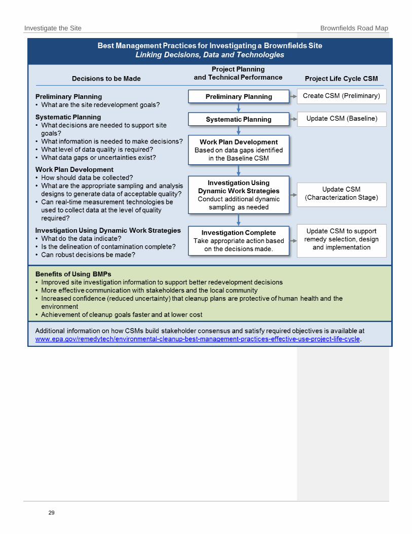
Investigate the Site Brownfields Road Map
29

Brownfields Road Map Investigate the Site
Conduct Your Site Investigation
The development of a Work Plan is critical to a successful site investigation. A Work Plan
addresses data gaps identified in the CSM, and includes information on data sampling
and analysis methods, and the required data quality. Specifically, the Work Plan should
include a Field Sampling Plan (FSP) and Quality Assurance Project Plan (QAPP). The FSP
outlines the objectives, rationale and procedures for collecting and analyzing
environmental samples. The QAPP describes the necessary quality assurance
procedures, quality control activities and key project personnel, providing a clear and
complete plan for the environmental data operation and its quality objectives.
Altogether, the Work Plan documents the procedural and analytical requirements for
Brownfields projects.
The following lists the activities that are typically conducted during the site investigation
phase. This list is intended as a general planning guide and is not a comprehensive
inventory of all site investigation activities required under state and federal regulations.
Factors to be considered while planning the site investigation are presented in the
margin in the form of questions.
Contact the EPA regional Brownfields coordinator to explore the potential for the project to qualify for a Brownfields assessment grant and options for technical assistance through the EPA’s TBA program.
If a Phase II ESA is needed, contact your state’s Brownfields program representative and EPA regional coordinator to identify the availability of state and federal support programs, financial incentives, and funding sources for site investigation and cleanup activities.
In collaboration with stakeholders, use the results of the Phase I ESA to update the project life cycle CSM. Identify critical data gaps as the basis for the design of a Phase II ESA.
Identify and consult with the appropriate federal, state, local and tribal agencies to include their input as early as possible in the project, including during the development of the Work Plan. Continue to work with regulatory agencies during the site investigation design and data collection phases to ensure that regulatory requirements are being properly addressed.
Invite community members to participate in discussions about the project goals and objectives and in decisions about the site investigation design.
Identify the proper mix of real-time measurement technologies, innovative sampling approaches (such as incremental sampling) and conventional methods
Consider These Questions
Goals and Planning
Can the need for cleanup be assessed accurately from the site assessment or from a previous site investigation?
Who or what could be affected by the contamination or cleanup efforts?
What happens if contamination poses a "significant threat" to local residents?
What happens if the contamination is originating from an adjacent property or other off-site source?
What happens if sampling indicates that contamination is originating from a naturally occurring source?
Oversight
Will the site be entered into a state Voluntary Cleanup Program (VCP)? If so, will the investigation plan be reviewed through the VCP? If not, are there applicable federal, state, local and tribal regulatory requirements?
Which agency will oversee the investigation? Does the agency have suitable standards or guidelines for the proposed reuse?
The Community
What issues has the community raised that may affect the site investigation?
How will the results of the site investigation be shared with the community?
What is a data gap?
A data gap identifies the information that is missing from a CSM and indicates the data needed to arrive at a successful management and control measure.
30

Investigate the Site Brownfields Road Map
(such as off-site laboratory analysis) to investigate the site and meet the required level of data quality.
Research and ensure that proposed field-based and off-site laboratory analytical methods can accurately detect all contaminants of interest to a concentration that is lower than or comparable to the screening level concentrations defined by the regulatory guidance and the agencies overseeing the project.
Conduct the Phase II ESA to define the environmental conditions associated with the identified RECs at the site:
o Identify potentially viable site sampling and testing methods to confirm geological and hydrogeological site conditions. For example, consider consulting with a geophysical survey service provider to evaluate approaches for cost-effectively addressing data gaps.
o Confirm and refine as necessary the human health and ecological pathways for exposure to site contaminants.
o Delineate the nature, extent, source and significance of any contamination confirmed to be present.
o During the field investigation, evaluate results with other stakeholders to achieve consensus that the associated data needs at each identified release have been addressed.
o If applicable, evaluate whether and how the infrastructure systems (for example, roads, sewers and structures) are affected by contamination.
Update the Baseline CSM with data and observations obtained during the Phase II site investigation.
Assess the risks posed to human health and the environment. Depending on the planned end use of the property, other potential exposure pathways or sensitive receptors may also require evaluation. Consider the human exposure pathways of direct contact, ingestion or inhalation of soil and dust, water and indoor air.
Depending on state regulatory requirements, perform a risk assessment to identify site-specific cleanup levels when contaminant concentrations confirmed at the site exceed regulatory screening levels.
Use the Characterization CSM to identify and evaluate potential cleanup options.
Evaluate confirmed site contamination in all affected environmental media in terms of overall cleanup costs, including initial actions and long-term operation
Consider These Questions
(continued)
Site Conditions
What are the potential exposure pathways?
Are the infrastructure systems (roads, buildings, sewers, public water systems and other facilities) contaminated? Could they be affected by efforts to clean up contamination?
Is the site likely to be a “challenging cleanup”? See Spotlight 9.
Options
Has the team explored the full range of investigation approaches that can produce data of the quality required?
What real-time technologies are available to facilitate site investigation and support data collection efforts?
Can the technologies selected limit the number of mobilizations to the site?
Will the site investigation involve iterative steps to address data gaps that arise during the project?
Incremental Sampling
Incremental sampling methodology (ISM) is a structured composite sampling and processing protocol for soils that provides representative samples of specific soil volumes by collecting numerous increments of soil that are combined, processed and subsampled according to specific protocols. ISM reduces data variability and improves the reliability and defensibility of sampling data. More information is available at www.itrcweb.org/Team/Public?teamID=11
31

Brownfields Road Map Investigate the Site
and maintenance. Include potential cleanup options and constraints that may affect redevelopment requirements, such as project schedules, costs and potential for achieving the desired reuse.
Share the updated CSM with members of the community to promote understanding of the site conditions.
Plan Your Next Steps
As discussed in the Introduction section, the Road Map lays out the cleanup process in a
linear manner. In reality, the “investigation” activities occur throughout the process as
the life cycle CSM (Spotlight 3 in the previous section) evolves as more is learned about
the site. The need to collect data to address data needs realized later in the process may
or will require additional data collection. The tools in this section are useful through the
process and whenever additional data collection is needed to support informed
decision-making. The next course of action is determined by the site investigation
results. Several possible outcomes and subsequent courses of action are explained
below.
Real-Time Sampling Equipment
A handheld X-ray fluorescence (XRF) instrument used to screen soil for contamination (left). XRF instruments are field-portable devices for simultaneously measuring metals and other elements in various media. The instrument provides a real-time display of the detected contaminant and concentration. XRF devices provide data in the field that can help identify and characterize contamination and guide cleanup work.
32
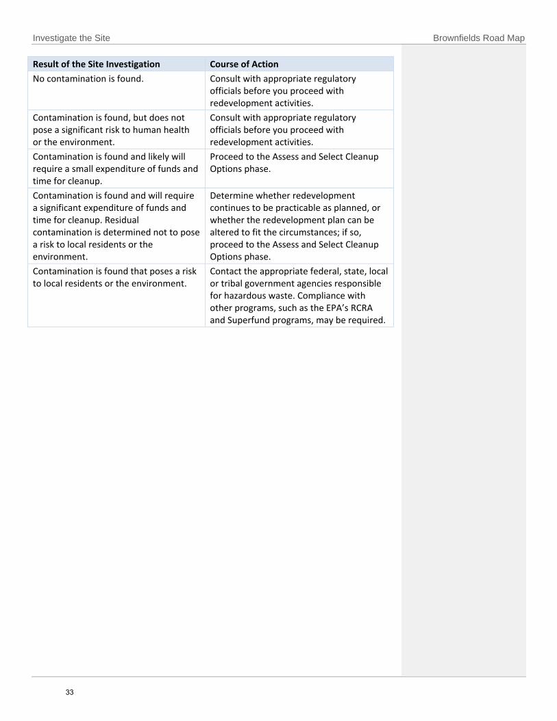
Investigate the Site Brownfields Road Map
Result of the Site Investigation Course of Action
No contamination is found. Consult with appropriate regulatory officials before you proceed with redevelopment activities.
Contamination is found, but does not pose a significant risk to human health or the environment.
Consult with appropriate regulatory officials before you proceed with redevelopment activities.
Contamination is found and likely will require a small expenditure of funds and time for cleanup.
Proceed to the Assess and Select Cleanup Options phase.
Contamination is found and will require a significant expenditure of funds and time for cleanup. Residual contamination is determined not to pose a risk to local residents or the environment.
Determine whether redevelopment continues to be practicable as planned, or whether the redevelopment plan can be altered to fit the circumstances; if so, proceed to the Assess and Select Cleanup Options phase.
Contamination is found that poses a risk to local residents or the environment.
Contact the appropriate federal, state, local or tribal government agencies responsible for hazardous waste. Compliance with other programs, such as the EPA’s RCRA and Superfund programs, may be required.
33

Brownfields Road Map Investigate the Site
Vapor Intrusion (VI) occurs when there is a migration of vapor-forming chemicals from any subsurface source into an overlying building or structure. The vapors can come from chemicals in contaminated soil or groundwater, and can enter buildings through cracks in basements and foundations, as well as through conduits and other openings in the building envelope (e.g., gaps around pipes and utility lines). People may come into contact with hazardous vapors while performing their day-to-day indoor activities. Chemicals that accumulate at low concentrations in occupied buildings may pose an unacceptable health risk due to long-term or chronic exposure. In extreme cases, vapors may accumulate in dwellings to levels that may pose acute health effects or near-term safety hazards (e.g., explosion).
Contaminants in the subsurface can become sources for VI if they volatilize under normal temperature and pressure conditions. Common vapor-forming chemicals may include volatile organic compounds (VOCs) (e.g., trichloroethylene and benzene); select semivolatile organic compounds (e.g., naphthalene); some polychlorinated biphenyls and pesticides; and elemental mercury.
Careful consideration of the VI pathway is warranted at sites where these vapor-forming chemicals are present in the subsurface. Typical Brownfields sites with VI concerns include (but are not limited to) former gas stations, dry cleaners, landfills, automobile repair shops and former manufacturing and chemical processing plants. However, because contaminated vapors can migrate laterally in the soil, or within groundwater or in conduits, the source does not need to be on the property to create a VI risk. Green spaces or properties with no history of industrial activity may be affected by VI if they are located near a contaminated property.
Considerations for Brownfields Projects
Evaluating the potential for VI should begin early in the site assessment and investigation phases. Solutions may be easier toimplement and are generally less expensive if VI concerns are evaluated before construction is complete.
The project life cycle CSM should incorporate VI concerns to help define data quality objectives and identify considerations forthe cleanup design.
Strategies to reduce or eliminate VI threats include:o Remediating or controlling the source(s) of contamination in the subsurfaceo Installing engineered exposure controls in new or existing buildings, such as sub-foundation ventilation or depressurization
systems, which can interrupt soil gas intrusion into the occupied spaces of the building (i.e., mitigate vapor intrusion)o Ventilating the affected buildings with properly operated heating, ventilation and air conditioning systems or using non-
mechanical meanso Restricting the use of the property and/or onsite buildings and facilities through institutional controlso Changing the location or altering the design of future buildings
Operation, maintenance and monitoring of remediation systems and engineered exposure controls are generally necessary.
Some states have specific VI guidance that pertain to their Brownfield cleanup programs; pertinent environmental agenciesshould be consulted to ensure that up-to-date and appropriate guidance is followed.
For More Information Technical guides are available with information about investigating and addressing VI, including Standard Guide for Vapor Encroachment Screening on Property Involved in Real Estate Transactions (www.astm.org/Standards/E2600.htm) and Technical Guide for Assessing and Mitigating the Vapor Intrusion Pathway from Subsurface Vapor Sources to Indoor Air (www.epa.gov/vaporintrusion/technical-guide-assessing-and-mitigating-vapor-intrusion-pathway-subsurface-vapor). The EPA’s VI website, www.epa.gov/vaporintrusion, provides basic information and policy, guidance, and technical documents. VI resources are also provided on the CLU-IN website at www.clu-in.org/issues/default.focus/sec/Vapor_Intrusion/cat/Overview/.
34

Investigate the Site Brownfields Road Map
Cleanup of contaminated mining sites as a part of Brownfields redevelopment can be a challenge due to potentially complex site history and substantial environmental issues. The major sources of contamination associated with these sites include mine drainage, waste rock, tailings and ore stockpiles. Other potential sources of contamination include waste generated from machine maintenance operations, vehicle repair, or other activities involving the use of solvents, petroleum, lubricants and other industrial chemicals.
Stakeholders can leverage innovative approaches to overcome the challenge of assessing and addressing contamination at these often large, complex mining sites. In the site assessment phase, identifying the type and extent of contamination is critical to a successful cleanup. Systematic project planning, dynamic work planning and the use of real-time measurement technologies under the Triad approach can facilitate efficient site characterization and are used to build a CSM. Technical considerations that can help develop a CSM that addresses the transport, mitigation and impacts of contamination for mining sites include:
Type of mining site
Past contamination and disposal practices
Type and volumes of contaminated media
Cleanup budget and time frame
Current site topography
Presence of mine shafts, openings or walls
Intended end use of the site
Mining site remediation commonly involves often expensive conventional treatment technologies, including relocation of waste, clean soil cap, creating vertical wall barriers and water diversion tactics or detention basins. Innovative treatment technologies—including phytotechnologies, enhanced bioremediation, in situ chemical oxidation, permeable reactive barriers, and soil amendment application—can provide significant cost and time savings and other benefits.
An important aspect of mining site reclamation and redevelopment is the active participation by all stakeholders and decision makers. Upfront involvement by stakeholders and the community can help manage expectations and costly project changes that may arise after the cleanup begins. The development of a CSM under the Triad approach will insure that the stakeholders and community have the opportunity to review consistent data in the decision-making process.
Example Brownfields Mining Sites
Suspected contamination at a former coal mine in Weirton, WV, obstructed redevelopment by prospective businesses. EPA awarded four Brownfield Assessment Grants to local councils and business groups to assess the former Weirton Steel property. After site assessments revealed no major contaminants were present, nearly $20 million was leveraged to complete redevelopment, leading to the creation of more than 350 jobs.
After purchasing 16,500 acres in Luzerne County, PA, from the former Blue Coal Corporation, the local nonprofit Earth Conservancy mapped out a land use plan for the property. EPA supported the resulting cleanup efforts by awarding 12 Brownfield Cleanup Grants totaling $2.4 million. This seed money led to the reclamation of 2,000 acres of mine-scarred lands that will be developed into open recreational, residential and commercial spaces.
For More Information
Information on ecological restoration opportunities such as wetland banks, is available at www.cluin.org/issues/default.focus/sec/characterization_cleanup_and_revitalization_of_mining_sites/cat/revitalization_and_reuse/. This website includes the report Mine Site Cleanup for Brownfields Redevelopment: A Three-Part Primer, which provides a detailed overview of cleanups at mining sites and offers innovative strategies, case studies and technical details on redevelopment. Additional information on mining site characterization, cleanup, and revitalization is available at www.clu-in.org/mining and www.epa.gov/superfund/abandoned-mine-lands-revitalization-and-reuse.
Federal Laws Related to Mining Site Remediation and Revitalization
Federal laws to be considered for mining site remediation and revitatlization include:
Surface Mining Control and Reclamation Act (SMCRA)
Comprehensive Environmental Response, Compensation, and Liability Act (CERCLA)
Clean Water Act (CWA)
Resource Conservation and Recovery Act (RCRA)
Toxic Substances Control Act (TSCA)
Safe Drinking Water Act (SDWA)
Clean Air Act (CAA)
Treatment Approach Emergency Planning and Community Right-to-Know Act (EPCRA)
National Environmental Policy Act (NEPA)
Visit www.epa.gov/laws-regulations/laws-and-executive-orders
for an overview of these laws and further information.
35
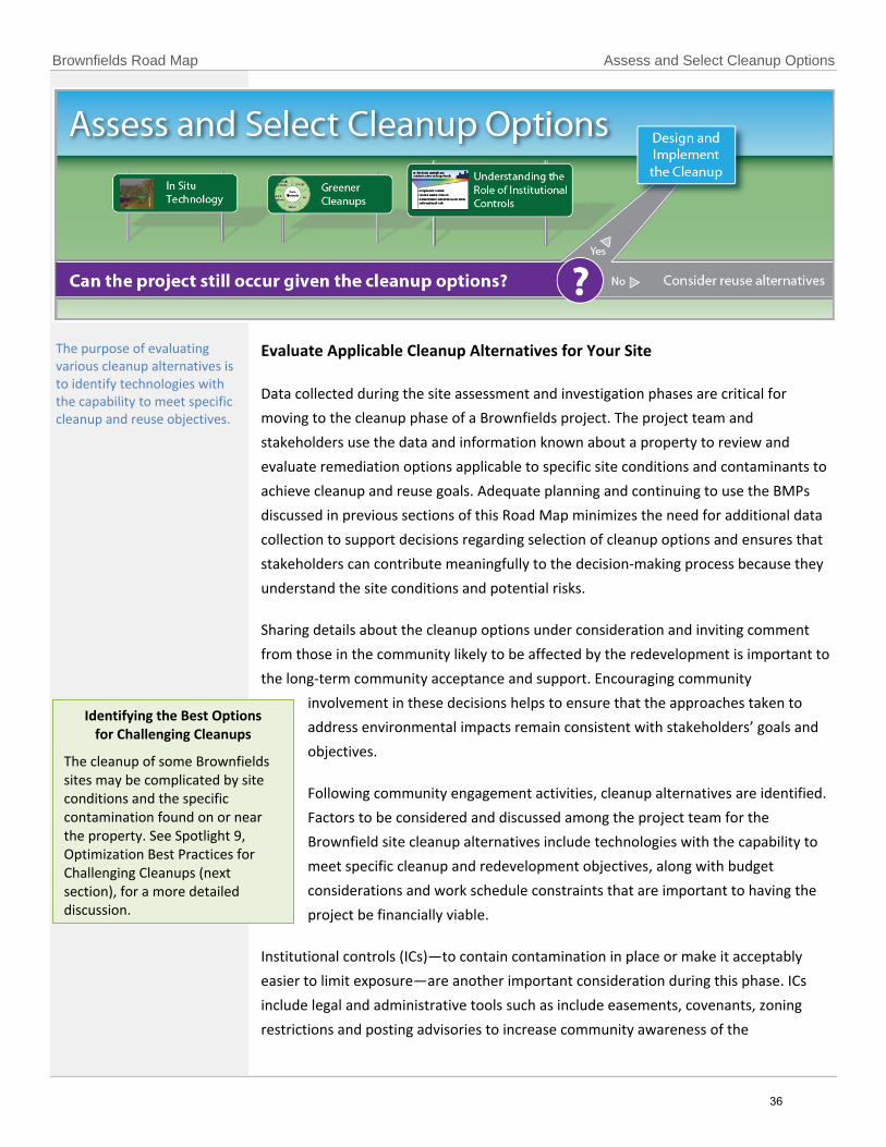
Brownfields Road Map Assess and Select Cleanup Options
Evaluate Applicable Cleanup Alternatives for Your Site
Data collected during the site assessment and investigation phases are critical for
moving to the cleanup phase of a Brownfields project. The project team and
stakeholders use the data and information known about a property to review and
evaluate remediation options applicable to specific site conditions and contaminants to
achieve cleanup and reuse goals. Adequate planning and continuing to use the BMPs
discussed in previous sections of this Road Map minimizes the need for additional data
collection to support decisions regarding selection of cleanup options and ensures that
stakeholders can contribute meaningfully to the decision-making process because they
understand the site conditions and potential risks.
Sharing details about the cleanup options under consideration and inviting comment
from those in the community likely to be affected by the redevelopment is important to
the long-term community acceptance and support. Encouraging community
involvement in these decisions helps to ensure that the approaches taken to
address environmental impacts remain consistent with stakeholders’ goals and
objectives.
Following community engagement activities, cleanup alternatives are identified.
Factors to be considered and discussed among the project team for the
Brownfield site cleanup alternatives include technologies with the capability to
meet specific cleanup and redevelopment objectives, along with budget
considerations and work schedule constraints that are important to having the
project be financially viable.
Institutional controls (ICs)—to contain contamination in place or make it acceptably
easier to limit exposure—are another important consideration during this phase. ICs
include legal and administrative tools such as include easements, covenants, zoning
restrictions and posting advisories to increase community awareness of the
The purpose of evaluating various cleanup alternatives is to identify technologies with the capability to meet specific cleanup and reuse objectives.
Identifying the Best Options for Challenging Cleanups
The cleanup of some Brownfields sites may be complicated by site conditions and the specific contamination found on or near the property. See Spotlight 9, Optimization Best Practices for Challenging Cleanups (next section), for a more detailed discussion.
36

Assess and Select Cleanup Options Brownfields Road Map
environmental conditions and cleanup activities at the site. See Spotlight 8,
Understanding the Role of Institutional Controls at Brownfields Sites, for more
information.
Selecting the Cleanup Options for Your Site
The following list identifies activities that are typically conducted during the evaluation
and selection of cleanup options. The list is intended as a general planning guide and is
not a comprehensive inventory of all activities to be undertaken during this phase.
Factors to be considered are presented in the margins in the form of questions.
Establish cleanup objectives and numeric goals that consider the likely end use. Use applicable standards, published state or federal guidelines, risk-based corrective actions (RBCA) or site-specific risk assessment results. It is essential that these objectives meet the specific statutory and regulatory requirements for the site and that the project team consider these objectives early in the process.
Communicate information about the proposed cleanup option to Brownfieldsstakeholders. Solicit the input of the affected community in the site cleanupselection process and actively engage community members in decision making.
Review general information about cleanup technologies and approaches tobecome familiar with those that may be applicable to the contaminants andgeologic and hydrogeologic conditions present at the site. Focus on identifyingcleanup options that have a proven track record for sites with similarcontaminants and conditions:
o See Appendix D (Guide to Contaminants and Technologies) for examplesof technologies that are appropriate for specific types of contaminants.
o Use the resources available www.epa.gov/remedytech to identifyinnovative cleanup technologies.
o Search existing literature that further describes the technologyalternatives.
o Analyze detailed technical information about the applicability oftechnology alternatives.
Enlist the help of a professional environmental practitioner with experience inapplying these technologies at similar sites.
Assess the need for using ICs as part of the remedy approach. At Brownfieldssites the option to control risk by pathway restrictions is common.
Narrow the list of potential cleanup options that are most appropriate andcompatible for addressing site contamination and proposed reuse:
o Network with other Brownfields stakeholders and environmentalpractitioners to leverage their expertise.
o Determine whether sufficient data are available to supportidentification and evaluation of cleanup alternatives.
Consider These Questions
Goals and Planning
Have site characterizationuncertainties have beensufficiently reduced?
What are the appropriateand feasible level of cleanupand how are they identified?
Oversight
Are there federal, state, local or tribal cleanuprequirements?
Are there prescribedstandards for the cleanup?
Is there a stateenvironmental insuranceprogram?
The Community
How can the communityparticipate in the review andselection of options?
What environmentalstandards should beconsidered to ensure thatcommunity stakeholders aresatisfied with the outcomeand process of the cleanup?
Are cleanup optionsacceptable in light ofcommunity concerns?
Are cleanup optionscompatible with regional orlocal planning goals andrequirements?
Site Conditions
Should risk-basedapproaches be consideredfor addressing exposure?
Will the cleanup facilitatethe planned redevelopment?
Is there a need for ICs aftercleanup? If so, will ICsfacilitate or hinderdevelopment?
37

Brownfields Road Map Assess and Select Cleanup Options
o Analyze in more detail the applicability of technologies to the contamination and conditions identified at a site.
o Determine whether combining remedies or technologies optimize cleanup at a site.
o Evaluate the options against a number of key factors, including their effectiveness, implementability and cost.
o Consider the benefits that some cleanup options may offer; for example, less disruption to the community, potential reduction of liability and long-term sustainability.
o Determine the effects of various technology alternatives on redevelopment objectives.
Continue to collaborate with regulatory agency stakeholders to ensure that regulatory requirements are properly addressed:
o Confirm that the agencies concur that site characterization uncertainties have been sufficiently reduced to allow the process of remedy selection and design to begin.
o Discuss or confirm cleanup objectives meet compliance with applicable statutory and regulatory requirements as well as requirements for intended use/reuse of the site.
o Obtain agency input regarding the range of cleanup options under consideration and input regarding any additional options.
Contact the EPA regional Brownfields coordinator to explore the potential for the project to qualify for a Brownfields cleanup grant, Revolving Loan Fund (RLF), or TBA support. Communities interested in applying for an EPA Brownfields cleanup grant should prepare an Analysis of Brownfields Cleanup Alternatives (ABCA), and an example of which is provided at www.epa.gov/sites/production/files/2015-10/documents/abca-example4cleanup-proposals.pdf.
Integrate cleanup alternatives with reuse alternatives to identify potential constraints on reuse and time schedules and to assess cost and risk factors.
Investigate environmental insurance policies, such as protection against cost overruns, undiscovered contamination and third-party litigation, and integrate their cost into the project financing strategy.
Select an acceptable remedy that not only achieves cleanup goals and addresses the risk of contamination, but also best meets the objectives for redevelopment and reuse of the property and is compatible and sustainable with the needs of the community. Note, the cleanup approach may combine remedies.
Build contingencies into the remedy and carefully develop matrices to monitor and determine progress toward meeting cleanup goals.
Find Helpful Resources
A wide variety of chemical contaminants may be present at Brownfields sites. Appendix
D (Guide to Contaminants and Technologies) at the end of this document provides
Consider These Questions
(continued)
Options
Are the options acceptable in light of community concerns about protection and reuse of the site?
What are the short- and long-term effects of the cleanup remedies under consideration?
What options are available to monitor the performance of cleanup remedies?
Are proposed ICs appropriate in light of community concerns?
What plans, including financial assurances, are being made to ensure that ICs remain functional as long as contamination is present?
Does the proposed cleanup approach place burdens on future land owners or occupants?
Timing and Funding
How long will cleanup take?
What will cleanup cost?
Will schedule constraints or the estimated cost adversely affect the project’s viability?
Who will pay for long-term costs to maintain the remedy, including any ICs?
38

Assess and Select Cleanup Options Brownfields Road Map
information about the applicability of technologies for particular types of Brownfields
sites. Additional information on innovative cleanup technologies is available online at
www.cluin.org/remediation/ and www.frtr.gov/scrntools.htm.
Plan Your Next Steps
After cleanup options have been selected for your site, consider the following options:
Result of the Review of Cleanup Options Course of Action
The proposed cleanup option appears feasible.
Proceed to the Design and Implement the Cleanup phase.
No cleanup option appears feasible in light of the identified contamination or the proposed redevelopment and land reuse needs (such as project milestones, cost and intended reuse).
Determine whether revising the redevelopment plan remains a practicable option; if so, proceed to the Design and Implement Cleanup phase.
Compliance with other programs, such as the EPA’s RCRA and Superfund programs, may be required.
39

Brownfields Road Map Assess and Select Cleanup Options
ld
The development of innovative treatment methods provides Brownfields stakeholders with new options for faster and more effective site cleanup. New approaches to site cleanup, based on the use of in situ, or in place, treatment technologies, promote more targeted or “surgical” options for cleanup by enabling a better understanding of subsurface features, contaminant distribution, volume, mass and behavior over time. Each technology has its limitations and suitable applications.
Benefits of In Situ Treatment
In situ treatment technologies are chemical, physical, biological, thermal or electrical processes that remove, degrade, chemically modify, stabilize or encapsulate contaminants within the soil or groundwater, in place. Methods that actively treat or destroy contaminants can reduce the time required to clean up a site, decrease the amount of residual contamination left at sites and minimize the need for long-term operations and maintenance. Together, these benefits can directly serve the interests of Brownfields stakeholders by:
Expediting site redevelopment and reuse.
Reducing the requirement for engineering controls (EC) and institutional controls (ICs).
Lowering or eliminating risks from long-term expenditures related to environmental protection measures.
In situ treatment remedies can also provide the added value of supporting the goals of greener cleanups. For example, in situ treatments can reduce the amount of treatment materials and waste generation and handling. In situ technologies or strategies can also be used to address residual contamination after more active and aggressive strategies are used to address the source.
Examples of In Situ Technologies
In Situ Thermal (IST) is the application of heat to contaminated soil and/or groundwater, causing the destruction or volatilization and mobilization of organic chemicals in the subsurface. As the chemicals volatilize into gases, they can be extracted via collection wells and treated in an ex situ treatment system at the surface. Heat can be introduced to the subsurface by electrical resistance heating, radio frequency heating, thermal conduction or injection of hot water, hot air or steam. IST is effective for remediation of dense or light nonaqueous phase liquids (DNAPLs or LNAPLs).
In Situ Chemical Oxidation (ISCO) is a remediation technology that involves injecting chemical oxidants, such as permanganate, persulfate and hydrogen peroxide, into the contaminated groundwater and/or soil where contaminants are chemically converted into nonhazardous or less toxic compounds that are often more stable or inert. ISCO can be applied to a wide range of volatile and semivolatile hazardous contaminants, including DNAPLs and dissolved-phase chemicals emanating from the source zones.
In Situ Flushing involves flooding the contamination zone with an appropriate solution to remove the contaminant from the soil. The contaminants are mobilized by solubilization, emulsification or a chemical reaction as the solution is injected or infiltrated into the contaminated area. Then the contaminant-bearing fluid is collected and brought to the surface for disposal, recirculation or on-site treatment and reinjection. In situ flushing can be combined with other remedies, applied in both the vadose and saturated zones, and is applicable to a wide range of contaminants. In situ flushing is ineffective for dissolved-phase plumes and low permeability soils. Extensive laboratory testing is required to determine the most effective chemical solution.
For More Information Information on in situ remediation technologies visit www.cluin.org/remediation and combined remedy resources at www.clu-in.org/products/combinedremedies/.
40

Brownfields Road Map Assess and Select Cleanup Options
Cleanup actions, while protective of the environment, also have their own “environmental footprint”—they use energy, water and materials. To reduce this footprint, cleanups can be performed in a “greener” manner by considering the environmental effects of remedy implementation and incorporating options to minimize the impact of cleanup actions. Principles of greener cleanup can be applied throughout the site assessment and cleanup process. It can be advantageous to consider these options early to reduce the overall footprint of the project. Greener cleanup BMPs can reduce environmental impacts while maintaining cleanup objectives and ensuring that the remedy is protective of human health and the environment.
Core Elements of Greener Cleanups
Reduce total energy use by improving energy efficiency and increasing use of energy from renewable resources.
Reduce air emissions of greenhouse gases and criteria pollutants such as ozone, nitrogen dioxide and sulfur dioxide.
Protect water resources and reduce water use.
Reduce waste and improve materials management.
Safeguard the land and ecosystem during site cleanup.
ASTM Standard E2893-16 “Standard Guide for Greener Cleanups” provides:
A systematic protocol to identify, prioritize, select, implement and report on the use of BMPs to reduce the environmental footprint of cleanup activities.
A list outlining 115 BMPs that are linked to the core elements of a greener cleanup and to relevant cleanup technologies.
Guidelines to quantify the environmental footprint of cleanup activities.
A reporting structure to promote public availability of information relating to the decision making process and communication of outcomes.
Examples of Sites Implementing Greener Cleanups
The Whitney Young Branch Library Brownfields Site, in Chicago, IL, used the ASTM Standard Guide for Greener Cleanups to select BMPs for reducing the environmental footprint of the tetrachloroethene (PCE) site cleanup methods.
The Grove Landfill Site in Austin, TX, utilized materials recycling, clean energy use and habitat restoration throughout the Brownfields cleanup of contaminated soil and surface water.
Footprint Assessment Tools
The Green Remediation Focus Footprint Assessment website provides a summary of available tools to evaluate the environmental footprint of remediation processes (www.cluin.org/greenremediation/footprintassessment).
For More Information
The Green Remediation Focus page of the EPA’s CLU-IN website at www.cluin.org/greenremediation provides information on integrating green remediation and BMPs into cleanups and case studies that describe green remediation implementation. More information on the ASTM Standard Guide for Greener Cleanup is available at www.epa.gov/greenercleanups/greener-cleanup-consensus-standard-initiative.
Mixing Trenches: At the Whitney Young Branch Library Brownfields Site, chemical oxidation reagents were mixed in three 16- by 16-foot trenches reinforced by steel. After mixing was complete, the steel was removed and reused onsite for purposes such as sidewalk shoring.
41

Assess and Select Cleanup Options Brownfields Road Map
ICs are a broad spectrum of administrative and legal tools used to help minimize the potential for exposure to residual contamination and to protect physical cleanup measures at contaminated sites. ICs work by limiting land or resource use or by providing information that helps modify or guide human behavior at a site. ICs typically supplement engineering controls and are used in conjunction with the overall cleanup remedy to support reuse. Long-term considerations associated with IC use, such as impacts on reuse and funding requirements, should be carefully weighed against the costs and benefits of permanent removal of contamination.
Types of ICs
Proprietary controls involve private agreements that impose restrictions on, or otherwise affect the use of, a property. Common examples of proprietary controls are covenants, deed restrictions and easements.
Governmental controls, such as zoning, building codes, groundwater use regulations and commercial fishing bans, restrict land or resource use by the authority of a government entity.
Enforcement and permit tools with IC components typically involve administrative orders, consent decrees and permits to limit certain activities at a site or require a specific activity, such as monitoring and reporting.
Informational devices, such as signs, markers and community outreach activities, provide notification and may communicate risks about residual contamination that may remain on a site after a cleanup remedy has been undertaken.
Long-Term Considerations
Identify the long-term costs and administrative implications of maintaining and enforcing ICs.
Evaluate the potential use of ICs early in the cleanup process to plan appropriately for implementation, maintenance and enforcement challenges.
Consider and compare leaving contamination in place while maintaining ICs to treating or removing contamination, including costs, risks, site reuse and other factors.
For More Information
The EPA’s guidance Institutional Controls: A Guide to Planning, Implementing, Maintaining, and Enforcing Institutional Controls at Contaminated Sites highlights some of the common issues that may be encountered when working with ICs, and provides an overview of EPA’s policy regarding the roles and responsibilities of the parties involved in the various life-cycle stages of ICs. This document is available online at www.epa.gov/fedfac/institutional-controls-guide-planning-implementing-maintaining-and-enforcing-institutional. In 2009, the EPA released the fact sheet An Introduction to the Cost of Engineering and Institutional Controls at Brownfield Properties, which provides general information about the costs of ECs and ICs at Brownfields sites and includes an example of the use of ICs as part of a site cleanup, and is available online at www.epa.gov/sites/production/files/2015-09/documents/lts_cost_fs.pdf. A 2017 EPA document Long Term Stewardship at Leaking Underground Storage Tank Sites with Residual Contamination provides an overview and approaches to long-term stewardship as well as tips and resources for achieving long-term stewardship at leaking underground storage tanks (UST) sites. The document is available online at www.epa.gov/ust/long-term-stewardship-leaking-underground-storage-tank-sites-residual-contamination.
42

Brownfields Road Map Design and Implement the Cleanup
Develop and Carry Out Your Detailed Cleanup Plans
During the cleanup design and implementation phase, the property is prepared for
redevelopment and reuse by carrying out the selected cleanup approach. The design of
a cleanup plan and implementation of the chosen remedies involves close coordination
with all other redevelopment efforts in the immediate vicinity of the site.
Building on the comprehensive understanding of site conditions that has evolved during
the project, real-time technologies and dynamic work strategies can be used to monitor
and assess the results of cleanup activities. As in the site investigation phase, these field-
based methods can be used to evaluate progress toward the achievement of the
cleanup goals. Accurate monitoring data help to minimize uncertainty and form the
basis for long-term monitoring strategies, including the use of ICs.
In some cases, implementing the cleanup may lead to the discovery of additional
contamination or may reveal other complicating factors that require the project team to
conduct further site investigation and characterization. Additional site investigation
results may demonstrate that no practical alternatives exist for cleaning up the site to
meet the reuse goals of the project; if so, the site owner may need to consider
modifying the proposed land reuse plan or identifying other land use alternatives. See
Spotlight 9, Optimization Best Practices for Challenging Cleanups, for details about sites
affected by contaminants that are difficult to investigate and clean up.
Design and Implement Your Cleanup
Typical activities that may be conducted during this phase are outlined below, along
with factors to consider. The list is intended as a general planning guide and is not a
comprehensive inventory of all activities to be undertaken during cleanup of a
Brownfields site.
The final phase of preparing a Brownfields property for reuse is designing and implementing the cleanup. During this phase, the discovery of additional contamination may require further site investigation or reassessment of available cleanup options.
Maintaining stakeholder participation during cleanup promotes long-term community acceptance and support of the planned reuse of the Brownfields site.
43

Design and Implement the Cleanup Brownfields Road Map
Review all applicable federal, state, local and tribal regulations and regulatoryguidelines to identify specific requirements, including guidelines for state VCPs.Keep in mind that new regulations can become effective in the middle of theproject.
Continue to engage regulatory stakeholders to ensure that regulatoryrequirements are being properly addressed:
o Confirm that the agency has reviewed the cleanup plan and concurswith the design of the selected remedy.
o Obtain agency input and concurrence on remedy assessment metricsand alternative exit strategies.
o Upon completion of remediation activities, consult with regulatorystakeholders on the process of receiving a decision of “no furtheraction.” Each state program has specialized conditions andrequirements for the certification and delisting process. Moreinformation is available online at www.epa.gov/brownfields/cleaning-brownfields-under-state-response-programs-getting-no-further-action.
Contact the state Brownfields program and the EPA regional Brownfieldscoordinator to identify and determine the availability of state and EPA supportprograms.
Develop cleanup and subsequent monitoring plans that incorporate technologyoptions and consider the effect of any cleanup activities on the proposed reuseof the property and the schedule for project design or construction:
o Develop or review the schedule for completion of the project.
o Obtain a final amount for the grant funding available for projectdevelopment.
o Consider duration and clear endpoints of the remedial action whichdirectly impacts the reuse schedule and costs.
o Coordinate renovation and construction of infrastructure with cleanupactivities.
o Coordinate activities with developers, financiers, construction firms andmembers of the local community.
Establish contingency plans to address the discovery of additionalcontamination during cleanup, including tools such as environmental insurancepolicies, or to supplement or replace the initial approach if progress towardsachieving cleanup objectives is not satisfactory.
Continue to maintain stakeholder consensus and active communityparticipation during cleanup:
o Conduct public outreach meetings on a regular basis.
o Provide updates about the progress of cleanup activity.
o Share successes when important cleanup milestones are achieved.
o Inform the community about changes in activity that could affect reuseplans.
Consider These Questions
Goals and Planning
How will the cleanup bemonitored and assessed?
Does the projected length oftime required for cleanuptake into accountcontingencies or long-termmonitoring?
Have alternative land usestrategies been developed?
Oversight
Are there federal, state, local and tribal requirements forthe design, installation andmonitoring of cleanupactivities?
The Community
How will the communityparticipate in this phase?
Are there examples ofeffective communityengagement?
Site Specifics
Can redevelopment andcleanup activities beperformed concurrently?
Will ICs facilitate or hinderredevelopment in thefuture?
Options
How will the cleanup designaffect long-term liabilities orfuture use of the site?
What can be done to protectthe community and otherproperty during cleanup?
Funding
What are the tradeoffsbetween cost and meetingproject deadlines?
How will long-termmonitoring be funded andmanaged?
44

Brownfields Road Map Design and Implement the Cleanup
Implement, document and monitor the performance of the cleanup using theaccepted assessment metrics.
Work with the state VCP, if applicable, and with tribal, county or local officials tofacilitate the placement and implementation of ICs.
Plan Your Next Steps
After the cleanup is completed, consider the following courses of action:
Result of Cleanup Course of Action
Contamination has been adequately removed, contained or controlled.
Before proceeding with redevelopment activities, consult with the appropriate regulatory officials to receive a “no further action” decision.
Additional contamination has been discovered.
Consult with appropriate regulatory officials to determine how to proceed with cleanup activities. You may need to return to the Investigate a Site phase to conduct additional sampling to delineate the extent and nature of the contamination and assess the impact of additional characterization and cleanup costs on the overall viability of the project.
Long-term site monitoring and operation and maintenance (O&M) of the site remedy is required.
Return to the Investigate a Site phase to evaluate options, including cost considerations, for long-term monitoring and O&M, and as necessary collect after-performance samples for monitoring cleanup.
Coordinating redevelopment and cleanup may mean future users take on roles associated with some aspects of maintenance, such as mowing or asphalt repair.
45

Design and Implement the Cleanup Brownfields Road Map
Next Step: Revitalization!
The Road Map provides valuable information to help Brownfields stakeholders better understand and implement the steps for investigating and cleaning up Brownfields sites. It also increases their awareness and knowledge of the wide range of technologies and resources available to support these activities – all leading up to reuse of the Brownfields site. The next step, to merge onto the road to site revitalization and reuse, is the most rewarding because this is the realization and achievement of those goals defined at the beginning of the project. Now that the cleanup is complete, site redevelopment and revitalization can begin. It is time to review the reuse goals set at the start of the Road Map during the planning phase and discussed in Section 3: Learn the Basics. The reuse goals considered the interests of many stakeholders. Re-engaging those stakeholders, as well as any new stakeholders involved during the cleanup process, to review and update the goals, will help ensure site reuse serves the broadest interests in the community, including providing the economic and social benefits that come with a well-planned, well-designed, sustainable and resilient Brownfields site redevelopment.
46
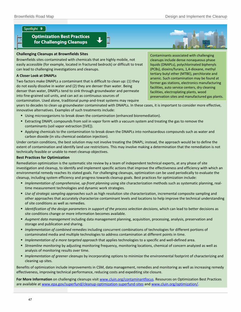
Brownfields Road Map Design and Implement the Cleanup
Challenging Cleanups at Brownfields Sites
Brownfields sites contaminated with chemicals that are highly mobile, not easily accessible (for example, located in fractured bedrock) or difficult to treat can lead to challenging investigations and cleanups.
A Closer Look at DNAPLs
Two factors make DNAPLs a contaminant that is difficult to clean up: (1) they do not easily dissolve in water and (2) they are denser than water. Being denser than water, DNAPLs tend to sink through groundwater and permeate into fine-grained soil units, and can act as continuous sources of contamination. Used alone, traditional pump-and-treat systems may require years to decades to clean up groundwater contaminated with DNAPLs. In these cases, it is important to consider more effective, innovative alternatives. Examples of such treatments include:
Using microorganisms to break down the contamination (enhanced bioremediation).
Extracting DNAPL compounds from soil in vapor form with a vacuum system and treating the gas to remove thecontaminants (soil vapor extraction [SVE]).
Applying chemicals to the contamination to break down the DNAPLs into nonhazardous compounds such as water andcarbon dioxide (in situ chemical oxidation injection).
Under certain conditions, the best solution may not involve treating the DNAPL; instead, the approach would be to define the extent of contamination and identify land use restrictions. This may involve making a determination that the remediation is not technically feasible or unable to meet cleanup objectives.
Best Practices for Optimization
Remediation optimization is the systematic site review by a team of independent technical experts, at any phase of site investigation and cleanup, to identify and implement specific actions that improve the effectiveness and efficiency with which an environmental remedy reaches its stated goals. For challenging cleanups, optimization can be used periodically to evaluate the cleanup, including system efficiency and progress towards cleanup goals. Best practices for optimization include:
Implementation of comprehensive, up-front planning using site characterization methods such as systematic planning, real-time measurement technologies and dynamic work strategies.
Use of strategic sampling approaches such as high resolution site characterization, incremental composite sampling andother approaches that accurately characterize contaminant levels and locations to help improve the technical understandingof site conditions as well as remedies.
Identification of the design parameters in support of the process selection decisions, which can lead to better decisions assite conditions change or more information becomes available.
Augment data management including data management planning, acquisition, processing, analysis, preservation andstorage and publication and sharing.
Implementation of combined remedies including concurrent combinations of technologies for different portions ofcontaminated media and multiple technologies to address contamination at different points in time.
Implementation of a more targeted approach that applies technologies to a specific and well-defined area.
Streamline monitoring by adjusting monitoring frequency, monitoring locations, chemical of concern analyzed as well asanalysis of monitoring results over time.
Implementation of greener cleanups by incorporating options to minimize the environmental footprint of characterizing andcleaning up sites.
Benefits of optimization include improvements in CSM, data management, remedies and monitoring as well as increasing remedy effectiveness, improving technical performance, reducing costs and expediting site closure.
For More Information on challenging cleanups visit www.cluin.org/contaminantfocus. Resources on Optimization Best Practices are available at www.epa.gov/superfund/cleanup-optimization-superfund-sites and www.cluin.org/optimization/.
Contaminants associated with challenging cleanups include dense nonaqueous phase liquids (DNAPLs), polychlorinated biphenyls (PCBs), dioxins/furans, 1,4-dioxane, methyl tertiary butyl ether (MTBE), perchlorate and arsenic. Such contamination may be found at former gas stations, electronics manufacturing facilities, auto service centers, dry cleaning facilities, electroplating plants, wood preservation sites and manufactured gas plants.
47

Design and Implement the Cleanup Brownfields Road Map
Incorporating resilient revitalization into Brownfields assessments and cleanups helps to protect human health and the environment now and into the future. Resilient revitalization adaptations are adjustments that societies or ecosystems make to limit the negative impacts of weather-related changes or to prepare for and adjust to future weather-related impacts. By considering resilient revitalization during the planning process and assessment phase, stakeholders can identify weather-related factors prior to Brownfields redevelopment and associated mitigation measures to help ensure that cleanups remain effective as the weather changes. For example, stakeholders can consider how changing temperature and precipitation patterns may impact the toxicity, fate and transport of onsite contaminants of concern and develop a plan that addresses these changes.
As discussed in the Climate Smart Brownfields Manual, stakeholders can consider observed and predicted weather-related changes in the project area as well as site-specific risk factors. Examples include:
Increased/decreased temperatures.
Increased/decreased precipitation.
Extreme weather events (e.g., storms ofunusual intensity, increased frequency andintensity of localized flooding events).
Increased risk of wildfires.
Changing dates for ground thaw/freezing.
Rising sea level.
Changing flood zones.
Changing environmental/ecological zones.
Increased salt water intrusion.
Higher/lower groundwater tables.
Stakeholders should consult authoritative resources such as the U.S. Geological Survey or National Weather Service to identify weather-related changes that might impact the site, accounting for site-specific risk factors such as proximity to tidal waterways, property affected by a revised Federal Emergency Management Agency (FEMA) flood plain map or site vulnerabilities due to changing hydraulic conditions. Although the ABCA should include an evaluation of how well each alternative can accommodate risk factors associated with weather-related changes, EPA does not expect stakeholders to generate new site-specific weather-related data. In the ABCA, grant recipients should demonstrate that they reviewed all relevant available data. The level of analysis expected depends on site complexity and risk associated with the remedial options and site redevelopment goals.
A good time to start incorporating resilient revitalization in a Brownfields project is during the Phase I ESA. The evaluation of historic site information can be expanded to include historic and more recent weather patterns. Consider weather-related vulnerabilities and resiliency of site structures, soil, vegetation and other elements in the site area. After the site assessment phase, Brownfields redevelopment can also incorporate weather-related change mitigation. Stakeholders should consider the environmental footprint of all site activities by exploring and implementing green remediation strategies to maximize sustainability, reducing energy and water usage, promoting carbon neutrality, promoting materials reuse and recycling, increasing urban greenspace and preserving land resources through green applications. These efforts can help ensure that, along with weather-related change adaptation, resilient revitalization is incorporated in the Brownfields redevelopment process.
For More Information EPA’s Climate Smart Brownfields Manual offers detailed tools, strategies and case studies that can assist in the Brownfields cleanup and redevelopment stages, and is available at www.epa.gov/land-revitalization/climate-smart-brownfields-manual.
48

Brownfields Road Map Appendix A: CSM and General Cleanup Steps
Appendix A
CSM and General Cleanup Steps: Crosswalk of Regulatory Program Stages and CSM Life Cycle Phases
Abbreviations presented in the title row:
CSM = Conceptual Site Model SPP = Systematic Project Planning DWS = Dynamic Work Strategies RTMT = Real Time Measurement Technologies
CERCLA = Comprehensive Environmental Response, Compensation and Liability Act
RCRA = Resource Conservation and Recovery Act UST = Underground Storage Tanks VCUP = Voluntarily Clean Up Programs
The Road Map outlines a general cleanup process and the names of the steps in this process are specific to the cleanup of Brownfields sites. The matrix above, CSM and General Cleanup Steps: Crosswalk of Regulatory Program Stages and CSM Life Cycle Phases, is a crosswalk of the various terminology and steps of different cleanup programs, illustrating that the general cleanup process applies to all these programs.
Use of terminology from regulatory frameworks is not intended to supplement any specific programmatic requirements or guidance. However, irrespective of the environmental program driving site cleanup, use of the components of a CSM in a flexible and comprehensive framework can facilitate site decision making throughout the site-cleanup process. Additionally, the use of SPP and a dynamic CSM along with DWS and RTMT at each key project stage can improve project efficiency and effectiveness.
Note: The width and gradation of the blue arrows demonstrating BMPs indicate the relative level of effort applied and the resulting impact and value of performing the BMPs at the indicated project stages.
49

Brownfields Road Map Appendix B: List Of Acronyms
Appendix B
LIST OF ACRONYMS
AA Atomic Absorption ABCA Analysis of Brownfield Cleanup
Alternatives AES Atomic Emission Spectroscopy AML Abandoned Mine Land ARC Assessment, Revolving Loan Fund
and Cleanup ASV Anodic Stripping Voltammetry ASTSWMO Association of State and Territorial
Solid Waste Management Officials AWP Area-Wide Planning BMP Best Management Practice BTEX Benzene, Toluene, Ethylbenzene,
and Xylene CCA Chrome-copper Arsenate CC Construction Complete CCl4 Carbon Tetrachloride CDFA Council of Development Finance
Agencies CERCLA Comprehensive Environmental
Response, Compensation, and Liability Act
CEI Community Engagement Initiative CLU-IN Contaminated Site Clean-up
Information CMI Corrective Measure Implementation COC Contaminant of Concern CSM Conceptual Site Model CWA Clean Water Act DIAL Differential Adsorption LIDAR DNAPL Dense Nonaqueous Phase Liquid DO Dissolved Oxygen DPT Direct-Push Technology DQO Data Quality Objective DWS Dynamic Work Strategy EC Engineering Control ECD Electron Capture Detector EISB Enhanced In Situ Bioremediation EOU Excessive, Obsolete, or
Unserviceable Munitions EPA U.S. Environmental Protection
Agency ERH Electrical Resistive Heating
ESA Environmental Site Assessment EWDJT Environmental Workforce
Development and Job Training FDIC Federal Deposit Insurance
Corporation FFD Fuel Fluorescence Detector FID Flame-Ionization Detector FOCS Fiber Optic Chemical Sensors FPXRF Field-Portable X-Ray Fluorescence FSP Field Sampling Plan FY Fiscal Year GC Gas Chromatography GC/MS Gas Chromatography/Mass
Spectrometry GIS Geographic Information Systems GPR Ground Penetrating Radar GPS Global Positioning System HPT Hydraulic Profiling Tool HRSC High-Resolution Site
Characterization IA Immunoassay IC Institutional Control IMS Ion Mobility Spectrometry ISB In Situ Bioremediation ISCO In Situ Chemical Oxidation ISM Incremental Sampling Method ISO In Situ Oxidation IST In Situ Thermal ITRC Interstate Technology and
Regulatory Council KSU Kansas State University LEL Lower Explosive Limit LIDAR Light Detection and Ranging LIF Laser-Induced Fluorescence LNAPL Light Nonaqueous Phase Liquid LTM Long-Term Monitoring LUST Leaking Underground Storage Tank MIP Membrane Interface Probe MS Mass Spectrometer MSL Mine-Scarred Land MTEL Methyl Tetraethyl Lead NAPL Nonaqueous Phase Liquid NFA No Further Action
50

Brownfields Road Map Appendix B: List Of Acronyms
NFRAP No Further Remedial Action Planned NPDES National Pollutant Discharge
Elimination System NPL National Priorities List OB Open Burn OD Open Detonation OLEM Office of Land and Emergency
Management O&M Operation and Maintenance OSRE Office of Site Remediation
Enforcement OSRTI Office of Superfund Remediation and
Technology Innovation OUST Office of Underground Storage Tanks P&T Pump and Treat PAH Polycyclic Aromatic Hydrocarbon PA/SI Preliminary Assessment/Site
Investigation PCB Polychlorinated Biphenyl PCE Tetrachloroethene PCOR/FCOR Preliminary or Final Close Out Report PCP Pentachlorophenol PID Photo Ionization Detector PRB Permeable Reactive Barrier PRP Potentially Responsible Party QAPP Quality Assurance Project Plan RBCA Risk-Based Corrective Action RCRA Resource Conservation and Recovery
Act RD/RA Remedial Design/Remedial Action REC Recognized Environmental Condition REDOX Reduction/Oxidation RFA RCRA Facility Assessment RFI RCRA Facility Investigation RI/FS Remedial Investigation/Feasibility
Study RFH Radio Frequency Heating FP Request for Proposal
RLF Revolving Loan Fund ROD Record of Decision ROST Rapid Optical Screening Tool RTMT Real Time Management
Technologies S/S Solidification/Stabilization SB Statement of Basis SC Specific Conductance SEMS Superfund Enterprise Management
System SERS Surface-Enhanced Raman Scatter SMCRA Surface Mining Control and
Reclamation Act SPP Systematic Project Planning SRI Superfund Redevelopment Initiative SVE Soil Vapor Extraction SVOC Semivolatile Organic Compound TAB Technical Assistance to Brownfields TBA Targeted Brownfields Assessments TCE Trichloroethene or Trichloroethylene TEL Tetraethyl Lead TSCA Toxic Substances Control Act USGS U.S. Geological Survey UST Underground Storage Tank UV Ultraviolet UVF Ultraviolet Fluorescence VCP Voluntary Cleanup Program VI Vapor Intrusion VOC Volatile Organic Compound XRF X-Ray Fluorescence XSD Halogen Specific Detector
51

Brownfields Road Map Appendix C: References and Additional Information
Appendix C
References and Additional Information
This appendix lists the sources of information referenced in this document and associated links, where
available, along with webpages that contain additional information related to the Brownfields Road
Map.
References
ATSM International. 2015. Standard Guide for Vapor Encroachment Screening on Property Involved in
Real Estate Transactions. ASTM E2600-15. https://www.astm.org/Standards/E2600.htm
ATSM International. 2011. Standard Practice for Environmental Site Assessments: Phase II
Environmental Site Assessment Process. ASTM E1903-11. https://www.astm.org/Standards/E1903.htm
ATSM International. 2013. Standard Practice for Environmental Site Assessments: Phase I Environmental
Site Assessment Process. ASTM E1527-13. https://www.astm.org/Standards/E1527.htm
U.S. Environmental Protection Agency (EPA). 2005. Mine Site Cleanup for Brownfields Redevelopment: A
Three-Part Primer. Office of Solid Waste and Emergency Response (OSWER). EPA 542-R-05-030.
https://nepis.epa.gov/Exe/ZyPDF.cgi/P1007S4F.PDF?Dockey=P1007S4F.PDF
EPA. 2008. Addressing Long Term Stewardship: Highlights from the Field. Office of Solid Waste and
Emergency Response (OSWER). https://nepis.epa.gov/Exe/ZyPURL.cgi?Dockey=P1003UTU.txt
EPA. 2009. An Introduction to the Cost of Engineering and Institutional Controls at Brownfield
Properties. February. Office of Solid Waste and Emergency Response (OSWER). EPA-560-F-08-244.
https://www.epa.gov/sites/production/files/2015-09/documents/lts_cost_fs.pdf
EPA. 2012a. Brownfields ABCA Example for Cleanup Grant Proposals.
https://www.epa.gov/sites/production/files/2015-
01/documents/abca_example_for_cleanup_proposals.pdf
EPA. 2012b. Institutional Controls: A Guide to Planning, Implementing, Maintaining, and Enforcing
Institutional Controls at Contaminated Sites. December. Office of Solid Waste and Emergency Response
(OSWER). OSWER 9355.0-89 EPA-540-R-09-001.
https://www.epa.gov/sites/production/files/documents/final_pime_guidance_december_2012.pdf
EPA. 2013. Formative Evaluation of the OSWER Community Engagement Initiative. October. Office of
Policy. EPA-100-K-15-001. https://www.epa.gov/sites/production/files/2015-10/documents/ce-eval-
report-final.pdf
EPA. 2014a. 2014 State Brownfields and Voluntary Response Programs. December. Office of Solid Waste
and Emergency Response (OSWER). EPA-42-F-14-215.
https://www.epa.gov/sites/production/files/2015-
11/documents/brownfields_state_report_2014_508_12-17-14_final_web.pdf
52

EPA. 2014b. The Revitalization Handbook - Revitalizing Contaminated Lands: Addressing Liability
Concerns. June. Office of Site Remediation Enforcement, Office of Enforcement and Compliance
Assurance. https://www.epa.gov/sites/production/files/2014-06/documents/revitalization-handbook-
2014-cleanup-enforcement.pdf
EPA. 2015a. Brownfields Success Story: Reclaiming Abandoned Mine Lands Once Parcel at a Time –
Luzerne County, Pennsylvania. August. EPA 560-15-197.
https://www.epa.gov/sites/production/files/2015-
10/documents/epa_oblr_successstory_earth_conservancy_v4_508.pdf
EPA. 2015b. EPA’s Vapor Intrusion Guide. October. Office of Solid Waste and Emergency Response
(OSWER). https://www.epa.gov/sites/production/files/2016-10/documents/factsheet.pdf
EPA. 2015c. OSWER Technical Guide for Assessing and Mitigating the Vapor Intrusion Pathway from
Subsurface Vapor Sources to Indoor Air. June. Office of Solid Waste and Emergency Response (OSWER).
OSWER Publication 9200.2-154. https://www.epa.gov/sites/production/files/2015-
09/documents/oswer-vapor-intrusion-technical-guide-final.pdf
EPA. 2016a. Brownfields Stakeholder Forum Kit. August. Office of Land and Emergency Management
(OLEM). EPA 560-K-16-003. https://www.epa.gov/sites/production/files/2016-
09/documents/final_final_stakeholder_forum_toolkit_8.25.2016.pdf
EPA. 2016b. Cleaning Up Brownfields under State Response Programs – Getting to ‘No Further Action’.
August. Office of Land and Emergency Management (OLEM). EPA 560-K-16-002.
https://www.epa.gov/sites/production/files/2016-08/documents/final_nfa_document_layout_8-1-
16.pdf
EPA. 2016c. Climate Smart Brownfields Manual. December. Office of Land and Emergency Management
(OLEM). EPA 560-F-16-005. https://www.epa.gov/sites/production/files/2017-
01/documents/final_climate_smart_brownfields_manual_online_version.pdf
EPA. 2016d. Errata for OSWER Technical Guide For Assessing And Mitigating The Vapor Intrusion
Pathway From Subsurface Vapor Sources To Indoor Air. September. OSWER Publication 9200.2-154.
https://www.epa.gov/sites/production/files/2016-10/documents/errata.pdf
EPA. 2016e. Setting the Stage for Leveraging Resources for Brownfields Revitalization. April. Office of
Land and Emergency Management (OLEM). EPA 560-K-16-001.
https://www.epa.gov/sites/production/files/2016-04/documents/final_leveraging_guide_document_4-
19-16.pdf
EPA. 2017. Brownfields Success Story: A Former Coal Mine Springs to Life – Weirton, West Virginia.
October. EPA 560-17-222. https://www.epa.gov/sites/production/files/2017-
10/documents/epa_oblr_successstory_three_springs_business_park.pdf
53

Additional Information
EPA. ANNOUNCING New Request for Proposals - FY 2018 Brownfields Assessment, Revolving Loan Fund,
and Cleanup Grant Guidelines. https://www.epa.gov/brownfields/announcing-new-request-proposals-
fy-2018-brownfields-assessment-revolving-loan-fund-and
EPA. Brownfields All Appropriate Inquiries. https://www.epa.gov/brownfields/brownfields-all-
appropriate-inquiries
EPA. Brownfields State and Tribal Program Updates. https://www.epa.gov/brownfields/brownfields-
state-tribal-program-updates
EPA. Brownfields Technical Assistance and Research. https://www.epa.gov/brownfields/brownfields-
technical-assistance-and-research
EPA. Cleanup and Optimization at Superfund Sites. https://www.epa.gov/superfund/cleanup-
optimization-superfund-sites
EPA. Cleanups At Federal Facilitates: Community Engagement. https://www.epa.gov/fedfac/community-
engagement
EPA. CLU-IN. Containment Focus: Introduction. https://clu-in.org/contaminantfocus/
EPA. CLU-IN. Green Remediation Focus. https://clu-in.org/greenremediation/
EPA. CLU-IN. Green Remediation Focus: Footprint Assessment. https://clu-
in.org/greenremediation/footprintassessment
EPA. CLU-IN. Optimizing Site Cleanups. https://clu-in.org/optimization/
EPA. CLU-IN. Technologies: Remediation. https://clu-in.org/remediation/
EPA. CLU-IN. Vapor Intrusion. https://clu-
in.org/issues/default.focus/sec/Vapor_Intrusion/cat/Overview/
EPA. Community Engagement and the Underground Storage Tank Program.
https://www.epa.gov/ust/community-engagement-and-underground-storage-tank-program
EPA. Council of Development Finance Agencies. CDFA Brownfields Technical Assistance Program.
https://www.cdfa.net/cdfa/cdfaweb.nsf/0/AE4DCA6EF6C10A3788257D7000567D43
EPA. Federal Remediation Technologies Roundtable. Technology Screening Matrix.
https://frtr.gov/scrntools.htm
EPA. Greener Cleanup Consensus Standard Initiative. https://www.epa.gov/greenercleanups/greener-
cleanup-consensus-standard-initiative
EPA. Interstate Technology and Regulatory Council. Incremental Sampling Methodology.
http://www.itrcweb.org/Team/Public?teamID=11
EPA. Interstate Technology and Regulatory Council. Sampling, Characterization, and Monitoring.
http://www.itrcweb.org/Team/Public?teamID=45
54

EPA. Key Grant Resources for Applicants and Recipients. https://www.epa.gov/grants/key-grant-
resources-applicants-and-recipients
EPA. Land Revitalization. https://www.epa.gov/land-revitalization
EPA. Petroleum Brownfields Action Plans. https://www.epa.gov/ust/petroleum-brownfields-action-
plans
EPA. Petroleum Brownfields. https://www.epa.gov/ust/petroleum-brownfields
EPA. RE-Powering America's Land. https://www.epa.gov/re-powering
EPA. Revitalization Tools for Communities. https://www.epa.gov/land-revitalization/revitalization-tools-
communities
EPA. Smart Growth. https://www.epa.gov/smartgrowth
EPA. State and Tribal Programs and Resources. https://www.epa.gov/brownfields/state-and-tribal-
programs-and-resources
EPA. Superfund Cleanup Policies and Guidance.
https://cfpub.epa.gov/compliance/resources/policies/cleanup/superfund/
EPA. Superfund Redevelopment Initiative. https://www.epa.gov/superfund-redevelopment-initiative
EPA. Triad Resource Center. https://triadcentral.clu-in.org/
EPA. Triad Resource Center Regulatory Information. https://triadcentral.clu-in.org/reg/
EPA. Types of Brownfields Grant Funding. https://www.epa.gov/brownfields/types-brownfields-grant-
funding
EPA. Types of Brownfields Grant Funding, Types of Competitive Grant Funding.
https://www.epa.gov/brownfields/types-brownfields-grant-funding
EPA. Vapor Intrusion. https://www.epa.gov/vaporintrusion
55

Brownfields Road Map Appendix D: Guide to Contaminants and Technologies
Appendix D
GUIDE TO CONTAMINANTS AND TECHNOLOGIES
This appendix is intended to help Brownfields stakeholders better understand the types of contaminants typically found at Brownfields sites by common site type and the range of technologies that may be appropriate for assessing and remediating those contaminants during the various phases of a site cleanup. Information is presented in Tables D-1 to D-3 as follows:
1. Table D-1 lists common site types and contaminant groups typically associated with the site types followed by short descriptions of each site type.
2. Table D-2 lists technologies that may be used to analyze contaminants typically found at Brownfields sites
followed by short descriptions of each investigation technology.
3. Table D-3 lists technologies used to treat contaminant groups typically found at Brownfields sites followed by short descriptions of each treatment technology.
Descriptions of the seven contaminant groups included in the tables are included at the end of this appendix. The appendix is intended to provide general information on Brownfields sites, contaminants, and technologies and is not intended to be all-inclusive. Contaminants and activities associated with common Brownfields site types may not be relevant to every site. Additionally, investigation and remediation technologies may not be appropriate for the listed contaminants in all situations. Stakeholders should consult EPA or state officials, qualified professionals, and other sources of information when proceeding with redevelopment activities.
56

Brownfields Road Map Appendix D: Guide to Contaminants and Technologies
D.1 What Types of Contaminants are Found at Brownfield Site? Various contaminants may be present at Brownfields sites. Table D-1 lists common site types and contaminant
groups typically associated with the site types followed by short descriptions of each site type.
Table D-1: Typical Contaminant Groups Found by Common Brownfields Site Type
Site Type
Hal
oge
nat
ed
VO
Cs
No
nh
alo
gen
ate
d V
OC
s
Hal
oge
nat
ed
SV
OC
s
No
nh
alo
gen
ate
d S
VO
Cs
Fue
ls
Me
tals
an
d m
eta
lloid
s
Agricultural ✓ ✓ ✓ ✓ ✓ ✓
Battery recycling and disposal ✓
Chemical and dye manufacturing ✓ ✓ ✓ ✓
Chlor-alkali manufacturing ✓ ✓ ✓
Cosmetics manufacturing ✓ ✓ ✓
Drum recycling ✓ ✓ ✓ ✓ ✓ ✓
Dry cleaning ✓ ✓
Gasoline stations ✓ ✓ ✓ ✓
Glass manufacturing ✓ ✓
Hospitals ✓ ✓ ✓
Incinerators ✓ ✓
Landfills, municipal and industrial ✓ ✓ ✓ ✓ ✓ ✓
Leather manufacturing ✓ ✓
Machine shops and metal fabrication ✓ ✓ ✓ ✓ ✓
Manufactured gas plants and coal gasification ✓ ✓ ✓ ✓
Marine maintenance ✓ ✓ ✓ ✓
Metal plating and finishing ✓ ✓ ✓ ✓ ✓
Metal recycling and automobile salvage ✓ ✓ ✓ ✓ ✓
Mining ✓ ✓ ✓
Painting and automobile body repair ✓ ✓ ✓ ✓
Pesticide manufacturing and use ✓ ✓ ✓ ✓ ✓ ✓
Petroleum refining and reuse ✓ ✓ ✓
Pharmaceutical manufacturing ✓ ✓ ✓
Photographic film manufacturing and development ✓ ✓ ✓ ✓
Plastic manufacturing ✓ ✓ ✓ ✓
Printing and ink manufacturing ✓ ✓ ✓ ✓
Railroad yards ✓ ✓ ✓ ✓ ✓ ✓
Research and educational institutions ✓ ✓ ✓ ✓
Semiconductor manufacturing ✓ ✓ ✓
Smelter operations ✓
57

Brownfields Road Map Appendix D: Guide to Contaminants and Technologies
Site Type
Hal
oge
nat
ed
VO
Cs
No
nh
alo
gen
ate
d V
OC
s
Hal
oge
nat
ed
SV
OC
s
No
nh
alo
gen
ate
d S
VO
Cs
Fue
ls
Me
tals
an
d m
eta
lloid
s
Underground storage tanks ✓ ✓ ✓ ✓
Vehicle maintenance ✓ ✓ ✓ ✓
Wood preservation ✓ ✓ ✓ ✓ ✓
Wood pulp and paper manufacturing ✓ ✓
Agricultural
Feed supply and other agricultural chemical distribution points may be contaminated with fertilizers, pesticides,
and herbicides. Groundwater, drainage area sediments, soils, and nearby surface waters may be contaminated
with pesticides and herbicides and could exhibit elevated levels of nitrate from fertilizer runoff. Contamination at
agricultural sites may also arise from chemicals used to operate, clean, and maintain farm equipment such as fuel,
oil, grease, and solvents.
Battery recycling and disposal
Battery recycling and disposal facilities regenerate, reclaim, and dispose of used batteries. Many batteries contain
toxic constituents such as lead, mercury, and cadmium. The metal in used batteries is separated from other
battery constituents and processed for reuse. Lead-acid automobile batteries must be broken to reclaim the lead
in them. In battery breaking, the top of the battery casing is removed, the sulfuric acid solution inside is drained,
and the lead components are separated from the casing. The remaining battery casing may be rinsed before
disposal to remove residual lead oxide. Discarded acid and rinse water may be stored in lagoons or tanks.
Chemicals may be released to soil and groundwater by leaking tanks or through spillage during the breaking
process. Discarded casings may be buried. Any metal remaining on buried, discarded casings may leach into soil
and groundwater. The extracted metal must be smelted before it can be reused. Particulate matter emitted by the
smelter may contaminate nearby surface soil.
Chemical and dye manufacturing
A wide range of chemicals are used and generated in facilities that manufacture, reformulate, and package
chemicals and dyes for commercial and industrial use. The types of contaminants released depend on the raw
materials, processes, equipment, and maintenance practices used. Environmental contamination resulting from
chemical and dye manufacturing may persist in nearby or downstream surface waters or sediments long after
operations have ceased. Moreover, chemical operations can change over time or involve multiple processes;
therefore, the sites may be overlaid with several generations of wastes from a variety of products or processes.
Many chemical facilities also have quality assurance and research laboratories that use small quantities of toxic
chemicals that could contribute to site contamination.
Chlor-alkali manufacturing
Chlor-alkali plants produce a variety of chemicals, including chlorine, caustic soda, hydrochloric acid, sodium
hypochlorite, sodium hydrosulfite, salt, hydrogen, sulfur dioxide, and spent sulfuric acid. Three basic processes are
used for the manufacture of chlorine and caustic soda from brine: the mercury cell, diaphragm cell, and membrane
cell processes. The mercury cell process uses elemental mercury as the cathode and produces mercury-
58

Brownfields Road Map Appendix D: Guide to Contaminants and Technologies
contaminated wastewater, solid waste, and gaseous emissions. The process and waste streams must be carefully
controlled to prevent the release of mercury to the environment. The diaphragm cell process may use lead or
graphite anodes and asbestos diaphragms and may generate chlorinated hydrocarbons as a by-product. The
membrane cell process is the most modern and has economic and environmental advantages. The primary by-
product of the membrane cell process is dilute hydrochloric acid, which must be neutralized before it is discharged
into the environment.
Cosmetics manufacturing
Cosmetics are mixtures of surfactants, oils, and other ingredients. Cosmetics may contain mineral or metallic and
nonmetallic additives. Titanium and zinc are used as sun blockers in sunscreen, for example. The color of makeup is
controlled by the concentrations and ratio of black or red iron oxide, titanium dioxide, and zinc oxide. Metal dyes
are used in fingernail polish. The uses and concentrations of heavy metals play an important role in cosmetics
production and a primary environmental concern at these site types.
Drum recycling
Drum recycling facilities clean used drums for reuse. Soil and groundwater contamination at these facilities may
result from leaking and spilling residual chemicals and oils. The variety of chemicals stored in drums makes
characterizing potential contaminants difficult. Contaminants could include acids, bases, corrosives, reactive
chemicals, flammable materials, and oils. Spillage of paint, paint thinners, and solvents can also contaminate drum
recycling facilities.
Dry cleaning
The dry cleaning industry provides garment cleaning and related services such as clothes pressing and finishing.
The dry cleaning process is physically similar to the home laundry process, except that clothes are washed in dry
cleaning solvent instead of water. Dry cleaning sites may become contaminated because of leaks, spills, and
improper disposal of solvents. Two prominent contaminants commonly associated with dry cleaning sites are
tetrachloroethene (PCE) and trichloroethene (TCE).
Gasoline stations
Gasoline stations consist of pump islands, underground storage tanks (UST) for fuel, small storage areas, and
service areas (which typically contain either hydraulic lifts or pits) for changing automobile engine oil and other
maintenance activities. Gasoline and diesel fuel are transferred from bulk tank trucks to large USTs. Spills at the
transfer areas and pumps, along with overfilling of and leakage from the USTs, are likely sources of contamination
at gasoline stations. The primary contaminants of concern at gasoline stations include petroleum hydrocarbons;
benzene, toluene, ethylbenzene, and xylenes (BTEX); and fuel oxygenates such as methyl tertiary butyl ether
(MTBE). Service areas typically have small containers of ethylene glycol (coolant), hydraulic oils, lubricants,
automotive batteries (lead and acid), and compressed gas, especially acetylene and oxygen cylinders for welding
operations. Surface soils may be contaminated because of historical spills or dumping of used lubricants, coolants,
and cleaning solvents generated during servicing. Subsurface soils and groundwater, especially in the vicinity of
USTs, may also be contaminated because of spills, overfilling, and leaks.
Glass manufacturing
The glass industry consists of firms engaged in primary glass manufacturing and of others that create products
using purchased glass. The primary contaminants associated with glass manufacturing are metals such as lead,
arsenic, and chromium. Other chemicals used in the glass manufacturing process include hydrofluoric acid, sulfuric
acid, and various organic and inorganic solvents. Contaminants may be released to the environment through spills
and leaks of raw materials and plant maintenance waste as well as insufficiently treated air emissions.
59

Brownfields Road Map Appendix D: Guide to Contaminants and Technologies
Hospitals
Hospitals use a variety of toxic chemicals for diagnostic and therapeutic procedures as well as for cleaning and
sterilization. Hazardous materials used include chemotherapy and antineoplastic chemicals, formaldehyde,
photographic chemicals, radionuclides, solvents, mercury, anesthetic gases, and other toxic or corrosive chemicals.
These substances may be released to the environment through leaks and spills, improper disposal of wastes, and
insufficient treatment of wastewater. In addition, medical waste incinerators may release mercury into the air.
Incinerators
An incinerator is an enclosed device that uses controlled flame combustion to thermally break down waste to an
ash residue that contains little or no combustible material. Incinerators may accept specific wastes such as
municipal solid waste, sewage sludge, or medical waste. Contamination from incinerators may be associated with
storage and handling of waste materials prior to incineration as well as disposal of ash and other by-products of
the combustion process.
Landfills, municipal and industrial
Landfills are now restricted to household garbage, yard wastes, construction debris, and office wastes. Until 1970,
however, landfills could accept industrial wastes. Therefore, older landfills are more likely to be contaminated with
hazardous chemicals. Even modern landfills can contain a host of chemicals from household wastes such as oils,
paints, solvents, corrosive cleaners, batteries, and gardening products. Illegal dumping at landfills can also be a
source of contamination. Improperly designed landfills have a higher likelihood of surface soil and groundwater
contamination and may trap explosive levels of methane gas and hydrogen sulfide in the soil cover.
Leather manufacturing
Leather tanning is the process of converting raw hides or skins into leather. Hides and skins absorb tannic acid and
other chemical substances that prevent them from decaying, make them resistant to wetting, and keep them
supple and durable. Tanning is essentially the reaction of collagen fibers in the hide with tannins, chromium, alum,
or other chemical agents. The most common tanning agents used in the United States are trivalent chromium and
vegetable tannins extracted from certain tree barks. Alum, syntans (manmade chemicals), formaldehyde,
glutaraldehyde, and heavy oils are also used as tanning agents.
Machine shops and metal fabrication
The fabricated metal product industry has facilities that generally perform two functions: forming metal shapes
and performing metal finishing operations, including surface preparation. Metal fabricators produce ferrous and
nonferrous metal products. Machining and other metal working may generate waste metals, lubricants, cleaners,
and other materials. These substances may contaminate soil, groundwater, and surface water if they are spilled,
leaked, or improperly disposed.
Manufactured gas plants and coal gasification
Manufactured gas has been produced as a fuel source from coal and oil since the early 1800s. Typically, coal or oil
is heated and the resulting volatilized gases are distilled to produce natural gas. Depending on the process design,
various by-products can be recovered, including anthracene, benzene, cresol, naphthalene, paraffin, phenol,
toluene, and xylenes. Waste products from manufactured gas operations include coal fines, coal tar, cyanide salts,
hydrogen sulfide gas, ammonia, and wastewater. Leakage and spillage from storage drums or tanks may
contaminate surface and subsurface soils, sediments, surface water, and groundwater.
Marine maintenance
Marine maintenance industry establishments engage in general painting and repairing ship or boat structures and
engines or power plants. Activities may include painting, servicing engines, structural repairs, engine or power
plant maintenance, electroplating, air conditioning and refrigeration service, electrical repair, and other cleaning
60

Brownfields Road Map Appendix D: Guide to Contaminants and Technologies
and repair services. A number of chemicals may be used at marine maintenance facilities, including chemical paint
strippers, blast media, antifouling paints, solvents, carburetor cleaner, cutting fluids, acids and alkalis, cyanide,
heavy metal baths, fiberglass and reinforcement, resins, and mold release agents.
Metal plating and finishing
Metal plating operations improve a product’s performance (for example, its durability or corrosion resistance) or
appearance. Metal components are first cleaned (using solvents or water-based detergents) to remove dirt and
oils from manufacturing operations. The metal components are subsequently etched, plated, and finished in a
series of vats or baths. Common plating metals include cadmium, chromium, copper, gold, nickel, silver, and their
alloys. Spillage during plating and cleaning operations and leakage or overflows from storage tanks and process
vats may contaminate concrete floors and underlying soils. Groundwater may also be contaminated by heavy
metals, cyanide, and solvents.
Metal recycling and automobile salvage
Automobile salvage yards recover usable parts, scrap metal, and other recyclable materials from old or wrecked
automobiles. Nonrecyclable materials are stored on site or sent to a municipal landfill. Metal recyclers purchase
metal from a variety of sources and sort and process the scrap metal for resale. Metals commonly salvaged by
these facilities include iron, steel, copper, brass, and aluminum. Sites may contain non-recyclable wastes and
contaminated materials. Contaminated “auto fluff,” a fibrous residue containing plastics, fabrics, and other
materials, may be present at sites that shred materials for salvage. Depending on the type of recycling operation
conducted at a site, the surrounding soils and groundwater may be contaminated with heavy metals, asbestos,
polychlorinated biphenyl (PCB) oils, hydraulic fluids, lubricating oils, fuels, solvents, tetraethyl lead, methyl tertiary-
butyl ether (MTBE), 1,4 dioxane, glycols and alcohols (drum antifreeze), and phthalates.
Mining
There are three general steps in the mining process: extraction, beneficiation, and processing. Extraction of the
mineral value from the rock or matrix is the initial step in the operation. Beneficiation is the processing of
extracted materials to clean or concentrate the product either for use as a final product or in preparation for
further processing. Beneficiation may involve physical (such as milling) or chemical (such as leaching) separation
processes or both. Processing is conducted after beneficiation to further extract or refine the material and prepare
it for specific uses. Processing may include a variety of operations such as smelting, refining, roasting, and
digesting. Chemical contamination at mining sites may result from acidic, metal-laden mine drainage. Spilled,
leaked, or improperly disposed of petroleum, lubricants, and other industrial chemicals may also result in site
contamination.
Painting and automobile body repair
Paint shops and automobile body repair shops paint various plastic and metal products and fix truck and
automobile body parts. Damaged automobile body parts are replaced or repaired with fillers and are then sanded,
primed, and painted. The shops may use cutting torches, welding equipment, solvents and cleaners, fiberglass,
various polymers and epoxy compounds, and sand or grit blasting. Gasoline and diesel from vehicle fuel tanks,
solvents, cleaners, acids, and paints may be leaked or spilled, contaminating soils and groundwater. Typical
contaminants include toluene, acetone, perchloroethylene, xylene, gasoline and diesel fuel, carbon tetrachloride,
and hydrochloric and phosphoric acids.
Pesticide manufacturing and use
A pesticide is any substance or mixture of substances intended for preventing, destroying, repelling, or mitigating
any pest. The term “pesticide” also applies to herbicides, fungicides, and various other substances used to control
pests. Spillage, leakage, and improper storage or disposal of pesticides may result in their release to the
environment. Sites may also be contaminated with properly applied but persistent pesticides. Because of the wide
61

Brownfields Road Map Appendix D: Guide to Contaminants and Technologies
variety of pesticides and applications, facilities manufacturing or using pesticides may be contaminated with a
broad range of chemicals.
Petroleum refining and reuse
Oil production facilities consist of oil drilling, refining, storage, transfer, transport, and recycling facilities. Typical
materials present at these facilities include crude, fuel, and motor oils as well as waste oils. Production processes
at these facilities may contaminate soils with sludges, acids, and waste oil additives as well as co-contaminants
such as PCBs when spills, leaks, or improper disposal practices occur. In some cases, disposal pits may contain
thick, tarry sludges with very high pH values. Groundwater and deeper soil may be contaminated with metals and
lighter oil fractions such as BTEX.
Pharmaceutical manufacturing
The pharmaceutical industry manufactures bulk pharmaceutical intermediates and active ingredients that are
further processed into finished products. Chemicals used in the manufacturing process vary according to the
desired product and the process type. Equipment must be thoroughly cleaned between processing operations for
different products. VOCs are used as solvents at various stages of the manufacturing process. Because of the purity
required for products, spent solvent is not usually reused in pharmaceutical manufacturing. However, it may be
sold for nonpharmaceutical use or destroyed via incineration. The ten contaminants most commonly discharged in
pharmaceutical wastewater are methanol; ethanol; acetone; isopropanol; acetic acid; methylene chloride; formic
acid; ammonium hydroxide; N,N-dimethylacetamide; and toluene.
Photographic film manufacturing and development
Photographic film is coated with an emulsion containing light-sensitive silver halide crystals. Once film has been
exposed, it must go through a series of chemical processes to bring out the images. Various chemicals are used as
developers and fixing solutions, including hydroquinone, catechols, aminophenols, acetic acid, muriatic
(hydrochloric) acid, and sodium or ammonium thiosulfate. Silver solutions are often generated during the
photographic development processes.
Plastic manufacturing
Almost all plastics are made from petroleum. Plastics are polymers, which are very long chains of molecules that
consist of subunits (monomers) linked together by chemical bonds. Monomers of petrochemical plastics are not
typically biodegradable. Wastes generated by the industry include polymers, phthalates, cadmium, solvents,
resins, chemical additives, and VOCs.
Printing and ink manufacturing
The printing industry consists of firms engaged in printing using one or more common processes such as
lithography, letterpress, flexography, gravure, and screen printing. Contamination may result from spills, leaks, and
improper disposal of excess chemicals and wastes, including ink constituents such as metals, cleaners, and solvents
used during printing and production processes.
Railroad yards
Railroad yards may consist of any combination of track and switching areas, engine maintenance buildings, engine
fueling areas, bulk and container storage and transfer stations, and storage areas for materials used in track and
engine maintenance. Materials used at railroad yards include diesel fuel, paint, solvents and degreasing agents,
PCB oils, and creosote. Spills, leaks, or dumping of these compounds may contaminate soil, groundwater, and
sediment. Chemical spills and leaks during loading and unloading of tanker and freight cars can also contaminate a
railroad yard. Virtually any type of chemical contamination could be present because of the variety of chemicals
used at and transported through railroad yards.
62

Brownfields Road Map Appendix D: Guide to Contaminants and Technologies
Research and educational institutions
Academic institutions are often similar to small cities, as they may have research laboratories, automobile repair
facilities, power plants, wastewater treatment plants, hazardous waste management and trash disposal, asbestos
management, drinking water supply facilities, grounds maintenance, and incineration facilities. Educational
institutions typically generate small quantities of a variety of wastes, including inorganic acids, organic solvents,
metals and metal dust, photographic waste, waste oil, paint, heavy metals, and pesticides.
Semiconductor manufacturing
The semiconductor manufacturing industry is a subset of the electronics manufacturing industry and produces
integrated circuits or “chips.” Contamination on semiconductor chips is one of the primary reasons that they fail;
therefore, chips are cleaned before and after many of the steps in manufacturing. Chemicals used in the
manufacturing process include various acids, ethylene glycol, hydroxide solutions, halogen gases, fluorocarbons,
chlorine, and various organic solvents.
Smelter operations
The primary purpose of smelting is to produce iron and steel from iron ore. Smelting is also used to extract copper
and other base metals from raw ores. Contamination from smelting operations often takes the form of deposition
of airborne metals, asbestos, and sulfur compounds in areas surrounding smelters. Contamination may also result
from improper storage and disposal of raw ores or by-product slag.
Underground storage tanks
A UST is a tank and any underground piping connected to a tank where at least 10 percent of the combined
volume is under the ground. USTs often contain petroleum products, gasoline, or other chemicals. Faulty
installation or inadequate operating and maintenance procedures can cause USTs to release their contents into the
environment. The greatest potential hazard from leaking USTs is that petroleum fuels, fuel additives, or other
hazardous substances can seep into soil and contaminate groundwater.
Vehicle maintenance
Vehicle maintenance involves handling and managing a wide variety of materials and wastes, including oils,
batteries, refrigerants, antifreeze, solvents, asbestos, and fuels. Improper management and disposal of wastes as
well as leaks from fuel and waste storage containers may result in contamination of vehicle maintenance facilities.
Wood preservation
Wood preservation sites typically consist of wood preparation facilities, chemical storage tanks, chemical
treatment areas (including high-pressure vessels in many cases), drip or drying areas, and wood storage areas.
Wood is treated with preservative chemicals either by dipping the wood into a chemical bath or by injecting
chemicals into the wood under pressure. Storage tanks at wood preservation sites could contain creosote,
pentachlorophenol, or chrome-copper arsenate (CCA) solutions for wood treatment. These chemicals could enter
the environment if the tanks were overfilled or leaked. Contaminated water squeezed from wood during
processing and retort sludge may have spilled on the ground, contaminating soil and groundwater. As treated
wood is transferred from the treatment area to the drying area, chemicals may drip onto soil and contaminate the
soil and groundwater. Likewise, drippage in drying areas, especially in older operations where pressure treatment
may not have been used, could contaminate soil. Runoff from site could also contaminate nearby surface waters.
Wood pulp and paper manufacturing
The pulp and paper industry produces commodity grades of wood pulp, printing and writing paper, sanitary tissue,
industrial-type paper, containerboard, and boxboard using cellulose fiber from timber or purchased or recycled
fibers. The two steps involved are pulping and paper or paperboard manufacturing. Pulping is the process of
dissolving wood chips into individual fibers using chemical, semi-chemical, or mechanical methods. Pulping is the
63

Brownfields Road Map Appendix D: Guide to Contaminants and Technologies
major source of environmental impacts in the industry. Chlorinated organic compounds in wastewater sludge from
the pulp plant are of particular concern because of their tendency to partition from effluent to solids. Improper
treatment or disposal of wastes may result in contamination being released to the environment. Spills and leaks of
process and waste chemicals are other common sources of contamination at pulp mills. Air emissions are also
problematic at pulp mills, which are typically noted for their unpleasant odors.
64

Brownfields Road Map Appendix D: Guide to Contaminants and Technologies
D.2 What Technologies May Be Used to Investigate Contaminants at
Brownfields Sites? Table D-2 lists technologies that may be used to analyze contaminants commonly found at Brownfields sites
followed by short descriptions of each investigation technology.
Table D-2: Technologies for Analyzing Contaminants at Brownfields Sites
Investigation Technology Hal
oge
nat
ed
VO
Cs
No
nh
alo
gen
ate
d
VO
Cs
Hal
oge
nat
ed
SV
OC
s
No
nh
alo
gen
ate
d
SVO
Cs
Fue
ls
Me
tals
an
d m
eta
lloid
s
Exp
losi
ves
Amperometric and Galvanic Cell Sensor ✓ ✓ ✓
Anodic Stripping Voltammetry ✓
Atomic Absorption Spectroscopy ✓
Catalytic Surface Oxidation ✓ ✓
Chemical Colorimetric Kits ✓ ✓ ✓ ✓ ✓ ✓ ✓
Cone Penetrometer Testing * ✓ ✓ ✓ ✓ ✓ ✓ ✓
Detector Tubes ✓ ✓
Electrical Conductivity Probe * ✓ ✓ ✓ ✓ ✓ ✓ ✓
Electromagnetic Conductivity * ✓
Explosimeter ✓ ✓ ✓ ✓ ✓ ✓ ✓
Fiber Optic Chemical Sensors * ✓ ✓ ✓
Field Bioassessment ✓ ✓ ✓ ✓ ✓ ✓
Field-Portable X-Ray Fluorescence * ✓
Flame Ionization Detector ✓ ✓ ✓ ✓
Fluorescence Spectrophotometry ✓
Fourier Transform Infrared Spectroscopy ✓ ✓ ✓
Free Product Sensors ✓ ✓ ✓
Fuel Fluorescence Detector * ✓
Gas Chromatography/ Mass Spectrometry ✓ ✓ ✓ ✓ ✓ ✓
Ground Penetrating Radar * ✓
Hydraulic Profiling Tool * ✓ ✓ ✓ ✓ ✓ ✓ ✓
Immunoassay Colorimetric Kits ✓ ✓ ✓ ✓ ✓ ✓ ✓
Inductively Coupled Plasma-Atomic Emission Spectroscopy
✓
Infrared Spectroscopy ✓ ✓ ✓ ✓ ✓
Ion Chromatography ✓
Ion Mobility Spectrometer ✓ ✓ ✓ ✓ ✓ ✓
Ion Trap Mass Spectrometry ✓ ✓ ✓ ✓
65

Brownfields Road Map Appendix D: Guide to Contaminants and Technologies
Investigation Technology Hal
oge
nat
ed
VO
Cs
No
nh
alo
gen
ate
d
VO
Cs
Hal
oge
nat
ed
SV
OC
s
No
nh
alo
gen
ate
d
SVO
Cs
Fue
ls
Me
tals
an
d m
eta
lloid
s
Exp
losi
ves
Laser-Induced Fluorescence (LIF) Probe (UVOST, ROST, TarGOST) *
✓
Magnetometry ✓
Membrane Interface Probe with Electron Capture Detectors (ECD) *
✓ ✓
Membrane Interface Probe with Flame Ionization Detector (FID) *
✓ ✓
Membrane Interface Probe with Halogen Specific Detector (XSD) Detector *
✓
Membrane Interface Probe with Photoionization Detector (PID)
✓ ✓ ✓
Near Infrared Reflectance/ Transmittance Spectroscopy
✓ ✓
Photoionization Detector (PID) * ✓ ✓ ✓ ✓ ✓
Piezoelectric Sensors ✓ ✓
Raman Spectroscopy/ Surface-Enhanced Raman Scattering (SERS)
✓ ✓ ✓ ✓ ✓
Room-Temperature Phosphorimetry ✓ ✓
Scattering/Absorption LIDAR ✓ ✓
Semiconductor Sensors ✓ ✓
Soil-Gas Analyzer Systems ✓ ✓ ✓ ✓ ✓ ✓
Solid/Porous Fiber Optic ✓ ✓ ✓ ✓
Synchronous Luminescence/ Fluorescence ✓ ✓ ✓ ✓ ✓
Thin-Layer Chromatography ✓
Titrimetry Kits ✓
Toxicity Tests ✓ ✓ ✓ ✓ ✓ ✓
Ultraviolet Fluorescence ✓ ✓ ✓
Ultraviolet Visible Spectrophotometry ✓ ✓ ✓ ✓
Waterloo Advanced Profiling System * ✓ ✓ ✓ ✓ ✓ ✓ ✓
* Indicates a direct-sensing technology. Direct Sensing Probes, which can be pushed or hammered into the
subsurface in the field, are designed to collect real-time information that can support dynamic work strategies and
decisions made in the field. The density of information provided by these probes makes them useful for high-
resolution imaging of contaminant source areas and plume geometry
66

Brownfields Road Map Appendix D: Guide to Contaminants and Technologies
Amperometric and Galvanic Cell Sensor
Amperometric and galvanic cell sensors involve ambient air quality monitoring of VOCs. Amperometric and
galvanic cell sensors measure an electrochemical response when the sensor comes into contact with the analyte of
interest. An internal pump draws an air sample into the analyzer. Each probe contains a sensor that is specifically
sensitive to a particular gas or vapor. These sensors typically consist of electrodes in contact with an electrolyte-
saturated insulator. Selective membranes allow the gas of interest to enter the insulator, and redox reaction on
the sensing-electrode surface generates a current that is proportional to the analyte concentration. When an
analyte is present, it will absorb to the thin-film sensor, which undergoes a change in electrical resistance
proportional to the mass of analyte absorbed onto its surface. This change is measured and converted to a vapor
concentration that is displayed on the readout of the analyzer.
Anodic Stripping Voltammetry
Anodic stripping voltammetry (ASV) is an electrochemical technique in which information about an analyte is
derived from measurement of current as a function of applied potential. The measurement is performed in an
electrochemical cell under polarizing conditions on a working electrode, which is normally a mercury or gold film-
coated, glassy carbon electrode. Analysis involves a two-step process consisting of electrolysis and stripping. The
analyte of interest is reduced and collected at the working electrode and then stripped off and measured. The
reduction step is much longer than the stripping step, and the increase in the signal to noise allows low-
concentration solutions to be measured. The advantage of ASV is the ability to distinguish between different
oxidation states of the same metal. Anodic stripping voltammetry, along with similar potentiometric techniques
(including constant current stripping voltammetry and cathodic stripping voltammetry), has been used for
measurement of trace levels of a variety of metals.
Atomic Absorption Spectroscopy
Atomic absorption (AA) spectroscopy involves the absorption of radiant energy by neutral atoms in the gaseous
state. Since samples are usually liquids or solids, the atoms or ions in the analyte must be vaporized in a flame or
graphite furnace. The atoms absorb ultraviolet or visible light and make transitions to higher electronic energy
levels. The analyte concentration is measured from the amount of absorption. More sophisticated instruments can
have more than one channel for simultaneous measurement of more than one element. Multi-element sequential
instruments can be programmed to automatically determine chosen elements sequentially.
Catalytic Surface Oxidation
Catalytic surface oxidation is a combustible gas indicator. Instruments can be used in the immediate environment
or can draw samples from remote areas through sampling lines or probes. Catalytic surface oxidation devices
operate in similar fashion to explosimeters.
Chemical Colorimetric Kits
Chemical colorimetric kits are self-contained portable kits for analyzing soil or water samples for the presence of a
variety of inorganic and organic compounds. These tests require no instrumentation and can be performed in the
field with minimal training. They should only be used as an indication or screening device and are safe for
thermally sensitive compounds. Colorimetry involves mixing of reagents of known concentrations with a test
solution in specified amounts that result in chemical reactions in which the absorption of radiant energy (color of
the solution) is a function of the concentration of the analyte of interest. At the simplest level, concentrations can
be estimated with visual comparators.
Cone Penetrometer Testing (direct sensing)
Cone Penetrometer Testing (CPT) is a direct-push technology that uses hydraulic pressure to advance sampling
devices and geotechnical and analytical sensors into the subsurface. Used for approximately the last 50 years for
geotechnical applications, its use for site characterization is relatively new.
67

Brownfields Road Map Appendix D: Guide to Contaminants and Technologies
Detector Tubes
Detector tubes contain a reagent located on absorbing material that is specifically sensitive to a particular vapor or
gas. Operation generally involves inserting the tube into a hand-held pump. As the handle of the pump is pulled,
ambient air is drawn inside the tube where it contacts the reagent and the reagent then changes color. The color
will move up the tube to indicate the concentration (indicated by a calibration mark on the tube).
Electrical Conductivity Probe (direct sensing)
An Electrical Conductivity (EC) Probe is a direct-push technology that measures electrical properties in soil to
determine relative vertical variations in lithology.
Electromagnetic Conductivity (direct sensing)
Electromagnetic Conductivity (EM) is a surface geophysics technology that measures the conductivity of the
subsurface, which includes soil, groundwater, rock, and objects buried in the ground.
Explosimeter
Explosimeters are used to verify flammable gas concentration in the atmosphere. Instruments can be used in the
immediate environment or can draw samples from remote areas through sampling lines or probes. The instrument
operates by the catalytic action of a heated filament in contact with combustible gases. The filament is heated to
operating temperature by passage of an electrical current. When the gas sample contacts the heated filament,
combustion on the surface raises the temperature in proportion to the quantity of combustibles in the sample. A
sensor measures the change in electrical resistance caused by the temperature increases. A signal is processed and
displayed as the percentage of the combustible gas present to the total required to reach the lower explosive limit
(LEL) or the percent combustible gas by volume.
Fiber Optic Chemical Sensors (direct sensing)
Fiber optic chemical sensors (FOCS) operate by transporting light by wavelength or intensity to provide
information about analytes in the environment surrounding the sensor. The environment surrounding a FOCS is
usually air or water. FOCS can be categorized as intrinsic or extrinsic. Extrinsic FOCS simply use an optical fiber to
transport light. An example is the laser induced fluorescence (LIF) cone penetrometer. The optical fiber is only a
conduit for the laser induced fluorescence to be transported to an uphole detector. In contrast, intrinsic FOCS use
the fiber directly as the detector. A portion of the optical fiber cladding is removed and replaced with a chemically
selective layer. The sensor is then placed directly into the medium to be analyzed. Interaction of the analyte with
the chemically selective layer creates a change in absorbance, reflectance, fluorescence, or light polarization. The
optical change is then detected by measuring changes in the light characteristic carried by the optical fiber.
Field Bioassessment
Field bioassessments provide an indication of the potential for ecological risk (or lack of) that can be used to: (1)
estimate the likelihood that ecological risk exists; (2) identify the need for site-specific data collection efforts; and
(3) focus site-specific ecological risk assessments where warranted. Initial screening-level assessments are not
designed or intended to provide definitive estimates of actual risk or generate cleanup goals, and are not based on
site-specific assumptions. Rather, their purpose is to assess the need to conduct a detailed ecological risk
assessment for a particular site.
Field-Portable X-Ray Fluorescence (direct sensing)
Field portable X-ray fluorescence (FPXRF) is a hand-held device for simultaneously measuring a number of metals
in various media. FPXRF units that run on battery power and use a radioactive source were developed for use in
analysis for lead-based paint and now are accepted as a stand-alone technique for analysis of lead. In response to
the growing need for field analysis of metals at hazardous waste sites, many of these FPXRF units have been
adapted for use in the environmental field. The field-rugged units use analytical techniques that have been
68

Brownfields Road Map Appendix D: Guide to Contaminants and Technologies
developed for analysis of numerous environmental contaminants in soils. They provide data in the field that can be
used to identify and characterize contaminated sites and guide remedial work, among other applications. In
addition, FPXRF units are now manufactured with non-radioactive sources, making them available for use
nationwide without having to address radioactive source use permitting requirements.
Flame Ionization Detector
Portable flame ionization detector (FID) instruments detect compounds by using a sampling pump to feed air into a
mixing chamber. The mixture is ignited as it passes over a pure hydrogen flame that breaks down the organic
molecules and produces ions (atoms or molecules that have gained or lost electrons and thus have a net positive
or negative charge). The ions gather on a collection plate, where a current is generated as a result of the high
voltage applied across the detector and the organic ions and electrons present in the gas. The magnitude of the
current is proportional to the concentration of organic vapors in the gas. FIDs are also commonly used as detectors
in portable gas chromatographs and have several advantages over photoionization detectors (PIDs), including a
wider measuring range and response to all hydrocarbons and methane. In addition, FIDs do not give false positive
readings to water vapor.
Fluorescence Spectrophotometry
Spectrophotometry encompasses a number of techniques involving measurement of the absorption spectra of
narrow band widths of radiation. A simple spectrophotometer consists of (1) a radiation source; (2) a
monochromator, containing a prism or grating that disperses the light so that only a limited wavelength or
frequency range is allowed to irradiate the sample; and (3) a detector that measures the amount of light
transmitted by the sample.
Fourier Transform Infrared Spectroscopy
Fourier transform infrared (FTIR) spectroscopy measures the absorption caused by infrared active molecules. This
technique involves generation of a light beam over a range of wavelengths in the near-infrared (IR) portion of the
spectrum. The beam passes through a parcel of atmosphere in which chemical species absorb IR radiation at
characteristic wavelengths. The beam is reflected directly back on itself to the receiver/transmitter. The received
spectrum is compared with a library spectrum for each chemical compound of interest so that the compounds
present can be identified and qualified. Data are analyzed using a computer and a software package.
Free Product Sensors
Free product sensors are designed to give an accurate measurement of liquids lighter than water. A 1.5-inch (38-
millimeter) diameter probe includes a highly visible light with an audible signal to indicate the presence of water
and light immiscible liquids.
Fuel Fluorescence Detector (direct sensing)
A Fuel Fluorescence Detector (FFD) is a direct push ultraviolet fluorescence (UVF) probe that is used primarily for
investigating fuel impacts. The probe contains a UV lamp that causes polycyclic aromatic hydrocarbons (PAHs) in
fuels to fluoresce. Fluorescence is captured by the probe and converted to an electronic signal which corresponds
to concentration.
Gas Chromatography/ Mass Spectrometry
Coupling mass spectrometers with gas chromatography (GC) systems allows separation and subsequent
determination of components of highly complex mixtures with a high degree of certainty. Similar compounds may
be retained for different lengths of time on the GC column, allowing separate identification and quantitation, even
if the two compounds, or fragments of compounds, have similar mass to charge ratios. Retention time thus
provides a secondary source of identification. Recently, manufacturers of mass spectrometers, particularly
spectrometers coupled with GC systems, have significantly reduced their overall size and have increased durability.
69
Brownfields Road Map Appendix D: Guide to Contaminants and Technologies
These changes allow what was once a laboratory bench-top instrument to be portable (or transportable), and
sufficiently rugged to perform field analysis.
Ground Penetrating Radar (direct sensing)
Ground penetrating radar (GPR) is most commonly used for locating buried objects (such as tanks, pipes, and
drums); mapping the depth of the shallow water table; identifying soil horizons and bedrock subsurface; mapping
trench boundaries; delineating karst features and the physical integrity of manmade earthen structures; and
selecting locations for installation of suction samplers in the vadose zone.
Hydraulic Profiling Tool (direct sensing)
The Hydraulic Profiling Tool (HPT) is a probe that measures the relative hydraulic properties of unconsolidated
subsurface deposits.
Immunoassay Colorimetric Kits
Immunoassay (IA) colorimetric kits involve field screening of individual contaminants. IA technology relies on an
antibody that is developed to have a high degree of sensitivity to the target compound. This antibody's high
specificity is coupled within a sensitive colorimetric reaction that provides a visual result. The intensity of the color
formed is inversely proportional to the concentration of the target analyte in the sample. The absence or presence
is determined by comparing the color developed by a sample of unknown concentration with the color formed
with the standard containing the analyte at a known concentration.
Inductively Coupled Plasma-Atomic Emission Spectroscopy
Atomic emission spectroscopy (AES) measures the optical emission from excited atoms to measure the analyte
concentration. Analyte atoms in solution are aspirated into the excitation region where they are desolvated,
vaporized, and atomized by a flame, discharge, or plasma. High-temperature atomization sources are used to
promote the atoms into high energy levels causing them to decay back to lower levels by emitting light. Inductively
coupled plasma (ICP) is a very high temperature (7,000 to 8,000 °K) excitation source that efficiently desolvates,
vaporizes, excites, and ionizes atoms. The standard ICP-AES instrument is a radial configuration. Recently
introduced models have an axial configuration, which can achieve lower detection limits. Each configuration has
advantages and disadvantages; radial configurations have a proven track record but higher detection limits, while
axial configurations have lower detection limits but may not be able to reproduce results as consistently.
Infrared Spectroscopy
Infrared (IR) spectroscopy has been an established bench-top laboratory analytical technique for many years. It
identifies and quantitates compounds through the use of their IR absorption spectra. Another use of the IR spectra
is found with recently developed video cameras. These cameras use IR absorption to image the absorbing
compounds on a video tape. The image appears as a cloud on the video and is used to monitor vapor behavior, but
the instrument does not identify or quantitate the individual compounds.
Ion Chromatography
Ion mobility spectrometry (IMS) is a technique used to detect and characterize organic vapors in air. Ion mobility
spectrometry analysis is based on analyte separations resulting from ionic mobilities rather than ionic masses. A
sampling pump draws air through a semipermeable membrane, which is selected to exclude or attenuate possible
interferents. The sample is ionized in a reaction region through interaction with a weak plasma of positive and
negative ions produced by a radioactive source. A shutter grid allows periodic introduction of the ions into a drift
tube, where they separate based on charge, mass, and shape with the arrival time recorded by a detector. The
identity of the molecules is determined using a computer to match the signals to IMS signatures held in memory. If
the IMS signature is known, it is also possible to program the instrument to detect specific compounds of interest.
70

Brownfields Road Map Appendix D: Guide to Contaminants and Technologies
IMS operates at atmospheric pressure, a characteristic that has practical advantages over mass spectrometry,
including smaller size, lower power requirements, less weight, and ease of use.
Ion Mobility Spectrometer
Ion mobility spectrometry (IMS) is a technique used to detect and characterize organic vapors in air. Ion mobility
spectrometry analysis is based on analyte separations resulting from ionic mobilities rather than ionic masses. A
sampling pump draws air through a semipermeable membrane, which is selected to exclude or attenuate possible
interferents. The sample is ionized in a reaction region through interaction with a weak plasma of positive and
negative ions produced by a radioactive source. A shutter grid allows periodic introduction of the ions into a drift
tube, where they separate based on charge, mass, and shape with the arrival time recorded by a detector. The
identity of the molecules is determined using a computer to match the signals to IMS signatures held in memory. If
the IMS signature is known, it is also possible to program the instrument to detect specific compounds of interest.
IMS operates at atmospheric pressure, a characteristic that has practical advantages over mass spectrometry,
including smaller size, lower power requirements, less weight, and ease of use.
Ion Trap Mass Spectrometry
Ion trap mass spectrometry determines the masses of atoms or molecules found in a solid, liquid, or gas,
particularly VOCs. It uses three electrodes to trap ions in a small volume. The mass analyzer consists of a ring
electrode separating two hemispherical electrodes. A mass spectrum is obtained by changing the electrode
voltages to eject the ions from the trap. The advantages of the ion trap mass spectrometer include compact size
and the ability to trap and accumulate ions to increase the signal-to-noise ratio of a measurement.
Laser-Induced Fluorescence (LIF) Probe (UVOST, ROST, TarGOST) (direct sensing)
Laser-induced Fluorescence (LIF) is a method for real-time, in situ, field screening of hydrocarbons in subsurface
soils and groundwater. The technology is intended to provide highly detailed, qualitative to semi-quantitative
information about the distribution of subsurface petroleum contamination. LIF sensors are deployed as part of
integrated, mobile CPT systems that are operated by highly trained technicians familiar with the technology and its
application. Examples of LIF probes include UltraViolet Optical Screening Tools (UVOST), Rapid Optical Screening
Tools (ROST), and Tar Specific Green Optical Screening Tools (TarGOST).
Magnetometry (direct sensing)
Magnetometry is a surface geophysics technology that is used for locating subsurface iron, nickel, cobalt and their
alloys, which are typically referred to as ferrous materials.
Membrane Interface Probe with Electron Capture Detectors (ECD) (direct sensing)
A membrane interface probe (MIP) is a semi-quantitative, field-screening device that can detect VOCs in vadose
and saturated soils. It is used in conjunction with a direct-push technology (DPT) platform, such as a CPT rig or a rig
that uses a hydraulic or pneumatic hammer to drive the MIP to the depth of interest to collect samples of
vaporized compounds. The probe captures the vapor sample, and a carrier gas transports the sample to the
surface for analysis by a variety of field or laboratory analytical methods. The ECD is used to detect chlorinated
VOCs such as tetrachloroethene (PCE) and trichloroethene (TCE).
Membrane Interface Probe with Flame Ionization Detector (FID) (direct sensing)
An MIP is a semi-quantitative, field-screening device that can detect VOCs in vadose and saturated soils. It is used
in conjunction with a DPT platform, such as a CPT rig or a rig that uses a hydraulic or pneumatic hammer to drive
the MIP to the depth of interest to collect samples of vaporized compounds. The probe captures the vapor sample,
and a carrier gas transports the sample to the surface for analysis by a variety of field or laboratory analytical
methods. The FID is used to detect straight chained hydrocarbons such as methane and butane.
71

Brownfields Road Map Appendix D: Guide to Contaminants and Technologies
Membrane Interface Probe with Halogen Specific Detector (XSD) Detector (direct sensing)
An MIP is a semi-quantitative, field-screening device that can detect VOCs in vadose and saturated soils. It is used
in conjunction with a DPT platform, such as a CPT or a rig that uses a hydraulic or pneumatic hammer to drive the
MIP to the depth of interest to collect samples of vaporized compounds. The probe captures the vapor sample,
and a carrier gas transports the sample to the surface for analysis by a variety of field or laboratory analytical
methods. The XSD is used to detect halogenated solvents such as chlorobenzene, chloroform and 1,2-
dichloroethene (1,2-DCE).
Membrane Interface Probe with Photoionization Detector (PID) (direct sensing)
An MIP is a semi-quantitative, field-screening device that can detect VOCs in vadose and saturated soils. It is used
in conjunction with a DPT platform, such as a CPT rig or a rig that uses a hydraulic or pneumatic hammer to drive
the MIP to the depth of interest to collect samples of vaporized compounds. The probe captures the vapor sample,
and a carrier gas transports the sample to the surface for analysis by a variety of field or laboratory analytical
methods. The PID is used to detect aromatic hydrocarbons, such as BTEX compounds.
Near Infrared Reflectance/ Transmittance Spectroscopy
Near infrared reflectance/transmittance spectroscopy involves airborne remote sensing identification of
subsurface VOC contamination. It uses reflectance signals resulting from bending and stretching vibrations in
molecular bonds between carbon, nitrogen, hydrogen, and oxygen. Calibration is required to correlate the spectral
response of each sample at individual wavelengths to known chemical concentrations from laboratory analysis.
Photoionization Detector (PID) (direct sensing)
The portable hand-held PID is composed of an ultraviolet lamp that emits photons (a quantum unit of light energy)
that are absorbed by the analyte in an ionization chamber. Ions produced during this process are collected by
electrodes. The current generated provides a measure of the analyte concentration. PIDs are commonly used as
detectors in portable gas chromatographs (GCs, which separate the specific analyte types). Because only a small
fraction of the analyte molecules are actually ionized, this method is considered nondestructive, allowing it to be
used in conjunction with another detector to confirm analysis results. Confirmation is easily accomplished by
connecting the exhaust port of the PID to a FID or ECD.
Piezoelectric Sensors
Piezoelectric sensors screen for chlorinated hydrocarbons and other VOC gases. Sensors using piezoelectric
materials develop an electrical response to changes in pressure. Typically, oscillating materials are used as
sensitive gravimetric detectors. Selective coatings allow specific organic solvent vapors to be sorbed on the crystal.
The increased mass of the crystal resulting from sorption changes the frequency of oscillation, which can be
correlated with concentration.
Raman Spectroscopy/ Surface-Enhanced Raman Scattering (SERS)
Raman spectroscopy encompasses a variety of techniques that involve detection and analysis of the scattering of
radiation. Raman spectroscopy is the measurement of the wavelength and intensity of inelastically scattered light
from molecules. When electromagnetic radiation passes through matter, most of the radiation continues in its
original direction but a small fraction is scattered in other directions.
Room-Temperature Phosphorimetry
Room-temperature phosphorimetry is based on detecting the phosphorescence emitted from organic compounds
absorbed on solid substrates at ambient temperatures. (Conventional phosphorimetry requires cryogenic [low
temperature] equipment.) Instrument design is similar to fluorescence techniques.
72

Brownfields Road Map Appendix D: Guide to Contaminants and Technologies
Scattering/Absorption LIDAR
Light detection and ranging (LIDAR) measurements of atmospheric trace gases have historically employed two
basic techniques: elastic scattering differential absorption LIDAR (DIAL) and inelastic scattering Raman LIDAR.
Semiconductor Sensors
Semiconductor sensors screen for chlorinated hydrocarbons in water and gas samples. Semiconductor sensors are
designed to respond electrically to the substance of interest.
Soil-Gas Analyzer Systems
Soil-gas sampling systems have been developed as part of multiple-use sampling tools. The Simulprobe soil
sampler can be used in its drive and sniff mode, allowing soil gases to be continuously collected while the sampler
is advanced into the subsurface. Based on the field screening of the soil gas sample, a collocated soil sample can be
immediately collected. Similarly, the ConeSipper can be used to collect soil gas samples in the vadose zone, and
then collect groundwater samples as the tool advances below the water table. Finally, most dual-tube sampling
systems can be used for alternating soil and soil gas sampling.
Solid/Porous Fiber Optic
Fiber optics is a technique that transmits light through long, thin, flexible fibers of glass, plastic, or other
transparent material. Parallel fibers bundled together can be used to transmit complete images. The most
common fiber-optic sensors send an excitation signal from a light source that is transmitted down the cable to a
sensor. The sensor fluoresces and provides a constant-intensity light source that is transmitted back up the cable
and detected as the return signal. The intensity of the return signal is reduced if the target contaminant is present.
(The intensity of the light that is recorded by the detector is inversely proportional to the concentration.) The
configuration of a fiber-optic sensor system requires a simple light source, a detector, and simple optics to focus
and guide light into and out of the fiber-optic conduit. The same fiber can be used to transmit the probe beam to
the sensor, as well as to carry the modulated signal back to the detector. At the proximal end of the fiber is a small
calculator-size box of optics and electronics that contains both the light source and the signal detection
equipment. (Generally, the fiber optic cable is attached to a spectrophotometer or a fluorometer, which contains
both a light source and a detector.) The electronics box is configured to a small central processing unit or a lap-top
computer that collects and analyzes the sensor signals and provides useful information on the analyte
concentration. At the distal and working end of the fiber is the sensor, normally encased in a protective metal
shield to prevent damage.
Synchronous Luminescence/ Fluorescence
Synchronous luminescence/fluorescence involves semi-quantitative analysis of PAHs and field screening of BTEX.
Synchronous luminescence/fluorescence involves the use of both emission and excitation monochromators to
record the luminescence signal, which allows greater selectivity in the analysis of environmental samples.
Instruments use a sweeping motion, similar to using a metal detector, to scan the site. During this operation, light
of a narrow wavelength is projected from the detector head onto the surface being inspected, causing excitation
fluorescence of the targeted materials. Low-level light energy released from the excited material's fluorescence is:
(1) filtered to reject unwanted wavelengths of reflected and ambient light, (2) amplified, (3) converted to a video
signal, and (4) relayed to the monitor. Light areas displayed on the monitor's darker background indicate the
presence of contamination to the operator.
Thin-Layer Chromatography
Thin-layer chromatography consists of a stationary phase immobilized on a glass or plastic plate and a solvent. The
sample, either liquid or dissolved in a volatile solvent (n-butanol and cellulose acetate), is deposited as a spot on
the stationary phase. The constituents of a sample can be identified by simultaneously running standards with the
unknown. One edge of the plate is then placed in a solvent reservoir and the solvent moves up the plate by
73

Brownfields Road Map Appendix D: Guide to Contaminants and Technologies
capillary action. When the solvent front reaches the other edge of the stationary phase, the plate is removed from
the solvent reservoir. The separated spots are visualized with ultraviolet light or by placing the plate in iodine
vapor. The different components in the mixture move up the plate at different rates as a result of differences in
their partitioning behavior between the mobile liquid phase and the stationary phase.
Titrimetry Kits
Thin-layer chromatography consists of a stationary phase immobilized on a glass or plastic plate and a solvent. The
sample, either liquid or dissolved in a volatile solvent (n-butanol and cellulose acetate), is deposited as a spot on
the stationary phase. The constituents of a sample can be identified by simultaneously running standards with the
unknown. One edge of the plate is then placed in a solvent reservoir and the solvent moves up the plate by
capillary action. When the solvent front reaches the other edge of the stationary phase, the plate is removed from
the solvent reservoir. The separated spots are visualized with ultraviolet light or by placing the plate in iodine
vapor. The different components in the mixture move up the plate at different rates as a result of differences in
their partitioning behavior between the mobile liquid phase and the stationary phase.
Toxicity Tests
Toxicity tests use specific aquatic and terrestrial organisms or microorganisms to measure biological response to
specific contaminants or mixtures of contaminants. The toxicity test consists of luminescent microorganisms that
emit light as a normal consequence of respiration and a temperature controlled illuminometer that reads the
bacterial light output. Chemicals or chemical mixtures that are toxic to the bacteria cause a reduction in light
output proportional to the strength of the toxin. A computer is linked to the system to provide data processing and
storage capabilities.
Ultraviolet Fluorescence
Ultraviolet (UV) fluorescence has been used in a number of applications for field screening including: (1) semi-
quantitative analysis of solvent extracted PAHs, (2) in conjunction with fiber optic sensors, and (3) as a surface
contamination detector, in which a non-fluorescing substance sprayed on the ground surface reacts chemically
with the contaminant of interest to form a substance that fluoresces with UV excitation.
Ultraviolet Visible Spectrophotometry
Ultraviolet Visible Spectrophotometry is used to detect transition metal ions, highly conjugated organic
compounds, and biological macromolecules. It encompasses a number of techniques involving measurement of
the absorption spectra of narrow band widths of radiation. Visible spectrometry covers the range of 380 to 780
nano-meters (nm) and uses tungsten lamps as the radiation source, glass or quartz prisms in the monochromators,
and photo-multiplier cells as the detector. UV spectrometers cover the region from 200 to 400 nm and usually use
a hydrogen lamp as a radiation source, a quartz prism in the monochromator, and a photo-multiplier tube as the
detector.
Waterloo Advanced Profiling System (direct sensing)
The Waterloo Advanced Profiling Systems (WaterlooAPS) is a direct-push groundwater sampling technology used
to collect discrete interval samples in a continuous vertical profile. In addition to groundwater sample collection,
the system provides measurements of other physiochemical data, including a continuous real-time read-out of an
Index of Hydraulic Conductivity (Ik), hydraulic head, specific conductance (SC), dissolved oxygen (DO), pH,
oxidation-reduction potential (ORP), and temperature. The stainless-steel profiling tip has 16 ports arranged in
four rows with an open sampling interval approximately 2.5 inches in length. Port screens can be changed to
reduce turbidity or optimize sampling productivity. To minimize sorption of contaminants to system materials,
stainless steel tubing conveys groundwater from the profiling tip to the sample collection apparatus at the surface.
A sacrificial profiling tip allows retraction grouting of completed profiling boreholes. Groundwater samples are
collected using either a peristaltic or a downhole nitrogen gas-drive pump, depending on depth to the water table.
74

Brownfields Road Map Appendix D: Guide to Contaminants and Technologies
Samples are collected directly into glass, zero-headspace, in-line sample containers that prevents sample contact
with system materials and ambient air. The containers are located on the suction side of the peristaltic pump to
prevent contact with pump head tubing.
75

Brownfields Road Map Appendix D: Guide to Contaminants and Technologies
D.3 What Technologies May be Used to Treat Contaminants at Brownfields
Sites? Table D-3 lists technologies used to treat contaminant groups typically found at Brownfields sites followed by short descriptions of each treatment technology.
Table D-3: Treatment Technologies Used at Brownfields Sites
Treatment Technology H
alo
gen
ate
d V
OC
s
No
nh
alo
gen
ate
d V
OC
s
Hal
oge
nat
ed
SV
OC
s
No
nh
alo
gen
ate
d
SVO
Cs
Fue
ls
Me
tals
an
d m
eta
lloid
s
Exp
losi
ves
Air Sparging G G G
Bioremediation G/S G/S G/S G/S G/S G/S
Chemical Treatment G/S G/S G/S G/S G/S G/S G/S
Electrokinetics G/S G/S G/S G/S G/S
Flushing G/S G/S G/S G/S G/S G/S
Incineration S S S S S S
In-Well Air Stripping G G
Mechanical Soil Aeration S
Multi-Phase Extraction G/S G/S G/S G/S G/S
Nanoremediation G/S G/S G/S G/S G/S G/S G/S
Open Burn/Open Detonation
S
Permeable Reactive Barrier G G G G G G G
Physical Separation S S S
Phytoremediation G/S G/S G/S G/S G/S G/S G/S
Pump and Treat G G G G G G G
Soil Amendments S S S S S S
Soil Vapor Extraction S S S
Soil Washing S S S S S S S
Solidification/Stabilization S S S S S S S
Solvent Extraction S S S S S S S
Thermal Desorption S S S S S S
Thermal Treatment (in situ) G/S G/S G/S G/S G/S
Vitrification S S S S S S
G - Groundwater, leachate, and surface water S - Soils, sediments, and sludges
76

Brownfields Road Map Appendix D: Guide to Contaminants and Technologies
Air Sparging
Air sparging involves injection of air or oxygen into a contaminated aquifer. Injected air traverses horizontally and
vertically in channels through the soil column, creating an underground stripper that removes volatile and
semivolatile organic contaminants by volatilization. The injected air helps to flush the contaminants into the
unsaturated zone. Soil Vapor Extraction (SVE) usually is implemented in conjunction with air sparging to remove
the generated vapor-phase contamination from the vadose zone. Oxygen added to the contaminated groundwater
and vadose zone soils also can enhance biodegradation of contaminants below and above the water table.
Bioremediation
Bioremediation involves use of microorganisms to degrade organic contaminants in soil, sludge, solids, and
groundwater either in situ or ex situ. It can also be used to make metals or metalloids less toxic or mobile. When
organic contaminants are being treated, the microorganisms break down contaminants by using them as a food
source or by cometabolizing them with a food source. Aerobic processes require an oxygen source, and the end
products typically are carbon dioxide and water. Anaerobic processes are conducted in the absence of oxygen, and
the end products can include methane, hydrogen gas, sulfide, elemental sulfur, and nitrogen gas. Bioremediation
techniques stimulate and create a favorable environment for microorganisms to grow and use contaminants as a
food and energy source or to cometabolize them. Generally, this process involves providing some combination of
oxygen (for aerobic processes only), food, nutrients, and moisture and controlling the temperature and pH.
Microorganisms that have been adapted for degradation of specific contaminants are sometimes added to
enhance the process. The process for treatment of metals and metalloids involves biological activity that promotes
formation of less toxic or mobile species by creating ambient conditions that will cause these species to form or by
acting directly on the contaminant. The treatment may result in oxidation, reduction, precipitation,
coprecipitation, or another transformation of the contaminant.
Chemical Treatment
Chemical treatment, also known as chemical reduction/oxidation (redox), typically involves redox reactions that
chemically convert hazardous contaminants into compounds that are nonhazardous, less toxic, more stable, less
mobile, or inert. Redox reactions involve the transfer of electrons from one compound to another. Specifically, one
reactant is oxidized (loses electrons) and one reactant is reduced (gains electrons). The oxidizing agents used for
treatment of hazardous contaminants in soil include ozone, hydrogen peroxide, hypochlorites, potassium
permanganate, Fenton’s reagent (hydrogen peroxide and iron), chlorine, and chlorine dioxide. This method may be
applied in situ or ex situ to soils, sludges, sediments, and other solids, and may also be applied to groundwater in
situ or ex situ chemical treatment using pump and treat technology. Pump and treat chemical treatment may also
include use of UV light in a process known as UV oxidation.
Electrokinetics
Electrokinetics is based on the theory that a low-density current will mobilize contaminants in the form of charged
species. A current passed between electrodes is intended to cause aqueous media, ions, and particulates to move
through soil, waste, and water. Contaminants arriving at the electrodes can be removed by means of electroplating
or electrodeposition, precipitation or coprecipitation, adsorption, complexing with ion exchange resins, or
pumping water (or other fluid) near the electrodes.
Flushing
For flushing, a solution of water, surfactants, or cosolvents is applied to soil or injected into the subsurface to treat
contaminated soil or groundwater. When soil is treated, the injection is often designed to raise the water table
into the contaminated soil zone. Injected water and treatment agents are recovered together with flushed
contaminants.
77

Brownfields Road Map Appendix D: Guide to Contaminants and Technologies
Incineration
Both on-site and off-site incineration involves use of high temperatures (870 to 1,200°C or 1,600 to 2,200°F) to
volatilize and combust (in the presence of oxygen) organic compounds in hazardous wastes. Auxiliary fuels are
often used to initiate and sustain combustion. The destruction and removal efficiency of properly operated
incinerators exceeds the 99.99 percent requirement for hazardous waste and can meet the 99.9999 percent
requirement for PCBs and dioxins. Off-gases and combustion residuals generally require treatment. On-site
incineration is typically a transportable unit. Waste is transported to a central facility for off-site incineration.
In-Well Air Stripping
For in-well air stripping, air is injected into a double-screened well, causing the VOCs in the contaminated
groundwater to be transferred from the dissolved phase to the vapor phase in air bubbles. As the air bubbles rise
to the surface of the water, the vapors are drawn off and treated by an SVE system.
Mechanical Soil Aeration
Mechanical soil aeration involves agitation of contaminated soil using tilling or other means to volatilize
contaminants.
Multi-Phase Extraction
Multi-phase extraction involves use of a vacuum system to remove various combinations of contaminated
groundwater, separate-phase petroleum product, and vapors from the subsurface. The system typically lowers the
water table around a well, exposing more of the formation. Contaminants in the newly exposed vadose zone are
then accessible for vapor extraction. Once above ground, the extracted vapors or liquid-phase organics and
groundwater are separated and treated.
Nanoremediation
Nanoremediation is a relatively new technology for environmental remediation. “Nanotechnology is the
understanding and control of matter at dimensions between approximately 1 and 100 nanometers, where unique
phenomena enable novel applications” (National Nanotechnology Initiative [NNI] 2008). Nanoparticles can be
highly reactive because of their large surface area to volume ratio and the presence of a greater number of
reactive sites. These features allows for increased contact with contaminants, thereby resulting in rapid reduction
of contaminant concentrations.
Open Burn/Open Detonation
Open burn (OB) and open detonation (OD) operations are conducted to destroy excess, obsolete, or unserviceable
(EOU) munitions and other items containing explosives, propellants, and other energetic materials. In OB
operations, materials are destroyed by self-sustained combustion, which is ignited by an external source, such as a
flame, heat, or a detonation wave. In OD operations, materials are destroyed by detonation, which generally is
initiated by an energetic charge.
Permeable Reactive Barrier
Permeable reactive barriers (PRB), also known as passive treatment walls, are installed across the flow path of a
contaminated groundwater plume, allowing the water portion of the plume to flow through the wall. These
barriers allow passage of water while prohibiting movement of contaminants by means of treatment agents within
the wall such as zero-valent metals (usually zero-valent iron), chelators, sorbents, compost, and microbes. The
contaminants are either degraded or retained in a concentrated form by the barrier material, which may need to
be replaced periodically.
78

Brownfields Road Map Appendix D: Guide to Contaminants and Technologies
Physical Separation
Physical separation processes use physical properties to separate contaminated and uncontaminated media or to
separate different types of media. For example, different-sized sieves and screens can be used to separate
contaminated soil from relatively uncontaminated debris. Another application of physical separation is dewatering
sediments or sludge.
Phytoremediation
Phytoremediation is a process in which plants are used to remove, transfer, stabilize, or destroy contaminants in
soil, sediment, or groundwater. The mechanisms of phytoremediation include enhanced rhizosphere
biodegradation (which takes place in soil or groundwater immediately around plant roots), phytoextraction (also
known as phytoaccumulation, the uptake of contaminants by plant roots and the translocation and accumulation
of contaminants into plant shoots and leaves), phytodegradation (metabolism of contaminants within plant
tissues), and phytostabilization (production of chemical compounds by plants to immobilize contaminants at the
interface of roots and soil). Phytoremediation applies to all biological, chemical, and physical processes that are
influenced by plants (including the rhizosphere) and that aid in the cleanup of contaminated substances.
Phytoremediation may be applied in situ or ex situ to soils, sludges, sediments, other solids, or groundwater.
Pump and Treat
Pump and treat involves extraction of groundwater from an aquifer and treatment of the water above the ground.
The extraction step is usually conducted by pumping groundwater from a well or trench. The treatment step can
involve a variety of technologies such as adsorption, air stripping, bioremediation, chemical treatment, filtration,
ion exchange, metal precipitation, and membrane filtration.
Soil Amendments
Many soils, particularly those found in urban, industrial, mining, and other disturbed areas, suffer from a range of
physical, chemical, and biological limitations. They include soil toxicity, too high or too low pH, lack of sufficient
organic matter, reduced water-holding capacity, reduced microbial communities, and compaction. Appropriate soil
amendments may be inorganic (such as liming materials), organic (for example, composts) or mixtures (such as
lime-stabilized biosolids). When specified and applied properly, these beneficial soil amendments limit many of the
exposure pathways and reduce soil phytotoxicity. Soil amendments also can restore appropriate soil conditions for
plant growth by balancing pH, adding organic matter, restoring soil microbial activity, increasing moisture
retention, and reducing compaction. Soil amendments can reduce the bioavailability of a wide range of
contaminants while simultaneously enhancing success of revegetation and, thereby, protecting against off-site
movement of contaminants by wind and water. As such, they can be used in situations ranging from time-critical
contaminant removal actions to long-term ecological revitalization projects. Using these residual materials
(industrial byproducts) offers the potential for significant cost savings compared with traditional alternatives. In
addition, land revitalization using soil amendments has significant ecological benefits, including benefits for the
hydrosphere and atmosphere.
Soil Vapor Extraction
Soil vapor extraction (SVE) is used to remediate unsaturated (vadose) zone soil. A vacuum is applied to the soil in
order to induce a controlled flow of air and remove volatile and some semivolatile organic contaminants from the
soil. SVE usually is performed in situ; however, in some cases, it can be used as an ex situ technology.
Soil Washing
For Soil washing, contaminants sorbed onto fine soil particles are separated from bulk soil in a water-based system
based on particle size. The wash water may be augmented with a basic leaching agent, surfactant, or chelating
agent or by adjusting pH to help remove contaminants. Soils and wash water are mixed ex situ in a tank or other
treatment unit. The wash water and various soil fractions are usually separated by means of gravity settling.
79

Brownfields Road Map Appendix D: Guide to Contaminants and Technologies
Solidification/Stabilization
Solidification/stabilization (S/S) reduces the mobility of hazardous substances and contaminants in the
environment through both physical and chemical means. The S/S process physically binds or encloses
contaminants within a stabilized mass. S/S can be performed both ex situ and in situ. Ex situ S/S requires
excavation of the material to be treated, and the treated material must be disposed of. In situ S/S involves use of
auger or caisson systems and injector head systems to add binders to contaminated soil or waste without
excavation, and the treated material is left in place.
Solvent Extraction
Solvent extraction involves use of an organic solvent as an extractant to separate contaminants from soil. The
organic solvent is mixed with contaminated soil in an extraction unit. The extracted solution is then passed through
a separator, where the contaminants and extractant are separated from the soil.
Thermal Desorption
For thermal desorption, wastes are heated so that organic contaminants and water volatilize. Typically, a carrier
gas or vacuum system transports the volatilized organic compounds and water to a gas treatment system, usually a
thermal oxidation or recovery system. Based on the operating temperature of the desorber, thermal desorption
processes can be categorized in two groups: high-temperature thermal desorption (320 to 560°C or 600 to 1,000°F)
and low-temperature thermal desorption (90 to 320°C or 200 to 600°F). Thermal desorption is an ex situ treatment
process.
Thermal Treatment (in situ)
In situ thermal treatment is a treatment process that uses heat to facilitate contaminant extraction through
volatilization and other mechanisms or to destroy contaminants in situ. Volatilized contaminants are typically
removed from the vadose zone using SVE. Specific types of in situ thermal treatment include conductive heating,
electrical resistive heating (ERH), radio frequency heating (RFH), hot air injection, hot water injection, and steam-
enhanced extraction. In situ thermal treatment is usually applied to a contaminated source area but may also be
applied to a groundwater plume.
Vitrification
Vitrification involves use of an electric current to melt contaminated soil at elevated temperatures (1,600 to
2,000°C or 2,900 to 3,650°F). When it cools, the vitrification product is a chemically stable, leach-resistant glass and
crystalline material similar to obsidian or basalt rock. The high-temperature component of the process destroys or
removes organic materials. Radionuclides and heavy metals are retained within the vitrified product. Vitrification
may be conducted in situ or ex situ.
80

Brownfields Road Map Appendix D: Guide to Contaminants and Technologies
D.4 Types of Contaminant Groups While a wide variety of contaminants may be present at Brownfields sites, the following are the more common
contaminant groups found at these sites. The seven common contaminant groups used in Tables D-1 to D-3 are
described below.
Halogenated VOCs
VOCs are hydrocarbon compounds that evaporate readily at room temperature. A halogen (fluorine, chlorine,
bromine, or iodine) is attached to a halogenated VOC. Locations where halogenated VOCs may be found include
burn pits, chemical manufacturing plants and disposal areas, contaminated marine sediments, disposal wells and
leach fields, electroplating and metal finishing shops, firefighting training areas, hangars and aircraft maintenance
areas, landfills and burial pits, leaking storage tanks, radioactive and mixed waste disposal areas, oxidation ponds
and lagoons, dry cleaning shops, grain storage sites, paint stripping and spray booth areas, pesticide and herbicide
mixing areas, solvent degreasing areas, surface impoundments, and vehicle maintenance areas.
Nonhalogenated VOCs
No halogen (fluorine, chlorine, bromine, or iodine) is attached to a nonhalogenated VOC. Locations where
nonhalogenated VOCs may be found include burn pits, chemical manufacturing plants and disposal areas,
contaminated marine sediments, disposal wells and leach fields, electroplating and metal finishing shops,
firefighting training areas, hangars and aircraft maintenance areas, landfills and burial pits, leaking storage tanks,
radioactive and mixed waste disposal areas, oxidation ponds and lagoons, paint stripping and spray booth areas,
pesticide and herbicide mixing areas, solvent degreasing areas, surface impoundments, and vehicle maintenance
areas.
Halogenated SVOCs
A halogen (fluorine, chlorine, bromine, or iodine) is attached to halogenated SVOCs are hydrocarbon compounds
with boiling points greater than 200ºC. Locations where halogenated SVOCs may be found include burn pits and
other combustion sources, chemical manufacturing plants and disposal areas, contaminated marine sediments,
disposal wells and leach fields, electroplating and metal finishing shops, firefighting training areas, hangars and
aircraft maintenance areas, landfills and burial pits, leaking storage tanks, radioactive and mixed waste disposal
areas, oxidation ponds and lagoons, dry cleaning shops, grain storage sites, pesticide and herbicide mixing areas,
solvent degreasing areas, surface impoundments, vehicle maintenance areas, and wood preservation sites.
Pesticides are a subgroup of halogenated SVOCs.
Nonhalogenated SVOCs
No halogen (fluorine, chlorine, bromine, or iodine) is attached to a nonhalogenated SVOC. Locations where
nonhalogenated SVOCs may be found include burn pits, chemical manufacturing plants and disposal areas,
contaminated marine sediments, disposal wells and leach fields, electroplating and metal finishing shops,
firefighting training areas, hangars and aircraft maintenance areas, landfills and burial pits, leaking storage tanks,
radioactive and mixed waste disposal areas, oxidation ponds and lagoons, pesticide and herbicide mixing areas,
solvent degreasing areas, surface impoundments, and vehicle maintenance areas, and wood preservation sites.
Fuels
Fuels are a general class of chemicals created by refining and manufacturing petroleum or natural gas for use in
combustion processes to generate heat or other energy. Fuels include nonhalogenated VOCs, nonhalogenated
SVOCs, or both. Sites where fuel contamination may be found include aircraft, storage and service areas, burn pits,
chemical disposal areas, contaminated marine sediments, disposal wells and leach fields, firefighting training
areas, hangars and aircraft maintenance areas, landfills and burial pits, leaking storage tanks, solvent degreasing
areas, surface impoundments, and vehicle maintenance areas.
81

Brownfields Road Map Appendix D: Guide to Contaminants and Technologies
Metals and metalloids
Metals are one of the three groups of elements distinguished by their ionization and bonding properties, along
with metalloids and nonmetals. Metals have certain characteristic physical properties: they are usually shiny, have
a high density, are ductile and malleable, usually have a high melting point, are usually hard, and conduct
electricity and heat well. Metalloids have properties that are intermediate between those of metals and
nonmetals. There is no unique way of distinguishing a metalloid from a true metal, but the most common way is
that metalloids are usually semiconductors rather than conductors. Locations where metals and metalloids may be
found include artillery and small arms impact areas, battery disposal areas, burn pits, chemical disposal areas,
contaminated marine sediments, disposal wells and leach fields, electroplating and metal finishing shops,
firefighting training areas, landfills and burial pits, leaking storage tanks, radioactive and mixed waste disposal
areas, oxidation ponds and lagoons, paint stripping and spray booth areas, sand blasting areas, surface
impoundments, and vehicle maintenance areas.
Explosives
Most commonly, artificial explosives are chemical explosives manufactured for use as explosives and propellants.
Sites where explosive contaminants may be found include artillery impact areas, contaminated marine sediments,
disposal wells, leach fields, landfills, burial pits, and TNT washout lagoons.
82