Embed Size (px)
Citation preview
BROOKSBY FARM
BROOKSBY FARM A Place-Based Education Case Study
BROOKSBY FARM This curriculum guide contains 4 hands-on inquiry-based activities that can be used for a place-based education field trip to learn about
the local watershed.
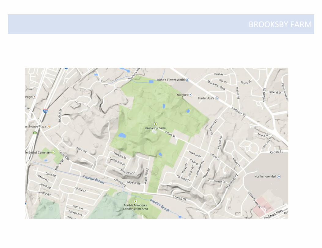
The site for this field trip was Brooksby Farm in Peabody, MA, this land is owned by the town of Peabody and is in the North River
watershed. Later students will visit the North River and then they will go to Salem Sound – the end point of the watershed. When
choosing your location be sure to find one that models the watershed as a system – with high points and low points
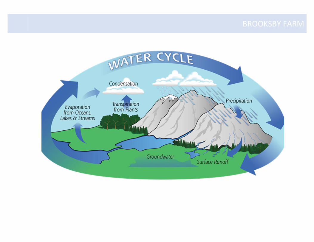
Station 1: Water Cycle Game – Water effects Earth’s surface processes.
Station 2: What is a Watershed - Water flows down-hill as run-off and ground water and pools up in low spots.
Station 3: Pond Water Quality - What abiotic factors keep the ecosystem in balance and functioning properly.
Station 4: Life in the Pond – Explore the diversity of life in a pond ecosystem.
Next Generation Science Standards Science & Technology Earth Systems ESS2.C: The Roles of Water in Earth’s Surface Processes – Water continually cycles among land, ocean and atmosphere via transpiration, evaporation, condensation and crystallization, and precipitation as well as downhill flows on land. Life Sciences LS2.A: Interdependent Relationships in Ecosystems – Organisms, and populations of organisms, are dependent on their environmental interactions both with other living things and with non-living factors. LS2.C: Ecosystem Dynamics, Functioning, and Resilience – Biodiversity describes the variety of species found in Earth’s terrestrial and oceanic
ecosystems. The completeness or integrity of an ecosystem’s biodiversity is often a measure of its health.
NOAA B-WET FUNDED
Developed in partnership with Peabody Parks and Rec and Higgins Middle School 6th grade teachers
BROOKSBY FARM
BROOKSBY FARM
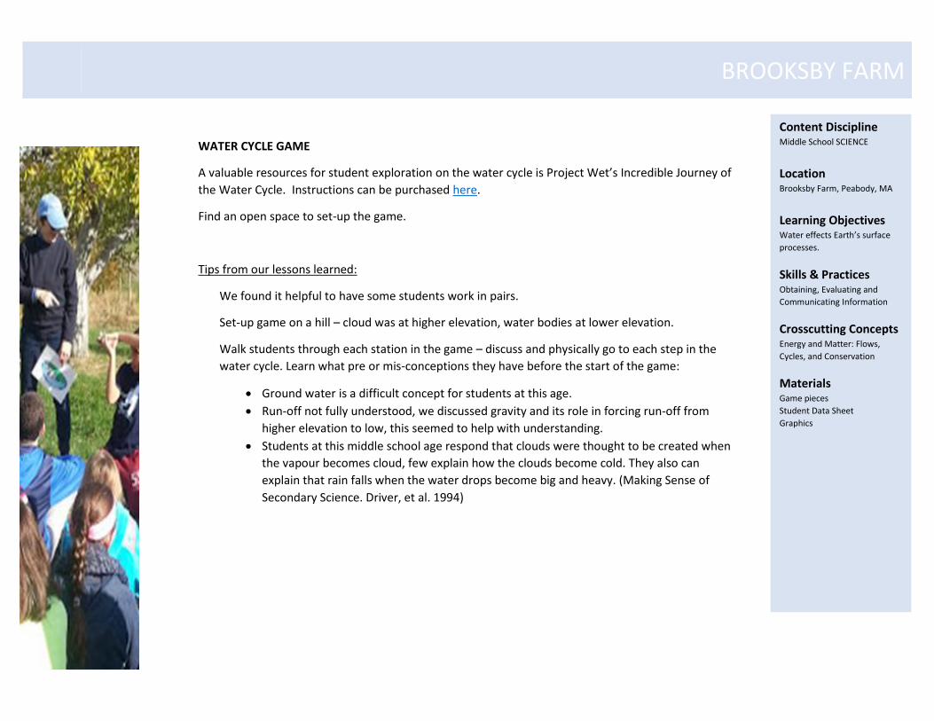
WATER CYCLE GAME
A valuable resources for student exploration on the water cycle is Project Wet’s Incredible Journey of
the Water Cycle. Instructions can be purchased here.
Find an open space to set-up the game.
Tips from our lessons learned:
We found it helpful to have some students work in pairs.
Set-up game on a hill – cloud was at higher elevation, water bodies at lower elevation.
Walk students through each station in the game – discuss and physically go to each step in the
water cycle. Learn what pre or mis-conceptions they have before the start of the game:
Ground water is a difficult concept for students at this age.
Run-off not fully understood, we discussed gravity and its role in forcing run-off from
higher elevation to low, this seemed to help with understanding.
Students at this middle school age respond that clouds were thought to be created when
the vapour becomes cloud, few explain how the clouds become cold. They also can
explain that rain falls when the water drops become big and heavy. (Making Sense of
Secondary Science. Driver, et al. 1994)
Content Discipline Middle School SCIENCE
Location Brooksby Farm, Peabody, MA
Learning Objectives Water effects Earth’s surface
processes.
Skills & Practices Obtaining, Evaluating and
Communicating Information
Crosscutting Concepts Energy and Matter: Flows,
Cycles, and Conservation
Materials Game pieces
Student Data Sheet
Graphics
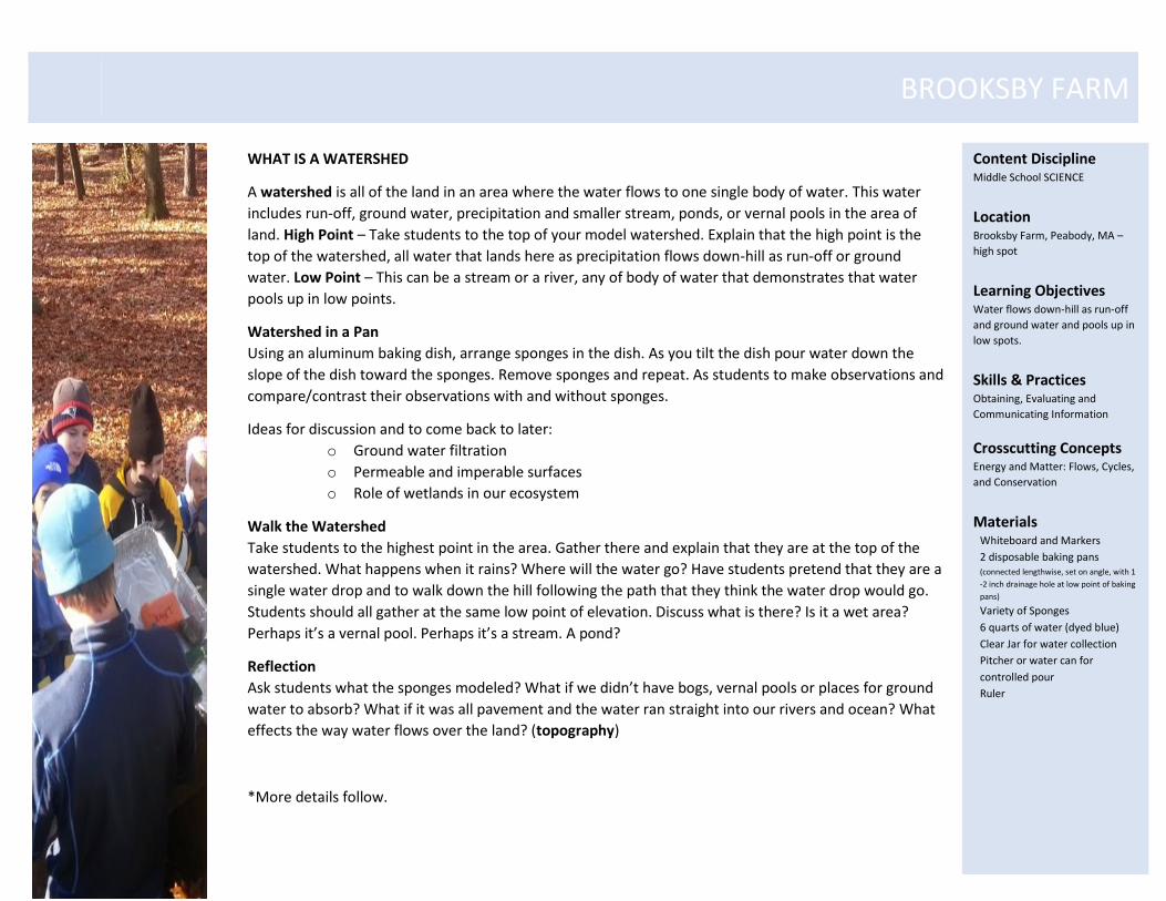
BROOKSBY FARM WHAT IS A WATERSHED
A watershed is all of the land in an area where the water flows to one single body of water. This water
includes run-off, ground water, precipitation and smaller stream, ponds, or vernal pools in the area of
land. High Point – Take students to the top of your model watershed. Explain that the high point is the
top of the watershed, all water that lands here as precipitation flows down-hill as run-off or ground
water. Low Point – This can be a stream or a river, any of body of water that demonstrates that water
pools up in low points.
Watershed in a Pan
Using an aluminum baking dish, arrange sponges in the dish. As you tilt the dish pour water down the
slope of the dish toward the sponges. Remove sponges and repeat. As students to make observations and
compare/contrast their observations with and without sponges.
Ideas for discussion and to come back to later:
o Ground water filtration
o Permeable and imperable surfaces
o Role of wetlands in our ecosystem
Walk the Watershed
Take students to the highest point in the area. Gather there and explain that they are at the top of the
watershed. What happens when it rains? Where will the water go? Have students pretend that they are a
single water drop and to walk down the hill following the path that they think the water drop would go.
Students should all gather at the same low point of elevation. Discuss what is there? Is it a wet area?
Perhaps it’s a vernal pool. Perhaps it’s a stream. A pond?
Reflection
Ask students what the sponges modeled? What if we didn’t have bogs, vernal pools or places for ground
water to absorb? What if it was all pavement and the water ran straight into our rivers and ocean? What
effects the way water flows over the land? (topography)
*More details follow.
Content Discipline Middle School SCIENCE
Location Brooksby Farm, Peabody, MA –
high spot
Learning Objectives Water flows down-hill as run-off
and ground water and pools up in
low spots.
Skills & Practices Obtaining, Evaluating and
Communicating Information
Crosscutting Concepts Energy and Matter: Flows, Cycles,
and Conservation
Materials Whiteboard and Markers
2 disposable baking pans (connected lengthwise, set on angle, with 1
-2 inch drainage hole at low point of baking
pans)
Variety of Sponges
6 quarts of water (dyed blue)
Clear Jar for water collection
Pitcher or water can for
controlled pour
Ruler
BROOKSBY FARM
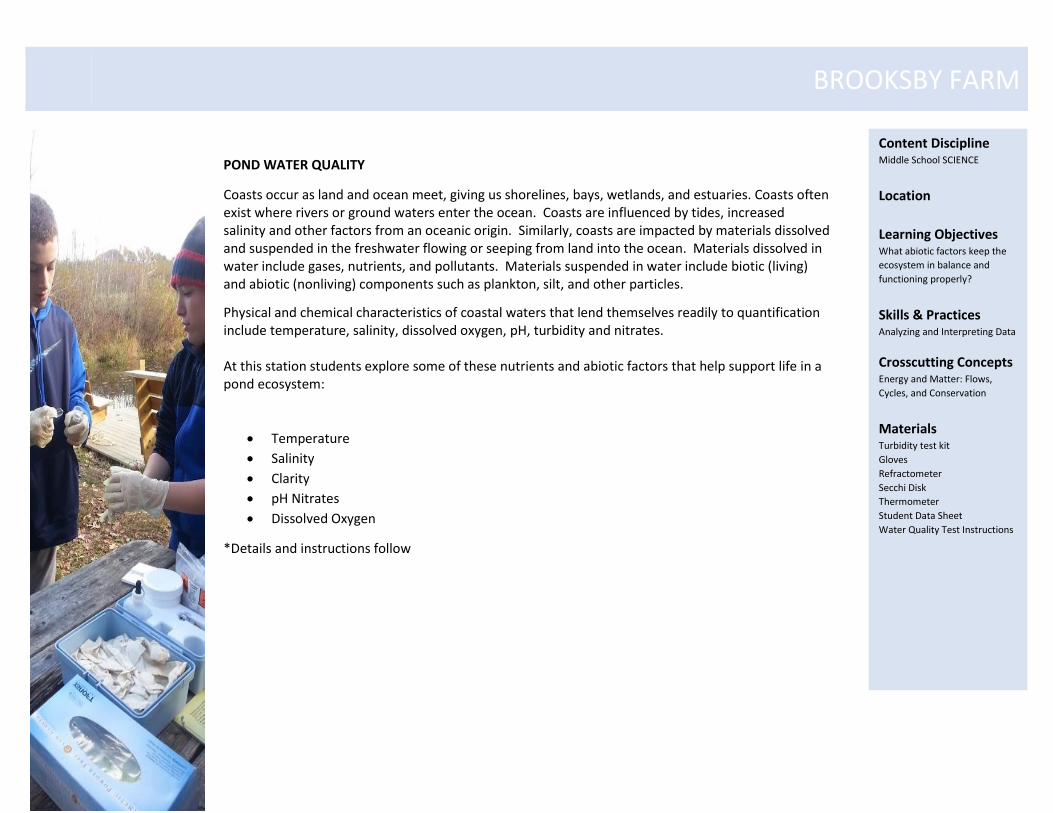
POND WATER QUALITY
Coasts occur as land and ocean meet, giving us shorelines, bays, wetlands, and estuaries. Coasts often exist where rivers or ground waters enter the ocean. Coasts are influenced by tides, increased salinity and other factors from an oceanic origin. Similarly, coasts are impacted by materials dissolved and suspended in the freshwater flowing or seeping from land into the ocean. Materials dissolved in water include gases, nutrients, and pollutants. Materials suspended in water include biotic (living) and abiotic (nonliving) components such as plankton, silt, and other particles.
Physical and chemical characteristics of coastal waters that lend themselves readily to quantification include temperature, salinity, dissolved oxygen, pH, turbidity and nitrates. At this station students explore some of these nutrients and abiotic factors that help support life in a pond ecosystem:
Temperature
Salinity
Clarity
pH Nitrates
Dissolved Oxygen
*Details and instructions follow
Content Discipline Middle School SCIENCE
Location
Learning Objectives What abiotic factors keep the
ecosystem in balance and
functioning properly?
Skills & Practices Analyzing and Interpreting Data
Crosscutting Concepts Energy and Matter: Flows,
Cycles, and Conservation
Materials Turbidity test kit
Gloves
Refractometer
Secchi Disk
Thermometer
Student Data Sheet
Water Quality Test Instructions
BROOKSBY FARM
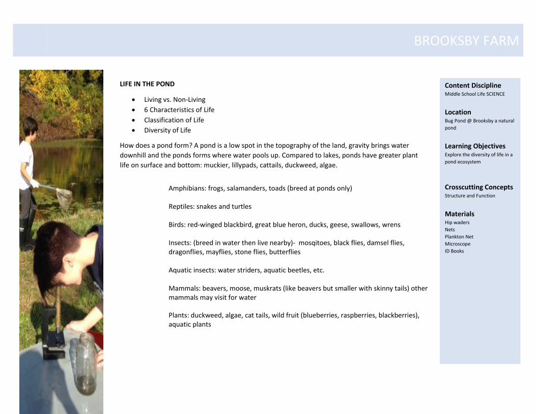
LIFE IN THE POND
Living vs. Non-Living
6 Characteristics of Life
Classification of Life
Diversity of Life
How does a pond form? A pond is a low spot in the topography of the land, gravity brings water
downhill and the ponds forms where water pools up. Compared to lakes, ponds have greater plant
life on surface and bottom: muckier, lillypads, cattails, duckweed, algae.
Amphibians: frogs, salamanders, toads (breed at ponds only) Reptiles: snakes and turtles Birds: red-winged blackbird, great blue heron, ducks, geese, swallows, wrens Insects: (breed in water then live nearby)- mosqitoes, black flies, damsel flies, dragonflies, mayflies, stone flies, butterflies Aquatic insects: water striders, aquatic beetles, etc.
Mammals: beavers, moose, muskrats (like beavers but smaller with skinny tails) other mammals may visit for water
Plants: duckweed, algae, cat tails, wild fruit (blueberries, raspberries, blackberries), aquatic plants
Content Discipline Middle School Life SCIENCE
Location Bug Pond @ Brooksby a natural
pond
Learning Objectives Explore the diversity of life in a
pond ecosystem
Crosscutting Concepts Structure and Function
Materials Hip waders
Nets
Plankton Net
Microscope
ID Books
BROOKSBY FARM
BROOKSBY FARM
BROOKSBY FARM
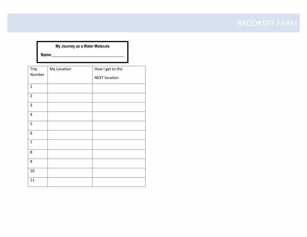
Trip
Number
My Location How I get to the
NEXT location
1
2
3
4
5
6
7
8
9
10
11
My Journey as a Water Molecule
Name __________________________________
BROOKSBY FARM
Watershed Overview
1. Instruct group to sit on stone benches (except for high bench). Set up Whiteboard in front of stage area so that is visible by
all. Announce that you are going to play “Pictionary.” Quickly explain rules. Using a blue marker, begin to draw a bird’s eye
view sketch of a watershed (brooks, streams, river, ocean). Stop when finished or when the answer, “Watershed” is called out.
Explain what a watershed is, highlight the fact that is pertains to all the bodies of the water and the land than channels the
drainage into the bodies of water.
2. Examples of watersheds. Ask students if they know what river drains the watershed of most of Boston (Charles River).
Explain that when it rains at some familiar places (Faneuil Hall, Science Museum, Fenway Park), the water is carried into the
Charles River and then out to Boston Harbor and the Atlantic Ocean. Ask students if they know where the water drains from the
Higgins Middle School (North River).
Watershed and Wetlands Demo
Trial 1: Move over to the large stone bench where you have stored the rest of your materials. Explain how the baking pan is
going to serve as a model watershed. Explain the vocabulary word “impervious” and ask students if they can think of a real-life
example of a watershed that is full of impervious surfaces. (You may need to give examples: parking lots, buildings, streets,
sidewalks, etc.) in order to get them to realize you are talking about a city scape. Explain that you are going to run an
experiment. It’s going to “rain” into the city watershed. Control variables will include area of the watershed, how much rain
falls, the rate it falls and where. Dependent variables will be rate of drainage and percentage of water that flows out into the
ocean (clear jar under drainage, held by student). Ask for predictions (hypotheses) for percentage flowing through watershed
and flow rate (fast, slow or in the middle). Have a volunteer hold clear jar “ocean” under drainage. Pour the “rainstorm”
steadily near the top of the watershed. As water pools up at drainage, point this out to students. Ask them why it’s happening
and what we would call that phenomenon if occurred in a real city (flood). Ask them if they know of any examples where this
occurs (Peabody). Ask for observations and measure height of water in “ocean” (clear jar).
BROOKSBY FARM
Trial 2: In between trials, tell students the story about how the flooding issue in Peabody has gotten worse over the years. Ask if
they know why (increased development, greater number of impervious surfaces). Explain how the construction of the North
Shore Mall really tipped the balance to make flooding a regular occurrence. Now run trial 2. Define the term “Wetland” and ask
students to provide examples. Have students place various “wetlands” (sponges) in your watershed. Explain that you are
changing the independent variable but that everything else about the experiment will remain the same. Ask for predictions in
flow rate (faster, slower, or the same as trial 1) and percentage flowing to ocean (more, less or the same as trial one). Conduct
rainstorm. Highlight how flow rate has decreased, flooding mitigated and how less water has made it through watershed (using
ruler to measure water height in “ocean” (clear jar). At this point, it is a good idea to point out the wetlands not only help
control the flow of water to protect against flooding and erosion but that they also help to filter out pollutants that enter
watershed from runoff.
The Rainstorm
Move to high point of land on the path towards climbing tower. Assemble students in a circle. Ask them to close their eyes and
imagine they are moving through the water cycle (reinforce evaporation, condensation and precipitation). Once they have
imagined falling as precipitation, instruct student to turn around and imagine where they would “flow” if they were a water
droplet. Point out that they are about to travel in the most downhill course until they are no long able to move downhill, at
which point they should stay put. Have them move in increments: “Flow 3 steps downhill, 3 more steps, 5 steps, etc.” After
students have flowed approximately 100 feet, instruct them to look around and the return to the hilltop. Make connections
about how certain water droplets flowed in the same direction over the same path (like a stream or a river) and that some
streams or rivers got to a flat location and all ended up in same spot (like a pond or a lake).
Walk the Watershed
Moving over by the Climbing Tower, to the right-hand downhill side, now instruct the full group to flow as water over the
landscape until they can no longer move downhill anymore. Remind them that they can never “flow” uphill. Remind the group
that if they come into an obstruction (such as a tree), they would likely flow around that object. Ask the group to refrain from
BROOKSBY FARM
running for safety reasons (no rapids on this river!). If they follow directions, the group should convene a small depression next
to the clear path (Tower Ave.). Ask the group if in reality, all the water that fill on that hillside would have made it to that spot.
What else might have happened (absorbed into ground, sucked up by vegetation, evaporated)? Even though no water is in the
depression, if the group jumps up and down, they should experience the soggy sponginess of that spot. Ask the group if water
only flows above ground (no). What do we call water that flows underground (groundwater?) Instruct the group to imagine
they are groundwater and to move down the path in the direction groundwater would flow. Remind them that even
groundwater does not flow uphill.
At the low point of land, there is a visible vernal pool (may or may not have water). Define vernal pool for the group. Ask the
group where any water that falls on the land visible from that spot would flow (how about water that falls over there? Over
there? Over there?) “So this means all of this land is in the same ______________(WATERSHED!). If time, follow the path
uphill, take a right onto Blazewhip Trail and connect to the far side of the vernal pool. Find location where water flows away
from Brooksby Farm. Discuss where is goes from there (down towards 114 through Brooksby Village, perhaps into a storm drain
and eventually out to Salem Sound and the Atlantic Ocean).
Conclusion stop. On the way back to Farm Store, stop one last time by the maple tree and tell the story about how, in 1974,
Brooksby Farm was up for sale and that developers made a plan to build some very nice neighborhoods on the property. A
group of Peabody residents petitioned the idea and pleaded for the City to buy the land and keep it as farm and woods for the
recreational enjoyment of all. Ask students to think about how the watershed may have been impacted if much of Brooksby
Farm had been converted to roads, houses and driveways (increased flooding and runoff). Could this have impacted the health
of Salem Sound (Yes, more pollutants running into watershed and out to sea.)