Embed Size (px)
Citation preview
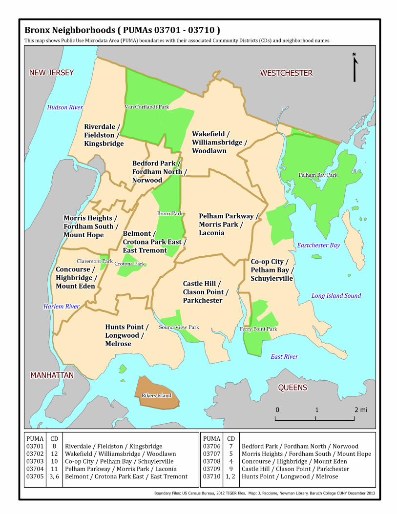
BronxNeighborhoods(PUMAs03701-03710)ThismapshowsPublicUseMicrodataArea(PUMA)boundarieswiththeirassociatedCommunityDistricts(CDs)andneighborhoodnames.
0 1 2 mi
BedfordPark/FordhamNorth/NorwoodMorrisHeights/FordhamSouth/MountHopeConcourse/Highbridge/MountEdenCastleHill/ClasonPoint/ParkchesterHuntsPoint/Longwood/MelroseBoundary Files: US Census Bureau, 2012 TIGER files. Map: J. Paccione, Newman Library, Baruch College CUNY December 2013
CD75491,2PUMA0370603707037080370903710
PUMA0370103702037030370403705CD81210113,6
Riverdale/Fieldston/KingsbridgeWake ield/Williamsbridge/WoodlawnCo-opCity/PelhamBay/SchuylervillePelhamParkway/MorrisPark/LaconiaBelmont/CrotonaParkEast/EastTremont
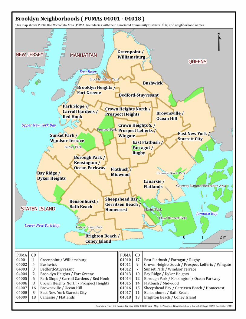
BrooklynNeighborhoods(PUMAs04001-04018)ThismapshowsPublicUseMicrodataArea(PUMA)boundarieswiththeirassociatedCommunityDistricts(CDs)andneighborhoodnames.
EastFlatbush/Farragut/RugbyCrownHeightsSouth/ProspectLefferts/WingateSunsetPark/WindsorTerraceBayRidge/DykerHeightsBoroughPark/Kensington/OceanParkwayFlatbush/MidwoodSheepsheadBay/GerritsenBeach/HomecrestBensonhurst/BathBeachBrightonBeach/ConeyIslandBoundary Files: US Census Bureau, 2012 TIGER files. Map: J. Paccione, Newman Library, Baruch College CUNY December 2013
CD1797101214151113
PUMA040100401104012040130401404015040160401704018
PUMA040010400204003040040400504006040070400804009
CD14326816518
Greenpoint/WilliamsburgBushwickBedford-StuyvesantBrooklynHeights/FortGreeneParkSlope/CarrollGardens/RedHookCrownHeightsNorth/ProspectHeightsBrownsville/OceanHillEastNewYorkStarrettCityCanarsie/Flatlands
0 1 2 mi
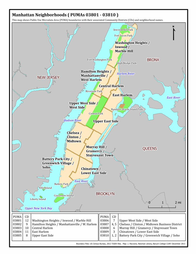
ManhattanNeighborhoods(PUMAs03801-03810)ThismapshowsPublicUseMicrodataArea(PUMA)boundarieswiththeirassociatedCommunityDistricts(CDs)andneighborhoodnames.
0 1 2 mi
UpperWestSide/WestSideChelsea/Clinton/MidtownBusinessDistrictMurrayHill/Gramercy/StuyvesantTownChinatown/LowerEastSideBatteryParkCity/GreenwichVillage/SohoBoundary Files: US Census Bureau, 2012 TIGER files. Map: J. Paccione, Newman Library, Baruch College CUNY December 2013
CD74,5631,2PUMA0380603807038080380903810
PUMA0380103802038030380403805CD12910118
WashingtonHeights/Inwood/MarbleHillHamiltonHeights/Manhattanville/W.HarlemCentralHarlemEastHarlemUpperEastSide
0 1 mi
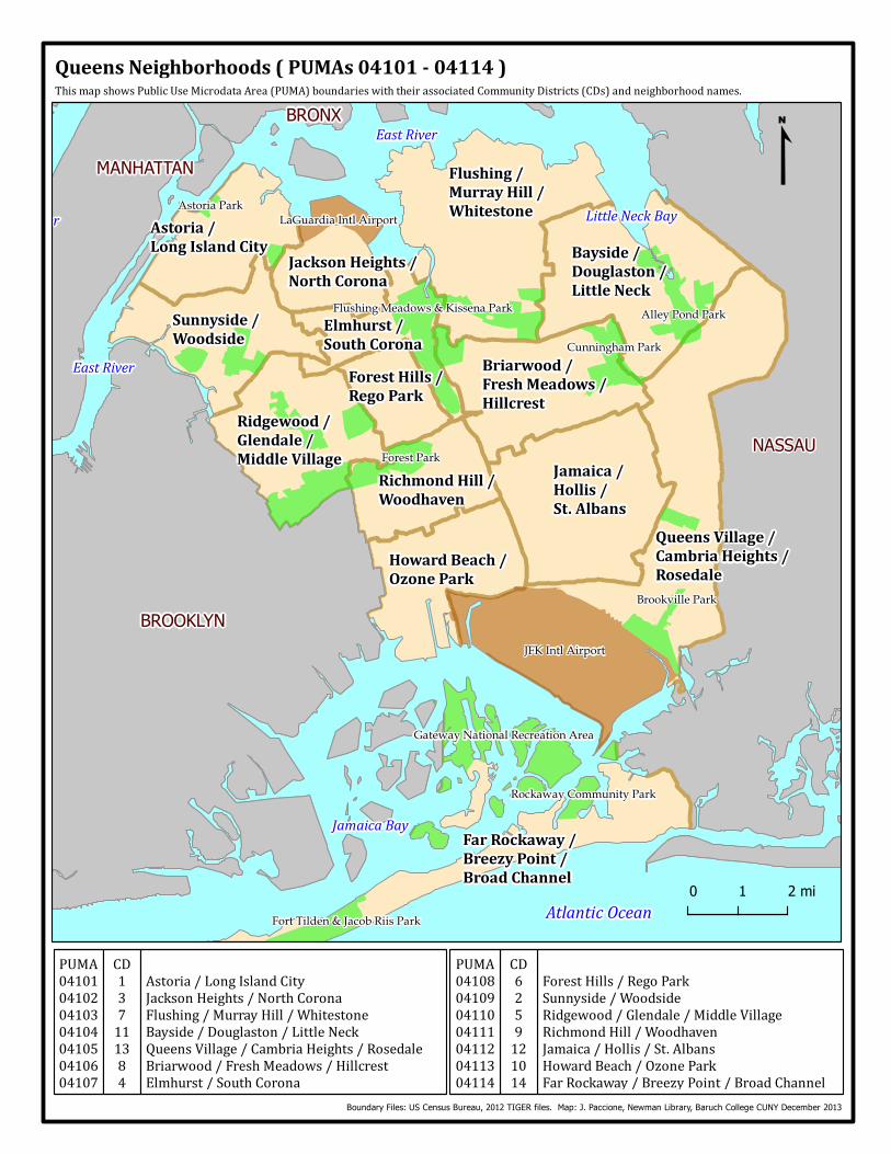
ForestHills/RegoParkSunnyside/WoodsideRidgewood/Glendale/MiddleVillageRichmondHill/WoodhavenJamaica/Hollis/St.AlbansHowardBeach/OzoneParkFarRockaway/BreezyPoint/BroadChannel
QueensNeighborhoods(PUMAs04101-04114)ThismapshowsPublicUseMicrodataArea(PUMA)boundarieswiththeirassociatedCommunityDistricts(CDs)andneighborhoodnames.
Boundary Files: US Census Bureau, 2012 TIGER files. Map: J. Paccione, Newman Library, Baruch College CUNY December 2013
CD6259121014
PUMA04108041090411004111041120411304114
PUMA04101041020410304104041050410604107
CD137111384
Astoria/LongIslandCityJacksonHeights/NorthCoronaFlushing/MurrayHill/WhitestoneBayside/Douglaston/LittleNeckQueensVillage/CambriaHeights/RosedaleBriarwood/FreshMeadows/HillcrestElmhurst/SouthCorona
0 1 2 mi
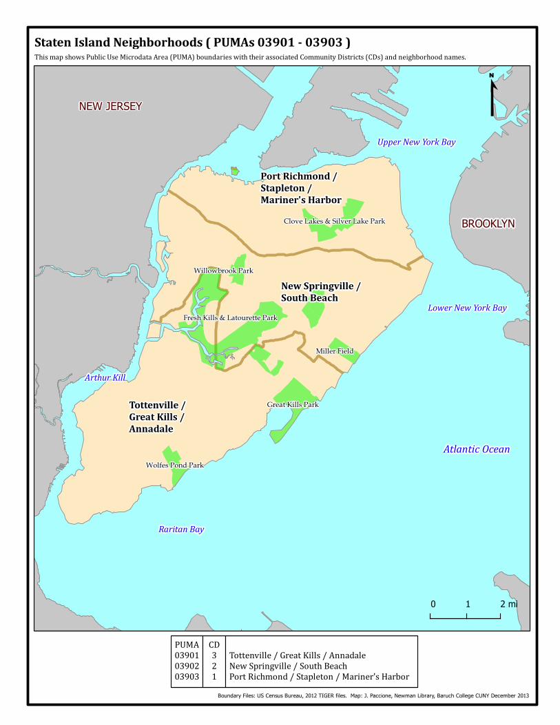
StatenIslandNeighborhoods(PUMAs03901-03903)ThismapshowsPublicUseMicrodataArea(PUMA)boundarieswiththeirassociatedCommunityDistricts(CDs)andneighborhoodnames.
0 1 2 mi
Boundary Files: US Census Bureau, 2012 TIGER files. Map: J. Paccione, Newman Library, Baruch College CUNY December 2013
PUMA039010390203903CD321 Tottenville/GreatKills/AnnadaleNewSpringville/SouthBeachPortRichmond/Stapleton/Mariner'sHarbor