Embed Size (px)
Citation preview
BRITISH LOGBOOKS IN UK ARCHIVES
17th
–19th
CENTURIES
A survey of the range, selection and suitability of British logbooks
and related documents for climatic research
Clive Wilkinson
Climatic Research Unit, University of East Anglia
Norwich, NR4 7TJ United Kingdom
E-mail [email protected]
(April 2006, revised October 2006, August 2007 and February 2009)
National Oceanic and Atmospheric Administration (NOAA)
Climate Database Modernization Program (CDMP)
All logbook and other images in this report are Crown Copyright and are
reproduced here with permission of the UK National Archives, Kew
2
Contents
Introduction..................................................................................................page 4
1. Scope, range and organization of the collections...................... page 4
1.1 The National Archive
1.2 British Library
1.3 National Maritime Museum
1.4 Hydrographic Office
2. Early Types of Logbook and their Notation – Pre 1850........... page 17
Early Royal Navy logbooks
East India Company Logbooks
3. Instrumental Data in Early Logbooks and Other Related Marine Sources
Pre-1850............................................................................................ page 32
3.1 Royal Navy
3.2 East India Company
3.3 Instrumental data from merchant shipping
3.4 Instrumental data in printed sources
3.5 Chronometer Rating Books
4. Related Research Aids.................................................................... page 38
4.1 Ship Lists
4.2 Sailing Instructions, charts, atlases
4.3 Operational histories
5. Priority Collections.......................................................................... page 44
British Library
National Archives
National Maritime Museum
6. Initial Selection and Acquisition of Logbooks for Imaging............page 46
6.1 British Library
6.2 National Archive
6.3 National Maritime Museum
7. Further Selection Criteria..................................................................page 49
7.1 Suitability for imaging
7.2 Duplication
7.3 Data quality
8. Integration of CLIWOC Data –Duplication....................................page 52
9. Royal Navy Logbooks and Marine Data 1850-1899........................page 52
9.1 Royal Navy logbooks – National Archives (ADM 53)
9.2 Additional logbooks – National Maritime Museum
9.3 Royal Navy Meteorological Registers – UK Met Office
9.4 Royal Navy Remarks Books – UK Hydrographic Office
9.5 Locating vessels and logbooks 1850-1899
9.6 Operational Areas
9.7 Summary of data in Royal Navy logbooks 1850-99
10. Whaling Logbooks.............................................................................page 61
11. Merchant Shipping Logbooks..........................................................page 61
11.1 Falmouth Packets
11.2 Merchant Shipping Meteorological Registers
12. Metadata.............................................................................................page 63
12.1 Sources for Metadata
12.2 Types of Metadata
3
13. Items of Unusual or Exceptional Interest....................................page 69
13.1 Pacific Ocean – 19th
Century
13.2 Stationary Ships
13.3 North American Lakes
13.4 Transports and Troopships
13.5 Indian Navy
Bibliography...................................................................................page 74
Appendix I Early Logbook Abbreviations and Notation...........page 76
Appendix II Regional Maps of Sailing Tracks............................page 78
Acknowledgements
The author wishes to acknowledge CDMP for providing funding for this
report. Further acknowledgments for assistance and support are also due to Scott
Woodruff, ESRL/NOAA, Dr. Dennis Wheeler, University of Sunderland, Frits Koek,
Royal Netherlands Meteorological Institute, Dr. Rob Allan and Catharine Ward,
Hadley Centre, Fiona Williamson, University of East Anglia, Dr. Andrew Cook, India
Office, British Library, and Rear-Admiral Roy Clare, Dr. Nigel Rigby, Daphne Knott
and Andrew Davis, National Maritime Museum, Greenwich.
4
Introduction
This report discusses the range, availability and suitability of ships‟ logbooks
in British archives to yield high resolution, instrumental and non-instrumental
climatic data. The temporal range of the report is the 17th
through 19th
centuries (a
separate report, Wilkinson 2009, discusses UK logbooks extending through the mid
20th
century). In part, this report builds on the experience and expertise developed
during the course of the CLIWOC Project, funded by the European Union from 2001
to 2003. CLIWOC (Climatological Database for the World‟s Oceans: 1750 to 1850 -
http://www.ucm.es/info/cliwoc; García-Herrera et al. 2005) drew on British, Spanish,
Dutch and French logbooks in the pre-instrumental period 1750-1850. As well as
being a separate climatological database, CLIWOC is also becoming part of ICOADS
(http://icoads.noaa.gov). During the course of the CLIWOC Project less than 5% of
British logbooks were exploited and none after 1830. This report leverages on the
experience of the UK CLIWOC team to enable ongoing exploitation and processing
of climatic data from British logbooks to be handled effectively and efficiently. The
other purpose of this report is to explore the potential of the British archives to yield
additional data for the post-1850 instrumental period. In addition to the CLIWOC
data, selected UK data from this period (probably exclusively based on holdings of
the Met Office) were digitized into the UK Marine Data Bank (MDB) decades ago
and have been blended into ICOADS (Woodruff et al. 2005). The first part of the
report will discuss the range of logbooks available within each archive. Early
logbooks will then be discussed in detail, including the general availability of early
instrumental data. The selection criteria for early logbooks will then be recommended
as well as integration with the existing CLIWOC data, avoiding unnecessary
duplication of material. The latter part of the report will concentrate on the
availability and nature of Royal Navy logbooks from 1850 to 1899, a discussion of
merchant shipping and whaling logbooks and sources of metadata on 18th
and 19th
century vessels.
1. Scope, Range and Organization of the Collections
In the United Kingdom, ships‟ logbooks can be found in three main repositories.
These are the British Library (BL), the National Archives (TNA), formerly known as
the Public Record Office (PRO) and the National Maritime Museum (NMM). Each of
these holds a distinct group of logbooks. The National Archives hold Royal Navy
5
logbooks compiled by individual officers, and general ships‟ logbooks recorded by
the officer of the watch. The officers‟ logbooks consist of captains‟ logs and the
logbooks of the master or navigating officer. The British Library collection is
primarily made up of logbooks produced by officers of the East India Company. The
National Maritime Museum holds the collection of Royal Navy logbooks written by
lieutenants. Much smaller collections can be found in museums, county record
offices and institutions such as the Scott Polar Research Institute, Cambridge, the
Royal Geographical Society, the UK Hydrographic Office, Taunton and the National
Meteorological Archive, Devon Record Office, near Exeter. It is the collections in the
three main repositories that form the primary focus of this report.
1.1 The National Archive (http://www.nationalarchives.gov.uk)
The National Archive is located at Kew in southwest London. Best access is by tube
from central London via the District Line. The National Archives are the chief
repository of papers and documents generated by the activities of the British state
from medieval times to the present. The major part of the collection of ships‟
logbooks was generated by the activities of the Royal Navy and is in original
manuscript form. The remaining part of the collection is made up of microfilm copies
of the logbooks of the Hudson‟s Bay Company. The original manuscripts of these
reside in Canada.
Temporal and Geographic range
The Royal Navy (RN) logbooks held in the National Archive begin in 1669 and run
through to 1976. Logbooks prepared since 1976 are subject to the thirty-year
exclusion rule, as these remain confidential. There are an estimated 220,000
individual logbooks. The geographic range of the logbooks is global. The North
Atlantic, West Indies and Mediterranean are particularly well represented. The RN
was also active in the South Atlantic and Indian Oceans, including the Bay of Bengal
and Arabian Gulf. Coverage of these areas is good though less dense than the North
Atlantic before the 19th
century particularly in times of peace. The Pacific Ocean is
the least well represented. The vessels of the Hudson‟s Bay Company, sailing from
England to the Company‟s factories in Canada, cover the higher northern latitudes of
the Atlantic from 1751 to 1870. Many of these also traded in the Pacific. The
northernmost regions are represented in the 19th
century by a large number of vessels
engaged in Arctic exploration.
6
Organization, binding and condition
The RN logbooks form a subdivision of the Admiralty records (ADM). These
Admiralty documents consist of the administrative and operational records of the RN
from the 17th
century to the recent past. The logbooks are organized into the groups
ADM 50 to ADM 55 inclusive. Hudson‟s Bay Company logbooks are in BH 1.
There are a small number of additional logbooks to be found in ADM 7/777 to ADM
7/780. The organization and cataloguing of groups ADM 50 to ADM 52 makes it
difficult to determine the exact number of individual logbooks available or to give an
exact number on a decadal basis. This is because some logbooks overlap between
decades and some volumes contain a very wide range of dates. The cataloguing
convention of grouping logbooks under the name of the ship brings together the
logbooks of different ships in different periods. Any figures given below are however
a very close approximation and sufficiently accurate to give a reliable guide.
ADM 50 (Admirals’ Journals)
There are 413 volumes of Admirals‟ journals covering the period 1702-1916
providing approximately 1,000 logbooks. Some are purely narrative as flag officers
were not required to record the general navigation and management of the ship. The
admiral did not command a vessel and the captain‟s or master‟s logbook should be
preferred to an admiral‟s journal in all cases.
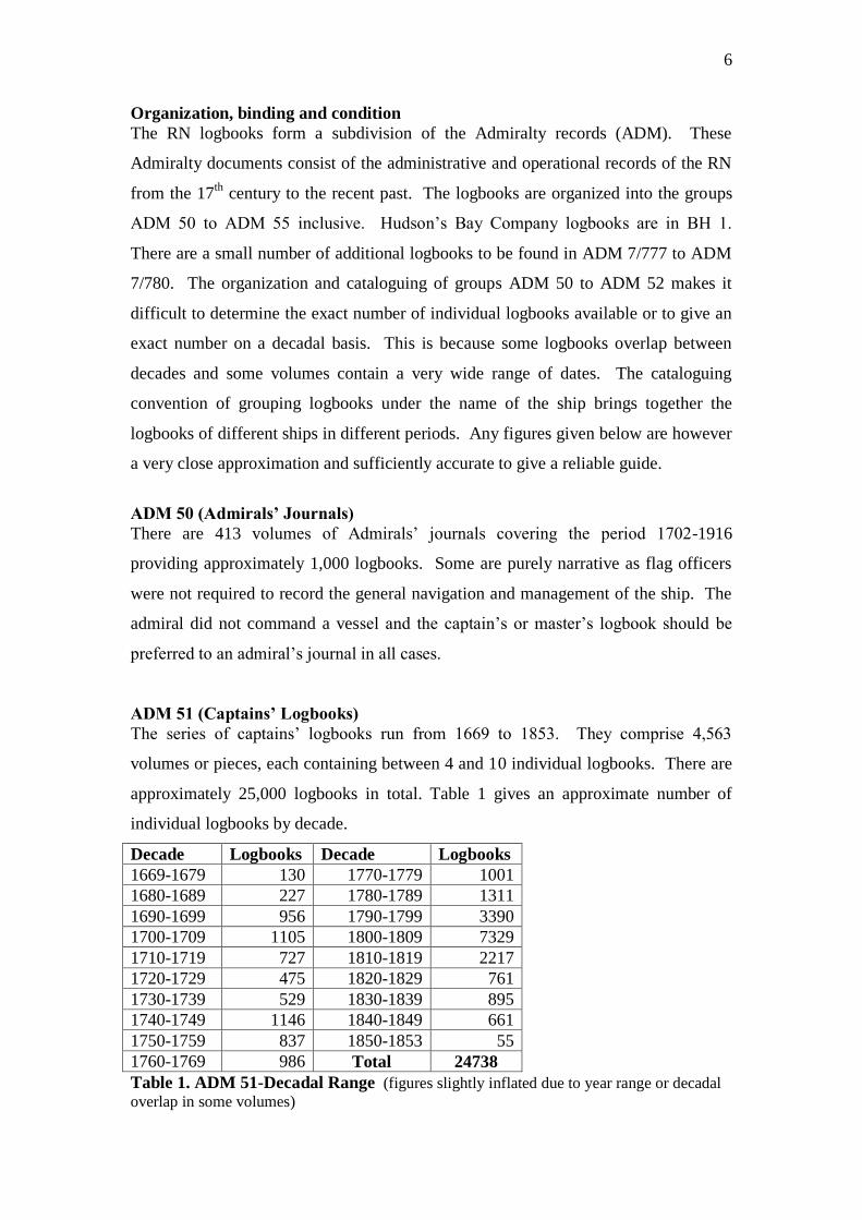
ADM 51 (Captains’ Logbooks)
The series of captains‟ logbooks run from 1669 to 1853. They comprise 4,563
volumes or pieces, each containing between 4 and 10 individual logbooks. There are
approximately 25,000 logbooks in total. Table 1 gives an approximate number of
individual logbooks by decade.
Decade Logbooks Decade Logbooks
1669-1679 130 1770-1779 1001
1680-1689 227 1780-1789 1311
1690-1699 956 1790-1799 3390
1700-1709 1105 1800-1809 7329
1710-1719 727 1810-1819 2217
1720-1729 475 1820-1829 761
1730-1739 529 1830-1839 895
1740-1749 1146 1840-1849 661
1750-1759 837 1850-1853 55
1760-1769 986 Total 24738
Table 1. ADM 51-Decadal Range (figures slightly inflated due to year range or decadal
overlap in some volumes)
7
Each individual logbook had a standard original, marble effect paper cover enclosing
the contents, which are bound into this cover. For storage each logbook has been
individually enclosed in an additional canvas cover with a part number written on the
outside. (These „part numbers‟ are not registered on the National Archive on-line
catalogue system but can be identified by calling up the volume number and counting
the number of individual logbooks listed). Several parts are gathered together and
placed in chronological order in a box designated with a volume or piece number.
Each volume usually contains the logs of one named vessel (not necessarily the same
vessel) over a period of years. However it is not unusual for volumes to contain the
logs of more than one named vessel. These other vessels have names beginning with
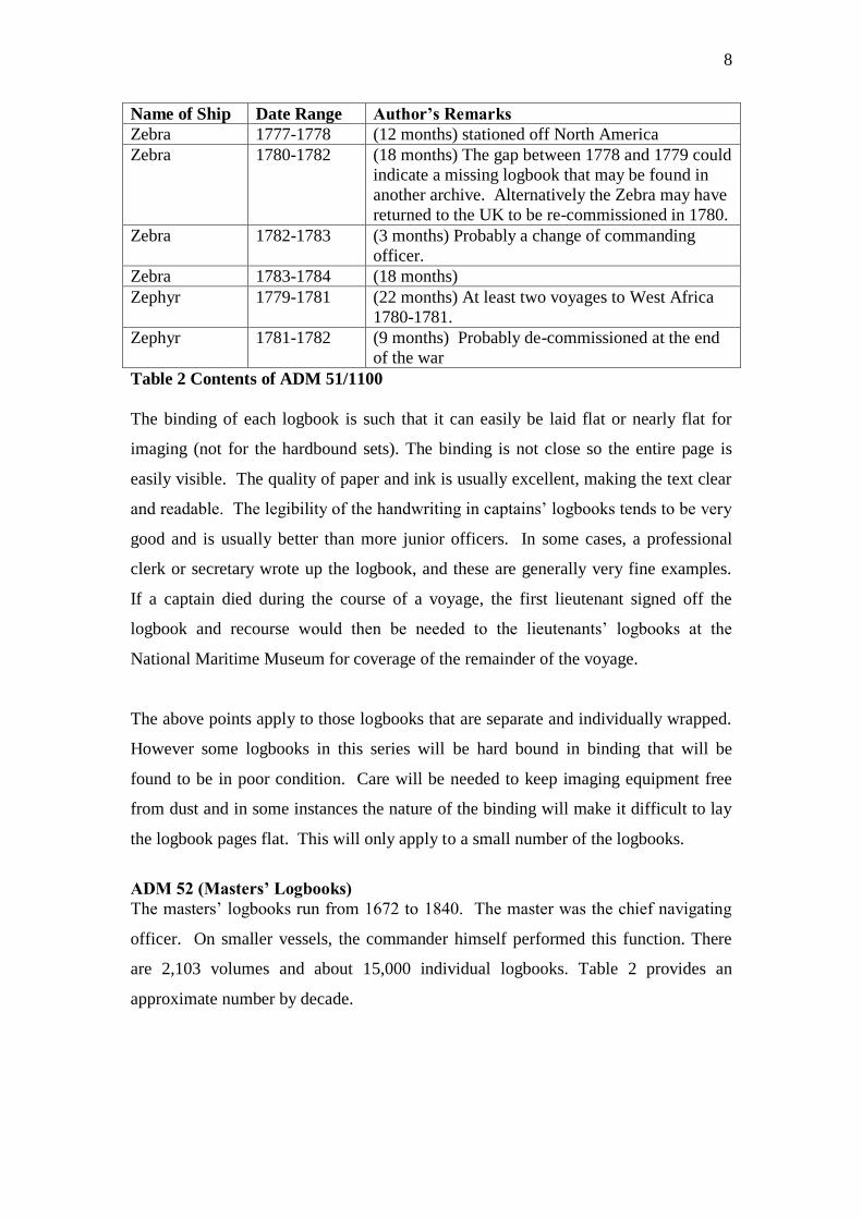
the same letter as the first. In the example to follow, volume ADM 51/1100 contains
logbooks for the vessels Zebra and Zephyr. Some of the logbooks in ADM 51 are in a
hardbound, book-style, rather than individually collected in a box.
Usually a logbook will contain entries for a twelve-month period but there is no
regulation concerning this. An officer began a logbook at the commencement of a
commission or appointment, and after twelve months often began a new document.
Sometimes the new logbook was bound together with the first giving longer coverage.
If an officer changed command, his current logbook ceased and another commenced
for his next command. The first page, inside the cover of each logbook, will state the
name of the vessel, the name of the captain, and the range of dates covered. If there is
no cover, it is either lost or more likely the logbook is a continuation of a previous
document. If in doubt, the logbook was always signed on the last written page and
this signature should match a logbook title page to be found somewhere else in the
set. The final date in the logbook can also be matched to a title page to be certain of
its place in the series.
The example following is typical of the contents of a volume. Remarks are the
author‟s and based on the information from the on-line catalogue and reference to
ADM 8, the station lists that provide the disposition of all vessels on a monthly basis.
8
Name of Ship Date Range Author’s Remarks
Zebra 1777-1778 (12 months) stationed off North America
Zebra 1780-1782 (18 months) The gap between 1778 and 1779 could
indicate a missing logbook that may be found in
another archive. Alternatively the Zebra may have
returned to the UK to be re-commissioned in 1780.
Zebra 1782-1783 (3 months) Probably a change of commanding
officer.
Zebra 1783-1784 (18 months)
Zephyr 1779-1781 (22 months) At least two voyages to West Africa
1780-1781.
Zephyr 1781-1782 (9 months) Probably de-commissioned at the end
of the war
Table 2 Contents of ADM 51/1100
The binding of each logbook is such that it can easily be laid flat or nearly flat for
imaging (not for the hardbound sets). The binding is not close so the entire page is
easily visible. The quality of paper and ink is usually excellent, making the text clear
and readable. The legibility of the handwriting in captains‟ logbooks tends to be very
good and is usually better than more junior officers. In some cases, a professional
clerk or secretary wrote up the logbook, and these are generally very fine examples.
If a captain died during the course of a voyage, the first lieutenant signed off the
logbook and recourse would then be needed to the lieutenants‟ logbooks at the
National Maritime Museum for coverage of the remainder of the voyage.
The above points apply to those logbooks that are separate and individually wrapped.
However some logbooks in this series will be hard bound in binding that will be
found to be in poor condition. Care will be needed to keep imaging equipment free
from dust and in some instances the nature of the binding will make it difficult to lay
the logbook pages flat. This will only apply to a small number of the logbooks.
ADM 52 (Masters’ Logbooks)
The masters‟ logbooks run from 1672 to 1840. The master was the chief navigating
officer. On smaller vessels, the commander himself performed this function. There
are 2,103 volumes and about 15,000 individual logbooks. Table 2 provides an
approximate number by decade.
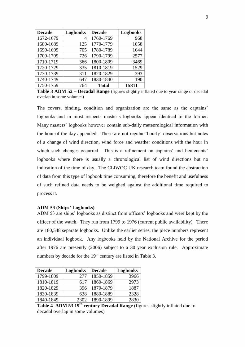
9
Decade Logbooks Decade Logbooks
1672-1679 4 1760-1769 968
1680-1689 125 1770-1779 1058
1690-1699 705 1780-1789 1644
1700-1709 726 1790-1799 2577
1710-1719 366 1800-1809 3469
1720-1729 335 1810-1819 1529
1730-1739 311 1820-1829 393
1740-1749 647 1830-1840 190
1750-1759 764 Total 15811
Table 3 ADM 52 – Decadal Range (figures slightly inflated due to year range or decadal
overlap in some volumes)
The covers, binding, condition and organization are the same as the captains‟
logbooks and in most respects master‟s logbooks appear identical to the former.
Many masters‟ logbooks however contain sub-daily meteorological information with
the hour of the day appended. These are not regular „hourly‟ observations but notes
of a change of wind direction, wind force and weather conditions with the hour in
which such changes occurred. This is a refinement on captains‟ and lieutenants‟
logbooks where there is usually a chronological list of wind directions but no
indication of the time of day. The CLIWOC UK research team found the abstraction
of data from this type of logbook time consuming, therefore the benefit and usefulness
of such refined data needs to be weighed against the additional time required to
process it.
ADM 53 (Ships’ Logbooks)
ADM 53 are ships‟ logbooks as distinct from officers‟ logbooks and were kept by the
officer of the watch. They run from 1799 to 1976 (current public availability). There
are 180,548 separate logbooks. Unlike the earlier series, the piece numbers represent
an individual logbook. Any logbooks held by the National Archive for the period
after 1976 are presently (2006) subject to a 30 year exclusion rule. Approximate
numbers by decade for the 19th
century are listed in Table 3.
Decade Logbooks Decade Logbooks
1799-1809 277 1850-1859 3966
1810-1819 617 1860-1869 2973
1820-1829 396 1870-1879 1887
1830-1839 638 1880-1889 2328
1840-1849 2302 1890-1899 2830
Table 4 ADM 53 19th
century Decadal Range (figures slightly inflated due to
decadal overlap in some volumes)

10
It should be noted that the large increase in the number of logbooks towards the end
of the 19th
century is a reflection of a change in logbook format. Some logbooks from
this period cover less than one year and sometimes less than six months causing
inflation of the figures represented.
ADM 54 (Supplementary logbooks)
This series is made up of 330 volumes and in all 383 individual logbooks. They run
from 1808 to 1871. They are mostly captains‟ logs though there are some written by
other officers.
ADM 55 (Ships on exploration) - Microfilm
This series, available only on microfilm, is made up of vessels on exploration or
undertaking hydrographic surveys. It does not contain all vessels on this type of
mission, as many more of these can be found in ADM 51 and ADM 53. The series
also contains several merchant ships, East India Company ships and at least one
whaler. The geographic range is extensive but weighed heavily towards the Arctic,
Antarctic, and then the Pacific, Australia and the west coast of North America. A
small number of logbooks are of vessels situated off west and southern Africa, the
Cape Verde Islands and one example off the Falkland Islands. There are 164 separate
volumes containing 194 individual logbooks. There is a large amount of duplication.
For instance the series contains the logbooks of James Cook and all of the officers of
the Resolution. There is similar duplication of logbooks for the Investigator
(Flinders) and Hecla (Parry). When the duplicates are discounted there are about 100
logbooks remaining. Six logbooks are specifically designated as meteorological
journals. Four of these have observations made in the Arctic, one the Antarctic and
one the Pacific (Resolution). Many of the logbooks in this series will contain
instrumental data. However, of those sampled many of the earliest did not have
instrumental data, the Cook and Flinders logbooks, excepted. Instrumental data is
here defined as temperature and barometric pressure, or at the very least, temperature
alone. In this series, logbooks written after 1820 are the most likely to consistently
record instrumental data. These logbooks should be considered a high priority for
processing, particularly as they are already available on microfilm. It will be possible
to supplement the instrumental data taken from this series by vessels on hydrographic
11
and exploratory missions in ADM 51 and ADM 53. A list of all such vessels is in
Tizard, (1900).
ADM 7 (Additional logbooks)
ADM 7 contains 36 logbooks including several unspecified Dutch vessels (ADM
7/844). Most of the logbooks are from the late 17th
century; another cluster exists for
the 1780s and many of these cover a period of only a few months. A notable
exception is the two logbooks of the Aurora (ADM 7/954-5) covering a return voyage
to the Far East 1899-1902, and the Algerine (ADM 7/50) in the eastern Pacific 1908-
10.
BH 1 (Hudson’s Bay Company)
BH 1 is a microfilm archive of the records of the Hudson‟s Bay Company. The
original logbooks, in manuscript form, have been archived in Canada.
(http://www.gov.mb.ca/chc/archives/hbca/) There are 130 volumes of logbooks held
on microfilm with references BH 1/1509 to BH 1/1639 inclusive. In total there are
437 logbooks, some of which contain multiple voyages. The logbooks were
originally microfilmed in alphabetical order but each microfilm set does not always
contain just one vessel or voyage. Some of the microfilms contain only part of a
voyage, the remainder of the voyage can then be found on the next microfilm in the
sequence. The earliest date is 1751 and the series runs through to 1870. The
microfilm images of the earlier logbooks (1750s) are of poor quality and difficult to
read. Many of the logbooks are for voyages from Gravesend in the Thames estuary,
northwards around Orkney then west to Hudson‟s Bay and the factories at Moose,
Churchill and York. Vessels departed in May to reach the Bay as the ice broke in
spring and returned during the months of August and September. The series also
contains logbooks for vessels voyaging to the Sandwich Islands (Hawaii) and the
Pacific coast of Canada.
Miscellaneous Logbooks
Small miscellaneous clusters of logbooks can be found in unexpected places at the
National Archive. The three items PRO 56-8 are unidentified logbooks. The
catalogue gives no indication of date or nationality. The section HCA (High Court of
Admiralty) has a few dozen logbooks, mostly 18th
century with a handful covering the
1820s to 1840s. Most of these are Portuguese merchant ships.
12
1.2 British Library (http://www.bl.uk)
At the British Library, located in central London, there are 50 miscellaneous logbooks
scattered among the Additional Manuscripts collection. The India Office Records
(http://www.bl.uk/collections/orientaloffice.html) keep the most significant collection.
These are the logbooks and journals kept by officers for the East India Company
(EIC). There are 3,822 journals; most of them catalogued under prefix L/MAR/B.
An essential guide to this collection is Farrington (1999). This catalogue lists each
vessel alphabetically with details of its voyage and the date of arrival at various
destinations. At the time of this report (2006) there is no on-line catalogue of EIC
logbooks. The EIC ceased as a trading organization after 1834, and this is reflected in
the Farrington catalogue. However there are additional logbooks of East India
merchant ships for the post 1834 period held in the India Office Record. These
additional logbooks are also catalogued under L/MAR/B.
Temporal and Geographic range
The collection of EIC logbooks starts in the early 17th
century, though there are less
than 200 covering the years before 1700. Most of the logbooks cover the 18th
and
early 19th
centuries up until 1834. Each logbook contains the outward and return leg
of a voyage, traversing the North and South Atlantic Oceans and the Indian Ocean.
Many cover the South China Sea and occasionally parts of the western Pacific. In
many respects they mirror the tracks of the Dutch East India ships whose logbooks are
held in The Netherlands but additionally include good coverage of the Bay of Bengal
and parts of the Arabian Gulf.
Organization, binding and condition
The EIC logbooks are bound chronologically under the name of the ship, each volume
containing three to four logs. Although in hard binding, each page is usually easy to
view. Due to the layout and format of these journals, no information is lost at the
binding margin. They will lie reasonably flat for imaging. The general condition of
the logbooks is excellent. A small number have runs of pages where the ink has faded
making it difficult and in some instances impossible to read. The number of these
logbooks is small and the problem is usually confined to a section of the logbook and
not to the entire volume. A very small number of these logbooks have latitude and
longitude recorded in a non-standard format that renders their usefulness problematic.
For instance, one logbook from the 1750s, probably as an experiment, recorded
13
longitude by magnetic declination only. It should be stated here that many of the later
EIC logbooks contained instrumental data. These data are usually for temperature
(common from the 1790s onwards), but barometric readings started to appear about
1800 and became more frequent as the 19th
century progressed. The availability of
instrumental data, the wide geographic coverage (at least three oceans per voyage)
and the consistency of the sailing routes used suggest that this series should be given
very high priority for imaging. The CLIWOC UK team found these logbooks to be
the most useful of the various types that they used.
1.3 National Maritime Museum (http://www.nmm.ac.uk)
The National Maritime Museum is located at Greenwich in southeast London. The
Museum‟s cataloguing system also contains a section ADM for Admiralty records,
and the lieutenants‟ logbooks are classified under this heading. The 5,205 volumes of
these documents were transferred to the Museum from the Admiralty in 1938. The
volumes are classified under ADM/L, and in common with the other two archives are
arranged according to the name of the ship. It is estimated that there are about 62,500
individual lieutenants‟ logbooks. The Museum also keeps over 100 journals written
by officers of the EIC. There are additional naval and merchant shipping logbooks in
both manuscript form and on microfilm, some whaling logs and a few logbooks of
French and Spanish warships. Most of these are in miscellaneous collections or part of
a distinct collection of family or company papers.
Temporal and Geographic range
The lieutenants‟ logbooks run from the 1680s to about 1807, with a handful extending
the range to 1809. It was about 1806 that lieutenants were no longer required to
submit logbooks to the Navy Board to receive their pay. It took some months and
even years for these instructions to circulate to those vessels on distant stations,
meaning that the number of logbooks begins to tail off after 1806. The geographic
coverage is identical to that of the RN captains‟ logbooks in the National Archives.
Lieutenants’ Logbooks - Organization, binding and condition
As many ships carried more than one lieutenant there is a frequent duplication of
logbooks in this series. This is advantageous in the sense that some officers kept
better journals than others or were more fulsome in their recording, making it possible
to select the best from a number of journals covering the same voyage; and also
possibly allowing cross-validation of the observations between duplicate journals.
14
There are several captains‟ logbooks bound up with this series. In some instances
these are duplicates of those found in the National Archives. However there are
instances where a captain‟s logbook has been bound with this series rather than with
its proper collection. More importantly, lieutenants could command naval vessels
such as small sloops, brigs, cutters and schooners. Therefore the logbook of the
commanding officer of a small ship might be found at Greenwich rather than in the
National Archives. There is no consistency in the way the Admiralty separated
captains‟ logbooks from those of lieutenants commanding as these lieutenants‟ logs
can be found in either archive. Furthermore, where a lieutenant had assumed
command of a vessel on the death of a captain, his log may also be found in
Greenwich though again there is no rule that determined in which archive it would be
held.
Where more than one ship is contained in a volume they are usually vessels whose
names begin with the same letter, although there are some exceptions. The individual
logbooks in each volume are for the most part, arranged chronologically though there
is sometimes a wide range of dates represented. Each volume contains anything from
six to twenty individual logbooks
The lieutenants‟ logbooks have been bound into large volumes. The majority of these
are in the original Admiralty leather binding, each volume being contained in an
additional canvas or paper wrapper. The volumes containing the ships whose names
begin with letters A to C have been rebound. These rebound volumes present a
number of difficulties for imaging. First where volumes have been rebound, the
binding is sometimes tight making it difficult in some instances to view the very edge
of the inside part of the page. In these circumstances it will be difficult to make the
page flat for imaging and there may be problems with depth of field over the entire
page. Secondly, those logbooks in their original binding present a different set of
considerations. The original binding in many cases is disintegrating causing much
dirt and dust when handled. Imaging equipment may need frequent cleaning to ensure
a sharp image. The back of the binding is frequently broken and often the individual
logbooks are loose. This does at least allow the pages to be laid flat for imaging.
15
A small number of logbooks are badly decayed and possibly beyond preservation.
There is no way of knowing the condition until the wrapper is opened. The majority,
despite the state of the binding, have pages in good condition. The ink is good and
they are perfectly readable.
Other Collections at the National Maritime Museum
Organization, binding and condition
The Museum has nearly 1,500 logbooks outside of the lieutenants‟ collection. There
is no catalogue convention that brings these together and they can appear anywhere
within the collections either as a distinct series within a „section‟ or as part of a group
of company or family papers. Of these, the LOG series (catalogued under section 6 in
the Museum) is particularly good and worthy of consideration as one of the priorities
for imaging. There are 496 individual logs. The binding and condition of these is
generally excellent. A description of the LOG series follows.
LOG/C
LOG/C contains 79 logbooks of merchant vessels. Many are masters or
midshipman‟s logs for EIC vessels. In some instances there is not a corresponding
logbook at the British Library (Farrington, 1999). Some are very fine examples such
as the logbooks of the Castle Huntley in the 1820s. The CLIWOC Project used 12
logbooks from LOG/C, but nearly 70 remain unopened, covering the 18th
and 19th
centuries. Of those viewed, the binding and condition is excellent
LOG/F
There are eight logbooks for foreign navies mainly French and Spanish. These have
not been viewed.
LOG/M
LOG/M contains a further 79 merchant ships‟ logbooks. The CLIWOC Project used
only one logbook from this set. The binding and condition of those viewed is
excellent. The series contains items of exceptional interest such as the logbook of the
merchant brig Monarch on a voyage from Liverpool to Valparaiso and back in 1824-
1825.
LOG/N
LOG/N contains 330 RN logbooks, written by the captain, but also by lieutenants and
midshipmen. Many are very fine and well kept examples. The CLIWOC Project
processed only 4 of these, although details of many more were prepared for
abstraction. Junior officers wrote many of these logbooks but some are also captains‟
logs. Most will be duplicates of those in the National Archive.
16
MRF
MRF, meaning microfilm, is a small and varied collection of logbooks available only
on microfilm.
JOD
JOD, meaning journals and diaries, contains a small number of purely narrative
logbooks. These rarely contain any tabulated data but usually contain all the elements
commonly found in standard logbooks. Some contain instrumental data, however the
narrative format means that the abstraction of this data is time consuming.
Private and Company Papers
Only a close approximation of the number of logbooks available under this heading
can be provided. This is because the series contains a small number of medical
logbooks and engineer‟s logbooks, as well as non-standard unofficial accounts of
voyages that have also been classified as logbooks. Section 4 of the NMM‟s
manuscript collection contains 610 logbooks covering the 18th
and early 19th
centuries. Section 5 has 100 logbooks covering the same period. Sections 7 and 8
have 11 and 5 logs respectively and section 9 has 289 logbooks. The latter are
classified as „uncatalogued‟ and have non-standard Museum reference numbers
prefixed „mss‟.
Many of these logbooks have at some time been part a collection of company
papers or the private papers of an individual. Though many are captains‟ logbooks
there are also the logbooks of midshipmen, other junior officers and petty officers. As
an example, the papers of Joseph Dudman (DUD) can provide logbooks for the EIC
ship Warely from 1811-1816, and the Inglis from 1811-1829. Many more sets of
papers have yet to be examined but look promising. Of those company and private
logs viewed, all are in good condition.
Meteorological Logbooks and Journals
The collections of private and company papers contain a modest number of
meteorological journals. These are not strictly ships‟ logbooks and are commonly
some form of abstract journal. There are many fine examples such as the met logs of
HMS Enterprize 1850-1852 (CLS/29/1-2) and the monthly met tables for HMS
Challenger 1872-1876 (TIZ/63/2).
17
1.4 The Hydrographic Office
The UK Hydrographic Office (UKHO) (http://www.ukho.gov.uk/) is located in
Taunton in Somerset. It is within moderate walking distance or a short journey by
taxi from Taunton railway station, which provides regular services to London,
Manchester and Newcastle, making the UKHO easily accessible. Although
containing an important archive, the UKHO is not, like the National Archives, open to
the general public. It is an establishment run by the Ministry of Defence (MOD) and
access is by prior appointment only. Security clearance will be required and in the
case of non-British citizens, a visit must be planned some weeks in advance and a
passport produced to gain access.
The hydrographic records were once a part of the Admiralty records, but because of
the importance of chart-making and the compilation of sailing directions, a separate
department and archive developed. One of the most important sets of records at the
Hydrographic Office are the “remark books.” These number nearly 8,000 and were
kept by officers to record details of anchorages, soundings, navigational marks and
any other matter worthy of notice. As such they complement the regular officers‟ and
ship‟s journals and logbooks, and thereby in conjunction with these, provide a very
full account of a voyage or commission. By the 1850s most remark books were
recording meteorological and oceanographic data and before that time, from 1816
onwards, data can be found though much less frequently observed. As a body, the
remark books provide over ¾ of a million days of instrumental data, recording
barometric pressure, air temperature and sea surface temperature. The archive also
has printed books from the late 19th
century containing records of sub-surface sea
temperatures. A detailed report on the Hydrographic Office, the remark books, and
other material is to be found in the list of references to this report
2. Types of Logbook and their Notation
2.1 The Early Royal Navy Logbook – Pre 1850
A. Format
The RN logbooks fall into two distinct types. The format of these two types is
dependent on the reckoning of the day. The first format, based on the nautical day,
had the logbook page divided into a series of rows and columns, each row
representing a different day. The rows extended across two facing pages. The
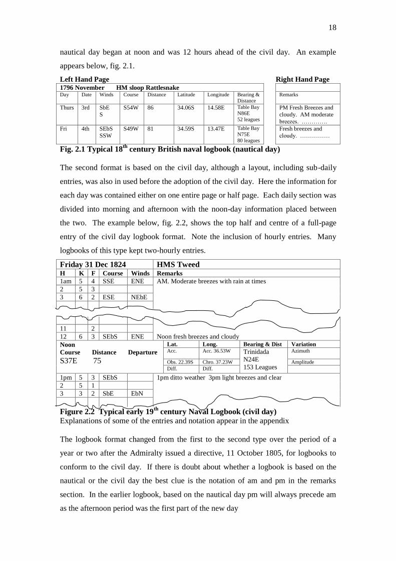
18
nautical day began at noon and was 12 hours ahead of the civil day. An example
appears below, fig. 2.1.
Left Hand Page Right Hand Page 1796 November HM sloop Rattlesnake Day Date Winds Course Distance Latitude Longitude Bearing &
Distance
Remarks
Thurs 3rd SbE
S
S54W 86 34.06S 14.58E Table Bay
N86E
52 leagues
PM Fresh Breezes and
cloudy. AM moderate
breezes. ………….
Fri 4th SEbS
SSW
S49W 81 34.59S 13.47E Table Bay
N75E
80 leagues
Fresh breezes and
cloudy. ……………
Fig. 2.1 Typical 18th
century British naval logbook (nautical day)
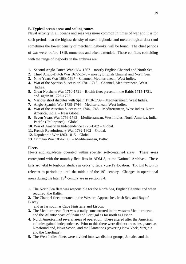
The second format is based on the civil day, although a layout, including sub-daily
entries, was also in used before the adoption of the civil day. Here the information for
each day was contained either on one entire page or half page. Each daily section was
divided into morning and afternoon with the noon-day information placed between
the two. The example below, fig. 2.2, shows the top half and centre of a full-page
entry of the civil day logbook format. Note the inclusion of hourly entries. Many
logbooks of this type kept two-hourly entries.
Friday 31 Dec 1824 HMS Tweed H K F Course Winds Remarks
1am 5 4 SSE ENE AM. Moderate breezes with rain at times
2 5 3
3 6 2 ESE NEbE
11 2
12 6 3 SEbS ENE Noon fresh breezes and cloudy
Noon
Course Distance Departure
S37E 75
Lat. Long. Bearing & Dist Variation Acc. Acc. 36.53W Trinidada
N24E
153 Leagues
Azimuth
Obs. 22.39S Chro. 37.23W Amplitude
Diff. Diff.
1pm 5 3 SEbS 1pm ditto weather 3pm light breezes and clear
2 5 1
3 3 2 SbE EbN
Figure 2.2 Typical early 19th
century Naval Logbook (civil day)
Explanations of some of the entries and notation appear in the appendix
The logbook format changed from the first to the second type over the period of a
year or two after the Admiralty issued a directive, 11 October 1805, for logbooks to
conform to the civil day. If there is doubt about whether a logbook is based on the
nautical or the civil day the best clue is the notation of am and pm in the remarks
section. In the earlier logbook, based on the nautical day pm will always precede am
as the afternoon period was the first part of the new day
19
B. Typical ocean areas and sailing routes
Naval activity in all oceans and seas was more common in times of war and it is for
such periods that the highest density of naval logbooks and meteorological data (and
sometimes the lowest density of merchant logbooks) will be found. The chief periods
of war were, before 1815, numerous and often extended. Those conflicts coinciding
with the range of logbooks in the archives are:
1. Second Anglo-Dutch War 1664-1667 – mostly English Channel and North Sea.
2. Third Anglo-Dutch War 1672-1678 – mostly English Channel and North Sea.
3. Nine Years War 1688-1697 – Channel, Mediterranean, West Indies.
4. War of the Spanish Succession 1701-1713 – Channel, Mediterranean, West
Indies.
5. Great Northern War 1710-1721 – British fleet present in the Baltic 1715-1721,
and again in 1726-1727.
6. Various short disputes with Spain 1718-1739 – Mediterranean, West Indies.
7. Anglo-Spanish War 1739-1744 – Mediterranean, West Indies.
8. War of the Austrian Succession 1744-1748 – Mediterranean, West Indies, North
America, India. – Near Global.
9. Seven Years War 1756-1763 – Mediterranean, West Indies, North America, India,
Pacific (Philippines) – Global.
10. War of American Independence 1776-1782 – Global.
11. French Revolutionary War 1792-1802 – Global.
12. Napoleonic War 1803-1815 – Global.
13. Crimean War 1854-1856 – Mediterranean, Baltic.
Fleets
Fleets and squadrons operated within specific self-contained areas. These areas
correspond with the monthly fleet lists in ADM 8, at the National Archives. These
lists are vital to logbook studies in order to fix a vessel‟s location. The list below is
relevant to periods up until the middle of the 19th century. Changes in operational
areas during the later 19th
century are in section 9.4.
1. The North Sea fleet was responsible for the North Sea, English Channel and when
required, the Baltic.
2. The Channel fleet operated in the Western Approaches, Irish Sea, and Bay of
Biscay
and as far south as Cape Finisterre and Lisbon.
3. The Mediterranean fleet was usually concentrated in the western Mediterranean,
and the Atlantic coast of Spain and Portugal as far north as Lisbon.
4. North America had several areas of operation. These altered after the American
colonies gained independence. Prior to this there were distinct areas designated as
Newfoundland, Nova Scotia, and the Plantations (covering New York, Virginia
and the Carolinas).
5. The West Indies fleets were divided into two distinct groups; Jamaica and the

20
Leeward Islands. There was often a frequent movement of smaller vessels
between the West Indies, the plantations, Nova Scotia and Newfoundland.
Group 4 and 5 therefore form a large cluster covering the eastern Caribbean and
the western Atlantic.
6. Africa – There was not an African squadron until the later 19th
century, but West
Africa and the Gulf of Guinea were both designated destinations in the fleet lists.
The vessels sent here usually made their way on to Jamaica.
7. The East Indies squadron was the most extensive in geographic range but
frequently the smallest in the number of vessels. The station in terms of operations
stretched from Madagascar (and later the Cape) to China, covering all of the
Southern Ocean, Arabian Gulf, Bay of Bengal, Indonesia, the South China Sea
and the Philippines. There was no permanent presence in these waters. The East
Indies squadron until 1793 was ordered home at the conclusion of a war.
Sailing routes (also see the shipping tracks in appendix II)
Geographical coverage, as noted above, is generally good. Nevertheless, and for the
obvious reasons of needing to exploit favourable winds, ships tended to follow the
same or similar routes. These are summarised in figure 2.3, which is based on
CLIWOC data, but provides an excellent impression of coverage for logbooks of
British sailing ships.
Figure 2.3 Ocean Coverage of UK CLIWOC Data (ship tracks produced by Frits
Koek, Royal Netherlands, Meteorological Institute - KNMI)
As a result, sailing vessels sent to designated areas could be expected, with occasional
exceptions, to follow particular routes. Ships departing and returning from the
northern parts of North America would maintain a fairly direct route to places such as
Halifax or St. John‟s in Newfoundland. Vessels sailing to the southern American
colonies and to the West Indies would take a route to the south of the sub-tropical
anti-cyclone, taking advantage of the NE trade winds. Those vessels sailing to
Jamaica, either directly from Europe or from Africa would take a similar route and
21
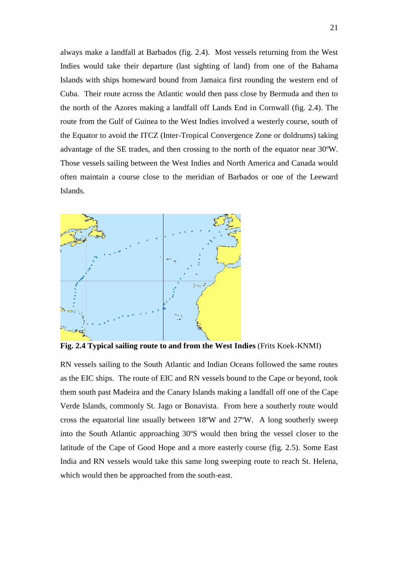
always make a landfall at Barbados (fig. 2.4). Most vessels returning from the West
Indies would take their departure (last sighting of land) from one of the Bahama
Islands with ships homeward bound from Jamaica first rounding the western end of
Cuba. Their route across the Atlantic would then pass close by Bermuda and then to
the north of the Azores making a landfall off Lands End in Cornwall (fig. 2.4). The
route from the Gulf of Guinea to the West Indies involved a westerly course, south of
the Equator to avoid the ITCZ (Inter-Tropical Convergence Zone or doldrums) taking
advantage of the SE trades, and then crossing to the north of the equator near 30ºW.
Those vessels sailing between the West Indies and North America and Canada would
often maintain a course close to the meridian of Barbados or one of the Leeward
Islands.
Fig. 2.4 Typical sailing route to and from the West Indies (Frits Koek-KNMI)
RN vessels sailing to the South Atlantic and Indian Oceans followed the same routes
as the EIC ships. The route of EIC and RN vessels bound to the Cape or beyond, took
them south past Madeira and the Canary Islands making a landfall off one of the Cape
Verde Islands, commonly St. Jago or Bonavista. From here a southerly route would
cross the equatorial line usually between 18ºW and 27ºW. A long southerly sweep
into the South Atlantic approaching 30ºS would then bring the vessel closer to the
latitude of the Cape of Good Hope and a more easterly course (fig. 2.5). Some East
India and RN vessels would take this same long sweeping route to reach St. Helena,
which would then be approached from the south-east.
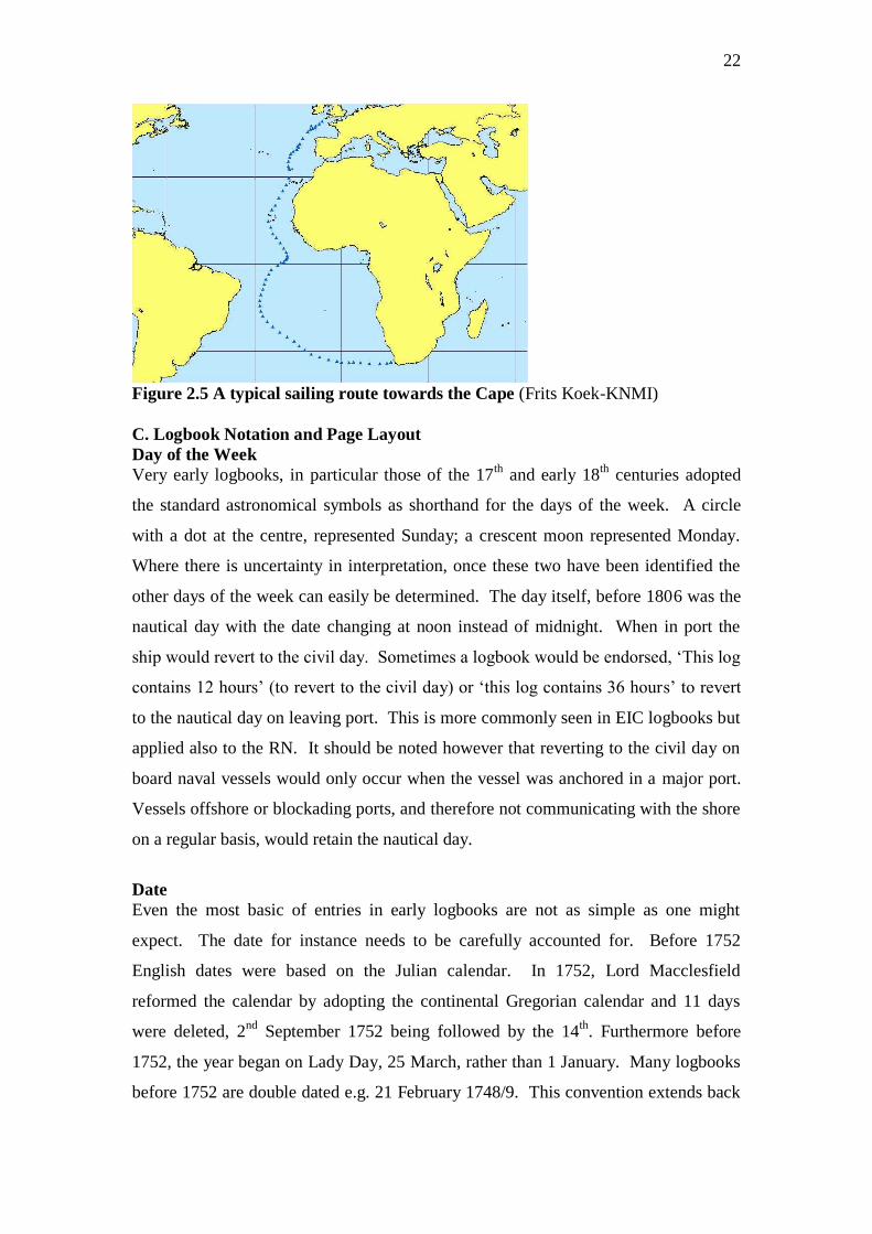
22
Figure 2.5 A typical sailing route towards the Cape (Frits Koek-KNMI)
C. Logbook Notation and Page Layout
Day of the Week
Very early logbooks, in particular those of the 17th
and early 18th
centuries adopted
the standard astronomical symbols as shorthand for the days of the week. A circle
with a dot at the centre, represented Sunday; a crescent moon represented Monday.
Where there is uncertainty in interpretation, once these two have been identified the
other days of the week can easily be determined. The day itself, before 1806 was the
nautical day with the date changing at noon instead of midnight. When in port the
ship would revert to the civil day. Sometimes a logbook would be endorsed, „This log
contains 12 hours‟ (to revert to the civil day) or „this log contains 36 hours‟ to revert
to the nautical day on leaving port. This is more commonly seen in EIC logbooks but
applied also to the RN. It should be noted however that reverting to the civil day on
board naval vessels would only occur when the vessel was anchored in a major port.
Vessels offshore or blockading ports, and therefore not communicating with the shore
on a regular basis, would retain the nautical day.
Date
Even the most basic of entries in early logbooks are not as simple as one might
expect. The date for instance needs to be carefully accounted for. Before 1752
English dates were based on the Julian calendar. In 1752, Lord Macclesfield
reformed the calendar by adopting the continental Gregorian calendar and 11 days
were deleted, 2nd
September 1752 being followed by the 14th
. Furthermore before
1752, the year began on Lady Day, 25 March, rather than 1 January. Many logbooks
before 1752 are double dated e.g. 21 February 1748/9. This convention extends back
23
into the late 17th
century but is not universal. The reader should be aware that in the
absence of a double date, for instance 21 February 1733, the year may actually be
1734 by our modern reckoning. Double dating covers only the period 1 Jan to 25
March. Because some officers used 1 Jan, only checking of the logbook can confirm
if, for example, 21 Feb 1733 is 1733 or 1734.
Wind direction
The winds were listed in chronological order as they changed throughout the day. It
is generally only in masters‟ logbooks that an hour of the day was appended to the
wind direction. The last wind direction listed was that recorded at or before noon on
that day. The first entry of a new day was after noon, usually 1pm. The wind
directions were described by reference to magnetic and not true north. To fix the
ship‟s position by dead reckoning, a correction was made to the course „made good‟
to account for the vessel‟s leeway. Leeway was the degree to which the vessel‟s
course was altered by the lateral pressure of the wind on the hull and sails. The
leeway was determined by wind direction and wind force and the sailing
characteristics of the vessel. A further correction was made for magnetic variation, a
term commonly used for magnetic declination. This correction was applied, to the
computation of the course made good. Therefore, individual wind directions were not
adjusted from magnetic to true until the various calculations had been performed. This
was done by the navigating officer, sometime after the noon observations, and based
on information recorded on a traverse board and rough log during the preceding 24
hours. A 32-point compass was generally used for recording both winds and courses.
There are rare instances where very precise wind observations were made based on a
64-point compass. Many mariners however tended to favour the reporting of winds
using just 16 or even 8 compass points out of the 32 (Wheeler, 2005).
Course
This was the course „made good‟ between two successive noon-day positions after
applying corrections for leeway and drift. Leeway has been described above. Drift
was the result of the influence of surface currents and tides on the movement of the
ship. The adjusted course was expressed as a degree of a circle but treated as
quadrants. Thus in figure 2.1, the course S54W is 54º west of south or 234º.
Although the courses steered were by magnetic compass, the course made good was
plotted on a chart and therefore was with reference to true north.
24
Distance
This was the distance covered between successive noon-day positions. It was
expressed in nautical miles, where a nautical mile is 1.15 statute miles.
Latitude
This was the distance north or south of the equator expressed in degrees and minutes.
The value could either be an estimate, by account or dead reckoning, or by
observation.
Longitude
A. Method
This was the distance east or west of a given meridian expressed in degrees and
minutes. Until the last decades of the 18th
century it can be assumed that all
longitudes are an estimate based on dead reckoning. From about the 1780s some
vessels were employing more sophisticated and reliable methods of determining
longitude. The following notation may appear next to the longitude recorded
Notation Meaning
Lun or Lunar Position calculated according to lunar observation and tables
Tk, chr or chro Position calculated using a chronometer or timekeeper
Obs.,observed Position calculated by solar or lunar observation
Dr, no obs.,
acc. or account
Position estimated by dead reckoning
In the absence of any notation the position recorded is certainly an estimate, as a dead
reckoning account was always kept even when other methods were employed. It
should be emphasised that with dead reckoning, many navigators built in a cushion of
error to ensure the safety of the vessel. The intention was to put the reckoning ahead
of the vessel‟s actual position so that a landfall could be anticipated. If instead the
vessel was ahead of the reckoning, it then ran the risk of striking a coast at night
before a proper lookout was deemed necessary. This is why some vessels may appear
to be sailing over land when their courses are plotted. In these instances a correction
can be applied as in figure 2.6.
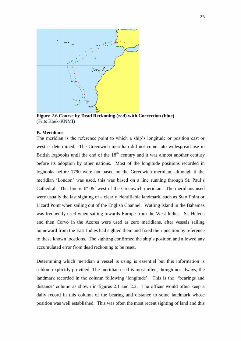
25
Figure 2.6 Course by Dead Reckoning (red) with Correction (blue)
(Frits Koek-KNMI)
B. Meridians
The meridian is the reference point to which a ship‟s longitude or position east or
west is determined. The Greenwich meridian did not come into widespread use in
British logbooks until the end of the 18th
century and it was almost another century
before its adoption by other nations. Most of the longitude positions recorded in
logbooks before 1790 were not based on the Greenwich meridian, although if the
meridian „London‟ was used, this was based on a line running through St. Paul‟s
Cathedral. This line is 0º 05´ west of the Greenwich meridian. The meridians used
were usually the last sighting of a clearly identifiable landmark, such as Start Point or
Lizard Point when sailing out of the English Channel. Watling Island in the Bahamas
was frequently used when sailing towards Europe from the West Indies. St. Helena
and then Corvo in the Azores were used as zero meridians, after vessels sailing
homeward from the East Indies had sighted them and fixed their position by reference
to these known locations. The sighting confirmed the ship‟s position and allowed any
accumulated error from dead reckoning to be reset.
Determining which meridian a vessel is using is essential but this information is
seldom explicitly provided. The meridian used is most often, though not always, the
landmark recorded in the column following „longitude‟. This is the „bearings and
distance‟ column as shown in figures 2.1 and 2.2. The officer would often keep a
daily record in this column of the bearing and distance to some landmark whose
position was well established. This was often the most recent sighting of land and this

26
landmark would provide a zero meridian. To be absolutely certain it is sometimes
necessary to go back some days or even weeks in the logbook and note the landmark
bearing and distance when the longitude recorded is closest to zero. If the longitude is
0.00 and a landmark bears due north or due south then that particular location is the
meridian used. But if after searching back, it is apparent that the meridian has been
reset, for example jumping from 17ºW on one day to 2ºW on the next, there is likely
to be a landmark in this instance, bearing NbE or NEbN (or possibly expressed as
N12E or similar) and that landmark can be taken as the new meridian. The best
method of keeping the correct meridian when processing a logbook is to keep a
careful note of the sighting of landfalls during long ocean passages. The longitude
will often be reset, the sighting having provided a new, and reliable meridian. There
were, however no clear rules or conventions for fixing a meridian, and the method
employed was subject to the inclination and experience of the log keeper. The
CLIWOC Project identified over 450 different meridians. These can be found on the
Project database under „Geodata‟ which is available on the website at
http://www.ucm.es/info/cliwoc. On the other hand, there were often occasions when
no longitude was recorded. This was common when close inshore or in sight of
recognized landmarks. Reference can then be made to the next column „bearings and
distance at noon‟.
Bearings and distance
This column in the logbook (fig. 2.1) gave the bearing and distance of some landmark
from the vessel at noon. The landmark was not necessarily visible from the ship. If
the landmark was in sight the bearing was expressed as a compass point and the
bearing therefore magnetic. If the landmark was not in sight, the bearing was taken
from a chart and was therefore a true bearing. In this instance the bearing would be
expressed very precisely in degrees, for example N12E. As a general rule, bearings
expressed as compass points are likely to be magnetic, those expressed in degrees are
almost always true. The distance to a bearing was recorded in leagues (being 3
nautical miles) or, if close at hand, more precisely in leagues and miles. The bearings
and distance column was seldom left blank, even in port when the location of the
anchorage would be stated. The bearing and distance provides a check on the
longitude of a vessel where the meridian being used is unclear. More importantly,
this information was sometimes the only positional data available when latitude and

27
longitude were omitted. This was usual when a vessel was inshore, in an enclosed sea
area such as the Mediterranean, Baltic and English Channel, or when sailing amongst
groups of islands such as those of Indonesia. All of these data are important for fixing
the meteorological observations in space.
Remarks
The remarks column occupied the entire facing page in logbooks of the nautical day
format (fig. 2.1). Unlike the tabular format of the opposite page, the remarks section
was narrative. In it were described the force of the wind, general weather,
precipitation, incidents of lightning and occasional mention of the sea state. Wind
force was expressed, until well into the 19th
century, in descriptive terms and assessed
without the use of instruments. A discussion of the conversion of these terms to
modern-day equivalents, as well as weather and sea-state descriptors are not within
the remit of this report and the reader is directed to the literature on this subject, in
particular CLIWOC (2003). The remainder of the „remarks‟ section was an account
of the general management of the ship including notes on discipline, health, mortality,
sightings of other vessels and any other incident worthy of mention. The remarks
section was divided into distinct time periods. The notation pm and am were
frequently employed, pm always preceding am when the nautical day was in use.
Many logbooks divided the day into three parts. The first part corresponded to the
period noon to 8pm. The second or middle part corresponded to the period 8pm to
4am. The latter part was the period from 4am to noon
Additional notation
The descriptions above apply equally to RN logbooks kept according to the civil day.
The example, given in figure 2.2 of the civil day logbook format, includes some
notation and sections not always found in the earlier types of logbook. The columns
marked K and F referred to the vessel‟s speed recorded hourly. The column K was
knots, or nautical miles per hour. The column F referred to fractional parts of a knot,
commonly termed fathoms. There were eight fathoms to a knot. In this context the
term fathom was not referring to depth of water, neither by the 17/18th
century was it
the more widely understood unit of 6 feet.
Originally, in the 16th
century the English log line, by which a vessel‟s speed
was measured, had knots at intervals of 42 feet. The number of knots run out by a
half-minute glass gave the speed in „knots‟ or miles per hour. There were seven
28
fractional parts between the knots on the log line, each equalling six feet, hence a
fathom being six feet. This was based on the notion that a mile of 5,000 feet equalled
one minute of an arc of latitude. When it was determined that a minute of an arc was
closer to 6,000 feet, the sea mile or nautical mile became a unit of measurement
separate from the geographic mile. To compensate for this Richard Norwood in 1637
proposed that the knots on the log line be spaced at 50-foot intervals. The fractional
parts of the knot, still termed fathoms, now totalled eight with a remainder of two feet
(Taylor, 1971). This is why the „8 fathoms‟ in a knot are not six foot each. It should
also be noted that knots and fathoms were not only used to record the speed of a
vessel but also to record the velocity of a current.
The terms „azimuth‟ and „amplitude‟, either of which might appear in
logbooks, referred to different methods of measuring the angle of a celestial body in
order to determine the local magnetic variation. The term „departure‟ is a reference to
a landmark or meridian from which the longitude has been estimated. The figure
inserted here is expressed either in degrees and minutes or nautical miles east or west
of the point of departure.
2.2 The East India Company Logbook
A. Format
From the mid 18th
century, the logbooks of the East India Company followed a
consistent format with minor differences in the items recorded. The earliest EIC
logbooks were often in a form similar to diaries. Later logbooks were prepared on
printed pages following a common layout in use by the mid 18th
century. Each
logbook page was made up of two days. The day was laid out in six columns, the last
being the widest and reserved for general remarks and narrative text. At the foot of
each day were one, or sometimes two rows of tabular data containing all of the noon
observations and navigational summaries for the day. From as early as the 1780s,
printed logbook pages included spaces for air temperature and barometric readings.
In common with early RN logbooks, EIC ships, and all other merchant vessels used
the nautical day, each day beginning at noon, 12 hours ahead of the civil day. The
nautical day was used throughout the period covered by EIC logbooks, and there was
no conversion to the civil day reckoning except when in port.
29
B. Typical ocean areas and sailing routes
EIC vessels sailing from Britain tended to follow a seasonal pattern by departing
during the winter and spring months, usually between December and May. This
allowed them to enter the Indian Ocean soon after the commencement of the SW
monsoon giving favourable winds to their destinations. It also meant that the Atlantic
ITCZ was traversed while nearer the equatorial line and at its narrowest. Likewise,
the return voyage from the east usually commenced in December or January to take
advantage of the NE monsoon in the Indian Ocean. On reaching the equatorial line in
the Atlantic, the ITCZ would be much further north allowing the Company‟s ships to
take advantage of the SE trade blowing from a more southerly direction to the north
of the line. Even with these environmental advantages it was not unusual to find East
Indiamen sailing at less advantageous times in early or late summer. The
consequence of this largely seasonal pattern of sailing was that during the months of
late October to early December, there were usually no such vessels traversing the
South Atlantic.
The route of East India and RN vessels towards the Cape of Good Hope has been
described above (fig. 2.5). Once past the Cape the usual route to India was through the
Mozambique Channel. By the 1780s and 1790s this track was less favoured except
by those vessels bound to Bombay or requiring a stop at Madagascar. From the mid
1780s, those vessels bound to Madras and Calcutta would sail east to the meridian of
Sri Lanka before adopting a northerly course to their destination. Others, usually for
China, would sail even further east before turning north to make a landfall off either
Christmas Island or off the coast of Sumatra. Vessels bound for China would
frequently pass through the Malacca Strait, before traversing the South China Sea.
The return voyage from India would sail a direct course towards the Cape of Good
Hope. Those vessels sailing from China would commonly enter the Indian Ocean
through the Sunda Strait, taking their departure from Java Head and sailing directly
towards the Cape. From the Cape the route then led to St. Helena, then across the
equator and usually to the west of the Azores before picking up the westerlies and
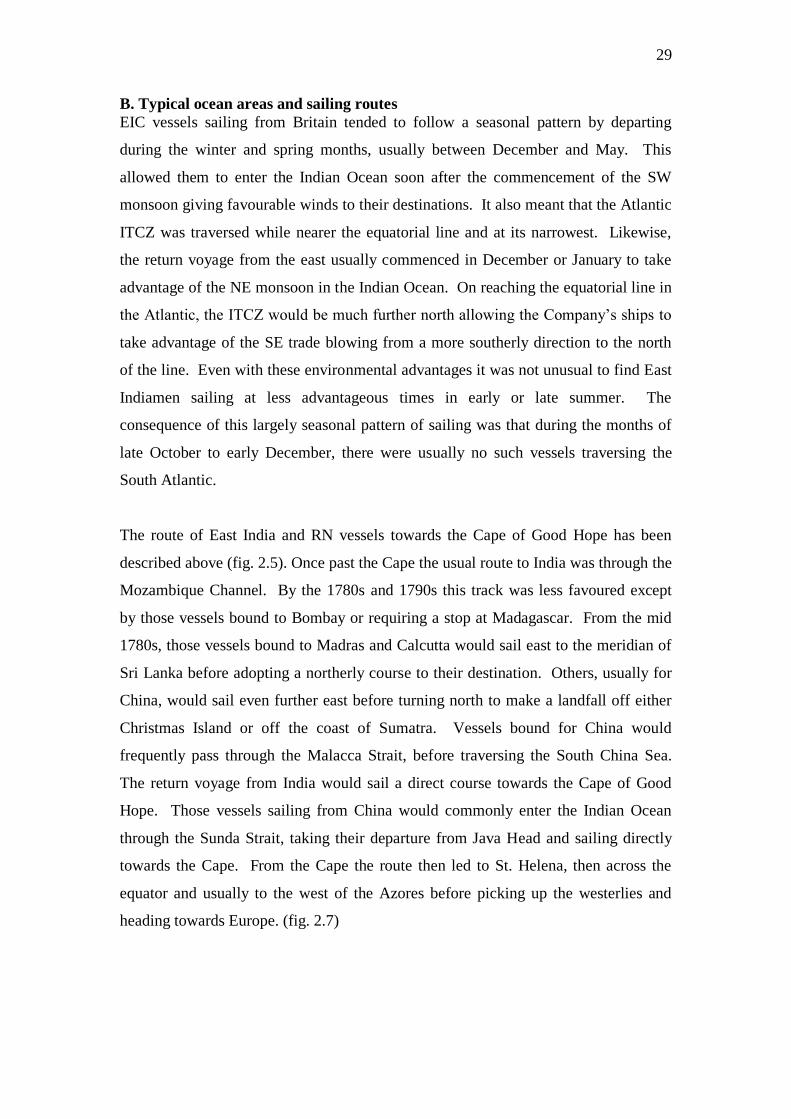
heading towards Europe. (fig. 2.7)
30
Fig. 2.7 Typical routes of East India Company vessels (Frits Koek-KNMI)
C. Notation
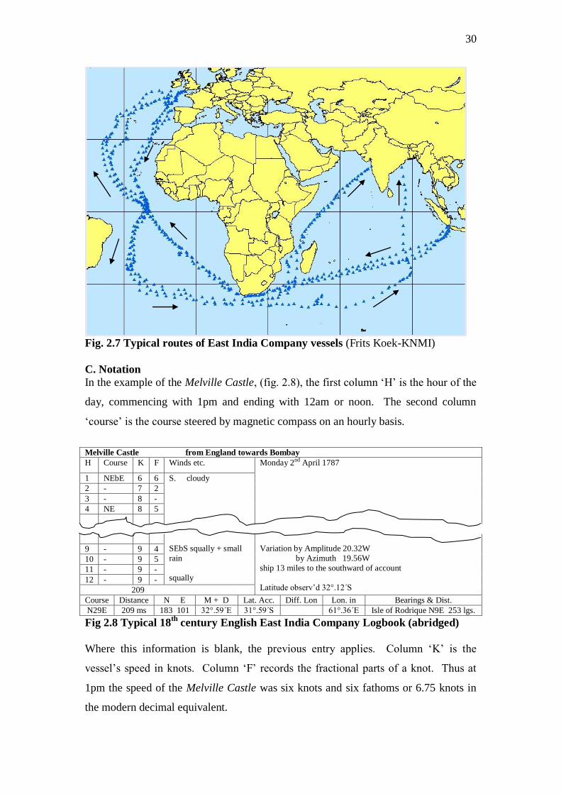
In the example of the Melville Castle, (fig. 2.8), the first column „H‟ is the hour of the
day, commencing with 1pm and ending with 12am or noon. The second column
„course‟ is the course steered by magnetic compass on an hourly basis.
Melville Castle from England towards Bombay
H Course K F Winds etc. Monday 2nd April 1787
1 NEbE 6 6 S. cloudy
2 - 7 2
3 - 8 -
4 NE 8 5
SEbS squally + small
rain
squally
Variation by Amplitude 20.32W
by Azimuth 19.56W
ship 13 miles to the southward of account
Latitude observ‟d 32°.12΄S
9 - 9 4
10 - 9 5
11 - 9 -
12 - 9 -
209
Course Distance N E M + D Lat. Acc. Diff. Lon Lon. in Bearings & Dist.
N29E 209 ms 183 101 32°.59΄E 31°.59΄S 61°.36΄E Isle of Rodrique N9E 253 lgs.
Fig 2.8 Typical 18th
century English East India Company Logbook (abridged)
Where this information is blank, the previous entry applies. Column „K‟ is the
vessel‟s speed in knots. Column „F‟ records the fractional parts of a knot. Thus at
1pm the speed of the Melville Castle was six knots and six fathoms or 6.75 knots in
the modern decimal equivalent.

31
The fifth column would contain a note of the wind direction, wind force and general
weather. In the example the wind direction „south‟, as recorded at 1pm, would hold
true until another direction was recorded for example at 9am SEbS. This particular
example has no wind force recorded but is an isolated example of this omission. EIC
ships had a slightly different and more archaic vocabulary for describing wind force.
For a full discussion of this see the CLIWOC (2003). The sixth column would record
any remarks concerning the general management of the ship along with any additional
navigational information. In the example the magnetic variation is recorded by two
different observations. The observed latitude was also recorded here. This was
common in earlier logbooks before a specific box for this information appeared on
printed logbook pages.
The rows along the bottom of each entry recorded the summary of the day‟s
navigational observations and calculations. In the example, the course made good
between the noon position and that of the previous day is N29E. The distance is 209
miles. The next entry „N‟ „E‟ refers to northings and eastings. In this example the
vessels has made 183 miles to the north and 101 miles to the east. The navigating
officer determined his course and distance made good by a method called plane
sailing. This involved the resolution of a right triangle in which the northings and
eastings represented two of its sides, the hypotenuse of which gave the true distance
and direction covered in the day. This was the simplest form of dead reckoning and
was adequate for navigation using plane charts on which the distances between
meridians remained constant regardless of latitude (see below).
The box „M+D‟ refers to meridian + distance or meridian distance. This is the
distance east or west of the zero meridian from which the vessel took its last departure
as distinct from the vessel‟s longitude according to the Greenwich meridian.
Meridian distance was stated in either leagues or degrees of a fixed length irrespective
of latitude (20 leagues = 1 degree). This is because large-scale plane charts were
being used to navigate rather than Mercator charts where the distance between
meridians narrows as the latitude increases. With plane charts, the distance between
meridians is constant at all latitudes (Jonkers, in press). In later logbooks meridian
distance is sometimes referred to as „Lon mde‟ or longitude made.
32
The box „Lat Acc‟ refers to the latitude by account or by dead reckoning. Comparing
this with the observed latitude in the remarks column indicates an error in the account
of 13´ or 13 nautical miles and the remarks column records that the vessel is 13 miles
to the south of account. Such errors in account were common and due to currents,
drift, leeway or minor errors in calculations or in the observations themselves. „Diff
Lon‟ refers to the difference in longitude from the previous day‟s position. In the
example the data are not inserted. In many logbooks „X‟ is used instead of „Diff‟ to
denote the difference, as in „X Lat‟ or „X Lon‟. „Long in‟ states the longitude
according to the Greenwich meridian. „Bearings and distance at noon‟ is the same
notation as in RN logbooks.
Other Notation
As with RN logbooks the abbreviations „tk‟ or „chr‟ refers to a timepiece, „ob‟ is
observed and „ac‟, „acc‟ or „act‟ is account or dead reckoning. The notation „var‟
refers to variation or magnetic declination. A symbol of a crescent moon indicates a
lunar observation. A circle with a dot in the middle is for a solar observation.
3. Instrumental data in early logbooks – pre 1850
3.1 Royal Navy
Instrumental data in logbooks before the 19th
century are rare. The data were usually
air temperature measured, as far as can be determined, in the main cabin. Barometric
pressure data are equally exceptional, and 18th
century RN logbooks are almost
devoid of such information. The few examples are confined to those vessels on
exploratory missions or to officers with a particular scientific curiosity.
Unsurprisingly, the voyages of Cook produced instrumental data. Likewise the
voyages of Mathew Flinders in the Reliance between 1795 and 1800 recorded air
temperature, several times each day. Flinders‟ logbooks in the Investigator can
confidently be expected to yield similar instrumental data. Nevertheless, instrumental
data can occasionally be found in early RN logbooks. The logbooks of Captain Philip
Beaver of the frigate Acasta contained temperature and air pressure readings in 1809
and again in the Nisus when he commander her in the years 1810-12. Contemporary
correspondence with Major James Rennell, suggests that Phillip Broke recorded air
temperature while commanding the frigate Shannon between 1807 and 1813. Unless
it is known beforehand that an officer made such readings, their presence in a logbook
33
can only be determined by direct inspection. This is a time-consuming task not
supported by any catalogue information to assist the enquirer.
Nevertheless, a sampling of RN logbooks can at least give a general indication of the
likelihood of instrumental data. The examples following were selected at random and
the degree of consistency suggests they are typical. An examination of several of the
logbooks from the ADM 55 microfilm series indicated that not all vessels on
exploration made instrumental observations. Leaving aside the logbooks of explorers
such as Cook and Flinders who are known to have made such observations, it is
apparent that it is not until the 1820s that instrumental data can be confidently
expected. A selection of logbooks revealed that the Seaflower (ADM 55/126)
recorded no instrumental data in 1807. The Bathurst (ADM 55/9) recorded both
temperature and barometric pressure in 1821. A further sample, the Samarang (ADM
55/125) in 1843 recorded temperature, barometric pressure and sea surface
temperature.
A random sample was also made of ADM 53, the ships‟ logbooks, on the assumption
that the same pattern would also hold true for the ADM 51 captains‟ logbooks. The
Alert (ADM 53/1) in 1800, contained no instrumental data. The Arrow (ADM
53/101) also recorded no instrumental data in the years 1826-1831. Both recorded
wind direction, wind force and weather in the style of 18th
century logbooks. The
Pandora (ADM 53/5501) in 1836 recorded wind direction with wind force according
to the Beaufort Scale. The weather was recorded in detail according to a system of
letters corresponding to a particular descriptive phrase according to the Beaufort style.
There were no instrumental data.
Instrumental data were found in the logbook of the Griffon (ADM 53/2601) covering
the years 1846 and 1847 . There was also evidence suggesting that the recording of
barometric pressure was expected and required as the logbook was endorsed „no
barometer‟, apparently to account for the absence of this information, although
pressure was recorded by sympiesometer. This was a type of barometer where the
atmospheric pressure acted upon an oil in the lower part of the instrument to compress
an elastic gas in the upper part. Like the Pandora of 1836, wind force was recorded
using the Beaufort Scale and the weather described by a series of letters. The scheme
34
of recording was detailed on a printed notice on the inside of the logbook cover
stating that observations were to be made hourly, „with clearness and precision‟, in
the logbooks of all Her Majesty‟s ships‟ by Admiralty instruction. The instrumental
data recorded in the logbook of the Griffon was temperature and pressure by
sympiesometer. The location of these instruments was not noted. The recording of
the data was not continuous but noted either intermittently or in clusters of days. This
may have been a reflection of the vessels activities and the data may only have been
recorded while at sea.
Logbooks in private collections held by the National Maritime Museum, support the
finding, in the National Archives, that the majority of RN logbooks did not
consistently record instrumental data before the 1840s. The logbooks of the
Challenger 1828 (FRE/201), Briton 1831 (COD/101/3), and the North Star 1826-
1847 (LOG N/N/20) did not record instrumental data. Again, these particular
logbooks were picked at random from those operating in distant seas, and as the types
of information recorded in them is so similar to those in the National Archives, they
should be considered typical. It should be noted however that not all of the logbooks
in these private collections were kept by commanding officers.
The above suggests that pre-1850 instrumental data can be expected in logbooks of
vessels on exploration or hydrographic survey (ADM 55) after 1820 but that.
Instrumental data are not common in RN logbooks (ADM 51 and 53) until 1840 or
even later. Despite this it is evident, even though not recorded in a logbook, that
many meteorological observations were made on board ship in the decades before the
1850s. These observations can be found in dedicated meteorological registers,
weather books or in the Remarks Books kept to record hydrographic information.
These documents are treated separately below in sections 9.3 and 9.4.
3.2 East India Company
Early instrumental data is to be found in the logbooks kept by the officers of the EIC.
As noted before, by the late 18th
century, the pre-printed logbook pages made
provision for this information to be recorded though this was not always done. A
close approximation of the incidence of instrumental data from this source can be
made based on the sample of East India Company logbooks processed by the
35
CLIWOC Project and an imaging project carried out (2008) involving a partnership of
the British Library, UK Met Office and CDMP. Of those logbooks processed by
CLIWOC, there were almost no instrumental data before 1780. Between 1780 and
1789 there were occasional temperature readings recorded. The 2008 imaging project
identified 2080 East India logbooks between 1790 and 1834. Of these 951 recorded
either pressure or temperature data and often both. Therefore just under half of the
EIC logbooks for this period recorded some sort of instrumental observation. It must
be noted however that data were not always recorded throughout an entire voyage,
and confined in some cases to the South Atlantic and Indian Oceans, or to an outward
voyage but not the return.
Where early instrumental data exist, the position of the instruments on board a ship is
not mentioned in logbooks. The main cabin is one likely location. Yet according to
Alexander Dalrymple, the EIC‟s hydrographer, the thermometer on board the EIC
SHIP Grenville in 1775 was located in the open air on the balcony. (Dalrymple,
1778) Although sited on the open balcony, the recordings suggest that the
thermometer was shaded. The balcony was a stern gallery at the very back of the
vessel, and extended across the entire breadth of the ship. It was directly off the main
cabin affording the commanding officer a private area to walk. It was the logical place
to hang such an instrument as the main cabin might, unless well ventilated, become
very warm in the tropics. Many large and medium sized RN vessels (those larger than
frigates) also had stern galleries though these became unfashionable by the 1790s,
making a revival by the end of the Napoleonic Wars in 1815. Contemporary
paintings suggest that East Indiamen continued to have stern galleries. With regard to
naval vessels the barometer and thermometer were commonly placed in the cabin.
Mathew Flinders reported that the instruments on board the Investigator 1801-3, were
hung in the cabin. He went on to mention that they were subject to interference by the
motion of the ship while at sea and suggested a correction to the observation.
(Flinders, 1806)
3.3 Instrumental data from merchant shipping
From various printed accounts it is clear that merchant ships in the early 19th
century
carried barometers and recorded pressure data and often air temperature. There are
also references to sea temperature. Very few of these very early logbooks have
36
survived and to date (2008) no significant collections have been found apart from the
modest numbers held by the National Maritime Museum in LOG/C and LOG/M. (see
3.1 above), and the small numbers of whaling logbooks (sections 10 and 11 below).
Some data from these logbooks has been reproduced in printed sources.
3.4 Instrumental data in printed sources
A variety of 19th
century books and journals record accounts, either whole or in part,
of voyages made by both naval and merchant shipping. Travel literature and
narratives of sea journeys were very popular in the 18th
and 19th
centuries, and the
various accounts of Cook‟s voyages and the publication of the Resolution journals are
a typical example. Many such accounts exist and those produced by officers of naval
vessels or other ships engaged in scientific enquiry usually reproduced an part of the
log of the voyage, or a meteorological register. Failing a convenient tabular appendix,
pressure and temperature data was sometimes recorded in the body of the narrative
itself.
A notable example is William Scoresby‟s Account of the Arctic Regions containing
meteorological registers for the period 1811-1818. Scoresby goes into particular
detail about the instruments and recording methods. James Weddell‟s Voyage
towards the South Pole (1825) contains tabulated air and sea temperature data in high
southern latitudes. Such accounts are not confined to English literature and Porter‟s
account of the cruise of the USS Essex 1813-1814 contains an extract from the
logbook giving pressure and SST data. J Reynolds Voyage of the US Frigate
Potomac (1835), has a meteorological register in the appendix that records pressure,
air temperature and SST while the Potomac was in the eastern Pacific, and during the
vessel‟s return to Boston. The register covers the period June 1833 to May 1834.
Further short extracts of pressure and temperature data in logbooks from the 1830s
and 1840s can be found in John Purdy‟s Memoir Descriptive to accompany the charts
of the North Atlantic Ocean (1853) and Sailing Directions for the Ethiopic of South
Atlantic Ocean (1855). Similar short extracts can be found in the two volumes of
Alexander Findlay‟s A Directory for the Navigation of the Pacific Ocean (1851). An
exceptional example, rich in logbook extracts, is the many editions of Maury‟s
Explanations and Sailing Directions (1851 [and other years]). Many short extracts of
instrumental data, connected with particular severe weather events can be found in
William Reid‟s An Attempt to Develop the Law of Storms (1850). The material found

37
in Purdy, Findlay and Reid is unique and of special significance because much of it is
data recorded on board merchant ships whose logbooks have not been located and in
all probability have not survived. Another significant source of printed
meteorological data is the Nautical Magazine first published in 1832 and continuing
to the present day. This journal is a mine of nautical history and information. For
example, the volume for 1845 prints part of the meteorological register of HMS
Iphigenia 1822 covering the tropical Atlantic both north and south of the equator and
a voyage from Havana to New York. SST is recorded along with the vessel‟s
position, the set of the current and the rate of flow. Other items of interest in this
volume include ice in the north Atlantic in 1836 and an extract from the log of HMS
Favourite in the Pacific 16-18 December 1842 at the time of a typhoon. Other
significant sources of printed logbook data, some much earlier than the 19th
century,
can be found in the Philosophical Transactions of the Royal Society, the Journal of
the American Philosophical Society, the Journal of the Royal Geographic Society and
the US Nautical Magazine and Naval Journal. Several of these journals are available
electronically via JSTOR and some of the books can be accessed on-line as PDF files
from Googlebooks.
3.5 Chronometer-Rating Books
Chronometers were in regular use by the vessels of the East India Company by the
1790s but were not commonly issued to Royal Navy vessels until much later. Some
captains would have purchased their own chronometer but these were expensive
instruments and their reliability was a matter of debate. The accurate running of a
chronometer was influenced by the motion of the ship and by the environmental
conditions. As such the various researches into chronometric longitudes and meridian
distances for the improvement of charts and sailing directions, involved the trials of
chronometers, with regular inspections and monitoring. In the course of chronometer
trials and rating, it was necessary to record the ambient temperature and frequently the
barometric pressure. As such, chronometer-rating books constitute an additional
source of marine instrumental data. Instructions for monitoring the performance of
chronometers can be found in the publication by Capt. Charles F. Shadwell, Notes on
the Management of Chronometers and the Measurement of Meridian Distances
(London, 1861). The appendix of this work, which can be accessed on Googlebooks,
includes examples of pre-printed forms on which the ratings, with barometric pressure
38
and air temperature, were to be recorded. At present (2008), the location of these
rating books is under investigation, but they are most likely to be held by the National
Maritime Museum in Greenwich. However the Royal Greenwich Observatory
Archive at Cambridge, the National Archives RGO series, and the Hydrographic
Office in Taunton may also hold some of these records.
4. Related Research Aids
4.1.1 Ship Lists - ADM 8 and ADM 7/560-1
There are so many logbooks in British archives that some preliminary organization
and selection is absolutely necessary before an item is chosen for data abstraction.
The National Archives hold in manuscript form the original Admiralty ship lists.
These begin in 1673 and continue to 1893, with two additional volumes covering
1903-1909, and are catalogued under ADM 8. There are omissions in the sequence
between 1814 and 1820, the years 1854 and 1856, and again between 1894 and 1903.
However the two volumes of ADM 7/560-1 provide the required information
covering the period 1811-1814 and 1815-1821, but on a ship-by-ship basis rather than
by station (see below). Vessels were allocated to various stations around the globe
(East Indies, Jamaica, Leeward Islands, Mediterranean, North America
(Newfoundland, Nova Scotia, and before American independence, Boston, New
York, Plantations [Virginia, Carolinas]), Africa and the Channel Fleet), and the ADM
8 documents list, month-by-month, to which station each ship was attached. This
greatly helps to optimise the geographic coverage of abstracted data and avoid
duplication. Additionally, the lists detail, under „convoys and cruisers‟, the vessels
stationed in British coastal waters and assigned convoy duty in European waters.
Also listed, but less frequently, are those vessels on convoy to more distant parts, such
as St. Helena, those under secret orders, on exploration, hydrographic survey or on
fishery protection. The remainder of the list is comprised the ships in port, refitting,
repairing, de-commissioned or allocated non-operational harbour duties.
For each station, the lists give information on a monthly basis. Other useful,
information is provided including the rate of the vessel. The rate was a division of
ship types, established by the civil branch of the navy, to regulate its administration.
In addition to the rate, ADM 8 records the name of the ship, number of guns and
numbers of crew (both fixed by the rate), the commanding officer, names of the
39
lieutenants and the date the ship sailed from Britain. Once a vessel reached its
destination, there is no indication from the fleet lists about its subsequent movements
or its return to Britain. The only indication, without an examination of the logbook,
that a vessel has left its station and returned, is the deletion of the ship‟s name from
the station list and its appearance in the lists for one of the English ports.
It should be noted that there is no volume of ADM 8 covering the years 1854 and
1856. From 1855 onwards, ADM 8 is in printed form rather than in manuscript. In
the very early printed versions some of the most useful data was omitted. ADM
8/135-7, covering the years 1855, 1857 and 1858, give no dates of sailing, only the
date the vessel was commissioned. Sailing dates are re-instated from 1859 onwards.
Additional data included in the printed volumes is whether the steam, and steam
assisted, vessels were paddle steamers or screw propelled, and the horsepower of the
engines. After 1860, the lists state if a vessel was iron clad or armour plated. By this
time the number of guns carried is less meaningful as an indication of the size and
type of vessel although these numbers continued to be stated until 1888. From 1889,
the number of guns is not given and the vessel is described by its type such as
battleship, cruiser or gunboat.
4.1.2 ADM 7/560-1
ADM 7/560 and 561, like ADM 8, are a list of shipping movements but based on
named vessels instead of stations. The volumes cover the period 1811-14 and 1815-
21 and fill the gaps in the ADM 8 series between 1814 and 1820. The information
they contain is superior to ADM 8 as they detail subsequent movements when „on
station‟ often with dates of arrival at different ports. Notes, of other vessels met or in
company, allow further refinement and cross-referencing. It should be noted however
that there are omissions and not all vessels have been recorded.
4.1.3 Limitations of ADM 8 and ADM 7/560-1
The ADM 8 series, together with the two volumes, ADM 7/560-761, can be relied
upon in most instances to give accurate information on the locations of vessels and
their time of sailing from Britain. The user should be aware however that the lists are
subject to omissions and minor errors. They were compiled at the time by Admiralty
clerks and based on the information supplied to the Admiralty by the ports.
Sometimes this information was out of date or incorrect, either due to a clerical error,
40
late communication, the countermanding of orders, or more commonly because short-
term events did not warrant recording. Occasional oversights and clerical errors are to
be expected in any form of administration. However a ship might also receive a
change in orders that was not notified to the clerks in time, and a vessel that in one
month was reported as having sailed to the East Indies may suddenly be found in the
Mediterranean instead. Likewise, a vessel making a swift passage to Lisbon or
Gibraltar could easily return in a matter of weeks and the particular passage would not
be recorded because it would be out-of date information when the next monthly list
was compiled. Furthermore, the date of sailing as recorded in ADM 8 might be quite
different to that recorded in the logbook. The port may have reported to the
Admiralty that a ship had sailed on a certain date (this being recorded) only to find
that the ship had returned, or put into some other port, owing to stress of weather or
other accident. The revised date of sailing may not then be recorded. The usefulness
and accuracy of these ship lists is not diminished by these minor and infrequent
errors. The occasional omission of large vessels making distant voyages seems less
excusable, though one must bear in mind that in wartime, some sailings were subject
to a degree of secrecy and that the Admiralty clerks could only record the information
that was given to them. Under these circumstances, operational histories can prove
useful. See 4.3 below.
4.1.4 ADM 7/569-75 – Abstract Ships’ Journals 1736-1795
A large number of 18th
century Royal Navy shipping movements are detailed in the
seven volumes ADM 7/569 to 575. These are substantial records; the last in the series
for instance is over 500 pages covering the period 1775 to 1795. Each volume is
indexed. These abstract journals were compiled from the original logbooks as they
were delivered to the Navy Board and provide the following tabulated information:
Name of ship, commander, start and finish dates of the logbook, names of each port or
destination visited, the date of arrival and the date of sailing from each port or
location, the number of days spent in port with a total for the whole logbook, the
number of days spent at sea with the total number for the logbook, and lastly a section
for general observation. This meticulous recording allowed the Admiralty to keep
track of vessels and commanders and it was not unknown for an officer to be
admonished for lack of activity. Through these records a precise overview of vessels‟
movements can be obtained without prior direct examination of each ship‟s logbook.
41
Additionally the total number of days spent at sea and in harbour allows the
identification and elimination of those logbooks with minimal sea time. These
records are unique and such detailed information is not available for other periods
until 1923 onwards. (See Admiralty movement books 10.3.3 below.)
4.1.5 ADM 7/502-38 Daily returns to the First Lord 1812-1830
This series is a detailed day-by-day report of arrivals and departures from the major
British ports as reported to the First Lord of the Admiralty. The ports reporting were
the Thames, Nore, Downs, Spithead and Plymouth, with a section for miscellaneous
ports such as Falmouth and Leith. In addition to shipping movements, the daily wind
direction at the Nore, Downs, Spithead, Plymouth, Falmouth and Leith was also
recorded. This source will provide details of shipping movements that may have been
overlooked in ADM 8. More importantly however the Daily Returns record the
movements of those Royal Navy vessels attached from the early 1820s to the
Falmouth packet service. The ADM 8 lists only record these vessels as being
attached to the packet service and give no hint of their movements. These movements
would usually range from Rio de Janeiro and Montevideo to Jamaica and Halifax. As
well as reporting their arrival at Falmouth and the date they has sailed from their last
port, these packet boats would often report on the location and activities of other
vessels they had met with and this was usually recorded in the Daily Return.
4.1.6 Pacific Manuscripts Bureau
A further source of RN shipping movements in the late 18th
and early 19th
centuries is
the list compiled by the Pacific Manuscripts Bureau of Australia. A microfilm of this
list can be found in the National Maritime Museum, Greenwich, reference
MRF/156/1-2. The microfilm provides an alphabetical list of all vessels thought to
have voyaged to the Pacific. In an attempt to be comprehensive the list includes many
ships that were stationed on the Atlantic coast of South America on the assumption
that they may have sailed around Cape Horn. As such the list provides an additional
source of shipping references and a useful check against other sources.
4.1.7 The Nautical Magazine
The Nautical Magazine was first published in 1832 and continues to this day. As well
as being a mine of nautical information and history, the magazine prints monthly lists
42
of naval movements. These movements consist mostly of the dates of arrival or
departure from ports with occasional remarks about the onward destination or
previous movements. These monthly lists are not comprehensive and are based on
communications sent to the magazine‟s editor.
4.1.8 Using the Ship Lists
Although it is not possible to know the movements of most vessels while „on station‟
from these various lists, (ADM 7/560-1 and ADM 7/569-75 excepted) it is possible to
identify and select those vessels most likely to be active at sea. Battleships (rated 1 to
3), which in the age of sail carried 60 to100 or more guns, were likely to be the most
inactive. (see 4.1.1 above for an explanation of the rate) They would be sent to their
designated station for offensive operations against French, Spanish or Dutch colonies
or to blockade European ports or as a response or in anticipation of an enemy sending
similar heavy units to an area, such as the West Indies. These units would cruise off
an enemy port or be held ready for a fleet action. With the exception of some of the
smaller 60-64 gun ships, battleships did not cruise and rarely had regular convoy
duties. Small two-deckers (50-44 guns), frigates and sloops (38-18 guns) would be
used to cruise for enemy merchantmen, carry communications and convoy merchant
ships. These are the vessels most likely to be at sea most of the time, and can easily
be identified from the ship lists. Unless a large battleship is known to be making a
long voyage, for example to the East Indies, it is best to select one of the smaller
vessels as they will see more active service at sea.
4.2 Sailing Instructions, charts and atlases
One of the potential difficulties with early logbook data is the determination of the
ship‟s location. The landmarks recorded may be unfamiliar and even when latitude
and longitude are recorded, the longitude may be based on an unfamiliar zero
meridian. It has even been known for a vessel to record (from an old Dutch chart) a
bearing to an island that does not exist (Saxemburgh in the South Atlantic).
Contemporary charts and sea atlases, to be found in the National Maritime Museum,
Greenwich, will resolve many of these questions. By far the most useful reference
works are the various sailing instructions issued for different parts of the world. For
the 17th
and 18th
centuries one can call upon The English Pilot (originally by John
Seller), of which there were various editions between 1675 and 1750. These were the
43
standard pilot books used by English navigators throughout the 18th
century, with
separate volumes for North America, the West Indian and the Oriental navigation.
Apart from the contemporary charts enclosed in the volumes, the primary advantage
of these works is the detailed route descriptions and discussions of winds and
currents, as well as the islands and landmarks likely to be encountered. It is here that
one can find archaic terms and spellings, and the location of places whose older
names have long disappeared from modern atlases. This can be most useful for
locating a point of departure used as a meridian. For the 19th
centuries there are the
general sailing directions by Horsburgh (1817) and Rosser and Imray (1866).
Recommended, however are John Purdy (1853) and (1855). Also recommended is
Alexander Findlay‟s, two-volume Directory for the Navigation of the Pacific Ocean
(1851). Each of these four publications contains an extensive set of place names with
descriptions, latitude and longitude, including ports and landmarks, some with archaic
names no longer in use. These would have been the place names in common use in
logbooks at the time.
4.3 Operational Histories
The general operational histories of the RN can be useful in a very limited way in
assisting with logbook selection. They can for instance provide some information on
the subsequent movements of vessels once they have been assigned to a station. It
may be possible for instance to find out exactly which region of the East or West
Indies a ship is operating, information that cannot be determined from the Admiralty
ship lists in ADM 8. The most useful is Clowes (1897-1903), which should be found
in larger libraries. The chief disadvantage however is that such histories naturally
focus on those vessels involved in important operations or engaged in battle. The
most useful and extensive meteorological data is to be gained from those vessels on
long ocean passages yet it is these vessels that are least likely to be mentioned in
histories, as mid-ocean encounters between opposing vessels are virtually non-
existent.
Even so operational histories can pick up significant short-term events not recorded in
the station lists. In 1806, vessels on blockade duty and stationed off the coasts of
France and Spain, were dispatched at short notice to seek out and destroy several
French squadrons that had successfully evaded the blockade and put to sea. Some of
the British ships sailed to the West Indies, one sailed to the East Indies, to give
44
warning, and a squadron of six ships of the line sailed towards St. Helena and the
Cape only to return once it was clear that the French had not sailed in that direction.
The point is that none of this is recorded in the station lists as the vessels concerned
were still officially designated as either part of the Western Squadron blockading the
French coast, or the Mediterranean fleet blockading Cadiz.
5. Priority Collections – Pre 1850
Considering the nature of the early logbook collections within each of the three main
archives, priorities for data processing should be dictated by the type and quality of
the data available, the geographic range, and the practical considerations for imaging.
Priority should be given to the following specific collections:
5.1 British Library - East India Company Logbooks
The East India logbooks should be given the first priority. These were imaged in
2008 and are due to be processed by CDMP in 2009.
Advantages
a. This is the only collection that, from 1800 onwards, can supply instrumental data
from almost all logbooks. This data is temperature and air pressure. Instrumental data
can be found as early as the mid 1780s but not in all logbooks.
b. Movements of the vessel can be ascertained before examining the logbook
(Farrington)
c. The East India journals provide at least two long voyages (out and return) each of
100 to 150 days at sea.
d. Each voyage is multi-ocean and covers both the North and South Atlantic, and the
Indian Ocean. Many also cover parts of the western Pacific and South China Sea.
e. The routes sailed are usually consistent.
f. The routes compliment those covered by Dutch East India vessels. The Dutch data
has already been incorporated into the CLIWOC and ICOADS databases.
g. Pre-printed logbook pages (post 1780) and a standard page format will ensure
consistency in the type of data recorded.
h. Sub-daily data recorded, sometimes on an hourly basis.
i. Detailed navigational information makes the position of these vessels much easier
to determine.
j. General condition of the logbooks excellent
k. Only c.100 logbooks processed by the CLIWOC Project and very few post 1800.
Disadvantages
No EIC logbooks after 1833/4 although there are some post 1835 logbooks available
in the British Library, India office Records, designated as East India traders.
5.2 The National Archives – Pre 1850
The logbooks held by the National Archives should be given second priority. Many
captains‟ logbooks started to resemble the EIC format after about 1810 or 1820 and
45
are likely to contain some instrumental data. Within the National Archive‟s
collections priority should be given to the following series.
ADM 55
ADM 55 is on microfilm making this series attractive. Most vessels from 1820
onwards can be expected to record instrumental data. ADM 55 is being imaged and
processed in 2008-9 in a project jointly funded by The Joint Information Systems
Committee (JISC) (http://www.jisc.ac.uk]), the Hadley Centre
(http://www.metoffice.gov.uk) and the British Atmospheric Data Centre (BADC)
(http://badc.nerc.ac.uk/home/index.html)
ADM 51, ADM 53 and ADM 52
For the 19th
century, many of the logbooks of those vessels on exploration or
surveying will record instrumental from about 1820. Instrumental data recorded on
other RN vessels can be expected from about 1840 onwards
Advantages
a. The data will cover areas not sailed by the EIC, such as the western Atlantic,
Caribbean, Mediterranean and some high northern latitudes
b. Sub-daily observations in masters‟ logs (ADM 52)
c. All of the logbooks sampled are in excellent condition
d. These collections were not processed by the CLIWOC Project
e. ADM 55 is available on microfilm
Disadvantages
a. Most, but not all, logbooks prior to 1820 will record non-instrumental data
b. Routes sailed are less predictable than those of the EIC.
c. Before 1840, the best data (instrumental) is more likely to be in remote areas and
recorded by vessels on survey or exploration. This will mean that density of
observation will be much less than on well frequented routes.
d. Voyages are shorter than those of the EIC except for those vessels sailing to the
East Indies.
e. Movements of vessels can only be estimated and cannot be ascertained in detail
without first examining the logbook.
5.3 National Maritime Museum
The collections in the Museum should have a lower priority but should not be
dismissed. Many of the private and company collections contain excellent material.
The LOG series may provide either a RN or an EIC logbook that is missing from the
other national collections. The lieutenants‟ logbooks, which almost cease after 1806,
do not contain instrumental data. The CLIWOC Project extensively processed the
series for the period 1750-1806.
46
6. Initial selection and acquisition of logbooks for imaging
6.1 British Library
The collection of EIC logbooks are recommended as a first priority for imaging and
processing for the reasons outlined above. The selection of logbooks within this
collection will depend on the particular priorities set by CDMP. Assuming that the
priority is for instrumental data the selection should start with logbooks from 1800
onwards as these are the most likely to have both temperature and air pressure
recorded. If temperature data are considered to be as important as air pressure data,
the start can be pushed back to 1790.
A further consideration should be the geographic coverage. Choosing those vessels
sailing to specific destinations can further refine the selection. Coverage of the
Arabian Gulf will require the selection of vessels sailing to Bombay. Those vessels
sailing to Bombay are also the ones most likely to pass through the Mozambique
Channel on the outward voyage. Voyages to Madras and Calcutta will cover the Bay
of Bengal. Voyages to Canton or Whampoa will provide data from the South China
Sea, Indonesia, and in some instances the western Pacific. It should further be
considered that those vessels sailing to China, via one of the Indian ports, will give
the most extensive geographic and temporal coverage. All of these voyages will of
course pass through the North and South Atlantic Oceans and in addition to the
considerations above, Company vessels at times touched at St. Helena on the outward
passage and selection of these vessels will give more extensive data coverage for the
South Atlantic.
A further factor to consider is the grouping of logbooks into volumes. Because each
volume (up to 3-4 logbooks) will contain the logbooks for a particular ship for a range
of years, the ship itself should form part of the initial selection rather than the year or
range of years. This will save double handling, as it will be more time efficient to
process all the logs in a volume at once rather than ask for the volume to be re-issued
a second time.
6.2 National Archives
The initial selection of RN Logbooks requires the consideration of factors not relevant
to EIC Logbooks. The former can be expected to provide data for long multi-ocean
voyages totalling several hundred days. Most RN voyages were not only much
47
shorter but sometimes did not take a route directly to a destination, for example when
cruising in a designated area. Such cruising within a specific area may even be
advantageous for analysing marine data. This consideration aside, and on the
assumption that long runs of data are preferred, initial selection of RN logbooks
should follow the procedure adopted by the CLIWOC Project. This was to select
vessels on the basis of their intended destination in order to approximate as far as
possible the long runs of data abstracted from the EIC logbooks. Priority was given to
the following regions or intended destinations. (These regions correspond to the main
regions in the logbook directory and database presently being compiled. This is so
that particular types of voyage can be easily identified.) Regional maps with typical
sailing routes are in the appendix to this report.
First priority was always given to those vessels sailing to the East Indies, and
when vessels were sailing in company, to the frigates and sloops rather than
the larger vessels. This was done because the larger vessels would normally
remain at their destination for some considerable time whereas the smaller
vessels would be directed to some other duty such as to cruise or to carry
communications. This meant that the logbook of the smaller vessel was much
more likely to contain more sea time and therefore more data. Furthermore
within any group of vessels sailing to the East Indies, the CLIWOC team
looked for those vessels stopping at St. Helena on the outward leg of the
voyage. Stopping at St. Helena meant a partial circuit of the South Atlantic
and more time at sea on the outward voyage. (region 1)
The second priority should be given to those vessels making voyages into the
South Atlantic, either to St. Helena or the Falkland Islands. Again time at sea
is the main consideration. (region 1)
The third priority should be vessels sailing to the West Indies a voyage of
about six weeks or up to twelve weeks if sailing as escort to a convoy. Within
this set, the CLIWOC team always searched out those few vessels sailing to
Jamaica via West Africa and the Gulf of Guinea. Once again sea time was the
48
main consideration. All of the first three priorities cover or pass through the
areas of the ocean dominated by the tropics and trade wind belts. (region 2)
The fourth priority was given to vessels sailing to North America. These
tended to be the shortest routes, a voyage from St. John‟s in Newfoundland to
the Plymouth for instance could take as little as three weeks. The route was
also through the more variable and stormy belt of the westerlies. Voyages to
the more southern parts of the United States used a more southerly route near
the northern edge of the NE trades. Although the trans-Atlantic routes offer
voyages with less sea time they have the advantage of being very numerous
and, added to the longer voyages to the East, provide a dense coverage of data
for the North Atlantic. (region 2)
The CLIWOC project gave the lowest priority to vessels in the Eastern
Atlantic or with destinations in the Mediterranean or other European waters.
(region 3)
A further point to consider is the physical handling of the logbooks. The logbooks
contained in ADM 51 and 52 are grouped together under the name of the vessel.
When a piece number (the term used by the National Archives for a volume) is
ordered, it will be on the basis that one of the logbooks contained within it has been
short listed for inspection, or processing. Each piece number can contain from four to
ten separate logbooks. The system followed by the CLIWOC Project was to always
allocate a short period of time to inspect the additional logbooks. In most cases it was
found that these other logbooks also contained data that were needed. This mode of
working had several advantages. First it saved double or even triple handling as the
same piece number might otherwise have been called for again if one of the other
logbooks was required. Secondly this mode of working provided a short cut for the
initial selection of logbooks. These secondary logbooks were selected on the basis
that they were there and contained good data therefore shortening the time needed for
the initial search. This provided the CLIWOC Project with efficiency gains. In some
instances logbooks were discovered that might otherwise have been overlooked.
49
Although this mode of working can save time, it does require the keeping of careful
records. Note must be made of what areas of the oceans and what dates have been
adequately covered, with a running account of what data is still required. Such
records should be kept in any event, but it is very important to check the content of
these additional logbooks against existing or anticipated data requirements. It
provides an efficient use of time and effort.
6.3 National Maritime Museum
As already noted, the lieutenants‟ logbooks as a collection were fully exploited by the
CLIWOC Project for the period 1750-1806. It should be noted however that for the
period 1750-1770 only part voyages were abstracted whereas after 1770, whole
voyages were processed. Furthermore the entire collection of pre-1750 lieutenants‟
logbooks have not been viewed or processed. The logbooks in the National Archives
can provide most of the pre-1750 data anyway. Any logbooks selected from the
company and private collections should, as in the other archives, be based on long
runs of data from vessels sailing to the most distant destinations.
7. Further Selection Criteria –Pre 1850
7.1 Suitability for imaging
The observations in this section apply primarily to the logbooks of the 18th
and early
19th
centuries. Before a logbook is finally selected for imaging and processing a
number of factors must be taken into account. First, as noted above, the vessel must
be sailing in or to a region and at a period where data is required. Assuming a
corresponding logbook has been located, it must then be in a physical condition that
will allow it to be easily imaged. Almost all of the logbooks in the National Archives
and the British Library will be suitable for imaging. Their storage format is such that
most can be laid flat for imaging. The paper quality and quality of the ink on the page
is generally excellent. There will however be very rare instances where ink has faded
on a few pages making it difficult to record. In all instances, a very quick
examination of the page and ink quality is to be recommended before the logbook is
processed in order to eliminate those very few that will not provide a clear sharp
image.
This recommendation applies equally to any logbooks processed in the National
Maritime Museum. In addition to this however, there are logbooks within the
50
NMM‟s collections that will be difficult to image effectively or will prove unsuitable.
Some volumes of logbooks have very decayed leather binding. Although the paper
pages within the volumes are very good, the page surface will need to be kept clean
and free from dust and other particles that will accumulate due to the handling of the
binding. A few logbooks will also be decayed, the pages being in an advanced stage
of disintegration, making them impossible to process. Other logbooks have large non-
standard pages. These have had their pages folded to fit into the covers of a standard
volume. The edges of these examples are usually heavily discoloured and the pages
can be difficult to unfold and lay flat for imaging. Logbooks in this condition are few
and confined, as far as can be ascertained, to the ADM/L series of lieutenants‟
logbooks. They should be discarded in all instances. Many are in canvas wrappers,
therefore their condition cannot be determined in advance.
Additionally, several hundred volumes of the lieutenants‟ logbooks, those under ships
whose names commence with letter A-C, have been rebound in a new hard binding.
This eliminates the difficulties of the original leather binding. However many of
these logs have been tightly bound and any wording at the very inside edges of the
pages can be difficult to read, and will be difficult to image. The pages within these
volumes will not lay perfectly flat and the inside edges will be angled away. This will
mean a less sharp image at this point unless the imaging equipment has sufficient
depth of field.
7.2 Duplication
There will be only minimal duplication of data providing that the logbooks being
processed are from either the National Archives or the British Library (but see note on
ADM 55 above). The lieutenants‟ logbooks at the National Maritime Museum offer a
large degree of duplication because several lieutenants would have served on the same
vessel. If logbooks are selected from the other two archives the amount of duplication
of data within a particular series will be very small. There will of course be
duplication between series such as the captains‟ and masters‟ logbooks. Duplication
will also occur when vessels sail in company. This can be advantageous when a
check is needed on data quality and consistency. Paired or multiple ship voyages can
be identified from the ship lists at the very start of the selection process and selected
or avoided on that basis. It should be noted however that when vessels sail in
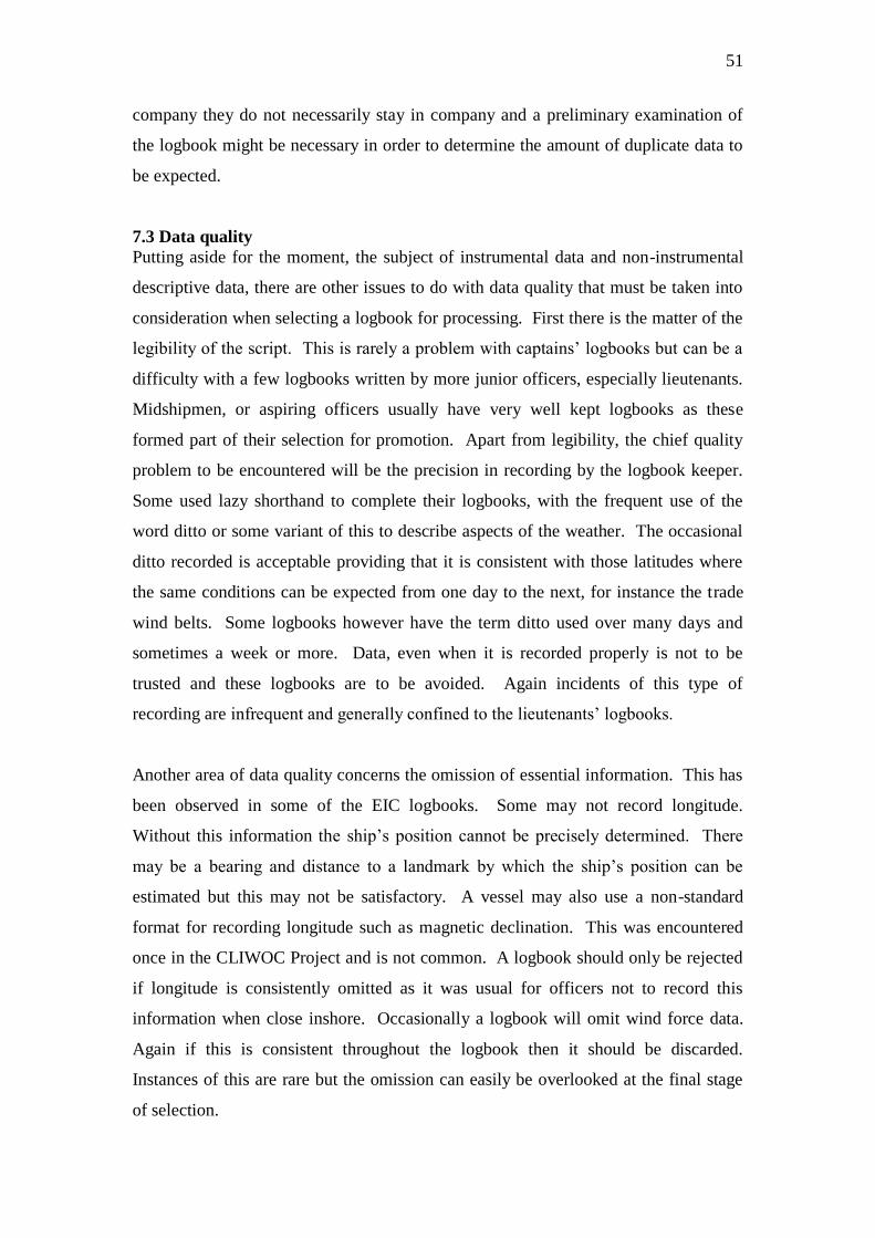
51
company they do not necessarily stay in company and a preliminary examination of
the logbook might be necessary in order to determine the amount of duplicate data to
be expected.
7.3 Data quality
Putting aside for the moment, the subject of instrumental data and non-instrumental
descriptive data, there are other issues to do with data quality that must be taken into
consideration when selecting a logbook for processing. First there is the matter of the
legibility of the script. This is rarely a problem with captains‟ logbooks but can be a
difficulty with a few logbooks written by more junior officers, especially lieutenants.
Midshipmen, or aspiring officers usually have very well kept logbooks as these
formed part of their selection for promotion. Apart from legibility, the chief quality
problem to be encountered will be the precision in recording by the logbook keeper.
Some used lazy shorthand to complete their logbooks, with the frequent use of the
word ditto or some variant of this to describe aspects of the weather. The occasional
ditto recorded is acceptable providing that it is consistent with those latitudes where
the same conditions can be expected from one day to the next, for instance the trade
wind belts. Some logbooks however have the term ditto used over many days and
sometimes a week or more. Data, even when it is recorded properly is not to be
trusted and these logbooks are to be avoided. Again incidents of this type of
recording are infrequent and generally confined to the lieutenants‟ logbooks.
Another area of data quality concerns the omission of essential information. This has
been observed in some of the EIC logbooks. Some may not record longitude.
Without this information the ship‟s position cannot be precisely determined. There
may be a bearing and distance to a landmark by which the ship‟s position can be
estimated but this may not be satisfactory. A vessel may also use a non-standard
format for recording longitude such as magnetic declination. This was encountered
once in the CLIWOC Project and is not common. A logbook should only be rejected
if longitude is consistently omitted as it was usual for officers not to record this
information when close inshore. Occasionally a logbook will omit wind force data.
Again if this is consistent throughout the logbook then it should be discarded.
Instances of this are rare but the omission can easily be overlooked at the final stage
of selection.

52
8. Integration of CLIWOC Data - Duplication
The CLIWOC team exploited only 5% of the available archive of UK logbooks with
emphasis placed heavily on the collections in the National Maritime Museum and, to
a lesser extent, the EIC logbooks in the British Library. The years covered by the
entire project were 1750 to 1850. The UK team however did not go beyond 1829 and
the period after 1810 was sparsely covered. Parts of the 1750s were also
insufficiently covered. The densest coverage was for the period 1793 to about 1807
when there was little data available from Dutch and Spanish sources due to an
extended period of successful maritime warfare on the part of the British RN. It was
necessary for the UK team to assist the other project teams to make up for this
shortfall in data.
The UK CLIWOC records were carefully preserved against future logbook projects
and it will be possible to check for duplication before any new logbooks are
processed. There will be no risk of duplication of logbooks processed for the period
after 1810 and it will not become an important consideration unless it is intended to
process additional logbooks for the period 1750-1805.
9. Royal Navy Logbooks – 1850-1899
Most of the RN logbooks for the post-1850 period will be found in the National
Archives. Additional navy and merchant logbooks can also be found amongst the
company and private papers held by the National Maritime Museum. RN logbooks in
the latter half of the 19th
century are of a very different format to those found earlier in
the century. Almost all contained detailed, sometimes hourly, instrumental data. The
instrumental observations were of temperature and air pressure. There are also some
measurements of sea temperature. Furthermore from the 1890s onwards, the nature of
the instrumentation and its location was stated. Observations of the weather were
enforced by regulation.
9.1 ADM 53 (1850-1899)
The logbooks are to be found in at the National Archives in ADM 53. These are
ships‟ logbooks kept by the officer of the watch. The collection as already noted runs
from 1799 to 1976 and consists of 180,548 separate logbooks. An approximate
number of logbooks by decade from 1850 to 1899 are provided in Table 4.
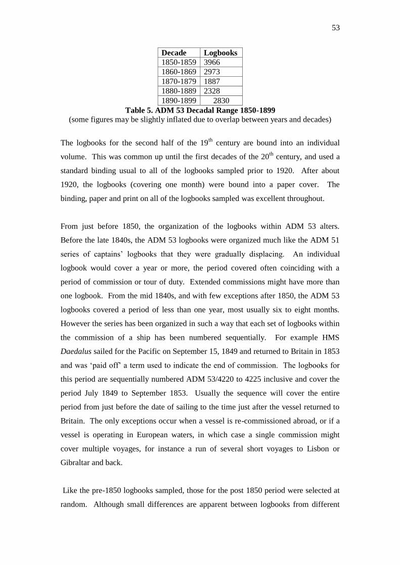
53
Decade Logbooks
1850-1859 3966
1860-1869 2973
1870-1879 1887
1880-1889 2328
1890-1899 2830
Table 5. ADM 53 Decadal Range 1850-1899
(some figures may be slightly inflated due to overlap between years and decades)
The logbooks for the second half of the 19th
century are bound into an individual
volume. This was common up until the first decades of the 20th
century, and used a
standard binding usual to all of the logbooks sampled prior to 1920. After about
1920, the logbooks (covering one month) were bound into a paper cover. The
binding, paper and print on all of the logbooks sampled was excellent throughout.
From just before 1850, the organization of the logbooks within ADM 53 alters.
Before the late 1840s, the ADM 53 logbooks were organized much like the ADM 51
series of captains‟ logbooks that they were gradually displacing. An individual
logbook would cover a year or more, the period covered often coinciding with a
period of commission or tour of duty. Extended commissions might have more than
one logbook. From the mid 1840s, and with few exceptions after 1850, the ADM 53
logbooks covered a period of less than one year, most usually six to eight months.
However the series has been organized in such a way that each set of logbooks within
the commission of a ship has been numbered sequentially. For example HMS
Daedalus sailed for the Pacific on September 15, 1849 and returned to Britain in 1853
and was „paid off‟ a term used to indicate the end of commission. The logbooks for
this period are sequentially numbered ADM 53/4220 to 4225 inclusive and cover the
period July 1849 to September 1853. Usually the sequence will cover the entire
period from just before the date of sailing to the time just after the vessel returned to
Britain. The only exceptions occur when a vessel is re-commissioned abroad, or if a
vessel is operating in European waters, in which case a single commission might
cover multiple voyages, for instance a run of several short voyages to Lisbon or
Gibraltar and back.
Like the pre-1850 logbooks sampled, those for the post 1850 period were selected at
random. Although small differences are apparent between logbooks from different
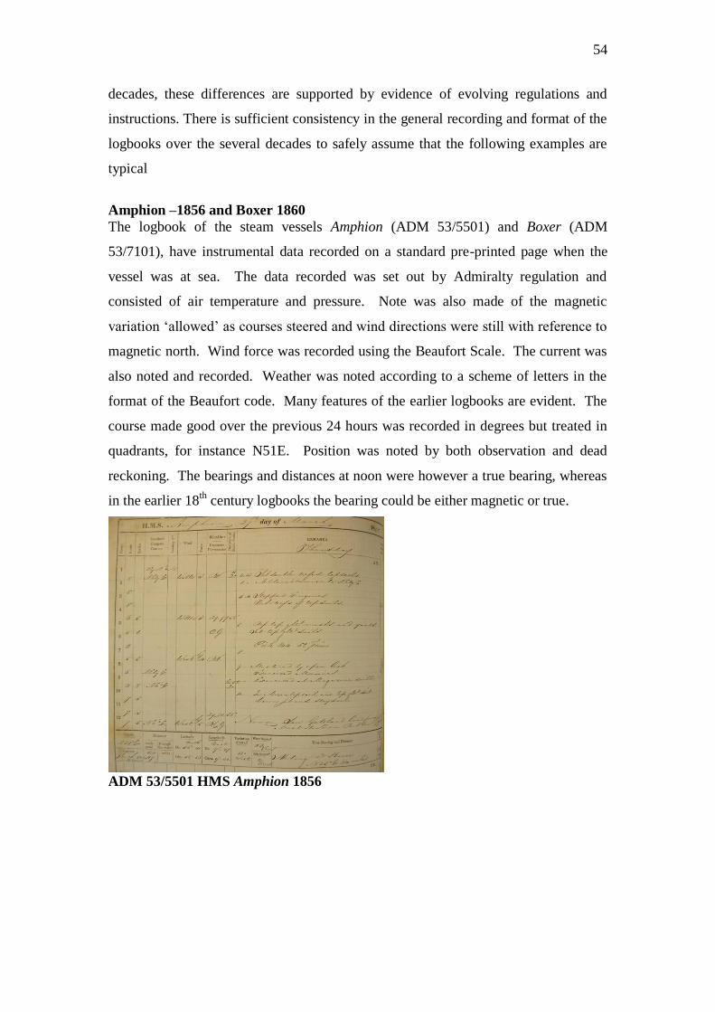
54
decades, these differences are supported by evidence of evolving regulations and
instructions. There is sufficient consistency in the general recording and format of the
logbooks over the several decades to safely assume that the following examples are
typical
Amphion –1856 and Boxer 1860
The logbook of the steam vessels Amphion (ADM 53/5501) and Boxer (ADM
53/7101), have instrumental data recorded on a standard pre-printed page when the
vessel was at sea. The data recorded was set out by Admiralty regulation and
consisted of air temperature and pressure. Note was also made of the magnetic
variation „allowed‟ as courses steered and wind directions were still with reference to
magnetic north. Wind force was recorded using the Beaufort Scale. The current was
also noted and recorded. Weather was noted according to a scheme of letters in the
format of the Beaufort code. Many features of the earlier logbooks are evident. The
course made good over the previous 24 hours was recorded in degrees but treated in
quadrants, for instance N51E. Position was noted by both observation and dead
reckoning. The bearings and distances at noon were however a true bearing, whereas
in the earlier 18th
century logbooks the bearing could be either magnetic or true.
ADM 53/5501 HMS Amphion 1856
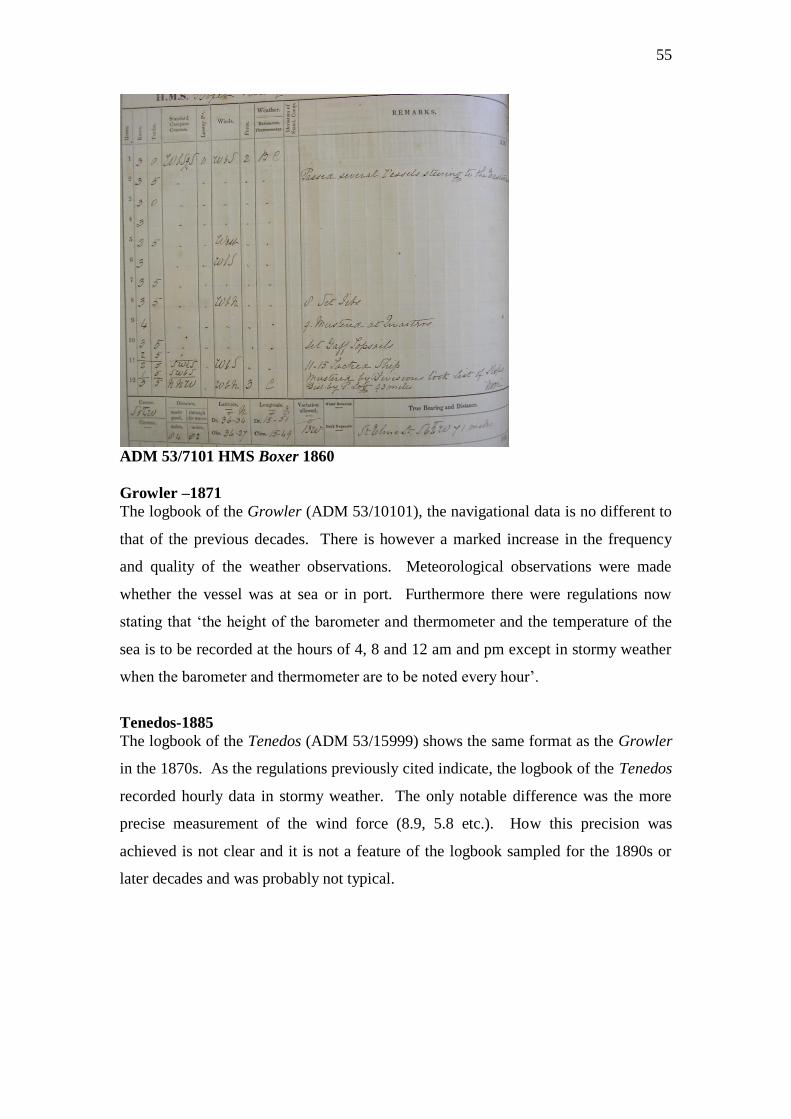
55
ADM 53/7101 HMS Boxer 1860
Growler –1871
The logbook of the Growler (ADM 53/10101), the navigational data is no different to
that of the previous decades. There is however a marked increase in the frequency
and quality of the weather observations. Meteorological observations were made
whether the vessel was at sea or in port. Furthermore there were regulations now
stating that „the height of the barometer and thermometer and the temperature of the
sea is to be recorded at the hours of 4, 8 and 12 am and pm except in stormy weather
when the barometer and thermometer are to be noted every hour‟.
Tenedos-1885
The logbook of the Tenedos (ADM 53/15999) shows the same format as the Growler
in the 1870s. As the regulations previously cited indicate, the logbook of the Tenedos
recorded hourly data in stormy weather. The only notable difference was the more
precise measurement of the wind force (8.9, 5.8 etc.). How this precision was
achieved is not clear and it is not a feature of the logbook sampled for the 1890s or
later decades and was probably not typical.
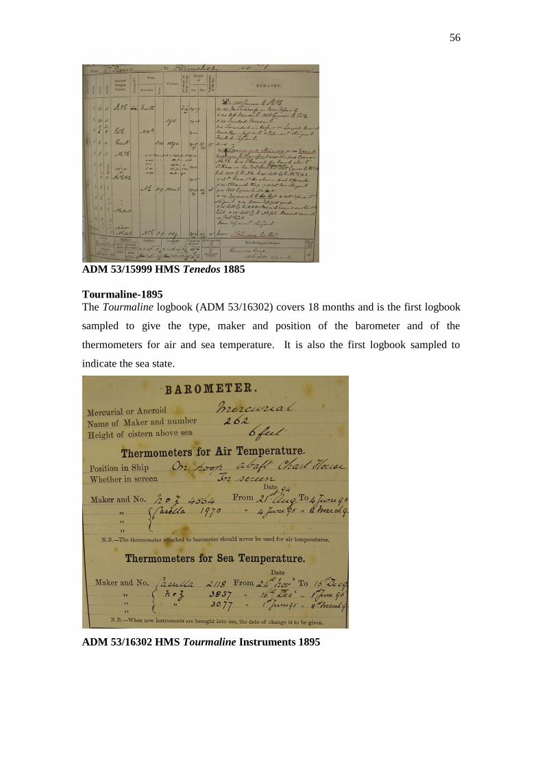
56
ADM 53/15999 HMS Tenedos 1885
Tourmaline-1895
The Tourmaline logbook (ADM 53/16302) covers 18 months and is the first logbook
sampled to give the type, maker and position of the barometer and of the
thermometers for air and sea temperature. It is also the first logbook sampled to
indicate the sea state.
ADM 53/16302 HMS Tourmaline Instruments 1895
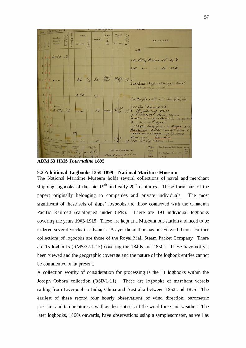
57
ADM 53 HMS Tourmaline 1895
9.2 Additional Logbooks 1850-1899 – National Maritime Museum
The National Maritime Museum holds several collections of naval and merchant
shipping logbooks of the late 19th
and early 20th
centuries. These form part of the
papers originally belonging to companies and private individuals. The most
significant of these sets of ships‟ logbooks are those connected with the Canadian
Pacific Railroad (catalogued under CPR). There are 191 individual logbooks
covering the years 1903-1915. These are kept at a Museum out-station and need to be
ordered several weeks in advance. As yet the author has not viewed them. Further
collections of logbooks are those of the Royal Mail Steam Packet Company. There
are 15 logbooks (RMS/37/1-15) covering the 1840s and 1850s. These have not yet
been viewed and the geographic coverage and the nature of the logbook entries cannot
be commented on at present.
A collection worthy of consideration for processing is the 11 logbooks within the
Joseph Osborn collection (OSB/1-11). These are logbooks of merchant vessels
sailing from Liverpool to India, China and Australia between 1853 and 1875. The
earliest of these record four hourly observations of wind direction, barometric
pressure and temperature as well as descriptions of the wind force and weather. The
later logbooks, 1860s onwards, have observations using a sympiesometer, as well as
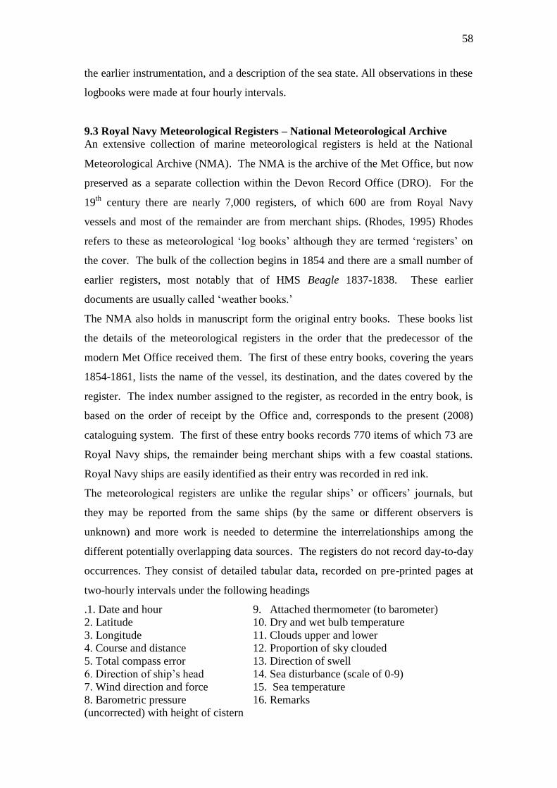
58
the earlier instrumentation, and a description of the sea state. All observations in these
logbooks were made at four hourly intervals.
9.3 Royal Navy Meteorological Registers – National Meteorological Archive
An extensive collection of marine meteorological registers is held at the National
Meteorological Archive (NMA). The NMA is the archive of the Met Office, but now
preserved as a separate collection within the Devon Record Office (DRO). For the
19th
century there are nearly 7,000 registers, of which 600 are from Royal Navy
vessels and most of the remainder are from merchant ships. (Rhodes, 1995) Rhodes
refers to these as meteorological „log books‟ although they are termed „registers‟ on
the cover. The bulk of the collection begins in 1854 and there are a small number of
earlier registers, most notably that of HMS Beagle 1837-1838. These earlier
documents are usually called „weather books.‟
The NMA also holds in manuscript form the original entry books. These books list
the details of the meteorological registers in the order that the predecessor of the
modern Met Office received them. The first of these entry books, covering the years
1854-1861, lists the name of the vessel, its destination, and the dates covered by the
register. The index number assigned to the register, as recorded in the entry book, is
based on the order of receipt by the Office and, corresponds to the present (2008)
cataloguing system. The first of these entry books records 770 items of which 73 are
Royal Navy ships, the remainder being merchant ships with a few coastal stations.
Royal Navy ships are easily identified as their entry was recorded in red ink.
The meteorological registers are unlike the regular ships‟ or officers‟ journals, but
they may be reported from the same ships (by the same or different observers is
unknown) and more work is needed to determine the interrelationships among the
different potentially overlapping data sources. The registers do not record day-to-day
occurrences. They consist of detailed tabular data, recorded on pre-printed pages at
two-hourly intervals under the following headings
.1. Date and hour 9. Attached thermometer (to barometer)
2. Latitude 10. Dry and wet bulb temperature
3. Longitude 11. Clouds upper and lower
4. Course and distance 12. Proportion of sky clouded
5. Total compass error 13. Direction of swell
6. Direction of ship‟s head 14. Sea disturbance (scale of 0-9)
7. Wind direction and force 15. Sea temperature
8. Barometric pressure 16. Remarks
(uncorrected) with height of cistern
59
The registers are consistent in format and very well kept. Importantly the registers
contain much metadata concerning the instruments, usually type and number,
position, height above sea level, etc. The necessary correction to be applied to the
observations has also been recorded. These meteorological registers will be subject to
a full inventory, including movements, dates and operating areas at a future date
(situation as 2009)
9.4 Remark Books – UK Hydrographic Office
The Hydrographic Office (UKHO) holds about 8,000 remarks books from 1759 to
1909. Remark books were kept by officers to note important matters concerned with
the management of the vessel that were not recorded in either the officer‟s or the
ship‟s deck log. These items usually related to wooding and watering the vessel, but
also included hydrographic information, sketches of landmarks, tidal and current
information and details of fortifications. The early remarks books (to the end of the
18th
century) confine themselves to those categories, but in the early to mid 1800‟s
there were increasing numbers of meteorological entries, at first in narrative form and
later (from 1816) in tabular form. By the mid 1850s/60s most remark books
contained meteorological data including pressure, temperature and SST, recorded
daily and often sub-daily. The Hydrographic Office has a basic printed list of remarks
books with the name of the vessel and year, and a detailed electronic inventory has
been produced (2008). Additional reports on the UKHO holdings can be found in the
bibliography to this report.
9.5 Locating vessels and logbooks 1850-1899
The location and short-listing of logbooks in the post 1850 to 1898 will be by the
same method as the earlier pre-1850 logbooks. The RN ship lists in ADM 8, found in
the National Archives, extend to 1893, after which, recourse can be made to the
official published Navy List. This was printed monthly and copies can be consulted in
both the National Archives‟ reference room and the library of the National Maritime
Museum. The Navy List provided information on the ship, its commanding officer
and station. There is also a brief summary of vessels by station immediately before
the main ship listing. Unlike ADM 8, it does not give the date of sailing from Britain.
More detail on the location and movements of vessels can be found in the manuscript
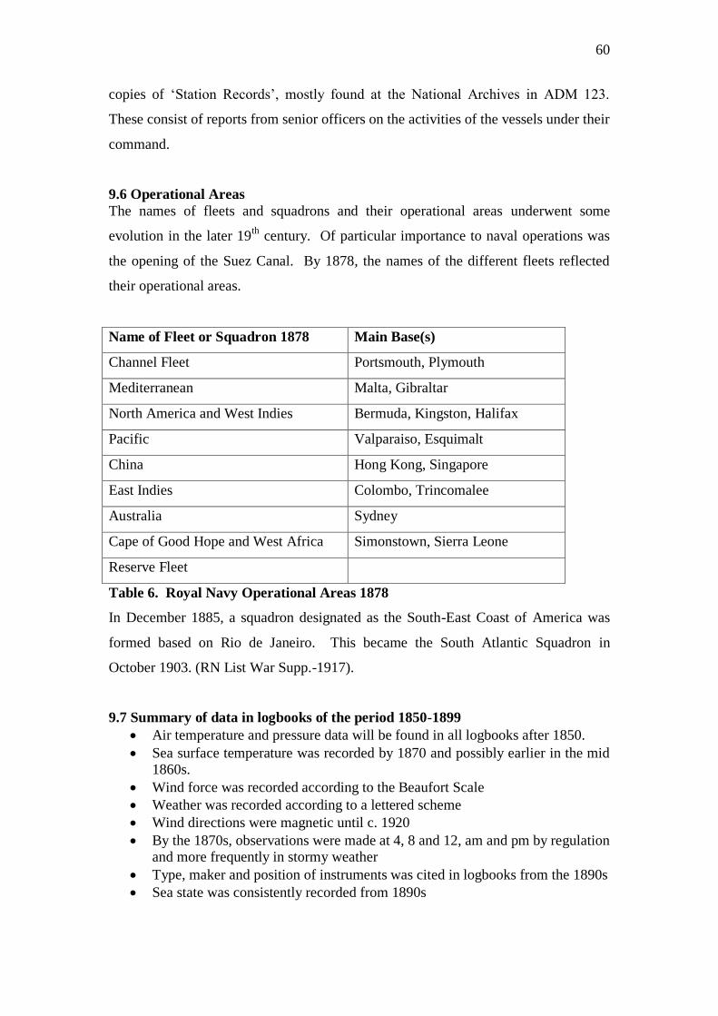
60
copies of „Station Records‟, mostly found at the National Archives in ADM 123.
These consist of reports from senior officers on the activities of the vessels under their
command.
9.6 Operational Areas
The names of fleets and squadrons and their operational areas underwent some
evolution in the later 19th
century. Of particular importance to naval operations was
the opening of the Suez Canal. By 1878, the names of the different fleets reflected
their operational areas.
Name of Fleet or Squadron 1878 Main Base(s)
Channel Fleet Portsmouth, Plymouth
Mediterranean Malta, Gibraltar
North America and West Indies Bermuda, Kingston, Halifax
Pacific Valparaiso, Esquimalt
China Hong Kong, Singapore
East Indies Colombo, Trincomalee
Australia Sydney
Cape of Good Hope and West Africa Simonstown, Sierra Leone
Reserve Fleet
Table 6. Royal Navy Operational Areas 1878
In December 1885, a squadron designated as the South-East Coast of America was
formed based on Rio de Janeiro. This became the South Atlantic Squadron in
October 1903. (RN List War Supp.-1917).
9.7 Summary of data in logbooks of the period 1850-1899
Air temperature and pressure data will be found in all logbooks after 1850.
Sea surface temperature was recorded by 1870 and possibly earlier in the mid 1860s.
Wind force was recorded according to the Beaufort Scale
Weather was recorded according to a lettered scheme
Wind directions were magnetic until c. 1920
By the 1870s, observations were made at 4, 8 and 12, am and pm by regulation and more frequently in stormy weather
Type, maker and position of instruments was cited in logbooks from the 1890s
Sea state was consistently recorded from 1890s
61
10. Whaling Logbooks
To date (2008) less than 200 whaling logbooks have been located in British archives
for the post-1800 period. The majority of these whaling ships were operating in the
Davis Straits and the seas off Greenland. Twenty-seven logbooks have been located
for other areas. Most of these other vessels were operating in the Pacific Ocean, but
some have also been found in the area of the South Shetland Islands, the Kergulen
Islands and the Antarctic. The author has not yet viewed these logbooks; therefore it
is not possible at present to report on their quality, format or the type of data recorded.
Whaling logbooks have not been collected into one archive. All of the collections are
relatively small and usually centred on the locations from which the whaling ships
sailed. The most significant numbers of whaling logbooks can be found at the
Dundee Library and Museum, the Town Docks Museum, Kingston-upon-Hull, the
Hull Local Studies Library, the National Maritime Museum, and the Scott Polar
Research Institute. Holdings, in single figures only, can also be found in the
collections of the Royal Geographical Society, the British Museum of Natural
History, Peterhead Public Library, the Gloucestershire County Records Office, and
the universities of Aberdeen, Exeter and Glasgow. It is likely that others exist,
probably not catalogued, in various UK county archive offices, universities, private
collections and small museums. Useful reference books for whaling logs are Downey
and Adams (1986) and Holland, (1982.)
11 Merchant Shipping Logbooks (excluding East India Company)
Unlike their American counterparts, British merchant shipping logbooks are few in
number. The most extensive collection is that of the EIC, discussed in detail earlier in
this report (section 1.2). Some merchant shipping logbooks exist in the National
Maritime Museum, either in the section LOG/M or scattered amongst the Museum‟s
holdings of company and private papers. Most of these date from the 18th
and 19th
centuries and have also been discussed earlier in this report (section 1.3). Small
amounts of data from merchant ships can be founded in a number of printed sources
and there is an extensive collection of 19th
century meteorological registers from
merchant ships held in the National Meteorological Archive in Exeter. See sections
3.4, 9.3 and 11.2 where these sources and collections are discussed
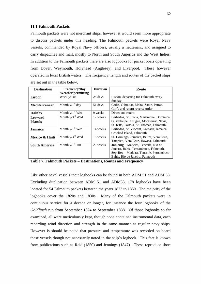
62
11.1 Falmouth Packets
Falmouth packets were not merchant ships, however it would seem more appropriate
to discuss packets under this heading. The Falmouth packets were Royal Navy
vessels, commanded by Royal Navy officers, usually a lieutenant, and assigned to
carry dispatches and mail, mostly to North and South America and the West Indies.
In addition to the Falmouth packets there are also logbooks for packet boats operating
from Dover, Weymouth, Holyhead (Anglesey), and Liverpool. These however
operated in local British waters. The frequency, length and routes of the packet ships
are set out in the table below.
Destination Frequency/Day
Weather permitting
Duration Route
Lisbon Weekly/Tue 28 days Lisbon, departing for Falmouth every
Sunday
Mediterranean Monthly/1st day 51 days Cadiz, Gibraltar, Malta, Zante, Patras,
Corfu and return reverse order
Halifax Monthly/1st Wed 9 weeks Direct and return
Leeward
Islands
Monthly/3rd
Wed 12 weeks Barbados, St. Lucia, Martinique, Dominica,
Guadeloupe, Antigua, Montserrat, Nevis,
St. Kitts, Tortola, St. Thomas, Falmouth
Jamaica Monthly/1st Wed 14 weeks Barbados, St. Vincent, Grenada, Jamaica,
Crooked Island, Falmouth
Mexico & Haiti Monthly/3rd
Wed 18 weeks St. Domingo, Jamaica, Belize, Vera Cruz,
Tampico, Vera Cruz, Havana, Falmouth
South America Monthly/1st Tue 20 weeks Jan-Aug – Madeira, Tenerife, Rio de
Janeiro, Bahia, Pernambuco, Falmouth.
Sep-Dec – Madeira, Tenerife, Pernambuco,
Bahia, Rio de Janeiro, Falmouth
Table 7. Falmouth Packets – Destinations, Routes and Frequency
Like other naval vessels their logbooks can be found in both ADM 51 and ADM 53.
Excluding duplication between ADM 51 and ADM53, 178 logbooks have been
located for 54 Falmouth packets between the years 1823 to 1850. The majority of the
logbooks cover the 1820s and 1830s. Many of the Falmouth packets were in
continuous service for a decade or longer, for instance the four logbooks of the
Goldfinch run from September 1824 to September 1838. Of those logbooks so far
examined, all were meticulously kept, though none contained instrumental data, each
recording wind direction and strength in the same manner as regular navy ships.
However is should be noted that pressure and temperature was recorded on board
these vessels though not necessarily noted in the ship‟s logbook. This fact is known
from publications such as Reid (1850) and Jennings (1847). These reproduce short
63
logbook extracts with pressure and temperature data, however the whereabouts of the
original instrumental data is presently (2008) under investigation.
11.2 Merchant Ship Meteorological Registers
As discussed in section 9.3 above, an extensive collection of marine meteorological
registers for the 19th
century is held at the National Meteorological Archive in Exeter.
Of nearly 7,000 registers, over 6,000 are from merchant ships. Their format is
described in section 9.3 above.
Several of the registers for merchant ships were examined by this author and
contained attached notes concerning the abstraction of data for research purposes.
This was carried out in „58/‟59 (presumed to be 1858/59) and 1871. Data abstracted
in the 1850s included reports of sea ice, aurora, and currents. The data abstracted in
1871 consisted of meteorological data for the tropical Atlantic in 10 deg. squares
between the latitudes of 10S and 20N. Additionally there are separate attached sheets
containing corrections. Whether these corrections are contemporary with the date of
the registers or made at the time of the later abstraction is not certain.
Rhodes (1995) reports that only four or five sets of observations were taken from
many of these meteorological registers and placed in the UK Marine Data Bank
(MDB). He does not record which sets of observations these were. However the
Manual for the Surface Marine Card Form 789 (MDB series 1-7, 1854-1953)
indicates, under series 1 for the years 1854-1920, that the set contains only reports of
wind, air and sea temperature, amount of cloud, and weather. Barometric pressure
seems to be absent. Rhodes indicates that about 1 million selective observations are
in the MDB with a further 2 million not processed. These meteorological registers are
presently only partly catalogued (2008-Royal Navy only) and a full inventory
including dates and operating areas will become available in due course.
12 Metadata
12.1 Sources of Metadata
12.1.1 Logbooks
The sources for metadata and other ancillary information needed to process historical
marine data are many and varied. Depending on the period under study, the logbook
itself will provide some of the required information. The logbook cover will usually
state the name of the ship, the range of dates covered by the logbook, the name of the
commanding officer and usually the name of the logbook keeper, if the keeper is not
64
the commanding officer. The latter point does not apply to those logbooks kept by
successive officers of the watch (ADM 53). Most late 19th
century Royal Navy
logbooks will also provide details of meteorological instruments. This information
includes the type and maker of the barometer, the height above sea level and the error.
Information on thermometers includes the maker, position and whether the instrument
is screened. Further information on meteorological instruments can be found in the
National Archive at Kew. BJ 10/6 is a register of Admiralty thermometers 1855-
1908, and BJ 10/2 is a register of Admiralty barometers 1854-1911.
12.1.2 Reference works
Metadata on ships and officers can be found in a number of standard reference books.
For the sailing ship era the most comprehensive work for RN vessels is David Lyon‟s,
Sailing Navy List. This gives all the details of RN ships built purchased or captured
from 1688 to 1860. For the period after 1860 there is Conway’s all the World’s
Fighting Ships 1860-1905. This volume describes all major navies including Britain,
the United States, Germany, Japan, France and Italy. Also for the 19th
century and
particularly good for the transitional period from sail to steam is Lyon and Winfield,
Sail and Steam Navy List 1815-1889. Farrington (1999) provides details of the size
(tonnage) and the commanding officer of most of the East India Company vessels. A
further useful volume is W. P. Gossset, The Lost Ships of the Royal Navy 1793-1900.
Knowing that a ship was lost will explain the absence of a logbook or the sudden
termination of a sequence of logbooks.
If the name of a commanding officer or logbook keeper is required, the most
unambiguous source is the logbook itself. Another source for these names is the
printed Navy List, produced monthly from the late 18th
century onwards. Copies of
the Navy List are readily available in both the National Archive and the National
Maritime Museum. A further source for the early period is the Commissioned Sea
Officers List 1688-1815, published by the Navy Records Society. The National
Archive holds a manuscript copy of this list that has been annotated with the names of
the ships the officers served on or commanded, with approximate dates (Jones, 1950).
Whenever possible however, the logbook itself should be the primary source of this
information.
65
12.2 Types of Metadata
12.2a Ship Name
It is usual to find the name of a vessel on all logbooks. With early logbooks there can
be alternative spellings of ship names, which one should be alert to (e.g. Enterprise
and Enterprize, or Cameleon and Camelion [for Chameleon]). Search engines within
archive catalogues may modernize a name or omit alternative spellings and it should
not be assumed that a logbook does not exist when a search produces a negative
result. This can be a particular problem when early British warships (originally
captured from an enemy) retain a form of their foreign name. One should also be
aware of the use of special characters such as „æ‟ (Megæra) or ç (Curaçoa) in some
on-line catalogues, which if not used can bring up a negative search result. Where
one suspects the use of such special characters, some imaginative search options using
„*‟ instead of the special character will usually produce a positive result. Over a
period of time, there will be a duplication of names and it should not be assumed that
ships with the same name are the same vessel. If dealing with an extended time
period, it is usual to append the date of launch to the vessel‟s name, for example,
Victory (1765). This method is unambiguous and absolutely necessary during war
periods when vessels may be lost and a new ship, then building, is assigned the name
of the lost vessel. Duplication of names of vessels co-existing will not usually occur
with the Royal Navy although there are very infrequent exceptions. A captured vessel
may be commissioned abroad and inadvertently given a name already in use.
Furthermore it is not unknown for a vessel to have its name changed. Such
circumstances can easily be checked against standard reference works, such as
Winfield (2005 & 2007) and Lyon and Winfield (2004) are12.2 best for this.
Duplication of names will occur between vessels of the Royal Navy and the East India
Company and it is therefore important to distinguish the owner or operator of the
vessel. Furthermore many East Indiamen were chartered and there are co-existing
EIC ships with the same name. Farrington (1999) provides a number to differentiate
between ships of the same name (example York 3, York 4).
12.2b Tonnage
Tonnage will give the relative size of the vessel. With sailing ships however, tonnage
was based on builder‟s measurements and did not refer to displacement. Tonnage by
builder‟s measurement was determined by a standard formula using the length of keel,
extreme breadth and the depth of the hold. Essentially it was a measurement of
66
carrying capacity but in the sailing ship era was applied to both warships and
merchant vessels. The dimensions used to work out the tonnage were the same for
different nations, however each used a slightly different formula. For instance in the
early 19th
century, if a British and American ship were registered as the same tonnage,
the American vessel would have slightly larger dimensions.
12.2c. Dimensions
The dimensions, available for most sailing vessels, are length of keel, extreme
breadth, and depth of hold. These were the dimensions used to calculate the tonnage.
For later vessels, in particular the steam era, extreme length and breadth, length
between perpendiculars and depth (below waterline) were usual.
12.2d. Ownership of Vessel
It is important to distinguish between naval and merchant vessels especially as there is
likely to be a duplication of ship names.
12.2e. Builder/Launch
The building details of vessels are the name of the builder and the location of the dock
or slipway, the date the ship was ordered or begun, the date of launch and sometimes
the date of completion. The year of launch is often useful to distinguish between
ships of the same name.
12.2f. Fate/Disposal
The details concerning the fate of a vessel can often explain the absence of a logbook
and prevent an unnecessary search
12.2g. Type of Vessel
Knowing the type of vessel is useful in determining the sorts of duties it would have
performed. This can then be used to judge the amount of activity and sea time one can
expect to find recorded in the logbook. Table 10 lists the types of vessels in the age
of sail.

67
Type of vessel Number
of guns
Typical duties
Ship of the Line 100-50 Blockade, fleet battle
Frigate 50-24/20 Cruising, commerce raiding,
repeating signals during fleet
battle.
Sloop 24/20-18 Cruising, commerce raiding,
exploration
Brig 18-12 Cruising, carrying despatches
Cutter 12-6 Revenue protection, carrying
despatches
Schooner 8-4 Revenue protection, carrying
despatches
Bomb vessel 1or 2
mortars
Bombardment
Storeship Supplying stores to fleets, ships
and colonies
Troopship Moving troops
Guardship 100-50 Commissioned warship kept in an
advanced state of readiness
Hulk
Lazarette
Prison ship
Powder hulk
Receiving ship
Sheer hulk
Harbour duties only.
Table 8. Types of Early Warship
In the age of steam and before the 20th
century, the categories are battleship, turret
ship, ironclad, armour-plated ship, cruisers of various classes, sloops, gunboats,
torpedo boats, troopships and storeships.
12.2h. Number of Guns
The number of guns carried on board a vessel in the age of sail gives a good
indication of the type and size of the vessel. The designated number of guns assigned
to Royal Navy vessels was not necessarily the total carried on board. The designated
number of guns fixed the vessel within a specific „rate‟ or administrative category so
that the proper number of officers, men, provisions, stores and rates of pay could be
allocated. A full, or „post captain‟ commanded a „rated‟ vessel. A „fifth rate‟ thirty-
eight gun frigate for instance could carry up to 46 guns, the additional eight being
made up of carronades, which were special short range ordnance. The official „rate‟,
based on the number of standard guns carried, was well understood and it was usual to
distinguish between types of vessels merely on the number of ordnance carried as per
the table following
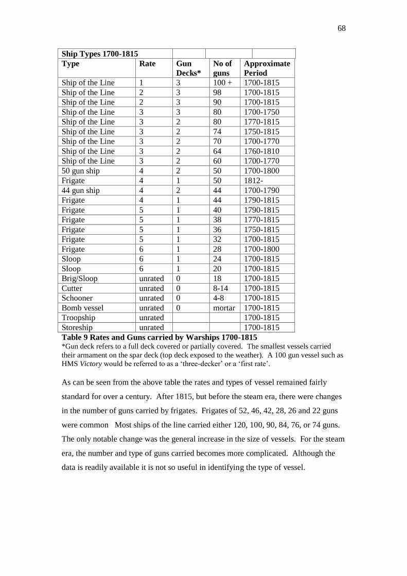
68
Ship Types 1700-1815
Type Rate Gun
Decks*
No of
guns
Approximate
Period
Ship of the Line 1 3 100 + 1700-1815
Ship of the Line 2 3 98 1700-1815
Ship of the Line 2 3 90 1700-1815
Ship of the Line 3 3 80 1700-1750
Ship of the Line 3 2 80 1770-1815
Ship of the Line 3 2 74 1750-1815
Ship of the Line 3 2 70 1700-1770
Ship of the Line 3 2 64 1760-1810
Ship of the Line 3 2 60 1700-1770
50 gun ship 4 2 50 1700-1800
Frigate 4 1 50 1812-
44 gun ship 4 2 44 1700-1790
Frigate 4 1 44 1790-1815
Frigate 5 1 40 1790-1815
Frigate 5 1 38 1770-1815
Frigate 5 1 36 1750-1815
Frigate 5 1 32 1700-1815
Frigate 6 1 28 1700-1800
Sloop 6 1 24 1700-1815
Sloop 6 1 20 1700-1815
Brig/Sloop unrated 0 18 1700-1815
Cutter unrated 0 8-14 1700-1815
Schooner unrated 0 4-8 1700-1815
Bomb vessel unrated 0 mortar 1700-1815
Troopship unrated 1700-1815
Storeship unrated 1700-1815
Table 9 Rates and Guns carried by Warships 1700-1815 *Gun deck refers to a full deck covered or partially covered. The smallest vessels carried
their armament on the spar deck (top deck exposed to the weather). A 100 gun vessel such as
HMS Victory would be referred to as a „three-decker‟ or a „first rate‟.
As can be seen from the above table the rates and types of vessel remained fairly
standard for over a century. After 1815, but before the steam era, there were changes
in the number of guns carried by frigates. Frigates of 52, 46, 42, 28, 26 and 22 guns
were common Most ships of the line carried either 120, 100, 90, 84, 76, or 74 guns.
The only notable change was the general increase in the size of vessels. For the steam
era, the number and type of guns carried becomes more complicated. Although the
data is readily available it is not so useful in identifying the type of vessel.
69
12.2i. Propulsion
The data available for ships of the 19th
century steam era are number and type of
engine, horsepower, number of shafts and maximum speed. Propulsion by paddle
wheel will also be noted if applicable
13. Items of Unusual or Exceptional Interest
The tens of thousands of logbooks in British archives will yield every imaginable
permutation of weather conditions and associated incidents. As such, marine
logbooks represent a rich resource for both the climatologist and the maritime
historian (Wilkinson, 2005). There are many interesting datasets and data series that
can be compiled from particular groupings of logbooks. This is only possible through
a resource such as the Logbook Directory, which allows such sets to identified. In
fact it was through the construction of the Directory that particular data series were
identified and this section of the Report aims to bring attention to some of these.
Furthermore, individual ships would on occasion experience severe or unusual
weather and even suffer loss due to shipwreck or foundering. An excellent example
of an important weather event being noted in a logbook is the case of HMS
Andromache. In July 1795, the Andromache sailed through the eye of a hurricane off
Bermuda. Every change of wind direction and force during the hurricane was noted
along with descriptions of the considerable damage to the ship. Another example of a
more general nature concerns very stormy weather off the Cape of Good Hope. In
April 1801, the East India Company ship Aurora sailed from Kedgeree for St. Helena.
(British Library L/MAR/B/228A) Her passage took an incredible 142 days. The
Aurora spent several weeks in severe stormy weather attempting to round the Cape of
Good Hope and was forced to take refuge at St. Augustine, Madagascar before
resuming her passage to St. Helena. Wherever possible such useful facts have been
noted in the Logbook Directory. The following datasets have been identified as being
of potential interest.
13.1 Pacific Ocean 19th
Century
During the 19th
century there was an increasing amount of Royal Navy activity in the
Pacific Ocean. A regular presence was established in the 1830s by vessels officially
attached to the South American Station. By 1838, there was a separate Pacific station,
designated in the fleet lists. The vessels attached to this station, usually six to ten in

70
number, were based in the eastern Pacific at Valparaiso. By the 1850s there were a
dozen or more vessels in the eastern Pacific on a permanent basis. By the late 1850s,
a northern and southern division was established, one based on Esquimalt on the west
coast of Canada, the other at Valparaiso. The extent of cruising on the Pacific station
covered the coasts of North, Central and South America, as far south as Cape Horn,
and cruising in the vicinity of the Galapagos and Hawaiian Islands was usual. A
crossing of the Pacific towards China or Australia was rare but not unknown.
Activity in the Western Pacific is less easy to determine from the station lists until the
re-organization of the listings in the 1850s. At this time the vague and extensive
station of the East Indies had been further divided into the China Station, based on
Hong Kong, and the Australia station based on Sydney and including New Zealand.
For instance in February 1872, 10 vessels were stationed in the Pacific (eastern), 23
vessels on the China station, 5 for Australia with a further two survey ships operating
off China and Japan. These numbers are exclusive of any store ships or troopships
operating between these stations and Britain. It should also be noted that instrumental
data, mainly air temperature and barometric pressure will be found in these logbooks
after 1850 and in some instances before that date. Sea surface temperature is recorded
by 1870 and, possibly earlier in the mid 1860s.
13.2 Stationary Ships
At certain points around the globe stationary base ships were established to provide a
command centre, a depot, store or barracks. Although the vessels designated to these
tasks rarely went to sea, a logbook was kept in precisely the same manner as seagoing
ships. With a few exceptions, most of these logbooks have survived. Wind direction
and wind force was recorded in accordance with the regulations at the time, although
until the mid 1860s there was no requirement to keep a record of air temperature and
barometric pressure while in port. Nevertheless these vessels provide extended
uninterrupted periods of weather and wind observations from fixed points, though
subject to interference by land mass and other boundary layer factors. From about the
mid 1860s and certainly by 1870, temperature and pressure data can be expected. In
some instances a meteorological register was kept. These are now in the National
Meteorological Archive in Exeter. The names locations and temporal coverage of
most stationary ships for the 19th
century is provided in the table below.

71
Name of Ship Type of Vessel Location Dates
Nerus Storeship Valparaiso 1844-1879
Naiad Depot ship Callao 1847-1865
Liffey Storeship Coquimbo 1878-1902
Alligator Hospital ship Hong Kong 1846-1865
Minden Hospital ship Hong Kong 1845-1861
Hercules Depot Hong Kong 1853-1865
Melville Hospital ship Hong Kong 1857-1873
Princess Charlotte Receiving ship Hong Kong 1857-1875
Meeanee Hospital ship Hong Kong 1868-1906
Wivern or Wyvern Guardship Hong Kong 1880-1922
Tortoise Depot ship Ascension Island 1844-1859
Meander Depot ship Ascension Island 1860-1866
Flora Depot ship Ascension Island 1866-1872
Dromedary Receiving ship Ascension Island 1867-
Seringapatam Coal depot Cape of Good Hope 1847-1872
Flora Depot ship Cape of Good Hope 1872-1891
Crescent Receiving ship Rio de Janeiro 1840-1854
Madagascar Receiving ship Rio de Janeiro 1854-1863
Egmont Receiving ship Rio de Janeiro 1863-1874
Isis Coal depot Sierra Leone 1861-1867
Vindictive Depot ship Fernando Po (Jellah) 1862-1871
Magnificent Convict ship
Receiving ship
Jamaica 1826-1838
1838-
Imaum Receiving ship Jamaica 1842-1862
Marianne? Receiving ship Jamaica 1858-1867
Aboukir Receiving ship Jamaica 1865-1877
Urgent Receiving ship Jamaica 1877-1903
Irresistible Receiving ship Bermuda 1868-1894
Terror Floating battery
Base ship
Bermuda 1857-1871
1871-1907
Pyramus Receiving ship Halifax 1832-1879
Romney Receiving ship Havana 1837-1846+
Hibernia Base ship Malta 1855-1902
Table 10 Global Distribution of RN Stationary Ships - 1844-1922
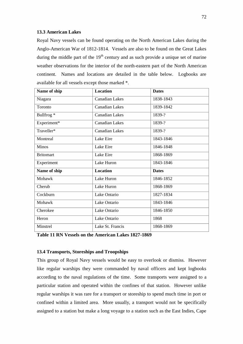
72
13.3 American Lakes
Royal Navy vessels can be found operating on the North American Lakes during the
Anglo-American War of 1812-1814. Vessels are also to be found on the Great Lakes
during the middle part of the 19th
century and as such provide a unique set of marine
weather observations for the interior of the north-eastern part of the North American
continent. Names and locations are detailed in the table below. Logbooks are
available for all vessels except those marked *.
Name of ship Location Dates
Niagara Canadian Lakes 1838-1843
Toronto Canadian Lakes 1839-1842
Bullfrog * Canadian Lakes 1839-?
Experiment* Canadian Lakes 1839-?
Traveller* Canadian Lakes 1839-?
Montreal Lake Eire 1843-1846
Minos Lake Eire 1846-1848
Britomart Lake Eire 1868-1869
Experiment Lake Huron 1843-1846
Name of ship Location Dates
Mohawk Lake Huron 1846-1852
Cherub Lake Huron 1868-1869
Cockburn Lake Ontario 1827-1834
Mohawk Lake Ontario 1843-1846
Cherokee Lake Ontario 1846-1850
Heron Lake Ontario 1868
Minstrel Lake St. Francis 1868-1869
Table 11 RN Vessels on the American Lakes 1827-1869
13.4 Transports, Storeships and Troopships
This group of Royal Navy vessels would be easy to overlook or dismiss. However
like regular warships they were commanded by naval officers and kept logbooks
according to the naval regulations of the time. Some transports were assigned to a
particular station and operated within the confines of that station. However unlike
regular warships it was rare for a transport or storeship to spend much time in port or
confined within a limited area. More usually, a transport would not be specifically
assigned to a station but make a long voyage to a station such as the East Indies, Cape
73
or Australia, unload, return to Britain and then load again for a return voyage. As
such the logbooks of these vessels will usually contain much sea time in far-flung
quarters of the globe. The number of transports used by the navy generally increased
from just after the middle of the 19th
century. With the establishment of bigger and
more permanent bases in such places as Bombay, Singapore and Hong Kong, it
became common for most warships to remain on station for long periods of time
(sometimes decades) rather than return to Britain at the end of a commission. With
warships re-commissioning abroad and remaining on station for extended periods of
time, it became necessary for fresh crews to be sent out in transports.
Troopships and storeships were usually conversions of older warships, redundant due
to age or inferior dimensions. Others were purchased merchant ships and a few were
purpose built. In the 18th and 19
th centuries there was a pattern to giving names to
these vessels, suggestive in some instances of their function. This fact can often assist
in identifying and selecting a logbook. In the late 18th
and early 19th
centuries,
common names for storeships were Abundance, Supply, Camel, and Dromedary.
Less suggestive but equally common names were Hindostan, Buffalo and Adventure.
From the late 1860s onwards there were particular vessels that plied regularly
between Britain, Africa and the Far East, or within the eastern stations. These were
the storeships Supply, Industry and Tyne. The troopships making regular journeys to
the East Indies and China with fresh Royal Navy crews were the Himalaya, Simoom,
Urgent, Megaera, Orontes and Tamar. There was also a dedicated India Transport
Service made up of five troopships. From 1867, the Crocodile and Serapis operated
for the most part in the Mediterranean sailing from Britain towards Port Said. The
Malabar (1867-1885), Jumna (1867-1887), and Euphrates (1867-1884) operated
mostly in the eastern seas until the opening of the Suez Canal allowed rapid access
from European waters to the East. The India Transport service vessels were not
warship conversions but purpose built troop carriers operated by the Royal Navy. The
logbooks of all of these vessels have survived. It should also be added that the main
19th
century period of Arctic exploration saw storeships being sent into high northern
latitudes to re-supply exploration vessels between the 1820s and 1850s.
74
13.5 Indian Navy
The India Office Collection of the British Library holds nearly fifty logbooks of
vessels of the Indian Navy in the 1840s and 1850s. These vessels were commanded
by English officers. The extent of operation is mostly the Arabian and Persian Gulf,
Suez and Bombay.
REFERENCES AND BIBLIOGRAPHY Chesneau, R. & E. Kolesnik, 1979: Conway’s all the World’s Fighting Ships 1860-1905,
(London)
CLIWOC, 2003: Multi-lingual Meteorological Dictionary (KNMI)
CLIWOC, The CLIWOC database (http://www.ucm.es/info/cliwoc/)
Clowes, Sir W. L., 1897-1903: The Royal Navy, a history, 7 vols. (London)
Dalrymple, A., 1778: „The Voyage of the EICS Grenville 1775‟, Philosophical Transactions
of the Royal Society, (vol. 68).
Downey, J & V. Adam, 1986: Whaling Log and Journals 1613-1927 (London)
Farrington, A., 1999: Catalogue of East India Company Ships’ Journals and Logs
1600-1834 (British Library)
Alexander Findlay, 1851: A Directory for the Navigation of the Pacific Ocean, 2 vols.
(London).
Flinders, Mathew 1806: „Observations on the Marine Barometer 1801-3‟, Philosophical
Transactions of the Royal Society.
García-Herrera, R., P. Jones, D. Wheeler, G. Können, and M.R. Prieto (Guest Eds.), 2005:
CLIWOC: Climatology of the World's Oceans, 1750-1850 (Special Issue). Clim. Change, 73,
1-194.
Gosset, P. 1986: The Lost Ships of the Royal Navy 1793-1900 (London)
Gough, B., 1971: The Royal Navy and the Northwest Coast of North America, 1810-1914,
(Vancouver).
Holland, C., 1982: Manuscripts in the Scott Polar Research Institute.
Horsburgh, J., 1817: India directory: or directions for sailing to and from the East Indies,
China, New Holland, Cape of Good Hope, Brazil and the interadjacent ports, (London)
James, W., 1850: The Naval History of Great Britain, 6 vols. (London).
Jennings E., 1843: Hints on Sea Risks (London)
Jones, C. G. P., 1950: Commissioned Sea Officers of the Royal Navy 1660-1815. 15 vols.
(annotated copy, National Archives, Kew.)
75
Jonkers, A.R.T., 2005: „Parallel Meridians: Diffusion and Change in Early-Modern
Oceanic Reckoning‟, J. Parmentier, Noord-Zuid in Oost-Indisch Perspectif (Hague)
Lyon, D., 1993: The Sailing Navy List 1688-1860, (London)
Lyon D, & R. Winfield, 2004: The Sail and Steam Navy List 1815-1889 (London).
Maury, M. F. 1851: Explanations and Sailing Directions to accompany the Wind and Current
Charts (Washington).
Nautical Magazine (1845)
Pacific Manuscripts Bureau (PMB), Index to Source Material on British Naval Vessels in the
Pacific Islands .... 1800-1900 (C. Dengate, Australian National University) Microfilm
(MRF/156/1-2, National Maritime Museum, Greenwich)
Porter, David, 1823: A Voyage in the South Seas in the years 1812, 1813 and 1814 (London)
Purdy, J. 1853: Memoir Descriptive to accompany the charts of the North Atlantic Ocean
(London)
Purdy, J. 1855: Sailing Directions for the Ethiopic or South Atlantic Ocean (London)
Reid, W. 1850: An Attempt to Develop the Law of Storms (London)
Reynolds, J. 1835: Voyage of the United States Frigate Potomac (New York)
Rhodes, M., „Additional Logbook Data 1854-1899 (unpublished NOAA/CDMP report,
1995). Available on http://icoads.gov/reclaim/
Rosser & Imray, 1866: The Indian Ocean Directory (London)
Royal Navy List – Special War Supplement, Jan 1917. (NMM Ref. 940.459(42) Roy P4460)
Scoresby, William 1819: Account of the Arctic Regions (London)
Seller, J., 1675: The English Pilot (London)
Shadwell, C. F. 1861: Notes on the Management of Chronometers and the Measurement of
Meridian Distances (London)
Taylor, E.G.R., 1971: The Haven Finding Art (London), 228-231.
Tizard, T.H., 1900: Chronological List of Officers conducting British Maritime Discoveries
and Surveys, together with the Names of the Vessels Employed, from the Earliest times until
1900 (publication 174, Hydrographic Department, London)
Toogood, C., 1895 &1971: Index to James Naval History, (London).
UK Met Office, „Surface Marine Card Form 789‟, Series 1-7 (1854-1953; Card Form 789)
[http://icoads.noaa.gov/reclaim/pdf/mdb_series 1-7.pdf]
Weddell, James 1827: A Voyage towards the South Pole performed in the Years 1822-24
(London)
76
Wheeler, D., 2005: „An Examination of the Accuracy and Consistency of Ships‟ Logbook
Weather Observations and Records‟, Climatic Change 73, 97-116.
Wilkinson, C., 2005: The Non-Climatic Research Potential of Ships‟ Logbooks and Journals,
Climatic Change 73, 155-167.
Wilkinson, C., 2009: British Logbooks in UK Archives, 20th Century: A survey of the range,
selection and suitability of British logbooks and related documents for climatic research.
Unpublished NOAA/CDMP report.
Wilkinson, C, C. Ward & F. Williamson, 2008: Report on the Royal Navy Remark Books
held at the Hydrographic Office, Taunton, UK. Unpublished NOAA/CDMP report.
Winfield, R., 2005: British Warships in the Age of Sail 1793-1817 (London).
Winfield, R., 2007: British Warships in the Age of Sail 1714-1792 (London)
Woodruff, S.D., H.F. Diaz, S.J. Worley, R.W. Reynolds, and S.J. Lubker, 2005: Early ship
observational data and ICOADS. Climatic Change, 73, 169-194.
APPENDIX I
Table of abbreviations and notation in early logbooks
Ac., Acc. or
Acct.
Account or estimate. Refers to the latitude or longitude having been
determined by dead reckoning or account.
am Period from midnight to noon. In logbooks kept according to the
nautical day, the am formed the latter part of the day.
Amp. Amplitude. An observation of a celestial body usually performed to
determine the magnetic variation of the compass
Azm. Azimuth. An observation of a celestial body usually performed to
determine the magnetic variation of the compass
Chron., Chro. Marine chronometer. Used to indicate that the longitude has been
determined by reference to a timekeeper.
Dep. Departure. The last sighting of a recognized landmark, usually used
as a zero meridian
Diff. Lon. Difference in longitude from the previous day
DR. Dead Reckoning. An estimate of the vessel‟s position based on
course and speed, with corrections for leeway, drift and magnetic
variation.
E Eastings. The distance a vessel has made in an easterly direction as
determined from a traverse table. A traverse table was a running
account of courses and speed.
F Fathom. Refers to the vessel‟s speed at one-eighth part of a knot or
nautical mile. In the later 19th
century, the term referred to one-tenth part of a knot. The term is also used in the same sense when
measuring the velocity of a current.
First part First part of the day. In logbooks kept according to the nautical day,
the first part was the period from noon to 8pm.
H Hour. Found at the head of the column where the hour of the day is
noted
77
K Knot. Refers to the vessel‟s speed in nautical miles per hour
Lat. Acc. Latitude by account. An estimate of the ship‟s latitude by dead
reckoning.
Latter part Latter part of the day. In logbooks kept according to the nautical day,
the latter part was the period from 4am to noon.
Lon. in Longitude by the Greenwich meridian
Lon. mde Longitude made. Distance in degrees and minutes from the zero
meridian
Lun. Lunar. Refers to the vessel‟s longitude being determined by a lunar
observation.
M+D Meridian + Distance. Longitude made. Distance in degrees and
minutes from the zero meridian expressed as leagues or degrees of a
fixed length irrespective of latitude. (indicating the use of plane charts
as opposed to mercator charts)
Middle part Middle part of the day. In logbooks kept according to the nautical
day, the middle part was the period from 8pm to 4am.
N Northings. The distance a vessel has made in a northerly direction as
determined from a traverse table. A traverse table was a running
account of courses and speed.
No obs. No observation. Indicates that, no celestial observation was possible
due to the state of the sky. The ship‟s position is often absent though
there may be a dead reckoning estimate.
Ob. Observed. Indicates that the vessel‟s position has been determined by
an observation, solar or lunar, as opposed to an estimate by dead
reckoning
pm Period from noon to midnight. In logbooks kept according to the
nautical day, am will form the first part of the day.
S Southings. The distance a vessel has made in a southerly direction as
determined from a traverse table. A traverse table was a running
account of courses and speed.
Second part Middle part of the day. In logbooks kept according to the nautical
day, the second or middle part was the period from 8pm to 4am.
TK Marine timekeeper or chronometer. Used to indicate that the
longitude has been determined by reference to a timekeeper.
Var. Variation. A term used for the magnetic declination of the ship‟s
compass
W Westings. The distance a vessel has made in a westerly direction as
determined from a traverse table. A traverse table was a running
account of courses and speed.
X Lat. Difference in latitude from the previous day
X Lon. Difference in longitude from the previous day
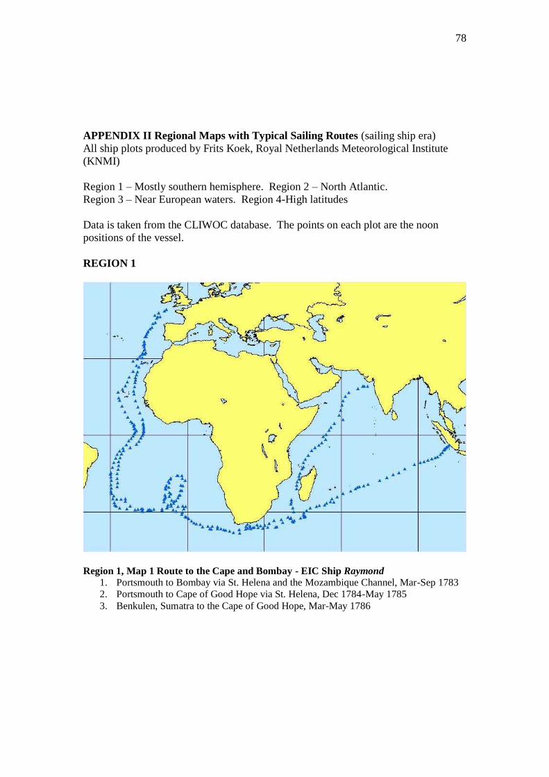
78
APPENDIX II Regional Maps with Typical Sailing Routes (sailing ship era)
All ship plots produced by Frits Koek, Royal Netherlands Meteorological Institute
(KNMI)
Region 1 – Mostly southern hemisphere. Region 2 – North Atlantic.
Region 3 – Near European waters. Region 4-High latitudes
Data is taken from the CLIWOC database. The points on each plot are the noon
positions of the vessel.
REGION 1
Region 1, Map 1 Route to the Cape and Bombay - EIC Ship Raymond
1. Portsmouth to Bombay via St. Helena and the Mozambique Channel, Mar-Sep 1783
2. Portsmouth to Cape of Good Hope via St. Helena, Dec 1784-May 1785
3. Benkulen, Sumatra to the Cape of Good Hope, Mar-May 1786

79
Region 1, Map 2 Route to Madras - EIC Ship Britannia
Downs to Madras May-Sep 1802
Region 1, Map 3 Route to Bengal and onward to China– EIC Ship George IV
1. Downs to Saugor Roads, Feb-Jun 1828
2. Saugor Roads towards China via the Malacca Straits, Aug-Sep 1828
3. Java Head to Downs via St. Helena, Feb-May 1829
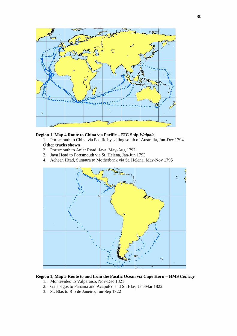
80
Region 1, Map 4 Route to China via Pacific – EIC Ship Walpole 1. Portsmouth to China via Pacific by sailing south of Australia, Jun-Dec 1794
Other tracks shown
2. Portsmouth to Anjer Road, Java, May-Aug 1792
3. Java Head to Portsmouth via St. Helena, Jan-Jun 1793
4. Acheen Head, Sumatra to Motherbank via St. Helena, May-Nov 1795
Region 1, Map 5 Route to and from the Pacific Ocean via Cape Horn – HMS Conway 1. Montevideo to Valparaiso, Nov-Dec 1821
2. Galapagos to Panama and Acapulco and St. Blas, Jan-Mar 1822
3. St. Blas to Rio de Janeiro, Jun-Sep 1822
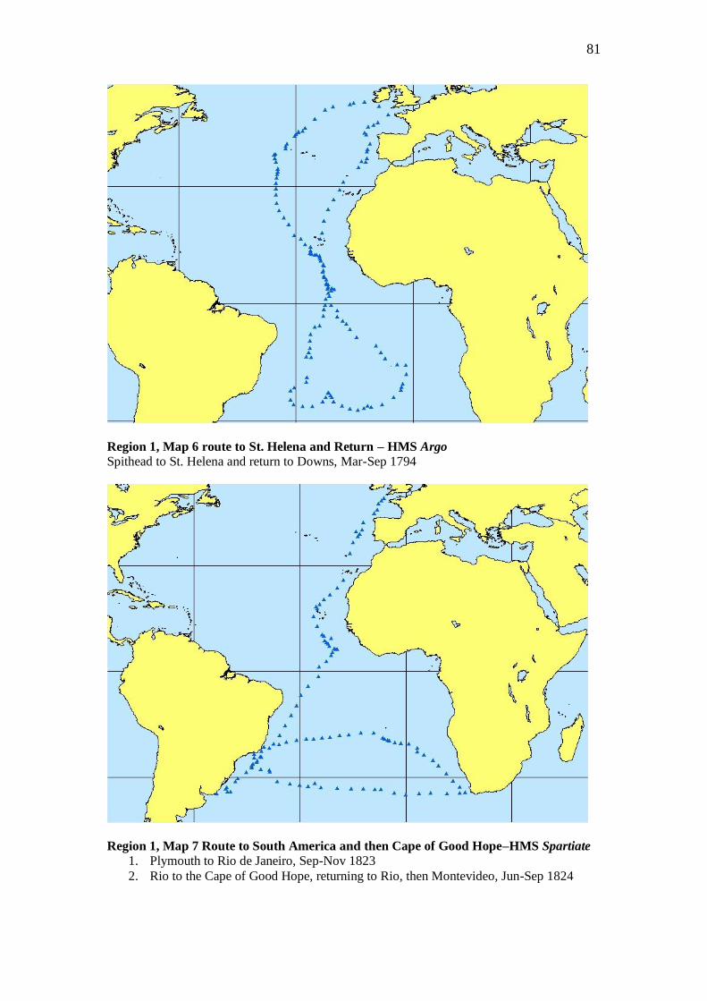
81
Region 1, Map 6 route to St. Helena and Return – HMS Argo
Spithead to St. Helena and return to Downs, Mar-Sep 1794
Region 1, Map 7 Route to South America and then Cape of Good Hope–HMS Spartiate
1. Plymouth to Rio de Janeiro, Sep-Nov 1823
2. Rio to the Cape of Good Hope, returning to Rio, then Montevideo, Jun-Sep 1824
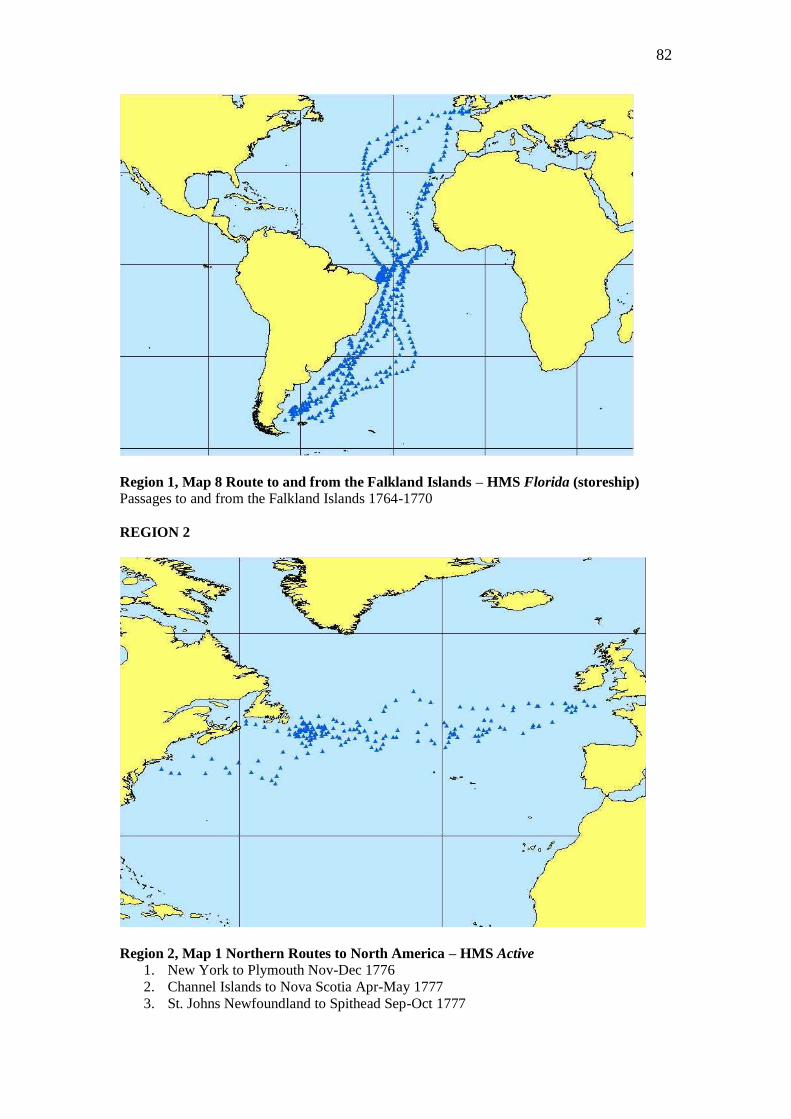
82
Region 1, Map 8 Route to and from the Falkland Islands – HMS Florida (storeship)
Passages to and from the Falkland Islands 1764-1770
REGION 2
Region 2, Map 1 Northern Routes to North America – HMS Active 1. New York to Plymouth Nov-Dec 1776
2. Channel Islands to Nova Scotia Apr-May 1777
3. St. Johns Newfoundland to Spithead Sep-Oct 1777
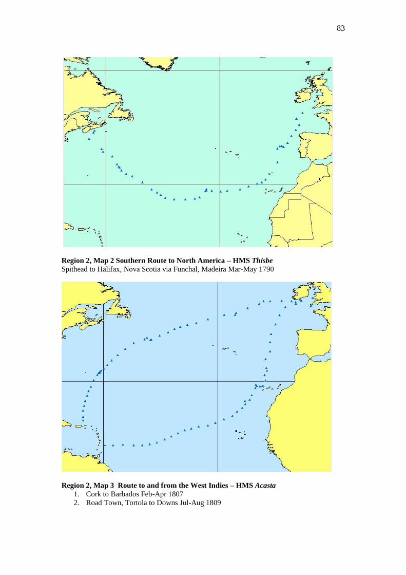
83
Region 2, Map 2 Southern Route to North America – HMS Thisbe
Spithead to Halifax, Nova Scotia via Funchal, Madeira Mar-May 1790
Region 2, Map 3 Route to and from the West Indies – HMS Acasta
1. Cork to Barbados Feb-Apr 1807
2. Road Town, Tortola to Downs Jul-Aug 1809
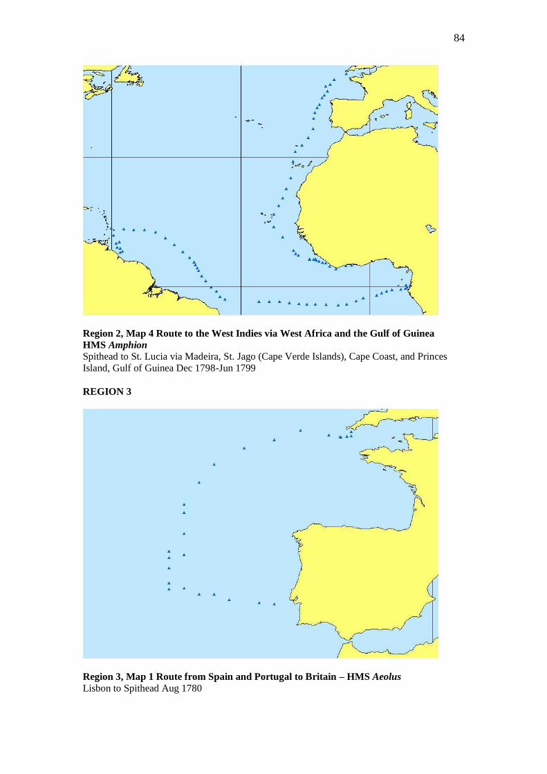
84
Region 2, Map 4 Route to the West Indies via West Africa and the Gulf of Guinea
HMS Amphion
Spithead to St. Lucia via Madeira, St. Jago (Cape Verde Islands), Cape Coast, and Princes
Island, Gulf of Guinea Dec 1798-Jun 1799
REGION 3
Region 3, Map 1 Route from Spain and Portugal to Britain – HMS Aeolus
Lisbon to Spithead Aug 1780
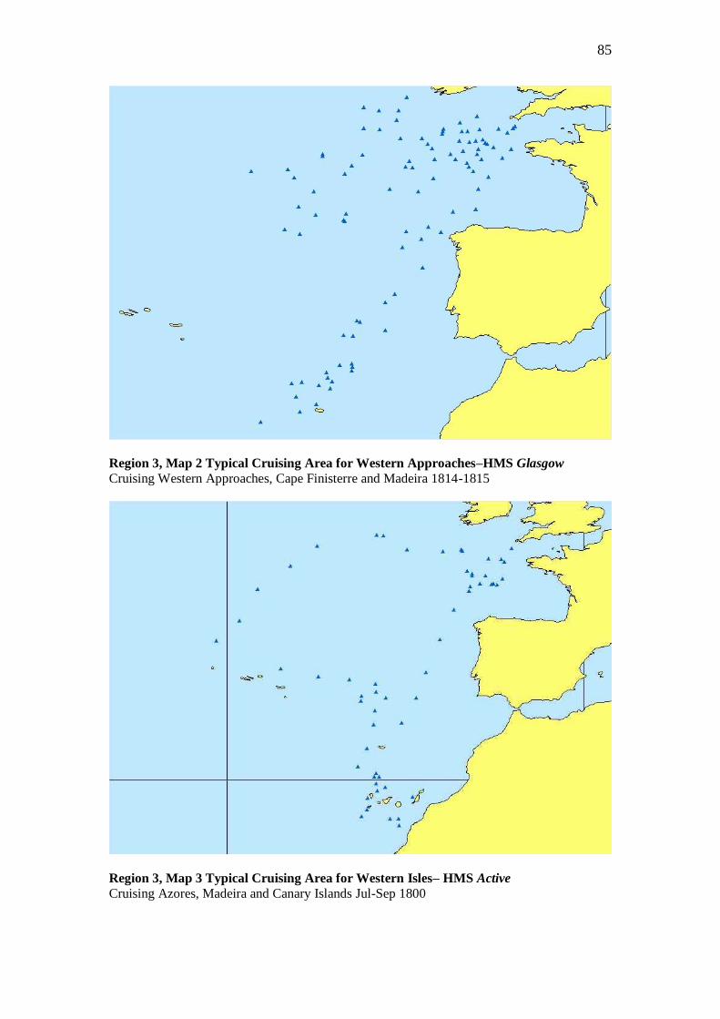
85
Region 3, Map 2 Typical Cruising Area for Western Approaches–HMS Glasgow
Cruising Western Approaches, Cape Finisterre and Madeira 1814-1815
Region 3, Map 3 Typical Cruising Area for Western Isles– HMS Active
Cruising Azores, Madeira and Canary Islands Jul-Sep 1800
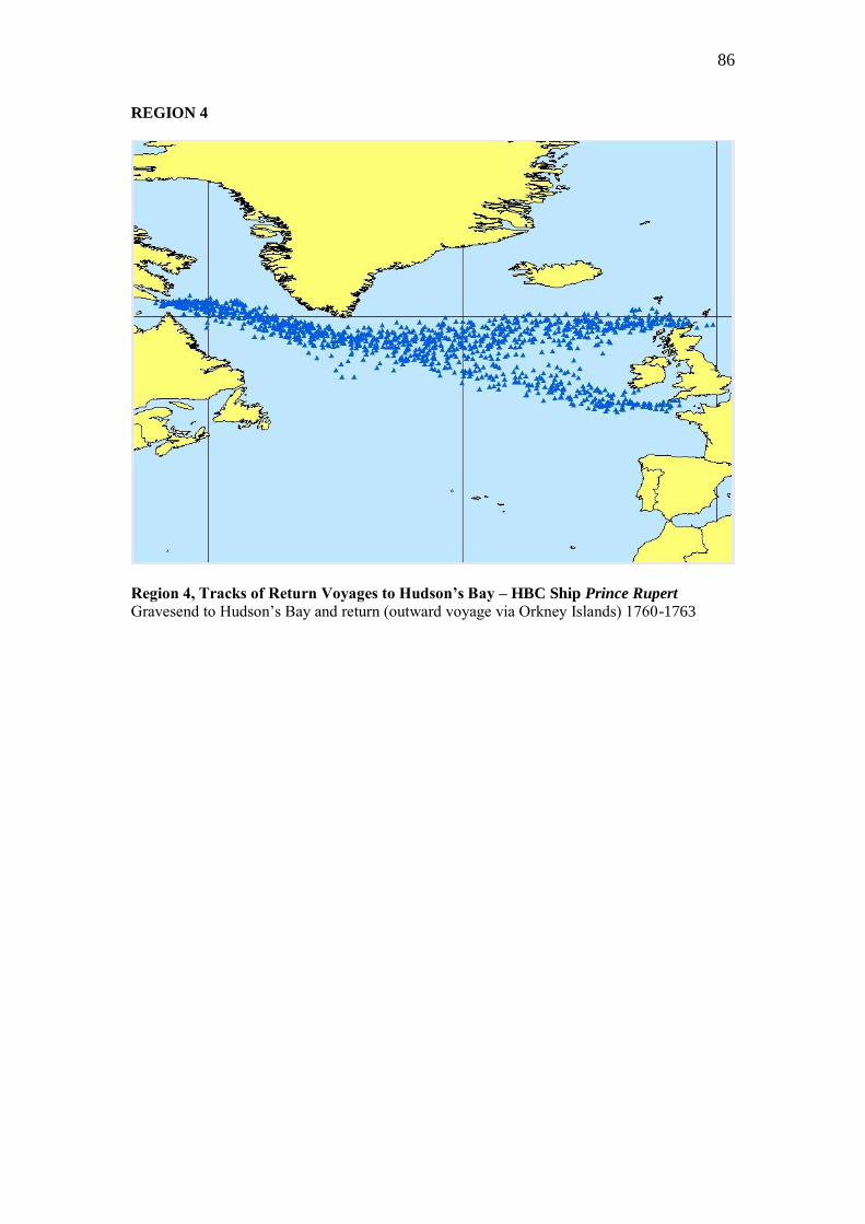
86
REGION 4
Region 4, Tracks of Return Voyages to Hudson’s Bay – HBC Ship Prince Rupert
Gravesend to Hudson‟s Bay and return (outward voyage via Orkney Islands) 1760-1763