Embed Size (px)
Citation preview
BRITISH GEOLOGICAL SURVEY
TECHNICAL REPORTS
Onshore Geology Series
TECHNICAL REPORT WAf97158
OBSERVATIONS OF COAL CLEAT IN BRITISH COALFIELDS
R A Ellison
Geographical index UK, Yorkshire, Lancashire, Warwickshire, Nottinghamshire
Subject Index Coal, fractures, joints, cleat
Bibliographic reference Ellison, R A. 1997. Observations of coal cleat in British coalfields. British Geological Survey Technical Report WAf97158 (Keyworth: British Geological Survey.)
0 NERC copyright 1997 Keyworth, British Geological Survey 1997 \
British Geological Survey Technical Report WA/97/58
Contents
Introduction Cleat and Joint Measurements Locality details Acknowledgements References
Index of localities and units with joints andor coal cleat azimuths recorded
P
British Geological Survey Technical Report WA/97/58
List of Figures
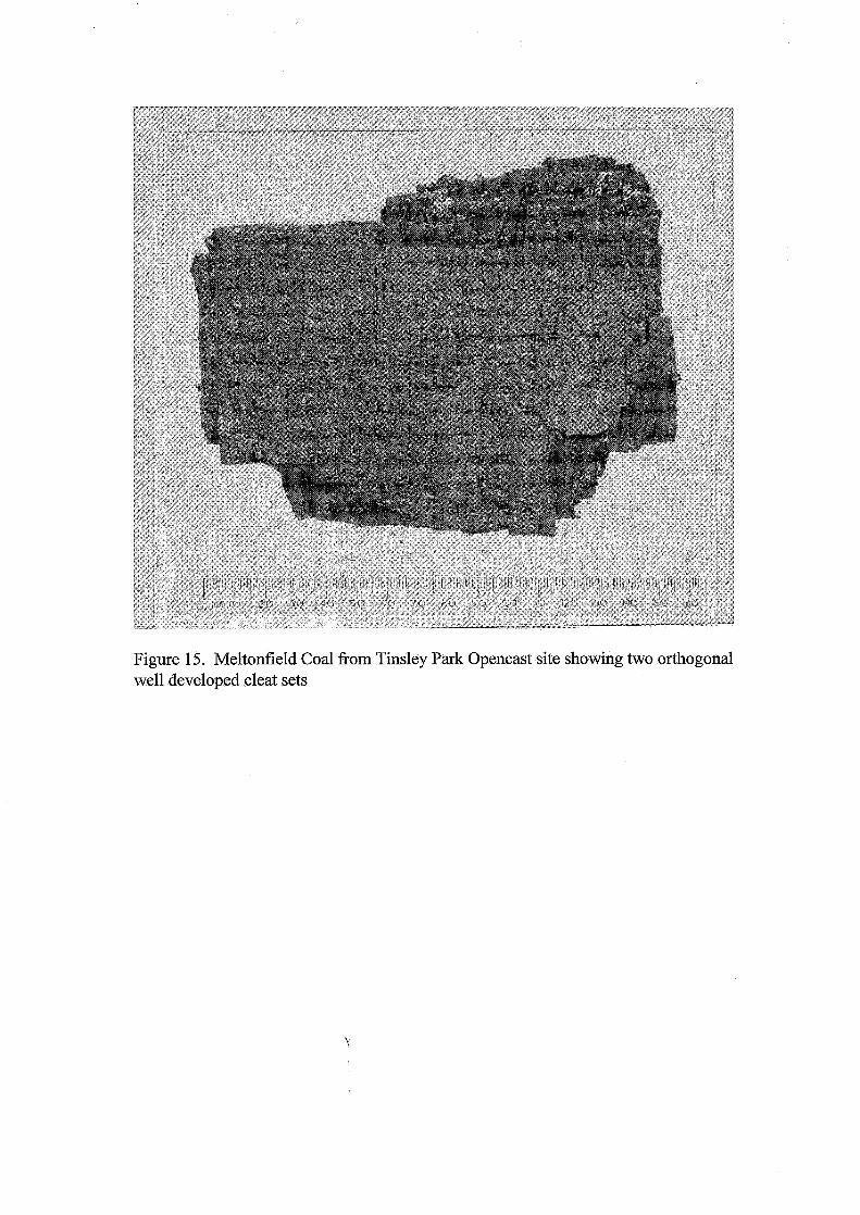
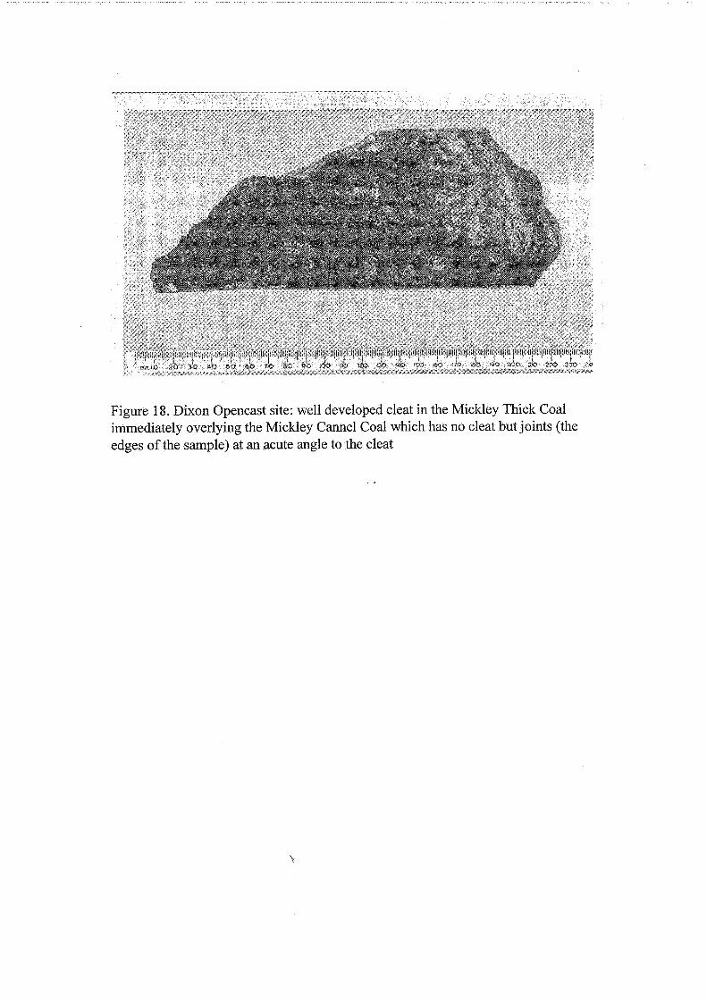
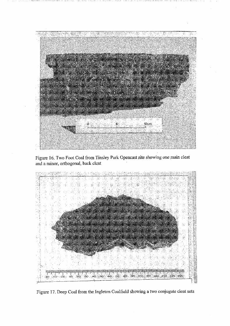
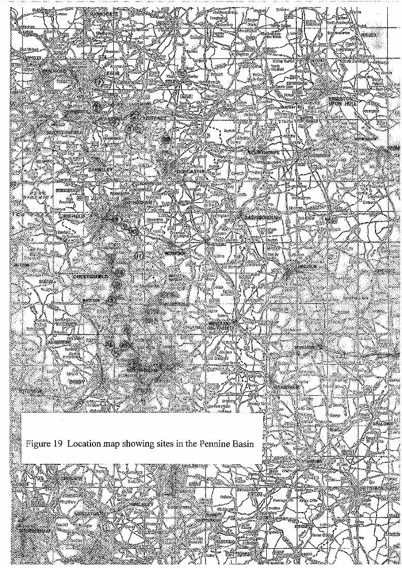
Figure 1 Skelton Opencast Site Figure 2 Lawns Lane and Lofthouse Opencast sites Figure 3 St John’s, Ackton and Cornwall Opencast sites and Sharlston and Prince of Wales collieries Figure 4 Detail at Ackton Opencast site Figure 5 Comparison of cleat in the Stanley Main coal at Sharlston and Prince of Wales collieries Figure 6 Tinsley Park, Waverley East and Pithouse Opencast sites Figure 7 Slayley and Dixon Opencast sites and Duckmanton Railway Cutting Figure 8 Ryefield and Godkin Opencast sites Figure 9 Cossall Opencast site Figure 10 Sudeley Opencast site Figure 11 Chapeltown Opencast site Figure 12 Riccall Colliery Figure 13 Askern Colliery Figure 14 The Lancaster Fells and Ingleton Coalfield Figure 15 Meltonfield Coal fiom Tinsley Park Opencast site showing two orthogonal well developed cleat sets Figure 16 Two Foot Coal fiom Tinsley Park Opencast site showing one main cleat and a minor, orthogonal, back cleat Figure 17 Deep Coal fiom the Ingleton Coalfield showing two conjugate cleat sets Figure 18 Dixon Opencast site: well developed cleat in the Mickley Thick Coal immediately overlying the Mickley Cannel Coal which has no cleat but joints at an acute angle to the cleat. Figure 19 Location map showing sites in the Pennine Basin
b 2
British Geological Survey Technical Report WA/97/58
Introduction
This technical report presents the observations made during a study into cleat and joint directions, largely in the Pennine Basin. Field work was carried out under the BGS Research and Development programme in 199 1 - 1992. Interpretation of these observations will be made elsewhere.
Cleat is the term widely in use to describe joints in coals. It is generally developed perpendicular to the bedding and there is normally one dominant set, known as the main cleat and a subsidiary, more or less perpendicular, set known as the back or butt cleat. Other sets may be developed in places, particularly in strongly faulted areas (see Figures 1, 2 and 3). Cleat is developed in all bright coals, including coalified allochthonous plant fragments and reworked clasts.
The study into coal cleat was formulated during the BGS regional mapping programme in the Yorkshire coalfield when the consistency of cleat azimuths was evident in several opencast coal sites. It is increasingly becoming clear that coal cleat development took place at an early stage of burial
and diagenesis (see for example Gayer, 1992) whereas joints in adjacent strata formed later. Thus, variation between cleat and joint azimuths is potentially an important indicator of changes in palaeostress field.
The main area of interest for the study is the Yorkshire, Derbyshire and Nottinghamshire coalfield where 16 opencast sites, 4 collieries and one large exposure were visited. Observations were made also in four other areas: the Lancaster Fells area and Ingleton coalfield, where Namurian and Westphalian coals have recently been mapped by BGS in the survey of the Lancaster district (1:50 000 geological sheet 59) (Brandon, 1992; Ellison, 1991a; 1991b), and opencast coal sites in the North Staffordshire, Warwickshire and Cumbria coalfields. Coal cleat azimuths were recorded at all localities and at most of them joint azimuths in rocks adjacent to coal seams are recorded.
Each locality in this report has a reference number, and National Grid Reference for the central part of the locality. They are given below along with a list of horizons in which cleat and joints were measured. Joint azimuths are mainly shown on rose diagrams with 10" segments. At least 20 cleat fractures were measured in each seam; they are plotted as rose diagrams with the mean azimuth shown as a broad line extending beyond the rose.
The regional structure, drawn largely of the evidence of mine plans, and an indication of the stratigraphical position of coals is given for each site.
Cleat and Joint measurements
In most opencast coal sites cleat azimuths were measured on the top bedding surface of coal seams exposed prior to excavation of the coal. Surfaces of tens to hundreds of square metres were exposed allowing an excellent appreciation of local variation in cleat orientation and its relationship to joints
3 'r
British Geological Survey Technical Report WA/97/58 and faults. In all cases it was found to be remarkably constant in direction in any one seam at a site. In view of this the number of measurements made was considered less important than gaining an indication of the range of direction in any one seam. Thus the cleat azimuth rose diagrams show the mean and range of cleat azimuths. Back cleat is illustrated where it is particularly well developed.
The azimuths of systematic joints in sandstones and siltstones are generally more variable in direction than cleat. They were measured as far as possible on two perpendicular quarry faces. Only the major, sub vertical, open, systematic joints are recorded and are plotted on rose diagrams with 10" segments..
The measurement of cleat underground was carried out by determining the angle between the cleat strike direction and a face line or heading centre line and then plotting the azimuth on a mine plan. The accuracy of these azimuths is likely to be +/-loo compared to compass bearings taken at surface outcrops.
Locality details
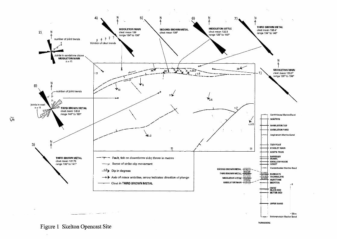
1. Skelton Opencast Coal Site (Figure 1)
The main structure at the locality is a 200m-wide graben in which the beds are gently folded into parallel periclines oblique to the graben, interpreted as having formed in response to sinistral shear along the graben bounding faults. There is evidence for compression in the form of tight chevron folds close against the northern boundary of the graben.
The dominant cleat trend is 135 to 140" but in the south-west of the site it trends at about 150". Where both trends are present they result in an anastomosing pattern that leads to the coal fracturing into pencil-shaped pieces.
The Third Brown Metal Coal has a well-developed systematic joint set perpendicular to the cleat. It penetrates through the entire seam and into the measures above and below. A weak back cleat in a middle parting of bright coal has a consistent 045 to 055" trend and is much closer spaced than the joints.
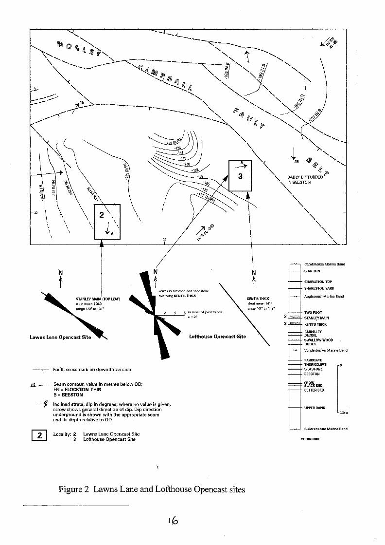
2. Lawns Lane Opencast Coal Site (Figure 2)
The Stanley Main Coal is split into three leaves at this site, the lowest formerly mined by the pillar and stall method. Cleat azimuths were measured in the top of the top leaf.
3. Lofthouse Colliery Opencast Coal Site (Figure 2)
B 4
British Geological Survey Technical Report WA/97/58 The site lies within 200m of the Morley Campsall fault belt. Cleat, in the Kent's Thick Coal is consistent at 140 to 142". In the overlying siltstones and sandstones a conjugate joint set is developed. Its bisectrix, parallel to the maximum horizontal stress trajectory, lies at about 145".
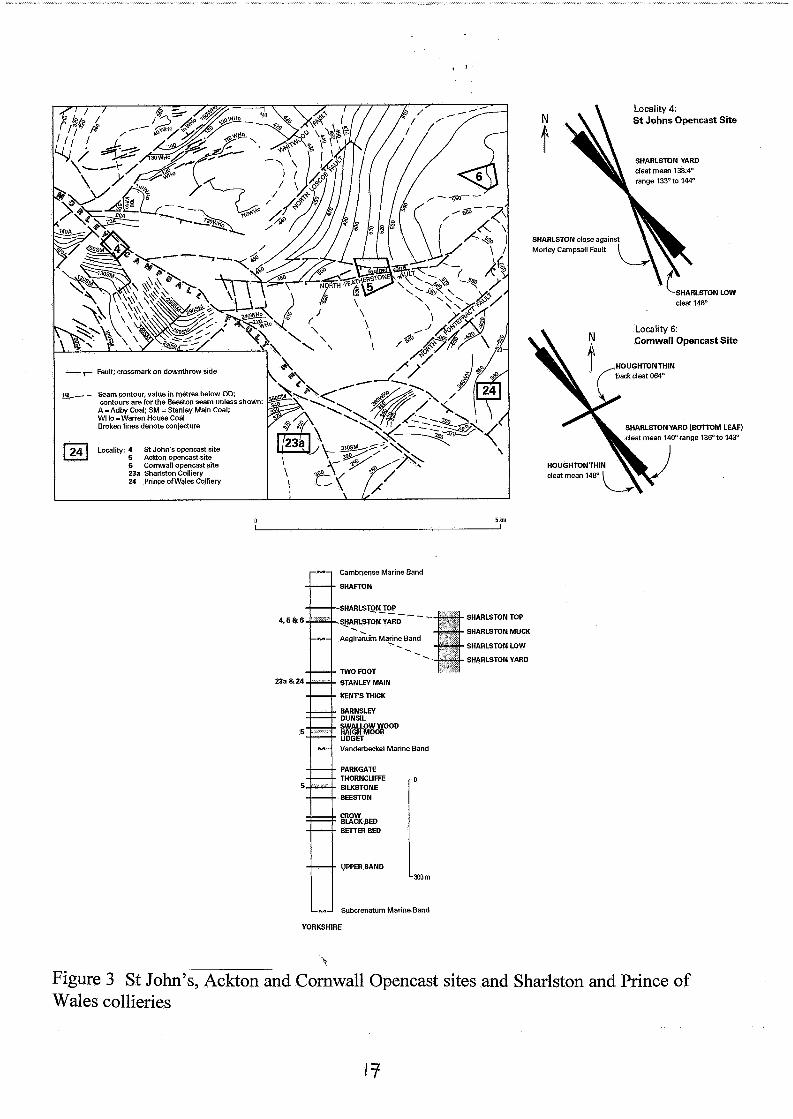
4. St John's Opencast Coal Site (Figure 3)
This site lies within the Morley Campsall fault belt, mostly in a NW-SE trending graben bounded on its northern side by a major, near vertical fault, the North Newlands Fault. It has a dip slip displacement of about 120 m down to the south. Close against this fault the Sharlston coals are almost vertical and are in places deformed in tight upright folds. The fault dip plane is near vertical and the fold axes orientation indicates that they formed during dextral transpression along the fault.
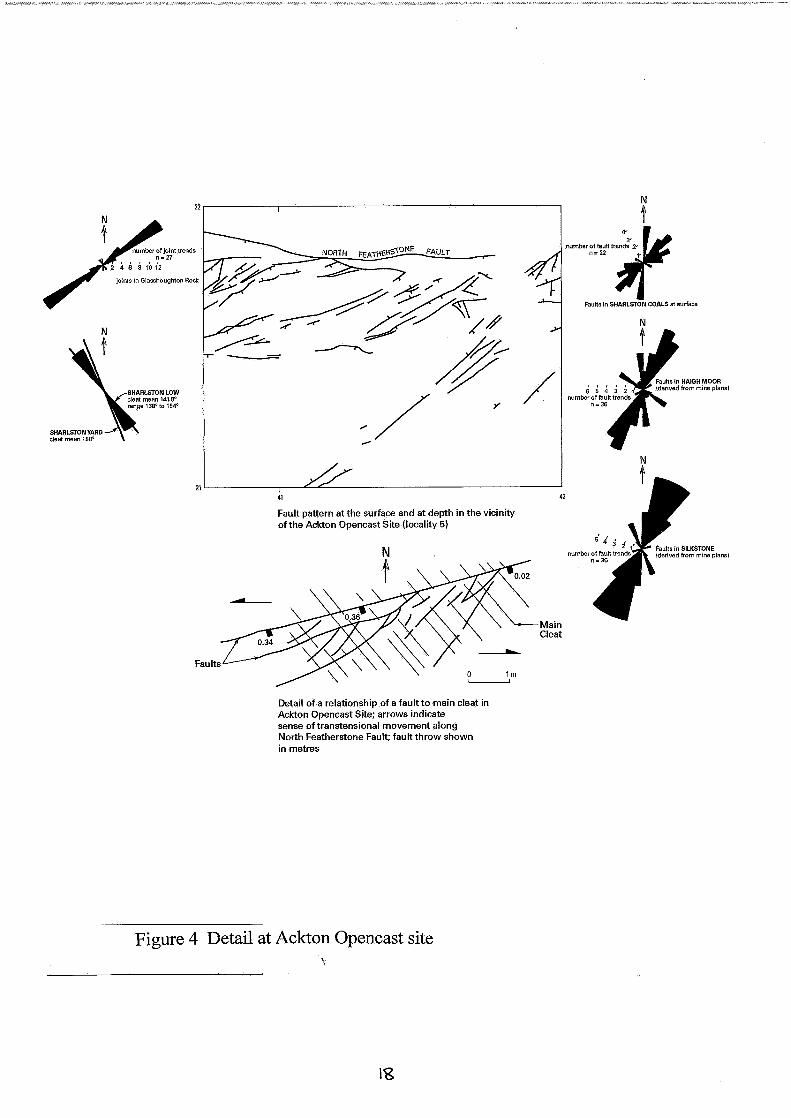
5. Ackton Opencast Coal Site (Figures 3 and 4)
The site lies south of the E-W trending North Featherstone Fault, a normal fault with an arcuate surface trace on the north side of the Morley Campsall fault belt. The structure of the Ackton area is particularly well known from mine plans in the Silkstone, Haigh Moor and Warren House Coals. The pattern of faults seen in the Opencast Coal Site is similar to that in the coals underground. This pattern is also observed on a smaller scale in association with a minor fault in the Sharlston Yard Coal (Figure 3). The general pattern of faulting can be accounted for by sinistral transtension along the North Featherstone Fault, resulting in the closely spaced normal faults at an acute angle to it. These NE-SW faults are near vertical and with a rapidly changing throw. Some are locally reverse faults, others pass into broad, open anticlinal flexures caused by dextral transcurrent motion along the North Featherstone Fault.
There is a variation of 16" anticlockwise between the main cleat azimuth of the Sharlston Yard and Sharlston Low coals, with an anticlockwise rotation from the older to younger coal. This is a significant variation when compared to the regional cleat orientation and may be caused by a change in direction of the maximum compressive stress during coalification.
6. Cornwall Opencast Coal Site (Figure 3)
This is a geologically simple site bounded on its eastern side by the NE trending Fairy Hill Fault with a normal throw down to the south. It is one of a dominant set developed in the northern part of the Yorkshire coalfield, largely to the north of the Don monocline. The coal cleat azimuth varies by So, rotating anticlockwise from the older Houghton Thin to younger Sharlston Yard coal.
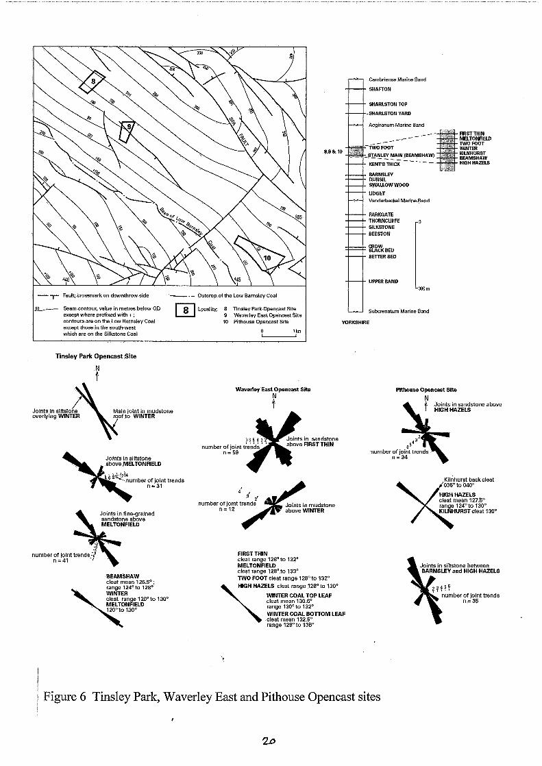
8. Tinsley Opencast Coal Site (Figure 6)
This locality, along with localities 9 and 10, occupy similar structural situations. The beds dip at 3 to 9" on the west flank of a broad NW-SE syncline, and the Spa Fault cuts the axial plane trace. The cleat and joint directions at the three sites are closely similar.
5 !
British Geological Survey Technical Report WA/97/58
Cleat in the Beamshaw Coal is unmineralised and generally has 2 to 3 mm spacing; a poor backcleat is developed. Cleat in the Winter and Meltonfield coals is colinear with the Beamshaw. An acute angle, up to loo, between two cleat sets in all the coals results in pencil-shaped
fragments of coal.
Systematic joints in the beds above the Winter Coal are rotated clockwise with respect to the cleat (mean 126.5"). The mudstone roof joints trend 140", and in siltstones 5 m above the coal the joints trend 155". A similar rotation is observed between the Beamshaw Coal and overlying strata: cleat 125", mudstone roof 130", overlying medium-grained sandstone 143". The systematic joints in mudstone and sandstone are confined to individual beds and terminate abruptly at the bed boundaries.
9. Waverley East Opencast Coal Site (Figure 6)
The six coals examined at this site have cleat azimuths in the range 128" to 136" but there is no systematic variation. Joints in the sandstone above the First Thin Coal are arranged in two roughly perpendicular sets, a NW-SE trending set being oriented about 10" clockwise from the cleat in the underlying coal. In comparison, joints in the mudstone roof of the Winter Coal are dominated by a NE-SW set. The coal cleat terminates abruptly at the top of the Winter Coal and does not pass into the mudstone.
10. Pithouse Opencast Coal Site (Figure 6)
Systematic joints were measured in siltstone beds between the Barnsley and High Hazels coals exposed in a 10 m-deep cutting made for a drainage ditch. The dominant joint trend is 10 to 15" clockwise fkom the mean cleat of the High Hazels Coal. Another joint set in the sandstone, with dips between about 80" and 50", strikes NNW-SSE.
Several tree stumps were observed protruding up to 0.1 m above the general bedding surface of the High Hazels Coal, their rims formed of coal and the former bole filled with siltstone. The cleat azimuth in their rims, formerly the tree bark, varies between 120" and 138", and is generally divergent from that in the associated coal seam which is 127.5". The cleat dip in the rim is near vertical where it is parallel to the cleat in the adjacent coal, but at points of greatest divergence from the regional azimuth the cleat in the rim dips about 80". This deflection is interpreted as being caused by a NE-SW compression during coalification.
The Kilnhurst Coal in particular has a well developed back cleat whose azimuth is parallel to a small normal fault seen in the opencast site.
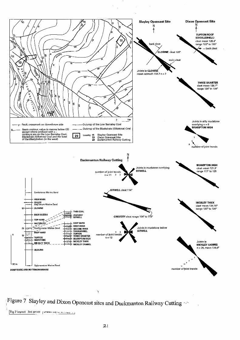
11. Slayey Opencast Coal Site (Figure 7)
6
British Geological Survey Technical Report WA/97/58 Systematic joints and cleat occur in the Clowne Coal. The joint azimuth is rotated 10" clockwise from the main cleat. The joints continue through the coal and the overlying mudstone but the cleat terminates at the bed boundary. The joints have the same trend as minor normal faults in the coal and a larger fault with 20 m throw at the site boundary. This evidence indicates that the joints and faults post-date the cleat formation.
13. Dixon Opencast Coal Site (Figure 7)
There is a small variation in the cleat between coals in this site. The mean cleat azimuth range is 121.3" to 129.75" and the overall range of all cleat is 117 to 134" but there is no stratigraphical trend to the variation. Nevertheless it may indicate small shifts in the stress field between successive cycles of deposition. This is most likely to be related to movement associated with the contemporary Brimmington Anticline. There is no detailed evidence for the influence on sedimentation of this tectonic activity but Smith et al. (1967) reported regional thickness andor facies changes related to the Brimmington structure, in particular in the Silkstone, Yard, Threequarters, Cockleshell, Piper and Deep Hard coals.
Joints in the Brampton High Coal and the overlying mudstone are more or less colinear with the cleat but none continues across the bed boundary.
The Mickley Camel Coal does not have a cleat but there is a well developed joint set about 10" clockwise from the Mickley Thick Coal cleat.
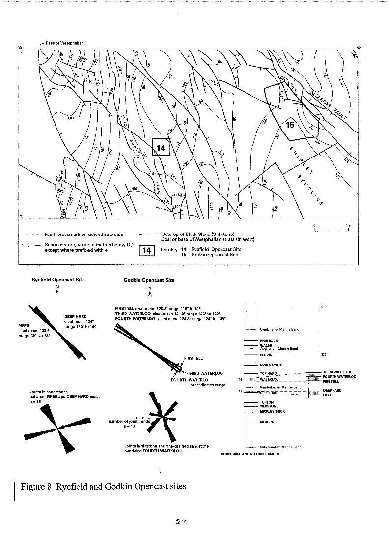
14. Ryefield Opencast Coal Site (Figure 8)
The cleat in the Deep Hard and Piper coals and the systematic joints in the sandstone between the coals have significantly different orientations.
15. Godkin Opencast Coal Site (Figure 8)
There is an 8" clockwise rotation in cleat between the First Ell and Fourth Waterloo coals which are separated by only about 10 m of siltstones and sandstones (Frost and others, 1979). Joints in siltstone and sandstone beds are not in general colinear with the coal cleat. Those in a blocky siltstone between the Forth Waterloo and First Ell coals have a different trend to those in the succeeding cycle.
The cleat in a thin, dirty coal within a mudstone seatearth between the Forth Waterloo and Ell coals trends 1 loo, compared to 120 to 130" in the main seams. The difference may be accounted for by rotational movement along the numerous listric shear surfaces that are characteristic of seatearth palaeosols. This conclusion lends support to the idea that the cleat was established prior to the listric fractures that formed during preferential compaction between the clay minerals and the organic remains in the soil (for a review see Besley and Fielding, 1989).
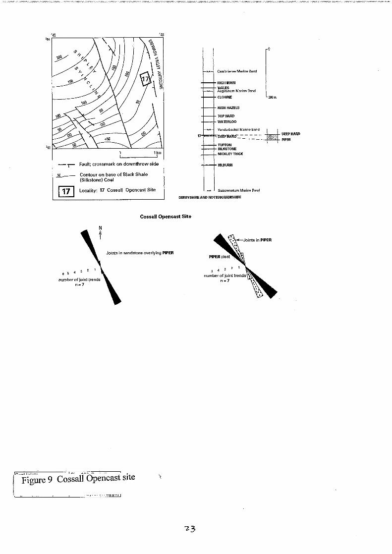
British Geological Survey Technical Report WA/97/58 17. Cossall Opencast Coal Site (Figure 9)
Directly overlying the Piper Coal is a hard, blocky, medium grey mudstone with well developed joints rotated 25" clockwise from the cleat in the Piper Coal. The joints pass into the coal where they are spaced at 0.3 m or more, compared to the cleat frequency of 10 mm or less.
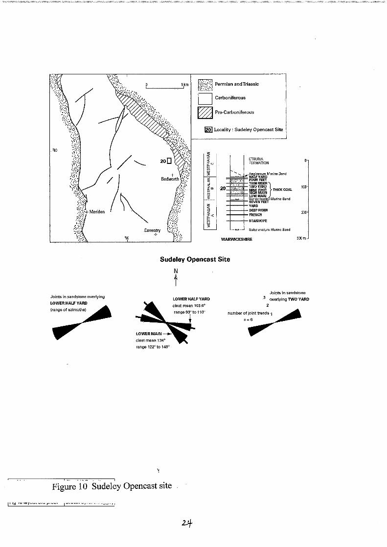
20. Sudeley Opencast Coal Site (Figure 10)
The site is in the Warwickshire Coalfield. The most interesting observation here is the variation by 20" of the cleat between the Low Main Coal of early Westphalian B age, and the Lower Half Yard Coal, of late Westphalian B age. This variation, the greatest seen between coals within a site, is thought to be associated with contemporary tectonic activity (Fulton and Williams, 1988) which led to mild inversion in an area over the NNE-SSW trending Arley Fault (Bridge, 1992). The main evidence for tectonic activity is the line of seam splits in the Warwickshire Thick Coal, the removal by erosion of the Etruria Mar1 from a tract centred on the Arley Fault, and the regional thinning of the Westphalian A and B strata.
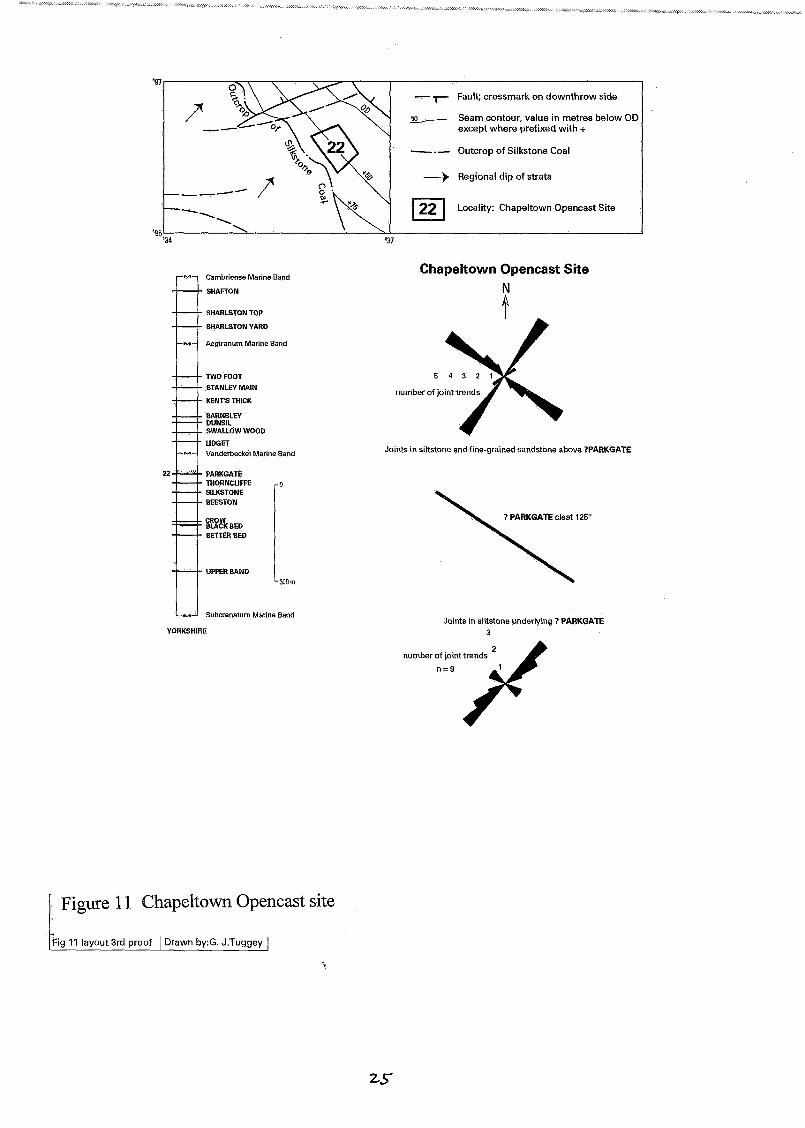
22. Chapeltown Opencast Coal Site (Figure 11)
The main seam exposed here is shown on the six-inches to one mile geological sheet as the Parkgate Coal. An allochthonous coal lens in the siltstones below the Parkgate Coal has cleat parallel to that in the main seam. There is a well developed orthogonal joint set in the siltstone and fine-grained sandstones above and below the coal.
23. Duckmanton Railway Cutting (Figure 7)
This section includes the type site of the Vanderbeckei Marine Band and the strata of Westphalian B (Duckmantian) age. The coal cleat in three seams is colinear but differs from the systematic joint azimuths in the associated sandstones and siltstones. The principal joint sets trend NW-SE and roughly E-W.
The mudstones overlying the Sitwell Coal show good examples of joints terminating at the boundary with overlying sandstone.
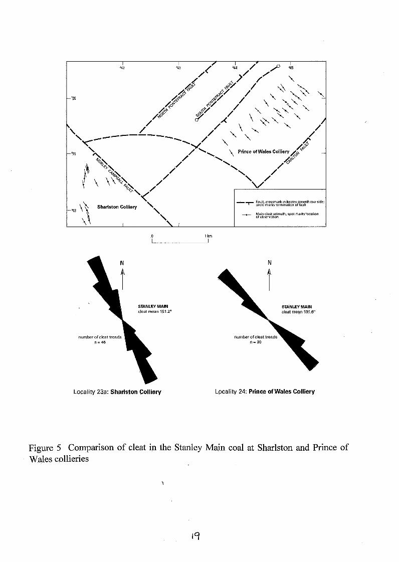
23a. Sharlston Colliery (Figures 3 and 5)
Cleat azimuths were taken in underground workings in the Stanley Main Coal south of the Morley Campsall fault belt. Additional measurements have been provided by British Coal Deep Mines. In combination with readings in the same coal south of the fault belt (see Locality 24), the influence of the fault on cleat development can be considered.
In the Stanley Main Coal the mean cleat reading is 15 1.2" (n = 42) and there is a variable backcleat with an azimuth at 90" to 60" to the main cleat.
8 'i
British Geological Survey Technical Report WA/97/58
24. Prince of Wales Colliery (Figures 3 and 5)
Workings in the Stanley Main Coal extend as far south as the Morley Campsall fault belt. Cleat measurements were taken as near to the fault belt as possible in order to assess its influence on cleat orientation.
The variation in cleat azimuth across the fault appears to be significant. The mean azimuth on the north side is 13 1.6" compared with 15 1.2" on the south side. A similar variation is seen between the Lofthouse Opencast Coal Site (Locality 3) and Lawns Lane Opencast Coal Site (Locality 2).
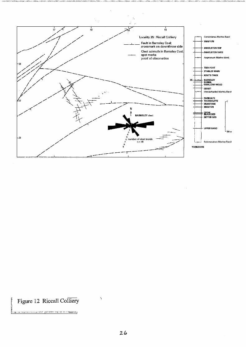
25. Riccall Colliery (Figure 12)
Riccall Colliery lies in the Selby Coalfield. Cleat azimuths were taken in several headings in the Barnsley Coal workings. Additional readings were provided by British Coal Deep Mines. Sub- horizontal to sub-vertical shears occur in the coal, many with sub-horizontal slickenslide fractures which in the more extreme cases give rise to a structure comparable to cone-in-cone.
An interesting feature is the rotation of cleat and the development of a conjugate set in certain areas. This is interpreted as the result of transpressive shear being concentrated along east-west fracture belts in the coalfield.
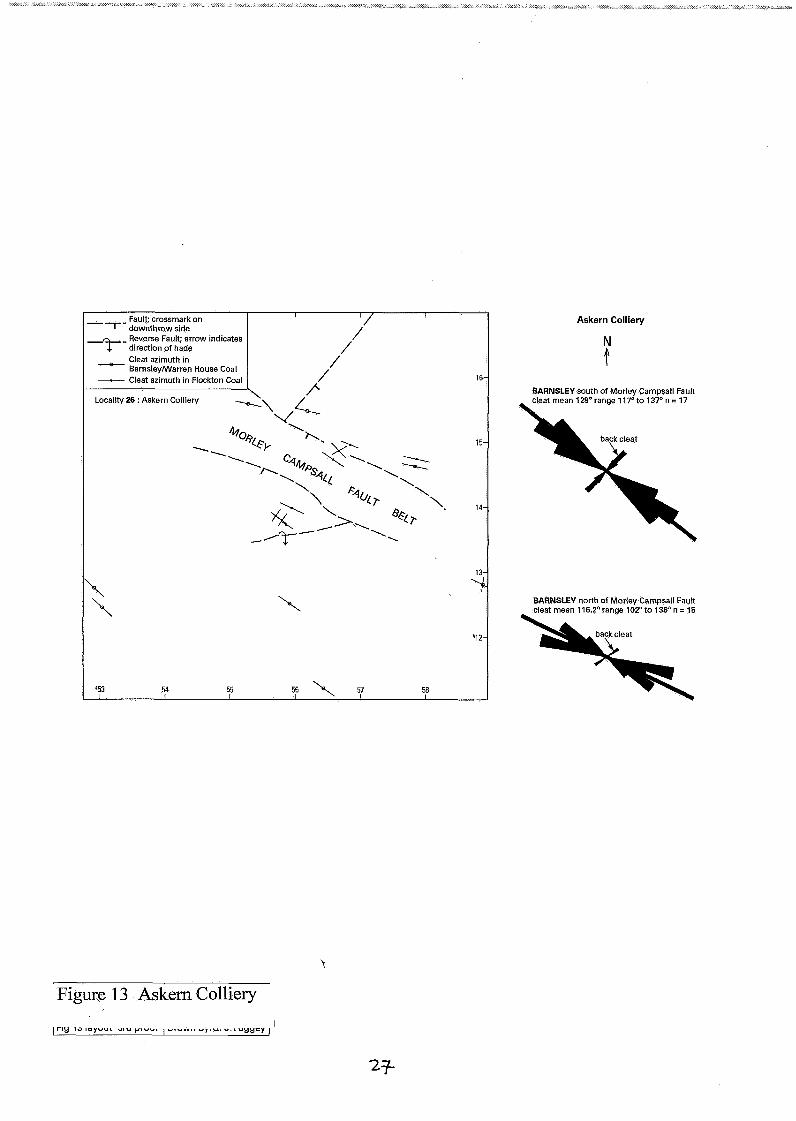
26. Askern Colliery (Figure 13)
Workings in the Warren House Coal close to the bottom of the shaft at the Colliery were examined and the readings combined with information from British Coal mine plans. Together, these sources give a geographical spread of data astride the Morley Campsall fault belt. Of significance is the more northerly trend of cleat to the south of the fault, a feature recognised in Wilcockson and Goossens (1 958) at Askern and in the Hatfield-Thorne area.
Cleats close to a fault plane within the Morley Campsall fault belt are a conjugate pair of equal development, whereas elsewhere a more usual strong main cleat and only a relatively weak, orthogonal back cleat is developed. Transpressive shear along the faults during cleat development is though to be the cause. At the "Barnsley slit", close to the pit bottom, the seatearth underlying the Warren House Coal contains a 23 mm-thick lens of coal inclined at about 40" to the horizontal due to compactional shearing in the seatearth. The cleat in the coal is perpendicular to the contact with the surrounding seatearth, presumably having been rotated during the shearing event. This observation suggest that the cleat formation post-dates the shearing which in turn is generally regarded as taking place during compaction of the Coal Measures (see also observations at Locality 15).
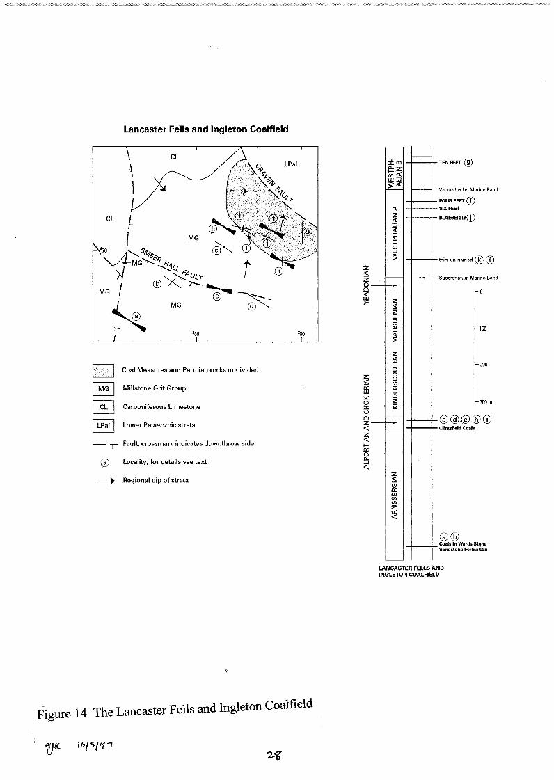
27. Ingleton Area (Figure 14)
9
British Geological Survey Technical Report WA/97/58 Coal cleat azimuths have been recorded during the recent survey of the Lancaster district. The coals are Namurian and Westphalian in age and lie in the Craven Basin which is bounded to the north by the Craven Fault. The most interesting aspect of the findings is that the cleat in the Westphalian coal nearest to the Craven Fault has a northerly trend, compared to the WSW regional trend. Although there are few data, it can be speculated that this is due to the proximity of the Craven Fault and its influence on the regional stress field during coalification, in a similar manner to the Morley Campsall fault belt in West Yorkshire.
The National Grid references and geological horizon of localities where cleat has been measured and the formation within which the coal occurs are listed below; the letters refer to the sites shown onFigure 14.
Ward’s Stone Sandstone Ward’s Stone Sandstone Accerhill Sandstone (Clintsfield coals) Accerhill Sandstone (Clintsfield coals) Ward’s Stone Sandstone Four Feet Coal: Coal Measures ?Ten Feet Coal: Coal Measures Accerhill Sandstone (Clintsfield coals) un-named coal: Coal Measures ?Blaeberry Coal: Coal Measures un-named coal: Coal Measures un-named coal: Coal Measures
[SD 535 6321 [SD 576 6691
[SD 6260 70191 [SD 6582 65151
[SD 6712 71801 [SD 700 7161 [SD 6240 7209; SD 6264 72021 [SD 6433 72061
[SD 6810 70811 [SD 6480 71671
[SD 6213 66181
[SD 6766 71301
Acknowledgements
The co-operation of British Coal Opencast and British Coal Deep Mines is gratefully acknowledged, in particular Steve Graham, Sam Cochrane and Guy Wilson assisted the planning and execution of the field work. Figures 1 to 14 were prepared by Graham Tuggey.
References
Besley, B.M. and Fielding, C.R. 1989. Palaeosols in Westphalian coal-bearing and red-bed sequences, central and northern England. Palaeogeography, Palaeoclimatology, Palaeoecology, Vol. 70,303-330.
Brandon, A. 1992. Geology of the Caton area. British Geological Survey Technical Report WN92115.
Bridge, D. McC. 1992. Geology of the Arley district (SP 29 SE). British Geological Survey Technical Report WN92128.
10 ‘v
British Geological Survey Technical Report WA/97/58 Ellison, R.A. 1991a. Geology of the Wray area - Sheet SD 66 NW. British Geological Survey Technical Report WAl91184.
Ellison, R.A. 1991b. Geology of the Bentham area - Sheet SD 66 NE. British Geological Survey Technical Report WAl9 1/83.
Frost, D. V. and Smart, J. G. 0.1979. Geology of the Country north of Derby (Sheet 125). Memoirs of the Geological Survey.
Fulton, I.M. and Williams, H. 1988. Palaeogoegraphical change and controls on Namurian and Westphalian AA3 sedimentation at the southern margin of the Pennine Basin, central England. 178- 197 in Besley, B.M. and Kelling, G. 1988 (editors). Sedimentation in a synorogenic basin complex: the Upper Carboniferous of north-west Europe. (Blackie: Glasgow and London.)
Gayer, R.A. and Pesek, J. 1992. Cannibalisation of Coal Measures in the South Wales Coalfield - significance for foreland basin evolution. Proceedings of the Ussher Society, Vol. 8,44-49.
Smith, E.G., Rhys, G.H. and Eden, R.A. 1967. Geology of the Country around Chesterfield, Matlock and Mansfield (Sheet 112). Memoirs of the Geological Survey.
Wilcockson, W.H. and Goossens, R.F. 1958. Geological Research in the Yorkshire Coalfield over the past one hundred years. Transactions of the Institution of Mining Engineers, Vol. 117,622-641.
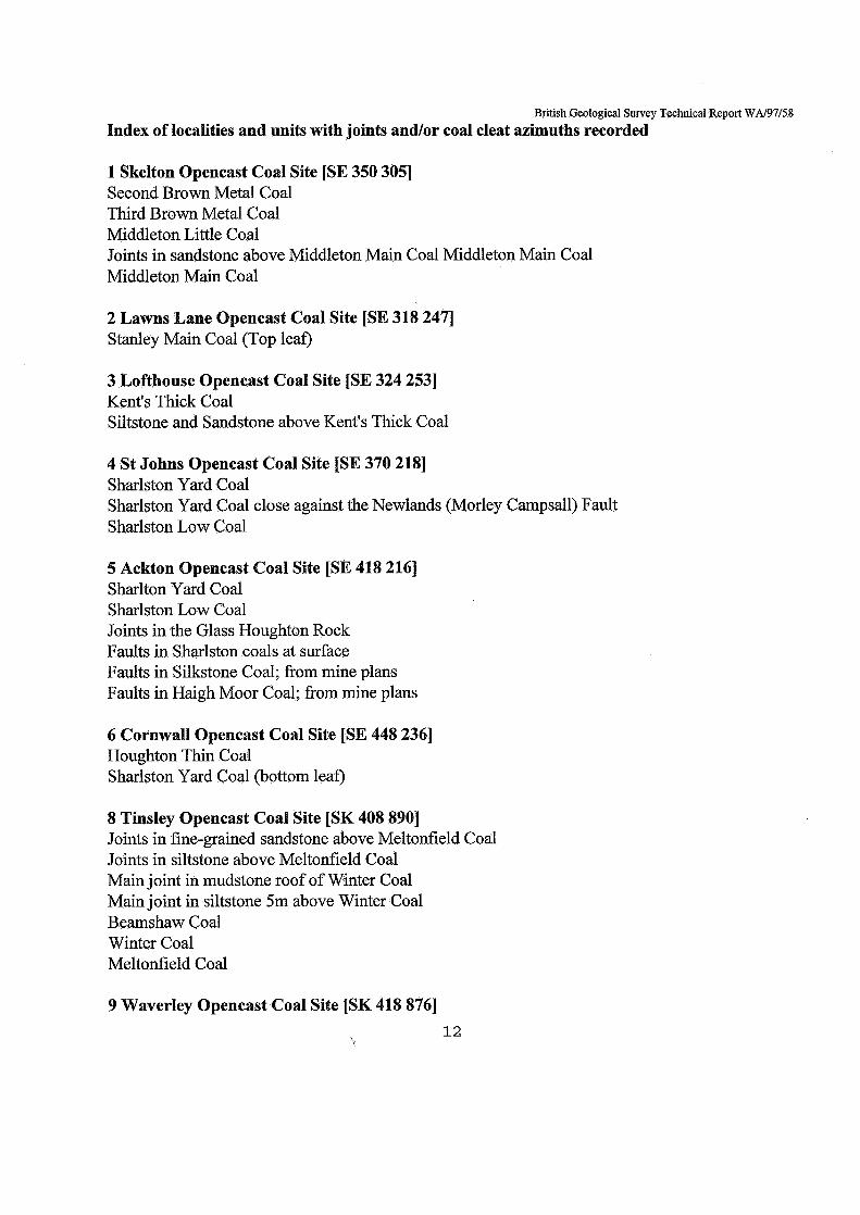
British Geological Survey Technical Report WA/97/58 Index of localities and units with joints and/or coal cleat azimuths recorded
1 Skelton Opencast Coal Site [SE 350 3051 Second Brown Metal Coal Third Brown Metal Coal Middleton Little Coal Joints in sandstone above Middleton Main Coal Middleton Main Coal Middleton Main Coal
2 Lawns Lane Opencast Coal Site [SE 318 2471 Stanley Main Coal (Top leaf)
3 Lofthouse Opencast Coal Site [SE 324 2531 Kent's Thick Coal Siltstone and Sandstone above Kent's Thick Coal
4 St Johns Opencast Coal Site [SE 370 2181 Sharlston Yard Coal Sharlston Yard Coal close against the Newlands (Morley Campsall) Fault Sharlston Low Coal
5 Ackton Opencast Coal Site [SE 418 2161 Sharlton Yard Coal Sharlston Low Coal Joints in the Glass Houghton Rock Faults in Sharlston coals at surface Faults in Silkstone Coal; from mine plans Faults in Haigh Moor Coal; from mine plans
6 Cornwall Opencast Coal Site [SE 448 2361 Houghton Thin Coal Sharlston Yard Coal (bottom leaf)
8 Tinsley Opencast Coal Site [SK 408 8901 Joints in fine-grained sandstone above Meltonfield Coal Joints in siltstone above Meltonfield Coal Main joint in mudstone roof of Winter Coal Main joint in siltstone 5m above Winter Coal Beamshaw Coal Winter Coal Meltonfield Coal
9 Waverley Opencast Coal Site [SK 418 8761 12
t
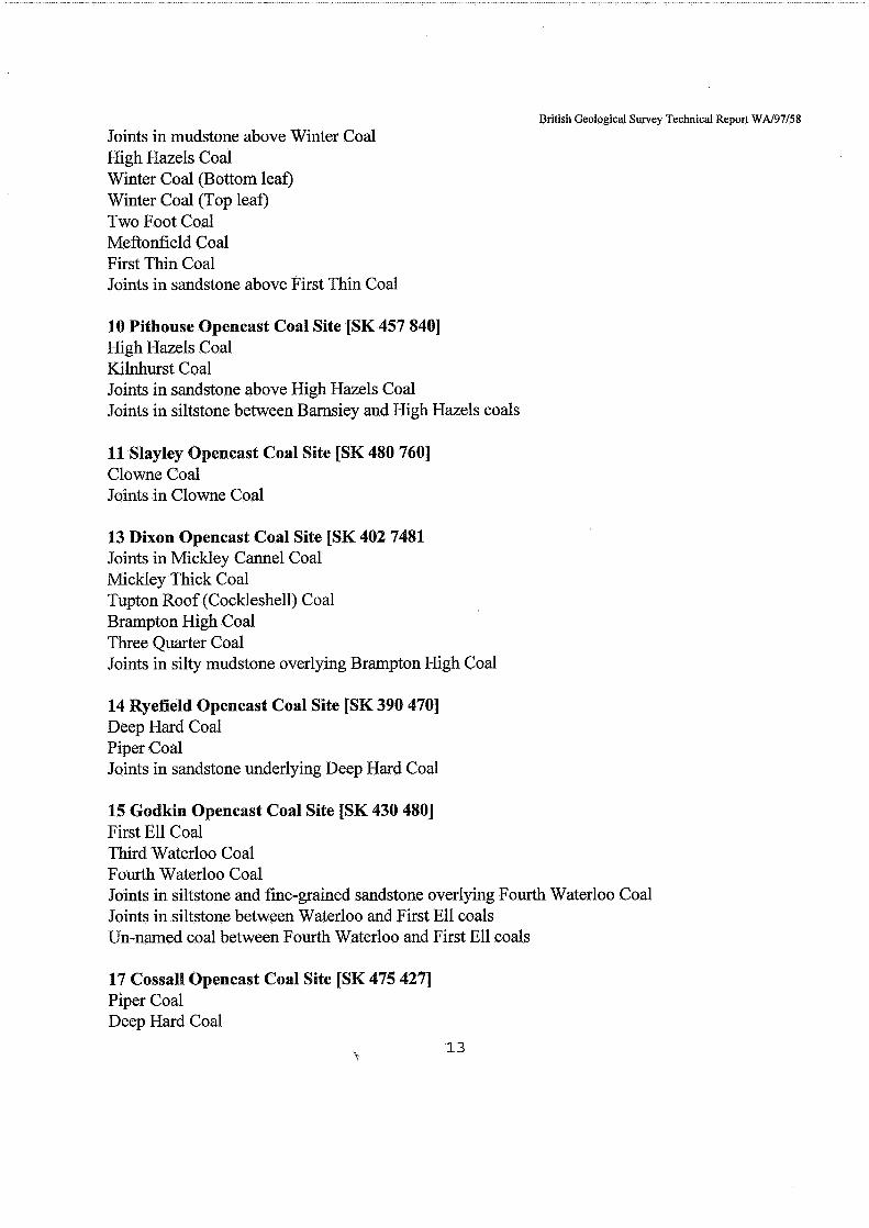
British Geological Survey Technical Report WA/97/58
Joints in mudstone above Winter Coal High Hazels Coal Winter Coal (Bottom leaf) Winter Coal (Top leaf) Two Foot Coal Meftonfield Coal First Thin Coal Joints in sandstone above First Thin Coal
10 Pithouse Opencast Coal Site [SK 457 8401 High Hazels Coal Kilnhurst Coal Joints in sandstone above High Hazels Coal Joints in siltstone between Barnsiey and High Hazels coals
11 Slayley Opencast Coal Site [SK 480 7601 Clowne Coal Joints in Clowne Coal
13 Dixon Opencast Coal Site [SK 402 7481 Joints in Mickley Camel Coal Mickley Thick Coal Tupton Roof (Cockleshell) Coal Brampton High Coal Three Quarter Coal Joints in silty mudstone overlying Brampton High Coal
14 Ryefield Opencast Coal Site [SK 390 4701 Deep Hard Coal Piper Coal Joints in sandstone underlying Deep Hard Coal
15 Godkin Opencast Coal Site [SK 430 4801 First Ell Coal Third Waterloo Coal Fourth Waterloo Coal Joints in siltstone and fine-grained sandstone overlying Fourth Waterloo Coal Joints in siltstone between Waterloo and First Ell coals Un-named coal between Fourth Waterloo and First Ell coals
17 Cossall Opencast Coal Site [SK 475 4271 Piper Coal Deep Hard Coal
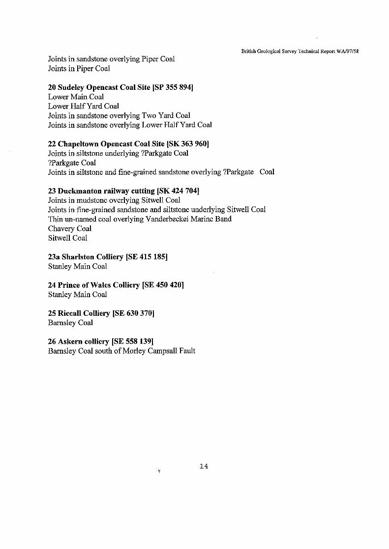
Joints in sandstone overlying Piper Coal Joints in Piper Coal
British Geological Survey Technical Report WA/97/58
20 Sudeley Opencast Coal Site [SP 355 8941 Lower Main Coal Lower Half Yard Coal Joints in sandstone overlying Two Yard Coal Joints in sandstone overlying Lower Half Yard Coal
22 Chapeltown Opencast Coal Site [SK 363 9601 Joints in siltstone underlying ?Parkgate Coal ?Parkgate Coal Joints in siltstone and fine-grained sandstone overlying ?Parkgate Coal
23 Duckmanton railway cutting [SK 424 7041 Joints in mudstone overlying Sitwell Coal Joints in fine-grained sandstone and siltstone underlying Sitwell Coal Thin un-named coal overlying Vanderbeckei Marine Band Chavery Coal Sitwell Coal
23a Sharlston Colliery [SE 415 1851 Stanley Main Coal
24 Prince of Wales Colliery [SE 450 4201 Stanley Main Coal
25 Riccall Colliery [SE 630 3701 Barnsley Coal
26 Askern colliery [SE 558 1391 Barnsley Coal south of Morley Campsall Fault
14
THIRD BROWN METAL cleat mean 13~5.4~ range 134Oto 140"
IY LI I I L t cleat mean 139 cleat mean 138" clear mean 132.5 range 134"to 138"
P number of joint trends
number of cleat trends
--- BETTERBED
THIRD BROWN METAL cleat mean 137,75 range 135"to 141'
35 36
-T- Fault, tick on downthrow side; throw in metres
Sense of strike slip movement
Dip in degrees
4 Axis of minor anticline, arrow indicates direction of plunge
- Cleat in THIRD BROWN METAL
MIDDLETON MAIN cleat mean 133.5' range 13O"to 136"
Cambriense Marine Band
SHAFTON
SHARLSTON TOP
SHARLSTON YARD
Aegiranum Marine Band k TWO FOOT STANLN MAIN
KENTS THICK
BARNSLEY DUNSIL SWAUOW WOOD UDGET
- \
SECOND BROWN METAL . THIRD BROWN METAL PARKGATE
MIDDLETON UTTLE / SLKSTONE THORNCUFFE
BEESTON .
/ MIDDLETON MAIN
Figure 1 Skelton Opencast Site
UPPER BAND n 0
300 m
F I
STANLEY MAIN (TOP LEAF1 deat mean 126.3 range 120'to 131'
Lawns Lane Opencast \ Site
KENPS THICK cleat mean 141'
\ ' Joints in siltstone and sandstone werlying KENPS THICK
- ,- Fault; crossmark on downthrow side
5- - Seam contour, value in metres below OD; FN = FLOCKTON THIN B = BEESTON
Inclined strata, dip in degrees; where no value is given, arrow shows general direction of dip. Dip direction underground is shown with the appropriate seam and its depth relative to OD
--$
121 Locality: 2 Lawns Lane Opencast site 3 Lofthouse Opencast Site
range 140'to 142'
Lofthouse Opencast \ Site
2 4 6 numberofjointtrends n = 2 2
\
Cambriense Marine Band
SHAFlON
SHARLSTON TOP
SHARLSTON YARD
Aegiranum Manne Band
TWO FOOT 2 STANLEY MAIN
3 WNPS THICK
BARNSLEY DUNSIL SWALLOW WOOD UDGET
Vanderbeckei Manne Band
PARKGATE THORNCUFFE -0 SILKSTONE BEESTON
mow BLACK BED BETTER BED
UPPER BAND
Subcrenatum Marine Band
YORKSHIRE
Figure 2 Lawns Lane and Lofthouse Opencast sites
I I I
n 5 h
5 SILKSTONE BEESTON
CROW BLACK BED BETTER BED
Cambriense Marine Band
SHAFlON
-SHARLSTON TOP
-qARLSTON YARD ----___
--- Aegirakm Mazne Band . . . . t-I
UPPER BAND
L-A Subcrenatum Marine Band
YORKSHIRE
SHARLSTON TOP
SHARLSTON MUCK
SHARLSTON LOW
SHARLSTON YARD
Locality 4: St Johns Opencast Site
SHARLSTON YARD cleat mean 138.4' range 133Oto 144"
SHARLSTON close agains Morley Campsall Fault
LSHARLSTON LOW cleat 148"
Cornwall Opencast Site
HOUGHTONTHI cleat mean 148O
Figure 3 St John's, Ackton and Cornwall Opencast sites and Sharlston and Prince of Wales collieries
2:
n = 27
ioms !n Glasshoughton Rock
N
RLSTON LOW mean 141 8'
e 13Pto 154'
SHARLSTON YARD &at mean 1580
2
number of fault trends
Faults ~n SHARLSTON COALS at surface
N
s tn HAIGH MOOR ed from mine plans)
I 41 42
Fault pattern at the surface and at depth in the vicinity of the Ackton Opencast Site (locality 5) 1
number of fauktrendsl' n.36 A
4 1
Faults
\ \'c-Main Cleat
Detail of a relationship of a fault to main cleat in Ackton Opencast Site; arrows indicate sense of transtensional movement along North Featherstone Fault; fault throw shown in metres
Figure 4 Detail at Ackton Opencast site \
0 1 km - STANLEY MAIN cleat mean 151.2O
number of cleat trends
N
Locality 23a: Sharlston Colliery Locality 24: Prince of Wales Colliery
Figure 5 Comparison of cleat in the Stanley Main coal at Sharlston and Prince of Wales collieries
- -,- Fault; crossmark on downthrow side c- . - Outcrop of the Low Barnsley Coal
Seam contour, value in metres below OD Locality. 8 Tinsley Park Opencast Site except where prefixed with + ; contours are on the Low Barnsley Coal except those in the south-west which are on the Silkstone Coal
9 Waverley East Opencast Site 10 Pithouse Opencast Site
0 1 km U
--- PARKGATE --- THORNCUFFE SILKSTONE BEESTON
~- --: ~'PKBED --- BETTERBED
UPPERBAND
Tinsley Park Opencast Site
r"
0
L300m
ain joint in mudstone of to WINTER
Joints in siltstone above MELTONFIELD
number of joint trends n = 31
number of joint n = 41
Joints in fine-grained ndstone above
BEAMSHAW cleat mean 126.5" ; range 124" to 128" WINTER
12Ooto 130°
130"
SHAFTON
SHARLSTON TOP
-SHARLSTON YARD
Aeoiranum Marine Band
89 & 10
Waverley East Opencast S i e
i in sandstone FIRST THIN number of joint t
n = 59
number of joint trends n=12
ints in mudstone
FIRST THIN cleat range 128'to 132' MELTONFIELD cleat range 128"to 133' TWOFOOTcleat range 128'to 132O HIGH HAZELS cleat range 128'to 130"
WINTER COAL TOP LEAF cleat mean 130.60 range 130°to 132O WINTER COAL BOTTOM LEAF cleat mean 132.5" range 128"to 136"
._ . I. DUNSIL # SWALLOW WOOD
UDGET Vanderbeckei Manne Band
Subcrenaturn Marine Band
YORKSHIRE
Pithouse Opencast Site N
number of joint tren
Kilnhurst back cleat
HIGH HAZELS cleat mean 127.5" range 124Oto 130"
HURSTcleat 130'
in siltstone between SLEY and HIGH HAZELS
umber of joint trends n = 35
{ Figure 6 Tinsley Park, Waverley East and Pithouse Opencast sites I
-r Fault; crossmark on downthrow side -.-Outcrop ofthe Low Barnsley Coal I lo-.--- seam contour, value in metreS below OD - .. - Outcrop of the Blackshale (Silkstone) Coal
except where prefixed with i ; contours are on the Low Barnsley Coal, Bladtshale (Silkstone Coal and the base of the Westphalian (in the west) 23 Duckmanton Railway Cutting
Local'iy: 13 Slayley Dlxon Opencast Opencast Site 'Ite
Cambriense Marine Band 1-4 Duckmanton Railway Cutting i
um Marine Band
11 THIN COAL
CHAVERY SWELL
23
13
DEEP HARD RRST PIPER SECOND PIPER COCKLESHELL TUPTON THREE QUARTER ERAMPTON HIGH MICKLEY THICK MICKLEY CANNEL
;I. ~ ~ L B ~ N Subcrenstum Marine Band
DERBYSHIRE AND NOTTINGHAMSHIRE
Joints in mudstone overlying number of joint trends SITWELL
SITWELL cleat 114"
\ CHAVERY cleat range 104Oto 1%'
Joints in mudstone below SITWELL
number of joint trends n=12
Joints in silty mudstone
nuhber of joint trends
MICKLEY THICK cleat mean 124.75" range 125"to 134"
MEKLEY CANNEL n = 26, mean 139.6"
number of joint trends
t
21
Base of Westphalian
0 1 km
-r Fault; crossmark on downthrow side
Seam contour, value in metres below OD except where prefixed with +
-.-Outcrop of Bladc Shale (Silkstone)
1141 Locality: 14 Ryefield Opencast Site
Coal or base of Westphalian strata (in west)
15 Godkin Opencast Site
Ryefield Opencast Site
i DEEP HARD cleat mean 134" range 130" to 140"
cleat mean 13
Joints in sandstones between PIPER and DEEP HARD coals n=15
Godkin Opencast Site
N
I / RRSTELLcleat mean 120.3" range 116"to 125" THIRD WATERLOO cleat mean 124.8Orange 1220 to 128O FOURTH WATERLOO cleat mean 124.8' range 124"to 138'
THIRD WATERLOO
~ U R T H WATERLO bar indicates range
4 3 number of joint tren
n=17
5
HIGH MAIN WALES
CLOWNE
HIGH HAZELS
-MOm
SILKSTONE MICKLEY THICK
KJLBURN
1-1 Subcrenatum Manne Band Joints in siltstone and fine-qrained sandstone
DERBYSHIRE AND NOlllNGHAMSHIRE overlying FOURTH WATERLOO
Figure 8 Ryefield and Godkin Opencast sites
22
0
- ,- Fault; crossmark on downthrow side
50-.--- Contour on base of Bladc Shale (Silkstone) Coal 1171 Locality: 17 Cossall Opencast Site
Cambriense Manne Band c; HIGH MAIN WALES Aegiranum Marine Band
CLOWNE
HIGH HAZELS
TOP HARD WATERLOO
1-4 Vsnderbeckei Marine Band
0
MO m
UPER TUPTON SLKSTONE MICKLEY THICK
KJLBURN
DERBYSHIRE AND NOTTINGHAMSHIRE
number of joint trends
Cossall Opencast Site
Joints in PIPER
number of jointtrends
,..__I :-:-A- ,.. --- - . [ Figure 9 Cossall Opencast site
Joints in sandstone overlying LOWER HALF YARD
(range of azimuths)
0-
100-
200-
300 m -
Permian andTriassic ... . .... ... Carboniferous
Pre-Carboniferous
Locality : Sudeley Opencast Site
FORMATION I I
DEEPRIDER WENCH
STANHOPE
Subcrenatum Marine Band
WARWICKSHIRE
Sudeley Opencast Site
i LOWER HALF YARD
LOWER MAIN
cleat mean 13
range 122Oto 148O
k I -. - .- .. . .. I
Figure 10 Sudeley Opencast site
Joints in sandstone overlying TWO YARD
2
number of joint trends 1
n=/
ut-
- r Fault; crossmark on downthrow side
Seam contour, value in metres below OC except where prefixed with +
-.- Outcrop of Silkstone Coal
--# Regional dip of strata
I
I
--- Cambriense Marine Band
--- SHAFFON
--- SHARLSTON TOP
--- SHARLSTON YARD
-U- Aegiranum Manne Band
--- TWO FOOT --- STANLEY MAIN
--- KENT'S THICK
' 1221 Locality: Chapeltown Opencast Site
437
495 \ \ \ "4
2 2 - 4 - PARKGATE --- THORNCUFFE --- SILKSTONE --- BEESTON
-- --: %'&BED --- BETTERBED
BARNSLEY DUNSIL # SWALLOW WOOD
UDGET Vanderbeckei Marine Band
0
UPPER BAND
Subcrenatum Marine Band
YORKSHIRE
Figure 11 Chapeltown Opencast site i Fig 11 layout 3rd proof I Drawn by:G. J.Tuggey I
Chapeltown Opencast Site
I
Joints in siltstone and fine-grained sandstone above ?PARKGATE
Joints in siltstone underlying ? PARKGAE 3
number of joint trends
n = 9 %
I 6: ,.( -/’ 63
-/ 6 number of cleat trends - 7
6 -7’ n = 4 0 / /
/ -I /
/ _/c--
I 65 /. A4
/ .4 /’ / /’ Locality 25 : Riccall Colliery /’ /’
Cleat azimuth in Barnsley Coa - spotmarks i ./- /’
/’ point of observation
BARNSLEY cleat
L .---
Figure 12 Riccall Colliery
SHAFTON
SHARLSTON TOP
-SHARETON YARD
TWO FOOT STANLEY MAIN
KENT’S THICK
DUNSIL SWALLOW WOOD
UDGET
PARKGATE THORNCUFFE SLKSTONE BEESTON
CROW BLACK BED BETTER BED
UPPER BAND
0
MO m
LMA Subcrenatum Manne Band
YORKSHIRE
Fault; crossmarkon
Reverse Fault; arrow indicates
- 7- downthrow side *- direction of hade /'
I I I
/
Cleat azimuth in BarnsleyMlarren House Coal - Cleat azimuth in Flockton Coal
/' ,/
-AuL Locality 26 : Askern Colliery
16
15
14
13
-7
41 2
453 54 55 56 \ 51 58 I I
Figure 13 Askern Colliery
Askern Colliery
N 1'
BARNSLEY south of Morley Campsall Fault leatmean 128"range117°t01370n=17
BARNSLEY north of Morley Campsall Fault cleatmean116.2°range102"to13Pn=15
Lancaster Fells and lngleton Coalfield
Coal Measures and Permian rocks undivided
Millstone Grit Group
Carboniferous Limestone
Lower Palaeozoic strata
- ,- Fault, crossmark indicates downthrow side
@ Locality; for details see text
+ Regional dip of strata
z z 0-
4
n a Y
z 4 a u.l Y 0 I V n
5
4 a
a - z I- cc 0
- TEN FEET @)
Vanderbeckei Marine Band
- FOUR FER @ - SIX FEET
- B L A E B E R R Y ~
-thin, un-named @ 0 Subcrenatum Manne Band
-0
-100
- 200
L 300 m -@@,@@a - Clintsiield Coals
LANCASTER FELLS AND INGLETON COALFIELD
b
Figure 14 The Lancaster Fells and Ingleton Coalfield