Embed Size (px)
Citation preview
BRITISH COLUMBIA
PROSPECTORS ASSISTANCE PROGRAM
MINISTRY OF ENERGY AND MINES
GEOLOGICAL SURVEY BRANCH
PROGRAM YEAR: 1995/1996
REPORT #: PAP 95-49
NAME: THOMAS LISLE
GEOLOGICAL AND GEOCHEMICAL REPORT
ON THE
RAINBOW 2,3 AND 4 MINERAL CLAIMS
PROJECT 95-96-PO67
TULAMEEN
SIMILKAMEEN MINING DIVISION
LAT. 49 34’ LONG.120 50’ NTS 92 H/lOW.
BY
T.E.LISLE, P.ENG.
NOVEMBER 30.1995
TABLE OF CONTENTS
SUMMARY AND CONCLUSIONS RECOMMENDATIONS INTRODUCTION LOCATION AND ACCESS PROPERTY CLIMATE TOPOGRAPHY AND VEGETATION HISTORY 1995 WORK PROGRAM REGIONAL SETTING GEOLOGY OF THE RAINBOW CLAIMS. GEOCHEMICAL SURVEY MAGNETIC SURVEY DISCUSSION REFERENCES
LOCATION AAer Contents CLAIM MAP Afier Page 2 REGIONAL GEOLOGY AAer Page 5 SUMMARY SKETCH Afler Page 9 ROPERTY GEOLOGY In Pocket GEOCHEMISTRY. COPPER-GOLD In Pocket
APPENDICES
PERSONNEL STATEMENT OF EXPENDITURES ASSAY AND GEOCHEMICAL DATA SHEETS
Page 1 Page 1 Page 2 Page 2 Page 3 Page 3 Page 4 Page 4 Page 5 Page 6 Page 7 Page 8 Page 9 Page 11
Fig. 1 Fig.2 Fig.3 Fig.4 Fig.5 Fig~6
Appendix I Appendix 2 Appendix 3

SUMMARY AND CONCLUSIONS
A geological and geochemical survey was carried out between June and October, 1995 on the Rainbow 2, 3, and 4 mineral claims located near Tulameen in the Similkameen Mining Division. The program was a continuation of work started in 1994, and was partly funded by the Prospectors Assistance Program administered by the British Columbia Ministry of Mines and Petroleum Resources.
The geological work indicated the presence of a felsic rhyolite ( feldspar porphyry) ? horizon adjacent to a Tertiary Otter granite stock. with an apparent trend of north northwest. Where exposed, this unit is limonitic and is marked by a significant amount of siliceous. pyritic alteration with clay, epidote, chlorite, and locally by magnetite and chalcopyrite.
Much of the altered rhyolitic zone is covered with glacial overburden. Analyses of soil samples collected from the grid revealed gold content to 290 ppb, and copper to 466 ppm Gold anomalies tend to be loosely clustered within or close to the indicated trace ofthe alteration zone. or down slope and down ice to the southwest. Anomalous copper assays are widely scattered and more common to the east of the zone.
The north section of the alteration zone is partly marked by anomalous magnetics of the same trend. Assessment report 16016 shows a weak VLF-EM conductor and associated gold and related metal soil anomaly along trend to the southeast on the Rainbow 4 claim.
It is concluded that the results of the preliminary surveys are sufficiently attractive to recommend further prospecting, sampling and geological mapping, and a continuation of the geochemical and geophysical surveys to evaluate the mineral potential of the Rainbow claims.
RECOMMENDATIONS.
1 j Analyze all (334) soil samples remaining from the 1994 and 1995 geochemical surveys.
2) Detail map and sample the alteration zone identified in previous work. and soil sample 50 meter line5 in area5 of interest.
3) Run VLF-EM (2 channel) surveys over the entire grid, and complete magnetic and geological surveys.

2
4) Southern sections of the Rainbow 4 mineral claim were investigated by geochemical and geophysical surveys in 1986 and the results described in Assessment Report 160 16. The area between the 1986 work and the 1995 work should be explored by a combination of geological, geochemical and geophysical surveys to complete coverage in this area.
5) Compile and correlate the Rainbow exploration data with exploration data from the Boulder-Rabbitt Mountain area to the east, and with the geology of the El Alemein gold occurrences to the south.
INTRODUCTION
The author, along with E. Ostensoe, P.Geo., submitted a proposal to the Prospectors Assistance Program administered by the provincial Ministry of Energy Mines and Petroleum Resources in May 1994. The proposal was for funding of a small exploration program proposed for the Rainbow claims located near Tulameen in the Similkameen Mining Division. The funding was granted, and the results of the 1994 work were submitted to the Ministry in a January, 1995 report
A further proposal was made to the Ministry in April, 1995 for additional funding to continue exploration work on the Rainbow claims. Funding was again allocated , and between June and October. 1995, a program ofgrid establishment, and geological and geochemical surveys were undertaken. We wish to acknowledge with thanks the assistance of grants received. These funds have covered a significant part of the exploration costs incurred
This report describes exploration work carried out with assistance ofthe Prospectors Grant. All technical observations are presented and discussed in the report. and compiled on maps accompanying the report. Due to budget constraints, only a limited number of soil samples were analyzed 334 samples remain to be analyzed at a future date. Because of the ongoing work, interpretations and conclusions are preliminary and may change significantly with results of proposed additional work.
LOCATION AND AKES
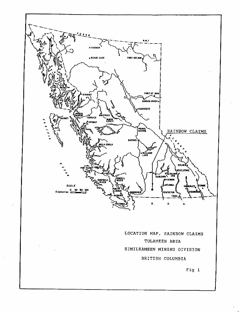
The Rainbow claims lie on the north slope of the Tulameen River Valley some six to ten kilometers west and northwest of the village of Tulameen in south central British Columbia. ( Figure 1). The geographic coordinates are Latitude 49 34’ ; Long. 120 50’. NTS Map sheet 92WJOW.

3
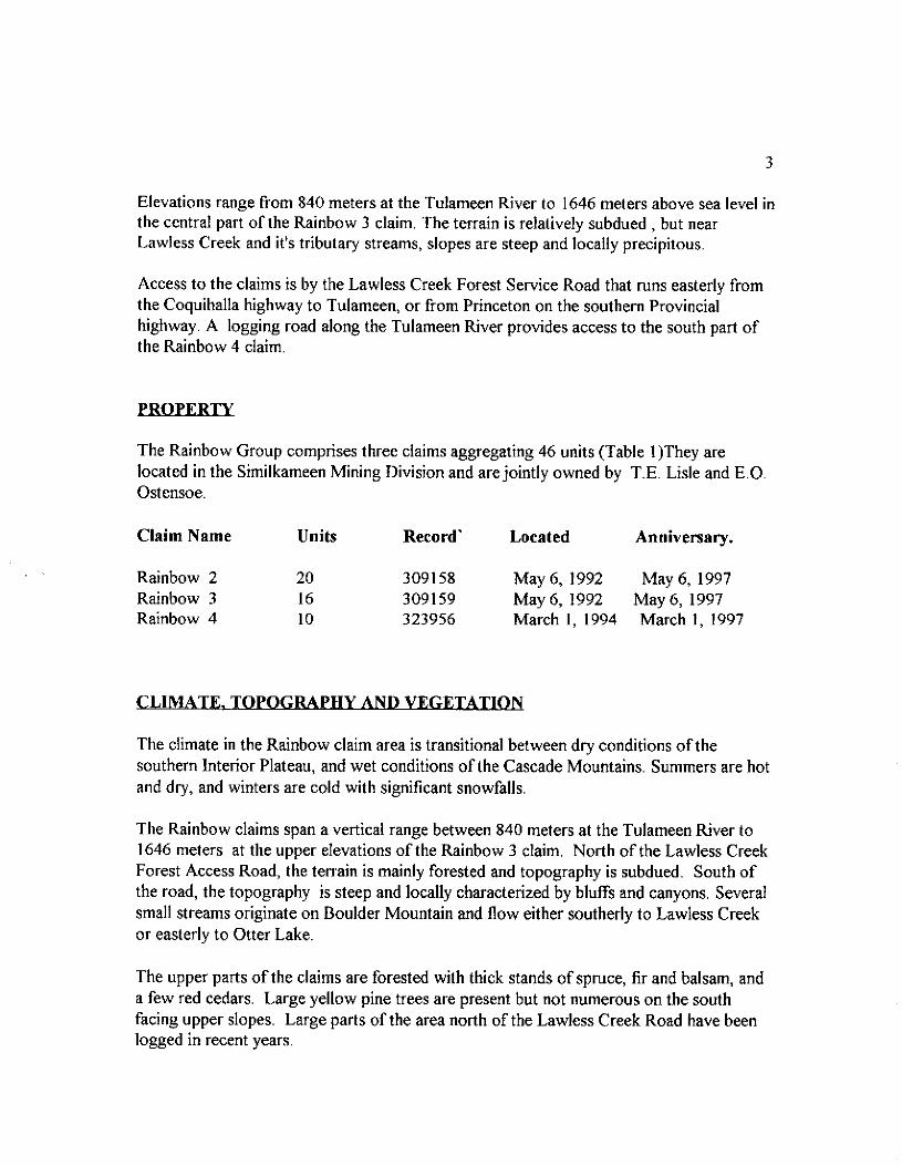
Elevations range from 840 meters at the Tulameen River to 1646 meters above sea level in the central part of the Rainbow 3 claim. The terrain is relatively subdued , but near Lawless Creek and it’s tributary streams, slopes are steep and locally precipitous.
Access to the claims is by the Lawless Creek Forest Service Road that runs easterly from the Coquihalla highway to Tulameen, or from Princeton on the southern Provincial highway. A logging road along the Tulameen River provides access to the south part of the Rainbow 4 claim.
The Rainbow Group comprises three claims aggregating 46 units (Table 1)They are located in the Similkameen Mining Division and are jointly owned by T.E. Lisle and E.O. Ostensoe.
Claim Name Units
Rainbow 2 20 Rainbow 3 16 Rainbow 4 10
Record’
30915s 309159 323956
Located Anniversary.
May 6, 1992 May 6, 1997 May 6, 1992 May 6, 1997 March 1, 1994 March I, 1997
CLIMATE.
The climate in the Rainbow claim area is transitional between dry conditions of the southern Interior Plateau, and wet conditions of the Cascade Mountains. Summers are hot and dry, and winters are cold with significant snowfalls.
The Rainbow claims span a vertical range between 840 meters at the Tulameen River to 1646 meters at the upper elevations of the Rainbow 3 claim. North of the Lawless Creek Forest Access Road, the terrain is mainly forested and topography is subdued. South of the road, the topography is steep and locally characterized by bluffs and canyons. Several small streams originate on Boulder Mountain and flow either southerly to Lawless Creek or easterly to Otter Lake.
The upper parts of the claims are forested with thick stands of spruce, fir and balsam, and a few red cedars. Large yellow pine trees are present but not numerous on the south facing upper slopes. Large parts of the area north of the Lawless Creek Road have been logged in recent years.

The mining history of the Tulameen area is documented in numerous government publications, and in more than 120 technical reports that have been filed for assessment purposes on mineral prospects in a 300 square kilometer area centered approximately on Tulameen.
The first comprehensive geological map of the Tulameen area was included in GSC Memoir 26 authored by Charles Camsell in 1913. Camsell showed the presence of a small granitic stock intruding the Nicola rocks in the area of the current Rainbow 3 claim.
Early prospectors were undoubtedly attracted to the Tulameen area by placer mining possibilities, particularly by discoveries of platinum in nearby streams and by production of large gold nuggets from Lawless and Boulder Creeks. A large gossaned alteration zone now exposed near the 9 kilometer mark on the Lawless Creek road occurs along a substantial creek valley that passes southerly through the Rainbow 2 claim. Several small bedrock pits located north of the road were excavated many decades ago and expose concentrations of pyrite and locally magnetite.
Important background information on the Rainbow claim area is contained in assessment reports 16016 and 17271. A 1993 preliminary prospecting report by Lisle and Ostensoe. and their report on the 1994 exploration work also provide background information.
1995 WORK PROGRAM
The following work was completed on the Rainbow claims between June and October, 1995.
Work Rainbow2 Rainbow 3 Rainbow 4 Total
Grid Lines. 8.50 Km. Geochemical (soil) * - Geology(l:5,000) 17.0 Km.
3.725 Km. 8.00 Km. 20.225 Km. 191 118 309 samples 22.0 Km. 5 Km. 44.0 Km. ?
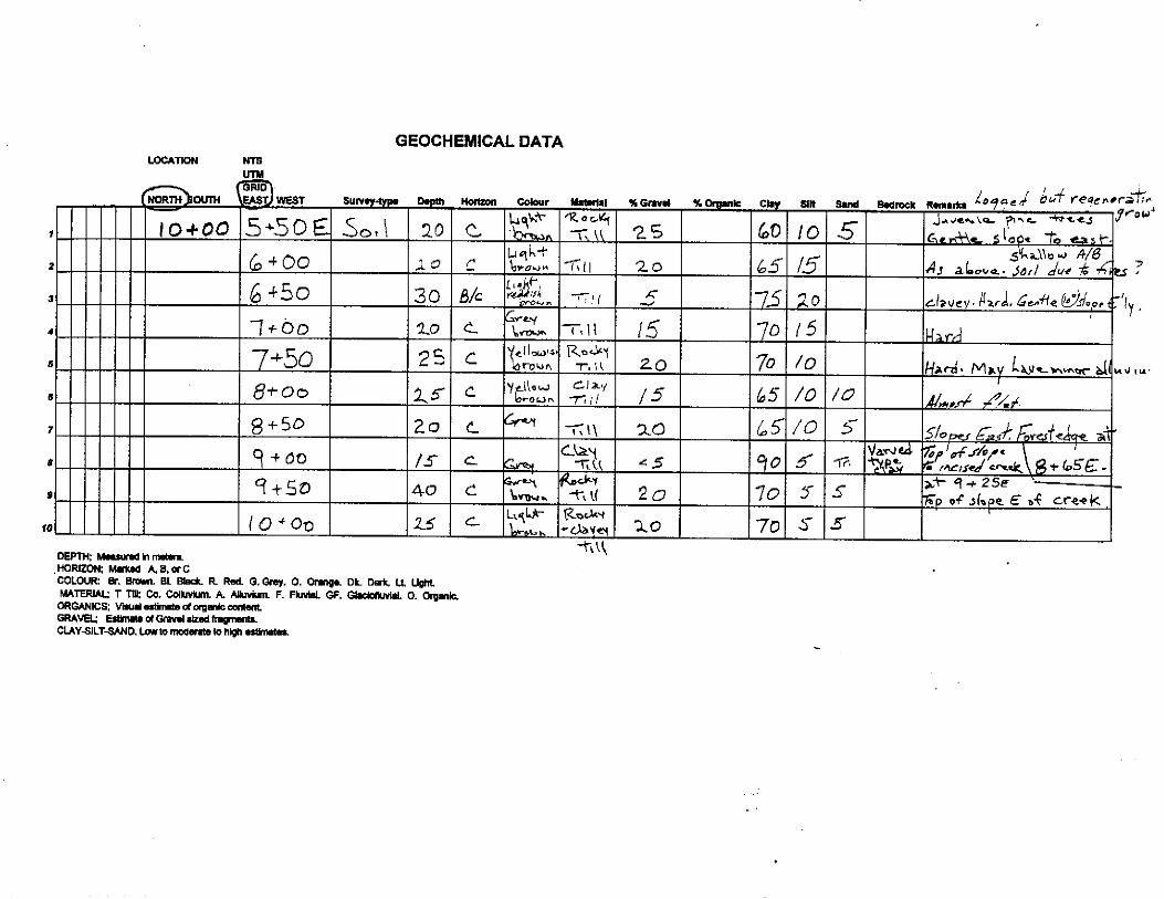
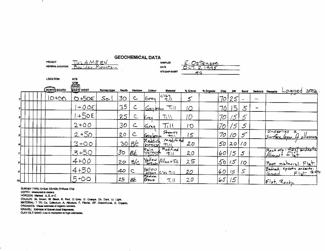
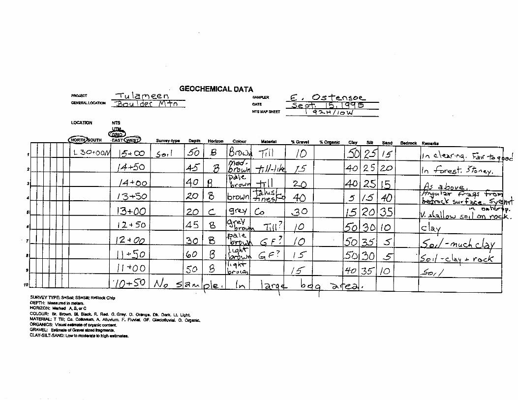
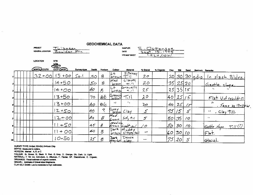
* 169 samples were selected from the above, and from those remaining from the 1994 work program. These samples were analyzed for gold and for 30 elements by ICP methods. 334 soil samples remain to be analyzed at a future date.
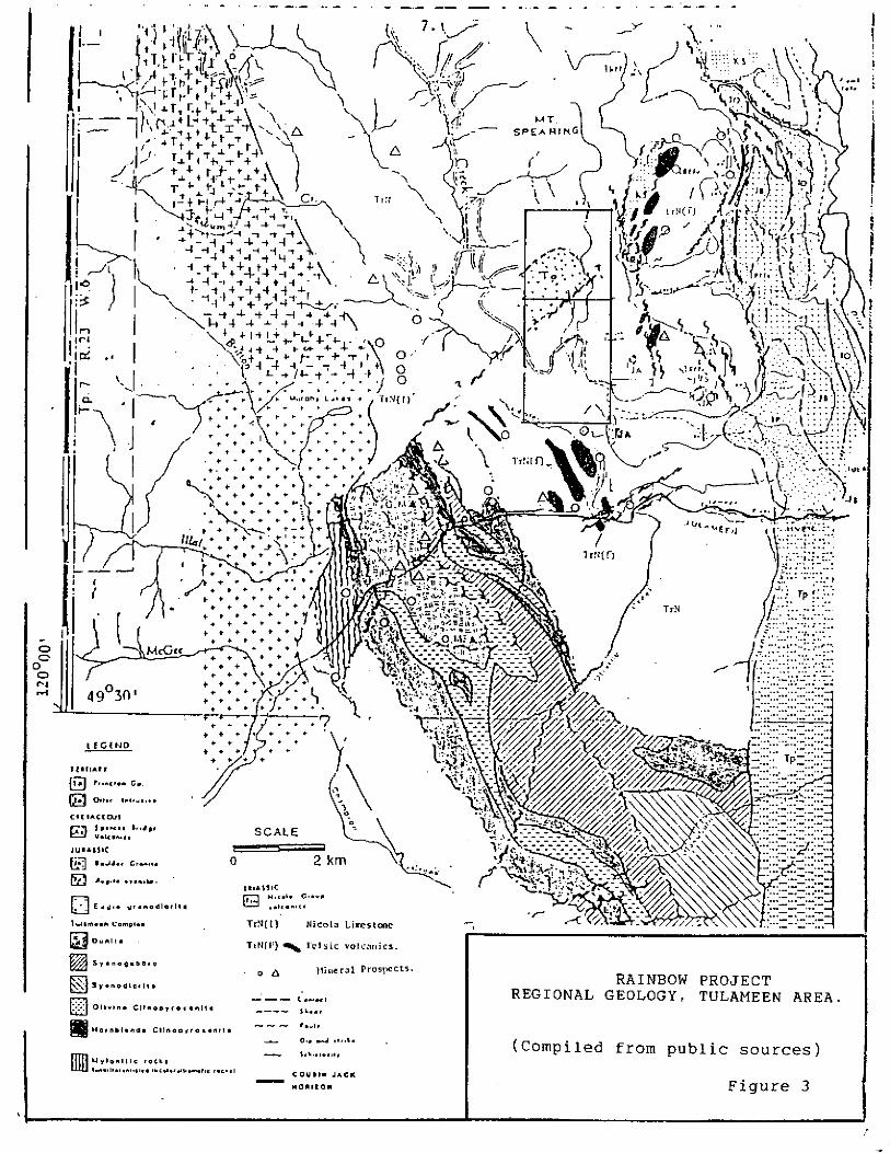
RECtONAL SETTING
The Nicola Group in southern British Columbia is part of a linear northwesterly Cordilleran belt of volcanic and sedimentary rocks developed in an Upper Triassic island arc. The group is , at least in the Princeton-Merritt area , a westward younging assemblage comprising:
a) An eastern belt of alkalic and talc-alkalic submarine volcanic rocks, lahar deposits, basaltic flows, and high-level syenite stocks.
b) A central belt of alkalic and talc-alkalic subaerial and submarine assemblages of andesite, basalt and co-magmatic intrusions of diorite and syenite, and breccia, conglomerate and lahar deposits.
c) A western belt of talc-alkalic flow and pyrociastic rocks ranging in composition from andesite to rhyolite, with minor interbedded limestone, volcanic conglomerate, sandstone and argillite. This assemblage appears to underlie much of the Tulameen area.
The Nicola Group to the west of Tulameen is bounded on the west by the Eagle Granodiorite, a syntectonic intrusion of apparent upper Jurassic age. Both the Eagle Granodiorite, and amphibolitized Nicola Group rocks dip westerly along a regionally developed northwest foliation. Several small intrusions are present in the Tulameen area They include the Late Triassic to Early Jurassic Boulder Granite, the upper Triassic Tulameen Ultramafic Complex, and Tertiary Otter granite stocks.
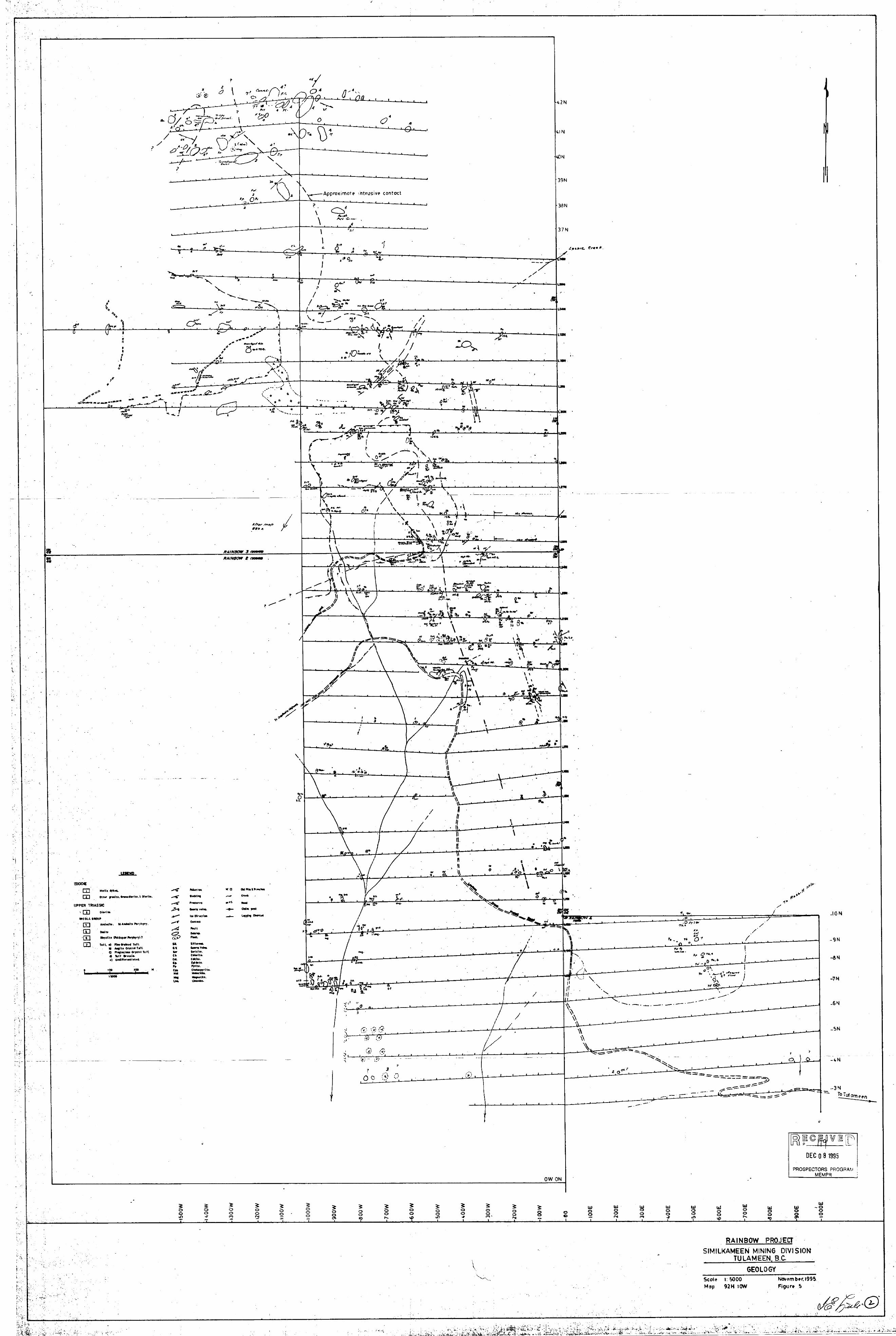
All ofthe older rock units are disrupted by faults that either trend northwest along the regional trend, or by Tertiary (Eocene) ? northeast faults that appear to mark the planes of significant right -lateral and vertical displacement. One of the northeast faults marks the north boundary of the Tulameen ultramafic complex and apparently trends northeast through the Rainbow claims close to an Otter Granite Stock. Figure 3 illustrates some of the features of the regional geology in the vicinity of Tulameen.
The Nicola volcanic rocks and related intrusions in south-central British Columbia are host to a number of world-class mineral deposits including copper-gold porphyries at Princeton and Kamloops; copper-molybdenum porphyries at Highland Valley; and the large Craigmont copper-iron skarn deposit at Merritt. In addition, the belt is host to a very large number of prospects, including those at Tulameen, that continue to be evaluated.

6
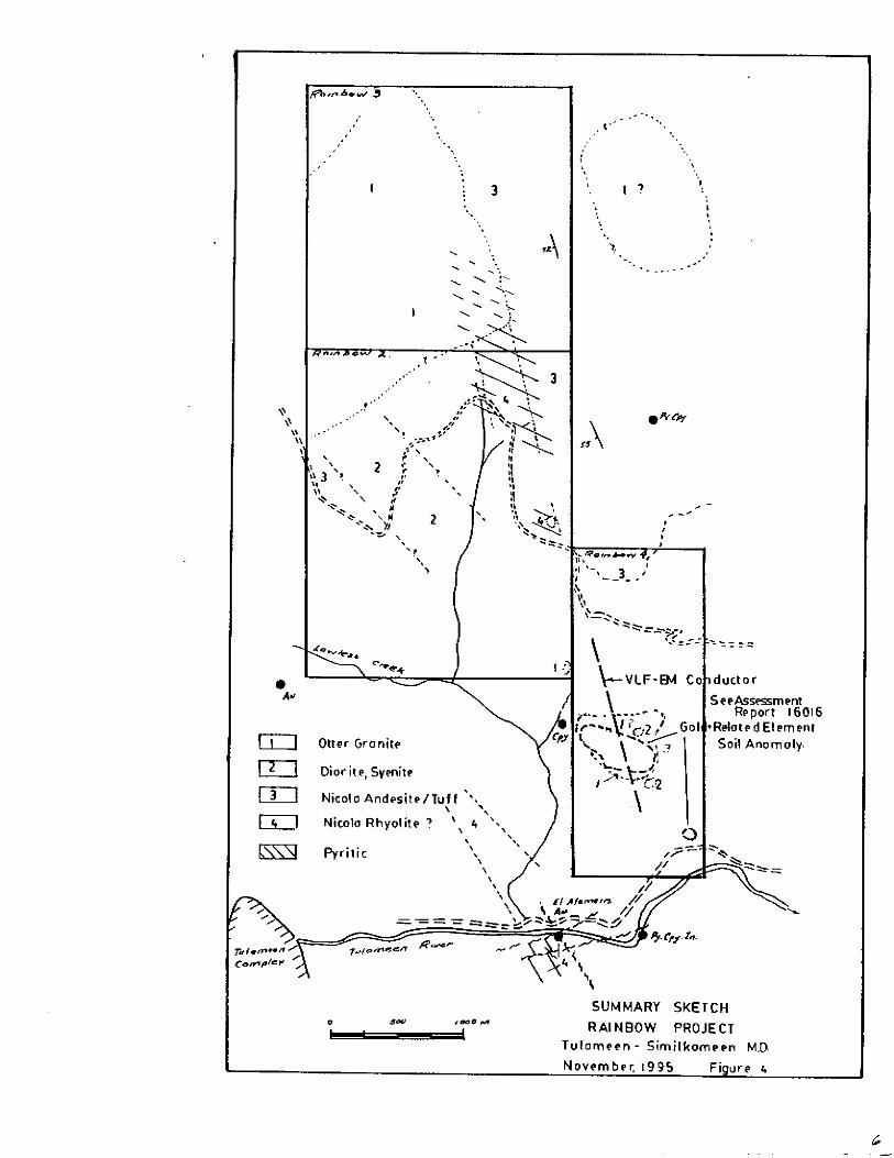
GEOLOGY OF THE RAINBOW CLAMS
The geology of the Tulameen area was first described by C. Camsell in 1913 in GSC Memoir 26, and was further elaborated by H.M.A.Rice in GSC Memoir 243 published in 1947. Both of these references showed the presence of a stock of Otter Granite in the area of the current Rainbow 3 claim, intruding both Nicola Group rocks and intrusive rocks variably described as either augite syenite or members ofthe Tulameen ultramafic complex, namely peridotite, pyroxenite or gabbro.
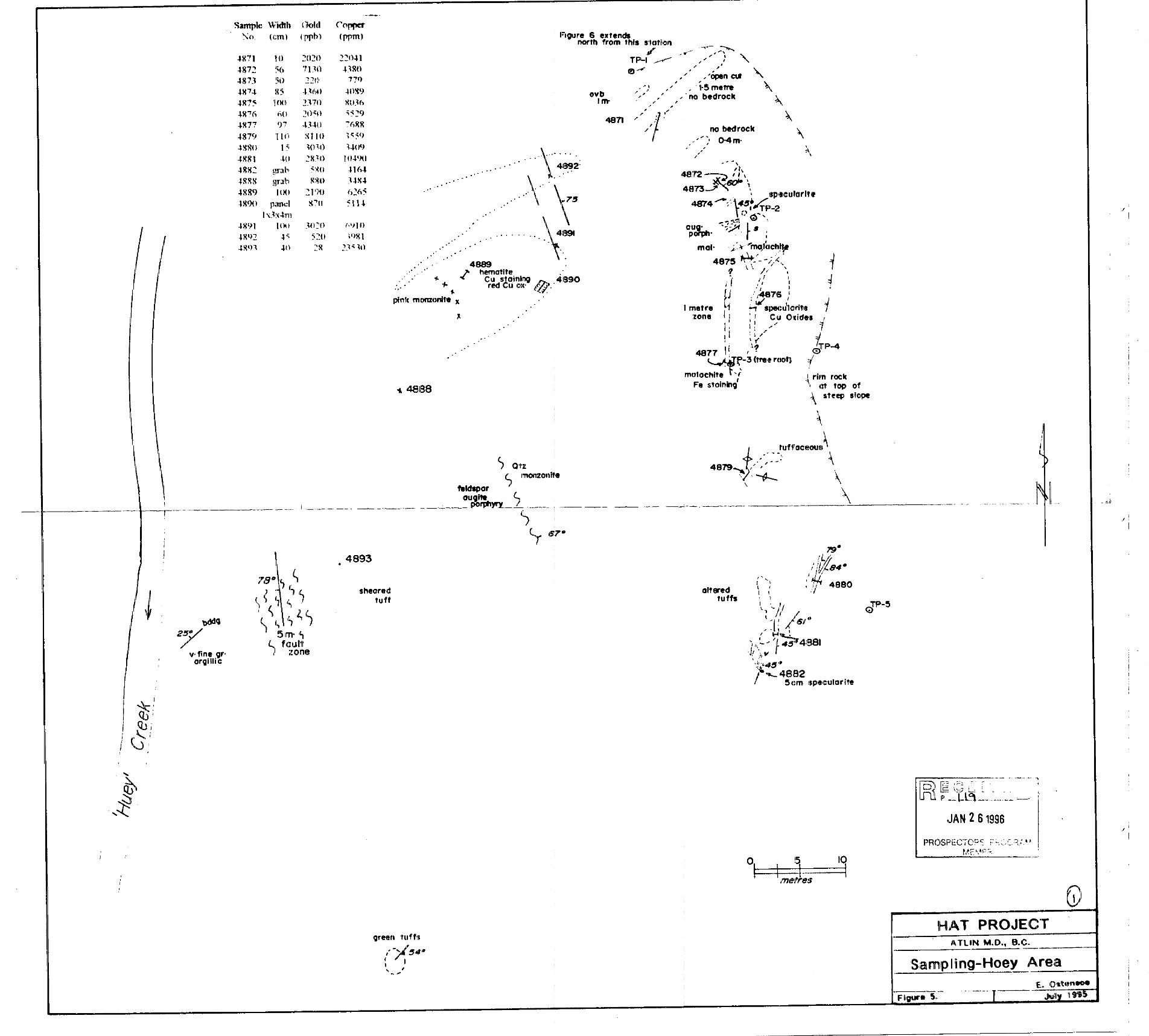
The oldest rocks in the area are Nicola Group flow and fragmental volcanic rocks that are mainly of andesitic composition. The assemblage is poorly to well bedded and forms a prominent belt along the east side of the Rainbow claims trending north northwest and dipping from about 55 to 75 degrees to the west. The belt is dominated by rocks provisionally mapped as augite crystal tuff, fine-grained tuff, subordinate amounts of plagioclase crystal tuff, and a variably textured tuff beccia that commonly contains distinctive pink to buff fine-grained felsic clasts. The clasts in this unit locally resemble trysts, and in places grade to pink stringers within or crossing foliation. The tuffaceous units are highly variable over narrow widths, and are interbedded with thin bands of andesite porphyry containing coarse feldspar laths. Near grid point 7+00N - 5+75E, a massive greenish-grey flow in contact with tuff may be dacitic in composition.
The andesitic unit is flanked on the west in part by a pale grey to greenish-grey rhyolite or feldspar porphyry This unit is commonly siliceous pyritic, in places porphyritic, and is generally poorly exposed. The western contact is obscured by overburden that covers a topographic low over a few hundred meters of width, and the trace of the horizon from 12+00N, 1+5OW and 18+75N, 4+OOW is obscured by drift. The section between 18+75N and 25+00N and the flanking rocks to the east are marked by a limonitic bleached siliceous zone with up to 10% pyrite, +- magnetite and minor chalcopyrite that is partly coincident with magnetic anomalies of similar trend. Skarny propylitic assemblages of epidote, chlorite, quartz. pyrite and chalcopyrite are locally evident in the eastern segments of the alteration zone.
The southwest side of the Rainbow 2 claim is underlain by a dark-grey tine-grained dioritic unit that may grade from gabbro to syenite. While separated from the above. it also appears to trend northwest. Xenoliths ofNicola andesitic rocks are present, and alteration includes epidote, chlorite. magnetite and minor pyrite. The diorite has been intruded on the north by a stock of Otter Granite. Pink granitic stringers, dykes and disseminations are common in the diorite, around which the composition varies widely. The boundaries ofthe diorite are poorly defined. The distribution of outcrops indicates that it may join a diorite-syenite mass shown on regional maps to lie a short distance to the southeast.
7
The Otter Granite stock underlies a large western segment of the Rainbow 3 claim. The stock is complex in that it contains highly variable concentrations of poor to well assimilated xenoliths of Nicola volcanic rocks. Compositionally the stock grades from granite to granodiorite with border zones more basic, in some areas reported to grade to gabbro. Typically, the contacts are irregular and the granite occurs in stringers, dykes and irregular masses. It is commonly pink to grey in colour, fine to medium-grained, and locally porphyritic. Altered biotite and hornblende are locally evident. The area north of the rhyolitic unit contains up to a few percent pyrite.
A poorly defined +- 15 meter zone of intense argillic alteration occurs at line 25+00N, 5+50 W, near the interpreted boundary between the granite and rhyolite. Argillic alteration, in part related to northeast fractures, is also evident in a road cut near 19+50N, 4+5ow.
Camsell showed the contact between the diorite-syenite and Otter granite to trend northeast. Assessment report 15,3 15) shows a large area near the headwaters of Lockie Creek immediately east of Rainbow 3 claim also to be underlain by granodiorite and diorite , and assessment report 16016 notes the presence of an area of Red granite in the eastern sections of the Rainbow 4 mineral claim. These occurrences suggest the possibility of a much larger area of Otter Granite.
A number of small basaltic dykes related to the Eocene Princeton Group, cut all of the older units. Typically they are black to dark-grey, magnetic, and locally porphyritic with fine hornblende, biotite or feldspar. These exposures are commonly accompanied by strong northeast fracture sets, that are thought to relate to Eocene faults that also trend northeast.
GEOCHEMICAL SURVEY
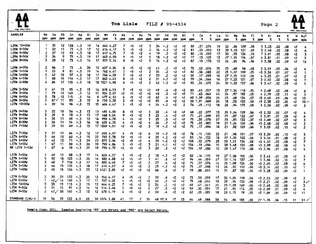
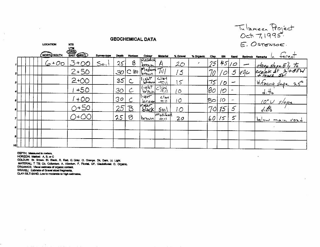
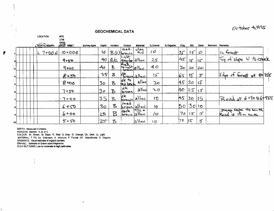
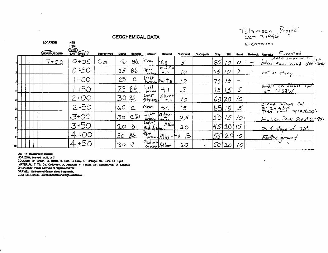
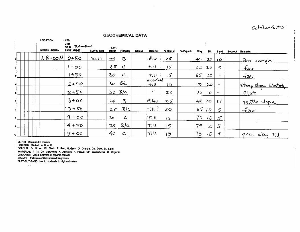
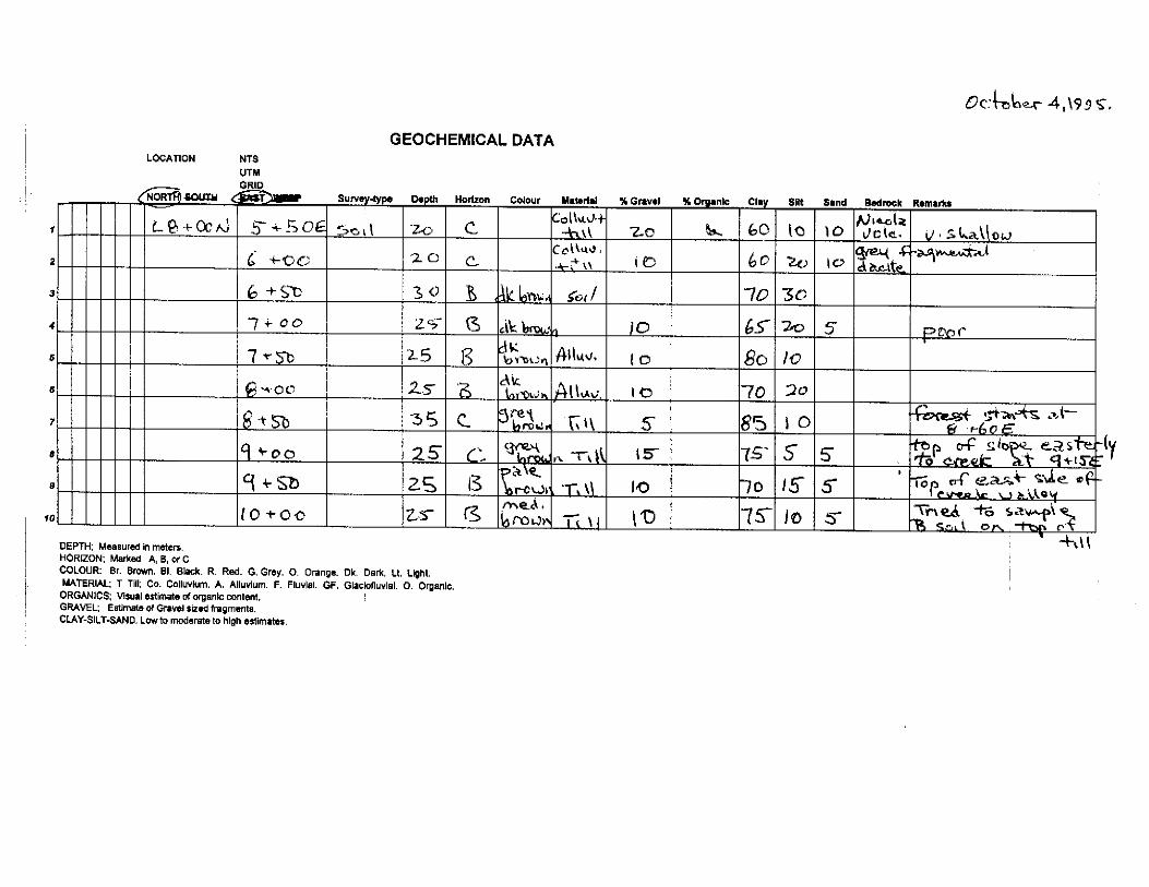
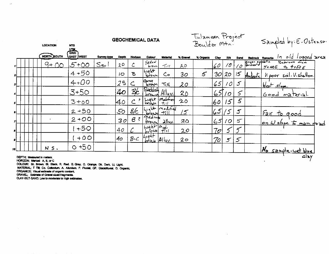
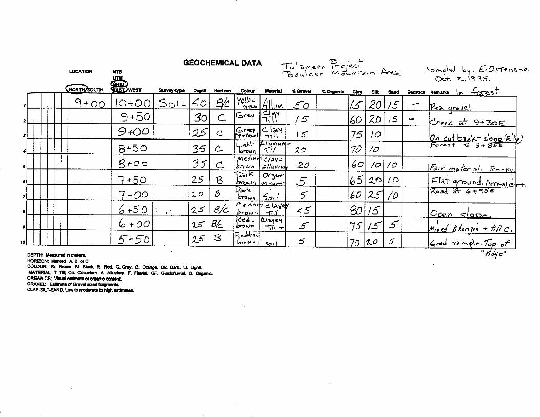
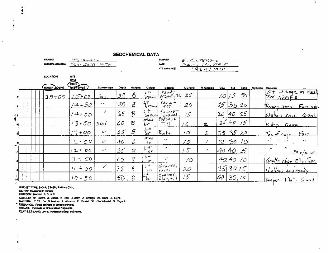
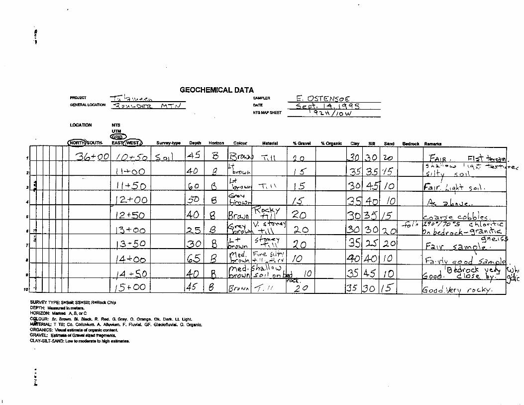
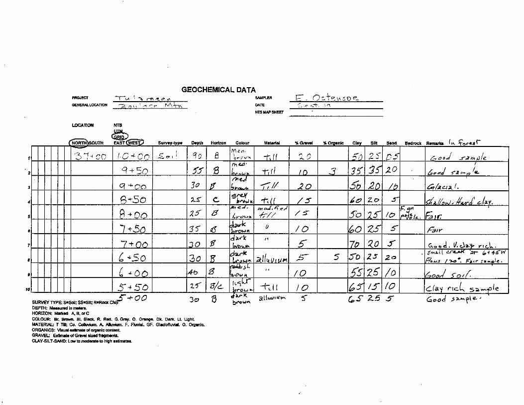
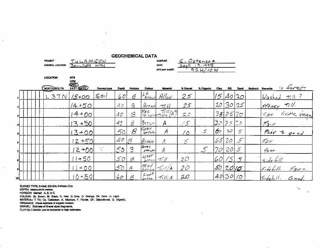
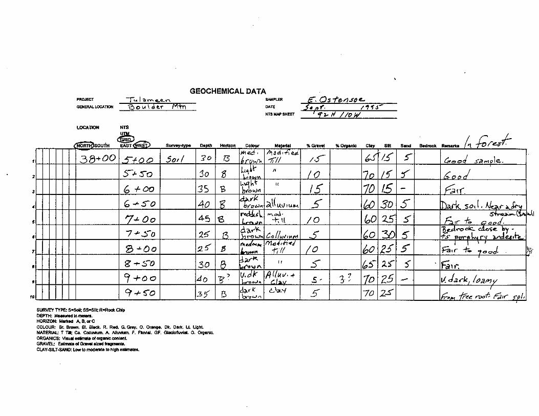
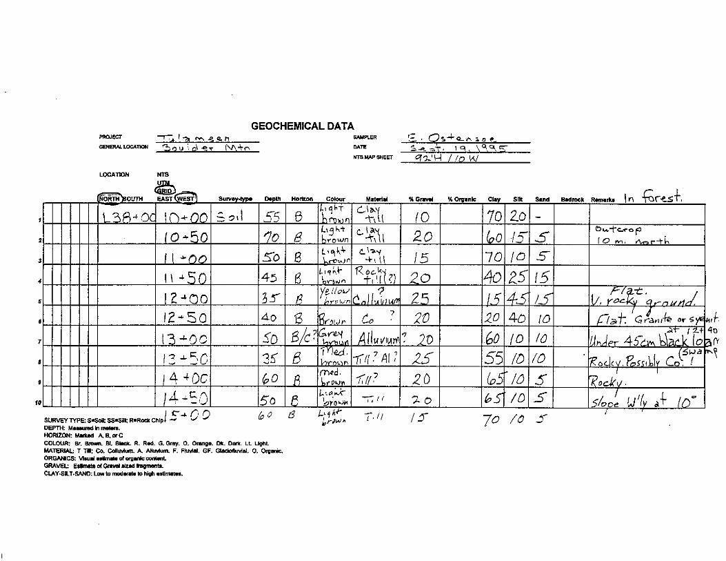
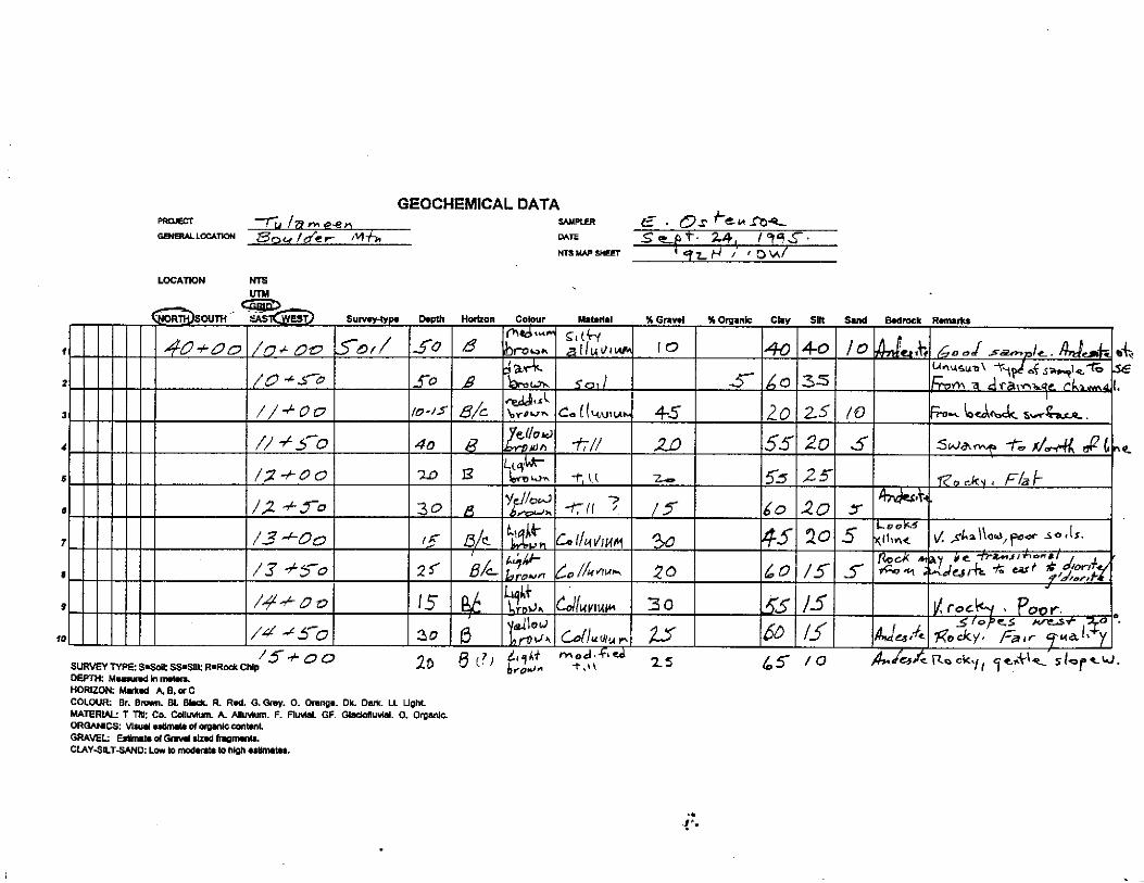
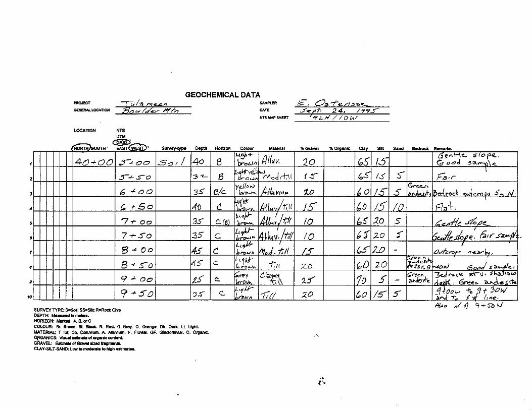
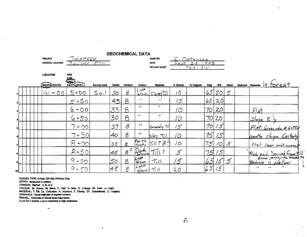
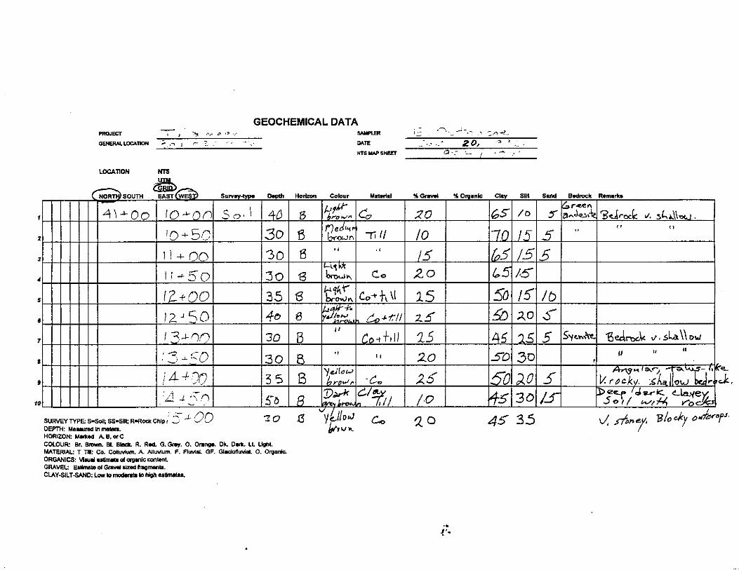
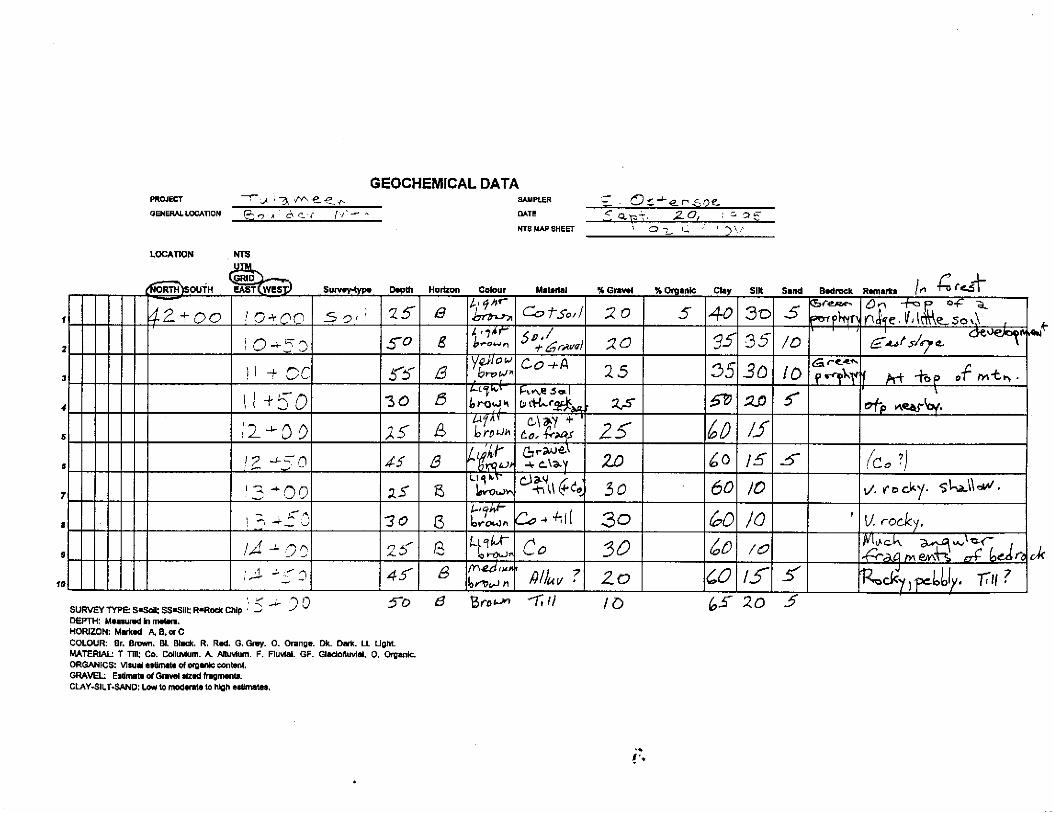
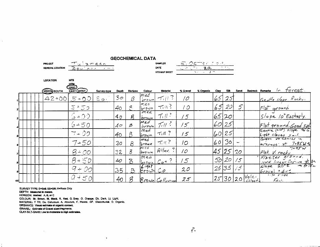
A total of 411 of 610 soil samples collected in the 1994 survey were analyzed for gold. and for 30 additional elements by ICP techniques. An additional 309 soil samples were collected during the I995 program. To get the best coverage over the central area of interest noted above, 169 soil samples from both the 1994 and 1995 programs were analyzed as above. 334 soil samples are on hand for future analyses.
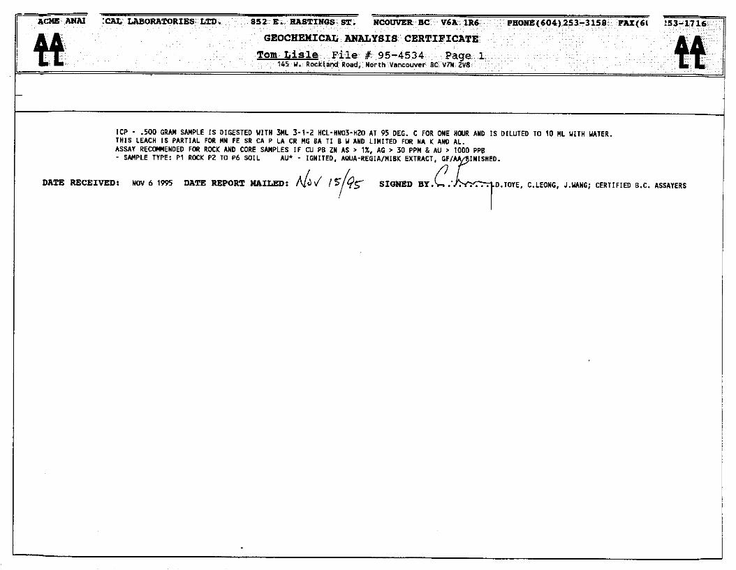
The 1995 samples were collected with a shovel in much the same manner as the 1994 samples. Details of the sample site, soil depth, horizon and other sample characteristics were recorded on data sheets that are included along with analytic data as an appendix to this report. The Acme Analytical Laboratory procedure on the -80 mesh soil fraction is explained on Geochemical Analyses Certificates.
8
For purposes of discussion, ice direction in the claim area is believed to be southwest as shown on figures 5 and 6. The gold and copper data has been plotted on figure 6 and is compiled along with results of the 1994 work. A preliminary assessment of the data indicates the following:
Gold content of the soils ranged to a high of 290 ppb. Contoured at 10 ppb, the distribution shows a loose clustering of 1 to 5 station anomalies that are partly coincident with the siliceous rhyolite and alteration zone, or down slope and down ice from that zone. Anomalous zones on the north section of Rainbow 4 claim occur in overburden covered areas to the west of tuffaceous outcrops that are similar to those mapped to the north.
A number of anomalous (+I00 ppm) copper analyses are present. They typically occur over andesitic rocks to the east of the rhyolite zone, and are partly coincident with areas of known mineralization at or close to the property boundary The highest result detected was 466 ppm located at 22+00N and 2+ 50 west.
The analyses revealed mainly background concentrations for other elements. Zinc, lead, silver and arsenic contents ranged to highs of 263 ppm, 75 ppm. 0.60 ppm, 14 ppm. respectively.
MAGNETIC SURVEY.
A magnetic survey was conducted over the Rainbow claim grid in the fall of 1994 using tw-o GSM- I9 (I 9-T) high sensitivity proton magnetometer/gradiometers equipped with inbuilt microprocessors and memory The field instrument was synchronized with a similar unit that was set up in Tulameen as a base station.
The magnetometers were initially tuned to a total magnetic field intensity of 58,000 nT. appropriate for the survey area. Observations were taken at 12.5 metre intervals on all 100 metre spaced grid lines with the exception of lines 35+00N and 36+00N. Steve Lowe, geophysical technician 1 data processor and autocad specialist, examined the data and executed corrections and procedures to produce computer-generated plan and profile presentations.
The results of the survey were summarized by Lisle and Ostensoe in a report dated January 15, 1995. Moditications. reflecting the geological mapping carried out in 1995 are presented as follows:
1) Magnetic relief in the survey area is low and commonly within a range of 300 nT. 2) Magnetic values tend to be slightly higher in the north and east parts of the grid relative
to values observed elsewhere.
9
3) The southwest corner ofthe grid, in particular Lines S+OON through 14+00N from about 5+OOW to lO+OOW, exhibits high magnetic relief up to about 1100 nT and is magnetically distinct from the balance of the grid. This area is largely underlain by dioritic rocks that could be expected to contain magnetite mineralization. The diorite is however intruded by dyke-like masses of Otter Granite within and around which magnetite is present. For this reason. uncertainty exists as to the cause of the magnetic signature.
4) A series of narrow magnetic “highs”, up to about 500 nT. form a conspicuous, but locally broken, north-northwesterly linear trend from the southeast to northwest corners of the grid. Some, but not all. of these highs are spatially, and likely directly related to the mafic tine-grained Tertiary dykes. There remains however a north northwesterly grain to the magnetics in this area that is emphasized by a small number of line to line responses of small amplitude both positive and negative.
Poor exposure along trend, and particularly along the west flank of the rhyolite, limits interpretation both as to the size and shape and origin of this unit. There are a large number of feldspar porphyry dykes in the Tulameen area, some of which are pyritic, and some of which have been investigated for economic mineralization. Rice described some of the Otter Granite related dykes as follows: I’--- a bewildering array of types no two of which are exactly alike. Some are clearly line-grained phases of the red or the grey granite and need no further description, but these are in the minority. In general terms the usual type is a rock with very fine-grained groundmass in some shade of red, buff, liver, mauve or grey in which are set conspicuous phenocrysts of white or pink feldspar, and in some specimens. much smaller phenocrysts of Camselbiotite and amphibole”.
Property immediately to the east of the Rainbow claims was investigated by the Abermin Corporation in the 1980’s. The Abermin work showed a spatial relationship of a number ofvein and stratiform sulphide occurrences on Rabbitt and Boulder Mountains to dacitic horizons thought to be part of the upper Nicola Group. Siliceous rocks similar to those observed on the Rainbow ground were noted at one of the Boulder Mountain prospects, however detailed correlation has not been carried out. Detailed mapping carried out by GEP Eastwood on the El Alemein property near the south boundary of the Rainbow 4 claim showed that the gold prospect occurs in or near a northwest trending rhyolite horizon containing both porphyritic and breccia phases.
10
Uncertainty remains as to whether the felsic unit at the Rainbow property in intrusive or extrusive. Regardless of the origin. the mineralization and alteration associated with this horizon represents an important exploration target requiring further evaluation. The characteristics of this target are summarized herewith:
1) A strong alteration zone associated with a felsic rhyolite horizon contains up to 10% pyrite with or without magnetite and minor chalcopyrite over a significant strike length.
2 ) Much of the trace of the zone. and particularly the west flank of the zone is covered by glacial drift.
3) A number of gold soil anomalies are loosely clustered along or near the zone, or down slope and down ice to the southwest.
4) The zone has an interpreted north northwest trend based on outcrop distribution. This is similar to bedding attitudes mapped to the east and is comparable to geochemical and geophysical trends reported on ground immediately to the east of the Rainbow 2 and 3 mineral claims. The trend is supported in part by magnetic anomalies detected in 1994 surveys. The indicated trace to the southeast on the Rainbow 4 claim is marked by a VLF- EM conductor that is in part associated with anomalous gold in the soil (A.R. 16,016).
November 30, 1995
II
1) Lord. T. and Green, A Soils and Surficial Geology of the Tulameen Area. Agriculture Canada, 1974.
2) Cook, S.J. and Fletcher, W.K. Platinum Distribution in Soil Profiles of the Tulameen Ultramatic Complex, Southern British Columbia. Journal of Geochemical Exploration, July. 1994.
3) Camsell, C.
4) Monger, J.W.H.
5) Preto, VA
Geology and Mineral deposits of the Tulameen District, British Columbia. GSC Memoir 26, 1913.
Geology of the Hope and Ashcroft Map Areas, British Columbia. Maps 41-1989, 42-1989, Geological Survey of Canada.
Geology of the Nicola Group between Merritt and Princeton. Bulletin 69, B.C. Ministry of Energy Mines and Petroleum Resources, 1979.
6) Rice, H.M. A. Geology and Mineral Deposits of the Princeton Map Area. G.S.C. Memoir 243, 1947.
7) Nixon, G.T. Geology of the Tulameen Ultramafic Complex. Open File 1988-25. B.C. Ministry of Energy, Mines and Petroleum Resources. 1988.
8) Lisle, T. Ostensoe, E. Prospecting Report on the Rainbow 2 and 3 Mineral Claims, Tulameen Area, Similkameen Mining Divisi0n.B.C. January 15, 1993. Assessment Report
9) Lisle, T. Ostensoe, E. Geochemical and Geophysical Report on the Rainbow 2 and 3 Mineral Claims, Tulameen Area, Similkameen Mining Division, January 15, 1995.
Assessment Report.
10) B.C. Ministry of Energy, Mines and Petroleum Resources Assessment Reports 15,3 15, 16,016 and 17,271.

t
ICP - .500 CM” SA”PLE IS DIGESTED YlTH 3ML 3-l-2 HCL-WO3-HZ0 A, 95 DEG. C FOR ONE HWR AND fS DILUTED TO 10 ML ,,,,H YATES. THlS LEACH IS PARTIAL FOR NN FE RR CA P LA CR NO SA 7, S Y AND LIMITED FOR NA K AND AL. ASSAY RECOMlENDED FMI ROCK AND CORE SAMPLES IF CU PB ZN AS ) 1%. AC , 30 PPM 8 A” > 1000 PPB _ SAMPLE TYPE: Pl ROCK P2 TO Pb SOIL AU* - IGNITED, AWA-REGIAIRISK EXTRACT. GP,
DATE RECEIVED: NOV 6 1995 DATE REPORT WLILND: SIQNED BY. c : C.LEONG, J.YANG; CERTIFIED B.C. ASSAYERS