Embed Size (px)
Citation preview

Public Review Draft
Bristol Bay Critical Habitat Areas (Egegik, Pilot Point, Cinder River, Port Heiden, and Port Moller) Management Plan
by
Division of Habitat
and
Division of Wildlife Conservation
Draft- February 12, 2010
Alaska Department of Fish and Game Divisions of Habitat and Wildlife Conservation
Symbols and Abbreviations The following symbols and abbreviations, and others approved for the Système International d'Unités (SI), are used without definition in the following reports by the Divisions of Sport Fish and of Commercial Fisheries: Fishery Manuscripts, Fishery Data Series Reports, Fishery Management Reports, and Special Publications. All others, including deviations from definitions listed below, are noted in the text at first mention, as well as in the titles or footnotes of tables, and in figure or figure captions. Weights and measures (metric) centimeter cm deciliter dL gram g hectare ha kilogram kg kilometer km liter L meter m milliliter mL millimeter mm Weights and measures (English) cubic feet per second ft3/s foot ft gallon gal inch in mile mi nautical mile nmi ounce oz pound lb quart qt yard yd Time and temperature day d degrees Celsius °C degrees Fahrenheit °F degrees kelvin K hour h minute min second s Physics and chemistry all atomic symbols alternating current AC ampere A calorie cal direct current DC hertz Hz horsepower hp hydrogen ion activity pH (negative log of) parts per million ppm parts per thousand ppt, ‰ volts V watts W
General Alaska Administrative Code AAC all commonly accepted abbreviations e.g., Mr., Mrs.,
AM, PM, etc. all commonly accepted professional titles e.g., Dr., Ph.D., R.N., etc. at @ compass directions:
east E north N south S west W
copyright © corporate suffixes:
Company Co. Corporation Corp. Incorporated Inc. Limited Ltd.
District of Columbia D.C. et alii (and others) et al. et cetera (and so forth) etc. exempli gratia (for example) e.g. Federal Information Code FIC id est (that is) i.e. latitude or longitude lat. or long. monetary symbols (U.S.) $, ¢ months (tables and figures): first three letters Jan,...,Dec registered trademark ® trademark ™ United States (adjective) U.S. United States of America (noun) USA U.S.C. United States
Code U.S. state use two-letter
abbreviations (e.g., AK, WA)
Measures (fisheries) fork length FL mideye to fork MEF mideye to tail fork METF standard length SL total length TL Mathematics, statistics all standard mathematical signs, symbols and abbreviations alternate hypothesis HA base of natural logarithm e catch per unit effort CPUE coefficient of variation CV common test statistics (F, t, χ2, etc.) confidence interval CI correlation coefficient (multiple) R correlation coefficient (simple) r covariance cov degree (angular ) ° degrees of freedom df expected value E greater than > greater than or equal to ≥ harvest per unit effort HPUE less than < less than or equal to ≤ logarithm (natural) ln logarithm (base 10) log logarithm (specify base) log2, etc. minute (angular) ' not significant NS null hypothesis HO percent % probability P probability of a type I error (rejection of the null hypothesis when true) α probability of a type II error (acceptance of the null hypothesis when false) β second (angular) " standard deviation SD standard error SE variance population Var sample var
BRISTOL BAY CRITICAL HABITAT AREAS MANAGEMENT PLAN
PUBLIC REVIEW DRAFT
Prepared by
Alaska Department of Fish and Game 333 Raspberry Road, Anchorage, Alaska 99518-1599
DRAFT February 12, 2010
Prepared by the Divisions of Habitat and Wildlife Conservation
Alaska Department of Fish and Game Anchorage, Alaska
This document is a draft, and should not be cited.
The Alaska Department of Fish and Game (ADF&G) administers all programs and activities free from discrimination based on race, color, national origin, age, sex, religion, marital status, pregnancy, parenthood, or disability. The department administers all programs and activities in compliance with Title VI of the Civil Rights Act of 1964, Section 504 of the Rehabilitation Act of 1973, Title II of the Americans with Disabilities Act (ADA) of 1990, the Age Discrimination Act of 1975, and Title IX of the Education Amendments of 1972.
If you believe you have been discriminated against in any program, activity, or facility please write: ADF&G ADA Coordinator, P.O. Box 115526, Juneau, AK 99811-5526
U.S. Fish and Wildlife Service, 4401 N. Fairfax Drive, MS 2042, Arlington, VA 22203 Office of Equal Opportunity, U.S. Department of the Interior, 1849 C Street NW MS 5230, Washington DC 20240
The department’s ADA Coordinator can be reached via phone at the following numbers: (VOICE) 907-465-6077, (Statewide Telecommunication Device for the Deaf) 1-800-478-3648,
(Juneau TDD) 907-465-3646, or (FAX) 907-465-6078 For information on alternative formats and questions on this publication, please contact:
ADF&G, Division of Sport Fish, Research and Technical Services, 333 Raspberry Road, Anchorage AK 99518 (907) 267-2375.

i
TABLE OF CONTENTS Page ACKNOWLEDGEMENTS..........................................................................................................................................V INTRODUCTION.........................................................................................................................................................1 PURPOSE......................................................................................................................................................................1 The Planning Process.....................................................................................................................................................1 Implementation..............................................................................................................................................................2 BRISTOL BAY CRITICAL HABITAT AREA STATUTES.......................................................................................3 MANAGEMENT PLAN GOALS.................................................................................................................................9 PROPOSED POLICIES ..............................................................................................................................................10 Compatibility ...............................................................................................................................................................11
Issue........................................................................................................................................................................11 Background.............................................................................................................................................................11 Proposed Policy ......................................................................................................................................................11 Evaluation...............................................................................................................................................................11
Access..........................................................................................................................................................................11 Issue........................................................................................................................................................................11 Background.............................................................................................................................................................11 Proposed Policy ......................................................................................................................................................12 Evaluation...............................................................................................................................................................12
Motorized Vehicles......................................................................................................................................................12 Issue........................................................................................................................................................................12 Background.............................................................................................................................................................12 Proposed Policy ......................................................................................................................................................13 Evaluation...............................................................................................................................................................14
Information, Education, and Outreach.........................................................................................................................14 Issue........................................................................................................................................................................14 Background.............................................................................................................................................................14 Proposed Policy .......................................................................................................................................................14 Evaluation...............................................................................................................................................................14
Scientific Research ......................................................................................................................................................15 Issue........................................................................................................................................................................15 Background.............................................................................................................................................................15 Proposed Policy ......................................................................................................................................................15 Evaluation...............................................................................................................................................................15
Recreational And Harvest Activities ...........................................................................................................................15 Issue........................................................................................................................................................................15 Background.............................................................................................................................................................15 Proposed Policy ......................................................................................................................................................16 Evaluation...............................................................................................................................................................16
Cultural, Historic, and Archeological Resources.........................................................................................................16 Issue........................................................................................................................................................................16 Background.............................................................................................................................................................16 Proposed policy: .....................................................................................................................................................16 Evaluation...............................................................................................................................................................16
ii
TABLE OF CONTENTS (Continued) Page
Introduction of Exotic Species (or Ecosystem Integrity).............................................................................................17 Issue........................................................................................................................................................................17 Background.............................................................................................................................................................17 Proposed policy: .....................................................................................................................................................17 Evaluation...............................................................................................................................................................17
Habitat and Population Enhancement..........................................................................................................................18 Issue........................................................................................................................................................................18 Background.............................................................................................................................................................18 Proposed policy ......................................................................................................................................................18 Evaluation...............................................................................................................................................................18
Cabins/Structures.........................................................................................................................................................18 Issue........................................................................................................................................................................18 Proposed policy ......................................................................................................................................................19 Evaluation...............................................................................................................................................................19
Camping ......................................................................................................................................................................20 Issue........................................................................................................................................................................20 Background.............................................................................................................................................................20 Proposed policy ......................................................................................................................................................20 Evaluation...............................................................................................................................................................21
Boat Storage and Maintenance ....................................................................................................................................21 Issue........................................................................................................................................................................21 Background.............................................................................................................................................................21 Proposed Policy ......................................................................................................................................................21 Evaluation...............................................................................................................................................................22
Docks And Boat Ramps ..............................................................................................................................................22 Issue........................................................................................................................................................................22 Background.............................................................................................................................................................22 Proposed Policy ......................................................................................................................................................22 Evaluation...............................................................................................................................................................23
Structures and Commercial Facilities ..........................................................................................................................23 Issue........................................................................................................................................................................23 Background.............................................................................................................................................................23 Proposed policy ......................................................................................................................................................23 Evaluation...............................................................................................................................................................23
Pipelines and Utilities ..................................................................................................................................................24 Issue........................................................................................................................................................................24 Background.............................................................................................................................................................24 Proposed policy .......................................................................................................................................................24 Evaluation...............................................................................................................................................................24
Oil and Gas ..................................................................................................................................................................25 Issue........................................................................................................................................................................25 Background.............................................................................................................................................................25 Proposed Policy ......................................................................................................................................................26 Evaluation...............................................................................................................................................................26
Roads/ Trails................................................................................................................................................................27 Issue........................................................................................................................................................................27 Background.............................................................................................................................................................27 Proposed policy .......................................................................................................................................................27

iii
TABLE OF CONTENTS (Continued) Page
Evaluation...............................................................................................................................................................27 Airstrips .......................................................................................................................................................................28
Issue........................................................................................................................................................................28 Background.............................................................................................................................................................28 Proposed policy ......................................................................................................................................................28 Evaluation...............................................................................................................................................................28
Mining .........................................................................................................................................................................28 Issue........................................................................................................................................................................28 Background.............................................................................................................................................................28 Proposed policy .......................................................................................................................................................29
Material Extraction ......................................................................................................................................................30 Issue........................................................................................................................................................................30 Background.............................................................................................................................................................30 Proposed policy ......................................................................................................................................................30 Evaluation...............................................................................................................................................................30
Hazards and Hazardous Substances.............................................................................................................................31 Issue........................................................................................................................................................................31 Background.............................................................................................................................................................31 Proposed policy .......................................................................................................................................................31 Evaluation...............................................................................................................................................................31
Shoreline alteration......................................................................................................................................................31 Issue........................................................................................................................................................................31 Background.............................................................................................................................................................32 Proposed policy ......................................................................................................................................................32 Evaluation...............................................................................................................................................................32
Water Quality ..............................................................................................................................................................32 Issue........................................................................................................................................................................32 Background.............................................................................................................................................................32 Proposed policy ......................................................................................................................................................33 Evaluation ...............................................................................................................................................................33
IMPLEMENTATION .................................................................................................................................................34 Special Area Permits ...................................................................................................................................................34 Local Knowledge.........................................................................................................................................................34 Boundary Corrections..................................................................................................................................................34 Mining Claims and Leasehold Locations ....................................................................................................................34 Actions of Federal, Other State, and Local Agencies ..................................................................................................34 PROPOSED CHANGES TO 5 AAC 95 .....................................................................................................................35 APPENDIX A: RESOURCE INVENTORY...............................................................................................................A APPENDIX B: PUBLIC SCOPING MEETINGS FOR BRISTOL BAY CRITICAL HABITAT AREAS MANAGEMENT PLAN.................................................................................................................................... ……..B APPENDIX C SCOPING QUESTIONAIRE............................................................................................................... C APPENDIX D ADF&G SPECIAL AREA REGULATIONS......................................................................................D APPENDIX E INHOLDINGS INVENTORY OF CRITICAL HABITAT AREAS BRISTOL BAY, ALASKA....... E APPENDIX F: MAPS ..................................................................................................................................................F

iv
v
ACKNOWLEDGEMENTS The Bristol Bay Critical Habitat Areas Management Plan has been prepared by Alaska
Department of Fish and Game biologists Mark Fink and Tammy Massie (Division of Habitat), and Ed Weiss (Division of Wildlife Conservation). This plan has been developed with the aid of an interagency planning team composed of representatives from state, federal, and local agencies with jurisdiction over the critical habitat areas and critical habitat area resources:
Joy Biedermann, Ray Burger, and Charles Pinckney, Alaska Department of Natural Resources
Sam Cotton, Aleutians East Borough
Jordan Keeler, Lake & Peninsula Borough
Don Strand, City of Egegik
Maggi Arend, U.S. Fish and Wildlife Service
Brian Lance, National Marine Fisheries Service
Ed Weiss and Joe Meehan, Alaska Department of Fish and Game, Division of Wildlife Conservation
Bob Murphy, Steve Schrof, and Paul Salomone, Alaska Department of Fish and Game, Division of Commercial Fisheries
Matt Miller, Craig Schwanke, and Jason Dye, Alaska Department of Fish and Game, Division of Sport Fish
Davin Holen, Alaska Department of Fish and Game, Division of Subsistence
Mark Fink and Tammy Massie, Alaska Department of Fish and Game, Division of Habitat
Other Alaska Department of Fish and Game staff contributors were Tom Rothe, Dan Rosenberg, Lem Butler, and Bob Small (Division of Wildlife Conservation) and Marla Carter (Division of Sport Fish).
Frances Inoue and Jason Graham (Alaska Department of Fish and Game, Division of Sport Fish) provided cartographic support.
Other Alaska Department of Natural Resources staff contributors included Rich Vanderhoek (State Historic Preservation Office).
Other U.S. Fish and Wildlife Service staff contributors included Susan Savage and Ron Britton (Alaska Peninsula/Becharof National Wildlife Refuge), Chris Dau, Bill Larned, and Bob Platte (Migratory Birds).
A number of individuals represented themselves and various organizations at scoping meetings. We especially want to thank the city and tribal administrators and residents of King Salmon, Egegik, Pilot Point, Port Heiden, and Nelson Lagoon for their contributions.
Partial funding for this project was provided through an Alaska State Wildlife Grant (SWG). The SWG program is funded by annual Congressional appropriations that are administered by the United States Fish and Wildlife Service.
February 12, 2010 Draft vi
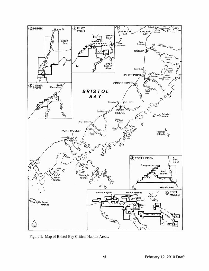
Figure 1.–Map of Bristol Bay Critical Habitat Areas.

February 12, 2010 Draft 1
INTRODUCTION In 1972 (§ 2 ch SLA 1972) the Alaska Legislature established five state critical habitat areas (CHAs) at major estuaries along the southern shore of Bristol Bay to protect natural habitat and game populations, especially waterfowl and shorebirds. From north to south along the Alaska Peninsula, they are as follows: the Egegik CHA at the mouth of Egegik River; the Pilot Point CHA at the mouths of King Salmon and Ugashik Rivers; the Cinder River CHA at the mouth of Cinder River and Mud Creek; the Port Heiden CHA at the mouth of Meshik River; and the Port Moller CHA in Port Moller itself and near the mouth of the Sapsuk River. Together, the Bristol Bay CHAs encompass approximately 284,050 acres, including the state lands, waters, and tide and submerged lands.
At the Left and Right Heads of Port Moller the boundary of the Port Moller CHA overlaps with the boundary of the Alaska Peninsula National Wildlife Refuge. In the Cinder River and Port Heiden CHAs, several small islands and a narrow area along the coast are included in the Alaska Maritime National Wildlife Refuge. Both of these National Wildlife Refuges are managed by the U.S. Fish and Wildlife Service (USFWS). The dividing line between state and federal jurisdiction is generally the line of Mean High Tide. Private lands, including lands owned by native corporations, also lie within the boundaries of some of the CHAs. This plan affects state lands and waters only. Private lands and federal lands and waters within the boundaries of the CHAs are not subject to critical habitat area authority.
PURPOSE The Bristol Bay CHAs are co-managed by the Alaska Department of Fish and Game (ADF&G) in accordance with Alaska Statute 16.20.520-530, and the Alaska Department of Natural Resources (DNR) per AS 38.05. The purpose of the Bristol Bay Critical Habitat Areas Management Plan is to provide consistent, long-range guidance in managing the five CHAs. ADF&G has undertaken this comprehensive planning process in order to establish guidelines, policies, and regulations for management of fish and wildlife, habitat, and current and future activities that affect them on the CHAs.
This draft plan presents management goals for the CHAs and their resources, and identifies polices to be used in determining whether proposed activities are compatible with the protection of fish and wildlife, their habitats, and public use of the CHAs. The goals and policies of this plan are adopted as regulation.
The plan does not address hunting or fishing regulations, which are the purview of the Alaska Boards of Fish and Game.
THE PLANNING PROCESS This plan is the result of a public planning process led by ADF&G. It was developed by a collaborative planning team representing the following state, federal, borough, and municipal entities: the State of Alaska Departments of Fish and Game and Natural Resources; the USFWS, the National Marine Fisheries Service (NMFS); the Lake and Peninsula Borough, the Aleutians East Borough; and the City of Egegik.
At the beginning of the planning process, ADF&G held public scoping meetings in King Salmon, Egegik, Pilot Point, Port Heiden, Nelson Lagoon, and Anchorage to explain the planning process and solicit citizen’s issues, interests, and concerns for the Bristol Bay CHAs.
February 12, 2010 Draft 2
The planning team used public input from these meetings to formulate a list of issues to be addressed in the plan. At the same time, resource information on the BBCHAs’ fish and wildlife populations and their habitats, other natural resources, existing land use and land ownership was being collected and synthesized. This information, presented in both map and narrative form, comprises the plan’s Resource Inventory (Appendix A and Appendix F [Map Supplement]).
Management goals and policies for the BBCHAs were developed by the planning team to address the identified issues. All policies were developed with consideration of their ability to meet the formulated management goals. In some cases, alternative policies were developed. Each alternative policy was analyzed according to its ability to meet the plan’s management goals. In addition, other applicable laws and the Public Trust Doctrine were considered.
This management plan is not only a product of local residents concerns and state law requirements, but also of an understanding of the resources and resource issues. This review draft is distributed widely to solicit comments and suggestions that will strengthen the plan and make it useful to the department and the public. A final plan will be prepared using the comments received during the public review process. Once revised, the Commissioner of the Alaska Department of Fish and Game will adopt the plan and corresponding regulations for use by the department in managing the CHAs. At that point, the plan can be implemented by ADF&G.
IMPLEMENTATION Future CHA management activities of ADF&G will be directed by this plan. Research programs, public use facilities, and other department projects will be consistent with the goals and policies presented in this plan. Similarly, future land use activities within the critical habitat areas, including those proposed by private individuals, companies or federal, local or state agencies, will be approved, conditioned, or denied on the basis of their consistency with the goals and policies provided in the adopted management plan and any applicable state statues and regulations.
A Special Areas Permit is required for any activity that may affect fish and wildlife habitat, including any construction activity, or any activity which disturbs fish or wildlife other than lawful hunting, trapping, fishing, and viewing in a designated state critical habitat area (5 AAC 95). A Special Areas Permit application form can be obtained from any ADF&G office or the department Web site (http://www.adfg.state.ak.us); the completed application should be submitted to the Division of Habitat Office in Anchorage.
Other state, federal, and local agencies have management responsibilities that affect the BBCHAs as well. Many uses, including lease or disposal of resources on state land in the BBCHAs require DNR authorization. Activities affecting air or water quality may require authorization from the Alaska Department of Environmental Conservation (DEC). The U.S. Army Corps of Engineers evaluates applications for permits which authorize activities affecting navigable waters and for the discharge of dredged and fill material in waters of the United States, including wetlands. Various federal and state agencies, along with local governments, review proposals for federal permits, pursuant to the Fish and Wildlife Coordination Act (16 USC 661-667 et. seq.), Coastal Zone Management Act, and the Alaska Coastal Management Program. The Aleutians East Borough and the Lake and Peninsula Borough may review and provide recommendations on all permit proposals within or affecting the coastal zone, including proposals for activities in the BBCHAs.
This plan will be reviewed and updated, as appropriate and necessary. Public participation will be solicited during the update process.

February 12, 2010 Draft 3
BRISTOL BAY CRITICAL HABITAT AREA STATUTES Alaska statutes that specifically pertain to the establishment and management of the five Bristol Bay Critical Habitats Areas are codified at 16.20. The management direction for all state critical habitats, AS 16.20.500, became law in 1972 (§ 2 ch 140 SLA 1972). The enabling legislation for the five state critical habitat areas in Bristol Bay became law in 1972 (§ 2 ch 140 SLA 1972).
Sec. 16.20.500. Purpose. The purpose of AS 16.20.500 – 16.20.690 is to protect and preserve habitat areas especially crucial to the perpetuation of fish and wildlife, and to restrict all other uses not compatible with that primary purpose.
Sec. 16.20.510. Regulations. The Board of Fisheries and the Board of Game, where appropriate, shall adopt regulations they consider advisable for conservation and protection purposes governing the taking of fish and game in state fish and game critical habitat areas.
Sec. 16.20.520. Multiple land use. Before the use, lease, or other disposal of land under private ownership or state jurisdiction and control, within state fish and game critical habitat areas created under AS 16.20.500 – 16.20.690, the person or responsible state department or agency shall notify the commissioner of fish and game. The commissioner shall acknowledge receipt of notice by return mail.
Sec. 16.20.530. Submission of plans and specifications. (a) When a board determines that the following information is required, it shall instruct the commissioner, in the letter of acknowledgment required under AS 16.20.520, to require the person or governmental agency to submit:
(1) full plans for the anticipated use; (2) full plans and specifications of proposed construction work; (3) complete plans and specifications for the proper protection of fish and game; and (4) the approximate date when the construction or work is to commence. (b) The board shall require the person or governmental agency to obtain the written approval
of the commissioner as to the sufficiency of the plans or specifications before construction is commenced. Sec. 16.20.550. Port Moller Critical Habitat Area established. The following described area is established as the Port Moller Critical Habitat Area:
(1) Township 50 South, Range 71 West, Seward Meridian Sections 7 - 8 Section 14 (not tide or submerged land) Sections 15 - 17 Sections 21 - 23 Section 32;
(2) Township 51 South, Range 71 West, Seward Meridian Section 3 (not tide or submerged land) Sections 4 - 5 Section 7 Sections 9 - 10 Sections 15 - 17;

February 12, 2010 Draft 4
(3) Township 49 South, Range 73 West, Seward Meridian Sections 10 - 11 Section 12 (not tide or submerged land) Sections 13 - 16 Section 21 Section 24 Section 28;
(4) Township 51 South, Range 72 West, Seward Meridian Sections 5 - 8 Sections 11 - 12;
(5) Township 50 South, Range 72 West, Seward Meridian Sections 18 - 19 Sections 30 - 32;
(6) Township 50 South, Range 73 West, Seward Meridian Sections 7 - 13 Sections 14 - 17 (not tide or submerged land) Section 18;
(7) Township 50 South, Range 74 West, Seward Meridian Sections 5 - 7 Section 8 (not tide or submerged land) Sections 9 - 13 Sections 14 - 16 (not tide or submerged land) Sections 17 - 18 Section 20;
(8) Township 50 South, Range 75 West, Seward Meridian Section 1 Sections 6 - 7;
(9) Township 49 South, Range 75 West, Seward Meridian Section 3 Sections 4 - 6 (not tide or submerged land) Sections 7 - 11 Sections 14 - 16 Sections 21 - 32;
(10) Township 48 South, Range 75 West, Seward Meridian Sections 15 - 18 Section 22 Sections 29 - 30 Section 31 (not tide or submerged land) Section 32;
(11) Township 48 South, Range 76 West, Seward Meridian Sections 13 - 17
February 12, 2010 Draft 5
Sections 19 - 23 Sections 25 - 27 Sections 29 - 30 Sections 34 - 35 Section 36 (not tide or submerged land);
(12) Township 50 South, Range 76 West, Seward Meridian Section 1 Section 3 Section 4 (not tide or submerged land) Section 9 (not tide or submerged land) Sections 10 - 13 Sections 14 - 16 (not tide or submerged land) Sections 21 - 23 (not tide or submerged land) Sections 24 - 25 Sections 26 - 28 (not tide or submerged land);
(13) Township 49 South, Range 76 West, Seward Meridian Sections 1 - 4 Sections 7 - 9 Sections 10 - 11 (not tide or submerged land) Sections 12 - 14 Sections 15 - 16 (not tide or submerged land) Sections 17 - 18 Section 21 (not tide or submerged land) Section 22 Sections 28 - 29 Sections 33 - 34;
(14) Township 49 South, Range 77 West, Seward Meridian Sections 1 - 2 Sections 4 - 5 Sections 7 - 12 Sections 13 - 18 (not tide or submerged land);
(15) Township 48 South, Range 77 West, Seward Meridian Sections 20 - 23 Sections 26 - 28;
(16) Township 48 South, Range 78 West, Seward Meridian Sections 26 - 27 Sections 31 - 34;
(17) Township 49 South, Range 78 West, Seward Meridian Sections 2 - 5 Sections 8 - 12 Sections 13 - 16 (not tide or submerged land) Section 17.
February 12, 2010 Draft 6
Sec. 16.20.555. Port Heiden Critical Habitat Area established. The following described area is established as the Port Heiden Critical Habitat Area:
(1) Township 38 South, Range 59 West, Seward Meridian Sections 13 - 15 (not tide or submerged land) Section 16 Section 21 Sections 22 - 27 (not tide or submerged land) Section 28 Sections 33 - 34 Sections 35 - 36 (not tide or submerged land);
(2) Township 38 South, Range 60 West, Seward Meridian Sections 17 - 19;
(3) Township 38 South, Range 61 West, Seward Meridian Sections 24 - 26 Section 34;
(4) Township 39 South, Range 59 West, Seward Meridian Sections 1 - 2 (not tide or submerged land) Section 3 Sections 10 - 14 (not tide or submerged land) Section 15 Sections 19 - 22 Sections 26 - 29 Sections 30 - 33 (not tide or submerged land) Sections 34 - 36;
(5) Township 39 South, Range 60 West, Seward Meridian Sections 18 - 24 Section 25 (not tide or submerged land) Sections 26 - 27 Sections 28 - 36 (not tide or submerged land);
(6) Township 39 South, Range 61 West, Seward Meridian Sections 2 - 4 Sections 8 - 9 Section 10 (not tide or submerged land) Sections 11 - 13 Sections 14 - 15 (not tide or submerged land) Sections 16 - 18 Sections 19 - 20 (not tide or submerged land) Section 21 Sections 22 - 36 (not tide or submerged land);
(7) Township 39 South, Range 62 West, Seward Meridian Section 13 Sections 23 - 28

February 12, 2010 Draft 7
Sections 32 - 34 Sections 35 - 36 (not tide or submerged land).
Sec. 16.20.560. Cinder River Critical Habitat area established. The following described area is established as the Cinder River Critical Habitat Area:
(1) Township 32 South, Range 54 West, Seward Meridian Section 29 Sections 31 - 32;
(2) Township 33 South, Range 55 West, Seward Meridian Sections 1 - 4 Sections 7 - 13 Sections 14 - 17 (not tide or submerged land) Section 18;
(3) Township 33 South, Range 56 West, Seward Meridian Sections 13 - 14 Sections 22 - 23 Sections 24 - 26 (not tide or submerged land) Sections 27 - 29 Sections 31 - 32 Sections 33 - 36 (not tide or submerged land);
(4) Township 34 South, Range 56 West, Seward Meridian Sections 5 - 7 Section 4 N 1/2;
(5) Township 34 South, Range 57 West, Seward Meridian Section 1 Section 12.
Sec. 16.20.565. Egegik Critical Habitat Area established. The following described area is established as the Egegik Critical Habitat Area:
(1) Township 24 South, Range 51 West, Seward Meridian Sections 1 - 2 Section 11 S 1/2 Section 12 N 1/2;
(2) Township 23 South, Range 51 West, Seward Meridian Section 13 Sections 24 - 25 Sections 35 - 36;
(3) Township 23 South, Range 50 West, Seward Meridian Section 7 Sections 18 - 19 Section 30 Section 31 (not tide or submerged land).

February 12, 2010 Draft 8
Sec. 16.20.570. Pilot Point Critical Habitat Area established. The following described area is established as the Pilot Point Critical Habitat Area:
(1) Township 30 South, Range 52 West, Seward Meridian (protracted) Sections 1 - 3 Section 12;
(2) Township 30 South, Range 51 West, Seward Meridian (protracted) Sections 5 - 8 Section 17;
(3) Township 31 South, Range 51 West, Seward Meridian (protracted) Sections 5 - 8 Sections 13 - 15 Sections 17 - 27;
(4) Township 30 South, Range 52 West, Seward Meridian (protracted) Sections 27 - 29 Sections 31 - 34;
(5) Township 31 South, Range 52 West, Seward Meridian (protracted) Sections 1 - 3 Sections 5 - 6 Sections 11 - 14 Sections 23 - 24;
(6) Township 30 South, Range 53 West, Seward Meridian (protracted) Section 36;
(7) Township 31 South, Range 53 West, Seward Meridian (protracted) Sections 1 - 2 Sections 10 - 11 Sections 12 - 14 (not tide or submerged land) Sections 15 - 16 Sections 20 - 21 Sections 22 - 28 (not tide or submerged land) Sections 29 - 31 Sections 32 - 36 (not tide or submerged land);
(8) Township 32 South, Range 54 West, Seward Meridian (protracted) Section 36.

February 12, 2010 draft 9
MANAGEMENT PLAN GOALS Activities occurring within the five Bristol Bay Critical Habitat Areas will be consistent with the following goals in accordance with the purpose for which the areas were established (AS 16.20.500). All department management decisions in the Bristol Bay CHAs, whether affecting activities undertaken by the department, other agencies, or the public, will be in accordance with these goals. Goal I. Fish and Wildlife Populations and Their Habitats
A. Manage the Bristol Bay Critical Habitat Areas to maintain and protect naturally occurring resident and migrant fish and wildlife populations and their natural habitats.
B. If appropriate, enhance or restore the quality and quantity of habitat for naturally occurring resident and migrant fish and wildlife.
C. Minimize unnecessary/harmful disturbance to fish and wildlife. D. Maintain water quality and quantity, natural substrates, and water circulation patterns
sufficient for the growth and propagation of fish and wildlife in fresh, estuarine, and marine waters.
E. Recognize the potential for cumulative impacts when considering effects of small incremental activities and actions affecting critical habitat area resources, including high frequency public use activities. (Public use means commercial and public, non-agency use.)
Goal II. Public Access and Use A. Maintain or improve public access to and within the Bristol Bay Critical Habitat Areas
consistent with the other goals of this management plan. B. Allow public uses when the uses are compatible with the management goals and
policies identified in this plan. C. Make information about the critical habitat areas available to the public. D. Maintain and, if compatible with existing public use, improve opportunities for hunting;
trapping; fishing; and harvest of aquatic plants within the critical habitat areas. E. Maintain opportunities for wildlife viewing, photography, study of fish and wildlife, and
other forms of recreation consistent with the goals of this management plan. Goal III. Management, Research, and Other Activities
A. Encourage and support research, monitoring, and enforcement activities necessary to achieve the goals and policies of the Bristol Bay Critical Habitat Areas Management Plan, as funding allows.
B. Foster interagency cooperation and coordination to assist in implementation of this management plan.
C. Use the most appropriate methods and means consistent with resource and habitat protection to accomplish management, research, and other activities.
D. Manage other uses in the critical habitat areas in a manner compatible with the primary purpose of conserving fish and wildlife populations and habitats in their natural diversity consistent with the goals of this management plan.
February 12, 2010 draft 10
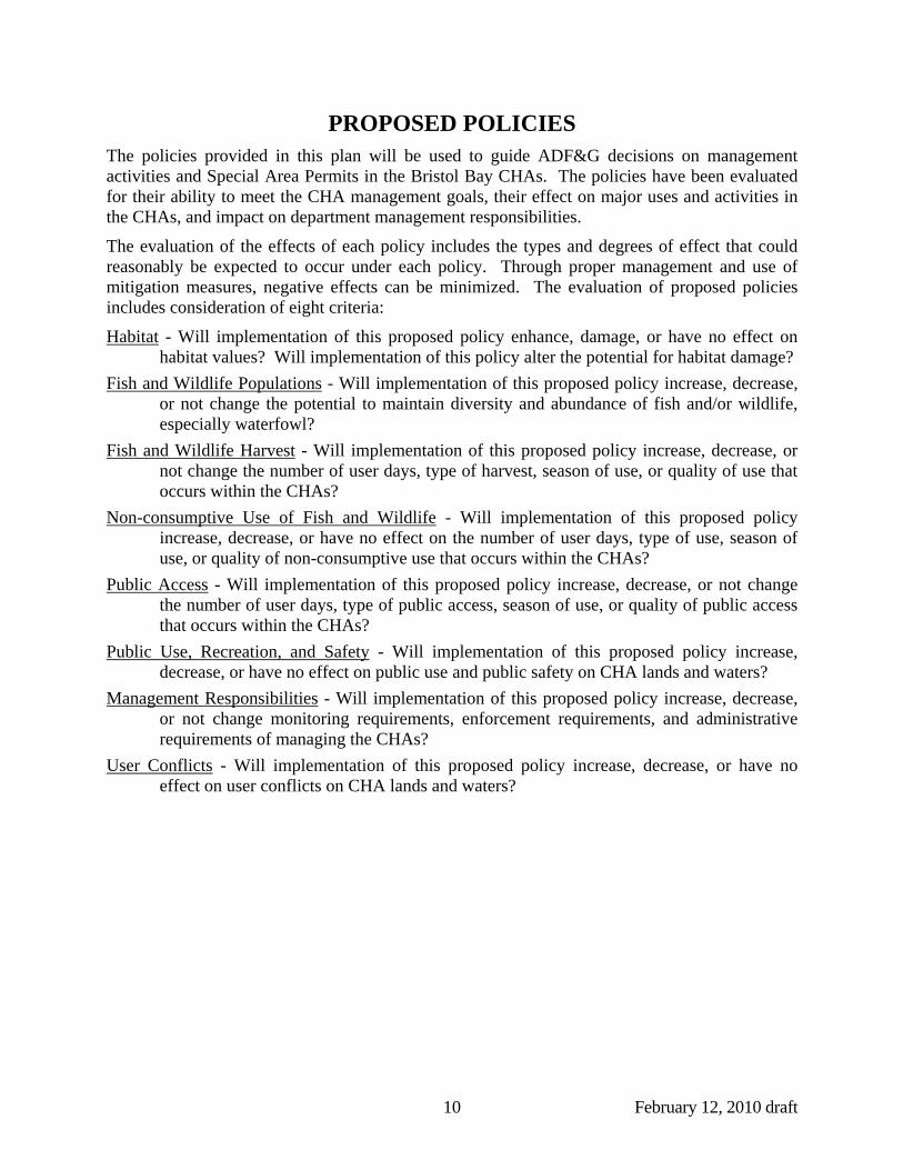
PROPOSED POLICIES The policies provided in this plan will be used to guide ADF&G decisions on management activities and Special Area Permits in the Bristol Bay CHAs. The policies have been evaluated for their ability to meet the CHA management goals, their effect on major uses and activities in the CHAs, and impact on department management responsibilities.
The evaluation of the effects of each policy includes the types and degrees of effect that could reasonably be expected to occur under each policy. Through proper management and use of mitigation measures, negative effects can be minimized. The evaluation of proposed policies includes consideration of eight criteria:
Habitat - Will implementation of this proposed policy enhance, damage, or have no effect on habitat values? Will implementation of this policy alter the potential for habitat damage?
Fish and Wildlife Populations - Will implementation of this proposed policy increase, decrease, or not change the potential to maintain diversity and abundance of fish and/or wildlife, especially waterfowl?
Fish and Wildlife Harvest - Will implementation of this proposed policy increase, decrease, or not change the number of user days, type of harvest, season of use, or quality of use that occurs within the CHAs?
Non-consumptive Use of Fish and Wildlife - Will implementation of this proposed policy increase, decrease, or have no effect on the number of user days, type of use, season of use, or quality of non-consumptive use that occurs within the CHAs?
Public Access - Will implementation of this proposed policy increase, decrease, or not change the number of user days, type of public access, season of use, or quality of public access that occurs within the CHAs?
Public Use, Recreation, and Safety - Will implementation of this proposed policy increase, decrease, or have no effect on public use and public safety on CHA lands and waters?
Management Responsibilities - Will implementation of this proposed policy increase, decrease, or not change monitoring requirements, enforcement requirements, and administrative requirements of managing the CHAs?
User Conflicts - Will implementation of this proposed policy increase, decrease, or have no effect on user conflicts on CHA lands and waters?

February 12, 2010 draft 11
COMPATIBILITY Issue Develop a policy requiring that all activities to be authorized within the five Bristol Bay CHAs must be conducted in a manner that is compatible with the statutory purposes for which the areas were created and with the goals and policies of the management plan.
Background Permitting decisions are made within the context of enabling legislation and other applicable statues, regulations, and polices. Permitting decisions are also guided by the goals and policies of the management plan. The department proposes this Compatibility policy that would apply to all plan policies (Ensures that goals do not need to be reinforced in every policy).
Statutory purpose “protect and preserve habitat areas especially crucial to the perpetuation of fish and wildlife, and to restrict all other uses not compatible with the primary purpose” 16.20.500.
Proposed Policy Uses and activities may be allowed in the critical habitat area when the uses and activities are compatible with the purposes for which the critical habitat area was established and with the goals and policies of the management plan. Uses and activities will be restricted as necessary to: (1) maintain and protect naturally occurring fish and wildlife populations and their habitats; (2) minimize unnecessary or harmful disturbance to fish and wildlife; and (3) maintain or improve public access to resources of the critical habitat area.
Evaluation The policy is intended to ensure that any type of land or water use activity is only allowed if it can be conducted in a manner that maintains fish and wildlife populations, their habitats, and public uses of those resources. Therefore the diversity and productivity of the critical habitat areas would be maintained. Some proposed land use activities may have the potential for a localized harmful disturbance to fish or wildlife or their habitats. This policy is intended to avoid or minimize disturbance, assuming there would not be adverse impacts to fish and wildlife populations. Impacts to public use of fish and wildlife resources, including hunting, fishing, and gathering, would also be limited under this proposed policy. Department management responsibilities may increase to ensure implementation of this policy, through project review, permitting, and monitoring activities, or as affected by actions from the Boards of Fish and Game.
ACCESS Issue Identify legal and appropriate public access to the CHAs and develop a policy that will guide development and management of public access within the CHAs. Address access to private lands within the CHAs.
Background Access to the Bristol Bay CHAs is primarily by boat or aircraft. There are no improved airstrips. Unimproved boat launches are located in Pilot Point and Port Heiden? There are off-road vehicle
February 12, 2010 draft 12
trails into Egegik, Pilot Point, and Port Heiden. Locals from Nelson Lagoon or Port Moller access Port Moller CHA via ORVs, along the beach, and by boat.
Proposed Policy The department will allow public access for continued public use in the critical habitat area. The department may allow improvements to public access within the critical habitat area under terms and conditions of a Special Area Permit.
Evaluation Current public access is low and has minor impacts to the critical habitat area resources. This policy would maintain public access for existing patterns of public use, including fish and wildlife harvest and does not propose any specific restrictions on future improvements of existing access. Therefore, habitat values would be maintained and user conflicts should be negligible. Fish and wildlife populations should not be affected by this policy. Any proposed access improvements would only be allowed if compatible with the purposes for which the critical habitat areas were established and the goals and policies of the plan.
MOTORIZED VEHICLES Issue Develop a policy identifying appropriate off-road use of motorized vehicles, landing and taking off of aircraft, and boat use on the CHAs and the terms and conditions under which use may be authorized.
Background Currently, the off-road use of wheeled or tracked vehicles in the Bristol Bay CHAs requires an individual special area permit from the department. If appropriate, the department could issue a general permit for off-road use of motorized vehicles in the CHAs under terms and conditions including specified seasons or specified corridors to minimize impacts to fish and wildlife and habitat.
Wheeled or tracked vehicles Currently, residents of the local communities, and some nonresidents working in Bristol Bay, use off-road use of wheeled or tracked vehicles in the Bristol Bay CHAs for beach combing, in support of set net sites and hunting, and as a general mode of transportation for recreation. Off-road vehicles (ORV) are the primary mode of travel on land in Egegik. There is at least one established vehicle trail in Egegik CHA and Port Heiden CHA. Local residents sometimes use snow machines whether there is snow or not. Snow machines are used to access inland hunting areas in the winter. It is not known whether the current motorized vehicle use is causing any harmful disturbance to wildlife. Restrictions on vehicle access less than current levels may be viewed as overly restrictive by the public.
Aircraft Although not quantified, aircraft activity over the CHAs is thought to be relatively low. There are airports near the Pilot Point and Port Heiden CHAs, and the Nelson Lagoon airport is within the Port Moller CHA. A nearby lodge uses Port Moller and the airstrip there to shuttle clients into the lodge. Aircraft likely fly along the coast during some times of the year. Although the

February 12, 2010 draft 13
use of aircraft is not allowed during the salmon fisheries, some fisherman will use private aircraft to look for salmon outside of the district during closures. Aircraft are also used for beachcombing for ivory and to support guided hunting (based from local lodges). There is guided bear hunting on the Egegik Spit but no sport fishing. One fish processor uses a helicopter to transport staff and equipment. There may be some aircraft use at Cinder River as there is a boat stored there. Fish and wildlife resource agencies, including ADF&G, NOAA, USFWS, and the U.S. Geological Survey conduct low level flight surveys; for research and management needs; this should not be restricted.
The Federal Aviation Administration (FAA) controls the airspace over the CHAs. The FAA can provide aviator advisories to remain above a minimum altitude to avoid wildlife disturbance. ADF&G only has jurisdiction over landings and takeoffs within the CHAs. Studies have documented aircraft generated disturbance of waterfowl in nearby Izembek Lagoon. If there was similar documented evidence for the CHAs, ADF&G could recommend aircraft over flight advisories to FAA (e.g., above ground level altitude minimums, horizontal distance) to reduce unnecessary disturbances to hauled-out marine mammals and/or large flocks of waterfowl that are sensitive to aircraft noise, including emperor geese, Steller’s eiders, brant, and Canada geese.
Boats Boats are a primary mode of transportation for the coastal communities adjacent to the Bristol Bay CHAs. Large numbers of boats operate in Egegik and Ugashik Bays, Port Heiden, and Port Moller during the commercial fishing seasons. Disturbance to marine mammals by motorized vehicles generally depends on their specific life stage at the time of the motorized activity. Most marine mammal haul outs occur at low tide when there is little adjacent boat traffic. Vessel traffic associated with the commercial fishery in Egegik does not appear to be affecting the CHA. At higher tides, there is an increased potential for interaction among seals and fishing boats, however, any effects are unknown. Increased boating activity during spring, fall, or winter staging areas for waterfowl or shorebirds could disturb or displace birds.
There is a limited use of personal watercraft, air-cushion vehicles, or airboats in the Bristol Bay CHAs. There is a small hovercraft in Nelson Lagoon. There did not appear to be any airboats in the Egegik, Pilot Point, or Nelson Lagoon areas. A small number of jet skis are known to occur in King Salmon/Naknek and Sand Point, however, the degree of use is unknown.
Proposed Policy The use of motorized vessels within the critical habitat area is generally allowed. The off-road use of wheeled, tracked, or other ground effect motorized vehicle requires a Special Area permit. The department may, in its discretion, issue a General Permit for the use of off-road vehicles on beaches or specified trails in ice-free months and/or in other areas within the critical habitat area when adequate snow and/or ground frost conditions exist to protect soils and vegetation from damage. When necessary to protect fish and wildlife habitat, prevent unnecessary disturbance or displacement of fish and wildlife populations, or the maintenance of compatible public recreation, motorized access may be restricted.
Aircraft landings and take-offs within spring waterfowl staging areas is prohibited from April 1 through May 15, except that the department may, in its discretion, issue a Special Area Permit for the landing and taking off of an aircraft within these areas if the there is a demonstrable need and for which there is no feasible alternative. All helicopter landings within the critical habitat
February 12, 2010 draft 14
area require a Special Area permit. Helicopter landings in the critical habitat area may be authorized only if the use is for research or management or for an activity for which there is no feasible alternative.
Evaluation This policy would prevent uncontrolled use of off-road vehicles, to minimize disturbance of fish and wildlife populations and their habitats. Restrictions to aircraft landings during key seasonal periods would prevent unnecessary disturbance or displacement of wildlife populations. With the exception of the aircraft restrictions, the policy would maintain public access, via motorized vessels, for existing patterns of public use, including fish and wildlife harvest and non-consumptive uses. Department management responsibilities could increase in an effort to inform the public and to enforce the seasonal aircraft and off-road vehicle restrictions.
INFORMATION, EDUCATION, AND OUTREACH Issue Develop a policy which will address the need for public information and education regarding the CHAs and their fish and wildlife resources.
Background Currently there are no signs identifying any of the five Bristol Bay CHAs. The department has produced an informational brochure about the five units. Additional information can be obtained at the Alaska Department of Fish and Game office in Anchorage. The department maintains a website with very basic information on the CHAs. (http://www.wildlife.alaska.gov/index.cfm?adfg=refuge.bristol_bay). Improvements to the website have yet to be implemented. Local knowledge of boundaries and permit requirements is limited.
Potential interpretive display sites could include airport(s), community building(s), F&G Office in King Salmon and near CHA boundaries.
Proposed Policy The department will provide information to critical habitat area users and the general public regarding critical habitat area resources and use restrictions. The department will encourage education projects and research of fish, wildlife, and habitat resources and their uses.
Evaluation An outreach program would require increased effort in the development of information, but could help to reduce management problems by fostering an informed user public, less likely to damage resources or violate critical habitat area rules. Information on species of concern could promote compliance with necessary harvest restrictions and closures. The public may also be able to assist in monitoring and reporting non-compliance with rules of the area.
An information/outreach program would increase public awareness of opportunities in the critical habitat areas, which could result in increased public use. Increased public use could impact fish and wildlife populations and habitats.
February 12, 2010 draft 15
SCIENTIFIC RESEARCH Issue Increased knowledge can improve the management and appreciation of the resources in the CHAs. They may attract more research interest than surrounding areas due to the exceptional resources or protected status of CHAs. This use of the CHA for research may need to be evaluated differently than other activities.
Background There is a low level of research currently in the CHAs but future researchers may need access and to install or monitor equipment. Helicopter and low level flights are used to reach sites as well as to conduct surveys. NOAA has an interest in getting better habitat delineations of nursery habitat for various species, including sole, cod, and forage fish. Aerial salmon surveys are flown by ADF&G, primarily upstream of the Egegik, Pilot Point, and Port Moller CHAs for management of the commercial salmon fisheries. Annual low-level bird and marine mammal surveys are flown over the entire Alaska Peninsula, including the Bristol Bay CHAs, by FWS, USGS, and NOAA. Research activities have the potential to disturb or displace fish and wildlife. However, any impact would be short-term, and would more than likely be outweighed by the benefits for management.
Proposed Policy The department will encourage compatible scientific research of fish, wildlife, habitat, and other resources in the critical habitat area to facilitate management.
Evaluation Improved understanding of critical habitat area resources would lead to more effective management of fish and wildlife populations and their habitats. Research results may illustrate the effects of harvest and other mortality factors on population levels. Information from research projects can enhance the public understanding of local ecology and biology of fish and wildlife species. Management effort, including project review and issuing permits, would fluctuate based on level of interest from research groups.
RECREATIONAL AND HARVEST ACTIVITIES Issue Develop a policy providing guidance in determining appropriate types and levels of recreational and harvest activities in the CHAs.
Background Hunting, fishing, and gathering of wild resources occur in the Bristol Bay CHAs. Beachcombing is a popular activity for both residents and visitors. Visitors generally land small planes on the beaches. Occasionally others are dropped off by commercial guides while not hunting. Beachcombing is best in spring after the winter storms have deposited walrus ivory, glass balls, etc. It is unknown whether beachcombing for profit is currently an issue. The possibility of commercial operation is conceivable, though it would only be profitable on a large scale. Large scale commercial beach combing (e.g., 30 people) may pose a problem. Some people now sell found items on a very small-scale, unofficial manner.

February 12, 2010 draft 16
Proposed Policy The department will allow recreational activities, including hiking and wildlife viewing; and harvest activities, including fishing, hunting, and gathering of wild resources within the critical habitat area. Use levels may be managed through the issuance of Special Area Permits, if necessary, to avoid adverse impacts to fish and wildlife populations and their habitats. Activities for which Special Area Permits may be required to manage use levels include, but are not limited to, access and camping.
Evaluation The policy should not affect public opportunities to hunt, fish, and gather wild resources. If properly administered, this policy would avoid impacts to fish and wildlife habitat. Management responsibilities will increase if the number of users increases to the level where additional permitting and regulations are required.
CULTURAL, HISTORIC, AND ARCHAEOLOGICAL RESOURCES Issue Develop a policy addressing the research on and protection of archæological, historical, and cultural resources in the critical habitat areas.
Background Although a comprehensive inventory of the CHAs has never been undertaken, numerous archæological sites have been identified on the Alaska Peninsula. Historic sites include villages and cabins used for hunting, trapping and fishing. Ancient sites generally represent habitation sites. Cultural sites may be found anywhere. Sites are commonly found at stream confluences and outlets, on dry river terraces, as well as in beach berm systems and on peninsulas projecting into bays. Historic cemeteries are also known in the region, including locations where graves have been exposed through beach erosion.
The Alaska Historic Preservation Act (AS 41.35) preserves and protects the historic, prehistoric and archæological resources of Alaska from loss, desecration and destruction. The investigation, excavation, gathering or removal from the natural state, of any historic, prehistoric or archæological resources requires a permit from the DNR Office of History and Archaeology and may also require a special area permit.
Proposed policy: The department will protect cultural, archaeological, and historic resources located within the critical habitat area. Where appropriate, the department will allow investigation of cultural, archaeological, and historic resources through a Special Area Permit, in coordination with the Department of Natural Resources, State Historic Preservation Office.
Evaluation The policy should not affect fish and wildlife populations or their habitats. General public access to and use of the CHAs should not be affected, except for temporary restrictions in areas under active investigation. Any temporary restrictions would be minimized through the permitting process. Reporting of archaeological results would enhance visitor appreciation of local culture

February 12, 2010 draft 17
and history. There could be an increase in management responsibilities relating to issuance of Special Area Permits for archaeological investigations.
INTRODUCTION OF EXOTIC SPECIES (OR ECOSYSTEM INTEGRITY) Issue Develop a policy to address protection and maintenance of the integrity of the ecosystems of the CHAs. Invasive species can introduce disease, compete for habitat and resources, and prey on natural populations.
Background The Bristol Bay CHAs support a remote, productive and unaltered natural ecosystem relatively free of introduced species and the perturbations of human impact. Alteration of this natural state would represent an irreversible loss of a valuable Alaskan resource. Prior to 1923, the Bureau of Indian Affairs established reindeer stations at Ugashik and Egegik to provide sources of income and food to local populations devastated by the 1918-1919 influenza epidemic. These were patterned after efforts on the Seward Peninsula to establish reindeer herds owned by Natives that had been trained by Laplanders and Sami. These reindeer eventually disappeared, having been absorbed by migrating caribou herds or consumed by wolves; or they became feral due to lack of active herding. Long-lived populations of reindeer on Bering Sea islands have been identified as causing range damage by overgrazing slow growing lichens and forbs and by causing erosion. (Ebbert and Byrd 2002) In the late 1990’s, the Northern Alaska Peninsula caribou herd was identified as having Bovine Respiratory Viral Disease Complex, lung worm pneumonia, and high levels of the parasites, esp. Ostertagia. These diseases are also present in domestic cattle and reindeer, though the source in this population is unidentified. “Test results on the levels of essential trace minerals in the blood of the caribou reveal that they are not ingesting sufficient selenium and copper to maintain a healthy immune system compared to other caribou herds. This nutritional deficiency may contribute to their increased susceptibility to disease and parasites (http://alaska.fws.gov/fisheries/invasive/index.htm).”
Invasive species can be unknowingly introduced in coastal areas via ballast water discharges from vessels. Invasive plants (seeds) can be introduced via equipment imported from other areas, or within seed mixes imported in for use in re-seeding/stabilizing exposed soils. The only potential for mariculture mentioned thus far in the area is planting juvenile king crabs. The department has previously opposed fish farming in state waters.
Proposed policy: The department will allow only those uses and activities in the critical habitat area, which will not compromise the integrity of the estuarine ecosystem. The introduction of exotic plant or animal species, whether wild or feral will not be allowed, unless for purposes described in the Habitat and Enhancement policy.
Evaluation The policy would minimize changes to the natural diversity and distribution of fish and wildlife and their habitats. There would be no affect on harvest and gathering activities, or to public access.
February 12, 2010 draft 18
HABITAT AND POPULATION ENHANCEMENT Issue Develop a policy that gives guidance for appropriate fish and wildlife habitat enhancement on the Bristol Bay CHAs and identify the impacts to consider when reviewing enhancement projects.
Background Enhancement projects generally involve increasing the quality or quantity of habitat to promote growth of a specific population. Habitat projects that help to restore a damaged habitat or depleted population would be better described as restoration. Habitat may also be created or expanded to mitigate for impacts from human development.
Public comment from Egegik suggested that the erosion of Egegik Spit has altered flow patterns in the bay and possibly negatively affects the community. The impacts to fish and wildlife resources are unknown at this time.
Proposed policy The department will, as appropriate, allow enhancement of naturally occurring fish and wildlife species and their habitats when enhancement restores or improves critical habitat area resource values (including diversity and abundance), and does not reduce the quality of public use and enjoyment of the critical habitat area.
Evaluation Enhancement of fish and wildlife habitats could result in increases in population numbers or densities that are the focus of enhancement efforts. Decreases or increases in some non-target species could also occur. Potential manipulation of habitat should be consistent with management objectives and evaluated for positive and negative effects. Implementation of enhancement activities could locally limit public access in the short term; however, long-term public access should be maintained. Enhancement activities would require increased management effort for planning, implementing, and monitoring projects.
CABINS/STRUCTURES Issue Develop a policy addressing authorization of existing cabins, establishment of a public use cabin program, establishment of new cabins, and resolution of unauthorized structures in the CHAs.
Background
There are several cabins within the Bristol Bay CHAs. In Egegik CHA, there was one cabin (known locally as Oscar’s cabin) on the end of spit that may have been removed during the winter 2008-09 ice storm. Another cabin is located on the middle of spit, and there is also a rundown cabin near the fish and game marker. The cabins were likely constructed originally as fish camp/ set net cabins. It was reported that there is only one cabin left on Egegik spit since the most recent storm/ high tide event in 2008-2009 pushed the sea ice in. There are set net cabins in the northern portion of Pilot Point CHA, with at least one identified as trespass. There is a trespass cabin in Port Heiden CHA (T61W, R39S) that is reportedly used by guides and
February 12, 2010 draft 19
public, mostly bear hunters. There are two trespass cabins identified by DNR records in Cinder River CHA, both near water on the spits. However, it is unclear whether the cabins are still there. There are no known cabins in the Port Moller CHA, however, there are approximately 10-15 set net sites with cabins at Nelson Lagoon. In addition, there are old mail trail and trapper cabins in area, exact locations unknown. There are many set net cabins on south side of lagoon, but all are on Native Corp land. Egegik and Nelson Lagoon have fixed locations and support structures for set netters; at Pilot Point the sites move.
Any policy should address different types of cabins, (i.e. trespass cabins, unauthorized set net cabins, trapping cabins, etc.). Most cabins in the Egegik area are on private land. The policy should address the future disposition of unauthorized cabins that may revert to the state. ADF&G does not currently have a public use cabin program.
The majority of the input from public scoping meetings was to allow existing cabins to remain as they are helpful in emergencies and/or for stranded people, but not to allow the construction of any additional cabins. There are also several cabins within CHA boundaries built on Native Corporation Land or on allotments.
Proposed policy To maintain public use opportunities and experiences, protect the critical habitat area resources, and preclude proprietary use of the critical habitat area, the department will:
(A) not allow the construction of new private or personal use cabins on the critical habitat area;
(B) in its discretion, establish a public use cabin program, as appropriate, in the critical habitat area using existing (unclaimed) cabins or new public use cabins on the critical habitat area;
(C) allow only commercial set net cabin leases which are essential for the purposes of operating set nets authorized under a commercial fisheries limited entry permit and a shore fisheries lease. A lease will be limited to the minimum acreage necessary to accommodate the facility and associated uses;
(D) in its discretion, allow administrative cabins and/or trapping cabins;
(E) allow only temporary tent platforms which will not significantly preclude existing public use of the critical habitat area. Permanent tent platforms will not be allowed. Use does not convey any future or exclusive rights and may not exceed one season's use;
(F) allow only temporary, portable duck blinds on the critical habitat area, except that the department, in its discretion, may establish permanent duck blinds for public use. Use does not convey any future or exclusive rights and may not exceed one season's use.
Allowed construction and use of structures in the critical habitat area will be authorized by Special Area Permit. For the purposes of this policy, “temporary” means “is used only for the term of the permit or the authorized duration of activity or use.”
Evaluation Public use of existing authorized structures would be maintained; use of unauthorized structures would be restricted. Increased monitoring and enforcement activities would be required to
February 12, 2010 draft 20
assure that unauthorized structures are not allowed and that authorized structures are operated in compliance with terms of their permits. Development of a public use program would increase management responsibilities.
CAMPING Issue Develop a policy that provides guidance for determining where and under what terms and conditions camping may be allowed.
Background There is little information on camping use in the CHAs. Birders and researchers may camp in the CHAs. Camping use is low at Cinder River, and primarily by people based on boats. Commercial guide camps can be addressed in this issue, but those also require DNR Land Use permits.
Scoping meeting input indicated that some people camp overnight, but no one camps long-term.
Proposed policy Camping will be managed in the critical habitat area to afford parties camping opportunities of up to two weeks in duration, with certain exceptions. Restrictions to camping may include provisions for location of camps and associated activities, types of structures, number of camp occupants, access points, period(s) of use, and number of authorized camps within a particular area.
Establishment of a non-commercial camp for up to 14 consecutive days will be allowed in the critical habitat area without a Special Area Permit. Establishment of a non-commercial camp for more than 14 consecutive days at any one location, or relocating a camp within a two-mile radius of the original campsites requires authorization through a Special Area Permit.
Commercial camping in the critical habitat area may be allowed under terms of a Special Area Permit.
Solid waste disposal is not allowed within the critical habitat area. Food and garbage must be isolated from bears by using bear-proof containers, electric fences, and/or enclosed food caches located at least 15 feet above ground, or within a hard-sided building, or within a lockable and hard-sided section of a vehicle, vessel, or aircraft. All garbage must be removed from the critical habitat area. Human waste disposal must be done accordance with Department of Environmental Conservation requirements (18 AAC 60).
If impacts to fish and wildlife resources are attributed to camping activities in sensitive areas of the critical habitat area, specific campsites should be established and camping activity limited to established sites.
Camping Policy Definitions For the purposes of implementing the camping policy:
“Bear-proof container” means a securable container constructed of a solid non-pliable material capable of withstanding the stress and compacting forces of an adult brown bear. When secured and under stress, the container will not have any cracks, openings, or hinges that would allow a
February 12, 2010 draft 21
bear to gain entry by biting or pulling with its claws. Wood containers are not considered bear resistant unless the containers are reinforced with metal. Ice chests and/or coolers are not considered to be bear-proof containers.
“Commercial camping” means the activity associated with the provision of assistance for compensation, or with the intent to receive compensation, to persons who camp in the critical habitat area.
“Solid waste” means garbage, refuse, abandoned, or other discarded solid or semi-solid material, regardless of whether subject to decomposition, originating fro any source.
Evaluation Public access for camping opportunities in the CHAs would be maintained. The policy would help to reduce user conflicts for preferred camp sites. Appropriately sited camps, which isolate food and garbage, should avoid impacts to fish and wildlife populations. Restrictions to public camping could be implemented should future impacts occur. Management responsibilities could increase to assure implementation of the policy.
BOAT STORAGE AND MAINTENANCE Issue Develop a policy to guide management of boat and gear storage and maintenance in CHAs.
Background The Bristol Bay CHAs support significant commercial fisheries, resulting in large vessel use, which requires some boat maintenance activities. Boat maintenance may consist of minor activities (e.g., untangling debris or gear from a propeller) to major hull work (e.g., sandblasting off paint). Boats are generally stored outside of the CHAs during the off-seasons for fishing. In the Port Heiden CHA, boats are grounded in the lagoon during commercial fishing seasons, south of the Meshik town site. Only the entrance to the small lagoon is within the boundary of the CHA.
Proposed Policy Anchorage or placement of a vessel or structure for longer than 14 days in the critical habitat area requires authorization under a Special Area Permit. A general permit may be issued under appropriate terms and conditions for the long-term anchoring of vessels in the vicinity of the Nelson Lagoon or other mooring locations supporting public use of the critical habitat area. Float structures, except when specifically allowed by other policies in this plan, will not be allowed on public lands and waters in the critical habitat area. Derelict or abandoned boats may not be left on public lands or waters in the critical habitat area. Intertidal boat maintenance that could result in a discharge to the critical habitat area may be authorized on private tidelands, or on public tidelands when there is no feasible alternative, under terms and conditions of a Special Area Permit that would preclude a discharge to the critical habitat area.
For the purpose of this policy, “discharges” means discharges of non-biological substances generally associated with boat maintenance, including but not limited to, paint, hull preservatives, sand from sandblasting activities, and fiberglass.
February 12, 2010 draft 22
Evaluation This policy would allow for boat storage while protecting CHA resources and uses of those resources, namely by preventing established, exclusive use of any particular area. There may be restrictions to public use of the CHA for boat maintenance activities to protect fish and wildlife habitat from potential contaminants and displacement.
DOCKS AND BOAT RAMPS Issue Develop a policy to provide guidance in permitting docks and boat ramps in the critical habitat areas.
Background There is a public dock at Nelson Lagoon (public dock constructed in 1993, permit to AEB funded by Aleutian Pribilof Island Community Development Association through DCCED) and private dock at the village of Port Moller near the entrance channel to Port Moller. Entrance channel is marked in non-winter months.
Boat launches and/or a dock near Dago Creek in Pilot Point CHA receive major use during commercial fishing season. At Port Heiden, boats are launched off the beach in the lagoon south of town. The CHA boundary line runs through the middle of lagoon, and the activity may or may not be in CHA. Public scoping comments from Port Heiden indicated that a dock would be infeasible because of the sedimentation and frequent movement of deeper channels.
All communities in or adjacent to the Bristol Bay CHAs are dependent on marine transport/ fishing. It is necessary to have docks/boat access. Heavy seasonal ice conditions necessitate either heavy duty dock construction or seasonal docks, which limit the number built and increases the costs such that there are no private docks.
Proposed Policy Harbors, docks, piers, boat ramps, and associated structures may be allowed for the purpose of maintaining or improving public access to Egegik Bay, Ugashik Bay, Cinder River Estuary, Port Heiden, and Port Moller, including Nelson Lagoon, and Herendeen Bay; or where adjacent upland landowners require access to their property. Siting, design, construction, and maintenance of these facilities will, to the maximum extent possible, avoid impacts to habitat, fish, wildlife, and navigation and public use and enjoyment of the critical habitat areas, including existing fisheries. Community dock development, seasonal docks, mooring buoys, and running lines will be encouraged over individual private permanent docks, whenever possible. Solid fill docks will be avoided, to the maximum extent possible, if the facility will impact productive habitat; interfere with natural coastal processes including tidal action, circulation, erosion, and deposition patterns; or interfere with public use of the critical habitat areas. Piling or floating docks will be used, whenever possible. The size of a structure will be kept to the minimum necessary to accommodate the proposed activity. Any project involving critical habitat area lands or waters would require a Special Area Permit and impacts associated with these improvements would need to be fully mitigated including, if appropriate, rehabilitation and restoration.

February 12, 2010 draft 23
Evaluation Public access to the CHA would be maintained or improved, while minimizing unnecessary impacts to fish and wildlife habitats. Impacts to public uses within the CHA would be minimized, but could include temporary restrictions during the construction of new docks or boat ramps. Given the anticipated low level of public need for docks and associated structures, changes to management activities would not be significant.
STRUCTURES AND COMMERCIAL FACILITIES Issue Develop a policy providing guidance in determining where, and under what terms and conditions, commercial guide/outfitter facilities, resource development facilities, outfalls, or structures, including floating structures, should be allowed.
Background Floating processors have operated within or adjacent to some of the Bristol Bay CHAs. A fish processing plant is located in Port Moller adjacent to the Port Moller CHA. Nelson Lagoon is currently requesting bids for developing a salmon processing facility, and Pilot Point is looking into a fish processing plant, potentially near Dago Creek. There may be a need to identify locations where facilities may be compatible and areas where development of facilities should be avoided. There are currently no commercial guiding facilities (lodges) in the vicinity. The nearest lodge is at Bear Lake, east of Port Moller. In addition, alternative energy projects are beginning to show up (e.g., wind turbines).
There are several floating processors operating in accordance with an Environmental Protection Agency general permit in the vicinity of the CHAs; DEC is taking over the NPDES permitting from EPA and the discharge permits are now under state authority. These include:
Big Creek Fisheries Egegik Plant -AKG520166 Icicle Seafoods Inc Egegik Plant-AKG520048 Coffee Point Seafoods Egegik Plant-AKG520536 Peter Pan Seafoods Port Moller Cold Bay Cannery- AKG520014
Sewage outfalls should not be allowed near subsistence use areas. The Lake and Peninsula Borough is working to map subsistence areas near villages.
Proposed policy A permanent commercial facility or structure (e.g., commercial guide/outfitter facility, resource development facility, outfall, floating structure) will not be allowed in the Critical habitat area unless it meets a public need which cannot otherwise be met on adjacent public or private lands, and which does not displace other established non-commercial use. Permanent commercial facilities in the critical habitat area, if allowed, will be authorized by Special Area Permit.
Evaluation This policy would assure that any structure is appropriately sited, constructed, and operated to avoid impacts to fish and wildlife populations and their habitats, and public use of fish and wildlife. Conflicts between a commercial facility/structure and established non-commercial uses would be avoided. Where authorized, a commercial facility or structure could increase the level
February 12, 2010 draft 24
of harvest activities and/or non-consumptive uses of fish and wildlife. Public use could increase under this policy. There would be no significant change in management responsibilities for permitting, monitoring, and enforcement. Prohibitions on permanent commercial facilities will help to avoid conflicts among CHA users.
PIPELINES AND UTILITIES Issue Develop a policy that will provide guidance in permitting pipelines and utilitites.
Background The Lake and Peninsula Borough is investigating the feasibility for wind power in many places; and there are not many suitable locations for turbines, so is likely that power transmission lines would be needed to distribute power from generation sites. If oil and gas exploration and development were to occur, there would likely be a need for transmission lines and/or possible pipelines for natural gas or oil. The DNR, Division of Oil and Gas (DO&G) considers the Port Moller-Herendeen Bay area as the most prospective for oil and gas exploration and for an offshore-onshore gas pipeline servicing the entire Bristol Bay-North Aleutian Basin region. In addition, Herendeen Bay to Balboa, Port Heiden to Kujulik Bay, and Pilot Point to Wide Bay are the three trans-peninsula transportation corridors identified in the DNR Bristol Bay Area Plan. Fiber optic lines and water pipelines are both parts of projects likely to occur in the conceivable future.
Proposed policy Construction of a new utility or pipeline will not be allowed in tide and submerged lands in the Critical habitat area. A new utility or pipeline may be allowed to cross within the remainder of the Critical habitat area where there is no feasible off-critical habitat area alternative, using an existing corridor wherever possible. Any easement issued within the Critical habitat area will be non-exclusive use only. A permitted utility line or pipeline will be located below ground and the corridor surface will be returned to pre-project conditions. The department may authorize, on a case-by-case basis, an above ground utility or pipeline, if installation below ground is not feasible.
Evaluation This policy would assure that any authorized pipeline or utility is appropriately sited, constructed, and operated to minimize disturbance or displacement of fish and wildlife populations and impacts to their habitats. Collocation of lines and use of non-CHA lands will minimize habitat damage. Public access and use may be temporarily restricted during construction of pipelines or utilities. Public access may also be increased by new pipeline or utility corridors. There would be an increase in management responsibilities for monitoring the implementation of mitigation activities, restoration of corridors to pre-project conditions, or use of corridors, if necessary.
February 12, 2010 draft 25
OIL AND GAS Issue Develop a policy providing guidance on the conditions under which oil and gas exploration, development and production may be allowed in Bristol Bay critical habitat areas.
Background There is little seismic information for the area, and what does exist is old. Since 1906, there have been 26 wells drilled on the Alaska Peninsula. The latest onshore well, the Amoco Becharof #1 was drilled in 1985. One offshore stratigraphic test well, the ARCO North Aleutian COST Well #1 was drilled in 1983. Test results from three wells drilled in the Port Moller area indicated potential oil reserves (e.g., Pan American Petroleum Corporation David River #1, Gulf Sandy River #1, and Pan American Petroleum Corporation Hoodoo #1). Results from the Amoco Becharof #1 well indicated potential natural gas. No wells to date have flowed commercial quantities of oil. The DNR, Division of Oil and Gas (DO&G) considers the Port Moller-Herendeen Bay area as the most prospective for oil and gas exploration and for an offshore-onshore gas pipeline servicing the entire Bristol Bay-North Aleutian Basin region. In addition, Herendeen Bay to Balboa, Port Heiden to Kujulik Bay, and Pilot Point to Wide Bay are the three trans-peninsula transportation corridors identified in the DNR Bristol Bay Area Plan. There are active surface seeps of natural gas onshore. There is a general opinion that little oil and gas potential exists near the Egegik CHA. The potential for additional exploration activities will likely be influenced by federal offshore lease activities.
The federal Mineral Management Service (MMS) was preparing to offer the North Aleutian Basin in an Outer Continental Shelf Lease Sale (Lease Sale 214) in 2011, with a draft EIS due in 2010. This sale has been indefinitely delayed due to a federal appeals court ruling (April 17, 2009) that the environmental impacts of MMS Alaska oil and gas lease sales were not adequately analyzed. The North Aleutian Basin sale area is located entirely offshore and extends from Unimak Island to a point north of the town of Port Moller. This area was originally offered for sale by MMS in 1988 (MMS 85-0052). Twenty-three leases were issued but no wells were drilled due to a Presidential and Congressional moratoria on oil and gas activities in 1989 and a subsequent federal buyback of the leases.
DO&G has been conducting lease sales for the Alaska Peninsula since 2005; no bids were received in the 2008 offering, and the next sale offering was held May 2009. Shell Oil relinquished leases for 33 tracts in the Port Moller area in 2008. Hewitt Mineral Corporation holds 5 tracts under lease, the only remaining oil and gas leases in the area. Tracts are typically 5,600 acres apiece. ADF&G developed mitigation measures for the BBCHAs which are included in the 2005 Alaska Peninsula Areawide Oil and Gas Lease Sale, Final Finding of the Director (Alaska Peninsula Best Interest Finding). The Best Interest Finding must be re-written every ten years and, therefore, the next Best Interest Finding must be completed no later than 2015.
Egegik CHA and portions of Pilot Point CHA are included in the Bristol Bay Fisheries Reserve.
AS 38.05.140 (f) states that, “The submerged and shoreland lying north of 57 degrees, 30 minutes, North latitude and east of 159 degrees, 49 minutes, West longitude within the Bristol Bay drainage are designated as the Bristol Bay Fisheries Reserve. Within the Bristol Bay Fisheries Reserve, a surface entry permit to develop an oil or gas lease or an exploration license
February 12, 2010 draft 26
under AS 38.05.131–38.05.134 may not be issued on state-owned or controlled land until the legislature by appropriate resolution specifically finds that the entry will not constitute danger to the fishery.” Further, the Alaska Peninsula Best Interest Finding states in Chapter 7, Mitigation Measure 4, “The siting of temporary or permanent facilities will be prohibited within the Bristol Bay Fisheries Reserve.”
The AEB has worked with MMS (offshore) and DO&G (state lands) for planning and mitigation of petroleum resource development. The AEB signed a 2004 memorandum of agreement (MOA) with the Bristol Bay Borough, Lake & Peninsula Borough, and DNR that establishes the mutual interests of all parties in facilitating and achieving responsible oil and gas development in the area. A new MOA to continue that agreement is currently in development.
The Bristol Bay CHAs are relatively small areas. Surface entry, below mean high water, is currently prohibited by the state. It may be reasonable to directionally drill from adjacent sites outside of the CHAs. For purposes of exploration, seismic methods would likely be used, requiring ship-borne or surface-based force generation and recording equipment for a period of a few weeks. Marine mammal observers and avoidance measures are routinely required for offshore programs. Considerations for offshore exploration activity may include potential interference with commercial fishing and potential effects to birds, fish (including juveniles/ crab larvae), and marine mammals.
In addition to CHA-specific mitigation measures, the DO&G Alaska Peninsula Best Interest Finding includes mitigation measures to address potential impacts to fish and wildlife resources, including, a measure that prohibits facilities other than docks, roads, utility or pipeline corridors, or terminal facilities within ½-mile of the coast and various rivers and streams, and within 500 feet of all fish-bearing waters.
Proposed Policy Oil and gas exploration, development, and production activities may be allowed on the critical habitat areas under terms and conditions of a Special Area Permit. The department will not allow surface entry for oil and gas exploration, development, or production activities, with the exception of seismic surveys, in the tide and submerged lands and waters of the critical habitat areas. Additional terms and conditions for oil and gas activity will be based upon the Alaska Peninsula Areawide state oil and gas lease mitigation measures for the critical habitat areas. It is not the intent of this policy to limit development of new stipulations based upon improved information and technology.
Evaluation This policy would avoid impacts to tide and submerged habitats and minimize impacts to upland habitats through appropriate siting, design, and construction during permit review. Seismic surveys are transitory activities rather than permanent facilities, and will be conditioned by permit reviews. Impacts to fish and wildlife populations, including displacement and mortality from spills, would be minimized. Public access and use of the CHA for fish and wildlife harvest and non-consumptive use could be restricted in the immediate vicinity of oil and gas infrastructure. Management responsibilities may increase based on location and duration of oil and gas activity.

February 12, 2010 draft 27
ROADS/ TRAILS Issue Develop a policy that provides guidance for permitting construction, use, and maintenance of roads and trails in the critical habitat areas.
Background The towns (Egegik, Pilot Point, Port Heiden, and Nelson Lagoon) associated with the CHAs all have small local road systems and a trail of some sort accessing a portion of the CHA. There are no roads in the Egegik CHA. There is a road north along the coast from the City of Pilot Point to Dago Creek, a portion of which is in the CHA. On the Nelson Lagoon, spit there is a road linking the airport to the village and trails, along the length of the spit accessing the beach, which are used by ORV’s and street-sized vehicles. From the beach, old oil and gas development roads can be reached; these are still suitable for vehicle use.
Most other access is by boat, ORV trail, or snowmachine when snow depth is sufficient. ORVs are also driven along beaches in the unvegetated areas. Egegik CHA is accessed by an ORV trail along the coast from town, along the uplands, although a portion is on the beach. There is no ORV trail within the state-owned portion of the Egegik CHA. There are rutted upland trails near Pilot Point and Port Heiden. There is also community support for trail improvements in Egegik and Pilot Point CHAs. Trail maintenance may be the best way to minimize damage. Use of ORV’s on unvegetated beaches is generally less damaging to habitat than on upland trails.
With potential oil and gas exploration nearby, and known coal reserves off Herendeen Bay, new roads may become an issue. Should oil and/or gas be discovered, there would likely be a need for a transportation corridor to be constructed for the movement of materials and product to the southern side of the Alaska Peninsula. Transportation corridors potentially affecting the CHAs have been included in DNR’s Bristol Bay Area Plan, including Herendeen Bay to Balboa, Port Heiden to Kujulik Bay, and Pilot Point to Wide Bay. There is also a proposal to build a road to Egegik’s South Spit. There are significant areas within the boundaries of the CHAs which are private (e.g., Native corporation land). Access to private property will need to be addressed.
Some roads from earlier O&G exploration continue to function as roads. O&G plan approval process may include requirements for road restoration.
Proposed policy The department will prohibit construction of new permanent roads or trails for motorized use in the critical habitat areas. The department may, in its discretion, allow maintenance or improvements to existing roads and trails by Special Area Permit, if the improvements fulfill a demonstrable need for which there is no feasible alternative.
Evaluation This policy would avoid impacts to fish and wildlife habitats from new road construction. Disturbance or displacement of fish and wildlife populations would be minimized through design and timing of any maintenance or improvement activities. Impacts to fish and wildlife harvest and gathering of wild resources would be avoided. Public access may be improved through maintenance or improvements of existing trails, but no current legal access activity is being

February 12, 2010 draft 28
restricted. There would be no significant change in management responsibilities for permitting, monitoring, and enforcement.
AIRSTRIPS Issue Develop a policy that provides guidance for permitting construction, use, and maintenance of airstrips in the critical habitat areas.
Background Egegik airstrip is public and owned by the City of Egegik. Nelson Lagoon, Pilot Point, Port Heiden all have rural airports maintained by ADOT&PF. Ugashik and Port Moller have BLM-owned public airstrips. Small wheeled planes commonly land on the beaches of spits and barrier islands. Only Nelson Lagoon’s airport is within the CHA boundaries; it is also within a ADOT Right-of-way. Airstrips at Egegik and Pilot Point are outside the CHAs. Additional airstrips may not be needed inside the areas since there are sites nearby, outside of CHAs.
Proposed policy The department will not allow construction of new airstrips in the critical habitat areas. Use, maintenance, and/or improvements to existing airstrips may be authorized by Special Area Permit.
Evaluation This policy would avoid additional impacts to fish and wildlife habitats, and fish and wildlife populations, from airstrip construction and subsequent use. Impacts to fish and wildlife harvest and gathering of wild resources would be avoided. Public access may be improved through maintenance or improvements of existing airstrips. Impacts from maintenance activities would be minimized through appropriate design and timing of maintenance work. There would be no significant change in management responsibilities for permitting, monitoring, and enforcement.
MINING Issue Develop a policy that sets forth the terms and conditions under which mining could be permitted on valid existing claims.
Background There were a series of state mining claims along Birthday Creek near Port Heiden; however, the state mining claims were closed in 2004 as the lands were only state selected, not patented. In addition, there was a beach mining operation for metal-bearing sands near Port Heiden (7th Sea Holding Co.), although they haven’t operated in a few years. The state mining claims were closed in 2009. Metal bearing sands (titanium, gold, etc.) have been identified in the Port Moller area. Mining techniques can include suction dredging, heavy equipment, hand equipment, sluice boxes, gold pans, magnetic/chemical processing, and/or settling impoundments. There would be a concern with erosion from beach mining, and the Lake and Peninsula Borough already monitors project permits for this.
February 12, 2010 draft 29
There are known coal reserves near Nelson Lagoon CHA. Coal mining and exploration is regulated by DNR under the Alaska Surface Mining Control and Reclamation Act (ASMCRA). ASMCRA has its own set of standards and review process.
The Commissioner of DNR has the authority to open or close land within the CHAs to new mineral entry under AS 38.05.185–38.05.275. Although a Special Area Permit can condition mining activity, mining may occur within open areas in the CHAs. If these lands are not closed to future mineral entry and leasehold location, they will continue to be available to the public for staking. The Commissioner of DNR also has the authority to temporarily close 640 acres of state lands to mineral leasing and new mineral entry where it is determined that mining is incompatible with significant surface resources, in this case fish and wildlife habitat and populations, and public use and enjoyment of those resources. The legislature can permanently close state lands to new mineral entry.
Through a separate action, DNR can establish a Leasehold Location Order (LLO) for the CHA to allow mining operations in a manner that maintains CHA values and is compatible with the purposes for which the CHAs were established. LLO’s do not have a geographic size requirement or limitation; the DNR Commissioner may issue an LLO with or without an associated management plan. Absent a closing order or legislation, a LLO is an option for management of the Bristol Bay CHAs due to the potential incompatibility of mining activity.
An LLO would restrict mining in a specific CHA to terms of a lease. This may be desirable, because in Alaska, rights to locatable minerals on lands owned by the State of Alaska are obtained by making a mineral discovery, staking the boundaries of the location, and recording the certificate of location within a designated time period. In most areas, such a location is a “mining claim’ that gives the owner an immediate property right to mine the deposits. However, in areas of the state that have been restricted to leasing, the location is a “leasehold location” rather than a mining claim. The leasehold location must be converted to an upland mining lease before mining begins. No mining of minerals on leasehold locations may take place, except for limited amount necessary for sampling or testing, until a mining lease has been obtained. The leasing process includes the exclusive right to convert the leasehold location to a noncompetitive lease. No lease sale or open bidding would occur.
Proposed policy The department may allow mining of valid mining claims or leaseholds under terms and conditions of a Special Area Permit. The department will prohibit recreational mining within the critical habitat area.
Evaluation This policy conforms to existing state mining laws and would minimize impacts to fish and wildlife habitats through appropriate siting, design, and timing of mining activities, however, mining activity on existing claims has the potential to remove or alter productive habitat in the CHA. The prohibition on recreational mining would minimize habitat damage and disturbance or displacement of fish and populations, however, impacts could occur from operations on mining claims. Impacts to fish and wildlife harvest and gathering of wild resources would also be minimized. Public access could be restricted in the vicinity of mining claims. There would be no significant change in management responsibilities for permitting, monitoring, and enforcement.
February 12, 2010 draft 30
The department would continue to work with DNR to identify LLO’s or mineral closing orders for areas within the CHAs to preclude impacts to fish and wildlife populations and their habitats from future mining activities.
MATERIAL EXTRACTION Issue Develop a policy that provides guidance in determining where, and under what conditions, material extraction may be permitted to occur in the Bristol Bay critical habitat areas.
Background Material removal from the intertidal areas occurred during early Dept. of Defense construction, which included the Port Heiden White Alice site. Removal of material can alter water flow patterns, and decrease the “sediment budget”, leading to changes in erosion and deposition. Many habitat types are based on substrate and water flow, barrier islands and spits, haul outs, and shallow intertidal areas. Coastal erosion can also threaten infrastructure. The south spit near Egegik is eroding, and there is local concern that continued erosion will adversely affect community infrastructure. However, others in the community view the spit as a source of gravel that should be extracted before it erodes away. There is a lack of available gravel sources in some communities.
DNR may identify conflicts based on where the CHAs overlap with their identified potential gravel sources.
Definition for “material” in Sec. 38.05.965(10)- "material" includes sand, stone, gravel, pumice, and common clay.”
Proposed policy The department will prohibit material extraction (sand and gravel removal) within the critical habitat area except for purposes of maintenance, enhancement, restoration, or management of the critical habitat area. Impacts of material extraction activities within the critical habitat area will be fully mitigated including, rehabilitation and restoration, as appropriate.
Evaluation This policy would protect fish and wildlife habitats, while allowing for material extraction for the purpose of maintaining, enhancing, or restoring fish and wildlife habitat. Disturbance or displacement of fish and wildlife populations would be avoided, except for possible short-term effects during material extraction for CHA purposes. The department does not foresee such activities in the near-term. Impacts to fish and wildlife harvest, gathering of wild resources, and non-consumptive uses would be avoided. Public access would be maintained, however, access could be improved if, for example, gravel is used to harden ORV trails. There would be no significant change in management responsibilities for permitting, monitoring, and enforcement. If material extraction for CHA purposes were proposed, the department would be closely involved in the design and planning of the project.

February 12, 2010 draft 31
HAZARDS AND HAZARDOUS SUBSTANCES Issue Develop a policy to address the placement of hazards and hazardous substances in the critical habitat areas.
Background AS 46.09.900 defines a hazardous substance as, (A) an element or compound that, when it enters into or on the surface or subsurface land or water of the state, presents an imminent and substantial danger to the public health or welfare, or to fish, animals, vegetation, or any part of the natural habitat in which fish, animals, or wildlife may be found; or (B) a substance defined as a hazardous substance under 42 U.S.C. 9601 -- 9657 (Comprehensive Environmental Response, Compensation, and Liability Act of 1980); "hazardous substance" does not include uncontaminated crude oil or uncontaminated refined oil. There are no known fuel storage sites within the CHAs.
Port Heiden, Pilot Point, and Nelson Lagoon have beach loading facilities for community fuel tanks. There are also contaminated sites near Pilot Point Cannery (former fuel storage) and north of Port Heiden CHA (Formerly Used Defense Site).
Proposed policy The department will prohibit disposal of hazardous substances (as defined by AS 46.09.900) and petroleum-based fuels in the critical habitat area. Hazardous substances or fuel storage is prohibited unless required to conduct an activity authorized by Special Area Permit, under conditions identified by the department. Authorized fuel storage will only be permitted for the period of operation during which the fuel is required to conduct the activity. Fuel authorized for storage must be contained in a structure that holds 110% of the combined volume of all fuel containers, and the containment structure or fuel containers must not be susceptible to damage by bears. This policy does not apply to fuel on board vessels, vehicles or aircraft, or for fuel actively used in a camp, or for fuel contained within authorized structures.
Evaluation This policy would help to preclude impacts to fish and wildlife populations and their habitats from pollution with hazards and hazardous substances. Impacts to fish and wildlife harvest, gathering of wild resources, and non-consumptive uses would be avoided. This policy would maintain public access, since small amounts needed for transportation are not prohibited. There would likely be no significant change in management responsibilities for permitting, monitoring, and enforcement. However, with the remoteness of the CHAs, an increase in monitoring and enforcement could be warranted.
SHORELINE ALTERATION Issue Develop a policy to protect infrastructure, land loss, habitat loss, and natural processes.

February 12, 2010 draft 32
Background Shallow subtidal, tide flat, and beach areas are important habitat for many species, including mussels and clams that are utilitized by higher order species such as eiders and sea otters. Changing climate pattern, such as increased storm frequency and intensity and/or reduced sea ice, can make existing coastlines more vulnerable.
Coastal erosion is prominent in several areas (e.g., the recently moved road in Pilot Point; erosion of South Spit at Egegik; and an exposed landfill at Port Heiden). Based on a comparison of an old USGS to current satellite images and National Hydrography Database, the Cinder River Estuary has expanded to about 5 times its size 40 years ago.
This is a very large issue in Egegik, and increased erosion of the spit is causing increasing bank erosion near the town. Some bank stabilization projects have already been done near Nelson Lagoon; sediment socks were used on the beach and did not work very well. Generally, the department does not advocate alterations of natural processes within a CHA unless a public resource is threatened. In the Kachemak Bay CHA, “shoreline alteration” is generally not allowed, but would require a permit if authorized. Tank farms exist near the coast in villages, and stabilization in these areas will be an issue.
Proposed policy Except as provided in the Docks and Boat Ramps, and Structures and Commercial Facilities policies, no alteration will be allowed of the natural shoreline of the critical habitat area except when it will provide an overwhelming public benefit and there is no feasible upland alternative, or, in the case where the proposed project is entirely on privately-owned tidelands, for the purpose of private property protection. Shoreline alteration of public tidelands to protect private property will not be allowed. Shoreline alteration will, to the maximum extent practicable, follow the natural configuration of the shoreline and avoid impacts to fish and wildlife populations, their habitat, and public use and enjoyment of the critical habitat area. Maintenance and clean-up of shore retention structures will be required of any shoreline alteration project.
Evaluation This policy would minimize impacts to tidelands through careful evaluation of shoreline alteration alternatives. Disturbance or displacement of fish and wildlife populations would be minimized through design and timing of installation. Habitat lost to bank armoring and hardened structures would only occur if the public benefit outweighs the impact to the CHA. Impacts to fish and wildlife harvest, gathering of wild resources, and non-consumptive uses would be avoided. There could be short-term limitations to public access during installation of shoreline alterations. There would be no significant change in management responsibilities for permitting, monitoring, and enforcement.
WATER QUALITY Issue Develop a policy addressing water quality in the Bristol Bay critical habitat areas.
Background Water quality has a direct tie to fisheries, and the region/villages are dependent on fisheries. Water quality is also important to wildlife populations.
February 12, 2010 draft 33
Proposed policy Water quality in the critical habitat area shall meet or exceed state water quality standards for the growth and propagation of fish, shellfish and other aquatic life, and wildlife. Cumulative effects of waste discharges shall be considered when determining appropriate activities within the critical habitat area and must meet the above specified standards.
Evaluation This policy would help to avoid impacts to fish and wildlife habitats from activities that could impact water quality. Good water quality is an important component of high quality habitat. Impacts to fish and wildlife harvest, gathering of wild resources, and non-consumptive uses would be avoided. This policy would maintain public access. There would likely be no significant change in management responsibilities for permitting, monitoring, and enforcement. However, with the remoteness of the CHAs, an increase in monitoring and enforcement could be warranted. The department would work closely with the Alaska Department of Environmental Conservation and the U.S. Environmental Protection Agency to assure water quality is maintained.

February 12, 2010 draft 34
IMPLEMENTATION The Bristol Bay Critical Habitat Areas Management Plan will be implemented by the Alaska Department of Fish and Game through its day-to-day management activities, through its annual budgetary process, and through Special Area Permits issued for land use activities in the critical habitat areas.
SPECIAL AREA PERMITS A Special Area Permit is required for any habitat altering activity, including construction, in the five Bristol Bay CHAs. A Special Area Permit application form can be obtained from any Alaska Department of Fish and Game office or from the department’s website at http://adfg.state.ak.us/. The completed application should be submitted to the Division of Habitat office in Anchorage (5 AAC 95).
LOCAL KNOWLEDGE Department staff will continue to work with users of the area to apply local information and knowledge to management of the CHAs. The department will seek cooperation with native corporation land mangers to promote compatible policy and development decisions for privately owned adjacent lands and private lands within the legislative boundaries.
Department staff will work to disseminate CHA information to local users.
BOUNDARY CORRECTIONS The department will coordinate with DNR to prepare a recommendation to the legislature to amend statutory boundary descriptions to correct existing inaccuracies. The boundaries described in the original designating statutes for the Port Moller, Pilot Point, and Egegik CHAs contain several typological and map interpretation mistakes that have resulted in the legal boundaries being shifted from the logical locations. Port Moller is the most problematic example, in that all sections in Township 48 South are shifted one range to the west; possibly due to a range labeling mistake on the U.S. Geological Survey Topological map used to write the boundary description when the bill was introduced to the legislature in 1972. The correction will incorporate barrier islands into the CHA rather than areas of open ocean.
MINING CLAIMS AND LEASEHOLD LOCATIONS The department will work with DNR to prepare mineral leasehold location orders for the Bristol Bay CHAs and also recommend that DNR not offer offshore prospecting permits or leases within the CHAs. The department will recommend that the legislature close the CHAs to new locatable mineral entry, mineral prospecting, and mineral leasing under AS 38.05.185-38.05.300.
ACTIONS OF FEDERAL, OTHER STATE, AND LOCAL AGENCIES This plan will also be used by other state, federal, and local decision-makers in planning for and making decisions for the CHAs under their respective statutory authorities.
February 12, 2010 draft 35
PROPOSED CHANGES TO 5 AAC 95 Amend 5 AAC 95 by adding a new section to read:
5 AAC 95.62X. Bristol Bay Critical Habitat Areas Management Plan. The goals and policies stated in the Bristol Bay Critical Habitat Areas Management Plan dated ___ are adopted by reference. The plan presents management goals and policies for Egegik, Pilot Point, Cinder River, Port Heiden, and Port Moller critical habitat areas and their resources that the department will use in determining whether proposed activities in the critical habitat areas are compatible with the protection of fish, wildlife, their habitats, and public use of the critical habitat areas. Under 5 AAC 95.420, a special area permit is required for certain activities occurring in a designated state critical habitat area. The department will review each special area permit application for consistency with the goals and policies of the management plan adopted by reference in this section. A special area permit for an activity in the Egegik Critical Habitat Area, Pilot Point Critical Habitat Area, Cinder River Critical Habitat Area, Port Heiden Critical Habitat Area, or the Port Moller Critical Habitat Area will be approved, conditioned, or denied based on the criteria set out in the goals and policies stated in the Bristol Bay Critical Habitat Areas Management Plan and on the standards contained elsewhere in this chapter. (Eff. __, Register __; __/__/2010, Register _____)
Authority: AS 16.05.020 AS 16.20.550
AS 16.05.050 AS 16.20.555
AS 16.20.500 AS 16.20.560
AS 16.20.520 AS 16.20.565
AS 16.20.530 AS 16.20.570
Amend 5 AAC 95 by adding a new section to read:
5 AAC 95.62X. Bristol Bay Critical Habitat Areas. (a) The following conditions apply to activities in the Egegik Critical Habitat Area, Pilot Point Critical Habitat Area, Cinder River Critical Habitat Area, Port Heiden Critical Habitat Area, or Port Moller Critical Habitat Area (critical habitat area):
(1) Off-road use of wheeled, tracked, or other ground-effect motorized vehicles: The off-road use of wheeled, tracked, or other ground-effect motorized vehicles is prohibited within the critical habitat area, except that:
(A) the department will, in its discretion, issue a general permit under 5 AAC 95.770 for the off-road use of a wheeled, tracked, or other ground-effect motorized vehicle of less than 1,000 pounds dry vehicle weight as follows:
(i) on beaches or specified trails in ice free months; and
(ii) on all critical habitat area land when there is adequate snow and/or ground frost conditions as described in the general permit;
February 12, 2010 draft 36
(B) the department may issue an individual special area permit, on a case-by-case basis, for the off-road use of a wheeled, tracked, or other ground-effect motorized vehicle within the critical habitat area not covered under (A) of this paragraph if the use is consistent with the goals and policies of the management plan under this section; and consistent with the purpose for which the critical habitat area was established;
(C) a person must obtain a special area permit before operating an off-road vehicle in the critical habitat area, unless a general permit is issued under (A) of this paragraph.
(2) Aircraft Access. The following restrictions apply to aircraft access in the critical habitat area:
(A) the landing or taking off of aircraft is prohibited from April 1 through May 15 in spring waterfowl staging areas as depicted on maps in the ___, 2010 Bristol Bay Critical Habitat Areas Management Plan, incorporated by reference in 5 AAC 95.62X; except that the department may, on a case-by-case basis, issue a special area permit for the landing and taking off of an aircraft if the use fulfills a demonstrable public need for which there is no feasible alternative, meets the goals and policies of the management plan, and is consistent with the purpose for which the critical habitat area was established;
(B) a person must obtain a special area permit before the landing and taking off of an aircraft between April 1 and May 15, in spring waterfowl staging areas identified under (A) of this paragraph;
(C) a person must obtain a special area permit before the landing and taking off of a helicopter in the critical habitat area.
(3) Structures. A person may not construct a structure, including duck blinds, navigation aids, or other hardened structure, within the critical habitat area without first obtaining a special area permit.
(4) Camping. The following restrictions apply to camping activities within the critical habitat area:
(A) a person may not engage in non-commercial camping within the critical habitat area for more than 14 consecutive days at one location unless authorized by a special area permit issued before the camping activity begins;
(B) a person may not provide commercial camping services within the critical habitat area unless authorized by a special area permit issued before providing the services;
(C) the following requirements apply to all camping activities within the critical habitat area:
(i) a person may not place, deposit, or leave any solid waste, including garbage and litter, within the critical habitat area; all waste must be removed at the time the camping activity ends;
(ii) a person may not store food and garbage at a campsite within the critical habitat area unless the food and garbage is isolated from bears by using a bear-proof container, an electric fence, an enclosed food cache located at least 15 feet above ground, or stored within a hard-sided building or a lockable and hard-sided section of a vehicle, vessel, or aircraft.
(5) Boat Storage and Maintenance. The following restrictions apply to boat storage or boat maintenance with the critical habitat area:
February 12, 2010 draft 37
(A) a person must obtain a special area permit before placing or anchoring a vessel within the critical habitat area for more than 14 consecutive days, unless a general permit is issued under (B) of this paragraph;
(B) the department may, in its discretion, issue a general permit under 5 AAC 95.770 for the anchorage of vessels for more than 14 consecutive days in the critical habitat area if the use is consistent with the goals and policies of the management plan under this section; and consistent with the purpose for which the critical habitat area was established;
(C) a person may not conduct boat maintenance activities that may result in a discharge within the critical habitat area unless authorized by special area permit issued before maintenance activities begin.
(6) Mining. A person may not engage in mining activities within the critical habitat area unless authorized by a special area permit issued before the mining activity begins.
(7) Fuel Storage and hazardous substances: the following restrictions apply to fuel storage and the handling of hazardous substances within the critical habitat area:
(A) a person may not release or dispose of a hazardous substance as defined by AS 46.09.900, or petroleum-based fuel in the critical habitat area;
(B) a person may not store fuel in the critical habitat area unless authorized by a special area permit issued before the activity begins; this prohibition does not apply to
(i) fuel contained in fuel tanks on board vessels, vehicles, or aircraft;
(ii) fuel actively used in a camp; and
(iii) fuel contained within permitted structures.
(b) In this section, (1) "bear-proof container"
(A) means a securable container constructed of a solid non-pliable material capable of withstanding the stress and compacting forces of an adult grizzly bear, and when secured and under stress, the container will not have any cracks, openings, or hinges that would allow a bear to gain entry by biting or pulling with its claws;
(B) does not include (i) a wood container unless the container is reinforced with metal; and (ii) ice chests and coolers;
(2) "commercial camping service" means the provision of assistance for compensation, or with the intent to receive compensation, to persons who camp in the critical habitat area;
(3) "solid waste" means garbage, refuse, abandoned, or other discarded solid or semisolid material, regardless of whether subject to decomposition, originating from any source. (Eff. __, Register___; __/__/2010, Register _____)
Authority: AS 16.05.020 AS 16.20.550 AS 16.05.050 AS 16.20.555 AS 16.20.500 AS 16.20.560 AS 16.20.520 AS 16.20.565 AS 16.20.530 AS 16.20.570

February 12, 2010 draft 38
February 12, 2010 draft
APPENDIX A: RESOURCE INVENTORY

February 12, 2010 draft
February 12, 2010 draft
Public Review Draft
Bristol Bay Critical Habitat Areas (Egegik, Pilot Point, Cinder River, Port Heiden, and Port Moller) Management Plan
APPENDIX A
Resource Inventory by
Division of Habitat and
Division of Wildlife Conservation

A-i

A-ii
TABLE OF CONTENTS Page
LIST OF TABLES....................................................................................................................................................AIII INTRODUCTION......................................................................................................................................................A1 GENERAL AREA DESCRIPTION...........................................................................................................................A1 Hydrography and Oceanography................................................................................................................................A2 Climate And Weather .................................................................................................................................................A2 Pre-History and History..............................................................................................................................................A2 Mineral Resources ......................................................................................................................................................A3
Oil and Gas Exploration Activity and Potential Hydrocarbon Resources .............................................................A3 Habitat Types..............................................................................................................................................................A4
Nearshore...............................................................................................................................................................A4 Terrestrial Vegetation ............................................................................................................................................A4 Aquatic Resources .................................................................................................................................................A5
Individual Area Descriptions......................................................................................................................................A5 Egegik....................................................................................................................................................................A5 Cinder River ..........................................................................................................................................................A6 Pilot Point ..............................................................................................................................................................A6 Port Heiden ............................................................................................................................................................A6 Port Moller.............................................................................................................................................................A7
AMPHIBIANS AND REPTILES...............................................................................................................................A7 BIRDS ........................................................................................................................................................................A8 Waterfowl ...................................................................................................................................................................A8
Black Scoters .........................................................................................................................................................A9 Steller’s Eider ........................................................................................................................................................A9 Cackling Geese ....................................................................................................................................................A11 Emperor Geese.....................................................................................................................................................A12 Tundra Swans ......................................................................................................................................................A13 Sandhill Cranes....................................................................................................................................................A14
Seabirds ....................................................................................................................................................................A14 Shorebirds.................................................................................................................................................................A15 Raptors......................................................................................................................................................................A16 MAMMALS.............................................................................................................................................................A17 Terrestrial Mammals.................................................................................................................................................A17
Caribou ................................................................................................................................................................A17 Bears ....................................................................................................................................................................A18 Moose ..................................................................................................................................................................A19 Wolves .................................................................................................................................................................A19 Furbearers ............................................................................................................................................................A20 Small Mammals ...................................................................................................................................................A21
Marine Mammals......................................................................................................................................................A22 Beluga Whale ......................................................................................................................................................A22 Spotted Seal .........................................................................................................................................................A23 Killer Whale ........................................................................................................................................................A23 Sea Otter ..............................................................................................................................................................A23 Gray Whale..........................................................................................................................................................A24 Pacific Walrus......................................................................................................................................................A25
FISH .........................................................................................................................................................................A26

A-iii
TABLE OF CONTENTS (Continued) Page
Finfish.......................................................................................................................................................................A26 Salmon/Anadromous Fish....................................................................................................................................A26 Resident Fish .......................................................................................................................................................A27
Herring......................................................................................................................................................................A28 Forage fish ...........................................................................................................................................................A28
MARINE INVERTEBRATES .................................................................................................................................A29 THREATENED AND ENDANGERED SPECIES..................................................................................................A29 SPECIES OF SPECIAL CONCERN .......................................................................................................................A29 HUMAN USE ..........................................................................................................................................................A30 Recreational Harvest Activities ................................................................................................................................A30
Sport Fishing........................................................................................................................................................A30 Hunting ................................................................................................................................................................A30 Trapping...............................................................................................................................................................A31
Commercial Fishing .................................................................................................................................................A31 Salmon.................................................................................................................................................................A31 Herring.................................................................................................................................................................A32
Subsistence Harvest (Fishing, Hunting, and Gathering)...........................................................................................A32 INFRASTRUCTURE...............................................................................................................................................A33
Cabins ..................................................................................................................................................................A33 Docks and Boat Ramps........................................................................................................................................A34 Roads, Trails, and Airstrips .................................................................................................................................A34
LAND STATUS & MANAGEMENT .....................................................................................................................A35 Bristol Bay Fisheries Reserve..............................................................................................................................A35 Oil and Gas Leasing.............................................................................................................................................A36 Mining .................................................................................................................................................................A37 Marine Protected Areas .......................................................................................................................................A37 Endangered Species Act- Critical Habitat Designations......................................................................................A38 Cultural, Archaeological, and Historic Resources ...............................................................................................A38
INFORMATION NEEDS ........................................................................................................................................A38 ACKNOWLEDGMENTS ........................................................................................................................................A38 REFERENCES .........................................................................................................................................................A39
A-iv
LIST OF TABLES Table Page A1. Anadromous Streams .................................................................................................................................A47 A2. Bird species in the Bristol Bay critical habitat areas. .................................................................................A48 A3. Select waterfowl observed within BBCHAs during USFWS Emperor Geese and Steller’s Eider
Surveys.......................................................................................................................................................A53 A4. Number of individuals in nesting seabird colonies in or near Bristol Bay critical habitat areas. ...............A55 A5. Seabirds breeding in the Bristol Bay critical habitat areas. ........................................................................A56 A6. Mammals in the Bristol Bay critical habitat areas......................................................................................A57 A7. Finfish in the Bristol Bay critical habitat areas. .........................................................................................A59 A8. Species listed as endangered or threatened under state or federal law, and ADF&G Species of Special
Concern. .....................................................................................................................................................A62 A9. Sockeye salmon escapement in the Egegik and Ugashik Districts, by river system, in numbers of fish,
Bristol Bay, 1997–2008..............................................................................................................................A63 A10. Estimated total escapement for chinook, sockeye, pink, and chum salmon and peak escapement counts
for coho salmon in the Nelson Lagoon, Herendeen-Moller Bay, Inner Port Heiden, and Cinder River Sections, Northern District, North Alaska Peninsula, 2008. ......................................................................A64
A11. Game Management Unit 9D and 9E reported harvest for beaver, lynx, land otter, wolf, and wolverine, 2000-2008. .................................................................................................................................................A66
A12. Commercial salmon catch in the Egegik District, Bristol Bay Management Area, 1997-2008. ................A67 A13. Commercial salmon catch in the Ugashik District, Bristol Bay Management Area, 1997-2008. ..............A67 A14. Sockeye salmon catch in the Northern District, by section, Alaska Peninsula Management Area, 1997–
2008............................................................................................................................................................A68 A15. Chinook salmon catch in the Northern District, by section, Alaska Peninsula Management Area, 1997 -
2008............................................................................................................................................................A68 A16. Chum salmon catch in the Northern District, by section, Alaska Peninsula Management Area, 1997–
2008............................................................................................................................................................A69 A17. Coho salmon catch in the Northern District, by section, Alaska Peninsula Management Area, 1997–
2008............................................................................................................................................................A69 A18. North Alaska Peninsula commercial herring sac roe fishery harvest in tons, by section, 1990-2006. .......A70 A19. Subsistence salmon harvest, by species, in the Egegik District, Bristol Bay Management Area, 1997-
2008............................................................................................................................................................A70 A 20. Subsistence salmon harvest, by species, in the Ugashik District, Bristol Bay Management Area, 1997-
2008............................................................................................................................................................A71 A21. Estimated subsistence salmon harvest, by species, in number of fish, by Port Heiden local residents,
1997-2008. .................................................................................................................................................A71 A22. Estimated subsistence salmon harvest, by specirs, in number of fish, by Nelson Lagoon and Port
Moller local residents, Northern District, Alaska Peninsula Management Area, 1997-2008.....................A72 A23. Estimated geese, swan, and crane harvest by rural Alaska community adjusted to 1996 community
population (number of birds)......................................................................................................................A73 A24. Estimated number of ducks harvested by rural Alaska community adjusted to 1996 community
population (number of birds)......................................................................................................................A73 A25. Estimated number of bird eggs harvested by rural Alaska community adjusted to 1995 community
population...................................................................................................................................................A73 A26. Bird (Table A2) and wildlife (Table A6) species lists source references. ..................................................A74
A-1
INTRODUCTION In 1972 (§ 2 ch SLA 1972) the Alaska Legislature established five state critical habitat areas (CHAs) at major estuaries along the southern shore of Bristol Bay to protect natural habitat and game populations, especially waterfowl and shorebirds. From north to south along the Alaska Peninsula, they are as follows: the Egegik CHA at the mouth of Egegik River; the Pilot Point CHA at the mouths of King Salmon and Ugashik Rivers; the Cinder River CHA at the mouth of Cinder River and Mud Creek; the Port Heiden CHA at the mouth of Meshik River; and the Port Moller CHA in Port Moller itself and near the mouth of the Sapsuk River. Together, the Bristol Bay CHAs encompass approximately 284,050 acres, including the state lands, waters, and tide and submerged lands.
The Bristol Bay CHAs support a diverse array of wildlife, commercially important marine resources, and ecologically significant marine organisms. More than 30 species of groundfish and shellfish depend upon the area for critical phases of their life history. King and tanner crabs, as well as shrimp, halibut, yellowfin sole, and herring are only a few of the commercially important fish and shellfish harvested in the area.
The unique habitats of the CHAs attract large numbers of resident and migratory birds, particularly waterfowl and shorebirds. Several species of waterfowl have an absolute dependency on one or more of the CHAs, and many species stop on the critical habitat areas during migrations between Asia and North America.
Killer, and gray whales, harbor seals, sea lions, sea otters, and Pacific walruses are present in the offshore waters of the CHAs and the surrounding Bering Sea and Bristol Bay.
The high primary productivity of the general area is generated by the exchange of nutrients and physical dynamics between the Bering Sea and freshwater and terrestrial habitats.
Human activities include hiking, wildlife viewing and photography, recreational boating, sport and commercial fishing, hunting, marine transportation, and scientific research.
GENERAL AREA DESCRIPTION The Alaska Peninsula is about 400 miles long, 100 miles across at its base tapering down to 3 miles across at the south western terminus; it extends from the mainland of Alaska towards the Aleutian Islands and separates Bristol Bay and the Bering Sea from the Northern Pacific Ocean. The southern (Pacific) side of the Alaska Peninsula is steep and rocky, with a shoreline formed by many glacial fjords. The Aleutian Range forms a spine of mountains and volcanoes 4,500 ft to 8,500 ft in elevation, running the length of the Peninsula. The Bristol Bay Lowlands extend from the Aleutian Range north towards the Bristol Bay coastline. This coastal plain area is characterized by low relief terrain, broad meandering streams and rivers, and many small lakes and ponds. The water table is high and the soil is typically poorly drained with a thick organic moss and sedge peat, interspersed with thin layers of volcanic ash.
Each of the five Bristol Bay CHAs is located on the northern coast of the Alaska Peninsula near a major freshwater input to the Bering Sea. These estuarine areas typically have unconsolidated sand, gravel or silt substrates; barrier island and spits are composed of coarser substrates, while extensive mudflats are exposed inside the lagoons and bays at low tides. The CHAs support an abundance and variety of waterfowl, shorebirds, fish, and marine mammals.
A-2
HYDROGRAPHY AND OCEANOGRAPHY The East Bering Sea region is an area of high biological productivity, enabling it to support globally significant commercial fisheries, as well as large seabird, waterfowl, and marine mammal populations. The marine productivity of the region is driven by several physical factors including water temperature, wind mixing, influx of nutrients across the shallow continental shelf, and circulation patterns. The eastern portion of Bristol Bay is a broad shallow continental shelf (Stabeno et al. 2005). The inner shelf area lies adjacent to all the CHAs, extending from the shoreline to the 50 m bathymetry line, but can vary by tens of kilometers. The Bering Coastal Current originates from Gulf of Alaska waters flowing through Unimak Pass, travels northeasterly parallel to the Alaska Peninsula coast along the 50 m bathymetry line, and continues through the Bering Strait. This relatively weak current along with tidal flows drives marine transport in the vicinity of the CHAs. The inner shelf (< 30 m deep) is characterized by an unstratified water column caused by tidal mixing. The mean tidal ranges along the Alaska Peninsula are high (7.6 ft at Entrance Point in Port Moller to 13.8 ft at Egegik River), and there is considerable variation due to specific locality, season, and storm conditions. (COOPS 2009)
CLIMATE AND WEATHER Subject to interannual variation, the southern extent of sea ice in the winter reaches into the region, directly affecting marine mammal and bird distribution and local weather conditions. The sea ice edge area itself is a biologically productive area due to the lowered salinity, water column stability, and to ice front structure. A large proportion of the annual primary productivity in the Bering Shelf region is derived from the spring phytoplankton bloom that accompanies ice retreat (Alexander and Niebaur 1981). Additionally, the sea ice edge serves as a foraging platform for marine mammals and seabirds attracted by lower trophic level production.
The four northern BBCHAs are considered to be part of the transitional zone between the continental zone to the north and east and the maritime zone which includes the Aleutian Chain and the Alaska Peninsula on the Pacific (windward) side of the Aleutian Range. Weather in this region is typified by high summer temperatures in the lower 60’s, relatively mild winters in the 20’s, and overcast skies. High winds and storms regularly produce storm surges, during which low lying coastal areas are inundated by waves at high tides. Port Moller CHA lies just within the boundary of the maritime climate zone, which tends to be windier, rainier (33” annually), and has a lower range of annual average temperatures than northern areas (25 – 50 F) (DCCED Community Database 2004). Winter on the Bristol Bay side of the Alaska Peninsula is characterized by more frequent storms with high winds (Piatt and Springer 2007).
PRE-HISTORY AND HISTORY The Alaska Peninsula is a very dynamic environment: climatic, volcanic and seismic factors have strongly influenced the landscape, and how humans have used that landscape. During the late Wisconsin glaciation, the shoreline of the northern Alaska Peninsula was deglaciated and exposed by low sea levels, (USGS Earth Surface and Processes Team 2006). It was during this time of lower sea levels that the Alaska Peninsula was first colonized by humans.
Explosive volcanic eruptions produce ashfall, pyroclastic flows, tsunamis, lahars (flooding and mudflows from snow and glacier melt) jökulhlaups (the draining of glacial and caldera lakes), seismic activity, and atmospheric effects, such as poisonous gasses and acid rains. This explosive
A-3
volcanism has periodically restarted the revegetation process across the Alaska Peninsula, leaving it a patchwork of vegetation types (Heusser 1983). Catastrophic volcanic eruptions between 4,000 and 3,500 years ago caused a massive zone of low biological productivity on the central Alaska Peninsula, probably resulting in the separation and differentiation of Eskimo and Aleut populations (VanderHoek and Nelson 2007). Volcanism continues to disrupt biological populations on the peninsula. In the recent past, the acidity of Mother Goose Lake and the King Salmon River was raised for several years by volcanic activity at Mt. Chiginigak, disrupting salmon runs in the Ugashik system (Morstad et al. 2009).
The Alaska Peninsula has been a mixing ground of cultures throughout the last 10,000 years, with the lower peninsula generally populated by groups affiliated with people in the Aleutians, and the upper peninsula most influenced by populations from Kodiak and northwest Alaska. During the late prehistoric period the central peninsula was the boundary between the Unangan (Aleut) in the south, the Alutiiq in the northeast and the Yupik (Eskimo) in the northwest.
Russian fur traders initialized western contact in the late eighteenth century, bringing western technology as well as forced servitude and disease. In the late 19th century, saltery and cannery operations began and introduced commercial fishing throughout the Bristol Bay region. This influx of cannery workers, fishermen, and commercial facilities changed the landscape of the region as settlements were established around canneries. Commercial fishing and subsistence activities continue to be the mainstays of the local economy.
Although a comprehensive inventory of the critical habitat areas has never been undertaken, numerous archæological sites have been identified on the Alaska Peninsula. Historic sites include villages and cabins used for hunting, trapping and fishing. Ancient sites generally represent habitation sites. Cultural sites may be found anywhere. Sites are commonly found at stream confluences and outlets, on dry river terraces, as well as in beach berm systems and on peninsulas projecting into bays. Historic cemeteries are also known in the region, including locations where graves have been exposed through beach erosion.
MINERAL RESOURCES There were a series of state mining claims along Birthday Creek near Port Heiden; however, the state mining claims were closed in 2004 as the lands were only state selected, not patented. In addition, there has been a beach mining operation proposed for metal bearing sands near Port Heiden (7th Sea Holding Co., although they haven’t operated in a few years). The state mining claims were closed in 2009. Metal bearing sands (titanium, gold, etc.) have been identified in the Port Moller area and at beaches south of Egegik CHA. Mining techniques can include suction dredging, heavy equipment, hand equipment, sluice boxes, gold pans, magnetic/chemical processing, and/or settling impoundments. There would be a concern with erosion from beach mining, and the Lake and Peninsula Borough already monitors project permits for this.
There are known coal reserves (Herendeen coal field) near Port Moller CHA.
A Mineral Closing Order (570) is in effect for 3,840 acres in the Nelson Lagoon area adjacent to the CHA (DNR 2005).
Oil and Gas Exploration Activity and Potential Hydrocarbon Resources The Bristol Bay CHAs are located within and near areas of interest to petroleum geologists and oil and gas exploration interests. There is little seismic information for the area, and what does
A-4
exist is old. Since 1906, there have been 26 wells drilled on the Alaska Peninsula. The latest onshore well, the Amoco Becharof #1 was drilled in 1985. One offshore stratigraphic test well, the ARCO North Aleutian COST Well #1 was drilled in 1983. Test results from three wells drilled in the Port Moller area indicated potential oil reserves (e.g., Pan American Petroleum Corporation David River #1, Gulf Sandy River #1, and Pan American Petroleum Corporation Hoodoo #1). Results from the Amoco Becharof #1 well indicated potential natural gas. No wells to date have flowed commercial quantities of oil. The Department of Natural Resources (DNR), Division of Oil and Gas (DO&G) considers the Port Moller-Herendeen Bay area as the most prospective for oil and gas exploration and for an offshore-onshore gas pipeline servicing the entire Bristol Bay-North Aleutian Basin region. In addition, Herendeen Bay to Balboa, Port Heiden to Kujulik Bay, and Pilot Point to Wide Bay are the three trans-peninsula transportation corridors identified in the DNR Bristol Bay Area Plan. There are active surface seeps of natural gas onshore. There is a general opinion that little oil and gas potential exists near the Egegik CHA. The potential for additional exploration activities will likely be influenced by federal lease activities.
HABITAT TYPES Nearshore Submerged aquatic vegetation in nearshore areas provides many important habitat functions as shelter and attachment substrate for invertebrates and juvenile fish. The vegetation itself is a nutrient source for zooplankton and waterfowl and the supported community attracts higher trophic level predators such as sea ducks, and marine mammals. Eelgrass (Zostera marina), grows in low intertidal and shallow subtidal areas on sand and mud substrates. Kelp (Laminaria sp.) typically grow in deeper water on rocky substrates; both are perennial plants.
Unvegetated mud and sandflats which are exposed by low tides support clam beds containing infaunal bivalves such as mussels (Mytilus edulis) and balthica macoma (Mucoma bulthicu), clams, cockles, scallops and polychaete worms. (Petersen 1985) Invertebrates living below the substrate are consumed by foraging shorebirds. Exposed flats may also be used by marine mammals for hauling out.
Rocky shoreline are found in limited areas in Port Moller. Cliffs and rocky islands provide habitat for some sea bird colonies above tidal influence and submerged cobble substrates are preferred by some fish species, such as juvenile gadids and salmon (Thedinga et al. 2008).
Barrier islands and spits create shallow water lagoon areas protected from the Bering Sea. Sandy shorelines are used for overnight roosting, preening, and as a source of grit by waterfowl, especially brant (Schroeder 1984). Beaches serve as foraging areas and travel corridors for terrestrial mammals and haul outs for marine mammals Seabirds and bald eagles may build ground or burrow nests on dunes, spits, or when tree and cliff habitat is unavailable, or the isolation of the island provides protection from terrestrial predators and disturbance. The backshore zone is the vegetated area, often with beach rye grass, above intertidal that is infrequently inundated by storm surges.
Terrestrial Vegetation The two northernmost CHAs are located in the Bristol Bay- Nushagak Lowlands Ecoregion. A tentative boundary has been proposed near Cinder River which would place the three southern CHAs in the Bristol Bay Lowlands Ecoregion (Tande and Michaelson 2001). Both these areas are similar, except the Bristol Bay Lowlands are characterized by a steeper coastal plain and

A-5
fewer lakes. The southeastern most portions of the Port Moller CHA lie partially in the Alaska Peninsula Mountains Ecoregion (Nowacki et al. 2001).
The wet tundra areas lower on the Peninsula typically support palustrine emergent wetlands, consisting of various sedges (e.g. Eriophorum sp.) and grasses (e.g. Calamagrostis canadensis) with a smaller component of bullrushes, horsetail, and low shrub (e.g. Vaccinum sp.). Areas higher in elevation, such as dunes, glacial moraines, or stream formed terraces have better drained soils with a higher content of sand and volcanic material; these areas support more woody vegetation, such as alder and shrub-scrub willow and dwarf birch (Selkregg 1974).
Aquatic Resources All of the Bristol Bay CHAs are located at the mouths of one or more large rivers that support major salmon runs; several smaller streams supporting anadromous fish also occur in CHAs (Table A1).
Upland areas of the CHAs are thickly interspersed with small freshwater ponds, both isolated and connected to stream systems. A very limited survey of the Bristol Bay lowlands ponds north of Egegik CHA indicates that even small, shallow ponds can support Alaska blackfish, three and nine spine stickleback, long nose sucker, rainbow smelt, and northern pike and that these fish populations may be utilized by loons, grebes, and mergansers (Hildreth 2008). Pondweed (Potamogeton spp) and water milfoil (Myriophyllum spp.) and other freshwater aquatic vegetation grows in these ponds and lakes and provides forage for herbivorous waterfowl. Freshwater marshes can be found adjacent to lakes.
INDIVIDUAL AREA DESCRIPTIONS Egegik The Egegik CHA encompasses estuarine, marine, and upland habitat at the mouth of Egegik Bay. The intertidal and submerged lands within the CHA boundaries, at low tide, are less than one fathom deep in most areas. The upland areas of Egegik CHA are tundra with many small isolated ponds. The most prominent feature of the CHA is South Spit which extends approximately 2.5 miles northward from the southern head of Egegik Bay across the mouth of the estuary. The width and length of the spit and associated barrier islands varies as they are eroded by storm events and costal currents. In recent history, there has been considerable erosion such that the spit is now bisected halfway along its length by a small channel. The spit itself is very narrow and consists of fine gravel and sand near the base and grades to coarse gravel and pebbles toward the end. Vegetation on the spit is limited to beach rye grass (Elymus arenarius) and some reed bent grass (Calamagrostris canadensis) towards the base of the spit. There are extensive mud flats located at the base of the spit, on the inshore side. These mudflats are only inundated at high tides and provide roosting habitat for shorebirds, especially dunlin, and waterfowl. Near the tip of the spit, shallow intertidal areas support large mussel beds, where waterbirds forage.
The City of Egegik (pop. 100 permanent; 2000 seasonally) is located approximately seven miles northeast on the shore of Egegik Bay. The city-owned gravel strip provides air access and several dock facilities service the village and canneries. Overland access to the CHA from Egegik crosses native corporation lands, via an undeveloped 17(b) 25 –foot trail easement along the shore. The Egegik CHA boundary includes 8,253 acres; 1,504 acres of which are privately owned by Becharof Native Corporation.
A-6
The Egegik River, which drains Becharof Lake, and the King Salmon River empty into Egegik Bay. These systems support one of the largest sockeye salmon runs in the Bristol Bay fishery.
Cinder River The Cinder River CHA encompasses the portions of the lagoon and barrier island complex formed at the mouths of Cinder River and Mud Creek. Uplands areas are low lying mudflat or coastal sedge and grass flats, interspersed with many small lakes and ponds. Much of the original (since establishment of the CHA) land area has been inundated by expansion of the lagoon. The Cinder River CHA boundary includes 25,773 acres; all land except for four islands in the Alaska Maritime National Wildlife Refuge is state owned. The closest inhabited area is Pilot Point to the north. Coastal grass flats around the mouth of Cinder River and south of the estuary are a critical spring feeding area. (BBCMP 1987)
Pilot Point The Pilot Point CHA is located around the shoreline of Ugashik Bay, and encompasses the mouths of the Ugashik and King Salmon Rivers, Dago Creek, and the coastline south of Ugashik Bay to Cape Menshikof. Like the Egegik CHA, though to a much lesser extent, a spit has formed at the southern head of the bay as a result of the longshore current moving sediment northwards. The village of Ugashik is located approximately three miles east of the eastern boundary of the CHA. The Pilot Point CHA boundary includes 46,551 acres; within the boundary, 21,912 acres are patented by the Pilot Point Native Corporation and two Native Allotments total 240 acres. The shoreline and uplands adjacent to the City of Pilot Point are not within the CHA. Access to the Pilot Point CHA is by boat or small plane. There is a ADOTPF maintained airstrip in Pilot Point; and unpaved road collocated in a RS2477 and 17(b) easement running north from town to the mouth of Dago Creek. There is a dock at Dago Creek and the area is used as a harbor, especially during summer months.
The area may have been used originally as a seasonal fish camp, but the permanent settlement developed around a saltery in 1889 and also housed river pilots to guide boats to the cannery upriver at Ugashik. By the time the 1918 influenza epidemic reached “Pilot Station,” the Alaska Packer’s Association was operating a cannery at the current Pilot Point town site. Cannery operations continued until the 1970s and some of the associated structures remain in place. Reindeer were introduced to the area after 1918, but eventually became feral or died-off when herding efforts failed. In more recent history, Pilot Point (76 residents) has become more populous and active than Ugashik (pop. 10).
Port Heiden The Port Heiden CHA is located just south of the city of Port Heiden and adjacent to the old Meshik village site, and continues around the mouth of the Meshik River, the southern shore of the bay and adjacent wet tundra, and includes the vegetated spit extending from the southern head of the bay towards Strogonof Point. The inner waters of Port Heiden are very shallow, with the exception of deeper channels at the mouth of the bay and along the coast near the village. Low tides expose extensive mudflats. Uplands east of Yellow Bluff Creek are owned by the Port Heiden Native Corporation, two privately held parcels total 240 acres, and the remainder of the 72,144 acres in the refuge is state-owned land.
In 1942, Ft. Morrow was constructed north of the old village site and approximately 5,000 people were stationed there. After World War II, the Army Air Corps Base was abandoned by
A-7
the military except for a relatively small parcel retained by the Air Force for an eventual White Alice Communications Systems site and a Radio Relay Site. Remediation and removal of debris and contaminated soils associated with this site by the US Army Corps of Engineers was initiated in 1985 and has continued through 2009.
Meshik River is the primary freshwater system draining into Port Heiden. It supports a relatively small sockeye salmon run; Chinook and coho salmon, and anadromous Dolly Varden spawn in upstream reaches (Wagner and Lanigan 1988).
Port Moller The Port Moller CHA encompasses portions of the largest estuarine embayment on the Bristol Bay side of the Alaska Peninsula. This estuary is separated into four distinct areas: Nelson Lagoon, Mud Bay, Herendeen Bay, and Moller Bay. Nelson Lagoon and Mud Bay are both shallow areas with mudflats that are dewatered at low tides and part of a barrier island/ spit complex. The Nelson Lagoon Spit is a approximately ten miles long, low laying sand spit vegetated above the intertidal area with beach rye. A number of barrier islands (the Kudobin Islands) extends towards the east from the spit and support several seabird colonies and marine mammal haulouts. The two more southern bays have very different characteristics. Although the lower areas of both bays contain mudflats at low tides; they also have deep channels and shelf regions. (McGurk 1996). Port Moller is the only one of the BBCHAs where rocky shorelines are found. There is also a fault near Left Head of Port Moller, trending parallel to the Alaska Peninsula (Wilson 1995).
Uplands in the Port Moller CHA in the Left Head and Right Head of Port Moller itself are part of the USFWS Alaska Peninsula National Wildlife Refuge. Other federal lands include one section near Mud Bay and 45 acres at the Hot Springs site. Eighteen Native Allotments within the CHA boundaries total 9,586 acres, and another 15,929 acres are held by the Nelson Lagoon Corporation.
The village of Nelson Lagoon lies on the spit on the southwest side of the CHA, and Port Moller lies on the northeastern side. Both communities have airstrips; the one in Nelson Lagoon is a DOT maintained public airstrip. Nelson Lagoon is an unincorporated community based on commercial and subsistence fishing. Port Moller is only seasonally inhabited; the majority of the population is associated with the Peter Pan Seafoods cannery operations during the summer. There is also an ADF&G office located at Port Moller.
AMPHIBIANS AND REPTILES Amphibians and reptiles are not known to occur in the Bristol Bay CHAs. However, the CHAs lie within the range of the leatherback sea turtle (Dermochelys coriacea), which is also a federally listed endangered species (MacDonald 2003). This wide-ranging species typically forages in temperate waters, but non-breeding turtles seem to be more cold-tolerant and have been seen in higher latitudes. Between 1960 and 1998, at least 19 leatherback sea turtles were observed between Southeast Alaska and the Alaska Peninsula (MacDonald 2003; ADF&G 1994). Leatherback sea turtles are an ESA listed endangered species. Wood frogs (Rana sylvatica) have been documented in southeast and central Alaska, north above the Arctic Circle, and to the beginning of the Alaska Peninsula. Wood frog surveys have not been conducted in the vicinity of the Bristol Bay CHAs.
A-8
BIRDS Passerine, shorebird and waterfowl concentrations abound throughout the vicinity of the Bristol Bay critical habitat areas. The northern coast of the Alaska Peninsula is widely recognized as valuable habitat for many species of migrating, breeding, and wintering birds (Arneson 1980, Gill et al. 1981, King and Dau 1981, Petersen et al. 1994), with seasonal bird densities in some locations exceeding 1000 birds/km2 (Gill et al. 1981). Large numbers of king eiders, black scoters, white-winged scoters, Steller’s eiders, long-tailed ducks, and emperor’s geese are seen each year during late summer through fall in the shoals and estuaries of Bristol Bay. Here birds molt and feed on the rich benthic invertebrate resources until sea ice displaces the birds further south. Individual and population viability is dependant on these areas and the rich nutrients available here to prepare the birds for breeding, overwintering, or migration.
WATERFOWL Numerous species of waterfowl are known to utilize the northern side of the Alaska Peninsula in the area of the Bristol Bay CHAs. Of these approximately 29 species are known to occur within the CHAs. (Table A2). Most are seasonal residents, although some species remain in the area year-round. The largest concentrations of ducks, geese, swans, and cranes occur during spring migration, molting and fall migrations. Estuaries, lagoons, river deltas, tidal flats, lowland ponds and adjacent uplands provide critical waterfowl habitats for spring and fall staging, molting, and nesting within each of the BBCHA’s at Egegik Bay, Ugashik Bay, Cinder River Lagoon, Port Heiden and Port Moller.
Migratory ducks begin arriving in the Bristol Bay region during late April and May. The timing of nesting varies, but most nest building and brood rearing occurs from approximately June through August.
Prior to leaving the Bristol Bay region, migratory ducks molt and build up fat reserves for the long flight south. Some of the diving ducks, such as scoter and long tailed ducks molt at sea, often near estuaries. Scaup and several other species molt on large inland lakes. Dabbling ducks, such as pintail, molt and stage in estuaries, river deltas, lagoons, and other similar coastal habitats. Males generally molt earlier than females, and are flightless for a 3 – 4 week period from about late June to early August. The tidal flats in Egegik Bay, Ugashik Bay, and Cinder River also support high densities of staging ducks during fall (Mallek and Dau 2008).
Migratory ducks depart from the Bristol Bay region at various times, depending on the species. Most have left the area by early to mid-October; however, some sea ducks may remain late into the fall and throughout the winter. Limited numbers of some species, particularly scoter and long- tailed ducks, winter along the Bristol Bay coast. Port Moller and Nelson Lagoon are also important wintering areas for black scoters and long-tailed ducks.
Several varieties of geese seasonally inhabit Bristol Bay and the Alaska Peninsula. Species most common in the CHAs include: emperor goose, cackling goose, Canada goose, greater white-fronted goose, and Pacific brant. Similar to ducks, the largest concentrations of geese occur during the spring and fall migrations. Coastal wetlands also support nesting populations, particularly breeding pairs of greater white-fronted geese.
Geese generally congregate in spring staging areas during April and May. Important staging habitats include: (1) Egegik Bay, (2) Ugashik Bay, and (3) the Cinder River Delta. A majority
A-9
of the geese move northward to nest, although some remain in the Bristol Bay regions to raise their young. The most prevalent nesting species is probably the greater white-fronted goose. Specific data are not available, but an estimated 4,000 pairs of white-fronts nest throughout the Bristol Bay lowlands (ADF&G 1983).
Estuaries, lagoons, river deltas, marshes, and tidelands again support large numbers of geese during the fall migration. The spring staging areas noted above are also important fall staging habitats. The greatest fall concentrations of geese in these areas typically occur during September and October.
Black Scoters Although little is known about this sea duck, recent satellite telemetry studies have provided insight into their annual movements and habitat preferences. During the winter the Pacific population of black scoters can be found in near-shore marine and estuarine areas along the Pacific coast from the Aleutian Islands to Baja, California (SDJV 2003) and are common within the BBCHA’s. In April, black scoters migrate through the BBCHA’s headed for their tundra nesting grounds on the north-central Alaska Peninsula, Bristol Bay lowlands, Yukon-Kuskokwim Delta, and to a lesser extent Kotzebue Sound and the Alaska North Slope. Important spring and fall staging areas include Ugashik Bay, Port Heiden, Seal Islands Lagoon and Port Moeller/Nelson Lagoon. Egegik Bay is an important spring and fall staging area as birds migrate through the Becharof Lake corridor on their way to and from the Northern Gulf of Alaska (D. Rosenberg, ADF&G, unpubl data). Males remain with females until eggs are laid, then depart to molting sites in marine and estuarine areas where they assemble in rafts of thousands to undergo the annual wing molt. Females stay with their broods for at least 4 weeks and then begin the molt. The wing molt for black scoters lasts for 3 – 4 weeks during July and August, at which time the birds are flightless. The Kuskokwim shoals and Kvichak Bay appear to be the most frequently used molting locations, however, molting concentrations are known to occur within the BBCHA’s. Fall migration back to wintering areas begins in September and last through November. Maximum numbers of black scoters observed during various spring and fall surveys within the BBCHA’s are included in Table A3.
Usually feeding in depths less than 10 m, the black scoter diet consist primarily of mussels and clams, but will also include crustaceans, limpets, barnacles, and vegetation (SDJV 2003).
Accurate population estimates for black scoters are lacking, crude estimates for the Pacific population are around 200,000 birds (SDJV 2008). The population estimate for 2004 to 2005 was 108,100 Black Scoter. Total population, including non-breeding birds, may approach 200,000. Based on similar surveys flown 7 to 15 years ago, the population has declined at an average annual change of -3.1%. Less intensive Waterfowl Breeding Population and Habitat Surveys indicate a 50% decline from 1956 to 2006.
Steller’s Eider Steller’s Eiders are sea ducks that spend the majority of the year in nearshore coastal marine waters where they dive for a variety of benthic invertebrates and submerged vegetation, often in association with eelgrass beds. Three breeding populations of Steller’s eiders are recognized, two in Arctic Russia (Atlantic and Pacific) and one in Alaska (U.S. Fish and Wildlife Service 2002). The Steller’s eider is the least abundant eider in Alaska. The Alaska breeding population, which nests primarily in the Barrow area of the western Arctic Coastal Plain of Alaska, was listed as

A-10
threatened in 1997 (Federal Register 62(112): 31748-31757). The Alaska breeding population may number as few as 1,000 individuals, mostly in the vicinity of Barrow (Quakenbush et al. 2004), though more recent estimates indicate there may now be fewer than 600 breeding birds in Alaska (D. Rosenberg, pers. comm.). Specific causes of decline in Alaska are not known, but may include poor productivity from predation, lead poisoning, and an unknown level of subsistence harvest (Flint and Herzog 1999).
Lagoons and bays within the Bristol Bay CHA’s provide important habitat for staging and molting. The majority of the Pacific population of Steller’s eiders (both Arctic Russian and Alaska) utilizes the Bristol Bay coast of the Alaska Peninsula during spring and fall migration. The numbers of birds using these areas varies by year and survey timing (see Larned 1992 to 2008, Dau and Mallek 2003 to 2009, Mallek and Dau 2003 to 2008), however, there is a high degree of site fidelity to principal spring and fall staging areas in Egegik Bay, Ugashik Bay, Cinder River Lagoon, Port Heiden, Seal Islands Lagoon, and Port Moller/Nelson Lagoon (Flint et al. 2000). An average of 18,000 Steller’s eiders wintered within the Port Moller CHA from 1991-95 (C. Dau, pers. comm.).
Larned (2008) estimated approximately 70,000 Steller’s eiders migrating north from the Alaska Peninsula in early April. This included birds in the Cinder River estuary (91), Port Heiden (8,826), Port Heiden to Port Moller (2,450), Seal Islands Lagoon (725), and Port Moller/Nelson Lagoon (7,582). Individually marked Steller’s eiders from the Alaska breeding population were found to utilize Port Heiden, Seal Islands Lagoon, Cinder River, and Nelson Lagoon/Port Moller CHA’s for spring and fall staging, molting, and wintering (P. Martin, USFWS, unpubl. data). Documented use, based on telemetry, has occurred in Port Heiden in the spring (7 March – 22 April), and fall (29 November), Seal Island Lagoon in fall (27 August – 9 October), Cinder River in spring (17 March – 16 April) and fall (25 October – 3 November) and Nelson Lagoon/Port Moller from 12 August through 22 April. Aerial survey data suggests Steller’s eiders are present in the Port Moller CHA year-round with population peaks during spring and fall staging, molting and winter (Petersen 1980, C. Dau pers.comm).
Individually marked Steller’s eiders from the Russian breeding population used Egegik Bay, Ugashik Bay, Port Heiden, and Seal Islands Lagoon for spring staging during their northward migration. Median arrival dates ranged from 7 – 23 April from 2004 – 2006 with the earliest spring arrival on 26 March (D. Rosenberg, ADF&G, unpubl. data). Birds remained in the area for up to 39 days with the average duration varying from 8.5 days in 2004 to 25 days in 2006.
Survey data since 1992 indicates a 2.6 percent average annual decline in the number of Steller’s eiders using this migration corridor, but since 2002 the population has been relatively stable (Larned 2008). Molting populations in these areas have not been adequately monitored but the trend at Nelson Lagoon, within the Port Moller CHA, indicates a 2.4 average annual increase since 1980 (C. Dau pers. comm.).
In late summer and fall, most of the world population of Steller’s eiders crosses the Bering Sea from Arctic nesting grounds to molt on the north side of the Alaska Peninsula from Port Heiden to Izembek lagoon (Petersen 1981; Dau et al. 2000). Molting Steller’s eiders have been reported at Cinder River and presence at Egegik/Ugashik is undetermined. Birds arrived on molting areas in Bristol Bay CHA’s from 18 July – 14 September with males preceding females. Birds used molting areas in Nelson Lagoon, Seal Islands Lagoon, and Port Heiden (D. Rosenberg, ADF&G, unpubl data). Birds in the federally listed population used molting areas in Seal Islands Lagoon
A-11
and Nelson Lagoon (P. Martin USFWS, unpubl. data). During the molt, Steller’s eiders simultaneously loose their flight feathers and are flightless for about three weeks from July to October with males generally preceding females. Flightless birds congregate in large concentrations in shallow, protected estuaries. In these estuaries, the Steller’s eiders rely heavily on crustaceans, mollusks, and other marine invertebrates.
Flocks exceeding 40,000 Steller’s eiders have been documented near Port Moller (Gill et al. 1981) where most subadult Steller’s eiders are thought to molt (Petersen 1980, 1981). Steller’s eiders also molt in Seal Islands Lagoon, Port Heiden, and Cinder River. During fall 2007 surveys for emperor geese, which also documented molting eiders, 80,102 Steller’s eiders were observed along the north side of the Alaska Peninsula. 39,288 Steller’s eiders (49%) were observed in Nelson Lagoon and Port Moller, 10,103 birds (12.6%) were observed in Port Heiden, and 50 birds (0.1%) in Egegik Bay (Mallek and Dau 2007).
After molting, a portion of the Steller’s eider population remains for the winter in shallow, nearshore marine waters along the western Alaska Peninsula, including Izembek Lagoon, Kinzarof Lagoon, Hook Bay, Nelson Lagoon, and Port Heiden. Many birds disperse to the eastern Aleutian Islands, the southside of the Alaska Peninsula, Kodiak and Cook Inlet (USFWS 2002). In mild winters some birds may remain in these areas.
Steller’s eider critical habitat was designated by the U.S. Fish and Wildlife Service in 2001. The designated habitat includes Seal Islands and Nelson Lagoon, on the north side of the Alaska Peninsula and a portion of the Port Moller CHA (USFWS 2001). Federally designated critical habitat in the Port Moller CHA is defined as nearshore waters up to 9 meters (30 feet) deep, the underlying marine benthic community, and eelgrass beds, where present, and associated flora and fauna. Steller’s eider use this designated area for spring staging, molting, and wintering in concentrations of tens of thousands of birds. It is used by both the unlisted birds from Russia and the threatened Alaska-breeding population.
Nelson Lagoon is an important site for Steller’s eider research, focusing on vital aspects of their ecology during molt and winter, surveys to document annual distribution, and banding and recapture to estimate survival rates. Other research has focused on aspects of reproduction, mortality, migration, and behavior (Flint et al. 2000).
Cackling Geese Cackling geese were previously classified as a subspecies of Canada geese, Branta canadensis minima. Recently, genetic analysis prompted reclassification of the small Aleutian, cackling, and Taverner’s subspecies in a new species Branta hutchinsii under the English name “cackling goose”, while retaining the name Canada goose, B. canadensis for larger subspecies to the east (Banks et al. 2004).
Cackling geese (Branta hutchinsii minima) nest on the Yukon-Kuskokwim (Y-K) Delta and winter primarily in the lower Willamette Valley in Washington and Oregon (Pacific Flyway 1999). Prior to the late 1980’s, the Central Valley of California was the primary wintering area (Sedinger and Bollinger 1987; Pacific Flyway 1999). During the spring migration, birds travel through the Copper River Delta and the intertidal marshes of Cook Inlet in Alaska prior to arriving at their coastal nesting grounds on the Y-K Delta (Pacific Flyway 1999). Cacklers utilize coastal lagoons and adjacent uplands on the north side of the Alaska Peninsula for fall staging in September and October (Nelson and Hansen 1959, cited in Pacific Flyway Council
A-12
1999; Sedinger and Bollinger 1987; Pacific Flyway Council 1999). The population experienced a significant decline in the late 1960’s through the 1980’s, reaching a peak count of less than 20,000 birds in 1984 and 1985. Numbers have increased steadily since 1986, reaching a fall index count of 205,000 in the 1997 (Pacific Flyway Council 1999). The Y-K Delta Goose Management Plan was instrumental in helping to restore the population through harvest strategies and conservation measures.
In the mid-1980’s, nearly the entire population of cackling geese staged in October in two areas, Ugashik Bay and the mouth of the Cinder River; using the intertidal marshes and coastal wetlands for feeding and roosting prior to the fall migration (Bollinger and Sedinger 1985, Sedinger and Bollinger 1987, Gill et al 1997; Pacific Flyway Council 1999). Shallow ponds and inland lakes were used for roosting at night and some foraging during daylight hours. Most geese foraged on the extensive mud flat along the Ugashik River (Bollinger and Sedinger 1985). Cacklers feed on Puccinella phryganodes and Triglochin palustris. found along pond shorelines and also forage on tide flats where Puccinellia and Hippuris species dominate (Pacific Flyway Council 1999).
A significant portion of the Ugashik Bay area used by cackling geese is within the Pilot Point CHA. Portions of the fall staging habitat is in the Cinder River CHA. These feeding and roosting areas are important to cackling geese based on the high proportion of the population that stages during the fall, apparently for building reserves for migration (Bollinger and Sedinger 1985; Pacific Flyway 1999). Ugashik Bay and Cinder River are the last stopover for cackling geese prior to a long overwater migration to British Columbia, Oregon and California.
Emperor Geese The emperor goose is strongly dependent on nearshore marine habitats through most of the year. Birds winter throughout the Aleutian Islands, on islands south of the Alaska Peninsula and on the Kodiak Archipelago from early October into mid-April; the duration is based on the specific wintering area (Hupp et al. 2008). In mild winters some birds remain in Alaska Peninsula estuaries if ice free habitat exists (Palmer 1976, Hupp et al. 2001, 2004). Wintering birds forage on eelgrass, algae, mussels, and invertebrates in the lagoons and crowberries (Empetrum nigrum) in the uplands (Taylor and Sowl 2008, Hupp et al. 2008).
Emperor geese begin migrating from wintering sites to staging areas on the Alaska Peninsula as early as March (Byrd et al. 1974, Byrd 1988) and remain until early May, before migrating to more northerly breeding areas (Hupp et al. 2001, 2004). Most breeding occurs in coastal lowland areas of the Yukon-Kuskokwim Delta (Y-K Delta) with smaller numbers breeding on St. Lawrence Island and in northeast Russia (Pacific Flyway Council 2006a).
In the fall, breeding geese migrate to molting sites in Alaska and Russia before migrating to staging areas in southwest Alaska (Petersen et al. 1994, Izembek NWR files). Molt migrants begin arriving in early to mid-August followed by the arrival of successful breeders by late September (Hupp et al. 2001, 2004). By November, most emperor geese disperse from fall staging areas to wintering sites.
Virtually the entire world’s population of emperor geese stage in spring and fall on the Alaska Peninsula (Dau and Mallek 2008, Mallek and Dau 2007). Emperor geese exhibit strong fidelity to staging lagoons within and among seasons and remain at single sites for more than one month (Schmutz 1992). Over 80 percent of the population in spring and fall stage from Cinder River

A-13
Lagoon to Nelson Lagoon. Other important locations along the Alaska Peninsula include the Seal Islands and Port Heiden.
These key Alaska Peninsula lagoons provide nutrients for several months in spring and fall that are critical to the long-term viability of the species. In fall birds bolster nutrient reserves for maintaining high rates of adult winter survival and in spring for reproductive success (Johnson et al. 1985).
The emperor geese population during the 2009 spring survey was estimated at 91,948 birds, which was 41% above the long-term average (1981-2008) and the second highest count since surveys began (Dau and Mallek 2009). In spring 2009, numbers of emperor geese staging in the vicinity of the five CHAs were: Nelson Lagoon/Port Moller (37,711), Port Heiden (23,591), Cinder River Estuary (3,572), Ugashik Bay/Pilot Point (1,892) and Egegik Bay (776) (Dau and Mallek 2009).
The 2007 fall survey resulted in an estimated population size of 73,531 geese. Numbers of emperor geese at the primary staging sites were: Nelson Lagoon/Port Moller (20,678); Port Heiden (11,238), Cinder River Estuary (16,256); Ugashik Bay (908); and Egegik Bay (1,716) (Mallek and Dau 2007). The fall emperor goose population was estimated at 150,000 to 200,000 birds in the late-1960’s (King and Lensink 1971, Eisenhauer and Kirkpatrick 1971). By 1981 when regular spring aerial surveys were begun, the population was about 100,000 and declined to about 50,000 by the late 1980’s (Pacific Flyway Council 2006).
In 1985, the Yukon-Kuskokwim Delta Goose Management Plan, a cooperative agreement with Federal, State and native organizations, was established to address the dramatic declines in the emperor geese population. In 1986, the hunting season was closed (Pacific Flyway Council 1994). The Y-K Delta Goose Management Plan also called for conservation programs and increased research. Predation on the breeding grounds, low winter survival of juvenile birds, and continued harvest have prevented restoration. Since 1986, the population has fluctuated between 50,000 and 80,000, but has not shown a consistent improvement until recently. The goal of the Pacific Flyway Council is to maintain a minimum population of 150,000 birds to reflect historical levels (Pacific Flyway Council 2006).
Tundra Swans The entire North American population of tundra swans exceeded 200,000 individual in 2001. The Western Population of the North American tundra swans has been increasing since the 1950’s and averaged over 80,600 over the 1990’s. The Bristol Bay nesting portion of the population was estimated at 18% of the Western Population of tundra swans (Pacific Flyway Council 2001). This constituted an estimated 4000–6000 individuals inhabiting the Northern Alaska Peninsula in 1988.
Tundra swans begin to arrive on the Alaska Peninsula in early spring, generally from March to May. River deltas and outlets, as well as lagoons and estuaries, are intensively used spring staging areas. Use is affected by tidal stage and the availability of pondweed (Potamogeton spp.) for foraging. Initiation of nesting appears to be closely related to the timing of snow melt. During warm years, swans may begin nesting around late April; during colder years nesting may begin in May. Hatching dates are approximately 40-50 days after the peak in arriving spring migrants. Wet meadow areas interspersed with many shallow lakes with littoral emergent vegetation have the highest nesting densities (Wilk 1988). They exhibit a strong fidelity for

A-14
traditional nesting sites, and frequently return to the same nesting areas year after year (ADF&G 1983).
In late August, following the nesting period and annual molt, swans again congregate in coastal and riverine habitats to stage. Migratory swans generally leave the Bristol Bay region from mid-September to early October (ADF&G 1983). Tundra swans are harvested for subsistence in both spring and fall hunts, and eggs are collected. Non-subsistence harvest occurs in the western US during the winter (Pacific Flyway Council 2001).
A small number of tundra swans overwinter in the southern portion of the Alaska Peninsula. The majority are found on Unimak Island and near Izembek Lagoon, but in addition to providing nesting and staging habitat, two swan overwintering areas near Mother Goose Lake have been identified (ADF&G 1983). Swans are especially vulnerable to disturbance in these areas because of the large concentrations of swans are present and the sensitive life functions that take place at these locations.
Sandhill Cranes The lesser sandhill crane (Grus canadensis canadensis) is yet another migratory species that is seasonally common in the Bristol Bay region. Along with sandhill cranes in the Cook Inlet region they are considered the Pacific Flyway Population (PFP) and managed separately from cranes in other areas of Alaska. Current estimates for the size of the PFP are not precise, but are believed to number between 20–25 thousand. Since 1999, an average of approximately 4,100 cranes has annually summered in the Bristol Bay region with the highest recorded breeding count occurring in 2008 (7,700 cranes; Mallek and Groves 2008).
Cranes generally begin to arrive on the Alaska Peninsula in early spring, with peak numbers occurring from late April to mid-May. Coastal habitats around Egegik Bay, Ugashik Bay, Cinder River, and Port Moller are especially important staging areas.
Precise nesting chronology data are not available for the area, although cranes are believed to initiate nest building activities around mid-May. Cranes remain relatively close to their nesting territories until the colts are fledged in August. Nest sites are generally dispersed throughout marshy areas and in sedge/grass meadows. Crane nests may be present in these areas throughout the Bristol Bay Lowlands.
Sandhill cranes are omnivorous and feed on insects, rodents, seeds, tubers, and occasionally frogs and marine organisms.
Fall staging begins around late August, with cranes congregating in the same areas as during the spring staging period. Most cranes generally leave the Bristol Bay region by mid-September, and pass through Cook Inlet before moving south to their wintering grounds in the central valley of California (Petrula and Rothe 2005).
SEABIRDS Thirty-four species of seabirds have been documented within or near the five Bristol Bay CHAs including 13 species of alcids; 13 species of gulls, terns and jaegers; 3 species of cormorants; and 5 species of petrels (Table A2). While most of these species occur throughout Bristol Bay, they are most abundant in the northwestern portion of the bay where colonies of nesting seabirds number into the hundreds-of-thousands, such as in the Walrus Islands and Capes Newenham and Peirce (Reeves et al. 2008). Large numbers are also found in the southwestern portion of Bristol
A-15
Bay but colonies in that region typically number less than 15,000 birds (USFWS Catalog of Alaskan Seabird Colonies).
Colonies within or near the five critical habitat areas, and along the entire northern Alaska Peninsula coast from the Port Moller CHA north, are relatively dispersed and small in size in comparison to other coastal areas in Alaska. The most common seabirds that nest within or near the CHAs, in decreasing relative abundance, include glaucous-winged gulls, black-legged kittiwakes, double-crested and pelagic cormorants, mew gulls, tufted puffins, pigeon guillemots and horned puffins (Tables A4 and A5). Arctic and Aleutian terns also nest in several colonies within or near the CHAs.
While relatively small breeding colonies exist along the entire coastline within and between the five CHAs and there are no breeding colonies in or near several of the CHAs (Egegik and Cinder River), these CHAs or their nearby waters are frequented at times by large numbers of seabird species (Dau, unpubl. data). Several species of gulls have been documented during incidental spring and fall aerial surveys in relatively large concentrations in all 5 CHAs, at times with peak numbers ranging from 15,000 to 20,000 individuals in Port Moller and several thousand individuals in the other 4 CHAs.
While black-legged kittiwakes have been documented in all 5 CHAs during these incidental aerial surveys, they were most abundant in Port Moller where they typically numbered less than 1,000 individuals. Likewise, cormorant species have been documented in all 5 CHAs but were most abundant in Port Moller and most observations there were under 100 individuals.
While Port Moller and Port Heiden support nesting colonies of arctic and Aleutian terns, these species have been documented in all 5 CHA’s during incidental aerial surveys. In some years, several hundred individuals have been documented in each CHA during the incidental aerial surveys. Long-tailed and parasitic jaegers are commonly found in spring and summer in low numbers (pairs or individual birds) and have been documented in all 5 CHAs.
Marbled murrelets have been documented in or near all 5 CHAs and Kittlitz’s murrelets have been documented in Port Moller. These seabirds are known or suspected breeders in or near these CHAs. While the marbled murrelet nests in trees in old growth throughout much of its range, they nest on the ground in treeless regions such as the Alaska Peninsula. The Kittlitz’s murrelet in known to nest solely on the ground throughout its range. Kittlitz’s murrelets have been listed by the USFWS as a candidate species under the ESA in 2004 due to their limited population size and observed population declines. Both species are listed on the National Audubon Society’s “watch list” due to conservation concerns of the species.
SHOREBIRDS As many as 30-35 species of shorebirds are likely to occur in the BBCHAs (Table A2). Most are seasonal residents, although some species may be present year-round. Bristol Bay lagoons and estuaries provide critical staging areas for both local breeding populations and shorebirds that nest to the north. The highest concentrations of shorebirds occur during the fall migration, when spectacular numbers of birds stage along the Peninsula.
In the fall survey by Gill et al. 1994, more than 300,000 shorebirds were seen, with nearly 90% occurring in Nelson Lagoon/Mud Bay, Egegik Bay, Cinder-Hook Lagoon, Kvichak Bay, and Port Heiden. Egegik Bay merits special protection in the fall for hosting one third of the breeding Alaskan population of bar-tailed godwits (Gill and Sarvis 1999). Port Heiden, Cinder

A-16
River-Hook Lagoon, and Ugashik Bay are recognized sites of “Hemispheric Importance” in the Western Hemisphere Shorebird Reserve, a designation given to the most important shorebird sites in the world (Gill et al. 1994, Brna 2003).
Although spring migration spans from early April through late June, most migrants move through the area between late April and mid-May. A few species, such as plovers and godwit, extensively use intertidal areas of Bristol Bay (Gibson and Kessel 1989). Sandpipers, yellowlegs, and a few other species concentrate in lagoons and estuaries. Most shorebirds move relatively quickly to their nesting grounds, however, and do not spend a great deal of time staging during spring.
The Alaska Peninsula hosts a small (probably <3,000 birds), highly disjunct breeding population of marbled godwits that are sufficiently different morphologically to warrant subspecific designation (Limosa fedoa beringiae) (Gibson and Kessel 1989). The marbled godwit is listed as a species of high concern within the U.S. and Alaska Shorebird conservation plans (Alaska Shorebird Working Group 2000). This ranking reflects a declining population, and threats on breeding and non-breeding grounds. The species occurs on the USFWS (2002b) national “Bird of Conservation Concern” list and lists in Regions 1, 3, 4, 5, 6, and 7 (Rothe 2003). The marbled godwit breeding range appears to be concentrated in the Ugashik area and may extend to the south to Port Heiden; the northern extent of the breeding range lies north of Ugashik village, though no breeding godwits were found in the Cinder River drainage during the same 2007 survey. During low tides, over 1,000 staging godwits were observed on the intertidal mudflats at Hook Lagoon, Cinder Lagoon, and Ugashik (Gill et al. 2008).
The Bristol Bay region provides nesting habitat for eight primary species of shorebirds including: greater yellowlegs, northern phalarope, common snipe, short-billed dowitcher, dunlin, and three species of sandpiper. Nesting typically occurs from early May through late July. Lowland meadows generally support the greatest densities and diversity of nesting species; but other habitats, such as rocky shorelines, bogs, streamsides and lakeshores, are also utilized as nesting areas.
Following the nesting period, shorebirds move to the coast to stage prior to migrating south. Some arrive at fall staging areas as early as June, and staging extends through mid-October. The duration of their stay along the coast varies with each species; those that molt before migrating stay the longest. The lagoons and estuaries of Ugashik and Egegik Bays and Cinder River provide critical fall staging habitats. During the fall, the staging birds are dependent on invertebrate food sources in the littoral and supralittoral areas to prepare for migration and molt. Bar-tailed godwits, short billed dowitchers, western sandpipers, rock sandpipers, and dunlin may be particularly susceptible to disturbance (Gill and Handel 1981).
Due to harsh climatic conditions, only a few species of shorebirds winter in Bristol Bay. The rock sandpiper is the most common winter inhabitant, though some migrate to other areas of the state to overwinter. Early research (Gill 1978) on the Alaska Peninsula indicated that populations of rock sandpipers are specific to the lagoon used through the summer molt and into the late fall. Sanderling may also overwinter in ice free areas.
RAPTORS

A-17
Twenty one species of raptors have been reported to occur in the Bristol Bay region. Many or all of these species may be found in the BBCHAs At least eleven of them have been observed within the BBCHAs (Table A2).
Bald eagles are present on the Alaska Peninsula year-round. Eagles are closely associated with habitats along the land/water interface, and nearly all nests occur within several hundred meters of the coastline or along rivers and large lakes. While forested areas near major water bodies constitute preferred nesting habitat, bald eagles are often found nesting on barrier island, tundra bluffs, and rocky cliffs within the BBCHA area when trees and cliffs are not available. Nesting activities generally extend from May through August. Adult eagles are likely to remain near their nesting areas all year, but may travel considerable distances seasonally in search of food. Juvenile eagles are frequently more active than adults, and are more likely to be found in areas other than where they were raised.
Other common raptors that may occur in the BBCHAs include the northern harrier (marshhawk), short-eared owl, rough-legged hawk, peregrine falcon, and the gyrfalcon.
MAMMALS TERRESTRIAL MAMMALS Caribou Caribou occupying the Alaska Peninsula in the vicinity of the BBCHAs are divided into or managed as two herds: the Northern Alaska Peninsula (NAP) herd and the Southern Alaska Peninsula (SAP) herd. The NAP herd ranges throughout Game Management subunits 9C and 9E from Port Moller north to the Naknek River utilizing portions of the Egegik, Pilot Point, Cinder River and Port Heiden CHAs. The Southern Alaska Peninsula (SAP) herd ranges through Game Management subunit 9D from the Port Moller area south to False Pass utilizing portions of the Port Moller CHA. Bristol Bay caribou utilize a variety of habitats, although arctic and alpine tundra and wet sedge areas are particularly important.
The NAP caribou herd’s primary calving grounds are located in two areas on the Bristol Bay lowlands from the King Salmon River near Port Moller northward to north of the Cinder River portions of which fall within both the Port Heiden and Cinder River CHAs (Maps 17 and 24) (McDonald 2003; Squib 2003). Within the Port Heiden CHA these calving grounds are primarily located on private uplands within the CHA boundary. Caribou calving grounds within the Cinder River CHA are located on state owned lands to be managed under the BBCHA plan. Calving peaks between late May and mid-June. Caribou disperse throughout much of the upper Alaska Peninsula during summer, but concentrations of several hundreds can occur on the lowlands throughout summer (Squib 2003). During fall, most of the NAP herd migrates northeast along the Bristol Bay lowlands to winter between the Ugashik and Naknek Rivers; in some years large numbers move north across the Naknek River (ADF&G 2007; McDonald 2003; Squib 2003). The NAP herd is currently in decline, reduced to fewer than 2,500 animals as of 2005, after a peak of about 20,000 during 1983-1989. Legal hunting was discontinued in 2005 in an effort to assist the herd in recovering.
The SAP herd’s primary calving grounds are in the Caribou River flats and Black Hills/Trader Mountain areas west of the Port Moller CHA (Map 31, Squib 2003). Approximately 25% of the herd calves in the Caribou River flats area. Many of these animals are relatively sedentary and
A-18
remain in the area throughout the winter. The eastern extent of this calving area occurs on state owned lands within the Port Moller CHA to be managed under the Bristol Bay CHAs plan. The remainder of the herd calves in the Black Hills/Trader Mountain area and winters around Cold Bay (ADF&G 2007). Calving peaks during the first two weeks of June. Annual movements of SAP caribou tend to be 50 miles or less. Historically, the size of the SAP herd has varied widely, ranging from 500 to more than 10,000 (ADF&G 2007). Following a peak of more than 10,000 caribou in 1983 the SAP herd went into a decline and by 1993 the herd was below 2500, at which time all hunting was closed. Between the mid 1990’s and 2002 the herd size appeared to stabilize and grew slowly to an estimated 4100 caribou in 2002. Between 2003 and 2007 the SAP herd again declined dramatically with an estimated size of 600 in spring 2007 (ADF&G 2009a). Low calf survival due to predation was a contributing factor. In an effort to help the declining herd hunting was again discontinued in 2005 and a predator management program was initiated in the area of the SAP herd calving grounds in June of 2008. Between spring of 2008 and August 2009 calf survival increased to 73% and the SAP herd increased to 700 caribou (ADF&G 2009b).
Bears The Alaska Peninsula Game Management Unit (GMU) 9 supports one of the highest brown bear densities in Alaska (McDonald 2003). Precise data on the distribution, movements and densities of brown bears in the western portion of GMU 9E where the BBCHAs are located is not available. Densities, however, are considered to be lower in this Bristol Bay coastal plain area than within the remainder of GMU 9. Within GMU 9 bear densities increased throughout the 80’s and 90’s following being depressed in the mid 1970’s due to over hunting and low salmon returns. Recent estimates from line transect surveys flown between 1999 and 2005 suggest that the overall bear density in GMU 9 is about 1 bear/3.5 miles2. However, this estimate is biased low because of the lack of current information in unit 9E and the southern part of 9B (Butler 2007).
Because of the areas relatively easy access and high quality large trophy bears the area has also developed into a premier trophy hunting area for brown bears, with DFG management objectives to maintain a high bear density capable of sustaining trophy harvest for large males (Butler 2007).
Brown bears typically den from October until April or May. Most den sites are located on hillsides or mountain slopes at elevations of less than 2,000 feet. On the Alaska Peninsula, dens usually occur in alder, willow or grass zones. Cubs are born in the den during January or February, and litters commonly include from one to four young. Denning habitat plays an important role in maintaining local bear populations, particularly with respect to reproduction (ADF&G 1983).
After emerging from their dens in spring, brown bears move to coastal grass flats where they feed on early growing herbaceous plants such as sedges. The same grass flats are used year after year, and provide the only reliable, high quality food source during spring when bears are generally in their poorest condition. Consequently, these grass flats are considered to be critical brown bear habitat. Coastal flats heavily used by concentrations of bears in the spring occur along the coastal fringe south of Egegik Bay CHA, around the Cinder River CHA and the coastal fringes around Port Heiden CHA. Carrion and marine mammal carcasses also provide important spring food sources as do moose calves and caribou calves in early summer. Bears begin feeding

A-19
on salmon along rivers as the summer progresses. Similar to spring feeding areas, rivers and streams within the CHAs that support anadromous fish populations constitute an extremely important food source and habitat for brown bear (Maps 3,10, 17, 24, and 31).
Moose Moose were largely absent from the area prior to the mid 1900's when the moose population began to expand and spread southward. Moose densities increased during the 1950’s and into the 1960’s at which time the moose population and the condition of range indicated that the area was overbrowsed (especially willow stands). Hunting was liberalized through the early 1970s to slow population growth and to allow range recovery. Moose densities subsequently decreased during the 1970’s. In 1973 hunting restrictions were implemented in response to population declines. This was especially evident in GMU 9E, inclusive of BBCHAs, where a 1983 census estimated a density of 2,500, 60% below the earlier peak levels. While recent data acquisition does not allow for a population estimate within subunit 9E; data from line transect surveys, bull to cow ratios, calf ratios and harvest data indicate that the population within Unit 9E has been relatively stable but at low levels (2,500) since the 1980’s.
Moose habitat on the Alaska Peninsula is primarily limited to the lower slopes and valleys of the Aleutian Range. Within the BBCHAs willow stands and shrublands along the major watercourses provide moose habitat westward toward the Bristol Bay coast. Sedge, horsetail, freshwater aquatic vegetation, and grasses are preferred food sources during the spring, birch, willow and aspen leaves, forbs, and freshwater aquatic vegetation in the summer, and birch, willow and aspen twigs in the fall in winter.
Riparian habitat along stretches of certain Alaska Peninsula rivers support winter concentrations of moose. Within or near the CHAs, winter moose concentrations occur within the Lefthead River and Peterson Creek drainages (near Port Moller CHA), the Meshik River drainage (near Port Heiden CHA), the upper Cinder River drainage (near Cinder River CHA), and the King Salmon River drainage (south of Pilot Point CHA) (Squibb 2003). Moose inhabiting these drainages migrate down to the river bottoms during winter, and disperse to somewhat higher elevations in summer. These winter ranges are considered to be critical habitat because browse is limited during this time of year and winter food supplies are essential in maintaining local populations. Additionally, moose are most susceptible to disturbance within these wintering areas because they are seasonally concentrated in these habitats and have low energy reserves.
Wolves Wolves (Canis lupus) are found throughout the Alaska Peninsula and occur within the BBCHAs. Specific abundance data are lacking. However, since the federal wolf control program in the 1950’s the population has increased primarily influenced by prey abundance and periodic outbreaks of rabies. There is an estimated 350 wolves in GMU 9 and 10 (Unimak Island)(Butler, 2006). In 2008, the DFG began intensive management efforts in the form of wolf control on caribou calving grounds in the area of the PMCHA in an effort to arrest the decline in the caribou herd (Hilderbrand pers. comm.).
Wolves are highly social animals, usually living in packs. They normally breed in February and March with litters of about five pups being born in May or early June. Primary food sources include moose and caribou as well as other smaller prey at times.

A-20
Furbearers The BBCHA’s are home to a number of furbearing species. Furbearers known to occur within the BBCHA’s or adjacent lands (Table A6) include beaver, coyote, gray wolves, red fox, lynx, mink, muskrat, river otter, and wolverine. While these species primarily inhabit upland areas, most make extensive use of the beaches, tide and submerged lands by foraging for carrion, small mammals and waterfowl. Weasels, red fox, mink, coyote and gray wolf are known to use the coastal tideland areas and water bodies searching for small mammals, carrion or other prey. They are found in nearly all habitat types, but most species favor coastal, riparian, wetland, or forested areas. Specific distributions and abundance data are lacking. Pelt sealing, which provides the most accurate harvest information, is only required for beaver, lynx, otter and wolverine. Information on general abundance and trends is estimated from returns of trapper questionnaires (Butler 2007).
Beavers are found in habitat with a dependable supply of water and adjacent willow, aspen, cottonwood, or birch vegetation. Abundance trends are estimated from trapper questionnaires which have indicated that the species is abundant and increasing since the late 1990’s (Butler, 2007).
Wolves (Canis lupus) are found throughout the Alaska Peninsula and occur within the BBCHAs. Wolves are highly social animals, usually living in packs. They normally breed in February and March with litters of about five pups being born in May or early June. Primary food sources include carrion, caribou, moose, and small game. Specific abundance data are lacking. However, since the federal wolf control program in the 1950’s the population has increased primarily influenced by prey abundance and periodic outbreaks of rabies. There is an estimated 350 wolves in GMU 9 and 10 (Unimak Island)(Butler, 2006). In 2008, the DFG began intensive management efforts in the form of wolf control on caribou calving grounds in the area of the PMCHA in an effort to arrest the decline in the caribou herd (Hilderbrand pers. comm.).
Coyotes range as far south as Cold Bay on the Alaska Peninsula. They are relatively uncommon, however based on trapper returns they appear to be increasing (Butler 2007 and pers. comm.). Interspecifc competition with wolves may be a limiting factor in their abundance. Coyotes generally make use of a wide variety of habitats and may be present on the BBCHA’s.
Both red fox and Arctic fox occur in the area of the BBCHAs. The red fox is the most common furbearer present in the area based on trapper ratings since 2000. Red foxes are abundant and seen year-round along beaches, the tundra, and in the adjacent uplands. Arctic fox occur along the marine coast and on open tundra. Species abundance is affected by periodic rabies, mange, and distemper epidemics. The relative abundance index declined during 2003-2005 (Butler 2007). Primary prey species include nesting birds, small rodents, and beached carrion,
Lynx occur in the portion of GMU 9E area north of Port Heiden. The area of the BBCHAs is on the fringe of the range for lynx. Lynx primarily feed on snowshoe hare and are primarily a boreal species, they can be found venturing out on to the tundra in search of other small prey such as arctic hares, lemmings, ptarmigan, squirrels, and microtine rodents when prey is scarce (Butler 2007).
Mink and river otters range throughout the Alaska Peninsula mainland in the area of the BBCHA’s inhabiting a variety of coastal marine and freshwater habitats. Mink are found in association with riparian habitats of lake shores, marshes, streams and marine beaches (Banfield
A-21
1974 & Lariviere, 1999 in Cook 2009). River otter, usually associated with riparian habitats of freshwater streams and lakes; are also often found in coastal lagoons and tidelands along the Alaska Peninsula (Muir, 1938; MacDonald & Cook, 2009). Detailed information on distribution and abundance within the BBCHA’s is unavailable, however, within GMU 9 mink abundance was generally reported as moderate with some increase and river otter abundance was reported as moderately high and increasing between 2000 - 2007(Butler 2007).
Muskrat are uncommon on the Alaska Peninsula and are not known to occur within the BBCHA’s.
Wolverine range throughout the mainland of the Alaska Peninsula across a wide variety of habitats types from tideland beaches to mountain tops. While there are no specific observations of wolverine within the BBCHA’s they do inhabit portions of the peninsula in the area of the BBCHA are known to scavenge along coastal beaches elsewhere on the Alaska Peninsula. Because of their large territorial requirements and low reproductive rates wolverine densities are typically lower than other furbearers in the region. Within GMU 9 and 10 trappers reported that wolverine has been relatively scarce but in stable numbers since 2000(Butler, 2007).
Small Mammals Small mammals known to occur within the BBCHA’s or surrounding area include porcupine, Alaskan hare (tundra hare), snowshoe hare, ermine, least weasel, Arctic ground squirrel and a number of microtine species (TABLE A6). Detailed abundance and distribution information is not available for these species.
While little is known about their distribution and abundance, porcupines are found in a wide variety of habitats throughout the Alaska Peninsula (Murie, 1938; MacDonald & Cook, 2009). In the open coastal tundra around the BBCHA’s they most likely utilized shrub habitats present in riparian areas and sheltered areas of the open tundra. Use of the tidelands may also occur. In 1925 Wetmore observed that one had used the beach evidently looking for kelp bunches at Izembek NWR, south of the PMCHA (in Murie, 1938).
Both Alaska hare and snowshoe hare are supposed to inhabit portions of the Alaska Peninsula in the area of the BBCHA’s. Snowshoe hare are known to use the shrubby woodlands and riparian areas of the northern portion of the peninsula, primarily not extending beyond the limits of the trees in the northern portion of the peninsula. On the Alaska Peninsula snowshoe hares have been found as far south as Mother Goose Lake, 25 miles east of CRCHA (MacDonald & Cook, 2009; Savage 2004). According to MacDonald and Cook Alaska hare are present throughout the Alaska Peninsula with specimens being taken as far south as the tip of the peninsula. Inhabiting a variety of coastal tundra and riparian shrub communities they are likely to be found within these areas of the BBCHA’s uplands.
Two weasel species, Ermine (short-tailed weasel) and least weasel, range throughout the Alaska Peninsula in the area of the BBCHA’s (Murie, 1938; MacDonald & Wood, 2009). These species inhabit a wide range of habitats but favor fringe habitats along meadows, streams, lakeshores, coastal shorelines, and marshes.
Arctic ground squirrels range throughout the Alaska Peninsula (MacDonald & Wood, 2009). Inhabiting areas with loose friable soils in tundra, riverbank, lakeshore, and meadow uplands within the BBCHA’s they provide an important food resource for foxes, eagles, brown bears, and other wildlife species.

A-22
A number of small rodents and insectivore species range throughout the Alaska Peninsula and are known to use the BBCHA’s and surrounding area (Table A6). These include Cinereus (masked) shrew, Montane (dusky) shrew and tundra shrew as well as northern red-backed vole, tundra vole and meadow jumping mouse. These species provide an important food source for many larger mammals and birds. Complete distribution, life history and habitat requirements for these species within the BBCHA’s do not exist. However, small mammal trapping within the BBCHA boundaries and adjacent areas of the Alaska Peninsula / Becharof National Wildlife Refuges, Katmai National Park and Izembek NWR indicate that these species are present within the BBCHA’s (Wilk et. al; 1986; Savage 2004; UAM 2009; Gill et. al. 1985). Many of these species forage within the tidelands which provide a renewable source of marine invertebrates and other prey with each tide cycle. At Izembek NWR & State Game Refuge, Brown (1996) observed that shrews were the most common and widespread small mammals, were found in the majority of habitat types, and usually in the greatest numbers in coastal areas. The highest concentrations of masked and dusky shrews were found near intertidal areas; and the dominant species on the barrier islands of Izembek Lagoon were Tundra voles.
MARINE MAMMALS Bristol Bay is an extremely productive marine and estuarine area and marine mammals use this rich and diverse area for feeding and rearing their young. Marine mammals in the region primarily include whales (beluga, killer, and gray), seals (harbor and spotted), Pacific walruses, Steller sea lions, and sea otters; however other species such as Cuvier’s beaked whale, minke whale, sei whale, harbor porpoise, Dall’s porpoise, Pacific white-sided dolphin, Northern fur seal, ribbon seal, ringed seal, and bearded seal may also use the area. (Table A6)
Beluga Whale Beluga whales live within Bristol Bay year round and current population estimates from aerial surveys estimate that the population is ~2,000 belugas and is growing at 4.8% per year (Lowry et al. 2008). Satellite tagging studies conducted by the Alaska Beluga Whale Committee, the Alaska Department of Fish and Game and the National Marine Fisheries Service between 2002 and 2009 show that beluga whales travel back and forth between Kvichak and Nushagak Bay using near shore, shallow estuarine waters and river habitats in spring and summer. In winter, beluga whales tend to use areas farther from shore within Bristol Bay. One tagged whale entered Egegik Bay in November and belugas are seen there in spring. Tagged whales also spent some time offshore of Egegik in February–April.
In Bristol Bay, beluga whales are known to eat rainbow smelt, salmon smolt and adult salmon, cod, rock sole, isopods, crab, and shrimp. Many females with new calves are seen in the Nushagak River upstream from Dillingham in May and some are seen in the Kvichak River as well. Beluga whales are harvested by many coastal and some upriver villages in this region for food.
Harbor Seal Harbor seals are year-round residents of Bristol Bay. This species is primarily a coastal inhabitant, but seals have been observed up to 87 miles offshore and in coastal rivers and lakes (Lowry et al. 2001; ADF&G 1983). Along the north coast of the Alaska Peninsula, seals congregate on shoals and sandbars, with particularly high densities occurring during low tides.
A-23
Aerial surveys conducted in the Bristol Bay region in the mid-1970’s, identified Cinder River, Port Heiden, and Port Moller as the three most heavily used harbor seal haulouts. As of 2005, Port Heiden and Port Moller continue to host the largest numbers of seals (4,000-5,000), followed by Ugashik Bay with approximately 2000 seals. Groups of seals can be seen during low tides on near shore islands in the bays and lagoons of the Alaska Peninsula from Port Moller to Egegik River. Seals are also common in the lower parts of rivers during the salmon runs (Squibb 2003).
Haulout areas and rookeries are critical to the maintenance of Bristol Bay harbor seal populations because there are a limited number of suitable sites and, consequently, these sites are generally used by large numbers of animals. Rookeries are especially vulnerable to disturbance, because disruption of pupping activities can result in abandonment and loss of pups, and ultimately cause declines in local populations (ADF&G 2003).
Harbor seals generally give birth to a single pup between late May and mid-July, with most young born during the first three weeks of June. Although one pup is the norm, there are occasional twins. Pups are usually weaned after three or four weeks. Within two weeks after females have stopped nursing mating occurs, primarily from late June to late July. From August to October harbor seals molt and haulout in large numbers.
Spotted Seal Spotted seals are difficult to distinguish from harbor seals and the two species overlap in their distribution in the Bristol Bay area. Spotted seals are more sea ice adapted and have their pups on sea ice in April. It is likely that seals seen in Bristol Bay in winter are spotted seals. In summer, spotted seals will haul out on mud flats and river bars and it is not known which haulouts contain harbor seals and which contain spotted seals.
Killer Whale Two ecotypes of killer whales are seen in Bristol Bay; the fish eaters, or residents, and the marine mammal eaters, or transients. Transient killer whales have been observed killing seals and beluga whales in Bristol Bay and chasing walruses and sea lions near Round Island, while the resident killer whales have been observed eating salmon and other fish. Shallow water habitats (too shallow for killer whales) are thought to be important escape habitat for beluga whales in this area.
Sea Otter The southwest Alaska stock of the northern sea otter is listed as threatened under the U.S. Endangered Species Act. Within Bristol Bay, sea otters typically occur along the Alaska Peninsula as far north as Egegik. Within this range, their distribution in Bristol Bay is primarily determined by water depth and sea ice extent. Otters feed on benthic invertebrates, and although they are capable of diving to depths of up to 100m, the majority of their foraging activity occurs in waters up to 40 m in depth (Bodkin et al. 2004). The presence of seasonal sea ice can reduce the availability of nearshore waters to feeding otters. Although the ecology of sea otters in Bristol Bay is not well understood, it is believed that otters move south and west along the Peninsula to maintain access to open water in severe ice years (Schneider and Faro 1975; Burn and Doroff 2005).
A-24
The current size of the sea otter population within the CHA vicinity is unknown. A decline in sea otter numbers of approximately 40-60% occurred along the North Alaska Peninsula from 1986-2000 (Burn and Doroff 2005). The eastern extent of the most recent Bristol Bay sea otter aerial survey in May 2000 was Cape Seniavin. At that time, the population was estimated to be approximately 5,000 otters (Burn and Doroff 2005). Within that area, the area with the highest concentrations of sea otters has been Port Moller and Herendeen Bay, where several thousand otters have been observed on multiple occasions (Burn and Doroff 2005, U.S. Fish and Wildlife Service unpublished information). In October 2009, the U.S. Fish and Wildlife Service designated critical habitat for the southwest Alaska population of sea otters, which includes Port Moller and Herendeen Bay.
Gray Whale Gray whales (Eschrichtius robustus) from the eastern North Pacific stock migrate annually from the coastal waters of California to feed throughout the summer in continental shelf waters of the Bering, Chukchi, and Beaufort Seas before returning to the Pacific Ocean in the fall (Angliss and Allen 2008). Gray whales travel to Alaska primarily to take advantage of the extensive benthic prey fields found throughout these high productive shallow-water marine ecosystems (Springer and McRoy 1993; Grebmeier et al. 2006), especially dense beds of amphipod infauna.
The coastal waters of Bristol Bay are an important migration corridor for gray whales traveling northward during the ice-free season to important feeding areas in Alaska (Frost 1982). After passing through Unimak Pass in the spring (April-May), thousands of gray whales likely move through the coastal waters of Bristol Bay as they continue to migrate north.
Most records of gray whales in southern Bristol Bay are opportunistic and incidental. At monitored coastal locations in northern Bristol Bay, gray whales are commonly observed during May-June (MacDonald and McClaran 2000; MacDonald 2001, 2003). Additionally, several gray whale carcasses are recorded along the Bristol Bay coast annually indicating a high use by gray whales (MacDonald 2003). The majority of the whales observed in the spring travel along the coastal zone the length of the Bristol Bay shoreline – from the Alaska Peninsula to Cape Newenham. Whales have been observed foraging along the Bristol Bay coast between at least Salt Water Lagoon southwest of Nelson Lagoon and Clark’s Point on then north side of the bay. During spring coastal surveys for waterfowl between 1992 and 2009 gray whales were observed off the coast of the all five Bristol Bay CHAs (Dau 2009 unpub. data, Larned 2009 unpub. data). Whales leave Bristol Bay and migrate northwest toward Saint Lawrence Island, and then into relatively shallow waters of the northern Bering Sea, the Chukchi, and the Beaufort Seas (Frost et al. 1982).
Gray whales begin their southward migration around mid-October and travel further offshore than in the spring. Little is known about the route they travel during fall but they are rarely documented in Bristol Bay at that time (Frost et al. 1982).
Several factors influence coastal use by gray whales, including prey abundance and distribution, predator abundance and distribution (i.e. killer whales), and the frequency and/or types of ship traffic in nearshore waters.
After a period of heavy commercial exploitation during the 19th and early 20th centuries, the eastern North Pacific gray whale population had dramatically declined and protection measures were put in place, including an endangered listing under the Endangered Species Act .
A-25
Subsequently, the population size of the eastern North Pacific gray whale increased and is now estimated at over 26,000 individuals (Rugh et al. 1999), at or near their historical pre-exploitation level (Angliss and Allen 2008). As a result of the current population trend, gray whales were delisted under the Endangered Species Act.
Pacific Walrus Pacific walrus (Odobenus rosmarus divergens) distribution seasonally encompasses the continental shelf of the Bering and Chukchi seas. Walruses primarily exploit the heterogeneous benthic prey field found throughout these high productive shallow-water marine ecosystems (Springer and McRoy 1993; Grebmeier et al. 2006). Walruses are highly social animals and will forage and rest in large groups throughout their range (Fay 1982; Taggart 1987). The entire walrus population overwinters in the Bering Sea. During the winter breeding period (January-March), walruses congregate in two main areas - northern and southeastern Bering Sea (Fay 1982).
Bristol Bay is recognized as the most important area for adult male walrus in Alaska during the ice-free season. After the breeding season, most females and subadults remain associated with sea ice and travel northward to the Chukchi Sea while most males remain in the Bering Sea (Fay 1982; Ray et al. 2005). Thousands of male walruses arrive to Bristol Bay during spring and occupy Bristol Bay throughout the summer and into the fall. Many of these animals are thought to come from the nearby breeding aggregation in the southeastern Bering Sea.
Male walruses utilize Bristol Bay during spring, summer, and early fall to restore important fat reserves lost during the winter breeding season through fasting (Fay 1982). The importance of Bristol Bay as a feeding area has been confirmed by foraging marks recorded in the sediments (Bornhold et al. 2005), stomach contents of harvested animals (Fay et al. 1981; Fay 1982; Hills et al. 1991; Sheffield 1997), foraging behavior observed during aerial surveys (Fay and Lowry 1981) and determined through satellite telemetry (Jay and Hills 2005). In Bristol Bay and the southeastern Bering Sea, walruses consume many types of prey taxa including, but not limited to: clams, snails, anemones, sea cucumbers, tunicates, and many types of large worms (Fay et al. 1981; Fay 1982; Hills et al. 1991; Sheffield 1997; Sheffield and Grebmeier 2009).
Historically, major walrus haulout sites within Bristol Bay include: Amak Island, Port Moller, Cape Seniavin (located between Port Moller and Port Heiden), Cape Pierce, Cape Newenham, and two islands within the Walrus Island State Game Sanctuary (Round and Big Twin) (Frost et al. 1982). The southwestern shoreline of Hagemeister Island has also recently emerged as a significant walrus haulout in this region (MacDonald and Winfree 2008). Between feeding bouts, walruses in Bristol Bay repetitively utilize only these few specific sites to rest. The parameters that define a specific haulout sites for walruses versus all available coastal locations within Bristol Bay are not well understood but may be influenced by prey abundance and distribution, walrus densities, physical terrain, or remoteness from disturbances.
During periods of extreme walrus population decline due to heavy commercial exploitation, walruses abandoned all Alaskan haulouts except for Round Island in Bristol Bay (Fay et al. 1984; Fay et al. 1989). With protective harvest measures in place by the 1960’s, walrus numbers increased and walruses began re-occupying traditional haulout sites in Bristol Bay during the 1980’s, including Amak Island and Port Moller (Frost 1982, Fay et al. 1984). Individuals and/or groups of up to 4,000 walruses have been observed hauled out at these locations within these Bristol Bay CHAs primarily during the summer months, but have been reported as early as

A-26
January at Port Moller and as late as October at Amak Island (Fay 1982, Frost et al. 1982). Walrus haulout use within the Cinder River, Pilot Point, and Egegik BBCHAs has not been well documented. Factors that could influence use of BBCHAs as walrus haulouts in the future include changes in prey abundance and distribution, walrus numbers, physical terrain of a haulout, and frequency of disturbances at haulout sites.
Currently, the total number and status of the Pacific walrus population is unknown. A 2006 joint survey by U.S. and Russian scientists collected population data using thermal imaging systems and satellite transmitters. Final results are expected during late 2009. During 2008, the Center for Biological Diversity filed a petition with the U.S. Fish and Wildlife Service (USFWS) to list Pacific walruses as threatened or endangered under the Endangered Species Act (ESA) and to designate critical habitat. Recently, USFWS initiated a detailed Status Review to determine if listing walruses under the ESA is warranted. By September 2010, USFWS will provide a final determination that ESA listing is warranted, not warranted, or warranted but precluded by pending proposals for other higher priority species.
Cape Seniavin is the only major haulout in southern Bristol Bay and the only major walrus haulout in Alaska not protected by a state or federal land designation. Cape Seniavin was proposed as a State Game Sanctuary in 1982, but has yet to be designated by the state legislature. The department is currently re-evaluating a sanctuary proposal.
FISH FINFISH The estuaries and rivers of Egegik and Ugashik Bays, Cinder River Lagoon, Port Heiden, and Port Moller support a wide variety of marine and freshwater fishes (Table A1). At least 77 species of fish have been observed in one or more of the CHAs or adjacent marine waters (Table A7). Primary species of economic or local importance include sockeye, pink, chum, coho (silver), and Chinook salmon, rainbow smelt, and whitefish.
Salmon/Anadromous Fish There are five major salmon-producing river systems-- Egegik, Ugashik, Cinder, Meshik and Nelson (Sapsuk) Rivers and 26 catalogued water bodies in or adjacent to the Bristol Bay CHAs. (Table A1) Known anadromous fish water bodies are identified in the Catalog and Atlas of Waters Important for Spawning, Rearing, or Migration of Anadromous Fishes at the Alaska Department of Fish and Game.
Sockeye salmon is by far the most abundant, but all five species of Pacific salmon are present in CHA waters in considerable numbers. Egegik and Ugashik rivers are two of the seven major sockeye systems in the Bristol Bay Management Area. Between 2004 and 2008, the average estimated annual escapement was nearly 1.4 million sockeye salmon for Egegik River (Jones et al. 2009). The average estimated annual escapement of sockeye salmon for Ugashik River was 1.1 million fish. Estimated escapements for salmon species in the Egegik and Ugashik river systems are presented in Table A9.
Although not as productive as Egegik and Ugashik rivers, lower Alaska Peninsula rivers and streams also support large numbers of sockeye salmon, with smaller numbers of coho, chum, Chinook and pink salmon. One of the largest sockeye systems is Nelson Lagoon followed by Cinder River and Meshik River. In 2008, the estimated sockeye salmon escapements for these
A-27
rivers were 178,000 fish (Nelson Lagoon), 61,250 fish (Meshik River), and 129,800 fish (Cinder River) (Murphy and Hartill 2008). Estimated 2008 escapements for rivers draining into Cinder River, Port Heiden, and Port Moller/Nelson Lagoon are presented in Table A10.
The timing of salmon runs varies by species and region. On the Alaska Peninsula, run timing for Chinook salmon extends from early June to August 1. Sockeye salmon appear in early June and are present through September. The chum salmon run extends from about July through August, while coho salmon run from mid-August into October. Spawning for the various salmon species generally occurs from mid-July to the end of December. Sockeye and chum salmon are the first species to begin spawning, and coho salmon spawning extends latest in the season.
Other important anadromous species within or adjacent to the Bristol Bay CHAs include Dolly Varden, steelhead (anadromous rainbow trout), and humpback whitefish. Dolly Varden spawn and overwinter in freshwater and move into marine feeding areas during the summer. Spawning generally takes place from the end of July to the beginning of December. Lakes, deep river pools, and spring-fed streams provide overwintering habitat. Mature Dolly Varden (2-5 years old) generally migrate into marine waters around break-up. They spend from several weeks to seven months in marine areas before returning to freshwater systems.
Steelhead have been documented in Nelson (Sapsuk) River, and the run extends from late April to mid May, and again in October. Spawning takes place in the spring. Juveniles remain in freshwater from one to four years before migrating to marine waters. Steelhead move out of freshwater systems from April through June, and spend several months to four years at sea before returning to their natal streams.
Anadromous humpback whitefish spawn during fall in shallow stretches of rivers and rocky reef areas of lakes. Adults overwinter in lakes, large rivers, or the nearshore marine environment. In spring, young of-the-year migrate to coastal waters where they summer and perhaps winter. Whitefish reach sexual maturity, and begin spawning, when five to seven years of age.
Smelt are also present in the Egegik Bay and Ugashik Bay drainages, including Ugashik River and Dog Salmon River (Fall et al. 1996).
Resident Fish Grayling, rainbow trout, lake trout, burbot, northern pike, and resident humpback whitefish are the most common resident species in the vicinity of the Bristol Bay CHAs. Arctic grayling are found north of Port Heiden and generally spawn during May. Although confined to freshwater systems, grayling migrate considerable distances between spawning, feeding, and overwintering areas.
Rainbow trout are irregularly distributed in the Bristol Bay and Alaska Peninsula region. Some rainbow trout inhabit river and streams on a year-round basis, while others move between streams and lakes. Stream dwelling rainbow trout move only limited distances within a river or stream. They overwinter in deep river holes, often in the lower stretches of rivers. After ice break-up, they disperse throughout the river system, frequently moving upstream. Lake dwelling rainbow trout have highly variable migrational patterns. Generally, adults overwinter in lakes, spawn in rivers and streams, and return to the lakes during summer and fall. Rainbow trout typically spawn at the same time and in the same type of aquatic habitat as steelhead. Lake trout are predominately found in cold, clear, deep lakes, although populations also occur in large clear rivers, glacial lakes, and shallow tundra ponds and are common in the Bristol Bay region. Lake

A-28
trout move between seasonal feeding areas and spawning grounds, and distances traveled increase with age. Generally, lake trout inhabit relatively deep waters during summer, and move into shallower areas to overwinter. Spawning takes place in late summer or fall over rock substrates where water depth is less than 40 feet (ADF&G 1983, ADF&G 2003).
Similar to lake trout, burbot prefer cool deep lakes, but are also found in rivers. During summer they inhabit waters that may be 660 feet or more in depth, but at night, individuals often move inshore to feed. Burbot also utilize nearshore areas of lakes to spawn, which primarily occurs in January and February. Following spawning, large numbers of burbot move into tributaries, presumably to feed, before returning to deep lake waters.
Northern pike is another major freshwater species in the Bristol Bay region. Pike overwinter in lakes and rivers, and spawn in marshes and shallow bays. They begin moving to traditional spawning areas about the time of ice break-up, and reproduce in spring. During summer and fall, northern pike reside in the relatively warm, slow moving waters of sloughs, meandering rivers, ponds, and the shallows of lakes. Prior to freezeup, they return to their wintering areas in the deeper portions of rivers and lakes (ADF&G 2003).
Other resident fish found in the area include coastrange sculpin (Cottus aleuticus), threespine (Gasterosteus aculeatus) and ninespine (Pungitius pungitius) stickleback, Alaska blackfish (Dallia pectoralis); and starry flounder (Platichthys stellatus) (Wagner and Lanigan 1988, Meckenburg et al. 2002).
HERRING Major concentrations of herring have been documented along the Bering Sea coast from Adak to Cape Seniavin (Jackson 2008). Aerial surveys conducted by ADF&G have documented Pacific herring in Port Heiden and Port Moller, including Herendeen Bay. However, the surveys have provided limited information on herring distribution and abundance due to lack of staff and suitable aircraft, reduced survey coverage, inclement weather conditions, and water turbidity.
Herring spawn on nearshore kelp beds. These eggs-on-kelp are very sensitive to environmental contaminants. Spawning occurs from late April through July in shallow, vegetated areas in the intertidal and subtidal zones (Jackson 2007, ADF&G 2003d). Herring eggs are adhesive, and survival is better for those eggs that stick to intertidal vegetation than for those which fall to the bottom. Milt released by the males drifts among the eggs and fertilizes them. The eggs hatch in about two weeks, depending on the temperature of the water. Larvae are present in nearshore areas from late April to September (ADF&G 2003).
Forage fish Forage fish are an important food source for marine mammals, seabirds, diving waterfowl, and other fish species. Small schooling fish such as herring, capelin, rainbow smelt, eulachon, Pacific sand lance, and juvenile walleye pollock use coastal regions and the continental inner shelf area. The coastal region along the Alaska Peninsula is used for summer feeding by Pacific cod and herring. Late juvenile Rock sole (Lepidopsetta spp) may be found in Port Moller and Port Heiden (NOAA 2005). Capelin spawning takes place in the spring in coarse sand and fine gravel intertidal areas; capelin are only near shore in the Bristol Bay during spawning but are a major food source for marine mammals and seabirds. Rainbow smelt can be either resident freshwater or anadromous; if anadromous they remain nearshore throughout their lives.

A-29
Concentrations of rainbow smelt have been observed near the Ugashik River and outside Port Heiden. Rainbow smelt and euchalon also spawn in the early spring. (Fritz et al. 1993)
MARINE INVERTEBRATES Juvenile red king crab habitat areas are located in shallow water in high relief bottom terrain where rich epifuanal communities provide shelter and food. A survey of Port Moller for juvenile red king crab conducted in 1992 by Wainright et al. found the most juveniles in the intertidal area (Akley and Witherell 1999). Major occurrences of small crabs in National Marine Fisheries Service trawl surveys occur within 30 miles of estuarine areas on northern side of the Alaska Peninsula (Stevens 1990, cited in Akley and Witherell 1999). The adult crabs are found in deeper offshore waters except for the spring and winter spawning period, during which they migrated to the shallow nearshore area. (Takeshita et al. 1990, cited in Akley and Witherell 1999).
Of the five crab species that inhabit the Bering Sea, only Dungeness crab (Cancer magister) inhabit shallow bays and estuaries as adults. They typically prefer areas with mud and sand bottoms in less than 15 fathoms of water. (ADF&G 2003)
Soft bottomed sediments north of the Alaska Peninsula support a variety of mollusks, sponges, anemones, ascidians, polychaetes, barnacles, mussels, urchins, sea stars, scallops, sea cucumbers, shrimp, and octopuses.
THREATENED AND ENDANGERED SPECIES There are several federally listed threatened or endangered species that are known to occur in the Bristol Bay CHA vicinity. In addition, the state Endangered Species Act (AS 16.20.190) establishes criteria for listing state endangered species, but the act does not include “threatened” or other categories. Of the 13 federally or state listed endangered species that have historically ranged in Alaska (Table A8), the short-tailed albatross (Diomedea albatrus), western stock of Steller sea lion (Eumetopias jubatus), humpback whale (Megaptera novaeangliae), and leatherback sea turtle could occur in the vicinity of the Bristol Bay CHAs. There are seven federally listed threatened species that occur in Alaska. Steller’s eider (Polysticta stelleri) seasonally utilize the nearshore areas of the five CHAs (Maps 7, 14, 21, 28, and 34). The northern sea otter (Enhydra lutris) is also found in or adjacent to the five CHAs, with greatest numbers occurring in the Port Moller area.
The U.S. Fish and Wildlife Service designated critical habitat for southwest distinct population of northern sea otters in October 2009, including Port Moller and Herendeen Bay (FWS-R7-ES-2008-0105; 50 CFR Part 17). The FWS designated critical habitat for Steller’s eider in February 2001 (66 FR 8850), which includes portions of Port Moller and Nelson Lagoon.
SPECIES OF SPECIAL CONCERN In Alaska, sensitive species are administratively designated by the Commissioner as Species of Special Concern (SSC). A Species of Special Concern is any species or subspecies of fish or wildlife or population of mammal or bird native to Alaska that has entered a long-term decline in abundance or is vulnerable to a significant decline due to low numbers, restricted distribution, dependence on limited habitat resources, or sensitivity to environmental disturbance. Because the state Endangered Species Act does not have threatened or candidate categories, such species may be included on the SSC list .
A-30
The Bristol Bay CHAs lie within the distribution of several Species of Special Concern (see Table A8), including the American peregrine falcon (Falco peregrinus anatum), Arctic peregrine falcon (Falco peregrinus tundrius), and harbor seal (Phoca vitulina). Steller's eider, the western stock of Steller sea lion, and northern sea otter are also on the SSC list. The Aleutian cackling goose (Branta hutchinsii leucopareia) is now recovered and abundant; it was delisted under the federal ESA in 2001 and will be removed from the state SSC list.
HUMAN USE Fish and wildlife populations in the Bristol Bay region are harvested extensively, and contribute significantly to both the local and State economies. The regulated take of fish and wildlife, including commercial and subsistence harvests is prevalent in the vicinity of the Bristol Bay CHAs, and all user groups have a vested interest in conservation of the region’s fish and wildlife resources. In many areas of the State, the distinction between harvest categories is not well defined. This is particularly true in rural areas, such as the upper Alaska Peninsula, where many residents harvest fish and wildlife both for personal use and as a source of income. Although the following discussion is presented in the traditional format of addressing distinct harvest activities, it is important to recognize that there is overlap between the user groups in the Bristol Bay area.
RECREATIONAL HARVEST ACTIVITIES Fish and wildlife populations in the Bristol Bay region provide excellent hunting and fishing opportunities. A wide variety of species are taken by local and non-local State residents, as well as individuals from the contiguous United States and foreign countries. Nonresidents that hunt and fish on the Alaska Peninsula frequently obtain the services of a professional guide, as do many non-local residents.
Sport Fishing Sport fishing in the Bristol Bay CHA vicinity is light; with the effort generally facilitated by guides or lodges, both locally and from communities nearby (e.g., King Salmon and Cold Bay). Species targeted include salmon, arctic char, and grayling, but other anadromous and resident species are also taken (ADF&G 1983, Sepez et.al. 2005). Most sport fishing takes place in rivers and streams outside of the CHAs; however, some fishing may occur within Port Heiden CHA (on the Meshik River) and Cinder River CHA and in the vicinity of the Port Moller CHA. Pilot Point has at least one business providing freshwater fishing services (Sepez et al. 2005). See also local harvest as described in the subsistence section. The department has not developed estimated sport fish harvest numbers for Alaska Peninsula streams within or adjacent to the Bristol Bay CHAs given the dispersed and low angler effort and the methodology for estimating harvest from public surveys.
Hunting The five critical habitat areas in Bristol Bay are located in GMU 9. The demarcation between GMU 9D and 9E falls in Port Moller; all of the CHAs but a portion of Port Moller CHA are in 9E. Caribou, brown bear, and moose are the major big game species harvested in the area. Between 1997 and 2005, the reported annual caribou harvest from the North Alaska Peninsula herd ranged from 34 to 490 animals (Butler 2005, Butler 2007). An average of 165 moose from GMU 9 were reported to be taken each year from 2000-2006 (Butler 2008). Annual brown bear
A-31
harvests in GMU 9, with an allowable harvest of one bear every four regulatory years, exceeded 558 bears every other year between 1997 and 2006 (Sellers 2003, Butler 2007). Wolves are also harvested by hunters in Bristol Bay CHAs vicinity (Table A11).
Waterfowl is the primary wildlife resource harvested in the Bristol Bay CHAs. The Ugashik Bay-Pilot Point area is one of the region’s most heavily used waterfowl harvest areas (ADF&G 1983). Harvest of waterfowl by local residents is further described in the subsistence harvest section. Interest in commercial guiding for waterfowl hunting is increasing in the Port Moller CHA (Tables A23-A25).
Trapping Trapping is important to the local communities on the Alaska Peninsula. Residents of the local communities have taken 89% of the reported harvest since 2000 within GMU 9 (Butler 2007). Furbearer harvests in GMU 9 were low and relatively stable during the 2000-2006 period. The harvest in 2002-03 was the highest on record since 1994-95. Probable reasons for the low harvest include large refugia in national parks, difficult travel conditions, and low fur prices.
GMU 9 includes drainages east of False Pass, through the Kvichak/Naknek river drainages, Katmai National Park and Preserve, and Lake Clark National Park and Preserve. However, the five Bristol Bay CHAs lie almost entirely with GMU subunit 9E. The communities of Egegik, Pilot Point, Ugashik, Port Heiden, and Nelson Lagoon harvest furbearers.
Reported harvest of beaver, lynx, land otter, wolverine, and wolf for 9E and 9D is shown in Table A11. From 2004 through 2009, an average of 20 beavers were harvested annually in 9E. Wolves are harvested by hunters and trappers. From 2004-2009, an annual average of 28 wolves were reported harvested (trapped/hunted) in GMU 9D and 9E.
Harvest occurs September through April, with the majority of animals harvested during the December through February period (Butler 2006). The most important harvest months are typically January and February. Modes of travel for beaver, lynx, otter, and wolverine trappers include snow machines and all-terrain vehicles.
The department assesses harvest information from pelt sealing records and from trapper questionnaires for species where sealing is not required. Information gathered for unsealed species (coyote, red fox, arctic fox, and mink) provides a rough, qualitative index to trends in populations of furbearers and trends in key prey species. The reported harvest and number of trappers is for the entire GMU sub-units 9D and 9E and are not specific to the critical habitat areas.
COMMERCIAL FISHING Salmon Sockeye salmon produced in river drainages of the upper Alaska Peninsula and inner Bristol Bay provide the basis for the major commercial salmon harvest activities (Jones et.al. 2009, Murphy and Hartill 2009). The marine waters of Egegik and Ugashik Bays are included in the Egegik and Ugashik Districts within the Bristol Bay Management Area. Marine waters near Cinder River and in Port Moller and Port Heiden are included in the Northern District within the Northern Alaska Peninsula Management Area.
A-32
The largest sockeye salmon harvest in the vicinity of the BBCHAs occurs in the Egegik District. Since 1997, approximately 2.3 million to 10.2 million sockeyes have been harvested from this district annually (Jones et al. 2009). In the Ugashik District, from 0.4 million to 5.0 million sockeye salmon were harvested annually, since 1996. Chinook, coho, pink, and chum salmon are also taken in all the fishing districts; chum salmon is the second most numerous species harvested. Tables A12 and A13 present approximate salmon commercial catch figures for all five species of Pacific salmon in the Egegik and Ugashik Districts. Legal gear for the salmon fishery includes drift gillnet and set gillnet; drift gillnet permits are the most numerous.
Fishing sections within the Northern District encompassing marine areas within or adjacent to the BBCHAs include the Cinder River Section, Outer and Inner Port Heiden Sections, Port Moller Bight, Herendeen-Moller Section, and the Nelson Lagoon Section. The sockeye salmon harvest is the largest within the Northern District. The average harvest of sockeye salmon from 1998-2007 was 1.9 million fish (Murphy and Hartill 2009). Chum salmon is the second most numerous salmon species harvested. Chinook, coho, and pink salmon are also harvested. Commercial catch estimates for sockeye, Chinook, chum, and coho salmon in the Northern District, by section, are found in Tables A14 through A17. Legal gear for the salmon fishery in the Northern District includes purse seine, set gillnet, and drift gillnet. The drift gillnet is the most widely used gear. The use of the purse seine has diminished; the most recent delivery occurred in 2001 (Shaul and Dinnocenzo 2002 cited in Murphy and Hartill 2009).
Herring The Port Moller and Port Heiden Districts of the North Alaska Peninsula Management Area encompass the marine areas of the Port Moller and Port Heiden Critical Habitat Areas. A commercial sac-roe herring fishery has occurred periodically since 1982 (Jackson 2008); the department has not opened a food and bait fishery in the North Alaska Peninsula Management Area. Prior to 1982, fishing vessels from the Togiak commercial herring sac roe fishery surveyed for herring in the waters along the North Alaska Peninsula. An average of 52 purse seine vessels fished the Port Moller District from 1986 to 1988 (Schwarz 1988 cited in Jackson 2008). The fishery historically ran from late May through mid to late June. Beginning in 1986, fishing boats targeted the earlier (May) herring biomass. ADF&G delayed the start-up of the fishery until May 30, in 1989 and 1990, to shift the harvest pressure to the later and more abundant herring stocks (Shaul et.al. 1991 cited in Jackson 2008). In years of sufficient herring biomass, the department has opened the sac-roe fishery in Port Moller earlier than May 30.
Since 1995, there has only been harvest from two years commercial herring fishery, likely due to low industry interest (Jackson 2007, Jackson 2008). Historically, herring sac roe primarily have been harvested from the Herendeen Bay and Port Moller Bay sections. Herring were last harvested in the Port Heiden District in 1992. The most recent sac roe fishery in the Port Moller District occurred in 2009 when 2,840 tons were harvested (R. Murphy, 2009).
The commercial herring sac roe fishery extends from April 15 through July 15. The actual harvest has occurred generally from mid-May to early/mid June. Historical harvests since 1990 for herring sac roe fisheries are presented in Table A18.
SUBSISTENCE HARVEST (FISHING, HUNTING, AND GATHERING) Residents from the communities in Bristol Bay and the Alaska Peninsula, including King Cove, Cold Bay, Nelson Lagoon, Port Heiden, Pilot Point, Ugashik, and Egegik utilize at least portions

A-33
of the CHAs for subsistence hunting and fishing (Hartill 2009, Jones et.al. 2009). Maps 36 through 40 depict fish and wildlife harvest activities for various communities. Under state regulation, all Alaska residents are eligible to participate in subsistence harvest and gathering activities on all lands and waters in Alaska, except where superseded by federal law (i.e., where federal lands are closed to the non-federally eligible residents, or federal lands are closed to all take). Hence, subsistence users from other areas of the state may also rely on fish and wildlife resources in the vicinity of the Bristol Bay CHAs.
Salmon and caribou are the most important subsistence resources in the CHAs, in terms of quantities harvested. Subsistence fishing for salmon is permitted in all commercial districts during commercial openings. In addition, all commercial districts are open for subsistence fishing in May and October, from Monday to Friday. Subsistence fishing may be opened by Emergency Order during extended commercial closures. Tables A19 and A20 present the amount of salmon harvested annually in the Egegik and Ugashik districts from 1997 to 2008 (Jones et.al. 2009). Subsistence salmon harvest for the communities of Port Heiden and Nelson Lagoon/Port Moller residents are presented in Tables A21 and A22 (Hartill 2009).
Moose and waterfowl are also of major importance to local subsistence users, and a wide variety of other species, including migratory birds, and non-salmon freshwater fish, are frequently harvested (Paige and Wolfe 1997, Fall et.al. 1996, ADF&G 1983). Communities on the Alaska Peninsula harvest ducks, geese, and seabirds (both adults and eggs) (Fall et.al. 1998, Paige and Wolfe Draft, Seim and Wentworth 1996). Migratory bird harvests are presented in Tables A23 through A25. Non-salmon freshwater fish harvested include arctic grayling, Dolly Varden, lake trout, northern pike, rainbow trout, whitefish, and smelt. It is important to recognize, however, that there are major differences in the types and quantities of resources utilized by different communities. In addition, there is annual variation in resource use within each community, depending on a number of factors such as species abundance and distribution. Specific information on the villages and communities in the engaged in subsistence activities in the vicinity of the Bristol Bay CHAs can be found in the Community Profile Database, maintained by ADF&G, Division of Subsistence.
INFRASTRUCTURE Cabins There are several cabins within the Bristol Bay CHAs. In Egegik CHA, there was one cabin on the end of spit. Another cabin is located on the middle of spit, and there is also a rundown cabin near the ADF&G commercial fisheries district marker. The cabins were likely constructed originally as fish camp/ set net cabins. It was reported that there is only one cabin left on Egegik spit since the storm/ high tide event in 2008-2009 pushed the sea ice in. There are set net cabins in the northern portion of Pilot Point CHA, with at least one identified as trespass. There is a cabin in Port Heiden CHA (T61W, R39S) that is reportedly used by guides and the public, mostly bear hunters (trespass). There are two trespass cabins identified by DNR records in Cinder River CHA; both near water on the spits. However it is unclear whether the cabins are still there. There are four known cabins in Port Moller CHA; however there are approximately 10-15 set net sites with cabins at Nelson Lagoon. In addition, there are old mail trail and trapper cabins in area, exact locations unknown. There are many set net cabins on south side of the lagoon, but all are on Native Corporation land. Egegik and Nelson Lagoon have fixed locations
A-34
and support structures for set netters; at Pilot Point the sites move. There are also several cabins within CHA boundaries built on native corporation land or on native allotments.
Docks and Boat Ramps There are public docks at Nelson Lagoon (public dock constructed in 1993, permit to AEB funded by Aleutian Pribilof Island Community Development Association through DCCED) and Port Moller (maintained by the cannery) near the entrance channel to Port Moller. The entrance channel is marked in non-winter months.
Boat launches and/or a dock, located near Dago Creek in Pilot Point CHA, receive major use during the commercial fishing season. At Port Heiden, boats are launched off the beach in the lagoon south of town. The CHA boundary line runs through the middle of lagoon, and the activity may or may not be in CHA. Public scoping comments from Port Heiden indicated that a dock would be infeasible because of the sedimentation and frequent movement of deeper channels.
All communities in or adjacent to the Bristol Bay CHAs are dependent on marine transport/ fishing. It is necessary to have docks/boat access. Heavy seasonal ice conditions necessitate either heavy duty dock construction or seasonal docks, which limits the number built and increases the costs such that there are no private docks.
Roads, Trails, and Airstrips The towns (Egegik, Pilot Point, Port Heiden, and Nelson Lagoon) associated with the CHAs all have small local road systems and a trail of some sort accessing a portion of the CHA. There are no roads in the Egegik CHA. There is a road north along the coast from the City of Pilot Point to Dago Creek, a portion of which is in the CHA. On the Nelson Lagoon spit there is a road linking the airport to the village and trails, along the length of the spit accessing the beach, which are used by off-road vehicles (ORV) and street-sized vehicles. From the beach, roads from earlier oil and gas exploration can be reached; these are still suitable for vehicle use. O&G plan approval process may include requirements for road restoration.
Most other access is by boat, ORV trail, or snowmachine when snow depth is sufficient. ORVs are also driven along beaches in the unvegetated areas. Egegik CHA is accessed by an ORV trail along the coast from town, along the uplands, although a portion is on the beach. There is no ORV trail within the state-owned portion of the Egegik CHA. There are rutted upland trails near Pilot Point and Port Heiden. There is also community support for trail improvements in Egegik and Pilot Point CHAs. Trail maintenance may be the best way to minimize damage. Use of ORV’s on unvegetated beaches is generally less damaging to habitat than on upland trails.
With potential oil and gas exploration nearby and known coal reserves off Herendeen Bay, new roads may become an issue. Should oil and/or gas be discovered, there would likely be a need for a transportation corridor to be constructed for the movement of materials and product to the southern side of the Alaska Peninsula. Transportation corridors potentially affecting the CHAs have been included in DNR’s Bristol Bay Area Plan, including Herendeen Bay to Balboa, Port Heiden to Kujulik Bay, and Pilot Point to Wide Bay. There is also a proposal to build a road to Egegik’s South Spit. There are significant areas within the boundaries of the CHAs which are private (e.g., native corporation land). Access to private property will need to be addressed.
A-35
LAND STATUS & MANAGEMENT The five critical habitat areas (CHA) in Bristol Bay; Egegik, Pilot Point, Cinder River, Port Heiden, and Port Moller encompass state uplands, tide, submerged lands, and estuaries, as well as private lands (e.g., Native corporation and native allotments). A small portion of the Alaska Peninsula Wildlife Refuge lies within the boundary of Port Moller CHA. There are a few areas of land located in Cinder River CHA that lie within the Alaska Maritime National Wildlife Refuge (see Appendix E Bristol Bay Inholdings). Approximately 6.5 acres of tidelands encompassing the dock area at Nelson Lagoon in the Port Moller CHA were conveyed to the Aleutians East Borough.
The State of Alaska manages state land and water within the five CHAs to protect and preserve habitat areas especially crucial to the perpetuation of fish and wildlife, and to restrict all other uses not compatible with that primary purpose. Uses of state CHA lands are managed to prevent habitat changes that would be harmful to the wildlife or habitat, or degrade existing public use. Hunting, fishing, trapping, and recreational activities are encouraged so long as they are in keeping with the primary purposes for establishing the CHAs. Due to the overlapping boundaries with federal and private lands, management is coordinated whenever necessary. Federal and private lands within the CHAs are not subject to CHA authority, but would, if acquired, become part of the CHAs as provided in statute.
Map 1 depicts the relative locations of Egegik, Pilot Point, Cinder River, Port Heiden, and Port Moller CHAs. Maps 2, 9, 16, 23, and 30 show the land status of the five CHAs as of August 2009. Native corporations own significant acreage within the boundaries of the CHAs (see also section on Area Descriptions). Corporations include the Becharof Corporation (Egegik CHA); Bristol Bay Native Corporation and Pilot Point Native Corporation (Pilot Point CHA); Alaska Peninsula Corporation (Port Heiden CHA); and Nelson Lagoon Corporation (Port Moller CHA). In addition, there are native allotments in three of the five CHAs. There are two native allotments in Pilot Point CHA totaling approximately 240 acres. In Port Heiden CHA, there are two native allotments totaling approximately 240 acres. There are 15 native allotments totaling approximately 1,714 acres in Port Moller CHA.
There are eight 17b easements located in the Bristol Bay CHAs which allow travel by foot, dogsled, animals, snowmobiles, two- and three-wheel vehicles, and small all-terrain vehicles (ATVs) less than 3,000 lbs. gross vehicle weight through private land to access public land. There are four 17b easements in Port Moller CHA, one in Port Heiden CHA, two in Pilot Point CHA, and one in Egegik CHA. There are also numerous shore fishery leases within the CHAs, including 14 leases in Port Moller, 29 leases in Pilot Point CHA, and four leases in Port Heiden CHA.
All five areas are recognized as Important Bird Areas on a global level by the National Audubon Society.
Bristol Bay Fisheries Reserve Several river drainages emptying into Ugashik Bay and Egegik Bay are located within the Bristol Bay Fisheries Reserve. This reserve was established by the State legislature under AS 38.05.140(f). The reserve includes submerged and shoreland lying north of 57 degrees, 30 minutes, North latitude and east of 159 degrees, 49 minutes, West longitude within the Bristol Bay drainage. Surface entry to develop an oil or gas lease on state-owned land is not permitted

A-36
within the reserve unless the legislature specifically finds that surface entry will not constitute a danger to local fisheries. Egegik CHA and portions of Pilot Point CHA are included in the Bristol Bay Fisheries Reserve.
Oil and Gas Leasing The DNR, Division of Oil and Gas has been conducting lease sales for the Alaska Peninsula since 2005; no bids were received in the 2008 and 2009 offerings. Shell Oil relinquished leases for 33 tracts in the Port Moller area in 2008. Hewitt Mineral Corporation holds 5 tracts under lease, the only remaining oil and gas leases in the area. Tracts are typically 5,600 acres apiece. ADF&G developed mitigation measures for the BBCHAs which are included in the 2005 Alaska Peninsula Areawide Oil and Gas Lease Sale, Final Finding of the Director (Alaska Peninsula Best Interest Finding). Measures restrict surface entry for drilling and above ground lease-related structures in tide and submerged lands in the CHAs; surface entry for seismic surveys may be allowed, consistent with Special Area regulations.
In addition to CHA-specific mitigation measures, the DO&G Alaska Peninsula Best Interest Finding includes other measures to address potential impacts to fish and wildlife resources, including, a measure that prohibits facilities other than docks, roads, utility or pipeline corridors, or terminal facilities within ½-mile of the coast and various rivers and streams; and within 500 feet of all fish-bearing waters. The Best Interest Finding must be re-written every ten years, and therefore the next Best Interest Finding must be completed no later than 2015.
The federal Mineral Management Service (MMS) was preparing to offer the North Aleutian Basin in an Outer Continental Shelf Lease Sale (Lease Sale 214) in 2011, with a draft EIS due in 2010. This sale has been indefinitely delayed due to a federal appeals court ruling (April 17, 2009) that the environmental impacts of MMS Alaska oil and gas lease sales were not adequately analyzed. The North Aleutian Basin sale area is located entirely offshore and extends from Unimak Island to a point north of the town of Port Moller. This area was originally offered for sale by MMS in 1988 (MMS 85-0052). Twenty-three leases were issued but no wells were drilled due to Presidential and Congressional moratoria on oil and gas activities in 1989 and a subsequent federal buyback of the leases.
The Aleutians East Borough (AEB) has worked with MMS (offshore) and DO&G (state lands) for planning and mitigation of petroleum resource development. The AEB signed a 2004 memorandum of agreement (MOA) with the Bristol Bay Borough, Lake & Peninsula Borough, and DNR that establishes the mutual interests of all parties in facilitating and achieving responsible oil and gas development in the area.
The Bristol Bay CHAs are relatively small areas. Surface entry below mean high water is currently prohibited by the state. It may be reasonable to directional drill from adjacent sites outside of the CHAs. For purposes of exploration, seismic methods would likely be used, requiring ship-borne or surface-based force generation and recording equipment for a period of a few weeks. Marine mammal observers and avoidance measures are routinely required for offshore programs. Considerations for offshore exploration activity may include potential interference with commercial fishing and potential effects to birds, fish (including juveniles/ crab larvae), and marine mammals.
A-37
Mining A Mineral Closing Order (570) is in effect for 3,840 acres in the Nelson Lagoon area adjacent to the CHA (DNR 2005).
Coal mining and exploration is regulated by DNR under the Alaska Surface Mining Control and Reclamation Act (ASMCRA). ASMCRA has its own set of standards and review process.
The Commissioner of DNR has the authority to open or close land within the CHAs to new mineral entry under AS 38.05.185 – 38.05.275. Although a Special Area Permit can condition mining activity, mining may occur within open areas in the CHAs. If these lands are not closed to future mineral entry and leasehold location, they will continue to be available to the public for staking. The Commissioner of DNR also has the authority to temporarily close 640 acres of state lands to mineral leasing and new mineral entry where it is determined that mining is incompatible with significant surface resources, in this case fish and wildlife habitat and populations, and public use and enjoyment of those resources. The legislature can permanently close state lands to new mineral entry.
Through a separate action, DNR can establish a Leasehold Location Order (LLO) for the refuge to allow mining operations in a manner that maintains critical habitat area values and is compatible with the purposes for which the CHAs were established. LLO’s do not have a geographic size requirement or limitation; the DNR Commissioner may issue an LLO with or without an associated management plan. Absent a closing order or legislation, a LLO is an option for management of the Bristol Bay CHAs due to the potential incompatibility of mining activity.
An LLO would restrict mining in a specific CHA to terms of a lease. This may be desirable, because in Alaska, rights to locatable minerals on lands owned by the State of Alaska are obtained by making a mineral discovery, staking the boundaries of the location, and recording the certificate of location within a designated time period. In most areas, such a location is a “mining claim’ that gives the owner an immediate property right to mine the deposits. However, in areas of the state that have been restricted to leasing, the location is a “leasehold location” rather than a mining claim. The leasehold location must be converted to an upland mining lease before mining begins. No mining of minerals on leasehold locations may take place, except for limited amount necessary for sampling or testing, until a mining lease has been obtained. The leasing process includes the exclusive right to convert the leasehold location to a noncompetitive lease. No lease sale or open bidding would occur.
Marine Protected Areas The North Pacific Fishery Management Council established three marine protected areas (MPA) in the Bering Sea, where groundfish trawling and scallop dredging has been closed. The Nearshore Bristol Bay MPA covers 65,170 square kilometers (19,000 square nautical miles) and prohibits all trawling (bottom trawling and pelagic trawling) in all of Bristol Bay east of longitude 162° W in an effort to preclude potential adverse impacts to king crabs and fish and crab habitat. There is an exception to the closure in one small area within this MPA, bounded by longitude 159° to 160° W and latitude 58° to 58° 43'N, in which non-state waters remain open to trawling during the period 1 April to 15 June each year (Witherall and Woodby 2005, W. Donaldson pers. comm. 2009). The Zone 1 (512) Closure to Trawl Gear and the Scallop Closed Area- Eastern Bering Sea overlap with the Nearshore Bristol Bay MPA and the BBCHAs.
A-38
Endangered Species Act- Critical Habitat Designations Geographically, critical habitat designations made by both the state and federal governments over lap in some areas of the BBCHAs. However, the state DF&G and the federal FWS manage activities in these areas pursuant to their own, separate authorities and distinct purposes. Where the critical habitat areas overlap, the FWS will review federal nexus activities for impacts to habitat essential for a specific species list under the Endangered Species Act and the department will review any habitat altering activity through the Special Area permit process and pursuant to the policies in this management plan. Authorization from both agencies may be required for some activities.
Cultural, Archaeological, and Historic Resources The Alaska Historic Preservation Act (AS 41.35) preserves and protects the historic, prehistoric and archæological resources of Alaska from loss, desecration and destruction. The investigation, excavation, gathering or removal from the natural state, of any historic, prehistoric or archæological resources requires a permit from the DNR, State Historic Preservation Office (SHPO) under AS 41.35.070, and may also require a Special Area Permit from ADF&G. If human remains are discovered, the Alaska State Troopers and SHPO must be notified to comply with AS 12.65.005 and AS 11.46.482(a)(3).
INFORMATION NEEDS 1) Distribution, abundance, seasonal phenology and population trends for waterfowl;
better understanding of these factors will allow more precise and effective management of public use and development.
2) The magnitude and seasonal timing of wildlife harvest for subsistence, sport and commercial purposes should continue to be expanded where data are lacking.
3) Inventory and monitor eelgrass resources and marine invertebrates that support waterfowl, shorebird, seabird, marine mammal, and fish populations.
ACKNOWLEDGMENTS The authors would like to thank Lem Butler, Daniel Rosenberg, Robert Small, Stephen Schrof, Robert Murphy, Matt Miller, Brad Palach, Joanne MacClellan, Marla Carter, and Ellen Simpson with ADF&G; Charles Pinckney and Richard VanderHoek with DNR; and Maggi Arend, Susan Savage, and staff with the migratory bird program with the U.S. Fish and Wildlife Service for their assistance in developing the resource inventory.
Frances Inoue and Jason Graham prepared the maps depicting resources, uses, and land status of the Bristol Bay CHAs.

A-39
REFERENCES Ackely, D and D. Witherell. 1999. Development of a Marine Habtiat Protection Area in Bristol Bay, Alaska. Pp
511-527 [in] Ecosystem approaches for fisheries management. Alaska Sea Grant College Program. AK-SG-99-01.
Alaska Department of Fish and Game. 1983. The Alaska Department of Fish and Game’s contribution to A social economic and environmental analysis of the proposed Bristol Bay Uplands Oil and Gas Lease Sale No. 41, State of Alaska, Governor’s Agency Advisory Committee on Leasing. September 1983.
Alaska Department of Fish and Game. 2003. Wildlife notebook series. http://www.adfg.state.ak.us/pubs/notebook/htm
Alaska Department of Fish and Game. 2009a. ADF&G March 2009 Special report to Alaska Board of Game on Unit 9 Predator Control.
http://www.wildlife.alaska.gov/management/control/pdfs/gmu9_bog_presentation_mar_09.pdf
Alaska Department of Fish and Game. 2009b. ADF&G Predation Management Summary Fall/Winter/Spring2008-2009. http://www.wildlife.alaska.gov/management/control/pdfs/summary_table_aug_09.pdf
Alaska Department of Natural Resources. 2005. Bristol Bay Area Plan for State Lands. Alaska Department of Natural Resources, Division of Mining, Land, and Water, Anchorage, Alaska.
Alexander, V. and H.J. Niebaur. 1981. Oceanography of the eastern Bering Sea ice-edge zone in spring. Limnology and Oceanography 26(6), 1111-1125.
Anderson, Erik. 2005. Small Mammal Baseline Surveys Alaska Peninsula/Becharof NWR, Alaska, Summer 2004. USFWS Alaska Peninsula / Becharof NWR, King Salmon, AK. 24 pgs.
Angliss, R. P. and B. M. Allen. 2008. Gray whale (Eschrichtius robustus): Eastern North Pacific stock. Alaska Marine Mammal Stock Assessments. NOAA-TM-AFSC-193.
Arneson, P.D. 1980. Identification , documentation and delineation of coastal migratory bird habitat in Alaska. Final Report. Environmental Assessment of the Alaska Continental Shelf. NOAA, Environmental Research Laboratory, Boulder CO. 350 pg
Banfield, A.W.F. 1974. The mammals of Canada. The University of Toronto Press, Toronto.
Banks, R.C., C. Cicero, J.L. Dunn, A.W. Kratter, P.C. Rasmussen, J.V. Remsen, J.D. Rising, and D.F. Stotz. 2004. Forty-fifth supplement to the American Ornithologists’ Union Check-list of North American Birds. Auk 121:989-995.
Bodkin, J.L., G.G. Esslinger and D.H. Monson. 2004. Foraging depths of sea otters and implications to coastal marine communities. Marine Mammal Science 20(2):305-321.
Bollinger, K.S. and J.S. Sedinger. 1985. Cackling Canada geese on the Ugashik Bay Peninsula, Alaska during fall staging/migration - 1984. Unpubl. Rept. U.S. Fish and Wildl. Serv., Anchorage. 37pp.
Bornhold, B. D., C. V. Jay, R. McConnaughey, G. Rathwell, K. Rhynas, and W. Collins. 2005. Walrus foraging marks on the seafloor in Bristol Bay, Alaska: a reconnaissance survey. Geo-Mar Lett 25:293-299
BBCMP. 1987. Bristol Bay Borough Coastal Management Plan
Brown, R. 1996. The small mammal fauna in six habitats in Izembek National Wildlife Refuge on the Alaska Peninsula. University of Alaska Fairbanks Honors’ Thesis. Fairbanks, Alaska. 31 pp.
Burn, D. 2003. Personal Communication on sea otters in and around the license solicitation and lease sale areas. Wildlife Biologist, Marine Mammals Management, U.S. Fish and Wildlife Service.
Burn, D.M. and A.M. Doroff. 2005. Decline in sea otter (Enhydra lutris) populations along the Alaska Peninsula, 1986-2001. Fishery Bulletin 103:270-279.
Butler, L. 2005. Unit 9C & 9E caribou management report. Pp. 38-48 [in] C. Brown, editor. Caribou management report of survey and inventory activities 1 July 2002-30 June 2004. Alaska Department of Fish and Game. Juneau, Alaska.
A-40
REFERENCES (Continued) Butler, L. 2006. Unit 9 and 10 wolf management report. Pp 65-68 [in] P. Harper, editor. Wolf management report
of survey and inventory activities 1 July 2002—30 June 2005. Alaska Department of Fish and Game. Project 14.0. Juneau, Alaska.
Butler, L. 2007. Unit 9 & 10 furbearer. Pp 107-115 [in] P. Harper, editor. Furbearer management report of survey and inventory activities 1 July 2003—30 June 2006. Alaska Department of Fish and Game. Project 7.0. Juneau, Alaska.
Butler, L. 2007 Unit 9C & 9E caribou management report. Pp. 33-42 [in] P. Harper editor. Caribou management report of survey and inventory activities 1 July 2004-30 June 2006. Alaska Department of Fish and Game. Juneau, Alaska.
Butler, L. 2007 Unit 9D caribou management report. Pp. 43-50 [in] P. Harper editor. Caribou management report of survey and inventory activities 1 July 2004-30 June 2006. Alaska Department of Fish and Game. Juneau, Alaska.
Butler, L. 2007. Unit 9 brown bear. Pp 109-120 [in] P. Harper, editor. Brown bear management report of survey and inventory activities 1 July 2004-30 June 2006. Alaska Department of Fish and Game. Juneau, Alaska.
Butler, L. 2008 Unit 9 moose management report. Pp. 116-124 [in] P. Harper editor. Moose management report of survey and inventory activities 1 July 2003-30 June 2005. Alaska Department of Fish and Game. Project 1.0. Juneau.
COOPS Center for Operational Oceanographic Products and Services, 2009. Tides and currents. National Ocean Service, NOAA. http://co-ops.nos.noaa.gov/index.shtml
Dau, Christian P. and E.J. Mallek. 2009. Aerial surveys of emperor geese and other waterbirds in Southwestern Alaska, Spring 1992 - 2009. USFWS, Migratory Bird Management, Anchorage, AK. Unpublished Data.
Dau, Christian P. and E.J. Mallek. 2009. Aerial surveys of emperor geese and other waterbirds in Southwestern Alaska, Fall 1992 - 2009. USFWS, Migratory Bird Management, Anchorage, AK. Unpublished Data.
Dau, C.P. and E.J. Mallek. 2008. Aerial survey of emperor geese and other waterbirds in southwestern Alaska, Spring 2008. Unpublished report. U.S. Fish and Wildlife Service, Migr. Bird Manage. Anchorage, AK. 16pp.
Dau, C.P., P.L. Flint, and M. R. Petersen. 2000. Distribution of recoveries of Steller’s eiders banded on the lower Alaska Peninsula, Alaska. J. Field Ornithol. 71(3): 541-548.
Denlinger, L.M. 2006. Alaska seabird information series. Unpubl. Rept., U.S. Fish and Wildl. Serv., Migratory Bird Management, Nongame Program, Anchorage, AK.
Fall, J.A., M.B. Chythlook, J.C. Schichnes, and J.M. Morris. 1996. An overview of the harvest and use of freshwater fish by the communities of the Bristol Bay region, southwest Alaska. Alaska Department of Fish and Game, Technical Paper No. 166, Anchorage.
Fall, J.A., A. Paige, V. Vanek, and L. Brown. 1998. Subsistence harvests and uses of birds and eggs in four communities of the Aleutian Islands area: Akutan, False Pass, Nelson Lagoon, and Nikolski. Alaska Department of Fish and Game, Technical Paper No. 243, Anchorage.
Fay, F. H. 1982. Ecology and biology of the Pacific walrus, Odobenus rosmarus divergens Illiger. North American Fauna 74:1-279.
Fay, F. H., B. P. Kelly, P. H. Gehnrich, J. L. Sease, and A. A. Hoover. 1984. Modern populations, migrations, demography, trophics, and historical status of the Pacific walrus. Final report for Contract NA81RAC00044, University of Alaska, Fairbanks, Alaska 99701. 142 pp.
Fay, F. H., B. P. Kelly, and J. L. Sease. 1989. Managing the exploitation of Pacific walruses: a tragedy of delayed response and poor communication. Marine Mammal Science 5(1):1-16.
Fay, F. H., and L. F. Lowry. 1981. Seasonal use and feeding habits of walruses in the proposed Bristol Bay clam fishery area. Council Document 18, North Pacific Fishery Management Council, Anchorage, Alaska. 61 pp.

A-41
REFERENCES (Continued) Fay, F., R. Nelson, A. Akeya, and K. Lourie. 1981. Preliminary report of the walrus research cruise of the ZRS
ZVYAGINO. Project V.6. Marine Mammals, US-USSR Agreement on Cooperation in the Field of Environmental Protection. 14 pp. (Available from the National Marine Mammal Laboratory, 7600 Sand Point Way NE, Bldg. 4, Seattle, Washington 98115).
Flint, P.L., M.R. Petersen, C.P. Dau, J.E. Hines, and J.D. Nichols. 2000. Annual survival and site fidelity of Steller’s eiders molting along the Alaska Peninsula. Journal of Wildlife Management 64:261-268.
Fredrickson, L.H. 2001. Steller’s Eider (Polysticta stelleri). The Birds of North America, No. 571 (A. Poole and F. Gill, eds.). Philadelphia: The Academy of Natural Sciences, Washington, D.C.
Fritz, L.W., V.G. Wespestad, and J.S. Collie. 1993. Distribution and abundance trends of forage fishes in the Bering Sea and Gulf of Alaska. In “Is it food? Addressing marine mammal and seabird declines” Alaska Sea Grant Report 93-01. pg 30-44.)
Frost, K.J., L.F. Lowry, and J. J. burns. 1982. Distribution of marine mammals in the coastal zone of the Bering Sea during summer and autumn. Final Report. Research Unit 613. Juneau, Alaska: NOAA Outer Continental Shelf Environmental assessment Program. 188 pp.
Garlich-Miller, J. 2003. Personal Communication Regarding Pacific Walrus. Marine Mammals Management, U.S. Fish and Wildlife Service.
Gill, R.E., Jr. and G.A. Sanger. 1979. Tufted puffins nesting in estuarine habitat. Auk Vol. 96 pp. 792-94.
Gill, R.E., Jr., M.R. Petersen, and P.D. Jorgensen. 1981. Birds of northcentral Alaska Peninsula, 1976-1980. Arctic 34:286-306.
Gill R.E., Jr. and C.M. Handel. 1981. Shorebirds of the Eastern Bering Sea. In “The eastern Bering Sea shelf: oceanography and resources.” Vol. 2 pg 719-738 D.W. Hood and J.A. Calder (eds.) University of Washington Press, Seattle WA.
Gill, Robert; Karen S. Bollinger and Margaret R. Petersen. 1985. Birds and mammals recorded at Ugashik Bay and Cinder River, Alaska Peninsula, September 26 - October 19, 1985. USFWS Alaska Office of Fish & Wildlife Research, Anchorage, AK.
Gill, R.E., D. Ruthrauff, and L. Tibbitts. 2008. Status of the Marbled Godwit on BLM lands on the Alaska Peninsula. In “Summaries of ongoing or new studies of Alaska shorebirds during 2007” J. Liebezeit (ed) for Alaska Shorebird Group.
Gill, R.E., C.A. Babcock, C.M. Handel, W.I. Butler, Jr., and D.G. Raveling. 1997. Migration, fidelity, and use of autumn staging grounds in Alaska by cackling Canada geese Branta Canadensis minima. Wildfowl 47:45-61.
Grebmeier, J.M., L.W. Cooper, H.M. Feder, and B.I. Sirenko. 2006. Ecosystem dynamics of the Pacific-influenced Northern Bering and Chukchi Seas in the Amerasian Arctic. Progress in Oceanography 71: 331-361.
Hartill, T. 2009. Annual summary of the commercial, subsistence, and personal use salmon fisheries and salmon escapements in the Alaska Peninsula, Aleutian Islands, and Atka-Amlia Islands Management Areas, 2008. Alaska Department of Fish and Game, Fishery Management Report No. 09-33, Anchorage.
Heusser, Calvin J. 1983. Pollen diagrams from the Shumagin Islands and adjacent Alaska Peninsula, southwestern Alaska. Boreas 12:279-295.
Hilderbrand, Grant. 2009. Personal communication with ADF&G Southcentral Regional Supervisor, Wildlife Conservation Division, ADF&G, Anchorage.
Hildreth, D.R. 2008. A pilot study to conduct a freshwater fish inventory of tundra ponds on the Bristol Bay Coastal Plain, King Salmon, Alaska 2006. Alaska Fisheries Data Series Number 2008-10 U.S. Fish and Wildlife Service.
Hills, S., B. W. Robson, and D. J. Seagars. 1991. Cruise report. Project V.6. Marine Mammals, US-USSR Agreement on Cooperation in the Field of Environmental Protection. 28 pp. (Available from the National Marine Mammal Laboratory, 7600 Sand Point Way NE, Bldg. 4, Seattle, Washington 98115).

A-42
REFERENCES (Continued) Hupp, J. W., J. A. Schumtz, and C. R. Elly. 2008. The annual migration cycle of emperor geese in western Alaska.
Arctic 61:23-34.
Jackson, J. V. 2008. Alaska Peninsula-Aleutian Islands Management Area herring sac roe and food and bait fisheries annual management report, 2006. Alaska Department of Fish and Game, Fishery Management Report No. 08-60, Anchorage.
Jay, C.V. and S. Hills. 2005. Movements of walruses radio-tagged in Bristol Bay, Alaska. Arctic 58(2):192-202.
Johnson, D.H., G. L. Krapu, K. J. Reinecke, D.G. Jorde. 1985. An Evaluation of Condition Indices for Birds. Journal of Wildlife Management 49:569-575.
Johnson, S.R., J.J. Burns, C.I. Malme, and R.A. Davis. 1989. Synthesis of information on the effects of noise and distribution of major haulout concentrations of Bering Sea pinnipeds. LGL Alaska Research Associates, Inc. for U.S. Minerals Management Service, Alaskan Outer Continental Shelf Region, Contract No. 14-12-0001-30361.
Jones, M., T. Sands, S. Morstad, P. Salomone, T. Baker, G. Buck, and F. West. 2009. 2008 Bristol Bay area annual management report. Alaska Department of Fish and Game, Fishery Management Report No. 09-30, Anchorage.
Lariviere, S. 1999. Mustela vison. Mammalian Species 608:1-9.
Larned, W.W. 2003. Steller’s eider spring migration surveys Southwest Alaska 2003. USFWS Unpublished Report, Anchorage, Alaska.
Larned, W. W. 2007. Steller’s eider spring migration surveys Southwest Alaska 2007. Unpublished report. U.S. Fish and Wildlife Service, Migr. Bird Manage. Soldotna, AK. 23pp.
Larned, W. W. 2008. Steller’s eider spring migration surveys Southwest Alaska 2008. Unpublished report. U.S. Fish and Wildlife Service, Migr. Bird Manage. Soldotna, AK. 24pp.
Larned, William. 2009. Steller's Eider spring migration surveys Southwest Alaska 1992–2008. USFWS Migratory Bird Management Office, Anchorage, Alaska. Unpublished Data.
Lowry, L. F., Frost K.J., Ver Hoef, J., and R.A. DeLong. 2001. Movements of satellite-tagged subadult and adult harbor seals in Prince William Sound, Alaska. Marine Mammal Science 17(4):835-861.
Lowry, L.F., K.J. Frost, A. Zerbini, D. DeMaster, and R. Reeves. 2008. Trend in aerial counts of beluga or white whales (Delphinapterus luecas) in Bristol Bay, Alaska, 1993-2005. Journal of Cetacean Research and Management 10(3):201–07.
McDonald, M.. 2003. Personal Communication regarding caribou distribution and range, and brown bear. Wildlife Biologist, Alaska Department of Fish and Game.
MacDonald, R. 2001. Abundance and distribution of marine mammals in northern Bristol Bay and southern Kuskokwim Bay, Alaska, 2000. A status report of the 2000 marine mammal monitoring effort at Togiak National Wildlife Refuge. U.S. Fish and Wildlife Service, Togiak NWR, Dillingham, Alaska. 50pp.
MacDonald, R. 2003. Abundance and distribution of marine mammals in northern Bristol Bay and southern Kuskokwim Bay, Alaska, 2002. A status report of the 2002 marine mammal monitoring effort at Togiak National Wildlife Refuge. U.S. Fish and Wildlife Service, Togiak NWR, Dillingham, Alaska. 47 pp.
MacDonald, S.O. 2003. Amphibians and reptiles of Alaska, A field handbook. Alaska Natural Heritage Program web version, http://www.alaskaherps.info/
MacDonald, S. O. and Joseph A. Cook. 2009. Recent mammals of Alaska. University of Alaska Press, Fairbanks, AK. 387 pp.
MacDonald, R. and M. McClaran. 2000. Abundance and distribution of marine mammals in northern Bristol Bay and southern Kuskokwim Bay, Alaska, 1999. A status report of the 1999 marine mammal monitoring effort at Togiak National Wildlife Refuge. U.S. Fish and Wildlife Service, Togiak NWR, Dillingham, Alaska. 52 pp
A-43
REFERENCES (Continued) MacDonald, R. and M. Winfree. 2000. Marine mammals haulout use in Bristol Bay and southern Kuskokwim Bay,
Alaska, 2006. A status report of the 2006 marine mammal monitoring effort at Togiak National Wildlife Refuge. U.S. Fish and Wildlife Service, Togiak NWR, Dillingham, Alaska. 50 pp
Mallek, E.J. and C.P. Dau. 2007. Aerial survey of emperor geese and other waterbirds in southwestern Alaska, Fall 2007. Unpublished report. U.S. Fish and Wildlife Service, Migr. Bird Manage. Anchorage, AK. 14pp.
Mallek, E.J. and C.P. Dau. 2008. Aerial survey of emperor geese and other waterbirds in southwestern Alaska, Fall 2008. Unpublished report. U.S. Fish and Wildlife Service, Migr. Bird Manage. Anchorage, AK. 14pp.
Mallek, E. J. and D.J. Groves. 2008. Waterfowl breeding population survey: Alaska-Yukon. Unpubl. U.S. Fish and Wildlife Service Report, Migratory Bird Management, Fairbanks, AK.
McGurk M.D. and H.D. Warburton. 1992. Pacific sand lance of the Port Moller estuary, southeastern Bering Sea: an estuarine-dependent early life history. Fish. Oceanogr. 1:4, 306-320.
Mecklenburg, C.W., T.A. Mecklenburg, and L.K. Thorsteinson. 2002. Fishes of Alaska. American Fisheries Society, Bethesda, Maryland. 1307 p.
Meehan, J. 2003. Personal Communication pertaining to species and habitats in the lease sale and license solicitation areas. Wildlife Biologist, Alaska Department of Fish and Game.
Morstad, S., C. Westing, T. Sands, and P. Salomone. 2009. Salmon spawning ground surveys in the Bristol Bay Area, Alaska, 2007. Alaska Department of Fish and Game, Fishery Management Report No. 09-06, Anchorage.
Murie, Olaus J. The Porcupine in Northern Alaska. Journal of Mammalogy, American Society of Mammalogists Vol. 7, No. 2 (May, 1926), pp. 109-113.
Murphy, R.L. and T.G. Hartill. 2009. North Alaska Peninsula commercial salmon annual management report, 2008. Alaska Department of Fish and Game, Fishery Management Report No. 09-36, Anchorage.
Nelson, U.D. and H.A. Hansen. 1959. The cackling goose, its migration and management. Trans. N. Amer. Wildl. and Nat. Resour. Conf. 24:174-186.
NOAA, National Marine Fisheries Service. 2005. Final Environmental Impact Statement for Essential Fish Habitat Identification and Conservation in Alaska. Volume 2, Appendices.
Nowacki, G., P. Spencer, M. Fleming, T. Brock, and T. Jorgenson. 2001. Unified Ecoregions of Alaska. U.S. Geological Survey, Reston VA.
Pacific Flyway Council. 1999. Pacific Flyway management plan for the cackling Canada goose. Cackling Canada Goose Subcomm., Pacific Flyway Study Comm. [c/o USFWS], Portland, OR Unpubl. Rept. 36 pp.+appendices.
Pacific Flyway Council. 2001. Pacific Flyway management plan for the western population of tundra swans. Pacific Flyway Study Committee, Subcommittee on Tundra Swans. Unpublished Report. [c/o USFWS, Portland, OR]. 28 pp.+ appendices.
Pacific Flyway Council. 2006. Pacific Flyway Management Plan for the Emperor Goose. Unpubl. rept. Emperor Goose Subcommittee, Pacific Flyway Study Committee [c/o USFWS-DMBM, Portland, OR]. 24 pp. + appendices.
Paige, A. and R. Wolfe. 1997. The Subsistence harvest of migratory birds in Alaska-Compendium and 1995 update. Alaska Department of Fish and Game, Technical Paper No. 228, Anchorage.
Paige, A. and R. Wolfe. DRAFT. The Subsistence harvest of migratory birds in Alaska- 1996 update. Alaska Department of Fish and Game, Prepared for USFWS, Cooperative Agreement No. 1448-70181-98-JO85, Anchorage.
Petersen, M.R. 1980. Observations of wing-feather moult and summer feeding ecology of Steller’s eiders at Nelson Lagoon, Alaska. Wildfowl 31(1980):99-106.
Petersen, M.R. 1981. Populations, feeding ecology and molt of Steller’s eiders. Condor 83:256-262.
A-44
REFERENCES(Continued) Petersen, M. 1985. Observations of emperor geese feeding at Nelson Lagoon, Alaska. Condor 85:367-368
Petrula, M.. J. and T.C. Rothe. 2005. Migration chronology, routes, and winter and summer range of Pacific Flyway population of lesser sandhill cranes. Proceedings North American Crane Workshop 9:53-68.
Piatt, J.F. and A.M. Springer. 2007. Marine Ecoregions of Alaska. Pp. 522-526 in: Robert Speis (ed.), Long –term Ecological Change in the Northern Gulf of Alaska. Elsevier, Amsterdam.
Piersma, T., R.E. Gill Jr., P De Goeij, A. Dekinga, M. L. Shepard, D. Ruthrauff, and L. Tibbitts. 2006. Shorebird avoidance of nearshore feeding and roosting areas at night correlates with presence of a nocturnal avian predator. Wader Study Group Bulletin 109: 73-76.
Quakenbush, L., R. Suydam, T. Obritschkewitsch, and M. Deering. 2004. Breeding biology of Steller’s eiders (Polysticta stelleri) near Barrow, Alaska, 1991–99. Arctic 57(2): 166-182.
Ray, G. C., J. McCormick-Ray, P. Berg, and H. E. Epstein. 2005. Pacific walrus: Benthic bioturbator of Beringia. Journal of Experimental Marine Biology and Ecology 330:403-419
Reeves, Andrew, M. Snively and J. Meehan. 2009. Northwestern Bristol Bay Seabird Surveys in 2006 and 2007. Alaska Department of Fish and Game, Anchorage, AK. 62pp.
Rugh, D. J., M. M. Muto, S. E. Moore, and D. P. DeMaster. 1999. Status review of the eastern north Pacific stock of gray whales. NOAA Technical Memorandum NMFS-AFSC-103. 96 pp.
Savage, Susan. 2004. Small Mammal Trapping Baseline Surveys, Mother Goose Lake, Alaska Peninsula/Becharof NWR, Alaska June- August 2003. U.S. Fish & Wildlife Service, Alaska Peninsula/Becharof NWR Complex, King Salmon, AK. 23 pgs.
Sea Duck Joint Venture Management Board. 2008. Sea Duck Joint Venture Strategic Plan 2008 – 2012. USFWS, Anchorage, Alaska; CWS, Sackville, New Brunswick. 95 pp.
Sea Duck Joint Venture. 2003a. Sea Duck Information Series, Black Scoter. USFWS, Anchorage, Alaska.
Schneider K.B. and J.B. Faro. 1975. Effects of sea ice on sea otters (Enhydra lutris). Journal of Mammalogy; (56)1:91-101
Schroeder, R.L. 1984. Habitat suitability index models: Black brant. US Fish and Wildlife Service, FWS/OBS-82/10.63. 11 pp.
Schwarz, L. 1988. Peninsula/Aleutians herring sac-roe fishery report to the Board of Fisheries. Alaska Department of Fish and Game, Commercial fisheries Division, Regional Information Report 4K88-3, Kodiak.
Sedinger, J.S. and K.S. Bollinger. 1987. Autumn staging of cackling Canada geese on the Alaska Peninsula. Wildfowl 38: 13-18.
Seim, S.G. and C. Wentworth. 1996. Subsistence migratory bird harvest survey Bristol Bay, 1995. U.S. Fish and Wildlife Service, Anchorage, Alaska. 57 pp.
Selkregg, L.L., 1974. Alaska Regional Profiles. Vol. 1 and 3. Arctic Environmental Information and Data Center.
Sellers, R.A. 2003. Unit 9 brown bear management report. Pages 103-113 in C. Healy, editor. Brown bear management report of survey and inventory activities 1 July 2000-30 June 2002. Alaska Department of Fish and Game. Juneau, Alaska.
Sellers, R.A. and Miller, S.D. 1991. Dynamics of a hunted brown bear population at Black Lake, Alaska. Third annual progress report, 1990. Alaska Department of Fish and Game. Juneau 23 pg.
Sepez, J.A., B.D. Tilt, C.L. Package, H.M. Lazrus, and I. Vaccoro. 2005. Community profiles for North Pacific fisheries – Alaska. U.S. Dep. Commer., NOAA Tech. Memo. NMFS-AFSC-1670, 552 p.
A-45
REFERENCES (Continued) Shaul, A.R. and J.J. Dinnocenzo. 2002. Annual summary of the commercial salmon fishery and a report on salmon
subsistence and personal use fisheries for the Alaska Peninsula, Aleutian Islands, and Atka-Amlia Islands management areas, 2001. Alaska Department of Fish and Game, Commercial fisheries Division, Regional Information Report 4K02-22, Anchorage.
Shaul, A.R., J.N. McCullough, A.J. Quimby, R.S. Berceli, and M.E. Stopha. 1991. 1990 Alaska Peninsula-Aleutian Islands Areas salmon and herring annual management report. Alaska Department of Fish and Game, Commercial fisheries Division, Regional Information Report 4K91-12, Kodiak.
Sheffield, G. 1997. Walrus feeding: a re-examination. MS thesis, University of Alaska-Fairbanks. Fairbanks, Alaska. 55 pp.
Springer, A. M., C. P. McRoy. 1993. The paradox of pelagic food webs in the northern Bering Sea III. Patterns of primary production. Continental Shelf Research (13)5:575-599.
Squibb, R. October 2003. Personal Communication. Regarding Mammals. Wildlife Biologist, Alaska Peninsula/Becharof NWR, U.S. Fish and Wildlife Service.
Stabeno, P.J., G.L. Hunt Jr., J.M. Napp, and J.D. Schumacher. 2005. Physical forcing of ecosystem dynamics on the Bering Sea shelf. Ch. 30 in The Sea, Vol. 14, A.R. Robinson and K. Brink (eds.) ISBN 0-674-01527-4.)
Stevens, B.G. 1990. Temperature-dependent growth of juvenile red king crab (Paralithodes camtschatica), and its effects on the size-at-age and subsequent recruitment in the eastern Bering Sea. Can. J. Fish. Aquat. Sci. 47:1307-1317.
Taggart, S. J. 1987. Grouping behavior of Pacific walruses (Odobenus rosmarus divergens Illiger), an evolutionary perspective. Ph.D. Dissertation. Institute of Marine Science, University of California, Santa Cruz, CA. 169 pp.
Takeshita, J., H. Fugita, and s. Matsuura. 1990. A note on population structure in the eastern Bering Sea adult red king crab, Paralithodes camtschaticus. In: Proceedings of the International Symposium on King and Tanner Crabs. University of Alaska Sea Grant, AK-SG-90-04, Fairbanks, pp. 428-434.
Tande, G. and J. Michaelson. 2001. Ecological subsections of Aniakchak National Monument and Preserve, Alaska Final Report. Alaska Region Inventory and Monitoring Program, National Park Service Alaska Region. 27 pp.
Taylor, E.J., and K.M. Sowl. 2008. Izembek National Wildlife Refuge final report of the 2004 biological program review. Unpubl. rept. U.S. Fish and Wildl. Serv., Division of Refuges. Anchorage, AK 120pp. + appendices.
Thedinga, J.F., S. W. Johnson, A.D. Neff, and M. R. Lindeberg. 2008. Fish assemblages in shallow, nearshore habitats of the Bering Sea. Transactions of the American Fisheries Society 2008; 137: 1157-1164
UAM 2009. University of Alaska Museum Mammal Specimens. UAF, Fairbanks, AK.(Data Accessed through GBIF Data Portal, www.gbif.net, 2009-12-16)
USFWS. 2001. Endangered and threatened wildlife and plants; final determination of critical habitat for the Alaska-breeding population of Steller's eider. Final Rule. Federal Register 66 (23): 8849-8884.
USFWS. 2002. Steller’s eider recovery plan. U.S. Fish and Wildlife Service, Fairbanks, Alaska. 27pp.
USGS Earth Surface and Processes Team. 2006. Ecosystem and Climate History of Alaska, Preliminary Results, Part C: Western Alaska http://esp.cr.usgs.gov/research/alaska/alaskaC.html
VanderHoek, R., and R. Nelson. 2007. Ecological roadblocks on a constrained landscape: The cultural effects of catastrophic holocene volcanism on the Alaska Peninsula, Southwest Alaska. [in] Living under the shadow: cultural impacts of volcanic eruptions. R. Torrence and J. Grattan, editors. One World Archaeology No. 53. Left Coast Press, Walnut Creek, California, pp. 133-152.
Wagner, T.A. and S.H. Lanigan. 1988. Survey of Fisheries Resources in the Meshik River Drainage Basin. U.S. Fish and Wildlife Service, King Salmon Fishery Assistance Office.
A-46
REFERENCES (Continued) Wilk, Randall J., Cynthia L. Kranich, Diane C. MacFarlane. 1986. Wildlife and vegetation studies in the Meshik-
Kujulik Bay, Ugashik-Wide Bay, and Herendeen-Balboa Bay drainages, Alaska Peninsula National Wildlife Refuge. King Salmon, Alaska : Alaska Peninsula/Becharof National Wildlife Refuges, 116pgs
Wilk, R.J. 1988. Distribution, abundance, population structure and productivity of tundra swans in Bristol Bay, Alaska. Arctic (41)4:288-292.

A-47
Table A1.–Anadromous Streams
Critical habitat area Stream no. Stream name Species
Egegik 322-10-10080 Egegik River CH, CO, K, P, S, DV
Pilot Point 321-10-10010 Dago Creek CO
Pilot Point 321-10-10020 Ugashik River CH,CO,K,P,S,OM, DV
Pilot Point 321-10-10020-2020 Dog Salmon River CH,CO,K,P,S,DV
Pilot Point 321-10-10030 King Salmon River CH,CO,K,P,S,AC
Cinder River 318-20-10610 Cinder River CH,CO,K,S
Cinder River 318-20-10200 Mud Creek CH,CO,K,S
Cinder River 318-20-10150 Cinder River S
Port Heiden 317-20-10900 Barabara Creek CH, CO
Port Heiden 317-20-10800 Birthday Creek CH,CO,K,S
Port Heiden 317-20-10700 Meshik River CH,CO,K,S
Port Heiden 317-20-10700-2013 Meshik R, M Creek CH,S
Port Heiden 317-20-10700-2008 Highland Creek CH,K,S
Port Heiden 317-20-10420 Yellow Bluff Creek CH,CO,K,S
Port Heiden 317-20-10200 Charles Creek CH,CO,K,S
Port Moller 314-30-1120 Unnamed CH
Port Moller 314-30-11100 Unnamed CH
Port Moller 314-30-11000 Left Head Creek CH,CO
Port Moller 314-30-10950 Unnamed Ch
Port Moller 314-30-10900 Unnamed CH,CO,P,S
Port Moller 314-30-10900-2020 Unnamed CO,P,S
Port Moller 314-30-10700 Right Head Creek CH,CO
Port Moller 314-30-10500 Mud Bay CH CO
Port Moller 314-30-10400 Mud Bay CH,CO,P,S
Port Moller 314-20-10900 Coal Creek CH,CO,P
Port Moller 313-30-10140 Caribou River CH,CO,K,P,S,SH
Species Codes S=sockeye, K=Chinook, CO=coho, P=pink, CH=chum, DV=Dolly Varden, OM=rainbow smelt, AC=Arctic char, SH=steelhead
Source: Catalog of Waters Important for the Spawning, Rearing, or Migration of Anadromous Fishes 2008

A-48
Table A2.–Bird species in the Bristol Bay critical habitat areas.
Common name Scientific name Egegik Pilot Point Cinder River
Port Heiden Port Moller Type / Residence
Bean Goose Anser fabalis 24 Accidental Greater White-fronted Goose Anser albifrons X, 3, 5
3, 7, 10, 11, 5
X, 7, 3, 5 2, 3, 5 X Breeder
Emperor goose Chen canagica 2, 3, 5,
19 2, 3, 10, 5,
22 2, 3, 8, 5, 22 2, 3, 5 2, 3, 5 Migration/Near shore
Lesser snow goose Chen caerulescens caerulescens X 10 X Migration Brant Branta bernicla 3 X, 10, 3, 22 8 3, 5 X, 3, 5 Migration Cackling goose (including Ridgeway, Taverner’s, & Aleutian sub-species) Branta hutchinsii 2, 3, 2, 6, 10 2 2 2, 12 Canada Goose Branta canadensis 3, 5 3, 22 3, 22 3 3 Migration
Tundra (whistling) swan Cygnus columbianus 2, 3, 5 2, 3, 6, 7, 10,
11, 22 2, 3, 8, 7 1, 3, 7 1, 3, 5 Breeder/Winter Gadwall Anas strepera 3 10, 3, 5, 22 3, 5 1, 3 X, 3, 5 Breeder Eurasian Wigeon Anas penelope 10 31 31 Migration
American wigeon Anas americana 6, 7, 10, 11,
3, 5, 22 2, 7, 5 1, 6, 3, 5, 7 X, 3, 5 Breeder
Mallard Anas platyrhynchos 2, 3, 5 2, 6, 7, 10, 11, 3, 5, 22
2, 3, 8, 7, 5, 22 1, 2, 3, 7 1, 2, 3, 5 Breeder
Northern shoveler Anas cylpeata 3 2, 10, 3, 22 3, 5 X, 3, 5 Breeder
Northern pintail Anas acuta 2, 3, 5 2, 3, 7, 10, 11, 5, 22
2, 3, 8, 5, 22 1, 2, 3, 5 2, 3, 5 Breeder
Green-winged teal Anas crecca 2, 3, 5 2, 3, 7, 10,
11, 22 8, 3, 22 1, 3 1, 3 Breeder Canvasback Aythya valisineria 3 5 Migration Redhead Aythya americana , 22 Migration
Greater scaup Aytha marila 3, 5 3, 7, 11, 5,
22 3, 8, 7, 5 1, 3, 5 3, 5 Breeder/Winter
Steller's eider Polysticta stelleri 3, 5 X, 3, 5, 22 2, 8, 3,
5, 22, 30 2, 3, 5 2, 3, 5 Migration/Winter Spectacled Eider Somateria fischeri 5 30 Near shore King eider Somateria spectabilis 3, 5 3, 5 8, 3, 5 2, 3, 5 2, 3, 5 Migration/Winter
Common eider Somateria mollissima 3, 5 3, 5 8, 3, 5 1, 2, 3, 5 2, 3, 5 Migration/Breeder/Winter
Harlequin duck Histrionicus histrionicus X, 5 5 8, 3, 5 1, 3, 5 1, 3, 5 Breeder/Resident Surf scoter Melanitta perspicillata 5 3, 5 8 2, 3, 5 X, 5 Migration/Winter
-continued-

A-49
Table A2.–Page 2 of 5.
Common name Scientific name Egegik Pilot Point Cinder River Port Heiden Port Moller Type / Residence
White-winged scoter Melanitta fusca 3, 5 2, 11, 3, 5, 22 3, 8, 5 2, 3, 5 1, 2, 3, 5 Migration/Winter
Black scoter Melanitta nigra 2, 3, 5 2, 3, 7, 5, 222, 3, 8, 7,
5 2, 3, 5, 7 2, 3, 5 Breeder/Resident Long tailed duck Clangula hyemalis X, 3, 5 X, 3, 5, 22 8, 3, 5 X, 3, 5 X, 3, 5 Breeder Bufflehead Buchephala albeola X, 3 3 5 5 X, 5 Winter/Breeder? Common goldeneye Bucephala clangula X, 3, 5 3, 11, 5 8, 3 3 X, 3, 5 Winter/Breeder/Resident Barrow's Goldeneye Bucephala islandica 11 Migration Common merganser Mergus merganser X, 3, 5 11, 5 8, 3, 5 1, 3 X Winter/Breeder/Resident
Red-breasted merganser Mergus serrator 2, 3, 5 7, 10, 3, 5, 223, 8, 7, 5,
22 1, 3, 5, 7 1, 2, 3, 5 Breeder Willow ptarmigan Lagopus lagopus X 7, 10, 11 7 1, 7 1 Breeder Red-throated loon Gavia stellata 3, 5 2, 3, 5, 22 3, 8, 5 3, 5 X, 3, 5 Breeder Pacific loon Gavia pacifica X?, 3, 5 X?, 3, 5 3, 5 X, 3, 5 Breeder/Winter1 Common loon Gavia immer X?, 5 X?, 11, 5 8, 3 3, 5 X, 3, 5 Breeder Yellow-billed Loon Gavia adamsii Migration Horned grebe Podiceps auritus 7 X Breeder? Red-necked grebe Podiceps grisegena , 3, 5 7, 11, 3, 5, 22 1, 3 X, 3, 5 Winter/Breeder? Northern Fulmar Fulmarus glacialis X Near shore Sooty shearwater Puffinus griseus X Migration/Near shore Short-tailed shearwater Puffinus tenuirostris 26 X, 14 Migration/Near shore Fork-tailed storm-petrel Oceanodroma furcata 26 X, 12 Migration/Near shore Leach's Storm-Petrel Oceanodroma leucorhoa 26 Migration/Near shore Double-crested cormorant Phalacrocorax auritus X 22 8 X, 4 X, 4 Breeder Red-faced cormorant Phalacrocorax urile X Breeder/Winter Pelagic cormorant Phalacrocorax pelagicus 4 3 1, 2, 3, 4 Breeder/Winter Osprey Pandion haliaetus X 30 Marginal Breeder
Bald eagle Haliaeetus leucocephalus 3 3, 7, 10, 11,
5, 22 2, 3, 8, 7,
5, 22 1, 3, 5, 7 1, 2, 3, 5 Breeder/Resident Northern harrier (marsh hawk) Circus cyaneus
2, 7, 10, 11, 22 7, 22 1, 7 12
Northern Goshawk Accipiter gentilis 7, 11 Breeder Rough-legged hawk Buteo lagopus 11, 22 1, 12B Breeder Golden eagle Aquila chrysaetos 7 1 Breeder/Resident Merlin Falco columbarius Gyrfalcon Falco rusticolus 19 22 1, 12B Breeder Peregrine falcon Falco peregrinus X , 22 X Breeder
-continued-
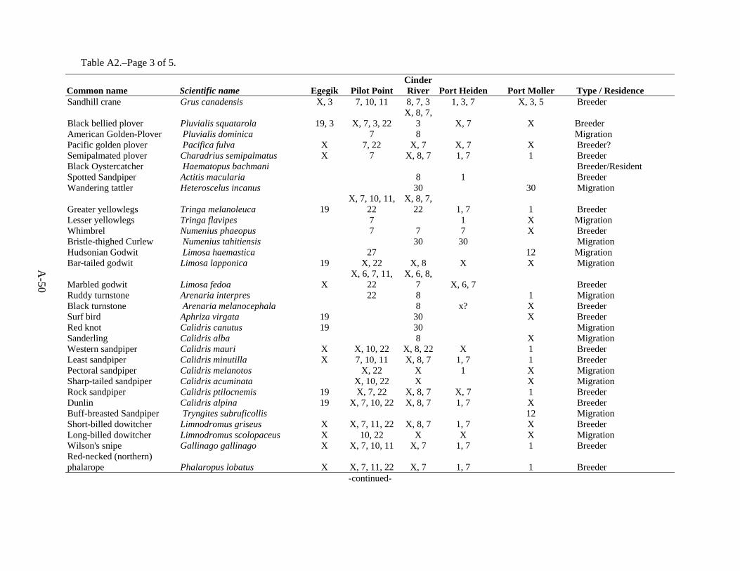
A-50
Table A2.–Page 3 of 5.
Common name Scientific name Egegik Pilot Point Cinder River Port Heiden Port Moller Type / Residence
Sandhill crane Grus canadensis X, 3 7, 10, 11 8, 7, 3 1, 3, 7 X, 3, 5 Breeder
Black bellied plover Pluvialis squatarola 19, 3 X, 7, 3, 22 X, 8, 7,
3 X, 7 X Breeder American Golden-Plover Pluvialis dominica 7 8 Migration Pacific golden plover Pacifica fulva X 7, 22 X, 7 X, 7 X Breeder? Semipalmated plover Charadrius semipalmatus X 7 X, 8, 7 1, 7 1 Breeder Black Oystercatcher Haematopus bachmani Breeder/Resident Spotted Sandpiper Actitis macularia 8 1 Breeder Wandering tattler Heteroscelus incanus 30 30 Migration
Greater yellowlegs Tringa melanoleuca 19 X, 7, 10, 11,
22 X, 8, 7,
22 1, 7 1 Breeder Lesser yellowlegs Tringa flavipes 7 1 X Migration Whimbrel Numenius phaeopus 7 7 7 X Breeder Bristle-thighed Curlew Numenius tahitiensis 30 30 Migration Hudsonian Godwit Limosa haemastica 27 12 Migration Bar-tailed godwit Limosa lapponica 19 X, 22 X, 8 X X Migration
Marbled godwit Limosa fedoa X X, 6, 7, 11,
22 X, 6, 8,
7 X, 6, 7 Breeder Ruddy turnstone Arenaria interpres 22 8 1 Migration Black turnstone Arenaria melanocephala 8 x? X Breeder Surf bird Aphriza virgata 19 30 X Breeder Red knot Calidris canutus 19 30 Migration Sanderling Calidris alba 8 X Migration Western sandpiper Calidris mauri X X, 10, 22 X, 8, 22 X 1 Breeder Least sandpiper Calidris minutilla X 7, 10, 11 X, 8, 7 1, 7 1 Breeder Pectoral sandpiper Calidris melanotos X, 22 X 1 X Migration Sharp-tailed sandpiper Calidris acuminata X, 10, 22 X X Migration Rock sandpiper Calidris ptilocnemis 19 X, 7, 22 X, 8, 7 X, 7 1 Breeder Dunlin Calidris alpina 19 X, 7, 10, 22 X, 8, 7 1, 7 X Breeder Buff-breasted Sandpiper Tryngites subruficollis 12 Migration Short-billed dowitcher Limnodromus griseus X X, 7, 11, 22 X, 8, 7 1, 7 X Breeder Long-billed dowitcher Limnodromus scolopaceus X 10, 22 X X X Migration Wilson's snipe Gallinago gallinago X X, 7, 10, 11 X, 7 1, 7 1 Breeder Red-necked (northern) phalarope Phalaropus lobatus X X, 7, 11, 22 X, 7 1, 7 1 Breeder
-continued-

A-51
Table A2.–Page 4 of 5.
Common name Scientific name Egegik Pilot Point Cinder River
Port Heiden Port Moller Type / Residence
Red phalarope Phalaropus fulicaria X 22 X X Migration
Black-legged kittiwake Rissa tridactyla X, 3, 4 2, 4, 5, 22 2, 8, 3,
4, 5 3, 4, 5 1, 2, 3, 4, 5 Breeder Sabine's gull Xema sabini X, 5 X, 5 3, 5 X, 3, 5 X, 3, 5 Transient Bonaparte's gull Larus philadelphia X X, 10, 22 8, 4, 22 1, 4 Breeder ?
Mew gull Larus canus 3, 4 3, 7, 10, 11,
4, 22 3, 8, 7, 4, 22 1, 4, 7 1, 3, 4 Breeder
Herring Gull Larus argentatus 8 12 Transient
Glaucous-winged gull Larus glaucescens 19, 3, 5 X, 7, 10, 11,
5, 22 X, 8 , 5 X, 5, 7 1, 5 Breeder Glaucous gull Larus hyperboreus 4, 5 4, 5 8, 4, 5 4, 5 X, 4, 5 Migration/Winter Aleutian tern Sterna aleutica X X X X X Breeder
Arctic tern Sterna paradisaea 3, 5 3, 7, 11, 5,
22 3, 8, 5 1, 3, 5 1, 3, 5 Breeder Pomarine jaeger Stercorarius pomarinus X, 4 Migration
Parasitic jaeger Stercorarius parasiticus X, 3* X, 7, 11, 3 X, 8, 7,
3* 1, 3, 4*, 7 X, 3*, 4* Breeder Long-tailed jaeger Stercorarius longicaudus 3* 7, 3* 8, 7, 3* 3*, 4*, 7 X, 3*, 4* Breeder Common murre Uria aalge 3 3 X Breeder Thick-billed murre Uria lomvia X Breeder Pigeon guillemot Cepphus columba 1, 3 Breeder Marbled murrelet Brachyramphus marmoratus X X X X 1 Breeder Kittlitz's murrelet Brachyramphus brevirostris 1 Ancient murrelet Synthliboramphus antiquus X Near shore Parakeet Auklet Aethia psittacula Near shore Crested auklet Aethia cristatella X Horned puffin Fratercula corniculata 1, 12 Breeder Tufted puffin Fratercula cirrhata X Breeder Great Horned Owl Bubo virginianus 12 Breeder/Resident Snowy owl Nyctea scandiaca 12 WIN/Transient Short-eared owl Asio flammeus 19 10, 22 8 1 12 Breeder/Resident Northern Saw-whet Owl Aegolius acadicus Breeder/Resident? Rufous Hummingbird Selasphorus rufus Transient Belted Kingfisher Ceryle alcyon 1 1,12 Breeder Alder Flycatcher Empidonax alnorum Breeder Northern shrike Lanius excubitor 10, 22 1 1, 12 Breeder
-continued-

A-52
Table A2.–Page 5 of 5.
Common name Scientific name Egegik Pilot Point Cinder River
Port Heiden Port Moller Type / Residence
Black-billed magpie Pica pica 7 1 1,12 Breeder/Resident
Common raven Corvus corax X, 22 7, 10, 11, 3,
22 3, 8, 22 1, 3, 7 2, 3, 12 Breeder/Resident Tree swallow Tachycineta bicolor 11 1 1,12 Breeder Violet Green Swallow Tachycineta thalassina 30 1 Breeder Bank swallow Riparia riparia X, 28 1 1, 12 Breeder Cliff Swallow Hirundo pyrrhonota 29 1 Breeder Barn Swallow Hirundo rustica 28, 29 Breeder Black-capped chickadee Parus atricapillus 7 1 X, 12 Breeder American dipper Cinclus mexicanus X 1 X Breeder Gray-cheeked thrush Catharus minimus 1 X Breeder Hermit thrush Catharus guttatus X X, 11, 7 X X, 7 1, 12, 28 Breeder American robin Turdus migratorius 11, 7 1, 7 Breeder Yellow Wagtail Motacilla flava 1 Breeder? American pipit Anthus rubescens 7, 18 7 X, 12 Breeder Water Pipit Anthus spinoletta 1 1 Orange-crowned warbler Vermivora celata 11 1 1,12 Breeder Yellow warbler Dendroica petechia 11 1 1 Breeder Wilson's warbler Wilsonia pusilla 11 1 1 Breeder American tree sparrow Passerculus sandwichensis 11, 7 1, 7 Breeder Savannah sparrow Passerculus sandwinchensis X 10, 11, 7, 22 1, 7 1 Breeder Fox sparrow Passerella iliaca 7, 22, 26 1, 7 1, 12 Breeder White-crowned sparrow Zonotrichia leucophrys 11, 7 1, 7 X Breeder Golden-crowned sparrow Zonotrichia atricapilla 11, 7 1, 7 1, 12 Breeder Lapland longspur Calcarius lapponicus X, 26 10, 11, 7, 22 8, 22 1, 7 1, 12 Breeder Snow bunting Plectrophenax nivalis X 22 22 1 1 Breeder McKay's bunting Plectrophenax hyperboreus Winter Gray-crowned Rosy-Finch Leucosticte tephrocotis Common redpoll Carduelis flammea 11, 7 8 7 1, 12 Breeder Hoary redpoll Carduelis hornemanni X, 12 Migration/Winter
* Listed species occur throughout Bristol Bay and general area of Bristol Bay CHA’s. Species with numerical cites or “X” are known to occur within the CHA noted. See Table A26 for source references.
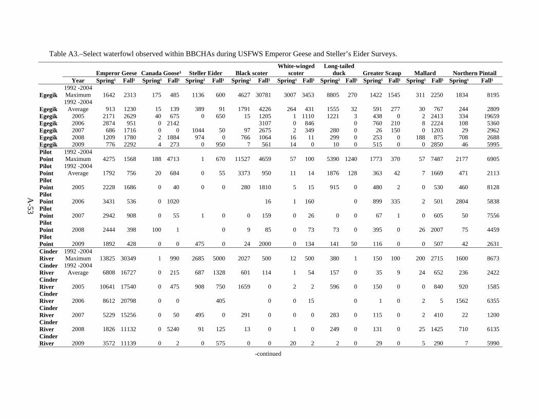
A-53
Table A3.–Select waterfowl observed within BBCHAs during USFWS Emperor Geese and Steller’s Eider Surveys.
Emperor Geese Canada Goose³ Steller Eider Black scoter White-winged
scoter Long-tailed
duck Greater Scaup Mallard Northern Pintail Year Spring¹ Fall¹ Spring¹ Fall¹ Spring² Fall¹ Spring² Fall¹ Spring¹ Fall¹ Spring² Fall¹ Spring¹ Fall¹ Spring¹ Fall¹ Spring¹ Fall¹
Egegik 1992 -2004 Maximum 1642 2313 175 485 1136 600 4627 30781 3007 3453 8805 270 1422 1545 311 2250 1834 8195
Egegik 1992 -2004
Average 913 1230 15 139 389 91 1791 4226 264 431 1555 32 591 277 30 767 244 2809 Egegik 2005 2171 2629 40 675 0 650 15 1205 1 1110 1221 3 438 0 2 2413 334 19659 Egegik 2006 2874 951 0 2142 3107 0 846 0 760 210 8 2224 108 5360 Egegik 2007 686 1716 0 0 1044 50 97 2675 2 349 280 0 26 150 0 1203 29 2962 Egegik 2008 1209 1780 2 1884 974 0 766 1064 16 11 299 0 253 0 188 875 708 2688 Egegik 2009 776 2292 4 273 0 950 7 561 14 0 10 0 515 0 0 2850 46 5995 Pilot Point
1992 -2004 Maximum 4275 1568 188 4713 1 670 11527 4659 57 100 5390 1240 1773 370 57 7487 2177 6905
Pilot Point
1992 -2004 Average 1792 756 20 684 0 55 3373 950 11 14 1876 128 363 42 7 1669 471 2113
Pilot Point 2005 2228 1686 0 40 0 0 280 1810 5 15 915 0 480 2 0 530 460 8128 Pilot Point 2006 3431 536 0 1020 16 1 160 0 899 335 2 501 2804 5838 Pilot Point 2007 2942 908 0 55 1 0 0 159 0 26 0 0 67 1 0 605 50 7556 Pilot Point 2008 2444 398 100 1 0 9 85 0 73 73 0 395 0 26 2007 75 4459 Pilot Point 2009 1892 428 0 0 475 0 24 2000 0 134 141 50 116 0 0 507 42 2631 Cinder River
1992 -2004 Maximum 13825 30349 1 990 2685 5000 2027 500 12 500 380 1 150 100 200 2715 1600 8673
Cinder River
1992 -2004 Average 6808 16727 0 215 687 1328 601 114 1 54 157 0 35 9 24 652 236 2422
Cinder River 2005 10641 17540 0 475 908 750 1659 0 2 2 596 0 150 0 0 840 920 1585 Cinder River 2006 8612 20798 0 0 405 0 0 15 0 1 0 2 5 1562 6355 Cinder River 2007 5229 15256 0 50 495 0 291 0 0 0 283 0 115 0 2 410 22 1200 Cinder River 2008 1826 11132 0 5240 91 125 13 0 1 0 249 0 131 0 25 1425 710 6135 Cinder River 2009 3572 11139 0 2 0 575 0 0 20 2 2 0 29 0 5 290 7 5990
-continued

A-54
Table A3.–Page 2 of 3.
Emperor Geese Canada Goose³ Steller Eider Black scoter White-winged
scoter Long-tailed
duck Greater Scaup Mallard Northern Pintail Year Spring¹ Fall¹ Spring¹ Fall¹ Spring² Fall¹ Spring² Fall¹ Spring¹ Fall¹ Spring² Fall¹ Spring¹ Fall¹ Spring¹ Fall¹ Spring¹ Fall¹ Port Heiden
1992 -2004 Maximum 33187 15282 70 7107 26820 24313 14148 8870 13 1476 992 50 859 395 5 2920 2606 26232
Port Heiden
1992 -2004 Average 19394 9051 6 1205 10380 11438 2564 2505 1 183 226 5 305 88 1 839 504 9195
Port Heiden 2005 20125 5677 0 520 17358 4700 799 668 0 435 150 0 84 240 0 125 195 15825 Port Heiden 2006 27822 7390 5 835 3550 1520 3 31 0 302 275 225 56 4950 12270 Port Heiden 2007 19227 11238 0 180 15419 10103 2656 3579 1 50 40 0 9 100 0 0 277 10098 Port Heiden 2008 15295 7922 0 703 8826 170 44 0 7 0 857 0 972 0 20 1750 2569 8885 Port Heiden 2009 23591 12090 0 115 15220 4800 367 65 8 250 397 0 127 375 0 1150 110 13420 Port Moller
1992 -2004 Maximum 28088 33569 350 433 42212 74125 16950 31082 1413 3406 4704 450 1600 2770 50 1446 1545 6700
Port Moller
1992 -2004 Average 16169 24661 27 132 18143 38099 10609 9892 123 491 1317 48 417 574 9 290 385 3385
Port Moller 2005 12319 17533 0 30 15740 18343 9430 9263 13 55 10771 0 1573 155 0 295 887 11577 Port Moller 2006 13964 25510 0 0 39411 6353 0 396 0 255 32 90 75 1944 2610 Port Moller 2007 25494 20678 0 215 13665 39288 5929 8376 4 159 21 0 430 120 60 580 1255 10458 Port Moller 2008 32012 19023 0 300 15450 17040 27067 3286 10 411 15750 0 1304 0 0 53 700 9850 Port Moller 2009 37711 18177 0 0 20162 35650 4237 5813 1 65 965 0 105 0 0 367 22 6998 * = Observed numbers of select waterfowl species recorded during spring or fall surveys targeting Emperor Geese and Steller’s Eiders, in survey segments within or adjacent to BBCHA's. See Dau & Mallek 1992 - 2008, Mallek & Dau 1992 - 2008 and Larned 1992 - 2008. Numbers reflect waterfowl opportunistically observed and recorded during surveys targeting Emperor Geese and Steller’s Eiders and therefore may not include all birds present during the survey nor fully represent usage of the BBCHA's by these or other species. Numbers presented may also include some birds outside of BBCHA's as survey segments do not directly correspond to CHA boundaries, ¹ = Data derived from Dau and Mallek published and unpublished spring and fall Emperor Goose Surveys. ² = Data derived from Larned published and unpublished spring Steller Eider Surveys. ³ = Includes all subforms of Canada Geese
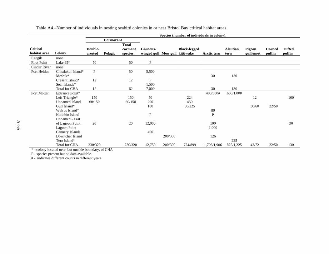
A-55
Table A4.–Number of individuals in nesting seabird colonies in or near Bristol Bay critical habitat areas. Species (number of individuals in colony).
Cormorant
Critical habitat area Colony
Double-crested Pelagic
Total cormant species
Gaucous-winged gull Mew gull
Black-legged kittiwake Arctic tern
Aleutian tern
Pigeon guillemot
Horned puffin
Tufted puffin
Egegik none Pilot Point Lake 65* 50 50 P Cinder River none Port Heiden Chistiakof Island* P 50 5,500 Meshik* 30 130 Cresent Island* 12 12 P Seal Islands* 1,500 Total for CHA 12 62 7,000 30 130 Port Moller Entrance Point* 400/600# 600/1,000 Left Triangle* 150 150 50 224 12 100 Unnamed Island 60/150 60/150 200 450 Gull Island* 100 50/225 30/60 22/50 Walrus Island* 80 Kudobin Island P P
Unnamed - East of Lagoon Point 20 20 12,000 100 30
Lagoon Point 1,000 Cannery Islands 400 Dowitcher Island 200/300 126 Tern Island* 225 Total for CHA 230/320 230/320 12,750 200/300 724/899 1,706/1,906 825/1,225 42/72 22/50 130 * - colony located near, but outside boundary, of CHA P - species present but no data available. # - indicates different counts in different years

A-56
Table A5.–Seabirds breeding in the Bristol Bay critical habitat areas.
Nests in CHA
Common name Scientific name Egegik Pilot Point
Cinder River
Port Heiden
Port Moller
Double Crested Cormorant Phalacrocorox auritus X X X Parasitic Jaeger Stercorarius parasiticus X X X X X Bonaparte's gull Laus philadelphia X X Mew Gull Larus canus X Glaucous-winged gull Larus glaucescens X X Sabine's Gull Xema sabini X X X X X Black-legged Kittiwake Rissa tridactyla X X Arctic Tern Sterna paradisaea X X Aleutian Tern Sterna aleutica X X Pigeon Guillemot Cepphus columba X
Marbled Murrelet Brachyramphus marmoratus X X X X X
Tufted puffin Fratercula cirrhata X Denlinger, L.M. 2006. Alaska Seabird Information Series. Unpublished Report U.S. Fish and Wildlife Service, Migratory Bird Management, Nongame Program, Anchorage, AK.
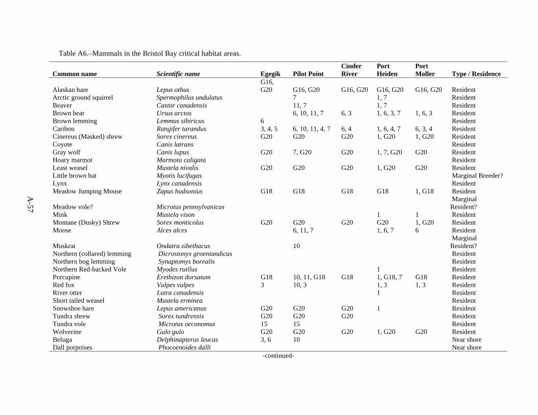
A-57
Table A6.–Mammals in the Bristol Bay critical habitat areas.
Common name Scientific name Egegik Pilot Point Cinder River
Port Heiden
Port Moller Type / Residence
Alaskan hare Lepus othus G16, G20 G16, G20 G16, G20 G16, G20 G16, G20 Resident
Arctic ground squirrel Spermophilus undulatus 7 1, 7 Resident Beaver Castor canadensis 11, 7 1, 7 Resident Brown bear Ursus arctos 6, 10, 11, 7 6, 3 1, 6, 3, 7 1, 6, 3 Resident Brown lemming Lemmus sibiricus 6 Resident Caribou Rangifer tarandus 3, 4, 5 6, 10, 11, 4, 7 6, 4 1, 6, 4, 7 6, 3, 4 Resident Cinereus (Masked) shrew Sorex cinereus G20 G20 G20 1, G20 1, G20 Resident Coyote Canis latrans Resident Gray wolf Canis lupus G20 7, G20 G20 1, 7, G20 G20 Resident Hoary marmot Marmota caligata Resident Least weasel Mustela nivalis G20 G20 G20 1, G20 G20 Resident Little brown bat Myotis lucifugas Marginal Breeder? Lynx Lynx canadensis Resident Meadow Jumping Mouse Zapus hudsonius G18 G18 G18 G18 1, G18 Resident
Meadow vole? Microtus pennsylvanicus Marginal Resident?
Mink Mustela vison 1 1 Resident Montane (Dusky) Shrew Sorex monticolus G20 G20 G20 G20 1, G20 Resident Moose Alces alces 6, 11, 7 1, 6, 7 6 Resident
Muskrat Ondatra zibethacus 10 Marginal Resident?
Northern (collared) lemming Dicrostonyx groeniandicus Resident Northern bog lemming Synaptomys borealis Resident Northern Red-backed Vole Myodes rutilus 1 Resident Porcupine Erethizon dorsatum G18 10, 11, G18 G18 1, G18, 7 G18 Resident Red fox Vulpes vulpes 3 10, 3 1, 3 1, 3 Resident River otter Lutra canadensis 1 Resident Short tailed weasel Mustela erminea Resident Snowshoe hare Lepus americanus G20 G20 G20 1 Resident Tundra shrew Sorex tundrensis G20 G20 G20 Resident Tundra vole Microtus oeconomus 15 15 Resident Wolverine Gulo gulo G20 G20 G20 1, G20 G20 Resident Beluga Delphinapterus leucas 3, 6 10 Near shore Dall porpoises Phocoenoides dalli Near shore
-continued-

A-58
Table A6.–Page 2 of 2.
Common name Scientific name Egegik Pilot Point Cinder River
Port Heiden
Port Moller Type / Residence
Gray whale Eschrichtius robustus 6, 3, 5, 17, 6, 3, 5, 17,
2, 3, 6, 5, 17, 3, 6, 5, 17, 3, 5, 17, Near shore
Harbor porpoise Phocoena phocoena 3, 5 3, 5 3, 5 3 Near shore
Harbor seal Phoca vitulina 6, 3, 5, G20 3, 6, 5, G20
2, 3, 6, 5, G20
3, 6, 5, G20
2, 3, 6, 5, G20 Resident
Humpback whale Megaptera novaeangliae Near shore Killer whale Orcinus orca 3 Near shore N. Right Whale Eubalaena glacialis Near shore Northern fur seal Callorhinus ursinus Transient Pacific White-sided dolphin Lagenorhynchus obliquidens Near shore Pilot whale Globicephala sp Near shore
Sea otter Enhydra lutris 3, 5, 20 6, 3, 5, 20 2, 3, 6 , 5, 20 3, 6, 5, 20
2, 3, 6, 5, 20 Resident
Spotted seal Phoca largha **, G20 **, G20 **, G20 **, G20 **, G20 Steller's sea lion Eumetopias jubatus 5 3, 5 3, 5 Resident Walrus Odobenus rosmarus 3 3 Near shore
**Sympatric with harbor seal in this region.
See Table A26 for source references.

A-59
Table A7.–Finfish in the Bristol Bay critical habitat areas.
Scientific name Common name Habitat notes Egegik Pilot Point
Cinder River
Port Heiden
Port Moller
Oncorhynchus gorbuscha pink salmon X X X O. keta chum salmon X X X X X O. kisutch coho salmon X X X X X O. nerka sockeye salmon X X X X X O. tshawytscha Chinook salmon X X X X X O. mykiss rainbow trout/ steelhead Port Moller S. extent of distribution X X X
Salvelinus alpinus arctic char S to Port Heiden- resident/anadromous? Scalon, 2000 Becharof Lake? X X X X
Salvelinus malma Dolly Varden all-anadromous/ freshwater X X X X X Salvelinus namaycush lake trout all- but generally absent from lowlands? X X X X X
Thymallus arcticus grayling Only Egegik and Ugashik drainages- freshwater X X
Esox lucius northern pike all-freshwater X X X X X Dallis pectoralis blackfish all-freshwater X X X X X Lota lota burbot all-freshwater X X X X X Corgonus pidschian humpback whitefish Coastal anadromous X X X X Prosopium coulteri pygmy whitefish deep lakes, cold streams X X Prosopium cylindraceum round whitefish all-freshwater X X X X X Gasterosteus aculeatus threespine stickleback all X X X X X Pungitius pungitius ninespine stickleback all X X X X X Lampetra camtschatica arctic lamprey all X X X X X Lampetra tridentata Pacific lamprey all X X X X X Lamptera alaskense Alaskan brook lamprey Ugashik and Egegik-freshwater X X Clupea harengus pallasi Pacific herring all X X X X X Thaleichtys pacificus eulachon all-anadromous X X X X X Mallotus villosus capelin all X X X X X Osmerus mordax rainbow smelt all- anadromous X X X X X Hypomesus olidus pond smelt all - freshwater X X X X X Liopsetta glacialis arctic flounder all-shallow brackish bays and estuaries X X X X X Platichthys stellatus starry flounder all- intertidal and off shore X X X X X Lepidopsetta polyxystra northern rock sole all- on continental shelf? X X X X X
Parophrys vetulus English sole Port Moller- lower intertidal soft bottom X
Isopsetta isolepis butter sole all-muddy bottom X X X X X Catostomus catostomus longnose sucker all-freshwater X X X X X
-continued-
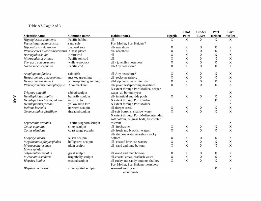
A-60
Table A7.-Page 2 of 3
Scientific name Common name Habitat notes Egegik Pilot Point
Cinder River
Port Heiden
Port Moller
Hippoglossus stenolepis Pacific halibut all X X X X X Psettichthys melanostictus sand sole Port Moller, Port Heiden ? Hippoglossus elassodon flathead sole all- nearshore X X X X X Pleuronectes quadrituberculatus Alaska plaice all- nearshore X X X X X Boreogadus saida Arctic cod all X X X X X Microgadus proximus Pacific tomcod all X X X X X Theragra calcogramma walleye pollock all - juveniles nearshore X X X X X Gadus macrocephalus Pacific cod all-Any nearshore? X X X X X Anoplopoma fimbria sablefish all-Any nearshore? X X X X X Hexagrammos octogrammus masked greenling all- rocky nearshore X X X X X Hexagrammos stelleri white-spotted greenling all-kelp beds, reefs intertidal X X X X X Pleurogrammus monopterygius Atka mackerel all- juveniles/spawning nearshore X X X X X
Triglops pingelii ribbed sculpin N extent through Port Molller, deeper water- all bottom types X
Hemilepidotus papilio butterfly sculpin all- intertidal and tide pools X X X X X Hemilepidotus hemilepidotus red Irish lord N extent through Port Heiden X X Hemilepidotus jordani yellow Irish lord N extent through Port Molller X Icelinus borealis northern sculpin all-deeper areas X X X X X Gymnocanthus pistilliger threaded sculpin all-soft bottoms, shallow water X X X X X
Leptocottus armatus Pacific staghorn sculpin
N extent through Port Moller-intertidal, soft bottom, eelgrass beds, freshwater tolerant X
Cottus cognatus slimy sculpin all- freshwater X X X X X Cottus aleuticus coast range sculpin all- fresh and brackish waters X X X X X
Enophrys lucasi leister sculpin all- shallow water nearshore rocky bottom X X X X X
Megalocottus platycephalus belligerent sculpin all- coastal brackish waters X X X X X Myoxocephalus jaok plain sculpin all -sand and mud bottom X X X X X Myxocephalus polyacanthocephalus great sculpin all -sand and mud bottom X X X X X Microcottus stellaris brightbelly sculpin all-coastal areas, brackish water X X X X X Blepsias bilobus crested sculpin all-rocky and sandy bottoms shallow X X X X X
Blepsias cirrhosus silverspotted sculpin Port Moller, Port Heiden- nearshore seaweed and rocks X X
-continued-
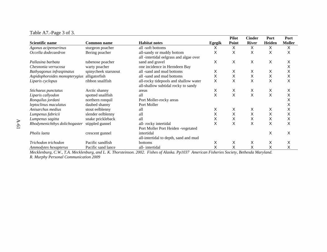
A-61
Table A7.-Page 3 of 3.
Scientific name Common name Habitat notes Egegik Pilot Point
Cinder River
Port Heiden
Port Moller
Agonus acipenserinus sturgeon poacher all -soft bottoms X X X X X Occella dodecaedron Bering poacher all-sandy or muddy bottom X X X X X
Pallasina barbata tubenose poacher all -intertidal eelgrass and algae over sand and gravel X X X X X
Chesnonia verrucosa warty poacher one incidence in Herndeen Bay X Bathyagonus infraspinatus spinycheek starsnout all -sand and mud bottoms X X X X X Aspidophoroides monopterygius alligatorfish all -sand and mud bottoms X X X X X Liparis cyclopus ribbon snailfish all-rocky tidepools and shallow water X X X X X
Stichaeus punctatus Arctic shanny all-shallow subtidal rocky to sandy areas X X X X X
Liparis callyodon spotted snailfish all X X X X X Ronquilus jordani northern ronquil Port Moller-rocky areas X leptoclinus maculatus daubed shanny Port Moller X Anisarchus medius stout eelblenny all X X X X X Lumpenus fabricii slender eelblenny all X X X X X Lumpenus sagitta snake prickleback all X X X X X Rhodymenichthys dolichogaster stippled gunnel all- rocky intertidal X X X X X
Pholis laeta crescent gunnel Port Moller Port Heiden -vegetated intertidal X X
Trichodon trichodon Pacific sandfish all-intertidal to depth, sand and mud bottoms X X X X X
Ammodytes hexapterus Pacific sand lance all- intertidal X X X X X Mecklenburg, C.W., T.A. Mecklenburg, and L. K. Thorsteinson. 2002. Fishes of Alaska. Pp1037 American Fisheries Society, Bethesda Maryland. R. Murphy Personal Communication 2009

A-62
Table A8.–Species listed as endangered or threatened under state or federal law, and ADF&G Species of Special Concern.
Federally Endangered (as of Oct 2009) State Endangered (effective 11/1993)
Short-tailed Albatross Diomedea albatrus Short-tailed Albatross Diomedea albatrus
Eskimo Curlew Numenius borealis Eskimo Curlew Numenius borealis
Humpback whale Megaptera novaengliae Blue whale Balaenoptera musculus
North Pacific right whale Eubalena glacialis Humpback whale Megaptera novaengliae
Aleutian shield fern Polystichum aleuticum Right whale Eubalena glacialis
Steller sea lion Eumetopias jubatus (west of 144º)
Bowhead whale Balaena mysticetus State Species of Special Concern (effective 11/1998)
Fin whale Balaenoptera physalus Spectacled Eider Somateria fischeri
Leatherback turtle Dermochelys coriacea Steller sea lion Eumetopias jubatus
Cook Inlet beluga whale Delphinapterus leucas Harbor seal Phoca vitulina
Blue whale Balaenoptera musculus Chinook salmon (fall run, Snake River) Oncorhynchus tshawytscha
Sei Whale Balaenoptera borealis Aleutian cackling goose Branta hutchinsii leucopareia
Sperm whales Physeter macrocephalus Cook Inlet beluga whale Delphinapterus leucas
American Peregrine Falcon Falco peregrinus anatum
Federally Threatened (as of October 2009) Arctic Peregrine Falcon Falco peregrinus tundrius
Spectacled Eider Somateria fischeri Northern Goshawk (Southeast AK) Accipiter gentilis laingi
Steller's Eider Polysticta stelleri Olive-sided Flycatcher Contopus cooperi
Northern sea otter (SW AK pop.) Enhydra lutris kenyoni Gray-cheeked Thrush Catharus minimus
Steller sea lion (east of 144º) Eumetopias jubatus Townsend's Warbler Dendroica townsendi
Polar bear Ursus maritimus Blackpoll Warbler Dendroica striata
Loggerhead turtle Caretta caretta Kenai brown bear Ursus arctos horribilis
Green turtle Chelonia mydas Bowhead whale Balaena mysticetus
Olive ridley turtle Lepidochelys olivacea
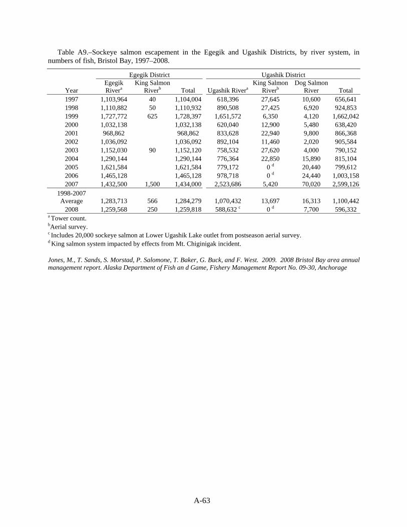
A-63
Table A9.–Sockeye salmon escapement in the Egegik and Ugashik Districts, by river system, in numbers of fish, Bristol Bay, 1997–2008.
Egegik District Ugashik District
Year Egegik Rivera
King Salmon Riverb Total Ugashik Rivera
King Salmon Riverb
Dog Salmon River Total
1997 1,103,964 40 1,104,004 618,396 27,645 10,600 656,641 1998 1,110,882 50 1,110,932 890,508 27,425 6,920 924,853 1999 1,727,772 625 1,728,397 1,651,572 6,350 4,120 1,662,0422000 1,032,138 1,032,138 620,040 12,900 5,480 638,420 2001 968,862 968,862 833,628 22,940 9,800 866,368 2002 1,036,092 1,036,092 892,104 11,460 2,020 905,584 2003 1,152,030 90 1,152,120 758,532 27,620 4,000 790,152 2004 1,290,144 1,290,144 776,364 22,850 15,890 815,104 2005 1,621,584 1,621,584 779,172 0 d 20,440 799,612 2006 1,465,128 1,465,128 978,718 0 d 24,440 1,003,1582007 1,432,500 1,500 1,434,000 2,523,686 5,420 70,020 2,599,126
1998-2007 Average 1,283,713 566 1,284,279 1,070,432 13,697 16,313 1,100,442
2008 1,259,568 250 1,259,818 588,632 c 0 d 7,700 596,332 a Tower count. bAerial survey. c Includes 20,000 sockeye salmon at Lower Ugashik Lake outlet from postseason aerial survey. d King salmon system impacted by effects from Mt. Chiginigak incident. Jones, M., T. Sands, S. Morstad, P. Salomone, T. Baker, G. Buck, and F. West. 2009. 2008 Bristol Bay area annual management report. Alaska Department of Fish an d Game, Fishery Management Report No. 09-30, Anchorage

A-64
Table A10.–Estimated total escapement for chinook, sockeye, pink, and chum salmon and peak escapement counts for coho salmon in the Nelson Lagoon, Herendeen-Moller Bay, Inner Port Heiden, and Cinder River Sections, Northern District, North Alaska Peninsula, 2008.
Number of Salmon a Stream No. Stream Name Chinook Sockeye Coho Pink Chum
NELSON LAGOON SECTION 313-30.01 David's R. (early) 12,000 1,000
313-30.01 & .04 David's R. (late) 313-30.02 Caribou River 25,000 12,000 313-30.03 Nelson (Sapsuk) River 5,012 141,600 24,000 3,139
Nelson Lagoon total 5,012 178,600 37,000 0 3,139
HERENDEEN-MOLLER BAY SECTION 314-20.02 Buck Valley 600 314-20.03 Doe Valley 20,010 314-20.04 Deer Valley 2,000 15,000 22,000 314-20.05 Portage Valley 20 500 314-20.06 Grass Valley 1,200 2,000 22,000 314-20.07 Lawrence Valley 3,000 3,000 21,000 314-20.08 Mine Harbor 200 314-20.09 Coal Creek 10,000 54,000
Herendeen Bay total 0 1,220 7,000 28,000 140,310
314-30-.04 Mud Bay, West 314-30.05 Mud Bay, East 2,000 314-30.07 Head Cr., Rt Head 1,500 314-30.09 Right Head Cr. 4,000 2,500 7,000 314-30.10 Lef Head Cr. 8,000 1,500 5,000
Moller Bay total 0 12,000 4,000 15,500 Total Herendeen-Moller Bay Section 0 1,220 19,000 32,000 155,810
INNER PORT HEIDEN SECTION 317-20.02 Charles Creek 2,000 5,000 317-20.04 A&B Red & Yellow bluff Creeks 1,200 22,000 3,000 317-20.06 Highland Creek 1,000 West Port Heiden Bay total 1,200 25,000 0 5,000 3,000
317-20.07 A Meshik River, main stem 1,800 12,500 27,000 4,000 317-20.07 B Braided Creek 800 2,000 1,200 317-20.07 C Landlocked Creek 9,000 317-20.07 D Bluff Creek 7,000 317-20.07 E Blue Violet Creek 1,000 8,000 317-20.07 F Wolf Creek 1,500 300 317-20.07 G Unnamed 500 317-20.07 H Shoe Creek 700 300 4,000 317-20.07 J Unnamed 50 300 317-20.07 K Unnamed 2,000 4,000 317-20.07 L Unnamed 800 4,000 2,000 317-20.07 M Unnamed 300 3,000 317-20.07 N Unnamed 6,000 317-20.07 O Plenty Bear Creek 1,200 3,000 4,000 317-20.07 O-A Paddle Creek 317-20.07 P Waterfall Creek 600 500 317-20.07 R Rainbow Creek 1,700 3,000 4,000 317-20.07 T Cub Creek 800
-continued-

A-65
Table A10.Page 2 of 2. Number of Salmon a
Stream No. Stream Name Chinook Sockeye Coho Pink Chum Meshik River total 10,000 61,250 27,000 0 24,600 317-20.08 317-20.09 Total Inner Port Heiden Section 11,200 86,250 27,000 5,000 30,300 OUTER PORT HEIDEN SECTION 318-10.01 Reindeer Creek Total Outer Port Heiden Section 0 0 0 0 0 CINDER RIVER SECTION 318-20.01 Unnamed 22,000 318-20.04 Mud Creek 33,000 500 318-20.06 A Cinder River, main stem 3,500 33,000 18,000 318-20.06 B Unnamed 300 2,000 318-20.06 C Unnamed 1,800 1,200 318-20.06 D Lava Creek 44,000 318-20.06 E High Creek 4,000 318-20.06 H Meloy Creek 4,000 6,800 318-20.06 J Wiggly Creek 5,000 5,000 318-20.06 K Ray Creek 2,200 318-20.06 L Unnamed 2,000 Cinder River total 12,800 129,800 22,500 0 23,200 Total Cinder River Section 12,800 129,800 22,500 0 23,200 a Chinook, sockeye, pink, and chum salmon numbers are estimated total escapements. Coho salmon numbers are peak counts and based on limited data. Murphy, R.L. and T.G. Hartill. 2009. North Alaska Peninsula commercial salmon annual management report, 2008 Alaska Department of Fish and Game, Fishery Management Report No. 09-36, Anchorage.
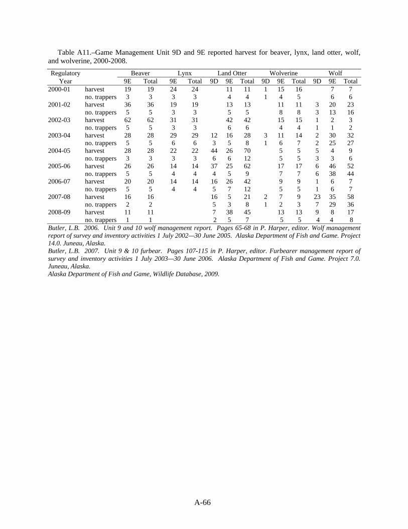
A-66
Table A11.–Game Management Unit 9D and 9E reported harvest for beaver, lynx, land otter, wolf, and wolverine, 2000-2008.
Regulatory Beaver Lynx Land Otter Wolverine Wolf Year 9E Total 9E Total 9D 9E Total 9D 9E Total 9D 9E Total
2000-01 harvest 19 19 24 24 11 11 1 15 16 7 7 no. trappers 3 3 3 3 4 4 1 4 5 6 6 2001-02 harvest 36 36 19 19 13 13 11 11 3 20 23 no. trappers 5 5 3 3 5 5 8 8 3 13 16 2002-03 harvest 62 62 31 31 42 42 15 15 1 2 3 no. trappers 5 5 3 3 6 6 4 4 1 1 2 2003-04 harvest 28 28 29 29 12 16 28 3 11 14 2 30 32 no. trappers 5 5 6 6 3 5 8 1 6 7 2 25 27 2004-05 harvest 28 28 22 22 44 26 70 5 5 5 4 9 no. trappers 3 3 3 3 6 6 12 5 5 3 3 6 2005-06 harvest 26 26 14 14 37 25 62 17 17 6 46 52 no. trappers 5 5 4 4 4 5 9 7 7 6 38 44 2006-07 harvest 20 20 14 14 16 26 42 9 9 1 6 7 no. trappers 5 5 4 4 5 7 12 5 5 1 6 7 2007-08 harvest 16 16 16 5 21 2 7 9 23 35 58 no. trappers 2 2 5 3 8 1 2 3 7 29 36 2008-09 harvest 11 11 7 38 45 13 13 9 8 17 no. trappers 1 1 2 5 7 5 5 4 4 8 Butler, L.B. 2006. Unit 9 and 10 wolf management report. Pages 65-68 in P. Harper, editor. Wolf management report of survey and inventory activities 1 July 2002—30 June 2005. Alaska Department of Fish and Game. Project 14.0. Juneau, Alaska. Butler, L.B. 2007. Unit 9 & 10 furbear. Pages 107-115 in P. Harper, editor. Furbearer management report of survey and inventory activities 1 July 2003—30 June 2006. Alaska Department of Fish and Game. Project 7.0. Juneau, Alaska. Alaska Department of Fish and Game, Wildlife Database, 2009.
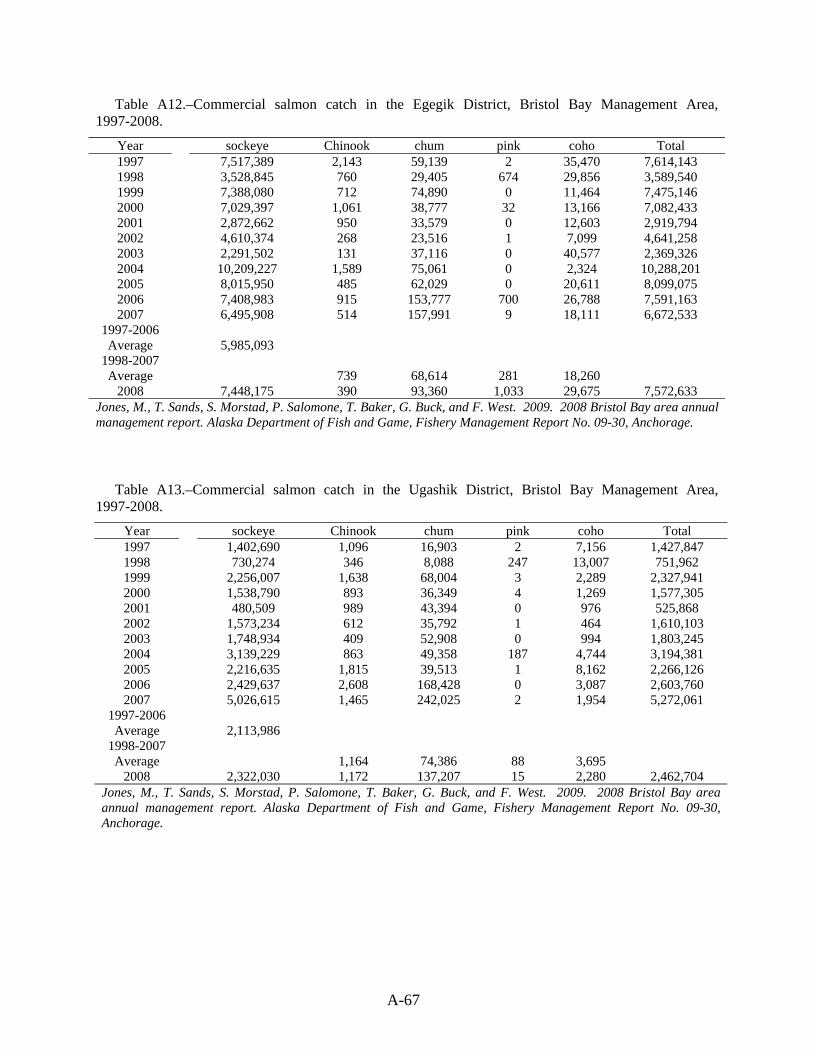
A-67
Table A12.–Commercial salmon catch in the Egegik District, Bristol Bay Management Area, 1997-2008.
Year sockeye Chinook chum pink coho Total 1997 7,517,389 2,143 59,139 2 35,470 7,614,143 1998 3,528,845 760 29,405 674 29,856 3,589,540 1999 7,388,080 712 74,890 0 11,464 7,475,146 2000 7,029,397 1,061 38,777 32 13,166 7,082,433 2001 2,872,662 950 33,579 0 12,603 2,919,794 2002 4,610,374 268 23,516 1 7,099 4,641,258 2003 2,291,502 131 37,116 0 40,577 2,369,326 2004 10,209,227 1,589 75,061 0 2,324 10,288,201 2005 8,015,950 485 62,029 0 20,611 8,099,075 2006 7,408,983 915 153,777 700 26,788 7,591,163 2007 6,495,908 514 157,991 9 18,111 6,672,533
1997-2006 Average 5,985,093
1998-2007 Average 739 68,614 281 18,260
2008 7,448,175 390 93,360 1,033 29,675 7,572,633 Jones, M., T. Sands, S. Morstad, P. Salomone, T. Baker, G. Buck, and F. West. 2009. 2008 Bristol Bay area annual management report. Alaska Department of Fish and Game, Fishery Management Report No. 09-30, Anchorage.
Table A13.–Commercial salmon catch in the Ugashik District, Bristol Bay Management Area, 1997-2008.
Year sockeye Chinook chum pink coho Total 1997 1,402,690 1,096 16,903 2 7,156 1,427,847 1998 730,274 346 8,088 247 13,007 751,962 1999 2,256,007 1,638 68,004 3 2,289 2,327,941 2000 1,538,790 893 36,349 4 1,269 1,577,305 2001 480,509 989 43,394 0 976 525,868 2002 1,573,234 612 35,792 1 464 1,610,103 2003 1,748,934 409 52,908 0 994 1,803,245 2004 3,139,229 863 49,358 187 4,744 3,194,381 2005 2,216,635 1,815 39,513 1 8,162 2,266,126 2006 2,429,637 2,608 168,428 0 3,087 2,603,760 2007 5,026,615 1,465 242,025 2 1,954 5,272,061
1997-2006 Average 2,113,986
1998-2007 Average 1,164 74,386 88 3,695
2008 2,322,030 1,172 137,207 15 2,280 2,462,704 Jones, M., T. Sands, S. Morstad, P. Salomone, T. Baker, G. Buck, and F. West. 2009. 2008 Bristol Bay area annual management report. Alaska Department of Fish and Game, Fishery Management Report No. 09-30, Anchorage.
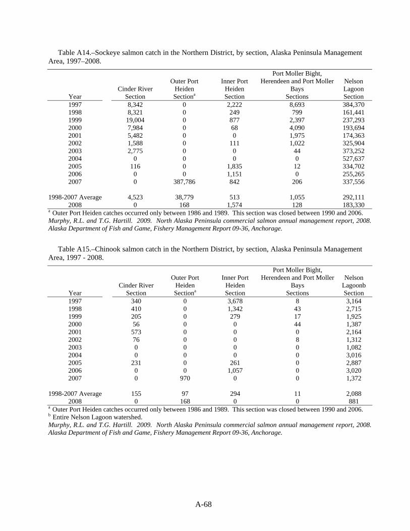
A-68
Table A14.–Sockeye salmon catch in the Northern District, by section, Alaska Peninsula Management Area, 1997–2008.
Cinder River Outer Port
Heiden Inner Port
Heiden
Port Moller Bight, Herendeen and Port Moller
Bays Nelson Lagoon
Year Section Sectiona Section Sections Section 1997 8,342 0 2,222 8,693 384,370 1998 8,321 0 249 799 161,441 1999 19,004 0 877 2,397 237,293 2000 7,984 0 68 4,090 193,694 2001 5,482 0 0 1,975 174,363 2002 1,588 0 111 1,022 325,904 2003 2,775 0 0 44 373,252 2004 0 0 0 0 527,637 2005 116 0 1,835 12 334,702 2006 0 0 1,151 0 255,265 2007 0 387,786 842 206 337,556
1998-2007 Average 4,523 38,779 513 1,055 292,111
2008 0 168 1,574 128 183,330 a Outer Port Heiden catches occurred only between 1986 and 1989. This section was closed between 1990 and 2006. Murphy, R.L. and T.G. Hartill. 2009. North Alaska Peninsula commercial salmon annual management report, 2008. Alaska Department of Fish and Game, Fishery Management Report 09-36, Anchorage.
Table A15.–Chinook salmon catch in the Northern District, by section, Alaska Peninsula Management Area, 1997 - 2008.
Cinder River Outer Port
Heiden Inner Port
Heiden
Port Moller Bight, Herendeen and Port Moller
Bays Nelson
Lagoonb Year Section Sectiona Section Sections Section 1997 340 0 3,678 8 3,164 1998 410 0 1,342 43 2,715 1999 205 0 279 17 1,925 2000 56 0 0 44 1,387 2001 573 0 0 0 2,164 2002 76 0 0 8 1,312 2003 0 0 0 0 1,082 2004 0 0 0 0 3,016 2005 231 0 261 0 2,887 2006 0 0 1,057 0 3,020 2007 0 970 0 0 1,372
1998-2007 Average 155 97 294 11 2,088
2008 0 168 0 0 881 a Outer Port Heiden catches occurred only between 1986 and 1989. This section was closed between 1990 and 2006. b Entire Nelson Lagoon watershed. Murphy, R.L. and T.G. Hartill. 2009. North Alaska Peninsula commercial salmon annual management report, 2008. Alaska Department of Fish and Game, Fishery Management Report 09-36, Anchorage.
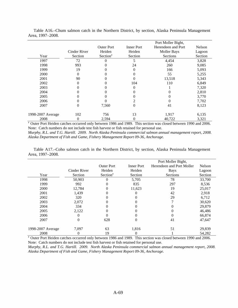
A-69
Table A16.–Chum salmon catch in the Northern District, by section, Alaska Peninsula Management Area, 1997–2008.
Cinder River Outer Port
Heiden Inner Port
Heiden
Port Moller Bight, Herendeen and Port
Moller Bays Nelson Lagoon
Year Section Sectiona Section Sections Section 1997 72 0 5 4,454 3,828 1998 993 0 24 260 9,085 1999 19 0 0 166 5,093 2000 0 0 0 55 5,255 2001 90 0 0 13,518 5,343 2002 0 0 104 110 6,849 2003 0 0 0 1 7,320 2004 0 0 0 0 2,810 2005 0 0 0 0 3,770 2006 0 0 2 0 7,702 2007 0 7,560 0 41 8,123
1998-2007 Average 102 756 13 1,917 6,135
2008 0 2,594 0 40,722 3,321 a Outer Port Heiden catches occurred only between 1986 and 1989. This section was closed between 1990 and 2006.Note: Catch numbers do not include test fish harvest or fish retained for personal use. Murphy, R.L. and T.G. Hartill. 2009. North Alaska Peninsula commercial salmon annual management report, 2008. Alaska Department of Fish and Game, Fishery Management Report 09-36, Anchorage.
Table A17.–Coho salmon catch in the Northern District, by section, Alaska Peninsula Management Area, 1997–2008.
Cinder River Outer Port
Heiden Inner Port
Heiden
Port Moller Bight, Herendeen and Port Moller
Bays Nelson Lagoon
Year Section Sectiona Section Sections Section 1998 50,903 0 5,705 78 33,700 1999 992 0 835 297 8,536 2000 12,784 0 11,623 19 25,017 2001 1,439 0 0 42 2,918 2002 320 0 0 29 6,712 2003 2,072 0 0 7 30,620 2004 334 0 0 0 29,879 2005 2,122 0 0 0 46,486 2006 0 0 0 0 66,874 2007 0 628 0 41 47,647
1998-2007 Average 7,097 63 1,816 51 29,839
2008 0 19 0 1 54,282 a Outer Port Heiden catches occurred only between 1986 and 1989. This section was closed between 1990 and 2006. Note: Catch numbers do not include test fish harvest or fish retained for personal use. Murphy, R.L. and T.G. Hartill. 2009. North Alaska Peninsula commercial salmon annual management report, 2008. Alaska Department of Fish and Game, Fishery Management Report 09-36, Anchorage.

A-70
Table A18.–North Alaska Peninsula commercial herring sac roe fishery harvest in tons, by section, 1990-2006.
Port Moller District Port Heiden District
Deer Island
Mud Bay Herendeen Bay
Port Moller
Bay Bear River
Coast Port
Heiden Year Section Section Section Section Section Total 1990 0 156 117 0 0 273 1991 156 167 690 300 0 1,313 1992 18 0 2,351 0 1,600 3,969 1993 0 107 371 58 0 536 1994 7 0 83 0 0 90 1995 3 146 188 0 0 337 1996 0 a a 0 0 a 1997 c c c c c c 1998 0 0 a a 0 a
1999-2004 c c c c c c 2005 0 0 351 0 0 351 2006 c c c c c c
1996-2005 Average 0 7 40 4 0 52 a This information cannot be released due to confidentiality requirements. b At least 11 tons were harvested in the Deer Island-Mud Bay Section c Fishery was closed Jackson, J.V. 2008. Alaska Peninsula-Aleutian Islands Management Area herring sac roe and food and bait fisheries annual management report, 2006. Alaska Department of Fish and Game, Fishery Management Report No. 08-60, Anchorage.
Table A19.–Subsistence salmon harvest, by species, in the Egegik District, Bristol Bay Management Area, 1997-2008.
Year a Permits Issued sockeye Chinook chum pink coho Total
1997 34 2,438 101 21 5 740 3,305 1998 36 1,795 44 33 52 389 2,313 1999 42 2,434 106 35 2 806 3,383 2000 31 842 16 11 0 262 1,131 2001 57 2,493 111 105 16 928 3,653 2002 53 1,892 65 34 12 356 2,359 2003 62 3,240 84 32 10 297 3,663 2004 46 2,618 169 410 91 1,423 4,711 2005 45 2,267 81 231 2 526 3,107 2006 41 1,641 94 34 7 641 2,417 2007 28 980 165 72 26 334 1,577
1998-2007 Average 44 2,020 93 100 32c 596 2,841 2008 b 44 2,149 119 156 27 644 3,095
a Estimates from 1989 to the present are based on the area fished, as first recorded on the permit. Prior to 1989, permit and harvest estimates are based on the community where the permit was issued. b A five-year average was used, as data was not available at the time of publishing. c Includes even years only. Jones, M., T. Sands, S. Morstad, P. Salomone, T. Baker, G. Buck, and F. West. 2009. 2008 Bristol Bay area annual management report. Alaska Department of Fish and Game, Fishery Management Report No. 09-30, Anchorage.

A-71
Table A 20.–Subsistence salmon harvest, by species, in the Ugashik District, Bristol Bay Management Area, 1997-2008.
Year a Permits Issued sockeye Chinook chum pink coho Total
1997 28 2,785 169 39 23 311 3,327 1998 27 1,241 59 75 82 485 1,942 1999 25 1,365 35 5 0 271 1,676 2000 31 1,927 51 34 1 467 2,480 2001 24 1,197 61 8 2 357 1,625 2002 23 1,294 51 14 2 460 1,821 2003 23 1,113 31 30 0 392 1,566 2004 21 804 64 9 4 234 1,115 2005 22 818 27 18 2 249 1,114 2006 25 962 41 6 16 339 1,364 2007 17 1,056 43 88 79 281 1,547
1998-2007 Average 24 1,178 46 29 21c 353 1,606 2008 b 22 951 41 30 20 299 1,341
a Estimates from 1989 to the present are based on the area fished, as first recorded on the permit. Prior to 1989, permit and harvest estimates are based on the community where the permit was issued. b A five-year average was used, as data was not available at the time of publishing. c Includes even years only. Jones, M., T. Sands, S. Morstad, P. Salomone, T. Baker, G. Buck, and F. West. 2009. 2008 Bristol Bay area annual management report. Alaska Department of Fish and Game, Fishery Management Report No. 09-30, Anchorage.
Table A21.–Estimated subsistence salmon harvest, by species, in number of fish, by Port Heiden local residents, 1997-2008.
Year a Permits Issued sockeye Chinook chum pink coho Total
1997 4 24 2 0 0 40 66 1998 3 100 26 0 0 100 226 1999 3 245 25 0 0 60 330 2000 3 0 6 0 0 21 27 2001 3 132 64 10 0 50 256 2002 3 34 120 6 0 50 210 2003 3 7 101 6 0 40 154 2004 3 80 60 0 0 0 140 2005 3 375 0 0 0 0 375 2006 2 0 0 0 0 30 30 2007 0 0 0 0 0 0 0
1998-2007 Average 2 92 32 1 0 14 139 2008 b 28 1,023 182 62 33 813 2,113
Note: The total number of salmon harvested are extrapolated from returned permits. Hartill, T. 2009. Annual summary of the commercial, subsistence, and personal use salmon fisheries and salmon escapements in the Alaska Peninsula, Aleutian Islands, and Atka-Amlia Islands Management Areas, 2008. Alaska Department of Fish and Game, Fishery Management Report No. 09-33, Anchorage.
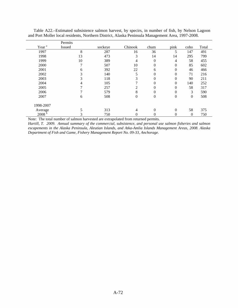
A-72
Table A22.–Estimated subsistence salmon harvest, by specirs, in number of fish, by Nelson Lagoon and Port Moller local residents, Northern District, Alaska Peninsula Management Area, 1997-2008.
Year a Permits Issued sockeye Chinook chum pink coho Total
1997 8 287 16 36 5 147 491 1998 13 473 3 14 14 295 799 1999 10 389 4 0 4 58 455 2000 7 507 10 0 0 85 602 2001 6 392 22 6 0 46 466 2002 3 140 5 0 0 71 216 2003 3 118 3 0 0 90 211 2004 4 105 7 0 0 140 252 2005 7 257 2 0 0 58 317 2006 7 579 8 0 0 3 590 2007 6 508 0 0 0 0 508
1998-2007 Average 5 313 4 0 0 58 375 2008 b 3 750 0 0 0 0 750
Note: The total number of salmon harvested are extrapolated from returned permits. Hartill, T. 2009. Annual summary of the commercial, subsistence, and personal use salmon fisheries and salmon escapements in the Alaska Peninsula, Aleutian Islands, and Atka-Amlia Islands Management Areas, 2008. Alaska Department of Fish and Game, Fishery Management Report No. 09-33, Anchorage.
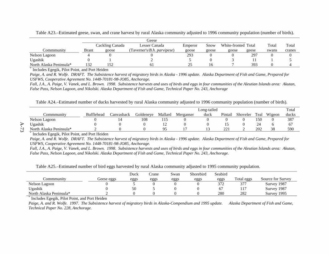
A-73
Table A23.–Estimated geese, swan, and crane harvest by rural Alaska community adjusted to 1996 community population (number of birds).
Geese
Commmunity Brant Cackling Canada
goose Lesser Canada
(Taverner's/B.h. parvipese) Emperor
goose Snow goose
White-fronted goose
Total geese
Total swans
Total cranes
Nelson Lagoon 4 0 0 293 0 0 297 0 0 Ugashik 0 1 2 5 0 3 11 1 5 North Alaska Peninsula* 132 152 61 25 16 7 393 0 4 * Includes Egegik, Pilot Point, and Port Heiden Paige, A. and R. Wolfe. DRAFT. The Subsistence harvest of migratory birds in Alaska - 1996 update. Alaska Department of Fish and Game, Prepared for USFWS, Cooperative Agreement No. 1448-70181-98-JO85, Anchorage. Fall, J.A., A. Paige, V. Vanek, and L. Brown. 1998. Subsistence harvests and uses of birds and eggs in four communities of the Aleutian Islands area: Akutan, False Pass, Nelson Lagoon, and Nikolski. Alaska Department of Fish and Game, Technical Paper No. 243, Anchorage
Table A24.–Estimated number of ducks harvested by rural Alaska community adjusted to 1996 community population (number of birds).
Commmunity Bufflehead Canvasback Goldeneye Mallard Merganser Long-tailed
duck Pintail Shoveler Teal Wigeon Total ducks
Nelson Lagoon 0 14 108 115 0 0 0 0 150 0 387 Ugashik 0 0 0 12 0 0 15 0 24 6 67 North Alaska Peninsula* 2 0 0 95 17 13 221 2 202 38 590 * Includes Egegik, Pilot Point, and Port Heiden Paige, A. and R. Wolfe. DRAFT. The Subsistence harvest of migratory birds in Alaska - 1996 update. Alaska Department of Fish and Game, Prepared for USFWS, Cooperative Agreement No. 1448-70181-98-JO85, Anchorage. Fall, J.A., A. Paige, V. Vanek, and L. Brown. 1998. Subsistence harvests and uses of birds and eggs in four communities of the Aleutian Islands area: Akutan, False Pass, Nelson Lagoon, and Nikolski. Alaska Department of Fish and Game, Technical Paper No. 243, Anchorage.
Table A25.–Estimated number of bird eggs harvested by rural Alaska community adjusted to 1995 community population.
Commmunity Geese eggs Duck eggs
Crane eggs
Swan eggs
Shorebird eggs
Seabird eggs Total eggs Source for Survey
Nelson Lagoon 0 5 0 0 0 372 377 Survey 1987 Ugashik 0 50 5 0 0 67 117 Survey 1987 North Alaska Peninsula* 2 0 0 0 0 280 282 Survey 1995 * Includes Egegik, Pilot Point, and Port Heiden Paige, A. and R. Wolfe. 1997. The Subsistence harvest of migratory birds in Alaska-Compendium and 1995 update. Alaska Department of Fish and Game, Technical Paper No. 228, Anchorage.
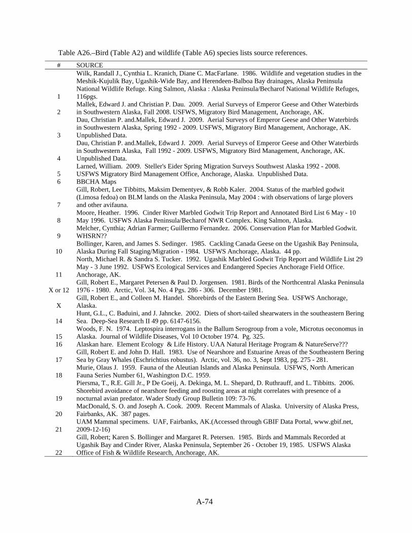
A-74
Table A26.–Bird (Table A2) and wildlife (Table A6) species lists source references.
# SOURCE
1
Wilk, Randall J., Cynthia L. Kranich, Diane C. MacFarlane. 1986. Wildlife and vegetation studies in the Meshik-Kujulik Bay, Ugashik-Wide Bay, and Herendeen-Balboa Bay drainages, Alaska Peninsula National Wildlife Refuge. King Salmon, Alaska : Alaska Peninsula/Becharof National Wildlife Refuges, 116pgs.
2 Mallek, Edward J. and Christian P. Dau. 2009. Aerial Surveys of Emperor Geese and Other Waterbirds in Southwestern Alaska, Fall 2008. USFWS, Migratory Bird Management, Anchorage, AK.
3
Dau, Christian P. and.Mallek, Edward J. 2009. Aerial Surveys of Emperor Geese and Other Waterbirds in Southwestern Alaska, Spring 1992 - 2009. USFWS, Migratory Bird Management, Anchorage, AK. Unpublished Data.
4
Dau, Christian P. and.Mallek, Edward J. 2009. Aerial Surveys of Emperor Geese and Other Waterbirds in Southwestern Alaska, Fall 1992 - 2009. USFWS, Migratory Bird Management, Anchorage, AK. Unpublished Data.
5 Larned, William. 2009. Steller's Eider Spring Migration Surveys Southwest Alaska 1992 - 2008. USFWS Migratory Bird Management Office, Anchorage, Alaska. Unpublished Data.
6 BBCHA Maps
7
Gill, Robert, Lee Tibbitts, Maksim Dementyev, & Robb Kaler. 2004. Status of the marbled godwit (Limosa fedoa) on BLM lands on the Alaska Peninsula, May 2004 : with observations of large plovers and other avifauna.
8 Moore, Heather. 1996. Cinder River Marbled Godwit Trip Report and Annotated Bird List 6 May - 10 May 1996. USFWS Alaska Peninsula/Becharof NWR Complex. King Salmon, Alaska.
9 Melcher, Cynthia; Adrian Farmer; Guillermo Fernandez. 2006. Conservation Plan for Marbled Godwit. WHSRN??
10 Bollinger, Karen, and James S. Sedinger. 1985. Cackling Canada Geese on the Ugashik Bay Peninsula, Alaska During Fall Staging/Migration - 1984. USFWS Anchorage, Alaska. 44 pp.
11
North, Michael R. & Sandra S. Tucker. 1992. Ugashik Marbled Godwit Trip Report and Wildlife List 29 May - 3 June 1992. USFWS Ecological Services and Endangered Species Anchorage Field Office. Anchorage, AK.
X or 12 Gill, Robert E., Margaret Petersen & Paul D. Jorgensen. 1981. Birds of the Northcentral Alaska Peninsula 1976 - 1980. Arctic, Vol. 34, No. 4 Pgs. 286 - 306. December 1981.
X Gill, Robert E., and Colleen M. Handel. Shorebirds of the Eastern Bering Sea. USFWS Anchorage, Alaska.
14 Hunt, G.L., C. Baduini, and J. Jahncke. 2002. Diets of short-tailed shearwaters in the southeastern Bering Sea. Deep-Sea Research II 49 pp. 6147-6156.
15 Woods, F. N. 1974. Leptospira interrogans in the Ballum Serogroup from a vole, Microtus oeconomus in Alaska. Journal of Wildlife Diseases, Vol 10 October 1974. Pg. 325.
16 Alaskan hare. Element Ecology & Life History. UAA Natural Heritage Program & NatureServe???
17 Gill, Robert E. and John D. Hall. 1983. Use of Nearshore and Estuarine Areas of the Southeastern Bering Sea by Gray Whales (Eschrichtius robustus). Arctic, vol. 36, no. 3, Sept 1983, pg. 275 - 281.
18 Murie, Olaus J. 1959. Fauna of the Aleutian Islands and Alaska Peninsula. USFWS, North American Fauna Series Number 61, Washington D.C. 1959.
19
Piersma, T., R.E. Gill Jr., P De Goeij, A. Dekinga, M. L. Shepard, D. Ruthrauff, and L. Tibbitts. 2006. Shorebird avoidance of nearshore feeding and roosting areas at night correlates with presence of a nocturnal avian predator. Wader Study Group Bulletin 109: 73-76.
20 MacDonald, S. O. and Joseph A. Cook. 2009. Recent Mammals of Alaska. University of Alaska Press, Fairbanks, AK. 387 pages.
21 UAM Mammal specimens. UAF, Fairbanks, AK.(Accessed through GBIF Data Portal, www.gbif.net, 2009-12-16)
22
Gill, Robert; Karen S. Bollinger and Margaret R. Petersen. 1985. Birds and Mammals Recorded at Ugashik Bay and Cinder River, Alaska Peninsula, September 26 - October 19, 1985. USFWS Alaska Office of Fish & Wildlife Research, Anchorage, AK.

APPENDIX B: PUBLIC SCOPING MEETINGS FOR
BRISTOL BAY CRITICAL HABITAT AREAS MANAGEMENT PLAN

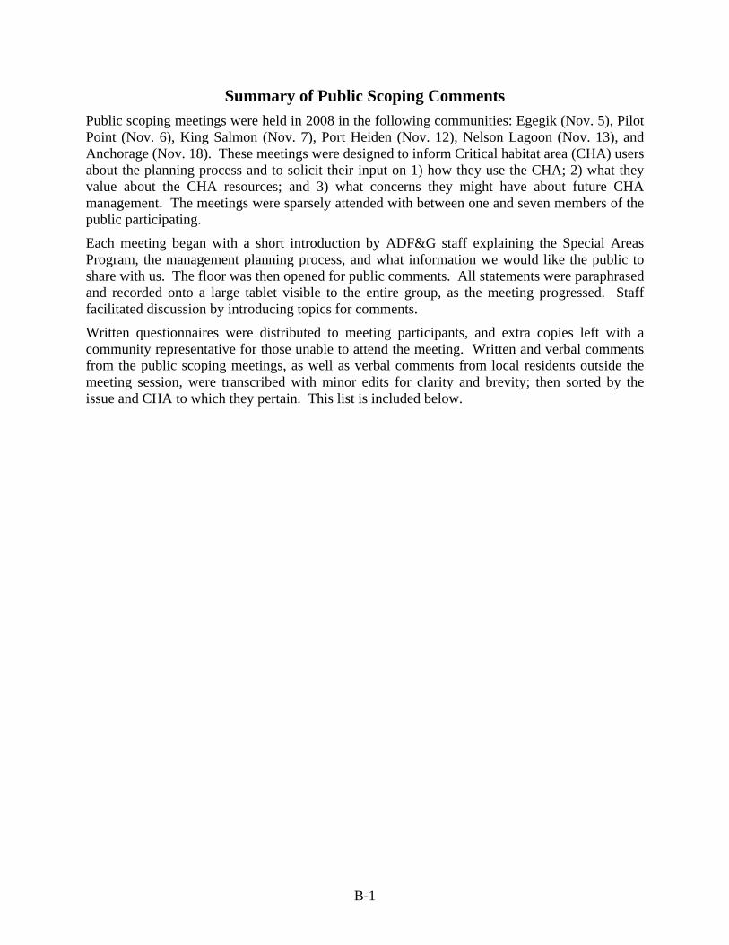
B-1
Summary of Public Scoping Comments Public scoping meetings were held in 2008 in the following communities: Egegik (Nov. 5), Pilot Point (Nov. 6), King Salmon (Nov. 7), Port Heiden (Nov. 12), Nelson Lagoon (Nov. 13), and Anchorage (Nov. 18). These meetings were designed to inform Critical habitat area (CHA) users about the planning process and to solicit their input on 1) how they use the CHA; 2) what they value about the CHA resources; and 3) what concerns they might have about future CHA management. The meetings were sparsely attended with between one and seven members of the public participating.
Each meeting began with a short introduction by ADF&G staff explaining the Special Areas Program, the management planning process, and what information we would like the public to share with us. The floor was then opened for public comments. All statements were paraphrased and recorded onto a large tablet visible to the entire group, as the meeting progressed. Staff facilitated discussion by introducing topics for comments.
Written questionnaires were distributed to meeting participants, and extra copies left with a community representative for those unable to attend the meeting. Written and verbal comments from the public scoping meetings, as well as verbal comments from local residents outside the meeting session, were transcribed with minor edits for clarity and brevity; then sorted by the issue and CHA to which they pertain. This list is included below.

B-2
Appendix B.–Summary of public scoping comments
Area Issue Comment Cinder River Access Just leave it alone for hunting and fishing Egegik Access The is more non-local use of the CHA in the summer, but it is mostly locals. Egegik Access can't use skiffs in fall weather (alternate access is needed) Nelson Lagoon Access There should be no restrictions on boat access to the lagoon. Nelson Lagoon Access Old oil company roads are used as trails. The same trails are used consistently Nelson Lagoon Access Access by snowmachine in the winter, ATV and skiff other times. In swampy areas, the only time vehicles can get
in is during the winter when they are frozen. Nelson Lagoon Access ATVs are also used on the Bering Sea side of the beach. Pilot Point Access Muddy point trails from town to inland lakes for hunting Pilot Point Access Trail already existing ok. Port Heiden Access Existing ATV Trails East and South of town. Some would be happier with one established, designated trail Port Heiden Access People access the upstream reaches of the Meshik with skiffs to go hunting. Port Heiden Access ATV trail from town ends at Meshik River…ATV’s can’t cross River. Port Heiden Access ATV -along inside of spit on mud and grass Port Heiden Access ATV access should be allowed in a way that limits impacts but do not want it prohibited. All CHAs Administrative There is too much plan writing going on, not enough coordination or work. All CHAs Administrative CHAs should be locally controlled All CHAs Administrative Plan should have a set revision or expiration date. Pilot Point Administrative "We don't want to lose our animals because the habitat is being compromised; however, we are hesitant to see
regulations be enforced that could take away people's land and or homes." Pilot Point Administrative Hold meetings that are planned (not last minute) so we can be more informed to make better decisions. Egegik Aircraft Plane landings occur on the spit year round, mostly beach combers, walrus ivory washes up a lot. Egegik Aircraft More beachcombing goes on in the spring hence there are more planes landing during the spring migration Pilot Point Aircraft Airplanes- landings occur on beach. -There is an airstrip near the cabin. Want to maintain existing Pilot Point Aircraft Most pilots naturally avoid dense bird areas due to safety considerations. Port Heiden Aircraft Aircraft landings-possible spring restriction for bird-possible fall restriction for birds, would not want to interfere
with hunting. Landings on beaches. Cinder River ATV ATV’s use beach there Egegik ATV ATVs are used more because walking in difficult. There is an upland trail to the CHA and then the trail goes down
onto the beach. Egegik ATV ATV- haven't seen impacts to marine mammals Egegik ATV need to use ATV's to get to clamming and waterfowl hunting in the Fall
-continued-

B-3
Appendix B–Summary of public scoping comments, Page 2 of 8.
Area Issue Comment Egegik ATV ATV use is all near or on Spit Pilot Point ATV Four wheelers are used both on and off of the beach. There are rutted trails on Native Corps land in northern
section of CHA. Pilot Point ATV More signs would help. Pilot Point ATV Trails are mostly on higher ground and don’t get too torn up. Pilot Point ATV ATVs use beach on South Spit. Egegik Boats There is increasing boat traffic through the hole in the spit Egegik Boundary Should get a legislative fix for the boundary All CHAs Cabins New cabins should be allowed. Cinder River Cabins Set net cabins Egegik Cabins Cabins were used by set netters originally, used by others . The furthest one is going to be moved. Egegik Cabins People conducting bird studies used the other. Egegik Cabins cabins are from fish camps (built by Jake and Gregory Meyers) Egegik Cabins cabins shouldn't be destroyed they are helpful for stranded people Egegik Cabins No new cabins Nelson Lagoon Cabins Several old cabins exist in the area, old overland mail route cabins and trapping cabin, not used anymore Nelson Lagoon Cabins All the newer cabins are on corporation land or native allotments. The ones on corporation land have to meet a
strict set of criteria. New trapping cabins would be okay, emergency cabins are a benefit to the community.
Pilot Point Cabins There are set net cabins in Northern portion of CHA Pilot Point Cabins Hunting cabins- one historic near slough on east side of spit, still used by many duck hunters. Pilot Point Cabins One fishing cabin on slough on west side of spit. Pilot Point Cabins Cabins-keep current structures but do not allow new ones. Pilot Point Cabins There should be public use cabins. Pilot Point Cabins Cabins should be grandfathered into the critical habitat area. Pilot Point Cabins "cabins should not be torn down that are currently in these habitats because that would be wasteful and potentially
more harmful than letting them stand as is. These cabins should not become property of the government unless the owner makes a fair sale by choice to the government. Government interference needs to be regulated. There should be a balance between presesrving the habitat and imposing more laws."
Pilot Point Cabins Grandfather in the existing cabins. Port Heiden Cabins Cabin indentified on map has been there many years; currently used by guides and the public, mostly bear hunters
-continued-
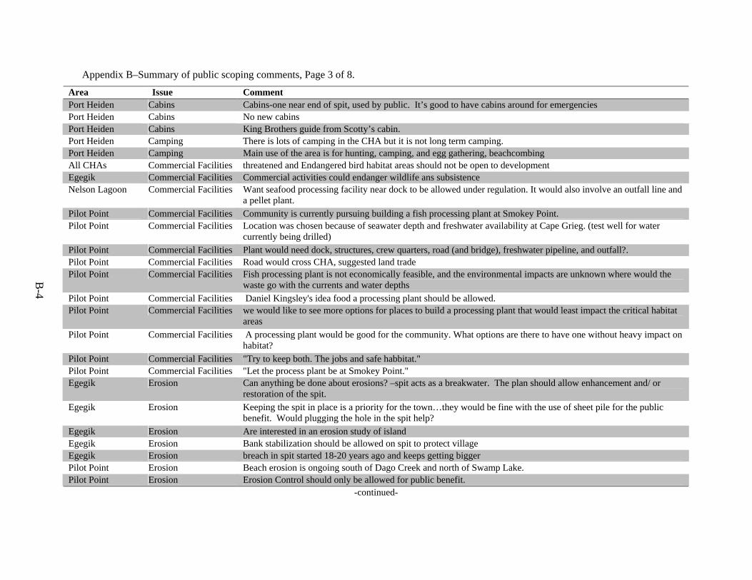
B-4
Appendix B–Summary of public scoping comments, Page 3 of 8.
Area Issue Comment Port Heiden Cabins Cabins-one near end of spit, used by public. It’s good to have cabins around for emergencies Port Heiden Cabins No new cabins Port Heiden Cabins King Brothers guide from Scotty’s cabin. Port Heiden Camping There is lots of camping in the CHA but it is not long term camping. Port Heiden Camping Main use of the area is for hunting, camping, and egg gathering, beachcombing All CHAs Commercial Facilities threatened and Endangered bird habitat areas should not be open to development Egegik Commercial Facilities Commercial activities could endanger wildlife ans subsistence Nelson Lagoon Commercial Facilities Want seafood processing facility near dock to be allowed under regulation. It would also involve an outfall line and
a pellet plant. Pilot Point Commercial Facilities Community is currently pursuing building a fish processing plant at Smokey Point. Pilot Point Commercial Facilities Location was chosen because of seawater depth and freshwater availability at Cape Grieg. (test well for water
currently being drilled) Pilot Point Commercial Facilities Plant would need dock, structures, crew quarters, road (and bridge), freshwater pipeline, and outfall?. Pilot Point Commercial Facilities Road would cross CHA, suggested land trade Pilot Point Commercial Facilities Fish processing plant is not economically feasible, and the environmental impacts are unknown where would the
waste go with the currents and water depths Pilot Point Commercial Facilities Daniel Kingsley's idea food a processing plant should be allowed. Pilot Point Commercial Facilities we would like to see more options for places to build a processing plant that would least impact the critical habitat
areas Pilot Point Commercial Facilities A processing plant would be good for the community. What options are there to have one without heavy impact on
habitat? Pilot Point Commercial Facilities "Try to keep both. The jobs and safe habbitat." Pilot Point Commercial Facilities "Let the process plant be at Smokey Point." Egegik Erosion Can anything be done about erosions? –spit acts as a breakwater. The plan should allow enhancement and/ or
restoration of the spit. Egegik Erosion Keeping the spit in place is a priority for the town…they would be fine with the use of sheet pile for the public
benefit. Would plugging the hole in the spit help? Egegik Erosion Are interested in an erosion study of island Egegik Erosion Bank stabilization should be allowed on spit to protect village Egegik Erosion breach in spit started 18-20 years ago and keeps getting bigger Pilot Point Erosion Beach erosion is ongoing south of Dago Creek and north of Swamp Lake. Pilot Point Erosion Erosion Control should only be allowed for public benefit.
-continued-

B-5
Appendix B–Summary of public scoping comments, Page 4 of 8.
Area Issue Comment Port Heiden Erosion During White Alice site construction gravel was mined and stockpiled in the lagoon area…possibility that erosion
could be attributed to this. Nelson Lagoon Fishing 50% of the local income comes from commercial fishing in during the summer. Nelson Lagoon Fishing Traditional fishing methods such as stake nets and set nets in the lagoon shouldn’t be restricted either. Nelson Lagoon Fishing The inside of the lagoon is fished heavily. Nelson Lagoon Fishing Do not want to see any increases in sport fishing such that regulations would be enacted to restrict commercial
fishing to preserve sport fishing. Port Heiden Fishing Area m line was moved north of Port Heiden. non-local fishermen outside of lagoon now mostly. Many locals go
up to Ugashik/Egegik to do their fishing Port Heiden Fishing Mostly silvers in streams and a few kings. Local fishing focuses on smaller west side rivers Port Heiden Fishing Run of silvers in Barbara Creek. Port Heiden Fishing Runs appear to have been dropping off in recent years but fishing pressure has dropped even more. All CHAs Fuel Storage Fuel storage shouldn’t be allowed. Port Heiden Fuel storage Smaller amounts of fuel storage okay, consider larger amounts on a case by case basis. Egegik History trading place for travelers Egegik History old village site Nelson Lagoon History Hot Springs is also an archaeological cultural site. Port Heiden History Concern that outsiders remove artifacts Pilot Point Hunting The area has good duck hunting, but not really at Cape Menshikoff. Pilot Point Hunting The amount of geese shot a day should be brought back up to two again. Pilot Point Hunting "I think that we should shoot one of everrything so you don't kill all of them." Pilot Point Hunting Bring back up the amount of geese shot a day back up to two. Pilot Point Hunting "In Pilot Point we are allowed to shot 2 or less in King Salmon you get shoot many more. They are the same
caribou. Should be the same on both sides." Egegik Material extraction Would like to be able to use spit as gravel source. Egegik Material extraction Gravel mining is not good, might contribute to erosion near town Nelson Lagoon Material extraction Interest in developing a gravel source. The location being considered is near the CHA but not in the CHA. It
would be a pit blasted out of the bluff, with a crusher/sorter onsite and barge. Pilot Point Material extraction There are other good gravel sources inland, no need to mine gravel. Pilot Point Material extraction no gravel extraction or mining Nelson Lagoon Mining Coal and Mineral mining-not on a large scale. But do not want permanent prohibition, in case fishing industry
crashes in future. Smaller scale, personal mining might be okay. Nelson Lagoon Mining Want community to have input on whether any mine is developed.
-continued-
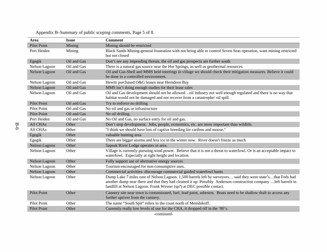
B-6
Appendix B–Summary of public scoping comments, Page 5 of 8.
Area Issue Comment Pilot Point Mining Mining should be restricted Port Heiden Mining Black Sands Mining-general frustration with not being able to control Seven Seas operation, want mining restricted
but not closed Egegik Oil and Gas Don’t see any impending threats, the oil and gas prospects are further south Nelson Lagoon Oil and Gas There is a natural gas source near the Hot Springs, as well as geothermal resources. Nelson Lagoon Oil and Gas Oil and Gas-Shell and MMS held meetings in village we should check their mitigation measures. Believe it could
be done in a controlled environment. Nelson Lagoon Oil and Gas Hewitt purchased O&G leases near Herndeen Bay Nelson Lagoon Oil and Gas MMS isn’t doing enough studies for their lease sales Nelson Lagoon Oil and Gas Oil and Gas development should not be allowed…oil industry not well enough regulated and there is no way that
habitat would not be damaged and not recover from a catastrophe/ oil spill. Pilot Point Oil and Gas Try to enforce no drilling Pilot Point Oil and Gas No oil and gas or infrastructure Pilot Point Oil and Gas No oil drilling. Port Heiden Oil and Gas No Oil and Gas, no surface entry for oil and gas. All CHAs Other Don’t stop development. Jobs, people, economics, etc. are more important than wildlife. All CHAs Other "I think we should have lots of captive breeding for caribou and moose." Egegik Other valuable hunting area Egegik Other There are bigger storms and less ice in the winter now. River doesn't freeze as much Nelson Lagoon Other Sapsuk River Lodge operates in area. Nelson Lagoon Other Village is currently pursuing wind power. Believe that it is not a threat to waterfowl. Or is an acceptable impact to
waterfowl. Especially at right height and location. Nelson Lagoon Other Fully support use of alternative energy sources Nelson Lagoon Other Tourism-encouraged for non-consumptive uses. Nelson Lagoon Other Commercial activities- discourage commercial guided waterfowl hunts Nelson Lagoon Other Dump Lake 7 miles east of Nelson Lagoon. 1,500 barrels left by surveyors… said they were state’s…that Feds had
another dump near there and that they had cleaned it up. Possibly Anderson construction company …left barrels in landfill at Nelson Lagoon. Frank Wesser (sp?) at DEC possible contact.
Pilot Point Other Cannery site near town is contaminated, fuel, lead paint, asbestos. Boats need to be shallow draft to access any further upriver from the cannery.
Pilot Point Other The name “South Spit” refers to the coast north of Menshikoff. Pilot Point Other Currently really low levels of use for the CHA, it dropped off in the ‘80’s.
-continued-

B-7
Appendix B–Summary of public scoping comments, Page 6 of 8.
Area Issue Comment Port Heiden Other Contaminated sites clean up ongoing the past several years (COE-Ron Flume DEC- Lewis Howard and J.
Halverson) Port Heiden Other There is a study currently ongoing for sea otters—Marine Mammal Council Port Heiden Other Taballik (sp?) Creek is the creek at the base of the spit. Port Heiden Other Wildman lodge also operates nearby Port Heiden Other lots of hunters go there, toursim use should be monitored Cinder River Resources Emperor geese use the inside beach near the river mouth Cinder River Resources Good for coho, waterfowl, and bears Egegik Resources Used to be mussels and butter clams (around 30 years ago) but there are a lot fewer now. Egegik Resources Lots of seal haul outs on inside of spit on sand/gravel bars Egegik Resources Lots of Belugas also pass through the area. Egegik Resources "There are too many seals" (interfering with fishing) Egegik Resources Arctic Tern eggs are gathered in area but are closer to town, more upland. Egegik Resources largest bar tailed godwit fall staging area Egegik Resources Emperor geese and ducks use the area too Egegik Resources fewer harbor seals now than in the past Egegik Resources old walruses stop on South Spit during migrations Egegik Resources shellfish are harvested both sides of the spits, cockles on the outsides, others on the inside Nelson Lagoon Resources Birds feed on berries in uplands around Port Moller Nelson Lagoon Resources Stellers eiders, Emperor geese, and Black brant can be found here over winter. But the most birds occur in the
spring and fall. Nelson Lagoon Resources For waterfowl, the freshwater ducks are hunted, the sea ducks are valued more for bird watching. Nelson Lagoon Resources Hunting-ducks in sloughs inland, geese on coast, caribou in the uplands, and bear and moose in the eastern areas
(mostly guided) Nelson Lagoon Resources Beachcombing is a popular use. Pilot Point Resources Stated that there are not many birds on the point (Smokey), they are mostly inland at that location. Pilot Point Resources The wetland areas not in the CHA west of the cape are good habitat. Pilot Point Resources the best tasting moose came from Pilot Point Pilot Point Resources lots of bird use south of town, esp. red throated loons, and cacklers and mallards Pilot Point Resources Birds fish and land are all valuable resources Pilot Point Resources "Try to find a balance between bringing in jobs without destroying habitat. Industry should not destroy habitat, but
government regulations should not completely hinder cultural and/or traditional ways of living." -continued-
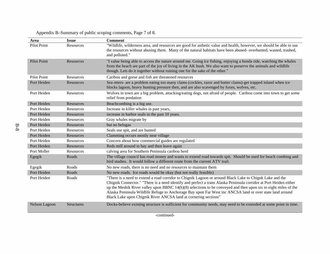
B-8
Appendix B–Summary of public scoping comments, Page 7 of 8.
Area Issue Comment Pilot Point Resources "Wildlife, wilderness area, and resources are good for asthetic value and health, however, we should be able to use
the resources without abusing them. Many of the natural habitats have been abused- overhunted, wasted, trashed, and polluted."
Pilot Point Resources "I value being able to access the nature around me. Going ice fishing, enjoying a honda ride, watching the whales from the beach are part of the joy of living in the AK bush. We also want to preserve the animals and wildlife though. Lets do it together without ruining one for the sake of the other."
Pilot Point Resources Caribou and geese and fish are threatened resources Port Heiden Resources Sea otters- are a problem eating too many clams (cockles, razor and butter clams)-get trapped inland when ice
blocks lagoon, heavy hunting pressure then, and are also scavenged by foxes, wolves, etc. Port Heiden Resources Wolves in town are a big problem, attacking/eating dogs, not afraid of people. Caribou come into town to get some
relief from predation Port Heiden Resources Beachcombing is a big use. Port Heiden Resources Increase in killer whales in past years, Port Heiden Resources increase in harbor seals in the past 10 years. Port Heiden Resources Gray whales migrate by Port Heiden Resources but no belugas Port Heiden Resources Seals use spit, and are hunted Port Heiden Resources Clamming occurs mostly near village Port Heiden Resources Concern about how commercial guides are regulated Port Heiden Resources Reds mill around in bay and then leave again Port Moller Resources calving area for Southern Peninsula caribou herd Egegik Roads The village council has road money and wants to extend road towards spit. Should be used for beach combing and
bird studies. It would follow a different route from the current ATV trail. Egegik Roads No new roads, there is no need and no resources to maintain them Port Heiden Roads No new roads. Ice roads would be okay (but not really feasible) Port Heiden Roads "There is a need to extend a road corridor to Chignik Lagoon or around Black Lake to Chignk Lake and the
Chignik Connector." "There is a need identify and perfect a trans Alaska Peninsula corridor at Port Heiden either up the Meshik River valley upon BBNC 14(h)(8) selections to be conveyed and then upon six to eight miles of the Alaska Peninsula Wildlife Refuge to Anchorage Bay upon Far West inc ANCSA land or over state land around Black Lake upon Chignik River ANCSA land at cornering sections"
Nelson Lagoon Structures Docks-believe existing structure is sufficient for community needs, may need to be extended at some point in time.
-continued-

B-9
Appendix B–Summary of public scoping comments, Page 8 of 8.
Area Issue Comment Pilot Point Structures "We value that there are still animals around, they are a major part of our culture-providing us with food. They
keep the environment healthy. We want to respect them because this is their land too. They are threatened because we are killing too many of them (than we need.) We are also building where they live. Only essentials should be built near those areas."
Pilot Point Structures "Build stuff only on your land, and don't try to get land from the state." Port Heiden Structures No need for a hardened boat launch/ dock. There is lots of coastal erosion deposition, would be hard to find a good
spot. Egegik Use camping, beach combing, geese and bear hunting


APPENDIX C
SCOPING QUESTIONAIRE


C-1
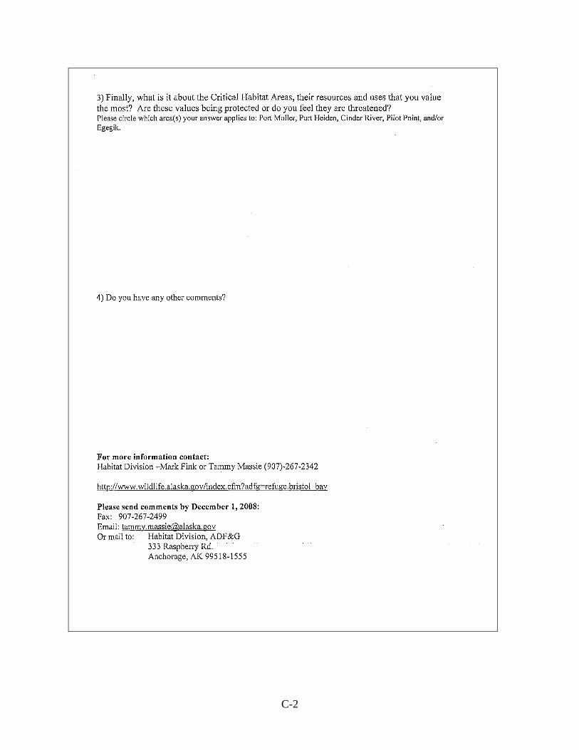
C-2

APPENDIX D
ADF&G SPECIAL AREA REGULATIONS


D-1


A


D-13

APPENDIX E
INHOLDINGS INVENTORY OF CRITICAL HABITAT AREAS BRISTOL BAY, ALASKA


Public Review Draft
INHOLDINGS INVENTORY OF CRITICAL HABITAT AREAS
BRISTOL BAY, ALASKA
Alaska Department of Fish & Game Division of Sport Fish
March 2008

TABLE OF CONTENTS Page
INTRODUCTION...................................................................................................................................................... E1 EGEGIK CRITICAL HABITAT AREA.................................................................................................................... E2 PILOT POINT CRITICAL HABITAT AREA........................................................................................................... E3 CINDER RIVER CRTICAL HABITAT AREA ........................................................................................................ E6 PORT HEIDEN CRITICAL HABITAT AREA......................................................................................................... E7 PORT MOLLER CRITICAL HABITAT AREA....................................................................................................... E9 SOURCES ................................................................................................................................................................ E15

E-1
BRISTOL BAY CRITICAL HABITAT AREAS
INTRODUCTION The Alaska State Legislature has classified over 3 million acres of land as being essential to the protection of fish and wildlife habitat. These areas are designated as refuges, critical habitat areas, or sanctuaries. Five of these legislatively designated areas are located in the Bristol Bay Region: Egegik Critical habitat area; Pilot Point Critical habitat area; Cinder River Critical habitat area; Port Heiden Critical habitat area; and Port Moller Critical habitat area. These five CHAs encompass over 620 thousand acres, including tide and submerged lands. These special areas provide important habitats for many species of mammals, birds, and fish. To assist in developing a management plan, information was collected to develop a catalog of inholdings for each CHA. The information collected could then be used in developing goals and policies for the management plan. In addition, the information could be used to prioritize inholdings for protection through land acquisitions, conservation easements and other mechanisms; and facilitate and maintain public access to fish and wildlife resources.
LAND OWNERSHIP: We developed a land title base for each of the special areas. Land ownership was determined utilizing records from the Bureau of Land Management (BLM), the Alaska Department of Natural Resources (ADNR), and the State Recorders Office. The information from these sources was cross-referenced to determine the current landowner, existing easements and development status.
Electronic land status maps was created, depicting the current size and location of lands within each special area. All public use easements were identified.

E-2
EGEGIK CRITICAL HABITAT AREA The uplands, tidelands, and submerged lands of Egegik Critical habitat area described in AS 16.20.565 was established in 1972 and contain 8,253 acres. This habitat area is located on the northern shore of the Alaska Peninsula
This refuge was created to protect and preserve habitat areas crucial to the perpetuation of fish and wildlife and to restrict all other uses not compatible with that primary purpose. Important species here include waterfowl molting, spring and fall concentrations as well as populations of spring brown bear feeding, wintering caribou, harbor seal haulout concentrations and spawning salmon.
The Becharof Corporation has patented (50-94-0479) 1504.14 acres of this habitat area. One easement exists within the CHA; EIN I C3, D1, D9, twenty-five feet in width for an existing trail from Egegik Bay parallel to the shoreline of Bristol Bay and Egegik Bay in Sec. 1, T. 23 S, R, 50 W, Seward Meridian, southwesterly to public lands. The uses allowed are travel by foot, dogsled, animals, snowmobiles, two- and three-wheel vehicles, and small all-terrain vehicles (ATVs) less than 3,000 lbs. Gross Vehicle Weight.
The remaining land is state land under General Selection 1696 Patent # 50-97-0186 and GS 1700 Patent # 50-97-0185 Bordering state land is tentatively approved AA5155. Sec. 16.20.565. The following described area is established as the Egegik Critical habitat area: Township 23 South 51 West, Seward Meridian: CHA Section 13
Sections 24 - 25 Sections 35 - 36;
All lands Patented to the State. Township 23 South 50 West, Seward Meridian: CHA Section 7
Sections 18 - 19 Section 30 Section 31 (not tide or submerged land).
Sections 1, 2, 3, 12 (Portions Of) IC # 231 issued to Becharof Corporation Sections 3, 4, 6, 7, 14, and 18-36 (Portions Of) Patent # 50940479 issued to Becharof Corporation. Township 24 South 51 West, Seward Meridian: CHA Sections 1 - 2
Section 11 S 1/2 Section 12 N 1/2;
All lands State Patented.
E-3
PILOT POINT CRITICAL HABITAT AREA The uplands, tidelands, and submerged lands of Pilot Point CHA described in AS 16.20.570 was established in 1972 and contain 46,551 acres. This habitat area is located on the northern shore of the Alaska Peninsula 368 air miles southwest of Anchorage and encompassing most of Ugashik Bay.
This refuge was created to protect and preserve habitat areas crucial to the perpetuation of fish and wildlife and to restrict all other uses not compatible with that primary purpose. Important species here include waterfowl molting, spring and fall concentrations as well as populations of spring brown bear feeding, wintering and calving caribou, harbor seal haulout concentrations and spawning salmon.
There are two privately held parcels within the critical habitat area totaling 239.94 acres. Pilot Point Native Corporation has patented and IC’d approximately 49567.96 acres within the CHA. Two 17b easements exist within the CHA; one 25 ft. wide access trail (EIN 10 D1) from the village of Pilot Point in Sec. 29, T. 30 S., R. 51 W., northerly to public land. The uses allowed are limited to winter and include travel by foot, dogsled, animals, snowmobiles, two- and three-wheel vehicles, and small all-terrain vehicles (ATVs) less than 3,000 lbs. Gross Vehicle Weight. The second is EIN 9c D9,an easement 50 ft in width for an existing access trail from cape Menshikof easterly through sections 31, 32, 33, 34, and 35, T. 31 S, R 53 W, to public land. The uses allowed are travel by foot, dogsled, animals, snowmobiles, two- and three-wheel vehicles, and small all-terrain vehicles (ATVs) track vehicles and four-wheel vehicles. There is one trespass cabin located in sec 3 of T 30 S R 52 W, ADL 223454.
There are twenty-nine shore fishery leases with the CHA boundary.
Sec. 16.20.570. The following described area is established as the Pilot Point Critical habitat area: Township 30 South, Range 51 West, Seward Meridian. CHA Sections 5 - 8
Section 17; Section 5-8 (Portions of)
Native Allotment #50-94-0403 issued to Darlene Lind. Land is described in USS 9214 containing 79.98 acres. Sections 5-8, 17 (Remaining) IC # 270/271/Pat 5091500 issued to Bristol Bay Native Corporation.

E-4
Township 30 South, Range 52 West, Seward Meridian. CHA Sections 1 - 3
Section 12 Sections 27 - 29 Sections 31 - 34
Sections 1,2 Patent # 50910500 issued to Pilot Point Native Corporation. Section 3 Patent # 50850476 issued to State of Alaska. Section 3 Trespass Cabin ADL 223454 James J Waletski. Section 10 (Portions of) Application pending case AA 12840 to US Coast Guard for Light House. Sections 27, 28, 33, 34 (Portions of) Native Allotment # 50890327 issued to Martha Kalmakoff described in USS 9216 and is 159.96 acres. Sections 27, 28, 29, 31, 32, 33, 34 (Portions of) Patents 50850476, 50900469 issued to State of Alaska. Township 30 South, Range 53 West, Seward Meridian. CHA Section 36; Section 36 Patent # 50840529 issued to State of Alaska. Township 31 South, Range 51 West, Seward Meridian. CHA Sections 5 - 8
Sections 13 - 15 Sections 17 - 27;
Sections 1- 3, 10-15, 24,25,31- 36 (Portions of) Patent # 50850462 issued to State of Alaska. Section 4, 5, 8, 9, 16, 17, 19-22, 26-30 (Portions of) Patent # 50910500 Issued to Pilot Point Native Corporation. Section 15 (Portion Of)
BLM case # 58327, Authorization issued to US Fish and Wildlife Service for a Right- Of-Way. Reservation under the provisions of 44 LD 513.
Township 31 South, Range 52 West, Seward Meridian
CHA Sections 1 - 3 Sections 5 - 6 Sections 11 - 14 Sections 23 - 24;
Sections 19- 21, 30, 31 Patent # 50850476 issued to State of Alaska. All Remaining Sections Patent # 50910500 issued to Pilot Point Native Corporation.

E-5
Township 31 South, Range 53 West, Seward Meridian. CHA Sections 1 - 2
Sections 10 - 11 Sections 12 - 14 (not tide or submerged land) Sections 15 - 16 Sections 20 - 21 Sections 22 - 28 (not tide or submerged land) Sections 29 - 31 Sections 32 - 36 (not tide or submerged land);
Sections 1, 2, 10- 12, 24, 25 Patent # 50840529 issued to State of Alaska. All Remaining Sections Patent # 50910500 issued to Pilot Point Native Corporation. Township 32 South, Range 54 West, Seward Meridian. CHA Section 36. Section 36 Tentative Approval AA 5316 issued to State of Alaska.

E-6
CINDER RIVER CRTICAL HABITAT AREA The uplands, tidelands, and submerged lands of Cinder River CHA described in AS 16.20.560 was established in 1972 and contain 25,773 acres. This habitat area is located on the northern shore of the Alaska Peninsula just south of the Pilot Point Critical habitat area.
This refuge was created to protect and preserve habitat areas crucial to the perpetuation of fish and wildlife and to restrict all other uses not compatible with that primary purpose. Important species here include waterfowl molting, spring and fall concentrations as well as populations of spring brown bear feeding, wintering caribou, harbor seal haulout concentrations and spawning salmon.
All State land under GS 1761, 1764, 1765, 1766, 1768, 1769, 1770, 1771 TA.
DNR Trespass Cases ADL 219964 Located within the SW ¼ of Section 32, T32S R54W. ADL 221897 Located within section 9, T33S R55W. ADL 219963 Located within the North ½, of Section 9 T33S R55W. There are no privately held parcels within the Cinder River CHA. Sec. 16.20.560. The following described area is established as the Cinder River Critical habitat area: CHA Township 32 South, Range 54 West, Seward Meridian Section 29 Sections 31 - 32; Township 33 South, Range 55 West, Seward Meridian Sections 1 - 4 Sections 7 - 13 Sections 14 - 17 (not tide or submerged land) Section 18; Township 33 South, Range 56 West, Seward Meridian Sections 13 - 14 Sections 22 - 23 Sections 24 - 26 (not tide or submerged land) Sections 27 - 29 Sections 31 - 32 Sections 33 - 36 (not tide or submerged land); Township 34 South, Range 56 West, Seward Meridian Sections 5 - 7 Section 4 N 1/2; Township 34 South, Range 57 West, Seward Meridian Section 1 Section 12. All lands
Patent 50-2008-0282 issued to State of Alaska.
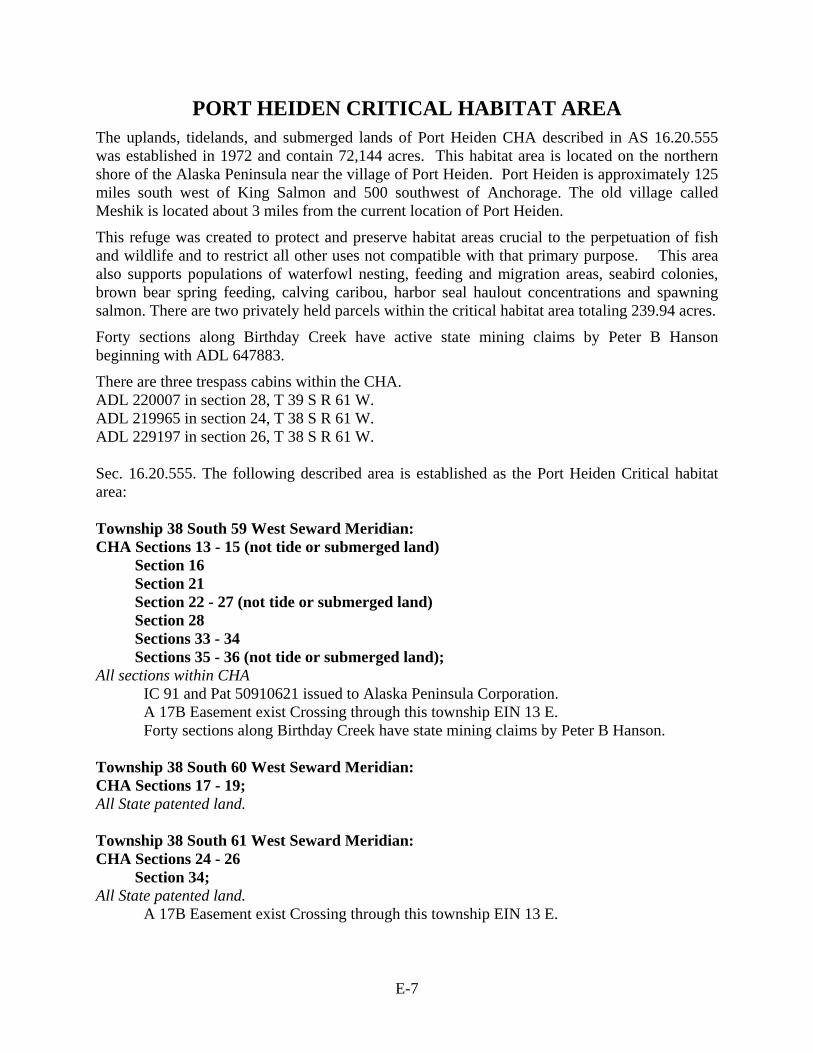
E-7
PORT HEIDEN CRITICAL HABITAT AREA The uplands, tidelands, and submerged lands of Port Heiden CHA described in AS 16.20.555 was established in 1972 and contain 72,144 acres. This habitat area is located on the northern shore of the Alaska Peninsula near the village of Port Heiden. Port Heiden is approximately 125 miles south west of King Salmon and 500 southwest of Anchorage. The old village called Meshik is located about 3 miles from the current location of Port Heiden.
This refuge was created to protect and preserve habitat areas crucial to the perpetuation of fish and wildlife and to restrict all other uses not compatible with that primary purpose. This area also supports populations of waterfowl nesting, feeding and migration areas, seabird colonies, brown bear spring feeding, calving caribou, harbor seal haulout concentrations and spawning salmon. There are two privately held parcels within the critical habitat area totaling 239.94 acres.
Forty sections along Birthday Creek have active state mining claims by Peter B Hanson beginning with ADL 647883.
There are three trespass cabins within the CHA. ADL 220007 in section 28, T 39 S R 61 W. ADL 219965 in section 24, T 38 S R 61 W. ADL 229197 in section 26, T 38 S R 61 W. Sec. 16.20.555. The following described area is established as the Port Heiden Critical habitat area: Township 38 South 59 West Seward Meridian: CHA Sections 13 - 15 (not tide or submerged land)
Section 16 Section 21 Section 22 - 27 (not tide or submerged land) Section 28 Sections 33 - 34 Sections 35 - 36 (not tide or submerged land);
All sections within CHA IC 91 and Pat 50910621 issued to Alaska Peninsula Corporation.
A 17B Easement exist Crossing through this township EIN 13 E. Forty sections along Birthday Creek have state mining claims by Peter B Hanson.
Township 38 South 60 West Seward Meridian: CHA Sections 17 - 19; All State patented land. Township 38 South 61 West Seward Meridian: CHA Sections 24 - 26
Section 34; All State patented land.
A 17B Easement exist Crossing through this township EIN 13 E.
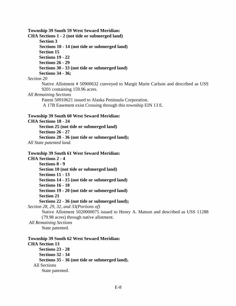
E-8
Township 39 South 59 West Seward Meridian: CHA Sections 1 - 2 (not tide or submerged land)
Section 3 Sections 10 - 14 (not tide or submerged land) Section 15 Sections 19 - 22 Sections 26 - 29 Sections 30 - 33 (not tide or submerged land) Sections 34 - 36;
Section 20 Native Allotment # 50900632 conveyed to Margit Marie Carlson and described as USS 9201 containing 159.96 acres.
All Remaining Sections Patent 50910621 issued to Alaska Peninsula Corporation.
A 17B Easement exist Crossing through this township EIN 13 E. Township 39 South 60 West Seward Meridian: CHA Sections 18 - 24
Section 25 (not tide or submerged land) Sections 26 - 27 Sections 28 - 36 (not tide or submerged land);
All State patented land. Township 39 South 61 West Seward Meridian: CHA Sections 2 - 4
Sections 8 - 9 Section 10 (not tide or submerged land) Sections 11 - 13 Sections 14 - 15 (not tide or submerged land) Sections 16 - 18 Sections 19 - 20 (not tide or submerged land) Section 21 Sections 22 - 36 (not tide or submerged land);
Section 28, 29, 32, and 33(Portions of) Native Allotment 5020000075 issued to Henry A. Matson and described as USS 11288 (79.98 acres) through native allotment.
All Remaining Sections State patented.
Township 39 South 62 West Seward Meridian: CHA Section 13
Sections 23 - 28 Sections 32 - 34 Sections 35 - 36 (not tide or submerged land).
All Sections State patented.

E-9
PORT MOLLER CRITICAL HABITAT AREA The uplands, tidelands, and submerged lands of Port Moller CHA described in AS 16.20.550 was established in 1972 and contain 131,263 acres. This habitat area is located on the northern shore of the Alaska Peninsula near the villages of Nelson Lagoon and Port Moller Approximately 540 air miles southwest from Anchorage, Alaska.
This refuge was created to protect and preserve habitat areas crucial to the perpetuation of fish and wildlife and to restrict all other uses not compatible with that primary purpose. This area also supports waterfowl nesting, feeding and migration areas as well as spring brown bear feeding areas, calving caribou, harbor seal haulout concentrations, spawning herrings concentrations, bird colonies and spawning salmon.
There are 18 privately held parcels of land within the CHA totaling 9585.64 acres. Nelson Lagoon Corporation holds 15929.21 acres within this Habitat area. There are also 45 acres of land withdrawn by BLM for hot spring. Four 17b easements exist within this CHA:
1) EIN 6 C4 E, a 25 ft. access trail from EIN 6a C5 D1, southwesterly to public lands, the uses allowed are travel by foot, dogsled, animals, snowmobiles, two- and three-wheel vehicles, and small all-terrain vehicles (ATVs) less than 3,000 lbs. Gross Vehicle Weight.
2) EIN 6a C5 D1 a one acre site easement upland of the mean high tide line on the west shore of Mud Bay at the northeastern end of trail easement EIN 6 C4 E. the uses allowed are vehicle parking (e.g. aircraft, boats, ATVs, snowmobiles, cars, trucks), temporary camping, and loading or unloading limited to 24 hours.
3) EIN 10 C5 M is a twenty-five ft. wide access trail from EIN 10a C5 M southwesterly to Public lands. Uses allowed are travel by foot, dogsled, animals, snowmobiles, two- and three-wheel vehicles, and small all-terrain vehicles (ATVs) less than 3,000 lbs. Gross Vehicle Weight.
4) EIN 10a C5 M is a one acre site easement upland of the mean high tide line on the north shore of Nelson Lagoon at northeastern end of trail easement EIN 10 C5 M, allowed uses are vehicle parking (e.g. aircraft, boats, ATVs, snowmobiles, cars, trucks), temporary camping, and loading or unloading limited to 24 hours.
There are four-teen shore fishery leases issued within the CHA, and 23 oil and gas leases issued to Shell Offshore Inc within the CHA.
Sec. 16.20.550. The following described area is established as the Port Moller Critical habitat area: Township 48 South, Range 78 West, Seward Meridian CHA Sections 26 - 27
Sections 31 - 34 All Sections Federal ownership. Township 48 South, Range 77 West, Seward Meridian. CHA Sections 20 - 23
Sections 26 - 28 All Sections
Patent # 50890787, issued to Nelson Lagoon Corporation.
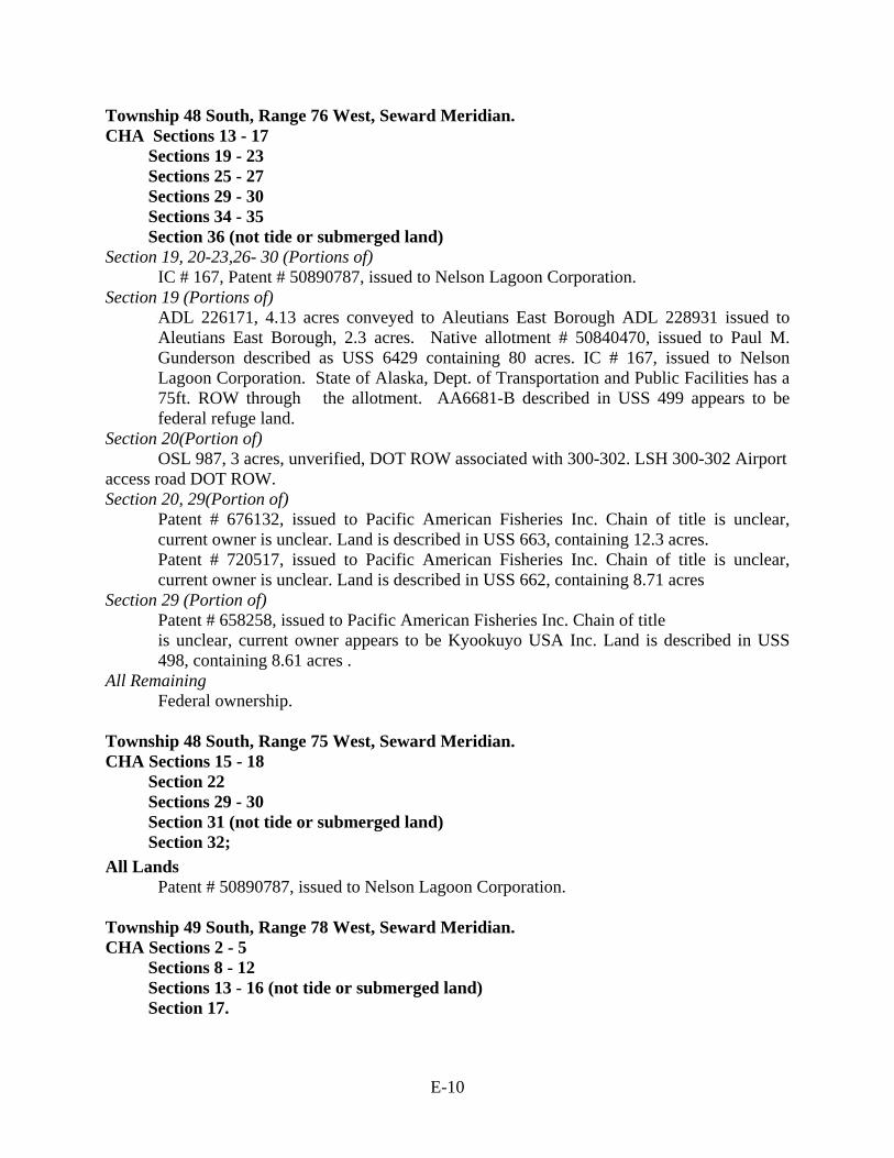
E-10
Township 48 South, Range 76 West, Seward Meridian. CHA Sections 13 - 17
Sections 19 - 23 Sections 25 - 27 Sections 29 - 30 Sections 34 - 35 Section 36 (not tide or submerged land)
Section 19, 20-23,26- 30 (Portions of) IC # 167, Patent # 50890787, issued to Nelson Lagoon Corporation.
Section 19 (Portions of) ADL 226171, 4.13 acres conveyed to Aleutians East Borough ADL 228931 issued to Aleutians East Borough, 2.3 acres. Native allotment # 50840470, issued to Paul M. Gunderson described as USS 6429 containing 80 acres. IC # 167, issued to Nelson Lagoon Corporation. State of Alaska, Dept. of Transportation and Public Facilities has a 75ft. ROW through the allotment. AA6681-B described in USS 499 appears to be federal refuge land.
Section 20(Portion of) OSL 987, 3 acres, unverified, DOT ROW associated with 300-302. LSH 300-302 Airport
access road DOT ROW. Section 20, 29(Portion of)
Patent # 676132, issued to Pacific American Fisheries Inc. Chain of title is unclear, current owner is unclear. Land is described in USS 663, containing 12.3 acres. Patent # 720517, issued to Pacific American Fisheries Inc. Chain of title is unclear, current owner is unclear. Land is described in USS 662, containing 8.71 acres
Section 29 (Portion of) Patent # 658258, issued to Pacific American Fisheries Inc. Chain of title is unclear, current owner appears to be Kyookuyo USA Inc. Land is described in USS 498, containing 8.61 acres .
All Remaining Federal ownership. Township 48 South, Range 75 West, Seward Meridian. CHA Sections 15 - 18
Section 22 Sections 29 - 30 Section 31 (not tide or submerged land) Section 32;
All Lands Patent # 50890787, issued to Nelson Lagoon Corporation.
Township 49 South, Range 78 West, Seward Meridian. CHA Sections 2 - 5
Sections 8 - 12 Sections 13 - 16 (not tide or submerged land) Section 17.
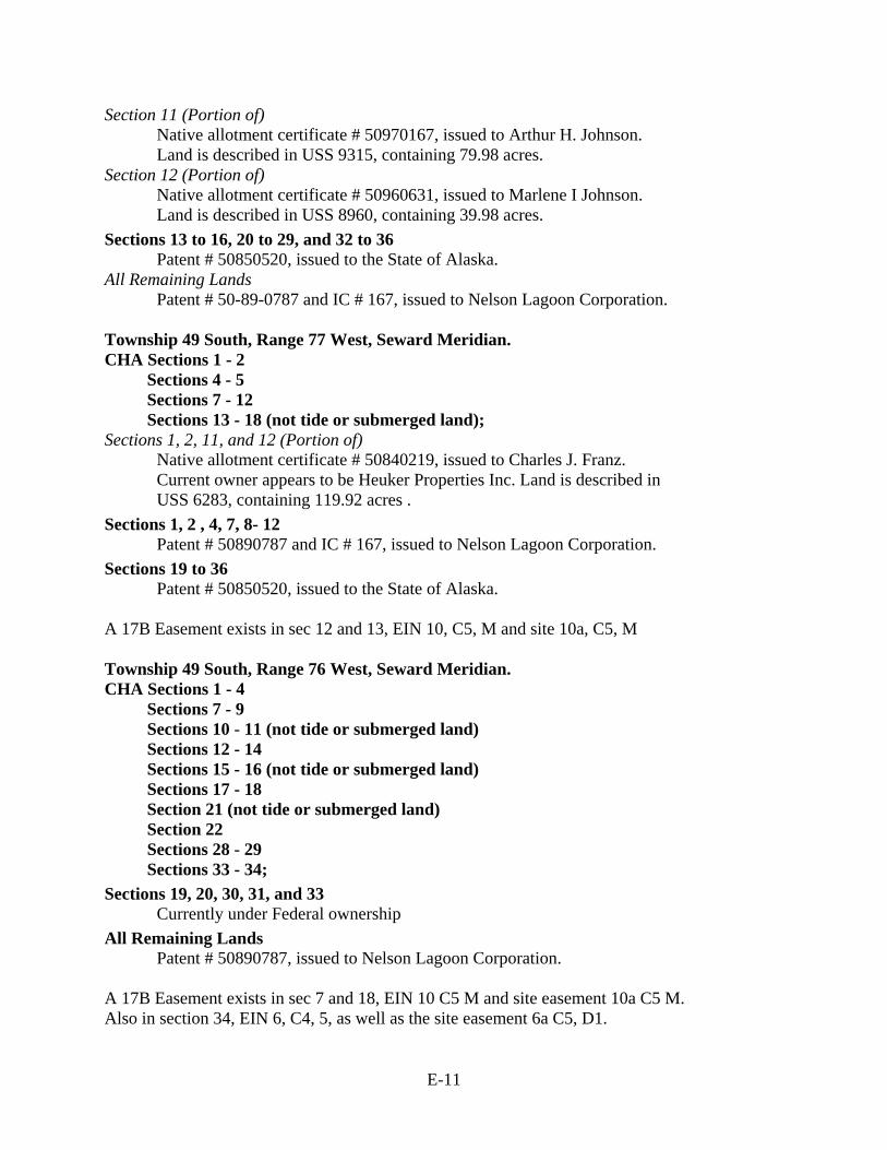
E-11
Section 11 (Portion of) Native allotment certificate # 50970167, issued to Arthur H. Johnson. Land is described in USS 9315, containing 79.98 acres.
Section 12 (Portion of) Native allotment certificate # 50960631, issued to Marlene I Johnson. Land is described in USS 8960, containing 39.98 acres.
Sections 13 to 16, 20 to 29, and 32 to 36 Patent # 50850520, issued to the State of Alaska.
All Remaining Lands Patent # 50-89-0787 and IC # 167, issued to Nelson Lagoon Corporation.
Township 49 South, Range 77 West, Seward Meridian. CHA Sections 1 - 2
Sections 4 - 5 Sections 7 - 12 Sections 13 - 18 (not tide or submerged land);
Sections 1, 2, 11, and 12 (Portion of) Native allotment certificate # 50840219, issued to Charles J. Franz. Current owner appears to be Heuker Properties Inc. Land is described in USS 6283, containing 119.92 acres .
Sections 1, 2 , 4, 7, 8- 12 Patent # 50890787 and IC # 167, issued to Nelson Lagoon Corporation.
Sections 19 to 36 Patent # 50850520, issued to the State of Alaska.
A 17B Easement exists in sec 12 and 13, EIN 10, C5, M and site 10a, C5, M Township 49 South, Range 76 West, Seward Meridian. CHA Sections 1 - 4
Sections 7 - 9 Sections 10 - 11 (not tide or submerged land) Sections 12 - 14 Sections 15 - 16 (not tide or submerged land) Sections 17 - 18 Section 21 (not tide or submerged land) Section 22 Sections 28 - 29 Sections 33 - 34;
Sections 19, 20, 30, 31, and 33 Currently under Federal ownership
All Remaining Lands Patent # 50890787, issued to Nelson Lagoon Corporation.
A 17B Easement exists in sec 7 and 18, EIN 10 C5 M and site easement 10a C5 M. Also in section 34, EIN 6, C4, 5, as well as the site easement 6a C5, D1.
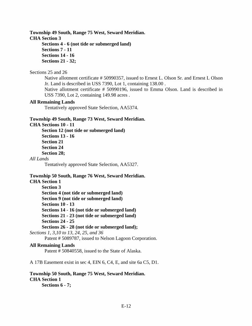
E-12
Township 49 South, Range 75 West, Seward Meridian. CHA Section 3
Sections 4 - 6 (not tide or submerged land) Sections 7 - 11 Sections 14 - 16 Sections 21 - 32;
Sections 25 and 26
Native allotment certificate # 50990357, issued to Ernest L. Olson Sr. and Ernest L Olson Jr. Land is described in USS 7390, Lot 1, containing 138.00 . Native allotment certificate # 50990196, issued to Emma Olson. Land is described in USS 7390, Lot 2, containing 149.98 acres .
All Remaining Lands Tentatively approved State Selection, AA5374.
Township 49 South, Range 73 West, Seward Meridian. CHA Sections 10 - 11
Section 12 (not tide or submerged land) Sections 13 - 16 Section 21 Section 24 Section 28;
All Lands Tentatively approved State Selection, AA5327.
Township 50 South, Range 76 West, Seward Meridian. CHA Section 1
Section 3 Section 4 (not tide or submerged land) Section 9 (not tide or submerged land) Sections 10 - 13 Sections 14 - 16 (not tide or submerged land) Sections 21 - 23 (not tide or submerged land) Sections 24 - 25 Sections 26 - 28 (not tide or submerged land);
Sections 1, 3,10 to 13, 24, 25, and 36 Patent # 5089787, issued to Nelson Lagoon Corporation.
All Remaining Lands Patent # 50840558, issued to the State of Alaska.
A 17B Easement exist in sec 4, EIN 6, C4, E, and site 6a C5, D1. Township 50 South, Range 75 West, Seward Meridian. CHA Section 1
Sections 6 - 7;
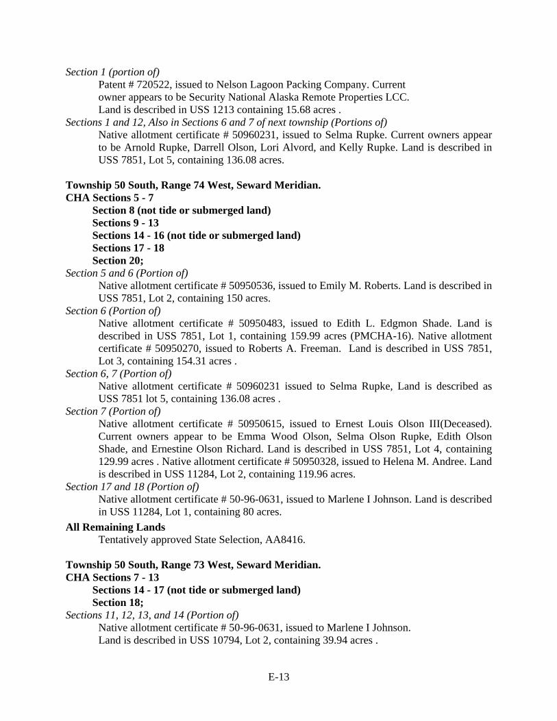
E-13
Section 1 (portion of) Patent # 720522, issued to Nelson Lagoon Packing Company. Current owner appears to be Security National Alaska Remote Properties LCC. Land is described in USS 1213 containing 15.68 acres .
Sections 1 and 12, Also in Sections 6 and 7 of next township (Portions of) Native allotment certificate # 50960231, issued to Selma Rupke. Current owners appear to be Arnold Rupke, Darrell Olson, Lori Alvord, and Kelly Rupke. Land is described in USS 7851, Lot 5, containing 136.08 acres.
Township 50 South, Range 74 West, Seward Meridian. CHA Sections 5 - 7
Section 8 (not tide or submerged land) Sections 9 - 13 Sections 14 - 16 (not tide or submerged land) Sections 17 - 18 Section 20;
Section 5 and 6 (Portion of) Native allotment certificate # 50950536, issued to Emily M. Roberts. Land is described in USS 7851, Lot 2, containing 150 acres.
Section 6 (Portion of) Native allotment certificate # 50950483, issued to Edith L. Edgmon Shade. Land is described in USS 7851, Lot 1, containing 159.99 acres (PMCHA-16). Native allotment certificate # 50950270, issued to Roberts A. Freeman. Land is described in USS 7851, Lot 3, containing 154.31 acres .
Section 6, 7 (Portion of) Native allotment certificate # 50960231 issued to Selma Rupke, Land is described as USS 7851 lot 5, containing 136.08 acres .
Section 7 (Portion of) Native allotment certificate # 50950615, issued to Ernest Louis Olson III(Deceased). Current owners appear to be Emma Wood Olson, Selma Olson Rupke, Edith Olson Shade, and Ernestine Olson Richard. Land is described in USS 7851, Lot 4, containing 129.99 acres . Native allotment certificate # 50950328, issued to Helena M. Andree. Land is described in USS 11284, Lot 2, containing 119.96 acres.
Section 17 and 18 (Portion of) Native allotment certificate # 50-96-0631, issued to Marlene I Johnson. Land is described in USS 11284, Lot 1, containing 80 acres.
All Remaining Lands Tentatively approved State Selection, AA8416.
Township 50 South, Range 73 West, Seward Meridian. CHA Sections 7 - 13
Sections 14 - 17 (not tide or submerged land) Section 18;
Sections 11, 12, 13, and 14 (Portion of) Native allotment certificate # 50-96-0631, issued to Marlene I Johnson. Land is described in USS 10794, Lot 2, containing 39.94 acres .
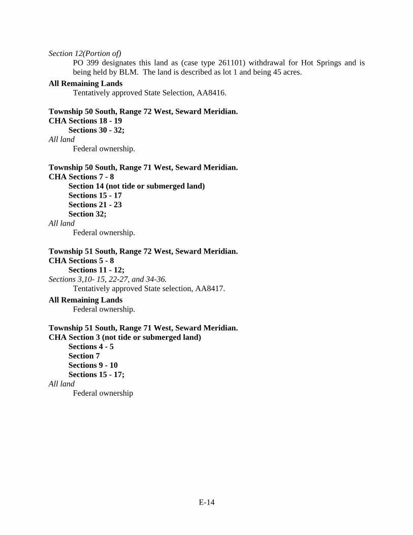
E-14
Section 12(Portion of) PO 399 designates this land as (case type 261101) withdrawal for Hot Springs and is being held by BLM. The land is described as lot 1 and being 45 acres.
All Remaining Lands Tentatively approved State Selection, AA8416.
Township 50 South, Range 72 West, Seward Meridian. CHA Sections 18 - 19
Sections 30 - 32; All land Federal ownership. Township 50 South, Range 71 West, Seward Meridian. CHA Sections 7 - 8
Section 14 (not tide or submerged land) Sections 15 - 17 Sections 21 - 23 Section 32;
All land Federal ownership. Township 51 South, Range 72 West, Seward Meridian. CHA Sections 5 - 8
Sections 11 - 12; Sections 3,10- 15, 22-27, and 34-36. Tentatively approved State selection, AA8417. All Remaining Lands
Federal ownership. Township 51 South, Range 71 West, Seward Meridian. CHA Section 3 (not tide or submerged land)
Sections 4 - 5 Section 7 Sections 9 - 10 Sections 15 - 17;
All land Federal ownership
E-15
SOURCES Grid Alaska PLSS Township Boundaries- http://www.asgdc.state.ak.us/ Alaska PLSS Section Grid - http://www.asgdc.state.ak.us/ Hydro NHD Area- http://nhd.usgs.gov/data.html NHD Flowline- http://nhd.usgs.gov/data.html NHD Waterbody- http://nhd.usgs.gov/data.html Coastline- Clipped from NHD Flowline Infrastructure Alaska Airstrips 1:63,360 from land Records http://www.asgdc.state.ak.us/ Secondary Roads -from infrastructure http://www.asgdc.state.ak.us/ Alaska DNR RS2477 Trails- from trails http://www.asgdc.state.ak.us/ Land Estate Land Disposal Conveyed http://www.asgdc.state.ak.us/ Permit Lease http://www.asgdc.state.ak.us/ Other Activities http://www.asgdc.state.ak.us/ Mineral Estate Mineral permit or Lease http://www.asgdc.state.ak.us/ Mineral Order http://www.asgdc.state.ak.us/ State Mining Claim http://www.asgdc.state.ak.us/ Native Allotments SDMS- derived from Master Title Plats Naldigi- ? Natural Resources Shore Fishery Lease http://www.asgdc.state.ak.us/ Other ADFGMarker- digitized from SFP 192 Mask- a digitized element used for asthetics. Ownership Agreement Settlement Reconveyence http://www.asgdc.state.ak.us/ Federal Action http://www.asgdc.state.ak.us/ Municipal Entitlement http://www.asgdc.state.ak.us/ Other State Aquired Land http://www.asgdc.state.ak.us/ State TA or Pat http://www.asgdc.state.ak.us/

E-16
Surface Admin Large Parcel http://www.asgdc.state.ak.us/ Alaska Maritime NWR http://alaska.fws.gov/GIS/refuge.htm City Boundary http://www.asgdc.state.ak.us/ Disposable Interest http://www.asgdc.state.ak.us/ State Managed LDA http://www.asgdc.state.ak.us/ Water Estate Tidal Conveyances http://www.asgdc.state.ak.us/

APPENDIX F: MAPS


Public Review Draft
BRISTOL BAY CRTICAL HABITAT AREAS
MANAGEMENT PLAN
Appendix F
MAPS
By Frances Inoue
and
Jason Graham
Division of Sport Fish, Region V
D R A F T
February 12, 2010
Alaska Department of Fish and Game Divisions of Habitat and Wildlife Conservation

MAPS BRISTOL BAY CRITICAL HABITAT AREAS Map Page 1. Overview. ......................................................................................................................................................F1 2. Egegik Land Status........................................................................................................................................F2 3. Egegik Mammals...........................................................................................................................................F3 4. Egegik Bird, Fish and Invertebrates ..............................................................................................................F4 5. Egegik Geese.................................................................................................................................................F5 6. Egegik Emperor Geese..................................................................................................................................F6 7. Egegik Steller’s Eider....................................................................................................................................F7 8. Egegik Ducks ................................................................................................................................................F8 9. Pilot Point Land Status ..................................................................................................................................F9 10. Pilot Point Mammals ...................................................................................................................................F10 11. Pilot Point Bird, Fish and Invertebrates ......................................................................................................F11 12. Pilot Point Geese .........................................................................................................................................F12 13. Pilot Point Emperor Geese ..........................................................................................................................F13 14. Pilot Point Steller’s Eider ............................................................................................................................F14 15. Pilot Point Ducks.........................................................................................................................................F15 16. Cinder River Land Status ............................................................................................................................F16 17. Cinder River Mammals ...............................................................................................................................F17 18. Cinder River Bird, Fish and Invertebrates...................................................................................................F18 19. Cinder River Geese .....................................................................................................................................F19 20. Cinder River Emperor Geese ......................................................................................................................F20 21. Cinder River Steller’s Eider ........................................................................................................................F21 22. Cinder River Ducks.....................................................................................................................................F22 23. Port Heiden Land Status..............................................................................................................................F23 24. Port Heiden Mammals.................................................................................................................................F24 25. Port Heiden Bird, Fish and Invertebrates ....................................................................................................F25 26. Port Heiden Geese.......................................................................................................................................F26 27. Port Heiden Emperor Geese ........................................................................................................................F27 28. Port Heiden Steller’s Eider..........................................................................................................................F28 29. Port Heiden Ducks ......................................................................................................................................F29 30. Port Moller Land Status ..............................................................................................................................F30 31. Port Moller Mammals .................................................................................................................................F31 32. Port Moller Bird, Fish and Invertebrates .....................................................................................................F32 33. Port Moller Emperor Geese.........................................................................................................................F33 34. Port Moller Steller’s Eider ..........................................................................................................................F34 35. Port Moller Waterfowl ................................................................................................................................F35 36. Egegik Region Subsistence Harvest Areas..................................................................................................F36 37. Pilot Point Region Subsistence Harvest Areas ............................................................................................F37 38. Ugashik Region Subsistence Harvest Areas................................................................................................F38 39. Port Heiden Region Subsistence Harvest Areas..........................................................................................F39 40. Nelson Lagoon Region Subsistence Harvest Areas.....................................................................................F40

F-41
Land Status: Base land status for this project comes from the DNR1. This coverage has been edited to reflect the land status information on DNR’s status plats2 ,BLM’s MTP’s2, the states recorders office3, and documented case reports4. Because Alaska is a non-recordation state, there is no guarantee that additional undocumented land transfers have occurred that could potentially alter the data we have compiled. Land ownership is not static, consequently, even in the time it took to compile this information, some parcels may have changed ownership.
1. http://www.asgdc.state.ak.us/metadata/vector/landstat/statewide/akstat_c63.html 2. http://www.dnr.state.ak.us/cgi-bin/lris/landrecords 3. http://www.dnr.state.ak.us/ssd/recoff/search.cfm 4. http://www.dnr.state.ak.us/las/lasmenu.cfm 5. http://sdms.ak.blm.gov/acres/acres_menu
Base Features: Hydrography: National Hydrography Dataset, U.S. Geological Survey, 2008.
CHA Boundaries: SA_LDAs, GIS layer, Alaska Department of Fish and Game, Division of Sport Fish, 2009.
Anadromous Fishes: Atlas to the Catalog of Waters Important for Spawning, Rearing, or Migration of Anadromous Fishes: Southwest Region. Geographic Information Systems Data Draft 2009. Division of Sport Fish, Alaska Department of Fish and Game, Anchorage.
Bald Eagle: Research Planning Institute, Inc. 2004. ESI Atlas. Bristol Bay, Alaska. Geographical Information Systems Data. Prepared for the National Oceanic and Atmospheric Administration, Hazardous Materials Response and Assessment Division, Seattle, Washington. (Rerelease in 2009 did not change digital data.)
Schempf, P., 2009. Personal communication. Wildlife Biologist, U.S. Fish and Wildlife Service, Douglas, Alaska. (No data available in this area)
Sowl, K. 2009. Personal communication and scanned maps. Wildlife Biologist, U.S. Fish and Wildlife Service, Cold Bay. (No data)
F-42
Savage, S. 2009. Personal communication. Wildlife Biologist, U.S. Fish and Wildlife Service, King Salmon. (Information on King Salmon River- Pilot Point)
Wolfe, C. 2009. Personal communication and GIS data.U.S. Fish and Wildlife Service, Division of Conservation, Planning, and Policy,Anchorage.
Bear: Research Planning Institute, Inc. 2004. ESI Atlas. Bristol Bay, Alaska. Geographical Information Systems Data. Prepared for the National Oceanic and Atmospheric Administration, Hazardous Materials Response and Assessment Division, Seattle, Washington. (Rerelease in 2009 did not change digital data.)
Bulter L., 2009. Personal communication and hardcopy maps. Wildlife Biologist, Division of Wildlife Conservation, Alaska Department of Fish and Game, Douglas.
Farley, S., 2009. Personal communication. Wildlife Biologist, Division of Wildlife Conservation, Alaska Department of Fish and Game, Anchorage.
Most Environmentally Sensitive Areas Atlas 2001. Habitat and Restoration Division, Alaska Department of Fish and Game, Anchorage.
Alaska Habitat Management Guide 1986. Southwest Region: Reference maps. Volume l: Distribution of Mammals. Habitat Division, Alaska Department of Fish and Game, Juneau
Blue Mussel: Research Planning Institute, Inc. 2004. ESI Atlas. Bristol Bay, Alaska. Geographical Information Systems Data. Prepared for the National Oceanic and Atmospheric Administration, Hazardous Materials Response and Assessment Division, Seattle, Washington. (Rerelease in 2009 did not change digital data.)
Crab (King and Tanner): Research Planning Institute, Inc. 2004. ESI Atlas. Bristol Bay, Alaska. Geographical Information Systems Data. Prepared for the National Oceanic and Atmospheric Administration, Hazardous Materials Response and Assessment Division, Seattle, Washington. (Rerelease in 2009 did not change digital data.)
Caribou: Alaska Habitat Management Guide 1986. Southwest Region: Reference maps. Volume l: Distribution of Mammals. Habitat Division, Alaska Department of Fish and Game, Juneau.
Bulter L., 2009. Personal communication and hardcopy maps. Wildlife Biologist, Division of Wildlife Conservation, Alaska Department of Fish and Game, Douglas.
F-43
Sowl, K. 2009. Personal communication and scanned maps. Wildlife Biologist, U.S. Fish and Wildlife Service, Cold Bay.
Wolfe, C. 2009. Personal communication and Geographical Information Systems Data.U.S. Fish and Wildlife Service, Division of Conservation, Planning, and Policy,Anchorage.
Steve Machida ADFG – (No Contact)
Minick, J. 2009. Personal communication and report/data (Ring of Fire). GIS Specialist, Bureau of Land Mangement.
McCabe, S. 2009. Personal communication. GIS Specialist, Bureau of Land Mangement.
Eelgrass: Ward, David. USGS –aerial photo –indistinct image- no defined eelgrass area
Grey Whale: Research Planning Institute, Inc. 2004. ESI Atlas. Bristol Bay, Alaska. Geographical Information Systems Data. Prepared for the National Oceanic and Atmospheric Administration, Hazardous Materials Response and Assessment Division, Seattle, Washington. (Rerelease in 2009 did not change digital data.)
Smith, B. 2009. Personal communication. National Oceanic and Atmospheric Administration.
Lance, B. 2009. Personal communication. National Marine Fisheries Service, National Oceanic and Atmospheric Administration.
Harbor Seal: Research Planning Institute, Inc. 2004. ESI Atlas. Bristol Bay, Alaska. Geographical Information Systems Data. Prepared for the National Oceanic and Atmospheric Administration, Hazardous Materials Response and Assessment Division, Seattle, Washington. (Rerelease in 2009 did not change digital data.)
Hiruki-Raring, L. 2005. Personal communication and Geographical Information Systems Data. (Harbor Seal point data). GIS Analyst, National Marine Mammal Laboratory, NOAA, Seattle, Washington
Withrow, D. 2009. Personal communication. Biologist, National Marine Mammal
Laboratory, NOAA, Seattle, Washington.
F-44
Rehberg, M., 2009. Personal communication and Geographical Information Systems Data. (Harbor Seal point data). Wildlife Biologist, Division of Wildlife Conservation, Alaska Department of Fish and Game, Anchorage.
Most Environmentally Sensitive Area Atlas 2001. Habitat and Restoration Division, Alaska Department of Fish and Game, Anchorage.
Herring: Most Environmentally Sensitive Area Atlas 2000. Habitat and Restoration Division, Alaska Department of Fish and Game, Anchorage.
Macoma spp.: Research Planning Institute, Inc. 2004. ESI Atlas. Bristol Bay, Alaska. Geographical Information Systems Data. Prepared for the National Oceanic and Atmospheric Administration, Hazardous Materials Response and Assessment Division, Seattle, Washington. (Rerelease in 2009 did not change digital data.)
Moose: Alaska Habitat Management Guide 1986. Southwest Region: Reference maps. Volume l: Distribution of Mammals. Habitat Division, Alaska Department of Fish and Game, Juneau.
Bulter L., 2009. Personal communication and hardcopy maps. Wildlife Biologist, Division of Wildlife Conservation, Alaska Department of Fish and Game, Douglas.
Dau, C. 2009. Personal communication. Wildlife Biologist, Migratory Birds, U.S. Fish and Wildlife Service, Anchorage.
Sowl, K. 2009. Personal communication and scanned maps. Wildlife Biologist, U.S. Fish and Wildlife Service, Cold Bay.
Wolfe, C. 2009. Personal communication and GIS data. U.S. Fish and Wildlife Service, Division of Conservation, Planning, and Policy, Anchorage.
Minick, J. 2009. Personal communication and report/data (Ring of Fire). GIS Specialist, Bureau of Land Management.
McCabe, S. 2009. Personal communication and Geographical Information Systems Data. GIS Specialist, Bureau of Land Management.
F-45
Seabird: U.S. Fish Wildlife Service 2004. Beringian Seabird Colony Catalog Computer Archives. U.S. Fish and Wildlife Service, Anchorage.
Goldberg, P. 2009. Personal communication and web site address. Avian Biological Science Technician, U.S. Fish and Wildlife Service, Migratory Bird Management, Anchorage.
Sea Otter: Research Planning Institute, Inc. 2004. ESI Atlas. Bristol Bay, Alaska. Geographical Information Systems Data. Prepared for the National Oceanic and Atmospheric Administration, Hazardous Materials Response and Assessment Division, Seattle, Washington. (Rerelease in 2009 did not change digital data.)
Bodkin J. 2009. Personal communication. Biologist, Bird Science Center, USGS, Anchorage
Shorebirds: Research Planning Institute, Inc. 2004. ESI Atlas. Bristol Bay, Alaska. Geographical Information Systems Data. Prepared for the National Oceanic and Atmospheric Administration, Hazardous Materials Response and Assessment Division, Seattle, Washington. (Rerelease in 2009 did not change digital data.)
Savage, S. 2009. Personal communication. Wildlife Biologist, U.S. Fish and Wildlife Service, King Salmon. (Plover nest sites and species lists)
Gill, R. USGS – (No Contact)
T. Lee Tibbitts USGS – (No contact)
Tundra Swan: Research Planning Institute, Inc. 2004. ESI Atlas. Bristol Bay, Alaska. Geographical Information Systems Data. Prepared for the National Oceanic and Atmospheric Administration, Hazardous Materials Response and Assessment Division, Seattle, Washington. (Rerelease in 2009 did not change digital data.)
Savage, S. 2009. Personal communication. Wildlife Biologist, U.S. Fish and Wildlife Service, King Salmon.
Dau, C. 2009. Personal communication. Wildlife Biologist, Migratory Birds, U.S. Fish and Wildlife Service, Anchorage.

F-46
Waterfowl (includes Emperor Geese and Steller’s Eider): Research Planning Institute, Inc. 2004. ESI Atlas. Bristol Bay, Alaska. Geographical Information Systems Data. Prepared for the National Oceanic and Atmospheric Administration, Hazardous Materials Response and Assessment Division, Seattle, Washington. (Rerelease in 2009 did not change digital data.)
Dau, C. 2009. Personal communication and hardcopy map. Wildlife Biologist, Migratory Birds, U.S. Fish and Wildlife Service, Anchorage. (Including Steller’s Eider and Emperor Geese)
Platte, R. 2009. Personal communication and Geographical Information Systems Data. Wildlife Biologist, Migratory Birds, U.S. Fish and Wildlife Service, Anchorage. (Detailed survey data on black scoter by transect)
Most Environmentally Sensitive Area Atlas 2000. Habitat and Restoration Division, Alaska Department of Fish and Game, Anchorage.
Alaska Habitat Management Guide 1986. Southwest Region: Reference maps. Volume 2:
Distribution of Birds. Habitat Division, Alaska Department of Fish and Game, Juneau
Walrus: Research Planning Institute, Inc. 2004. ESI Atlas. Bristol Bay, Alaska. Geographical Information Systems Data. Prepared for the National Oceanic and Atmospheric Administration, Hazardous Materials Response and Assessment Division, Seattle, Washington. (Rerelease in 2009 did not change digital data.)
Most Environmentally Sensitive Area Atlas 2000. Habitat and Restoration Division, Alaska Department of Fish and Game, Anchorage.
Garlich-Miller, J. 2009. Personal communication and web site address. Wildlife Biologist, U.S. Fish and Wildlife Service, Marine Mammal Management,Anchorage.
Subsistence: Alaska Habitat Management Guide 1985. Southwest Region: Reference maps. Volume 4: Human Use of Fish and Wildlife. Habitat Division, Alaska Department of Fish and Game, Juneau
F-47
Holen, D. 2009. Personal communication and place names data. Subsistence Resource Specialist. Division of Subsistence, Alaska Department of Fish and Game, Anchorage.
By Community:
Egegik: Morris, J., field research 1982-1983. Division of Subsistence, ADF&G, 1984. Bristol Bay Region Subsistence Profile for description of methodology and further information.
Data were collected through interviews with ten Egegik residents. Draft maps were reviewed and corrected at a public meeting prior to final drafting. Data represent contemporary resource use areas, defined as areas used over the 1963 to 1983 time period.
Nelson Lagoon: Stanek, R., field research 1987. Subsistence Resource Specialist. Division of Subsistence, ADF&G, 1984. Bristol Bay Region Subsistence Profile for description of methodology and further information.
Data were collected through interviews with thirteen Nelson Lagoon households out of 18 households. Draft maps were reviewed and corrected at a public meeting prior to final drafting. Data represent contemporary resource use areas, defined as areas used over the 1963 to 1983 time period.
Pilot Point: Morris, J., field research 1982-1983. Division of Subsistence, ADF&G, 1984. Bristol Bay Region Subsistence Profile for description of methodology and further information.
Data were collected through interviews with six Pilot Point residents. Draft maps were reviewed and corrected at a public meeting prior to final drafting. Data represent contemporary resource use areas, defined as areas used over the 1963 to 1983 time period.
Port Heiden: Morris, J., field research 1982-1983. Division of Subsistence, ADF&G, 1984. Bristol Bay Region Subsistence Profile for description of methodology and further information.
Data were collected at a public meeting held in Port Heiden. Draft maps were reviewed and corrected at a public meeting prior to final drafting. Data represent contemporary resource use areas, defined as areas used over the 1963 to 1983 time period.
F-48
Ugashik: Brigs, R., field research 1982-1983. Bristol Bay Region Subsistence Profile for description of methodology and further information.
Data were collected with the aid of two local experts in Ugashik. Data represent contemporary resource use areas, defined as areas used over the 1963 to 1983 time period.