Embed Size (px)
DESCRIPTION
Bringing satellite winds to hub-height. Merete Badger, DTU Wind Energy, Denmark Rolv Erlend Bredesen, Erik Berge Kjeller Vindteknikk , Norway Alfredo Peña, Andrea Hahmann, Jake Badger, Ioanna Karagali, Charlotte Hasager, Torben Mikkelsen DTU Wind Energy, Denmark. - PowerPoint PPT Presentation
Citation preview
Bringing satellite winds to hub-heightMerete Badger, DTU Wind Energy, Denmark
Rolv Erlend Bredesen, Erik BergeKjeller Vindteknikk, Norway
Alfredo Peña, Andrea Hahmann, Jake Badger, Ioanna Karagali, Charlotte Hasager, Torben MikkelsenDTU Wind Energy, Denmark

DTU Wind Energy, Technical University of Denmark
Ocean wind fields from satellites
2 04/19/2023
Scatterometer Synthetic Aperture Radar (SAR)
Retrieved parameters Wind speed and direction Wind speed
Spatial resolution 0.25°lat/lon 500 m
Spatial coverage Global Selected areas
Coastal mask Up to 70 km from coastline None
Temporal resolution Twice daily Variable – less than one per day
Temporal coverage Systematically since 1991 ScanSAR since 1995
Current sensors ASCAT, OSCAT, HY2A, MetOp-B
Envisat ASAR, Radarsat-1/2
Rain sensitivity High – rain flags provided Low
DTU Wind Energy, Technical University of Denmark
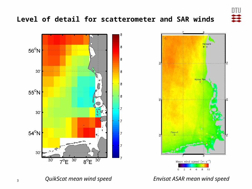
Level of detail for scatterometer and SAR winds
Presentation name3 21 Jan 2012QuikScat mean wind speed Envisat ASAR mean wind speed
DTU Wind Energy, Technical University of Denmark
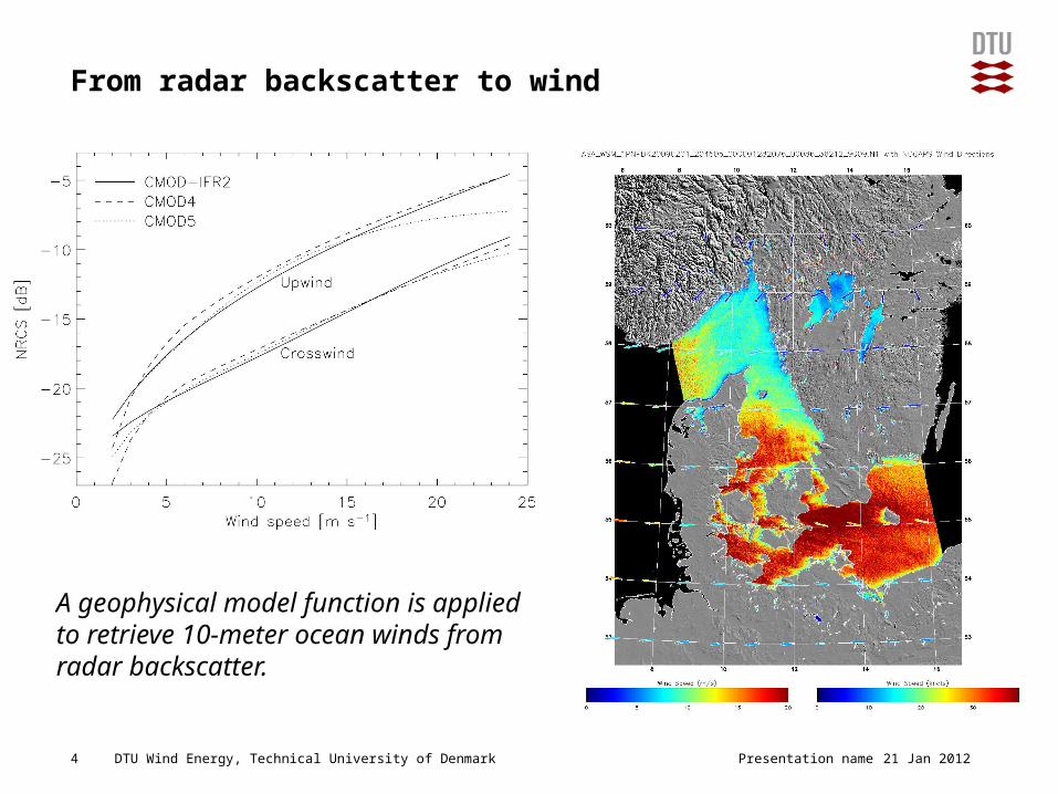
From radar backscatter to wind
Presentation name4 21 Jan 2012
A geophysical model function is applied to retrieve 10-meter ocean winds from radar backscatter.
DTU Wind Energy, Technical University of Denmark Presentation name5 21 Jan 2012
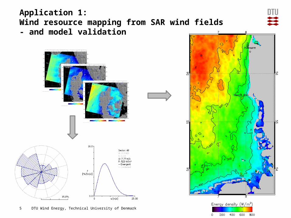
Application 1:Wind resource mapping from SAR wind fields- and model validation
DTU Wind Energy, Technical University of Denmark
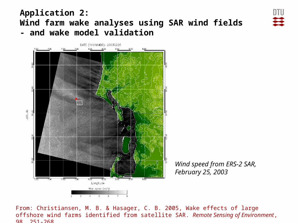
Application 2:Wind farm wake analyses using SAR wind fields - and wake model validation
Presentation name6 21 Jan 2012
Wind speed from ERS-2 SAR,February 25, 2003
From: Christiansen, M. B. & Hasager, C. B. 2005, Wake effects of large offshore wind farms identified from satellite SAR. Remote Sensing of Environment, 98, 251-268
DTU Wind Energy, Technical University of Denmark
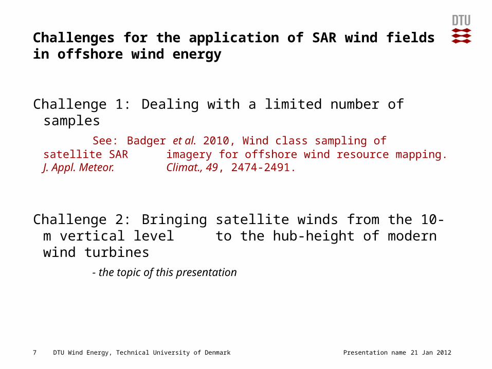
Challenges for the application of SAR wind fields in offshore wind energy
Challenge 1: Dealing with a limited number of samples
See: Badger et al. 2010, Wind class sampling of satellite SAR imagery for offshore wind resource mapping. J. Appl. Meteor. Climat., 49, 2474-2491.
Challenge 2: Bringing satellite winds from the 10-m vertical level to the hub-height of modern wind turbines
- the topic of this presentation
Presentation name7 21 Jan 2012
DTU Wind Energy, Technical University of Denmark
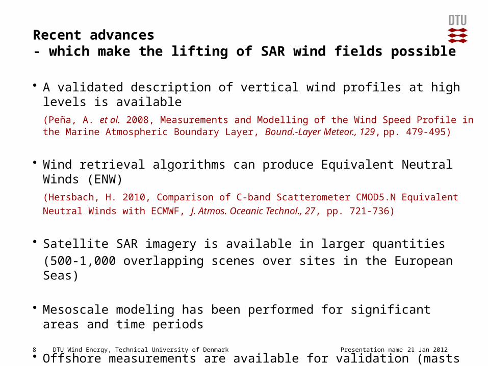
Recent advances - which make the lifting of SAR wind fields possible
• A validated description of vertical wind profiles at high levels is available
(Peña, A. et al. 2008, Measurements and Modelling of the Wind Speed Profile in the Marine Atmospheric Boundary Layer, Bound.-Layer Meteor., 129, pp. 479-495)
• Wind retrieval algorithms can produce Equivalent Neutral Winds (ENW)
(Hersbach, H. 2010, Comparison of C-band Scatterometer CMOD5.N Equivalent
Neutral Winds with ECMWF, J. Atmos. Oceanic Technol., 27, pp. 721-736)
• Satellite SAR imagery is available in larger quantities
(500-1,000 overlapping scenes over sites in the European Seas)
• Mesoscale modeling has been performed for significant areas and time periods
• Offshore measurements are available for validation (masts and LiDAR)
Presentation name8 21 Jan 2012
DTU Wind Energy, Technical University of Denmark
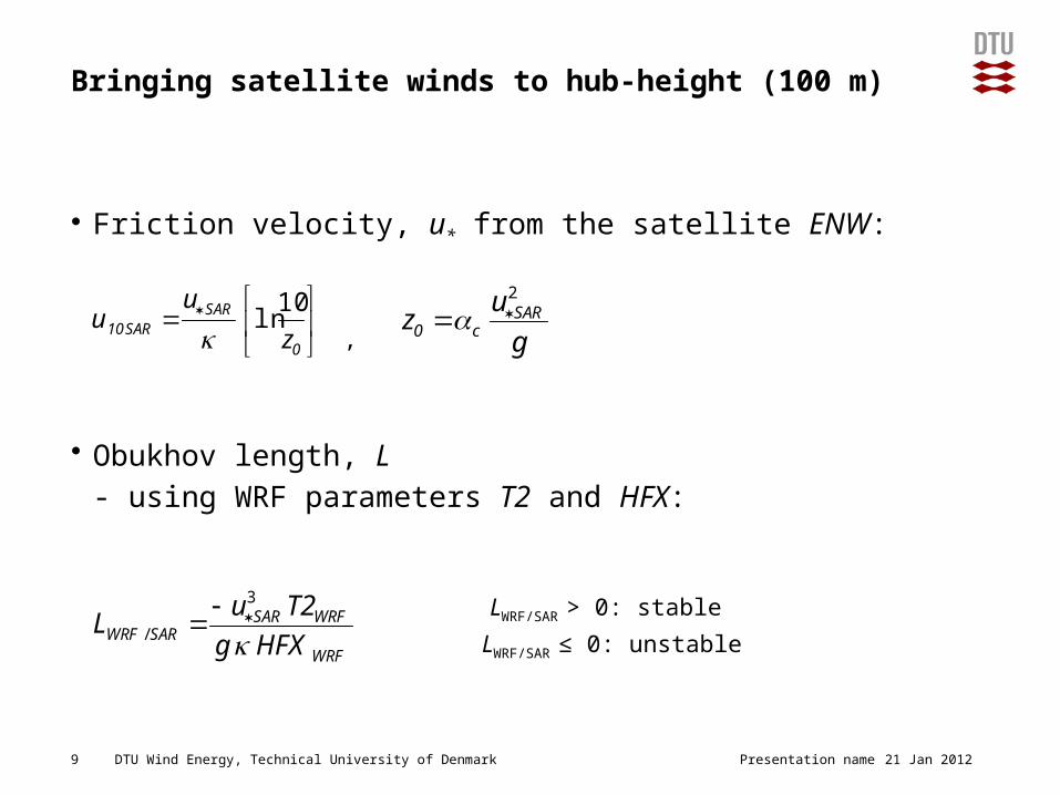
Bringing satellite winds to hub-height (100 m)
• Friction velocity, u* from the satellite ENW:
,
• Obukhov length, L
- using WRF parameters T2 and HFX:
LWRF/SAR > 0: stable
LWRF/SAR ≤ 0: unstable
Presentation name9 21 Jan 2012
g
uz SAR
c0
2
WRF
WRFSARSARWRF HFXg
T2uL
3
/
0
SARSAR10 z
uu
10ln
DTU Wind Energy, Technical University of Denmark
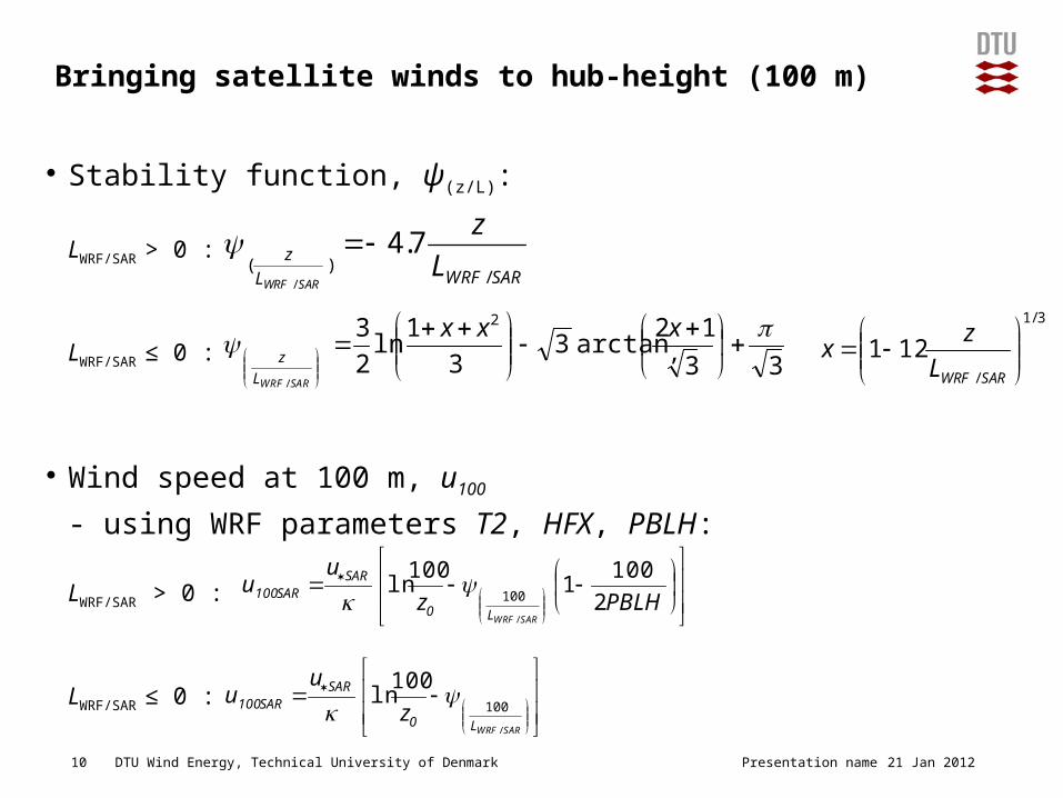
Bringing satellite winds to hub-height (100 m)
• Stability function, ψ(z/L):
LWRF/SAR > 0 :
LWRF/SAR ≤ 0 : ,
• Wind speed at 100 m, u100
- using WRF parameters T2, HFX, PBLH:
LWRF/SAR > 0 :
LWRF/SAR ≤ 0 :
Presentation name10 21 Jan 2012
33
12arctan3
3
1ln2
3 2
/
xxx
SARWRFL
z
3/1
/
121
SARWRFL
zx
SARWRFL
z L
z
SARWRF /)(
7.4/
PBLHz
uu
SARWRFL0
SARSAR100 2
1001
100ln
/
100
SARWRFL0
SARSAR100 z
uu
/
100
100ln
DTU Wind Energy, Technical University of Denmark
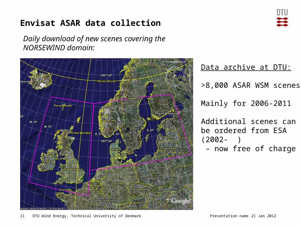
Envisat ASAR data collection
Presentation name11 21 Jan 2012
Data archive at DTU:
>8,000 ASAR WSM scenes
Mainly for 2006-2011
Additional scenes can be ordered from ESA (2002- ) – now free of charge
Daily download of new scenes covering the NORSEWIND domain:

DTU Wind Energy, Technical University of Denmark
100-m winds at Fino-1
Presentation name12 21 Jan 2012
DTU Wind Energy, Technical University of Denmark
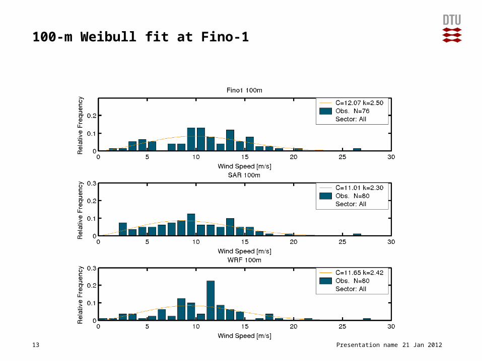
100-m Weibull fit at Fino-1
Presentation name13 21 Jan 2012
DTU Wind Energy, Technical University of Denmark
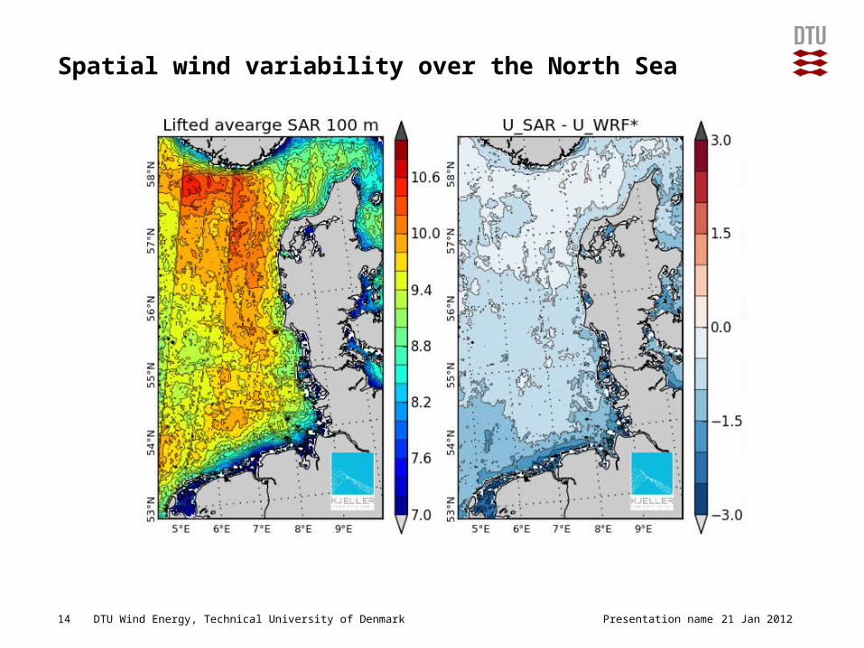
Spatial wind variability over the North Sea
Presentation name14 21 Jan 2012

DTU Wind Energy, Technical University of Denmark
Sampling effects over the North Sea
Presentation name15 21 Jan 2012
DTU Wind Energy, Technical University of Denmark
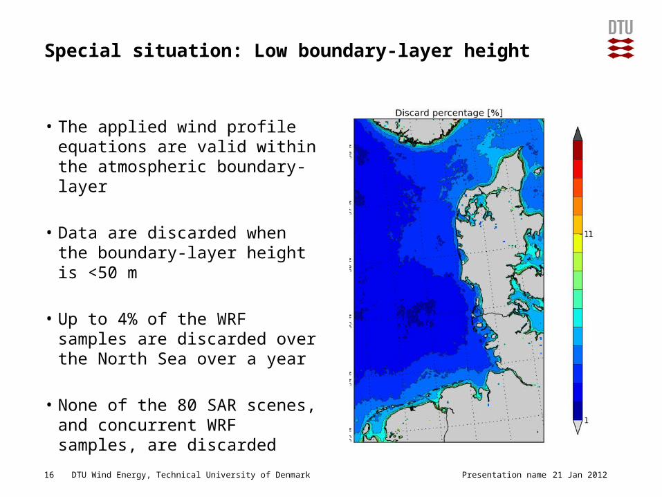
Special situation: Low boundary-layer height
• The applied wind profile equations are valid within the atmospheric boundary-layer
• Data are discarded when the boundary-layer height is <50 m
• Up to 4% of the WRF samples are discarded over the North Sea over a year
• None of the 80 SAR scenes, and concurrent WRF samples, are discarded
Presentation name16 21 Jan 2012
DTU Wind Energy, Technical University of Denmark
Conclusions
• Satellite SAR data lifted to 100 m under-estimate the wind speed at Fino-1
• Concurrent WRF simulations also under-estimate the 100-m wind speed at Fino-1
• SAR-WRF agreement is generally good over the North Sea with the largest differences near the coast of Germany
• The number of SAR samples (80) is insufficient to describe the mean wind climate accurately
• Work is in progress to improve the accuracy of lifted satellite wind fields
• Satellite observations represent a valuable source of information for offshore wind energy applications (e.g. wind resource mapping, wind farm wake analyses)
Presentation name17 21 Jan 2012
DTU Wind Energy, Technical University of Denmark
Acknowledgements
Satellite data:
The European Space Agency (ESA)
Remote Sensing Systems (RSS)
SAR wind field retrieval:
Collecte Localisation Satellites (CLS)
The Johns Hopkins University, Applied Physics Laboratory (JHU/APL)
Fino-1 and Fino-2 mast data:
Bundesministerium für Umwelt (BMU), Projektträger Juelich (PTJ), Deutsches Windenergie Institut (DEWI)
Funding:
EU-NORSEWInD (TREN-FP7EN-21908)
18 21 Jan 2012Presentation name