Embed Size (px)
Citation preview
UNESCO - Man and the Biosphere (MAB) Programme - Biosphere reserve nomination form - January 2013
BIOSPHERE RESERVE
NOMINATION FORM
September 2013
Brighton & Hove and Lewes Downs Biosphere
Reserve Application

UNESCO - Man and the Biosphere (MAB) Programme - Biosphere reserve nomination form - January 2013
CONTENTS
PART I: SUMMARY
Introduction
1. Proposed name
2. Country name
3. Fulfillment of the Three Functions of Biosphere Reserves
4. Criteria for Designation as a Biosphere Reserve
5. Endorsements
PART II: DESCRIPTION
6. Location
7. Area
8. Biogeographical region
9. Land use
10. Human population
11. Biophysical characteristics
12. Ecosystem Services
13. Main Objectives
14. Conservation Function
15. Development Function
16. Logistic support Function
17. Governance, Biosphere Reserve Management and Coordination
18. Special Designations
19. Supporting Documents
(including an overview of the Appendices, and Acronyms)
20. Addresses
Annexes
Annex I: MABnet Directory of the Biosphere Reserves
Annex II: Promotion and Communication Materials
Appendices (see over)

UNESCO - Man and the Biosphere (MAB) Programme - Biosphere reserve nomination form – January 2013
Appendices – Brighton & Hove and Lewes Downs Biosphere Partnership 1. Terms of Reference for the Brighton & Hove and Lewes Downs Biosphere Partnership (September 2013) 2. Biosphere Reserve Management Strategy for the Brighton & Hove and Lewes Downs (final version, September 2013) 3. Equalities Impact Assessment for public consultation on the Biosphere proposal (2013) 4. Public Consultation summary report on Biosphere proposal (September 2013) 5. Bibliographic References A. Brighton & Hove and Lewes Downs Biosphere Partnership Publications B. Other Publications by Biosphere Partners and Other Organisations 1. Rural Environment a) Core Areas b) Buffer Zone (Terrestrial SDNP) Freshwater Environment 2. Urban Environment Transition Areas (Terrestrial) a) Brighton & Hove b) Lewes District c) Adur District 3. Coastal & Marine Environment a) Buffer Zone (Marine) b) Transition Area (Marine) 4. Knowledge, Learning and Awareness 6. Endorsement letters of support from Biosphere Partners and other bodies (2013) a) Signatory bodies b) Biosphere Partner organisations c) National UNESCO supporting bodies 7. Important Species (economically important as well as threatened species) 8. Land Use & Management Plans
NNR (also SACs) Management Plans by Natural England (2) SSSI Views About Management (VAMs) by Natural England (14) ‘South Downs National Park Partnership Management Plan 2014-2019’ by SDNPA ‘Marine Conservation Zone : Selection Assessment Document for Beachy Head West
rMCZ no 13.2’ by SE Region Balanced Seas programme Map Attachments: Map 1 – Location & Zonation map Map 2 – Land Use & Nature Conservation map

UNESCO - Man and the Biosphere (MAB) Programme - Biosphere reserve nomination form - January 2013
BIOSPHERE RESERVE
NOMINATION FORM
[2013]
PART I
Brighton & Hove and Lewes Downs Biosphere Reserve
Application
September 2013
Brighton & Hove and Lewes Downs
Biosphere Partnership

UNESCO - Man and the Biosphere (MAB) Programme - Biosphere reserve nomination form – January 2013
2
PART I : SUMMARY Introduction It is proposed that the Brighton & Hove and Lewes Downs becomes a UNESCO Biosphere Reserve as an international best-practice area that brings people and nature closer together and aspires to be “world class by nature”. The aim is “to create a world-class environment, that is economically successful and enjoyed by all – forever”. The plan is to use the proposed Biosphere status to better care for, manage, and enjoy our special local environment of countryside, coast and urban areas. Indeed this Biosphere proposal stands out because of the closely entwined nature of these three environments within a discrete and relatively small geographic unit, and the integrated approach that we are pursuing to their conservation and management. There are a variety of important and rare wildlife habitats locally, from chalk grassland on the downs to wetlands in the river valleys and estuaries, and from the rich tapestry of urban greenspace to the vegetated shingle beaches and chalk cliffs and reefs of the coast. These habitats support more than 200 species that are on international conservation lists and more than 300 that are national biodiversity conservation priorities, and more than one thousand locally rare species. Brighton & Hove is host to the National Elm collection. The connections of ‘green networks’ for wildlife and people between town, country and coast are significant. National Park downland extends as fingers into the urban settlements and in places right down to the coast with its public beaches and accessible routes. The downland connects with a network of green spaces and corridors that helps to knit this ‘green infrastructure’ together. The rural, urban and coastal/marine areas that make up the local environment sustain many of the daily needs of the 371,000 people that live here through the “ecosystem services” that they provide. These services range from clean water to local food, amelioration of waste products, fresh air, and access to open space for relaxation and inspiration. The local environment’s quality also attracts around 12 million visitors annually, and is critical to the area’s sustainable economic development. However, this creates significant pressures on the natural environment, which is also home to thousands of other species. The need for a balance to be established between human needs and sustainability of the wider environment is therefore paramount. The area has a rich human heritage that is closely linked to the natural environment, from nationally significant early Neolithic settlements to an economy traditionally based on fishing and farming. It came to prominence in the Regency period (late 18 century) as a royal coastal resort providing health and wellbeing opportunities. In modern times it has become internationally renowned also as a centre for contemporary culture, arts and digital media, and environmental initiatives.
th
The proposed new Biosphere Reserve is composed of a natural geographic unit in ecological and cultural terms, centred on the South Downs chalk block between the River Adur at Shoreham in the west and the River Ouse at Newhaven in the east. It covers an area of 389 square kilometres (150 square miles) or 38,921 hectares (96,175 acres), just bigger than the nearby Isle of Wight. Three-quarters of the area is on land and one-quarter is the sea.

UNESCO - Man and the Biosphere (MAB) Programme - Biosphere reserve nomination form – January 2013
3
The proposed “Core Area” is made up of 13 existing national Sites of Special Scientific Interest (SSSIs), as well as one partial site, that cover almost 5% of the proposed Biosphere Reserve. Two of these SSSIs are also European Special Areas of Conservation (SACs) to conserve their chalk downland communities. The surrounding rural “Buffer Zone” of the South Downs National Park makes up the principal land area for inclusion, with a marine Buffer Zone represented by the statutory recommended Marine Conservation Zone (rMCZ) of Beachy Head West along the coast. The “Transition Areas” on land are composed of the city of Brighton & Hove, together with the smaller urban settlements of Lewes, Newhaven, Peacehaven, Telscombe, Shoreham, Shoreham Beach, and Southwick. The near-shore English Channel sea (out to 2 nautical miles offshore) makes up the marine Transition Area. A Biosphere Reserve would complement the existing designations present, such as the South Downs National Park, by bringing the large urban coastal settlements and their people into closer contact with the natural environment across the whole area. Biosphere status would help to better integrate locally the three objectives of nature conservation, sustainable socio-economic development, and logistic support (or knowledge, learning and awareness) through a more holistic approach. It would help strengthen further the already significant partnership working and diversity of local initiatives present that exists. This strong and rich heritage of partnership working across the public and voluntary sectors and civic engagement in measures to improve the environment and pursue sustainable development goes back many years. In the late 19 and early 20 centuries the former th th Brighton Corporation had the foresight and vision to buy significant tracts of downland to protect groundwater supplies and prevent uncontrolled development. The area also spawned a number of civic bodies for environmental and social good, and this ethos continues to this day with a thriving community and voluntary sector, in addition to the proactive focus of public bodies and much political attention. The Brighton & Hove and Lewes Downs Biosphere Partnership is composed of almost forty public, educational, community, voluntary and private sector organisations. It perceives Biosphere status as an opportunity to further raise awareness and the profile of the area, and so help to attract national and international funding opportunities, stimulate fresh ‘green’ economic opportunities, and support community action to create local environmental benefits. Biosphere status would be used to engender a stronger sense of community engagement and pride in the local environment, through more environmental education, hands-on experience and practical volunteering opportunities. Further links between local learning institutions and environmental managers would be developed, as well as making new connections to international Biosphere networks, to further the knowledge needed to address our conservation and development challenges. The Biosphere Partnership is working to realise these potential benefits by seeking “win-win” solutions for people and nature to create a better more sustainable future.

UNESCO - Man and the Biosphere (MAB) Programme - Biosphere reserve nomination form – January 2013
4
This proposal helps to implement a number of the targets of the UNESCO MAB Madrid Action Plan 2008-13, in particular through the local focus on:
Extensive local communication and public engagement work (Target 6: Communication strategies integrated);
Innovative work to further sustainable development (Target 8: Linkages with sustainable development initiatives)
Broad and inclusive partnership process (Target 10: Participatory processes); Green Network / Infrastructure mapping and enhancements programme (Target 14:
Cooperative conservation and development strategies); Substantial applied research activity through the two universities and other learning
institutions present (Target 16: Site-based policy-relevant research programmes); Local studies and action underway on ecosystem services (Target 19: Research
programmes on ecosystem services and management) Developing relationships with local research bodies to support management and
improvement actions (Target 20: applied research programmes linked to management) Inclusion of significant urban areas that are closely linked to their surrounding environment
(Target 23: mechanism to address urban issues in a regional context); Progress made in securing funding internally and externally e.g. major grant from the
national ‘Nature Improvement Area’ programme (Target 25: Improved financial mechanisms);
Developing work with the private sector including water supply, public transport and tourism bodies (Target 27: Increased private sector involvement)
1. PROPOSED NAME OF THE BIOSPHERE RESERVE: Brighton & Hove and Lewes Downs Biosphere 2. NAME OF THE COUNTRY: England, United Kingdom 3. FULFILLMENT OF THE THREE FUNCTIONS OF BIOSPHERE RESERVES
3.1 "Conservation - contribute to the conservation of landscapes, ecosystems, species and genetic variation".
Three distinct but inter-related environments make up the proposed Biosphere Reserve area:
Rural environment of part of the South Downs National Park, centred on the chalk block that lies between the River Adur in the west and the River Ouse in the east, home to about 13,000 people
Coastal and marine environment of the English Channel, running from Shoreham Harbour in the west to Newhaven Harbour in the east and extending out to the subtidal chalk outcrops that lie up to 2 nautical miles offshore
Urban environments of Brighton & Hove, Lewes, Newhaven, Peacehaven and Telscombe, and Shoreham, Shoreham Beach and Southwick, home to around 358,000 people

UNESCO - Man and the Biosphere (MAB) Programme - Biosphere reserve nomination form – January 2013
5
Location Maps
UK Biosphere Reserves and Zones, incl. proposed Brighton & Hove and Lewes Downs Biosphere (N.B. indicative location and area only for this proposed Biosphere, with no zones marked)

UNESCO - Man and the Biosphere (MAB) Programme - Biosphere reserve nomination form – January 2013
6
Proposed Brighton & Hove and Lewes Downs Biosphere Reserve and Zones
Rural environment Coastal and Marine environment
Urban environment

UNESCO - Man and the Biosphere (MAB) Programme - Biosphere reserve nomination form – January 2013
7
The area boasts a number of notable assets in its natural environment, including: internationally important rare chalk downland (including two European protected areas) on
land, and coastal chalk cliffs and subtidal reefs at sea; chalk grassland of the South Downs National Park (the UK’s newest and most populated
national park) that extends from the surrounding downland right into the heart of the city and towns, connecting to urban greenspace networks;
the UK’s National Elm Collection in Brighton & Hove, the principal place in the country where such mature elm trees still survive following Dutch Elm Disease in the 1970s thanks to the area’s geography and topography and an active control zone, today it has the largest and most diverse collection of mature elm trees anywhere in the world;
night-time roosts of thousands of starlings circle Brighton’s piers, and large numbers of herring gulls (the symbol of the local football team) which though locally prevalent are a globally threatened species;
the largest and most remarkable of all chalk dry valleys in Britain at Devil’s Dyke, an outstanding feature of periglacial chalk geomorphology;
the best and most extensive exposure of the Offaster pilula geological zone in England at ‘Brighton to Newhaven Cliffs’ SSSI, with an ancient “raised beach” and cliffs that comprise one of the most extensive sections of ice age geology visible in Northern Europe;
one of the most complex and well-dated early Neolithic human settlements in Britain at the “causewayed camp” at Whitehawk in Brighton, with evidence of the lives of the earliest farming communities.
The range of landscapes, ecosystems, species and genetic diversity in the area are as follows. Landscapes The principal landscapes of our proposed area are: - Brighton Chalk Block – stretching between the River Adur and River Ouse, it is part of the Natural England National Character Area of the South Downs that extends from east to west across Sussex and into Hampshire. Together with the adjoining block of the Lewes Downs, it makes up the principal terrestrial landscape of our area and is characterised by mostly open “whale-backed” windswept downland based upon a chalk geology of >100-million year old Cretaceous deposits. The expansive landscape of the South Downs is characterised by vast, open, and exposed areas dominated by large agricultural fields, with limited woodland and scrub areas. - River Valleys – the Adur and Ouse represent two of the four major rivers of the South Downs. They flow from the High Weald and Low Weald (and Lower Greensand) national character areas southwards into the sea and have carved out the chalk blocks into discrete landscape units over geological time. These two tidal rivers meander through wide flat floodplains, enclosed by steep-sided chalk slopes, to form distinctive U-shaped valleys leading down to estuaries on the coast. The river valleys are characterised by meandering river channels, although these have been straightened and embanked by levees along much of their lengths, with networks of drainage ditches dissecting the largely pastoral floodplain. - Coastal Plain – a narrow flatter (urbanised) coastal plain lies in the west running from central Brighton to the estuary of the River Adur at Shoreham (and beyond). - Coast and inshore marine – coastal chalk cliffs extend from Brighton Marina eastwards to the estuary of the River Ouse at Newhaven (and beyond to Beachy Head near Eastbourne). The

UNESCO - Man and the Biosphere (MAB) Programme - Biosphere reserve nomination form – January 2013
8
moderately exposed sea of the English Channel has a relatively flat and gently shelving seabed down to shallow depths of less than 15 metres. The inshore marine environment here is made up of a chalk reef of eroded gullies in the east, and a subtidal ledge of discontinuous chalk outcrops extending offshore westwards following the line of the 10m depth contour. The benthic environment is composed principally of extensive sand wave fields which in places are broken by exposed bedrock and mixed sediments of lag gravel deposits. Ecosystems, Species, & Genetic variation The main habitat types found in the local area, together with their associated species, are summarised below (according to the three Biosphere environments that they occur in). Whilst there are no globally or nationally endemic species found in the proposed Biosphere area, there are 211 species recorded that are listed on the IUCN Red Lists and 58 species that are CITES-listed. At the national level there are around 308 species defined as UK Biodiversity Action Plan (BAP) priorities and 164 that are legally protected, whilst locally in Sussex there are 1,052 considered rare that have been recorded from the Biosphere area. Important local genetic varieties of species furthermore include unique elm tree Elmus spp. varieties and cultivars as well as wild apple tree varieties found in Brighton & Hove. The domesticated breeds of South Downs sheep and rare Sussex cattle, that graze the downland and river valleys respectively, are also distinctive. Rural environment: - Farmland Though mostly comprised of intensive arable cultivation and extensive agriculturally improved livestock-grazed grassland, the South Downs here also support important examples of lowland chalk grassland. Lowland calcareous grassland (on chalk or limestone) is one of the richest wildlife habitats in the country. It is particularly important for its high botanical species diversity, with up to 40-50 vascular plant species per square metre being possible, and it hosts two-thirds of Britain’s threatened grassland plant species according to Natural England’s ‘State of the Natural Environment (2008)’ report. It is also important for the invertebrate communities that it supports, notably butterflies with 20 species having a substantial proportion of their breeding populations in this habitat. Characteristic species include the round-headed rampion Phyteuma orbiculare and early spider orchid Ophrys sphegodes plants, wart-biter cricket Decticus verrucivorus and Adonis Blue butterfly Lysandra bellargus insects, and birds such as skylarks Alauda arvensis subsp. arvensis. Much chalk grassland has been lost over the past two hundred years, which has decreased by almost half in the South Downs overall, with a 25% loss in Sussex between 1966 and 1980. It is one of the most threatened habitats nationally also, with a loss of almost 20% from 1990-1998 alone. Losses have been due to both agricultural intensification and abandonment of marginal land, leaving remaining linear fragments mostly within the protected areas of the northern scarp steep downland slope. The surrounding matrix of more intensive agricultural land is a mixture of arable and pastoral farmland. It includes widespread application of agri-environment scheme options for the characteristic wildlife present, notably farmland bird species such as the corn bunting Emberiza calandra subsp. calandra, skylark and yellowhammer Emberiza citronella, as well as brown hares Lepus europaeus and rare arable annual ‘weeds’.

UNESCO - Man and the Biosphere (MAB) Programme - Biosphere reserve nomination form – January 2013
9
- Deciduous woodland (and scrub) Woodlands are generally relatively small and sporadic on the South Downs, consisting of farm plantations as well as recent secondary woodland and chalk scrub. More substantial ancient woodlands exist mainly on the north side of the Downs, as well as historic estate parkland. Ancient woodlands, as relatively stable continuously wooded habitats, are amongst the most biodiverse habitats in the country. Broadleaved woodland overall contains the greatest number of species of conservation concern according to the UK Biodiversity Action Plan, more than twice as many as chalk grassland for example, and has the highest number of globally threatened and rapidly declining species (78). Their flora and fauna includes ancient woodland indicator plant species such as the iconic spring carpets of bluebells Hyacinthoides non-scripta, and animals such as White Admiral butterflies Limenitis camilla, hazel dormice Muscardinus avellanarius and various bat species. - Freshwater wetland The two river valleys both contain limited areas of remnant wetland habitats, including floodplain grassland and grazing marsh, fen, extensive field ditch systems and small reed beds. Offham Marshes SSSI is notable for supporting one of the best natural wet “carr” woodlands fed by a natural chalk spring upwelling in the UK. Wetland species interest includes large numbers of wintering and breeding birds such as lapwing Vanellus vanellus, redshank Tringa totanus and snipe Gallinago gallinago, migrant warblers (Reed Acrocephalus scirpaceus, Sedge A. schoenobaenus and Cetti’s Cettia cetti), amphibian species including great-crested newts Triturus cristatus, and plants such as Greater Water-parsnip Sium latifolium. Although the chalk downs generally lack surface water, they do support some of the best-known examples in the UK of “near-natural” headwater chalk streams at their bases, emerging from the scarp slope spring lines. Many of these streams provide breeding gravels for rare sea trout Salmo trutta in the winter. There are also a series of historic man-made “dew ponds” for livestock-watering, which serve as islands of fluctuating aquatic habitat in a landscape of free-draining chalk for ephemeral species such as the fairy shrimp Chirocephalus diaphanous. Coastal and marine environment: - Coast The protected cliffs from Brighton Marina to Newhaven include substantial linear areas of chalk grassland on their tops with rare coastal species such as Strawberry Clover Trifolium fragiferum. The cliffs provide nesting niches for birds, including fulmars Fulmarus glacialis and a remnant colony of kittiwakes Rissa tridactyla. To the west, patches of the internationally rare habitat of vegetated shingle occur, with plants such as the rare sea knotgrass Polygonum maritimum, although most of the coastline here is developed and intensively regulated and managed. - Intertidal zone A wave-cut chalk platform runs east from Brighton to Newhaven within the Site of Special Scientific Interest (SSSI) here, with a series of parallel gullies and ridges with rocky tide pools supporting characteristic species such as sea anemones, blue mussel Mytilus edulis and native oyster Ostrea edulis beds. To the west, the intertidal area is made up of Brighton & Hove’s and Shoreham’s shingle beaches. Brighton Marina represents a very sheltered lagoon environment that supports a diversity of species more typical of deeper water habitats, including protected short-snouted seahorses Hippocampus hippocampus. The underwater footing structures of Brighton’s two piers additionally provide hard substrates for locally uncommon species associated with rocky coasts.
UNESCO - Man and the Biosphere (MAB) Programme - Biosphere reserve nomination form – January 2013
10
- River estuaries The Adur (a SSSI) and Ouse rivers contain a variety of substrates but have been considerably modified and constricted with hard edges. The Adur estuary does however include fringing saltmarsh vegetation, a very rare habitat along the coastline locally, with plants such as glasswort Salicornia europea and small but increasing amounts of the introduced cord-grass Spartina spp . Furthermore their mudflats are important for wading birds, including ringed plover Charadrius hiaticula, redshank and dunlin Calidris alpina in the lower Adur. The estuaries also provide rich feeding grounds for fish and crabs as well as being important juvenile marine fish nurseries. At the seaward end of the Adur, the Shoreham outer harbour area is a haven for a host of marine flora and fauna and supports small numbers of wintering purple sandpipers Calidris maritima. - Subtidal zone The subtidal chalk reef of the recommended Marine Conservation Zone (rMCZ) of ‘Beachy Head West’ runs parallel to the SSSI from Brighton to Newhaven and beyond. It includes notable species such as long- Hippocampus guttulatus and short-snouted seahorses, blue mussel and native oyster beds, mobile eel Anguilla anguilla populations, and sea squirts. There is also a discontinuous chalk ledge to the west off Brighton, which gives rise to a unique series of low underwater north-facing chalk cliffs. These include local marine Sites of Nature Conservation Importance (mSNCIs) that support a dense hydroid-bryozoan animal “turf”. Other seabed habitats include a series of large sandwaves in the shallow waters to the east, lying offshore of the foot of the chalk block, giving the seabed an undulating profile which forms the seasonal spawning grounds for many fish species such as the fascinating and economically important black bream Spondyliosoma cantharus. Biological records are held for more than three hundred marine sample sites/species in this area. - Open sea The English Channel here is seasonally visited by cetacean species (porpoises and dolphins mainly), although their abundance has apparently declined. A wide variety of seabirds feed and nest in the area - especially gulls, auks, gannets Morus bassanus and fulmars; rarer species such as terns, sea ducks, grebes and kittiwakes are also present. The seas support a wide diversity of fish species, many seasonal in their occurrence, including undulate ray Raja undulata, black bream, twaite Alosa fallax and allis shad Alosa alosa, Atlantic salmon Salmo salar and sea trout, and sharks including porbeagle Lamna nasus and basking shark Cetorhinus maximus. Urban environment: - Urban green spaces The urban areas of Brighton & Hove, Lewes town and the coastal settlements of Newhaven, Peacehaven and Telscombe, and Shoreham generally contain extensive networks of greenspace. These include public parks and other open spaces such as housing estates and school grounds, allotments, cemeteries and previously developed “brownfield” sites as well as numerous private gardens. Urban greenspace in Brighton & Hove and Lewes town especially is relatively well-connected to the rural countryside on their margins, and several publicly accessible urban fringe sites such as East Brighton Park and Landport Bottom respectively contain important chalk grassland. Brighton & Hove’s urban greenspace covers about 575 hectares as part of its mapped ‘Green Network’, including a number of designated Local Nature Reserves (LNRs). Lewes District includes a number of LNRs also on its urban fringes, including at Lewes Railway Land and Castle Hill, Newhaven. A broad range of Local Wildlife Sites (Sites of Nature Conservation Importance, SNCIs) have been additionally identified for planning protection. With regard to species, research by the University of Sussex demonstrates the importance of urban greenspace and vegetation in

UNESCO - Man and the Biosphere (MAB) Programme - Biosphere reserve nomination form – January 2013
11
Brighton and Lewes as a nectar source for honey bees Apis mellifera, a critically important pollinator of domestic and agricultural plants that has been suffering grave declines. - Urban green features Natural vegetation is also found in the streets and houses of the built environment in the form of trees in civic spaces and streets, and the growing numbers of vegetated buildings (green roofs and walls) being developed. There are some 12,000 individual street trees in Brighton & Hove, including part of the National Elm Collection (made up of some 19,000 trees across the city, including parks and open spaces), the only place in mainland Britain where such a diversity can be found. The two largest known English Elm Ulmus procera trees worldwide are located in the city’s Preston Park. The White-letter Hairstreak butterfly Satyrium w-album is particularly associated with the National Elm Collection in Brighton. Brighton & Hove has a number of well-established examples of “green buildings” and they are also part of many new developments. One of the largest and oldest green walls in existence is along the seafront of Madeira Drive, which extends for over a kilometre in length and is more than ten metres high. The ‘One Brighton’ housing development near Brighton Station has rooftop allotments, as well as solar photovoltaic panels on a ‘brown roof’, a biomass boiler, and is essentially car-free with substantial cycle facilities. In Lewes, the Linklater Pavilion has a sedum roof, as well as photovoltaic cells, a ground source heat pump and its own water supply. Plans to develop the University of Sussex’s campus at Falmer include extensive undergrounding of hard-surfaced car parking areas and conversion to green roofs, as well as a range of environmental technologies proposed. Brighton & Hove is renowned for its large populations of starlings Sturnus vulgaris subsp. vulgaris (a threatened species), that roost on the city’s piers and breed in the roof spaces of houses. The urban areas also host migrant swifts Apus apus (declining in number), majestic peregrine falcons Falco peregrinus (recovering in number) and ravens Corvus corax by Lewes (probably breeding), as well as the iconic Herring Gull Larus argentatus subsp. argenteus (locally ubiquitous, yet globally threatened). 3.2 "Development - foster economic and human development which is socio-culturally and ecologically sustainable".
The proposed Biosphere Reserve area is home to around 371,000 people. It is nationally and internationally renowned for its arts and culture, distinctive settlements, independent mindset, and its links to the surrounding iconic English landscape of downland, white chalk cliffs and beaches overlooked by Regency buildings and squares. Because of its innate qualities and its proximity to London (55 miles by road or less than one hour away by train) it is a magnet for tourists, welcoming around 12 million visitors per year. - Historic/cultural background There is evidence of settlements in the area since Neolithic times, with Whitehawk Camp in east Brighton being one of the earliest known human settlements in Britain. Newhaven and Lewes were established as Anglo Saxon settlements in the 5th and 6th centuries and Brighton’s predecessor fishing village of Brighthelmston appeared in the Domesday Book of 1086. Brighton supported the largest fishing fleet in the region until the 1700s, with fish carried over the Downs to Lewes on the historic Juggs Road, whilst on land the economy was based on mixed farming of sheep and corn. Brighton became famous as a health and then tourist resort in the late
UNESCO - Man and the Biosphere (MAB) Programme - Biosphere reserve nomination form – January 2013
12
eighteenth century, thanks to Dr Richard Russell who extolled the health giving properties of sea water and air. The renowned Brighton Pavilion was built by the Prince Regent, later King George IV, at this time. Another famous local doctor was Gideon Mantell who was born in Lewes and became an expert on local fossils and dinosaur bones to found the Sussex Scientific Institution in Brighton in the 1830s. The urban development of Brighton from Regency and Victorian times with the arrival of the railways has bestowed a legacy of great architecture, including extensive terraces and squares. One of the first public electric railways in the world was created in 1883 by Magnus Volk along the seafront of Kemptown and still operates today. The Victorians built a railway to the Downs at Devil’s Dyke (now an accessible trail attracting more than one million visitors a year) which helped to raise popular awareness of the South Downs. Indeed the former Brighton Corporation purchased significant tracts of downland in the late 19th and early 20th Century to protect its water supply and undeveloped nature. Lewes became an important town in Norman times and contains the remains of Lewes Castle and a medieval priory, part of a rich and varied architectural heritage that includes over 500 listed buildings. It was the site of a famous battle in 1264 (the 2nd Barons’ war) which led to the defeat of royalist forces by Simon de Montford, who for a short while became the "uncrowned King of England”. To this day, Lewes remains nationally renowned for the burning of protestant martyrs and the attempt by Guy Fawkes to destroy the Houses of Parliament in 1605, giving rise to its famous Bonfire Night which is the largest in the country. Lewes was also home of the radical author Thomas Paine from 1768–1774 before he emigrated to the US and inspired the American declaration of Independence with his pamphlet ‘Common Sense’. Newhaven is known for its port harbour and Palmerston fort, the largest defense work built in Sussex and one of the nationally designated Scheduled Ancient Monuments present in the local area. The settlements of Peacehaven (the southernmost point of the Greenwich meridian line in Britain) and Telscombe were created in the early 20th century. The historic core of Shoreham-by-Sea has a distinctive character that was established by the Normans at the end of the 11th Century using a ‘fine urban grain’ grid pattern that survives in part today. The Marlpins museum is designated as a Scheduled Ancient Monument and is the only secular medieval building remaining in Shoreham, with other important historic buildings including St Mary de Haura Church (Grade I listed) and St Nicolas Church in Old Shoreham (of Anglo-Saxon origin) to the north. Southwick to the east had a Roman villa and was recorded in the Domesday Book, growing to become a popular Victorian holiday destination especially with the arrival of the railway in 1840. Shoreham Beach to the south lies on the shingle bank that has been thrown up over the centuries by the sea. It became a location for summer homes around the turn of the twentieth century, before being cleared for defence during the Second World War and thereafter re-developed. It was briefly home to a flourishing early film industry, as was Shoreham and St Anne Wells Gardens in Hove; Brighton remains a popular location for film-makers. The close association between sites of both archaeological/historical and ecological interest in the area provides an active opportunity for promoting public understanding and engagement. - Current socio-economic activities Brighton & Hove has continued to evolve from being a seaside resort to a service sector economy, and was recognised with city status in 2001. Today it has a population of 273,000 people, including a significant proportion of younger people and homosexual people which lends to its reputation of being a liberal and cosmopolitan city. It also has a growing population from ethnically diverse backgrounds. It is especially known as a contemporary centre for arts and culture, as

UNESCO - Man and the Biosphere (MAB) Programme - Biosphere reserve nomination form – January 2013
13
demonstrated by Brighton Festival (the largest in the UK after Edinburgh) and associated Fringe Festival (the second largest in the world). It plays a lead role regionally in “creative entrepreneurship” and is a centre of financial industries, digital companies and, increasingly, environmental technologies. It has two internationally renowned universities, hosting around 35,000 students, as well as numerous language schools and other learning institutions. It has a reputation for progressive social and environmental activism, and there is a strong and long-standing public interest in the environment, underpinned by a wide range of civil society groups concerned with their local environment. The environment is part of local politics also, including the election of the country’s first Green MP in 2010 and the first Green-led council in 2011. Lewes town has also been a magnet for innovative and progressive people, and as the county town of East Sussex is home to a number of public authorities and serves as a rail and bus gateway to the South Downs National Park (of which it is part). It hosts an annual internationally renowned bonfire celebration run by a number of historic societies. Newhaven is currently entering exciting times with its focus on economic regeneration, which is intended to strengthen employment opportunities, including the development of a new university technical college specialising in marine and environmental engineering. Planned port improvements will further bolster this important link to mainland Europe for ferry passengers and freight, as well as supporting the local fishing fleet. It will also be the maintenance hub of the proposed offshore Rampion wind farm if approved for development. The economy of Adur District is closely linked to the larger conurbations of Brighton & Hove and Worthing to the west which offer greater employment opportunities, hence only 44% of Adur’s workforce actually work within the District. The largest employment sectors here are ‘wholesale retail and vehicle repair’ which account for 21% of total employment. Shoreham Harbour provides a concentration of employment in mining, quarrying and manufacturing as a major commercial port specialising in aggregates, timber, steel, and locally-grown cereals as well as its marine activities. Whilst the manufacturing sector has been performing relatively well in Adur, traditional manufacturing across the region continues to decline. More land is needed to increase the number and type of jobs available, reduce out-commuting and encourage investment back into the local economy. Socio-economic challenges exist however, with the urban areas constrained in their size and future growth through their geography, being sandwiched between the sea and the South Downs National Park. Some of Brighton & Hove’s neighbourhoods have been identified as facing high levels of disadvantage, with 12% within the ten per cent most deprived local areas in England and two in the most deprived one per cent. This is manifested in marked differences in physical and mental health and life expectancy between neighbourhoods. The four Lewes District urban settlements generally have low levels of deprivation, but there are low-income pockets in three of the settlements. Adur is the most deprived local authority in West Sussex, although it ranks as the 145th most deprived of 354 local authority areas in England, and has 3 designated Local Neighbourhood Improvement Areas (LNIAs) and two wards in the 20% most deprived in England within the Biosphere area. The local economy and population of the Biosphere are heavily reliant on the productivity and quality of the natural environment. Visitor tourism is a particularly important sector, receiving around 12 million visitors each year in addition to leisure and recreation by local residents. Brighton & Hove receives some 8.5 million visitors per annum, as one of the most popular UK cities for tourists after London. They contribute over £732 million to the local economy and the

UNESCO - Man and the Biosphere (MAB) Programme - Biosphere reserve nomination form – January 2013
14
industry employs approximately 14% of the city’s workforce (through some 17,500 jobs). Lewes District is also an important visitor destination, with 3.1 million visitors each year (mostly within the proposed Biosphere area) who make a combined spend of £155m, supporting 2,300 jobs. Adur District as a whole receives about 1 million visitors a year, whose expenditure exceeds £42 million and directly supports 759 jobs or an estimated 1,100 jobs in tourism-related businesses generally, representing 6.2% of the employee workforce. The tourism industry in the area remains largely buoyant despite difficult economic conditions in recent years. Tourism creates pressures on the local environment, including water consumption, waste, and vehicle traffic and visitor activity tending to concentrate on core routes and a limited set of “honey pot” areas such as the central seafront and a few well-known South Downs sites. To promote the economy whilst safeguarding the environment, Brighton & Hove City Council (BHCC) is developing an eco-tourism strategy, and launched a ‘Green Brighton Guide’ for visitors in 2012. Other economic activities based upon the local environment include harvesting and extraction of primary resources, especially through farming and commercial sea fishing. The majority of the rural environment is farmed. BHCC owns 4150 ha of downland estate, which was bought up in the late 19th and early 20th Centuries to safeguard the city’s water supply and protect the area from development. The land is worth approximately £38.5 million and supports more than 75 full time jobs through tenant farmers and others. Other rural land use includes some native forestry and country sports (hunting/shooting) activity. On the coast, the ports of Newhaven, Shoreham and Brighton Marina harbour a fleet of almost seventy active commercial fishing vessels, mostly smaller inshore boats which fish using a variety of mainly static fishing methods and typically land their catch daily. Much of the catch goes to local and regional (including London) markets and restaurants, with the remainder going to mainland Europe where there is high demand. Recreational fishing of both the sea and rivers is a significant leisure sector, with sea-fishing boats operating out of all three ports and private angling also taking place from the shore. - Sustainable development potential There is already a good track record of pursuing more sustainable development in the area, with significant plans to improve further in the future. The two local authorities of Brighton & Hove City Council (BHCC) and Lewes District Council (LDC) were early signatories to the 10:10 Campaign to cut carbon dioxide emissions. Brighton & Hove was the only UK city to be placed in the top three most sustainable cities in each of Forum for the Future’s ‘National Sustainable Cities Index’ four annual assessments made in 2007-10. Brighton & Hove City Council was the first in the country to implement in 2010 the International Standard ISO 14001 environmental management system jointly integrated with the British Standard for Sustainable Events (BS 8901), and is adopting the international standard in sustainable events in 2013. Lewes District Council has held EMAS accreditation since 1999 and the International Standard ISO 14001in environmental management since 2002. Adur District Council’s (ADC) Joint Sustainable Community Strategy with Worthing (2010 – 2026) ‘Waves Ahead’ identifies sustainable development as part of its vision for the future, with its emerging Local Plan incorporating sustainability policies especially regarding energy efficiency. East Sussex County Council (ESCC) adopted a wide-ranging and ambitious Environment Strategy in 2011. West Sussex County Council (WSCC) established a cross-sector Environment and Climate Change Board in 2010 to promote a co-ordinated approach to tackling these issues. The South Downs National Park Management Plan, coordinated by the South Downs National
UNESCO - Man and the Biosphere (MAB) Programme - Biosphere reserve nomination form – January 2013
15
Park Authority (SDNPA), is underpinned throughout by sustainability in its promotion of development and activities in keeping with the special qualities of the area; it will itself be subject to a sustainability appraisal also. BHCC has adopted the ‘One Planet’ approach of BioRegional and WWF as its practical framework for furthering sustainable development of both its own operations and partnership working across the city. Brighton & Hove was confirmed as the world’s first ‘One Planet City’ in 2013, based upon its adopted three-year Sustainability Action Plan to implement measures for each of the ten ‘One Planet Living’ principles of sustainable development: zero carbon, zero waste, sustainable transport, local and sustainable food, sustainable materials, sustainable water, land use and wildlife, equity and local economy, culture and community, and health and happiness. Varied stakeholders within and external to BHCC are taking forward actions under the different principles, such as making council buildings more energy and water-efficient, reduce waste and encourage more active travel. LDC is addressing sustainability through its ‘People Place and Prosperity’ theme which focuses on the three sectors of sustainable business, sustainable communities (through its ‘Smarter Living’ programme) and sustainable action within the council (through its EMAS / ISO 14001 systems), to reduce the ecological footprint of the district and help to adapt to climate change impacts. ADC has been implementing an ambitious programme of energy efficiency measures including in its own council buildings through its ‘New Ways of Working’ programme. Two economic environmental growth areas are identified in BHCC’s Economic Strategy (2013-18) which aims towards becoming a low-carbon economy and links to ‘One Planet Economy’ aims, as well as the current Brighton City Deal initiative (which includes LDC and ADC) to become a nationally recognised 'Eco tech' hub for the region. This has developed into the concept of ‘Growth Hubs’ and these are planned for Brighton as well as Shoreham Harbour and Shoreham Airport in Adur District. One proposed environmental growth area is the environmental technologies sector, including construction sector retrofit of energy efficiency measures as well as renewable energy generation. The second is the evolution of the tourism offer to visitors focussed on local food and eco-tourism, with links to the proposed Biosphere Reserve including through more sustainable access and appreciation of the South Downs, coast/sea, and urban greenspace. - Ecosystem Services flows/inputs The human population here is highly dependent on the local provision of ecosystem services, although they may not necessarily be aware of this, with the key service being the water supply from the chalk groundwater aquifer. Other services include watershed protection (e.g. from flooding) and provision of local food and outdoor health and recreation. A number of initiatives in the proposed Biosphere area are presently working to develop and apply the concept of ecosystems services locally to value what the natural environment provides to human well-being, as a means to better conserve and integrate it in socio-economic policy formulation. The ‘South Downs Way Ahead’ Nature Improvement Area (NIA) project, part of the national ‘Biodiversity 2020’ strategy, has a particular focus on chalk grassland habitats and chalk aquifer groundwater quality. A pilot project by the Lewes & Ouse Valley eco-nomics (L&OVe) group is working with local stakeholders to identify, map and value the services of greatest significance in our area and raise awareness of our links to them. Natural England’s work to characterise the South Downs ‘National Character Area’ has identified a number of important services (beyond the general ‘supporting services’ of ecosystems such as primary production and nutrient cycling):

UNESCO - Man and the Biosphere (MAB) Programme - Biosphere reserve nomination form – January 2013
16
1. Provisioning services – food provision (cereals and lamb) water availability from the Brighton Groundwater Management Unit (under pressure)
2. Regulating services – climate - carbon sequestration by increasing organic matter inputs and by reducing the
frequency / area of cultivation soil erosion - similar links to climate measures above freshwater flooding - increasing natural water storage and infiltration on the Downs and
managing run-off coastal flooding/erosion - mitigation through natural processes and habitats as possible
3. Cultural services – recreational opportunity - important on the South Downs for the health and wellbeing of
the wider population in the South East region less tangible values - include provision of a sense of place, history, and inspiration to people tranquillity and dark night skies biodiversity - especially the internationally important lowland chalk grassland geodiversity - especially the coastal chalk cliffs
In the urban areas, important ecosystem services are provided by green spaces and features, which provide wildlife habitats, food-growing areas, recreational opportunities, carbon storage in urban greenery, and amelioration of local climate, air quality and rainwater flows too. 3.3 "Logistic support - support for demonstration projects, environmental education and training, research and monitoring related to local, regional, national and global issues of conservation and sustainable development". Current Activities: A wide variety of activity related to environmental education, research and training, and public engagement is already taking place in the proposed Biosphere Reserve area. There is a strong foundation in place for such activity, given the presence of two major universities and around a hundred local schools and further education colleges (and a number of environmental education centres and special projects), set against the background of a high degree of public interest in the local environment. - Environmental education Various types of environmental education are provided through the primary and secondary school curriculum to tens of thousands of school children in the area. The Brighton & Hove Environmental Education (BHee) programme (2011-14) is being delivered for BHCC by the non-governmental organisations (NGOs) of the Sussex Wildlife Trust (SWT) and Resource Futures through pupil workshops, teacher training, dedicated materials and support, and encourages the adoption of ‘Eco School’ programmes. West Sussex County Council (WSCC) instead promotes a locally developed initiative called ‘Engauge’ for their schools to pursue sustainability measures under nine areas. East Sussex County Council (ESCC) has developed a sustainable schools web-based toolkit under its former ‘Carbon Hub’ project to support reduced carbon emissions and improved resource efficiency in their schools. Various partnerships operate in Lewes between voluntary environmental organisations (such as the Railway Land Wildlife Trust) and individual schools. More widely across the whole National Park, the SDNPA is developing the ‘Our South

UNESCO - Man and the Biosphere (MAB) Programme - Biosphere reserve nomination form – January 2013
17
Downs’ educational programme to reach out with an outdoor learning curriculum to the more than half a million children in the 700+ schools that are located within or close to its boundary. Many schools in the Biosphere area have been awarded ‘Eco School’ status at varying levels, with some being real pioneers of sustainable practices and diversification of their school grounds. There is also a range of extra-curricular initiatives such as SWT’s ‘Forest Schools’ local programme, ‘Wild Beach‘ pilot project (involving SWT and Sussex IFCA), and greening of school grounds for biodiversity by the Lewes Wildlife Project. At further and higher education levels there are many students taking specialist environmental courses. The University of Brighton runs thirteen undergraduate degree courses and ten Masters courses with a core environmental focus, whilst the University of Sussex offers three and one such courses respectively. The land-based Plumpton College runs nine vocational courses focussed on countryside management at the levels of both Higher Education and Further Education. For both children and adults, there are a number of specialist local environmental education centres that provide learning resources and activities to a range of different groups. The Linklater Pavilion community environmental change study centre is a recent dedicated facility in Lewes, whilst the Dorothy Stringer Environmental Centre, Brighton Peace and Environment Centre and Booth Museum of Natural History are all active in Brighton. - Research and training Academic and applied research and monitoring in our proposed Biosphere area is led by the two local universities (Brighton and Sussex), which together have almost 40,000 students and staff, and have both been rated within the top three greenest universities in the UK. A very wide range of research is carried out, a proportion of which focuses specifically on the local environment, with other active institutions including Plumpton College, Archaeology South East (part of University College London), local colleges, secondary schools, statutory and charitable bodies, and many knowledgeable local societies and individuals. Areas of research include, for example, developing greener technologies in sectors such as transport and energy; ecological research on diverse local habitats (especially chalk grassland), key species (including honey bees), and monitoring of designated sites; and social science research on subjects such as tourism and leisure, outdoors health, access and human relationships with nature. A broad range of applied and vocational training is available locally to people concerned with the environment, including: practical short courses for adults run by Plumpton College; applied training by other local colleges such as City College in Brighton on energy efficiency measures; more technical courses by the two Universities; teacher training in environmental education delivery; public courses such as those of the Sussex Wildlife Trust (who run over a hundred nature courses annually); and internal staff training of Biosphere partner organisations. All students at Plumpton College receive practical work experience, whilst all University students have the option of carrying out volunteer placements to gain professional experience. - Public engagement An impressive array of environmental engagement activities on nature conservation and sustainable development take place for local people, delivered by a mixture of public, charitable and community groups. A great range of group meetings and public events takes place throughout the year, backed up by a significant proportion of regular volunteers (part of the almost 20,000 volunteer positions in Brighton & Hove alone that contribute some £100 million of work annually).

UNESCO - Man and the Biosphere (MAB) Programme - Biosphere reserve nomination form – January 2013
18
Nature conservation work, for example, is undertaken by around fifty local Friends groups across the area, actively supported by the council ranger services of BHCC and LDC. ADC has worked with local people including schools to establish community groups, which carry out projects as diverse as creating play areas, wildflower areas, tree planting, community allotments, and especially outdoor fitness equipment for five “green gyms”. Both residents and visitors receive environmental information through a wide range of media including websites such as the Green Brighton Guide, site-based interpretation panels, public exhibitions including at local museums, at cultural events including the Brighton Festival and Fringe, and through a multitude of both printed and online information. The numerous topics covered range from wildlife surveys to environmental sustainability, including climate change action and local food-growing, to initiatives focussed on outdoors health such as “green gyms” and “health walks”, disability action, environmental arts, archaeology and heritage. Future Activities: As part of the wider process for developing a future action plan derived from the management strategy (see section 4.7c), the higher education partners will work further with the Biosphere Partnership to address the specific research questions identified to be able to allow us to better understand and monitor the Biosphere area. This will involve developing a Research Plan for the Biosphere that sets out the baseline situation and determines what research will be required to complement monitoring activities to enable evaluation of the Biosphere’s impact. Subject areas will span our three principal objectives and could make use of national or local ecosystem services frameworks, for example, as an organising structure. University student projects, both postgraduate and undergraduate, will be the main means used to investigate applied topics. Links to wider spatial areas will be made as possible, including the World Network of Biosphere Reserves. An initial proposal has been developed for a ‘Biosphere (Higher) Education Board’ by the universities and Plumpton College to co-ordinate, educate and facilitate the delivery of this Biosphere area. Elements under consideration include co-ordination of such activities as carrying out relevant research, applying for research grants, establishing international links, environmental educational provision, student volunteering, campus active learning, and linking with local businesses. A broad spectrum of plans and proposals already exists for the future across the three components of ‘logistic support’ set out above. Key initiatives that are being progressed or are planned include the examples below. - Environmental education Further development of SDNPA’s ‘Our South Downs’ educational Learning through Landscapes initiative is planned. A £5m development of a new flagship ‘Big Nature Centre’ by Dorothy Stringer high school on the Surrenden campus is proposed, to expand educational and community environmental learning and teaching capacity for Brighton & Hove and beyond. The University of Brighton is involved in development of the Newhaven ‘CleanTech’ University Technical College (for 14-19 year olds), specialising in marine and environmental engineering to support the regional growth of marine and environmental industries through engagement with business and community partners. Lastly an increased focus by Plumpton College on leisure tourism is planned, including outdoor education through a new degree programme.

UNESCO - Man and the Biosphere (MAB) Programme - Biosphere reserve nomination form – January 2013
19
- Research and training Research questions will be identified with the universities, and grant bids and student projects developed as appropriate to help support sustainable management of the area. There is also scope for each of the higher education institutions to develop more specific short training courses for adult learners to meet identified needs and interests in the local area, with Plumpton College specialising in practical subjects. The University of Brighton will further expand its environmental research associated with clean energy, waste management, bio-contamination treatment/monitoring, ecological diversity of different environments, and social science research into tourism, outdoors health, land access and engagement with nature to inform and support the Biosphere project through its regional research impact. Specific examples include work with Shoreham Port to address marine erosion, novel tidal energy development, and ‘Connected Communities’ research. It will also lead the ‘Green Growth Platform’ for Sussex in 2014-19 to stimulate growth of environmental sector companies, provide support to improve their performance and stimulate public and business demand. The Community University Partnership Programme (CUPP) will be a principal mechanism to provide university support for wider research and training projects for the Biosphere through provision of specialist workshop, student volunteers and academic support. - Public engagement BHCC and SDNPA are working together on a major funding bid to restore Stanmer Park by Brighton and make it a high-quality visitor gateway to the National Park. A partnership project is being developed on the archaeology of Whitehawk Hill in east Brighton by Archaeology South East, which will include a focus on engaging local people with cultural and natural heritage. 4. CRITERIA FOR DESIGNATION AS A BIOSPHERE RESERVE 4.1. "Encompass a mosaic of ecological systems representative of major biogeographic region(s), including a gradation of human interventions". The proposed Brighton & Hove and Lewes Downs Biosphere Reserve is located in biogeographic terms within the temperate broad-leaf forests biome of the British Islands province of the Palearctic realm (based on the Udvardy 1975 classification system). It includes all of the principal characteristic habitats and land uses that represent this part of the South Downs and coastal area of Sussex, and many of those typical of the region of south-east England. Our proposal is holistic in nature by including all three of the main environments that occur in and around the unit of the Brighton chalk block, namely rural downland and countryside, coastal and marine areas, and major urban settlements. As such a significant gradation of human modification is included within the principal habitats represented, in the following approximate order (from relatively natural through to entirely anthropogenic in origin and existence): - Coastal chalk cliffs (SSSI) – most of the eastern part is in a relatively natural state, whereas the western end is protected by concrete sea defences and includes engineered support - Subtidal chalk reef (rMCZ) – protected from mobile fishing by trawlers, so subject to static fishing and recreational disturbance only - Freshwater wetland habitats – these include a diversity of micro-habitats from relatively natural chalk streams, carr and fen through to regularly managed ditches and artificial dew ponds

UNESCO - Man and the Biosphere (MAB) Programme - Biosphere reserve nomination form – January 2013
20
- Shingle beaches – rare vegetated shingle is present as a few fragments only, most beach areas being intensively used, managed by beach cleaning and/or regulated by recharge and groynes - Deciduous woodland – ancient woodland areas were historically managed by traditional silviculture systems, which have partly lapsed in modern times, whereas recent secondary woodland and scrub is often unmanaged - River estuaries – mostly artificially constrained by flood embankments and built structures - Chalk grassland – created by and dependent on low-intensity grazing by livestock (sheep) - Intensively farmed crops and grassland – subject to very regular management to maximise its productivity for food production - Urban greenspace – most types such as public parks have been derived from grassland and designed for their civic purpose, and are subject to regular management mostly intensive mowing - Built environment – wholly artificial in nature and substrate, but can include natural elements such as green roofs and walls, gardens and street trees 4.2 "Be of significance for biological diversity conservation". Whilst there are no globally or nationally endemic species found in the proposed Biosphere area, there are 211 species recorded that are listed on the international IUCN Red Lists and 58 species that are CITES-listed (36 of which are EC CITES Annex A). At the national level there are 308 species defined as UK Biodiversity Action Plan (BAP) priorities, and 164 that are legally protected, that have been recorded in the proposed area. The Brighton & Hove Local BAP (2013) lists 115 UK BAP species in need of conservation action locally, of which 18 are highlighted for individual specific action. The most significant species that are listed on international conservation lists and have been frequently recorded in the proposed Biosphere area include the following taxa below. IUCN Red List (global, post-2001) – three ‘Threatened’ categories (5 species in total) of ‘Critically Endangered’, ‘Endangered’ and ‘Vulnerable’ e.g. European Eel (Anguilla anguilla) The IUCN Red List for Great Britain includes 128 ‘Threatened’ species additionally, mostly flowering plants and insect species. EC CITES Annex A (including all CITES Appendix 1 species) – Birds (29 species), including Common Kestrel Falco tinnunculus and Peregrine Falcon Falco peregrinus; Marine Mammals (7 species) – mostly Bottle-Nosed Dolphin Tursiops truncatus
Examples of nationally significant species for nature conservation (UK BAP and Brighton & Hove LBAP) that are well-represented/recorded include: Mammals – Hedgehog Erinaceus europaeus, Brown Hare Lepus europaeus, Hazel Dormouse Muscardinus avellanarius Birds – Skylark Alauda arvensis subsp. arvensis, Linnet Carduelis cannabina, Corn Bunting Emberiza calandra subsp. calandra, Yellowhammer Emberiza citronella, Grey Partridge Perdix perdix, Lapwing Vanellus vanellus, Starling Sturnus vulgaris subsp. vulgaris Herptiles - Slow-worm Anguis fragilis, Common Toad Bufo bufo, Grass Snake Natrix natrix, Adder Vipera berus, Common Lizard Zootoca vivipara, Great Crested Newt Triturus cristatus
UNESCO - Man and the Biosphere (MAB) Programme - Biosphere reserve nomination form – January 2013
21
Fish (freshwater & marine) - Bullhead Cottus gobio, Lamprey Lampreta sp., Short-snouted and Long-snouted seahorses Hippocampus hippocampus and H. guttulatus, Sea Trout Salmo trutta, and European Eels Anguilla anguilla Butterflies - Small Heath Coenonympha pamphilus, Wall Lasiommata megera, Dingy Skipper Erynnis tages subsp. tages, Grizzled Skipper Pyrgus malvae, and Small Blue Cupido minimus Other insects - Chalk Carpet moth Scotopteryx bipunctaria, Stag Beetle Lucanus cervus, Brown-banded Carder Bee Bombus humilis Other invertebrates – marine molluscs (shellfish) – Native Oysters Ostrea edulis Plants - Red-Star Thistle Centaurea calcitrapa, Burnt Orchis ustulata and Musk Herminium monorchis orchids, White Helleborine Cephalanthera damasonium Some species are representative of rare habitat types or unique land use practices also, such as:
the Wart-biter Cricket Decticus verrucivorus, present only at the two SAC chalk grassland sites, as both have uncommon south-facing aspects
species especially dependent on traditional grazing regimes of chalk grassland e.g. Adonis Blue Lysandra bellargus butterfly
the White Helleborine Cephalanthera damasonium which depends on the maintenance of open woodland glades on chalk soils
unusual moss and liverwort species in chalk streams, such as Hygroamblystegium fluviatile and Platyhypnidium riparioides respectively.
the ephemeral Fairy Shrimp Chirocephalus diaphanous, a resident of dew ponds (man-made water bodies with ancient origins), many of which were created on the South Downs in Victorian times for livestock to drink from due to the absence of surface water
a small breeding colony of Kittiwake Rissa tridactyla seabirds on the steep chalk cliff faces freshwater invertebrates such as the Great Silver Diving Beetle Hydrophilus piceus in
wetland grazing marsh ditches subtidal chalk which hosts species including ross coral, sea squirts, piddocks and boring
worms the rare vegetated shingle habitat supports rare species such as the Toadflax Brocade moth
Calophasia lunula The most important habitats are principally associated with chalk (on land and under the sea) and/or rare freshwater ecosystems. The most significant terrestrial habitat for conservation is undoubtedly the internationally rare chalk grassland, which is globally restricted to north-west Europe with the UK (especially southern England, including the South Downs) believed to contain about half of the world distribution of this highly diverse habitat. Most of the remaining species-rich chalk grassland in the area lies within Sites of Special Scientific Interest (SSSIs) designated to protect them, mainly along the northern scarp slope of the South Downs. Some valuable south-facing areas occur in the two SSSIs that are also European Special Areas of Conservation (SACs). With regard to the freshwater habitats on the Downs, there are nationally important chalk streams that emerge from the scarp slopes, with a unique steeply wooded and highly natural character. Remnant floodplain and chalk wetland habitats occur in two SSSIs by Lewes town with important fen, reedbed and “carr” woodland, and wet grassland and ditches, that support populations of rare plants, invertebrates, amphibians and birds.

UNESCO - Man and the Biosphere (MAB) Programme - Biosphere reserve nomination form – January 2013
22
The chalk features of coastal and marine environments are notable habitats for biodiversity conservation, comprising: - the SSSI chalk cliffs and intertidal platform from Brighton to Newhaven - the adjacent subtidal chalk reef of Beachy Head West rMCZ, containing one of the best regional examples of subtidal chalk platform and gullies with associated littoral chalk communities - and the discontinuous chalk ledge which extends westwards out to sea along a chain of local marine SNCIs. Coastal exposures of chalk are internationally rare, with the southern and eastern coasts of England hosting more than half of the European resource. The most extensive areas of sublittoral chalk in Britain occur in Kent and Sussex, making them nationally important for this habitat type. Indeed Sussex is the only location on the British Isles where chalk strata appear as offshore, linear vertical “cliffs” underwater, making these exposures of at least national importance. The small fragments of coastal vegetated shingle beach that occur are an internationally rare habitat, listed as a UK BAP priority habitat and on Annex I of the EC Habitats Directive, and hence are also a significant habitat resource. 4.3 "Provide an opportunity to explore and demonstrate approaches to sustainable development on a regional scale”. The proposed Biosphere area has both a sound history and strong ambitions to promote sustainable development at this geographic scale and serve as a potential beacon of good practice at regional, national and international levels. The main local authorities involved (BHCC, LDC and ADC) have been progressing sustainability initiatives for the past twenty years or more. A number of national awards have been bestowed upon the area, with Brighton & Hove being the only UK city to be placed in the top three most sustainable cities in each of Forum for the Future’s ‘National Sustainable Cities Index’ recent assessments. Lewes has received a number of ‘Green Apple’ awards for Environmental performance (Environmental Management, Energy Efficiency projects) across the authority at regional and national level and the Advantage Business Award for working in partnership on Climate Change issues in the sector. It has also held EMAS accreditation since 1999. Brighton & Hove has recently been independently accredited by BioRegional as the world’s first ‘One Planet City’ for the plans of the council and its partners in the city to enable local people to live well but within a fairer share of the earth’s resources (using just one planet’s worth of resources rather than the current 3½). The three-year Sustainability Action Plan (2013-16) includes both short and longer term ambitions for both the council and the city as whole, to improve local quality of life, reduce impacts on the environment, save money and make the area more resilient. Detailed improvement measures are set out under each of the ten ‘One Planet Living’ principles of the sustainable development framework, covering: zero carbon, zero waste, sustainable transport, local and sustainable food, sustainable materials, sustainable water, land use and wildlife, local economy, culture and community, and health and happiness. The One Planet framework represents the principal implementation mechanism for the Brighton & Hove Climate Change Strategy (2011-15). It is hoped that One Planet City work will serve as a practical example of progressing sustainability worldwide, through the One Planet global network which is now used in fifty countries around the world.

UNESCO - Man and the Biosphere (MAB) Programme - Biosphere reserve nomination form – January 2013
23
Sustainability in Lewes District is addressed through its ‘People Place and Prosperity’ (PPP) framework, which looks at the three sectors of sustainable business, sustainable communities (through ‘Smarter Living’) and sustainable action within Lewes DC (under EMAS / ISO 14001). The main theme of PPP is to demonstrate that linking people and organisations with different skills to find solutions for sustainable living ensures that these solutions are economically robust, resource efficient and socially inclusive. LDC’s ‘Smarter Living’ programme has been developed by its Local Sustainability Team to promote and enable pro-environmental behaviour through a “bottom-up” approach that works with discrete communities who are empowered to select activities/actions they prefer to reduce their community’s impact. Several measures are used to monitor success including greenhouse gas emissions and ecological footprint. LDC also has an environmental programme that is split into 7 headline areas that cover all of the significant environmental impacts of the council’s operations, with environmental policy principles that inform a corresponding environmental improvement programme. The seven areas cover Pollution Prevention and Control, Transport, Procurement, Sustainable Development, Energy and Water, Biodiversity, and Waste & Recycling. LDC has signed up to the Local Government Association initiative ‘Climate Local’, with a revised Climate Change Action Plan is being developed to update the present 2010 plan. The Joint Sustainable Community Strategy for Adur and Worthing (2010 – 2026) ‘Waves Ahead’ identifies striving for Sustainable Development as part of its vision for the future. ADC is committed to encouraging sustainable development, and its emerging Local Plan incorporates a raft of policies seeking to reduce energy demand, ensure energy-efficient supply and renewable energy provision. For example, all new residential development will be required to meet the ‘Code for Sustainable Homes - Level 4’ as a minimum, and non-domestic development to achieve BREEAM ‘Very Good’. ADC has been implementing ‘New Ways of Working’, which will reduce the overall number of office buildings and adapt existing buildings to be more energy-efficient and incorporate solar photovoltaic panels as part of an ambitious programme of energy efficiency measures. West Sussex County Council (WSCC) has a Performance Framework (2011-2014) that includes “building a sustainable future” as a priority. This commits WSCC to protecting the environment by providing leadership within the authority as well as across the County as a whole. There is a particular focus on the reduction of carbon emissions and climate change adaptation, as well as using resources more efficiently to make sustainability “business as usual”. A multi-sectoral Environment and Climate Change Board was established in 2010 to integrate policy and action in these areas. East Sussex has an Environment Strategy (2011-2026) developed by the Environment Strategy Group of the East Sussex Strategic Partnership, which includes East Sussex County Council (ESCC). The strategy is based upon ten environmental principles that range from waste, transport and air quality to climate change and landscape and townscape conservation. The South Downs National Park Authority (SDNPA) is focussed upon the National Park becoming a beacon of sustainable development, in line with national government policy, especially in terms of resource management and energy efficiency. The developing SDNP Management Plan and Local Plan are underpinned by sustainability, and include policies aimed at tackling issues such as: transport (reduced car use, improved public transport and cycling initiatives); water (reduced demands, improving quality through land management); farming (developing local markets); tourism (green tourism initiatives); communities development (better access to local housing, jobs, facilities and services, and less reliance on private transport and lengthy journeys); and sustainable economic

UNESCO - Man and the Biosphere (MAB) Programme - Biosphere reserve nomination form – January 2013
24
growth (strengthening local supply chains, and reducing resource use). SDNPA itself has an internal Sustainability Strategy also, which includes a strong focus on carbon reduction. The Sussex Inshore Fisheries & Conservation Authority (IFCA) has conducted an innovative assessment of all inshore marine fisheries in this area against the Marine Stewardship Council (MSC) sustainability criteria to identify strategies for improving their management in the future. The two main Universities of Brighton and Sussex both have comprehensive sustainability and environmental policies, especially focussed upon implementation of carbon reduction programmes, as well as grounds management for biodiversity. The Biosphere initiative offers great scope to join up and multiply the sustainability work of individual bodies to better address some of the area’s challenges on a wider more natural scale. For example, a common proactive approach to improving the sustainability of our water resources is a priority amongst several partners. This will involve closer working with the water companies and the public to raise awareness of the issues and to explore possible solutions. Similarly, scope exists for a more co-ordinated approach to promoting access to local food (linking producers and consumers) and to the outdoors for healthy recreation and active travel options. 4.4 "Have an appropriate size to serve the three functions of biosphere reserves" a) Long-term conservation: The entire proposed Biosphere area covers some 389 square kilometres (150 square miles), of which: - Core Areas The thirteen whole SSSIs (plus one small part of an additional SSSI) cover 1,832 hectares (18 square kilometres), about 4.7% of the total area, and are designated at a national level (and at an international level for the 2 SACs) as part of the statutory network to conserve nature through protected areas over the long term. - Buffer Zones The terrestrial buffer zone is centred on the Brighton Chalk Block section of the South Downs National Park that lies between the Adur and Ouse rivers and covers an area of 20,479 ha (53% of the total area). This area constitutes a discrete natural unit for the purpose of nature conservation, as part of the overall objectives of the draft SDNP management plan. Hence this entire landscape unit is considered to be of sufficient size for effective conservation in the long term, given the focus on landscape-scale action through measures such as targeted agri-environment schemes. The marine buffer zone area comprises the western half of the Beachy Head West rMCZ, covering the linear subtidal chalk reef that extends offshore out to 0.5 miles from the mean high water mark (or c. 0.25 nautical miles from the lowest astronomical tide). The western half of the rMCZ (some 1,270 ha out of a total area of 2358 ha) is included within the Biosphere area. This represents 3% of the Biosphere’s total area, or 14% of the marine area. This part of the MCZ on its own is probably not large enough to ensure the long-term conservation of all of its features, hence it needs to be considered as an integral part of the whole site and in tandem with other non-MCZ subtidal chalk features such as the marine SNCIs to the west.

UNESCO - Man and the Biosphere (MAB) Programme - Biosphere reserve nomination form – January 2013
25
b) Areas for demonstrating sustainable uses: Multiple opportunities for furthering the sustainable use of natural resources exist in the Buffer Zones and the Transition Areas (both terrestrial and marine for each area) of the proposed Biosphere Reserve. The following four examples illustrate each environment of the two Biosphere zones: Land – promotion of more sustainable “eco-tourism” activity by visitors to South Downs attractions in the local area of the SDNP (Buffer Zone); encouragement of local food-growing by individuals and communities in the urban areas of Brighton & Hove, Lewes and Shoreham (Transition Area). Marine – proposed voluntary approach to work with the recreational boating community to avoid anchoring on the chalk reef of the rMCZ (Buffer Zone); a pilot project and campaign to encourage local consumption of fish harvested from the wider sea (Transition Area). 4.5 Through appropriate zonation: "(a) a legally constituted core area or areas devoted to long term protection, according to the conservation objectives of the biosphere reserve, and of sufficient size to meet these objectives"?
Designation as SAC and SSSI affords the highest available protection for nature conservation. The principal conservation objective of all designated SSSIs is to maintain or restore the habitats, species and other biological/geological features for which they were originally notified to meet the nationally agreed (‘Public Service Agreement’ and ‘Biodiversity 2020’ strategy) target standards of “favourable conservation status” of 95% of SSSIs by 2020, or at least “unfavourable recovering” status before then. In August 2012 half (51%) of all the SSSI land in the area was classified by Natural England’s statutory condition monitoring system as being favourable, and nearly all the remainder (48%) as unfavourable recovering, leaving just 1% as “unfavourable no change” or “declining”. Based on this assessment of status and trends, it is clear that the sites’ conservation objectives are being met and hence the prospects for their long-term conservation are good and that their size is adequate in general (although the effects of climate change especially are likely to challenge this). The core areas are distributed as a “string of pearls” in an arc along the northern chalk scarp slope and eastern downland areas that then descends down the river valleys and estuaries and joins the coastal strip of chalk cliffs in the east. They comprise all of the nationally designated SSSIs on and around the Brighton and Lewes chalk blocks, numbering thirteen whole sites and one part-site which include: - 9 biological sites (plus 1 part-site), including 2 European SACs - 3 geological sites (small-sized inland chalk quarries) - 1 mixed biological/ geological site (coastal cliffs) The eleven sites with biological interest (in full or part) are dominated by 6 chalk grassland sites, with the other sites comprising 2 freshwater, 1 acid grassland (part-site), 1 coastal and 1 estuarine site. The majority of the two coastal and estuarine core area sites are situated directly next to urban transition areas, with relatively small parts only adjoining the rural SDNP buffer zone area as per the classic Biosphere zonation scheme.
UNESCO - Man and the Biosphere (MAB) Programme - Biosphere reserve nomination form – January 2013
26
The six chalk grassland sites cover 1089 ha, distributed semi-contiguously mainly along the northern steep scarp slope of the South Downs. They have been designated to conserve their characteristic habitats of south-east England chalk grassland, as well as chalk scrub and woodland (including juniper), and rare species assemblages, including: higher plants (especially orchids), invertebrates (especially butterflies and moths, as well as a grasshopper) and breeding downland birds, as well as some related geological features. The two SACs have been designated as part of the European Union’s Natura 2000 network of sites to conserve their “semi-natural dry grasslands and scrubland facies on calcareous substrates (Festuco-Brometalia) (important orchid sites)”, and the population of early gentian also in the case of Castle Hill SAC. Their collective size, subject to a statutory protection regime and near-universal positive management, is believed to be sufficient to maintain their conservation interest in the long term. This assessment is based upon the assumptions that extraneous impacts are adequately controlled or mitigated, and that their strict protection is effectively integrated with wider landscape-scale conservation measures in the surrounding buffer zone of the national park. The other protected areas’ semi-natural habitats (wetland and coastal cliff/estuary) complement this core focus on chalk grassland, but these sites are generally probably not large enough in their own right to conserve their wider ecosystems (hence the need for landscape-scale measures through the rural and coastal/marine buffer zone areas). The two freshwater SSSIs are designated to protect a wide diversity of invertebrates and host nationally important winter bird populations at Lewes Brooks (a RSPB reserve in part) and to conserve the unusually large amphibian populations and scarce insects present at Offham Marshes freshwater alluvial grazing marsh. The coastal Brighton to Newhaven Cliffs SSSI exists to conserve rare plants and a locally important colony of breeding seabirds and diverse community of beetles, in addition to its main geological interest. The Adur Estuary SSSI was designated to conserve the only significant area of saltmarsh in central Sussex with its unusual estuarine plant communities and large area of intertidal mudflats of importance to wading birds. It is also a RSPB nature reserve in part. The part-site (8 ha of 64 ha total area) of Ditchling Common SSSI has its southern unit only of (wet) lowland acid grassland included in the Biosphere/SDNP areas and contains a rich botanical diversity. The four geological SSSI sites are designated to conserve their different chalk exposures and in some cases fossil interest. They include the single most important section in the Cenomanian Chalk Marl and Grey Chalk in western Europe (Southerham Grey Pit); sections of the Lower Chalk and Middle Chalk with abundant fossil fishes (at Southerham Machine Bottom Pit); and Middle and Upper Chalk including the Lewes Member (Southerham Works Pit). Brighton to Newhaven Cliffs SSSI has the best and most extensive exposure of the Offaster pilula zone in England, and is a nationally important reference section for the upper Cretaceous period. "(b) a buffer zone or zones clearly identified and surrounding or contiguous to the core area or areas, where only activities compatible with the conservation objectives can take place." The Buffer Zones are split between the terrestrial environment of the South Downs National Park (SDNP) sub-area that lies between the Adur and Ouse rivers centred on the Brighton Chalk Block, and the marine environment of the adjacent Beachy Head West recommended Marine Conservation Zone (western part). All of the SSSI Core Areas are located within the designated South Downs National Park, although only partially in the case of the two coastal/estuarine sites.

UNESCO - Man and the Biosphere (MAB) Programme - Biosphere reserve nomination form – January 2013
27
The terrestrial buffer zone boundary of the proposed Biosphere Reserve exactly follows the designated SDNP boundary in this area of the Brighton Chalk Block and its surrounds, covering an area of 20,479 ha. The buffer zone surrounds all of the SSSI core areas with the principal exception of the coastal sites of the Adur Estuary SSSI and Brighton to Newhaven Cliffs SSSI which run for much of their lengths through and alongside the settlements of Shoreham and Saltdean-Peacehaven -Newhaven respectively. The rural area of the SDNP is mostly used for mixed agriculture (both arable and pastoral), as well as groundwater supply and extensive recreation, with more limited woodland management, game management, small settlements, roads, and telecommunications installations. Future activities (based upon the draft SDNP management plan) are foreseen to continue the existing uses and increase agri-environment management, eco-tourism, sustainable outdoor recreation and access, and potentially small-scale renewable energy generation also. Potential future pressures on the SDNP rural area include: changes in agricultural practice, driven by global food markets and increasingly by climate change; water quality and quantity (including potential over-abstraction); increased recreational pressure (including commercial mass dog-walking); transport infrastructure developments (roads, ports, railways, airports) and increasing traffic levels; and the expansion of built development, including renewable energy infrastructure (wind turbines, offshore wind farm cabling, and solar arrays). The Beachy Head West recommended Marine Conservation Zone runs along the eastern chalk SSSI coastline out to 0.25 nm distance and is a new type of Marine Protected Area where nature conservation together with sustainable management is the focus. The designation of this recommended site is presently under consideration by the Government (DEFRA), with a decision expected by 2014. The proposed Biosphere Reserve buffer zone in the marine environment covers an area of about 1,270 ha, and connects directly with the terrestrial SDNP buffer zone in places but mostly with part-urbanised sections of coast. Current use and management are principally for local inshore commercial fisheries, as well as some activity by recreational anglers and sailors. If and when the area is designated as a MCZ, the impact of activities here will be considered against its conservation objectives. The draft conservation objectives of this MCZ are to “maintain” all of the notified features with the exception of the littoral chalk communities. Here the objective is to “recover” this feature, which is proposed to happen by a voluntary measure to restrict boat anchoring in addition to the existing exclusion of bottom-trawling (under a sea fisheries byelaw). "(c) an outer transition area where sustainable resource management practices are promoted and developed" The proposed Transition Areas are twofold: 1. Urban built-up areas – centred around the city of Brighton & Hove, the urban areas stretch almost continuously along the coast from Shoreham and Shoreham Beach in the west, through Telscombe and Peacehaven to Newhaven in the east. All of these built-up areas lie outside of the South Downs National Park (SDNP). In addition, Lewes town is included in the Transition Area, though is situated inland from the coastal communities and lies within the SDNP. The urban areas extend over around 7,200 ha of mostly built-up land use, principally made up of buildings (residential, commercial, industrial and public) and other built infrastructure but including an extensive network of urban greenspace and peripheral countryside sites. A resident population of about 358,000 people live here, significantly supplemented by around 12 million visitors annually.

UNESCO - Man and the Biosphere (MAB) Programme - Biosphere reserve nomination form – January 2013
28
The settlements are relatively affluent but contain significant pockets of social deprivation. The economy is highly developed and dominated by the service sector, including significant tourism, with locally important financial, insurance, digital and local government sectors and relatively localised industrial activity including ports, waste processing and recycling, and other environmental technologies. Both contemporary and future issues which the proposed Biosphere could contribute to include the following examples: - more natural composition and management of urban greenspace - promotion of “green infrastructure” in the urban environment to deliver multiple functions and benefits - further urban “greening”, including further green roofs, walls and buildings - encouraging more environmentally-friendly lifestyles, including water and energy use, active travel, through BHCC’s ‘One Planet’ programme, LDC’s ‘Smarter Living’ programme and ADC’s (internal) ‘New Ways of Working’ programme - seeking to better reconcile conflicts between new built development and nature conservation - facilitating opportunities for much increased “bio-literacy” of local people, in terms of understanding and engagement with their local natural environment 2. Marine environment (excluding the MCZ buffer zone area) – this extends along 25 kilometres (16 miles) of coastline out to 2 nautical miles offshore between Shoreham Harbour and Newhaven Harbour. The marine transition area covers a total area of 9,407 ha of shallow inshore waters. It includes two locally-identified designated non-statutory marine SNCIs (South West Rocks and Looe Gate) and a further two locally important but not yet designated sites (Ship Rock and Marina Reef) that mark the discontinuous subtidal chalk ledge that extends westwards offshore from Brighton. Other representative intertidal and subtidal habitats included in the area are shingle beaches, sand waves on the seabed and mixed sediment (sand and gravel) habitats. The main use of the marine environment is for commercial fisheries, which are generally small-scale in nature and use a variety of both “static” (pots and traps) and higher-impact “mobile” fishing methods (e.g. trammel nets, drift nets, and limited trawls). Sussex IFCA are progressing an approach to sustainable fisheries here, including having acted as a national pilot area for the UK Inshore Fisheries Sustainability Project which has assessed the local fisheries against international Marine Stewardship Council (MSC) criteria and made recommendations on taking sustainable management further in the future. Other uses include for recreation (such as sea-angling, boating and diving) and tourism (mostly beach-based), as well as for sewage disposal through an upgraded long sea outfall pipe offshore from Peacehaven. Brighton & Hove is part of the ‘Blue Flag’ beach scheme. (d) Additional information about the interaction between the three areas The three proposed Biosphere zones are intimately connected in the local area, given its compact size and diverse interactions of the three environments of town, countryside and coast/sea including the close dependency of human populations on the natural environment. The biodiversity present in the Core Areas is mostly not confined to these individual sites but interacts with the surrounding Buffer Zones through ecological processes in both the terrestrial and marine environments. The urban transition areas are physically connected to the rural SDNP buffer zone through “green networks” that support multiple uses including wildlife conservation and human recreation. Indeed a major objective of the Biosphere proposal is to better connect urban-dwellers with the natural environment on their doorsteps and beyond, in tandem with increased ecological connectivity (of chalk grassland in particular) by bringing the countryside into the heart of

UNESCO - Man and the Biosphere (MAB) Programme - Biosphere reserve nomination form – January 2013
29
settlements. Water is the key element that joins urban and rural environments, given the dependence of most of the local population on the groundwater aquifer of the Brighton Chalk Block. This necessitates a catchment scale approach to the management of water resources, including to address the threat of freshwater flooding through both rural and urban land use and management. Similarly the land and sea are closely linked through “diffuse pollution” from the runoff/discharge of nutrients from land and disposal of sewage to sea, and through flooding and erosion of the coastline. One of the key issues for the marine environment resulting from this is nutrient enrichment (mainly nitrogen and phosphorus from wastewater effluents and agriculture), causing locally poor bathing water quality, environmental impacts and presenting a threat to the important tourist trade. A focus for the proposed Biosphere Reserve is thus to address nutrient enrichment from both rural and urban sources by influencing land use (e.g. through agri-environment schemes) and householders’ behaviour (e.g. through public education and outreach programmes). 4.6 "Organizational arrangements should be provided for the involvement and participation of a suitable range of inter alia public authorities, local communities and private interests in the design and the carrying out of the functions of a biosphere reserve." 4.6.1 Arrangements in place or foreseen The proposed area has a diverse and active community of organisations with responsibilities or interests in the local environment and promoting sustainable development along with a history of working co-operatively. The Brighton & Hove and Lewes Downs Biosphere Partnership is made up of a mixture of up to 40 public (both national statutory and local authorities), private, educational and voluntary bodies represented by officers of key organisations on the Partnership Board. This body, which meets 3 times per year, helps to steer project development and delivery and to share and co-operate on their different organisational agendas, and is composed of organisations which, it is proposed, will be elected from the ‘whole partnership’ on an annual basis. An Executive Group meets more regularly to oversee and direct project development, and be accountable for partnership and project governance, implementation and finances. A Delivery Group is proposed to develop and deliver detailed project implementation. Working groups come together as needed to develop thematic content and priorities of the management strategy across the different Biosphere zones and environments. An agreed Terms of Reference (Appendix 1) exists that sets out partnership governance structure, roles and composition. The whole partnership includes all of the area’s local authorities (with communication also maintained with the two county councils of West and East Sussex), including the South Downs National Park Authority (SDNPA) and the Sussex Inshore Fisheries and Conservation Authority (IFCA). A number of the main voluntary conservation and community bodies that are active locally are involved, as well as the two higher education institutions and representation from local schools. Endorsement letters of support have been provided by Partners and other bodies – see Appendix 5.

UNESCO - Man and the Biosphere (MAB) Programme - Biosphere reserve nomination form – January 2013
30
The Partnership comprises almost 40 organisations as follows:
Local Authorities – Brighton & Hove City Council (BHCC, lead/host partner); other District Council partners – Lewes District Council (LDC), Adur District Council (ADC), Mid Sussex District Council (MSDC), and Horsham District Council (HDC); Town councils (LDC area) of Lewes, Newhaven, Peacehaven and Telscombe; Parish councils (LDC area) of Hamsey, East Chiltington and Ditchling (through the Ditchling Society); (both East Sussex County Council (ESCC) and West Sussex County Council (WSCC) are actively collaborating also) Other ‘local authority’ partners – South Downs National Park Authority (SDNPA), Sussex Inshore Fisheries & Conservation Authority (IFCA) National statutory environment bodies – Natural England (NE), Environment Agency (EA) Voluntary bodies (national/local) – Sussex Wildlife Trust (SWT), National Trust (NT), Royal Society for the Protection of Birds (RSPB), Friends of the Earth (FoE, Brighton & Hove), Community & Voluntary Sector Forum (CVSF, Brighton & Hove), Railway Land Wildlife Trust (Lewes), South Downs Society (SDS), Brighton Peace & Environment Centre (BPEC), Brighton & Hove Allotment Federation (BHAF); Hurstpierpoint, Keymer and Ditchling Transition; BioRegional; Butterfly Conservation Sussex (SxBC); Brighton & Hove Food Partnership (BHFP) Education bodies – University of Brighton, University of Sussex, Plumpton College, Dorothy Stringer High School, Archaeology South East (part of University College London) Private sector bodies – Brighton & Hove Bus Company, Southern Railway, Jury’s Inn hotel, South East Water
Other stakeholders have been involved through a number of working groups (land management, coastal & marine, and knowledge & learning) and specific workshops and meetings through which they have been able to provide inputs to the Biosphere proposal. In 2012 it was extensively promoted to the public through attendance at 85 events which reached out to an estimated 10,000 people. During early 2013 a four-month consultation was held about the proposed Biosphere plans to receive inputs from the local public and relevant stakeholder organisations. A range of means were employed to promote the consultation, including a travelling “roadshow” of some 70 geographic and thematic events, presentations at meetings and information stands, local press publicity and digital promotion (including web, email and social media). This resulted in almost 1,800 public consultation inputs. Additionally to date around 1,500 people have registered their support as a “Friend of the Biosphere” and signed up to stay in touch with the Biosphere project. 4.6.2 Have any cultural and social impact assessments been conducted, or similar tools and guidelines been used? An Equality Impact Assessment (EqIA) using BHCC’s policy and standard framework has been produced that covers the formal public consultation exercise in early 2013 (Appendix 3), covering statutory categories such as gender, age, disability, race and religion. As a result proactive engagement has taken place of local forums that represent age and disability, in addition to different geographical and sectoral interests in the area. Analysis of the public responses has been carried out including assessment of our equalities coverage. A further EqIA will be produced that addresses implementation of the Biosphere if approved. The aim is to actively address social inequalities to accessing, understanding and benefiting from the local environment through the Biosphere initiative – for example through local events programmes and projects such as food-growing and habitat creation.

UNESCO - Man and the Biosphere (MAB) Programme - Biosphere reserve nomination form – January 2013
31
4.7 Mechanisms for implementation Does the proposed biosphere reserve have: "(a) mechanisms to manage human use and activities in the buffer zone or zones" ? Management of the proposed Core Areas will continue to be according to the controls and objectives of the statutory nature conservation designations (SSSI and SAC) which are overseen by Natural England on behalf of the UK Government department of DEFRA. The terrestrial Buffer Zone is presently covered by the former South Downs AONB management plan, which will soon be replaced by the South Downs National Park Management Plan (NPMP). This has been the subject of formal consultation during summer 2013 prior to being finalised by the end of 2013 and then adopted from March 2014 for a rolling 5-year period. The NPMP seeks long-term outcomes according to three key objectives: a thriving, living landscape; people connected with places; and towards a sustainable future. A series of thematic and sectoral policies have been developed under these areas, with a more detailed delivery framework to be developed to implement these by working in partnership with all relevant organisations in the area. In parallel with the draft management plan, the SDNPA is developing planning policy through the emerging National Park Local Plan which is foreseen to be adopted in 2017 and set out a framework through to 2035. In the interim period, it is working closely with local planning authorities to ensure a consistent approach to planning across the park area.
The marine Buffer Zone of the western half of Beachy Head West rMCZ when confirmed will be subject to finalisation of its conservation objectives by Natural England and then an examination of potential management measures by Sussex IFCA of the impact of present activities against these. The draft conservation objectives are to maintain current notifiable features with an additional measure to recover the reef through voluntary restriction of recreational boats anchoring on it. This is in addition to the current sea fisheries byelaw that excludes commercial fishing using mobile bottom-trawling gear. "(b) a management policy or plan for the area as a biosphere reserve" ? A Brighton & Hove and Lewes Downs Biosphere Management Strategy has been developed to cover the five-year period 2014-19 (Appendix 2), from which a detailed Action Plan(s) will be developed to set out practical implementation priorities according to the distinct objectives, geographical environments and Biosphere zones, and key organisations and sectors. The management strategy describes the elements of our area and work in terms of their characteristics, information resources, and current policy and practice. The six chapters of the strategy are: Introduction, Linkages (connections between different environments), the Rural, Urban, and Coastal/Marine environments, and Knowledge, Learning & Awareness. In each of the geographic environments, the two main Biosphere functions of nature conservation and sustainable development are addressed, with the third Biosphere function of logistic support being the focus of the final chapter. Proposals for the future are identified for each featured element that will reduce deficiencies, address gaps and enable new opportunities to be realised. A summary table is included which sets out the general principles for improvement for each element and the proposed specific focus for the Biosphere Project to “add value” to improvement efforts.

UNESCO - Man and the Biosphere (MAB) Programme - Biosphere reserve nomination form – January 2013
32
The Brighton & Hove and Lewes Downs Biosphere Partnership is strongly focussed on how it can add value to the wide and extensive spectrum of existing work and organisations. The Biosphere initiative has the potential to act as a network “hub” to better link individual partners working on themes of common interest (e.g. tourism and recreation), and to increase public awareness of the opportunities to practically engage (e.g. access, volunteering, groups). Such a role could potentially extend to facilitating dialogue between different interests, and/or disbursing third party funding according to an agreed framework of priorities such as outlined in the management strategy. "(c) a designated authority or mechanism to implement this policy or plan" ? No new organisation is planned to be established or deemed necessary or desirable at present to implement the proposed Biosphere management strategy. Instead it is proposed to work through the Biosphere Partnership of existing bodies in our area with Brighton & Hove City Council (BHCC) as the lead partner. The Brighton & Hove and Lewes Downs Biosphere project will thus be steered by its Partnership Board, with oversight and accountability by the smaller Executive Group. Implementation of the management strategy in practice will be co-ordinated by a Delivery Group (with thematic Working Groups as needed) based upon an overall detailed Action Plan. The action plan will be developed from the high-level strategic management strategy after the formal submission to UNESCO (in September 2013), to create a detailed framework to progress practical project activities for which external grant funding bids will be made. It is envisaged that key partners will develop their own organisational action plans for implementation, derived from the overall Biosphere action plan e.g. BHCC aims to produce a new green space action plan to cover these elements, and the Higher Education partner bodies propose to work through a new Biosphere HE Board. Implementation will principally be carried out through existing mechanisms – including Local Development Frameworks, organisational/departmental work plans, and landscape/key site management plans – to effect practical changes on the ground. In addition, planned projects (by partner organisations and others) that are aligned to the Biosphere objectives and can be co-promoted as such, will be identified. Lastly, subject to securing additional external funding, there will be new activities implemented directly by Biosphere project staff/partners, and/or by disbursing and managing grant funding to local bodies (both partners and other groups). Examples of some of the key existing mechanisms to use for Biosphere implementation include: Local Authorities – Local Development Frameworks, Sustainable Community Strategies, departmental work plans/strategies (e.g. Environment, Sustainability), Local Transport Plans, Local Biodiversity Action Plans National Park (SDNPA) – Management Plan & Delivery Plan, Local Plan, ‘South Downs Way Ahead’ Nature Improvement Area programme Marine environment (Sussex IFCA) – Strategy, Annual Plans, Strategic Research Plans (annual) Protected Areas (NE, NGOs) – site management plans, SSSI objectives, corporate initiatives e.g. LCA framework Others – organisational work plans/strategies, sectoral/partnership plans e.g. Adur & Ouse Catchment Management Plan (led by the Environment Agency)

UNESCO - Man and the Biosphere (MAB) Programme - Biosphere reserve nomination form – January 2013
33
“(d) programmes for research, monitoring, education and training"? The proposed programmes in this area are covered in the ‘Knowledge, Learning & Awareness’ chapter of the Brighton & Hove and Lewes Downs Biosphere Management Strategy (2014-19). Increasing our understanding through research, monitoring and professional training will help improve and conserve the proposed Biosphere area for future generations of local residents. Our Biosphere project aims to support individuals to take a progressive learning journey from awareness and knowledge to active engagement in the environment by: (i) Encouraging broad public understanding, enjoyment, support & engagement - greater awareness by the general public of the local environment, and their relationship to it, is fundamental to realise our aim to re-connect people to their surrounds and turn growing interest into tangible positive action. (ii) Promoting environmental education and interpretation to encourage positive behavioural change – we will encourage more local schools to take part in environmental initiatives such as ‘Eco-School’ status and build capacity themselves to deliver environmental education. Further opportunities exist by using dedicated environmental education centres to expand educational and community environmental learning and teaching capacity, and use the coastal environment in particular as a new learning centre. (iii) Supporting research and monitoring which leads to greater environmental understanding and local application – we will promote greater partnership working to encourage applied local research studies and implement more comprehensive standardised monitoring approaches. (iv) Facilitating professional training for a strong skills base to conserve, manage and enhance our environment – we wish to promote support and training for professionals (in different sectors), students and volunteers (as a key community resource).


UNESCO - Man and the Biosphere (MAB) Programme - Biosphere reserve nomination form - January 2013
BIOSPHERE RESERVE
NOMINATION FORM
[2013]
PART II
Brighton & Hove and Lewes Downs Biosphere Reserve
Application
September 2013
Brighton & Hove and Lewes Downs
Biosphere Partnership

UNESCO - Man and the Biosphere (MAB) Programme - Biosphere reserve nomination form – January 2013
43
6. LOCATION (COORDINATES AND MAP) 6.1 Biosphere Reserve’s standard geographical coordinates (all projected under WGS 84): Cardinal Points Latitude Longitude Most central point: Falmer area
50:50:56.291 N 0:6:28.023 W
Northernmost point: Ditchling Parish north
50:56:47.973 N 0:6:8.781 W
Southernmost point: English Channel (off Newhaven)
50:44:50.405 N 0:4:2.925 E
Westernmost point: Bramber
50:52:55.253 N 0:18:59.055 W
Easternmost point: Ringmer area
50:52:23.346 N 0:5:49.122 E
6.2 Map(s) on a topographic layer of the precise location and delimitation of the three zones of the biosphere reserve See map below or http://biospherehere.org.uk/where-on-earth/ 7. AREA (see map): Total: (ha)
Terrestrial (ha) Marine (ha) Total (ha) 7.1 Core Area 1,832 (4.7%)* 0** 1,832 (4.7%) 7.2 Buffer Zone 20,479 (52.6%) 1,103 (2.8%) 21,582 (55.5%) 7.3 Transition Area 7,203 (18.5%) 8,304 (21.3%) 15,507 (39.8%) TOTAL: 29,514 (75.8%) 9,407 (24.2%) 38,921
* Core Area SSSIs are mostly located within the terrestrial Buffer Zone SDNP area ** ‘Brighton to Newhaven Cliffs’ SSSI extends down to the low water mark, and overlaps with the marine Buffer Zone ‘Beachy Head West’ rMCZ

UNESCO - Man and the Biosphere (MAB) Programme - Biosphere reserve nomination form – January 2013
44
Biosphere Area & Zones Map

UNESCO - Man and the Biosphere (MAB) Programme - Biosphere reserve nomination form – January 2013
45
7.4 Brief rationale of this zonation in terms of the respective functions of the biosphere reserve The proposed Brighton & Hove and Lewes Downs Biosphere Reserve area and zonation have been developed to deliver the three functions in a complementary manner in practice, and so meet the requirements of the UNESCO Seville Strategy, Statutory Framework for the World Network of Biosphere Reserves, and Madrid Action Plan. The proposed area comprises a discrete coherent unit that is appropriate to take a more strategic landscape-scale approach based on natural boundaries, and is representative of the wider biogeographical area of the South Downs, coast and sea within which it sits and the range of human communities that reside in this region. The Core Areas are made up by thirteen nationally designated SSSIs (two of which are European Special Areas of Conservation or SACs), and one partial SSSI site, on and around the Brighton and Lewes chalk blocks, which are strictly protected and whose primary purpose is nature conservation. These areas consist of nine biological sites (six of which support internationally rare lowland chalk grassland habitats), three geological sites, and one mixed biological/ geological site. Two of the core area sites (in coastal and estuarine locations) have most of their area situated directly next to urban transition areas, with small parts only adjoining the rural South Downs National Park (SDNP) buffer zone area.
Castle Hill SAC, with Lewes Downs SAC in the background

UNESCO - Man and the Biosphere (MAB) Programme - Biosphere reserve nomination form – January 2013
46
The two Buffer Zones are split between the terrestrial and marine environments, comprised respectively of:
the SDNP area centred on the Brighton Chalk Block and lying broadly between the Adur and Ouse rivers
South Downs National Park – Brighton chalk block, near Devil’s Dyke
the western part of the recommended Marine Conservation Zone (rMCZ) of Beachy Head West, that runs parallel to the eastern coastline of the proposed Biosphere Reserve.
Beachy Head West rMCZ – looking west from Newhaven Port
Both Buffer Zones have as a main purpose conservation of their natural interest whilst enabling their sustainable use and management by people.

UNESCO - Man and the Biosphere (MAB) Programme - Biosphere reserve nomination form – January 2013
47
The two Transition Areas are similarly divided between terrestrial and marine areas, made up respectively of:
all of the major urban built-up areas
Brighton & Hove – showing mature elm trees, urban greenspace and the Royal Pavilion behind
the near-shore sea of the English Channel (outside of the recommended MCZ buffer zone) extending along the length of the proposed terrestrial Biosphere Reserve area out to a distance of two nautical miles.
English Channel – off Brighton, with chalk cliff coastline in background
A range of key issues occur in both environments for the Biosphere to address, to seek to balance and integrate the objectives of nature conservation, sustainable socio-economic development, and logistic support (termed ‘knowledge, learning and awareness’ here). There are no other zonation schemes in the area that directly overlap or conflict with the proposed Biosphere zonation.

UNESCO - Man and the Biosphere (MAB) Programme - Biosphere reserve nomination form – January 2013
48
8. BIOGEOGRAPHICAL REGION The proposed Biosphere is located within the temperate broad-leaf forests biome of the British Islands province of the Palearctic realm (based on the Udvardy 1975 classification system). 9. LAND USE 9.1 Historical In the terrestrial environment (including all three Biosphere zones), there is evidence of human occupation dating back to the Palaeolithic period, with the bones of one the earliest human occupants of Sussex being found at Black Rock by Brighton Marina together with now-extinct Ice Age animals that they hunted. The chalk hills of the South Downs were cleared of their woodland cover by early humans in Neolithic times six thousand years ago. This is when the first vestiges of “proto-urbanism” settled communities were established through the causewayed camp enclosures at Whitehawk Hill in east Brighton and Offham Hill by Lewes. In the Iron Age and then the Bronze Age periods (c. 2000BC – 43AD) a number of Iron Age hill-forts were established along the length of the South Downs here, including around Brighton at Hollingbury, Devil’s Dyke, Ditchling Beacon and Thundersbarrow Hill. Later Bronze Age settlements have been unearthed on the fringes of Brighton at Stanmer Park and Mile Oak. The Roman occupation of England left traces of villas and other sites, such as a villa at Southwick, with Valley Gardens on the Steine in Brighton being a main thoroughfare in ancient times as it is today. Further settlement took place in the Saxon period (410-1066AD) including at Newhaven and Lewes. For much of the last millennium, the most important town in the region was Lewes, established during the late Anglo Saxon period (early 10th century) with its own “mint”. The Norman conquest of 1066 quickly became established here, with the construction of the original Lewes castle in 1067-69 and the dense grid pattern of settlement of Shoreham-by-Sea at the end of the 11th Century. Lewes became the administrative centre for the surrounding county of Sussex, as it is for East Sussex today, and the town was the scene of a major strategic battle between King Henry III and his barons in 1264. A Franciscan friary was also built in the 13th century in Lewes. Lewes is well-known today for its huge annual bonfire festival on 5th November. This national commemoration, symbolising the defeat of the attempt by the Catholic Guy Fawkes to destroy the Houses of Parliament in 1605, has special significance in Lewes, where 17 Protestant martyrs were burned at the stake during the reign of Mary I (1553-7). Other settlements in the Biosphere area came to prominence later. At the time of the Norman conquest, the small fishing village of Brightelmstone was recorded in the Domesday Book of 1086, the nucleus and historic core of the modern city of Brighton in the Laines area of today. The village developed as an important fishing centre but was destroyed by fire in the early 16th century. The rebuilt town of Brighton became famous from the late 1700s as a health resort, and its fashionable reputation was secured when the Prince Regent (later George III) decided to build his iconic Brighton Pavilion near the seafront in 1787. The arrival of the railway in 1841 has assured its place as a favourite holiday destination for Londoners and others ever since. Brighton & Hove has evolved from its origins as a small fishing settlement to an upper class seaside health resort and then mass tourism destination with the arrival of the railways in Victorian times. The population has shifted from a mainly working-class population living in dense areas of poor slum housing, to an increasingly cosmopolitan and gentrified city (being granted this status in 2001) with many middle-

UNESCO - Man and the Biosphere (MAB) Programme - Biosphere reserve nomination form – January 2013
49
class professionals (many of whom commute to London for employment), people pursuing alternative lifestyles and a significant and expanding student population. The coast and sea environment (Biosphere marine Buffer Zone / Transition Area) were actively used by fishing fleets based in the small settlements along the coast as well as the two estuarine river valleys. Brighton had the largest fishing fleet in the region until the industry and the lower town were wiped out by a storm and coastal erosion at the beginning of the 1700s. Newhaven today lies at the mouth of the River Ouse to the sea, although this has fluctuated over the centuries between Seaford in the east (a medieval Cinque port) and back to Tide Mills following the great Elizabethan storm of 1597. The contemporary estuary was artificially established in 1791 along with Newhaven port, with the ‘Port of Newhaven’ officially recognised in 1882. The imposing Palmerston Fort was built to protect the port in 1859 and is the largest defense work built in Sussex. The Adur Estuary and Shoreham Harbour have served as a port since Roman times, expanding through Norman and mediaeval times to include its first sea locks in Victorian times. In 1750 Brighton was the origin of the populist seaside health mania of the late eighteenth century. This evolved to the mass coastal tourism phenomenon in Victorian times with the coming of the railways from London. The railways also benefitted other coastal towns in the area. At Shoreham, it stimulated the development of several shipyards and renewed coastal trading. At Newhaven, the London, Brighton and South Coast Railway Company funded improvements to the harbour and a cross channel ferry to Dieppe was inaugurated in 1863 which still operates. The rural South Downs in this area (Biosphere terrestrial Buffer Zone, containing Core Areas) were used almost exclusively for agriculture, with a mix of seasonal sheep grazing and crops including corn. The balance between the two fluctuated greatly in extent and intensity over time. The downland agricultural villages are located on spring lines, with long parishes spanning the well-wooded Low Weald up to the open Downs, reflecting the seasonal livestock grazing movements between the winter and summer months. Ditchling is one of a few parishes whose strip parish origins are still visible. Local wind power was also developed here in the 19th century, with a number of windmills still functional across the area including the iconic Jack and Jill windmills. Thus the original coastal and agrarian culture based upon local natural resources has changed greatly in the last two hundred years, with the advent of seaside tourism, mass transportation and the great urbanisation of the coastal strip along this part of Sussex. Brighton and Hove has expanded over the surrounding hills and absorbed outlying settlements, and the entirely new settlements of Peacehaven and Telscombe (Cliffs) were created in the early 20th century and Shoreham Beach not until after World War II. The result today is one of densely populated urban areas (Biosphere Transition Areas) sandwiched between the sea and downs with high numbers of visitors and temporary residents, surrounded by a rural environment intensively used for both agriculture and recreation. 9.2 Who are the main users of the biosphere reserve? (for each zone, and main resources used) The terrestrial Core Areas are mainly subject to traditional agricultural use through extensive grazing of chalk downland and floodplain grassland for conservation management, by nature conservation organisations and private farmers – with the two often working together in partnership. Many of the areas are “open access” to the public for recreation and some sites

UNESCO - Man and the Biosphere (MAB) Programme - Biosphere reserve nomination form – January 2013
50
receive thousands of visitors each year. The two coastal and estuarine Core Area sites in contrast are artificially constrained but receive less active management, and are the focus of small-scale recreational fisheries and some water sports. The large area of the terrestrial Buffer Zone of the South Downs National Park is mostly farmed with a mixture of intensive arable and livestock farming on mostly agriculturally-improved and fertilised grassland by both private and tenant farmers. More limited forestry and woodland management (including for the growing local firewood and biomass fuel market) takes place, as do recreational shooting, hunting and fishing. Outdoor recreation by the large local neighbouring urban populations, as well as tourists/visitors to the area, is the other significant use of the rural environment here, based around the extensive network of public rights of way together with the South Downs Way National Trail and areas of open access land. The main forms of recreation are walking, running and off-road mountain-biking, as well as equestrian use and other activities such as paragliding for example. Some of the ‘honey-pot’ sites on the South Downs receive hundreds of thousands of visitors a year, with the most popular, Devil’s Dyke, receiving around 800,000 visits. The terrestrial Transition Area(s) of the near-continuous coastal urban settlements of Brighton & Hove, Newhaven, Shoreham, Shoreham Beach, Southwick, Peacehaven and Telscombe – together with Lewes town lying inland – are the focus of most human activity, covering a whole spectrum of domestic, business and leisure uses. The main users of this area are the approximately 358,000 urban residents and 12 million annual visitors. They principally use the resource of space – for housing, transport, retail and recreation – in addition to the daily human needs of food, water (mainly from the chalk aquifer), waste and other resources. The main natural resource of the marine environment (recommended MCZ Buffer Zone and wider Transition Area together) is for local commercial fisheries, in addition to recreational sea-fishing, boating and water sports. The ports of Newhaven, Shoreham and Brighton Marina harbour a fleet of more than forty registered commercial fishing vessels (mostly small inshore day boats) that use a variety of mainly static fishing methods to catch a range of species. Target species vary seasonally and include cod, cuttlefish, bass, plaice, sole, mackerel, herring, lobster, crab and whelk. Much of the catch goes to local and regional (including London) markets and restaurants, with the remainder going to mainland Europe. 9.3 What are the rules (including customary or traditional) of land use in and access to each zone of the biosphere reserve? The Core Areas are all nationally designated statutory SSSIs (including two SACs) and thus their land use is primarily regulated by Natural England through approved management agreements and consents with private landowners that restrict any “potentially damaging operations”. SSSI management mostly comprises extensive livestock grazing to maintain or restore the structure and diversity of notified features. Public access and non-damaging activities are permitted in those SSSIs that are designated as “open access” and/or managed by organisations in the public interest. The terrestrial Buffer Zone of the SDNP is mainly farmed land and as such is subject to a range of statutory controls on agricultural practice, including compliance with Good Agricultural and Environmental Condition (GAEC) criteria by farmers to receive “single farm support” subsidy. Beyond this general minimum standard, additional statutory regulations guide agricultural practice in specific areas of the proposed Biosphere, including for example Nitrate Vulnerable Zones

UNESCO - Man and the Biosphere (MAB) Programme - Biosphere reserve nomination form – January 2013
51
(NVZs) and Source Protection Zones (SPZs) to limit nitrogen fertiliser applications and protect groundwater aquifers respectively. Voluntary agri-environment scheme options under Environmental Stewardship entail further adherence to specific environmentally-friendly measures. Many farmers here are tenants, including all of those on Brighton & Hove City Council’s 4150 ha estate, and are subject to the particulars of their agricultural tenancy agreements. Lastly, registered areas of “common land” such as at Ditchling Beacon (managed by SWT on behalf of the village ‘commoners’), have been the focus over many centuries of traditional communal use mainly for seasonal livestock grazing and firewood extraction although they are privately owned. Other land and resource use in the terrestrial Buffer Zone is similarly subject to varied regulatory regimes, including:
- Woodland management (regulated by Forestry Commission felling licenses and the UK Woodland Assurance Scheme standards)
- Water resources (abstraction and other practices being regulated by the Environment Agency)
- Public access and recreation (subject to statutory and voluntary access provision, including local byelaws on public use of sites)
- Built development (controlled through the land use planning system and development control processes of Local Development Frameworks and Local Planning Authorities, which is the South Downs National Park Authority here)
Land use in the terrestrial Transition Areas of the urban environments, which lie outside the SDNP (except for Lewes town), is closely regulated through both local planning (LDF policies) and national statutory processes (e.g. industrial and waste practices by the Environment Agency). Beyond the built environment itself, use of urban green spaces is not just protected through the planning system but activities are also governed by varying local byelaws on permitted uses. Green features, such as significant urban trees, for example, receive protection through a statutory system of Tree Protection Orders (TPOs). The marine environment of the Transition Area (and recommended MCZ Buffer Zone area) is now regulated under a new system introduced by the Marine and Coastal Access Act (2009) which provides a framework for the sustainable use of marine resources. An integrated system of Marine Plans to manage development and use of the coastal (including estuaries) and marine environment is being progressed. Sustainable inshore fisheries and conservation are managed in the area by the statutory body Sussex Inshore Fisheries and Conservation Authority (IFCA), whose jurisdiction extends to 6 nautical miles offshore. Sussex IFCA manages marine resources through a suite of regulation, education and voluntary measures, with the existing suite of regulatory byelaws currently undergoing a review. The contemporary inshore fisheries local management regime has developed since 1893, with the physical and biological environment also having a major influence on local fishing activity through the spatial and temporal presence of target fish species. The recommended MCZ Buffer Zone area is also regulated by the aforementioned planning process, but as a Marine Protected Area is further governed (by NE with IFCA) through its conservation objectives of maintaining or recovering its designated features. 9.4 Describe women’s and men’s different levels of access to and control over resources. Only a small proportion of the local population nowadays are directly employed in primary natural resource use, principally through farming and fishing, so this is not as significant an issue as in
UNESCO - Man and the Biosphere (MAB) Programme - Biosphere reserve nomination form – January 2013
52
previous times. Such industries remain however male-dominated, including at the higher end of exercising managerial control over natural resources, despite some notable exceptions and an increasing trend of female involvement. Women in the UK are traditionally employed more in the service sector, which in this area includes the retail and tourism sectors especially. Many more people are engaged in accessing local natural resources in a non-commercial or exploitative manner, principally for informal recreation in green spaces. Some gender differences and issues can come in to play here, for example women may feel unsafe walking alone in more remote areas, whereas for pregnant women (as well as old and very young people) the steep and uneven downland terrain could present a safety risk to them. Women still perform the majority of caring responsibilities in many households and families, hence they may lack the time to enjoy access and recreation in the natural environment. Lastly, financial barriers may especially apply to women to prevent them affording access to public or private motorised transport to access most downland areas, which is likely to be an increasing issue on the current economic recession in which female (and youth) unemployment rate is rising in particular. 10. HUMAN POPULATION OF PROPOSED BIOSPHERE RESERVE
Permanently Seasonally 10.1 Core Area(s) 0 0 10.2 Buffer Zone(s): 13,290 Limited (some “travellers”) 10.3 Transition Area(s): 358,323 Substantial (up to 12 million visitors) TOTAL: 371,613 Approx. 12 million
10.4 Brief description of local communities living within or near the proposed biosphere reserve: The proposed Biosphere area is home to around 371,500 people, the great majority of whom are urban-dwellers in the Transition Area in the following settlements:
- Brighton & Hove – 273,369 (2011 census) - Lewes – 16,650 (2012 mid-year estimate) - Newhaven – 12,230 (2012 mid-year estimate) - Peacehaven – 14,612 (2012 mid-year estimate) - Telscombe Cliffs & East Saltdean - 7,651 (2012 mid-year estimate) - Shoreham, Shoreham Beach & Southwick (8 wards) – 33,811 (2011 census)
Considerable population movements occur over time between Brighton & Hove, Lewes and Adur Districts and other neighbouring districts, as well as with London.
The rural Buffer Zone of the South Downs National Park in and around the Brighton chalk block additionally is home to a population of approximately 13,290 people (estimated from 2011 census) spread across various rural parishes. The rural population of the SDNP has increased by 6.8% over the past ten years, considerably more than any other national park and just less than the average for the whole country. Almost 30% of SDNP residents across the whole park area were aged over 60 years old in 2011. The resident population within the Core Areas of the fourteen nationally protected sites is non-existent or negligible.

UNESCO - Man and the Biosphere (MAB) Programme - Biosphere reserve nomination form – January 2013
53
The area is also the destination for around twelve million visitors each year, with staying visitors making up a significant seasonal population in summer especially which includes thousands of foreign language students. It also hosts a number of traditional and “new-age” travellers, mainly in the summer months who typically occupy local green spaces for short periods of time. The population has increased by almost 10% (25,000 people) in Brighton & Hove in the last 10 years, and is predicted to further increase by 15.1% (39,000 people) by 2030 based on present trends, with the working age population projected to increase by 12,650 over the next 10 years alone. This has significant implications for future jobs provision. Projections for Lewes District as a whole estimate that the largest population increase will be in the 85+ age group, with a 20% increase by 2020. Adur District as a whole in contrast has seen the smallest increase in population across all of West and East Sussex over the last 10 years, just a 2.9% increase or 1,700 people. The population demographics of the local communities is mostly made up of people of White British background, constituting 80% in Brighton & Hove, 92.5% in the Lewes District area and 93% in the Adur District area. The proportion of people from Black and minority ethnic backgrounds is increasing in Brighton & Hove, up by 80% over ten years to almost 20% of the population (a third of whom are classed as “other white”), with an increase evident in Lewes District of East Sussex too over this period. In terms of country of birth, 6% of the population of Brighton & Hove were born in other EU countries and 4% in the Middle East and Asia. Brighton & Hove has many single adults (43%) and lesbian, gay, bisexual and transgender (LGBT) people (estimated 15-16%). The city has an unusual age distribution, with a bulge of residents aged 20-44 years and relatively high numbers of residents aged 85 years or more. In Adur District 22% of the population are aged 65 or over, whilst in the Lewes District area nearly 32% of people fall in this age class. The population of Brighton & Hove as well as Lewes District generally is well-educated compared with the South East and national averages, whereas in Adur District the proportion of people with no qualifications is higher then the UK average. 8% of adult residents of Brighton & Hove have a severe restrictive physical disability and 2% a learning disability. A sizable proportion of the local population are of working age (16-64): 70% in Brighton & Hove, 61% in Adur District as a whole, but just 47% in this part of Lewes District (with just under 45% economically active here in 2001). The employment rate in Brighton & Hove is 71%, although unemployment remains higher than the South East average. Residents made up 75% of the workforce in 2001, although Brighton & Hove is a net exporter of commuters, with the service sector economy (especially tourism, which employs 14% of the workforce) and entrepreneurial activities being significant economic activities. Lewes town is an important administrative centre, with 44% of jobs being in public administration, education and health. Newhaven has a high proportion of jobs (31%) in manufacturing, with a concentration of industry and a range of facilities involved in waste management. Peacehaven has a large residential population but only provides 5% of the total employment in Lewes District, with most residents working elsewhere (particularly in Brighton) or being retired. Only 44% of Adur’s workforce work within the District, others being closely linked to Brighton & Hove and Worthing. The largest employment sectors here are ‘wholesale retail and vehicle repair’ which account for 21% of total employment, with the major commercial port of Shoreham Harbour also providing significant employment.

UNESCO - Man and the Biosphere (MAB) Programme - Biosphere reserve nomination form – January 2013
54
Some of Brighton & Hove’s areas have been identified as facing high levels of disadvantage, with 12% within in the ten per cent most deprived in England and two (out of 164 local areas) in the most deprived one per cent of areas in England. This is manifested in marked differences in physical and mental health and life expectancy between neighbourhoods. The four urban settlements in Lewes District generally have low levels of deprivation but pockets exist in three of the settlements with Newhaven Valley being the most deprived ward. About 1 in 3 households in Newhaven Valley and Peacehaven East are on low income (less than 60% of the national median income). Adur is the most deprived local authority in West Sussex, though nationally is ranked 145th out of 326 local authorities in England, with two of the wards within the proposed Biosphere area falling within the 20% most deprived wards in England (Eastbrook and Southlands). 10.5 Name(s) of the major settlement(s) within and near the proposed biosphere reserve: The city of Brighton & Hove The towns of Lewes, Newhaven, Peacehaven, Shoreham and Southwick 10.6. Cultural significance: The historic urban development of Brighton has been underway since Neolithic times, with the establishment of one of the first settled communities at the causewayed camp on Whitehawk Hill. A wide range of archaeological sites occur in the area, often in close association with chalk downland sites of nature conservation interest, in particular the series of Iron Age hill forts on prominent ‘beacon’ sites such as Ditchling Beacon for example. A legacy of renowned architecture exists today from Regency and Victorian times, most notably the Royal Pavilion but extending to the historic terraces running down to the seafront, many with their own green squares. Brighton & Hove has two universities, as well as numerous language schools and other learning institutions. The thriving arts and culture sector is demonstrated by Brighton Festival being the second largest in the UK and associated Fringe Festival being the second largest in the world. Many other annual city-wide festivals take place, including Gay Pride, the Great Escape and White Night, in addition to numerous local events year-round. In 2010-11, 2.7 million people participated in cultural events in the city, over half of whom (58%) were local residents. Lewes has a significant and rich heritage, with the remains of Lewes Castle and a medieval priory, together with a diverse architectural legacy that includes over 500 listed buildings. Lewes town hosts a renowned annual bonfire night that celebrates the foiling of the plot to blow up the Houses of Parliament. Other popular cultural attractions include the internationally renowned Glyndebourne Opera House and Charleston Manor nearby. Newhaven has a Palmerston Fort and historic East Quay in the harbour, and hosts an annual Fish Festival. Peacehaven has a Meridian Monument that marks the coincidence with the Greenwich meridian. Shoreham-by-Sea has a number of visitor attractions including the annual Adur Festival and airshow at Shoreham Airport. The rural village of Ditchling is well known for its cultural interest, and has a new museum and many resident artists, as well as playing a role in the Arts and Crafts design movement (c. 1900). As the planning authority for the terrestrial buffer zone area, the SDNPA is responsible for the protection and conservation of a variety of historic features and the built heritage, including

UNESCO - Man and the Biosphere (MAB) Programme - Biosphere reserve nomination form – January 2013
55
archaeological sites, listed buildings, historic parklands, and Conservation Areas within built settlements. The SDNPA is currently producing appraisals and action plans for all built conservation areas and also maintains a register of ‘Heritage at risk’ which enables targeted work to stop damage and encourage good management. Other local authorities in the transition areas, as well as a significant number of voluntary civic and heritage societies, are concerned with studying and safeguarding different cultural elements or areas of interest. For example, activities range from archaeological excavations to preservation of industrial architecture such as windmills, as well as maintenance of the historic Regency squares in Brighton & Hove. Other groups exist to maintain or bring back aspects of our “intangible cultural heritage”, including for example the numerous historic bonfire societies of Lewes and its surrounds, performance of folk songs and dances from the South Downs, or new traditions such as the annual ‘Burning of the Clocks’ on the winter solstice in Brighton. 10.7. Specify the number of spoken and written languages (including ethnic, minority and endangered languages) in the biosphere reserve. According to the 2011 national census, English is not the first or preferred language for 8% of residents in Brighton & Hove. More than 25 other main languages are used, with the principal ones being Arabic (spoken by 0.8% of the population), Polish (0.8%), Chinese (0.7%), Spanish (0.6%), and French (0.5%), with other European and Asian languages individually making up smaller proportions of people. In the other main local authority areas of Lewes and Adur Districts, a lower proportion of people speak a language other than English as their main language. Only 3% of people in Lewes District do not speak English as their first language, with 1% speaking other European languages (EU). In Adur District, figures for other languages are very low in both the 2001and 2011 Censuses. Sussex had a distinctive old dialect of English that has largely died out in common usage though can still be found in some words for landscape features (e.g. “bostal” or a steep downland path, “laines” or open land at the foot of the Downs, and “twittens” or alleyways) and wildlife names (e.g. “yaffle”, the green woodpecker), and more than 30 words existed for different types of mud (!). The unofficial Sussex motto uses this old vocabulary: “We wunt be druv” (meaning “We won’t be driven”, in the sense of being told what to do). 11. BIOPHYSICAL CHARACTERISTICS
11.1. General description of site characteristics and topography of area: The proposed Biosphere is centred on the Brighton chalk block that lies between the River Adur floodplain in the west and the River Ouse floodplain in the east, forming a central part of the wider South Downs hills. Together with the adjoining smaller block of the Lewes Downs in the north-east, chalk downland makes up the principal terrestrial landscape of the area. The other significant terrestrial landscape element are the river valleys of the Adur and Ouse, representing two of the four major rivers of the South Downs that have carved out the chalk blocks in to discrete landscape units over geological time. These two tidal rivers flow southwards from the Sussex Weald in the north to the sea. The other minor terrestrial landscape types included along the northern fringe of the Biosphere are the low ridge of the Lower Greensand and the Low Weald.
UNESCO - Man and the Biosphere (MAB) Programme - Biosphere reserve nomination form – January 2013
56
The coastal and marine environment of the proposed Biosphere comprises the moderately exposed coast and inshore area of the sea of the English Channel in this area. Impressive chalk cliffs dominate the coastline in the east, whereas a narrow flatter (urbanised) coastal plain lies in the west running to the estuary of the River Adur at Shoreham (and beyond). Beneath the waves, the seabed is relatively flat and gently shelving down to shallow depths, and is composed principally of extensive sand wave fields which in places are broken by exposed bedrock and mixed sediments of lag gravel deposits. A chalk reef of eroded gullies occurs near-shore in the east, whilst a subtidal ledge of discontinuous chalk outcrops extends offshore westwards (following the line of the 10 m depth contour). 11.2 Altitudinal Range 11.2.1 Highest elevation above sea level: 248 metres (Ditchling Beacon on the South Downs) 11.2.2 Lowest elevation above sea level: 0 metres (at the coast) 11.2.3 For coastal/marine areas, maximum depth below mean sea level: 20 metres 11.3. Climate: The climate of our area is one of the driest and sunniest in the UK; however, the South Downs is one of the wettest areas of the South East England region. The figures below are from the UK Met Office for the period 1981-2010 at Shoreham-by-Sea, which has a mean annual temperature of about 10 °C. 11.3.1 Average temperature of the warmest month: 20.8 °C (August) 11.3.2 Average temperature of the coldest month: 1.9 °C (February) 11.3.3 Mean annual precipitation: 723 mm (recorded at an elevation of 13 metres asl) 11.3.4 Is there a meteorological station in or near the proposed biosphere reserve? If so,
what is its name and location and how long has it been operating? The UK’s Met Office has a synoptic climate station at Shoreham Beach (lat 50.836, long -0.292 or
Latitude 50° 49' 39", Longitude 0° 16' 05", elevation 13m asl) with average climate station data available since 1981. There are also weather stations located at Brighton Racecourse (lat 50.832, long -0.101; 109 m asl)
and Plumpton Racecourse (lat 50.929, long -0.069; 40 m asl). Furthermore there is a simple weather station with a rain gauge on the rural Ditchling Road. 11.4. Geology, geomorphology, soils: Most of the land area is based on a chalk bedrock geology of >100-million year old Cretaceous deposits. The South Downs here are characterised by an undulating “whale-backed” profile and in cross section have a gentle southern dip slope and steep north-facing scarp slope. The scarp slope is interspersed in places by deep narrow dry valleys (“coombs”), of which Devil’s Dyke is the best example in the UK, and has chalk streams that emerge from spring lines near its base. The soils

UNESCO - Man and the Biosphere (MAB) Programme - Biosphere reserve nomination form – January 2013
57
that overlay and are derived from the chalk are mostly thin, well-drained and poor in minerals and nutrients, forming the basis of the rich botanical diversity of the chalk grasslands. In places there are pockets of deep, more fertile soils on the chalk plateau, dip slope and in the valley bottoms, as well as patches of wind-blown “loess” deposits originating from the last Ice Age. The two rivers meander through wide flat valley floodplains that are enclosed by steep-sided chalk slopes, to form distinctive U-shaped valleys leading down to their estuaries on the coast. Their rich and fertile soils are alluvial in origin, although their traditional regular renewal through flooding is nowadays more restricted. The other geology and soil types present are the free-draining sands of the Lower Greensand ridge and heavy circumneutral waterlogged clays of the Low Weald beyond this at the northern edge of the Biosphere, whereas the flat coastal plain in the south-west is made up of a mixture of sands, silts and clays overlying chalk bedrock. 11.5. Bioclimatic zone
Aridity index Areas Average annual rainfall/mm
Penman (UNEP index)
Core area(s)
Buffer zone(s)
Transition area
Hyper-arid P<100 <0.05 <0.05 Arid 100-400 0.05-0.28 0.05-0.20 Semi-arid 400-600 0.28-0.43 0.21-0.50 Dry Sub-humid
600-800 0.43-0.60 0.51-0.65 √
Moist Sub-humid
800-1200 0.60-0.90 >0.65 √ √
Per-humid P>1200 >0.90 Table 1: Aridity index resulting from the use of P/ETP Mean annual precipitation (P)/mean annual potential evapotranspiration (ETP) 11.6. Biological Characteristics [List main habitat types (e.g. tropical evergreen forest, savanna woodland, alpine tundra, coral reef, kelp beds) and land cover types (e.g. residential areas, agricultural land, pastoral land). For each type, indicate: -REGIONAL if the habitat or land cover type is widely distributed within the biogeographical region within which the proposed Biosphere Reserve is located to assess the habitat's or land cover type's representativeness. - LOCAL if the habitat is of limited distribution within the proposed Biosphere Reserve to assess the habitat's or land cover type's uniqueness. For each habitat or land cover type, list characteristic species and describe important natural processes (e.g. tides, sedimentation, glacial retreat, natural fire) or human impacts (e.g. grazing, selective cutting, agricultural practices) affecting the system. As appropriate, refer to the vegetation or land cover map provided as supporting documentation.
Seven main types of habitats and land cover occur in the proposed Biosphere Reserve, as follows:
1. Lowland chalk grassland 2. Agricultural land - Pastoral & Arable (downland and river valleys) 3. Deciduous woodland and scrub 4. Freshwater wetland 5. Built-up areas - urban greenspace 6. Coastal zone - principally chalk cliffs & vegetated shingle 7. Marine zone - Intertidal & Subtidal

UNESCO - Man and the Biosphere (MAB) Programme - Biosphere reserve nomination form – January 2013
58
Biosphere Land Use Map

UNESCO - Man and the Biosphere (MAB) Programme - Biosphere reserve nomination form – January 2013
59
DISTRIBUTION 11.6.1. Lowland chalk grassland Local Chalk grassland is one of the richest wildlife habitats in the UK, supporting a very high diversity of vascular plants as well as invertebrate populations, especially butterflies. The high biodiversity is principally a result of many centuries of sustained management by people, dating back to some of the earliest woodland clearance by ancient human populations. 11.6.1a. Characteristic species Many of the characteristic species of chalk grassland are highly attractive, with some being well-known to local people. They include:
- the round-headed rampion Phyteuma orbiculare (the county flower of Sussex) - various orchid species, including the rare early spider orchid Ophrys sphegodes - the beautiful Adonis blue butterfly Lysandra bellargus - the evocative song of the declining Skylark Alauda arvensis subsp. arvensis - and the rare Wart-biter cricket Decticus verrucivorus – restricted to south-facing slopes on
the two chalk grassland SAC sites in our area 11.6.1b. Important natural processes & human impacts Chalk grassland depends on sustained sympathetic extensive livestock grazing management (mostly by sheep in the summer months) for its continued survival, as has been the case on the Downs for many centuries. However much has been lost over the past sixty years as a result of both agricultural intensification (to intensive fertilised grassland and arable cultivation) and abandonment of marginal land (to scrub and secondary woodland invasion), leaving linear fragments mostly within the protected areas of the northern scarp slope. DISTRIBUTION 11.6.2. Agricultural land - Pastoral & Arable Regional The examples of diverse chalk grassland habitats, though the product of traditional agriculture, are now relatively isolated within a wider matrix of modern more intensively farmed land comprising a mixture of agriculturally “improved” species-poor grasslands and arable cultivation. Most of the grassland on the downs is now re-seeded with agricultural rye grass; the main arable crops include cereals (wheat and barley), beans, flax and increasingly oilseed rape. Large arable monoculture fields dominate much of the dip slope of the Downs, and are presently much more profitable than livestock farming. Mixed farming practices remain prevalent on the Downs, however, as well as in neighbouring landscapes including the river valleys and lower farmland below the northern scarp downland slopes. Farmland covers an area of 16,226 ha in total in the proposed Biosphere area. 11.6.2.a. Characteristic species Arable (and mixed) farmland is of particular importance for farmland bird species, such as the corn bunting Emberiza calandra subsp. calandra and yellowhammer Emberiza citronella, as well as brown hares Lepus europaeus and arable annual “weeds” such as Shepherd's-needle Scandix pecten-veneris (many of which are now rare due to efficient seed-cleaning techniques). Whilst intensive pasture is generally of limited botanical diversity and wildlife interest, the mostly grazed floodplain grassland of the river valleys is host to many characteristic species including lapwing Vanellus vanellus, swallows Hirundo rustica, birds of prey in the winter, bats such as

UNESCO - Man and the Biosphere (MAB) Programme - Biosphere reserve nomination form – January 2013
60
Daubenton’s bat Myotis daubentonii, and dragonflies including the Variable Damselfly Coenagrion pulchellum on the River Ouse. 11.6.2.b. Important natural processes & human impacts Pastoral management on the downs is mostly through year-round grazing by large numbers of sheep (and some cattle), including characteristic native breeds such as the attractive South Downs sheep. Artificial fertiliser inputs are applied to boost grassland productivity along with routine application of herbicides to control problem weeds. Down in the two river valley floodplains however, conditions are more fertile through the natural process of flooding which typically occurs in the wetter winter months. Natural flooding is restricted by river embankments and regulated through manipulation of water levels through the use of sluices on the extensive network of drainage ditches in the floodplain. The rich land here is mostly used as grassland grazed by sheep and cattle (including the native Sussex breed), as well as some silage/hay-cutting and crop cultivation. Intensive arable cultivation involves a high usage of artificial fertilisers, herbicides and pesticide applications generally, with potential implications for groundwater quality in the chalk aquifer. Most crops are autumn-sown and then harvested in the summer months, leaving little field area as winter stubbles which used to provide an important food resource for farmland birds. Many farmers have signed up to the Environmental Stewardship agri-environment scheme, however, and have introduced measures such as buffer strips along field margins, wild bird cover crops, pollen and nectar wildflower mixes, skylark plots and less intensive hedgerow management. DISTRIBUTION 11.6.3. Deciduous woodland and scrub Regional Pockets of mainly deciduous woodland and scrub occur as part of the landscape mosaic on the Downs in this area, adding diversity and some are important areas for wildlife in their own right. Woodlands here are generally relatively small and sporadic, consisting of farm plantations as well as recent secondary woodland (mostly ash and sycamore) and chalk scrub (mostly hawthorn and blackthorn). More substantial ancient woodlands (at least 400 years old) occur on the northern scarp slope (e.g. Newtimber Holt and Clayton Holt), on the scarp footslopes of the Low Weald (e.g. Woods Mill and Shaves Wood), as well as historic estate parkland and woodland at Stanmer and a long linear “rew” woodland at the base of the chalk escarpment itself. 11.6.3.a. Characteristic species Ancient woodlands are amongst the most biodiverse habitats in the country, hosting many ancient woodland indicator plant species such as the spectacular spring carpets of bluebells Hyacinthoides non-scripta (which is threatened by hybridisation with non-native Spanish bluebells). A wealth of animal life occurs here also, such as White Admiral butterflies Limenitis camilla, hazel dormice Muscardinus avellanarius and most British bat species including the rare Bechstein’s bat Myotis bechsteinii. Secondary woodlands and scrub (mostly on chalk) are less diverse, with most dominated by ash trees Fraxinus excelsior (newly threatened by ash dieback disease) and hawthorn and blackthorn shrubs (Crataegus monogyna and Prunus spinosa) respectively. 11.6.3.b. Important natural processes & human impacts Ancient woodlands have typically been managed for their timber, coppice products and firewood for centuries or even millennia. Much of this traditional management ceased after the Second World War, however, due to a collapse in their economic value and a steep decline in the rural

UNESCO - Man and the Biosphere (MAB) Programme - Biosphere reserve nomination form – January 2013
61
labour force employed in this. Their fortunes have improved again in more recent times, with increasing value and interest in management for carbon-neutral wood fuel production, nature conservation and “lifestyle” ownership of wood lots. As a “climax” ecosystem, native woodland is subject to a range of natural processes if left unmanaged by people, including blow-down of larger trees or whole woodland stands (as happened in the “Great Storm” of 1987); defoliation or even dieback from herbivore populations and increasing tree diseases; and innate processes including stand succession and self-thinning. DISTRIBUTION 11.6.4. Freshwater wetland Regional (rivers) / Local (chalk streams & dew ponds) The principal wetlands in our area are located in the two river valleys, notably the two national SSSI sites as well as various local wildlife sites by the River Ouse at Lewes. The limited areas of remnant wetland habitats include fen and small reed beds, as well as extensive field ditch systems amongst floodplain grassland and grazing marsh. Offham Marshes SSSI is notable for supporting one of the best natural wet woodlands (“carr” fen wetland with trees) fed by chalk springs in the UK. Whilst there are no natural wetlands on the surface of the free-draining chalk block, some of the best-known examples of headwater chalk streams emerge from spring lines on the scarp slopes (e.g. at Poynings), and an important network of manmade “dew ponds” remains on the downs which serves as islands of fluctuating aquatic habitat in an otherwise dry landscape. 11.6.4.a. Characteristic species Species of interest in the river valleys in our area includes large numbers of birds such as lapwing Vanellus vanellus, redshank Tringa totanus and snipe Gallinago gallinago, migrant warblers (Reed Acrocephalus scirpaceus, Sedge A. schoenobaenus and Cetti’s Cettia cetti). Other wildlife interest includes amphibian species such as the protected great-crested newt Triturus cristatus, and plants such as Greater Water-parsnip Sium latifolium. The chalk streams include fine examples with “tufa” deposits (which form unusual waterfall features) and gravel beds that support unusual moss and liverwort species (e.g. Platyhypnidium riparioides), and provide spawning grounds for sea trout Salmo trutta in the winter. Dew ponds periodically dry out but host ephemeral species such as the fairy shrimp Cheirocephanus diaphanous. 11.6.4.b. Important natural processes & human impacts Wetland habitats would have been more extensive in the past, when the river systems were more natural and less regulated. These days natural flooding does still occur, mostly in the winter months, but the river valleys have been extensively drained for agriculture through artificial embankments, sluice systems and pumping stations, and extensive ditch networks. Both conventional agricultural management and more recent conservation practice such as at the RSPB’s Lewes Brooks reserve (part of the SSSI) involve extensive livestock grazing combined with periodic ditch clearance. The historic dew ponds were dug and lined with an impermeable layer to provide water for livestock on the downs, with modern new or reinstated examples having been created for conservation; however, many are now permanently dry and in need of restoration. The chalk streams are considered as very rare and important examples of remaining “near-natural” ecosystems, as is the “carr” woodland at Offham Marshes SSSI.
UNESCO - Man and the Biosphere (MAB) Programme - Biosphere reserve nomination form – January 2013
62
DISTRIBUTION 11.6.5. Built-up areas - urban greenspace Regional Extensive networks of urban greenspace exist within the built-up areas, from the public parks and amenity grounds of housing estates, to the numerous private gardens and pockets of undeveloped land, that reach out to the urban fringes and include a number of locally designated chalk grassland and other wildlife sites. Urban greenspace in Brighton & Hove and Lewes is relatively well-connected to publicly accessible fringing countryside sites and rural habitats, for example in East Brighton and Malling Down and Landport Bottom by Lewes. There are also a few examples of previously developed “brownfield” sites, sometimes called “urban commons” by ecologists. Brighton & Hove’s urban greenspace covers around 500 hectares and is part of its mapped ‘Green Network’. Lewes town includes various public parks and playing fields, a large cemetery and Lewes Railway Land LNR. Newhaven similarly has a number of green spaces and nature reserves including Castle Hill LNR. Peacehaven has several small parks, including the Dell and an exciting new “Big Park” project is being developed. Telscombe has a large “Tye” that is part of the South Downs National Park and a focus for coastal chalk grassland restoration. 11.6.5.a. Characteristic species Characteristic urban species of interest include birds such as starlings Sturnus vulgaris subsp. vulgaris, swifts Apus apus and peregrine falcons Falco peregrinus, which also serve as public spectacles in terms of their numbers and iconic behaviour. The sizeable population of the White-letter Hairstreak butterfly Satyrium w-album is associated with Brighton’s renowned National Elm Collection (Ulmus spp.) of street and park trees. 11.6.5.b. Important natural processes & human impacts Urban greenspace is by definition created and maintained by people. The management of much public open space comprises relatively intensive regular mowing of species-poor amenity grassland areas, although increasingly the local authorities are relaxing management to provide more natural benefits to both wildlife and people, often working with local people to do so. Many examples of progressive management practices exist in the urban areas, including wildlife-friendly planting schemes in parks and housing estate grounds, sheep-grazing of urban fringe land involving local people in their welfare (“lookering”), and community food-growing and composting projects. DISTRIBUTION 11.6.6. Coastal zone Local The long extent of Brighton to Newhaven Cliffs SSSI in the east includes substantial blocks of semi-improved chalk grassland with maritime elements on their tops, and niches for wildlife on their vertical faces, that extend almost continuously from Black Rock / Brighton Marina to Castle Hill LNR at Newhaven. The shingle beaches to the west include a few small patches of the internationally rare habitat of vegetated shingle, notably at Shoreham Beach LNR as well as designated SNCIs by Shoreham Harbour power station and along the Volks Railway west of Brighton Marina. 11.6.6.a. Characteristic species The clifftop grassland includes rare coastal species such as Hoary Stock Matthiola incana, Sea-heath Frankenia laevis, Rock Sea lavender Limonium binervosum and Strawberry Clover Trifolium fragiferum. The cliffs provide nesting niches for birds additionally, including fulmars Fulmarus glaciarus and a

UNESCO - Man and the Biosphere (MAB) Programme - Biosphere reserve nomination form – January 2013
63
remnant colony of kittiwakes Rissa tridactyla. Vegetated shingle patches include plants such as the rare sea knotgrass Polygonum maritimum and attractive yellow-horned poppy Glaucium flavum. 11.6.6.b. Important natural processes & human impacts The coastline is almost entirely developed and/or intensively regulated and managed through the installation of long-standing groynes and hard sea defences to protect against the natural processes of sea-flooding of urban areas and cliff erosion. The more urbanised western end of the chalk cliffs is an important recreational route (the Undercliff walk) which has been built up as a concrete walkway and the cliffs re-profiled and stabilised where necessary for public safety. The cliff-top grassland is mostly managed by mowing and is affected by enrichment from dog-fouling. The limited areas of vegetated shingle are mostly unmanaged and left in a natural state, although they can be affected by trampling and beach-cleaning activities. DISTRIBUTION 11.6.7. Marine zone - Intertidal & Subtidal Regional / Local (subtidal chalk) The intertidal zone is comprised of a wave-cut chalk platform in the east (part of the SSSI), and built-up shingle beaches in the west. The two river estuaries of the Adur and Ouse contain a variety of substrates, with the Adur Estuary SSSI having fringing saltmarsh vegetation which is a very rare habitat along the coastline of Sussex. Built infrastructure offers further habitats, and includes Brighton Marina which is akin to a sheltered lagoon, and Brighton’s two piers whose footings provide hard surfaces for colonising organisms. The subtidal zone hosts a range of habitats, notably sublittoral chalk as well as other benthic habitats including rocky areas, sheltered muddy gravels, and sands & gravels, as well as the open sea itself. The subtidal chalk reef in the east makes up the recommended Marine Conservation Zone of ‘Beachy Head West’. Extending offshore to the west is a discontinuous chalk ledge comprising a unique series of low underwater north-facing cliffs including South-west Rocks, Looe Gate and Ship Rock as well as Marina Reef marine SNCI sites. Other seabed habitats include a series of large sandwaves in the shallow waters to the east, lying offshore of the foot of the chalk block, giving the seabed an undulating profile.
11.6.7.a. Characteristic species Biological records are held for more than three hundred local marine sample sites. Intertidal: The chalk reef consists of a series of parallel gullies and ridges running out to sea, with rocky tide pools that hold characteristic species such as sea anemones, blue mussels and native oyster beds. The shingle beaches to the west in contrast are much less diverse. The saltmarsh of the Adur Estuary SSSI includes plants such as sea purslane Halimione portulacoides and glasswort Salicornia europaea and unusually little cord-grass Spartina spp . The mudflats are important for wading birds, including ringed plover Charadrius hiaticula, redshank Tringa totanus and dunlin Calidris alpina in the lower Adur. The estuaries also provide rich feeding grounds for fish and crabs as well as being important juvenile marine fish nurseries for species including sea bass Dicentrachus labrax. At the seaward end (beyond the SSSI) of the Adur, the Shoreham outer harbour area is a haven for a host of marine flora and fauna with its wooden wharf pilings supporting a range of algae, hydroids, sponges, tunicates and barnacles whilst small numbers of purple sandpipers Calidris maritima winter on the harbour walls.
UNESCO - Man and the Biosphere (MAB) Programme - Biosphere reserve nomination form – January 2013
64
Within the sheltered lagoon conditions of Brighton Marina the floating submerged pontoon structures provide a habitat more typical of deeper water with an associated high diversity of species. These include kelps and red seaweed, plumose anemone, several sponge species and short-snouted seahorses Hippocampus hippocampus. The underwater footing structures of Brighton’s two famous piers provide manmade hard substrates for species otherwise associated with rocky coasts. Subtidal: The chalk reef of the recommended MCZ includes notable species such as both long- and short-snouted seahorses Hippocampus guttulatus and H. hippocampus, blue mussel Mytilus edulis and native oyster Ostrea edulis beds, mobile eel populations Anguilla anguilla, and sea squirts. The western offshore chalk outcrops support a dense animal “turf” of hydroids and bryozoans, with foliose red algae on their upper horizontal surfaces and sponges common on the silted sloping surfaces, together with the horseshoe worm. The extensive sand wave fields and gravel seabed habitats form the seasonal spawning grounds for many fish species, including black bream Spondyliosoma cantharus. The seas of the open coast are seasonally visited by cetacean species (harbour porpoises Phocoena phocoena and bottlenose dolphins Tursiops truncatus mainly) although their abundance has apparently declined. A wide variety of seabirds feed and nest in the area - especially gulls, auks, gannets and kittiwakes – and rarer species such as terns, sea ducks, grebes and fulmar are also present. The seas support a wide diversity of fish species, many seasonal in their occurrence, including undulate and blonde ray species (Raja spp.), herring Clupea harengus, plaice Pleuronectes platessa, mackerel Scomber scombrus, Dover sole Solea solea, black bream Spondyliosoma cantharus (making extensive nesting beds), twaite and allis shad (Alosa fallax and Alosa alosa respectively), Atlantic salmon Salmo salar and sea trout Salmo trutta, and sharks including porbeagle Lamna nasus, shortfin mako Isurus oxyrinchus, and basking shark Cetorhinus maximus. 11.6.7.b. Important natural processes & human impacts The chalk reef is governed principally by natural marine processes, most obviously the twice-daily tides and seasonal spring and neap tide extremes. Human management impacts are limited to periodic sea-defence works and more regular small-scale static fishing, foraging, recreational “rock-pooling”, associated trampling, and disposal of dredgings offshore. The historic installation of groynes for coastal defence has disrupted the natural process of longshore drift to enable a build-up of material that has created the shingle beaches for which Brighton is now known. Regular cleaning of rubbish from intensively used public stretches of beach improves their amenity value although may also remove washed-up marine life from the strand line and thus hinder its ecological naturalness. Both estuaries have been considerably modified by people, especially the Ouse whose channel has been straightened, principally through built-up sea walls and flood embankments that have constricted their natural tidal regime. Human use of the sea is dominated by inshore commercial fisheries, with limited recreational fisheries as well as boating and diving activity taking place.

UNESCO - Man and the Biosphere (MAB) Programme - Biosphere reserve nomination form – January 2013
65
12. ECOSYSTEM SERVICES 12.1 Ecosystem services provided by each ecosystem of the biosphere reserve and the beneficiaries of these services. The types of ecosystem services and their beneficiaries for each of the five principal ecosystems present are described below – detailing the three standard categories of provisioning, regulating and cultural services – as used in international, national and regional studies including: the Millennium Ecosystem Assessment (MA) Framework (2005), The Economics of Ecosystems and Biodiversity (TEEB) Framework (2008 interim report), UK National Ecosystem Assessment (2011) and the South Downs National Character Area (NCA) profile (2013) by Natural England. Supporting services – including primary production, nutrient and water cycling, and soil formation – underpin and are common to all of the ecosystems below (in the case of soil formation, terrestrial ones only) hence are not individually detailed.
1. Agricultural land (including lowland chalk grassland) - Food Provision: major cereals (on dip slope) and lamb (pastoral downland) production, with small-scale food “foraging” by the public; most goes to regional or national markets, although SDNPA run a branding scheme for South Downs lamb, SWT run a conservation grazing box scheme and BHFP run a sheep-share project. - Water Availability: the important chalk aquifer of the Brighton Groundwater Management Unit provides all of the drinking water for the major urban coastal settlements, but is under significant stress at times from excess demand over supply (hence is failing the requirements of the Water Framework Directive); the chalk geology plays a fundamental role in natural purification of water quality. - Regulating Climate: some carbon is stored in agricultural soils with higher organic matter levels in the top soil horizon, with the area around Brighton having a notably higher proportion of carbon stored (5-10%) than other parts of the South Downs (arable cultivation of the generally impoverished mineral soils reduces this); such carbon storage is probably relatively unimportant in its contribution to climate regulation. - Regulating Soil Erosion: the light downland chalk soils are shallow and prone to loss through erosion, especially where organic matter levels are low after continuous arable cultivation or where soils are compacted; the main beneficiaries of soil conservation practices would be farmers. - Regulating Water Flooding: agricultural land management practices play an important role in the storage of water and/or regulation of surface water run-off from heavy rainfall events to reduce downslope and downstream flooding of urban areas in particular. Urban populations in Brighton & Hove, Shoreham and Lewes are the main potential beneficiaries of improved water retention and slower release, though have been badly affected by flooding in the past, most recently in autumn 2000. - Biodiversity & Geodiversity: the lowland chalk grassland is internationally important and supports a large diversity of species including a number of rare taxa, whilst there are nationally important examples of geological exposures in old quarries and geomorphological features such as the dry glacial valley of Devil’s Dyke. Both nature and people benefit from such diversity, including for example through the availability of wild pollinating insects present. - Recreational Opportunity: the SDNP downland especially provides multiple opportunities for a range of access and outdoor recreation activities, linked to the considerable number of public rights of way and increasing amount of open access land. It makes a major contribution to the health and wellbeing of the local population as well as visitors, who also help support the local economy.

UNESCO - Man and the Biosphere (MAB) Programme - Biosphere reserve nomination form – January 2013
66
- Sense of Place & History, Inspiration & Tranquillity: the open, rolling downland and typically dispersed settlement pattern and traditional flint buildings constitute an iconic landscape; it is relatively tranquil for the highly developed South East region with some remaining dark night skies; it has a rich ancient history with Iron Age hillforts and Bronze Age barrows linked by ancient ways; local people especially benefit from this strong local identity, and visitors are attracted to its distinctiveness.
2. Woodland (including scrub) - Timber: nearly all woodland areas were traditionally managed for their timber for construction and firewood until WWII; there has been a recent resurgence in demand for logs as bio-fuel for households although much woodland has been unmanaged for several decades. - Regulating Climate: carbon sequestration occurs in standing timber and woodland soils, making a relatively small contribution to absorption of local emissions; trees and woodland play a significant role in purification of local air quality. - Biodiversity: native woodlands contain a high species diversity and conservation importance as relatively stable climax ecosystems, including rare and specialised wildlife adapted to their complexity of structure and niches; the ecosystem itself is the main beneficiary of such diversity which gives it longer-term stability. - Recreational Opportunity: woodlands in particular offer scope for natural recreation and contact with nature for local people, with whom they are very popular despite their relatively limited extent within the Biosphere area. These are mostly heavily used in the urban fringes, although more woodland (both ancient and secondary) is located in the rural environment of the SDNP.
3. Wetland (freshwater) - Water Availability: water is abstracted upstream from the Adur and especially the Ouse rivers (just above the tidal limit north of Lewes) by the two local water companies, with 94% of this going to public water supply (and small percentages only going to aquaculture, agriculture and industry); wetlands also play an important role in the natural purification of water quality. - Regulating Climate: some carbon is locked-up in anaerobic waterlogged peat soils of local wetlands and temporarily in vegetation growth, making a relatively small contribution to absorption of local emissions. - Regulating Water Flooding: wetland river floodplains can play a key role in storing excess water from heavy rainfall especially in the winter months and reducing the significant risk of river flooding especially from the River Ouse at Lewes; Lewes town inhabitants will be the main beneficiaries of using the Lower Ouse floodplain around Lewes Brooks SSSI to receive excessive flood waters, whereas the lesser risk to Shoreham inhabitants from fluvial flooding by the River Adur is another potential area. - Biodiversity: a rich diversity is present across the freshwater ecosystems, including rare and unusual species associated with such habitats as the near-natural chalk streams; both nature and people benefit, for example through the biological treatment of waste water by wetland vegetation. - Recreational Opportunity: recreational freshwater angling in the two rivers and their tributaries is a popular pastime with local people, with small numbers also engaged in boating.
4. Built-up areas (including urban greenspace) - Food Provision: small-scale vegetable and fruit production on allotments, in gardens and other urban greenspaces with numerous initiatives in Brighton, Lewes and Shoreham to encourage more people to grow their own food. This non-commercial local food production is so popular that the availability of land is insufficient for the increasing level of demand.

UNESCO - Man and the Biosphere (MAB) Programme - Biosphere reserve nomination form – January 2013
67
- Regulating Climate / Water Flooding: urban vegetation including street trees and green buildings helps to ameliorate local climate and air quality through the provision of shade in urban ‘heat islands’ and filtration/absorption of airborne pollutants. It also buffers against storm water runoff and so helps to avoid surface water flooding of the mostly hard-surfaced urban environment. - Biodiversity: whilst the species diversity of urban areas may be reduced in comparison to the best semi-natural rural habitats, it is people especially that benefit from local wildlife which provides a source of joy and inspiration to many, as well as practical volunteering and health benefits, and services such as the pollination of garden plants and control of pest species. - Recreational Opportunity: the urban areas offer numerous possibilities for informal and organised recreation activities, including in the extensive network of parks, gardens and other green spaces; local residents in particular benefit from this essential resource for promotion of natural health and wellbeing. - Sense of Place & History, and Inspiration: the rapid growth of the coastal urban areas especially over the past 200 years has bestowed a rich legacy of distinct culture and architecture (notably in Brighton & Hove and Lewes), together with historic parks and rare English elms, all of which contribute to a very strong sense of place and urban history for local residents and visitors alike.
5. Coastal & Marine areas (coastal, intertidal, and subtidal zones) - Food Provision: small-scale inshore commercial, fisheries targeting a range of fish and shellfish species according to the season, as well as recreational sea-angling and some seashore foraging; commercial fish catches mostly go to regional (especially London) and international markets (especially the near-continent), although some is consumed locally including through restaurants and direct sales to the public. - Regulating Water Flooding: tidal flooding presents a potential risk in the estuarine waters of the River Ouse, hence any natural storage/mitigation options could benefit the population of Newhaven, and to a lesser degree Shoreham on the River Adur. - Regulation of Coastal Flooding and Erosion: a combination of hard engineered infrastructure (sea defences that include the elevated sea wall and the many groynes) and part-reinforced chalk cliffs coastline protects the extensively developed coastal urban areas of Brighton & Hove, Shoreham, Peacehaven and Saltdean with the long-term policy here being to “Hold the Line” through coastal protection measures. - Biodiversity & Geodiversity: although the richness of the coast and sea remains largely hidden to most people, this ecosystem is less subject to human influence and hosts as many species as found on land. It provides an important opportunity to observe and interpret geological formation and geomorphological processes. - Recreational Opportunity: the beaches and seafront of Brighton & Hove especially, as well as Shoreham and Newhaven, are very popular with many of the 12 million annual visitors (and residents alike), with a minority of people participating in more active water sports such as surfing and diving, as well as boating being enjoyed by the thousands of leisure craft that are moored in Shoreham, Newhaven and Brighton. Recreational sea angling is also popular, taking place from both the shore and small vessels, and is a significant economic activity within the area (as found by the national survey ‘Sea Angling 2012’). - Sense of Place & History, Inspiration & Tranquillity: the coastal area includes some of the earliest settlements established to exploit the rich resources of the sea and river estuaries, and has acted as the driving force behind the later waves of health and seaside resort development. It continues to offer a source of natural inspiration and peacefulness, benefitting both local people and visitors.

UNESCO - Man and the Biosphere (MAB) Programme - Biosphere reserve nomination form – January 2013
68
12.2 Specify whether indicators of ecosystem services are used to evaluate the three functions (conservation, development and logistic) of biosphere reserves. An ecosystem services framework will be considered as a potential structure to organise the planned future Research Plan to assess changes to variables under the three Biosphere objectives. Many potential indicators of specific ecosystem services exist locally and so could be drawn from: - Provisioning services: Food Provision, Water Availability - Regulating services: of Climate, Soil Erosion, Water Flooding, Coastal Flooding and Erosion - Cultural services: Recreational Opportunity, Sense of Place/Inspiration, Tranquillity, Sense of History; plus Biodiversity and Geodiversity 12.3 Describe biodiversity involved in the provision of ecosystems services in the biosphere reserve (e.g. species or groups of species involved). Varied biodiversity is directly involved in the provision ecosystem services in the local area, including the following key species groups in approximate order of their local significance: - Bees and wild pollinating insects – these play a crucial role in agricultural crop pollination (e.g. oilseed rape) and local small-scale orchards fruit production, as well as in urban areas also for allotments and other food-growing schemes and for flowering plants in urban green spaces including public parks and private gardens. - Fish and shellfish (marine and freshwater) – a broad range of species are targeted by local inshore commercial marine fisheries, including sole Solea solea, plaice Pleuronectes platessa, cod Gadus morhua, lobsters Homarus vulgaris, crab Cancer pagarus and shellfish, whereas recreational fisheries include, for example, mackerel Scomber scombrus in the sea and sea trout Salmo trutta in the river estuaries. - Trees (in woodlands and urban environments) – a range of native broadleaved species occur both as wild plants and planted individuals, including ash Fraxinus excelsior and oak Quercus spp. trees especially and a wide diversity of elm Ulmus spp. trees in Brighton & Hove in particular, all of which help to ameliorate local air quality, provide shade from extreme heat, absorb some human carbon emissions, and some are also harvested for timber and firewood. - Aquatic vegetation (freshwater) – wetland plants such as common reed Phragmites australis can help to absorb excess nutrients and contaminants, as well as trap sediment, in order to purify water quality and serve as biological agents for potential water supply. - Predator species (varied groups) – various predators and parasites of insect pests (e.g. parasitic wasps and aphids) are important to prevent major outbreaks which can have damaging effects on food and horticultural crops, whereas mammalian predators such as foxes Vulpes vulpes in urban areas can play an important role in controlling numbers of rats Rattus norvegicus and hence naturally aiding public health and sanitation. - Wild game, seashore animals and fruit – public foraging of a wide range of local wild food takes place on a relatively small scale, for example to control rabbit Oryctolagus cuniculus populations (which can severely damage crops and chalk grassland in excess numbers), collect shellfish such as cockles Cardium edule for the pot, or harvest blackberries Rubus fruticosus and other hedgerow fruits in season for conserves, puddings and drinks.

UNESCO - Man and the Biosphere (MAB) Programme - Biosphere reserve nomination form – January 2013
69
12.4 Specify whether any ecosystem services assessment has been done for the proposed biosphere reserve. If yes, is this assessment used to develop the management plan? Maps of the potential supply of ten different ecosystem services types have been produced for the proposed Biosphere area by Natural England using a national land cover dataset according to a draft methodology being trialled. Natural England have also assessed at a high level the ecosystem services of the South Downs National Character Area, including how ‘Strategic Environmental Opportunities’ for improvement are likely to impact upon their provision. It is envisaged that these will link to Biosphere implementation work in the future. A project is underway on spatial mapping and relative valuation (rather than economic) of ecosystem services across the whole South Downs National Park area, which is being carried out for SDNPA by the Sussex Wildlife Trust using a national GIS methodology developed by The Wildlife Trusts. Subsequently it is intended to expand this spatial assessment to the whole county of Sussex, including a potential special focus upon the Biosphere area enabling future integration with the Biosphere management strategy to inform spatial and thematic priorities for enhancements. In addition, a number of more specific ecosystem services projects are being carried out under the ‘South Downs Way Ahead’ Nature Improvement Area (NIA) framework, which is being funded by DEFRA through SDNPA for the period 2012-15 as one of twelve national pilot areas. A detailed evaluation of groundwater resources and hydrology in the different chalk block aquifers is being undertaken by SDNPA, working with the EA and water companies. Local community assessment meanwhile is being led by the Lewes & Ouse Valley eco-nomics (L&OVe) group to raise local awareness and support for the socioeconomic links to the local environment here. 13 MAIN OBJECTIVES FOR THE BIOSPHERE RESERVE’S DESIGNATION 13.1 Describe the main objectives of the proposed biosphere reserve, integrating the three functions (conservation, development and logistic), presented below (sections 14 to 16), including components of biological and cultural diversity. Please specify the indirect pressures and/or organizational issues. The overall aim of the proposed Brighton & Hove and Lewes Downs Biosphere Reserve is: “To create a world-class environment, that is economically successful and enjoyed by all – forever.” The three main objectives have been determined according to the three functions of all Biosphere Reserves, with the language used and examples given made specific to the local context, as follows:
1. Nature Conservation Improve important local wildlife habitats and species, and precious environmental resources such as water, through better downland and floodplain management, enhanced landscapes and urban spaces, and new marine conservation initiatives.
2. Sustainable Socio-Economic Development Take positive action on reducing energy and water use and waste generation, encouraging sustainable transport and local food, and developing new social and economic opportunities such as outdoor health, eco-tourism and low-carbon industries.

UNESCO - Man and the Biosphere (MAB) Programme - Biosphere reserve nomination form – January 2013
70
3. Knowledge, Learning and Awareness Increase awareness and knowledge of our environment and culture by working with local universities, schools and colleges, and the public, to actively engage people in the use, appreciation, conservation and management of their local area. The more “technical” project objective, which cuts across and seeks to integrate the three functions as well as the three environments, is: “To promote international Biosphere status as a unified approach to town, country and sea which adds value; improves policy and practice; supports healthy ecosystem services; and better connects people to their environment.” The Biosphere Management Strategy addresses the objectives principally according to the three distinct environments present in the local area, for which the tow main objectives of nature conservation and sustainable socio-economic development are considered for each. The interconnections between the different environments is dealt with in its own strategy chapter on ”Linkages”, for example urban-rural and land-sea interactions (especially water). The third Biosphere function of logistic support is considered as a cross-cutting topic for all environments and sectors in the final strategy chapter on “Knowledge, Learning & Awareness”. Some thirty different principal topics (in some cases with numerous sub-types) are covered within the management strategy (see the table in the ‘Introduction’ chapter for details), including a “Future Focus” section for each of these which sets out the planned and potential elements for future action to address issues and gaps and realise possible opportunities. Indirect pressures on the area include global phenomena such as climate change, ongoing economic recession and rapid human development of technological, social and physical infrastructure. More specific local issues include socioeconomic inequality between communities, poor public health related to inactive or unhealthy lifestyles, declining water quality due to rising nitrate and pesticide levels in groundwater, ongoing cuts to public sector services including nature conservation and environmental sustainability, potential relegation of the environment relative to economic priorities, and increasing disengagement of young people especially from their local environment. The Brighton & Hove and Lewes Downs Biosphere Partnership of almost forty different organisations continues to grow in number and diversity. This is a welcome trend, but one that will require increasingly sophisticated communication and co-ordination to be effective and provide a shared space for different agendas to identify common aims and objectives. The geographic area is quite complex, not simply due to its three distinct environments, but also in terms of the diverse public bodies responsible for its administration and management. These comprise: one unitary authority (BHCC), two main district authorities (parts of Lewes DC and Adur DC, the latter itself being integrated with Worthing Borough Council), two county councils (East Sussex and West Sussex, being responsible for wider functions including education, transport, minerals and waste) and the South Downs NPA, as well as marine bodies including Sussex IFCA and the Marine Management Organisation. Greater co-operation between the three main local authorities is being actively considered under the national ‘City Deal’ programme in which the “city region” of Brighton could be the future principal scale for socioeconomic development. This area, although a little larger in extent, closely overlaps with the proposed Biosphere area, which might be considered as the (natural) environmental component of this approach. 13.2 Describe the sustainable development objectives of the biosphere reserve.

UNESCO - Man and the Biosphere (MAB) Programme - Biosphere reserve nomination form – January 2013
71
The sustainable development objectives are structured broadly according to the ‘One Planet’ framework. Although this initiative is only being pursued in Brighton & Hove, it provides a framework to organise our activities which applies across all of the environments and authority areas in varying ways to address issues of common interest or concern. The adapted framework for sustainable socio-economic development of the Biosphere area has eight main components as set out below, together with the proposed principles and specific focus for each. Overall objective – to reduce the “ecological footprint” of human activities through positive behavioural change. The Biosphere Partnership aims to “add value” to local activities, by raising awareness to encourage organisations and individuals to take positive action to reduce their footprint. Specific objectives – 1. Carbon / Energy – there is a need to make buildings more energy efficient and generate more renewable energy. The Biosphere Partnership aims to promote energy conservation measures and renewable energy generation opportunities, to help reduce fuel bills and climate change impacts. 2. Waste Management / Sustainable Materials – there is a need to reduce waste, reuse as possible, recycle and recover (energy), and use sustainable products (with low embodied energy). The Biosphere Partnership aims to work with community bodies and the public to reduce waste generation, increase recycling rates and compost food waste. 3. Sustainable Transport – there is a need to reduce the need to travel and encourage low carbon modes of transport to reduce emissions, and improve sustainable access to the countryside. The Biosphere Partnership aims to promote active and low carbon travel to urban populations for its multiple benefits, and work to better link sustainable access to the countryside. 4. Local and Sustainable Food – there is a need to choose more low-impact diets and reduce food waste (in urban areas especially), connect rural producers to urban markets, and ensure marine fisheries are sustainable. The Biosphere Partnership aims to integrate and promote healthy local growing and eating, support rural infrastructure and product-branding, and support work to achieve Marine Stewardship Council (MSC) fisheries certification and encourage local fish consumption. 5. Sustainable Water – there is a need to use water more efficiently in buildings and in the products people buy. The Biosphere Partnership aims to work with the public and water companies to seek to balance water demand with local available supply. Note:- the focus here covers (mainly urban) demand for water only; water supply (water resources and quality) and other issues, including flooding, are addressed under the integrated approach to ”Linkages” in the Biosphere management strategy, and fall broadly under the first Biosphere function of nature conservation. 6. Culture and Community (including Heritage) – there is a need to nurture a culture of sustainability, community and a sense of place which builds on local cultural heritage. The Biosphere Partnership aims to encourage a sense of place and identity by working with organisations (heritage and arts) and the public to connect with their local environment (including running sustainable events/venues).

UNESCO - Man and the Biosphere (MAB) Programme - Biosphere reserve nomination form – January 2013
72
7. Local Economy (and Equity) – there is a need to foster more sustainable and equitable economic development, that is better linked to the local environment and communities. The Biosphere Partnership aims to develop ‘eco-tourism’ opportunities for visitors (and residents) to sustainably appreciate the natural environment, support appropriate rural diversification, encourage new development which is sustainable (e.g. environmental industries) and support fair trade. 8. Health and Wellbeing/Happiness (including Recreation & Access) – there is a need to encourage active balanced lifestyles to promote good health and wellbeing. The Biosphere Partnership aims to promote sustainable outdoor recreation that brings health and other benefits through greater contact with nature. 13.3 Indicate the main stakeholders involved in the management of the biosphere reserve. a) A summary overview of the principal stakeholders engaged in Biosphere management, according to Biosphere zone, is as follows: Core Areas – Natural England and individual SSSI owner/occupiers (including the conservation NGOs of the National Trust, Sussex Wildlife Trust, and Royal Society for the Protection of Birds), with support from the South Downs National Park Authority Buffer Zones – South Downs National Park Authority (terrestrial area), and Sussex Inshore Fisheries & Conservation Authority and the national Marine Management Organisation (marine area) Transition Areas – Brighton & Hove City Council, Lewes District Council, and Adur District Council (terrestrial area), and Sussex Inshore Fisheries & Conservation Authority and the national Marine Management Organisation (marine area) b) A more complete list of the main stakeholders concerned with the management of our area, according to the geographic environments that they are active in, is set out below indicating whether they are Biosphere partners presently or other bodies. - Rural environment Biosphere Partners:
South Downs National Park Authority National government environmental bodies – Natural England (responsible for overseeing
the SSSI core areas) and the Environment Agency (responsible for regulation of the water environment and other areas)
National/local NGOs – the National Trust, Sussex Wildlife Trust, and RSPB all own and manage designated land for nature conservation in the area
Local authorities (5) – Brighton & Hove City Council, Lewes District Council, Adur District Council, Horsham District Council and Mid Sussex District Council
Other bodies: Individual landowners and farmers (including BHCC and other tenants) – some of whom
are members of national/local bodies such as the National Farmers Union, Country Landowners Association, or SDNP Land Management Group (3 Biosphere workshops have been run for local farmers)

UNESCO - Man and the Biosphere (MAB) Programme - Biosphere reserve nomination form – January 2013
73
Water companies (private) – Southern Water Services (handling wastewater, and water supply to most of the Biosphere area) and South East Water (supplying water to the north and eastern areas only of the Biosphere, most notably Newhaven) , both of which own some areas of downland (Biosphere discussions have taken place with both companies)
Other NGOs and local groups – including conservation, heritage and recreational interests - Urban environment Biosphere Partners:
Main local authorities (3) – Brighton & Hove City Council, Lewes District Council, and Adur District Council
Other bodies: County councils (responsible for wider services including education and transport) – East
Sussex County Council and West Sussex County Council, both of whom are actively collaborating with the Biosphere Partnership and considering becoming formal members
Landscape management contractors (private companies) and a leisure trust – used by LDC and ADC respectively
Numerous local civic groups – e.g. including local ‘Friends’ of parks and other green spaces (one Biosphere workshop and numerous events have been run for and with this sector)
- Marine environment Biosphere Partners:
Sussex Inshore Fisheries & Conservation Authority (IFCA) – responsible for the integrated management of marine inshore fisheries and conservation
Other bodies: Marine Management Organisation (MMO) – national government body with varied
responsibilities, including licensing fisheries, marine planning and development, and some protected species
Port Authorities (2 private entities) – for Newhaven and Shoreham Ports (Biosphere discussions have taken place with both ports)
Individual commercial inshore fishermen – some 70 locally registered/based boats operate (a Biosphere presentation was given to Newhaven fishermen and other port users)
Recreational interest groups and businesses – e.g. dive clubs, sailing clubs, sea anglers 13.4 What consultation procedure was used for designing the biosphere reserve? The proposal to become a Biosphere Reserve first emerged in 2008, with a Sustainability Conference held in Brighton including international speakers that was attended by many local interested parties. A nascent Biosphere Partnership was established under the (Brighton & Hove) City Sustainability Partnership in 2010, and funding was secured by BHCC for a project officer to be employed from September 2011. Direct approaches have been made over time to other key local organisations, partnerships and individuals to invite them to participate in the initiative as formal partners, or through ongoing informal communication only. This has resulted in a sustained expansion of the Partnership and the sectors, environments and localities covered. For example, additional settlements within Lewes District have opted in to the Biosphere initiative since the summer of 2012, including four town councils (Lewes, Newhaven, Peacehaven and Telscombe) and three parish councils (Hamsey, East

UNESCO - Man and the Biosphere (MAB) Programme - Biosphere reserve nomination form – January 2013
74
Chiltington and Ditchling). Most recently, in April 2013, Adur District Council opted to include its urban settlements of Shoreham, Shoreham Beach and Southwick in addition to its SDNP area. Early workshops were held in March-April 2012 for local urban and rural interest groups in Brighton and Lewes respectively to inform them of the initiative, answer their questions, and capture their ideas for possible measures to take. A series of ten internal workshops was also held for the entire staff team of Brighton & Hove City Parks department (some 150 workers) in early 2012, again to inform them and receive their suggestions. General public dissemination of the Biosphere Project formally commenced with a public launch involving members of the UK MAB Committee in May 2012, followed by attendance and information provision at 85 local events in 2012 reaching out to an estimated 10,000 people around the area. Partners and other bodies were involved in a series of working group meetings to generate the content of the management strategy under the themes of land management (including water management), the coastal/marine environment, and knowledge and learning. A “pre-consultation” exercise of other identified key local stakeholder organisations (including all parish councils, for example) and individuals then took place for 6 weeks in November-December 2012 to invite their early inputs to the draft management strategy. This resulted in limited but valuable inputs. Formal consultation took place, engaging with both professional organisations and the local public, for 12 weeks in January-April 2013 on both the draft management strategy content and general proposal to become a Biosphere Reserve. The consultation was advertised through a launch event and regular subsequent publicity, and was actively promoted through attendance at 70 local events and meetings across the area and different sectors. The public consultation was later extended for a further month (to late May 2013), given the decision of two local authorities (ADC and LDC) to include significant further areas within the proposed area and so enable further local inputs. Fifteen detailed organisational and individual responses to the management strategy were received. Nearly 1,800 individual questionnaire responses were received through both digital and paper means. The public consultation responses have been compiled in a summary report (Appendix 4), with the headline results being that 94% of respondents support the proposal to become a Biosphere Reserve and 95% support the three objectives (the Biosphere functions). Furthermore by May 2013 almost 1,500 local people had registered as a “Friend of the Biosphere” to show their support and receive regular information updates. 13.5 How will stakeholder involvement in implementing and managing the biosphere reserve be fostered? The Biosphere Partnership has adopted a governance structure according to an agreed terms of reference (as summarised in Part 1 sections 4.6.1 and 4.7.c), with individual partners registering through a formal sign-up form. This registration requires that they set out what they are individually doing now to deliver one or more of the Biosphere objectives, and what more they will do in the future, as well as what resources they can put in to taking the initiative forward – in terms of their time, money and/or materials. Thus a general framework exists that documents the individual commitments of the partners. Following the submission of the application to UNESCO, the Partnership will produce an action plan based upon the adopted management strategy to elaborate detailed project proposals,

UNESCO - Man and the Biosphere (MAB) Programme - Biosphere reserve nomination form – January 2013
75
including which partners and other organisations need to be involved. It is expected that individual partners or sectors will then develop specific action plans as appropriate to direct their particular implementation elements. The Partnership will continue to reach out to other local bodies and encourage them to become involved, including to implement specific elements of the action plan. For example, environmental education in schools would need to be carried out through the BHee network in Brighton & Hove, while local land management initiatives would require collaboration with BHCC’s group of tenant farmers; discussions have already taken place with these networks. It will also be important to continue to engage individual members of the local community in making the vision a reality by helping to implement aspects of the management strategy. This will take place through general dissemination and publicity methods and especially through the “Friends of the Biosphere” e-group. This group now numbers almost 1,500 local people who receive regular e-updates and information. They can be asked directly to get involved in particular events or campaigns, or be encouraged to take practical actions such as planting wildflower seeds in their local area. An on-going presence at relevant local events and meetings will be maintained, to continue to promote the Biosphere initiative and peoples’ engagement in it. 13.6 What are the expected main sources of resources (financial, material and human) to implement the objectives of the biosphere reserve and projects within it? For the two-year period up to the submission of the application to UNESCO in September 2013, the lead partner BHCC has funded the core costs of the Biosphere Project by hosting a dedicated full-time project officer post and associated expenses and provision of facilities. Some key partners meanwhile have contributed funding to particular elements and phases of project expenditure, notably for the formal public consultation exercise in early 2013. From the financial year 2014/15 onwards there is a plan to share both core and project costs across the Partnership, in the short term at least. The lead partner BHCC is committed to providing £20,000 (40% of the estimated core costs) in 2014/15, and other key partners including SDNPA as well as EA, IFCA and ADC have indicated that they will also make financial contributions (to be confirmed through individual organisational budget-setting processes in winter 2013/14). The Partnership is committed to securing the necessary core resources internally, whilst acknowledging the increasingly difficult economic environment it is operating in. In the medium term the plan is to successfully secure major external funding, for example from a proposed bid to the EU LIFE+ fund in 2014, which at the earliest would release funding from mid-2015. Other opportunities will also be explored to secure funding, such as working with Local Enterprise Partnerships (LEPs) and the Sussex Local Nature Partnership (LNP) e.g. on green infrastructure. The mechanism for securing formal commitments of resources from individual partners is the partner registration form that they have signed up to. This covers their support not just in terms of any financial contribution, but also their in-kind contributions of staff and any volunteer time as well as of materials, such as providing venues for meetings and events and producing dissemination materials and campaigns.

UNESCO - Man and the Biosphere (MAB) Programme - Biosphere reserve nomination form – January 2013
76
Implementation of the management strategy and future action plan will be enacted in varying ways: - Existing planned projects by partners which can be (more) closely aligned with the shared Biosphere Partnership agenda - Changed operational policy and practice within individual partner organisations, to better deliver Biosphere objectives (not necessarily having resource implications) - New proposed projects, for which it is likely that external funding from public or private grant-making or sponsoring bodies (at local, national or international levels) would need to be secured. This could happen through a number of individual project funding bids, and/or through one or more major funding applications to establish a common fund to support the implementation of priority projects by partners and other local bodies. It is also hoped that the new Biosphere Partnership will inspire organisations not previously involved in the environment to work together to create new projects to deliver Biosphere objectives. This is where the Biosphere initiative, if successful, could have the most impact. 14 CONSERVATION FUNCTION 14.1. At the level of landscapes and ecosystems (including soils, water and climate) 14.1.1 Describe and give the location of ecosystems and/or land cover types of the biosphere reserve. (see Biosphere land use map)
1. Lowland chalk grassland: within SSSI core areas and other downland fragments, especially along the northern scarp slope but including urban fringe areas also; chalk grassland distribution has been additionally mapped in detail for SDNP and BHCC through a ‘habitat potential model’ study by SBRC
2. Agricultural land (pastoral & arable): the major land use of the terrestrial rural buffer zone of the South Downs National Park, both on the chalk downland blocks and in the two river valleys of the Adur and Ouse
3. Deciduous woodland and scrub: larger ancient semi-natural woodlands with native broadleaved woodland cover predominantly are found in the rural area of the Weald just to the north and below the chalk block, with typically smaller secondary woodlands found on the downs together with areas of thorny scrub which increased in post-war decades (to the detriment of chalk grassland) in the absence of agricultural/conservation management
4. Freshwater wetland: predominantly located in the flat floodplains of the two river valleys of the Ouse (especially) and the Adur
5. Built-up areas (including urban greenspace): the main urban area is the built-up area (and urban fringes ) of the city of Brighton & Hove, together with the larger towns of Lewes, Newhaven and Shoreham and smaller urban areas of Peacehaven, Telscombe, East Saltdean, Southwick and Shoreham Beach.
6. Coastal zone: this extends over 25 kilometres length between Shoreham Beach in the west and Tide Mills by Newhaven in the east, and is dominated by shingle beaches in the western half (including rare vegetated shingle patches at either end) and chalk cliffs in the eastern half between Brighton Marina and Newhaven Harbour.
7. Marine zone (Intertidal & Subtidal): this extends out to approximately 2 nautical miles offshore from the coastline, and includes a chalk reef in the eastern half in both the intertidal and subtidal zones (with SSSI and rMCZ designations respectively) and a discontinuous subtidal chalk ledge extending offshore in the west, together with more ubiquitous sand and gravel areas of the seabed.
UNESCO - Man and the Biosphere (MAB) Programme - Biosphere reserve nomination form – January 2013
77
14.1.2 What kind of protection regimes (including customary and traditional) exist for the core area(s) and the buffer zone(s)? Core Areas: The 14 Sites of Special Scientific Interest (SSSIs) (including one part-site) form the Core Areas of the Biosphere, and are part of the designated national system of such protected areas administered by the government agency Natural England (NE). Two of the SSSIs – Castle Hill and Lewes Downs chalk grassland sites – are additionally designated as European Special Areas of Conservation (SACs) as part of the ‘Natura 2000’ network across the continent. SSSIs are legally protected under the Wildlife and Countryside Act 1981, as amended by the Countryside and Rights of Way (CROW) Act 2000 and the Natural Environment and Rural Communities (NERC) Act 2006. The Habitats Directive (Council Directive 92/43/EEC of 21 May 1992) requires EU Member States to create a network of protected wildlife areas consisting of Special Areas of Conservation (SACs), and Special Protection Areas (SPAs) established to protect wild birds under the Birds Directive (Council Directive 79/409/EEC of 2 April 1979), which together form the Natura 2000 network. These sites are part of a range of measures aimed at conserving important or threatened habitats and species. The legal requirements relating to the designation, protection and management of SACs in England are set out in the Conservation of Habitats and Species Regulations 2010 (SI No. 2010/490) (as amended), often referred to as ‘the Habitats Regulations’. Designation as SAC and SSSI affords the highest available legal protection for nature conservation. SSSIs are protected from development under national planning policy and through local authority plans, since Local Planning Authorities have a duty to conserve them. Each SSSI has an original citation document that specifies which features it has been notified for, as well as NE’s ‘Views about Management’ which states how the site’s special conservation interest can be conserved and enhanced. The aim for every site is to maintain or restore the notified features to achieve “favourable conservation status”. NE’s formal consent is required prior to a SSSI owner/occupier carrying out any “potentially damaging operations” as specified for each site. The six chalk grassland SSSI Core Areas – namely Beeding Hill to Newtimber Hill, Castle Hill (SAC), Clayton to Offham Escarpment, Kingston Escarpment, Lewes Downs (SAC), and Wolstonbury Hill – have been assessed through condition assessments by Natural England as 99% of their collective 1089 ha area meeting the national (Public Service Agreement) target. The majority of their area (55%) is classed as “favourable” conservation status and 44% as “unfavourable recovering” status. Much of their land cover is in conservation ownership and management (by the National Trust, Natural England, and Sussex Wildlife Trust), with much additional private land also in Higher Level Stewardship (HLS) schemes to deliver targeted nature conservation measures. With regard to the other SSSI Core Areas (not chalk grassland) condition assessments:
- Lewes Brooks SSSI (freshwater) is all “unfavourable recovering” status - Offham Marshes SSSI (freshwater) is roughly 2:1 “favourable” to “unfavourable recovering”
status
- Brighton to Newhaven Cliffs SSSI is all “favourable” conservation status
- Adur Estuary SSSI is also all “favourable” conservation status
- Ditchling Common SSSI part-site (southern 8 ha unit only included) is “favourable” conservation status

UNESCO - Man and the Biosphere (MAB) Programme - Biosphere reserve nomination form – January 2013
78
- All four geological SSSI sites – Southerham Grey Pit, Southerham Machine Bottom Pit, and Southerham Works Pit, as well as Brighton to Newhaven Cliffs (again) – are “favourable” conservation status
Buffer Zones: Terrestrial – The South Downs National Park area between the floodplains of the River Adur and River Ouse constitutes the terrestrial Buffer Zone of our Biosphere. It was designated in April 2010 as the UK’s fifteenth and newest national park, which represent the highest form of national landscape protection. It has two statutory purposes – to conserve and enhance the natural beauty, wildlife and cultural heritage of the area, and to promote opportunities for the understanding and enjoyment of the special qualities of the Park by the public – as well as a duty to seek to foster the economic and social well-being of the local communities within the National Park. The former South Downs Management Plan, drawn up when the area was designated as two Areas of Outstanding Natural Beauty (AONBs), will soon be replaced by the South Downs National Park Management Plan (NPMP). This sets out the strategic priorities, objectives and principal actions needed to deliver its purposes for the seven identified special qualities of the park. This plan is the subject of formal consultation during summer 2013, prior to being finalised by the end of 2013 and then adopted from March 2014 for a rolling 5-year period. The SDNPA acts as the Local Planning Authority to decide on major planning applications within the park, and is producing a National Park Local Plan which is foreseen to be adopted in 2017 and set out a framework through to 2035. Marine – The western half of Beachy Head West recommended Marine Conservation Zone (rMCZ) makes up the marine Buffer Zone of the Biosphere area. MCZs are a new type of Marine Protected Area, to integrate nature conservation and sustainable management as part of a national MPA network. The designation of this recommended site is presently under consideration by the Government (DEFRA), with a decision expected by 2014. It has a suite of draft conservation objectives to maintain or recover its identified features for designation, which will be finalised when confirmed by Natural England before an examination of potential management measures is carried out by Sussex IFCA of the impact of present activities against these. The draft conservation objectives are to maintain current notifiable features, with an additional measure to recover the reef through voluntary restriction of recreational boat anchoring on it. This is in addition to the current sea fisheries byelaw that excludes commercial fishing using mobile bottom-trawling gear. 14.1.3 Which indicators or data are used to assess the efficiency of the actions/strategy used? Baseline data and monitoring of the Biosphere objectives, through a suite of indicators, exists and is being obtained to support the measures to be agreed in the future Action Plan with links made to the proposed Research Plan by the ‘Biosphere Higher Education Board’. For the nature conservation objective, information is being gathered across a range of nature conservation sites, protected landscapes/seascapes, priority habitats and species (in terms of their populations and pressures) including from the sources set out below.

UNESCO - Man and the Biosphere (MAB) Programme - Biosphere reserve nomination form – January 2013
79
Sites: - SSSI Core Areas – the ‘Common Standards Monitoring’ system used by Natural England on
a periodic cycle (typically every 6 years) will provide statutory information on the “favourable conservation status” of the notified features of each of the fourteen SSSIs (including the 2 SACs).
- Local Wildlife Sites (SNCIs) – the systems used by BHCC (62 sites), ESCC Local Sites Partnership (39 sites lie within the LDC Biosphere area, half of the District total of 80 sites – of which 12 are actively managed and monitored by LDC itself) and the West Sussex SNCI Partnership (6 sites lie within the ADC Biosphere area) will provide further information on the conservation status and positive management of these additional non-statutory sites. Annual monitoring/review takes place (of a proportion at least) and a report is made to DEFRA nationally under the National Indicator 197, supplemented by a full review every 10 years ideally.
Protected Landscapes/Seascapes:
- SDNP terrestrial Buffer Zone – The SDNPA will be monitoring a suite of more than 50 indicators identified within the draft South Downs NPMP and ‘State of the South Downs National Park’ baseline report (2012). These indicators will be used to assess the status of a range of policies and actions including land use and management, priority habitats and species, non-native invasive species, heritage assets, and other environmental values such as tranquillity in this protected landscape unit. A further source of information/indicators is NE’s South Downs Landscape Character Area framework.
- rMCZ (Beachy Head West) marine Buffer Zone – NE will specify indicators for this site’s designated features and conduct statutory condition monitoring of these, with the support of Sussex IFCA and the local community.
Priority Habitats (UK / Local BAPs):
- SDNP terrestrial Buffer Zone – information from local monitoring of the habitat indicators identified within the ‘State of the South Downs National Park’ baseline report (2012) and future South Downs NPMP will be used for the rural environment.
- Urban & Coastal/Marine Transition Areas – the indicators for monitoring will be based on information generated for a selection of the conservation objectives contained within the Brighton & Hove Local Biodiversity Action Plan (LBAP), which includes both national and Sussex county level objectives, as well as the planned future LBAP for Lewes District.
Monitoring indicators of priority (BAP) species are covered under sections 14.2.4/14.3.3 below. 14.2 At the level of species and ecosystem diversity: 14.2.1 Identify main groups of species or species of particular interest for the conservation objectives, especially those that are endemic to this biosphere reserve, and provide a brief description of the communities in which they occur Internationally-listed conservation species include 211 IUCN Red List species and 58 CITES-listed species that have been recorded from the area, although none are endemic. Regarding national conservation priorities, 308 UK BAP species have been recorded from diverse environments, whilst the Brighton & Hove LBAP (2013) lists 115 UK BAP species in need of conservation action

UNESCO - Man and the Biosphere (MAB) Programme - Biosphere reserve nomination form – January 2013
80
locally, of which 18 are highlighted for individual specific action. 164 species recorded from the Biosphere area are legally protected in the UK. Other species highlighted for statutory conservation effort are identified in the notification schedules of the eleven biological SSSIs, as well as in the Beachy Head West rMCZ selection assessment document for this proposed marine protected area and in SDNPA’s ‘State of the South Downs National Park’ baseline report (2012) for this protected landscape. Some particular species of conservation interest are named below according to the main ecosystems’ communities in which they typically occur. 1. Lowland chalk grassland: Orchids (various species including Burnt Orchis ustulata, Musk Herminium monorchis, and Early Spider Ophrys sphegodes), Wart-biter Cricket Decticus verrucivorus, Small Blue Cupido minimus and Adonis Blue Lysandra bellargus butterflies, Adder Vipera berus 2. Farmland: Birds – Corn Bunting Emberiza calandra subsp. calandra, Grey Partridge Perdix perdix, Skylark Alauda arvensis subsp. arvensis, Yellowhammer Emberiza citronella, Lapwing Vanellus vanellus, Linnet Carduelis cannabina; Brown-banded Carder Bee Bombus humilis 3. Deciduous woodland and scrub: Bats (all species), Hazel Dormouse Muscardinus avellanarius 4. Freshwater wetland: Great Crested Newt Triturus cristatus, Great Silver Diving Beetle Hydrophilus piceus 5. Urban areas: English Elm tree (varieties) Ulmus procera, Starling Sturnus vulgaris subsp. vulgaris 6. Coastal/Marine zones (especially chalk features): Toadflax Brocade moth Calophasia lunula, Short-snouted and Long-snouted seahorses Hippocampus hippocampus and H. guttulatus, European Eels Anguilla anguilla 14.2.2 Describe the state and trends of the ecosystems and/or land cover types described above and the natural and human drivers of the trends. The location and extent of habitats and land use in our area has been digitally mapped to national standards by the Sussex Biodiversity Record Centre (SBRC), based upon national Ordnance Survey mapping and drawing in local datasets as available, such as BHCC’s Open Spaces survey. This ongoing data compilation forms the basis of the Biosphere land use map provided above. This spatial information enables assessment of changes in the extent of ecosystems in the area over time, though does not itself give insights on condition or drivers of change. There is incomplete knowledge of the state, trends and drivers of the main ecosystems in the area, which is summarised below.
1. Lowland chalk grassland:
State – for the statutory SSSI Core Area sites, 55% of their area of chalk grassland is in ”favourable conservation status” and almost all of the rest is ”unfavourable recovering”. Other nature conservation sites include SNCIs and LNRs, which do not undergo regular ecological monitoring but are the subject of local to national annual condition reporting to DEFRA by BHCC and the two County Councils. The ‘South Downs Way Ahead’ Nature Improvement Area (NIA) project has assessed in 2012-13 the nature of remaining chalk grassland and scope for future habitat creation in the SDNP, including in Brighton & Hove’s non-SDNP urban ‘green network’, through a ‘habitat potential model’ analysis.

UNESCO - Man and the Biosphere (MAB) Programme - Biosphere reserve nomination form – January 2013
81
Trends & Drivers (natural/human) – chalk grassland area/quality is generally increasing on statutory SSSI Core Area sites, as shown by periodic monitoring by Natural England and other conservation bodies. This is the result of targeted positive management, such as grazing and scrub removal, especially through Higher Level Stewardship (HLS) agri-environment measures. The NIA project is focussed on the re-instatement of chalk grassland management by SDNPA, BHCC, LDC and others over a three-year period (2012-15). The chalk grassland ‘habitat potential model’ indicates significant scope for habitat (re-) creation in the Biosphere area.
2. Agricultural land (pastoral & arable):
State – national monitoring schemes operate for the species groups of farmland birds and butterflies of the wider countryside in our area, but lack enough samples to enable statistically significant results to be derived locally. However the South Downs Farmland Bird Initiative (a partnership between the SDNPA, NE and RSPB) is undertaking targeted monitoring to determine the effects of agri-environment schemes to give a better picture of farmland bird numbers. Trends & Drivers (natural/human) – the local area has generally mirrored the historic regional and national level declines in farmland birds and specialist butterflies. Anecdotal evidence suggests that declines in farmland birds in the South Downs have not been as marked as for the SE England region as a whole however, partly due to the prevailing mixed farming landscape that provides a wide variety of feeding and nesting opportunities. In addition, positive management interventions have been made in recent years, especially for farmland birds through HLS / Entry Level Stewardship (ELS) agri-environment schemes that include spatially targeted options for them.
3. Deciduous woodland and scrub:
State – the extent of different broad types of woodland is assessed nationally every ten years through the National Woodland and Trees Inventory by the Forestry Commission, whilst assessment of ‘ancient semi-natural woodland’ has been carried out nationally in the past by English Nature and in more detail for Sussex recently through the Sussex Biodiversity Records Centre (SBRC). All ancient woodlands (including small examples <2 ha size) within the Biosphere area have been identified and mapped. The condition of woodlands within the area is largely unknown. Trends & Drivers (natural/human) – loss of native woodland, and especially ancient woodland, through conversion to other land uses has reduced in recent times through improved protection through legislation and planning systems. In contrast younger secondary woodland and scrub on the South Downs has been targeted for removal in some areas for restoration of chalk grassland.
4. Freshwater wetland: State – various wetland surveys have been carried out in our area principally by the Environment Agency (e.g. fisheries and river corridor surveys) and the Sussex Wildlife Trust (under the Sussex Wetland Landscapes Project). High-quality wetland habitat is now rare, with only a few hundred hectares of fen and reedbed remaining in the whole county of Sussex, and hence many wetland species are at critically low levels and dependent on retaining a network of features such as ponds. Sussex chalk streams are unique in character and relatively natural in their state, and have been surveyed in detail with action plans being formulated for a restoration project across the SDNP. Land use, management and surface drainage all have an impact on wetland systems, requiring an integrated catchment focus to address them. Trends & Drivers (natural/human) – river and stream water quality, as frequently assessed through biological monitoring by the Environment Agency, has improved considerably over the last twenty
UNESCO - Man and the Biosphere (MAB) Programme - Biosphere reserve nomination form – January 2013
82
years or so as a result of higher statutory standards and investment in controlling point pollution sources such as sewage works by water companies. Diffuse pollution at a catchment scale from varied human inputs remains an issue in many parts. River morphology remains heavily modified generally from historic human interventions. Other non-fluvial wetland habitats have been less monitored generally, hence have less clear trends. The Adur & Ouse Partnership pilot catchment project has a management plan over the coming years to bring its water bodies up to “good ecological status”, as required under the EC Water Framework Directive with delivery through the national river basin management planning process.
5. Built-up areas (including urban greenspace): State – BHCC carried out an Open Spaces study in 2008 which mapped and classified all of the urban greenspace in its administrative area, albeit not with a particular ecological focus per se. This enables monitoring of future changes in area and principal type/usage. Adur District undertook an Open Space, Sport and Recreation Study in 2005 (and a Playing Pitch Review in 2006/12) and is currently having an independent review of its Parks and Open Spaces to inform its Parks Strategy (2013-18). The urban areas of Lewes District lack specific open space studies and mapping, although aerial photos exist to enable this in the future. Trends & Drivers (natural/human) – national and local planning policies exist to give general protection to public open space in urban areas, although piecemeal losses to built development occur over time which worsen the general deficiency of accessible natural greenspace in Brighton & Hove at least.
6. Coastal zone: State – various ecological surveys/programmes exist for the coastal strip, including of the intertidal chalk zone east of Brighton by Natural England and the Natural History Museum and monitoring of Shoreham Beach LNR and its vegetated shingle habitat. Additionally the ‘Shoresearch’ programme run by the Sussex Wildlife Trust now includes monitoring for new species that may indicate changes in marine ecology from climate change. Trends & Drivers (natural/human) – drivers include improving seawater quality, as well as practices of beach management and intensity of recreational disturbance for example. Measures to protect and enhance the important vegetated shingle habitat at the site of Shoreham Beach LNR by an active management group have been very successful.
7. Marine zone (Intertidal & Subtidal): State – as for the coast, there have been both area-specific and general surveys in the marine zone, especially of the subtidal chalk of the marine SNCI sites (including the chalk reef of the rMCZ) and the ‘Seasearch’ programme (now run by SWT) by volunteer recreational divers. Marine fish surveys are carried out by Sussex IFCA under their research and monitoring programme, as well as specific ecological assessments. They undertook a strategic sustainability assessment of Sussex inshore fisheries in 2010 to support future management planning, and found many local fisheries to be considered sustainable based upon international MSC certification criteria. Natural England and the Joint Nature Conservation Committee (JNCC) have also carried out some marine ecological surveys, including of seabirds. The Sussex Coastal Habitats Inshore Pilot (SCHIP) project led by the Environment Agency and Sussex IFCA is mapping inshore benthic marine habitats along the Sussex Coast presently.

UNESCO - Man and the Biosphere (MAB) Programme - Biosphere reserve nomination form – January 2013
83
Trends & Drivers (natural/human) – no longer-term statistical data was available for the local area to assess population trends in marine habitats or species (including commercial fisheries). Drivers include fisheries intensity and other human pressures, whilst a natural driver is that of climate change causing a general northward movement of marine species with warming sea temperatures. Planned improvement in coastal water quality in the Adur and Ouse area under the EC Water Framework and Bathing Water Directives will reduce the nutrient loading and contaminants reaching the marine zone in the future. 14.2.3 What are the pressures on key species? In other words: what are the threats (example unsustainable management of forest), their immediate causes (drivers of change like forest change or habitat change), their underlying causes (example overgrazing, fire, pollution), and the main driving forces (example: economic, political, social, external, etc.) and the area(s) concerned. The key terrestrial conservation priority in the proposed Biosphere is the conservation and sustainable management of chalk grassland and its priority species on the South Downs. The main threat to this resource has typically come from agricultural conversion to more productive uses (intensive grassland or arable), or conversely, and of equal significance, land abandonment with resulting succession to rank tor grassland and scrub and secondary woodland invasion. These phenomena deprive the rich chalk grassland communities and their characteristic rare species of any habitat or the suitable conditions (e.g. sward height and composition through extensive grazing) respectively to thrive. Both result from underlying socioeconomic drivers that have come to the fore since World War II, with the increasing intensification, mechanisation and globalisation of UK agriculture leading to large-scale loss of traditional species-rich grasslands on the chalk and elsewhere. In contrast the steep slopes of the northern downland scarp, where most of the remaining chalk grassland occurs have escaped the plough and land use conversion but many were abandoned as being too marginal and inaccessible for even extensive livestock grazing, an agricultural sector that has become increasingly marginal itself in recent times. This dual division of land conversion and intensification versus land abandonment has been played out across the rural farmed area more generally, with most farmland being intensified whilst some other terrestrial habitats such as native broadleaved woodland were effectively abandoned. The decline of typical mixed farming systems in the rural area and especially the intensification of arable production, for example with the introduction of autumn-sown crops and consequent loss of winter stubbles, has had severe impacts upon farmland bird communities. This has deprived them of feeding opportunities in both winter and summer, as well as nesting opportunities through earlier cropping times and the reduction of marginal habitats including the loss of hedgerows and rough field margins. In the native woodlands, whilst a few ancient woodlands were converted to more productive non-native conifer plantations in the post-war years, the main trend has been the abandonment of traditional woodland management such as coppicing and silvicultural thinning due to the loss of economic drivers (and a plentiful rural labour source). The increasing shade conditions and structural uniformity has impacted especially upon earlier successional species including butterflies, birds such as nightingales, and dormice. Freshwater wetland habitats and species have historically suffered mainly through habitat loss from drainage and conversion to more productive agricultural areas, whilst remaining wetlands have

UNESCO - Man and the Biosphere (MAB) Programme - Biosphere reserve nomination form – January 2013
84
suffered from the loss of traditional management (due to their economic marginalisation) including periodic ditch clearance, reed-cutting and seasonal flooding regimes. A further factor has been the increasing eutrophication of freshwater ecosystems from nutrient-loading through sewage discharges to rivers and streams. Coastal and marine habitats and species, especially the priority assemblages associated with chalk, have been directly impacted in some instances by human actions, including trawl fishing in the west and coastal protection engineered works in the east, as well as beach-cleaning and disturbance/development of vegetated shingle areas. Such localised direct impacts may be exacerbated by overfishing in the English Channel generally, as well as increasingly through climate change impacts from warming sea conditions driving communities northwards, and the introduction of invasive species such as the American slipper limpet blanketing suitable surfaces. Lastly much former countryside has been lost to built development, through the past expansion of the urban areas, especially around Brighton & Hove, placing more importance and pressure upon the contemporary urban greenspace resource for wildlife and people alike. A lack of sympathetic and integrated management (for economic and/or social reasons such as aesthetics and lack of awareness) represents the key threat to urban greenspace and its valuable natural features including the Elm trees and associated wildlife. In this example, there is a need for new replacement trees and aftercare management to maintain the resource against the background of an aging Victorian tree population and reduced council budgets to invest in this area. 14.2.4 What kind of measures and indicators are currently used, or planned to be used to assess both species groups and the pressures on them? Who undertakes this work, or will do so in the future? A suite of indicators exists for monitoring the condition of species and pressures upon them as follows: - SSSI Core Area sites – Natural England apply their ‘Common Standards Monitoring’ standardised system to assess the “favourable conservation status” of key species for which individual sites (mostly chalk grassland habitats, including the 2 SACs) have been designated in part, for example the populations of early spider orchids Ophrys sphegodes at Castle Hill SAC. - SDNP terrestrial Buffer Zone – information from landscape-scale monitoring of the species indicators within the ‘State of the South Downs National Park’ baseline report (2012) will be used by SDNPA and others to assess their status and drivers of change over time. In the local area the key species groups are bats and farmland birds, with both to be monitored through DEFRA’s national measures based upon data principally collected by natural history NGO volunteers and collated through the Sussex Biodiversity Record Centre. - rMCZ (Beachy Head West) marine Buffer Zone – NE will specify indicators for this site’s designated features and conduct statutory condition monitoring of these, including species such as native oysters and the two species of seahorses for example. - Terrestrial environment general survey and monitoring – a number of different voluntary groups and methods are active in the area at a whole landscape scale, for example of popular groups such as birds as well as butterfly populations being carried out. The Brighton & Hove Local Biodiversity Action Plan (which includes both national and Sussex county level elements) provides a framework for more targeted monitoring of priority species. - Freshwater environment general survey and monitoring – is mostly carried out and led by the Environment Agency through their statutory sampling programme of fisheries and river water quality, as well as more targeted assessments of key species such as water voles for example.

UNESCO - Man and the Biosphere (MAB) Programme - Biosphere reserve nomination form – January 2013
85
Other bodies active include SWT’s Sussex Wetland Landscapes Project and the Ouse & Adur Rivers Trust (OART). - Marine environment general survey and monitoring – the main active monitoring is by Sussex IFCA of commercial fisheries, together with site-specific surveys and assessments by Natural England and others, including under the Shoresearch and Seasearch programmes. 14.2.5 What actions are currently undertaken to reduce these pressures? Conservation management of key sites, especially designated SSSIs by conservation NGOs and private farmers through agri-environment scheme support from Natural England, is the main local approach to addressing pressures upon important species communities and their host ecosystems. The Higher Level Stewardship (HLS) scheme especially has enabled both parties to reintroduce and sustain targeted restoration and land management, for example scrub removal and fencing for livestock grazing on neglected chalk grasslands, to the extent that nearly all designated areas are now either favourable or recovering status. There is a particular focus on farmland birds and a suite of measures to support sensitive management, for example of field margins and hedgerows. A parallel focus on supporting the restoration and sustainable management of native broadleaved woodlands, for example through reintroducing coppicing and other silvicultural management for both timber and wildlife conservation, has been encouraged through the Forestry Commission’s England Woodland Grant Scheme as well as smaller scale initiatives by the Woodland Trust and individual woodland owners and managers. Sympathetic management of wetlands is being applied on designated sites and nature reserves such as the RSPB’s Lewes Brooks SSSI through conservation and agri-environment management approaches, for example to reinstate positive ditch and water level management regimes. In rivers and streams more generally, improving water quality, control of invasive species and priority BAP species conservation initiatives have been driven by the Environment Agency as statutory regulator working with the private water companies and individual sectors. In coastal and marine areas, localised and small-scale reinstatement and sympathetic management of vegetated shingle areas is mostly carried out by local voluntary groups, whilst marine conservation and recreational dive clubs are advocating measures to identify and conserve subtidal chalk features. Many local improvements of urban greenspace have been carried out by a combination of local authorities and voluntary groups (‘Friends of’ groups) for individual sites in recent years, especially in Brighton & Hove where as many as sixty such groups are active. Examples include converting annual flower beds to nectar-rich and drought-resistant perennial planting in many large parks; introducing long-grass meadow management to some parks, and sheep-grazing to many neglected urban fringe sites (e.g Landport Bottom by Lewes); and creating new habitats such as chalk ‘butterfly banks’ on urban amenity grassland. The reintroduction of sheep grazing has been enabled through a trained body of local volunteers who have become “lookerers” to carry out daily checks on the animals, reducing management costs and stimulating community interest and involvement. 14.2.6 What actions do you intend to take to reduce these pressures? Future conservation actions to address pressures on species and their ecosystems are planned across the suite of areas and habitats by building on existing measures, through a number of new

UNESCO - Man and the Biosphere (MAB) Programme - Biosphere reserve nomination form – January 2013
86
initiatives including the forthcoming South Downs National Park Management Plan, the ‘South Downs Way Ahead’ Nature Improvement Area project and follow-up work from 2015, the South Downs National Character Area profile, and the recently adopted Brighton & Hove LBAP. The future Biosphere Action Plan will draw upon these and include specific additional desired measures as part of detailing its planned activities. The key national mechanism of agri-environment schemes, operating under the European Common Agricultural Policy (CAP), have played an important role in the area to drive positive land management including nature conservation since 1987. The present Rural Development Programme for England (RDPE, 2007-13) finishes at the end of 2013 however. Discussions are underway in the EU on the reform of the CAP and budget allocations under an expected EU Rural Development Regulation. National work on designing a successor to the current RDPE is being carried out by DEFRA, Natural England, the Rural Payments Agency, the Environment Agency and the Forestry Commission to include a new environmental land management scheme. The many sites (nationally designated and others that are locally important) subject to conservation management by conservation NGOs and voluntary groups will continue to be as sympathetically managed as possible within available resources until a successor RDPE scheme becomes available. Many consider that the rural farmland and woodland environment requires economic incentives / subsidies for private owners to incorporate sensitive options in their management more generally. Conservation action for freshwater ecosystems overall will increasingly be driven through the requirements of the EC Water Framework Directive and its local co-ordinated application through the Adur & Ouse Partnership, which is working closely with the Biosphere Partnership. Actions proposed under the Catchment Plan for the area include new habitat creation, river floodplain re-naturalisation projects and expansion of floodplain habitats and enhancement of chalk streams. In the marine environment, the Beachy Head West rMCZ, if and when confirmed, is planned as the principal focus for spatial conservation effort, with other subtidal chalk features proposed to be the subject of voluntary negotiations and agreements with local fishing interests as part of efforts to promote local sustainable fisheries more generally. Lastly urban greenspaces, as the key component of urban ‘green infrastructure’, will be the subject of a more co-ordinated approach by BHCC through a new strategy in 2015. Practical enhancement projects under the NIA programme, such as creation of wildflower grassland areas and ‘butterfly banks’ on housing estates and other amenity grassland sites from locally harvested and cultivated seed, will continue to 2015 and beyond it is hoped. 14.3. At the level of genetic diversity: 14.3.1 Indicate species or varieties that are of importance (e.g. for conservation, medicine, food production, agrobiodiversity, cultural practices etc.) Species that are biodiversity conservation priorities have been set out elsewhere under sections 4.2 and 14.2.1 above. Other important wild species for food are principally various marine fish that are targeted by local and other commercial fisheries in the offshore marine area where there is a very important fishery, with Shoreham Port being both a major lander and exporter of fish. The

UNESCO - Man and the Biosphere (MAB) Programme - Biosphere reserve nomination form – January 2013
87
main species fished are sole, plaice, cod, lobsters, crab, and shellfish including cuttlefish Sepia officinalis. The originally wild species of the honeybee Apis mellifera is a vitally important species to both commercial agriculture and plant communities generally, given its paramount role in the pollination of flowering crops, such as oil seed rape and orchard fruits, as well as garden and wild plants. There are also agricultural species varieties particular to the proposed Biosphere area that are of cultural and economic importance, namely the domesticated breeds of South Downs sheep as well as rare Sussex cattle. South Downs sheep have been a feature of the downland since at least the mid-1700s, and until recently were a locally common breed for their quality meat as well as aesthetic appeal. Sussex cattle are a relatively hardy breed that typically graze rough vegetation in lowland floodplain areas. The genetic resource of more than one hundred almost unique elm tree varieties and cultivars spanning some 19,000 individual trees in Brighton & Hove is of at least national significance, with many representing the last remaining individuals of their kinds in the world. There are also wild apple trees growing at Whitehawk and Bevendean in east Brighton which may be of international significance in genetic terms. 14.3.2 What ecological, economic or social pressures or changes may threaten these species or varieties? Pressures on priority species for biodiversity conservation have been covered previously. For commercial marine fisheries, overfishing remains a potential threat given the extensive movements of many fish populations with the seasons and their consequent exposure to industrial fishing practices mostly offshore. Climate change is already altering the population distribution of some commercial fish species, for example mackerel, with additional deleterious local effects. The local honeybee populations are being intensively studied by the internationally-renowned Laboratory of Apiculture & Social Insects (LASI) at the University of Sussex, with the main issue found to limit their population sizes and vigour, other than varied diseases and threats to bee health, being the availability of adequate flower nectar sources throughout the active year. The rare agricultural breeds of South Downs sheep and Sussex cattle have previously declined due to competition with more productive varieties based upon more intensive pastoral farming systems. The unique elm tree varieties and cultivars are mainly threatened by a naturally aging population structure, combined with the perennial threat from Dutch Elm Disease invading as an epidemic from beyond the Biosphere’s boundaries. Widespread public ignorance of their value and stretched budgets of the local authorities to protect and maintain the resource are additional issues. 14.3.3 What indicators, at the level of the species, are used, or will be used, to assess the evolution of population status and associated use? Local monitoring of the sizes and abundance of commercial fish populations, including juvenile stages, is carried out by Sussex IFCA working with local fishermen.

UNESCO - Man and the Biosphere (MAB) Programme - Biosphere reserve nomination form – January 2013
88
Honeybee populations are being researched and monitored for their size, health and spatial utilisation of the local environment through studies at LASI, including of new wildflower grassland habitat creation projects under the NIA programme in Brighton & Hove. The elm tree population in Brighton & Hove has been the subject of detailed study (notably by local expert Peter Bourne) to record, map and photograph its diversity. The Brighton Permaculture Trust has been assessing the diversity of local apple tree varieties. 14.3.4 What measures will be used to conserve genetic diversity and practices associated with their conservation? Marine fishes and honeybees are less significant for their genetic diversity than for their economic and ecological importance, with various measures being pursued to maintain or increase their population viability. These include the creation of a network of Marine Protected Areas (MPAs), and experimental breeding of honey bees that are more resistant to the worldwide phenomenon of ‘colony collapse disorder’, respectively. Both South Downs sheep and Sussex cattle varieties are the subject of active programmes by local breeders, which are supporting interest in their use including from farmers, conservation grazers and the public. The key genetic resource for conservation in our area is the National Elm Collection, with planned actions by BHCC and others to conserve and diversify the (age structure of the) Elm population working with other national and international experts. Local apple tree varieties are being cultivated and planted out, especially in local school grounds, by the Brighton Permaculture Trust working with Action in Rural Sussex. 15. DEVELOPMENT FUNCTION 15.1. Potential for fostering economic and human development which is socio-culturally and ecologically sustainable: 15.1.1 Describe how and why the area has potential to serve as a site of excellence/model region for promoting sustainable development. The main local authorities of Brighton & Hove City Council (BHCC), Lewes District Council (LDC) and Adur District Council (ADC) have been active over many years on progressing sustainability. Brighton & Hove was the only UK city to be placed in the top three most sustainable cities in each of Forum for the Future’s ‘National Sustainable Cities Index’ assessments four annual assessments made in 2007-10. Brighton & Hove City Council was the first in the country to implement in 2010 the International Standard ISO 14001 environmental management system jointly integrated with the British Standard for Sustainable Events (BS 8901), and is adopting the international standard in sustainable events in 2013. Brighton & Hove has recently been confirmed as the world’s first ‘One Planet City’, based upon a three-year Sustainability Action Plan (SAP) to implement measures for each of the ten ‘One Planet Living’ principles of sustainable development. These cover the principles of zero carbon, zero waste, sustainable transport, local and sustainable food, sustainable materials, sustainable water, land use and wildlife, equity and local economy, culture and community, and health and happiness. Various organisations are taking forward actions under the
UNESCO - Man and the Biosphere (MAB) Programme - Biosphere reserve nomination form – January 2013
89
different principles, including to make council buildings more energy and water-efficient, reduce waste and encourage more active travel around the city. Lewes District Council has held EMAS accreditation since 1999 and the International Standard ISO 14001in environmental management since 2002. It is promoting its ‘Smarter Living’ programme to reduce the ecological footprint of the district and help people to adapt to climate change impacts. Adur District Council’s Joint Sustainable Community Strategy with Worthing (2010 – 2026) ‘Waves Ahead’ identifies sustainable development as part of its vision for the future, with its emerging Local Plan incorporating sustainability policies especially regarding energy efficiency. It has been implementing an ambitious programme of energy efficiency measures including in its own council buildings through its ‘New Ways of Working’ programme. East Sussex County Council (ESCC) adopted a wide-ranging and ambitious Environment Strategy in 2011. West Sussex County Council (WSCC) has included a priority of ‘Building a Sustainable Future’ within its Performance Framework (2011-2014) with a particular focus on tackling climate change. In 2010 WSCC established an Environment and Climate Change Board made up of representatives across all sectors to embed action on these issues in the development and delivery of policy and proposals across the county. All of the local authorities in Sussex are working together to improve the energy efficiency of all properties by setting up a Sussex Energy Saving Programme to install energy saving measures in more than 250,000 households over the next 25 years. The South Downs National Park Authority (SDNPA) is focussed upon the National Park becoming a beacon of sustainable development, in line with national government policy, especially in terms of resource management and energy efficiency. The developing SDNP Management Plan and Local Plan are underpinned by sustainability, and will include a sustainability appraisal of all the policies contained within them. SDNPA itself has an internal Sustainability Strategy, with a strong focus on carbon reduction. The two universities, of Sussex and Brighton, were ranked in the top three greenest UK universities (first and third respectively) in 2012 in the ‘People and Planet Green League’. The area thus has a strong focus on promoting sustainable development and is amongst the foremost places in the UK in this regard. The plans for the future seek to build upon this, including through recognition as an international Biosphere and based upon ‘One Planet Living’ as a key framework. 15.1.2 How do you assess changes and successes (which objectives and by which indicator)? There are a number of frameworks for monitoring sustainable development in the area. Transition Areas (urban) – in Brighton & Hove there is the ‘One Planet’ framework, whilst in Lewes District there is an internal environmental management system (EMAS / ISO 14001) and Adur District is developing new sustainability monitoring indicators. All local authorities report annually to central government on a range of National Indicators furthermore.

UNESCO - Man and the Biosphere (MAB) Programme - Biosphere reserve nomination form – January 2013
90
Indicators for Brighton & Hove’s ‘One Planet’ are being drafted to develop a monitoring framework of outputs/outcomes across its ten principles, focussed on either BHCC itself as the Council or the entire administrative area of the City, as detailed in the table below. One Planet Principle Council (BHCC) City (Brighton & Hove) Overall ‘Ecological Footprint’ size (proposed
assessment 3-yearly) 1. Zero Carbon annual % reduction emissions, % renewable energy consumed,
fuel poverty 2. Zero Waste % recycling rate % domestic waste recycled/composted, and
% construction-demolition/commercial waste reused/recycled
3. Sustainable Transport
mode of work/commute travel, and emissions
traffic counts, bus/cycle usage, electric vehicle points, emissions, air quality, safety, access to jobs and schools, and surveys for schemes and personal transport plans
4. Sustainable Materials
% council spend in local economy / SMEs-3rd Sector bodies
Waste Resources Action Plan national re-use measure (tbc)
5. Local & Sustainable Food
‘food footprint’ measure, and qualitative measures
6. Sustainable Water water use reduction targets
water consumption, water quality (freshwater/marine), flooding, and re-use
7. Land Use & Wildlife
public awareness/ understanding, urban chalk grassland monitoring & other sites
public engagement activities by rangers, Local Wildlife Sites condition, ‘Friends’ groups data on biodiversity increases (LBAP measures)
8. Culture & Community
council venues/events with Sustainability Action Plan / Environmental Management System, Royal Pavilion & Museums volunteers & public satisfaction
9. Equity & Local Economy
child poverty, inequality in access to employment by qualification, % of people earning below the living wage, carbon efficiency
10. Health & Happiness
staff satisfaction, wellbeing portal & HR uptake, sickness targets
self-reported wellbeing, active living, travel to school, substance misuse, sexual health
Several measures have been used by Lewes District Council to monitor progress on sustainability, including greenhouse gas emissions and ecological footprint, with the main mechanisms now through its internal EMAS / ISO 14001 environmental management and auditing systems, as well as reporting for the District under the Government’s National Indicators including carbon dioxide emissions, household waste quantities, and air quality. Annual reporting under EMAS is based on a set of core indicators relating to energy efficiency, material efficiency, water, waste, biodiversity and emissions.

UNESCO - Man and the Biosphere (MAB) Programme - Biosphere reserve nomination form – January 2013
91
Transition Areas (marine) – inshore fisheries in the marine environment are the subject of monitoring by Sussex IFCA. They conducted a ‘Navigating the Future’ study which assessed all 26 of the main Sussex fisheries against the Marine Stewardship Council (MSC) criteria, an internationally agreed sustainability criteria for fisheries. This baseline study provides a means by which to measure future changes in local fisheries’ sustainability status. Buffer Zone (terrestrial) – the South Downs National Park area will be monitored by SDNPA according to a suite of more than fifty indicators identified within the draft South Downs National Park Management Plan (NPMP) as well as the ‘State of the South Downs National Park’ baseline report (2012). Sustainable development indicators are being drafted for the NPMP to include: - Sustainable Land Management – availability of incentives, introduction of ‘payments for ecosystem services’, and improved public understanding of local goods and services - Cultural Heritage – sustainable management of heritage assets, improved condition, and greater public understanding & involvement - Access – improved opportunities for enjoyment by all visitors, and improved public transport, cycling and walking access with reduced car use - Sustainable Tourism – more sustainable tourism, and enhanced visitor enjoyment experience - Community – active involvement, better understanding, local role in housing development, access to essential services without car use, and improved health and wellbeing - Sustainable Economy – number of jobs created and supported by local enterprises, number and diversity of business types, and average spend per visitor per day 15.2. If tourism is a major activity: 15.2.1 Describe the type(s) of tourism and the touristic facilities available. Summarize the main touristic attractions in the proposed biosphere reserve and their location(s). The main type of tourism is national day-trippers, especially given the area’s easy accessibility from London and its popularity with visitors from the capital. There are substantial numbers of staying visitors, international visitors and language students also. Brighton & Hove has a rich legacy of renowned architecture, especially from Regency and Victorian times, notably the Royal Pavilion but extending to the historic terraces running down to the seafront with their green squares, with the city’s seafront as well as its main parks being important attractions. The annual Brighton Festival is the largest in the UK after Edinburgh, and the associated Fringe Festival is the second largest in the world. Visitor activity is largely centred on the city of Brighton & Hove itself, with over 10,000 accommodation ‘bed-spaces’ being available ranging from hotels to guest houses to self-catering properties and a few designated caravan & camping sites. Lewes town contains the remains of Lewes Castle and the medieval priory, together with a rich and varied architectural heritage that includes over 500 listed buildings such as Anne of Cleeves House. Lewes town hosts an annual internationally renowned bonfire celebration run by a number of historic bonfire societies. Other popular cultural attractions nearby include Harvey’s Brewery, Glyndebourne Opera House and Plumpton Racecourse. Newhaven Fort was built in the 1860s and is now a Scheduled Ancient Monument, with the marine workshops on Newhaven’s East Quay being another prominent heritage asset. There are 289 bed spaces as accommodation in Lewes town and 769 across the rest of Lewes District.

UNESCO - Man and the Biosphere (MAB) Programme - Biosphere reserve nomination form – January 2013
92
Shoreham’s historic centre includes a museum and a number of listed buildings and historically important churches. The local beaches attract surfers, and there are numerous recreational routes to the South Downs and footpaths along the River Adur. Shoreham-by-Sea lacks substantial visitor accommodation but attracts day visitors to events and activities through the year including the Food & Drink and Adur Festivals, annual airshow at Shoreham Airport, and regular farmers markets. There are widespread opportunities for public access within the rural SDNP buffer zone through the extensive network of public rights of way that includes the long-distance South Downs Way recreational path. Visitors enjoy a wide range of activities including walking, cycling, horse-riding, adventure sports and natural history. The key visitor sites are Devil’s Dyke with its spectacular views and exceptional dry chalk valley, and Stanmer Park with its historic parkland estate; both sites are easily accessible and attract large numbers of people. Other sites include open farms, heritage sites, villages and pubs. Accommodation facilities include bed and breakfast accommodation or hotels, and a small number of camping/caravanning sites exist which have a relatively large capacity. Self-catering accommodation accounts for about a quarter of the businesses, but only 6% of the bed capacity. Along the South Downs Way, in particular, there are gaps in the accommodation provision. 15.2.2 How many visitors come to the proposed biosphere reserve each year? Is there an upward or downward trend, or a particular target? Tourism is a major industry and source of income for the proposed Biosphere area. It is estimated that the whole proposed Biosphere area receives around 12 million annual visitors, 8.5 million of whom visit the city of Brighton & Hove as one of the most popular city visitor destinations in the UK. Brighton & Hove attracts 1.4 million overnight guests per annum, and 7.1 million single-day visitors. Lewes District is also an important visitor destination, receiving 3.1 million visitors each year to the district as a whole (the western half of which is in the proposed Biosphere area and includes many of the main visitor attractions). A recent economic impact assessment survey in Lewes District recorded 26% of visits being overnight stays and 26% being day visits from people living elsewhere, while 43% were recreational activities by local residents. Adur District as a whole receives approximately 0.9 million day trips and an estimated 87,000 overnight guests. In the South Downs National Park as a whole, there were 46 million visitor days spent in the year of 2011/12 according to a comprehensive visitor survey by SDNPA, with the greatest concentration of visitors occurring within the proposed Biosphere area. Most were from local visitors on day trips either from inside the National Park (14%) or near by (67%). Only 4% of visits are by staying visitors from holiday accommodation inside the National Park, with the remainder staying outside it in nearby towns and cities. Staying visitors use a range of accommodation, although the most popular is the homes of friends or relatives. Brighton & Hove has seen an increasing trend of visitor numbers, which have risen from 8.1 million to just over 8.5 million annual visitors in the last five years, coupled with increasing interest in the ‘Visit Brighton’ website. BHCC’s aim is to continue to attract increasing numbers of visitors to the city, within the future vision of its tourism strategy: “to make Brighton & Hove a sustainable destination where visitors are welcome, the industry is profitable, the community benefits and the environment is enhanced”.

UNESCO - Man and the Biosphere (MAB) Programme - Biosphere reserve nomination form – January 2013
93
Like BHCC, SDNPA seeks to attract more higher-value staying visitors to the area and convert day visits to longer stays, by offering them high quality experiences, and adding to the depth and variety of products on offer, given that they spend on average six times more than a resident making a day visit. In order to cater for all preferences and incomes there needs to be a greater variety of accommodation types provided throughout the National Park. 15.2.3 How are tourism activities currently managed? Each of the main local authorities involved has its own tourism unit, and SDNPA has a lead officer. Brighton & Hove’s tourism strategy is based on the ‘VICE’ model, which seeks to ensure that the benefits of tourism are equally balanced between the needs of the Visitor, the tourism Industry, the Community and the Environment. The ‘VisitBrighton’ unit has four main areas of activity: marketing nationally and internationally, to inspire people to visit; selling the city as a major conference and meeting destination through its Convention Bureau; destination management, working in partnership with others to act on behalf of visitors to ensure they have a quality experience; and visitor services to deliver a range of information, booking and welcome services. VisitBrighton’s work is underpinned by a partnership scheme that works with a range of over 450 local businesses that support its operation and receive a good return on their investment. Lewes District Council has a tourism team within its Property Regeneration and Enterprise department that works in partnership with the business community, and runs a Tourist Information Centre (TIC) in Lewes. The present visitor guide and website is being transformed to a new “Stay” marketing brand: "Stay Lewes" for the town of Lewes in 2013, and thereafter also “Stay Coastal Lewes” (Seaford, Newhaven, Peacehaven, Telscombe and East Saltdean), and “Stay Rural Lewes” (the 16 rural villages and parishes) brands. ADC has a joint Regeneration Team which promotes the tourism offer across Adur and Worthing Districts and facilitates a wide range of events and activities. Investment has been made in a new Visitor Information Centre, located on Worthing’s seafront within the historic Dome cinema building. The South Downs National Park is promoted and marketed by various destination management partnerships and local authorities, hence could benefit from a more co-ordinated overall approach. 15.2.4 Indicate possible positive and/or negative impacts of tourism at present or foreseen and how they will be assessed (linked to section 14)? Generally the balance between tourism and other land uses is maintained as people recognise the critical importance of visitors to the local economy, combined with the significance of a high quality visitor offer including the quality of the local environment. National Parks have a clear opportunity to contribute significantly to economic growth through the promotion of sustainable tourism. The economic benefits of tourism cannot be overstated to the area, with scope to diversify and grow these more sustainably in the future towards eco-tourism niche activities and greener tourism generally as is being proposed by BHCC and SDNPA for example. By its very nature tourism creates pressure on the environment however, from the high numbers of people using visitor and transport infrastructure and consuming resources including food and water, with demand for water increasing greatly in the summer months for example. Visitor movement and activity tend to concentrate on core routes and a limited set of ”honey pot” areas,

UNESCO - Man and the Biosphere (MAB) Programme - Biosphere reserve nomination form – January 2013
94
such as the central seafront and a few iconic South Downs sites such as Devil’s Dyke and Stanmer Park. Such locations in the National Park can experience conflicts from the high volume of visitor pressure (e.g. 800,000 people annually at Devil’s Dyke) at key access points such as car parks. There are high levels of car dependency to visit rural attractions especially, with resulting congestion, air quality impacts and localised damage to visitor infrastructure. Other possible impacts in the SDNP include conflict between visitors and land managers resulting from potential crop damage and disturbance of grazing livestock, which in extreme cases results in animals being killed through dog attacks. There are also potential conflicts between different types of visitors wishing to use the countryside, for example between walkers, cyclists and horse riders. Visitor pressure can also create potential conflicts with nature conservation objectives, particularly with regard to ground-nesting birds on the Downs for example. The impacts of current tourism and recreation (both positive and negative) on the local environment (especially the new South Downs National Park) are the subject of research by the local higher education bodies. This is a key area for further research and assessment in the future, and will be a principal topic for consideration by the new Biosphere Higher Education Board. 15.2.5 How will these impacts be managed, and by whom? Tourism and recreation impacts on the environment will be managed by the area’s local authorities, comprising the three main councils and SDNPA, according to their adopted policies and strategies. Whilst their internal tourism bodies are responsible for the strategic promotion of their respective areas, management issues in terms of individual site impacts are dealt with by other teams such as those for transport, parking, waste, public toilets, and parks and countryside for example. The SDNPA seeks to manage visitor pressure in a number of ways. One key approach is increasing awareness to help lead to behaviour change; initiatives might include control of dogs to prevent disturbance to livestock and ground-nesting birds, increasing understanding of other users and broadening knowledge of the environment and damaging activity. The SDNPA will work with a variety of tourism organisations, accommodation providers and visitor attractions to help deliver the key messages to increase awareness and encourage behaviour change. Another key initiative is to reduce car use; this is being achieved through improved access by public transport (including subsidised bus services by SDNPA and BHCC) and increasing safe access for walkers and cyclists. This will be coupled with an awareness campaign to encourage people to leave their car at home. Voluntary bodies also play a role, for example where they own or manage visitor sites and centres. Such partners within the National Park seek to protect the most sensitive habitats through careful route planning, enabling the great majority of visitors to visit the most robust areas whilst access to more sensitive areas will not be actively promoted.

UNESCO - Man and the Biosphere (MAB) Programme - Biosphere reserve nomination form – January 2013
95
15.3. Agricultural (including grazing) and other activities (including traditional and customary): 15.3.1 Describe the type of agricultural (including grazing) and other activities, area concerned and people involved (including men and women) Over one hundred farm holdings (around 106) exist across the estimated 16,226 ha farmed area of the proposed Biosphere, of which 60% are individually owned holdings and 40% are tenancy holdings (of Brighton & Hove City Council and the Glynde/Glyndebourne estates). Annual farm survey data is collected across the country by DEFRA under the June Agricultural Census. For the administrative area of BHCC combined with all of LDC, in 2010 the farmed area of 25,778 ha included 233 holdings (mostly grassland, grazed mainly by sheep) with a total labour force of 692 people. The largest single ownership of agricultural land in the proposed Biosphere area is Brighton & Hove City Council’s tenanted city downland estate, which covers 4150 ha area and supports 77 full time equivalent (FTE) jobs spread across 39 tenancies. Thus modern agriculture employs only small numbers of people compared to the historic past, when most of the local population would have been employed in agriculture. The workforce remains predominantly male, although the numbers of women taking up farming are increasing. Most agricultural holdings in the Biosphere area are mixed farming, a combination of livestock (sheep and/or cattle) and arable (cereals, oil seed rape and flax crops) production. Other holdings include: 12 holdings of livestock only (sheep and/or cattle); 1 holding of mixed farming including dairy (Plumpton College’s Wales Farm); 1 poultry farm; and 4 vineyards. There are no purely arable holdings. Over 85% of local holdings are in the Entry Level Stewardship (ELS) / Higher Level Stewardship (HLS) agri-environment schemes run by Natural England, more than the national average of about 70%. ELS and HLS (including Organic options) have been applied across 15,475 ha of the proposed Biosphere’s farmland area, consisting of: 12,774 ha ELS/HLS combined area, 2181 ha ELS/OELS only, and 521 ha HLS only. Limited traditional management of small farm woodlands also takes place. Some novel agricultural production can be found, such as viticulture for example which is a small but growing land use. Other agricultural activities include rearing of game and recreational shooting of game birds and rabbits. 15.3.2 Indicate the possible positive and/or negative impacts of these activities on conservation objectives (section 14) Landowners and farmers are key actors in the management and conservation of rural biodiversity, with many carrying out agri-environment schemes to deliver targeted benefits to important natural resources including wildlife. The continuation or reinstatement of extensive livestock grazing is especially critical to the maintenance of chalk grassland ecological diversity. Mixed farming systems in general are vital to the health of farmland bird populations through their demands for a range of food and nesting opportunities. Thus farming is fundamental not just in local socioeconomic terms, but in the continued management of the natural environment of the countryside.
UNESCO - Man and the Biosphere (MAB) Programme - Biosphere reserve nomination form – January 2013
96
Negative impacts can and do arise however, for example through incidents of pollution of watercourses and aquifers by fertilisers and pesticides. Land use conversion and intensification, as formerly promoted by public policies, has been a significant destructive force on the natural environment in the past. Insensitive management of individual locations (generally outside of agri-environment scheme support) can also damage their nature interest. 15.3.3 Which indicators are, or will be used to assess the state and its trends? Socioeconomic assessment and monitoring of agricultural activity in the rural Buffer Zone SDNP area is led by SDNPA under its developing NPMP indicators (being drafted) for sustainable land management and according to the indicators within its ‘State of the South Downs National Park’ baseline report (2012). These include: - % of land in food production - total annual value of agri-environment schemes 15.3.4 What actions are currently undertaken, and which measures will be applied to strengthen positive impacts or reduce negative impacts on the biodiversity objectives? The main mechanism for sustainable land management of rural farmland in general is through “cross compliance” with ‘Good Agricultural and Environmental Condition’ to receive public subsidy support under the Single Payment Scheme. Positive management options are principally additionally enabled by Natural England’s Environmental Stewardship agri-environment scheme (Entry Level Stewardship, and especially the targeted competitive Higher Level Stewardship schemes) which is taking on new entrants until the end of 2013 only, after which future new support is currently uncertain. Sustainable woodland management is mainly supported through the Forestry Commission’s England Woodland Grant Scheme. Future RDPE support is under discussion at national Government and EU levels, as described under section 14.2.6 above. Conservation management of individual key sites by conservation NGOs, with or without public financial support, plays a critical role in conjunction with wider farmland management. The National Trust, a Biosphere Partner organisation, is the largest and most significant player locally in this regard, along with other bodies carrying out livestock grazing including SWT, RSPB, NE, BHCC, and LDC. The main future focus for the SDNP rural Buffer Zone is sustainable land management based on an ecosystems services approach. Future support for agriculture will be based on incentives for enhancing the provision of services such as clean water, local food and a healthy environment with a diverse and sustainable biodiversity.

UNESCO - Man and the Biosphere (MAB) Programme - Biosphere reserve nomination form – January 2013
97
15.4 Other types of activities positively or negatively contributing to local sustainable development, including impact/influence of the biosphere reserve outside its boundaries. 15.4.1 Describe the type of activities, area concerned and people involved (including men and women) A broad range of other local land and sea use activities occur within or impact upon the proposed Biosphere area, the most significant of which are set out below in approximate order of their importance. - Water supply & treatment: Virtually all of the proposed Biosphere’s water comes from the groundwater aquifer of the Brighton chalk block, which is pumped up through a system of fifteen boreholes for public water supply by Southern Water Services. A nitrate removal plant has been installed at one location so far to treat excess levels of this nutrient for public consumption. - Waste management: Waste covers both domestic and commercial refuse as well as wastewater sewerage disposal. All local authorities provide household waste collection services and encourage sustainable waste management. Lewes District Council has recently introduced food waste collections and Brighton & Hove is making recycling easier in the city centre. Commercial waste is collected and processed by the private sector. Most materials collected for composting or recycling are exported from the Biosphere area for treatment. Most of the area’s domestic residual refuse (from Brighton & Hove and Lewes District) is disposed of through the ‘Energy from Waste’ facility at Newhaven operated by Veolia. Treated sewage is now discharged to sea by Southern Water Services principally through the new long sea outfall at Peacehaven. BHCC employs 400 staff in its CityClean department, and LDC has 100 staff involved in its Waste & Recycling services. - Transport: Whilst local transport is dominated by private car use and the road network, Brighton & Hove in particular has lower than average car ownership and the public transport network of buses (operated by Brighton & Hove Buses and other companies) and railways (mostly operated by Southern Railway) is relatively well-developed. Indeed Brighton & Hove has the best bus network in the country outside London, with increasing usage each year, and a new “bike hub” is being established as part of the redevelopment of Brighton railway station. The Big Lemon bus company in Brighton runs on biodiesel from recycled cooking oil waste. - Built development: New development for housing, commercial and industrial purposes is concentrated in the main urban areas. Available sites for future major development schemes are limited given the lack of space between the sea and National Park. Opportunities to maximise the development potential of “brownfield” sites is illustrated by the planned regeneration projects for Newhaven as well as Shoreham Port. However, there is a need to consider development of some strategic “greenfield” sites on the urban fringes to try and meet future housing needs through the emerging Local Plans. - Energy production (including renewables): The gas-fired power station at Shoreham Port is the main local source of energy production, and there is a future proposal for a renewable electricity generating facility here burning biomass. A major offshore wind farm called Rampion is proposed to be developed by EON in the English Channel 13-26 km from the coast at Brighton, some distance from the proposed Biosphere area. On land, the only major wind turbine presently is on the South Downs at Glyndebourne. At the smaller-scale local level a growing number of solar and biomass systems are being installed by both organisations and households.

UNESCO - Man and the Biosphere (MAB) Programme - Biosphere reserve nomination form – January 2013
98
- Fishing (sea and freshwater, commercial & recreational): An estimated 68 commercial inshore sea-fishing vessels (mostly under-10 metre inshore boats) operate in the proposed Biosphere area (based on vessels active over the last three years) which fish using a variety of mainly static fishing methods and typically land their catch fresh daily: 28 from Shoreham, 20 from Newhaven and 20 from Brighton. A further estimated 15-20 commercial boats are registered at one of the three ports but have not been seen to be active in recent years. Shoreham and Newhaven ports both mostly land shellfish, with Shoreham being the most important port in Sussex (in 2007) for the quantity of scallops and cuttlefish landed, as well as sole and sea bass. Recreational sea-fishing also operates from all three ports, with Brighton Marina for example having around 20 charter angling vessels. Freshwater fishing occurs on the two main rivers and their tributaries, and is regulated by the Environment Agency with private angling clubs who own most of the fishing rights. - Outdoor recreation: Urban greenspaces and the rural downs are extensively used by the public (and commercial and charitable operators to a more limited extent) for active outdoor recreation, as well as boating and other active water sports taking place on the sea and rivers. There is an extensive network of public rights of way in the area, as well as 1,665 ha of open “access land” designated. - Local food-growing: Whilst subsistence agriculture was historically important, modern food-growing for sustenance, health and recreation is increasingly popular with local people including a younger generation of urban–dwellers in Brighton & Hove, Lewes and Shoreham. For example Brighton & Hove has 3500 allotment plots which are in high demand, and the Brighton & Hove Allotments Federation has more than 3000 members. Similarly, the area of allotments has been expanded in Adur District and community use is actively encouraged. The ‘Harvest Brighton & Hove’ programme has trebled the number of community food growing projects from 2009 to 2013, and the BHFP/BHCC community composting scheme continues to expand to include 650 households across 24 sites. 15.4.2 Indicate the possible positive and/or negative impacts of these activities on conservation objectives (section 14). Have some results already been achieved? - Water supply: Excessive abstraction of water for human consumption can threaten local wetland ecosystems, both groundwater and rainfall-fed, in times of drought. Water metering is leading to reduced per capita demand. - Waste management: Collection, treatment and disposal of household waste is well-managed in the area with modern infrastructure in place for the transfer of waste, with a low and relatively localised impact upon the natural environment. Sewage disposal at sea may lead to some local effects, although the new treatment plant and outfall is much cleaner than the previous system. However, it involves very high energy costs to pump wastewater to it, although some energy is recovered from the treatment plant itself. - Transport: Vehicle movements are the main local contributor to poor air quality in some urban areas, which has effects not just on human health but on local ecosystems too. - Built development: Where development takes place on sites with nature conservation interest, there can be local biodiversity impacts directly or indirectly through reduced ecological connectivity for example; green buildings however can potentially enhance local habitats and environmental quality.

UNESCO - Man and the Biosphere (MAB) Programme - Biosphere reserve nomination form – January 2013
99
- Energy production: Fossil fuel burning is the main contributor to human-induced climate change, which is predicted to have great impacts upon ecological systems globally; direct local impacts are more limited, although industrial structures can blight landscapes and views. The proposed Rampion offshore wind farm would alter the seascape views and have some direct local ecological impacts during the construction phase, both at sea and on land through an electricity cable route that would cross the western end of the Biosphere area. - Fishing: As long as fish population take for human consumption is within safe biological limits, this represents a sustainable renewable resource with positive socioeconomic effects and manageable ecological impacts; fisheries and the marine ecology generally rely on good water quality free of excessive pollution impacts. Sussex IFCA carried out a pilot study in 2010 to assess the sustainability of local fisheries against international Marine Stewardship Council (MSC) criteria. - Outdoor recreation: Large numbers of people and/or particularly damaging forms of recreation can cause major localised disturbance and consequent impacts on an area’s biodiversity interest, although such activities and potential impacts can generally be managed and limited. - Local food-growing: This generally increases small-scale landscape diversity and provides a potential food resource not just for people, but for wildlife too (albeit including potential pest species); however, most food consumed comes from outside the area as part of the global food system, with consequent environmental impacts. 15.4.3 What indicators are, or will be used to assess the state and its trends? - Water supply: Water abstraction is subject to a detailed system of reviews and permits by the Environment Agency; drinking water quality, including from groundwater, is subject to strict monitoring regimes by the water companies and Environment Agency to detect and address potential contaminants including nitrates and pesticides. - Waste management: Local authorities in the proposed Biosphere area measure how much waste is collected, how much is recycled or composted and how much is disposed of. All waste streams are closely monitored and all facilities that take waste are regulated by the Environment Agency. Local Authorities assess various indicators for waste annually under the Government’s suite of National Indicators, namely residual household waste per household, % of household waste sent for reuse, recycling and composting, and % of municipal waste to landfill (NIs 191, 192 and 193 respectively). Wastewater disposal to rivers and the sea is similarly subject to close monitoring by the water companies and Environment Agency. - Transport: Vehicle numbers as well as local air quality are monitored by local authorities with responsibilities for highways, as well as by the national Highways Agency for trunk roads, with annual assessment and reporting under the National Indicators NI 175 on access to services and facilities by public transport, walking and cycling, and NI 194 on % reduction in NOx and primary PM10 emissions by local authorities’ activities. Bus and Rail Companies also maintain statistics in relation to numbers of passengers. - Built development: This is subject to the statutory development control system regulated by local planning authorities who collect and analyse information on its nature and trends, with annual assessment and

UNESCO - Man and the Biosphere (MAB) Programme - Biosphere reserve nomination form – January 2013
100
reporting under various National Indicators including NI 154 on net additional homes provided, NI 159 on the supply of ready to develop housing sites, and NI 170 on previously developed land that has been vacant or derelict for more than 5 years. - Energy production: Local fossil fuel burning emissions are regulated and monitored by the Environment Agency, and new development of energy infrastructure is subject to the local or national development control system; local authorities report on the National Indicators NI 185 on CO2 reduction from their operations and NI 186 on per capita reduction in CO2 emissions. - Fishing: Regulation of fisheries quotas is carried out by the Marine Management Organisation, whereas local enforcement of inshore fisheries activities is the responsibility of Sussex IFCA, who conduct research to support their management prescriptions and gather baseline information on fish populations e.g. small fish surveys in selected Sussex estuaries. - Outdoor recreation: Some limited monitoring of numbers of people and types of activities is carried out on an occasional basis at key locations both urban and on the Downs, including through automatic counters by SDNPA. - Local food-growing: Local authorities and food partnerships undertake monitoring of supply and demand for allotments and the numbers of projects active in this area respectively. 15.4.4 What actions are currently undertaken, and which measures will be applied to strengthen positive impacts or reducing negative ones on the biosphere reserve objectives? - Water supply: Water abstraction is regulated by the Environment Agency, including reviews to avoid damaging impacts on dependent freshwater ecosystems, with legislation driving increasingly rigorous measures and planned campaigns to reduce public water consumption. Universal water metering is being introduced by the water companies to the proposed Biosphere’s urban areas. Current action to improve water quality for human consumption when necessary involves end-of-pipe treatment including nitrate stripping at one source (with very high energy costs) or blending with higher quality sources to meet drinking water standards. There is considerable interest in working with water companies in the future to take more catchment-scale approaches to work with rural and urban polluters to reduce contaminants reaching aquifers and watercourses. This has been piloted locally by EA and BHCC working with the council’s tenant farmers on its city downland estate to raise awareness of water quality issues and invest in capital improvements to agricultural practice. - Waste management: The local authorities in the Biosphere have progressive waste strategies with ambitious recycling targets. Various initiatives are underway to recycle and reuse more materials, for example LDC has introduced domestic collection of food waste and Brighton & Hove City Council is improving the recycling service. Wastewater quantities could be reduced by water-saving campaigns. - Transport: Local transport authorities are using national capital funding to progressively improve infrastructure for public transport, cycling and walking, whilst also engaging with the public to influence travel behaviour including through personal transport planning. Many sustainable transport projects are operating in both the urban areas and SDNP rural area, for example promotion of new cycling infrastructure and subsidised buses to popular downland sites. - Built development:

UNESCO - Man and the Biosphere (MAB) Programme - Biosphere reserve nomination form – January 2013
101
Local Development Frameworks and related planning policies of Local Planning Authorities contain various policies to promote environmental sustainability of built development and spatial land use, including measures designed to safeguard local biodiversity interest e.g. BHCC Supplementary Planning Document 11 on ‘Nature Conservation & Development’. - Energy production: Local policies and initiatives exist to promote the increased uptake of renewable energy generation methods, as well as more energy efficient usage by the public and businesses. Urban communities run various ‘Transition Town’ initiatives to reduce fossil fuel dependence, and there is a Brighton Energy Co-op promoting local community investment in renewable energy development. The proposed Rampion offshore wind farm off the coast of Brighton is presently subject to the statutory planning process, with an Environmental Statement produced to identify potential impacts and proposed mitigation measures, and extensive consultation and stakeholder inputs have taken place, especially to seek to mitigate the impacts of the construction area and cable route at sea and on land. The ‘emerging policies’ of the SDNP support appropriate renewable energy schemes that would not conflict the primary purposes and duty, hence large-scale developments with major landscape impacts would be opposed. - Fishing: Sussex IFCA has led a pilot project to assess the sustainability of local inshore fisheries and is carrying out detailed mapping of seabed habitats; future proposals include working closely with the area’s fishermen to promote consumption of local and sustainable fish here. - Outdoor recreation: The ranger services of SDNPA, BHCC and LDC and local conservation NGOs provide information on appropriate use and access of sites, including codes of responsible behaviour, and actively manage these. Considerable future scope exists to encourage more people to enjoy and use the local environment in a sustainable way. - Local food-growing: Numerous local food-growing initiatives exist across Brighton & Hove (through the Food Partnership), Lewes and Shoreham areas, with much effort being made to expand local food production and consumption; future strategies aim to increase this work. 15.5 Benefits of economic activities to local people. 15.5.1 For the activities described above, what income or benefits do local communities (including men and women) derive directly from the site proposed as a biosphere reserve and how? The total estimated economic value of the proposed Biosphere area is some £7 billion, according to an estimate by the Brighton Business Partnership. - Visitor tourism: In Brighton & Hove visitors to the city collectively contributed £722.6 million to the local economy in 2011 according to BHCC’s most recent annual Economic Impact Assessment. Approximately 14% of the total workforce of the city is employed within tourism, equating to 18,634 actual jobs (or 13,695 FTEs). Both the economic value and the number of jobs had increased by 2.6% from the previous year’s assessment. In Lewes District (as a whole) visitors make a combined spend of £155 million per year which supports 2,300 jobs. In Adur District (as a whole) staying visitors spent £12.8 million and day trips generated a further £28 million of expenditure, with overall direct expenditure generated by tourism exceeding £42 million which supports 759 jobs. Overall there

UNESCO - Man and the Biosphere (MAB) Programme - Biosphere reserve nomination form – January 2013
102
are an estimated 1,100 jobs in tourism-related businesses in Adur District, representing 6.2% of the employee workforce. The South Downs National Park as a whole is a major resource for recreation (local visitors) and tourism (those from further afield), whose 46 million visitor days annually generate some £464.3 million of income and support around 11,700 jobs. - Agriculture: Agriculture represents 0.5% of national GDP, hence in the proposed Biosphere area this would potentially equate to £35 million. Employment in agriculture in Brighton & Hove in the 2001 Census represented just 0.5% of the workforce. For the largest single land holding of BHCC’s city downland estate, this supports 77 FTE jobs (spread across 39 tenancies) and also includes 16 farm diversification initiatives. The estate is valued at c. £38.5 million value and generates a net income to the council as landowner after all expenditure of c. £0.5 million annually; the income/profit of individual tenants is additional to this. Local figures on the economic value of woodland and forestry production are unavailable, although this is substantially less than for agriculture despite the improving market drivers of wood fuel and ‘lifestyle’ ownership blocks of recent years. - Water supply: It is difficult to economically quantify the value of local water resources, which is principally the groundwater aquifer of the Brighton Chalk Block that essentially provides a free natural water filtration ecosystem service that is immensely valuable and indeed fundamental to peoples’ daily survival, prosperity and future development potential. In contrast, the alternative of end-of-pipe solutions to water purification, where individual boreholes have higher than acceptable levels of chemical contaminants, is very expensive. The economic (and energy) cost of new nitrate treatment plants is some £3 million each, with annual operating costs of up to £50,000. There are no treatment methods for some contaminants, such as metaldehydes from slug pellets, placing even more value on conserving naturally high water quality in the aquifers. A rough calculation of the economic cost (rather than benefits) of local water supply, based upon each person consuming 1 tonne of water (1000 litres) per week at a charge of about £1, gives a total cost of some £19.325 million per year for the proposed Biosphere area. Some local industries, such as the Harveys Brewery in Lewes are entirely dependent on the water that they pump from their own chalk spring borehole to provide water for beer. In terms of local employment, the principal water company Southern Water employs over 2,000 people across its operational area, of which the proposed Biosphere area is one unit. Employment in utilities (water as well as electricity and gas) in Brighton & Hove in the 2001 Census represented 1.3% of the workforce. - Waste management: A proportion of the substantial annual cost of the local authorities providing waste management services is recouped through the income received from selling recycled material, which for BHCC is approximately £700,000 per year and for LDC about £620,000. 400 staff are employed in BHCC’s CityClean service and 100 people in LDC’s Refuse & Recycling service, with further staff employed by the private waste contractor used Veolia. The new water treatment works at Peacehaven that commenced operation in 2013 represents a £300 million capital investment by Southern Water to support cleaner seas through improved sewage treatment and disposal. - Transport: Employment in transport in Brighton & Hove in the 2001 Census represented 8.5% of the workforce, although the study for the Brighton & Hove Economic Partnership in 2010 put this at just 4.7% including about 1000 employees of Brighton & Hove Buses (a Biosphere partner) and almost 200 employees of NCP who run public car parks. BHCC, LDC/ESCC and SDNPA have all been recently successful in securing national Local Sustainable Transport funding e.g. the recent award to ESCC for Lewes town and the SDNP of £1.5 million, and Newhaven £2.2 million, and a £4 million award to BHCC for improvements to the Lewes Road corridor. - Built development:

UNESCO - Man and the Biosphere (MAB) Programme - Biosphere reserve nomination form – January 2013
103
Employment in construction in Brighton & Hove in the 2001 Census represented 6.1% of the workforce, although the study for the Brighton & Hove Economic Partnership in 2010 put this at just 2.7%. Its economic value to the area as a sector for economic growth is no doubt significant. - Energy production: Employment in utilities (electricity and gas, as well as water) in Brighton & Hove in the 2001 Census represented 1.3% of the workforce, hence is relatively insignificant. This may change with major proposed new developments such as the Rampion offshore wind farm, and the desired growth in environmental industries including renewables. - Fishing: The ports of Newhaven, Shoreham and Brighton Marina harbour a fleet of 68 active commercial fishing vessels, and recreational fishing boats also operate out of all three ports (Brighton Marina being home to around 20 charter angling vessels for example). Further people fish from the sea shore and along rivers too. National economic statistics for commercial sea fisheries in 2011 rank Shoreham as the 12th most important port by landing weight (6000 tonnes, £10.9 million value) and Newhaven in 16th place (3600 tonnes, £7.1 million value) of mainly shellfish. Both ports show a generally increasing trend in recent years, and of the figures are apparently underestimates. A proportion of the local catch is consumed locally, although this is an area for the Partnership to focus on increasing. - Outdoor recreation: No figures are held for the income/local employment from outdoor recreation as a distinct area from tourism more generally. It could be quite significant however, given that on just one ‘honey pot’ site at Devil’s Dyke as many as 800,000 visitors come here annually, with many spending money on local services too. - Local food-growing: No figures are held for the economic value of local food-growing across the area. In terms of the numbers of people engaged in this activity, in Brighton & Hove alone there are over 60 community groups involved and 3500 households with an allotment plot for example. 15.5.2 What indicators are used to measure such income or other benefits? - Visitor tourism: Annual Economic Impact Assessment reports are produced for the local authorities based upon modelled estimates of the volume, value and economic impact of tourism on their areas. Population census figures include information on employment sectors including tourism. - Agriculture: The annual June Agricultural Census nationally by DEFRA enables monitoring of employment in agriculture and levels of production of different systems. - Water supply: The five-yearly business plans and specific assessments produced by water companies include some local information and valuation. Population census figures include information on employment sectors including utilities. - Waste management: The local authorities track financial expenditure and income for waste services, with a view to reducing waste generated and therefore its economic and environmental costs, as well as employment levels. - Transport: Local bus and rail companies monitor their income from passengers using public transport. Population census figures include information on employment sectors including transportation. - Built development:

UNESCO - Man and the Biosphere (MAB) Programme - Biosphere reserve nomination form – January 2013
104
Local Planning Authorities maintain figures on the amount of new house completions and starts, as well as information on employment and retail floorspace, and the amount of vacant floorspace. They also conduct regular checks of implementation of planning policies. Population census figures include information on employment sectors including construction. - Energy production: Population census figures include information on employment sectors including utilities. - Fishing: The national Marine Management Organisation (MMO) collects monthly and annual figures on the amount and value of fish landed at UK ports, including Shoreham and Newhaven in the proposed Biosphere area. - Outdoor recreation: The national body of Sport England maintains records of participation in organised sports, and individual sporting bodies maintain data on numbers participating in their respective sports. Informal outdoor recreation is harder to monitor however, although is assessed less frequently by individual organisations at key sites such as by SDNPA and NT locally. Population census figures include information on employment sectors including formal leisure provision. - Local food-growing: Local Authorities regularly assess their provision of allotment spaces. Relevant local NGOs track levels of participation in their projects, for example Harvest Brighton & Hove. 15.6. Spiritual and cultural values and customary practices. 15.6.1 Describe any cultural and spiritual values and customary practices including languages, rituals, and traditional livelihoods. Are any of these endangered or declining? Local spiritual values are diverse although often individualistic and non-denominational in nature in the contemporary urbanised society of the area. Traditional cultural values have been eroded somewhat in many settlements through the rapid urbanisation of the past two hundred years, and some of the links to the land, environment and heritage have been broken. The local Sussex dialect of English, which had common links to French, has died out from practical use. Many local people do appear to have a desire to know and participate more in their area and its identity however, as evidenced by participation in Biosphere events for example. Some traditional practices do continue with Lewes Bonfire festival being the prime example, whilst traditional ‘Copper family’ singing still continues to this day. Other traditions have intermingled and morphed with more modern ones, such as Brighton’s ‘Burning of the Clocks’ on midwinter eve. A very strong contemporary culture exists in Brighton and Lewes especially, with major cultural events such as Brighton Festival and Fringe and many smaller ones generally thriving. 15.6.2 Indicate activities aimed at identifying, safeguarding, promoting and/or revitalising such values and practices. Many local organisations, groups and projects are active in publicising and celebrating cultural heritage. Examples range from the numerous bonfire societies in and around Lewes, to bodies involved in the preservation of archaeological sites (e.g. the Brighton & Hove Archaeological Society) and the folk culture of the South Downs (e.g. the South Downs Society has recently compiled an album of local folk songs). There is an intensive programme of modern festivals, with

UNESCO - Man and the Biosphere (MAB) Programme - Biosphere reserve nomination form – January 2013
105
events on most weekends, which include the Great Escape music festival, the Brighton Marathon, the Shoreham Festival and the Newhaven Fish Festival for example. 15.6.3 How should cultural values be integrated in the development process: elements of identity, traditional knowledge, social organizations, etc.? The Biosphere Partnership is keen to integrate local cultural values with the environmental identity that the proposed Biosphere represents. For example, the Biosphere Partnership has been actively working with a local heritage partnership on a project focussed on understanding and celebrating the rich archaeological resource of ancient hill forts and camps, including running joint guided walks and workshops. In the future it is envisaged that further such efforts will be pursued to promote both natural and cultural heritage in an integrated way, including a pilot public project at Whitehawk Hill Neolithic camp working with the ‘Archaeology South East’ unit (a local Biosphere partner) of University College London. Another partner, the South Downs Society, is active in preserving and reviving traditional practices in the buffer zone of the National Park for example as a means to engage with rural stakeholders also. 15.6.4 Specify whether any indicators are used to evaluate these activities. If yes, which ones and give details. This is an area that will be considered further by the Partnership in developing the future action plan and research plan also, for example to assess the level of public provision of information and learning about local cultural values and devise ways to improve this. 16. LOGISTIC SUPPORT FUNCTION 16.1. Research and monitoring 16.1.1 Describe existing and planned research programmes and projects as well as monitoring activities and the areas in which they are undertaken in order to address specific questions related to biosphere reserve management and for the implementation of the management plan. A wide variety of existing research activity is taking place which is relevant to the management of the proposed Biosphere, principally through the higher education bodies of the Universities of Brighton and Sussex, as well as various monitoring programmes which are spread across public and voluntary organisations. Working with the university partners and others the management strategy identifies a suite of active or planned specific research projects which can potentially support Biosphere management work with applied information. The Biosphere Partnership plans to identify the specific research questions and the needs to effectively understand and carry out key management activities in the area. Hence as part of the wider process for developing a future action plan derived from the management strategy (see section 4.7c), the higher education partners will develop a Research Plan that enables a better understanding and ability to monitor the proposed Biosphere area. This proposed plan will set out the baseline situation and determine the research that will be required to complement the monitoring activities under broad subject areas to enable evaluation of positive impacts over time.
UNESCO - Man and the Biosphere (MAB) Programme - Biosphere reserve nomination form – January 2013
106
These areas will span the three principal objectives and could make use of national or local ecosystem services frameworks for example as an organising structure. The principal mechanism to address applied issues will be through university student projects, both postgraduate and undergraduate, with links made to wider spatial areas as possible including other members of the World Network of Biosphere Reserves. A summary of both existing and planned research and monitoring projects taking place in the area are given below, set out according to the different categories of physical (”abiotic”), living (“biodiversity”) and socio-economic environments as well as monitoring (environmental elements). Fuller details of these projects are contained within the ‘Knowledge, Learning & Awareness’ chapter of the management strategy. a) Physical Environment: - The University of Brighton is carrying out various Applied Geosciences projects in the proposed Biosphere, including: climate change impacts on rainwater recharge; improved management of river and coastal waters; and monitoring and management of air quality. A future applied research project is planned to address marine erosion around Shoreham Port. - The University of Sussex currently carries out research that includes pollution of aquatic environments. A future applied research project is planned on investigating catchment influences on water quality, to identify pollution sources that can impact aquatic wildlife. b) Living Environment: - The University of Brighton runs various local environmental research projects, including on: chalk grassland, urban biodiversity and human-wild mammal interactions, and pollination ecology. Future targeted research is planned on the ecological diversity of urban, rural and marine environments. - Research by the University of Sussex on the local natural environment includes honey bee research (by the LASI unit) and insect population and community ecology. Continued applied research is planned on local honey bee populations, wild bees and bumblebees, as well as restoration/re-creation of species-rich chalk grassland species studies on rare/declining insects. - Local research by Plumpton College is primarily focused on sustainable land use, including on: ground-nesting birds; hazel dormice; chalk stream water quality; and biodiversity impacts of flax/linseed cultivation. - BHCC is collaborating with the Royal Botanic Gardens Kew (at Wakehurst Place, Sussex) on wildflower propagation and research at Stanmer Nursery under the NIA project. c) Socio-economic Environment: - The University of Brighton’s socio-economic research projects include a focus on: cultural ecosystem services; communal food-growing; urban space; tourism in the SDNP; landscape and disability; ecotherapy and ecopsychology; and sustainable architecture & design. Future research projects are planned on: further expansion of environmental research associated with clean energy, waste management, bio-contamination treatment and monitoring; leading a Sussex-wide ‘Green Growth Platform’ to stimulate growth of companies in environmental sectors; social science research into tourism, outdoors health, land access and human relationships with the natural world; and CUPP community unit support to Biosphere research and training projects. - Current socio-economic ‘environmental’ research projects by the University of Sussex include a focus on: low-energy innovations and the transition to sustainability; renewable energy; food and

UNESCO - Man and the Biosphere (MAB) Programme - Biosphere reserve nomination form – January 2013
107
sustainable eating; community and culture; and the digital economy. Future socioeconomic research includes: a new major funded project on wind farms and a grant proposal on reducing individuals’ use of air travel for leisure purposes. - Plumpton College carries out socio-economic research on agriculture (including viticulture) and on the outdoors, health and well-being. Its research includes: climate change and vine cultivation and its sustainability impacts; community-supported agriculture; eco-health audit for SDNPA; and water recreation. - The Sussex Inshore Fisheries Conservation Authority (IFCA) has a Strategic Research Plan (2012-15) with three research themes on: sustainable exploitation of fish stocks; ecosystem interactions and socio-economic elements. Future projects are planned for example to develop a stock assessment, harvest strategy and harvest control rule information for each fish stock. d) Monitoring (environmental): A broad range of public bodies and NGOs undertake environmental monitoring, including: - Natural England – condition monitoring of Sites of Special Scientific Interest under the ‘Common Standards Monitoring’ system (every 6 years) - BHCC, ESCC & WSCC – annual monitoring & reporting system to DEFRA for Local Wildlife Sites (LWS) - Sussex Biodiversity Records Centre (SBRC) – receives and catalogues species records for Sussex; it is also carrying out detailed habitat condition assessments of chalk grassland sites in NIA project focal areas - Sussex Seasearch and Shoresearch – SWT uses volunteer divers to map the nearshore seabed, and volunteers on land to map the intertidal area. - RSPB – runs the ‘Volunteer & Farmer Alliance’ programme to monitor farmland bird assemblages - University of Brighton – running a scheme for Earthwatch volunteers to study urban mammals - Plumpton College – monitors ground-nesting farmland birds year-round, other birds and water quality in its chalk streams - Environment Agency – regularly monitors the chemical and biological quality of freshwater rivers - Butterfly Conservation (Sussex branch) – carries out butterfly transects recording for the national monitoring scheme - Sussex Ornithological Society – co-ordinates BTO surveys including the recent Sussex Bird Atlas The future focus for monitoring our Biosphere area will be integrated with other standardised local systems, including under the SDNP monitoring framework being developed, Brighton & Hove’s ‘One Planet’ draft monitoring framework, the Brighton & Hove LBAP, and the Adur & Ouse Partnership’s proposed monitoring of the water environment (including of freshwater surface water quality, natural rivers, and the coastal/marine environment). 16.1.2 Summarize past research and monitoring activities related to biosphere reserve management. Past research and monitoring work by our higher education partners and others includes many of the current project areas listed in the previous section which have been carried through to the present day. Examples of relevant past research projects with a local environment focus by the University of Brighton include:

UNESCO - Man and the Biosphere (MAB) Programme - Biosphere reserve nomination form – January 2013
108
- ‘Lifescapes’ - a GIS-based project to spatially map and analyse the chalk grassland habitat network on the South Downs, and assess its patch sizes and ecological connectivity for the movement of key species such as butterflies - Ecological mapping of grasses and orchid species - Faecal tracking to monitor river pollution from livestock and other sources - Investigation of the impact of landfill site leachates on rural ecology 16.1.3 Indicate what research infrastructure is available in the proposed biosphere reserve, and what role the biosphere reserve will play in supporting such infrastructure. The principal research infrastructure in the area exists on the local academic campuses of the Universities of Brighton and Sussex, as well as at Plumpton College. It includes libraries, computer labs, research laboratories with advanced scientific equipment, design and media studios and other buildings at the Universities. Plumpton College has a working farm, equine unit and wine centre, with horticultural nurseries at Stanmer and rural land covering 900 ha in area. Other project partners that carry out research and have some associated equipment and facilities include Sussex IFCA (with various marine vessels and survey kit), the Archaeology South East unit of UCL with survey and analysis equipment, and the conservation bodies of SWT, RSPB and NE who have ecological survey materials for example. 16.2. Education for sustainable development and public awareness. 16.2.1 Describe existing and planned activities, indicating the target group(s) and numbers of people involved (as “teachers” and “students”) and the area concerned. There is a strong foundation in place in the proposed Biosphere area for both environmental education and public awareness/engagement activities, given the presence of two major universities and around a hundred local schools and further education colleges (as well as various environmental education centres and special projects) combined with a high degree of public interest in their local environment. a) Environmental education The education infrastructure of the area comprises: - Around 100 state schools - 54 primary schools, 8 secondary schools, and 6 special schools are in Brighton & Hove; 14 primary and 3 secondary schools are located in the Lewes District area of the Biosphere; and 11 primary Schools and 2 (secondary) academies in the Adur District area. Approximate total pupil numbers are 25,000 primary children and 18,000 secondary children, plus 500 at special schools; staff numbers are approximately 1,750 teachers. - Several well-known independent (private) schools - 5+ Further Education colleges: including 3 ‘Foundation’ Colleges which act as partner colleges of the University of Brighton, which include Plumpton College that provides a range of mainly Further and Higher Education courses, as well as training, to a total of 4,200 students - 2 Universities – the University of Brighton has 21,000 students and 2,600 staff across its 5 campuses (3 of which are in the Biosphere area), with 13 undergraduate degree courses with a core environmental focus and 10 postgraduate Masters degree courses. The University of Sussex has 12,500 students and >2,000 staff, and offers 3 or more undergraduate degree courses and 1or more Masters degree courses with a core environmental focus - 5+ dedicated environmental education centres – including Woods Mill (SWT) hosting over 3000 pupils annually from all over Sussex; the Linklater Pavilion at Lewes Railway Land LNR, catering
UNESCO - Man and the Biosphere (MAB) Programme - Biosphere reserve nomination form – January 2013
109
especially to adult social care and social inclusion groups as well as local schools; the Dorothy Stringer Environmental Centre, providing environmental education to its own secondary school pupils and other local primary schools in Brighton & Hove; the Booth Museum of Natural History (BHCC); Brighton Peace and Environment Centre (BPEC); and the Earthship sustainable building/Stanmer Organics in Brighton. - Other learning institutes – for example the Friends Centre, Whitehawk Inn, and Bridge Community Education Centre in Brighton. - Other environmental learning programmes – for example through organised groups such as the Scouting movement, Duke of Edinburgh award, and the John Muir South Downs award. A summary of existing and planned environmental education activities is given below, with more details provided in the ‘Knowledge, Learning & Awareness’ chapter of our management strategy. - The Brighton & Hove Environmental Education (BHee) programme (2011- 2014) is the main delivery framework for environmental education to some 70 state schools, with a focus that includes encouraging even more schools to attain ‘Eco School’ sustainability status. - East Sussex County Council (ESCC) is the Local Education Authority (LEA) in the Lewes District part of the proposed Biosphere (with 17 state schools here), and its Environment Strategy (2011) includes objectives to promote awareness. - West Sussex County Council (WSCC) is the LEA in the Adur District part of the proposed Biosphere (with 13 state schools here), and its Sustainability Strategy promotes awareness of climate change issues and mitigation measures. Outside organisations that run environmental initiatives in local schools and elsewhere include: - South Downs National Park – ‘Our South Downs’ programme of outdoor learning, aiming to engage with 0.5 million local children from more than 700 schools, working with national charity ‘Learning through Landscapes’ - SWT - ‘Forest Schools’ programme and ‘Wild Beach’ pilot project - Shoreham Beach - marine education work - Brighton Peace & Environment Centre - global awareness and sustainability - Harvest - local food project - Fishersgate Community Association – school gardening club - Sustrans Bike It - sustainable transport Future planned projects include: - Establishing a bespoke South Downs curriculum through the ‘Our South Downs’ project to provide a framework for formal education to engage with the Downs and be better connected to the landscape of the Park (SDNPA project) - Planned development of a University Technical College at Newhaven for 600 14-19 year olds specialising in marine and environmental engineering, to open in September 2015 - A flagship £5m ‘Big Nature Centre’ proposal - on the Surrenden campus in Brighton by Dorothy Stringer secondary school, to establish a central community resource for teaching and learning in environmental education - Lewes Linklater Pavilion environmental change study centre – future development of programmes including knowledge building, water resources, sea level rise, biodiversity, resilience education, citizenship and social inclusion - Expansion of Plumpton College’s delivery of outdoor education training - Expanding the ‘Wild Beach’ pilot project to other schools and developing a teacher training programme to use the marine environment as a learning centre (SWT project)

UNESCO - Man and the Biosphere (MAB) Programme - Biosphere reserve nomination form – January 2013
110
- Supporting schools to use a Sustainable Schools Toolkit, to increase awareness about the environment among young people (ESCC focus) - Encouraging better links between local schools and their green spaces (e.g. Castle Hill LNR, Newhaven) - Stanmer Park possible visitor centre (BHCC/SDNPA joint planned project) - Rampion offshore wind farm potential visitor centre (EON project) b) Public Awareness & Engagement A range of different audiences exist to potentially target environmental information and activities, including: - Distinct geographic audiences of the three Biosphere environments - rural (including landowners and farmers), urban (including greenspace users especially), and coastal/marine (including sea-users, especially fishermen) - Local residents (some 371,500 people) including adults, children and young people (post-school age) - Volunteers especially, as a key resource for most local community and environmental groups and projects (Brighton & Hove alone had around 1,600 groups and organisations operating within the community and voluntary sector in 2009, employing 7% of the city’s workforce with 24% of its residents regularly volunteering) - More temporary residents, including the 33,000-strong university student population and foreign language students in summer schools - Tourists, numbering around 12 million annually, both national and international visitors The number and diversity of existing and planned projects in our area is very great, mostly by local voluntary groups, hence a selection only is provided according to different sectors below. Nature Conservation: - Urban Greenspace e.g. Brighton & Hove ‘Friends of’ parks & urban fringe sites (approximately 60 groups); BHCC CityParks rangers (involved in around 275 public events per year) and LDC rangers; the Lewes Wildlife Project (SWT) - Rural Countryside e.g. South Downs Volunteer Ranger Service; various national conservation NGOs (with about 10% of the population of Sussex being members of an environmental organisation) including the Sussex Wildlife Trust (with more than 30,000 members and more than 30 nature reserves), the National Trust (a major landowner and largest national membership body), the RSPB (with 2 local nature reserves); and individual natural history/conservation groups such as Butterfly Conservation (Sussex branch) - Coastal & Marine e.g. Sussex ShoreSearch and SeaSearch programmes Environmental sustainability: - Community & Culture e.g. Brighton & Hove Greenspace Network; East Sussex Archaeology & Museums Partnership - Food e.g. Brighton & Hove Food Partnership; Lewes ‘Common Cause’ food group - Economy/Tourism e.g. Lewes & Ouse Valley eco-nomics (L&OVe) group - Energy e.g. Brighton & Hove 10:10 campaign; Transition Town Lewes - Health, Recreation & Access e.g. BHCC and ADC ‘Health Walks’ and ‘Green Gym’ programmes - Waste e.g. Magpie Co-operative (community recycling and re-use project in Brighton) - Transport e.g. Lewes Road for Clean Air campaign - Water e.g. Ouse and Adur Rivers Trust (OART)

UNESCO - Man and the Biosphere (MAB) Programme - Biosphere reserve nomination form – January 2013
111
The future focus on activities in this area includes the potential elements below:
- Increase the number/proportion of visitors engaging in ‘eco-tourism’ activities, including through new smart phone apps / green hotels / campsites etc.
- Share knowledge of ecosystem services (termed ”nature gain” locally by L&OVe) with the public, community groups and businesses (including Utilities bodies)
- Ensure consistent and clear interpretation about the South Downs, to tell a co-ordinated story (SDNPA objective)
- Increase awareness of the National Park among visitors and surrounding communities (SDNPA objective)
- Disseminate local environment information through sustainable transport infrastructure (e.g. train companies/stations, buses/stops, cycling & walking, and taxis/car clubs, boats)
- Work with local environmental NGOs to reach out and involve their memberships in the Biosphere Project’s overall approach to the local environment
- Deliver integrated community environmental education programmes and interpretation in Lewes District (especially at Landport Bottom - LDC & Plumpton College focus)
- Seek to work with existing and proposed coastal visitor facilities to integrate Biosphere interpretation e.g. Brighton Sealife Centre, and planned ‘i360’ West Pier Observation Tower and Heritage Centre
- Support and encourage volunteering - Reconnect young people with nature, to stimulate and educate them to be advocates for
the natural environment in the future 16.2.2. What facilities and financial resources are (or will be) available for these activities? Existing bodies and mechanisms will continue to deliver the environmental education and public awareness/engagement activities illustrated above, through local schools, colleges, universities and environmental education centres as well as a combination of public and voluntary bodies focussed upon local engagement. Thus many initiatives are ongoing, such as the work of local authority rangers with local people on environmental improvements, guided walks and other public events. Some major new projects have funding in place to be delivered, including the ‘Our South Downs’ SDNPA project to deliver a bespoke South Downs curriculum as well as development of the new University Technical College at Newhaven. Other proposals are seeking funding in the future, including the flagship £5m ‘Big Nature Centre’ project, £5m restoration work and creation of a SDNP visitor gateway at Stanmer Park, and the development of a local environment visitor centre linked to the proposed Rampion wind farm development if approved. The Biosphere Project seeks to add value to the activities of individual bodies by acting as a framework and potential hub to connect up diverse projects, and where possible attract new resources centrally to potentially support priority activities by partners and other bodies. 16.3 Contribution to the World Network of Biosphere Reserves. 16.3.1 How will the proposed biosphere reserve contribute to the World Network of Biosphere Reserves, its Regional and Thematic Networks?

UNESCO - Man and the Biosphere (MAB) Programme - Biosphere reserve nomination form – January 2013
112
The proposed Biosphere Reserve has the potential to offer something special to the WNBR and its networks, namely the inclusion of a well-known and heavily-populated coastal urban area that is intimately linked to its surrounding high-quality natural environment of the National Park, with plans to further and better integrate nature in to local peoples’ lives. There is already a strong focus and great deal of activity on the environment locally, with many examples of innovative and progressive practice (e.g. sheep-grazing of the urban fringes and small-scale food-growing involving local people, and investigation of a ‘payment for ecosystem services’ approach to local resource management) which the Partnership is keen to share with other interested areas of the WNBR. There is particular scope for the local Universities to use wider Biosphere networks to exchange expertise and develop collaborative academic links and new research opportunities, with an idea of hosting an international meeting in parallel with a EUROMAB meeting perhaps in 2015. 16.3.2 What are the expected benefits of international cooperation for the biosphere reserve? There is a desire to tell the local story to others, and similarly learn from the experience of other sites to see what can be applied here. There are a number of areas in which the Partnership could benefit from others’ experience, for example in the promotion of eco-tourism that involves the Biosphere brand. The raised profile anticipated from gaining Biosphere status could lead to a more general focus on international collaboration for the area, with as yet unforeseen and unrealised opportunities emerging. Opportunities are anticipated not just for learning and knowledge transfer, but also for shared funding applications and project implementation, through European mechanisms for example, through this raised profile and strengthened international cooperation being realised. 16.4 Internal and external communication channels and media used by the biosphere reserve. 16.4.1 Is there a biosphere reserve website? Yes – www.biospherehere.org.uk 16.4.2 Is there an electronic newsletter? Yes – ‘Friends of the Biosphere’ regular e-updates (approximately monthly)
16.4.3 Does the biosphere reserve belong to a social network (Facebook, Twitter, etc.)? Yes – www.facebook.com\biosphereHere www.twitter.com\biosphereHere

UNESCO - Man and the Biosphere (MAB) Programme - Biosphere reserve nomination form – January 2013
113
17. GOVERNANCE, BIOSPHERE RESERVE MANAGEMENT AND COORDINATION 17.1 Management and coordination structure: 17.1.1 What is the legal status of the biosphere reserve? The Biosphere Reserve itself has no statutory or legal status under UK law, although contains within it various legal geographic entities including the different statutory protected areas and landscape of the National Park as well as local authority administrative boundaries etc. However, it is anticipated that various statutory instruments will reference the future Biosphere Reserve once inscribed by UNESCO, for example Local Development Frameworks with particular relevant planning policies and guidance. 17.1.2 What is the legal status of the core area(s) and the buffer zone(s)? The SSSI core areas are designated under the Wildlife & Countryside Act 1981 (as amended). The two Special Areas of Conservation are designated under the EC Habitats Directive (Council Directive 92/43/EEC of 21st May 1992). In the UK the Directive has been transposed into national laws in England, Scotland and Wales by means of the Conservation (Natural Habitats, & c.) Regulations 1994 (as amended), known as “the Habitats Regulations”. The terrestrial buffer zone of the South Downs National Park is designated under the National Parks and Access to the Countryside Act (1949). The marine buffer zone of the recommended Marine Conservation Zone of (part of) Beachy Head West presently awaits this status to be confirmed by the UK Government, which will take place under the Marine and Coastal Access Act (2009), and is anticipated by 2014. 17.1.3 Which administrative authorities have competence for each zone of the biosphere reserve (core area(s), buffer zone(s), transition area(s))? Core Areas: Natural England – the Government’s statutory nature conservation advisory body in England. Buffer Zones: Terrestrial – the South Downs National Park Authority (SDNPA), which functions as the Local Planning Authority for this protected landscape. Note that two additional district councils (Horsham and Mid-Sussex) to the three main local authorities detailed under Transition Areas below have agreed to include relatively small rural SDNP areas within the Biosphere proposal, for which SDNPA is the representative and lead body. Marine – the regulatory authorities – Sussex Inshore Fisheries & Conservation Authority (IFCA), Marine Management Organisation (MMO) and Local Authorities – will be responsible for the implementation of appropriate management for MCZ sites to reach ‘favourable conservation status’, by working with Natural England (NE) who will provide detailed conservation advice, and in consultation with key local stakeholders. The national MMO body is responsible for enforcing the general offence of damaging Marine Conservation Zones. Sussex IFCA has a duty to further the conservation objectives of MCZs, with the expectation to introduce management measures (statutory byelaws or voluntary codes) to regulate fishing activity where considered necessary according to the detailed conservation advice from NE.

UNESCO - Man and the Biosphere (MAB) Programme - Biosphere reserve nomination form – January 2013
114
Transition Areas: Terrestrial – Three main Local Authorities – - Brighton & Hove City Council (BHCC) – a unitary authority whose entire administrative area is being included within the proposed Biosphere. - Lewes District Council (LDC) – the western part of this District Council is being included. - Adur District Council (ADC) – the eastern part of this District Council is being included. Lewes and Adur District Councils lie within East Sussex County Council and West Sussex County Council areas respectively. In these areas the county councils are responsible for some local government functions including transport, education, waste and minerals. Marine – The Marine Management Organisation (MMO) – a national statutory body responsible for preparing marine plans for English inshore waters (out to 6 nautical miles), a process which has commenced in 2013 for the ‘South Inshore’ area, and taking decisions on proposed developments. The MMO is now also responsible for most marine licensing in English inshore waters. The MMO further licenses fishing activity and manages UK fishing fleet capacity and fisheries quotas. Sussex IFCA – a local statutory body that has primary responsibility for inshore fisheries management, regulating commercial fisheries within open coastal waters under its duty to sustainably manage sea fisheries resources and to protect marine ecosystems from the impact of fishing. The Environment Agency (EA) has the responsibility to protect migratory fish in England. 17.1.4. Clarify the respective competence of each of these authorities. On land the competence of each authority is relatively clear-cut, with each Local Planning Authority (including the SDNPA) required to consider the position of their neighbours in relation to developing Local Plans. At sea the administrative framework is more complex and also relatively new following the introduction of the Marine and Coastal Access Act in 2009. The specific roles of the MMO and IFCA, as well as other bodies including NE and the EA, are described in some detail in the preceding section. 17.1.5 Indicate the main land tenure (ownership) for each zone. Core Areas: Core areas are mainly owned by private landowners. Some areas are part of the BHCC city downland estate, and others are owned by NGOs including the National Trust, SWT and the RSPB. Buffer Zones: Terrestrial areas of the buffer zone are mainly owned by private landowners. It also includes substantial public ownership, including BHCC’s 4150 ha city downland estate as well as a smaller area owned by LDC. The main NGO landowner is the National Trust. The marine buffer zone is owned by the Crown Estate.

UNESCO - Man and the Biosphere (MAB) Programme - Biosphere reserve nomination form – January 2013
115
Transition Areas: The terrestrial transition areas consist of a mixture of public (local authority) land and private (business and individuals) ownership. The marine transition area is owned by the Crown Estate. 17.1.6. Is there a single manager/coordinator of the biosphere reserve? Who designates and employs him/her? The Partnership employs a full-time Biosphere Project Officer, who for administrative purposes is hosted by BHCC as the lead partner on their behalf. The Biosphere Project Officer manages the practical work of the project and acts as a central point for awareness-raising, information, networking and co-ordination. The Biosphere Project is led by a Partnership Board and an elected Executive Group. It is the Partnership that will lead on the future direction of the Biosphere, even if the actual management is led by its individual members, with local authorities, particularly Brighton & Hove, playing an important role in this. 17.1.7. Are there consultative advisory or decision-making bodies for each zone or for the whole biosphere reserve? Describe their composition, role and competence, and the frequency of their meetings. The SSSI Core Areas management are overseen solely by Natural England, according to their expertise, in liaison with SSSI owners/occupiers and other interested parties. The SDNP terrestrial Buffer Zone management is overseen by SDNPA, again according to its expertise and relationships with numerous landowners, farmers, conservation and community groups etc. In particular it works closely with the South Downs Land Managers Group that represents some of the local landowners and farmers to take a common approach on issues of mutual interest. NE and EA are statutory consultees on various environmental matters here and elsewhere, for example protected species and water abstraction, whilst a range of local NGOs also provide advisory inputs on such issues. A number of high-level partnerships also operate, including the Sussex Local Nature Partnership (LNP) and the Adur & Ouse Partnership (on water catchment action) which are recognised nationally by DEFRA. The Beachy Head West rMCZ proposal of the marine Buffer Zone was drawn up through a participatory process under the south-east regional ‘Balanced Seas’ programme involving a very wide range of stakeholders and including workshop events and meetings. The future arrangements for participation in the implementation and management of the new marine protected area, if and when confirmed, are still to be determined. The terrestrial urban Transition Areas are divided across the three local authority areas of Brighton & Hove, Lewes and Adur Districts, and as such have different advisory/decision-making structures in place. Local Strategic Partnerships (LSPs) in each area are responsible for producing a Sustainable Community Strategy (SCS) which sets out the vision and priorities for the area, oversee progress towards these through a network of sub-groups, and meet quarterly typically. The Brighton & Hove Strategic Partnership produced its ‘Creating the City of Opportunities’ SCS in 2010 and is refreshing this in 2013/14. It is the main framework for wider input and decision-

UNESCO - Man and the Biosphere (MAB) Programme - Biosphere reserve nomination form – January 2013
116
making in this city, with its family of thematic partnerships including the City Sustainability Partnership within which the Biosphere Partnership presently sits. The individual partnerships all include a relatively balanced composition of sectors and key organisations. Lewes District has a Local Strategic Partnership with five Local Area Partnerships within the countywide East Sussex Strategic Partnership, and has produced its ‘Pride of Place’ SCS. Adur District has a Local Strategic Partnership (LSP) which monitors progress through various theme groups that support the implementation of the joint SCS (2010-2026) with Worthing Borough Council. There is also the ‘Coast to Capital’ Local Enterprise Partnership (LEP) that encourages economic growth, investment and employment of the area from the Sussex coast up to south London, and overlaps in Lewes District in the east with the South East LEP. The marine Transition Area has no single body or forum as such presently, although the Sussex IFCA Board, composed of a balanced range of sectoral interest members, provides a public decision-making body on issues for which they have responsibility (fisheries and conservation). There is an emerging group made up mainly of conservation organisations/professionals concerned with the coast and seas in Sussex, which is aligned with the new Sussex Local Nature Partnership (LNP) that is recognised by DEFRA. The bodies referred to above are focussed upon parts of the proposed Biosphere area only, hence the Biosphere Partnership forms the de facto group to take a holistic approach to the environment of the whole area as set out below. 17.1.8. Has a coordination structure been established specifically for the biosphere reserve? Describe in detail its functioning, composition and the relative proportion of each group in this structure, its role and competence. Is this coordination structure autonomous or is it under the authority of local or central government, or of the manager/coordinator of the biosphere reserve? The Brighton & Hove and Lewes Downs Biosphere Partnership has been established specifically to apply to UNESCO for Biosphere Reserve status and then oversee implementation of this, once inscribed. Terms of Reference have been agreed (Appendix 1) which set out the governance structure, roles and desired balanced composition of the Partnership. The ‘whole partnership’ is made up of a mixture of almost forty public (both national statutory and local authorities), private, educational and voluntary bodies, from which a smaller Partnership Board is derived, made up of officers of some 20 key organisations meeting 3-4 times per year. This body’s membership is set to be elected from the whole partnership on an annual basis, with the relative proportions of different sectors proposed as public bodies (7), educational bodies (5), voluntary bodies (5) and private bodies (3). Its role is to help to steer project development and delivery and to share and co-operate on their different organisational agendas. An Executive Group of 5 individuals from different sectors and areas meets more regularly to oversee and direct project development, and be accountable for partnership and project governance, implementation and finances. A Delivery Group is proposed to develop and deliver detailed project implementation. Different working groups have come together as needed until now to develop thematic content and

UNESCO - Man and the Biosphere (MAB) Programme - Biosphere reserve nomination form – January 2013
117
priorities of the management strategy across the different Biosphere zones and environments, with scope to do this for the future implementation phase also. The Brighton & Hove and Lewes Downs Biosphere Partnership operates independently and without being required to answer to any higher authority per se, although presently fits within the structure of the Brighton & Hove Strategic Partnership as a sub-partnership of its City Sustainability Partnership. This informal “reporting line” works for the urban Transition Area of Brighton & Hove, with communication on the rural and marine Buffer Zones/Transition Areas made to the SDNPA Board and Sussex IFCA Board respectively. It does not presently directly link to the other main urban areas of Lewes District and Adur District however, other than through the local authority officer representatives on the Biosphere Partnership. In the future a more formal link could perhaps be made to the new Sussex Local Nature Partnership, which has a remit for the whole geographic area and beyond. 17.1.9. How is the management/coordination adapted to the local situation? The proposed Biosphere has both a diversity of different environments and stakeholder organisations, hence a partnership structure and project approach has been developed to suit these particular circumstances. With regard to the Partnership, the Executive Group contains representatives from all three environments of rural, urban and marine areas who are involved across all three Biosphere objectives. The partnership has endeavoured to avoid duplication by working with many of the existing local environmental partnerships and initiatives, rather than seek to create an entirely new approach to environmental action in the area. 17.1.10. Is there a procedure for evaluating and monitoring the effectiveness of the management? The proposed Action Plan to be developed from the management strategy, including a research plan linked to monitoring key indicators, will include detailed activities together with indicators of outputs and outcomes that can be monitored and evaluated over a 5-10 year period by the Executive Group more frequently and Partnership Board periodically (e.g. at annual meetings of the whole partnership, through an annual progress report). This should enable the extent to which the three objectives are furthered and have an effective positive impact to be assessed. Individual partners will also monitor progress against their own policies and actions. 17.2. Conflicts within the biosphere reserve: 17.2.1. Describe any important conflicts regarding the access or the use of natural resources in the area considered (and precise period if accurate). If the biosphere reserve has contributed to preventing or resolving some of these conflicts, explain what has been resolved or prevented, and how this was achieved for each zone. Conflicts occurring are essentially over the limited resource of space to ideally deliver multiple benefits to a densely populated area with multiple pressures. One area of conflict is between food growing (mostly on rural agricultural land), space for wildlife, delivery of other ecosystem services especially water quality and access to the countryside and green spaces for local people. Agri-environment management schemes can help to foster a more integrated approach to agricultural land management, and are a tool that we are keen to use and

UNESCO - Man and the Biosphere (MAB) Programme - Biosphere reserve nomination form – January 2013
118
influence. Rural-urban conflicts over access to farmland are a deeper issue which will require a long-term education approach to responsible use of the countryside, to reduce the number of dog attacks on grazing livestock for example – a key complaint of farmers here. Another important conflict is over the intense demand for land for new housing development to meet national allocation targets, which is especially pertinent to the south-east region given its proximity to London as an economic powerhouse for the country. Such development not only has immediate physical effects on the development site itself, but also has wider environmental impacts from construction to population demand for resources and facilities as well as potential impacts on our green infrastructure provision. Development pressure is high in Brighton & Hove given its popularity as a place to live and natural constraints of space, with few large locations remaining for major built development. Such pressure may be displaced to surrounding areas and the impacts dispersed across a wider area as a consequence. Future possible wind energy developments have the potential to generate conflicts between different stakeholder interests, particularly with regard to the proposed Rampion offshore wind farm which would have negative ecological and socioeconomic impacts in the short term at least and potential positive benefits in the longer term. Liaison has taken place with the developers EON over a possible future role for the Biosphere initiative by being involved in their support for local environmental projects. A further area which is topical at present is the new framework for proposed Marine Protected Areas which has resulted in some conflict between conservationists and some economic interests, notably local fishermen and ports in some locations. As a new initiative itself, the proposed Biosphere could have the potential to act as a local neutral platform to seek to resolve possible conflicts over exploitative access to sensitive marine areas perhaps. Other impacts and conflicts occur in coastal waters, for example the continued pressure for coastal development and engineered sea flood defences as well as the disposal of sewage to sea with associated bathing water quality implications. These are further areas which the proposed Biosphere could potentially be involved with to promote more natural approaches and help to make local people aware of the quality of the coast and sea and their role in this. 17.2.2. If there are any conflicts in competence among the different administrative authorities in the management of the biosphere reserve, describe these. The competence of different administrative bodies in our area has been described in detail in section 17.1.3/4 above. There are no overt or intractable conflicts between bodies here, rather a few areas that require careful navigation and development of relationships over time – especially where new structures have been created. These include for example the planning powers of local authorities having been transferred to SDNPA for this area when it was recently established. Another recent and ongoing change is the integration of marine planning and management functions since 2009, with organisations with diverse agendas increasingly coming in to contact and possible conflict with each other.

UNESCO - Man and the Biosphere (MAB) Programme - Biosphere reserve nomination form – January 2013
119
17.2.3. Explain the means used to resolve these conflicts, and their effectiveness. In the two examples given above, measures for compromise and dialogue respectively have been established to promote effective working relationships. SDNPA has devolved the management of development control to many local authorities. For the new marine protected area network, the regional ‘Balanced Seas’ programme has gone some way to building trust and establishing consensus amongst diverse actors over a practical way forward, although further work remains to be done. 17.3. Representation, participation and consultation of local communities: 17.3.1. At what stages in the existence of a biosphere reserve have local people been involved: design of the biosphere reserve, drawing up of the management/cooperation plan, implementation of the plan, day to day management of the biosphere reserve? The Partnership has communicated and engaged with local people from an early stage of this project. Initial workshops were held on the urban and rural environments in March and April 2012, which was followed by the formal project launch in May 2012. Since then there has been a strong public engagement programme for over a year during which people have been invited to input their views informally and then formally through the public consultation in early 2013, outlining what they value and how their local environment can be improved further. Local stakeholder bodies have also had various opportunities to engage with the process. The inputs captured from all these sources have been fed into the development of the management strategy. This consultation and engagement work has led to the proposed Biosphere boundary being significantly expanded twice through urban areas of Lewes and Adur Districts opting to be included. The ‘Friends of the Biosphere’ supporters group of almost 1,500 people provides a further means for two-way communication to take place. Both ‘Friends’ and other local people will play a critical role in future implementation and management measures, for example as volunteers on local practical improvement works such as wildflower meadow creation or participants in local environmental surveys with support from partners’ staff and local experts. 17.3.2. Describe how the local people (including women and indigenous communities) have been, and/or are represented in the planning and management of the biosphere reserve. Local people are represented on the Partnership Board through the membership of the Brighton & Hove Community & Voluntary Sector Forum (environmental representative), and in Lewes District nominally through the membership of local NGO the Railway Land Wildlife Trust. Other partners with local community membership and sectoral agendas include the Brighton Peace & Environment Centre, Brighton & Hove Food Partnership, Brighton & Hove Allotment Federation, Sussex Wildlife Trust, RSPB, and South Downs Society. An Equalities Impact Assessment (EqIA) has been carried out for the public consultation process (Appendix 3) to ensure the information was accessible to under-represented groups. Meetings were held with groups including the Federation for Independent Living and the Older People’s Council in Brighton & Hove. Ensuring engagement across all sectors of the community will be a key aim for the Biosphere initiative, thus the future action plan(s) will be subject to further EqIA(s) to ensure this aim is met.

UNESCO - Man and the Biosphere (MAB) Programme - Biosphere reserve nomination form – January 2013
120
17.3.3. Describe the specific situation of young people in the proposed biosphere reserve. The proposed Biosphere area has a large proportion of young people, in particular in Brighton & Hove where this age demographic (under 25 year-olds) is unusually large comprising almost one-third (32.3% in 2011) of the entire population. The principal means to interact with young people is through the educational sector Biosphere partners (two universities, one college and one secondary school) to reach out to their student communities, with consultation events being run at each of these institutions in early 2013. The Partnership has also actively collaborated with the BHee project, which works on environmental education with all schools in Brighton & Hove, by running a dedicated Biosphere seminar and providing information materials for all the lead environmental co-ordinators in March 2013. The majority of the Project’s public events have been especially focussed on families too, including hands-on activities to engage children. Lastly, two of the individual Biosphere partners operate their own youth councils, the Sussex Wildlife Trust and the Railway Land Wildlife Trust in Lewes, with the latter having received national awards for its work in this area. Such youth inclusion in governance could be a possible future focus for the Biosphere Partnership. 17.3.4. What form does this representation take: e.g., companies, associations, environmental associations, trade unions? As described under section 17.3.2 above, there are a number of different NGO, voluntary and community bodies represented on the Partnership Board. 17.3.5. Are there procedures for integrating the representative body of local communities (e.g., financial, election of representatives, traditional authorities)? As described above, the Partnership reports information and progress to the City Sustainability Partnership and from there the Brighton & Hove Strategic Partnership, as well as having the Brighton & Hove Community & Voluntary Sector Forum as an individual partner. 17.3.6. How long-lived are consultation mechanisms (permanent assembly, consultation on specific projects)? Make a complete description of this consultation. What are the roles of involved stakeholders compared to the role of the biosphere reserve? The formal public and stakeholder consultation on the Biosphere proposal, objectives and management strategy took place for four months in January – May 2013, as described in detail under section 13.4. A more permanent mechanism would be through the annual general meeting (AGM) of the whole partnership, which would be widely publicised in the local area and enable public inputs as part of this. It is likely that such an event would go beyond a typical AGM and instead be designed to draw partners and the public in to discuss and explore various issues affecting the area. 17.3.7. What consultation mechanisms have been used, and who has been involved? Are they for specific purposes or long-term? What impacts have they had on decision-making processes (decisional, consultative or merely to inform the population)? The mechanisms employed for the formal public consultation in early 2013 are described in detail under section 13.4. A summary report on the public consultation responses has been produced

UNESCO - Man and the Biosphere (MAB) Programme - Biosphere reserve nomination form – January 2013
121
(Appendix 4), based upon quantitative and qualitative analyses of the almost 1,800 individual responses received. This information will be used to inform the detail of the future Action Plan to be produced, in terms of where public interest and demand is greatest for local environmental improvements to be made. 17.3.8. Do women participate in community organizations and decision-making processes? Are their interests and needs given equal consideration? What incentives or programmes are in place to encourage their representation and participation? Women are typically significantly more active in community organisations than men in general; however this is not necessarily reflected at a decision-making level. The Partnership Board and Executive Group have a higher membership of men than women, which is largely down to individual organisations putting representatives forward and is an issue for future attention to seek to redress this balance. The Biosphere consultation was subject to an Equalities Impact Assessment (EqIA) being carried out, with a further EqIA to be done regarding the proposed implementation of the Biosphere initiative once an Action Plan has been completed (see section 4.6.2). Analysis of almost 1,800 public consultation responses shows a significant majority of women (59%) over men (/other) to have taken part. Future incentives or programmes to encourage women’s participation could for example involve consulting with the local Women’s Centre and running appropriate activities to attract them, such as women and children’s walks. 17.4. The management/cooperation plan/policy: 17.4.1. Is there a management/cooperation plan/policy for the biosphere reserve as a whole? Yes – a management strategy (Appendix 2) has been written and consulted on that covers the entire proposed Biosphere area. 17.4.2. Which actors are involved in preparing the management/cooperation plan? How are they involved? The Biosphere Management Strategy has been written principally by the Biosphere Project Officer, with the authors of the rural and coastal/marine chapters being SDNPA and Sussex IFCA respectively and the ‘linkages’ chapter having extensive input from the EA on the water environment in particular. Both Partnership and working group (including key non-partner organisations) meetings and workshops were held to capture the views and inputs of different actors to develop the content of our strategy, and draft versions provided to them for a further opportunity to input prior to the two external consultation phases being held.

UNESCO - Man and the Biosphere (MAB) Programme - Biosphere reserve nomination form – January 2013
122
17.4.3. Do local authorities formally adopt the management/cooperation plan? Are local authorities making reference to it in other policies and/or plans? The main partners including the three main local authorities, as well as SDNPA and Sussex IFCA for the rural and marine environments have formally signed-off internally the Biosphere application to UNESCO and the accompanying management strategy during the summer of 2013. Local authority plans and policies are now beginning to refer to the proposed Biosphere status and focus, notably through the new draft BHCC City Plan which contains a number of references to it across different relevant policies including nature conservation. 17.4.4. What is the duration of the management/cooperation plan? How often is it revised or renegotiated? The management strategy (combined with the future Action Plan) is scheduled to run for a 5-year period formally from April 2014, during which time they will be monitored, adapted if necessary, and then planned to be completely reviewed and revised by early 2019. 17.4.5. Describe the contents of the management/cooperation plan. Does it consist of detailed measures or detailed guidelines? Give some examples of measures or guidelines advocated by the plan. The Biosphere Management Strategy (Appendix 2) has six chapters as follows:
1. Introduction 2. Linkages (the connections that bring together town and country, and land and sea) 3. Rural Environment 4. Urban Environment 5. Coastal/Marine Environment 6. Knowledge, Learning & Awareness
In each of the three environments (chapters 3-5), the two main Biosphere functions of nature conservation and sustainable socio-economic development are addressed, with the final chapter (6) addressing “logistic support”. In each of the five substantive chapters (2-6), the different aspects of specific elements are described in terms of their nature, information resources, and current policy and practice. Proposals for future focus are identified under the Biosphere framework which will reduce deficiencies, address gaps and enable new opportunities to be realised. The Introduction chapter (1) contains a summary table that details each of the main elements/ issues covered by this strategy, set out according to the three Biosphere objectives (plus overall ”linkages”). This discusses the general principles for improvement as well as the proposed focus for the Biosphere Project to “add value” to improvement efforts.

UNESCO - Man and the Biosphere (MAB) Programme - Biosphere reserve nomination form – January 2013
123
The management strategy is a relatively high-level document, describing the main attributes and focal elements without going in to details of activities and future actions, which will be the purpose of the future Action Plan to be produced. Examples of strategic measures advocated for the Biosphere initiative to add value to the environment, according to each strategy chapter, include:
1. Linkages – e.g. work with rural and urban land managers and householders, through a catchment management approach with the Adur & Ouse Partnership, to reduce contamination of water resources (especially groundwater aquifers, as well as coastal bathing waters), and overall water demand
2. Rural Environment – e.g. promote enhanced environmental management of chalk grassland habitats and control scrub invasion; encourage sustainable land management based on an ecosystem services approach
3. Urban Environment – e.g. progress public urban greenspace to be managed in more sustainable ways, as part of an integrated approach to ‘green infrastructure’ networks; encourage new development to combine high environmental performance with more living green surfaces (roofs and walls)
4. Coastal/Marine Environment – support the implementation of the new ‘Beachy Head West’ recommended Marine Conservation Zone together with voluntary measures to protect other sensitive marine areas; promote local sustainable commercial marine fisheries combined with increased awareness and consumption amongst the local public
5. Knowledge, Learning & Awareness – the key area is to seek to re-connect people to their local environment through increased interest and improved understanding, and transform this to positive behavioural change and active engagement; work with local education bodies to identify information needs to support environmental management and enact applied research studies to meet these
17.4.6. Indicate how this management/cooperation plan addresses the objectives of the proposed biosphere reserve (as described in section 13.1.) The three Biosphere objectives are covered by the first two (nature conservation and sustainable development) being addressed according to each the three different Environment chapters, whereas the third objective of “logistic support” is covered in its own final chapter. 17.4.7. Is the plan binding? Is it based on a consensus? The Biosphere Management Strategy can not be considered as binding in a strict legal sense, but is being signed up to by all Biosphere partners including through formal decision-making procedures (e.g. local authorities’ democratic committee/cabinet mechanisms) by all of the key partners. Hence the strategy is certainly based upon a consensus across the Partnership (and to some extent beyond this) and partners are committed to it to the extent possible without it being a statutory document or process itself. Some parts of the strategy are directly derived from existing statutory policies, hence these areas quoted are binding in their own right. 17.4.8. Which authorities are in charge of the implementation of the plan, especially in the buffer zone(s) and the transition area(s)? The implementation of the management strategy in the SSSI Core Areas will be led by Natural England (NE), as the Government’s statutory nature conservation advisory body for these designated sites in England. NE has worked closely to seek to integrate its strategic work, for

UNESCO - Man and the Biosphere (MAB) Programme - Biosphere reserve nomination form – January 2013
124
example on measures to enhance the South Downs Landscape Character Area, with the Biosphere Project as a desired local delivery mechanism. Implementation in the terrestrial SDNP Buffer Zone will be led by the South Downs National Park Authority (SDNPA), as the strategic body which oversees this whole protected landscape including its statutory planning role. The SDNPA has produced the Rural Environment chapter of the management strategy, and as such is committed to delivering its own developing management plan priorities locally in association with the Biosphere Partnership. The marine rMCZ Buffer Zone area’s administration and enforcement is divided between various bodies including the MMO, Sussex IFCA and NE (as described in section 17.1.3) with links to the EA. Implementation of relevant measures in the management strategy/future action plan would be carried out between one of these bodies (especially IFCA and NE as Biosphere partners) and involve the Biosphere Project as beneficial to achieve these. Implementation in the terrestrial urban Transition Areas will generally be led by one of the three main Local Authorities (BHCC, LDC and ADC) according to the area concerned, and involve other organisations (from the public, private or voluntary/community sectors) based upon the nature of the particular project. Implementation of the strategy in the marine Transition Area will generally be led by Sussex IFCA, as the Biosphere partner most concerned with the marine environment and author of the Coastal & Marine Environment strategy chapter, according to its role and responsibilities (i.e. especially inshore fisheries and conservation). 17.4.9. Which factors impede or help its implementation? The key consideration is the extent to which the Biosphere initiative, including the management strategy and future action plan, is known about and actively taken on by other local organisations, projects and individuals to further their specific agendas as well as contributing to the common aims. The challenge is for the Biosphere Project to be seen and understood as a useful status and framework, one that adds value through a holistic vision, effective partnership working and integrated approach to improving the local environment including through new ways of working and external resources. There is much local interest and support for this new initiative, as shown through the public consultation and ‘Friends of the Biosphere’ network, which needs to see real improvements made and itself be galvanised to support and take practical action. Inevitably there is inherent organisational and individual resistance to change itself, as well as obstacles within and between organisations to delivering significant changes. The improved partnership working already evident through the Biosphere Project is beginning to change this pattern of institutional individualism and inertia however. 17.4.10. Is the biosphere reserve integrated in regional/national strategies? Vice versa, how are the local/municipal plans integrated in the planning of the biosphere reserve? The proposed Biosphere Reserve interacts with the national level principally through its partner organisations and the UK MAB Committee, as well as through local Members of Parliament (MPs), to potentially influence relevant future strategies e.g. of DEFRA in the UK Government. At a sub-regional level, the emerging ‘City Deal’ programme of the ‘City Region’ of Greater Brighton is a

UNESCO - Man and the Biosphere (MAB) Programme - Biosphere reserve nomination form – January 2013
125
framework that the Partnership will seek to input to in terms of its (natural) environment components. Local Plans of the three main local authorities – as well as the county councils, SDNPA, and IFCA as other public bodies – are strongly integrated within the content of the management strategy. 17.4.11. Indicate the main source of the funding and the estimated yearly budget The main project partners (including BHCC and other public bodies such as the other local authorities, SDNPA, IFCA and NE/EA) are expected to be the principal funders of the project’s core costs in the short-term (from the financial year 2014/15 for two years or more) to mainly support the employment of the project officer. This is however subject to annual budget approval through the financial processes of each body. Every Biosphere partner is required to contribute resources to the Partnership in some form, including the in-kind contributions of staff/volunteer time and/or materials (e.g. for dissemination) beyond any financial contribution. It is anticipated that the Biosphere can deliver tangible benefits within existing budgets through improved partnership working and engagement of local communities and residents. However, the plan is to secure additional funding (e.g. from an EU programme or large corporate sponsor) to resource both core and project costs, although this is unlikely to be possible before mid-2015 at the earliest due to bid preparation time and funding protocols. For those proposed projects in the future action plan requiring additional resources, it will be necessary to obtain external funding from public or private grant-making or sponsoring bodies (at local, national or international levels) for them to be implemented, either individually or ideally as a collective programme. The approximate annual costs/budget are: Core Costs – Project Officer (full-time, incl all on-costs and expenses) - £40,000 Project Costs – £10,000 (for the short-term, in the absence of major support being received) Total - £50,000 pa minimum Plus in-kind contributions from Partner organisations – estimated at a total of 60 days staff time per annum collectively

UNESCO - Man and the Biosphere (MAB) Programme - Biosphere reserve nomination form – January 2013
126
17.5. Conclusions: 17.5.1. In your opinion, what will ensure that both the functioning of the biosphere reserve and the structures in place will be satisfactory? Explain why and how, especially regarding the fulfillment of the three functions of biosphere reserves (conservation, development, logistic) and the participation of local communities. The Brighton & Hove and Lewes Downs Biosphere Partnership has demonstrated its flexibility to operate as a representative body that involves the key interested parties to make things happen, and provides a shared space for different interest to come together and agree common approaches. Whilst it plans to continue to evolve and increase in local knowledge and engagement of organisations and the public, it already has the necessary critical mass of organisations and support to make a difference. The Partnership extends across sectors that deal with all three of the Biosphere objectives, and is working to develop a balanced representation including more private sector inclusion for example. It has made strenuous proactive efforts to date to engage a large number and wide range of local people, through events, the ‘Friends’ programme, and an extensive consultation exercise – giving a firm foundation to embed and extend this further when the Biosphere becomes fully operational in the future. Having invested so much time and resources in to the development of the Biosphere proposal, there is a collective determination of the Partnership to ensure that this effort is translated in to future implementation that brings tangible benefits to individual partners, other bodies, local communities, and the special natural and cultural environment of the area. 18. SPECIAL DESIGNATIONS: ( ) UNESCO World Heritage Site ( ) RAMSAR Wetland Convention Site (Y) Other international/regional l conservation conventions/directives 2 Special Areas of Conservation (SACs), EC Habitats Directive – Castle Hill and Lewes Downs ( ) Long term monitoring site ( ) Long Term Ecological Research Site (LTER site) (Y) Other - South Downs National Park – covering the terrestrial Buffer Zone rural environment - ‘One Planet City’ – Brighton & Hove has been recognised by BioRegional as the world’s first such area for pursuing sustainable development - National Elm Collection – Brighton & Hove is host to this threatened resource of trees

UNESCO - Man and the Biosphere (MAB) Programme - Biosphere reserve nomination form – January 2013
127
19. SUPPORTING DOCUMENTS (submitted with nomination form): (1) Location and zonation map with coordinates Most central point: Falmer area – 50:50:56.291 N, 0:6:28.023 W Northernmost point: Ditchling Parish N – 50:56:47.973 N, 0:6:8.781 W Southernmost point: English Channel (off Newhaven) – 50:44:50.405 N, 0:4:2.925 E Westernmost point: Bramber – 50:52:55.253 N, 0:18:59.055 W Easternmost point: Ringmer area – 50:52:23.346 N, 0:5:49.122 E Provide a map on a topographic layer of the precise location and delimitation of the three zones of the biosphere reserve (both paper and electronic copies). Attached. Shapefiles (also in WGS 84 projection system) used to produce the map must also be attached to the electronic copy of the form. Attached. If applicable, also provide a link to access this map on the internet. http://biospherehere.org.uk/where-on-earth/ (2) Vegetation map or land cover map [showing the principal habitats and land cover types] Attached. (3) List of principal legal documents [authorizing the establishment and governing use and management of the proposed biosphere reserve and any administrative area(s) they contain] These are listed below, including brief syntheses of contents and web links to PDF document copies (rather than printed document copies being attached due to their size).
Countryside and Rights of Way Act (2000), Chapter 37, UK Public General Act (170 pages) www.legislation.gov.uk/ukpga/2000/37/pdfs/ukpga_20000037_en.pdf
Synthesis: a national Act that covers topics including nature conservation and the protection of wildlife (including through national Sites of Special Scientific Interest - SSSIs); Areas of Outstanding Natural Beauty; provision for public access to the countryside; and public rights of way.
The Conservation (Natural Habitats, &c.) Regulations 1994, UK Statutory Instrument No.
2716 (61 pages) www.legislation.gov.uk/uksi/1994/2716/made/data.pdf Synthesis: the national legislation that brings into law the EC Habitats Regulations (1992) – Council Directive 92/43/EEC of 21 May 1992 – on the conservation of natural habitats and of wild fauna and flora (including through Special Areas of Conservation – SACs).
National Parks and Access to the Countryside Act (1949), Chapter 97, UK Public General Act (111 pages) www.legislation.gov.uk/ukpga/1949/97/pdfs/ukpga_19490097_en.pdf
Synthesis: National Parks in England are designated under this Act, and are managed by National Park authorities as established under the Environment Act 1995 – the South Downs National Park (Authority), was established through The South Downs National Park Authority (Establishment) Order (2010) No. 497.

UNESCO - Man and the Biosphere (MAB) Programme - Biosphere reserve nomination form – January 2013
128
Marine and Coastal Access Act (2009), Chapter 23, UK Public General Act (347 pages) www.legislation.gov.uk/ukpga/2009/23/pdfs/ukpga_20090023_en.pdf
Synthesis: an Act bringing together many marine functions and activities under a consolidated approach, including provision for marine protected areas (including Marine Conservation Zones); migratory and freshwater fish; and establishment of an English coastal walking route and rights of access to coastal land.
Natural Environment and Rural Communities Act (2006) Chapter 16, UK Public General
Act (114 pages) www.legislation.gov.uk/ukpga/2006/16/pdfs/ukpga_20060016_en.pdf
Synthesis: an Act about bodies concerned with the natural environment and rural communities; to make provision in connection with wildlife, Sites of Special Scientific Interest, National Parks; and rights of way.
Local Government Act (various, most recent significant in 2000), Chapter 22, UK Public
General Act (108 pages) www.legislation.gov.uk/ukpga/2000/22/pdfs/ukpga_20000022_en.pdf
Synthesis: an Act about the functions and procedures of local authorities and elections, including giving them powers to promote economic, social and environmental well-being within their boundaries.

UNESCO - Man and the Biosphere (MAB) Programme - Biosphere reserve nomination form – January 2013
129
(4) List of existing land use and management/cooperation plans [for the administrative area(s) included within the proposed biosphere reserve] These are listed below, including brief syntheses of contents, with printed document copies attached as Appendix 8 (other than the local authority Local Development Framework draft documents where web links to PDF document copies are provided instead due to their size). - Core Areas NNR (also SACs) Management Plans (2):
‘Castle Hill NNR Management Plan (December 2010, covering the period of 1 April 2011 – 31 March 2016)’ by Malcolm J Emery & Lou Parkinson, Natural England (63 pages)
‘Lewes Downs NNR Management Plan (December 2010, covering the period of 1 April 2012 – 31 March 2017)’ by Malcolm J Emery & Lou Parkinson, Natural England (43 pages)
Synthesis: these two NNR management plans have been produced for a five-year period by the Natural England site managers involved, according to a standard format that covers a description and evaluation of the site, followed by a practical action plan and accompanying information.
SSSI Views About Management (VAMs) by English Nature (now Natural England) (14):
Adur Estuary Beeding Hill to Newtimber Hill Brighton to Newhaven Cliffs Castle Hill Clayton to Offham Escarpment Ditchling Common Kingston Escarpment Lewes Brooks Lewes Downs Offham Marshes Southerham Grey Pit Southerham Machine Bottom Pit Southerham Works Pit Wolstonbury Hill
Synthesis: ‘Views About Management’ (VAMs) are brief statements by Natural England (formerly English Nature) of the basic management that is needed to conserve and enhance the wildlife or geological features of each Site of Special Scientific Interest (SSSI), for the information of SSSI owners and occupiers and others as required of NE under the Countryside and Rights of Way Act 2000.

UNESCO - Man and the Biosphere (MAB) Programme - Biosphere reserve nomination form – January 2013
130
- Buffer Zones
Terrestrial – SDNP block:
‘South Downs National Park Partnership Management Plan 2014-2019 (consultation draft, July 2013)’ by South Downs National Park Authority
Synthesis: this draft management plan (for adoption by March 2014) summarises the national park’s characteristics and sets out a suite of proposed outcomes and policies for delivery in partnership, according to SDNPA’s two statutory purposes and duty, together with frameworks for delivery and monitoring. Marine – rMCZ unit:
‘Marine Conservation Zone : Selection Assessment Document for Beachy Head West rMCZ no 13.2’, Final Recommendations of Sites (Part 2) by SE Region ‘Balanced Seas Marine Conservation Zone Project’ (September 2011) (14 pages)
Synthesis: this technical document sets out the features proposed for designation in this recommended Marine Conservation Zone, together with their proposed conservation objectives (“maintain” or “recover”) and management measures as appropriate. - Transition Areas Terrestrial – Local Authority ‘Local Development Frameworks’:
‘Brighton & Hove Proposed Submission City Plan Part One, Brighton & Hove City Council’s Local Development Framework (February 2013)’, by Brighton & Hove City Council (235 pages) www.brighton-hove.gov.uk/sites/brighton-hove.gov.uk/files/downloads/ldf/Proposed_Submission_City_Plan_Part_One.pdf
‘Lewes District Local Plan Part 1 – Joint Core Strategy, Proposed Submission Document’ (January 2013), by Lewes District Council and the South Downs National Park Authority (140 pages) www.lewes.gov.uk/Files/plan_Core_Strategy_PSD_Jan.pdf
‘Draft Adur Local Plan’ (consultation draft, September 2012) (180 pages)
[revised draft to be consulted on from late September 2013] www.adur-worthing.gov.uk/adur-local-plan-consultation/
Synthesis: these are the draft Local Development Framework statutory Development Plan Documents for the three Local Planning Authorities in the area (with SDNPA to develop a LDF also for the period 2017-35), and represent the main means to deliver sustainable development through spatial planning, whilst reflecting the needs of local communities.
Marine – MMO South Coast Plan:
MMO South Coast Plan (Inshore & Offshore areas) [due to be published in 2015, presently at a draft development stage only] www.marinemanagement.org.uk/marineplanning/areas/south_key.htm
Synthesis: this plan represents a new integrated approach to managing and balancing the many activities, resources and assets of the marine environment, and will guide where they should occur.

UNESCO - Man and the Biosphere (MAB) Programme - Biosphere reserve nomination form – January 2013
131
(5) List of important species [threatened species as well as economically important species occurring within the proposed biosphere reserve, including common names, wherever possible] Attached as Appendix 7. (6) List of main bibliographic references [main publications and articles of relevance to the proposed biosphere reserve over the past 5-10 years] Attached as Appendix 5. (7) Original Endorsement letters (according to paragraph 5) Attached as Appendix 6.

UNESCO - Man and the Biosphere (MAB) Programme - Biosphere reserve nomination form – January 2013
132
(8) Further supporting documents Appendices – Brighton & Hove and Lewes Downs Biosphere Partnership 1. Terms of Reference for the Brighton & Hove and Lewes Downs Biosphere Partnership (September 2013) Attached at end. 2. Biosphere Reserve Management Strategy for the Brighton & Hove and Lewes Downs (final version, September 2013) Attached as a separate folder. 3. Equalities Impact Assessment for public consultation on the Biosphere proposal (2013) Attached at end. 4. Public Consultation summary report on Biosphere proposal (September 2013) Attached at end. 5. Bibliographic References Attached, at end, under the following headings:
A. Brighton & Hove and Lewes Downs Biosphere Partnership Publications
B. Other Publications by Biosphere Partners and Other Organisations
1. Rural Environment
a) - Core Areas:
b) - Buffer Zone (Terrestrial SDNP):
- Freshwater Environment:
2. Urban Environment
Transition Areas (Terrestrial)
a) - Brighton & Hove:
b) - Lewes District:
c) - Adur District:
3. Coastal & Marine Environment
a) - Buffer Zone (Marine):
b) - Transition Area (Marine):
4. Knowledge, Learning and Awareness

UNESCO - Man and the Biosphere (MAB) Programme - Biosphere reserve nomination form – January 2013
133
6. Endorsement letters of support from Biosphere Partners and other bodies (2013) Attached, at end, from: a) Signatory bodies – Natural England South Downs National Park Authority Sussex Inshore Fisheries & Conservation Authority Adur District Council Brighton & Hove City Council Lewes District Council DEFRA (UK Government department) UK MAB Committee b) Biosphere Partner organisations – Archaeology South East (part of University College London) BioRegional Brighton & Hove Allotment Federation Brighton & Hove Bus Company Brighton & Hove Food Partnership Brighton Peace & Environment Centre Butterfly Conservation (Sussex branch) Community & Voluntary Sector Forum (Brighton & Hove) Ditchling Society Dorothy Stringer High School Environment Agency Friends of the Earth (Brighton & Hove) Hamsey Parish Council Horsham District Council Hurstpierpoint, Keymer and Ditchling Transition Jury’s Inn hotel Lewes Town Council Mid Sussex District Council National Trust Natural England Newhaven Town Council Peacehaven Town Council Plumpton College Railway Land Wildlife Trust (Lewes) Royal Society for the Protection of Birds South Downs Society South East Water Sussex Wildlife Trust Telscombe Town Council University of Brighton

UNESCO - Man and the Biosphere (MAB) Programme - Biosphere reserve nomination form – January 2013
134
University of Sussex c) National UNESCO supporting bodies – UK MAB Committee Urban Forum UK National Commission for UNESCO 7. Important Species (economically important as well as threatened species) Table attached at end. 8. Land Use & Management Plans Attached at end:
NNR (also SACs) Management Plans by Natural England (2)
SSSI Views About Management (VAMs) by Natural England (14)
‘South Downs National Park Partnership Management Plan 2014-2019’ by SDNPA
‘Marine Conservation Zone : Selection Assessment Document for Beachy Head West rMCZ no 13.2’ by SE Region Balanced Seas programme
UNESCO - Man and the Biosphere (MAB) Programme - Biosphere reserve nomination form – January 2013
135
Acronyms used in nomination form ADC: Adur District Council AGM: Annual General Meeting AONB: Area of Outstanding Natural Beauty BAP: Biodiversity Action Plan BHCC: Brighton & Hove City Council BHee: Brighton & Hove Environmental Education (programme) BHFP: Brighton & Hove Food Partnership BPEC: Brighton Peace and Environment Centre BREEAM: Building Research Establishment Environmental Assessment Method BS: British Standard BTO: British Trust for Ornithology CAP: Common Agricultural Policy CITES: Convention on International Trade in Endangered Species of Wild Fauna and Flora CROW: Countryside and Rights of Way Act (2000) CUPP: Community University Partnership Programme (of the University of Brighton) DEFRA: Department of Environment, Food and Rural Affairs EA: Environment Agency EC: European Community ELS: Entry Level Stewardship scheme EMAS: Environmental Management Audit System EqIA: Equality Impact Assessment ESCC: East Sussex County Council EU: European Union EUROMAB: European Man & the Biosphere Programme (UNESCO) FTE: Full Time Equivalent (jobs) GAEC: Good Agricultural and Environmental Condition HE: Higher Education HLS: Higher Level Stewardship scheme IFCA: Inshore Fisheries & Conservation Authority ISO: International Standards Organisation IUCN: International Union for the Conservation of Nature JNCC: Joint Nature Conservation Committee L&OVe: Lewes and Ouse Valley eco-nomics LASI: Laboratory of Apiculture & Social Insects (University of Sussex) LBAP: Local Biodiversity Action Plan LCA: Landscape Character Area LDC: Lewes District Council LDF: Local Development Framework LEA: Local Education Authority LEP: Local Enterprise Partnership LNIA: Local Neighbourhood Improvement Area LNP: Local Nature Partnership LNR: Local Nature Reserve LPA: Local Planning Authority LSP: Local Strategic Partnership

UNESCO - Man and the Biosphere (MAB) Programme - Biosphere reserve nomination form – January 2013
136
LWS: Local Wildlife Site MA: Millennium Ecosystem Assessment MAB: Man & the Biosphere Programme (UNESCO) MCZ: Marine Conservation Zone MMO: Marine Management Organisation MP: Member of Parliament MPA: Marine Protected Area MSC: Marine Stewardship Council NCA: National Character Area NE: Natural England NERC: Natural Environment and Rural Communities Act (2006) NGO: Non Governmental Organisation NI: National Indicator (for UK local authorities' monitoring) NIA: Nature Improvement Area NPMP: National Park Management Plan NT: National Trust NVZ: Nitrate Vulnerable Zone OART: Ouse and Adur Rivers Trust OELS: Organic Entry Level Stewardship scheme PMP: Partnership Management Plan (South Downs National Park) PPP: ‘People Place and Prosperity’ (programme of LDC) RDPE: Rural Development Programme for England (2007-13) RSPB: Royal Society for the Protection of Birds SAC: Special Area of Conservation SAP: Sustainability Action Plan (One Planet Living) SBRC: Sussex Biodiversity Record Centre SCHIP: Sussex Coastal Habitats Inshore Pilot project SCS: Sustainable Community Strategy SDNP: South Downs National Park SDNPA: South Downs National Park Authority SNCI: Site of Nature Conservation Importance SPA: Special Protection Areas (for birds) SPZ: Source Protection Zone SSSI: Site of Special Scientific Interest SWT: Sussex Wildlife Trust TEEB: The Economics of Ecosystems and Biodiversity TIC: Tourist Information Centre TPO: Tree Protection Order UCL: University College London UK: United Kingdom UNESCO: United Nations Educational, Scientific and Cultural Organisation WBC: Worthing Borough Council WFD: Water Framework Directive WSCC: West Sussex County Council

UNESCO - Man and the Biosphere (MAB) Programme - Biosphere reserve nomination form – January 2013
137
20. ADDRESSES: 20.1 Contact address of the proposed biosphere reserve:
Name: Brighton & Hove and Lewes Downs Biosphere Partnership
c/o Brighton & Hove City Council _____________________________________
Street or P.O. Box: Hollingdean Depot, Upper Hollingdean Road __________________
City with postal code: Brighton BN1 7GA_____________________________________
Country: United Kingdom _________________________________________________
Telephone: 01273 294720 ________________________________________________
Telefax (or telex): 01273 294512 ___________________________________________
E-mail: [email protected] ________________________________________
Web site: www.biospherehere.org.uk 20.2. Administering entity of the core area(s):
Name: Natural England _________________________________________________
Street or P.O. Box: Mail Hub Block B Government Buildings, Whittington Road_______
City with postal code: Worcester WR5 2LQ ___________________________________
Country: United Kingdom _________________________________________________
Telephone: 0845 600 3078 _______________________________________________
Telefax (or telex): 0300 060 0125 __________________________________________
E-mail: [email protected] ____________________________________
Web site www.naturalengland.org.uk 20.3. Administering entity of the buffer zone(s): a) Terrestrial Buffer Zone:
Name: South Downs National Park Authority _______________________________
Street or P.O. Box: Hatton House, Bepton Road _______________________________
City with postal code: Midhurst, West Sussex GU29 9LU ________________________
Country: United Kingdom _________________________________________________
Telephone: 0300 303 1053 _______________________________________________
Telefax (or telex): 01730 817365 ___________________________________________
E-mail: [email protected] __________________________________________
Web site: www.southdowns.gov.uk

UNESCO - Man and the Biosphere (MAB) Programme - Biosphere reserve nomination form – January 2013
138
b) Marine Buffer Zone:
Name: Sussex Inshore Fisheries & Conservation Authority ___________________
Street or P.O. Box: 12a Riverside Business Centre, Brighton Road ________________
City with postal code: Shoreham-by-Sea, West Sussex BN43 6RE ________________
Country: United Kingdom _________________________________________________
Telephone: 01273 454407 ________________________________________________
Telefax (or telex): 01273 454408 ___________________________________________
E-mail: [email protected] _________________________________________
Web site: www.sussex-ifca.gov.uk 20.4. Administering entity of the transition area(s): a) Terrestrial Transition Area:
Name: Brighton & Hove City Council ______________________________________
Street or P.O. Box: King’s House, Grand Avenue ______________________________
City with postal code: Brighton & Hove, BN3 2LS ______________________________
Country: United Kingdom _________________________________________________
Telephone: 01273 290000 ________________________________________________
Telefax (or telex): 01273 294512 ___________________________________________
E-mail: [email protected] _____________________________________
Web site: www.brighton-hove.gov.uk
Name: Lewes District Council ____________________________________________
Street or P.O. Box: Lewes House, 32 High Street ______________________________
City with postal code: Lewes, East Sussex BN7 2LX____________________________
Country: United Kingdom _________________________________________________
Telephone: 01273 471600 ________________________________________________
Telefax (or telex): 01273 484462 ___________________________________________
E-mail: [email protected] ____________________________________________
Web site: www.lewes.gov.uk
Name: Adur District Council _____________________________________________
Street or P.O. Box: Town Hall, Chapel Road __________________________________
City with postal code: Worthing, West Sussex, BN14 7DA _______________________
Country: United Kingdom _________________________________________________
Telephone: 01903 239999 ________________________________________________
Telefax (or telex): ______________________________________________________
E-mail: [email protected] ____________________________________
Web site: www.adur-worthing.gov.uk
UNESCO - Man and the Biosphere (MAB) Programme - Biosphere reserve nomination form – January 2013
139
b) Marine Transition Area:
Name: Sussex Inshore Fisheries & Conservation Authority ___________________
Street or P.O. Box: 12a Riverside Business Centre, Brighton Road ________________
City with postal code: Shoreham-by-Sea, West Sussex BN43 6RE ________________
Country: United Kingdom _________________________________________________
Telephone: 01273 454407 ________________________________________________
Telefax (or telex): 01273 454408 ___________________________________________
E-mail: [email protected] _________________________________________
Web site: www.sussex-ifca.gov.uk
UNESCO - Man and the Biosphere (MAB) Programme - Biosphere reserve nomination form – January 2013
140
Annex I to the Biosphere Reserve Nomination Form, January 2013
MABnet Directory of Biosphere Reserves Biosphere Reserve Description
Administrative details
Country: England, United Kingdom Name of BR: Brighton & Hove and Lewes Downs Biosphere Year designated: Administrative authorities: Brighton & Hove City Council, Lewes District Council, Adur District Council, South Downs National Park Authority, Natural England, Sussex Inshore Fisheries & Conservation Authority, Marine Management Organisation Name Contact: Brighton & Hove and Lewes Downs Biosphere Partnership, c/o Brighton & Hove City Council Contact address: Hollingdean Depot, Upper Hollingdean Road, Brighton BN1 7GA, United Kingdom Phone - 01273 294720 Email - [email protected] Related links: www.biospherehere.org.uk Social networks: www.facebook.com\biosphereHere www.twitter.com\biosphereHere Description General description: The Biosphere Reserve is centred on the Brighton chalk block that lies between the River Adur in the west and the River Ouse in the east, forming a central unit of the hills of the South Downs National Park. Chalk downland makes up the principal terrestrial landscape of the area, bounded at each end by the two river valleys. Other minor terrestrial landscapes at the northern fringe of the area are the Lower Greensand and the Low Weald. The coastal and marine environment is made up of a moderately exposed coast and inshore area (out to 2 nautical miles) of the sea of the English Channel. Impressive chalk cliffs dominate the coastline in the east, whereas a narrow flatter (urbanised) coastal plain lies in the west, running to the estuary of the River Adur at Shoreham. The seabed is relatively flat and gently shelving down to shallow depths, and is composed principally of extensive sand wave fields broken in places by exposed bedrock and mixed gravel sediments. A chalk reef of eroded gullies occurs near-shore in the east, whilst a subtidal ledge of discontinuous chalk outcrops extends offshore westwards. The Biosphere area is home to around 371,500 people, the great majority of whom are urban-dwellers in the Transition Area (population around 358,500) in the main settlements of the city of Brighton & Hove and the towns of Lewes, Newhaven, Peacehaven, Shoreham and Southwick. The three main local authorities governing the Transition Area are Brighton & Hove City Council, Lewes District Council and Adur District Council. The rural Buffer Zone of the recently designated South Downs National Park is additionally home to a population of around 13,500 people. No people live within the fourteen protected areas that make up the Core Areas, which are all designated as national ‘Sites of Special Scientific Interest’ for their nature conservation (biological and/or geological) interest and two of them are also European ‘Special Areas of Conservation’. The area is the destination for around 12 million visitors each year, attracted to its high-quality natural environment, dynamic contemporary culture and significant and rich heritage, which includes a range of archaeological sites dating back to the Neolithic period as well as a legacy of more recent renowned urban architecture.

UNESCO - Man and the Biosphere (MAB) Programme - Biosphere reserve nomination form – January 2013
141
Major ecosystem type: temperate grasslands, broad-leaf forests and inshore marine ecosystems Major habitats & land cover types:
1. Agricultural land (arable & pastoral, including lowland chalk grassland) 2. Deciduous woodland and scrub 3. Freshwater wetland 4. Built-up areas (urban greenspace) 5. Coastal & Marine zones (intertidal & subtidal)
Bioclimatic zone: Moist Sub-humid & Dry Sub-humid Location (latitude & longitude): 50:50:56.291 N, 0:6:28.023 W Total Area (ha): 38,921 ha Core area(s): 1,832 ha (5%) Buffer zone(s): 21,582 ha (55%) Transition area(s): 15,507 ha (40%) Different existing zonation: N/A Altitudinal range (metres above sea level): -20–248 Zonation map(s): see http://biospherehere.org.uk/where-on-earth/ Main objectives of the biosphere reserve Brief description
Overall aim: “To create a world-class environment, that is economically successful and enjoyed by all – forever.” Technical project objective: “To promote international Biosphere status as a unified approach to town, country and sea which adds value; improves policy and practice; supports healthy ecosystem services; and better connects people to their environment.” Individual objectives:
1. Nature Conservation 2. Sustainable Socio-Economic Development 3. Knowledge, Learning and Awareness
Research Brief description A wide variety of existing research activity is taking place on the physical (‘abiotic’), living (‘biodiversity’) and socio-economic environments which is relevant to the management of the proposed Biosphere, principally through the local higher education bodies of the Universities of Brighton and Sussex. The Biosphere Partnership plans to identify the specific research questions and the needs to effectively understand and carry out key management activities in the area, to be supported through applied student research projects.
Monitoring Brief description Various (environmental) monitoring programmes are carried out by a range of local public and voluntary organisations, contributing to knowledge of the present (baseline) situation set out in the nomination form and accompanying management strategy. A future research plan will draw upon this and the research questions identified to determine monitoring activities needed to enable evaluation of impacts over time.
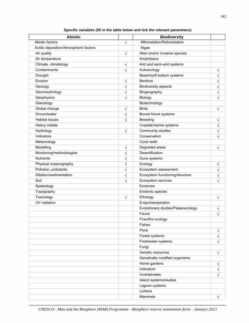
UNESCO - Man and the Biosphere (MAB) Programme - Biosphere reserve nomination form – January 2013
142
Specific variables (fill in the table below and tick the relevant parameters)
Abiotic Biodiversity Abiotic factors √ Afforestation/Reforestation Acidic deposition/Atmospheric factors Algae Air quality √ Alien and/or invasive species Air temperature Amphibians Climate, climatology √ Arid and semi-arid systems Contaminants √ Autoecology √ Drought Beach/soft bottom systems √ Erosion √ Benthos √ Geology √ Biodiversity aspects √ Geomorphology √ Biogeography √ Geophysics √ Biology √ Glaciology Biotechnology Global change √ Birds √ Groundwater √ Boreal forest systems Habitat issues √ Breeding √ Heavy metals Coastal/marine systems √ Hydrology √ Community studies √ Indicators Conservation √ Meteorology Coral reefs Modelling √ Degraded areas √ Monitoring/methodologies √ Desertification Nutrients √ Dune systems Physical oceanography √ Ecology √ Pollution, pollutants √ Ecosystem assessment √ Siltation/sedimentation √ Ecosystem functioning/structure √ Soil √ Ecosystem services √ Speleology Ecotones Topography Endemic species Toxicology √ Ethology √ UV radiation Evapotranspiration Evolutionary studies/Palaeoecology √ Fauna √ Fires/fire ecology Fishes Flora √ Forest systems √ Freshwater systems √ Fungi Genetic resources √ Genetically modified organisms Home gardens √ Indicators √ Invertebrates √ Island systems/studies Lagoon systems Lichens Mammals √

UNESCO - Man and the Biosphere (MAB) Programme - Biosphere reserve nomination form – January 2013
143
Mangrove systems Mediterranean type systems
Microorganisms √ Migrating populations Modelling √ Monitoring/methodologies √ Mountain and highland systems Natural and other resources √ Natural medicinal products Perturbations and resilience Pests/Diseases √ Phenology Phytosociology/Succession Plankton Plants √ Polar systems Pollination √ Population genetics/dynamics √ Productivity Rare/Endangered species √ Reptiles Restoration/Rehabilitation √ Species (re) introduction Species inventorying √ Sub-tropical and temperate rainforest
t
Taxonomy Temperate forest systems √ Temperate grassland systems √ Tropical dry forest systems Tropical grassland and savannah systems Tropical humid forest systems Tundra systems Vegetation studies √ Volcanic/Geothermal systems Wetland systems √ Wildlife √
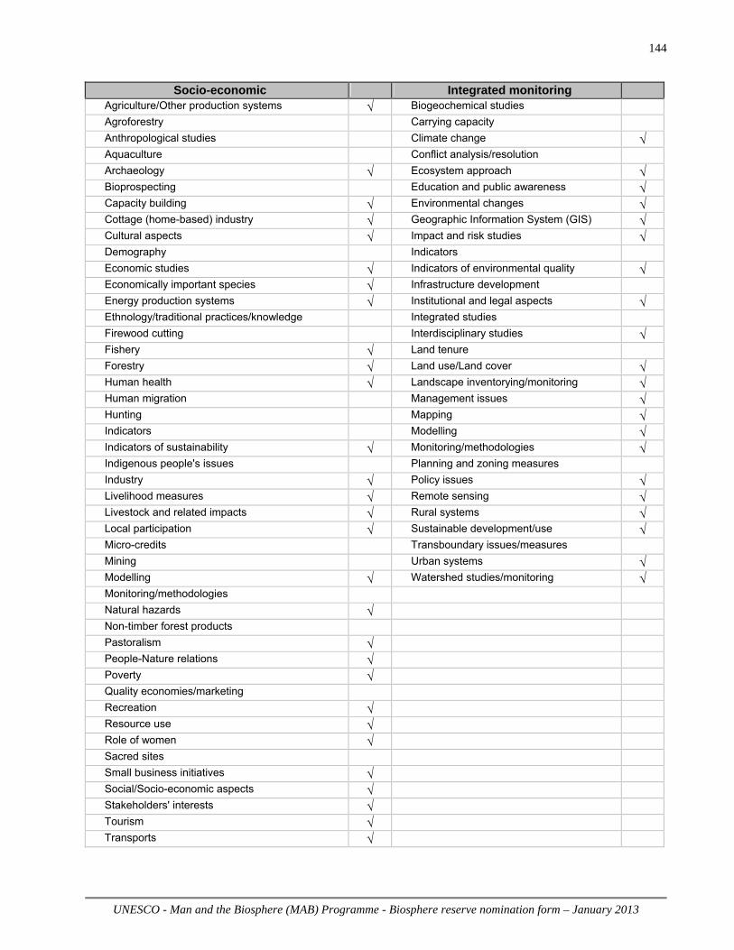
UNESCO - Man and the Biosphere (MAB) Programme - Biosphere reserve nomination form – January 2013
144
Socio-economic Integrated monitoring
Agriculture/Other production systems √ Biogeochemical studies Agroforestry Carrying capacity Anthropological studies Climate change √ Aquaculture Conflict analysis/resolution Archaeology √ Ecosystem approach √ Bioprospecting Education and public awareness √ Capacity building √ Environmental changes √ Cottage (home-based) industry √ Geographic Information System (GIS) √ Cultural aspects √ Impact and risk studies √ Demography Indicators Economic studies √ Indicators of environmental quality √ Economically important species √ Infrastructure development Energy production systems √ Institutional and legal aspects √ Ethnology/traditional practices/knowledge Integrated studies Firewood cutting Interdisciplinary studies √ Fishery √ Land tenure Forestry √ Land use/Land cover √ Human health √ Landscape inventorying/monitoring √ Human migration Management issues √ Hunting Mapping √ Indicators Modelling √ Indicators of sustainability √ Monitoring/methodologies √ Indigenous people's issues Planning and zoning measures Industry √ Policy issues √ Livelihood measures √ Remote sensing √ Livestock and related impacts √ Rural systems √ Local participation √ Sustainable development/use √ Micro-credits Transboundary issues/measures Mining Urban systems √ Modelling √ Watershed studies/monitoring √ Monitoring/methodologies
Natural hazards √
Non-timber forest products
Pastoralism √
People-Nature relations √
Poverty √
Quality economies/marketing
Recreation √
Resource use √
Role of women √
Sacred sites
Small business initiatives √
Social/Socio-economic aspects √
Stakeholders' interests √
Tourism √
Transports √

UNESCO - Man and the Biosphere (MAB) Programme - Biosphere reserve nomination form – January 2013
145
Annex II to the Biosphere Reserve Nomination Form, January 2013
Promotion and Communication Materials
For the Proposed Biosphere Reserve
Provide some promotional material regarding the proposed site, notably high quality photos, and/or short videos on the site so as to allow the Secretariat to prepare appropriate files for press events. To this end, a selection of photographs in high resolution (300 dpi), with photo credits and captions and video footage (rushes), without any comments or sub-titles, of professional quality – DV CAM or BETA only, will be needed. In addition, return a signed copy of the following Agreement on Non-Exclusive Rights. A maximum of ten (10) minutes on each biosphere reserve will then be assembled in the audiovisual section of UNESCO and the final product, called a B-roll, will be sent to the press.

UNESCO - Man and the Biosphere (MAB) Programme - Biosphere reserve nomination form – January 2013
146
UNESCO Photo Library Bureau of Public Information
Photothèque de l’UNESCO Bureau de l’Information du Public
AGREEMENT GRANTING NON-EXCLUSIVE RIGHTS
Reference: (photo file names & numbers)
Coast – DSCs 0082, 1717, 2601, 2654, 7822, 7824, 7830, 8618, 8626, 8645, 8659, 8666, 8706, 8891; Photos 0118, 0120 Rural – DSCs 4810, 4823, 4925, 5755, 5780, 5833, 5866, 5868, 5886, 7717, 8444, 8454, 8650, 8655, 8896, 8916, 8920, 8921, 8926; ‘Early Spider Orchid’ Urban – DSCs 0242, 7721, 7805, 7859, 7866, 7868, 8364 1. a) I the undersigned, copyright-holder of the above mentioned photo(s) hereby grant to
UNESCO free of charge the non-exclusive right to exploit, publish, reproduce, diffuse, communicate to the public in any form and on any support, including digital, all or part of the photograph(s) and to licence these rights to third parties on the basis of the rights herein vested in UNESCO
b) These rights are granted to UNESCO for the legal term of copyright throughout the world.
c) The name of the photographer will be cited alongside UNESCO’s whenever his/her work is used in any form.
2. I certify that:
a) I am the sole copyright holder of the photo(s) and am the owner of the rights granted by virtue of this agreement and other rights conferred to me by national legislation and pertinent international conventions on copyright and that I have full rights to enter into this agreement.
b) The photo(s) is/are in no way whatever a violation or an infringement of any existing copyright or licence, and contain(s) nothing obscene, libellous or defamatory.
Name and Address: Rich Howorth – c/o Brighton & Hove City Council, Brighton BN1 7GA Date: 19th September 2013
Signature :
(sign, return to UNESCO two copies of the Agreement and retain the original for yourself) ________________________________________________________________________________________ Mailing address: 7 Place Fontenoy, 75352 Paris 07 SP, Direct Telephone: 00331 – 45681687 Direct Fax: 00331 – 45685655; e-mail: [email protected]; [email protected]