Embed Size (px)
Citation preview
B R I G H A M Y O U N G U N I V E R S I T Y
G E O L O G I C A L S O C I E T Y O F A M E R I C A
F I E L D T R I P G U I D E B O O K
1 9 9 7 A N N U A L M E E T I N G S A L T L A K E C I T Y , U T A H
E D I T E D B Y P A U L K A R L L I N K A N D B A R T J . K O W A L L I S
V O I U M E 4 2 I 9 9 7
P A R '
PROTEROZOIC TO RECENT STRATIGRAPHY, TECTONICS, AND VOLCANOLOGY, UTAH, NEVADA,
SOUTHERN IDAHO AND CENTRAL MEXICO Edited by
Paul Karl Link and Bart J. Kowallis
BRIGHAM YOUNG UNIVERSITY GEOLOGY STUDIES
Volume 42, Part I, 1997
CONTENTS
Neoproterozoic Sedimentation and Tectonics in West-Central Utah . . . . . . . . . . . . . . . . . . Nicholas Christie-Blick 1
Proterozoic Tidal, Glacial, and Fluvial Sedimentation in Big Cottonwood Canyon, Utah . . . . . . . . Todd A. Ehlers, Marjorie A. Chan, and Paul Karl Link 31
Sequence Stratigraphy and Paleoecology of the Middle Cambrian Spence Shale in Northern Utah and Southern Idaho . . . . . . . . . . . . . . . W. David Liddell, Scott H. Wright, and Carlton E. Brett 59
Late Ordovician Mass Extinction: Sedimentologic, Cyclostratigraphic, and Biostratigraphic Records from Platform and Basin Successions, Central Nevada . . . . . . . . . . . . Stan C. Finney,
John D. Cooper, and William B. N. Beny 79
Carbonate Sequences and Fossil Communities from the Upper Ordovician-Lower Silurian of the Eastern Great Basin . . . . . . . . . . . . . . . . . . . . . . . . . . . . . . Mark T. Harris and Peter M. Sheehan 105
Late Devonian Alamo Impact Event, Global Kellwasser Events, and Major Eustatic Events, Eastern Great Basin, Nevada and Utah . . . . . . . . . . . . . . . . . . . . . . . . . . Charles A. Sandberg,
Jared R. Morrow and John E. Warme 129
Overview of Mississippian Depositional and Paleotectonic History of the Antler Foreland, Eastern Nevada and Western Utah . . . . . . . . . . . . . . . . . . . . . . . . . . . . . . . . . . . . . . . . . N. J. Silberling,
K. M. Nichols, J. H. Trexler, Jr., E W. Jewel1 and R. A. Crosbie 161
Triassic- Jurassic Tectonism and Magmatism in the Mesozoic Continental Arc of Nevada: Classic Relations and New Developments . . . . . . . . . . . . . . . . . . . . . . . . . . S. J. Wyld, and J. E. Wright 197
Grand Tour of the Ruby-East Humboldt Metamorphic Core Complex, Northeastern Nevada: Part 1 - Introduction & Road Log . . . . . . . . . . . . . . . . . . . . . . . . . . . . . . . . Arthur W. Snoke, Keith A. Howard,
Allen J. McGrew, Bradford R. Burton, Calvin G. Barnes, Mark T. Peters, and James E. Wright 225
Part 2: Petrogenesis and thermal evolution of deep continental crust: the record from the East Humboldt Range, Nevada . . . . . . . . . . . . . . . . . . . . . . . . . Allen J. McGrew and Mark T. Peters 270
Part 3: Geology and petrology of Cretaceous and Tertiary granitic rocks, Lamoille Canyon, Ruby Mountains, Nevada . . . . . . . . . . . . . . . . . . . . . . . . . . . . . . Sang-yun Lee and Calvin G. Barnes
Part 4: Geology and geochemistry of the Hanison Pass pluton, central Ruby Mountains, Nevada . . . . . . . . . . . Bradford R. Burton, Calvin G. Barnes, Trina Burling and James E. Wright
Hinterland to Foreland Transect through the Sevier Orogen, Northeast Nevada to North Central Utah: Structural Style, Metamorphism, and Kinematic History of a Large Contractional Orogenic Wedge . . . . . . . . . . . . . . . . . . . . . . . . . Phyllis Camilleri, W. Adolph Yonkee,
Jim Coogan, Peter DeCelles, Allen McGrew, Michael Wells
Part 2: The Architecture of the Sevier Hinterland: A Crustal Transect through the Pequop Mountains, Wood Hills, and East Humboldt Range, Nevada . . . . . . . . . . . . . . . Phyllis Camilleri
and Allen McGrew
Part 3: Large-Magnitude Crustal Thickening and Repeated Extensional Exhumation in the Raft River, Grouse Creek and Albion Mountains . . . . . . . . . . . . . . . . . . Michael L. Wells,
Thomas D. Hoisch, Lori M. Hanson, Evan D. Wolff, and James R. Struthers
Part 4: Kinematics and Mechanics of the Willard Thrust Sheet, Central Part of the Sevier Orogenic Wedge, North-central Utah . . . . . . . . . . . . . . . . . . . . . . . . . . . . . . . . . . . . . . W. A. Yonkee
Part 5: Kinematics and Synorogenic Sedimentation of the Eastern Frontal Part of the Sevier Orogenic Wedge, Northern Utah . . . . . . . . . . . . . . . . W. A. Yonkee, F! G. DeCelles and J. Coogan
Bimodal Basalt-Rhyolite Magmatism in the Central and Western Snake River Plain, Idaho and Oregon . . . . . . . . . . . . . . . . . . . . . . . . . . . . . . . . . . . . . Mike McCurry, Bill Bonnichsen, Craig White,
Martha M. Godchaux, and Scott S. Hughes
Bimodal, Magmatism, Basaltic Volcanic Styles, Tectonics, and Geomorphic Processes of the Eastern Snake River Plain, Idaho . . . . . . . . . . . . . . . . . . . . Scott S. Hughes, Richard l? Smith,
William R. Hackett, Michael McCuny, Steve R. Anderson, and Gregory C. Ferdock
High, Old, Pluvial Lakes of Western Nevada . . . . . . . . . . . . . . . . . . . . . . . . . . Marith Reheis, and Roger Momson
Late Pleistocene-Holocene Cataclysmic Eruptions at Nevado de Toluca and . . . . . . . . . . . . . . . . . . . . . . . . . . . . . . Jocotitlan Volcanoes, Central Mexico J. L. Macias, F! A. Garcia, J. L. Arce,
C. Siebe, J. M. Espindola, J. C. Komorowski, and K. Scott
Triassic- Jurassic Tectonism and Magmatism in the Mesozoic Continental Arc of Nevada: Classic Relations
and New Developments
S. J. WYLD Department of Geology, University of Georgia, Athens, Georgia 30602
J.E. WRIGHT Department of Geology and Geophysics, Rice University, Houston, Texas 77005
ABSTRACT
This field trip will focus on the early Mesozoic structural and magmatic evolution of the Black Rock Desert region of northwest Nevada, which forms part of the Mesozoic magmatic arc assemblages of the western U.S. Cordillera, and on deformed back-arc basinal strata of the Luning-Fencemaker fold-and-thrust belt, located east of the Black Rock Desert. The principal goals of this trip are as follows. (1) To demonstrate that the major- ity of early Mesozoic magmatic rocks of the Black Rock Desert region are of Late Triassic to Early Jurassic age-this contrasts with other arc assemblages of the Cordillera where the most voluminous early Mesozoic magmatism occurred in the Middle to Late Jurassic. (2) To demonstrate that Mesozoic shortening deformation in the Black Rock Desert is primarily of Early Jurassic age and that there is little evidence for shortening in the Middle to Late Jurassic-this contrasts with other arc assemblages of the Cordillera where major Mesozoic shortening occurred in the Middle to Late Jurassic. (3) To examine the nature of Jurassic deforma- tion in the Black Rock Desert, which involved development of a large-scale ductile thrust zone at shallow mid-crustal levels (-8-10 km depth). This ductile thrust and its less deformed upper plate are well-exposed in the western Black Rock Desert. (4) To examine structures in the back-arc Luning-Fencemaker fold-and- thrust belt, and investigate the possibility that much of the deformation in these rocks may be coeval with Early Jurassic shortening in the Black Rock Desert arc province, rather than Middle to Late Jurassic as has been generally inferred in previous studies. (5) To explore the implications of these relations for the Mesozoic tectonic evolution of the western U.S. Cordillera.
INTRODUCTION continent. These "western arc assemblages" (Fig. 1) are entirely marine and are typically associated with subduc-
Early Mesozoic magmatic arc assemblages in the west- tion complex assemblages and ophiolite sequences, imply- ern U.S. Cordillera record events along an active plate ing development in an oceanic environment. They may be margin that developed following accretion of Paleozoic arc the continuation of the continental arc or they krranes to the continent during the Permo-Triassic may be allochthonous. The continental arc assemblages, Sonoma OrogenY. Traditionally, these arc assemblages can because of their undisputed origin on the continental mar- be divided into two groups (e.g., Schweickert, 1978; Saleeby gin, represent a source of infomation about events and Busby-Spera, 1992). (1) Arc assemblages with base- affecting the margin during the early Mesozoic. Only when ment or stratigraphic ties to the continent. These "continen- these continental margin events are fully can tal arc assemblages'' (Fig. 1) clearly developed on the North the evolution of the western arc assemblages be confidentlv .., American plate above an east-dipping subduction zone. linked to the continent. They vary from subaerial to marine and were built on con- Until recently, most of the work on the continental arc tinental crust to the south (southern California and Arizona) assemblages has been in the Klamath Mountains, Sierra and accreted Paleozoic terranes to the north. (2) Arc assem- Nevada, southeastern California and southwestern Arizona, blages without clear basement or stratigraphic ties to the while comparatively less was known about the Black Rock

EARLY MESOZOIC (TRIASSIC AND JURASSIC)
MAGMATIC ARC AND BACK-ARC RELATED ROCKS BASlNAL STRATA
WESTERN ARC (BASINAL TERRANE) ASSEMBLAGES
CONTINENTAL ARC $$iflit ASSEMBLAGES
LUE MTN, ROVINCE
province ]nay thus provide insight into the tlevelopr~ielit of the 1)ack-arc fold-and-thrust l d t . Finally, rcceirt studic>s ill the, Bldck Rock I)c,sert clenlonstrate that it rxprriencctl '1
suI)stantially ciiffihrer-tt early 3leso~oic magniatic ,incl stn~c- tuml history fi.oni other continc~ntal arc :tssenll)lagcs to the mest and the soutl~; specifically, carly hleso~oic shortening tlefornlation ~tnd volnminol~s rt~agrnatism occrlrrrd tens of millions of years carlier 111 thc Ulcxck Rock Ilcsert than iii othc~r arc provinctls. This suggests a 1nore cornplex tectonic cvitlut~oti for the carly hleso~olc contt~lental margtn tl1an has previously bcen rchcogrtizcd, as exp1;dncd fi~rther bclo\v.
Olt this field trip, we will exa~riinc ~tratigr~tl~liic, structur- al arsd magmatic relations in the Black Rock Destlrt and atlj:~cc>nt basinid ttm-are. Our god5 ,trc su\eral. (1) 'li) \isit classic euposures of the earl4. kfcso~oic rrlagrrlatic arc arrcl its Paleozoic basctnerlt in the Black Rock llescrt. (2) To exam- ine the effects of Meso~oic shortening cleforrrintion oti this arc assenlblagc, which included development of a large- scale tluctile shear zone at shallow mid-crustal levels. 13) 'Ti,
cfernonstvate that the tiltlirig of early Mesozoic shorteni~rg ancl voluminous arc magnlatism in the Black Rock Desert is diEt,rcnt fro111 that of the Klilarnath hlouritairrs-to-Ari~o~~it portion of the continf~ntal itre, ;mtl to explorc possible rea- sons fi)r this disparity (4) To cx;unine part of'thc tfefonnetl I>asinal strata of the I,~l~~ir-tg-Ferict~~~litke~r fold-and-thnls t lwlt, and consider how defi)imation in these rocks ma? h c ~ lirlkrti with defonnntion in the Black Rock Desert,
REGIONAL, GEO1,OCIC FRAY1 EIVORK
Studies in cor~ti~icntal ;Ire itssernblages of the Klartlatlr 32"N + Monrrklins, Sierra Nevada, west-centval Nevada, southeast
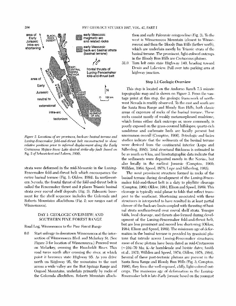
Citlifc)rnia and soutl-iwest Ari~ona stlpport the following Figlrrc I . Afop of t~estet71 CIS. (:ordillcra ~hozciitg di.stt.i!~rltion of illterprctatiOllS al,Out intra-arc tectonism cl,lring edy M ~ ~ ~ ) - ecir-ly Mc>sozoic urc u td hock-cm husin ossetttbl~~ge.s, fioritcll thrwst.~ zoic time. (1) Arc magmatis111 and sedimentation during the o f Lti,lit?g-F(z:c.ncon(iker $)l<l-iirtd-t17rt~st hclt (LITB, Olrlorc, 19841,
Triassic to Early Jurassic occltrred irr either a tectonically citrtl 12kjrrt.r-Srtozo Loke rlextrul strike-?lip filult (JiSLfi, solirl line lchor. .rc.l,/l /oc'c,tfz(l, rhs),czi/ /irLr tLJ,ere irL#&l-rc.rl. Schtceicki,rt cLIKl netltrd (ex~erieilc'~1lg lieither \l-t(?rtening or (axtellsioa) or
Lahretz. 1990). actively extertsiond environment (e.g., Busby-Spera, 1988).
Ilt.sert segrrrcttt of the contincmtal arc ill northwest Nevacfa (Fig. 1). Thts area is all important source of infortrzation, homevel; ahont events ,tffecting the active continental margill. First, it contains well-exposed arid extensivt. sec- tions of hiltlso*oie arc rocks artd P;tleozoic arc basexnetit, collectively spanning over 200 m.y. of geologic history, frortl the ~tlitl-Paleo~oic to the mi~f-Crc~t~~ceous (fittlcr and IVardlau, 1!lX1; Russcll, 1984. SIahtr; 1989; L1;\.1d, 1990; Qrris~n, 1996). Secol~ci, it is directly ;ic+j;tcent to a 1t;lck-arc marine province (see husinal terraut. in Fig. 1) tl1;it was the site of rnalor shortening deforination in the Jurassic ( l ,ur l ing-f ; i .acc~kr ii)lcl-and-tllrust 1)elt; Speed, 1978; Oldo\v, 1984). The evolution of thrb Black Rock 1)esert
This conclusion is hased on the preset? ation, \I ithiti thcsc areas, of co~itinrto~ts Triassic to Lx)vver Jlirassic stratigral)hic scctionr with 110 c\~idencc for coeval shortenirrg deformd- tion, iir~cl, locally, on direct strtlctt~ral or stratigraphic t ~ i - cfence for extension (Sariborn, 1960, Bushy-Spera, 1988, Hawood, 1992; Saleeby and Busby-Spera, 1992; Wyld arid Wright, 1993). (2) Zntra-arc shorteni~rg cleforrnation was w~iclespread clriring the Micldlc to Late Jur;irsic, affecting dl tlle areas listed above e\cthgt sttutheasternt~iost California atlcl sorlthwcst Arizona where c.xtcnsion continued (I-larper arrtl Wright, 1984; Oldow, 198'4; Sltdrp, 1988; IL7riglrt trod I",lh;tn, 1988; Walker et al , 1990; Sdeeby '~nti Busby-Spcra, 19'32; Smith ct al., 1993). Tliis c~ntract ion~~l defornt, '1 t' 1011
occurred, depelrcling oil specific locality, sortietime tlurir~g the interval 170-150 %la arid cv'ts accor~iparrirti 1)y \olttrrti-
WYLD AND WRIGHT: TRIASSIC-JURASSIC TECTONISM & MAGMATISM, NEVADA 199
nous arc magmatism. How this intra-arc deformation relates to events farther inland is somewhat less clear. Deforma- tion of the early Mesozoic back-arc basin succession of central Nevada in the Luning-Fencemaker fold-and-thrust belt is interpreted to be coeval with Middle to Late Jurassic shortening to the west (Oldow, 1984; Speed et al., 1988); however, the timing of deformation in the fold-and-thrust belt is not tightly constrained and correlations with events to the west are thus uncertain.
New data from the Black Rock Desert (summarized here and discussed in detail in later sections) are at odds with relations farther west and south within the arc assemblages and require reinterpretation of events affecting the active Cordilleran margin in the early Mesozoic; these new data also suggest alternative interpretations of the deformation- a1 record within the back-arc region (Wyld et al., 1996). First, the principal Jurassic shortening deformation in the Black Rock Desert occurred in the Early Jurassic at -200 Ma, and there is no clear evidence for any significant deformation in this area during the Middle to Late Jurassic (Quinn, 1996; Wyld, 1996; Wyld et al., 1996). Thus, the Black Rock Desert segment of the continental arc experi- enced major shortening deformation some 30-50 m.y. ear- lier than shortening in arc assemblages to the west and south. Furthermore, shortening deformation in the Black Rock Desert occurred at the same time that arc assem- blages to the west and south were either extensional or tectonically neutral. Second, the principal period of volu- minous Jurassic arc magmatism in the Black Rock Desert occurred in the Early Jurassic, whereas there is only limited evidence of Middle to Late Jurassic arc magmatism (Wyld, 1991a, 1996; Quinn et al., 1997).
These differences led Wyld et al. (1996) to conclude that the Black Rock Desert and other arc assemblages did not evolve together in the Jurassic in the same spatial arrange- ment in which they are now organized. Building on the work of Schweickert and Lahren (1990, 1993) who argued that a Cretaceous strike-slip fault with -450 km of right- lateral displacement is located within eastern California (Mojave-Snow Lake fault) and that this fault or related structures may have continued northward between the Black Rock Desert and Klamath Mountains (Fig. l), Wyld et al. (1996) concluded that the Black h c k Desert proba- bly lay entirely north of the Klamath Mountains and more southerly arc assemblages during the Jurassic (Fig. 2). Differences in the Jurassic structural and magmatic evolu- tion between the Black Rock Desert segment of the conti- nental arc and the Klamath Mountains-to-Arizona segments can thus be viewed as reflecting north to south variations in events or processes affecting the active plate margin in the Jurassic. Two possible explanations were advanced by Wyld et al. (1996). (1) The Early Jurassic plate margin was curved. Given an appropriate relative-convergence vector
between the North American plate and the subducting oceanic plate, this curvature could result in a large orthog- onal component of convergence in the vicinity of the Black Rock Desert, which would promote shortening deforma- tion in the upper plate, but a larger transverse component to the south, which would promote strike-slip faulting in the upper plate and could account for a record of neutral to ex- tensional tectonism. (2) Restricted collision of an island arc or some other crustal mass occurred along the northern part of the plate boundary (in the vicinity of the Black Rock Desert) but did not affect the plate margin farther to the south. One intriguing aspect of this reconstruction is that the Luning-Fencemaker fold-and-thrust belt occupies a back-arc position relative to the Black Rock Desert seg- ment of the continental arc, but lies mostly north of the other arc assemblages (Fig. 2). Because shortening defor- mation in the Black Rock Desert occurred in the Early Jurassic, this reconstructed spatial arrangement suggests that Luning-Fencemaker deformation may in part be Early Jurassic, rather than Middle to Late Jurassic as is generally inferred.
GEOLOGY OF NORTHWEST NEVADA AND THE BLACK ROCK DESERT
The geology of northwest Nevada is shown in Figure 3. This area is located near the western margin of the Basin and Range province. The Black Rock Desert area includes three mountain ranges: the Pine Forest Range, the Bilk Creek Mountains and the Jackson Mountains (Fig. 3). Paleo- zoic and Mesozoic rocks of magmatic arc affinity are exposed in all three ranges (Ketner and Wardlaw, 1981; Russell, 1984; Jones, 1990; Wyld, 1990; Quinn, 1996). Paleozoic strata, a combination of sedimentary and less common vol- canic rocks, range in age from Late Devonian(?) or Missis- sippian to Permian. Mesozoic strata are mostly of latest Triassic to Early Jurassic age and are dominated by mafic to intermediate, subduction-related volcanogenic rocks; however, some older Triassic and some Lower Cretaceous strata, mostly sedimentary, are locally present. Numerous Mesozoic plutons, mostly of Jurassic and Cretaceous age but also including some that are Triassic, intrude the Paleo- zoic and Mesozoic strata (Fig. 3); these intrusions attest to the generally intra-arc position of the Black Rock Desert during the entire Mesozoic.
East and south of the Black Rock Desert are a number of ranges that are underlain in part by thick successions of Triassic sedimentary strata (Triassic basinal strata; Fig. 3). These strata, which were deposited in a deep marine back- arc basin, consist mostly of mudstone with lesser amounts of intercalated quartz sandstone and carbonate, and consti- tute part of the basinal terrane shown in Figures 1 and 2 (Speed, 1978; Lupe and Silberling, 1985). Basind terrane
200 BYU GEOLOGY STUDlE S 1997, VOI,. 42, PART I
and related rocks
L frontal thrusts of Luning-Fencemaker fold-and-thrust belt
0 IOOkm u
Figure 2. Locutiorls of arc pro~inces, back-arc l~~~sirzal b m n e and Ltming-Fencenzakw fill-cmrl-thrust belt reconstrtrcted to sAotu relutioe positio?zs prior to irlfe~red displacement along Ae Early Cretaceous Mqjaoe-Snow Lake cle.xtral strike-slip jkult @used on Fig. 2 qf Sclzwc~ickert am1 Lahren, 1990).
strata were deformed in the mid-Mesozoic in the Luning- Fencemaker fold-and-thrust belt which ellcornpasses the entire basinal terrane (Fig. 1; Oldow, 1984). In northwest- ern Nevada, the frontal thrust of dte fold-and-thrt~st belt is called the Fci~cetnaker thrust and it places X-iassic hasinal strata over coeval shelf deposits (Fig. 3). Paleozoic base- ment for the shelf sequence includes the Golconda and Roberts Mountains allochthons (Fig. 2; see ranges east of Cvirtnemucca).
DAY 1: GEOLOGIC OVERVIEW; AND SOUTHERN PINE FOREST RANGE
Road Log, Winuen~tlcca to the Pine Forest Range
0.0 Start mileage in downtown Winnemucca at the inter- section of Winnemucca Blvd. and Melarkey St. (See Figure 3 for location of Wirinemucca.) Proceed west on Melarkey, crossing the I3umboldt River. This road turns north after crossing the river, at which point it hecornes state Itighway 95. As you drive north on Highway 95, the mountains to the cast across a wide valley are the Elot Springs Range and Osgood Mountains, underlain primarily by rocks of the Golconda allochthon, Roherts Mountain alloch-
thon and early Paleozoic miogeocline (Fig. 3). To the west is Winnemucca Mountain (closest to Winrte- mucca) and then the Bloody Run Hills (farther north), whicli are underlain mostly by Triassic strata of the 1)asinal terrane. The prominent, light-caolorecl outcrops in the Bloody Run llills are Cretaceous plutons.
31.0 Tiirrt left onto state Ilighway 140, heading toward Denio and Lakeview. Pull over into parking area at highway junction.
Stop 1.1 Geologic Overview
This stop is located on the Anclo~no Ranch 7.5 ntinutc topographic map and is shown on Figure 3. From the van- tage point at this stop, the geologic frainework of north- west Nevada is readily observed. To the east and south are the Santa Rosa Range artd Bloody Run flills, both classic areas of exposure of rocks of the basinal terrane. Thtai~ rocks consist rnostly of \vlvrakly metainorpllosed muc~stonc, which forms either dark outcrops or, more commonly, is poorly exposed on the grass-covered hillslopes; quartz-rich sandstone and carbonate beds are locally present 11ut lincolrnnon overall (Compton, 1960). Petrologic and facie\ studies indicate that the sediments of t l~u basinal terrane were derived from the continent:il interior (Lupe anct Silberling, 1985). X~tal structural thickness is estimated to be as much as 6 km, arid biostratigraphic data indicate that the sediments were deposited n~ostly in the Norian, ?>tit also locally in the earliest Jurassic (Compton, 1960: Willden, 1964; Speed, 1978; Lupe and Silbarling, 1985).
The nzost prominent structure formed in rocks of the basinal tei~arie during development of the Luning-Fence- maker fold-and-thrust belt is a slaty to phyllitic cleavage (Compton, 1960; Olclow, 198.1; Elison and Speed, 1989). This cleavage is typically axial planar to folds that reflect trans- port to the southeast. Shortening associated with theie structul-es is interpreted to have resulted in at least partial closure of the back-arc basin cortpled wit11 thrusting of basi- nal strata southeastward over coeval shelf strata. Younger folds, local cleavage, and tlirusts also fbrrtird cluring devel- opment of the Luning-Fencemaker fold-and-thrust belt, but are less prominent and record less shortening (Olclowv, 1984; Elison and Speed, 1989). The minirnurn age of dcfor- mation in the basinal teirane is provided 1)y granitoid plu- tons that intrude across Luning-E'encentaker structures; some of these plutons have been dated as mid-Cretaceous (-104-70 Ma; K-Ar hornblende and biotite dates; Smith et al., 1971; IVillden and Speed, 1974; Oltlow, 1978, 1984). Several of these post-tectonic plr~tons are present in tlie Sanki Rosa Range and Bloody Run Hills (Fig. 3; Contpton, 1960), they form the well-txposed, cliffy, light-colored out- crops. The n~axin~um age of deformation in the Luning- Fenc>errlaker belt is late-Early Jurassic based on the youngest
WYLD AND WRIGHT TRIASSIC-JURASSIC TECTONISM & MAGMATISM, NEVADA 201
EARLY MESOZOIC GEOLOGIC PROVINCES
- CENBZOIC 42'
Quaternary strata
Tertiary strata
MESOZOIC
plutons
Q :.:.:.:. arc strata and related hypabyssal intrusions
# Triassic basinal strata
Triassic shelf strata
PALEOZOIC
arc and related strata
Golconda allochthon
Roberts Mtns. allochthon
miogeocline strata -
41° b- - ' early Mesozoic
Fencemaker thrust (dashed where covered)
.3.3 location of field Mp stop and stop number
I - 0 l o 20 30 40 km m g m t i ~ ,f - basinal termne 2- continental shelf end Paleozoic basement arc * 0
Figure 3. Location and summary geology m a p of northwest Nevada.
age (Toarcian) of basinal terrane rocks deformed in the fold-and-thrust belt (Speed, 1974, 1978).
To the west are low hills and ranges underlain by Tertiary strata (Double H Mountains) and more strata of the basinal tetrane (Slumbering Hills). Farther west are the high ranges of the Black Rock Desert. Little work has been done on the Cenozoic extensional history of this part of the Basin and Range province, but it appears to be an area of rela- tively low-magnitude extension: Tertiary strata are still widely exposed in the ranges and some ranges have not been uplifted sufficiently to expose any older rocks (Fig. 3); multiple episodes of Cenozoic normal faulting and rotated normal faults have not been recognized; and metamorphic core complexes are not present.
Proceed west on Highway 140. At mile 57.6, the highway crosses the Quinn River. To the north are the Bilk Creek Mountains, at the southern tip of which is a very small but classic locality for upper Paleozoic and lower Mesozoic
strata of magmatic arc &nity (Quinn River Crossing; Ketner and Wardlaw, 1981). 71.8 Turn left onto the Big Creek Ranch road (gravel);
this junction is marked by a sign for a "Photo Gallery" on the west side of the road and several large mailboxes on the east side.
75.5 Stop at cattleguard.
Stop 1.2: Overview of Pine Forest Range
This stop is located on the Dyke Canyon 7.5 minute topographic map and shown in Figure 4.
Paleozoic and Mesozoic Stratigraphy
The most complete section of Paleozoic and Mesozoic strata in the Black Rock Desert is in the east-central Pine Forest Range (Fig. 4). Pre-Cenozoic strata in this area com- prise a thick (-9 km) succession that ranges in age from
202 BYU GEOLOGY STUDIES 1997, VOL. 42, PART I
UPPER PALEOZOIC SEDIMENTARY UNIT
BUCKAROO TUFF and WOODWARD LIMESTONE
sides of normal
SHORT CREEK
PLUTONIC ROCKS
DUFFERPEAK < trend and plunge of Jurassic lineation
\ strike and dip direction of Cretaceous foliation
WYLD AND WRIGHT: TRIASSIC-JURASSIC TECTONISM & MAGMATISM, NEVADA 203
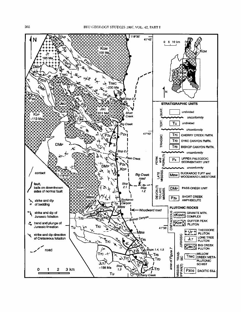
Devonian(?) or Mississippian to latest Triassic (Fig. 5). In describing this stratigraphy, two features are important to emphasize. First, older units are progressively more de- formed and metamorphosed than younger units (Wyld, 1996), and therefore older units are described as metamor- phic rocks; the origin of this feature is explained below. Second, the section has been tilted southward and is now exposed in broadly cross-sectional view with units young- ing consistently toward the south (Fig. 4; Wyld, 1990). As will be explained below, this tilting most likely occurred in the Cretaceous and/or Cenozoic.
The Paleozoic and Triassic stratigraphy of the east-cen- tral Pine Forest Range has been described in detail in Wyld (1990, 1991a, 1991b) and is summarized here and in Figure 5. Paleozoic strata consist largely of sedimentary rocks, although two pulses of volcanism are represented by the mafic Short Creek amphibolite and the felsic Buckaroo tuff. Deep marine conditions of deposition characterize the older part of the section, but shallow marine conditions predominated in the Late Mississippian and Permian. Apparently all of the Pennsylvanian and possibly the early part of the Permian are missing across a low-angle uncon- formity (Fig. 5). Another low-angle unconformity separates Permian and Middle(?) to Late Triassic strata (Fig. 5). Triassic strata record subsidence of the arc to relatively deep marine depths and the onset of early Mesozoic arc magma- tism (Wyld, 1990, 1991a). Older Triassic rocks (Ladinian or Carnian to early Norian) include abundant carbonates and siliciclastic strata (Bishop Canyon formation), and these were succeeded during the remainder of the Norian by basaltic to andesitic lavas and volcaniclastic strata (Dyke Canyon and Cheny Creek formations) which accumulated to a thickness of about 3 krn (Fig. 5).
The ages of the upper Mississippian to uppermost Triassic units described above are well defined by either paleonto- logic or radiometric age data (Fig. 5; Wyld, 1990, 1991a). The ages of the two oldest units, the Pass Creek unit and the Short Creek amphibolite, are defined in part on less direct evidence, listed as follows. (1) Fossils from the top of the Pass Creek unit are Late Mississippian (Wyld, 1990). (2) Late Devonian (resedimented) radiolaria are present in
Figure 4. Geologic map of the east-central Pine Forest Range (out- lined area in inset map) and locations offield trip stops 1.2-2.3. Inset m a p shows entire Pine Forest Range (see Fig. 3 for location of Pine Forest Range). Patterns in inset map as follows: dark shad- ing is Paleozoic strata and Triassic plutons, light shading is Meso- zoic strata, white is Tertiary strata; cross pattern is Jurassic plutons, diagonal line pattern is Cretaceow plutons. Ages of plutons are from U-Pb zircon analyses (see text).
chert clasts in strata of the Bilk Creek Mountains (Fig. 2) that are lithologically identical to the Pass Creek unit (Jones, 1990; Wyld, 1990). (3) In situ Late Devonian to Early Carboniferous radiolaria have been found in strata of the Jackson Mountains that are lithologically identical to the Pass Creek unit (Fig. 2; Russell, 1981; Quinn, 1996). Based on these three relations, the Pass Creek unit is interpreted to be of Late Devonian(?) to Late Mississippian age. (4) The Short Creek amphibolite is in gradational con- tact beneath the Pass Creek unit. (5) The Short Creek amphibolite is intruded by a dacitic dike (Mississippian[?] dacitic sill unit in Fig. 4) that is very similar in composition to the distinctive Buckaroo tuff which has yielded a -327 Ma (Late Mississippian) U-Pb zircon age (Wyld, 1991a). Collectively, these relations indicate that the Short Creek amphibolite is no younger than Late Mississippian and suggest that it is probably Devonian.
Wyld (1990) suggested that intensely deformed quartzo- feldspathic and mafic schists located north of the Short Creek amphibolite were derived from arkosic sedimentary and mafic volcanogenic protoliths that were possibly broad- ly correlative with lower Paleozoic rocks in the Sierra Nevada and Klamath Mountains. These rocks, which were given the names Paleozoic(?) quartzo-feldspathic schist by Wyld (1990) and Willow Creek schist by Wyld (1996), have thus previously been interpreted to constitute the oldest exposed unit within the stratigraphic succession. Recent work has shown, however, that at least part of this map unit is a deformed and metamorphosed Middle Triassic pluton because a sample of typical quartzo-feldspathic schist yielded a morphologically homogeneous population of eu- hedral zircons, 11 of which gave Middle Triassic (-230 Ma) single-crystal U-Pb dates (B. Darby and G. Gehrels, personal communication, 1997). How much of this unit is plutonic remains uncertain at present; it appears likely, how- ever, that a mixture of highly strained pluton and highly strained wall rock selvages are present. The Willow Creek schist is thus redefined here to include only those quartzo- feldspathic schists that are believed to be deformed plu- tonic rock, whereas areas underlain primarily by mafic schists are tentatively correlated with the Short Creek amphibolite (see map units labeled Pzs[?] in Fig. 4).
Mesozoic Magmatism
Magmatic rocks of Triassic, Jurassic and Cretaceous age are widespread in the Pine Forest Range. Triassic magrna- tism in the Pine Forest Range apparently occurred in two pulses. The first is represented by plutons and stocks in the northern and east-central parts of the range that have been dated as Middle Triassic (-230-235 Ma; U-Pb zircon ages), including the Willow Creek schist (Wyld, 1991a; Wright and Wyld, unpublished data; B. Darby and G.
204 BYU GEOLOGY STUDIES 1997, VOL. 42, PART I
Cherry Creek formation
Dyke Canyon formation
Bishop Canyon formation
upper Pz sedim. unit
mudstone dacitic tuff
limestone andesitic
siliciclastic basaltic lava flows
Buckaroo tuff Woodward limestone
Pass Creek unit
Short Creek amphibolite
volcaniclastic F: fossil age . v:v: rocks R: radiometric age
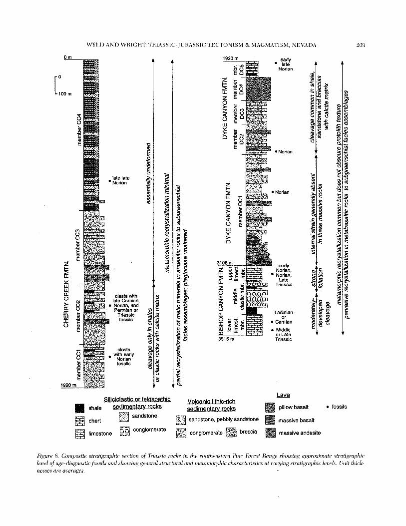
Figure 5. Paleozoic and Mesozoic stratigraphy of the east-central Pine Forest Range. All units are depicted in tenns of protoliths regard- less of degree of deformation or metamorphism. Thicknesses determined for different units are structural. Age data from Wyld (1990, 1991a).
Gehrels, personal communication, 1997). The second pulse of Triassic magmatism occurred in the latest Triassic (Norian) and is represented by the thick accumulations of volcano- genic Late Triassic strata (Fig. 5).
Widespread magmatism continued after this for the next -15-25 m.y. into the Jurassic, and is represented pri- marily by plutonic rocks; no dated Jurassic volcanogenic strata are known, although volcanogenic rocks in the south- westernmost Pine Forest Range may be Jurassic based on stratigraphic relations (Wyld, 1991a). Three Jurassic plutons are present in the east-central Pine Forest Range (Fig. 4); the 201 Ma Big Creek pluton, the -198 Ma Lone Tree pluton, only a small part of which protrudes from under a cover of Tertiary strata, and the 185 Ma Theodore pluton (U-Pb zircon ages; Wyld, 1996). Five other Jurassic plutons are present elsewhere in the Pine Forest Range. Of these we have preliminary U-Pb zircon data from four indicat- ing crystallization of two at -190 Ma and two between -190-180 Ma (Wright, unpublished data). The fifth pluton is constrained by cross-cutting relations to be Early Jurassic, and pre--190 Ma (Wyld, 1991a). Collectively, the data described above indicate that the continental arc in this area experienced a prolonged episode of magmatism from
the latest Triassic to the Early and possibly early Middle Jurassic. Interestingly, however, there is no evidence for any late Middle or Late Jurassic magmatism in the Pine Forest Range.
Cretaceous magmatic rocks include two large plutonic bodies, the Duffer Peak pluton and the Granite Mountain plutonic complex (Fig. 4). These two plutonic bodies were emplaced in the mid-Cretaceous between -114-108 Ma (preliminary U-Pb zircon data; Wyld, 1991a; Wright and Wyld, unpublished data).
Mesozoic Deformation
Two principal episodes of Mesozoic deformation and metamorphism have afTected the east-central Pine Forest Range (Wyld, 1991a, 1996). The older episode was region- al in extent and occurred during the Jurassic; it is dis- cussed in detail below. The younger episode was more localized around the Lower Cretaceous Duffer Peak pluton and Granite Mountain complex (Fig. 4); it is described in more detail in the text for stop 2.1. This Cretaceous defor- mation is interpreted to primarily reflect strain related to pluton emplacement (Wyld, 1991a). The only other struc-
WYLD AND WRIGHT: TRIASSIC-JURASSIC TECTONISM & MAGMATISM, NEVADA
area of pe~as ive overprint by Cretaceous metamorphism and deformation --
area where regional structures overprinted by hornblende homfels facies metamorphism in contact aureole of Theodore pluton
REGIONAL JURASSIC DEFORMATION AND METAMORPHISM
Short Willow shear zone - strongly foliated and lineated mylonites of the Willow Creek schist and Short Creek amphiblite
rocks variably deformed and metamorphosed in upper plate of shear zone, includin Short Creek amphibolite through Cherry Creek lbrmation
Figure 6. Simpli&wd inup of the east-central Pine Forest Range {same urea as Figure 4) showing variation in regional Jurassic structures and inetczrnorphic grade with stratigraphic depth, locution of the Jurassic Short Willow shear zone, and locations offield trip stops 1.3-1.5 and 2.2-2.83. To airl in conzparing locations between this figu~e and Figure 4, the outlines of Cretaceous and Jurassic plutons are shown (symbols same as in Figure 4), as are the contcicts between the Paleozoic and Triassic units and the major faults (see thin lines running through the slzaded and patterned areas). Al~breoiations 'inp" and "mb" refer to metamorphic asseinblages developed in rnetapelitic and inetabasaltic protoliths, respectively. Heavy &shed lines indicate bouizdaries between different metamorphic facies. Heavy dotter1 lines indicate mineral-in isograds. Other abbreviations are: ab, albite; actin, actinolite; anclal, andalusite; biot, biotite; chlor, chlorite; cord, cordierite; cpx, clinopyroxene; epid, epidote; hbl, hornblende; musc, muscovite; plug, plagioclase; preh, prehnite; qtz, qtulrtz; sph, sphene.
tures of significance in the east-central Pine Forest Range are high-angle brittle hults (Fig. 4), most of which are demonstrably related to Cenozoic extension, and all of which postdate Jurassic deformation (Wyld, 1991a). The general distribution and character of Mesozoic deforn~a- tion and metamorphism in the east-central Pine Forest Range is shown in Figure 6, which shows the same area as Figure 4 but emphasizes key features of Mesozoic defor- mation and metamorphism. Regional Jurassic deformation produced structures whose character and metamorphic grade vary spatially in the east-central Pine Forest Range (Fig. 6). Important aspects of the Jurassic deformation in this area are as follows (summarized from Wyld, 1996).
1. Regional structures affect a coherent ~trat igraphi~ succession that is unbroken by any faults formed dur-
ing or prior to regional deformation. This stratigraphic succession strikes NW-SE and is tilted so that strata young from northeast to southwest (Fig. 4).
2. Regional deformation produced structures and meta- morphic assemblages that vary progressively with stratigraphic depth (Figs. 4, 6). At the highest strati- graphic levels (youngest Triassic strata), the principal structure is a pressure-solution cleavage developed only in rheologically incompetent rock types and accompanied by minimal metamorphic recrystalliza- tion. At deeper stratigraphic levels, within the Triassic to upper Paleozoic part of the section, the cleavage is more pronounced and pervasive and is accompanied by more complete metamorphic recrystallization to subgreenschist or lower greenschist facies assem- blages. Proceeding downsection, regional structures
206 BYU GEOLOGY STUDIES 1997, VOL. 42, PART I
progressively change into a greenschist to amphibo- lite grade schistosity, and at the deepest exposed lev- els, where Devonian(?) strata are intruded by the Willow Creek meta-plutonic schist, the rocks are amphibolite grade mylonites with a pronounced folia- tion and stretching lineation. This zone of mylo- nites is called the Short Willow shear zone (Fig. 6). Nowhere within the sequence is there any break or abrupt change in the metamorphic and deformational gradient.
3. The regional foliation, where not significantly affected by Cretaceous deformation, is NW-striking and mod- erately to steeply dipping (Fig. 4). The stretching lin- eation present in the northern part of the area trends northwest or southeast and has a subhorizontal plunge.
4. There is only limited evidence for folding of strati- graphic layering during regional Jurassic deforma- tion, and the regional foliation is typically at a low angle to bedding (Fig. 4). This is consistent with an interpretation that deformation occurred by broadly layer-parallel shear, probably coupled with layer-per- pendicular shortening. It is not consistent with a model of deformation by layer-parallel shortening. The few folds observed are asymmetric and indicate that young rocks moved to thk northwest relative to older rocks.
5. Shear sense indicators within higher strain schists and mylonites (described in detail in Wyld [1996]) also indicate that young rocks moved to the north- west relative to older rocks. Because the stretching lineation within the shear zone is subhorizontal, this appears to imply dextral strike-slip sense of motion; however, as explained below, this conclusion is mis- leading because it does not take into account tilting of the stratigraphic section.
The relations summarized above are interpreted as fol- lows (Wyld, 1996). First, regional deformation in the east- central Pine Forest Range occurred when the Paleozoic- Mesozoic stratigraphic succession was still upright to account for the consistent and progressive increase in metamorphic grade with stratigraphic depth. Thus, tilting of the stratigraphic succession occurred after regional de- formation. Second, regional deformation was related to development of the Short Willow shear zone, with the pro- gressively lower strain rocks to the south representing a strain gradient above the shear zone. Because tilting of the stratigraphic section occurred after regional deformation, we can conclude that the shear zone developed originally as a low-angle (subhorizontal) ductile fault at the deepest exposed stratigraphic levels (-8-10 km depth) and that the lower strain rocks to the south are the upper plate of
the shear zone, with both the shear zone and its upper plate now tilted to the south.
Subhorizontal ductile shear zones can develop during either regional shortening or regional extension and it is important to address which structural model is appropriate in the Pine Forest Range. The simplest way to approach this question would be by examining the lower plate of the shear zone. Unfortunately, this is not exposed because the shear zone is cut out to the north by the Granite Mountain plutonic complex (Figs. 4, 6). Preliminary work farther north in the Pine Forest Range, however, indicates the presence of metasedimentary rocks, most likely correlative with the Pass Creek unit, which were deformed and metamorphosed to amphibolite grade during the Late Triassic or Early Juras- sic and which are a good candidate for lower plate rocks of the Short Willow shear zone (Wyld et al., 1996). If correct, this argues for older-on-younger relations and a thrust interpretation. The structural character of the upper plate of the Short Willow shear zone is also relevant. Numerous studies in areas where low-angle extensional shear zones are exposed indicate that their upper plate (1) is imbricat- ed by brittle normal faults resulting in a structurally atten- uated stratigraphic section that is tilted with respect to the ductile shear zone and (2) contains rocks that are at a notably lower metamorphic grade than rocks within the shear zone (e.g., Gans and Miller, 1983; Davis and Lister, 1988; McGrew, 1993). None of these features are present in the upper plate of the Short Willow shear zone. Instead, a coherent stratigraphic section in which metamorphic grade and strain increase steadily downsection is observed, and this is very similar to relations observed in the upper plates of ductile thrust faults (Ramsay, 1981; Sanderson, 1982; Miller et al., 1988; Smith et al., 1993). Finally, there is no evidence for Early Jurassic extensional tectonism elsewhere in the Black Rock Desert; however, there is a record of Early Jurassic thrust faulting in the Jackson Mountains (Fig. 3; Quinn and Wright, 1993; and see later section). The Short Willow shear zone is therefore inter- preted to be a ductile thrust fault.
Structural relations summarized above indicate that, in present day coordinates, young rocks moved to the north- west relative to older rocks during shear zone develop- ment. The original sense of shear is more difficult to evalu- ate due to uncertainties about exactly how tilting of the stratigraphic section in the east-central Pine Forest Range was accomplished after shear zone development. Tilting is believed to be related in part to forcible intrusion of the Cretaceous plutons, particularly the massive Granite Moun- tain complex which extends from the central Pine Forest Range northeast into the Bilk Creek Mountains (Figs. 3,4), but was probably also influenced by differential uplift dur- ing Cenozoic Basin and Range extension (Wyld, 1991a, 1996). Because tilting was likely accomplished as a multi-
WYLD AND WRIGHT: TRIASSIC-JURASSIC TECTONISM & MAGMATISM, NEVADA 207
stage process, and because the axes of tilting events are uncertain, it is not possible to precisely determine pre-tilt- ing orientations of structures. One conclusion that can be made with some degree of certainty, however, is that no reasonable tilting history would reconstruct shear sense back to any direction other than top-to-the-west, top-to- the-northwest, or top-to-the-north. Original sense of shear is thus interpreted to be broadly top-to-the-northwest.
Regional deformation in the east-central Pine Forest Range occurred in the Early Jurassic based on the fact that rocks as young as latest Norian are involved in the defor- mation, evidence that the 201 Ma Big Creek pluton was intruded during deformation, as described below, and the presence of a metamorphic aureole around the 185 Ma Theodore pluton which overprints the regional fabric (Fig. 6; Wyld, 1996). Further evidence for an Early Jurassic age of regional deformation in the Pine Forest Range comes from the northernmost part of the range where regional structures deform rocks as young as -230 Ma and are cross-cut by an -180 Ma pluton (preliminary U-Pb zir- con; Wright and Wyld, unpublished data). There is no evi- dence for any younger Jurassic deformation in the Pine Forest Range.
Proceed west along Big Creek road (Fig. 4). 78.6 Junction with Woodward Road (Fig. 4). Turn left and
proceed south along the range front. 83.9 Junction with Cherry Creek road (unmarked dirt
and gravel road). This road is shown on Figures 4 and 7. Turn west up; the road appears deeply rutted near the junction but improves in a short distance and is easily driveable. Remain on main road going west.
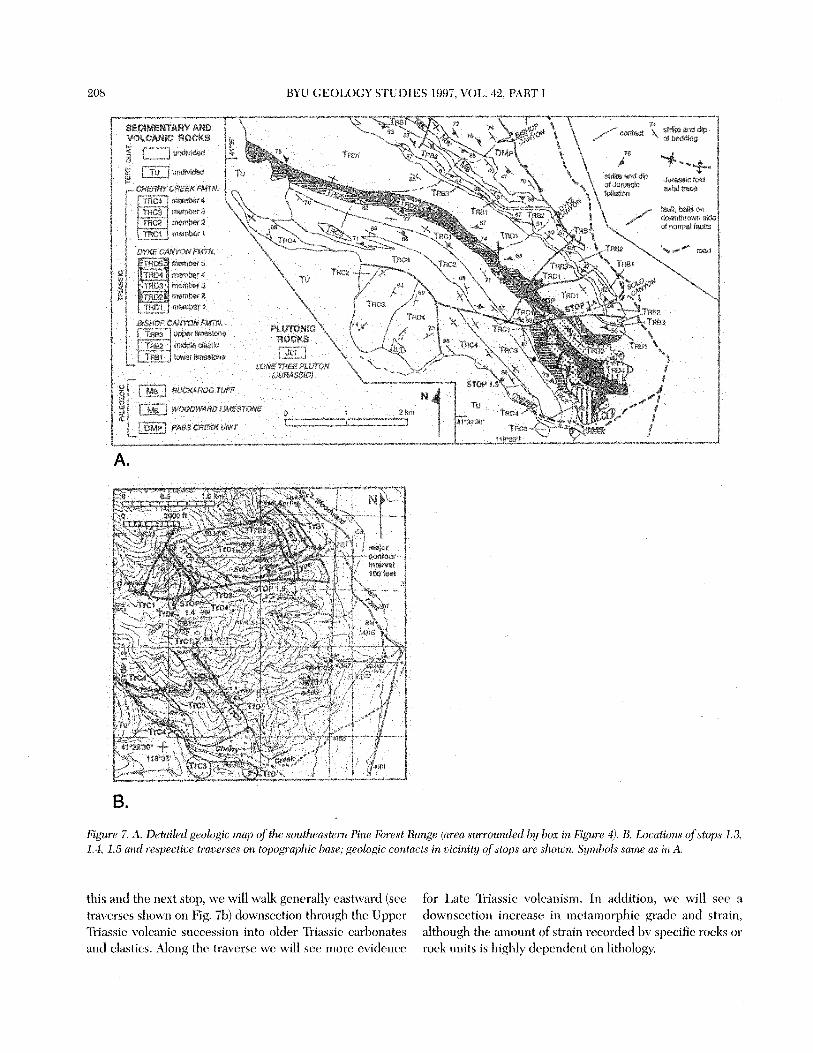
86.2 Junction with gravel mine road that goes uphill back to the east (see road junction at stop 1.3 position on Fig. 7b). Park on mine road near the junction.
Stop 1.3: Younger, lower strain Triassic strata
This stop is located on the Dyke Canyon 7.5 minute topographic map and is shown on Figures 4 and 7. The tra- verse at this stop (shown in detail on Fig. 7b) will take us northeast up the mine road about 800 m. Along the way, we will look at several units of the Cherry Creek forma- tion, the youngest Triassic unit mapped in the east-central Pine Forest Range, focusing on the magmatic, stratigraphic and structural record.
The Cherry Creek formation has been divided into four members (Figs. 7, 8), the lower three of which (Trcl-3) are dominated by coarse clastic rocks rich in andesitic volcanic detritus but also contain some interlayered andesite lava flows, and the uppermost of which (Trc4) consists primari- ly of fine grained clastic strata rich in volcanic detritus. The late Norian age of the Cherry Creek formation is well
defined by fossils (Fig. 8). Facies analysis indicates that this unit accumulated in a marine environment near the base of the slope, with members Trcl-3 reflecting nearby active volcanism and member Trc4 reflecting either distal volcan- ism or erosion of the volcanic carapace (Wyld, 1991a). On this traverse, we will see distal turbidites of member Trc4, lavas of member Trc3, and spectacular outcrops of volcani- clastic debris flows of member Trc2. This 1.9 km thick suc- cession dominated by volcanogenic material (Fig. 8) is a manifestation of the flare-up of Late Triassic to Early Jurassic magmatism in the Black Rock Desert segment of the conti- nental arc.
Within these youngest Triassic rocks there is very little evidence of internal strain or metamorphism (see Fig. 6 and text adjacent to stratigraphic column in Fig. 8); these relations can be seen in outcrops along the road. Sedimen- tary textures and structures are well preserved and there is only minor metamorphic recrystallization, even within vol- canic material. In general, internal strain in these rocks is evident only within the lower two members of the forma- tion, where it is manifested primarily by a low-grade cleav- age visible only in shales or clastic rocks with a carbonate matrix. Low strain, low-grade conditions recorded by the upper Cherry Creek formation cannot be taken as evidence that these rocks did not suffer the same deformational his- tory as older, higher strain, higher-grade rocks to the north because gradational contacts exist between all members of the Cherry Creek formation and between the Cherry Creek formation and the underlying Dyke Canyon formation. Instead, the Cherry Creek formation simply experienced less strain and lower PIT conditions than older rocks; this is interpreted to reflect location of the Cherry Creek for- mation at structurally high levels during regional meta- morphism (Wyld, 1996).
Return to vehicles and retrace route back to Woodward Road. 88.4 Junction with Woodward Road. Turn north. 89.4 Junction with dirt and gravel road leading into Solo
Canyon across the southern part of the Solo Canyon alluvial fan (see Figs. 7a and 7b for location). Turn west. Note that Solo Canyon is a local, not a formal, name for this drainage; its location is shown in Fig- ure 7, but the canyon is not named on the Dyke Canyon 7.5 minute topographic map of this area.
89.8 Junction with road leading back down the northern part of the Solo Canyon alluvial fan (see Fig. 7). Pass this road and proceed west up Solo Canyon.
90.7 Small parking and turnaround spot by the side of the road.
Stop 1.4: Older, higher strain Triassic strata
This stop is located on the Dyke Canyon 7.5 minute topographic map and is shown on Figures 7a and 7b. At
208 BYLT GEOLOGY STUDIES 1997, VOL. 42, PAR'I' i
Figure 7. A. Detailed geologic Tnrq) ($'the soutllecrst~rrr. Pine Forest Rnnge (Wea sumurt&tl by lrox in Figz~rr -1). B. Locutinrts ofst[)ps 1.3, 1.4, 1 . 5 and r f ~ ~ p e c t i w trot-erscs on topographic base, geologic contacts in ~icinitly o f stops ure sllot~n. Syrn!?ols same as in A.
this ancl the next stop, we will walk generally eastward (see for Late Triassic volcanisnt. In addition, we will see a traverses sliown on Fig. 71)) cfow1seetion thrortgh the Upper downsection irkcrease in metaniorphic grade and strain, Triassic volcanic s~tccessiori into older Triassic c;trl>onates although the amount of strain rt-worded by specific rocks or and elastics. Along the traverse we will see more evidence rock units is tdghly depertdrnt or1 litl~ology.
-I 11
CH
ER
RY
CR
EE
K F
MTN
. l3 m
embe
r CC
l ,
mem
ber C
C2
, m
emb
erC
C3
, m
embe
r CC
4 1.
clea
vage
onl
y in
sha
les
esse
ntia
lly u
ndef
orm
ed
* or
ela
stic
rock
s w
ith c
alci
te m
atrix
- -
- -
*
irS
met
amor
phic
recr
ysta
lliza
tion
min
imal
- pa
rtia
l rec
ryst
ailiz
atio
n of
maf
ic m
iner
als
in a
ndes
itic
rock
s to
sub
gree
nsch
ist
faci
es a
ssem
blag
es; p
lagi
ocla
se u
nalte
red
DY
KE
CA
NY
ON
FM
TN.
A Is!
3
..
- ] l
imes
t. m
iddl
e lim
est]
mem
ber
mem
ber
mem
ber
mbr
. 15
mod
erat
ely-
st
rong
, , in
tern
al s
trai
n ge
nera
lly a
bsen
t cl
eava
ge c
omm
on in
sha
le,
* d
eve
lo~
ed
**fo
liatio
n-
- - -
in
thes
e m
assi
ve ro
cks
sand
ston
e an
d br
ecci
as
clea
vase
w
ith c
alci
te m
atrix
met
amor
phic
recr
ysta
lliza
tion
com
mon
but
doe
s no
t obs
cure
pro
tolit
h te
xtur
e 4
perv
asiv
e re
crys
talli
zatio
n in
mek
abas
altic
rock
s to
sub
gree
nsch
ist f
acie
s as
sem
blag
es
+
210 BYU GEOLOGY STUDIES 1997, VOL. 42, PART I
Begin by first hiking about 300 m west up the road to the lower member of the Cheny Creek formation (unit Trcl; see Fig. 7b). This unit consists mostly of turbidite-facies conglomerate and sandstone, interspersed with spectacu- lar debris flow deposits (Fig. 8). Clasts were derived from an active andesitic volcanic center, a source of incomplete- ly-lithified carbonate, and the underlying Dyke Canyon formation (Wyld, 1991a). Strain is minimal and heteroge- neously-distributed in this unit: the coarsest-grained strata (e.g., the debris flow deposits) have no visible cleavage, whereas finer-grained rock types locally display a slaty cleav- age. Metamorphic grade is very low in this unit; there is only limited metamorphic recrystallization of protolith min- eralogy and m&c crystals are commonly unaltered.
Proceed eastward into the upper part of the Dyke Can- yon formation, looking at outcrops above the road on the north side (Fig. 7b). The Norian Dyke Canyon formation has been divided into 5 members (Figs. 7, 8), four of which we will see at this stop. These include member Trd5, which consists mostly of interbedded chert and argillite; member Trd4, composed of basaltic pillow lava and pillow breccia; member Trd3, characterized by turbidite-facies, tuffaceous volcanic sandstone and breccia; and member Trd2, which contains a heterogeneous mixture of basaltic volcanic breccia and sandstone, massive to pillowed basal- tic lava, and rare limestone. Member Trdl, described in more detail below, consists mostly of basaltic lava and vol- canic breccia. Facies data from throughout this -1200 m thick formation indicate deposition in a relatively deep marine environment, with proximal active volcanism re- corded by the lower four members (Wyld, 1991a).
Relations to observe as you hike through the upper four members of the Dyke Canyon formation, ultimately drop- ping back downhill to the vehicles (Fig. To), are as follows. First, there is an abundance of proximal volcanogenic stra- ta in this part of the section. Second, cleavage is evident in most rock types, although this cleavage varies in character from spaced in chert-argillite rocks to more penetrative in tuffaceous sandstones, and it is only locally evident in the coarser breccias and lavas (Fig. 8). This more pervasive cleavage development is a distinct difference between the Dyke Canyon and Chen-y Creek formations and reflects a gradual increase in strain downsection. Second, basaltic rocks that make up most of the Dyke Canyon formation have a distinct green color, reflecting the widespread pres- ence of metamorphic chlorite + epidote + actinolite (Figs. 6, 8). This well-developed subgreenschist facies assem- blage contrasts with the minor degree of metamorphic recrystallization in the Cherry Creek formation and reflects increasing metamorphism downsection.
Return to vehicles, turn around and drive east 0.2 miles. 90.9 Park in small grassy area.
Stop 1.5: Older, higher strain Triassic strata, continued
This stop is located on the Dyke Canyon 7.5 minute topographic map and is shown on Figure 7. We will start out in the lower member of the Dyke Canyon formation, looking at outcrops reached by hiking 100-200 feet up the ravine north of the parking area, and we will then sidehill east through the Bishop Canyon formation, dropping back down to the road near the range front (see traverse located on Fig. 7b).
The lower member of the Dyke Canyon formation here (Trdl) is composed entirely of massive basaltic lava with prominent large pyroxene phenocrysts (augite porphyry), and coarse volcanic breccia of similar composition (Fig. 8). The underlying Bishop Canyon formation, -200400 m thick, has been divided into three members (Figs. 7,8; Wyld, 1990); an upper, generally fine-grained limestone member that contains early Norian conodonts (Trb3); a middle clastic member (Trb2) that consists of siliciclastic conglomerate, sandstone and shale; and a lower, generally fine-grained limestone member that contains Ladinian or Carnian cono- donts (Trbl). There is no primary volcanic detritus in the Bishop Canyon formation, and facies relations (turbidite facies siliciclastic rocks and turbidite to pelagicIhemipelag- ic facies carbonates) indicate deposition in a relatively deep marine environment near the base of the slope (Wyld, 1990, 1991a).
Our main purpose on this traverse is to look at structur- al relations. We start out in the lavas and breccias of the lower Dyke Canyon formation which show no sign of any internal strain, although they do contain a subgreenschist facies metamorphic assemblage (Fig. 6) that imparts a pro- nounced green color to the rocks. Lack of any internal strain is characteristic of the bulk of unit Trdl (Fig. 8) and is interpreted to be related to the fact that this unit is com- posed almost entirely of massive lava flows and coarse mas- sive breccias that are locally tens of meters thick. These rock types would be rheologically strong and difficult to deform under the relatively low-strain conditions that affected Triassic rocks in the east-central Pine Forest Range. In contrast to the lower part of the Dyke Canyon forma- tion, rocks of the Bishop Canyon formation exhibit a well- developed cleavage that is evident in all rock types. This is interpreted to reflect the fact that the Bishop Canyon for- mation is composed of rock types that were rheologically weaker, such as comparatively thin-bedded limestone and siliciclastic strata. Thus, during deformation, strain in this part of the stratigraphic section was accommodated pri- marily in the incompetent Bishop Canyon formation.
On a more detailed level, there is a local increase in strain within the Bishop Canyon formation upsection from the base of the formation to the contact with the unde-
WYLD AND WRIGHT: TRIASSIC-JURASSIC TECTONISM & MAGMATISM, NEVADA 211
formed basal member of the Dyke Canyon formation (see text adjacent to stratigraphic column in Fig. 8); this increase in strain is manifested primarily by an increasingly intense foliation upsection toward the Dyke Canyon formation. This pattern is interpreted to reflect differential strain during layer-parallel shear, with the highest strain occurring in incompetent rocks (Bishop Canyon formation) near their boundary with strong rocks (lower Dyke Canyon formation).
In summary, the relations we have seen in stops 1.3-1.5 indicate the following. First, there was a prolonged episode of basaltic to andesitic marine volcanism in this area in the latest Triassic (Norian). Second, the extent of regional meta- morphic recrystallization increases downsection within the Triassic strata of the east-central Pine Forest Range. Finally, Jurassic strain recorded in these strata is heterogeneous and is controlled both by rheology and by stratigraphic depth, with deformation most pronounced in finer-grained sedimentary rocks and in rocks that occupy the deeper stratigraphic levels.
Return to vehicles and drive east along Solo Canyon road. 91.5 Intersection with two roads leading down the allu-
vial fan at the mouth of Solo Canyon (Fig. 7). Take the northern road.
91.9 Intersection with Woodward road. Turn north. 95.8 Intersection with Big Creek road. Turn right (east). 102.6 Junction with Highway 140. Turn left (north). 127.5 Denio Junction.
DAY 2: CENTRAL PINE FOREST RANGE- JURASSIC PLUTONISM AND DEEPER
LEVEL JURASSIC DEFORMATION
0.0 Denio Junction. Proceed south on Highway 140. 24.8 Intersection with Big Creek road. Turn west (right). 31.6 Junction with Woodward road.
STOP 2.1. Overview
This stop is located on the Dyke Canyon 7.5 minute topographic map and is shown on Figure 4. It is an over- view stop to provide information relevant for connecting relations seen yesterday with stop 2.2 today.
Paleozoic rocks that form the stratigraphic basement for the Triassic section we saw yesterday underlie a much larger area in the east-central Pine Forest Range than the Triassic rocks (Fig. 4). From the vantage point of this stop, Paleozoic strata underlie most of the area from -6 km to the north (to Big Creek), -5 km to the south (to south of Bishop Canyon), and -3 km to the west (Fig. 4). Most of this area is underlain by the Pass Creek unit (Fig. 4). This distinctive unit consists of a monotonous assemblage of metamorphosed shales with less common sandstone and minor conglomerate. The coarser clastic rocks are commonly
graded and can be classified as turbidite facies where not extensively metamorphosed and recrystallized; thus depo- sition is inferred to have occurred in a relatively deep marine environment, probably a deep sea fan. Clastic detri- tus in coarser rocks includes abundant mono-crystalline quartz, p~l~crystalline quartz, chert and argillite (Wyld, 1990). Calculated structural thickness of the unit is -4 km (Fig. 5), but this can only be considered approximate. As noted earlier, age constraints for the Pass Creek unit indi- cate deposition in the Late Devonian(?) to Late Mississip- pian.
As discussed by Wyld (1990), the Pass Creek unit appears very similar in composition, facies, thickness, and age range to the Bragdon Formation of the eastern Klamath Moun- tains (Miller and Harwood, 1990). This suggests that the two units may have been deposited within the same basin and argues for relatively close proximity between the Black Rock Desert and Klamath Mountains provinces in the mid-Paleozoic. In contrast, the Jurassic evolution of these provinces is very different, as discussed in the introduction and further below, which suggests that the two provinces were more distant from one another in the Jurassic (Wyld et al., 1996). We hypothesize that the eastern Klamath Mountains and Black Rock Desert provinces were located very near to one another in the mid-Paleozoic, but that they were displaced from one another sometime between the mid-Paleozoic and the Jurassic. Insofar as both provinces record intermittent arc volcanism during this time interval (Miller and Hanvood, 1990; Wyld, 1990), we suggest that the most likely explanation for displacement is broadly arc- parallel strike-slip faulting. One possible interpretation is that the eastern Klamath Mountains province was dis- placed to the south relative to the Black Rock Desert pro- vince during the Pennsylvanian left-lateral strike-slip fault- ing episode which resulted in truncation of the continental margin farther south (Walker, 1988). This is an appealing sense of displacement because it positions the eastern Kla- math Mountains province correctly to be moved northward again along the right-lateral Mojave-Snow Lake strike-slip fault (Schweickert and Lahren, 1990, 1993) in the Creta- ceous into its current position west of the Black Rock Desert (Figs. 1,2), as hypothesized by Wyld et al. (1996).
From the Triassic units north into mid-Paleozoic strata, the pattern of downsection increasing Jurassic strain and synmetamorphic grade that we saw yesterday persists, but is obscured to some extent by metamorphism and defor- mation around the Cretaceous Duffer Peak pluton (Figs. 4, 6). The Duffer Peak pluton underlies the high country that can be seen to the west from this stop. It is surrounded by an aureole of metamorphism and deformation related to intrusion (Fig. 6; Wyld, 1991a). This aureole is particularly wide on its east side near the range front where the pluton margin dips outward (east) at a moderate angle; in con-
212 BYU GEOLOGY STUDIES 1997, VOL. 42, PART I
trast, the pluton margin is more steeply dipping elsewhere and the metamorphic and deformational aureole is corre- spondingly more narrow (Fig. 6). Within the wide eastern aureole zone, Jurassic structures (described further below) are refolded by tight to isoclinal Cretaceous folds, and over- printed by a generally pronounced Cretaceous foliation and by upper greenschist to arnphibolite-facies Cretaceous metamorphism (Wyld, 1991a). Farther from the pluton mar- gin, Cretaceous strain and metamorphic grade diminish and eventually die out (Wyld, 1991a).
Because the Cretaceous overprint features are promi- nent from the vicinity of Buckaroo Canyon to Pass Creek (Figs. 4, 6), and because patterns of Jurassic deformation and metamorphism can only be discerned in this area by detailed microscopic studies coupled with macroscopic observations at multiple localities, it is impractical to take traverses through this region to observe the effects of Jurassic deformation and metamorphism. Key relations within the area of Cretaceous overprint are, however, described below. Because most of this area is underlain by the Pass Creek unit, we focus on relations in this unit.
Detailed outcrop-scale and microtextural studies within metapelites of the Pass Creek unit between its upper and lower contacts indicate that the Jurassic regional fabric in this unit varies progressively from a low-grade slaty cleav- age in &e younger (southern) part of the unit, to a phyllitic foliation in the middle part of the unit, to a fine-grained schistose foliation defined by visible mica in the older (northern) part of the unit (Wyld, 1996). Accompanying this downsection change in the character of the regional folia- tion is the appearance of a stretching lineation, defined by pebbles in conglomerates which vary from unstrained at high stratigraphic levels to highly elongate at deep strati- graphic levels. Metamorphic grade also increases with stratigraphic depth from subgreenschist or lower green- schist-grade at the top of the unit to amphibolite-grade at the base of the unit where it is in gradational contact with the Short Creek amphibolite (Figs. 4, 6; Wyld, 1996). It is important to emphasize that these changes in the character of structures and syntectonic metamorphism downsection within the Pass Creek unit are gradual and are not associ- ated with any structural break. Our next field trip stop (see below) will be in the more highly strained and metamor- phosed lower Pass Creek unit. For those future users of this guide who may be interested in seeing the relatively low-grade and low-strain rocks of the upper Pass Creek unit, good exposures can be found locally in the area north of Bishop Canyon (Fig. 4).
Turn right and proceed 1.3 miles north on the Woodward road. 32.9 Intersection with dirt road heading west toward
Pass Creek (shown on Fig. 4); cattle fence gate at
entrance of road. Turn west (left). Be sure to close the cattle gate.
33.9 Mouth of Pass Creek. Park.
STOP 2.2. Deformation in mid-Paleozoic units; syntectonic metamorphism around
Big Creek pluton
This stop is located on the Howard Hot Spring 7.5 minute topographic map and is shown on Figures 4 and 9a. There are two main goals to this stop. One is to look at the character and metamorphic grade of regional Jurassic structures in rocks at this stratigraphic level and compare this with what was seen in younger rocks yesterday The Pass Creek meta~edimentar~ rocks we will look at here were deformed under amphibolite grade conditions; this is based on the metamorphic assemblage in metabasaltic rocks of the adjacent Short Creek amphibolite (Figs. 4, 6) which is in gradational contact with the Pass Creek unit. The Pass Creek rocks at this stop are also more highly strained than the rocks we saw yesterday.
Another goal is to observe metamorphic and structural evidence that the nearby 201 Ma Big Creek pluton is syn- tectonic with respect to the regional deformation. The lower part of the Pass Creek unit and the Short Creek amphibolite are intruded by the Big Creek ~ l u t o n (Fig. 4). Detailed studies within metapelites of the lower Pass Creek unit indicate that the regional (syntectonic) metamorphic assemblage in these rocks varies with distance from the Big Creek ~ l u t o n (Fig. 6; Wyld, 1996). Farther from the pluton, biotite always occurs with muscovite and there are no aluminosilicates. Closer to the pluton, however, first andalusite and then cordierite porphyroblasts appear as part of the regional metamorphic assemblage (Fig. 6) and biotite locally occurs in the absence of muscovite. These relations suggest that the regional metamorphic assem- blage is upgraded toward the Big Creek pluton margin. In addition, aluminosilicate p~rph~roblasts exhibit syntectonic textural relations with respect to the regional fabric. These textural relations can be summarized as follows: the regional foliation (defined largely by aligned mica) can be traced into the ends of the andalusite and cordierite porphyrob- lasts but also bends weakly around them; there are no pressure shadows at the ends of the porphyroblasts; the long axes of the andalusite porphyroblasts are parallel to the regional foliation and define a stretchmg lineation (Wyld, 1991a, 1996). Collectively, these relations provide evidence that regional deformation and metamorphism occurred dur- ing emplacement of the Big Creek pluton at 201 Ma. This Early Jurassic age for regional deformation is further cor- roborated by 4 0 ~ r / 3 9 ~ r age data from nearby samples of the Short Creek amphibolite; syntectonic hornblende from these samples yielded 40Ad39~r plateau ages of -193-205
WYLD AND WRIGHT: TRIASSIC-JURASSIC TECTONISM & MAGMATISM, NEVADA 213
Ma (Wyld and I? Copeland, unpublished data). We will also see further structural evidence for syntectonic intrusion of the Big Creek ~ lu ton at stop 2.3.
Hike north along the range front -800 m to the first major drainage (Fig. 9a). The traverse proceeds west up the southern ravine of the drainage to about the 4800 feet elevation, then sidehills to the north around to the north- ern ravine of this drainage, then sidehills farther north to a point where one can look northward down into the next big drainage at the Short Creek arnphibolite. Outcrops along this traverse are in the lower part of the Pass Creek unit and show the following features. (1) Schistose metapelites with a foliation defined by fine grained biotite and mus- covite. Compare this with the low-grade slaty cleavage seen yesterday. (2) Highly strained and lineated chert-pebble conglomerates. Compare this with the generally unstrained pebbles in coarse clastic rocks seen yesterday. (3) Andalu- site porphyroblasts in metapelites in the aureole of the Big Creek pluton whose long axes lie within the plane of the regional foliation and define a stretching lineation.
Return to vehicles and drive back east on the Pass Creek road. 34.9 Intersection with Woodward road. Turn south (right),
closing the cattle gate. 36.2 Intersection with Big Creek road. Turn east (left). 43.0 Intersection with Hwy. 140. Turn north (left). 51.0 Intersection with dirt road leading west toward the
range front. This road initially goes off from the highway at an acute angle to the southwest and is difficult to see coming &om the south along the high- way. A helpful hint is to look for the small hill that it angles to the top of. Turn onto this road and pro- ceed westward through a cumbersome cattle gate- be sure to close the gate.
53.9 Intersection with north-south dirt road along the range front. Turn south (left).
55.0 Y-intersection with a dirt road going southeast. Take right track (i.e., continue south).
55.9 Junction with dirt road that proceeds west up Short Creek (see Figs. 4 and 9b). Turn west (right).
56.9 Park along the side of the road. Four wheel drive is needed to proceed farther.
STOP 2.3. Jurassic ductile shear zone and syntectonic Big Creek pluton.
This stop is located on the Howard Hot Springs 7.5 minute topographic map and is shown on Figures 4 and 9b. At this stop, we will see rocks that experienced the highest regional strain and metamorphic grade in the east- central Pine Forest Range. The units involved are the Short Creek amphibolite and the Willow Creek schist, both of which were metamorphosed to amphibolite grade during
deformation, based on the syntectonic assemblage in meta- mafic rocks (Fig. 6). Deformation occurred within the Short Willow shear zone (Figs. 4, 6) and produced a my- lonitic foliation with a well-developed stretching lineation; this mylonitic fabric is obvious in hand-sample but recrys- tallized on a microscopic scale and is therefore best de- scribed as annealed or b1astomylonitic. Recrystallization is interpreted to be due in part to high temperatures attained during deformation, but is probably also related to some extent to thermal effects associated with intrusion of the Cretaceous Granite Mountain plutonic complex (Fig. 4).
Foliation within the Short Willow shear zone strikes, on average, to the west-northwest, and dips, on average mod- erately to the south-southwest (Fig. 4); however, there is some variation in foliation attitude due to the presence of Cretaceous folmng related to intrusion of the Granite Moun- tain plutonic complex. These folds are generally gentle to open, and are visible at the outcrop scale or manifested by larger-scale variations in the attitude of the Jurassic foliation.
At this stop, we will observe structures and shear sense indicators within the shear zone. The Willow Creek meta- plutonic schist is granodioritic in overall composition but is so deformed that protolith textures are completely unrecognizable. Foliation in these rocks is defined by high- ly-strained quartz ribbons, preferred alignment of mafic minerals (biotite f hornblende f epidote), and a pro- nounced metamorphic segregation layering between mafic and felsic minerals. The subhorizontal stretching lineation is defined by strained quartz and clusters of mafic miner- als. Shear sense indicators are not obvious at the outcrop scale, but S-C fabrics are locally evident in thin section and indicate a dextral sense of motion (in present-day coordi- nates). The Short Creek amphbolite consists mostly of meta- basaltic rocks, but also includes minor metapelitic biotite schists and rare marbles. Deformation has greatly obscured protolith textures in the Short Creek amphibolite but it is locally possible to discern that the metabasalts were de- rived from a combination of lava and volcaniclastic rock (Wyld, 1990). Foliation in these rocks is defined by the preferred alignment of metamorphic minerals, including, dependmg on rock type, hornblende, epidote, sphene, clino- pyroxene, plagioclase, biotite, muscovite, and andalusite. The subhorizontal stretching lineation is defined by long axes of hornblende and strained volcanic clasts in amphi- bolites, and by long axes of andalusite in metapelitic rocks. Shear sense is defined by sigma structures at various scales (formed around relict phenocrysts, amygdules and volcanic clasts in metavolcanogenic rocks) and consistently indicates dextral sense of shear (in present-day coordinates). Recall, however, that original shear sense can only be determined by reconstructing the orientation of Jurassic structures prior to post- Jurassic tilting of the stratigraphic section (see hrther discussion below).

Clle will also t3xarrdne rrlatio~is indicating that the Short Willotv shear Lorle cfevelopcd in the Early Jltrassic at -201 %la. Relevailt rslations irrclttde the interlsely drformetl and nlctarno~phosod state of the -230 >la Wllaw Creek meta- ph~titrtie schist, \vl~hiell indicitt~s thitt this pl~ttot~ was clearly intrudecl prior to deforrnatiotl, and a variety of structrtral and metaniorphic relatiotls it1 and around the 201 Mit Big Creek plutort indicating that thir pluton was intruded dur- ing deforntittio~l, as described fiirtlrer helot+ (Wyld, 1996).
noted in arr earlier section (see text for stop 1.2), tilt- ing of the stratigraphic ~ e c l i o i ~ in the east-central Pine E;ore,t Range to the soutll i\ interpreted to have occurred after regional ctcforniatio~z arltl metarnorphism, and the Short Willow shear zone is interpreted to have originated it \ '1 \ttbhoriztontd ductile thrt~st, with the lower-strain, lower-grade rock\ located to thc so~~ t l l of the sl~ear zone rtprcsenting the less deformed upper p1;rte of the shear zone. App'1rer1t de~tral shear ser~re indicators in tlre shear zone therefort. retouitruct to an origitlal sense of shear (i.e., prior to tilting) that is l,roadly top-to-tile-nortltwest, a5 clisct~ssed earlicc A schematic rnodel showing interprst- tad Early Jurassic relations (prior to tilting of the strati- graphic succession) ii preserrtrtf in Figure 10. The cll~ctile thrttrt is infived to have dcvcloped at a depth of ahout 8-10 km. T11is depth i.; hasc~d o ~ t the structtiral thickness of the upper plate and the presence of synttctonic andalusite ~trrtl cortlicrite ill 11t~tape1itt.s trrar the upper boundaly of the \hear zone (Figs. 4, (i) which require5 nictarno~+phi\nr at depths of <-9 km. Intru\ion of the \y~itcctonic Big
Figzrr~ 9, l,ocrrtto,ts of rtops 2 2 nt~cl 2 3 nnrl resy~~ctirr~ ft.rrr.(>rrrs or1 to)~ogmphic hacc, A Slzows lhss C:I*L'P~ (ITC'LI nmr rczrtg~ front and stop 2 2 B Sl~otcs S/tort ( , ' l r c z k rlrcti,rcrgc~ o?ld 5101) 2 3 1Ji111 ~ ~ / l l l b ~ b s1lrr1e (IS ill Figurc, $, P ' C C P ~ ~ Ql.5 rr/tic/~ rs Vuclft'rnnry lrrtid~lirlr
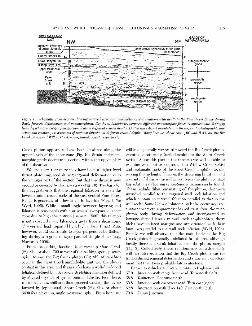
LWLU A N D \VKIC;W'C 't'Hfi\SSIC:-JCIlASSlC 'TE(:'I'ONfS\l & ~lA(:\I,tTIS\L, NEVAL)A 2 15
sub-greenschist grade
I
, arnphibolite grade
I
Figure 10. Schc~nzotic cross-set-tion shozcitlg infirnarl strilctl~r-(11 atzrl metamorphic ~rla!ions tcit11 cleptlt iri t?rc Pitzc. Forv\it Nntzgi- duri-ir1g Early Jurcissic cleforrtmtion alicl it~etantoryhisr~t. Deptlis lo 1iotoulnr-ic.s betzceetr d!fc~r(>r;t ~rtetrrirzorplizc fitr.i~s i s cr~q)roxi~~~cri~. Sguiggly lines d~pict n~or-phok)g~y of rr~egasco~~icJi)lrisls at clifioi-cmt cntst(i1 rlepths. 12ottrrI lifr(rs rlepict orientation (rcitl~ wsprct to strcitigr-aplxic lay eringl N I ~ C ~ i-elntirc pe~~asicencss o f regional foliirtiorl (zf difircnt crzi~stcrl deptfrr. \V\l/i,c!/ Ir'r~cs ( ir .~ rlreclr zotir. JBC crncl 7FI$'C,' am the Big Creek plutott urztI \l/i'llotc: Creek tnptci-plutonic. schist, rt~specfirrly
Creek pluton appears to have been localizcrl along the upper levels of tlrc shear zone (Fig. 10). Strain and nreta- n~orphic grade decrease upsection witl~il~ the tlpprr plate of the shear zone.
We speculatca that there may have b c ~ ~ a higher level thrust plate enrplacccf during regional dcfornration onto the yortngcr part of thc section, but that this thrust is now eroded or coverctl by Tertiary strata (Fig. 10). The basis for this suggestion is that the regional foliation in even the lowest strain 'Eiassie rocks of the east-centml Pin(. Forest Range is geneldly at a low angle to layering (Figs. 4, 7a; Wyld, 1996). While a sn~all angle between layering and foliation is reasonable within or near a layer-parallel shear zone due to high shear strain (Rarnsay, 1980), this relation is not expected Inany kilonreters away from a slicar zctnc. The vertical load imparted by a higher levcl tllrurt plate, however, could contribute to layer-pcrpc~rrclic1i1i~r flattcn- ing during a regime of layer-parallel sinrlplc shear (e.g., Northrup, 1996).
From tlic parking location, hike west 1113 Sfrort Crcck (Fig. 9bj. At ;al)ot~t 700 ni west of the parking spot, go south uphill toward thc Rig Creek plutotl (Fig. 91)). R/letapelites occur in the Short Creek arrrphibolite unit near tlie plutou contact in this area, and these rocks ~ L I V P a \vell-dev~lo~>td foliation cfefined I)y nrica and a stretching lineation definetl by aligned ciystals of syntectonie andaltlsite. Iirorn here, retur~l back cfownhill and then proceecl west up the. ri~vir~e forrrted by (ephemeral) Short Creek (Fig. 9b). At al>oilt 5400 feet elevation, angle westward uphill, Frorn Irere, we
will hike gcncrally westmmrd toward the 13ig (:rcrak plt~ton, eventually r~t~rnrirrg back downitill to the Short C:rrek ravine. Along this part of the traverse wc3 will be :rhle to chuantinc exet~llcnt exposures of the 'IVillo\v Crcek scliist and metanlatic rocks of tlre Short Creek amphibolite, ob- stx~vi~lg tlrc, ~nylotritic foliation, the strctclri~xg litlc,atiotr, and a variety of shear sense indicators. Near the, pluton contact key rclatioris irldicatir~g syntectonie iiltnisio~l cknri 1)e fotind. These include dikes, enranating oil' the pluton, tlrat were iutrnclecl parallel to the regional wall rock foliutiorr and wlrich cor~tain an intthrnal foliation parallel to tlrat in tlic wall rocks. Sotric. 1)lel)s of plutonic rock also ovcilr near the contact that werc apparently sheared away from the main pluton body drrring deforntation anti incorporated as lozengc-shaped lenses in wall rock an~phibolitcs; these blebs 11iavc Lblitatcd ~tlargins anti are oriented with their long axes parallel to thtl wall rock foliation ('Iliyld, 1996). Fi~ially, we will observe that the rr~niri 1,odl of the Big Creek plrltori is gent~rally ilnfoliatcd in this area, nlthoitgli locally there ir u xvc-cak foliation near the pluton margin (Fig. 3). Collccti~ely, these relations arc consistent otily writli an interpretation that the Big Crrck pluton ivar iu- trrrc'led during regionit1 defomiation aricl shear Lorre tlcvclop- rnent, 1)ut that it was probably latc3 s>i.itectooic.
Returt~ to vclricles and retrace route to F liglirva) 140. 57.9 Junctiori wit11 range hont road. Turn north (left). 58.8 Y-jr~nction. Contirr~te north. 59.8 Jnnction with cast-west road. 'T~trn eart (riglit). 62.8 Intersection with flwy 140. Ttirn north (left). 79.6 Dmio Jlrnction.
216 BYU GEOLOGY STUDIES 1997, VOL. 42, PART I
DAY 3: JACKSON MOUNTAINS lates with the Cheny Creek formation in the Pine Forest AND BASINAL TERRANE Range.
0.0 Denio Junction. Proceed south on Highway 140. 29.8 Junction with paved road leading south to the Jack-
son Mountains (Fig. 3). This road is a short distance beyond a ranch on the south side of the highway. Turn south (right).
31.4 Intersection with gravel road. Stay on paved road going south along the west side of the Jackson Moun- tains.
37.4 Junction with gravel road going west. Stay on range front road going south.
49.8 Pullover spot on side of road.
Stop 3.1. Geology of the Jackson Mountains
This stop is on the Hobo Canyon 7.5 minute topographic map and is shown on Figure 11. Here we will discuss the geology of the Jackson Mountains which is similar in many respects to that of the Pine Forest Range, except that more Mesozoic rocks and fewer Paleozoic rocks are exposed, and Mesozoic strata as young as Cretaceous are present (Figs. 11, 12; Russell, 1984; Quinn, 1996; Quinn et d., 1997). The Jackson Mountains thus preserves higher Mesozoic crustal levels than the Pine Forest Range.
The geology of the Jackson Mountains is dominated by the Happy Creek igneous complex (Fig. 11). This complex was previously considered to consist in large part of basal- tic to andesitic volcanic strata, which were believed to have been deposited over the time span from latest Triassic or Early Jurassic through the Late Jurassic (Willden, 1964; Russell, 1984; Maher, 1989). Recent studies by Quinn et al. (1997), however, have demonstrated that the Happy Creek complex is instead composed largely of hypabyssal subvol- canic intrusions with only minor supracrustal volcanogenic strata (Fig. 11). Furthermore, Quinn et al. (1997) have shown that the complex was emplaced entirely during the latest Triassic(?) to Early Jurassic because it cuts strata as young as Norian and is cut by plutons dated at 196-190 Ma (U-Pb zircon) (Figs. 11, 12).
Flanking the Happy Creek complex to the east and west are older strata (Triassic Boulder Creek beds) that were bowed up and cross-cut by the complex during its emplace- ment (Figs. 11-13). These strata are entirely of Late Triassic (Carnian to Norian) age (Russell, 1984; Maher, 1989) and are divisible into three main units that are correlative with Triassic units in the Pine Forest Range based on composi- tion and facies (Quinn, 1996; Quinn et al., 1997). Units Trbl and Trb2 on the west side of the Jackson Mountains (Fig. 11) are correlated with the Bishop Canyon and Dyke Can- yon formations of the Pine Forest Range, respectively, and unit Trb3 on the east side of the Jackson Mountains corre-
Paleozoic rocks occur only on the west side of the Jack- son Mountains, where they are everywhere in fault contact with Triassic strata (Fig. 11, 13; Quinn, 1996). The most widespread Paleozoic unit is the McGill Canyon forma- tion, which contains Mississippian fossils and consists of metamorphosed shale, less common quartz-rich sandstone and minor chert-pebble conglomerate (Figs. 11, 12). This unit correlates with the Pass Creek unit of the Pine Forest Range based on composition, facies and age. Other Paleo- zoic or inferred Paleozoic units on the west side of the Jack- son Mountains include the following (Quinn, 1996). (1) A Permian volcaniclastic unit, which consists of volcaniclastic rocks and minor carbonates with Permian fossils, and which unconformably overlies the McGill Canyon formation (Figs. 11, 12). (2) The Hobo Canyon amphibolite, which struc- turally overlies the McGill Canyon formation on the west side of the Jackson Mountains (Fig. 11-13), and consists mostly of amphibolite-grade metarnafic schist. This unit is not directly dated, but is inferred to be older than the McGill Canyon formation because it structurally overlies the latter unit along a thrust fault and because this thrust fault is one of a stacked series of thrusts that elsewhere demonstrably place older, higher-grade rocks over younger, lower-grade rocks (Figs. 11, 13; Quinn, 1996). This unit is considered likely to be correlative with the compositionally similar Short Creek amphibolite of the Pine Forest Range, and is therefore inferred to be of Devonian age (Fig. 12).
Unconformably overlying the Happy Creek complex along the central axis of the Jackson Mountains is the King Lear Formation (Figs. 11-13). This formation consists of subaerially-deposited, Lower Cretaceous sandstone and con- glomerate, with minor shale and felsic volcaniclastic rock (Willden, 1964; Russell, 1984; Quinn et al., 1997).
Early Mesozoic Magmatism and Deformation
Lower Mesozoic igneous rocks in the Jackson Mountains include Norian volcanogenic strata of the Boulder Creek beds, the uppermost Triassic(?) to Lower Jurassic Happy Creek complex, and several Jurassic plutons (Figs. 11, 12). Three of these plutons have yielded Early Jurassic U-Pb zircon ages (196-190 Ma) and two have yielded Middle Jurassic U-Pb zircon ages (-170 and 163 Ma) (Fig. 11, including inset map; Quinn et al., 1997). Thus, like the Pine Forest Range, the most voluminous early Mesozoic magmatism in the Jackson Mountains occurred in the latest Triassic to Early Jurassic, whereas there is only minor evi- dence of magmatism in the Middle to Late Jurassic time frame.
Two phases of penetrative Mesozoic shortening defor- mation, D l and D2, are recognized in the Jackson Moun-
WYLD AND WRIGHT: TKIiiSSfC-J URASSIC TECTONISM & XIA(;5lATISM, NEVADA
Jurassic plutons bate Tdassic
Latest Tdassic(?) to Early Jurassic Boulder Creek beds (Tri -3)
I-fappy Creek igneous complex .Q Permian volcaniclastic unit hypabyssal intrusive rocks 8 B ~ i s s i s s i ~ ~ i a n McGill Cnyn. fmtn.
ion supracrustal volcaniclastic rocks 22 $rn Devonian(?) Hobo Cnyn,
fault; balls on hanging wail of normal -- - - amphibolite road
faults, barbs on hanging wall of thrusts
Figure 11. Gertc~rc~lizc.c/ geology ofthe ccrttra/Jiicksor& ~Cfourltai~is if;-on~ ()ztirzn, 1996, cind Qtjirzt~ t't al., 1997, st'^ outlirtrcl nruct i r~ if~svl map), i~rul locations of stops 3.1-3 3. Irtset t~z(zp sltows twtire Jackson 31ountctins ctnrl jurzgo Ifills arm jsep Fig. 3 jbr locations i $ t f t ~ ~ c features). Ritt~rrts irt inset tnnp (1s follows. s/tatling is P~leozoic-Me~ozoiC ~11~1gtruzfic urc t~ftd wlated rocks exchisice of Jzrrassic plrctc~~u wiziclz (ire shown with cross ~)atter'lz, stripcel pctttt'm i5 lkius~ic 1)asinal t ~ r m n e , u r z l > c ~ t f e r ) ~ ~ is %rtiar?y Ages of phitons are I T-Pl> zircon dates (()~~irzn et N/., 1997).
tains (Quinn, 1996; Mlyld et al., 1996). D1 dehrnlation is The main manifestation of 111 defom~ation is a foliation evident only in the two older Triassic ririits ('li-1-2) and the that varies in strain itnd rnctarnorphic grade with strati- P;~Ieo/;oic units on the west side of the range, wherea\ IX2 graI)lzic depth (Quiutl, 1996). Thus, S1 is a low-grade spclcrcl deformation affects the Happy Creek complex and older cleavage in Triassic Boulder Creek beds units Trl-2 ~tncl units (Quirrn, 1996). D l ant1 D2 were separated by an in tile Per1ni;ttl volcaniclastic unit, a generally phyllitio to t:pisode of hulting that juxtaposed Paleozoic artd Triassic sehistose foliation tlefi~tecll>y suhgreenscllist to greenschiit rooks on the west side of the range (Fig. 11; Qllinli, 1996). grade rnet;rrnorphic ulinc~ruli and stretched pel)l)les in the
218 BYU GEOLOGY STUDIES 1997, VOL. 42, PART I
9' M a m y l Intrusives Strata Deformation
i$:c:-iY Klng Lear - :::.:.:.: ,.::::::: Formation , :v
146 4 ' I? D2
?I? - ED1 7
reek s Trl-3)
west side faulting
0 ::*: Canyon . F-= formation :*,
bo Canyon phibollte
o fossil age
Figure 12. Summary diagram showing stratigraphy of Jackson Mountains, age span of intrusive rocks, and timing of d e f m t i o n and faulting. Modified from Quinn (1996). Symbols same as in Figure 5. Age data from Willden (1 964), Russell (1 984), and @inn et al. (1997).
Mississippian McGill Canyon formation, and an amphibo- lite-grade, schistose to locally mylonitic foliation in the Devonian(?) Hobo Canyon amphibolite. Orientation of the S1 foliation varies due to later D2 deformation. The D l fabric affects rocks as young as Norian, is overprinted by contact metamorphism in the aureole of the 193 Ma Parrot Peak pluton, and is cut by hypabyssal rocks of the Happy Creek complex (Quinn, 1996). D l deformation therefore occurred in the latest Triassic to mid-Early Jurassic (Fig. 12). In addition, syntectonic hornblendes from the Hobo Canyon amphibolite yielded a 40~r/39Ar plateau age of -200 Ma (Quinn, 1996).
D l deformation in the Jackson Mountains is identical in both timing and style to the regional Jurassic deformation of the Pine Forest Range, and is thus considered to have occurred in response to the same phenomena-develop- ment of a broadly layer-parallel shear zone at the strati- graphic depth of mid-Paleozoic rocks coupled with a pat- tern of decreasing strain and metamorphic grade upsection
away from the shear zone in its upper plate (Quinn, 1996). Lack of evidence for D l deformation in the youngest Boulder Creek beds strata on the east side of the Jackson Mountains (unit Tr3) is interpreted to reflect the fact that these units were at high stratigraphic levels during D l deformation and did not accumulate sufficient strain to be recognizable through the effects of subsequent D2 defor- mation.
Several faults are present on the west side of the Jackson Mountains, including a stacked series of west-dipping thrust faults near Jackson Creek and a south-dpping reverse fault south of Bliss Canyon (Figs. 11, 13). The thrusts place older rocks deformed to higher grades during D l deforma- tion progressively over younger rocks deformed at lower grades during D l deformation (Quinn, 1996). The reverse fault places the McGill Canyon formation over Triassic strata. All of these faults affect rocks as young as Norian, cut D l structures, and are cut by hypabyssal rocks of the Happy Creek complex (Fig. 11; Quinn, 1996). They were therefore all active during the early Early Jurassic.
D2 deformation produced a NE-striking, steeply-dip- ping cleavage that is variably developed in the Happy Creek complex and all older rocks units, and was accompanied by subgreenschist grade metamorphism with no evidence of any variation in strain or metamorphic grade with strati- graphic depth (Quinn, 1996). In general, the D2 cleavage is best developed in unit Tr3 and in Paleozoic and Triassic strata near the western margin of the Happy Creek complex, and is less prominent or pervasive in rocks of the Happy Creek complex. This deformation was previously consid- ered to have affected the Cretaceous King Lear Formation, and was therefore previously considered to be Cretaceous in age (Russell, 1984; Maher, 1989). Recent work by Quinn et al. (1997), however, has shown that the King Lear For- mation is neither deformed nor metamorphosed and that deposition of this unit therefore postdates D2 deformation. D2 deformation thus occurred sometime in the interval be- tween the mid-Early Jurassic and the mid-Early Cretaceous (Fig. 12). The structural significance of this deformation remains unclear at present because its age is uncertain and because no equivalent deformation is recognized in the Pine Forest Range. One possibility is that it is related to strain associated with intrusion of the massive hypabyssal suite making up most of the Happy Creek complex (Fig. 11)-this could explain its heterogeneous development within the Jackson Mountains and its absence in the Pine Forest Range where no equivalent large intrusive complex is present. Further study will be required, however, to re- solve this problem.
At this stop, we have a good view of the key elements of the geology of the western Jackson Mountains (Fig. 14). The Jackson Creek valley is the large valley directly to the east. To the far south are prominent limestone cliffs of
WYLD AND \\JIil(;HT 'I'RIASSIC-JLIRASSIC 'I'1C:'TOYIShf & 'LlA(:L1A'TISLI, NEVill)A 219
3000 1 Hobo Cnyn. amphibolite
DeLong Peak
King Lear pluton I (-1 70 Ma)
McGill Cnyn. formation
1;igurrz 13. I:ent~ri~lizrrl rrzst-tcc~st cross s~rtiorr fhrortgl~ tlic c.~rttrirl Jitr.kson Jfortrtfrtitts ~ t c ~ ~ r Jilrkson Cr6.r.k (~noc1ific.d irftt~r- Quinrr ct (11.. 1997). Pi~tferrts s a i ~ e 11s in Figure 1 I . l7rrits TR3ii-r. arc cli$ier.crif rtirrtibc.t~s r$Bozrk&r C r t ~ k 1)crl unit TR3.
Boltldcr Creek beds unit Trl, eqi~ivalent to tlie Bisltop Canyon formation of the Pine Forest Range. Previously considered to irtcllitle coherent bed', or units of c;trl)ot~;itr (Russell, 1984; Maher, 1989), detailed ~iiapping by (&inn (1996) indicates that tlic. limestones occrir as large to \lnall, irregularly-shaltedpe I-todies completel) surrountled It) clac- tic rocks. Based o11 these relatioil\, Quinn (1996) 'irguecl that the limestoiles are largc olistoliths that sltrrt~pccl or slid from a c'i~rtjo~~ate hank clownslope. Stnicturally above Teassic \trata, just south of Jacksorr Creek, ;ue a \cries of ue\t-clipping thrust sheets of ~rietanioq>l.tic rock (Figs. 13, 14; Vtlinn, 1996). ?'he hvo strt~cturnlly lower thrwt streets irnljricatecl the McC:iIl Cariyo~i form~itiorl and en~placed these grcenschist-grade rocks over stibgreen,chist-gr& Boulder Crcek beds unit Tr2. Tlio stn~cturally higlwr thr~rst sheet, which ~inderlics the low hills just wuth of the moutli of Jackson Creek, places the amp1iibolitc~-grxlt. Ilcvorriar~(?) Hobo Chnyon amphil~olite over the hlcGill Canyon foilna- tion (Figs. 13, 14). Tlte proniinent high topogr;tphy behind (to the east of) these E'aleozoic ktrrcl Tnas\ic rock\ i \ uitder- Iaixi it~ostly I)y hyp;rl>)ssal hasalti aiicl antfchsite\ of thr. lEappy Creek complex, which intruclc acres\ tllc thrrtst fii111t.s in several places (Fig. 14). 'h the north of Jackson (:rec.k, tho lligli c,or~rrtr? rwar
the range front i\ underlain 1)y t l ~ composite IJarrot I'cak plutoti aitd Hmrisoii Gro\ih stock (Figs. 11, 14), which yielcled V-Pt) ~ircori ages of 193 Ma arid 190 Xla, re\pcc- tivcl) (Quinn et .tl., 1997). Tltrse plutorzs int~-1111~ the hyp- abyisal rocks of the IIappy Crcek complex, wlticlr arc exposet1 primarily \out11 arid east of tlie plutons. Tlic low, poorly exposed hills w s t of t l ~ e pluton, arc underlain 1,y the McCill Chuyot~ formation (Fig. 14). The grccrlschiit facies regiorral foliation in thew n~etaclastic rocks i5 over- printed by cont;tcbt rrletarrrorl~hirrri i t r the a~~rcaole of the plutons.
Straight cast, t i p the Jacks011 (Creek i7alle); yoit call see the massive, ljrortrinerrt, clark clifTs of tlie Happy Creek h~7pabyssitl conrplex. Vi'heir we clrivc lip thc \alley (\ec tlirectio~r\ below), you will ~iotice that tlitlre is no sign of stratigrapl~ic lalcring or lit1iologic variatioi~ within these cliff\. 'Wri\ i\ l)ecau\e tlrt clifk arta rnaclc np of rnorroto- nously Itotiiogenc~oiir hypJ~ys\al intruriw mcks rattler tliat~ the 1ayet.c.d voIc:t~iic SIICCCYS~~II inferred by ~?rcvior~\ \vorkers (Quinn ct. al., 1997).
Drive soutll 0.6 milt&$ along tlte ntngch front road. 50.4 Junction with gravel roacl g o i ~ ~ g cast up Jackson
C:rec~k (Fig. 141. 'litrn e,ist (Icft). 56.2 Intersc~ction with dirt roacl to the north. Spay 011 xlrilirr
road going east. 56.9 This is the pass ljehvt>crt the tast-west trcncling Jack-
son Creek clrainagc and tlic \outIt-trending Trol~t Creek drainage (Fig. 1 I). I terth, tltc mitin roacl turr~s ronth down thc 'Rout Creek valley. Here al\o there i\ at11 inter\t.ction with it dirt roacl going upl-rill to the cwt (Fig. 11, 15). Turn onto the latter road and pro- cccd ~iphill.
59.1 P~tllovcr \pot 'it hairpin tunt (Fig. 15).
STOP 3.2. King Lear Formation and basal unconfnrmity.
. .. I iris stop i\ 011 tlie P'lrrot Pt.:~k 7.5 minute topographic r11.ip tultl is \llo\vn on Figure 15. tIcre we will look at the King I,r;u Fonttation ,u1c1 tilt. tnrconfori~rity sepztratirig tlli5 t ~ r r i t fro~n older rock\ of the Jackson Zlountain\.
The King I,ear Forination was clcpoiited in a relatively sl-iort intend in thr, Earl) Cretaceous I)peaurr a tuff near the Iusr of the forirriltiorr h;u heen tl,ited at -125 Ma, atlcl thc C;lover Creek igncous cornpleu, which intrudes tllc upper part of tlre formation, lias brc,n dated at -123 Ma
BYU GEOLOGY STUDIES 199'7, VOL,. 42, PART I
\
I Quaternary IN
Tertiary felsite I
Jurassic plutons
Latest Triassic(?) to Early Jurassic Happy Creek igneous complex I
I supracrustal I volcaniclastic strata I
I hypabyssal intrusions \
I I
Late Triassic Boulder Creek beds *
Stop 3.1 \, member 2 ' .
Scale (Kilometers) member 1 1
0 1 2
mid-Paleozoic(?) intrusive metabasalt
Mississippian McGill Canyon formation
r?a\mnisn/3\ Unhn WWVUI llal I\ : I I lvuv
Canyon amphibolite
J thrust fault, barbs on upper plate, dashed where covered
strike and dip of bedding
0'
strike and dip ,/ road of foliation
Figure 14. Geology of the western Jackson Mountains, near Jackson Crwk (see boxed rrr6.a in Fig. 11). figure nzod$erl fmln e inrr (1996). Note that the Jurassic plutons cut the Hrlppy Creck corrzplex and the Happy Creek cotnpkx cuts across t h ~ thrrc-sf fnults
(U-Pb zircon; Quinn et al., 1997; Fig. 15). The basal con- 1984; Quinn et a]., 1997). The King Lear Formation was tact of the formation is an unconforrnity which spans the previously interpreted to have been depositcYl a\ a molassc Middle and Late Jurassic as well as perhaps portions of the sequence sheti from ,i west-vergent thrust belt that i111l)ri- Early Jurassic and/or Early Cretaceous (Figs. 12, 15; Russell, cated the Ilappy Creek complex and older strata (Rtls\ell,
WYLD AND WRIGHT: 'TRIASSIC-JURASSIC 'TECTONIShl& MAC;MKTISM, NEVADA
D Quaternary; hypabyssal intrusive rocks Qls is landslide of the Latest Triassic(?) to
Early Jurassic Happy Creek Tertiary felsite complex
Middle Jurassic , oelong peak pluton and related intrusions
24
'I strike and dip of bedding .C I \ road
/ fault, balls on downthrown side of normal faults
HAPPY CREEK- MIDDLE JURASSIC COMPLEX PLUTON
Epiclastic volcanogenic detritus derived from the Clover Creek complex
Clover Creek Igneous Complex: Mainly intrusive andesite and dacite
Sedimentary lithic-rich sandstone and conglomerate
Volcanic- and plutonic-fithic rich sandstone and conglomerate (derived from Happy Creek complex and Jurassic plutons)
Figure 15. A. Geologic rrap shozoitlg the crrztrnl part. qf the King Leur himation jsin~pl@rc~~fiortz @&inn, 1996), clge clata (U-PI, zircon) fi-om Qt~inn ot al. (1997). B. G~nrlralizecl stratigraphic architectzlre of the King kclr Forrnatiovb film @inn et al., 1997).
1984; Maher, 1989). This interpretation has recently been shown to be incorrect. Specifically, data reported in Quinn (1996) and Qtlinrl et al. (1997) indicate that the hypothesized west-vergent thrust systenl does not exist. Insteacl, it is now recognized that the King Lear Fornation was deposited in an exterisional half-gral~en, .~vhose eastern boundary fault is a high-angle normal fault (Figs. 11, 13, 1%).
Walk to t l ~ e west and drop downhill several meters to see spectacular outcrops of the King Lear Formation and the unconformity b e ~ e c ~ n this nlnit and underlying Jurassic plutonic rock. The basal part of the King L e a Formation, here and elsewhere in the Jackson Mountains, consists of
with tlie -170 Ma DeLong Peak pluton (Fig. 15; Quinn et al., 1997).
Two features are interesting about this basal King Lear unconfonnity. First, the King Lear Formation sits uncon- fonnably on only three rock units in the Jackson Mountains: hypabyssal rocks of the Eiappy Creek complex, supracrustal rocks of tlie Happy Creek complex, and part of a fine- grained Middle Jurassic pluton (Figs. 11, 15a). Second, the basal part of the King Lear Fonnatiorl coritai~ls clasts de- rived from erosion of tlre Happy Creek comnplex and Jurassic plutonic rocks (Fig. 1%; Quinrr, 1996). It therefore appears that Jurassic tecto~iisrn in the Jackson Mountairls had not
conglomerate containing rounded pebbles anit cc)bbles of resulted in widespread ltplift and exposure of Triassic or andesitic rock and dioritic plutonic rock (Fig. 15b; Quinn Paleozoic basenlent rocks by the tirtle the King Leiir For- et al., 1997). These clasts are identical to rocks of the Happy mation was first deposited in the Early Cretaceous. This is Creek complex and Jurassic plt~toxis and are inferrecl to consistent with relations in the Pine Forest Range indicat- have been derived from erosion of these rocks. Underlying ing that the Black Rock Desert was riot subjected to any the King Lear Formation, along an unconformity that is major shortening deformation in the Middle to Late Jur- well exposed in this area, are fine-grained diorites associated assic-in other words, if the Black Rock Desert had been
222 BYU GEOLOGY STUDIES 1997, VOL. 42, PART I
subjected to two major phases of Jurassic shortening defor- mation, one in the Early Jurassic as documented above, and one in the Middle to Late Jurassic as is seen in many other arc assemblages of the western U.S. Cordillera, then it seems likely that the combined effects of this shortening would have resulted in significant uplift and widespread exposure of Triassic and Paleozoic basement rocks. The relations described above thus add further support to the conclusion, based on relations in the Pine Forest Range, that there is no significant Middle to Late Jurassic defor- mation recorded in the Black Rock Desert segment of the continental arc.
To the west down the Jackson Creek valley are good views of hypabyssal rocks of the Happy Creek complex. From here, it can clearly be seen that there is no stratifica- tion in these rocks and that they crop out in the massive, homogeneous, clifi exposures typical of plutonic rocks. To the north, strata of the King Lear Formation dip homocli- nally at a low angle to the east on top of the Happy Creek complex (Fig. 13a), attesting to the lack of any significant deformation during or after King Lear deposition.
Return to vehicles and drive back downhill to the main road at the pass. 61.5 Junction with main road at the pass. Turn south
(left) down Trout Creek valley (Figs. 11, 15a). 72.4 Y-intersection with gravel road going north. Stay on
road going south. 87.1 Pull over by low hills and park.
STOP 3.3. Triassic basinal terrane and Luning-Fencemaker fold-and-thrust-belt
in the Jungo Hills area
This stop is located on the Jungo 7.5 minute topographic map and is shown on Figure 11 (inset). At this stop, we will look at deformed sedimentary strata of the Triassic basinal terrane (Figs. 3, 11 inset), part of the Luning-Fencemaker fold-and-thrust belt. Strata in this area are typical of the basinal terrane and consist mostly of metamorphosed mud- stone with less common quartz-rich sandstone and minor calcareous rocks, although some dacitic sills are also locally abundant (Wyld, work in progress). Similar sedimentary strata crop out from here east to Winnemucca (Fig. 3; Willden, 1964).
This part of the basinal terrane lies very close to mag- matic arc and related strata of the Black Rock Desert pro- vince (Fig. 11 inset) and is one of the few places where the contact between the arc province and the back-arc basinal terrane may be exposed. The only published geologic map of this area is that of Willden (1964). His study shows the contact between Jackson Mountains Paleozoic-Mesozoic arc rocks and basinal terrane rocks as a high-angle fault. Wyld (unpublished data) mapped this area in detail in
1996, and found that a high-angle fault is present, but that it separates strata typical of the basinal terrane (metapelite the dominant rock type) to the east from strata that are similar but contain more abundant carbonate. It is thus not clear that this fault, whose sense of displacement is inde- terminate at this time, actually forms the boundary between the arc province to the west and the back-arc basinal ter- rane to the east. Rather, it appears that the fault may sepa- rate mudstone-dominated facies of the basinal terrane from a more carbonate-dominated facies of the same depositional basin. Further mapping is needed to the west of this area to determine whether the arc-basinal terrane contact is anywhere exposed or whether any facies or structural changes can be found that would shed light on the nature of the arc-basinal terrane boundary. At present, the nature of the arc-basinal terrane boundary remains unknown.
Hike from the parking spot west a short distance up the low hills through deformed strata of the basinal terrane. The principal structure seen in these rocks is a well-devel- oped slaty to phyllitic cleavage (Sl) parallel to bedding which strikes northeast and dips to the northwest. Our ongoing studies in basinal terrane strata throughout the Jungo Hills area, in Blue Mountain and in the Santa Rosa Range (Fig. 3) indicate that this cleavage is axial planar to tight to isoclinal folds of bedding that are overturned to the southeast (Fl), and that these structures (S1 and F1) are the dominant structures in this part of the Luning-Fence- maker fold-and-thrust belt. Younger phases of folding are locally evident in these rocks, including D2 open folds and D3 crenulation folds, but these later structures are hetero- geneously distributed and represent substantially less short- ening strain.
It is difficult at present to conclusively link deformation in this part of the Luning-Fencemaker belt with Early Jur- assic deformation in the Black Rock Desert for three reasons. First, the original orientation of Early Jurassic structures in the Pine Forest Range are uncertain due to substantial post-Jurassic tilting, and Early Jurassic structures in the Jackson Mountains have been reoriented by younger de- formation that may be related to intrusion of hypabyssal rocks of the Happy Creek complex, as described above. Thus, it is difficult to link structures between the arc and the back-arc on the basis of orientation. Second, little is known about the boundary between Black Rock Desert arc rocks and back-arc basinal strata, as noted above, and it is therefore not possible at present to examine how struc- tures may be related across this boundary Finally, the tim- ing of deformation in the Luning-Fencemaker fold-and- thrust belt is poorly constrained and it is therefore difficult to relate structures between the arc and the back-arc on the basis of age.
Previous studies in the Luning-Fencemaker belt have inferred that most deformation probably occurred in the
WYLD AND WRIGHT: TRIASSIC-JURASSIC TECTONISM & MAGMATISM, NEVADA 223
Middle to Late Jurassic (Oldow, 1984; Speed et al., 1988; and references therein). This inference is based in part on imprecise dating (K-Ar ages) of intrusive rocks that may be syntectonic, although structural relations are somewhat ambiguous. This inference has probably also been influ- enced by the fact that Middle to Late Jurassic deformation is widespread in parts of the western U.S. Cordillera. Our new data from the Black Rock Desert, indicating that this area was affected by major Early Jurassic shortening with little evidence for Middle to Late Jurassic deformation, sug- gests that the timing of deformation in the Luning-Fence- maker fold-and-thrust belt needs to be examined more care- fully. Specifically, since the arc region immediately west of the Luning-Fencemaker fold-and-thrust belt was deformed primarily in the Early Jurassic, then it would appear likely that this may also be the age of major shortening in the adjacent back-arc, particularly since our ongoing studies indicates that most shortening in this part of the Luning- Fencemaker fold-and-thrust belt was accommodated dur- ing a single phase of deformation.
This problem is an important one to resolve because the Luning-Fencemaker belt is a major belt of shortening with- in the western U.S. Cordillera, and one which reflects the final closure of marine basins within the more internal parts of the continental margin (Fig. 1). Shifting the timing of main-phase shortening within this belt from Middle or Late Jurassic to Early Jurassic, some 3 0 5 0 m.y. earlier, would thus have major implications for paleogeographic, struc- tural and tectonic reconstructions of the Cordillera during the Mesozoic. In particular, if most shortening in the Luning- Fencemaker fold-and-thrust belt occurred in the Early Jur- assic, this would support the model depicted in Figure 2 and described in Wyld et al. (1996) arguing that the early Mesozoic arc and back-arc in the vicinity of the Black Rock Desert experienced a different Jurassic structural evolu- tion from the Klamath Mountains-to-Arizona segment of the continental arc because these provinces occupied dif- ferent parts of the continental margin prior to arc-parallel displacement 'on the Cretaceous Mojave-Snow Lake strike-
- slip fault. Further work on the timing of deformation in the Luning-Fencemaker fold-and-thrust belt is clearly needed to resolve this important question.
Return to vehicles and proceed south. 88.5 Intersection with major gravel road. Turn east (left). 123.1 Intersection with Highway 95lMelarkey street. Turn
east (right). 123.6 Intersection with Winnemucca Boulevard. Down-
town Winnemucca.
ACKNOWLEDGMENTS
This work was supported by National Science Founda- tion Grants EAR 92-19268 and EAR 9526129, and the
paper has benefited from helpful reviews by Paul K. Link, Richard A. Schweickert, and M. Meghan Miller.
REFERENCES CITED
Busby-Spera, C.J., 1988, Speculative tectonic model for the early Meso- zoic arc of the southwest Cordilleran Unlted States. Geology, v. 16, p. 1121-1125.
Compton, R.R., 1960, Contact metamorphism in Santa Rosa Range, Nevada Geological Society of America Bulletm, v. 71, p. 138g1416.
Davis, G.A., and Llster, G.S., 1988, Detachment faulting in continental extension; Perspectives from the southwestern U.S. Cordillera, in Clark, S E, Burchfiel, B C , and Suppe, J., eds., Processes in continen- tal lithospheric deformation. Geological Soclety of America Special Paper 218, p. 133-160.
Elison, M.W., and Speed, R.C., 1989, Structural development during fly- sch basin collapse. the Fencemaker allochthon, East Range, Nevada. Journal of Structural Geology, v. 11, p. 522-538.
Gans, PB., and Miller, E.L., 1983, Style of mld-Tert~ary extension in east- central Nevada, in Geologic excursions in the overthrust belt and metamorphic core complexes of the intermountam region, Nevada, Geological Society of America Field Trip Guidebook Utah Geologlcal and Mineral Survey Special Studies 59, p. 411-415.
Harper, G D., and Wnght, J.E., 1984, Middle to Late Jurassic tectonic evolution of the Klamath Mountains, California-Oregon. Tectonics, v. 3, p. 759-772.
Harwood, D.S., 1992, Stratigraphy of Paleozolc and lower Mesozoic rocks m the northern Sierra terrane, California. U.S Geologlcal Survey Bulletin 1957, 78 pp.
Jones, A.E., 1990, Geology and tectonic significance of terranes near Quinn River Crossing, Humboldt County, Nevada, in Harwood, D S., and Miller, M.M., eds., Paleozolc and Early Mesozolc Paleogeo- graphlc Relations; Slerra Nevada, Klamath Mountains, and Related Terranes Geological Soclety of America Special Paper, v. 255, p. 239-254.
Ketner, K B., and Wardlaw, B.R., 1981, Permian and Triassic rocks near Quinn River Crossing, Humboldt County, Nevada. Geology, v 9, p. 123.
Lupe, R., and Silberling, N.J., 1985, Genetic relationship between lower Mesozolc continental strata of the Colorada Plateau and marine strata of the western Great Basin: significance for accretionary history of Cordilleran hthotectonic terranes. in Howell, D.G., ed., Tectonostrati- graphic terranes of the Circum-Pacific region Circum-Pacific Council for Energy and Mineral Resources, Earth Science Series, no. 1, p. 263.
Maher, K., A,, 1989, Geology of the Jackson Mountains, northwest Nevada [Ph D. thesis] Pasadena, California Institute of Technology, 491 pp.
McGrew, A.J., 1993, The origin and evolution of the southern Snake Range decollement, east-central Nevada Tectonics, v. 12, p 21-34
Miller, E.L., Gans, PB., Wright, J.E., and Sutter, J.E, 1988, Metamorphic hlstory of the east-central Basln and Range province. Tectonic setting and relationship to magmahsm, in Emst, W.G , ed., Metamorphism and crustal evolution, western coterminous United States, Rubey Vol 7: Prentice-Hall, Englewood Cliffs, New Jersey, p 649-682.
Miller, M.M., and Harwood, D.S., 1990, Stratigraphic variation and com- mon provenance of upper Paleozolc rocks in the northern Slerra and eastern Klamath terranes, northern Califomla, In Hanvood, D.S , and Mlller, M.M., eds., Paleozoic and Early Mesozolc Paleogeographic Relations; Sierra Nevada, Klamath Mountains, and Related Terranes. Geological Society of America Special Paper, v. 255, p. 175-192
Northrup, C.J., 1996, Structural expressions and tectonic implications of general noncoaxial flow in the midcrust of a collisiond orogen. The northern Scandinavian Caledonides: Tectonics, v. 15, p. 490505.
224 BYU GEOLOGY STUDIES 1997, VOL. 42, PART I
Oldow, J.S., 1978, Tnassic Pamlico Formation; an allochthonous sequence of volcanogenic-carbonate rocks in west-central Nevada, in Howell, D.G., and McDougd, K.A., eds., Mesozo~c paleogeography of the west- ern U.S. Pacific Section, Society of Economic Paleontologists and Mineralogsts, Pacific Coast Paleogeography Symposium 2, p. 222-236.
Oldow, J.S., 1984, Evolution of a late Mesozoic back-arc fold and thrust belt, northwestern Great Basin, U.S.A.. Tectonophysics, v. 102, p 245-274.
Qumn, M.J., 1996, Pre-Terhary stratigraphy, magmat~sm, and structural h~story of the central Jackson Mountains, Humboldt County, Nevada 1Ph.D. thesis]. Rce University, Houston, Texas, 243 p.
Quinn, M.J., and Wnght, J.E., 1993, The timing of Jurassic orogenesis in the continental arc terrane of the western U.S Cordillera. Jackson Mountains, northwestern Nevada. Geological Society of America Ab- stracts with Programs, v. 25, p 136.
Quinn, M.J., Wright, J.E., and Wyld, S.J., 1997, Happy Creek igneous complex and tectonic evolution of the early Mesozoic arc in the Jackson Mountains, northwest Nevada:Geological Society of Amenca Bullehn, v. 109, p. 461482.
Ramsay, J.G., 1980, Shear zone geomehy: A review. Journal of Structural Geology, v. 2, p. 83-99.
Ramsay, J.G., 1981, Tectonlcs of the Helvehc Nappes, in McCoy, K.R, and Price, N.J., eds., Thrust and nappe tectonics Geological Soclety of London Special Publication, p. 293309.
Russell, B.J., 1981, Pre-Tertiary paleogeography and tectonic history of the Jackson Mountains, northwestern Nevada. Ph.D. thesis, North- western University, Evanston, Illinois, 206 pp.
Russell, B.J., 1984, Mesozoic geology of the Jackson Mountains, north- western Nevada. Geological Soc~ety of America Bulletin, v. 95, p. 313.
Saleeby, J.B., and Busby-Spera, C., 1992, Early Mesozoic tectonlc evolu- hon of the western U.S. Cordillera, in Burchfiel, B.C., L~pman, PW., and Zoback, M.L., eds., The Cordilleran orogen: Conterminous U.S.: Boulder, Colorado, Geological Society of America, Geology of North America, v. G-3, p. 107-168.
Sanborn, A.F, 1960, Geology and paleontology of the southwest quarter of the Big Bend quadrangle, Shasta county, California. California Division of Mines and Geology, Special Report 6,26 pp.
Sanderson, D.J, 1982, Models of strain vanation in nappes and thrust sheets: A review: Tectonophysics, v. 88, p. 201-233.
Schweickert, R.A., 1978, Triassic and Jurassic paleogeography of the Sierra Nevada and adjacent region, Cdifornia and western Nevada, in Howell, D.G., and McDougall, K.A., eds., Mesozoic paleogeography of the western U.S.: Paclfic Section, Society of Economic Paleontologists and Mineralogists, Pacific Coast Paleogeography Sympos~um 2, p. 361-384.
Schwe~ckert, R.A., and Lahren, M.M., 1990, Speculative reconstruction of the Mojave-Snow Lake fault. Implications for Paleozoic and Mesozoic orogenesis in the western United States: Tectonics, v. 9, p. 1609-1629.
Schweickert, R.A., and Lahren, M.M., 1993, Triass~c- Jurassic magmat~c arc in eastern Califomla and western Nevada: Arc evolution, cryptic tectonic breaks, and significance of the Mojave-Snow Lake fault, in Dunne, G., and McDougall, K., eds., Mesozoic pale~geograph~ of the Western United States-11: Society of Economic Paleontologists and Mineralogists, Pacific Section, Book 71, p. 227-246
Sharp, WD., 1988, Pre-Cretaceous crustal evolution in the S~erra Nevada reglon, California, in Ernst, W.G., ed., Metamorphism and crustal evolution, western coterminous United States, Rubey Volume 7. Englewood Cliffs, New Jersey, Prentice-Hall, p. 824-864.
Smith, D.L., Wyld, S.J., Wright, J.E , and Miller, E.L., 1993, Progess~on and timing of Mesozoic crustal shortening in the northern Great
Basin, western U.S.A., in Dunne, G., and McDougall, K., eds., Mesozo~c paleogeography of the western United States-11. Soc~ety of Economic meontologists and Mineralogsts, Pacific Section, Book 71, p. 389406
Smith, J.G, McKee, E.H., Tatlock, D.B., and Marvin, R.E, 1971, Meso- zoic gran~tic rocks in northwest Nevada: A link between the Sierra Nevada and Idaho batholiths Geological Society of Amenca Bulletin, v. 82, p. 2933-2944.
Speed, R C , 1974, Evaporite-carbonate rocks of the Jurasslc Lovelock Format~on, West Humboldt Range, Nevada Geolog~cal Society of Amenca Bulletin, v. 85, p. 105-118.
Speed, R.C., 1978, Paleogeographic and plate tectonic evolut~on of the early Mesozoic marine province of the western Great Basin, in Howell, D.G., and McDougall, K.A., eds., Mesozoic paleogeography of the western U.S.. Society of Economic Paleontologists and Mineralogsts, Paclfic Section, Pacific Coast Paleogeography Symposium 2, p 253-270
Speed, R., Elison, M.W., and Heck, ER., 1988, Phanerozo~c tectonlc evo- lution of the Great Basln, in Ernst, W.G., ed., Metamorphism and crustal evoluhon, western coterminous United States, Rubey Vol. 7. Prentlce-Hall, Englewood Chffs, New Jersey, p. 5 7 2 4 5 .
Walker, J.D., 1988, Permian and Triass~c rocks of the Mojave Desert and their implications for timing and mechanisms of continental trunca- tion. Tectonics, v. 7, p 685709.
Walker, J.D., Marhn, M W, Bartley, J.M., and Coleman, D.S., 1990, T~mmg and kinematics of deformation in the Cronese Hrlls, California, and ~mpl~cations for Mesozo~c structure of the southwestern Cordillera. Geology, v. 18, p. 554-557.
Willden, R , 1964, Geology and mineral depos~ts of Humboldt County, Nevada. Nevada Bureau of Mines Bullehn, v 59,154 pp.
Willden, R., and Speed, R.C., 1974, Geology and mineral deposits of Church111 County, Nevada. Nevada Bureau of Mines and Geology Bulletin 83,95 pp
Wnght, J.E., and Fahan, M.R., 1988, An expanded vlew of Jurassic oroge- nesis in the western United States Cord~llera. Middle Jurassic (pre- Nevadan) reg~onal metamorphism and thrust faulting within an active arc environment, Klamath Mountans, California: Geolog~cal Soclety of Arnenca Bulletin, v 100, p 85M76.
Wyld, S.J , 1990, Paleozo~c and Mesozoic rocks of the Pine Forest Range, northwest Nevada, and the~r relation to volcanlc arc assemblages of the western U.S. Cordillera, in Hanvood, D.S. and M~ller, M M., eds., Late Paleozoic and early Mesozolc paleogeograph~c relations. Klamath Mountains, Sierra Nevada, and related rocks. Geological Society of Amenca Speclal Paper 255, p. 219-237.
Wyld, S.J., 1991a, Geology and geochronology of the Pine Forest Range, northwest Nevada. Stratrgraphlc, structural and magmatrc hlstory, and regional implicat~ons [Ph.D. thesis]: Stanford, California, Stanford Univers~ty, 429 p.
Wyld, S.J., 1991b, Permo-Triassic tectonism In volcanic arc sequences of the western US. Cord~llera, and implications for the Sonoma orogeny. Tectonics, v. 10, p. 1007-1017.
Wyld, S J., 1996, Early Jurasslc deformation in the Pine Forest Range, northwest Nevada, and implicahons for Cordilleran tectonics. Tectonlcs, v. 15, p 566-583.
Wyld, S.J., Quinn, M.J., and Wright, J E., 1996, Anomalous(?) Early Jur- assic deformation in the western U.S. Cordillera Geology, v. 24, p. 1037-1040.
Wyld, S.J., and Wright, J.E., 1993, Mesozo~c stratigraphy and structural history of the southern Prne Nut Range, west-central Nevada, in Dunne, G., and McDougall, K., eds., Mesozoic Paleogeography of the western United States-11, Pacific Section SEPM, Book 71, p. 289406


![[H. W. Wyld, H.w. Wyld] Mathematical Methods for p(BookFi.org)](https://img.pdfslide.us/doc/110x75/55cf9295550346f57b97ae32/h-w-wyld-hw-wyld-mathematical-methods-for-pbookfiorg.jpg)