Embed Size (px)
Citation preview
Landscape Ecology 16: 767–779, 2002.© 2002 Kluwer Academic Publishers. Printed in the Netherlands.
767
Perspective paper
Bridging the gap between ecology and spatial planning in landscapeecology
Paul Opdam1,∗, Ruud Foppen2 & Claire Vos2
1ALTERRA, Department of Landscape Ecology and Department of Environmental Sciences, Nature Conservationand Plant Ecology Group, Wageningen University Research Centre, Postbus 47, 6700 AA Wageningen, The Nether-lands2ALTERRA, Department of Landscape Ecology, Wageningen University Research Centre, Postbus 47, 6700 AAWageningen, The Netherlands (∗author for correspondence, e-mail: [email protected])
Received 14 March 2001; Revised 26 July 2001; Accepted 7 September 2001
Key words: application of empirical data, dispersal corridors, habitat network, integration of pattern and processapproach, landscape planning, metapopulation studies
Abstract
Landscapes are studied by pattern (the geographical approach) and by process (the ecological approach withinlandscape ecology). The future of landscape ecology depends on whether the two approaches can be integrated.We present an approach to bridge the gap between the many detailed process studies on species, and appliedactivities such as landscape evaluation and design, which require integrated knowledge. The approach consistsof four components: 1) Empirical case studies of different scales, organisms and processes. 2) Modeling studiesto extrapolate empirical studies across space and time. 3) Modeling studies to produce guidelines and standardsfor landscape conditions. 4) Methods and tools for integration to the landscape level, which can be built intomultidisciplinary tools for design and evaluation. We conclude that in the landscape ecological literature, the steps 1and 2 are well represented, whereas the steps 3 and 4 are mostly neglected. We challenge landscape ecologists topush landscape ecology to a higher level of maturation and to further develop its profile as a problem-orientedscience.
Introduction
Landscape ecology is defined as a problem-orientedscience (IALE executive committee 1998). It has de-veloped from the growing awareness of environmentalproblems since the nineteen seventies. Spatial plan-ning and landscape design are disciplines which trans-fer the knowledge developed in landscape ecology toapplication. To optimize this process of knowledgetransfer, landscape ecology must co-evolve with spa-tial planning (Ahern 1999). The development of eco-logically sustainable landscapes requires that patternsof future landscapes sustain the necessary ecologicalprocesses in the landscape. Therefore, we must knowhow landscape patterns relate to these processes. Inthis paper we point out that most empirical process
studies are of no use to landscape management as longas we fail to transfer the information to the level ofproblem solving. We concur with Moss (2000), thatthe justification of landscape ecology as a science re-quires that this gap between process studies and spatialplanning is bridged. Therefore, we think it is necessaryto develop an approach for generalizing and aggre-gating ecological knowledge for application in spatialplanning. In this paper, we elaborate such an approachfor spatial processes in populations. We focus on bioticprocesses as we consider that the gap to application inlandscape planning for biotic processes is especiallywide compared to abiotic processes such as water andnutrient flows.
Why is so much knowledge on ecologicalprocesses not applied in spatial planning? We interpret

768
this in the context of the maturation process of land-scape ecology: apparently the merging of geographicaland ecological disciplines is not yet complete. Toclarify our viewpoint we summarize a bit of history.The first landscape ecologists were geographers (Neef1982). Zonneveld (1982) regarded the vegetation andsoil surveyors as well as geographers as the typicallandscape ecologists (‘close to the practical holisticlandscape scientists’). Early landscape ecology wasdominated by pattern analysis and pattern interpre-tation, for instance in terms of the suitability of thelandscape to land use functions (Ružicka and Mik-los 1982; Haase 1989; Miklos 1989). The holisticentity of the science was stressed, and the notionsof landscape homeostasis and biocybernetic regula-tion were key issues (Zonneveld 1982; Naveh 1987).The Veldhoven proceedings (Tjallingii and De Veer1982) contained various attempts to apply informationtheory and thermodynamics as a means of landscapeanalysis (e.g., Phipps 1982; Veen 1982), but this lineof research was never developed to an operationallevel (but see Li 2000). In a recent special issue ofLandscape and Urban Planning devoted to holisticlandscape ecology (Naveh 2000) we could not findmuch progress in the development of a mechanisticbasis for a holistic landscape ecology.
On the other hand, landscape ecologists who hadtheir roots in ecology (e.g., Forman 1982) were muchmore interested in spatial processes linking the land-scape pieces together. However, because in the earlydays ecologists were not yet interested in the role ofspatial heterogeneity, there was not much ecologicalbasis for landscape ecologists to build on. In the in-dex of Odum’s (1971) handbook the word landscapedoes not occur and landscape maps only appear, withreference to land use, in the chapter on resources. Sim-ilarly, Krebs’ (1985) handbook on ecology does notrefer to ‘landscape’, and only three times to spatial het-erogeneity. The metapopulation theory (launched byLevins as far back as 1970) was elaborated at the land-scape scale by landscape ecologists (e.g., Hendersonand Merriam 1985; Fahrig and Merriam 1985; Opdamet al. 1985; Van Dorp and Opdam 1987; Baudry andMerriam 1988; Opdam 1988, 1991), years before thistheory became the focus of spatial ecology (Hanskiand Simberloff 1997).
The different roots of landscape ecology con-tributed their own knowledge and methods. Geogra-phy contributed the spatial approach and the develop-ment of maps as spatially explicit representations ofthe landscape. Maps are simplified reflections of land-
scape functioning, but often this is assumed rather thantested, as is illustrated by the many indices for describ-ing landscape pattern that bear no apparent relation toecological processes (Schumaker 1996; Vos et al. 2001a). The geographer Haines-Young (1999) stated it thisway: ‘Much contemporary work on pattern has fo-cussed on the analysis or description of spatial geom-etry and has failed to provide any understanding of thesignificance or meaning of these patterns’. This un-derstanding must be developed within the ecologicaldomains of research.
We argue that the lack of a mechanistic basis fora holistic landscape ecology and, consequently, forspatial planning, is because many empirical and the-oretical ecological studies fail to transfer their resultsin the context of landscape pattern. Most authors ofdetailed studies do not attempt to bridge the gap togeneralization and application (Figure 1). For exam-ple, looking through the papers on habitat fragmen-tation in ‘Landscape Ecology’, of the 33 papers weclassified as such only 11 attempted to make the ob-tained knowledge about species pattern relationshipsexplicit by a (multiple) regression model, which wouldallow spatially explicit predictions of species occur-rence in landscape patches. Only 2 studies apply aspatially explicit metapopulation model to be able tomake predictions on persistence of the species in thelandscape (Figure 1, arrow 1). A major gap in this fieldof landscape ecology is the lack of methods to transferstudies on single species to generalized knowledge onthe relation between landscape pattern and biodiver-sity. While understanding of processes requires a focuson single species distributions and individual behavior,the application of this knowledge in spatial planningrequires several steps that are not well developed inlandscape ecological methods. In these steps the va-riety of species’ responses to the landscape and thevariety of landscape patterns are reduced and gener-alized, and subsequently made available to users ina form that does not require detailed understandingof ecological processes. In our view, this is why re-cent landscape planning papers do not use the currentbody of knowledge on species and landscapes (e.g.,Takeuchi and Lee 1989; Bastian and Roder 1998;Duhme and Pauleit 1998; Van Lier 1998). Therefore,future landscape plans are not tested against criteriabased on ecological processes (Figure 1, arrow 2).
Moss (1999) considered the geographic and theecological branches as the ‘solitudes’ of landscapeecology, referring to the difficult interaction betweenthe two, and postulates that landscape ecology can

769
Figure 1. Two distinct approaches within landscape ecology. At the left, the geo-ecological (pattern based) approach, ending up in spatialplanning. At the right the bio-ecological (process oriented) approach. The numbered arrows and the gray-shaded bloc indicate where in ourview research is underrepresented and the transfer of information is not operating well.
only maturate if the two are merged. Fahrig (1999)illustrated Moss’s view by defining landscape ecologyas a subdiscipline of ecology: ‘Landscape ecology isthe study of how landscape structure affects the abun-dance and distribution of organisms’. We postulate,like Moss (2000), that the future of landscape ecol-ogy lies in the understanding of how landscape patternis related to the functioning of the landscape system,placed in the context of (changing) social values andland use. A necessary step to that goal is the integra-tion of process knowledge from different disciplines.We feel that the knowledge and methods to achievethis integration and apply its results in landscapeplanning and management are what make landscapeecology unique as compared to other disciplines.
In this paper, we contribute to strategies and meth-ods of data integration by, firstly, identifying whatsort of information is required in the various stagesof problem solving. This provides us with the land-marks for data integration. Secondly, we present a wayfrom detailed, species-oriented and local, empiricalstudies to a body of knowledge about the landscape-biodiversity relationship that provides the informationrequired in the consecutive phases of the planningprocess. We illustrate our approach with examplesfrom our own practice. We focus on habitat networks(Opdam 2001), because we have developed our exper-tise in that subject. We do not claim to cover the wholescope of landscape ecology, but offer our approach to
our colleagues to test its usefulness in other fields oflandscape ecology.
Data required in spatial planning
In decision-making on future landscapes, landscapeplanners, landscape managers and politicians are in-volved in a cyclic process (Figure 2). At differentpoints in the cycle different sorts of knowledge arerequired. The basic condition for a successful use ofecological process knowledge in landscape planningis that this knowledge is tailored for the different stepsof this planning cycle.
The cycle starts with a problem definition phase,which is basically a comparison between the futureambitions or goals for the functions of the planningarea and the actual situation, in our case maintaininghabitat conservation networks in a human dominatedlandscape. This phase requires clearly defined goalsand quantitative measures of success. For example,the planning goal may be to maintain a certain numberof identified species with persistent populations, whilethe measure of success is the number of those speciesthat actually do maintain persistent populations.
In this definition phase we need an assessment tool(Figure 2) which may encompass:– measures for the ecological functioning of the
landscape that reflect the policy aims for nature

770
Figure 2. Information needed in different phases of the planning cycle. It starts with a comparison of the actual suitability of the landscape forselected landscape functions (in our case: biodiversity conservation) with the policy ambitions or goals. This step requires a problem analysistool. Usually problems can be solved in different ways, which may lead to alternative future landscape options. Then, after choosing the mostprofitable option, the plan is developed and subsequently evaluated and monitored to see whether the newly developed landscape really doeswhat it is expected to do (planning cycle adapted from Harms et al. 1993).
conservation; for example the number of speciesin sustainable habitat networks, the percentage ofactual or potential species present;
– landscape standards required for persistent (meta)populations of target species, for example min-imum amount of habitat or minimum landscapecohesion (Opdam et al. submitted);
– a spatially explicit tool to assess whether andwhere these conditions are actually realized in theplanning area.
This assessment tool may take various forms. For ex-ample, one may use empirical data to determine thenetwork of suitable habitat for the species and de-fine the occupied patches, and use an incidence-basedmodel (Hanski 1994; Ter Break et al. 1998; Vos et al.2000) to transfer the distribution pattern to a mea-sure related to persistence. Alternatively, one may useecologically-scaled landscape indices to determine forwhich species profile the landscape provides condi-tions for persistence (Vos et al. 2001a), or use a GIS(geographic information system) model based on land-scape cohesion assessment to determine the potentialof the landscape for a set of target species (Opdamet al. submitted). In many cases, time will not al-low extensive field sampling and subsequent analyses.Therefore, quickly applicable tools, which are ableto assess the conditions of the landscape independentof species distribution data, are preferable (Opdam2001).
Once the problem is defined, the next step requiresa set of possible solutions (Figure 2). These may takethe form of simple and qualitative indications, for ex-ample minimum area rules for ecosystems based onthe key patch approach (Verboom et al. 2001; Opdamand Wiens 2001). In many cases, one solution willpromote only some of the target species, whereas otherspecies are neutral or even negatively affected. Also,different solutions may have different chances of beingimplemented, given social and economic restrictions.For instance, a mosaic of small elements may be easierto mix with agricultural claims than developing a largekey patch.
Finding the optimal combination of options in amultifunctional context is a complex process, whichcan be guided by supplying landscape scenarios anddecision support tools (e.g., Harms et al. 1993). In thisstep, alternative options for the landscape are assessedand compared. It requires the same type of informationas discussed under problem definition, but the toolsmust have predictive power. An analysis of the presentsituation is of no use here.
After choosing for the most cost-effective option,the new landscape plan is designed and constructed.This phase asks for technical specifications, suchas templates for corridor types for particular speciesprofiles, or required dimensions of fauna underpasses.
The final stage is an assessment of the success ofthe plan after implementation. Monitoring the effects
771
of the landscape change is important to validate themodel’s predictions, to improve the quality of the pre-dictive toolbox and, most importantly to allow for afurther planning round or implementation phase if thegoals are not met. We suggest that the method usedearlier for comparing alternative scenarios could beused. In this case, the conditions for biodiversity inthe restored landscape are compared to the conditionsrequired for attaining the targets. We consider thatlandscape ecologists should provide such monitoringschemes.
So, depending on the stage in the planning process,we may need either simple rules and concepts or rig-orous quantitative tools. In all cases, except when theplanning is aimed at a single species, rules, conceptsand tools must apply for a combination of species.In the next section we present the strategy that wedeveloped to obtain this information.
Strategy of data integration
The steps we distinguish in the research strategy aredepicted in Figure 3. Empirical knowledge should bethe basis of any scientific rule. Field studies may focuson pattern analysis at the population level or measurespatial processes on individuals in connection with thelandscape structure.
Studies of distribution patterns in a landscapenetwork
Characteristically, populations in landscapes are spa-tially structured and their performance may be affectedby the spatial characteristics of the habitat networkin the landscape and the structure of the matrix inbetween. The observed distribution patterns representsnapshots in the dynamic interaction between distrib-ution patterns of species and spatial processes, gov-erned by the landscape pattern and landscape change.Differences in habitat patch occupancy over a land-scape region are interpreted as the effect of landscapepattern on population processes. For instance, infor-mation about the significance of corridor elements inthe matrix for birds can be obtained by correlatingpresence/absence patterns with characteristics of thepatch network and the density of hedgerows in thelandscape matrix (e.g., Van Dorp and Opdam 1987).Also, we obtain indications of the degree of frag-mentation at which species are affected by habitatconfiguration and matrix characteristics. If different
species are compared in the same landscape, we obtaininformation about the between-species variation in re-sponse to landscape variation. Usually, such studiesproduce notions about concepts and solutions, ratherthan reliable tools for evaluation and prediction. Spa-tially explicit regression models can be applied todefine whether and where there is a problem for thespecies (e.g., Vos and Chardon 1998), but becausethey are based on correlations the uncertainty of suchresults is considerable.
Process studies at the level of populations andindividual movements
A next step in empirical studies is measuring processesat the level of local populations. The dynamics ofnetwork populations can be understood by the ex-tinction and recolonization rates of local populations.Most importantly, for understanding the relation be-tween these processes and the landscape pattern, suchmeasures should be related to patch and matrix charac-teristics (Vos et al. 2001a). Dispersal is one of the keyprocesses for population persistence in a landscapenetwork (Opdam 1988; Wiens 1997). The dispersalstream across a landscape is the result of decisionsof individuals in response to landscape pattern, con-cerning velocity, choice of directions, probability ofcrossing borders, etc. Dispersal studies should includethe role of landscape structure on distance and direc-tion of dispersal movements, particularly the influenceof corridor and barrier structures in the matrix (Voset al. 2001b).
Predictions of persistence
The approaches mentioned thus far concern distribu-tion of species in a habitat network. However, conser-vation is primarily focussed on persistence. Therefore,an important step in building up our knowledge ba-sis for landscape planning is that we determine underwhich conditions landscape networks allow persis-tence. Hence, we must be able to translate distributionpatterns into persistence estimates. This requires eitherindividual-based mechanistic metapopulation models(Lindenmayer and Lacy 1995; Lindenmayer and Poss-ingham 1995; Smith and Gilpin 1997; Foppen et al.2000a) or incidence function metapopulation models(e.g., Verboom et al. 1991; Thomas and Hanski 1997;Vos et al. 2000). Verboom et al. 2001 combine the twomodels for one purpose.

772
Figure 3. Steps in the research strategy. From top to bottom, the results of empirical studies are transferred to other landscapes and to predictionsof persistence, whereas in the subsequent steps the single species level is left for a multi-species level that allows predictions on the potential ofthe landscape. These predictions can be validated by empirical data.
Generalization to other landscapes
Most empirical studies encompass only a minor part ofall variation in landscape configuration that is encoun-tered in landscape planning. Therefore, applicationin landscapes outside the range of variation is prob-lematic. Also, similar problems arise if species havedifferent responses to landscape configuration in dif-ferent parts of their geographical range (Mönkkönenand Reunanen 1999) .
There are various approaches to overcome thisproblem. Case studies might be repeated in areas withdifferent configurations of the habitat network to testthe validity of empirically obtained regression models(Taylor 1991). Alternatively, metapopulation mod-els can be used as a tool for extrapolation across alandscape gradient. For instance, such models can de-tect critical thresholds for landscape cohesion (Andrén1996, Vos et al. 2001a).
Aggregation to multi species level, generating simplelandscape indicators and design rules
Strictly speaking, no two species are alike regardingthe landscapes they need for survival. But as land-scapes are not planned for single species, the challengeis to find similarities between species. These similar-ities form the basis to classify species into ecologicalprofiles, and generate rules for sustainable landscapesfor these profiles (Vos et al. 2001a; Opdam et al. 2002;Verboom et al. 2001).
Examples
Developing guidelines and assessment tools forcorridors
The resistance of the landscape for dispersing indi-viduals is an important component of connectivity in
773
human-dominated landscapes, where boundaries be-tween habitat patches are sharp and the permeabilityof boundaries and the matrix will vary greatly (Wiens1997; Bennett 1999). In nature conservation practice,the protection of zones with high permeability, so-called corridors or linkages, are being implementedto enhance successful dispersal of organisms (e.g.,NPP 1990; Bonner 1994; IUCN 1995; Jongman andTroumbis 1996; Bennett 1999; Vas et al. 2001b).There is a need for general rules for effective corridordesign.
Empirical case study on individual movements in alandscape
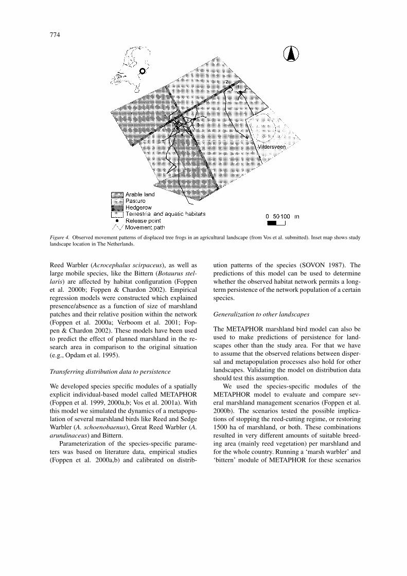
Vos et al. (submitted) started at the level of the in-dividual moving through the landscape. Tree frogs(Hyla arborea) were taken as organisms suitable forfield studies and representative of small-sized groundmoving organism. In field experiments, the behaviorof radio-tagged tree frogs in an agricultural landscape,which resembles the matrix between suitable habitatpatches for this species, was registered. These exper-iments provided data on movement speed and turningangle, as well as the probability of crossing boundaries(Figure 4). Such data identify that landscape elementshave different effects on frog movement, and thusinfluence the direction and speed of movement. Forquantitative application in landscape planning, suchdata have to be generalized to other landscape patternsand aggregated to the landscape level.
Generalization to other landscapes
To extrapolate these individual and local scale obser-vations to differences in connectivity between land-scapes, the simulation model SMALLSTEPS was cal-ibrated on the observed movement paths (Vos et al.2002). To test the reliability of the model predic-tions, the model was tested in a different study area,comparing the predicted transition of individuals be-tween populations with actually observed dispersalevents (Vos, unpublished data). Vermeulen (1995),Tischendorf and Wissel (1997) and Haddad (1999)also followed this approach with spatially explicitmovement models based on individual-level studiesof movement on a micro scale. These models can beused to generate simple connectivity values of differ-ent types of landscapes for the particular species understudy. Such values can be put into a GIS model toassess or predict connectivity of a planning landscape.Another application is to determine the effectiveness
of alternative corridor designs (Figure 5). However,the applicability in spatial planning is limited sincethe connectivity values are species specific, and willat best hold for species with comparable reactions tolandscape heterogeneity.
Aggregation to multi species levelIn the next step (Figure 3), in which more generalcorridor requirements for species complexes are de-veloped, the connectivity estimates obtained for dif-ferent species will be aggregated. This step is still inprogress. The basic goal is to establish, for a range ofspecies, the key characteristics that determine corridoreffectiveness in landscapes with different degrees ofhabitat fragmentation. Species with comparable cor-ridor requirements are then grouped into similar cor-ridor profiles. To develop such a framework, simula-tion studies with model species in computer-generatedlandscapes help to generate ecological profiles (Voset al. 2001a). A profile represents a range of specieswith similar sensitivity to landscape resistance. Eachprofile is connected to a basic corridor type. In con-structing profiles, we need to consider variation inhabitat-specific movement velocity, dispersal mortal-ity, habitat preferences, and boundary behavior indifferent landscape configurations. The modeling ofthe impact of corridor width and movement attributesby Tischendorf and Wissel (1997) is a good exampleof this approach.
Developing guidelines and assessment tools foreffective habitat networks
In the Netherlands marshlands are important to natureconservation. To safeguard marshland biodiversity,marshland areas are planned to function as a habitatnetwork, including marshland restoration and new cor-ridor zones. For the Dutch government it is importantto know whether the plans are adequate to reach thegoal, and where enlargement of existing areas, devel-opment of stepping stones and corridor zones will bemost effective.
Empirical case studies: inferring significance ofnetwork configuration from distribution patternMarshland birds are often absent in suitable habi-tat and their presence is related to the amount andspatial configuration of habitat. Studies on the dis-tribution of bird species in the Dutch marshland net-work found that small and abundant species, like the
774
Figure 4. Observed movement patterns of displaced tree frogs in an agricultural landscape (from Vos et al. submitted). Inset map shows studylandscape location in The Netherlands.
Reed Warbler (Acrocephalus scirpaceus), as well aslarge mobile species, like the Bittern (Botaurus stel-laris) are affected by habitat configuration (Foppenet al. 2000b; Foppen & Chardon 2002). Empiricalregression models were constructed which explainedpresence/absence as a function of size of marshlandpatches and their relative position within the network(Foppen et al. 2000a; Verboom et al. 2001; Fop-pen & Chardon 2002). These models have been usedto predict the effect of planned marshland in the re-search area in comparison to the original situation(e.g., Opdam et al. 1995).
Transferring distribution data to persistence
We developed species specific modules of a spatiallyexplicit individual-based model called METAPHOR(Foppen et al. 1999, 2000a,b; Vos et al. 2001a). Withthis model we simulated the dynamics of a metapopu-lation of several marshland birds like Reed and SedgeWarbler (A. schoenobaenus), Great Reed Warbler (A.arundinaceus) and Bittern.
Parameterization of the species-specific parame-ters was based on literature data, empirical studies(Foppen et al. 2000a,b) and calibrated on distrib-
ution patterns of the species (SOVON 1987). Thepredictions of this model can be used to determinewhether the observed habitat network permits a long-term persistence of the network population of a certainspecies.
Generalization to other landscapes
The METAPHOR marshland bird model can also beused to make predictions of persistence for land-scapes other than the study area. For that we haveto assume that the observed relations between disper-sal and metapopulation processes also hold for otherlandscapes. Validating the model on distribution datashould test this assumption.
We used the species-specific modules of theMETAPHOR model to evaluate and compare sev-eral marshland management scenarios (Foppen et al.2000b). The scenarios tested the possible implica-tions of stopping the reed-cutting regime, or restoring1500 ha of marshland, or both. These combinationsresulted in very different amounts of suitable breed-ing area (mainly reed vegetation) per marshland andfor the whole country. Running a ‘marsh warbler’ and‘bittern’ module of METAPHOR for these scenarios

775
Figure 5. Application of the movement model SMALLSTEPS, based on parameters estimated from the observation of field patterns (Figure 4).The model is used to measure connectivity of a landscape for the tree frog in various landscape scenarios.
indicated the impacts on persistence and occupationpattern for these species in the Netherlands (Figure 6).
Aggregating to multispecies level; rules forapplication
For a further aggregation to the multi-species level wedistinguished two ecological profiles, respectively rep-resenting small marshland songbirds and marshlandherons (Foppen et al. 2000b). General rules for min-imal key patch size were developed for each of these
Table 1. Population sizes (in pairs at carrying capacity) in twolandscape configurations as a result of METAPHOR simula-tions for a ‘marsh heron’ and a ‘marsh warbler’. Indicated arethe average size and the range for a network with and without akey population (KP). Based on Verboom et al. (2001).
Species KP Network with KP Network without KP
Marshheron 20 83 (62–190) 122 (97–1009)
Marshwarbler 100 130 (120–175) 150 (132–160)

776
Figure 6. Occupation probability in different landscape regions in the Netherlands, as predicted by a METAPHOR Bittern model. Occupationis presented relative to carrying capacity as an average saturation. Geographical classification based on soil and geomorphologic cues. Presentedare three situations. From left to right: present situation, present location of marshlands with a natural management regime (after stopping reedcutting) and the National Ecological Network scenario (with restoration and change to natural management regime). Based on Foppen et al.(2000b).
species profiles (Table 1, Verboom et al. 2000). A keypatch is a habitat patch in a network with a very smallprobability of going extinct (<5% in 100 years), basedon an assumption of one immigrant per generation.We used our empirical data on presence/absence ofmarshland birds and the resulting predictive regressionmodels to estimate the size of key patches for speciesprofiles (Verboom et al. 2001). The METAPHORmodel was used to test these estimates in differentlandscape configurations. Also, by using this modelwe extrapolated the standards for one patch to stan-dards for a total network of patches (Verboom et al.2001, Table 1).
These rules were built into the rule based modelLARCH (Chardon et al. 2000), which is able to de-termine quickly the potential for conservation of ahabitat network, independently of species distributiondata. In the case of the marshland birds it was usedto evaluate the proposed national ecological networkplan and several alternatives (see Opdam et al. 2002,Groot Bruinderink et al. 2002; Verboom et al. 2001).
Conclusion
In our view, the integration of ecological and ge-ographical research lines (in the context of socio-economic conditions) is the core activity of landscapeecology. It is absolutely necessary to obtain that in-
tegration when we want to design and develop land-scapes on a sound ecological basis, rather than justdesigning a landscape pattern which might seem ad-equate for some years, but which bears no relationshipto the natural processes in the landscape system.
We presented the ecological part of this mechanis-tic knowledge basis as a knowledge pyramid in fourlayers:
1. Empirical case studies on many different scales,organisms and processes.
2. Modeling studies to extrapolate empirical studiesacross space and time
3. Modeling studies to produce guidelines and gen-eral rules.
4. Tools for integration to the landscape level, so thatapplication in multidisciplinary landscape studiesbecomes possible.We conclude that in the landscape ecological lit-
erature, steps 1 and 2 are well represented, whereassteps 3 and 4 are mostly neglected. Steps 1 and 2are also claimed by spatial ecology (With and King1999; Fahrig 1999). We challenge landscape ecolo-gists to pay much more attention to steps 3 and 4 tobridge the gap between knowledge development andknowledge application. Accomplishing this will givelandscape ecology a much stronger profile, and wewill proceed a step towards landscape design basedon ecological processes. Our approach was devel-

777
oped in our own practice, and it remains to be seento what extent it makes sense in other parts of theworld. The Netherlands has a strongly urbanizinglandscape, where humans dominate the landscape andland use functions compete strongly for space. Spa-tial planning is widely accepted. Nature and landscapevalues are becoming strong components in the com-petition for space, and politicians and managers askfor quantitative tools to consider the cost-effectivenessof measures in the landscape. In this context there is agreat need for quantitative ecological knowledge at thelandscape level. We postulate that this is typical for ur-banizing areas in the world, where nature is consideredan important part of the green environment. We invitelandscape researchers to share their experience with uswith respect to the sort of information needed in land-scape management, and other strategies to build up themechanistic knowledge base to support that need.
Acknowledgements
We are grateful to our colleagues in the departmentof landscape ecology, in particular Hans Baveco,Paul Chardon, Carla Grashof, Henk Meeuwsen, WimNieuwenhuizen, Rogier Pouwels, Rien Reijnen, AlexSchotman and Jana Verboom for their contribution tothe research strategy that we present here. Also, wewant to acknowledge the stimulating discussions withmany ecologists and managers from the Ministeries ofAgriculture and Transport, as well as many other endusers of our research products.
References
Ahern, J. 1999. Integration of landscape ecology and landscape de-sign: An evolutionary process. In Issues in Landscape Ecology.pp. 119–123. Edited by J. A. Wiens and M. R. Moss. Inter-national Association for Landscape Ecology, Guelph, Ontario,Canada.
Andrén, H. 1996. Population responses to habitat fragmentation:statistical power and the random sample hypothesis. Oikos 76:235–242.
Bastian, O. and Röder, M. 1998. Assessment of landscape changeby land evaluation of past and present situation. Landscape andUrban Planning 41: 163–170.
Baudry, J. and Merriam, H. G. 1988. Connectivity and connect-edness: functional versus structural patterns in landscapes. InConnectivity in Landscape Ecology. pp. 23–28. Edited by K. F.Schreiber. Proceedings of the 2nd international seminar of theInternational Association of Landscape Ecology, Münster, Ger-many, July 1987. Münstersche Geographische Arbeiten 29,Münster.
Bennett, A. F. 1999. Linkages in the landscape. The IUCN ForestConservation Programme. IUCN, Gland, Switzerland; Cam-bridge, UK.
Bonner, J. 1994. Wildlife’s roads to nowhere? New Scientist 143:30–34.
Chardon, J.P., Foppen, R.P.B. and Geilen, N. 2000. LARCH-RIVER: a method to assess the functioning of rivers as ecologicalnetworks. European Water Management 3: 35–43.
Duhme, F. and Pauleit, S. 1998. Some examples of different land-scape systems and their biodiversity potential. Landsc. UrbanPlanning 41: 249–262.
Fahrig, L. and Merriam, G. 1985. Habitat patch connectivity andpopulation survival. Ecology 66: 1762–1768.
Fahrig, L. 1999. When is a landscape perspective important? InIssues in Landscape Ecology. pp. 145–147. Edited by J. A.Wiens and M. R. Moss. International Association for LandscapeEcology, Guelph, Ontario, Canada.
Forman, R. T. T 1982. Interaction among landscape elements: acore of landscape ecology. In Perspectives in Landscape Ecol-ogy. pp. 35–48. Edited by S. P. T Jallingii and A. A. de Veer.Proceedings of the 1st international congress in landscape ecol-ogy, Veldhoven, The Netherlands, April 6–11 1981, Center forAgricultural Publishing and Documentation: Wageningen, NL.
Foppen, R. and Chardon, J. P. 2002. Occurrence of red dwellingpasserines in fragmented marshland; inferring occupation thresh-olds and landscape indices (submitted).
Foppen, R., Chardon, J. P. and Liefveld, W. 2000a. Understandingthe role of sink patches in source-sink metapopulations: ReedWarbler in an agricultural landscape. Cons. Biol. 14: 1881–1892
Foppen, R., Reijnen, R. and De Jong, M. 2000b. De planning enhet beheer van rietmoerassen; beleidsevaluatie met behulp vaneen modelstudie naar de levensvatbaarheid van moerasvogels.Landschap 16: 99–112.
Foppen, R., Ter Braak, C. J. F., Verboom, J. and Reijnen, R. 1999.Sedge Warblers Acrocephalus schoenobaenus and African rain-fall, a low population resilience in fragmented marshlands. Ardea86: 113–127.
Groot Bruinderink, G., Van der Sluis, Th., Lammertsma, D. andOpdam, P. (2002). The assessment of a tentative, coherent eco-logical network for large mammals in Northwest Europe. Biol.Cons. (submitted).
Haase, G. 1989. Medium scale landscape classification in theGerman Democratic Republic. Landsc. Ecol. 3: 29–42.
Haddad, N. M. 1999. Corridor use predicted from behaviors athabitat boundaries. Am. Nat. 153: 215–227.
Haines-Young, R. 1999. Landscape pattern: Context and process.In Issues in Landscape Ecology. pp. 33–37. Edited by J. A.Wiens and M. R. Moss. International Association for LandscapeEcology: Guelph, Ontario, Canada.
Hanski, I. 1994. A practical model of metapopulation dynamics. J.Animal Ecol. 63: 151–162.
Hanski, I. and D. Simberloff 1997. The metapopulation approach,its history, conceptual domain, and application to conservation.In Metapopulation Biology. pp. 5–26. Edited by I. A. Hanski,and M. E. Gilpin. Academic Press, London, UK.
Harms, B., Knaapen, J. P. and Rademakers, J. G. 1993. Landscapeplanning for nature restoration: comparing regional scenarios.In Landscape Ecology of a Stressed Environment. pp. 197–218.Edited by C. C. Vos and P. Opdam. Chapman & Hall, London,UK.
Henderson, M. T. and Merriam, G. 1985. Patchy environmentsand species survival: chipmunks in an agricultural mosaic. Biol.Cons. 31: 95–105. IALE Excecutive Committee 1998.
IALE Mission Statement. IALE Bull. 16: 1.

778
International Union for Conservation of Nature and Natural Re-sources (IUCN) 1995. River corridors in Hungary: a strategy forthe conservation of the Danube and its tributaries (1993–1994).IUCN, Gland, Switzerland; Budapest, Hungary.
Jongman, A. H. G. and Troumbis, A. Y. 1996. The wider land-scape for nature conservation: ecological corridors and bufferzones. MN2.7 Sub-Project Report. European Center for NatureConservation, Tilburg.
Krebs, C. J. 1985. Ecology: the Experimental Analysis of Distrib-ution and Abundance, 3rd edition. Harper and Row: New York,NY, USA.
Levins, R. 1970. Extinction. In Some Mathematical Problems inBiology. pp. 77–107. Edited by M. Gerstenhaber. AmericanMathematical Society, Providence, Rhode Island, USA.
Li, B. L. 2000. Why is the holistic approach becoming so importantin landscape ecology? Landsc. Urban Planning 50: 27–41.
Lindenmayer, D. B. and Lacy, R. C. 1995. A simulation study of theimpacts of population subdivision on the mountain brushtail pos-sum Trichosurus caninus Ogilby (Phalangeridae: marsupialia) insouth-eastern Australia. I. Demographic stability and populationpersistence. Biol. Cons. 73: 119–129.
Lindenmayer, D. B. and Possingham, H. P. 1995. Modelling theviability of metapopulations of the endangered Leadbeaters’spossum in south-eastern Australia. Biodiv. Cons. 4: 984–1018.
Miklos, L. 1989. The general ecological model of the Slovak So-cialist Republic-Methodology and contents. Landsc. Ecol. 3:43–52.
Mönkkönen, M. and Reunanen, P. 1999. On critical thresholds inlandscape connectivity: a management perspective. Oikos 84:302–305.
Moss M. R. 1999. Fostering academic and institutional activities inlandscape ecology. In Issues in Landscape Ecology. pp. 138–144.Edited by J. A. Wiens and M. R. Moss. International Associationfor Landscape Ecology, Guelph, Ontario, Canada
Moss, M. R. 2000. Interdisciplinarity, landscape ecology and the‘Transformation of Agricultural Landscapes’. Landsc. Ecol. 15:303–311.
Naveh, Z. 1987. Biocybernetic and thermodynamic perspectives oflandscape functions and land use patterns. Landsc. Ecol. 1: 75–84.
Naveh, Z. 2000. What is holistic landscape ecology? Landsc. UrbanPlanning 50: 7–26.
Neef, E. 1982. Stages in the development of landscape ecology. InPerspectives in Landscape Ecology. pp. 19–28. Edited by S. P.Tjallingii and A. A. de Veer. Proceedings of the 1st interna-tional congress in landscape ecology, Veldhoven, The Nether-lands, April 6–11 1981, Center for Agricultural Publishing andDocumentation, Wageningen, NL.
NPP 1990 Nature Policy Plan. Ministry of Agriculture, NatureConservation and Fisheries. SDU, The Hague, NL (in Dutch).
Odum, E. P. 1971. Fundamentals of Ecology, 3d edition. W.B.Saunders Company, Philadelphia, Pennsylvania, USA.
Opdam, P. 1988. Populations in fragmented landscape. In Con-nectivity in Landscape Ecology. pp. 75–77. Edited by K. F.Schreiber. Proceedings of the 2nd international seminar of theInternational Association of Landscape Ecology, Münster, Ger-many, July 1987. Münstersche Geographische Arbeiten 29,Münster.
Opdam, P. 1991. Metapopulation theory and habitat fragmentation:a review of holarctic breeding bird studies. Landsc. Ecol. 5: 93–106.
Opdam, P. 2001. Assessing the conservation potential of habitatnetworks. In Concepts and Application of Landscape Ecol-
ogy in Biological Conservation. Edited by K. J. Gutzwiller,Springer-Verlag, New York, USA (in press).
Opdam. P. and Wiens, J. A. 2001. Fragmentation, habitat lossand landscape management. In Conserving Bird Biodiversity.Edited by K. Norris and D. Pain. Cambridge University Press,Cambridge, UK (in press).
Opdam, P., Rijsdijk, G. and Hustings, F. 1985. Bird communitiesin small woods in an agricultural landscape: effects of area andisolation. Biol. Cons. 34: 333–352.
Opdam, P., Verboom, J. and Reijnen, R. (2002). Landscape cohesionassessment: determining the conservation potential of landscapesfor biodiversity (submitted).
Opdam, P., Foppen, R., Reijnen, R. and Schotman, A. 1995. Thelandscape ecological approach in bird conservation: integratingthe metapopulation concept into spatial planning. Ibis 137: 139–146.
Phipps, M. 1982. Information theory and landscape analysis. InPerspectives in Landscape Ecology, pp. 57–64. Edited by S. P.Tjallingii and A. A. de Veer. Proceedings of the 1st interna-tional congress in landscape ecology, Veldhoven, The Nether-lands, April 6–11 1981, Center for Agricultural Publishing andDocumentation, Wageningen, NL.
Ružicka, M. and Miklos, L. 1982. Methodology of ecologicallandscape evaluation for optimal development of territory. InPerspectives in Landscape Ecology. pp. 99–108. Edited by S.P.Tjallingii and A.A. de Veer. Proceedings of the 1st interna-tional congress in landscape ecology, Veldhoven, The Nether-lands, April 6–11 1981, Center for Agricultural Publishing andDocumentation: Wageningen, NL.
Schumaker, N. 1996. Using landscape indices to predict habitatconnectivity. Ecology 77: 1210–1225.
Smith, A. T. and Gilpin, M. 1997. Spatially correlated dynamicsin a Pika population. In Metapopulation Biology. pp. 407–428.Edited by I. A. Hanski, and M. E. Gilpin. Academic Press,London, UK.
SOVON. 1987. Atlas van de Nederlandse Vogels. SOVON, Arnhem,NL.
Takeuchi, K. and Lee, D.-K. 1989. A framework for environmen-tal management planning – A landscape-ecological approach.Landsc. Ecol. 3: 53–63.
Ter Braak, C. J. F, Hanski, I. and Verboom, J. 1998. The incidencefunction approach to modeling of metapopulation dynamics. InModeling Spatiotemporal Dynamics in Ecology. pp. 167–188.Edited by J. Bascompte and R. V. Sole. Springer-Verlag, NewYork.
Taylor, B. 1991. Investigating species incidence over habitat frag-ments of different areas – a look at error estimation. Biol. J.Linnean Soc. 42: 177–191.
Thomas, C. D. and Hanski, I. 1997. Butterfly metapopulations.In Metapopulation Biology: Ecology, Genetics and Evolution.pp. 359–386. Edited by I. Hanski and M. E. Gilpin. AcademicPress, London, UK.
Tischendorf, L. and Wissel, C.1997. Corridors as conduits for smallanimals: attainable distances depending on movement pattern,boundary reaction and corridor width. Oikos 79: 603–611.
Tjallingii, S.P. and De Veer, A.A. (eds). 1982. Perspectives in Land-scape Ecology. Proceedings of the 1st international congress inlandscape ecology, Veldhoven, The Netherlands, April 6–111981, Center for Agricultural Publishing and Documentation,Wageningen, NL.
Van Dorp, D. and P. F. M. Opdam 1987. Effects of patch size, isola-tion and regional abundance on forest bird communities. Landsc.Ecol. 1: 59–73.

779
Van Lier, H. N. 1998. The role of land use planning in sustainablerural systems. Landsc. Urban Planning 41: 83–92.
Veen, A. W. L. 1982. Specifying the concept of landscape cell(ecotype) in terms of interacting physico-chemical processes andexternal vegetation characteristics. In Perspectives in LandscapeEcology. pp. 49–56. Edited by S. P. Tjallingii and A. A. de Veer,Proceedings of the 1st international congress in landscape ecol-ogy, Veldhoven, The Netherlands, April 6–11 1981, Center forAgricultural Publishing and Documentation, Wageningen, NL.
Verboom, J., Schotman, A., Opdam, P. and Metz, J.A.J. 1991.European nuthatch metapopulations in a fragmented agriculturallandscape. Oikos 61: 149–156.
Verboom, J., Foppen, R., Chardon, P., Opdam, P. and Luttikhuizen,P. 2001. Standards for persistent habitat networks for vertebratepopulations: the key patch approach. An example for marshlandbird populations. Biol. Cons. 100: 89–101.
Vermeulen, H. J. W. 1995. Road-side verges: habitat and corridorfor carbid beetles of poor sandy and open areas. Ph.D. thesis.Wageningen Agricultural University, Wageningen, NL.
Vos, C. C. and Chardon, J. P. 1998. Effects of habitat fragmentationand road density on the distribution pattern of the moor frog Ranaarvalis. J. Appl. Ecol. 35: 44–56.
Vos, C. C., ter Braak, C. J. F. and Nieuwenhuizen, W. 2000. Empir-ical evidence of metapopulation dynamics; the case of the Treefrog (Hyla arborea). Ecol. Bull. 48: 165–180.
Vos, C. C., Verboom, J., Opdam, P. F. M., and Ter Braak, C. J. F.2001a. Towards ecologically scaled landscape indices. Am. Nat.157: 24–51.
Vos, C. C., Baveco, H. and Grashof-Bokdam, C. J. 2001b. Corridorsand species dispersal. In Concepts and Application of LandscapeEcology in Biological Conservation. Edited by K. J. Gutzwiller.Springer-Verlag, New York (in press).
Vos, C. C., Baveco, H., Chardon, P. and Goedhart, P. (2002).The role of habitat heterogeneity on dispersal in agriculturallandscapes. Landsc. Ecol. (submitted).
Wiens, J. A. 1997. Metapopulation dynamics and landscape ecol-ogy. In Metapopulation Biology; Ecology, Genetics, and Evolu-tion. pp. 43–68. Edited by I. Hanski and M. E. Gilpin, AcademicPress, San Diego, CA, USA.
With, K. A. and King, A. W. 1999. Extinction thresholds for speciesin fractal landscapes. Cons. Biol. 13: 14–326.
Zonneveld, I. S. 1982. Land(scape) Ecology, a science or a state ofmind. In Perspectives in Landscape Ecology. pp. 9–15. Editedby S. P. Tjallingii and A. A. de Veer. Proceedings of the 1st inter-national congress in landscape ecology, Veldhoven, The Nether-lands, April 6–11 1981, Center for Agricultural Publishing andDocumentation: Wageningen, NL.