Embed Size (px)
DESCRIPTION
Bridgeview Park Master Plan as proposed to the Stillwater City Council on March 3, 2015.
Citation preview
TO: Mayor & Councilmembers FROM: Bill Turnblad, Community Development Director DATE: February 26, 2015 RE: Bridgeview Park Plan INTRODUCTION On March 3, 2015 the City Council is scheduled to consider the first draft of the final plan for Bridgeview Park. This draft is based upon conceptual plans that were developed through meetings conducted with the downtown business community, governmental agencies that have review authority, marina owners and operators, the boating public and interested residents, as well as both the Park Commission and the Planning Commission. Several Council members were present at each stage of the process. COMMENTS On January 6, 2015 the City Council reviewed the conceptual plans for Bridgeview Park. Though there was support for the concepts, two discussion areas emerged. The first related to phasing and funding for implementation of the plan. The second was that if there is a municipal dock, it should be as close to downtown as possible.
1. Phasing and funding. Build-out of the plan would occur in five phases (see attached plan). Though specific dates have not been set for each phase, they could occur one to three years apart. The overall timeframe for plan implementation would then be 5 – 15 years, or longer. This open ended timing takes some pressure off of funding, since about 50% of the estimated $10.7 million total project cost could be the City’s responsibility.
2. Dock location
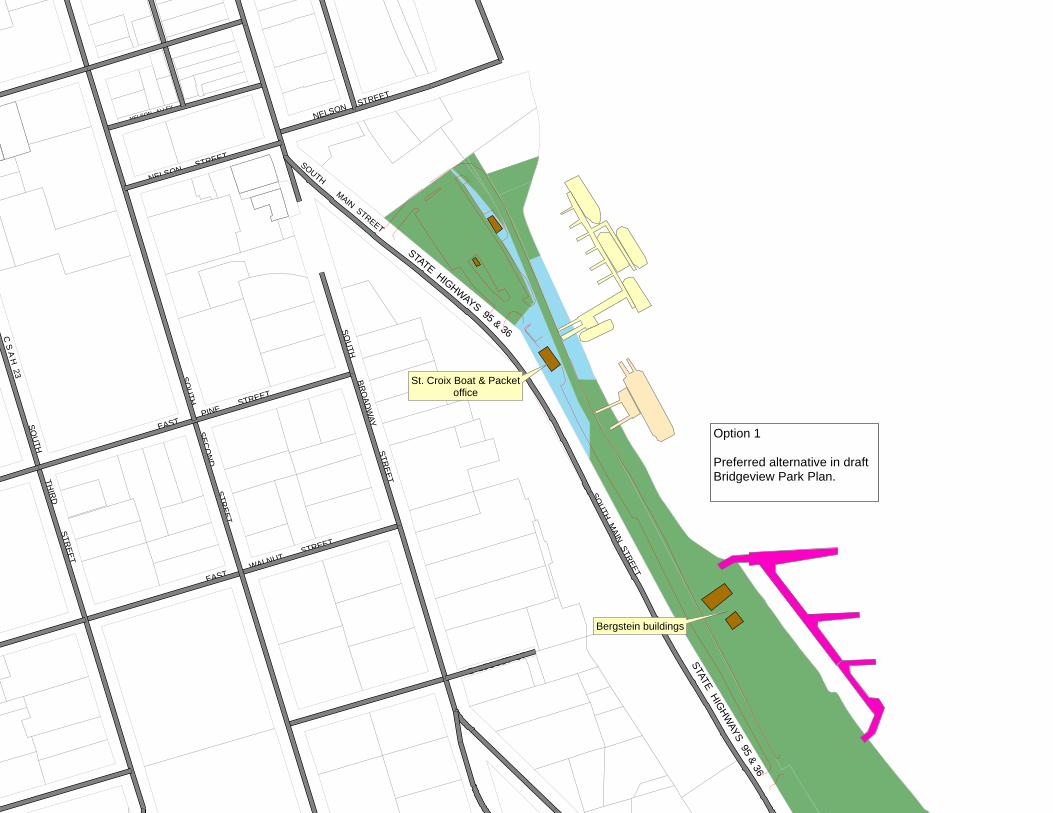
The focus area for the municipal dock, as identified by the majority of opinions expressed at the various planning meetings, is the stretch of City owned shoreline between Nelson Street and the two Bergstein buildings in Bridgeview Park. Four location options are provided in the attached sketches.
Bridgeview Park Plan Page 2
• The first option is to construct a municipal dock adjacent to the Bergstein buildings in Bridgeview Park. This is the option shown as the preferred option in the draft park plan.
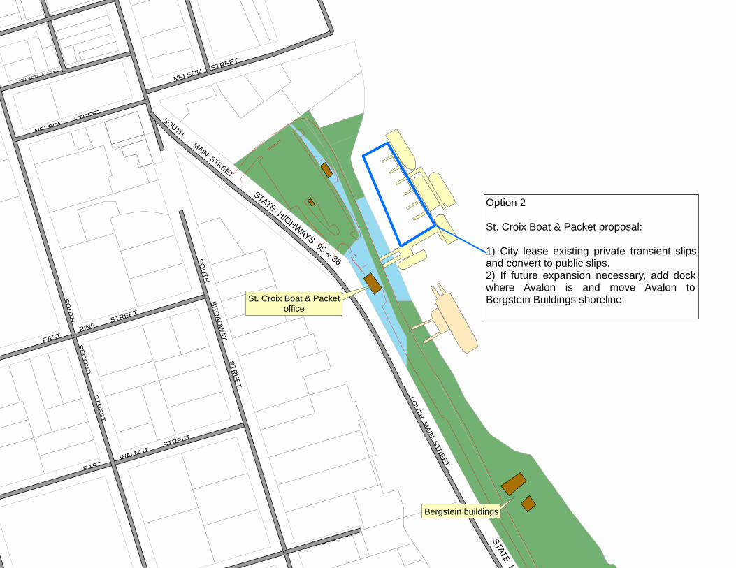
• The second option is to lease St. Croix Boat & Packet’s transient slips and convert them to public boat slips.
o St. Croix Boat & Packet is “on-board” with this option. o The City could lease the slips for two years. After two years, the lease
could be continued, or the other options could be pursued. o The City’s maintenance responsibilities would only be for the slip
structures, not the dock itself. o The City would have no up-front capital costs.
This would allow the public dockage to be offered as early as this summer, rather than at some undetermined future phase of park plan development.
o The location of the public dockage would be very close to downtown proper.
o The City could offer free boat docking if there were no City paid attendants, no electricity, not water or sewer service.
Offering no services would not only allow docking to be free, but it would also discourage overnight stays.
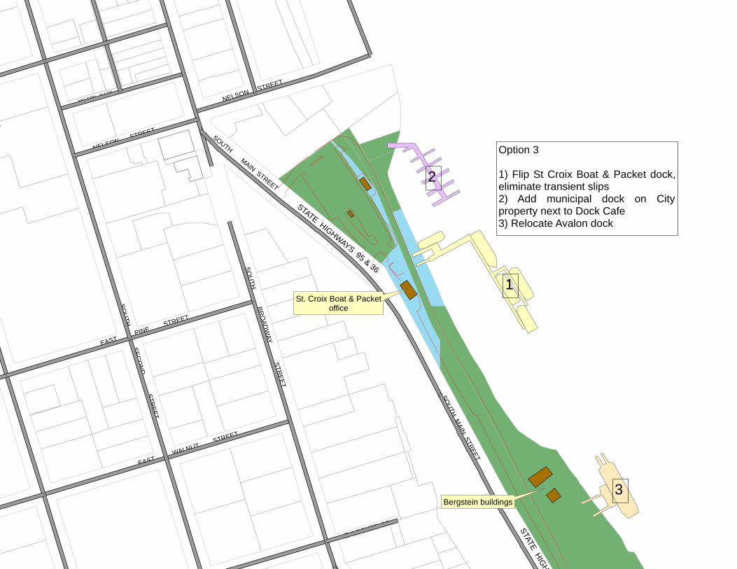
• The third option would be to reconstruct the St. Croix Boat & Packet dock by reorienting the extension to the south instead of to the north. The result would be room to construct a new municipal dock where the old city dock was, immediately adjacent to the Dock Café. This option would also require the relocation of the Avalon, because it could no longer maneuver into its current dock if the extension of the main dock were reoriented southward.
o An advantage to this option is that it provides the absolute shortest distance from the focus stretch of shoreline to downtown proper.
o Disadvantages include: Relocating the Avalon to the Bergstein building site may create
incompatible land uses depending upon the end use of the Bergstein buildings.
Parking for the Avalon customers is primarily in City Lot 1. By moving the Avalon further south, the distance between parking and the excursion boat is doubled.
Rebuilding the St. Croix Boat & Packet’s dock will be a large expense that would have to be borne by the City.
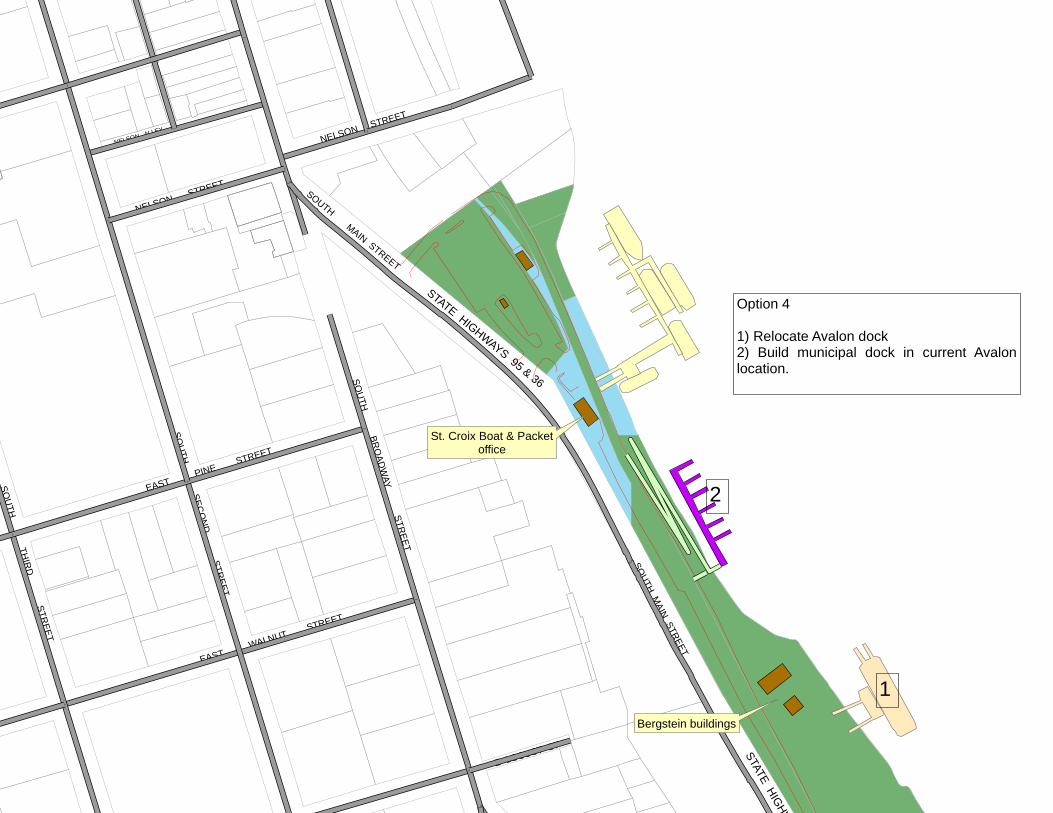
• The fourth option would be for the City to build a dock where the Avalon is currently located.
o An advantage to this option is that the distance to Downtown is shorter than a dock at the Bergstein buildings would be.
o Disadvantages to the option include: Since the dock would be new, it would be required to have ADA
accessibility. This would necessitate an expensive switch-back ramp up the narrow, steep bluffline.
Bridgeview Park Plan Page 3
Relocating the Avalon to the Bergstein building site may create incompatible land uses depending upon the end use of the Bergstein buildings.
REQUEST Staff requests the Council to consider approving the Bridgeview Park Plan, with one change. The change would be to refer to the draft plan’s “preferred dock location” as one of several dock location options. The other options could then be included as an appendix. If the Council supports the plan for Bridgeview Park, with or without staff’s suggested change, staff would bring a Resolution of Adoption to the March 17 Council meeting. ALTERNATIVES
1. Direct staff to bring a Resolution of Approval to the March 17 Council meeting. 2. Table action for additional information.
bt attachments: Draft Plan Dock location options
GO
VT LOT 4
STATE HIGHWAYS 95 & 36
E LOCUST ST
GOVT LOT 1
CHICAGO
& NORTHW
ESTERN RAILROAD
SOUTH M
AIN STREET
STATE HIGHWAYS 95 & 36
EAST PINE S
TREET
EAST WALNUT S
TREET
SOU
TH SEC
ON
D STR
EET
NELSON STREET
SOUTH
C S A H
23
NELSON ALLEY
SOU
TH TH
IRD
STREET
NELSON STREET
MAIN STREET
SOU
TH BR
OAD
WAY STR
EET
Option 1
Preferred alternative in draftBridgeview Park Plan.
St. Croix Boat & Packetoffice
Bergstein buildings
GO
VT LOT 4
STATE HIGHWAYS 95 & 36
E LOCUST ST
GOVT LOT 1
CHICAGO
& NORTHW
ESTERN RAILROAD
SOUTH M
AIN STREET
STATE H
EAST PINE S
TREET
EAST WALNUT S
TREET
SOU
TH SEC
ON
D STR
EET
NELSON STREET
SOUTH
NELSON ALLEYNELSON STREET
MAIN STREET
SOU
TH BR
OAD
WAY STR
EET
Option 2
St. Croix Boat & Packet proposal:
1) City lease existing private transient slipsand convert to public slips.2) If future expansion necessary, add dockwhere Avalon is and move Avalon toBergstein Buildings shoreline.St. Croix Boat & Packet
office
Bergstein buildings
GO
VT LOT 4
STATE HIGHWAYS 95 & 36
E LOCUST ST
GOVT LOT 1
CHICAGO
& NORTHW
ESTERN RAILROAD
SOUTH M
AIN STREET
STATE HIGHW
EAST PINE S
TREET
EAST WALNUT S
TREET
SOU
TH SEC
ON
D STR
EET
NELSON STREET
SOUTH
NELSON ALLEY
NELSON STREET
MAIN STREET
SOU
TH BR
OAD
WAY STR
EET
Option 3
1) Flip St Croix Boat & Packet dock,eliminate transient slips2) Add municipal dock on Cityproperty next to Dock Cafe3) Relocate Avalon dock
1
2
3
St. Croix Boat & Packetoffice
Bergstein buildings
GO
VT LOT 4
STATE HIGHWAYS 95 & 36
E LOCUST ST
GOVT LOT 1
CHICAGO
& NORTHW
ESTERN RAILROAD
SOUTH M
AIN STREET
STATE HIGHW
EAST PINE S
TREET
EAST WALNUT S
TREET
SOU
TH SEC
ON
D STR
EET
NELSON STREET
SOUTH
NELSON ALLEY
SOU
TH TH
IRD
STREET
NELSON STREET
MAIN STREET
SOU
TH BR
OAD
WAY STR
EET
Option 4
1) Relocate Avalon dock2) Build municipal dock in current Avalonlocation.
1
2
St. Croix Boat & Packetoffice
Bergstein buildings
Bridgeview Park Master Plan Update
February 13, 2015 DRAFT
in Association with Baird
M A S T E R P L A N U P D A T E i
Bridgeview Park Master Plan Update
Acknowledgements
City of Stillwater City Council
City of Stillwater Planning Commission
City of Stillwater Parks Commission
Bill Turnblad City of Stillwater, Community Development Director
Abbi Wittman City of Stillwater, City Planner
Shawn Sanders City of Stillwater, Public Works Director
Todd Clarkowski Minnesota Department of Transportation
Kevin Western Minnesota Department of Transportation
Molly Shodeen Minnesota Department of Natural Resources
Kent Skaar Minnesota Department of Natural Resources
Ann Pung-Turwedo Washington County
Tim Mason Wisconsin Department of Transportation
Chris Willger Wisconsin Department of Natural Resources
Ellen Denzer St. Croix County (Wisconsin)
Amanda Engesether St. Croix County (Wisconsin)
Susan Hoyt St. Joseph Township (Wisconsin)
Carolyn Barrette St. Joseph Township (Wisconsin)
Todd Streeter Greater Stillwater Area Chamber of Commerce
Downtown Stillwater Business Owners
Lower St. Croix Marina Managers
Stillwater Residents
B R I D G E V I E W P A R Ki i
Table of Contents
1. Introduction 1-1
Regulatory Context 1-4
1998 Master Plan Highlights 1-6
Public Involvement 1-8
Related Planning and Design 1-9
2. Site Characteristics 2-1
Natural Resources Context 2-2
Cultural Resources Context 2-4
Existing Site Conditions 2-6
3. Master Plan 3-1
Site Program and Design 3-2
Transient Dock Study 3-10
Potential Activity Programming and Partnerships 3-14
4. Implementation 4-1
i i iM A S T E R P L A N U P D A T E
List of Figures
Figure 1 Project Location Map 1-2
Figure 2 Aerial Photo of Project Site 1-3
Figure 3 Aerial Photo of Downtown Stillwater 1-3
Figure 4 Lower St. Croix Riverway Overview Map (MnDNR 2002) 1-5
Figure 5 Original Visitors Center Concept Sketch 1-6
Figure 6 Environmental Issues Matrix 1-7
Figure 7 Stillwater Public Library 1-8
Figure 8 Stillwater City Hall 1-8
Figure 9 Lift Bridge and Lowell Park 1-9
Figure 10 Hersey & Bean Lumber Company Sawmill , c. 1875 1-10
Figure 12 Relocated Historic Bergstein Buildings 1-10
Figure 11 Historic Sawmill Stone Wall 1-10
Figure 13 St. Croix Crossing Project Loop Trail (MnDOT) 1-11
Figure 14 Bridgeview Park Property Shoreline Looking North 2-1
Figure 15 Natural Resources Context Map 2-3
Figure 16 Cultural Resources Context Map 2-5
Figure 17 Existing Conditions Plan 2-7
Figure 18 St Croix Trail (TH 95/TH 36) Looking North 2-9
Figure 19 South Park Access Drive Under Construction 2-9
Figure 20 Shoreline Path Looking North 2-10
Figure 21 Center Clearing Looking North 2-10
Figure 22 Center Clearing Looking South 2-11
Figure 23 Historic Bergstein Buildings 2-11
Figure 24 Downtown Approach near St. Croix Boat & Packet 2-12
Figure 25 Downtown Approach Adjacent Municipal Parking Lot 2-12
B R I D G E V I E W P A R Ki v
Figure 26 Recreational Trails 3-1
Figure 27 Bridgeview Park Master Plan 3-3
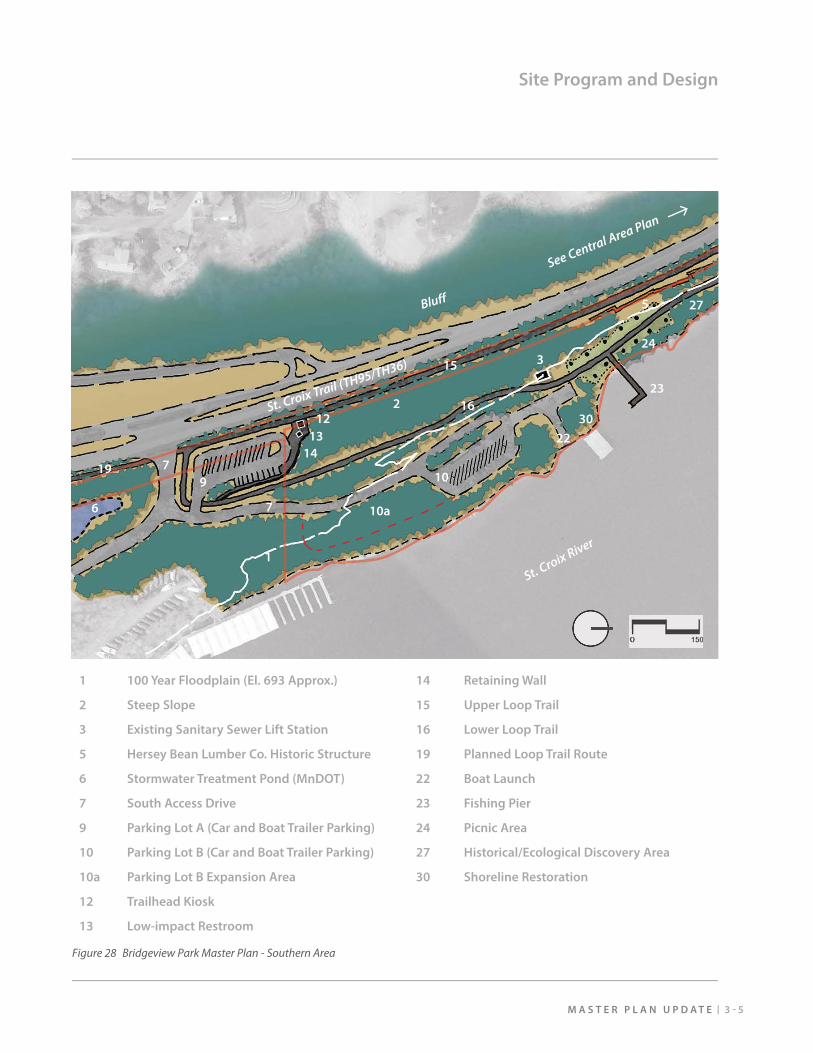
Figure 28 Bridgeview Park Master Plan - Southern Area 3-5
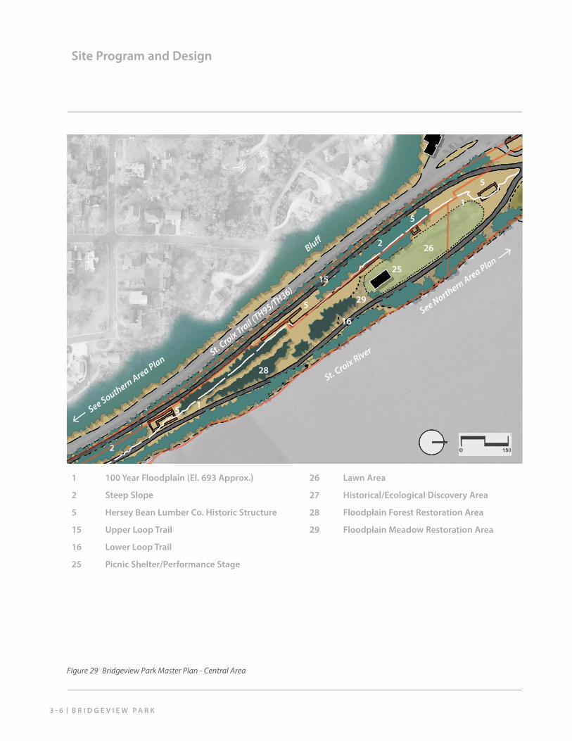
Figure 29 Bridgeview Park Master Plan - Central Area 3-6
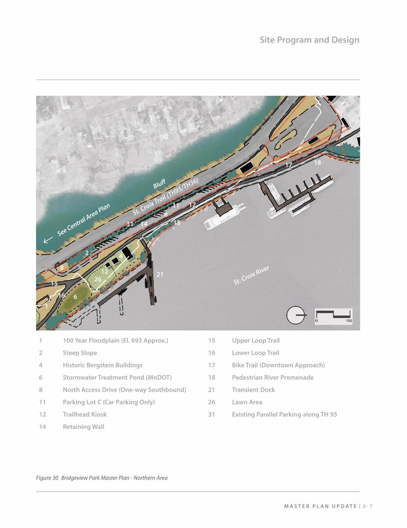
Figure 30 Bridgeview Park Master Plan - Northern Area 3-7
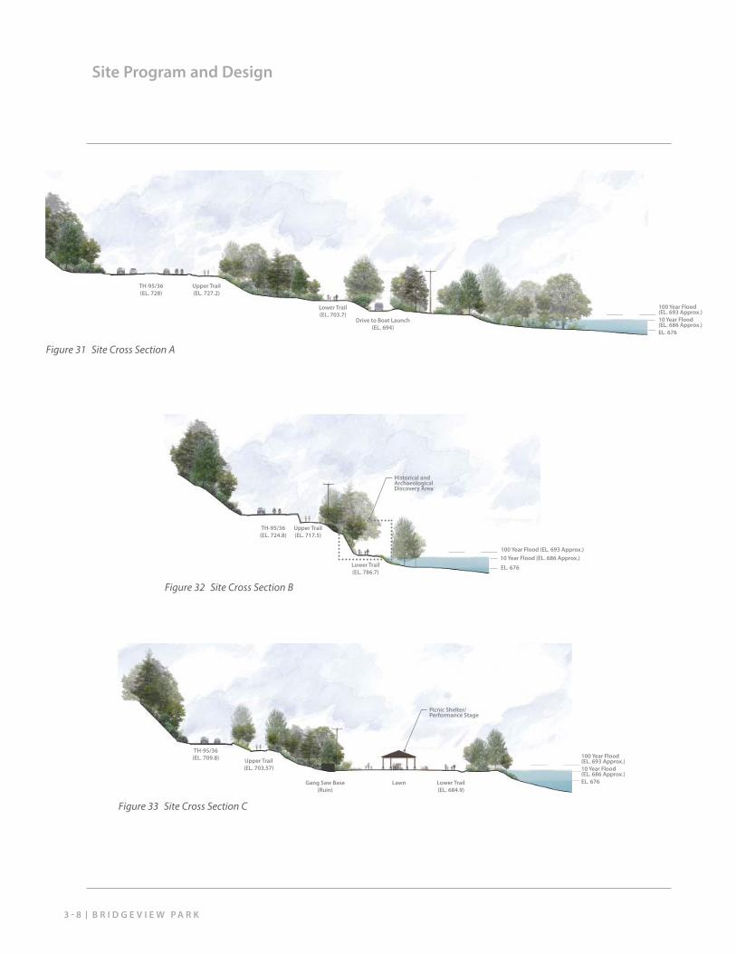
Figure 31 Site Cross Section A 3-8
Figure 33 Site Cross Section C 3-8
Figure 32 Site Cross Section B 3-8
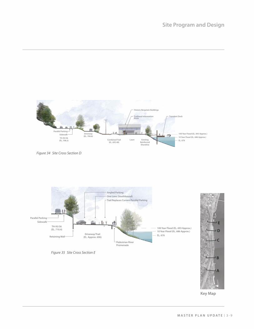
Figure 34 Site Cross Section D 3-9
Figure 35 Site Cross Section E 3-9
Figure 36 St. Croix Boat &Packet Dock 3-10
Figure 37 Alternative Dock Location Assessment Map 3-12
Figure 38 Alternative Dock Location Assessment Matrix 3-13
Figure 39 Paddling 3-14
Figure 40 Shakespeare in the Park 3-14
Figure 41 Bridgeview Park Phasing Plan 4-1
M A S T E R P L A N U P D A T E 1 - 1
1. Introduction
Regulatory Context
1998 Master Plan Highlights
Public Involvement
Related Planning and Design
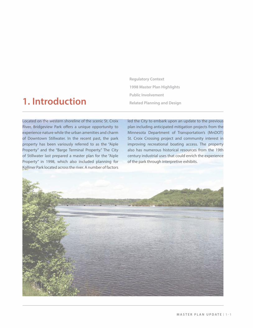
Located on the western shoreline of the scenic St. Croix River, Bridgeview Park off ers a unique opportunity to experience nature while the urban amenities and charm of Downtown Stillwater. In the recent past, the park property has been variously referred to as the “Aiple Property” and the “Barge Terminal Property.” The City of Stillwater last prepared a master plan for the “Aiple Property” in 1998, which also included planning for Kolliner Park located across the river. A number of factors
led the City to embark upon an update to the previous plan including anticipated mitigation projects from the Minnesota Department of Transportation’s (MnDOT) St. Croix Crossing project and community interest in improving recreational boating access. The property also has numerous historical resources from the 19th century industrial uses that could enrich the experience of the park through interpretive exhibits.
B R I D G E V I E W P A R K1 - 2
Introduction
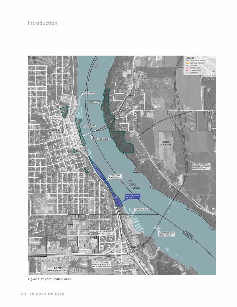
Figure 1 Project Location Map
1 - 3M A S T E R P L A N U P D A T E
Introduction
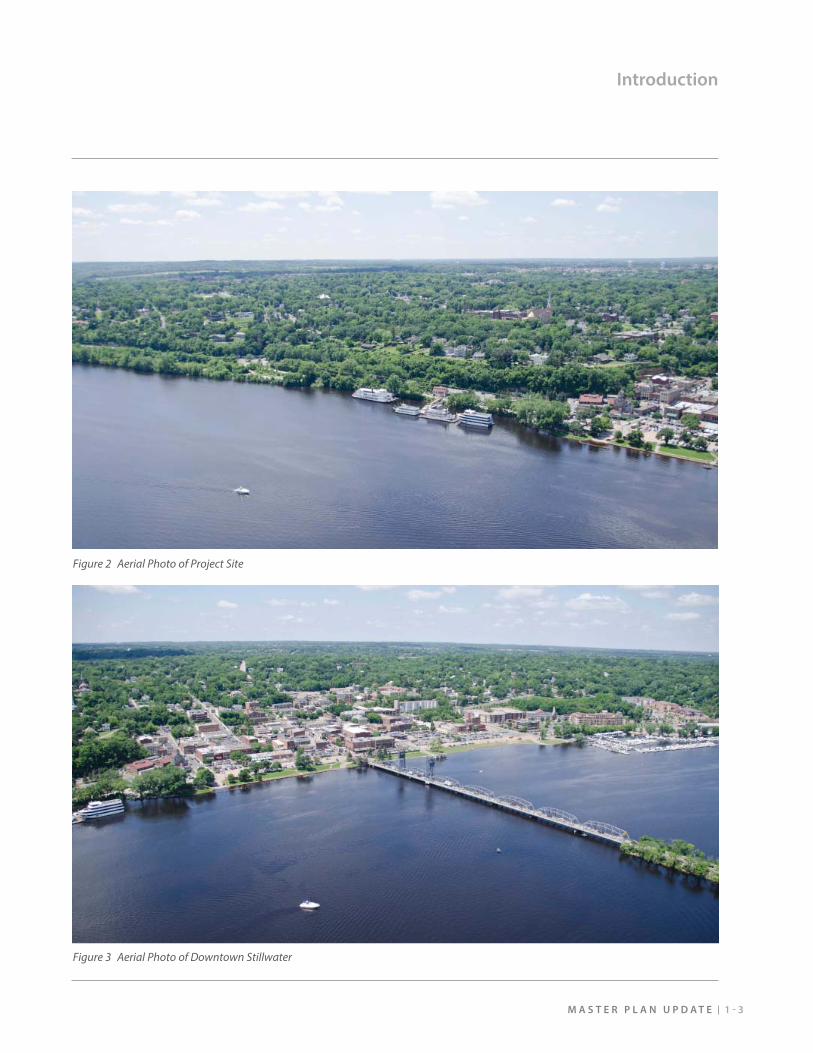
Figure 2 Aerial Photo of Project Site
Figure 3 Aerial Photo of Downtown Stillwater
B R I D G E V I E W P A R K1 - 4
Regulatory Context
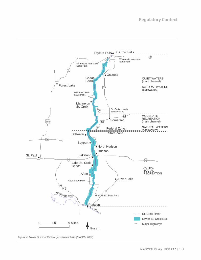
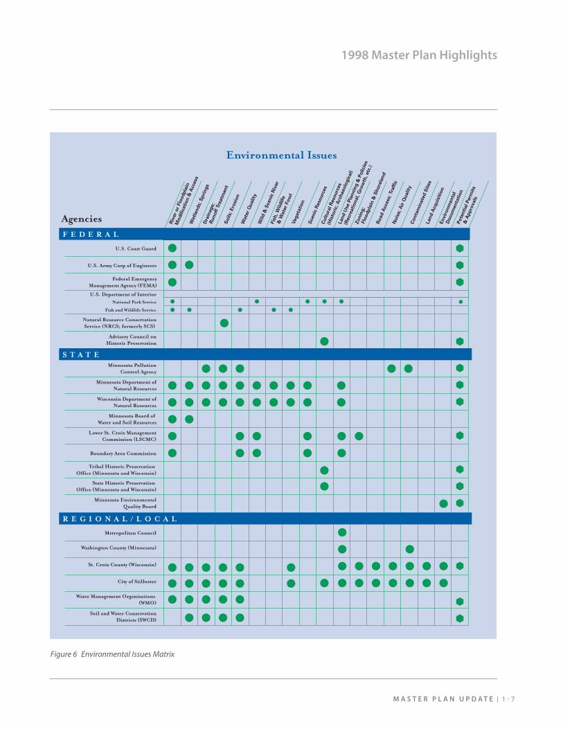
As part of the legislation designating the St. Croix as a National Wild and Scenic River, the Cooperative Management Plan (2002) was developed to guide stewardship of the river and its surroundings. Geographically, the overall plan addresses the river extents from Taylors Falls extending south to Prescott where it converges with the Mississippi River. Stillwater sits within the section of the river designated as an “active social recreation area.” It is also designated as a “State Zone,” which is managed cooperatively by the Minnesota Department of Natural Resources (MnDNR) and the Wisconsin Department of Natural Resources (WiDNR).
North of Stillwater, the river transitions into a “moderate recreation” area and then a “quiet waters” area, which is managed by the National Park Service. See Figure 4 for an overview map of the Riverway. In addition, other federal, state, and local agencies have jurisdiction and permitting authority. See Figure 6 for a comprehensive matrix outlining regulatory responsibilities.
1 - 5M A S T E R P L A N U P D A T E
Regulatory Context
Mississippi River
Federal ZoneState Zone
Taylors Falls
Forest Lake
St. Paul
Marine on St. Croix
Osceola
Stillwater
Hudson
River Falls
Prescott
8
1061
8
35
9494
35
NorthMajor Highways
Lower St. Croix NSR
St. Croix River
0 4.5 9 Miles
Bayport
Lakeland
North Hudson
Lake St. CroixBeach
Afton
Afton State Park
Kinnickinnic State Park
Wisconsin Interstate State Park
Minnesota InterstateState Park
William O'Brien State Park
St. Croix IslandsWildlife Area
QUIET WATERS(main channel)
NATURAL WATERS(backwaters)
MODERATERECREATION(main channel)
NATURAL WATERS(backwaters)
ACTIVESOCIALRECREATION
St. Croix Falls
CedarBend
35
10
35E Somerset35
64
64
36
Figure 4 Lower St. Croix Riverway Overview Map (MnDNR 2002)
B R I D G E V I E W P A R K1 - 6
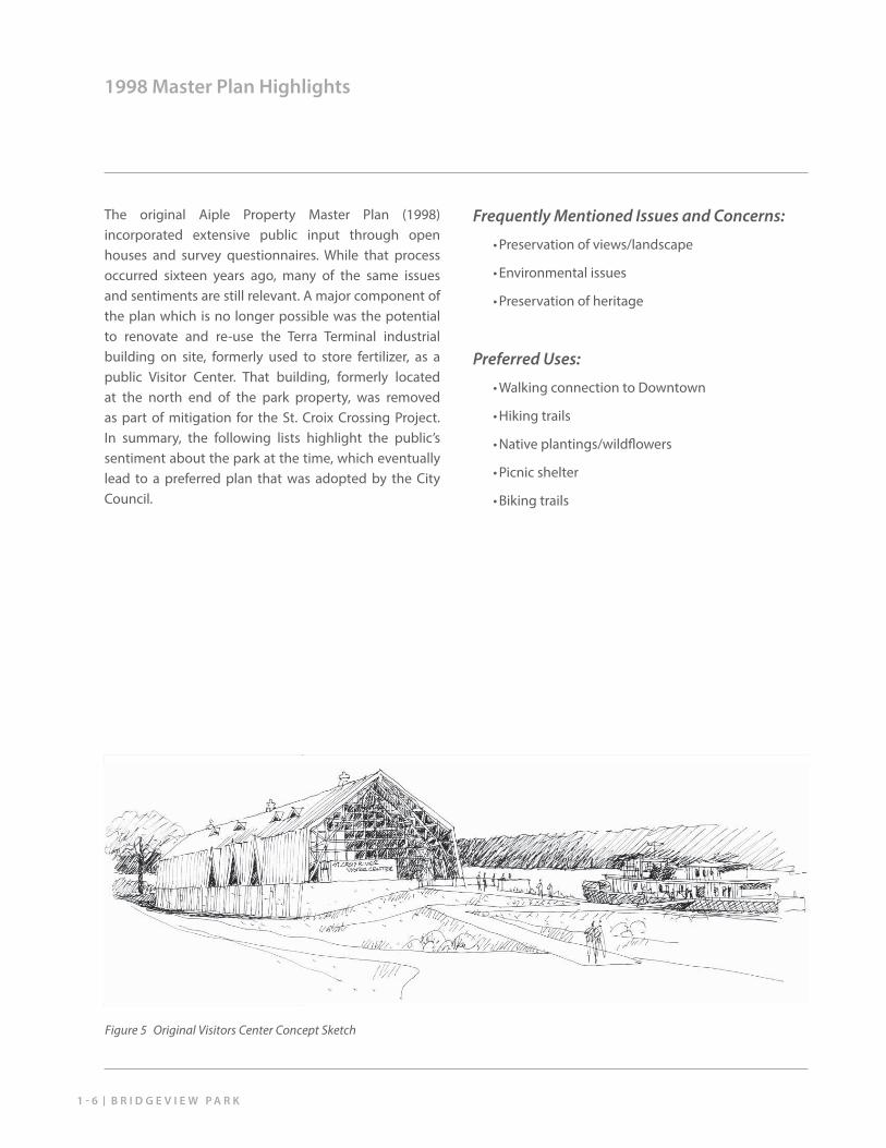
1998 Master Plan Highlights
The original Aiple Property Master Plan (1998) incorporated extensive public input through open houses and survey questionnaires. While that process occurred sixteen years ago, many of the same issues and sentiments are still relevant. A major component of the plan which is no longer possible was the potential to renovate and re-use the Terra Terminal industrial building on site, formerly used to store fertilizer, as a public Visitor Center. That building, formerly located at the north end of the park property, was removed as part of mitigation for the St. Croix Crossing Project. In summary, the following lists highlight the public’s sentiment about the park at the time, which eventually lead to a preferred plan that was adopted by the City Council.
Frequently Mentioned Issues and Concerns:
• Preservation of views/landscape
• Environmental issues
• Preservation of heritage
Preferred Uses:
• Walking connection to Downtown
• Hiking trails
• Native plantings/wildfl owers
• Picnic shelter
• Biking trails
Figure 5 Original Visitors Center Concept Sketch
1 - 7M A S T E R P L A N U P D A T E
1998 Master Plan Highlights
U.S. Coast Guard
S T A T E
R E G I O N A L / L O C A L
U.S. Army Corp of Engineers
Federal Emergency� Management Agency (FEMA)
U.S. Department of Interior�National Park Service�
�
Natural Resource Conservation�Service (NRCS; formerly SCS)
Advisory Council on�Historic Preservation
Minnesota Pollution�Control Agency
Minnesota Department of�Natural Resources
Wisconsin Department of�Natural Resources
Minnesota Board of �Water and Soil Resources
Lower St. Croix Management�Commission (LSCMC)
Boundary Area Commission
Tribal Historic Preservation �Office (Minnesota and Wisconsin)
State Historic Preservation �Office (Minnesota and Wisconsin)
Minnesota Environmental�Quality Board
Washington County (Minnesota)
Metropolitan Council
St. Croix County (Wisconsin)
City of Stillwater
Water Management Organizations �(WMO)
Soil and Water Conservation�Districts (SWCD)
Fish and Wildlife Service
Riv
er
or
Flo
od
pla
in
Mo
dif
icati
on
& A
ccess
Wetl
an
ds; S
pri
ng
sD
rain
ag
e;
R
un
off
Tre
atm
en
t
Wate
r Q
uality
So
ils; E
rosio
n
Wild
& S
cen
ic R
iver
Fis
h, W
ild
life
&
Wate
r Fo
wl
Veg
eta
tio
n
Scen
ic R
eso
urc
es
Cu
ltu
ral R
eso
urc
es
(H
isto
ric; A
rch
aeo
log
ical)
Lan
d U
se P
lan
nin
g &
Po
licie
s
(R
ecre
ati
on
al, G
row
th, etc
.)
Zo
nin
g;
Flo
od
pla
in &
Sh
ore
lan
dR
oad
Access; Tra
ffic
No
ise; A
ir Q
uality
Co
nta
min
ate
d S
ites
Lan
d A
cq
uis
itio
nE
nvir
on
men
tal
D
ocu
men
tati
on
Po
ten
tial P
erm
its
&
Ap
pro
vals
F E D E R A L
Agencies
Environmental Issues
Figure 6 Environmental Issues Matrix
B R I D G E V I E W P A R K1 - 8
Public Involvement
Initiated in the summer of 2014, the master plan update unfolded over an approximately six month period. The City and its consultant team coordinated with numerous agencies, commissions, the local business community, and the public to refresh the previous plan according to the current circumstances and the City’s related downtown planning eff orts. Through the public involvement process, a list of primary goals emerged that should guide future development of the park property over time.
Primary Master Plan Goals:
• Improve convenient access to the park by car, boat, bike, and on foot.
• Capitalize on the park’s proximity to downtown to welcome park visitors to the greater Stillwater community.
• Respect the scenic character of the river.
• Re-envision opportunities for the site’s historical resources to become more accessible and engaging.
• Extend active recreation opportunities through trail linkages.
• Provide fl exible spaces for public gathering and potential park programming.
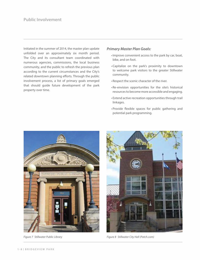
Figure 7 Stillwater Public Library Figure 8 Stillwater City Hall (Patch.com)
1 - 9M A S T E R P L A N U P D A T E
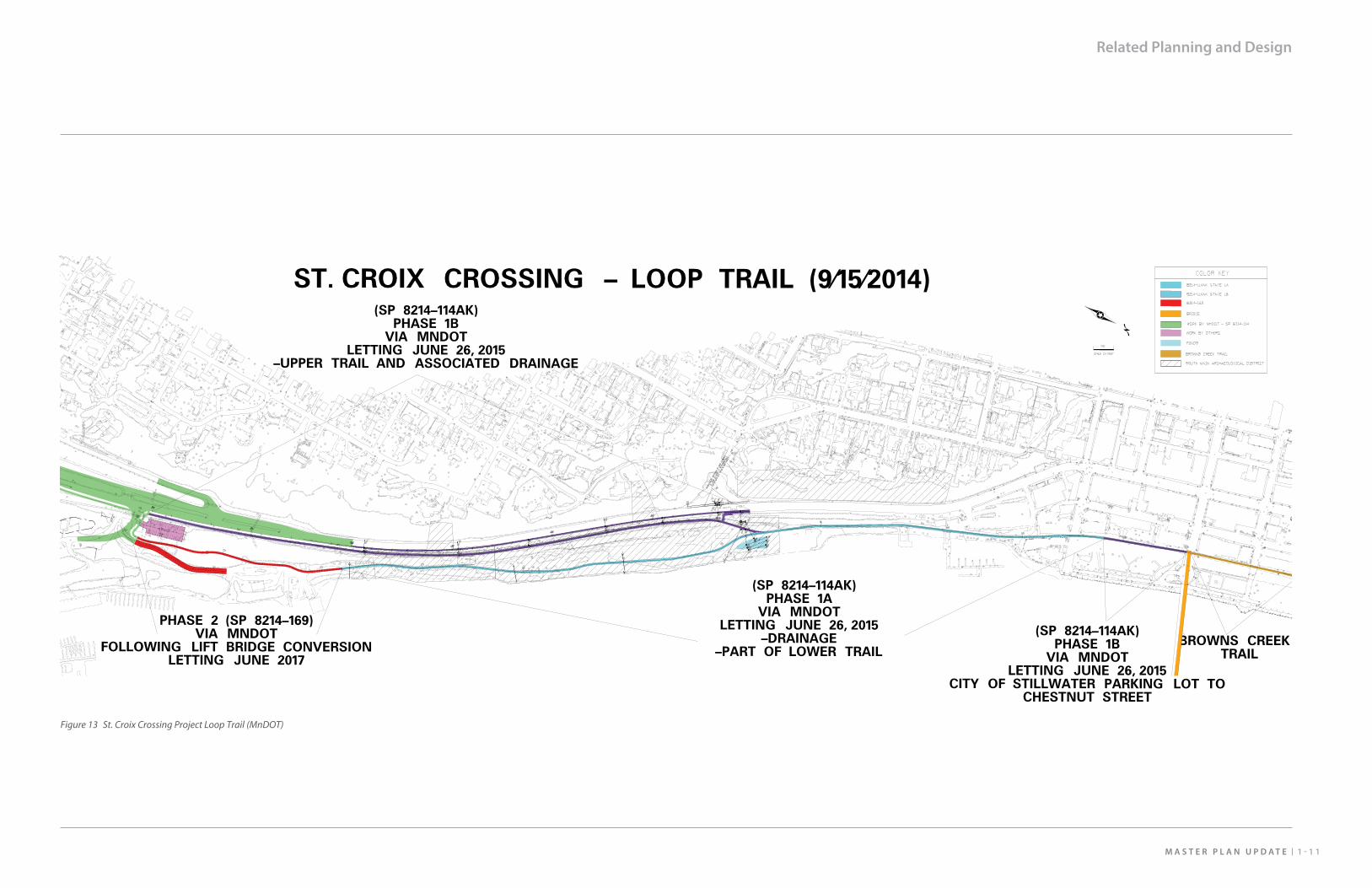
Related Planning and Design
It is a dynamic period of planning and design for Downtown Stillwater and the St. Croix River vicinity. The implementation of the St. Croix Crossing project has reach beyond the primary river crossing bridge and highway design that includes a number of mitigation measures that have relevance for the future development of Bridgeview Park as outlined in the list at right. In addition, the City has been developing plans for several years in conjunction with MnDNR for a potential public boat launch in the park. Lastly, the Greater Stillwater Chamber of Commerce and local business community has initiated a downtown revitalization eff ort that seeks to identify opportunities that will make the downtown commercial district a vibrant destination for residents and visitors in addition to growing the economic base of the community.
St. Croix Crossing Mitigation Measures:
• Removal of the Terra Terminal building
• Kolliner Park: removal of non-historic elements to allow reversion to a “natural state”
• Riverway interpretation
• Public boat access study
• Completion of the loop trail system including grading of the municipal barge facility property
• Recreation, education, and Riverway restoration
• Lift Bridge pedestrian/bicycle conversion
• Historic resources study and stabilization
• Relocation of historic Bergstein buildings to site
(adapted from St. Croix Crossing Project SFEIS, 2012)
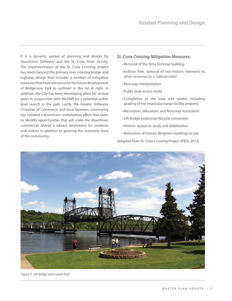
Figure 9 Lift Bridge and Lowell Park
B R I D G E V I E W P A R K1 - 1 0
Related Planning and Design
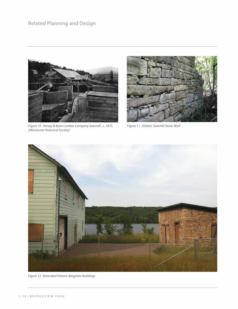
Figure 10 Hersey & Bean Lumber Company Sawmill , c. 1875 (Minnesota Historical Society)
Figure 11 Historic Sawmill Stone Wall
Figure 12 Relocated Historic Bergstein Buildings
1 - 1 1M A S T E R P L A N U P D A T E
Related Planning and Design
Figure 13 St. Croix Crossing Project Loop Trail (MnDOT)
M A S T E R P L A N U P D A T E 2 - 1
Natural Resources Context
Cultural Resources Context
Existing Site Conditions2. Site Characteristics
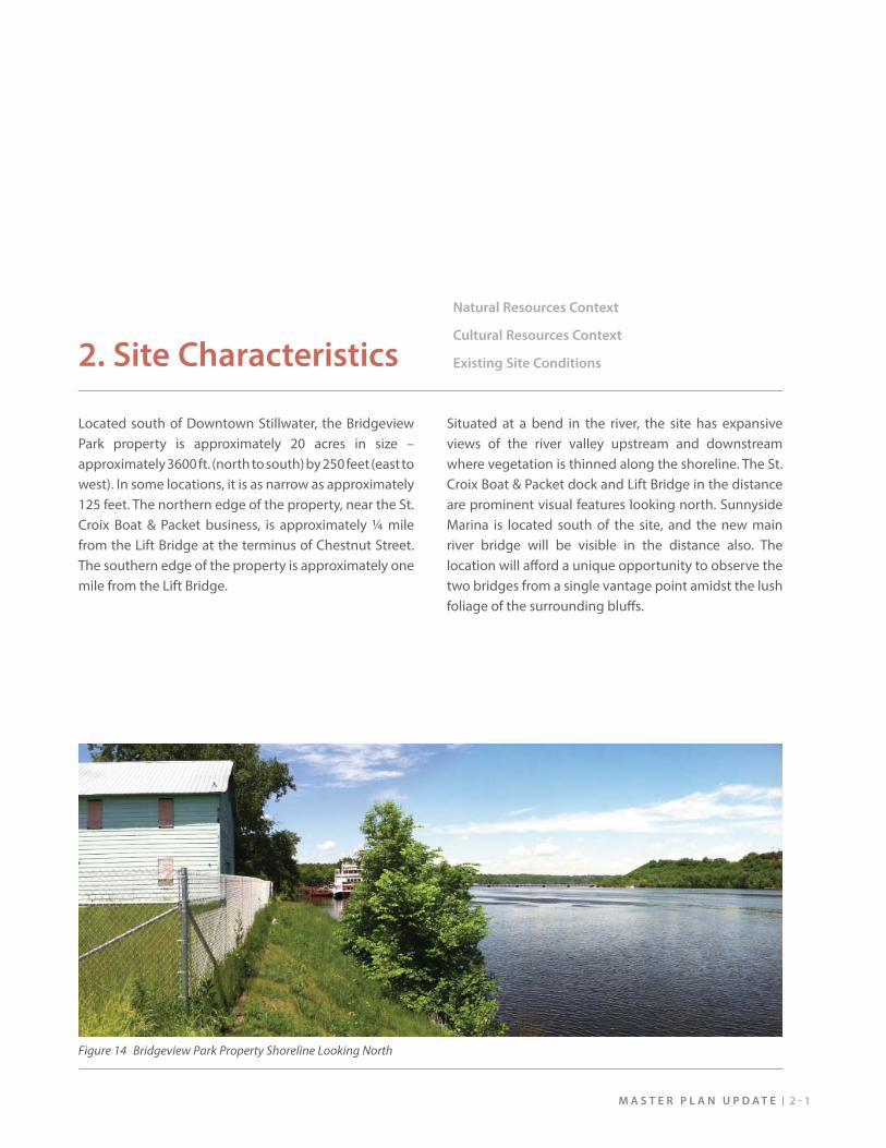
Located south of Downtown Stillwater, the Bridgeview Park property is approximately 20 acres in size – approximately 3600 ft. (north to south) by 250 feet (east to west). In some locations, it is as narrow as approximately 125 feet. The northern edge of the property, near the St. Croix Boat & Packet business, is approximately ¼ mile from the Lift Bridge at the terminus of Chestnut Street. The southern edge of the property is approximately one mile from the Lift Bridge.
Situated at a bend in the river, the site has expansive views of the river valley upstream and downstream where vegetation is thinned along the shoreline. The St. Croix Boat & Packet dock and Lift Bridge in the distance are prominent visual features looking north. Sunnyside Marina is located south of the site, and the new main river bridge will be visible in the distance also. The location will aff ord a unique opportunity to observe the two bridges from a single vantage point amidst the lush foliage of the surrounding bluff s.
Figure 14 Bridgeview Park Property Shoreline Looking North
B R I D G E V I E W P A R K2 - 2
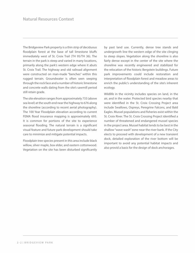
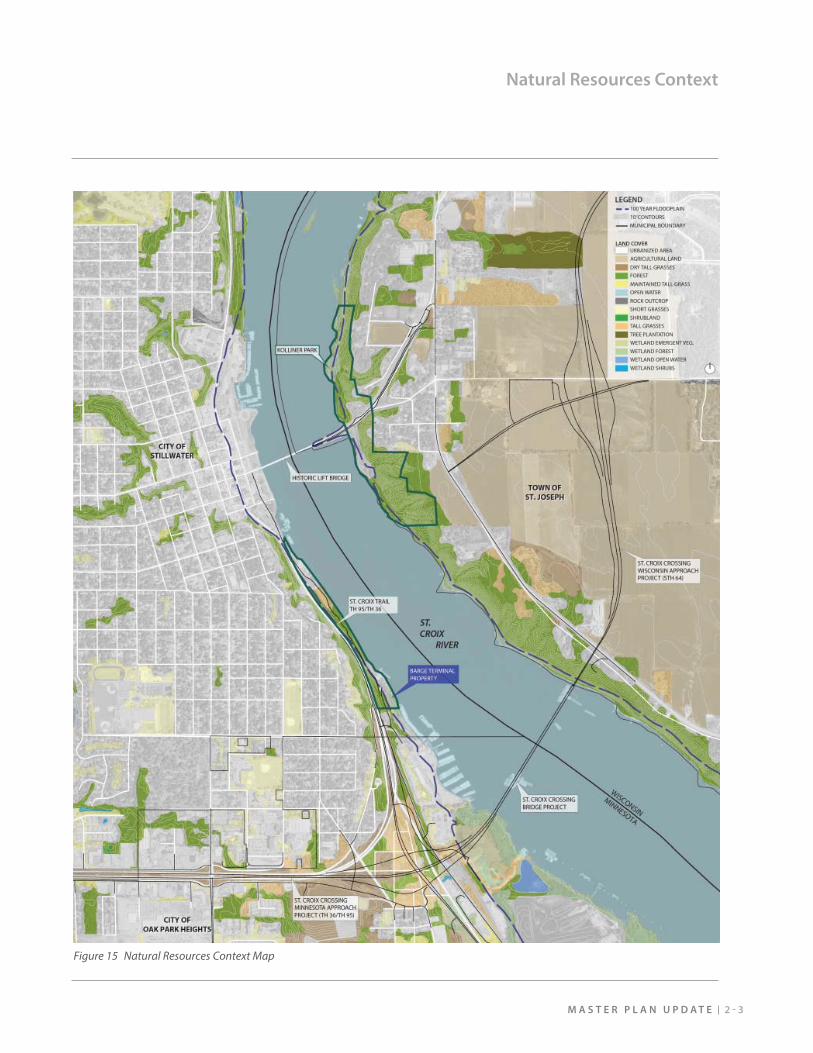
Natural Resources Context
The Bridgeview Park property is a thin strip of deciduous fl oodplain forest at the base of tall limestone bluff s immediately west of St. Croix Trail (TH 95/TH 36). The terrain in the park is steep and varied in many locations, primarily along the park’s western edge where it abuts St. Croix Trail. The highway and old railroad alignment were constructed on man-made “benches” within this rugged terrain. Groundwater is often seen seeping through the rock face and a number of historic limestone and concrete walls dating from the site’s sawmill period still retain grade.
The site elevation ranges from approximately 733 (above sea level) at the south end near the highway to 676 along the shoreline (according to recent aerial photography). The 100 Year Floodplain elevation according to current FEMA fl ood insurance mapping is approximately 693. It is common for portions of the site to experience seasonal fl ooding. The natural terrain is a signifi cant visual feature and future park development should take care to minimize and mitigate potential impacts.
Floodplain tree species present in this area include black willow, silver maple, box elder, and eastern cottonwood. Vegetation on the site has been disturbed signifi cantly
by past land use. Currently, dense tree stands and undergrowth line the western edge of the site clinging to steep slopes. Vegetation along the shoreline is also fairly dense except in the center of the site where the shoreline was recently engineered and stabilized for the relocation of the historic Bergstein buildings. Future park improvements could include restoration and interpretation of fl oodplain forest and meadow areas to enrich the public’s understanding of the site’s inherent ecology.
Wildlife in the vicinity includes species on land, in the air, and in the water. Protected bird species nearby that were identifi ed in the St. Croix Crossing Project area include Swallows, Ospreys, Peregrine Falcons, and Bald Eagles. Mussel populations and fi sheries exist within the St. Croix River. The St. Croix Crossing Project identifi ed a number of threatened and endangered mussel species in the project area. Mussel habitat tends to be best in the shallow “wave wash” zone near the river bank. If the City elects to proceed with development of a new transient dock, detailed exploration of the river bottom will be important to avoid any potential habitat impacts and also provid a basis for the design of dock anchorages.
2 - 3M A S T E R P L A N U P D A T E
Natural Resources Context
Figure 15 Natural Resources Context Map
B R I D G E V I E W P A R K2 - 4
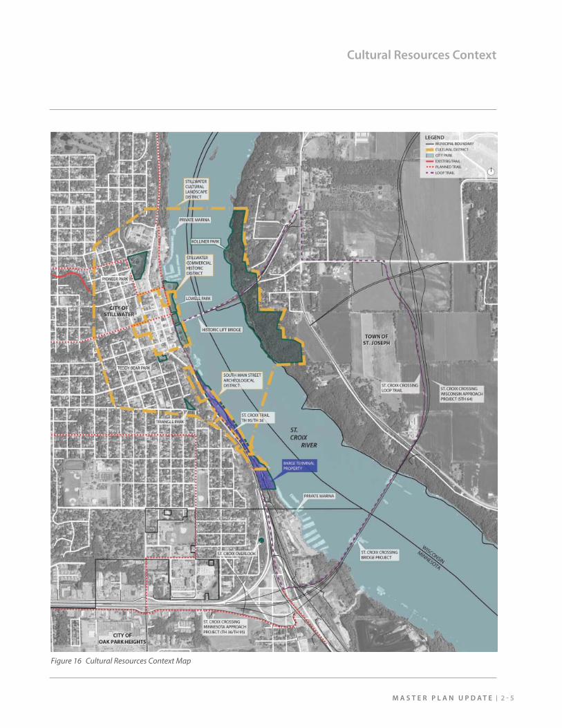
Cultural Resources Context
The Bridgeview Park property is rich with 19th century Stillwater history. It is set within the recently recognized South Main Archaeological District on the National Register of Historic Places (NHRP). One hundred and fi fty years ago, it was not a place to recreate – it was a place of industry. The area was home to a huge sawmill complex known as the Northwestern Mill, operated by the Hersey, Bean, and Brown Company. Archaeological study conducted for the St. Croix Crossing Project refers to this as the Hersey-Bean Sawmill. The mill was built in 1853 and by 1881 it employed 225 men and could produce 18 million board feet of lumber a year. Rising production
costs, diminishing supplies of timber and increased distances to markets contributed to the mill’s closure in 1904. By 1910, nearly all of the structures associated with the operation had been dismantled, however a few stone and brick foundations can still be found on the park property. These “ruins” off er an opportunity to provide a window on a unique aspect of Stillwater’s past through development of a coordinated interpretive plan along the proposed trails in the park. Additionally, the park is included within the Stillwater Cultural Landscape District and a gateway to the Stillwater Commercial
2 - 5M A S T E R P L A N U P D A T E
Cultural Resources Context
Figure 16 Cultural Resources Context Map
B R I D G E V I E W P A R K2 - 6
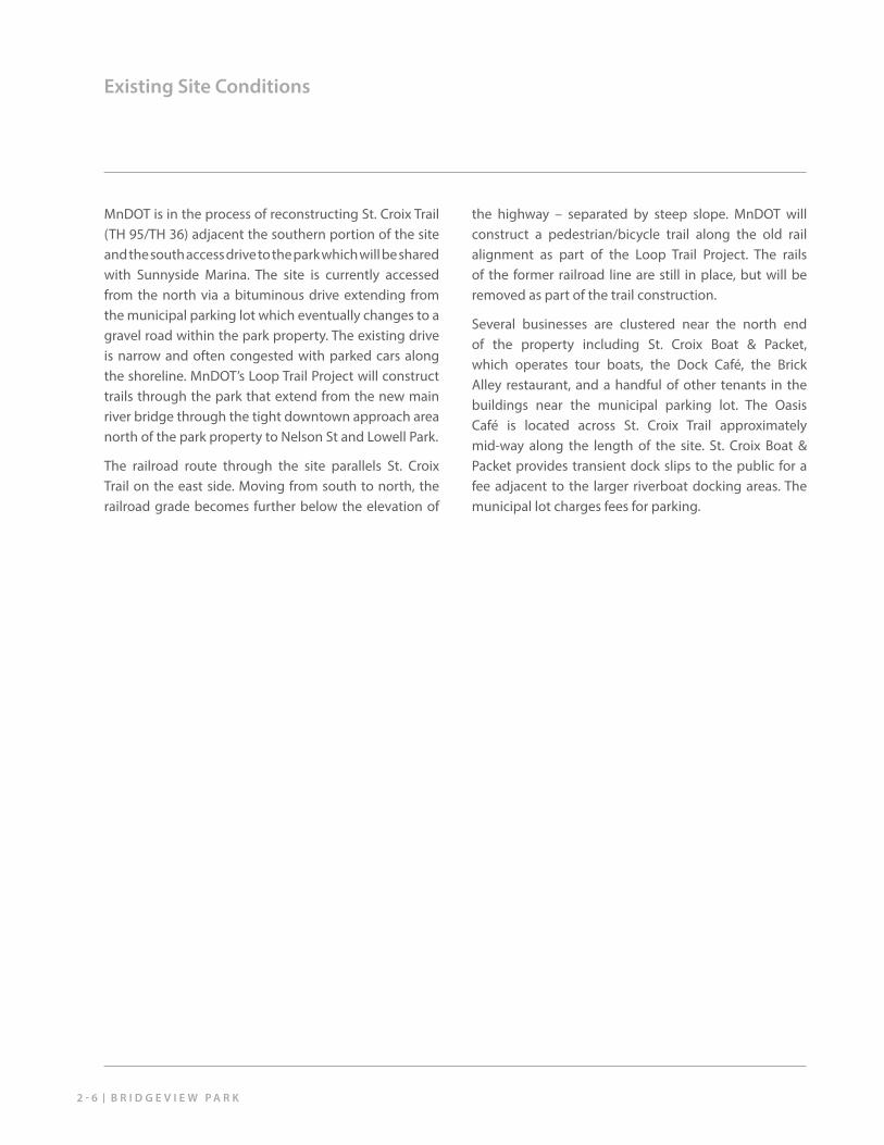
Existing Site Conditions
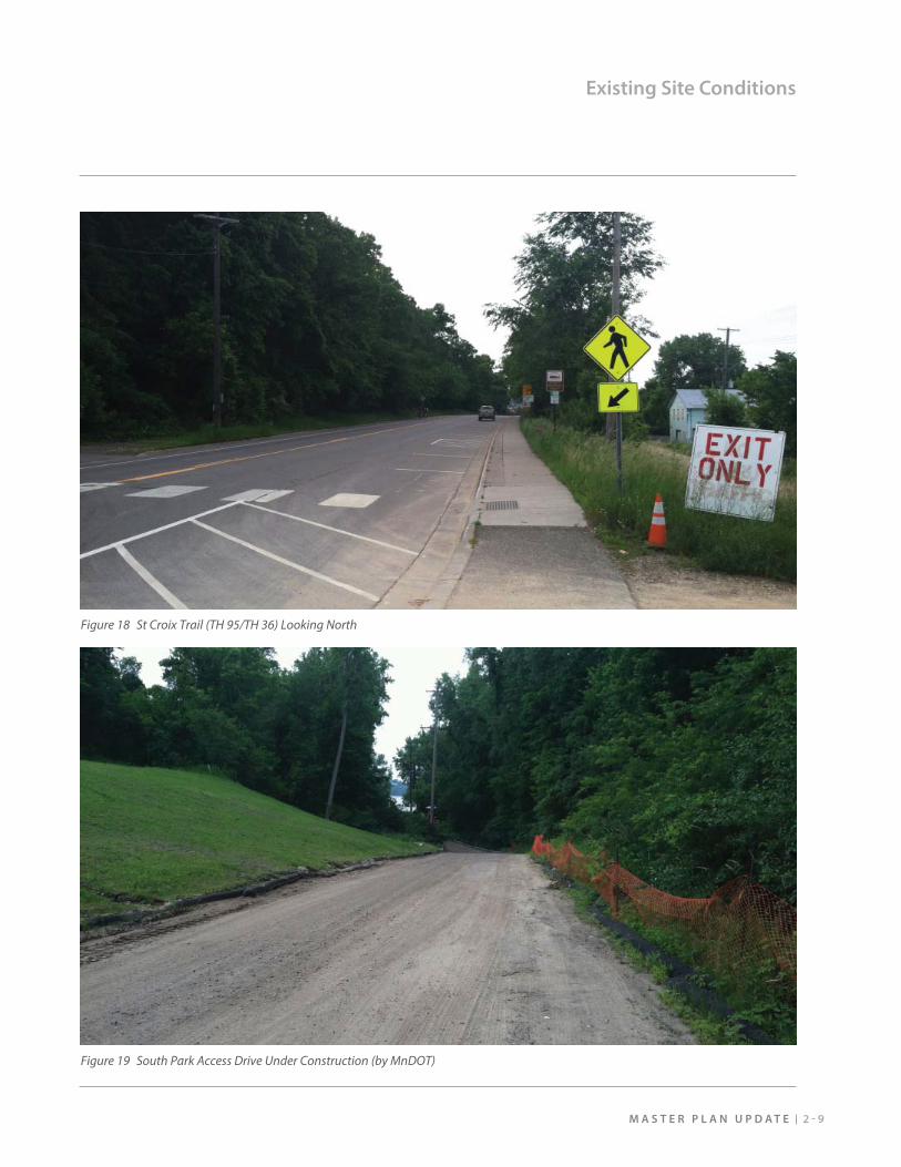
MnDOT is in the process of reconstructing St. Croix Trail (TH 95/TH 36) adjacent the southern portion of the site and the south access drive to the park which will be shared with Sunnyside Marina. The site is currently accessed from the north via a bituminous drive extending from the municipal parking lot which eventually changes to a gravel road within the park property. The existing drive is narrow and often congested with parked cars along the shoreline. MnDOT’s Loop Trail Project will construct trails through the park that extend from the new main river bridge through the tight downtown approach area north of the park property to Nelson St and Lowell Park.
The railroad route through the site parallels St. Croix Trail on the east side. Moving from south to north, the railroad grade becomes further below the elevation of
the highway – separated by steep slope. MnDOT will construct a pedestrian/bicycle trail along the old rail alignment as part of the Loop Trail Project. The rails of the former railroad line are still in place, but will be removed as part of the trail construction.
Several businesses are clustered near the north end of the property including St. Croix Boat & Packet, which operates tour boats, the Dock Café, the Brick Alley restaurant, and a handful of other tenants in the buildings near the municipal parking lot. The Oasis Café is located across St. Croix Trail approximately mid-way along the length of the site. St. Croix Boat & Packet provides transient dock slips to the public for a fee adjacent to the larger riverboat docking areas. The municipal lot charges fees for parking.
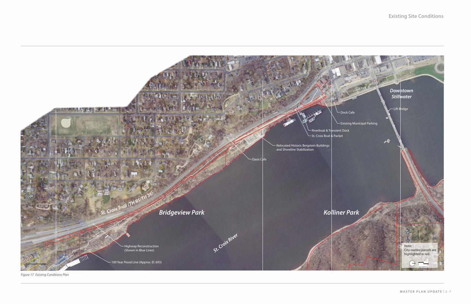
2 - 7M A S T E R P L A N U P D A T E
Existing Site Conditions
Riverboat & Transient Dock
Dock Cafe
St. Croix Boat & Packet
Existing Municipal Parking
Lift Bridge
Lowell Park
100 Year Flood Line (Approx. El. 693)
Highway Reconstruction (Shown in Blue Lines)
Relocated Historic Bergstein Buildings and Shoreline Stabilization
Sunnyside Marina
Oasis Cafe
Note:City-owned parcels are highlighted in red.
St. Croix River
Kolliner ParkBridgeview Park
DowntownStillwater
St. Croix Trail (TH 95/TH 36)
MAIN ST
WATER ST
CHESTN
UT ST
Figure 17 Existing Conditions Plan
2 - 9M A S T E R P L A N U P D A T E
Existing Site Conditions
Figure 18 St Croix Trail (TH 95/TH 36) Looking North
Figure 19 South Park Access Drive Under Construction (by MnDOT)
B R I D G E V I E W P A R K2 - 1 0
Existing Site Conditions
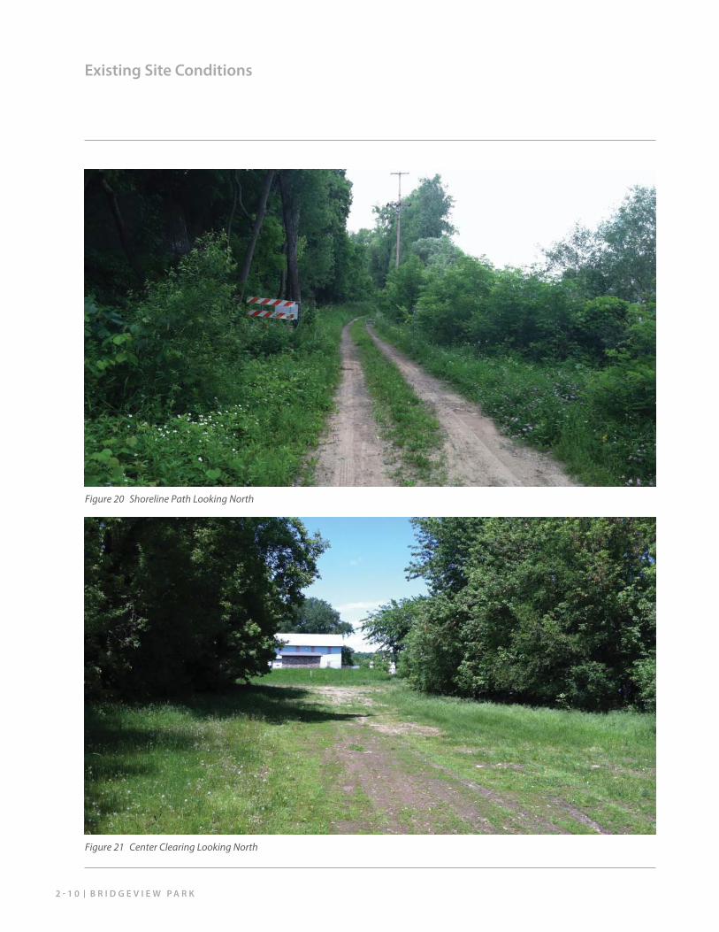
Figure 20 Shoreline Path Looking North
Figure 21 Center Clearing Looking North
2 - 1 1M A S T E R P L A N U P D A T E
Existing Site Conditions
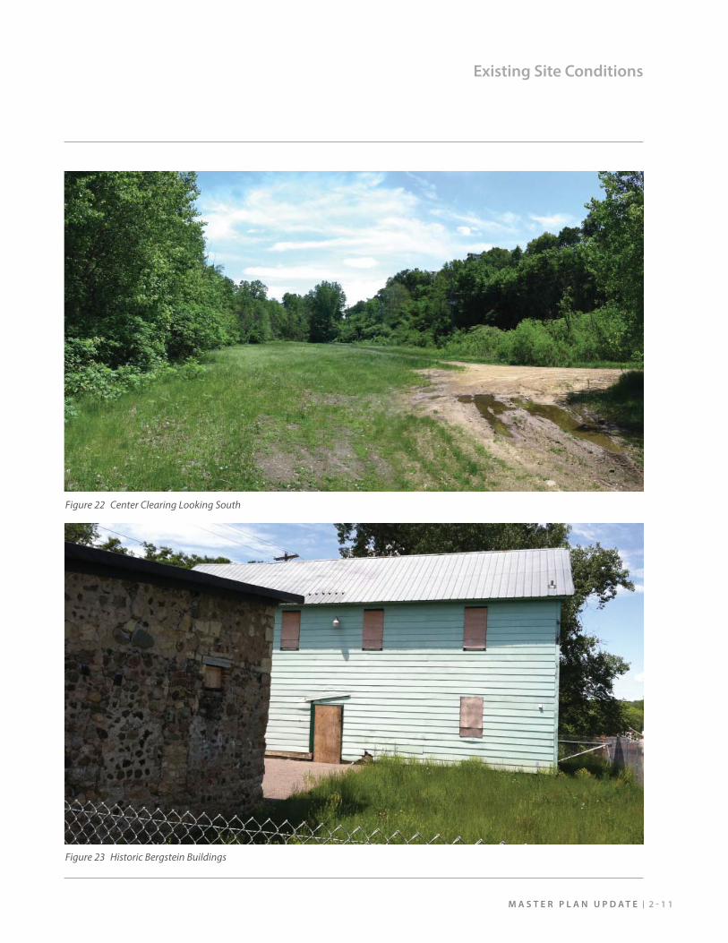
Figure 22 Center Clearing Looking South
Figure 23 Historic Bergstein Buildings
B R I D G E V I E W P A R K2 - 1 2
Existing Site Conditions
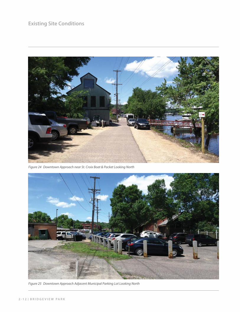
Figure 24 Downtown Approach near St. Croix Boat & Packet Looking North
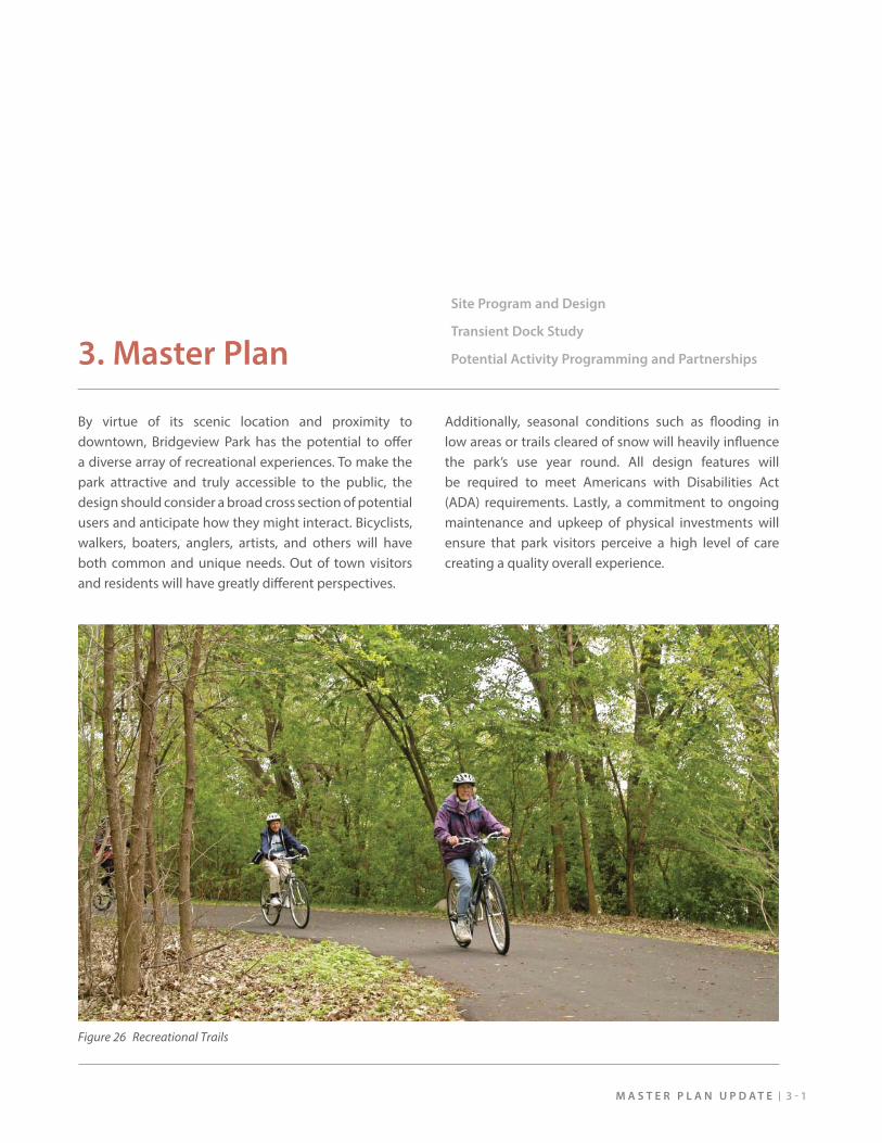
Figure 25 Downtown Approach Adjacent Municipal Parking Lot Looking North
M A S T E R P L A N U P D A T E 3 - 1
Site Program and Design
Transient Dock Study
Potential Activity Programming and Partnerships3. Master Plan
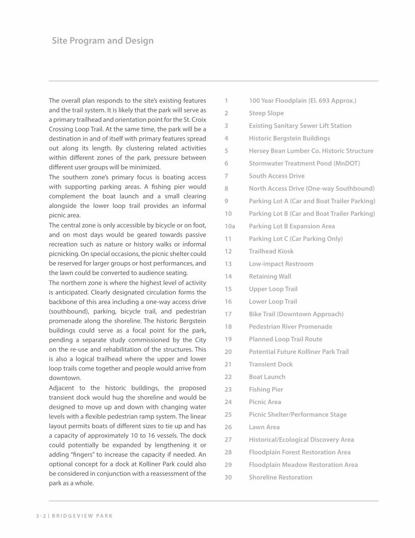
By virtue of its scenic location and proximity to downtown, Bridgeview Park has the potential to off er a diverse array of recreational experiences. To make the park attractive and truly accessible to the public, the design should consider a broad cross section of potential users and anticipate how they might interact. Bicyclists, walkers, boaters, anglers, artists, and others will have both common and unique needs. Out of town visitors and residents will have greatly diff erent perspectives.
Additionally, seasonal conditions such as fl ooding in low areas or trails cleared of snow will heavily infl uence the park’s use year round. All design features will be required to meet Americans with Disabilities Act (ADA) requirements. Lastly, a commitment to ongoing maintenance and upkeep of physical investments will ensure that park visitors perceive a high level of care creating a quality overall experience.
Figure 26 Recreational Trails
B R I D G E V I E W P A R K3 - 2
Site Program and Design
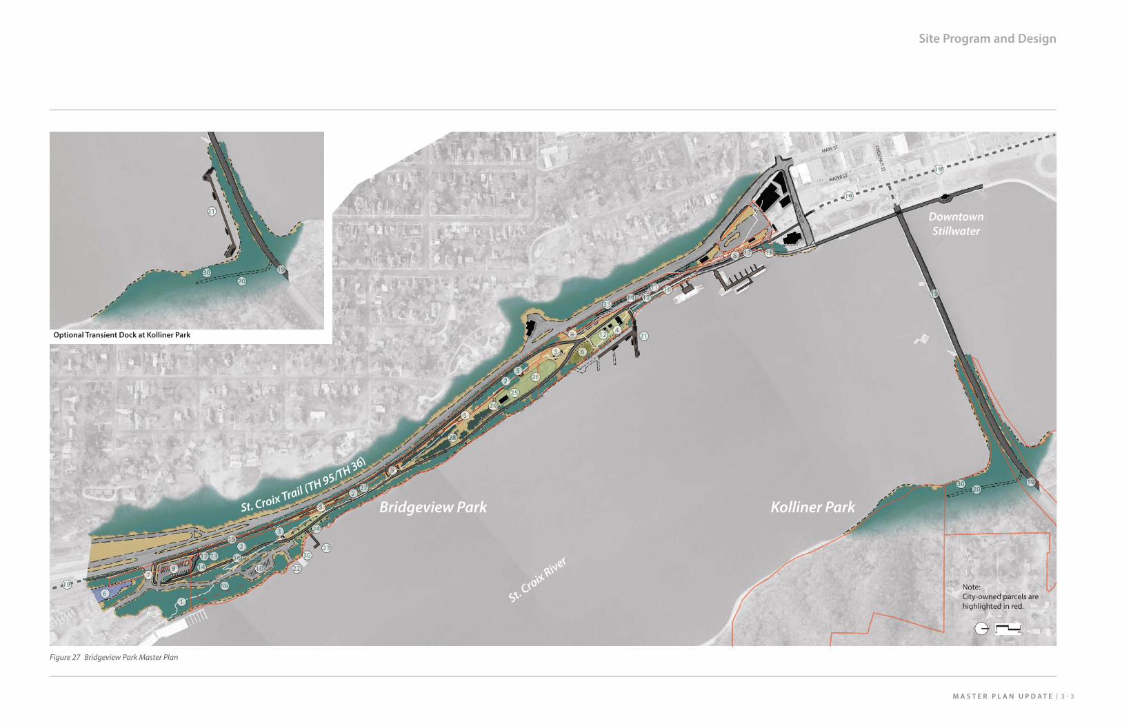
The overall plan responds to the site’s existing features and the trail system. It is likely that the park will serve as a primary trailhead and orientation point for the St. Croix Crossing Loop Trail. At the same time, the park will be a destination in and of itself with primary features spread out along its length. By clustering related activities within diff erent zones of the park, pressure between diff erent user groups will be minimized.The southern zone’s primary focus is boating access with supporting parking areas. A fi shing pier would complement the boat launch and a small clearing alongside the lower loop trail provides an informal picnic area.The central zone is only accessible by bicycle or on foot, and on most days would be geared towards passive recreation such as nature or history walks or informal picnicking. On special occasions, the picnic shelter could be reserved for larger groups or host performances, and the lawn could be converted to audience seating. The northern zone is where the highest level of activity is anticipated. Clearly designated circulation forms the backbone of this area including a one-way access drive (southbound), parking, bicycle trail, and pedestrian promenade along the shoreline. The historic Bergstein buildings could serve as a focal point for the park, pending a separate study commissioned by the City on the re-use and rehabilitation of the structures. This is also a logical trailhead where the upper and lower loop trails come together and people would arrive from downtown.Adjacent to the historic buildings, the proposed transient dock would hug the shoreline and would be designed to move up and down with changing water levels with a fl exible pedestrian ramp system. The linear layout permits boats of diff erent sizes to tie up and has a capacity of approximately 10 to 16 vessels. The dock could potentially be expanded by lengthening it or adding “fi ngers” to increase the capacity if needed. An optional concept for a dock at Kolliner Park could also be considered in conjunction with a reassessment of the park as a whole.
1 100 Year Floodplain (El. 693 Approx.)
2 Steep Slope
3 Existing Sanitary Sewer Lift Station
4 Historic Bergstein Buildings
5 Hersey Bean Lumber Co. Historic Structure
6 Stormwater Treatment Pond (MnDOT)
7 South Access Drive
8 North Access Drive (One-way Southbound)
9 Parking Lot A (Car and Boat Trailer Parking)
10 Parking Lot B (Car and Boat Trailer Parking)
10a Parking Lot B Expansion Area
11 Parking Lot C (Car Parking Only)
12 Trailhead Kiosk
13 Low-impact Restroom
14 Retaining Wall
15 Upper Loop Trail
16 Lower Loop Trail
17 Bike Trail (Downtown Approach)
18 Pedestrian River Promenade
19 Planned Loop Trail Route
20 Potential Future Kolliner Park Trail
21 Transient Dock
22 Boat Launch
23 Fishing Pier
24 Picnic Area
25 Picnic Shelter/Performance Stage
26 Lawn Area
27 Historical/Ecological Discovery Area
28 Floodplain Forest Restoration Area
29 Floodplain Meadow Restoration Area
30 Shoreline Restoration
Note:City-owned parcels are highlighted in red.
St. Croix River
Kolliner ParkBridgeview Park
DowntownStillwater
NELSO
N ST
MAIN ST
WATER ST
CHESTN
UT ST
Potential Future Trail
Planned Loop Trail
Transient Dock(10 - 17 boats)
Optional Transient Dock at Kolliner Park
Restored Forest & Shoreline(WiDNR)
St. Croix Trail (TH 95/TH 36)
3 - 3M A S T E R P L A N U P D A T E
Site Program and Design
11111111111111
1010101010101010101010010
10a
999999999999999999777
333
121 13
14141441444444444444
1616161616161616116161616616161661666161616161616616666166666661666616
1515151515511155515515151515115155115155151551115151511511115151515511555151
888888888888888888
888888888888888888888888888888888888888888
2272772777277222
5555555555555555555555555555555555555555555555555555555555555555555555555
5555555555555555555555555555555555555555555555555555555555555555555
55555555555555555555555555555555555555555555555555
30333
202020222
2122
1919191919199191911919199919111
5555555
555555555555555555
22828282228282822822222222828282822222
292929292929292929292229222992929229229929229222
222222
2
222222222222
14141414141141414414141411114141411411414111411441411111111111
111111111111111111111111111111111111111111
19199
1991119
191919191911919191919911119
19191191919
19191119919111919191919920202020200220202020222222
212122
2222
2322
22222242424224224444442444442222222
2522
30333033333333
3033333
2626622
666
666
3131311111113111111131311313111333
12222222222244444444444444444444444
181818181881818188188181888818181818188181881188181881818888818888818118181111181818188181818818181181818
181811818181818181818181881881818188188181818181888188181888881811881818111181181818888888
17171717171717171717717177717177177177771717177171717777
17171717171717171717171771717177171777777777111717171111711111
Figure 27 Bridgeview Park Master Plan
3 - 5M A S T E R P L A N U P D A T E
Site Program and Design
1 100 Year Floodplain (El. 693 Approx.)
2 Steep Slope
3 Existing Sanitary Sewer Lift Station
5 Hersey Bean Lumber Co. Historic Structure
6 Stormwater Treatment Pond (MnDOT)
7 South Access Drive
9 Parking Lot A (Car and Boat Trailer Parking)
10 Parking Lot B (Car and Boat Trailer Parking)
10a Parking Lot B Expansion Area
12 Trailhead Kiosk
13 Low-impact Restroom
14 Retaining Wall
15 Upper Loop Trail
16 Lower Loop Trail
19 Planned Loop Trail Route
22 Boat Launch
23 Fishing Pier
24 Picnic Area
27 Historical/Ecological Discovery Area
30 Shoreline Restoration
1
2
3
19
22
23
30
24
275
6
7
7
9 10
10a
12
13
14
15
St. Croix Trail (TH95/TH36)
St. Croix River
Bluff
16
See Central Area Plan
Figure 28 Bridgeview Park Master Plan - Southern Area
B R I D G E V I E W P A R K3 - 6
Site Program and Design
1 100 Year Floodplain (El. 693 Approx.)
2 Steep Slope
5 Hersey Bean Lumber Co. Historic Structure
15 Upper Loop Trail
16 Lower Loop Trail
25 Picnic Shelter/Performance Stage
26 Lawn Area
27 Historical/Ecological Discovery Area
28 Floodplain Forest Restoration Area
29 Floodplain Meadow Restoration Area
1
2
2
5
5
5
5
15
16
25
26
28
1
29
St. Croix Trail (
TH95/TH36)
St. Croix River
Bluff
See Southern Area Plan
See Northern Area Plan
Figure 29 Bridgeview Park Master Plan - Central Area
3 - 7M A S T E R P L A N U P D A T E
Site Program and Design
1 100 Year Floodplain (El. 693 Approx.)
2 Steep Slope
4 Historic Bergstein Buildings
6 Stormwater Treatment Pond (MnDOT)
8 North Access Drive (One-way Southbound)
11 Parking Lot C (Car Parking Only)
12 Trailhead Kiosk
14 Retaining Wall
15 Upper Loop Trail
16 Lower Loop Trail
17 Bike Trail (Downtown Approach)
18 Pedestrian River Promenade
21 Transient Dock
26 Lawn Area
31 Existing Parallel Parking along TH 95
1
24
6
11
31 14
12
15
16
17
17
18
2126
18
8
8
See Central Area PlanSt. Croix Trail (TH95/TH36)
Bluff
St. Croix River
Figure 30 Bridgeview Park Master Plan - Northern Area
B R I D G E V I E W P A R K3 - 8
Site Program and Design
TH-95/36
(EL. 728)
Upper Trail
(EL. 727.2)
Lower Trail
(EL. 703.7)Drive to Boat Launch
(EL. 694)
100 Year Flood (EL. 693 Approx.)
EL. 676
10 Year Flood(EL. 686 Approx.)
TH-95/36
(EL. 724.8)
Upper Trail
(EL. 717.5)
Lower Trail
(EL. 786.7)
100 Year Flood (EL. 693 Approx.)
Historical and Archaeological Discovery Area
EL. 676
10 Year Flood (EL. 686 Approx.)
TH-95/36
(EL. 709.8)Upper Trail
(EL. 703.57)
Gang Saw Base
(Ruin)
Lawn Lower Trail
(EL. 684.9)
Picnic Shelter/Performance Stage
100 Year Flood (EL. 693 Approx.)
EL. 676
10 Year Flood(EL. 686 Approx.)
Figure 31 Site Cross Section A
Figure 32 Site Cross Section B
Figure 33 Site Cross Section C
3 - 9M A S T E R P L A N U P D A T E
Site Program and Design
Key Map
A
B
C
D
E
TH-95/36
(EL. 708.3)
Parallel Parking
Sidewalk Driveway
(EL. 700.6)
Combined Trail
(EL. 693.48)
Lawn Existing
Reinforced
Shoreline
100 Year Flood (EL. 693 Approx.)
EL. 676
10 Year Flood (EL. 686 Approx.)
Historic Bergstein Buildings
Trailhead Information Kiosk
Transient Dock
TH-95/36
(EL. 710.4)
Parallel Parking
Angled Parking
Sidewalk
Retaining Wall
One Lane (Southbound)
Trail Replaces Current Parallel Parking
Pedestrian River
Promenade
Driveway/Trail
(EL. Approx. 696)
100 Year Flood (EL. 693 Approx.)
EL. 676
10 Year Flood (EL. 686 Approx.)
Figure 34 Site Cross Section D
Figure 35 Site Cross Section E
B R I D G E V I E W P A R K3 - 1 0
Transient Dock Study
Recreational boating is a popular local activity and viewed by the Stillwater business community as a fundamental part of the economy, but with unrealized growth potential. A Dock Needs Analysis report (see Appendix B) was prepared that delved into the characteristics of recreational boating on the St. Croix River, investigated marina usage, and identifi ed potential locations for a new dock. For the study, “transient docking” was defi ned to be short-term daily use only - not overnight. In addition, any potential new dock would need to be designed with limited services so as not to be technically classifi ed as a “marina” since current regulations in the Cooperative Management Plan (2002) prohibit the development of any new marinas within the Riverway.
Studies in the late 1990’s estimated that approximately 310,000 people recreated on the river annually out of a total of over 2 million visitors. Riverway usage at Stillwater was calibrated at 16 acres per moving boat. In contrast, the Hudson Narrows area saw a density of 2.2 acres per moving boat. Based on review of current aerial mapping, there are approximately 2,000 boat slips overall available between Stillwater and Prescott. At a glance, the marinas appear nearly full during the boating season, which was generally confi rmed by a survey of marina managers. While many of these facilities try to accommodate transient boaters as space allows, very few slips are actually dedicated for public use.
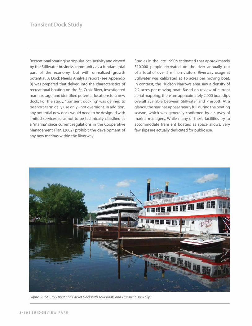
Figure 36 St. Croix Boat and Packet Dock with Tour Boats and Transient Dock Slips
3 - 1 1M A S T E R P L A N U P D A T E
Transient Dock Study
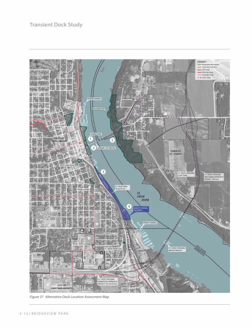
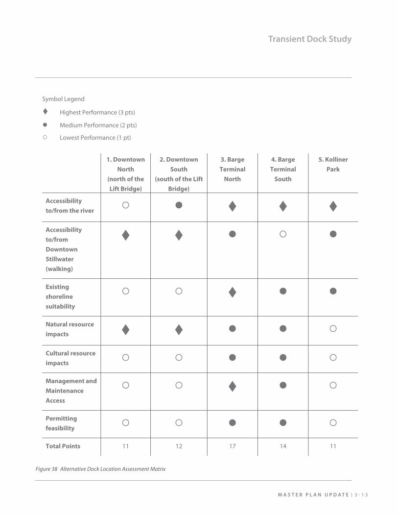
Based on the assessment of current recreational boating use on the Lower St. Croix, Stillwater is currently not conveniently connected to the boating activity already occurring in close proximity and potentially missing out on the potential economic benefi ts and additional vitality that recreational boating would bring. Based on the evaluation of key factors, the recommended location for the new dock is the Barge Terminal North site (location #3 on the map on the following page).
Primary Benefi ts of the Selected Dock Location:
• Located south of the Lift Bridge and conveniently accessible by avoiding bridge opening restrictions.
• Set within a ½ mile walking radius to the center of downtown (Chestnut Street) - a reasonable 5 to 10 minute walk for most people.
• Already generally clear of woody vegetation along the shoreline and engineered for stability.
• Away from the Hersey-Bean Sawmill historical features, which are generally congregated in the middle and southern ends of the property.
• Potential to develop the dock in conjunction with the new park.
• Opportunity to utilize space within the recently relocated Bergstein buildings for management and maintenance of the dock without the need for a new structure (pending a separate study by the City).
B R I D G E V I E W P A R K3 - 1 2
Transient Dock Study
Figure 37 Alternative Dock Location Assessment Map
Symbol Legend
Highest Performance (3 pts)
Medium Performance (2 pts)
Lowest Performance (1 pt)
1. Downtown
North
(north of the
Lift Bridge)
2. Downtown
South
(south of the Lift
Bridge)
3. Barge
Terminal
North
4. Barge
Terminal
South
5. Kolliner
Park
Accessibility
to/from the river
Accessibility
to/from
Downtown
Stillwater
(walking)
Existing
shoreline
suitability
Natural resource
impacts Cultural resource
impacts
Management and
Maintenance
Access
Permitting
feasibility
Total Points 11 12 17 14 11
3 - 1 3M A S T E R P L A N U P D A T E
Transient Dock Study
Figure 38 Alternative Dock Location Assessment Matrix
B R I D G E V I E W P A R K3 - 1 4
Potential Activity Programming and Partnerships
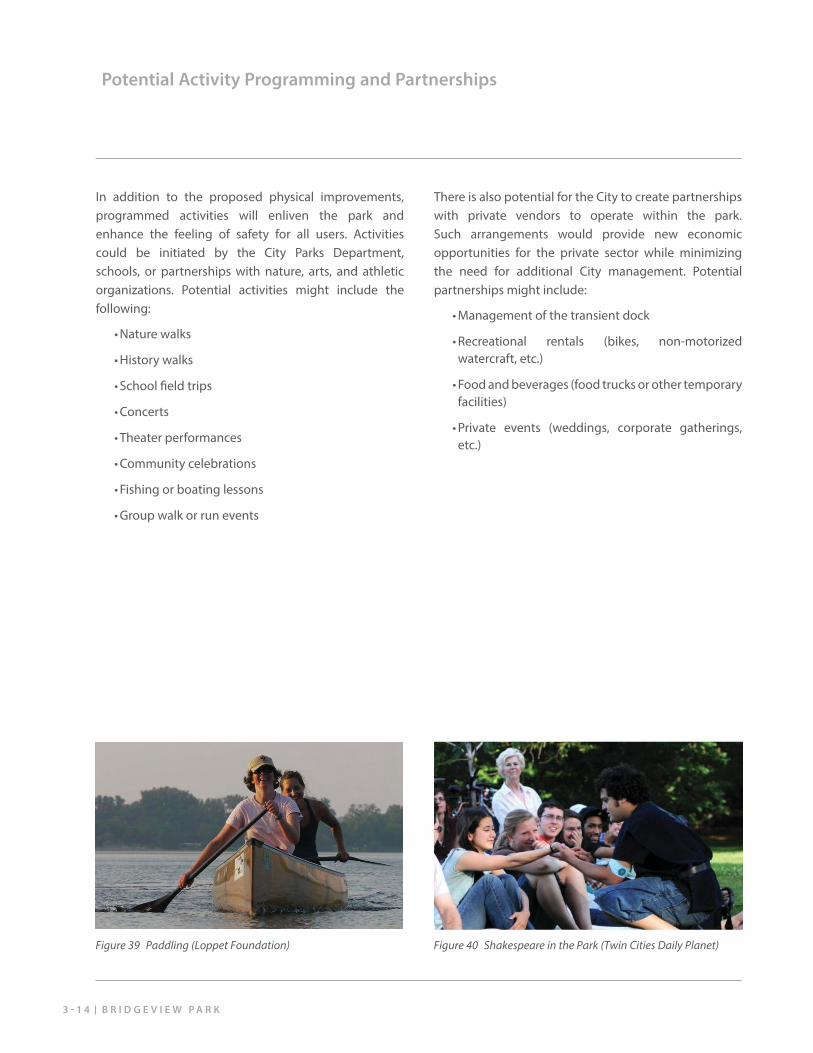
In addition to the proposed physical improvements, programmed activities will enliven the park and enhance the feeling of safety for all users. Activities could be initiated by the City Parks Department, schools, or partnerships with nature, arts, and athletic organizations. Potential activities might include the following:
• Nature walks
• History walks
• School fi eld trips
• Concerts
• Theater performances
• Community celebrations
• Fishing or boating lessons
• Group walk or run events
There is also potential for the City to create partnerships with private vendors to operate within the park. Such arrangements would provide new economic opportunities for the private sector while minimizing the need for additional City management. Potential partnerships might include:
• Management of the transient dock
• Recreational rentals (bikes, non-motorized watercraft, etc.)
• Food and beverages (food trucks or other temporary facilities)
• Private events (weddings, corporate gatherings, etc.)
Figure 39 Paddling (Loppet Foundation) Figure 40 Shakespeare in the Park (Twin Cities Daily Planet)
M A S T E R P L A N U P D A T E 4 - 1
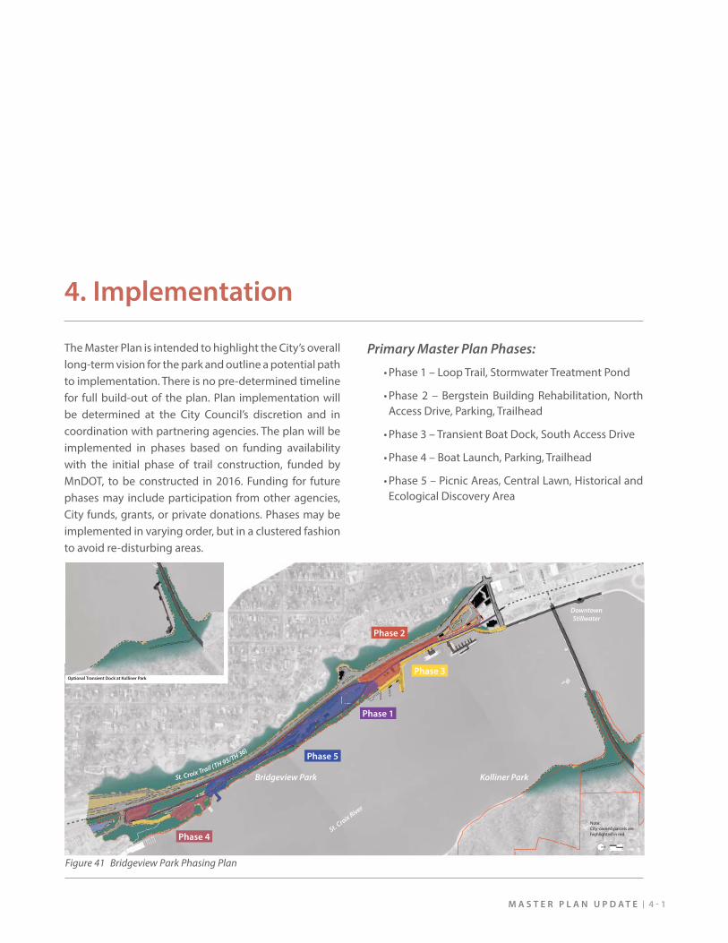
4. Implementation
The Master Plan is intended to highlight the City’s overall long-term vision for the park and outline a potential path to implementation. There is no pre-determined timeline for full build-out of the plan. Plan implementation will be determined at the City Council’s discretion and in coordination with partnering agencies. The plan will be implemented in phases based on funding availability with the initial phase of trail construction, funded by MnDOT, to be constructed in 2016. Funding for future phases may include participation from other agencies, City funds, grants, or private donations. Phases may be implemented in varying order, but in a clustered fashion to avoid re-disturbing areas.
Primary Master Plan Phases:
• Phase 1 – Loop Trail, Stormwater Treatment Pond
• Phase 2 – Bergstein Building Rehabilitation, North Access Drive, Parking, Trailhead
• Phase 3 – Transient Boat Dock, South Access Drive
• Phase 4 – Boat Launch, Parking, Trailhead
• Phase 5 – Picnic Areas, Central Lawn, Historical and Ecological Discovery Area
Note:City-owned parcels are highlighted in red.
St. Croix River
Kolliner ParkBridgeview Park
DowntownStillwater
NELSO
N ST
MAIN ST
WATER ST
CHESTN
UT ST
Potential Future Trail
Planned Loop Trail
Transient Dock(10 - 17 boats)
Optional Transient Dock at Kolliner Park
Restored Forest & Shoreline(WiDNR)
St. Croix Trail (TH 95/TH 36)Phase 5
Phase 1
Phase 2
Phase 3
Phase 4
Figure 41 Bridgeview Park Phasing Plan
A P P E N D I C E S M A S T E R P L A N U P D A T E
Appendix A - Cost Estimates
Bridgeview Park Master Plan UpdatePreferred Concept Cost Estimate - Phase Summary
2/13/2015
SRF Consulting Group, Inc. 1 of 14
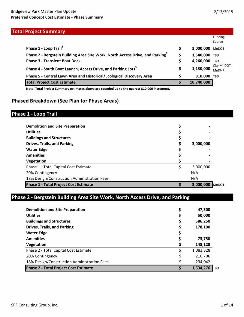
Total Project SummaryFunding Source
Phase 1 - Loop Trail1 3,000,000$ MnDOT
Phase 2 - Bergstein Building Area Site Work, North Access Drive, and Parking2 1,540,000$ TBD
Phase 3 - Transient Boat Dock 4,260,000$ TBD
Phase 4 - South Boat Launch, Access Drive, and Parking Lots3 1,130,000$ City,MnDOT,MnDNR
Phase 5 - Central Lawn Area and Historical/Ecological Discovery Area 810,000$ TBD
Total Project Cost Estimate 10,740,000$ Note: Total Project Summary estimates above are rounded up to the nearest $10,000 increment.
Phased Breakdown (See Plan for Phase Areas)
Phase 1 - Loop Trail
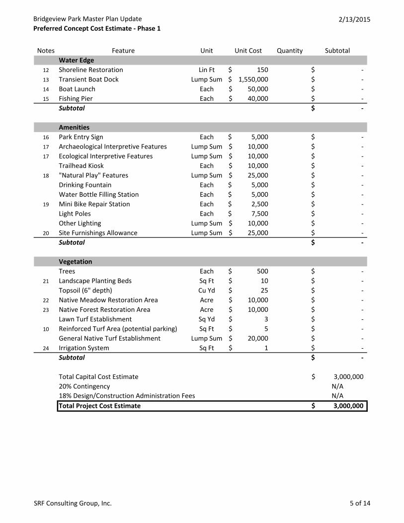
Demolition and Site Preparation -$ Utilities -$ Buildings and Structures -$ Drives, Trails, and Parking 3,000,000$ Water Edge -$ Amenities -$ Vegetation -$ Phase 1 - Total Capital Cost Estimate 3,000,000$ 20% Contingency N/A18% Design/Construction Administration Fees N/APhase 1 - Total Project Cost Estimate 3,000,000$ MnDOT
Phase 2 - Bergstein Building Area Site Work, North Access Drive, and Parking
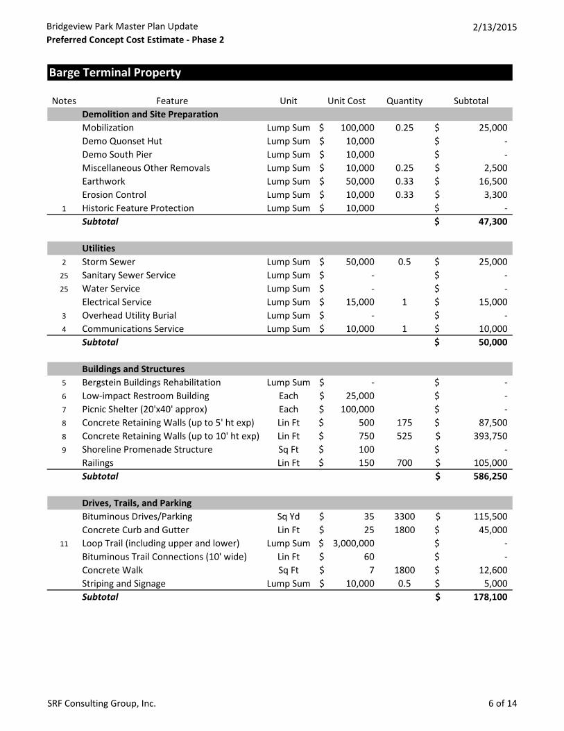
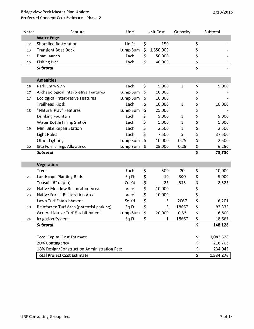
Demolition and Site Preparation 47,300$ Utilities 50,000$ Buildings and Structures 586,250$ Drives, Trails, and Parking 178,100$ Water Edge -$ Amenities 73,750$ Vegetation 148,128$ Phase 2 - Total Capital Cost Estimate 1,083,528$ 20% Contingency 216,706$ 18% Design/Construction Administration Fees 234,042$ Phase 2 - Total Project Cost Estimate 1,534,276$ TBD
Bridgeview Park Master Plan UpdatePreferred Concept Cost Estimate - Phase Summary
2/13/2015
SRF Consulting Group, Inc. 2 of 14
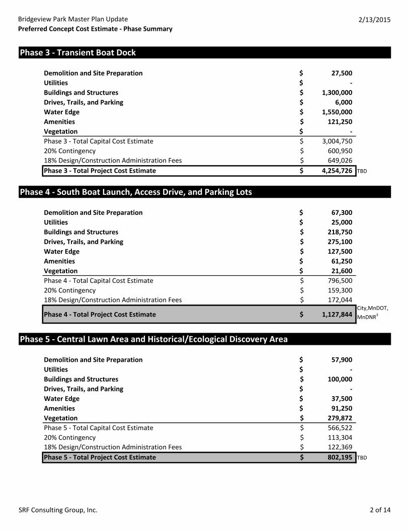
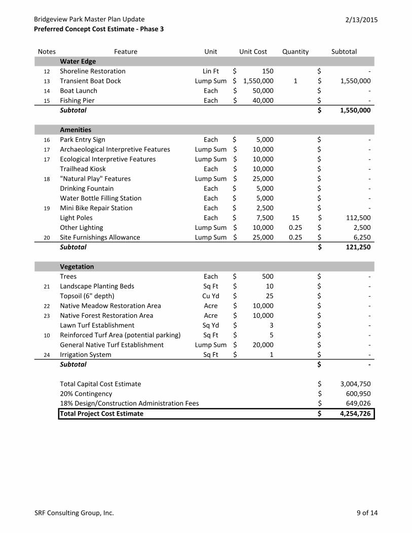
Phase 3 - Transient Boat Dock
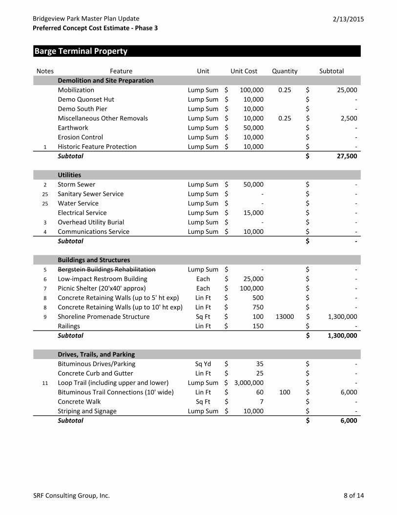
Demolition and Site Preparation 27,500$ Utilities -$ Buildings and Structures 1,300,000$ Drives, Trails, and Parking 6,000$ Water Edge 1,550,000$ Amenities 121,250$ Vegetation -$ Phase 3 - Total Capital Cost Estimate 3,004,750$ 20% Contingency 600,950$ 18% Design/Construction Administration Fees 649,026$ Phase 3 - Total Project Cost Estimate 4,254,726$ TBD
Phase 4 - South Boat Launch, Access Drive, and Parking Lots
Demolition and Site Preparation 67,300$ Utilities 25,000$ Buildings and Structures 218,750$ Drives, Trails, and Parking 275,100$ Water Edge 127,500$ Amenities 61,250$ Vegetation 21,600$ Phase 4 - Total Capital Cost Estimate 796,500$ 20% Contingency 159,300$ 18% Design/Construction Administration Fees 172,044$
Phase 4 - Total Project Cost Estimate 1,127,844$ City,MnDOT,MnDNR3
Phase 5 - Central Lawn Area and Historical/Ecological Discovery Area
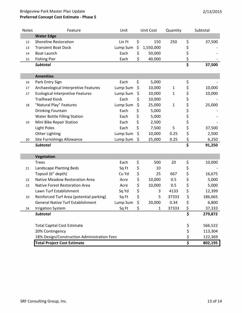
Demolition and Site Preparation 57,900$ Utilities -$ Buildings and Structures 100,000$ Drives, Trails, and Parking -$ Water Edge 37,500$ Amenities 91,250$ Vegetation 279,872$ Phase 5 - Total Capital Cost Estimate 566,522$ 20% Contingency 113,304$ 18% Design/Construction Administration Fees 122,369$ Phase 5 - Total Project Cost Estimate 802,195$ TBD
Bridgeview Park Master Plan UpdatePreferred Concept Cost Estimate - Phase Summary
2/13/2015
SRF Consulting Group, Inc. 3 of 14
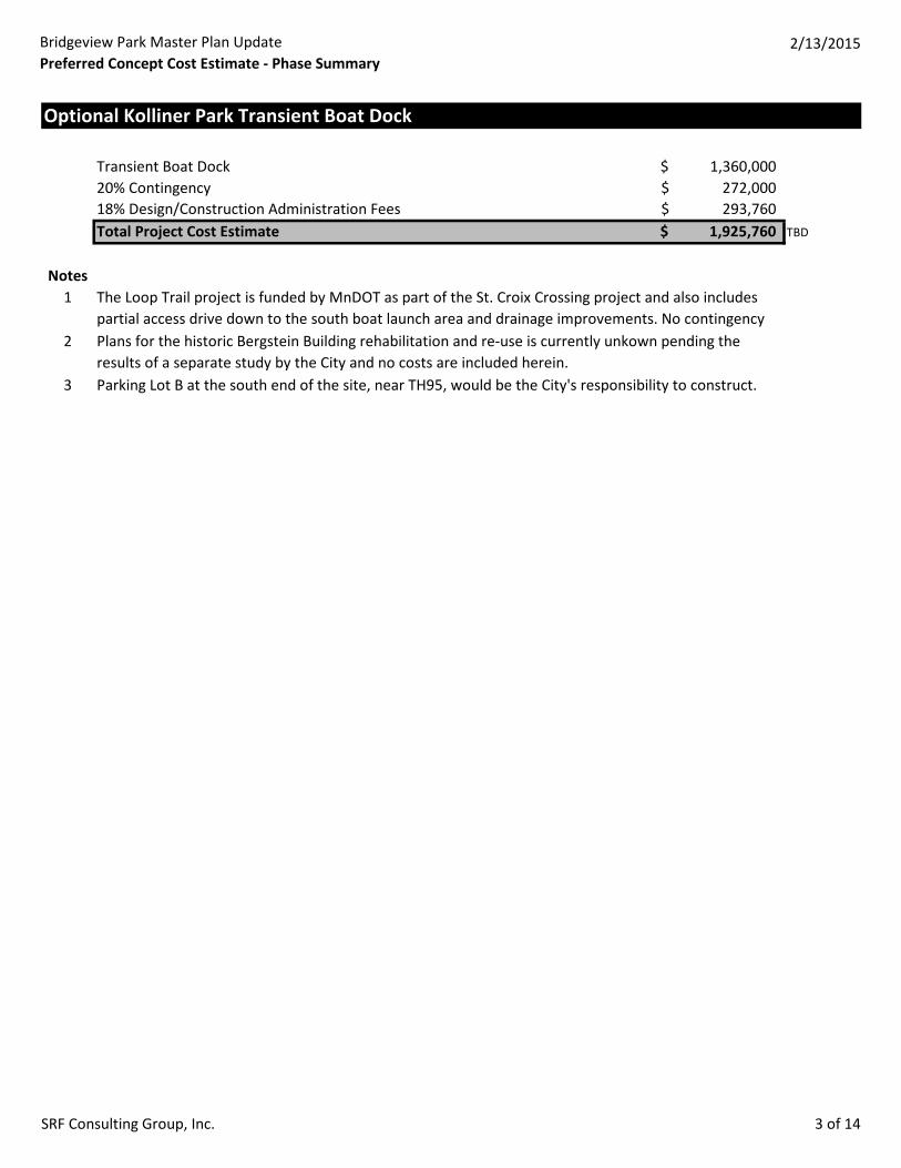
Optional Kolliner Park Transient Boat Dock
Transient Boat Dock 1,360,000$ 20% Contingency 272,000$ 18% Design/Construction Administration Fees 293,760$ Total Project Cost Estimate 1,925,760$ TBD
Notes1
2
3
The Loop Trail project is funded by MnDOT as part of the St. Croix Crossing project and also includes partial access drive down to the south boat launch area and drainage improvements. No contingency Plans for the historic Bergstein Building rehabilitation and re-use is currently unkown pending the results of a separate study by the City and no costs are included herein.Parking Lot B at the south end of the site, near TH95, would be the City's responsibility to construct.
Bridgeview Park Master Plan UpdatePreferred Concept Cost Estimate - Phase 1
2/13/2015
SRF Consulting Group, Inc. 4 of 14
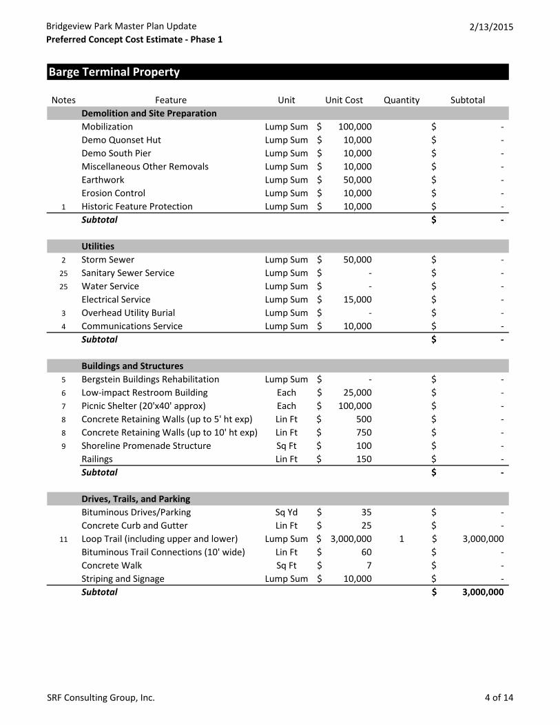
Barge Terminal Property
Notes Feature Unit Unit Cost Quantity SubtotalDemolition and Site PreparationMobilization Lump Sum 100,000$ -$ Demo Quonset Hut Lump Sum 10,000$ -$ Demo South Pier Lump Sum 10,000$ -$ Miscellaneous Other Removals Lump Sum 10,000$ -$ Earthwork Lump Sum 50,000$ -$ Erosion Control Lump Sum 10,000$ -$
1 Historic Feature Protection Lump Sum 10,000$ -$ Subtotal -$
Utilities2 Storm Sewer Lump Sum 50,000$ -$
25 Sanitary Sewer Service Lump Sum -$ -$ 25 Water Service Lump Sum -$ -$
Electrical Service Lump Sum 15,000$ -$ 3 Overhead Utility Burial Lump Sum -$ -$ 4 Communications Service Lump Sum 10,000$ -$
Subtotal -$
Buildings and Structures5 Bergstein Buildings Rehabilitation Lump Sum -$ -$ 6 Low-impact Restroom Building Each 25,000$ -$ 7 Picnic Shelter (20'x40' approx) Each 100,000$ -$ 8 Concrete Retaining Walls (up to 5' ht exp) Lin Ft 500$ -$ 8 Concrete Retaining Walls (up to 10' ht exp) Lin Ft 750$ -$ 9 Shoreline Promenade Structure Sq Ft 100$ -$
Railings Lin Ft 150$ -$ Subtotal -$
Drives, Trails, and ParkingBituminous Drives/Parking Sq Yd 35$ -$ Concrete Curb and Gutter Lin Ft 25$ -$
11 Loop Trail (including upper and lower) Lump Sum 3,000,000$ 1 3,000,000$ Bituminous Trail Connections (10' wide) Lin Ft 60$ -$ Concrete Walk Sq Ft 7$ -$ Striping and Signage Lump Sum 10,000$ -$ Subtotal 3,000,000$
Bridgeview Park Master Plan UpdatePreferred Concept Cost Estimate - Phase 1
2/13/2015
SRF Consulting Group, Inc. 5 of 14
Notes Feature Unit Unit Cost Quantity SubtotalWater Edge
12 Shoreline Restoration Lin Ft 150$ -$ 13 Transient Boat Dock Lump Sum 1,550,000$ -$ 14 Boat Launch Each 50,000$ -$ 15 Fishing Pier Each 40,000$ -$
Subtotal -$
Amenities16 Park Entry Sign Each 5,000$ -$ 17 Archaeological Interpretive Features Lump Sum 10,000$ -$ 17 Ecological Interpretive Features Lump Sum 10,000$ -$
Trailhead Kiosk Each 10,000$ -$ 18 "Natural Play" Features Lump Sum 25,000$ -$
Drinking Fountain Each 5,000$ -$ Water Bottle Filling Station Each 5,000$ -$
19 Mini Bike Repair Station Each 2,500$ -$ Light Poles Each 7,500$ -$ Other Lighting Lump Sum 10,000$ -$
20 Site Furnishings Allowance Lump Sum 25,000$ -$ Subtotal -$
VegetationTrees Each 500$ -$
21 Landscape Planting Beds Sq Ft 10$ -$ Topsoil (6" depth) Cu Yd 25$ -$
22 Native Meadow Restoration Area Acre 10,000$ -$ 23 Native Forest Restoration Area Acre 10,000$ -$
Lawn Turf Establishment Sq Yd 3$ -$ 10 Reinforced Turf Area (potential parking) Sq Ft 5$ -$
General Native Turf Establishment Lump Sum 20,000$ -$ 24 Irrigation System Sq Ft 1$ -$
Subtotal -$
Total Capital Cost Estimate 3,000,000$ 20% Contingency N/A18% Design/Construction Administration Fees N/ATotal Project Cost Estimate 3,000,000$
Bridgeview Park Master Plan UpdatePreferred Concept Cost Estimate - Phase 2
2/13/2015
SRF Consulting Group, Inc. 6 of 14
Barge Terminal Property
Notes Feature Unit Unit Cost Quantity SubtotalDemolition and Site PreparationMobilization Lump Sum 100,000$ 0.25 25,000$ Demo Quonset Hut Lump Sum 10,000$ -$ Demo South Pier Lump Sum 10,000$ -$ Miscellaneous Other Removals Lump Sum 10,000$ 0.25 2,500$ Earthwork Lump Sum 50,000$ 0.33 16,500$ Erosion Control Lump Sum 10,000$ 0.33 3,300$
1 Historic Feature Protection Lump Sum 10,000$ -$ Subtotal 47,300$
Utilities2 Storm Sewer Lump Sum 50,000$ 0.5 25,000$
25 Sanitary Sewer Service Lump Sum -$ -$ 25 Water Service Lump Sum -$ -$
Electrical Service Lump Sum 15,000$ 1 15,000$ 3 Overhead Utility Burial Lump Sum -$ -$ 4 Communications Service Lump Sum 10,000$ 1 10,000$
Subtotal 50,000$
Buildings and Structures5 Bergstein Buildings Rehabilitation Lump Sum -$ -$ 6 Low-impact Restroom Building Each 25,000$ -$ 7 Picnic Shelter (20'x40' approx) Each 100,000$ -$ 8 Concrete Retaining Walls (up to 5' ht exp) Lin Ft 500$ 175 87,500$ 8 Concrete Retaining Walls (up to 10' ht exp) Lin Ft 750$ 525 393,750$ 9 Shoreline Promenade Structure Sq Ft 100$ -$
Railings Lin Ft 150$ 700 105,000$ Subtotal 586,250$
Drives, Trails, and ParkingBituminous Drives/Parking Sq Yd 35$ 3300 115,500$ Concrete Curb and Gutter Lin Ft 25$ 1800 45,000$
11 Loop Trail (including upper and lower) Lump Sum 3,000,000$ -$ Bituminous Trail Connections (10' wide) Lin Ft 60$ -$ Concrete Walk Sq Ft 7$ 1800 12,600$ Striping and Signage Lump Sum 10,000$ 0.5 5,000$ Subtotal 178,100$
Bridgeview Park Master Plan UpdatePreferred Concept Cost Estimate - Phase 2
2/13/2015
SRF Consulting Group, Inc. 7 of 14
Notes Feature Unit Unit Cost Quantity SubtotalWater Edge
12 Shoreline Restoration Lin Ft 150$ -$ 13 Transient Boat Dock Lump Sum 1,550,000$ -$ 14 Boat Launch Each 50,000$ -$ 15 Fishing Pier Each 40,000$ -$
Subtotal -$
Amenities16 Park Entry Sign Each 5,000$ 1 5,000$ 17 Archaeological Interpretive Features Lump Sum 10,000$ -$ 17 Ecological Interpretive Features Lump Sum 10,000$ -$
Trailhead Kiosk Each 10,000$ 1 10,000$ 18 "Natural Play" Features Lump Sum 25,000$ -$
Drinking Fountain Each 5,000$ 1 5,000$ Water Bottle Filling Station Each 5,000$ 1 5,000$
19 Mini Bike Repair Station Each 2,500$ 1 2,500$ Light Poles Each 7,500$ 5 37,500$ Other Lighting Lump Sum 10,000$ 0.25 2,500$
20 Site Furnishings Allowance Lump Sum 25,000$ 0.25 6,250$ Subtotal 73,750$
VegetationTrees Each 500$ 20 10,000$
21 Landscape Planting Beds Sq Ft 10$ 500 5,000$ Topsoil (6" depth) Cu Yd 25$ 333 8,325$
22 Native Meadow Restoration Area Acre 10,000$ -$ 23 Native Forest Restoration Area Acre 10,000$ -$
Lawn Turf Establishment Sq Yd 3$ 2067 6,201$ 10 Reinforced Turf Area (potential parking) Sq Ft 5$ 18667 93,335$
General Native Turf Establishment Lump Sum 20,000$ 0.33 6,600$ 24 Irrigation System Sq Ft 1$ 18667 18,667$
Subtotal 148,128$
Total Capital Cost Estimate 1,083,528$ 20% Contingency 216,706$ 18% Design/Construction Administration Fees 234,042$ Total Project Cost Estimate 1,534,276$
Bridgeview Park Master Plan UpdatePreferred Concept Cost Estimate - Phase 3
2/13/2015
SRF Consulting Group, Inc. 8 of 14
Barge Terminal Property
Notes Feature Unit Unit Cost Quantity SubtotalDemolition and Site PreparationMobilization Lump Sum 100,000$ 0.25 25,000$ Demo Quonset Hut Lump Sum 10,000$ -$ Demo South Pier Lump Sum 10,000$ -$ Miscellaneous Other Removals Lump Sum 10,000$ 0.25 2,500$ Earthwork Lump Sum 50,000$ -$ Erosion Control Lump Sum 10,000$ -$
1 Historic Feature Protection Lump Sum 10,000$ -$ Subtotal 27,500$
Utilities2 Storm Sewer Lump Sum 50,000$ -$
25 Sanitary Sewer Service Lump Sum -$ -$ 25 Water Service Lump Sum -$ -$
Electrical Service Lump Sum 15,000$ -$ 3 Overhead Utility Burial Lump Sum -$ -$ 4 Communications Service Lump Sum 10,000$ -$
Subtotal -$
Buildings and Structures5 Bergstein Buildings Rehabilitation Lump Sum -$ -$ 6 Low-impact Restroom Building Each 25,000$ -$ 7 Picnic Shelter (20'x40' approx) Each 100,000$ -$ 8 Concrete Retaining Walls (up to 5' ht exp) Lin Ft 500$ -$ 8 Concrete Retaining Walls (up to 10' ht exp) Lin Ft 750$ -$ 9 Shoreline Promenade Structure Sq Ft 100$ 13000 1,300,000$
Railings Lin Ft 150$ -$ Subtotal 1,300,000$
Drives, Trails, and ParkingBituminous Drives/Parking Sq Yd 35$ -$ Concrete Curb and Gutter Lin Ft 25$ -$
11 Loop Trail (including upper and lower) Lump Sum 3,000,000$ -$ Bituminous Trail Connections (10' wide) Lin Ft 60$ 100 6,000$ Concrete Walk Sq Ft 7$ -$ Striping and Signage Lump Sum 10,000$ -$ Subtotal 6,000$
Bridgeview Park Master Plan UpdatePreferred Concept Cost Estimate - Phase 3
2/13/2015
SRF Consulting Group, Inc. 9 of 14
Notes Feature Unit Unit Cost Quantity SubtotalWater Edge
12 Shoreline Restoration Lin Ft 150$ -$ 13 Transient Boat Dock Lump Sum 1,550,000$ 1 1,550,000$ 14 Boat Launch Each 50,000$ -$ 15 Fishing Pier Each 40,000$ -$
Subtotal 1,550,000$
Amenities16 Park Entry Sign Each 5,000$ -$ 17 Archaeological Interpretive Features Lump Sum 10,000$ -$ 17 Ecological Interpretive Features Lump Sum 10,000$ -$
Trailhead Kiosk Each 10,000$ -$ 18 "Natural Play" Features Lump Sum 25,000$ -$
Drinking Fountain Each 5,000$ -$ Water Bottle Filling Station Each 5,000$ -$
19 Mini Bike Repair Station Each 2,500$ -$ Light Poles Each 7,500$ 15 112,500$ Other Lighting Lump Sum 10,000$ 0.25 2,500$
20 Site Furnishings Allowance Lump Sum 25,000$ 0.25 6,250$ Subtotal 121,250$
VegetationTrees Each 500$ -$
21 Landscape Planting Beds Sq Ft 10$ -$ Topsoil (6" depth) Cu Yd 25$ -$
22 Native Meadow Restoration Area Acre 10,000$ -$ 23 Native Forest Restoration Area Acre 10,000$ -$
Lawn Turf Establishment Sq Yd 3$ -$ 10 Reinforced Turf Area (potential parking) Sq Ft 5$ -$
General Native Turf Establishment Lump Sum 20,000$ -$ 24 Irrigation System Sq Ft 1$ -$
Subtotal -$
Total Capital Cost Estimate 3,004,750$ 20% Contingency 600,950$ 18% Design/Construction Administration Fees 649,026$ Total Project Cost Estimate 4,254,726$
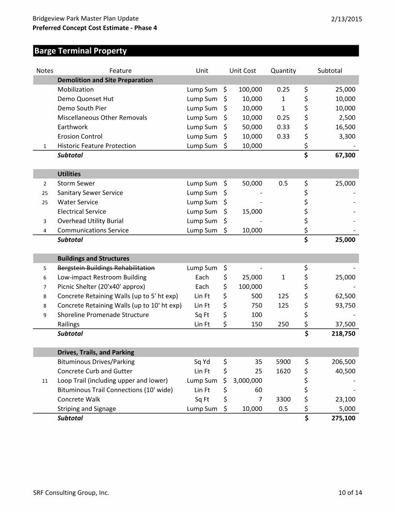
Bridgeview Park Master Plan UpdatePreferred Concept Cost Estimate - Phase 4
2/13/2015
SRF Consulting Group, Inc. 10 of 14
Barge Terminal Property
Notes Feature Unit Unit Cost Quantity SubtotalDemolition and Site PreparationMobilization Lump Sum 100,000$ 0.25 25,000$ Demo Quonset Hut Lump Sum 10,000$ 1 10,000$ Demo South Pier Lump Sum 10,000$ 1 10,000$ Miscellaneous Other Removals Lump Sum 10,000$ 0.25 2,500$ Earthwork Lump Sum 50,000$ 0.33 16,500$ Erosion Control Lump Sum 10,000$ 0.33 3,300$
1 Historic Feature Protection Lump Sum 10,000$ -$ Subtotal 67,300$
Utilities2 Storm Sewer Lump Sum 50,000$ 0.5 25,000$
25 Sanitary Sewer Service Lump Sum -$ -$ 25 Water Service Lump Sum -$ -$
Electrical Service Lump Sum 15,000$ -$ 3 Overhead Utility Burial Lump Sum -$ -$ 4 Communications Service Lump Sum 10,000$ -$
Subtotal 25,000$
Buildings and Structures5 Bergstein Buildings Rehabilitation Lump Sum -$ -$ 6 Low-impact Restroom Building Each 25,000$ 1 25,000$ 7 Picnic Shelter (20'x40' approx) Each 100,000$ -$ 8 Concrete Retaining Walls (up to 5' ht exp) Lin Ft 500$ 125 62,500$ 8 Concrete Retaining Walls (up to 10' ht exp) Lin Ft 750$ 125 93,750$ 9 Shoreline Promenade Structure Sq Ft 100$ -$
Railings Lin Ft 150$ 250 37,500$ Subtotal 218,750$
Drives, Trails, and ParkingBituminous Drives/Parking Sq Yd 35$ 5900 206,500$ Concrete Curb and Gutter Lin Ft 25$ 1620 40,500$
11 Loop Trail (including upper and lower) Lump Sum 3,000,000$ -$ Bituminous Trail Connections (10' wide) Lin Ft 60$ -$ Concrete Walk Sq Ft 7$ 3300 23,100$ Striping and Signage Lump Sum 10,000$ 0.5 5,000$ Subtotal 275,100$
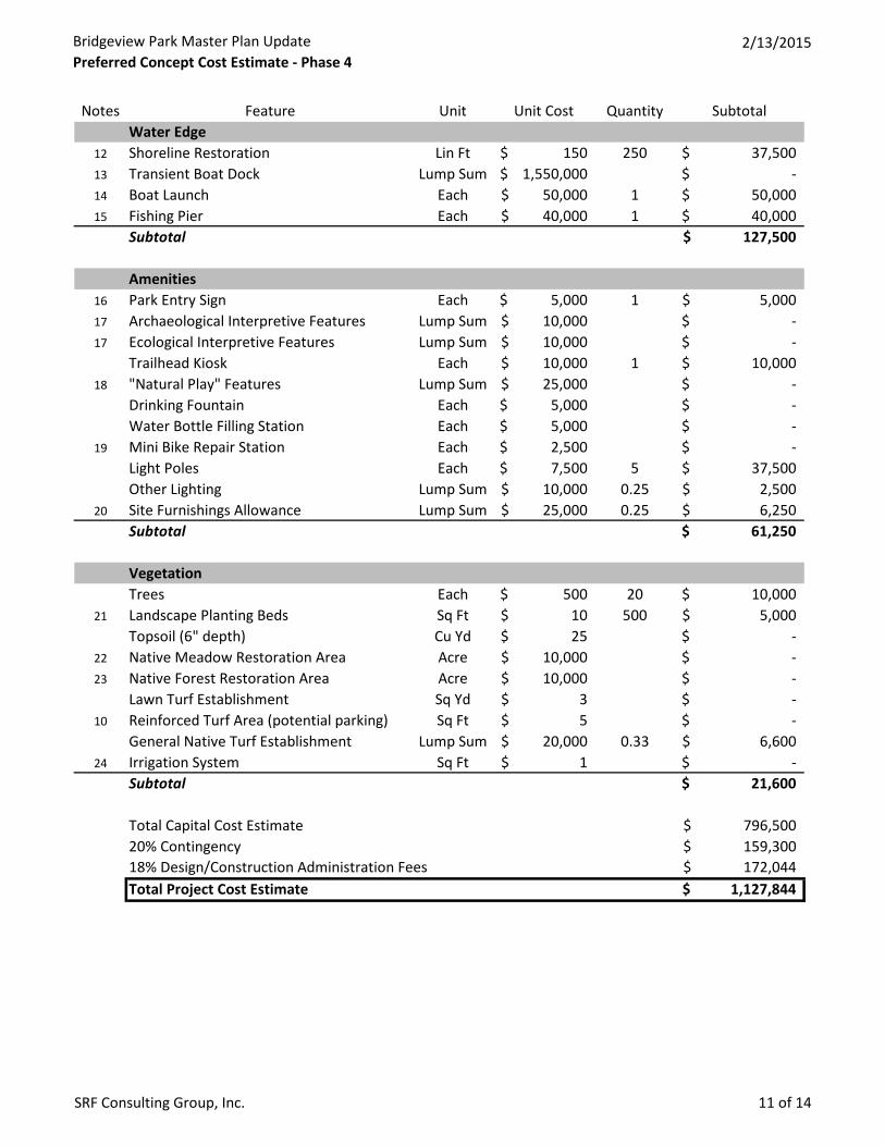
Bridgeview Park Master Plan UpdatePreferred Concept Cost Estimate - Phase 4
2/13/2015
SRF Consulting Group, Inc. 11 of 14
Notes Feature Unit Unit Cost Quantity SubtotalWater Edge
12 Shoreline Restoration Lin Ft 150$ 250 37,500$ 13 Transient Boat Dock Lump Sum 1,550,000$ -$ 14 Boat Launch Each 50,000$ 1 50,000$ 15 Fishing Pier Each 40,000$ 1 40,000$
Subtotal 127,500$
Amenities16 Park Entry Sign Each 5,000$ 1 5,000$ 17 Archaeological Interpretive Features Lump Sum 10,000$ -$ 17 Ecological Interpretive Features Lump Sum 10,000$ -$
Trailhead Kiosk Each 10,000$ 1 10,000$ 18 "Natural Play" Features Lump Sum 25,000$ -$
Drinking Fountain Each 5,000$ -$ Water Bottle Filling Station Each 5,000$ -$
19 Mini Bike Repair Station Each 2,500$ -$ Light Poles Each 7,500$ 5 37,500$ Other Lighting Lump Sum 10,000$ 0.25 2,500$
20 Site Furnishings Allowance Lump Sum 25,000$ 0.25 6,250$ Subtotal 61,250$
VegetationTrees Each 500$ 20 10,000$
21 Landscape Planting Beds Sq Ft 10$ 500 5,000$ Topsoil (6" depth) Cu Yd 25$ -$
22 Native Meadow Restoration Area Acre 10,000$ -$ 23 Native Forest Restoration Area Acre 10,000$ -$
Lawn Turf Establishment Sq Yd 3$ -$ 10 Reinforced Turf Area (potential parking) Sq Ft 5$ -$
General Native Turf Establishment Lump Sum 20,000$ 0.33 6,600$ 24 Irrigation System Sq Ft 1$ -$
Subtotal 21,600$
Total Capital Cost Estimate 796,500$ 20% Contingency 159,300$ 18% Design/Construction Administration Fees 172,044$ Total Project Cost Estimate 1,127,844$
Bridgeview Park Master Plan UpdatePreferred Concept Cost Estimate - Phase 5
2/13/2015
SRF Consulting Group, Inc. 12 of 14
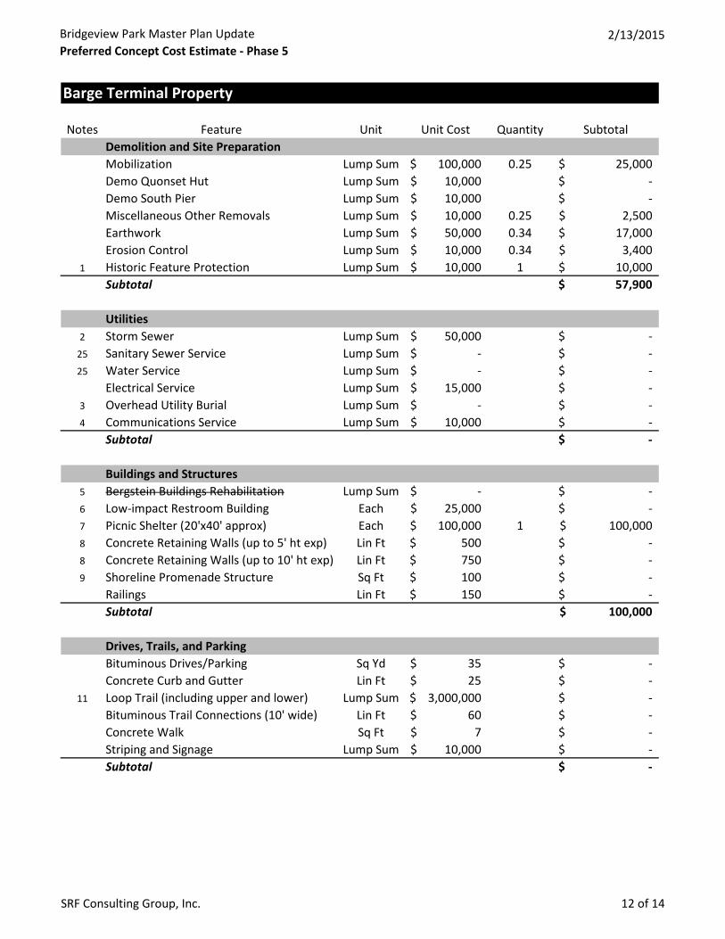
Barge Terminal Property
Notes Feature Unit Unit Cost Quantity SubtotalDemolition and Site PreparationMobilization Lump Sum 100,000$ 0.25 25,000$ Demo Quonset Hut Lump Sum 10,000$ -$ Demo South Pier Lump Sum 10,000$ -$ Miscellaneous Other Removals Lump Sum 10,000$ 0.25 2,500$ Earthwork Lump Sum 50,000$ 0.34 17,000$ Erosion Control Lump Sum 10,000$ 0.34 3,400$
1 Historic Feature Protection Lump Sum 10,000$ 1 10,000$ Subtotal 57,900$
Utilities2 Storm Sewer Lump Sum 50,000$ -$
25 Sanitary Sewer Service Lump Sum -$ -$ 25 Water Service Lump Sum -$ -$
Electrical Service Lump Sum 15,000$ -$ 3 Overhead Utility Burial Lump Sum -$ -$ 4 Communications Service Lump Sum 10,000$ -$
Subtotal -$
Buildings and Structures5 Bergstein Buildings Rehabilitation Lump Sum -$ -$ 6 Low-impact Restroom Building Each 25,000$ -$ 7 Picnic Shelter (20'x40' approx) Each 100,000$ 1 100,000$ 8 Concrete Retaining Walls (up to 5' ht exp) Lin Ft 500$ -$ 8 Concrete Retaining Walls (up to 10' ht exp) Lin Ft 750$ -$ 9 Shoreline Promenade Structure Sq Ft 100$ -$
Railings Lin Ft 150$ -$ Subtotal 100,000$
Drives, Trails, and ParkingBituminous Drives/Parking Sq Yd 35$ -$ Concrete Curb and Gutter Lin Ft 25$ -$
11 Loop Trail (including upper and lower) Lump Sum 3,000,000$ -$ Bituminous Trail Connections (10' wide) Lin Ft 60$ -$ Concrete Walk Sq Ft 7$ -$ Striping and Signage Lump Sum 10,000$ -$ Subtotal -$
Bridgeview Park Master Plan UpdatePreferred Concept Cost Estimate - Phase 5
2/13/2015
SRF Consulting Group, Inc. 13 of 14
Notes Feature Unit Unit Cost Quantity SubtotalWater Edge
12 Shoreline Restoration Lin Ft 150$ 250 37,500$ 13 Transient Boat Dock Lump Sum 1,550,000$ -$ 14 Boat Launch Each 50,000$ -$ 15 Fishing Pier Each 40,000$ -$
Subtotal 37,500$
Amenities16 Park Entry Sign Each 5,000$ -$ 17 Archaeological Interpretive Features Lump Sum 10,000$ 1 10,000$ 17 Ecological Interpretive Features Lump Sum 10,000$ 1 10,000$
Trailhead Kiosk Each 10,000$ -$ 18 "Natural Play" Features Lump Sum 25,000$ 1 25,000$
Drinking Fountain Each 5,000$ -$ Water Bottle Filling Station Each 5,000$ -$
19 Mini Bike Repair Station Each 2,500$ -$ Light Poles Each 7,500$ 5 37,500$ Other Lighting Lump Sum 10,000$ 0.25 2,500$
20 Site Furnishings Allowance Lump Sum 25,000$ 0.25 6,250$ Subtotal 91,250$
VegetationTrees Each 500$ 20 10,000$
21 Landscape Planting Beds Sq Ft 10$ -$ Topsoil (6" depth) Cu Yd 25$ 667 16,675$
22 Native Meadow Restoration Area Acre 10,000$ 0.5 5,000$ 23 Native Forest Restoration Area Acre 10,000$ 0.5 5,000$
Lawn Turf Establishment Sq Yd 3$ 4133 12,399$ 10 Reinforced Turf Area (potential parking) Sq Ft 5$ 37333 186,665$
General Native Turf Establishment Lump Sum 20,000$ 0.34 6,800$ 24 Irrigation System Sq Ft 1$ 37333 37,333$
Subtotal 279,872$
Total Capital Cost Estimate 566,522$ 20% Contingency 113,304$ 18% Design/Construction Administration Fees 122,369$ Total Project Cost Estimate 802,195$
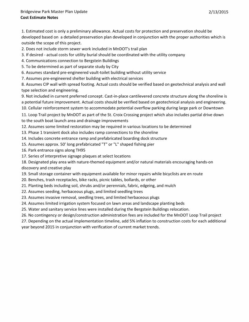
Bridgeview Park Master Plan UpdateCost Estimate Notes
2/13/2015
1. Estimated cost is only a preliminary allowance. Actual costs for protection and preservation should be developed based on a detailed preservation plan developed in conjunction with the proper authorities which is outside the scope of this project.2. Does not include storm sewer work included in MnDOT's trail plan3. If desired - actual costs for utility burial should be coordinated with the utility company4. Communications connection to Bergstein Buildings5. To be determined as part of separate study by City6. Assumes standard pre-engineered vault-toilet building without utility service7. Assumes pre-engineered shelter building with electrical services8. Assumes CIP wall with spread footing. Actual costs should be verified based on geotechnical analysis and wall type selection and engineering.9. Not included in current preferred concept. Cast-in-place cantilevered concrete structure along the shoreline is a potential future improvement. Actual costs should be verified based on geotechnical analysis and engineering.10. Cellular reinforcement system to accommodate potential overflow parking during large park or Downtown 11. Loop Trail project by MnDOT as part of the St. Croix Crossing project which also includes partial drive down to the south boat launch area and drainage improvements12. Assumes some limited restoration may be required in various locations to be determined13. Phase 1 transient dock also includes ramp connections to the shoreline14. Includes concrete entrance ramp and prefabricated boarding dock structure15. Assumes approx. 50' long prefabricated "T" or "L" shaped fishing pier16. Park entrance signs along TH9517. Series of interpretive signage plaques at select locations18. Designated play area with nature-themed equipment and/or natural materials encouraging hands-on discovery and creative play19. Small storage container with equipment available for minor repairs while bicyclists are en route20. Benches, trash receptacles, bike racks, picnic tables, bollards, or other21. Planting beds including soil, shrubs and/or perennials, fabric, edgeing, and mulch22. Assumes seeding, herbaceous plugs, and limited seedling trees23. Assumes invasive removal, seedling trees, and limited herbaceous plugs24. Assumes limited irrigation system focused on lawn areas and landscape planting beds25. Water and sanitary service lines were installed during the Bergstein Buildings relocation.26. No contingency or design/construction administration fees are included for the MnDOT Loop Trail project27. Depending on the actual implementation timeline, add 5% inflation to construction costs for each additional year beyond 2015 in conjunction with verification of current market trends.
A P P E N D I C E S M A S T E R P L A N U P D A T E
Appendix B - Dock Needs’ Analysis
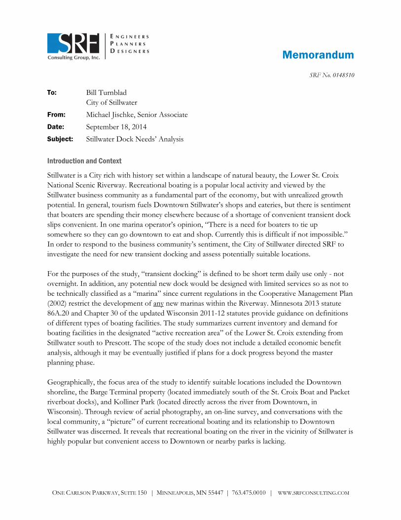
Memorandum
ONE CARLSON PARKWAY, SUITE 150 | MINNEAPOLIS, MN 55447 | 763.475.0010 | WWW.SRFCONSULTING.COM
SRF No. 0148510
To: Bill Turnblad City of Stillwater
From: Michael Jischke, Senior Associate
Date: September 18, 2014
Subject: Stillwater Dock Needs’ Analysis
Introduction and Context
Stillwater is a City rich with history set within a landscape of natural beauty, the Lower St. Croix National Scenic Riverway. Recreational boating is a popular local activity and viewed by the Stillwater business community as a fundamental part of the economy, but with unrealized growth potential. In general, tourism fuels Downtown Stillwater’s shops and eateries, but there is sentiment that boaters are spending their money elsewhere because of a shortage of convenient transient dock slips convenient. In one marina operator’s opinion, “There is a need for boaters to tie up somewhere so they can go downtown to eat and shop. Currently this is difficult if not impossible.” In order to respond to the business community’s sentiment, the City of Stillwater directed SRF to investigate the need for new transient docking and assess potentially suitable locations. For the purposes of the study, “transient docking” is defined to be short term daily use only - not overnight. In addition, any potential new dock would be designed with limited services so as not to be technically classified as a “marina” since current regulations in the Cooperative Management Plan (2002) restrict the development of any new marinas within the Riverway. Minnesota 2013 statute 86A.20 and Chapter 30 of the updated Wisconsin 2011-12 statutes provide guidance on definitions of different types of boating facilities. The study summarizes current inventory and demand for boating facilities in the designated “active recreation area” of the Lower St. Croix extending from Stillwater south to Prescott. The scope of the study does not include a detailed economic benefit analysis, although it may be eventually justified if plans for a dock progress beyond the master planning phase. Geographically, the focus area of the study to identify suitable locations included the Downtown shoreline, the Barge Terminal property (located immediately south of the St. Croix Boat and Packet riverboat docks), and Kolliner Park (located directly across the river from Downtown, in Wisconsin). Through review of aerial photography, an on-line survey, and conversations with the local community, a “picture” of current recreational boating and its relationship to Downtown Stillwater was discerned. It reveals that recreational boating on the river in the vicinity of Stillwater is highly popular but convenient access to Downtown or nearby parks is lacking.
Bill Turnblad September 18, 2014 City of Stillwater Page 2
Stillwater is not alone in addressing the challenge of accommodating recreational boaters. Extending to the confluence with the Mississippi River, five primary cities currently have sizable boating facilities – Stillwater, Bayport, Hudson, Afton and Prescott. They share an identity as “river towns,” contributing to the attraction of the region as a recreational destination. Historically, industrial uses predominated, but for the most part, the working riverfront has been transformed into recreational and residential uses. The multitude of marinas, parks, and trail systems that are existing or under development are an indication of its popularity and significance. Nevertheless, in order to benefit from recreational boating, communities must find the right balance between recreational use and the preservation and management of the significant natural and cultural resources that exist.
Recreational Water Use Overview
As part of the legislation designating the St. Croix as a National Wild and Scenic River, the Cooperative Management Plan (2002) was developed to guide stewardship of the river and its surroundings. Geographically, the overall plan addresses the river extents from Taylors Falls extending south to Prescott where it converges with the Mississippi River. Stillwater sits within the section of the river designated as an “active social recreation area,” which is managed primarily by Minnesota and Wisconsin. North of Stillwater, the river transitions into a “moderate recreation” area and then a “quiet waters” area, which is managed by the National Park Service. See Figure 1 for an overview map of the Riverway. In general, the management plan acknowledges the cultural and economic importance of recreational boating, but to ensure that the resource remains attractive and vital over time, it sets rules and standards limiting the usage. The primary measure for the establishing the carrying capacity of the river is boating density (acreage of water per moving boat). The threshold for more stringent regulations is 10 acres per moving boat. In 1997, as part of the Environmental Impact Statement (EIS) for the management plan, Riverway usage at Stillwater was calibrated at 16 acres per moving boat. In contrast, the Hudson Narrows area saw a density of 2.2 acres per moving boat. In addition to the level of usage, river hydrology and other natural characteristics factor into local regulations such as no-wake zones. Studies at the time the management plan was prepared estimated that approximately 310,000 people recreated on the river annually out of a total of over 2 million visitors. Assuming that most recreational boating traffic is seasonal (roughly six months out of the year), that equates to approximately 1,800 people per day (May through October), and presumably most would be weekend boaters. At one time, the designated Boundary Waters Commission performed regular bi-annual aerial surveys and created data on recreational boating usage, but the Commission is now disbanded and archived information is not currently accessible to the public. At the time it was drafted in order to prevent boating overuse, the plan stipulated that no new marinas or boat launches will be built with the exception of a proposed launch at A.S. King Generating Plant (currently operated by Xcel Energy). Consequently, any plans for new boating facilities would require close coordination with the managing and permitting agencies.
Bill Turnblad September 18, 2014 City of Stillwater Page 3
Boating Culture
The natural surroundings are undoubtedly an attraction for both motorized and non-motorized boaters. In addition, social factors also play a major role creating a boating culture that is inherent to the character of the Riverway and river towns. As noted above, there is a preponderance of private marinas in the area. While the study is limited to the suitability of a new transient dock – not a marina – certain lessons can be drawn from the marina setting that highlight boaters’ needs and expectations. Depending on size, a marina can actually develop the characteristics of a small village unto itself. In fact, some exclusive marinas are related directly to residential properties. Experientially, people enjoy seeing the variety of boats and social interactions that inevitably occur out on the dock. Access to restaurants, bars and shops is also a desirable aspect to marina location.
Boating is a lifestyle choice requiring significant time and monetary investment, and an entire support industry exists to supply and maintain people’s boats and facilities. Service providers fill the niche to allow people enjoy their boating experience without being burdened by all the upkeep. They also provide additional amenities that enhance the boating experience and general enjoyment of the Riverway including information, food and beverages, picnic areas, fishing gear, and restrooms to name just a few. Boating clubs and rental vendors, sometimes associated with marinas, also diversify access to the Riverway by providing watercraft to people who may not own one themselves.
Review of Existing Marinas and Docks
Along the Riverway, numerous private marinas provide a variety of boating facilities including: seasonal docking, transient docking, winter storage, repair and fueling. Some marinas are coupled with residential development, while others are purely commercial. In each city, there are typically several marinas, and scales vary widely from 12 slips up to 300. Based on review of current aerial mapping, there are approximately 2,000 boat slips overall available between Stillwater and Prescott. At a glance, the marinas appear nearly full, although it is impossible to determine exact usage and use fluctuates seasonally. Anecdotally, several marina operators indicated a gradual recovery in boating usage since a sharp drop-off in 2008/2009 coinciding with the national economic recession. See Figures 2 through 8 (attachments) for aerial photos showing marina and dock locations in each of the communities. It is notable how greatly the natural shoreline was altered to create protective areas for many of the marinas.
Through a survey of local marina managers, we learned that there are different uses of the term “transient docking” in the market as compared to the parameters specified by the City for the study. For most marinas, transient docking also includes overnight, weekly or stays of other longer temporary durations, and it is often a small part of a marina’s overall operation. In fact, some managers said that shorter duration transient docking is not profitable and would prefer to avoid it. We surmise that the challenge is primarily due to a marina’s ability to charge higher fees for overnight or extended usage according to the length of stay. For shorter stays though, it is common to charge hourly fees, similar to a street parking meter, which do not generate significant revenue in aggregate. In addition, boaters that stay longer may require additional services that generate supplemental income.
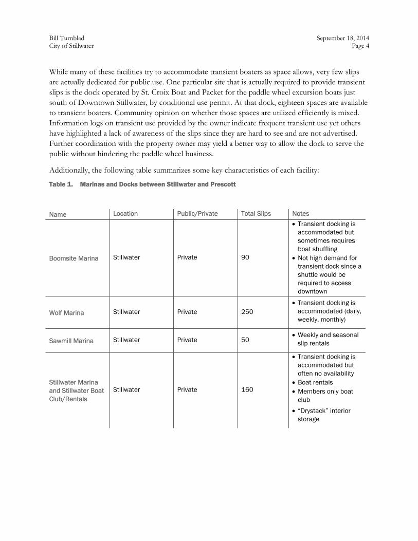
Bill Turnblad September 18, 2014 City of Stillwater Page 4
While many of these facilities try to accommodate transient boaters as space allows, very few slips are actually dedicated for public use. One particular site that is actually required to provide transient slips is the dock operated by St. Croix Boat and Packet for the paddle wheel excursion boats just south of Downtown Stillwater, by conditional use permit. At that dock, eighteen spaces are available to transient boaters. Community opinion on whether those spaces are utilized efficiently is mixed. Information logs on transient use provided by the owner indicate frequent transient use yet others have highlighted a lack of awareness of the slips since they are hard to see and are not advertised. Further coordination with the property owner may yield a better way to allow the dock to serve the public without hindering the paddle wheel business.
Additionally, the following table summarizes some key characteristics of each facility:
Table 1. Marinas and Docks between Stillwater and Prescott
Name Location Public/Private Total Slips Notes
Boomsite Marina Stillwater Private 90
Transient docking is accommodated but sometimes requires boat shuffling
Not high demand for transient dock since a shuttle would be required to access downtown
Wolf Marina Stillwater Private 250 Transient docking is
accommodated (daily, weekly, monthly)
Sawmill Marina Stillwater Private 50 Weekly and seasonal
slip rentals
Stillwater Marina and Stillwater Boat Club/Rentals
Stillwater Private 160
Transient docking is accommodated but often no availability
Boat rentals Members only boat
club
“Drystack” interior storage
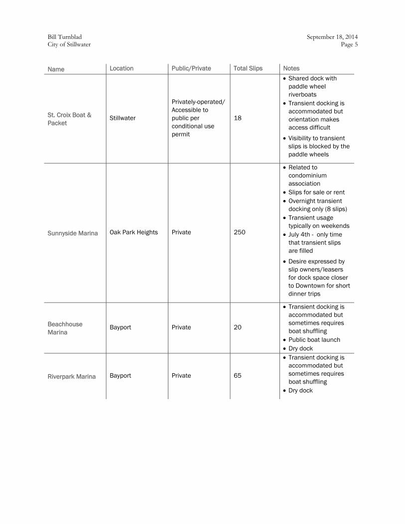
Bill Turnblad September 18, 2014 City of Stillwater Page 5
Name Location Public/Private Total Slips Notes
St. Croix Boat & Packet
Stillwater
Privately-operated/ Accessible to public per conditional use permit
18
Shared dock with paddle wheel riverboats
Transient docking is accommodated but orientation makes access difficult
Visibility to transient slips is blocked by the paddle wheels
Sunnyside Marina Oak Park Heights Private 250
Related to condominium association
Slips for sale or rent Overnight transient
docking only (8 slips) Transient usage
typically on weekends July 4th - only time
that transient slips are filled
Desire expressed by slip owners/leasers for dock space closer to Downtown for short dinner trips
Beachhouse Marina
Bayport Private 20
Transient docking is accommodated but sometimes requires boat shuffling
Public boat launch Dry dock
Riverpark Marina Bayport Private 65
Transient docking is accommodated but sometimes requires boat shuffling
Dry dock
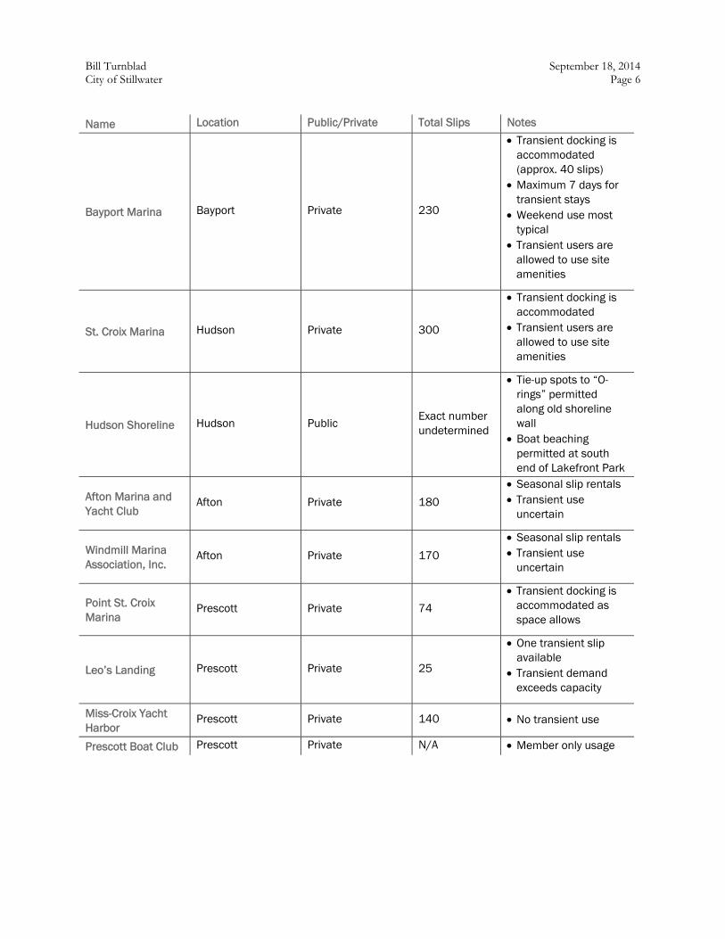
Bill Turnblad September 18, 2014 City of Stillwater Page 6
Name Location Public/Private Total Slips Notes
Bayport Marina Bayport Private 230
Transient docking is accommodated (approx. 40 slips)
Maximum 7 days for transient stays
Weekend use most typical
Transient users are allowed to use site amenities
St. Croix Marina Hudson Private 300
Transient docking is accommodated
Transient users are allowed to use site amenities
Hudson Shoreline Hudson Public Exact number undetermined
Tie-up spots to “O-rings” permitted along old shoreline wall
Boat beaching permitted at south end of Lakefront Park
Afton Marina and Yacht Club
Afton Private 180
Seasonal slip rentals Transient use
uncertain
Windmill Marina Association, Inc.
Afton Private 170
Seasonal slip rentals Transient use
uncertain
Point St. Croix Marina
Prescott Private 74
Transient docking is accommodated as space allows
Leo’s Landing Prescott Private 25
One transient slip available
Transient demand exceeds capacity
Miss-Croix Yacht Harbor
Prescott Private 140 No transient use
Prescott Boat Club Prescott Private N/A Member only usage
Bill Turnblad September 18, 2014 City of Stillwater Page 7
Non-motorized Boating Facilities
The Riverway is also a popular location for non-motorized watercraft including canoes, kayaks, rowers and sailboards. It is more difficult to ascertain the level of usage though. The Minnesota DNR lists six outfitters that rent canoes along the St Croix, including both Minnesota and Wisconsin businesses. For the most part, they are located in the vicinity of Taylors Falls and St. Croix Falls, north of Stillwater in the section of the river designated for “quiet waters.” The river channel in that section is narrower with many side channels and islands creating a backdrop for a different recreational experience that is presumably more popular for non-motorized watercraft than the immediate vicinity of Stillwater.
Nevertheless, provisions for non-motorized use should not necessarily be precluded near Stillwater and extending south in the “active social recreation area.” Discussions with local non-motorized users indicate a latent demand for access points and shoreline boat storage near Stillwater. Some features that would facilitate safe and convenient use at potential access points include gradual walking grades and docks that adjust to the current water level of the river. Additionally, enforcement of a no-wake zone near docks and boat launches would enable non-motorized users to share facilities with motorized users with fewer conflicts.
Potential Transient Dock Locations and Sizes
With the backdrop of the current characteristics of recreational boating and its regulatory framework established, the study team looked at Stillwater’s geography and initially identified five (5) potential locations for a new transient dock for further evaluation:
Downtown North (north of the Lift Bridge)
Downtown South (south of the Lift Bridge)
Barge Terminal North
Barge Terminal South
Kolliner Park (south of the Lift Bridge)
The following matrix (Table 2) illustrates a comparison of the suitability of the potential sites used to identify the preferred location. See Figure 9 for a map of the locations.
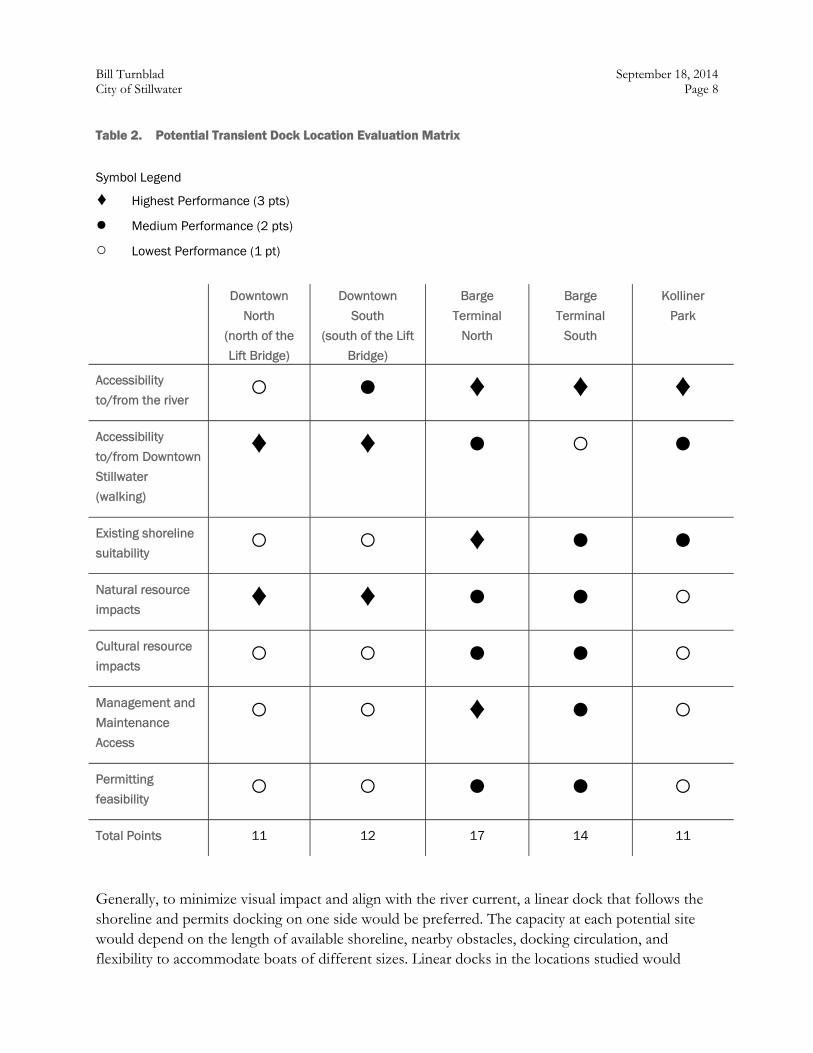
Bill Turnblad September 18, 2014 City of Stillwater Page 8
Table 2. Potential Transient Dock Location Evaluation Matrix
Symbol Legend
♦ Highest Performance (3 pts)
● Medium Performance (2 pts)
○ Lowest Performance (1 pt)
Downtown
North
(north of the
Lift Bridge)
Downtown
South
(south of the Lift
Bridge)
Barge
Terminal
North
Barge
Terminal
South
Kolliner
Park
Accessibility
to/from the river ○ ● ♦ ♦ ♦
Accessibility
to/from Downtown
Stillwater
(walking)
♦ ♦ ● ○ ●
Existing shoreline
suitability ○ ○ ♦ ● ●
Natural resource
impacts ♦ ♦ ● ● ○
Cultural resource
impacts ○ ○ ● ● ○
Management and
Maintenance
Access
○ ○ ♦ ● ○
Permitting
feasibility ○ ○ ● ● ○
Total Points 11 12 17 14 11
Generally, to minimize visual impact and align with the river current, a linear dock that follows the shoreline and permits docking on one side would be preferred. The capacity at each potential site would depend on the length of available shoreline, nearby obstacles, docking circulation, and flexibility to accommodate boats of different sizes. Linear docks in the locations studied would
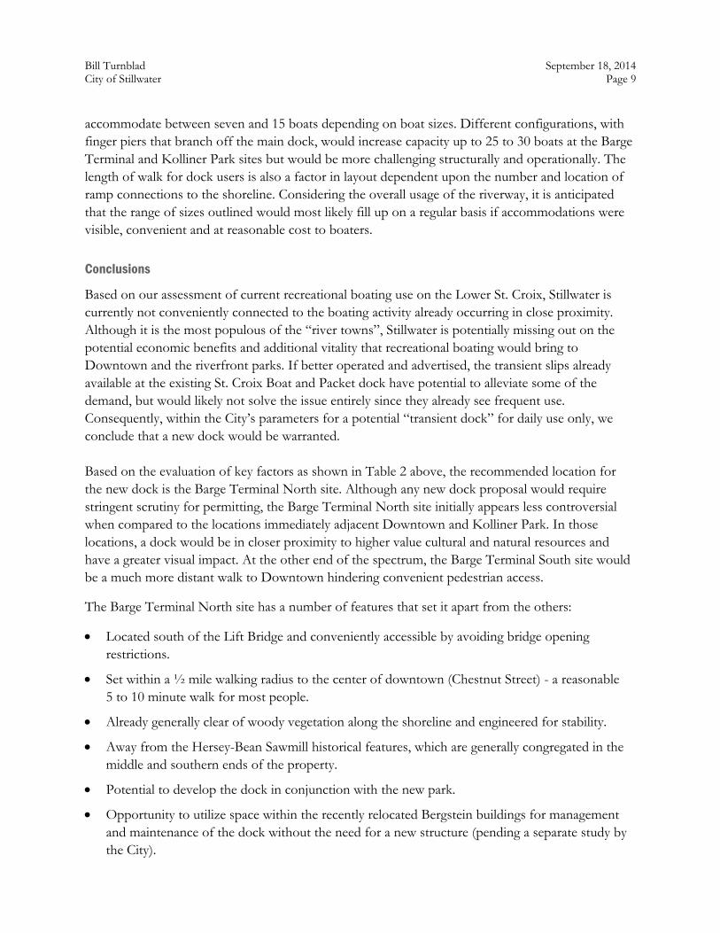
Bill Turnblad September 18, 2014 City of Stillwater Page 9
accommodate between seven and 15 boats depending on boat sizes. Different configurations, with finger piers that branch off the main dock, would increase capacity up to 25 to 30 boats at the Barge Terminal and Kolliner Park sites but would be more challenging structurally and operationally. The length of walk for dock users is also a factor in layout dependent upon the number and location of ramp connections to the shoreline. Considering the overall usage of the riverway, it is anticipated that the range of sizes outlined would most likely fill up on a regular basis if accommodations were visible, convenient and at reasonable cost to boaters.
Conclusions
Based on our assessment of current recreational boating use on the Lower St. Croix, Stillwater is currently not conveniently connected to the boating activity already occurring in close proximity. Although it is the most populous of the “river towns”, Stillwater is potentially missing out on the potential economic benefits and additional vitality that recreational boating would bring to Downtown and the riverfront parks. If better operated and advertised, the transient slips already available at the existing St. Croix Boat and Packet dock have potential to alleviate some of the demand, but would likely not solve the issue entirely since they already see frequent use. Consequently, within the City’s parameters for a potential “transient dock” for daily use only, we conclude that a new dock would be warranted. Based on the evaluation of key factors as shown in Table 2 above, the recommended location for the new dock is the Barge Terminal North site. Although any new dock proposal would require stringent scrutiny for permitting, the Barge Terminal North site initially appears less controversial when compared to the locations immediately adjacent Downtown and Kolliner Park. In those locations, a dock would be in closer proximity to higher value cultural and natural resources and have a greater visual impact. At the other end of the spectrum, the Barge Terminal South site would be a much more distant walk to Downtown hindering convenient pedestrian access.
The Barge Terminal North site has a number of features that set it apart from the others:
Located south of the Lift Bridge and conveniently accessible by avoiding bridge opening restrictions.
Set within a ½ mile walking radius to the center of downtown (Chestnut Street) - a reasonable 5 to 10 minute walk for most people.
Already generally clear of woody vegetation along the shoreline and engineered for stability.
Away from the Hersey-Bean Sawmill historical features, which are generally congregated in the middle and southern ends of the property.
Potential to develop the dock in conjunction with the new park.
Opportunity to utilize space within the recently relocated Bergstein buildings for management and maintenance of the dock without the need for a new structure (pending a separate study by the City).
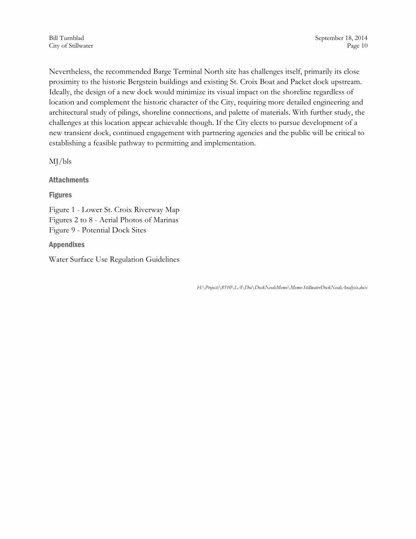
Bill Turnblad September 18, 2014 City of Stillwater Page 10
Nevertheless, the recommended Barge Terminal North site has challenges itself, primarily its close proximity to the historic Bergstein buildings and existing St. Croix Boat and Packet dock upstream. Ideally, the design of a new dock would minimize its visual impact on the shoreline regardless of location and complement the historic character of the City, requiring more detailed engineering and architectural study of pilings, shoreline connections, and palette of materials. With further study, the challenges at this location appear achievable though. If the City elects to pursue development of a new transient dock, continued engagement with partnering agencies and the public will be critical to establishing a feasible pathway to permitting and implementation.
MJ/bls
Attachments
Figures
Figure 1 - Lower St. Croix Riverway Map Figures 2 to 8 - Aerial Photos of Marinas Figure 9 - Potential Dock Sites
Appendixes
Water Surface Use Regulation Guidelines
H:\Projects\8510\LA\Doc\DockNeedsMemo\Memo-StillwaterDockNeedsAnalysis.docx
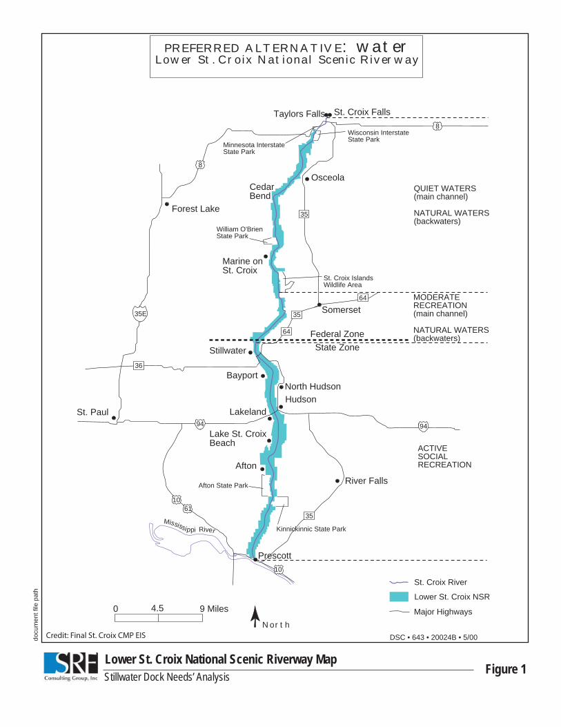
docu
men
t fi le
pat
h
Figure 1Lower St. Croix National Scenic Riverway MapStillwater Dock Needs’ Analysis
Mississippi River
Federal ZoneState Zone
Taylors Falls
Forest Lake
St. Paul
Marine on St. Croix
Osceola
Stillwater
Hudson
River Falls
Prescott
8
1061
8
35
9494
35
PREFERRED ALTERNATIVE: waterLower St. Croix National Scenic Riverway
NorthMajor Highways
Lower St. Croix NSR
St. Croix River
0 4.5 9 Miles
Bayport
Lakeland
North Hudson
Lake St. CroixBeach
Afton
Afton State Park
Kinnickinnic State Park
Wisconsin Interstate State Park
Minnesota InterstateState Park
William O'Brien State Park
St. Croix IslandsWildlife Area
QUIET WATERS(main channel)
NATURAL WATERS(backwaters)
MODERATERECREATION(main channel)
NATURAL WATERS(backwaters)
ACTIVESOCIALRECREATION
DSC • 643 • 20024B • 5/00
St. Croix Falls
CedarBend
35
10
35E Somerset35
64
64
36
Credit: Final St. Croix CMP EIS
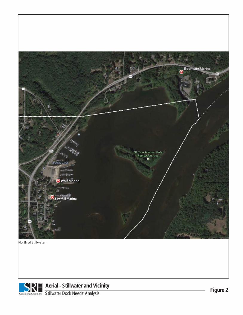
Aerial - Stillwater and VicinityFigure 2Stillwater Dock Needs’ Analysis
Sawmill MarinaSawmill Marina
North of Stillwater
Aerial - Stillwater and VicinityFigure 3Stillwater Dock Needs’ Analysis
St. Croix Boat & PacketSt. Croix Boat & Packet
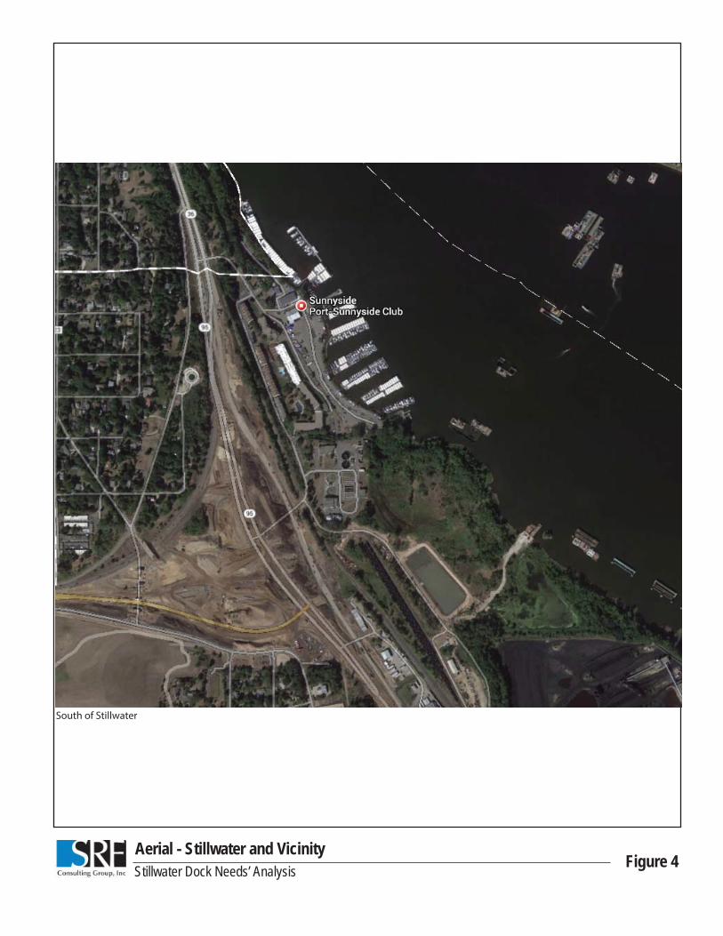
Aerial - Stillwater and VicinityFigure 4Stillwater Dock Needs’ Analysis
South of Stillwater
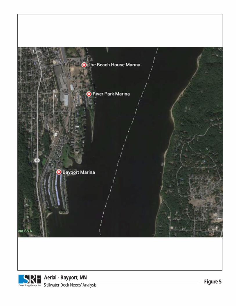
Aerial - Bayport, MNFigure 5Stillwater Dock Needs’ Analysis
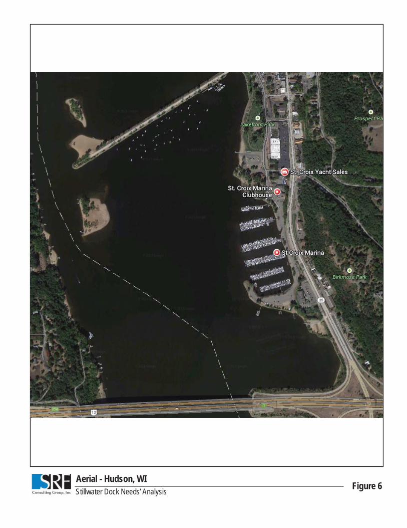
Aerial - Hudson, WIFigure 6Stillwater Dock Needs’ Analysis
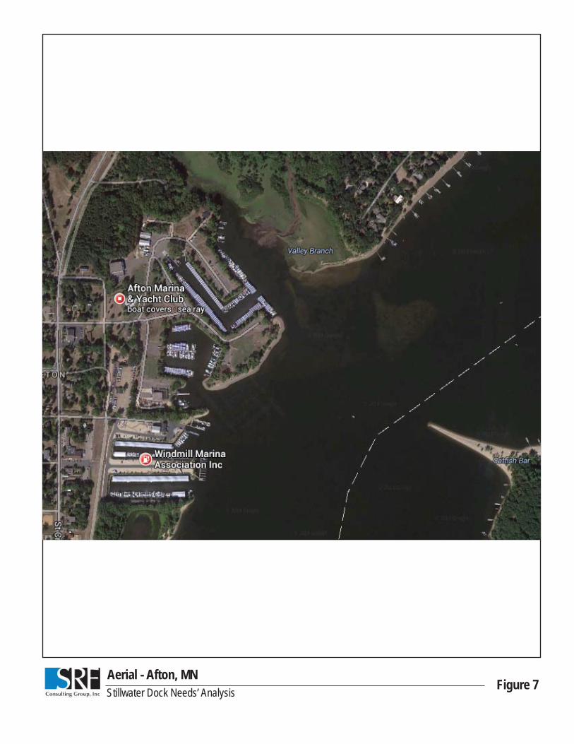
Aerial - Afton, MNFigure 7Stillwater Dock Needs’ Analysis
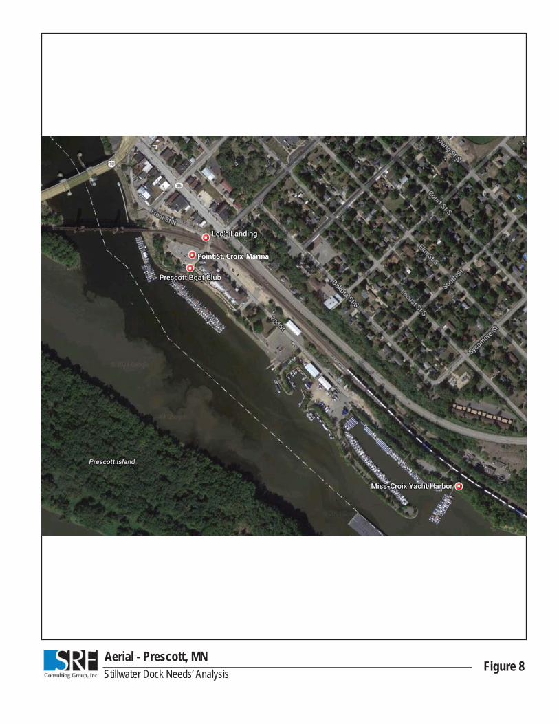
Aerial - Prescott, MNFigure 8Stillwater Dock Needs’ Analysis
Point St. Croix MarinaPoint St. Croix Marina
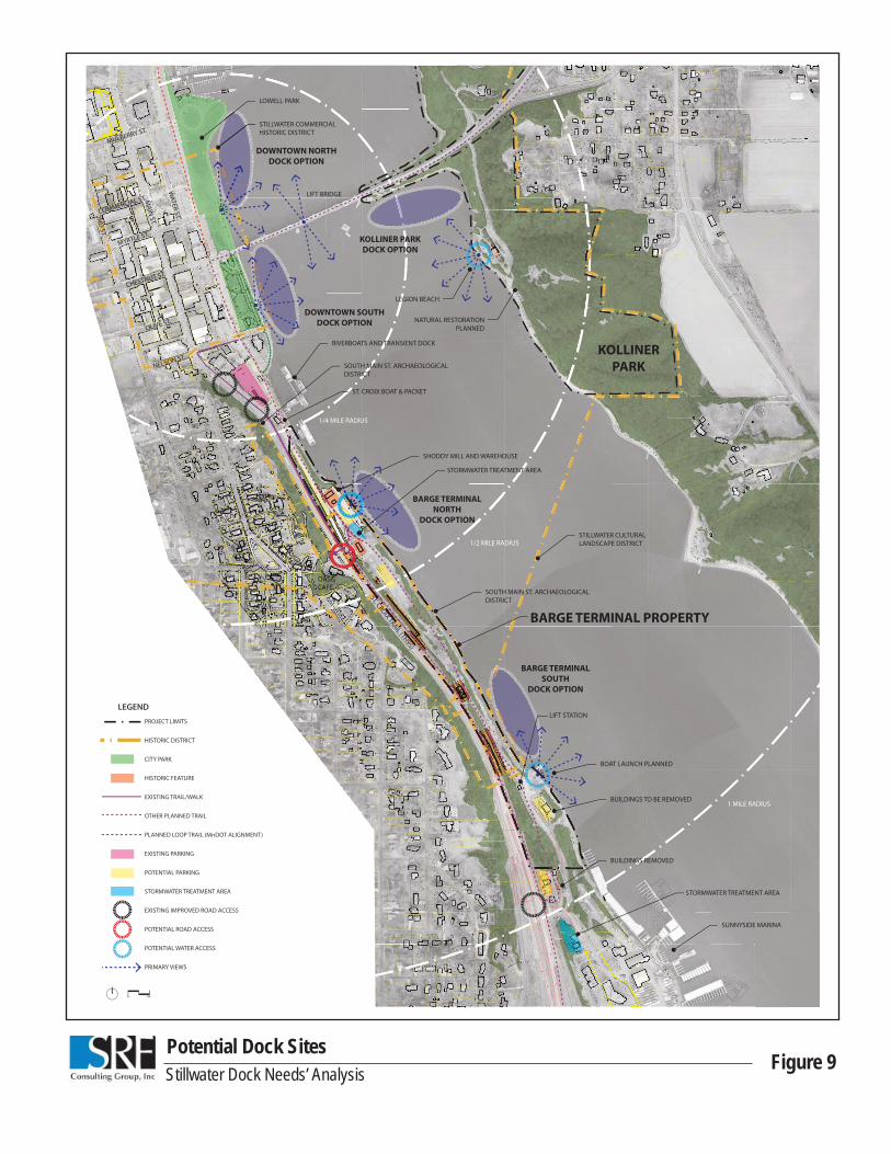
Stillwater Dock Needs’ AnalysisPotential Dock Sites
Figure 9
LEGION BEACH
NATURAL RESTORATIONPLANNED
STILLWATER COMMERCIAL HISTORIC DISTRICT
LIFT BRIDGE
KOLLINER
PARK
STILLWATER CULTURAL LANDSCAPE DISTRICT
BARGE TERMINAL PROPERTY
OASISCAFE
SHODDY MILL AND WAREHOUSE
STORMWATER TREATMENT AREA
STORMWATER TREATMENT AREA
BUILDINGS REMOVED
SUNNYSIDE MARINA
LIFT STATION
BUILDINGS TO BE REMOVED
BOAT LAUNCH PLANNED
RIVERBOATS AND TRANSIENT DOCK
SOUTH MAIN ST. ARCHAEOLOGICAL DISTRICT
SOUTH MAIN ST. ARCHAEOLOGICAL DISTRICT
ST. CROIX BOAT & PACKET
LOWELL PARK
1/2 MILE RADIUS
1/4 MILE RADIUS
1 MILE RADIUS
KOLLINER PARK
DOCK OPTION
BARGE TERMINAL
NORTH
DOCK OPTION
BARGE TERMINAL
SOUTH
DOCK OPTION
MAIN
ST.
CHESTNUT ST.
MULBERRY ST.
MYRTLE ST.
COMMERCIAL ST.
OLIVE ST.
NELSON ST.
WATER ST.2N
D ST.
ST. CROIX TRAIL (TH95)
DOWNTOWN NORTH
DOCK OPTION
DOWNTOWN SOUTH
DOCK OPTION
PROJECT LIMITS
HISTORIC DISTRICT
CITY PARK
HISTORIC FEATURE
EXISTING TRAIL/WALK
OTHER PLANNED TRAIL
PLANNED LOOP TRAIL (MnDOT ALIGNMENT)
EXISTING PARKING
POTENTIAL PARKING
STORMWATER TREATMENT AREA
EXISTING IMPROVED ROAD ACCESS
POTENTIAL ROAD ACCESS
POTENTIAL WATER ACCESS
PRIMARY VIEWS
LEGEND