Embed Size (px)
Citation preview

Bridge Tracker
bridges.msnbc.com
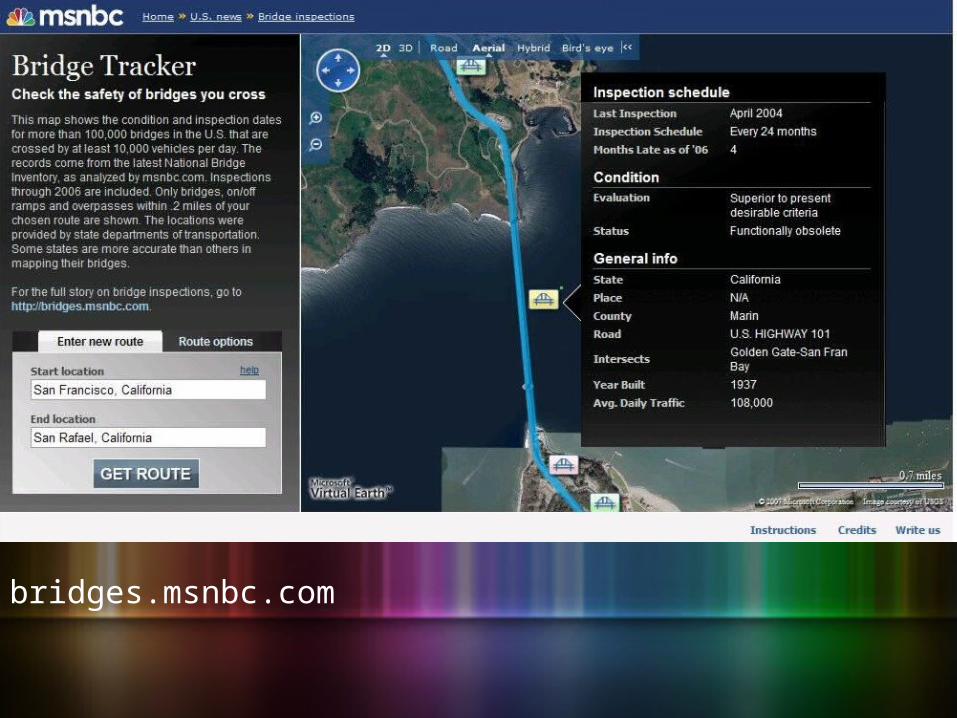
bridges.msnbc.com
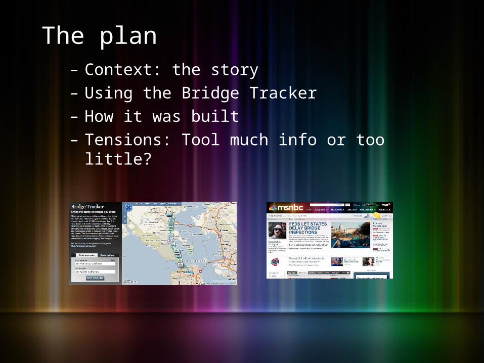
The plan– Context: the story– Using the Bridge Tracker– How it was built– Tensions: Tool much info or too little?


Raw data for a single bridge…
0692700521210010100404100000GOLDEN GATE-
SAN FRAN BAY U.S. HIGHWAY 101 04-MRN-101-L.01 999900000101000000101013749120012228
36000641323212193706001080001999003350001
001121067109999A5531331100300101891280502
7903032032018902849999N0000N0000008165713
9492N585381027423040424NNN065486006549098
22919991N210000056000202Y817990020200000N
N1190212070722FC11930720971220589

… that’s a year late for inspection

A school bus on its morning run approaches a 107-year-old steel truss bridge near Circleville, Ohio. The fracture-critical span was one of at least 17,000 bridges in the U.S. that went more than two years between inspections. The county engineer said he saved about $200 by putting off its checkup.


Using the Bridge Tracker

Find bridges along a route

See details on condition, inspection

Navigation: Enter a new route

Navigation: Filter on bridge condition

Navigation: Filter by inspection late

How it was built
GOAL: Understand how the application works by learning about each of the components and how they work together

Tools
Programming:
Client-side (front end)
1. CSS
2. HTML
3. Javascript
Server-side (back end)
1. C#
Other tools:
Microsoft Virtual Earth
Microsoft MapPoint Web Service*
* =
Timeline
- About three months total; two months development- Factors (excuses)
- No real news peg- Didn’t want to rush it- Idea kept evolving- Learning new languages/technologies*- Proxy*

Application flow
1. Start and end locations are sent to the proxy, along with search criteria 2. Proxy passes that information to MapPoint WS3. MapPoint calculates route, then searches data set for bridges that match search criteria and are near route4. List of matching bridges is returned, including latitude and longitude for each 5. MapPoint sends the list back through the proxy6. Bridge Tracker receives the list (in XML format), then plots each bridge and sets its info

Components: Data set
- Database from National Bridge Inventory
- Uploaded to MapPoint WS and set as data source
- Doesn’t need to be geocoded prior to upload

Components: MapPoint Web Service
- Offers location-based services such as maps, directions and proximity searches
- In this case, calculates a route and finds bridges within a certain distance of that route
- Con: a bit pricey

Components: MapPoint Web Service

Components: Proxy
- Allows us to talk to a web service outside of our domain
- Acts as the “middleman” between the Bridge Tracker and MWS
- Necessary for us, but not you- Could be built using C, ASP, PHP,
Java, Ruby…any other server-side language

Components: Map application
- “Front end” - what the user interacts with
- CSS/HTML for design and layout- Javascript (AJAX) for functionality- Virtual Earth in our case, but
doesn’t have to be

Code review?

Resources
MapPoint Web ServiceMapPoint home - http://www.microsoft.com/mappoint/products/webservice/default.mspxFully-functional demo applications - http://demo.mappoint.net/ Software Development Kit (SDK) - http://msdn.microsoft.com/en-us/library/bb507684.aspx
Virtual EarthInteractive SDK - http://dev.live.com/virtualearth/sdk/Code reference - http://msdn.microsoft.com/en-us/library/bb429619.aspxHelp and “hacks” - http://viavirtualearth.com/vve/Dashboard/Default.ashx
Anything else – [email protected]

Tensions– Usability– Depth– Limitations– Dirty data

Culture clash?

Culture clash?
Phil is on the right.

Culture clash?
Phil is on the right. (My right.)

Tensions– Usability: Who are we designing for?

Where do I start?
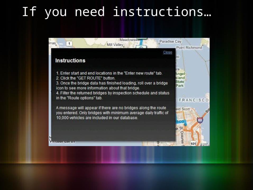
If you need instructions…

alphachannel.msnbc.msn.com
User feedback

Tensions– Usability: Who are we designing for?– Depth: Too much information?

As proposed: 27 facts

As built: 12 facts

Tensions– Usability: Who are we designing for?– Depth: Too much information?– Limitations: Can 100,000 be too few bridges?


“Useless”
“The problem with your bridge tracker is that the definition of what bridges show up (with over X amount of traffic) makes it non-functional for most of the country. … What a useless tool.”
John from Bloomington

bridges.msnbc.com

Tensions– Usability: Who are we designing for?– Depth: Too much information?– Limitations: Too few bridges?– Dirty data: How deal with this?

Dirty data
“Not as good as we thought.”
Thomas D. Everett
bridges team leader
Federal Highway Administration

Bridge Tracker 2.0– More bridges?– Search nearby?– Database lookup?

Credits– Interactive editor: Phil Zepeda– Designer: Julie Yokers– Reporting and data analysis: Bill Dedman– Director of interactive projects: Paige West– Projects editor: Michael Brunker– Special thanks to Anthony Baker, Mike Simon,
Caleb Thompson