Embed Size (px)
Citation preview
BRENTWOOD TOWN CENTRE
DEVELOPMENT PLANPhase III of the Development Plan Review Process
Adopted by Council 1996 June 10
Planning & Building Department
BRENTWOOD TOWN CENTRE PLAN Reference Date: 1996 June 04. Contents 1
Phase III of the Development Plan Review ProcessAdopted by Council 1996 June 10
Table of Contents 1.0 Background . . . . . . . . . . . . . . . . . . . . . . . . . . . . . . . . . . . . . 1
2.0 Policy Framework . . . . . . . . . . . . . . . . . . . . . . . . . . . . . . . . . 1
3.0 Development Plan Approach . . . . . . . . . . . . . . . . . . . . . . . . . . 2
4.0 Town Centre Concept . . . . . . . . . . . . . . . . . . . . . . . . . . . . . . . 2
5.0 Character Concepts . . . . . . . . . . . . . . . . . . . . . . . . . . . . . . . . 3
5.1 The “Village” Concept 5.2 Dawson Street 5.3 Lougheed Highway 5.4 Identified Neighbourhoods 5.5 The Natural Environment
6.0 Systems . . . . . . . . . . . . . . . . . . . . . . . . . . . . . . . . . . . . . . . 7
6.1 Public Transit 6.2 Road Network 6.3 Open Space Network and Environmental Enhancements 6.4 Pedestrian and Cycling Network 6.5 Parking
7.0 Land Use . . . . . . . . . . . . . . . . . . . . . . . . . . . . . . . . . . . . . . . 12
7.1 Commercial 7.2 Residential 7.3 industrial 7.4 Community Facilities and Services
8.0 Development Program . . . . . . . . . . . . . . . . . . . . . . . . . . . . . . 19
9.0 Further Study and Implementation . . . . . . . . . . . . . . . . . . . . . . 20
Sketches #1 – #10 . . . . . . . . . . . . . . . . . . . . . . . . . . . . . . . . . . . 22
Attached: Appendix A . . . . . . . . . . . . . . . . . . . . . . . . . . . . . . . . . 29
BRENTWOOD TOWN CENTREDEVELOPMENT PLAN
BRENTWOOD TOWN CENTRE PLAN Reference Date: 1996 June 04. Contents 2
BRENTWOOD TOWN CENTRE DEVELOPMENT PLANReprint Edition
Note for reprint edition
This reprint of the Brentwood Town Centre Development Plan remains as adopted by Council on 1996 June 10.
It is advised the numerous amendments to the Development Plan have been adopted by Council since 1996. Some of these amendments relate to the following:
• BrentwoodTownCentreDevelopmentPlan,FinalizedAdjustments,adoptedbyCouncil2000 December 11;
• HoldomStationAreaGuidePlan,adoptedbyCouncil 2003 January 20; and
• Variousamendmentrezoningapplicationsapproved since 1996.
Contact the Planning Department for further information.
BRENTWOOD TOWN CENTRE PLAN Reference Date: 1996 June 04. Page 1
1.0 BackgroundThe Brentwood Town Centre is the desig-nated town centre for the north-west sector of Burnaby. The town centre is intended to be a focus of higher-density and higher-intensity residential and commercial op-portunities, public transit and supporting leisure facilities.
The Brentwood Town Centre will play a significant role in the City’s growth management strategy by accommodating some of the overall future growth in the City. The revised town centre Develop-ment Plan is an important element in the City’s response to meeting future growth allocations established for Burnaby by the Greater Vancouver Regional District and to transportation initiatives establishing the
2.0 Policy FrameworkThe Brentwood Town Centre Policy Frame-work was adopted by Council on 1995 March 13. The framework is organized through the discussion of policy issues which are the prime ones supported by the public consultation process.
These issues are organized under the seven general headings of:
1. Town Centre Concept and Redevel-opment Potential
2. Quality of the Environment3. Residential Development4. Commercial and Mixed-Use Devel-
opment5. Industrial Development6. Transportation
BRENTWOOD TOWN CENTREDEVELOPMENT PLAN
Lougheed Corridor for a light rapid transit (LRT) extension to Coquitlam as the next priority with its resultant opportunities for additional focussed growth.
The overall Brentwood Town Centre Devel-opment Plan review involved a three phase process: Phase I – Information gathering and issue identification; Phase II – De-termination of a policy framework; and Phase III – Preparation and adoption of a revised Development Plan. The Phase I and Phase II processes which resulted in the establishment of a policy framework with its organizing principles and strategies are the basis for the formulation of the revised Development Plan, constituting Phase III of the review process.
7. Social Planning and Community Facilities
Flowing out of the extensive discussion of each of the issues, guiding “strategies” as well as major “organizing principles” for the town centre framework were identified. The identified fifty strategies and five organiz-ing principles are outlined in Appendix “A” (attached), and are the basis for the formulation of the Development Plan. This framework also continues as an important policy foundation which needs to be kept in mind and which will guide refinements, further initiatives, and programs needing to be pursued relative to the implementation of the Development Plan.
BRENTWOOD TOWN CENTRE PLAN Reference Date: 1996 June 04Page 2
3.0 Development Plan ApproachThe formulation of the Development Plan is based on the policy framework. The policy framework represents the interdepen-dent integration of the following aspects:
development programland usemovement and physical networksenvironmental considerationssocial and recreational considerationsfiscal and infrastructure considerationsphasing implications
The development of major urban centres requires the management of complexity and of the wide diversity of community interests. Land use designations remain at the core of the Development Plan as the primary redevelopment and economic
decision making tool. However, a range of other illustrative and network diagrams, concepts and approaches has been pursued to convey the overall intent and character of the proposed Development Plan. The op-portunity is to create a layered and textured vision for the town centre area which would combine physical, environmental and social aspects into a cohesive and complete urban environment. The plan is open-ended to the extent that it will allow incremental refinements while providing a strong overall conceptual framework.
The proposed Development Plan is described in the following sections. The sec-tions taken as a whole represent the pro-posed Development Plan as an integrated entity, conveying the Phase II conceptual framework.
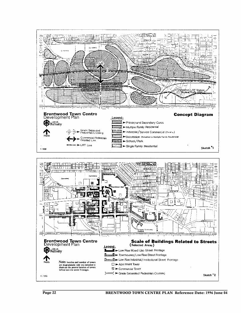
4.0 Town Centre ConceptA conceptual diagram is outlined (Sketch 1 attached) as an image of the town centre concept.
The town centre is organized on the basis of a transit-oriented, high-density, mixed-use, high-vitality central core with surrounding medium-density supporting development. The development of a complete community is proposed, enabling people to live, work and play within the area, with the goal of providing an inclusive and diverse commu-nity to benefit all.
A strong, centrally located, mixed-use core, building upon and enriching exist-ing elements proposed to be retained, is indicated. There is a need to overcome the divisive nature of the Lougheed Highway and Willingdon Avenue. The strength of Brentwood Mall and its mixed-use redevel-opment potential as the linchpin of the core
is acknowledged. The core is linked across Willingdon Avenue to the west and across Lougheed Highway to the south. Commer-cial uses are emphasized in close proximity to the Lougheed/Willingdon intersection, blending with high-density residential uses away from the intersection and becoming predominantly residential of a high and medium density nature at the outer reaches of the core.
A sustainable environment is desired. Major growth opportunities particularly for residential development are offered by the proposed LRT along the Lougheed Highway corridor and other focussed transit improve-ments. While an urbane environment is proposed, it is one which emphasizes a pedestrian-oriented village scale and the creation of neighbourhood enclaves linked by greenways. An elementary school and park site is identified west of Delta Avenue
BRENTWOOD TOWN CENTRE PLAN Reference Date: 1996 June 04. Page 3
and south of the Dawson Street extension. The greenway environmental approach related to boulevard landscaping, urban trails and landscaped buffer areas will link an array of private and public green spaces, into a unified greenway system both for the town centre and integrated with the City’s overall greenway system. The enhance-ment of the special greenways related to watercourses flowing into Still Creek and toward Burnaby Lake is considered a key opportunity from both urban stormwater management and environmental amenity viewpoints. One of the challenges of the Plan is to promote a harmonious integra-tion of urbane and natural environmental approaches.
The Dawson Street alignment provides for a compact mixed-use “high street” in the vicinity of Willingdon Avenue with com-mercial uses at-grade and residential above and behind. The core and the “high street” are integrated by providing for a commercial link along Willingdon Avenue between these two elements and at the Lougheed/
Willingdon intersection to give a strong urban focus to the geographical centre of the town centre.
The overall town centre precinct encom-passes an area of approximately 400 acres including road rights-of-way. The major edge conditions of the town centre are: to the north, the existing single-family dwelling neighbourhoods; to the south, the CNR/BNR Railway and existing industrial beyond; and to the east and west, industrial development, which are subject to further area studies related to LRT stations.
The key major roads in this area are Will-ingdon Avenue, the Lougheed Highway and Dawson Street (as well as its eastern extension) for which specific buffering, integrative, and urban design initiatives are provided for in the Plan.
The development plan is further described in the following sections related to charac-ter concepts, overall systems, land uses and development program.
5.0 Character ConceptsThe character concepts outlined in this section are intended to develop a sense of place and a special identity for the Brentwood Town Centre both as a whole and in its key elements. The five character concepts include the overall village concept, the specific Dawson Street “high street”, the Lougheed Highway frontage treatment, identified neighbourhoods, and the natural environment. The first concept regarding the “village” is an overall concept giving the town centre a special sense of human scale and providing a unifying urban design approach for different uses and enclaves within the town centre. The Dawson Street “high street” highlights the importance of
an identified stretch of Dawson Street as a unifying community-use convenience and drop-in commercial focus for the town centre. The Lougheed Highway is a dominating potentially-divisive element which needs to be dealt with and as much as possible designed and enhanced to be a unifying asset rather than a liability for the town centre. The definition of identifiable sub-areas or neighbourhoods will also assist in conveying a sense of place and human scale to the town centre. An enhanced natural environment will help provide livable residential environments and soften the existing industrial context of much of the area.
BRENTWOOD TOWN CENTRE PLAN Reference Date: 1996 June 04Page 4
5.1 The “Village” Concept
The “village” concept is one related to human scale, streetscape character, and an integrative approach to differing proximate uses. The general urban design concept for street frontages in the town centre is to create low-scale and continuous build-ing frontages along streets. A promenade quality is encouraged for street frontages with generous paved pedestrian ways, street trees, building canopies, and pedestrian related uses. Higher density forms including high-rise towers would be located internal to the development sites behind the lower-scaled buildings along the street frontages. A diagrammatic illustration of the “village” street frontage approach is outlined in Sketch 2 (attached). The “village” approach emphasizes architectural detailing, greater building faceting and encouragement of slop-ing roof elements for low-rise buildings.
For residential sites, whether low-rise or high-rise, the development of a townhouse facade at a maximum 2½ storey scale with front doors facing the street is desirable along the street frontages. Generally for mixed-use sites, at-grade commercial uses surmounted by up to 3 floors of residential or commercial would be desirable along street frontages. Wherever possible, other uses such as industrial, institutional, or recreational buildings along town centre street frontages should attempt to maintain a similar maximum two to three storey
scale and a continuous building form along street frontages.
The street frontage exceptions to this ap-proach are the Lougheed Highway frontage (except in the vicinity of the Willingdon Avenue intersection), Gilmore Avenue and the stretch of Willingdon Avenue south of Dawson Street. These frontages would emphasize a buffering landscape treatment with berms and trees screening the build-ings setback a minimum 50 ft. for these streets and desirably 90 ft. in the case of residential building along the Lougheed and Willingdon frontages.
A general greening approach to street frontages is proposed with street trees, grass boulevards, and appropriately landscaped front yards. Streets with at-grade com-mercial would be setback to accommodate weather protection canopies, outdoor cafe and restaurant patios, and other boulevard enrichment features such as fountains, sculpture, planters and benches.
Such an integrative approach can provide pleasing, human-scaled, high quality, urban environments. This approach can help sustain the integrity of residential projects constructed within a largely industrial context and with sympathetic design treat-ments, allow adjacent industrial and resi-dential projects to appropriately co-exist.
5.2 Dawson Street
As a special element of the overall “village” concept, the development of a “village street” or “high street” is proposed for Dawson Street and its eastward extension, a street which has a strong sense of place and special identity within the town centre. It would function to promote community cohesiveness, in particular linking the north side of Dawson Street to future redevelop-
ment areas south of Dawson Street. There are varied uses along this street including industrial, commercial, residential, com-munity or park uses. The intent is to develop a quality, attractive, and active urban street through the development of lower and smaller scaled, well-faceted and richly detailed development along the Dawson Street frontage with landscaped
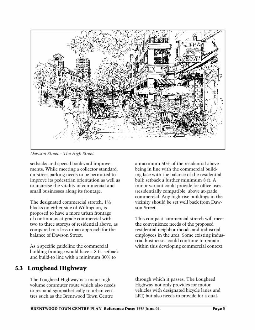
BRENTWOOD TOWN CENTRE PLAN Reference Date: 1996 June 04. Page 5
Dawson Street – The High Street
setbacks and special boulevard improve-ments. While meeting a collector standard, on-street parking needs to be permitted to improve its pedestrian orientation as well as to increase the vitality of commercial and small businesses along its frontage.
The designated commercial stretch, 1½ blocks on either side of Willingdon, is proposed to have a more urban frontage of continuous at-grade commercial with two to three storeys of residential above, as compared to a less urban approach for the balance of Dawson Street.
As a specific guideline the commercial building frontage would have a 8 ft. setback and build-to line with a minimum 30% to
a maximum 50% of the residential above being in line with the commercial build-ing face with the balance of the residential bulk setback a further minimum 8 ft. A minor variant could provide for office uses (residentially compatible) above at-grade commercial. Any high-rise buildings in the vicinity should be set well back from Daw-son Street.
This compact commercial stretch will meet the convenience needs of the proposed residential neighbourhoods and industrial employees in the area. Some existing indus-trial businesses could continue to remain within this developing commercial context.
5.3 Lougheed Highway
The Lougheed Highway is a major high volume commuter route which also needs to respond sympathetically to urban cen-tres such as the Brentwood Town Centre
through which it passes. The Lougheed Highway not only provides for motor vehicles with designated bicycle lanes and LRT, but also needs to provide for a qual-
BRENTWOOD TOWN CENTRE PLAN Reference Date: 1996 June 04Page 6
ity urban boulevard treatment as it passes through the town centre area with separated sidewalks and street trees. An urban trail is proposed on the south side to provide for not only pedestrians but also recreational cyclists including children and seniors. Sig-
nalized intersections of the highway should facilitate ease of crossing by pedestrians and cyclists. Grade-separated pedestrian crossings which can also accommodate dismounted cyclists are desired just east of Willingdon Avenue and at Delta Avenue.
5.4 Identified Neighbourhoods
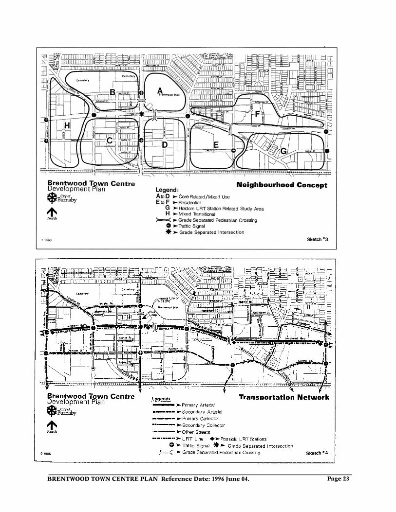
The town centre can also be seen as a family of linked identifiable sub-areas or neighbourhoods, see Sketch 3 (attached). Each of these neighbourhoods has its own character, intrinsic separation, and differ-ent combinations of land use and intensity which sets each one apart from the other. The six neighbourhoods can be described in three groupings. The neighbourhoods A to D are core-related, mixed-use areas with A and B having stronger commercial com-ponents, especially A with Brentwood Mall. Neighbourhoods E and F are primarily resi-dential neighbourhoods. Area G is a future neighbourhood related to an LRT station in
the vicinity of Holdom Avenue. Area H is a mixed-use area oriented generally towards Gilmore Avenue with strong existing indus-trial and service commercial uses and some residential opportunities. Neighbourhoods with strong residential components would each provide some community-oriented facilities such as convenience commercial and public open spaces.
The neighbourhoods are linked together through the road network and pedestrian/cyclist linkages. Appropriate signalized intersections and grade-separated pedes-trian crossings of streets will also assist in linking these neighbourhoods.
5.5 The Natural Environment
The development of an enhanced natural environment is an important conceptual objective. The predominant existing in-dustrial character of the area, in particular south of the Lougheed Highway, currently provides minimal natural amenities. Delib-erate focussed initiatives need to be pursued to counteract this current image. Some of the ways of re-asserting and creating an en-hanced natural environment are as follows.
The regeneration, restoration and en-hancement of the Still Creek drainage and parkway system as a major public greenway amenity is needed. Urban stormwater management alternatives to reduce the environmental impact of urban run-off on receiving streams should be pursued.
A matrix of greenways is proposed, pen-etrating the town centre core, joining open space amenities in the area and linking the town centre to the primary Still Creek and Burnaby Lake open space systems. These greenways would be achieved through a combination of street tree programs, boulevard landscaping, linear parkways, and urban trails. Greenways provide an environmentally-sensitive context for the transportation network, emphasizing alternative modes such as transit, cycling and walking.
The built-form context also needs to be sensitive to the natural environment, recognizing a relatively mild climate ap-propriate for outdoor activity but requiring protection from frequent rainy periods.
BRENTWOOD TOWN CENTRE PLAN Reference Date: 1996 June 04. Page 7
6.1 Public Transit
Public transit improvements are an impor-tant part of the policy framework and need to be pursued in order to accommodate increased development in the area.
A surface Light Rapid Transit (LRT) line is proposed along the Lougheed Highway corridor. The LRT will be accommodated within the Lougheed Highway right-of-way with the general alignment being currently considered along the south side of the high-way. Due to the high traffic volumes at the Lougheed/Willingdon intersection and in light of the heavier surface LRT infrastruc-ture relative to SkyTrain and existing grades with the Lougheed/Willingdon intersection being at the top of a knoll, it is essential for the LRT to be grade-separated at this inter-section probably by being depressed below grade. An appropriate vertical alignment for LRT will be assessed in the context of a further design process.
The Brentwood LRT Station should be established at a specific location in the vicinity of the Lougheed/Willingdon in-tersection which maximizes high-density redevelopment potential. The pedestrian grade-separated crossing of the Lougheed Highway desired in the core area should be integrated with the LRT station.
The penetration of natural light into higher density areas through careful building siting
and design is also desirable, particularly for outdoor spaces.
6.0 SystemsThe systems outlined in this section pri-marily relate to transportation and open space systems. They are closely related to the character concepts outlined in the previ-ous section. These systems are described under the following sub sections:
The Brentwood bus loop may continue to be generally located on the Brentwood Mall site but needs to be closely linked to the Brentwood LRT Station. Improvements to the bus system need to be pursued which would focus bus routes within this sector of Burnaby on the Brentwood Town Centre and emphasize linkages to other town centres.
Other LRT stations, other than the ex-pected station at Willingdon Avenue, could be established along the Lougheed Highway corridor in the vicinity of the town centre. At this time, other possible LRT station locations are at Boundary Road, Gilmore Avenue, Delta Avenue and/or Holdom Avenue. Further land use studies leading to area plan changes would be pursued relative to specific determined locations of other LRT stations on the periphery of the Plan area such as at Boundary Road and Holdom Avenue.
The effect of LRT on the Brentwood Town Centre and surrounding area will need to be monitored with a view to accentuating its positive aspects and ameliorating any negative aspects.
6.1 Public Transit6.2 Road Network6.3 Open Space Network and Environ-
mental Enhancements6.4 Pedestrian and Cycling Network6.5 Parking
BRENTWOOD TOWN CENTRE PLAN Reference Date: 1996 June 04Page 8
6.2 Road Network
The road network as outlined in Sketch 4 (attached) is in line with the conceptual framework and with the adopted Burnaby Transportation Plan. Road network im-provements need to be pursued to accom-modate increased development in the area. The road network is designed to prevent “rat-running” through residential areas by accommodating traffic growth on the arteri-als such as Lougheed Highway and Willing-don Avenue, and to provide for alternative modes of travel including transit, cycling and walking.
The Lougheed Highway and Willingdon Avenue are the major east-west and north-south arterials. It is desirable for the intersection of these two arterials to be grade-separated, although its location at the centre of the town centre requires that it be designed in an urban and pedestrian/cyclist-friendly manner.
The objective is to achieve a fully inte-grated, comprehensive solution for the various proximate components composed of the grade-separated intersection, the LRT alignment and station, the bus loop, grade-separated pedestrian access across the Lougheed Highway and Willingdon Avenue, core-related major redevelopment including air-rights, drop-off and pick-up access near the LRT station and bus loop, parking and service access to abutting major private developments, and the public pedestrian, cycling and open space network in this vicinity.
Other road improvements include the eastward extension of Dawson Street, the northern extension of Westminster Avenue to this Dawson Street Extension, and the Madison/Douglas westward extension to link with First Avenue. Traffic calming mea-sures including on-street parking would be encouraged on Dawson Street to emphasize
its primary use for local traffic. Achieving continuity of the east-west Still Creek/Nor-land industrial route from Boundary Road east to Sprott Street and improvements to the Lougheed Highway will relieve vehicular pressures off this Dawson/Juneau align-ment.
Other minor road improvements or adjust-ments include the eastward extension of Alaska Street to Beta Avenue, a cul-de-sac east from Beta Avenue serving the proposed residential area on the north side of the Lougheed Highway between Beta and Delta Avenues, and the closure of Douglas Road at Lougheed Highway while maintaining a right-turn in and out access of Delta Ave-nue north of the Lougheed Highway. Traffic concerns within the existing Brentwood Park neighbourhood may be pursued as a resident initiative through the Traffic and Transportation Committee of Council.
Wherever possible, minor roads should have a maximum road width standard of 36 ft. with on-street parking promoted in order to discourage their use for other than local traffic. Some wider road standards may be necessary where on-street cyclists need to be specifically accommodated. Other “in-ternal” private roads within developments should enhance and be compatible with the public “grid” road network with public pedestrian and cycling ways within green corridors.
Vehicular accesses to developments need to be designed to minimize interruptions along pedestrian-oriented streets. Some access to major development could be achieved directly off the Lougheed Highway or Willingdon Avenue but would require special right-turn in and out lanes to main-tain the through traffic function of these arterials.
BRENTWOOD TOWN CENTRE PLAN Reference Date: 1996 June 04. Page 9
Chubb Creek adjacent Industrial Park
6.3 Open Space Network and Environmental Enhancements
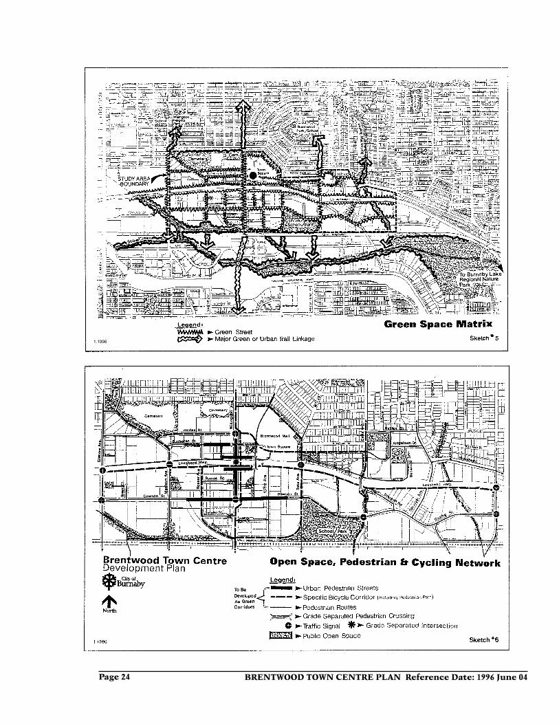
The town centre open space network is integrated with the pedestrian and urban trail network. The open space system is illustrated in Sketches 5 and 6 (attached). Sketch 5 outlines an overall image of the town centre area as it is linked to the north to major park and open space ravine areas and to the south to the primary Still Creek drainage and park trail system accessing the Burnaby Lake Regional Nature Park and the Central Valley Sports Complex.
Sketch 5 also attempts to convey the green-ing matrix concept for the town centre linking the various primary green spaces. Sketch 6 is a diagram of the various open spaces and linkage elements. Some of the greening components are specifically noted as follows.
a) Existing parks, buffer areas and green space are provided north of the Lougheed Highway such as Willingdon
Heights Park (expanded to the south in conjunction with the Douglas Road to First Avenue connector), the two cem-eteries, Brentwood Park/School, Springer Park, buffer areas at Delta Avenue and Halifax Street, and the Nation Way ravine.
b) A 6 acre school and 9 acre park site is proposed south of the Dawson Street Extension between Beta and Delta Avenues. An elementary school and a small community centre facility are planned, either as adjoining or separate facilities, depending on further detailed studies. Appropriate remediation of soil contamination of this currently industrially-utilized site for public uses would need to be pursued.
c) A minimum 1 acre public town square is proposed with an urban character suitable for public celebrations and surrounded by pedestrian arcades with high-vitality drop-in commercial
BRENTWOOD TOWN CENTRE PLAN Reference Date: 1996 June 04Page 10
activities such as cafes and restaurants. This town square should be City con-trolled. This town square is desired on the central Brentwood Mall site near the Lougheed/Willingdon intersection. This feature could be provided in conjunction with major redevelopment of the Mall site and/or the establishment of the LRT Station.
d) Further small urban public parks under City control, up to a 1 to 2 acre size, are also desirable within the various proposed neighbourhoods to provide a more immediate open space amenity for neighbourhood residents. In some cases, closed portions of street rights-of-way can provide such open spaces. A variety of other open space features and passages of a communal and public nature would also be encour-aged in private developments. The main public pedestrian linkages such as those to the LRT Station should be enhanced by public open space “gateways” at key locations.
e) There are three creeks identified in the area. Beecher Creek in the eastern part and Chubb Creek as well as a small unnamed (BL-8) tributary watercourse in the western part of the area, should be preserved and enhanced as public amenities. In the long term privately-owned portions of creek areas should be acquired by the City.
f) Within the area, north of the Lougheed Highway between Beta and Delta Avenues, some of the existing treed area on the western and the eastern portion would be protected with an east-west buffer strip of trees maintained south of the lane to screen the proposed apartment development from the existing single-family dwelling area. The pedestrian overpass of the Lougheed Highway at Delta Avenue would be linked into a linear north-south park trail.
g) Landscaped buffer strips emphasiz-ing native trees and shrubs are proposed
along both sides of the Lougheed High-way except for a more urban treatment in the vicinity of Willingdon Avenue. This landscaped buffer will assist in buffering residential developments, screening the proposed LRT line, and accommodate public pedestrian and urban trail facilities.
h) Greening the town centre as a positive environmental, organizing and integrative concept is promoted. Burna-by has been well served by its tradition of complementing the natural environ-ment with street trees and landscaped yards, even within our higher density urban areas. Natural vegetation acts as an environmental filter helping to cleanse the air and to improve the envi-ronment from visual and psychological viewpoints.
The provision of seasonal colours through flowering shrubs and trees is also encouraged. Much of the existing context of the Brentwood area, which is of a relatively bare industrial nature, can be softened and benefit from improved livability through such enhancement.
To ensure implementation of a strong greenways concept into the heart of the Town Centre, wider dedicated road rights-of-way of 76 ft. wide are pro-posed. Thus wider landscaped boule-vards with the possibility of double rows of street trees and enhanced pedestrian and cycling provisions may be achieved.
i) Alternative stormwater manage-ment practices are being pursued by the City Engineering Department towards reducing the environmental impact of urban run-off on receiving streams. Components of a total integrated sys-tem related to stormwater management include consideration of detention/retention facilities, floodplain and watercourse delineation and protection, sedimentation control, and porous pave-ments.
BRENTWOOD TOWN CENTRE PLAN Reference Date: 1996 June 04. Page 11
6.4 Pedestrian and Cycling Network
The pedestrian and cycling networks in this area are closely related to the open space network with its greening and greenway concepts. Urban trails which are pedestrian and cycling facilities within a green corridor, desirably off-road where possible, are pro-posed as outlined on Sketch 6. These urban trails will link various parks in the area. Pedestrian-only trails will link to the Still Creek nature corridor which is intended to preclude cyclists.
While these urban trail routes are the primary ones for cycling, cyclists are also accommodated on major roads through the provision of wider curb lanes. It is acknowl-edged that steep grades on some of the north-south urban trails will be unavoid-able in light of existing grades in the area. The provision of bike racks is encouraged throughout the town centre area.
Sidewalks, separated wherever possible, would be expected to be provided on all
streets. Public walkways would also be provided within easements or linear park linkages where appropriate.
Pedestrian and cycling friendly signaliza-tions need to be pursued at all signalized intersections, particularly along Lougheed Highway and Willingdon Avenue. Grade-separated crossings in the core area are proposed across the Lougheed Highway and Willingdon Avenue and across the Lougheed Highway at Delta Avenue.
The overall pedestrian network should be designed to accommodate the physically challenged wherever possible.
Special urban pedestrian-oriented streetscapes should be provided within the core area as well as along the designated service commercial frontages along Dawson Street and Willingdon Avenue.
6.5 Parking
Parking is considered a component in-terdependent with the other town centre transportation components. Specific park-ing approaches will assist in achieving the “village concept”.
Further parking provisions for town centre development whether of a commercial or residential nature should be provided un-derground wherever possible. The ramifica-tions of mixed-uses and of improved public transit facilities vis-a-vis required parking will be assessed on their own merits within the context of specific major development proposals.
To serve the commercial “high street” pro-posed along Dawson Street between Madi-son and Beta Avenues, consideration should be given to the provision of a few small public surface parking lots located south of Dawson Street behind the commercial strip, funded by a payment-in-lieu program.
Retention of on-street parking is important to serve the residents and local businesses and to assist in furthering street vitality in the town centre.
BRENTWOOD TOWN CENTRE PLAN Reference Date: 1996 June 04Page 12
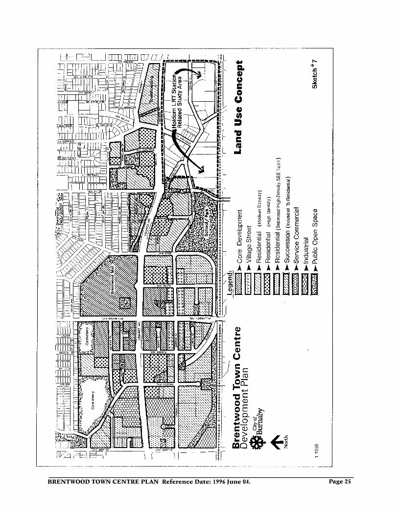
7.0 Land UseThe concept land use plan is outlined in Sketch 7 (attached). This plan should be viewed in close relationship to Sketches 8, 9 and 10 (attached), which provide a separate view of the main commercial, residential and industrial land use components, as well as related open space elements.
These sketches represent a further refine-ment of the conceptual diagram (Sketch 1). Further minor shifting of boundary lines may be considered in pursuing implemen-tation of the Plan. These land use plans are also clarified by the character concepts outlined in Sketches 2 and 3.
Included in this section is a discussion of community facilities and services, many of which have been alluded to under various headings but which need to be discussed as a specific land use component.
As much of the lands proposed for future commercial, residential, and community uses are currently industrially-utilized lands, the appropriate remediation of these former industrial areas will require sig-nificant effort and expenditures including approvals of the provincial Ministry of the Environment.
7.1 Commercial
A range of commercial opportunities in the area is encouraged. The town centre would be strengthened and focussed through the development of a strong primary core, and the Dawson Street “High Street”.
Some local neighbourhood commercial would be provided as well as continued rec-ognition of some auto-oriented commercial.
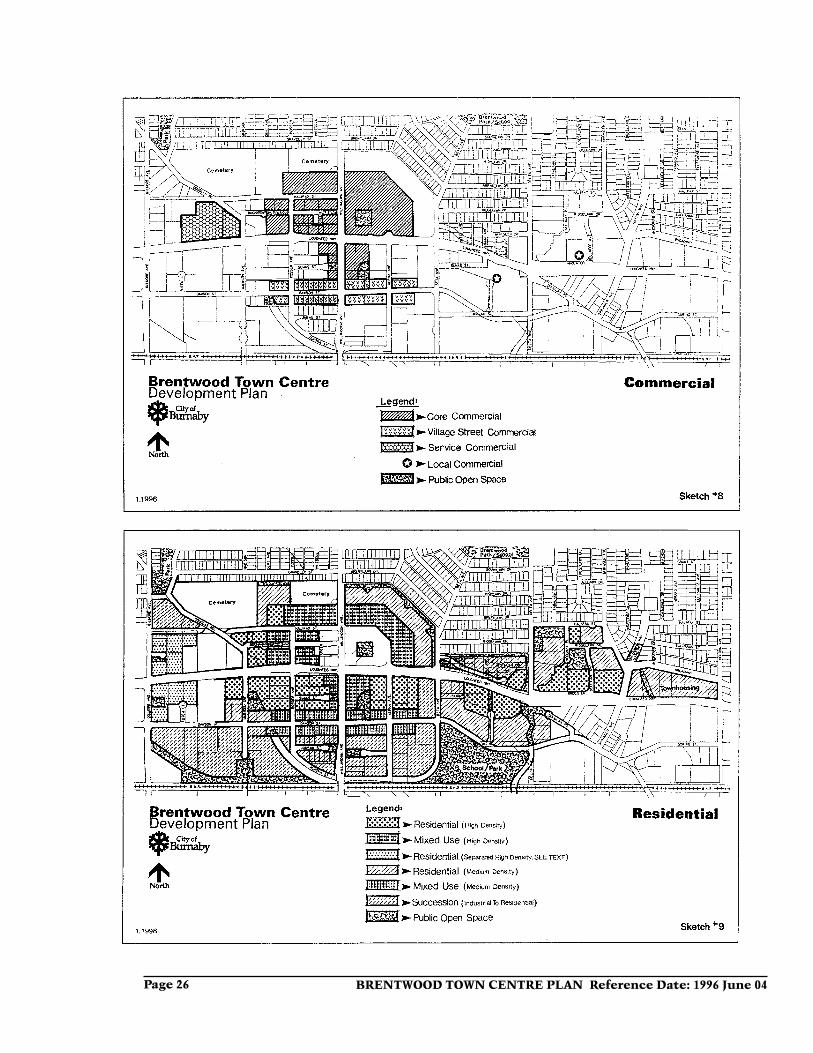
The commercial components are outlined in Sketch 8. The emphasis is on the devel-opment of a strong pedestrian-friendly and village-scaled environment and of a cohe-sive and compact commercial area to serve the residential and industrial development in the area.
a) Primary Core
The primary core is a high-density mixed-use area which encompasses the four quadrant blocks around the Lougheed/Willingdon intersection. Each of the quad-rants, while accommodating high-density development, will have differing proportions of retail, convenience commercial, office, hotel, and residential uses.
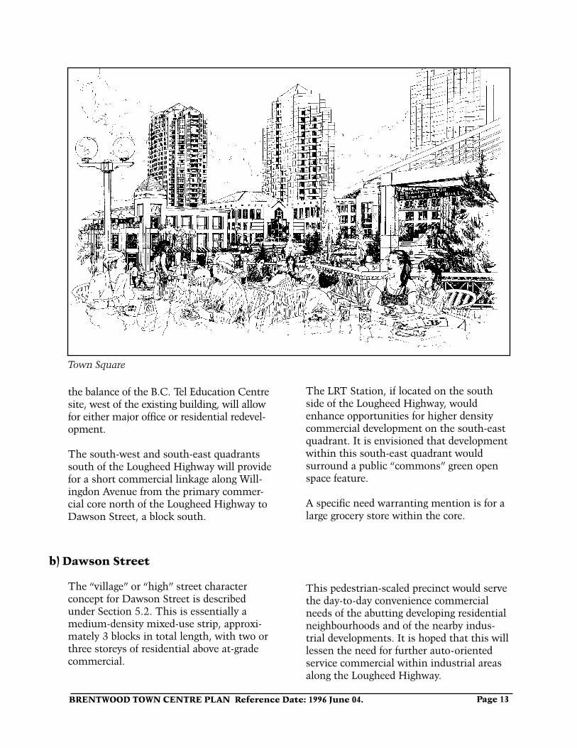
The large north-east Brentwood Mall quadrant recognizes the continuing strength of the mall and encourages the development of major office development and pedestrian-oriented commercial focussed around a “town square” public open space feature near the Lougheed/Willingdon intersection.
High-rise developments should be oriented to the Lougheed/Willingdon intersection in the south-west portion of the mall site. De-velopment near the intersection would be integrated with grade-separated pedestrian crossings across the Lougheed Highway and Willingdon Avenue to other core quadrants as well as integration with the bus loop and the LRT station.
The north-west quadrant will continue to provide higher-density commercial oppor-tunities on smaller site consolidations. A public open space focus is envisioned along the commercial pedestrian-oriented Buchan-an Street alignment. The redevelopment of
BRENTWOOD TOWN CENTRE PLAN Reference Date: 1996 June 04. Page 13
Town Square
the balance of the B.C. Tel Education Centre site, west of the existing building, will allow for either major office or residential redevel-opment.
The south-west and south-east quadrants south of the Lougheed Highway will provide for a short commercial linkage along Will-ingdon Avenue from the primary commer-cial core north of the Lougheed Highway to Dawson Street, a block south.
The LRT Station, if located on the south side of the Lougheed Highway, would enhance opportunities for higher density commercial development on the south-east quadrant. It is envisioned that development within this south-east quadrant would surround a public “commons” green open space feature.
A specific need warranting mention is for a large grocery store within the core.
b) Dawson Street
The “village” or “high” street character concept for Dawson Street is described under Section 5.2. This is essentially a medium-density mixed-use strip, approxi-mately 3 blocks in total length, with two or three storeys of residential above at-grade commercial.
This pedestrian-scaled precinct would serve the day-to-day convenience commercial needs of the abutting developing residential neighbourhoods and of the nearby indus-trial developments. It is hoped that this will lessen the need for further auto-oriented service commercial within industrial areas along the Lougheed Highway.
BRENTWOOD TOWN CENTRE PLAN Reference Date: 1996 June 04Page 14
c) Local Neighbourhood Commercial
Each of the delineated neighbourhoods should provide some day-to-day conve-nience commercial facilities. The neigh-bourhoods west of Beta Avenue would be served by the core and Dawson Street
commercial. An existing small convenience facility and a proposed small convenience facility are identified for neighbourhoods E and F respectively, one north and one south of the Lougheed Highway.
d) Auto-Oriented Commercial
A few newer C4-type auto-oriented com-mercial developments including a motor hotel are located on the north side of the Lougheed Highway just west of Madison Avenue and are recognized as a continuing
component of the Plan. Possible residential redevelopment could be considered in the longer range, subject in particular to appro-priate access being provided which is not off the Lougheed Highway.
7.2 Residential
An expanded range of housing choices is proposed through medium and high-density multiple-family developments accommo-dating a variety of household types within a structure of identifiable neighbourhoods. Residential proposals would utilize the zon-ing districts outlined in the current Burnaby Zoning Bylaw as guidelines although con-sideration could be given to new zoning districts providing for increased permitted densities.
In particular, the provision of ground-oriented family housing components is encouraged. Implementation policies such as those related to affordable housing would be further addressed through the Housing Committee of Council. When approved by the City, such affordable housing policies would form part of the Development Plan. It is expected that large major residential developments could provide a component of affordable housing. The use of density bonusing could assist in achieving desired affordable housing objectives.
Mixed-use developments which include a residential component are encouraged in a number of locations particularly integrated with at-grade commercial uses. Innovative mixed-use developments composed of at-grade industrial uses of selected types with residential above would be given consider-ation in transitional areas.
Road rights-of-way dedications and the closure of redundant existing road and lane rights-of-way will need to be pursued in creating appropriate residential redevelop-ment site assemblies. Vehicular access to development needs to be designed to minimize interruptions along pedestrian-oriented streets.
Developers of proposed residential develop-ment proximate to the railway and CNR tunnel will need to provide consultant stud-ies related to train noise and vibration.
The residential concept is outlined in Sketch 9 (attached)
a) High-Density Residential
Locations for high-density residential development are indicated within the core,
in immediately abutting areas, and as part of neighbourhood groupings in areas east
BRENTWOOD TOWN CENTRE PLAN Reference Date: 1996 June 04. Page 15
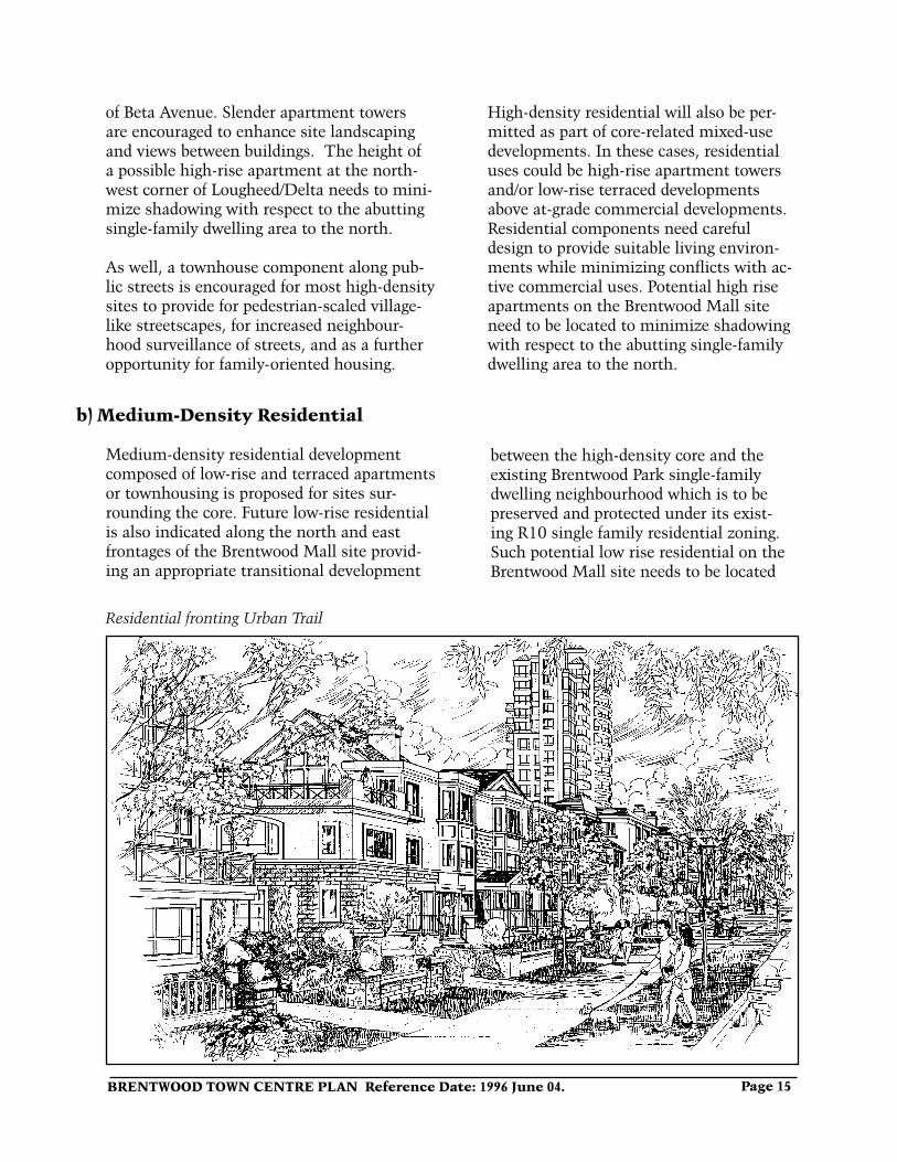
Residential fronting Urban Trail
of Beta Avenue. Slender apartment towers are encouraged to enhance site landscaping and views between buildings. The height of a possible high-rise apartment at the north-west corner of Lougheed/Delta needs to mini-mize shadowing with respect to the abutting single-family dwelling area to the north.
As well, a townhouse component along pub-lic streets is encouraged for most high-density sites to provide for pedestrian-scaled village-like streetscapes, for increased neighbour-hood surveillance of streets, and as a further opportunity for family-oriented housing.
High-density residential will also be per-mitted as part of core-related mixed-use developments. In these cases, residential uses could be high-rise apartment towers and/or low-rise terraced developments above at-grade commercial developments. Residential components need careful design to provide suitable living environ-ments while minimizing conflicts with ac-tive commercial uses. Potential high rise apartments on the Brentwood Mall site need to be located to minimize shadowing with respect to the abutting single-family dwelling area to the north.
b) Medium-Density Residential
Medium-density residential development composed of low-rise and terraced apartments or townhousing is proposed for sites sur-rounding the core. Future low-rise residential is also indicated along the north and east frontages of the Brentwood Mall site provid-ing an appropriate transitional development
between the high-density core and the existing Brentwood Park single-family dwelling neighbourhood which is to be preserved and protected under its exist-ing R10 single family residential zoning. Such potential low rise residential on the Brentwood Mall site needs to be located
BRENTWOOD TOWN CENTRE PLAN Reference Date: 1996 June 04Page 16
to minimize shadowing with respect to the abutting single-family dwelling area. A townhouse component along public streets or the provision of units directly accessible
to streets is encouraged. Along the Dawson Street “high street”, medium-density resi-dential above at-grade commercial is also proposed.
c) Separated Residential
The sites related to this designation are located in the vicinity of Gilmore Avenue. These sites are separated from the residen-tially designated areas to the east by strong, newer service commercial and industrial/office developments on the north and south sides respectively of the Lougheed Highway. These sites are designated for residential development due to their attractiveness for early redevelopment.
However, due to the continuing strong industrial and service commercial context of the area, residential development com-patibility needs to be pursued by assuring low-site coverage developments, possibly at higher densities, which would emphasize abundant natural buffering landscaping.
d) Succession Residential
These areas are those that have a strong existing industrial presence many of which could continue for some time. It is probable that residential redevelopment would likely be pursued after the primary residential areas north of Dawson Street, although large sites ripe for redevelopment should be given consideration for advancement on their own merits.
Special care will need to be taken to miti-gate nearby train noise and vibration and to
consider the softer soil conditions in a large portion of these areas.
A proposed urban design response to the railway is to have any future adjacent low rise residential development turn its back on the railway with a low-rise continuous “sound” wall, treated as a sculptural ele-ment, against which a formal double row of street trees would be ranged as a greening softening effect.
e) Potential Residential
This potential residential area refers to the lands also described as eastern industrial. Its residential potential is in relation to the probable location of an LRT Station in the vicinity of the Lougheed/Holdom intersec-tion.
However, future residential development is constrained by the level of some newer and high quality industrial and commercial-industrial developments, by the proximity
of the busy railway line, and poor load-bearing, soft soil conditions in the area. A further specific area study needs to be pursued relative to the Holdom LRT sta-tion. The implications and timing of the Holdom Avenue overpass south to Douglas Road would also need to be considered. The proposed area study should include other existing industrial lands east of Holdom Avenue.
BRENTWOOD TOWN CENTRE PLAN Reference Date: 1996 June 04. Page 17
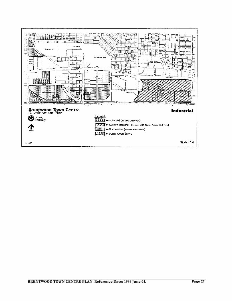
7.3 Industrial
The GVRD’s adopted growth allocations for Burnaby and the proposed LRT along the Lougheed Highway corridor with its signifi-cant capital costs requires the response of maximizing increased residential redevelop-ment within the Brentwood Town Centre Development Plan. Within this context, most existing industrial areas within the town centre are proposed to be phased out in the long term (see Sketch #10). It is important that the industrial to residential transition be achieved in an orderly fashion, permitting existing continuing industrial
developments to appropriately co-exist with new residential developments. Industrial developments are supported that provide high and varied employment opportunities such as industrial office park and incubator developments.
Large-scale warehouse “big box” retailing is not supported in the industrial areas. The industrial component is described under the following sections for western and eastern industrial areas and succession areas.
a) Western Industrial
The western industrial area is generally oriented to Gilmore Avenue, to the western end of Dawson Street, and to other proxi-mate strong existing and developing indus-trial development, particularly the Bridge Business Park to the west and the Will-ingdon Business Park to the south. These industrial areas are existing high-quality M5-type industrial/park developments with a high office use component.
The implications of probable LRT stations
in the vicinity of Lougheed/Boundary and possibly of Lougheed/Gilmore on further possible land use changes needs to be studied once the specific LRT station locations are determined.
This further LRT station-related area study would include reconsideration of land uses between Boundary Road and Gilmore Ave-nue, such as the Bridge Business Park as well as redevelopment approaches pursued in the City of Vancouver west of Boundary Road.
b) Eastern Industrial
The eastern area accommodates existing industrial development including many sites of a service commercial nature. The probable location of an LRT station in the vicinity of the Lougheed/Holdom intersec-
tion would result in land use changes particularly related to residential redevelop-ment potential. A further specific area study needs to be pursued related to a Holdom LRT station.
c) Succession (industrial to residential)
These industrial areas are the same ones described as the succession residential ar-eas. A number of major high-quality indus-trial developments as well as a number of incubator-type industrial firms are located in these areas some of which could remain into the foreseeable future. In general, it is probable that residential redevelopment of
these areas would likely be pursued after the primary residentially-designated areas north of Dawson Street, although large sites ripe for redevelopment should be given consideration for advancement on their own merits. Innovative mixed-use develop-ments composed of at-grade industrial with residential above would be given consid-
BRENTWOOD TOWN CENTRE PLAN Reference Date: 1996 June 04Page 18
eration in these succession areas. If any new industrial developments are developed within these areas, it is desirable that their designs be compatible with the proposed village concept.
In addition, it is recognized that some good quality existing industrial developments are
also located in the primary redevelopment areas in particular along Dawson Street and south-west of the Lougheed/Willingdon intersection. Where owners decide to retain industrial developments for some time, new abutting residential developments will need to be compatibly designed.
7.4 Community Facilities and Services
Appropriate community facilities and social services are required to meet the needs of residents and employees of the town centre and those in abutting areas. It is desirable to provide an integrated urban environment to provide for people of all types and ages, varying family formations and varying incomes. The social attractiveness and in-herent safety of the urban environment will be assisted by encouraging the development of pedestrian-scaled village character and streetscapes. Some of the proposed commu-nity facilities and services are as follows:
a) An elementary school is proposed to be developed south of Dawson Street, east of Beta Avenue, when justified by actual student enrollments. A grade-separated pedestrian crossing is desired across the Lougheed Highway at Delta Avenue in part to accommodate student access to Brentwood Park Elementary School in the interim. It is desirable that the new elementary school be conceived as a community school to respond to emerging local community needs.
b) A small community centre facility either adjoining the school or separate from the school is proposed. Specific functions to be included in such a com-munity centre would be further pursued by the Parks and Recreation Com-mission and staff, and include further public discussion.
c) Willingdon Heights Park and Com-munity Centre would also serve town centre residents and employees.
d) The needs of various sectors of the population such as children, youth, seniors and disabled people should be addressed in conjunction with the implementation of the Development Plan.
e) Major commercial developments should provide for some community-use facilities such as child care centres, community meeting rooms, office space for community groups and attractive useable open space. A community polic-ing office is desirable in a town centre core location.
f) Major residential developments should provide for appropriate commu-nal recreational facilities, playgrounds in family-oriented developments, and attractive useable open space. The de-velopment of publicly-oriented facilities such as child care centres would also be welcomed.
g) The major existing and proposed community facilities at Confederation Park and Kensington Park provide for a substantial part of the recreational needs of residents and employees within and proximate to the town centre. Some of these existing facilities are the Eileen Dailly Pool, Confederation Centre (older adults), McGill Library and Kensington Rink.
BRENTWOOD TOWN CENTRE PLAN Reference Date: 1996 June 04. Page 19
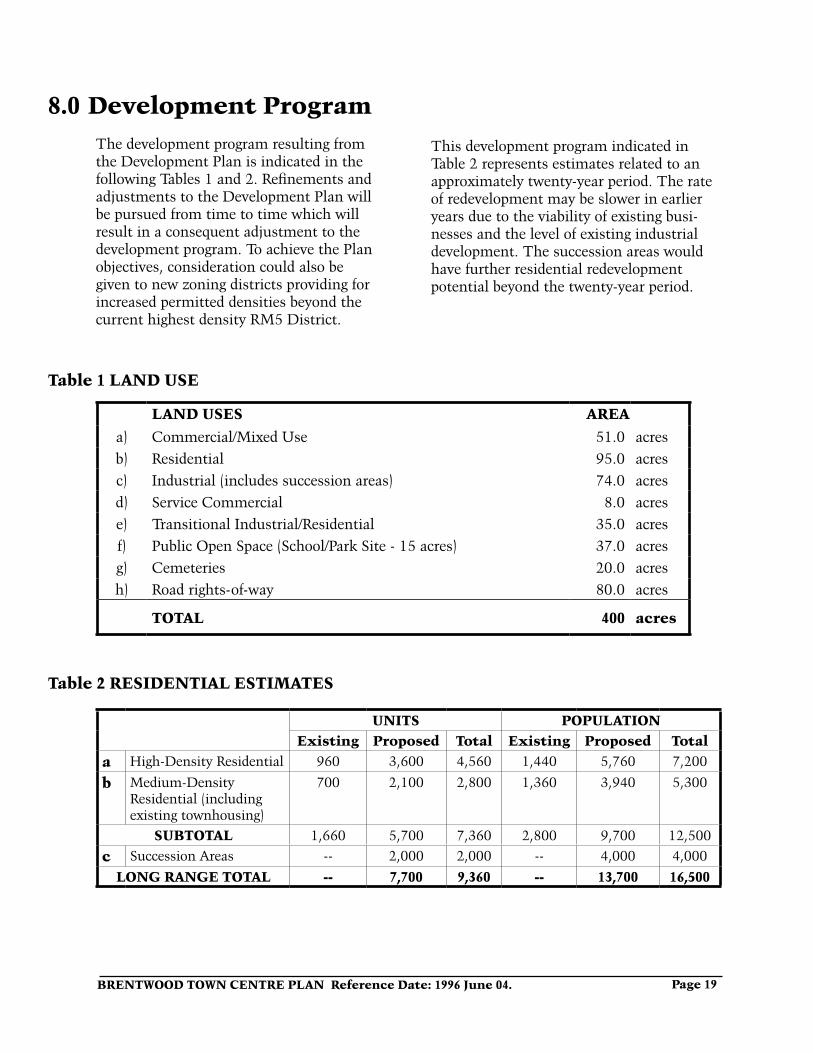
LAND USES AREA
a) Commercial/Mixed Use 51.0 acresb) Residential 95.0 acresc) Industrial (includes succession areas) 74.0 acresd) Service Commercial 8.0 acrese) Transitional Industrial/Residential 35.0 acresf) Public Open Space (School/Park Site - 15 acres) 37.0 acresg) Cemeteries 20.0 acresh) Road rights-of-way 80.0 acres
TOTAL 400 acres
Table 1 LAND USE
Table 2 RESIDENTIAL ESTIMATES
UNITS POPULATIONExisting Proposed Total Existing Proposed Total
a High-Density Residential 960 3,600 4,560 1,440 5,760 7,200
b Medium-Density Residential (including existing townhousing)
700 2,100 2,800 1,360 3,940 5,300
SUBTOTAL 1,660 5,700 7,360 2,800 9,700 12,500
c Succession Areas -- 2,000 2,000 -- 4,000 4,000
LONG RANGE TOTAL -- 7,700 9,360 -- 13,700 16,500
8.0 Development ProgramThe development program resulting from the Development Plan is indicated in the following Tables 1 and 2. Refinements and adjustments to the Development Plan will be pursued from time to time which will result in a consequent adjustment to the development program. To achieve the Plan objectives, consideration could also be given to new zoning districts providing for increased permitted densities beyond the current highest density RM5 District.
This development program indicated in Table 2 represents estimates related to an approximately twenty-year period. The rate of redevelopment may be slower in earlier years due to the viability of existing busi-nesses and the level of existing industrial development. The succession areas would have further residential redevelopment potential beyond the twenty-year period.
BRENTWOOD TOWN CENTRE PLAN Reference Date: 1996 June 04Page 20
9.0 Further Study and ImplementationThe proposed Brentwood Town Centre Development Plan is a concept which will be the basis for further detailed studies on various aspects of the plan. Fulfilment of the Plan is a dynamic, step-by-step process
which will require timely future refine-ments and adjustments. In pursuing spe-cific development proposals, more detailed block-related community plans will also need to be pursued.
9.1 Infrastructure Improvements
The provision of the required infrastructure for the town centre in fulfilment of the Devel-opment Plan will be achieved over a lengthy period of time.
a) Detailed study needs to be undertaken once the Development Plan is approved to determine needed infrastructure improve-ments. Infrastructure improvements and initiatives include those related to:
i) Transportation improvements ii) Environmental initiatives iii) School site iv) Parkland and public open space v) Streetscape urban design improvement vi) Public walkway and cycling paths vii) Community centre facilities viii) Child care centre and other publicly-
oriented amenities ix) Grade-separated pedestrian crossings x) Land assembly options xi) Remediation of formerly industrially
utilized lands.
Depending on the nature of further studies, other parties will need to be involved such as the Ministry of Transportation and Highways, B.C. Transit and the G.V.R.D. b) Appropriate financing arrangements will
need to be pursued to achieve the fulfil-ment of the Development Plan and needed infrastructure improvements. The City will have to bear some significant infrastruc-ture costs. The School Board will need to
be involved in the acquisition of the proposed school site. Funding programs by the provincial and federal levels of government should also be taken advan-tage of.
The new LRT line will generally be funded by the province but will require a reciprocal City response of encour-aging major residential and higher density commercial growth. Private development through its opportunities for major redevelopment and increased densities will also be expected to bear a large part of infrastructure costs neces-sary to implement the Plan.
Upgrading of some services and provi-sion of amenities of community benefit can be achieved through rezoning and subdivision applications on individual sites. The use of Development Cost Charges needs to be comprehensively studied to assure that the City takes full advantage of this option. For example, the City may institute Cost Charges to assist in paying the capital costs of sewer, water and drainage facilities, and highway facilities including grade-separated pedestrian linkages, as well as park land. Other available provisions of the Municipal Act should be pursued to achieve desirable funding of various aspects of the Development Plan.
BRENTWOOD TOWN CENTRE PLAN Reference Date: 1996 June 04. Page 21
9.2 Implementation of Other City Policies
Other policies either on a City-wide basis or specific to the Brentwood Town Centre would continue to be pursued and be incorporated within the context of the Brentwood Development Plan as is the case for other area plans. These are related, for
example, to environmental, social, service and housing programs and initiatives. Many of these issues would require discussion and approval through various standing commit-tees of Council.
9.3 Further Implications of Light Rapid Transit
The development of Light Rapid Transit (LRT) along the Lougheed corridor will have a major effect on the development potential of this corridor, especially the Brentwood area. The Development Plan takes into consideration an LRT station location in the vicinity of the Lougheed/Willingdon intersection and other possible locations.
However, as noted in Section 7.3 which discusses the western and eastern industrial
areas, further development plan studies will need to be pursued centred on other proximate LRT station locations, such as in the vicinity of the Lougheed/Boundary and Lougheed/Holdom intersections. These fur-ther area plans will affect the western and eastern portions of the Brentwood Town Centre study area as well as lands outside the current study area and be pursued on the usual comprehensive review basis.
D.G. StensonDirector Planning & Building
KI:lfAttachments: Appendix A/Sketches #1-#10
BRENTWOOD TOWN CENTRE PLAN Reference Date: 1996 June 04Page 22
BRENTWOOD TOWN CENTRE PLAN Reference Date: 1996 June 04. Page 23
BRENTWOOD TOWN CENTRE PLAN Reference Date: 1996 June 04Page 24
1.1996
BRENTWOOD TOWN CENTRE PLAN Reference Date: 1996 June 04. Page 25
BRENTWOOD TOWN CENTRE PLAN Reference Date: 1996 June 04Page 26
BRENTWOOD TOWN CENTRE PLAN Reference Date: 1996 June 04. Page 27

BRENTWOOD TOWN CENTRE PLAN Reference Date: 1996 June 04Page 28
BRENTWOOD TOWN CENTRE PLAN Reference Date: 1996 June 04. Page 29
1.0 Organizing Principles
Appendix “A”
Framework for the BRENTWOOD TOWN CENTRE PLAN(Phase II of the Development Plan Review Process) Adopted by Council 1995 March 13
SummaryOrganizing Principles and Strategies
a) Organization of the town centre on the basis of a transit-oriented, high-density, mixed-use, high-vitality, central core around the Lougheed Highway and Willingdon Avenue intersection with surrounding medium density supporting development.
b) Development of a complete community with the ability for people to live, work and play within the Brentwood area and to provide an inclusive and diverse community to benefit people of differing ages, family formations, income levels, physical abilities and social needs.
2.0 Strategies
2.1 Town Centre Concept and Redevelopment Potential
(1) Brentwood Town Centre should strive to achieve its optimum potential growth with respect to an increased residential, employ-ment and visitor population to further municipal and regional population growth and transportation objectives.
c) Promotion of lower-scaled, pedestrian-oriented streetscapes and movement corridors, creating a unifying, village concept urban design approach for the overall town centre.
d) Provision of a complete and integrated public infrastructure to support the town centre development.
e) Pursuance of appropriate measures to enhance the environmental quality of the area and to cope with substantial site constraints in the area.
(2) Brentwood Town Centre should continue to develop as the principal urban centre for the north-west sector, reinforcing and strengthening its com-mercial (retail, office, hotel), residential and transportation components.
APPENDIX “A” BRENTWOOD TOWN CENTRE PLAN Page 29
BRENTWOOD TOWN CENTRE PLAN Reference Date: 1996 June 04Page 30
(3) The Hastings Street Village would con-tinue to be supported as a retail service street and commercial/ residential char-acter area complementary to the Brent-wood Town Centre.
(4) Transitional, lower scaled development enhanced where possible with green buf-fers, should be provided along the north-ern boundary of the town centre adjacent the Brentwood Park neighbourhood.
(5) Strong and clearly delineated linkages particularly for pedestrians and cyclists should be provided between the adjacent
residential neighbourhoods and the town centre core.
(6) The major redevelopment of the five identified keystone lands should be encouraged as a catalyst towards the town centre redevelopment.
(7) Appropriate funding arrangements will need to be explored for the provision of required infrastructure improvements to support the town centre redevelopment.
2.2 Quality of the Environment
(8) The development of an environmentally sustainable community should be pur-sued for the Brentwood Town Centre.
(9) Urban design guidelines should be pursued for the town centre to achieve a “village” character for the Brentwood Town Centre especially with regard to providing unifying, high vitality, char-acter, pedestrian-friendly streetscapes; boulevard humanizing elements; and lower-scaled building elements along local street frontages.
(10) A network of green spaces and green-ways including the linking of Environ-mentally Sensitive Areas (ESA) both within and outside the town centre should be pursued utilizing the ap-proaches of protection, enhancement and creation.
(11) A portion of the existing sloping treed area north of the Lougheed Highway should be retained as a conservation park area. Two creeks located on the southwestern and eastern periphery of the town centre would be retained in their natural condition.
(12) Ecologically-sound landscaping should be encouraged including a diversity of well-adapted and low-maintenance species with some emphasis on native plants, in line with Integrated Pest Management (IPM) goals.
(13) There are a number of environmental matters which need to be addressed in pursuing the redevelopment of the Brentwood area including aspects related to:
(a) contamination and remediation measures with respect to redevelop-ment of existing industrial sites;
(b) appropriate redevelopment use of low-lying areas in the south portion of the area with poor soil conditions;
(c) controlling the quality and quantity of storm run-off in the town centre, and
(d) appropriate buffering condi-tions for sites directly adjacent the Lougheed Highway and the railway.
Page 30 APPENDIX “A” BRENTWOOD TOWN CENTRE PLAN
BRENTWOOD TOWN CENTRE PLAN Reference Date: 1996 June 04. Page 31
2.3 Residential Development
(14) An expanded range of housing choices should be provided through medium and high-density multiple-family developments accommodating all household types within a structure of identifiable neighbourhoods.
(15) The potential should be promoted for the Brentwood Town Centre to provide for ad-ditional residential growth as a significant component of Lougheed Transit Corridor development and in line with the City’s Residential Growth Management Strategy.
(16) An affordable housing policy for the Brentwood Town Centre should be developed.
(17) Proposed major residential devel-opment especially south of the Lougheed Highway requires the provision of additional parkland, community facilities, school provi-sions and infrastructure improve-ments.
2.4 Commercial and Mixed-Use Development
(18) In the process of redevelopment, the Brentwood Mall should attempt to reduce its emphasis on both surface parking and the auto-oriented mode of consumer transportation.
(19) In order for the Brentwood Mall site to be developed towards an integrated urban, high-density, high-intensity, mixed-use (including residential) complex, initia-tives to achieve an outdoor street and pedestrian-oriented organizing system and improved linkages to the surrounding community would be encouraged.
(20) Focussed, street and pedestrian-oriented convenience and retail commercial de-velopment should be provided within the core area of the town centre for the con-venient use of both residents of the town
centre and industrial and office employees in the area.
(21) A residential presence is desired in the commercial core to increase residential choice and human inter-action and animation at the street level.
(22) The full range of office development should be encouraged in the town centre with emphasis on the provi-sion of convenience and service offices and encouragement of major high-density office developments within the core.
(23) Major hotel development with a full range of business-oriented and visitor facilities such as conference centres should be encouraged in the core.
2.5 Industrial Development
(24) The phasing out of a substantial proportion of industrially-designated lands, much of it currently utilized for low-intensity and/or auto-oriented uses, in favour of other higher intensity town centre uses is proposed.
(25) Some existing high-quality and high-intensity industrial developments particularly south of Dawson Street and west of Willingdon Avenue with their strong employment base should be retained or alternatively phased out only in the longer term.
APPENDIX “A” BRENTWOOD TOWN CENTRE PLAN Page 31
BRENTWOOD TOWN CENTRE PLAN Reference Date: 1996 June 04Page 32
(26) It is desirable that industrially desig-nated lands outside the town centre area be also retained and strengthened not only to provide for enhanced and diverse employment opportunities but also to support higher intensity and service-type commercial and commu-nity uses focussed within the nearby town centre.
(27) The specific design of new appropriate industrial, residential and commercial developments should be carefully considered to minimize conflicts and enhance their compatibility.
(28) Sub-area precincts need to be identified where industrial uses are to be retained for the long term, where industrial uses are considered transitional but could remain for some time and where
industrial lands are ready for redevelop-ment to other uses.
(29) A unifying streetscape, urban design infrastructure should be pursued to assist in assuring the appropriate coexistence of proximate industrial and residential uses.
(30) Some initial large residential devel-opments should be encouraged to establish a strong residential presence within the existing industrial context.
(31) An appropriate form of mixed residen-tial and selected light industrial uses should be considered as a means of providing a transition at interface loca-tions with existing strong industrial sub-areas.
2.6 Transportation
(32) The redevelopment of the Brentwood Town Centre is based on the premise that an LRT line will be established along the general Lougheed Highway corridor and will be a catalyst for major redevelopment.
(33) Accommodation of the general LRT alignment should be protected and it is desirable that the LRT alignment be deflected off the right-of-way so that it is fully integrated with the town centre redevelopment. Further clarification of a preferred LRT alignment is needed to assist in developing the final Develop-ment Plan.
(34) Potential LRT station locations in the vicinity of the Willingdon Avenue and Holdom Avenue intersections along the Lougheed Highway should be given consideration in the determination of the Development Plan. LRT should be fully integrated into the town centre and station locations should be easily
accessible by motor vehicles, cyclists and pedestrians.
(35) Improved bus routes from all parts of north Burnaby should be focussed into the bus loop located within the Brent-wood Town Centre core, as well as the provision of good local bus services within the town centre.
(36) The Brentwood bus loop should be fully integrated with a Brentwood LRT Station.
(37) Improved direct fastbus connections from the Brentwood bus loop to the other Burnaby town centres and to regional activity centres should be provided.
(38) A comprehensive road network should be pursued for the town centre which discourages wherever possible through-traffic in abutting existing neighbour-hoods such as Brentwood Park and
Page 32 APPENDIX “A” BRENTWOOD TOWN CENTRE PLAN
BRENTWOOD TOWN CENTRE PLAN Reference Date: 1996 June 04. Contents 3
which provides for on-street parking where appropriate.
(39) The proposals for the Dawson/Juneau Connector and the northern extension of Westminster Avenue to Juneau Street as outlined in the Burnaby Transportation Plan are supported.
(40) Improved signalized intersections along the Lougheed Highway for north-south streets within the town centre should be pursued.
(41) A comprehensive pedestrian and cycling system which is both street related and independent of streets needs to be pro-vided within the town centre and linked to the surrounding community.
(42) The pedestrian and cycling system needs to be tied into the City’s cycle,roadandurbantrailnetworkand to the Still Creek Parkway.
(43)Grade-separatedpedestriancross-ings of Willingdon Avenue and the Lougheed Highway should be considered within the town centre’s core area and across the Lougheed Highway at Delta Avenue.
(44) Extensive areas of surface park-ing are discouraged in the town centre. Initiatives could be pursued to reduce parking provisions such as through the establishment of public parking facilities funded by a payment-in-lieuprogram,increasedpublictransitusage,andexplorationof shared parking options.
2.7 Social Planning and Community Facilities
(45) Appropriate community facilities and social services should be provided within the town centre to serve the needs of residents and employees of the town centre as well as those in directly abutting areas. Proposed community facilities within the town centre should be focussed to some extent in order to provide a stronger community presence in the town centre area.
(46) The major existing and proposed community facilities at Confederation and Kensington Parks provide a sub-stantial part of the recreational needs of residents and employees within and proximate to the town centre.
(47) A side-by-side elementary school and neighbourhood park site with the school functioning as a community school with a community facilities component should be provided south of the Lougheed Highway.
(48) A range of other smaller neighbour-hood park areas and public open spaces including the provision of a “town square” feature in a high profile core location should be provided.
(49) The provision of facilities of public benefit to town centre residents and employees and the community at large should be provided in major privately developed mixed-use and residential developments within the town centre.
(50) In fulfilling the town centre develop-ment,socialplanningaspectsofthetown centre need to be emphasized including meeting the social needs of allsegmentsofthecommunity,includ-ing those with disabilities and other needs,andaddressingtheconcernsofthe impact of development and safety and crime in town centre areas.
APPENDIX “A” BRENTWOOD TOWN CENTRE PLAN Page 33

BRENTWOOD TOWN CENTRE PLAN Reference Date: 1996 June 04. Contents 4