Embed Size (px)
Citation preview
Breaking the Disaster Cycle on Bolivar Peninsula, TexasRecovery and Hazard Mitigation after Hurricane Ike
Mitigation Case StudiesJune 2010
DRAFT (July 8, 2010)

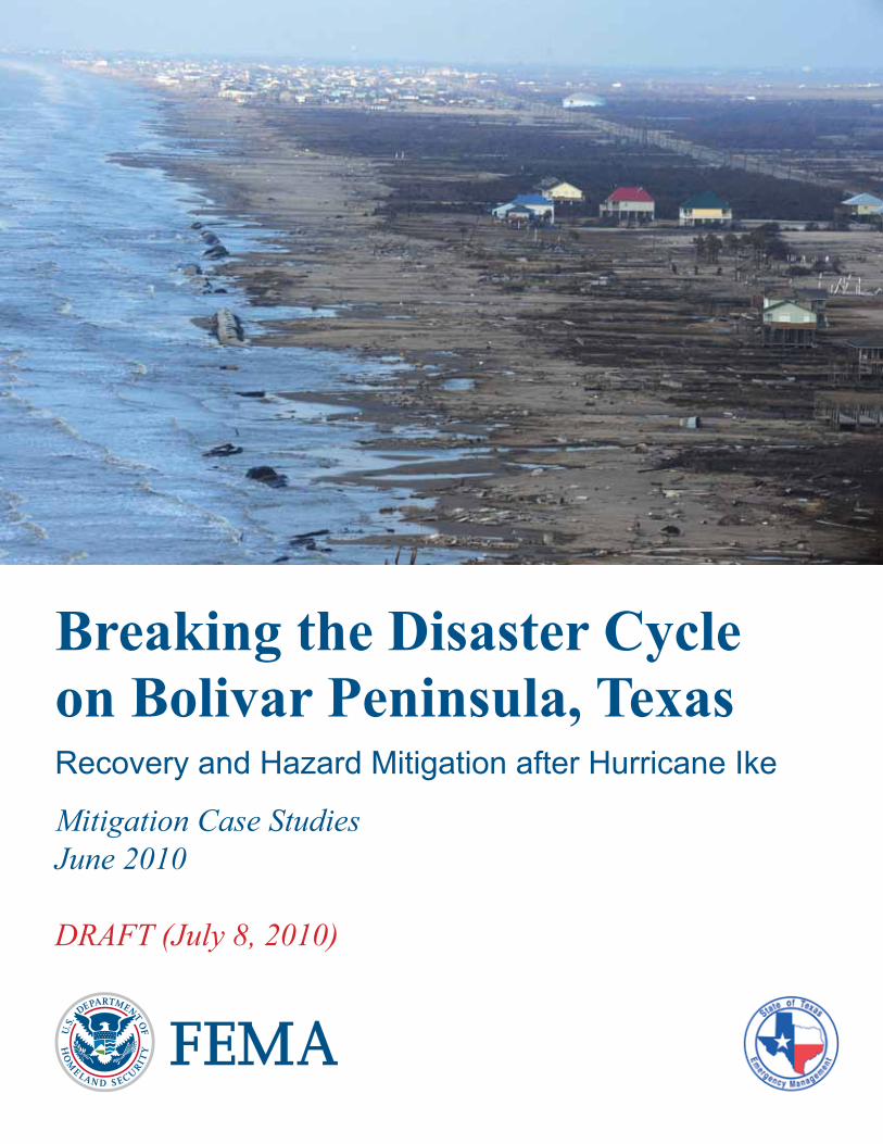
Hurricane Ike devastated Bolivar Peninsula, shown on the cover. With the help from FEMA, State and local governments,
residents are working to recover, so the Peninsula can once againbe a place of serenity and joy for visitors of all ages.
Cover photo: Jocelyn Augustino/FEMA.
The mission of the Federal Emergency Management Agency is to support our citizens and first responders
to ensure that as a nationwe work together to build, sustain, and improve our capability
to prepare for, protect against, respond to, recover from, and mitigate all hazards.
This report documents hazard mitigation and recoveryon Bolivar Peninsula in Galveston County, Texas,
after Hurricane Ike (Disaster Number 1791).This report was prepared in June 2010
by the Federal Emergency Management Agency, Region 6,Mitigation Division and Hurricane Ike Recovery Office.
Writer: Ann Patton. Editor and Graphic Designer: Rosane Walker.
Breaking the Disaster Cycleon Bolivar Peninsula, TexasRecovery and Hazard Mitigation after Hurricane Ike
Mitigation Case StudiesJune 2010
DRAFT (July 8, 2010)
Federal Emergency Management Agency, Region 6Mitigation Division and Hurricane Ike Recovery Office
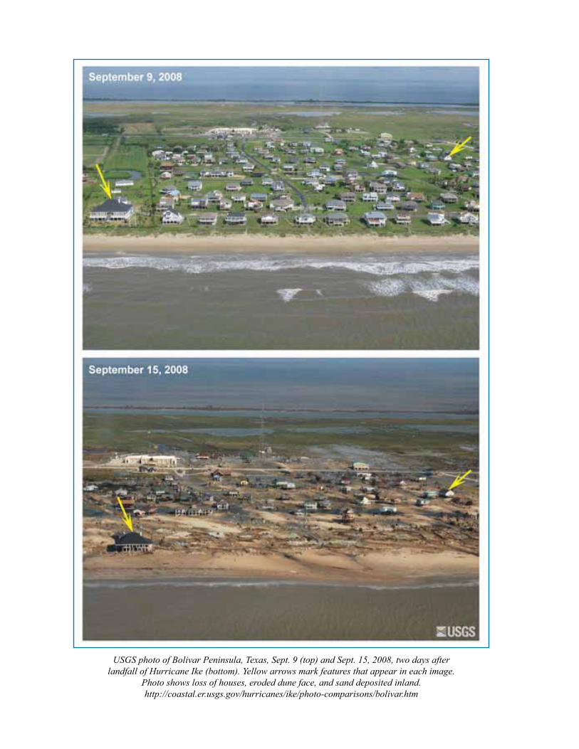
USGS photo of Bolivar Peninsula, Texas, Sept. 9 (top) and Sept. 15, 2008, two days after landfall of Hurricane Ike (bottom). Yellow arrows mark features that appear in each image.
Photo shows loss of houses, eroded dune face, and sand deposited inland.http://coastal.er.usgs.gov/hurricanes/ike/photo-comparisons/bolivar.htm
ContentsIntroduction .............................................................................................................1
SummaryAbout Bolivar Peninsula .........................................................................................3
The PlaceThe People
Hurricane Ike and Bolivar Storm History ...............................................................6Hurricane IkeHurricane Ike CostsGulf Coast Storms
Recovery ..............................................................................................................10Hazard Mitigation .................................................................................................11
Hazard Mitigation RecommendationsSubstantial DamageSynthesizing Plans
Bolivar Acquisition Project ...................................................................................17Structural Acquisition ProgramPeople and PropertiesFocus Areas ElevationCost SharingManaging the ProcessLand Use and Reuse PlansCoastal Barrier Resources ActCosts and Benefits
Bolivar Blueprint ..................................................................................................31Bolivar BlueprintVisionSteering CommitteePenDeCo, Bolivar’s Recovery CorporationWorking PartnershipsImplementation ChallengesSecrets of SuccessRecovery ProjectsResiliency and Empowerment
Conclusion – the Way Forward.............................................................................40Challenges and OpportunitiesRecommendations Conclusion
Appendixes ...........................................................................................................43Appendix A - Bolivar Peninsula ChronologyAppendix B - 1900 HurricaneAppendix C - Hurricane Ike Residential Substantial Damage Estimator (RSDE) EffortAppendix D - Bolivar Blueprint Recovery ProjectsAppendix E - References
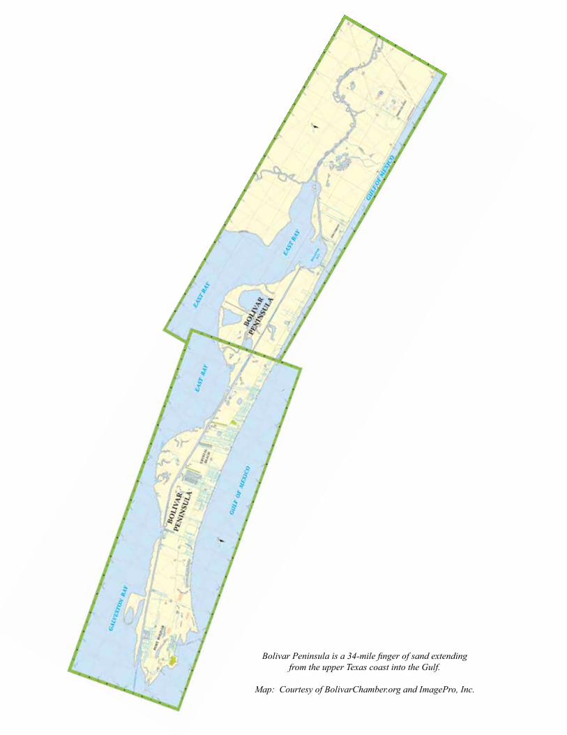
Bolivar Peninsula is a 34-mile finger of sand extending from the upper Texas coast into the Gulf.
Map: Courtesy of BolivarChamber.org and ImagePro, Inc.
1
Breaking the Disaster Cycle on Bolivar Peninsula, Texas
Mitigation Case Studies
Introduction
This case study details the recovery and planning efforts on Bolivar Peninsula, Texas, after Hurricane Ike in September 2008. The primary focus is a historic hazard mitigation project, one of the largest structural
acquisition projects in United States’ history. It is also the largest hazard-mitigation grant ever awarded by the Federal Emergency Management Agency (FEMA) in the state of Texas. This project is still on-going and has a project performance period of two years.
This report summarizes background, issues, challenges, and opportunities relating to disaster recovery, the buyout project, and a related long-term recovery project named the Bolivar Blueprint.
Appendixes include a Bolivar chronology of important events, information about the 1900 hurricane, Residential Substantial Damage Estimator process during Hurricane Ike, recommended Blueprint recovery projects, and references.
The aftermath of Hurricane Ike offers an important opportunity to document mitigation and recovery management, successes, challenges, and lessons learned. This document was prepared in June 2010 to support FEMA’s mission statement and to provide information that can help governments and citizens learn from this experience, while making sound decisions about reducing disaster losses and making wise use of the nation’s coastal lands.
It is dedicated to the citizens of Bolivar working to recover from Hurricane Ike and to preserve and improve Bolivar Peninsula.
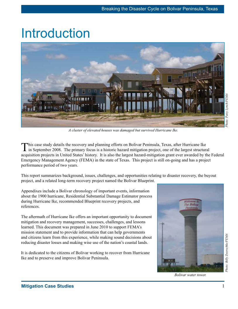
A cluster of elevated houses was damaged but survived Hurricane Ike.
Phot
o: P
atsy
Lyn
ch/F
EMA
Bolivar water tower.
Phot
o: B
illy
Zwer
schk
e/FE
MA
Breaking the Disaster Cycle on Bolivar Peninsula, Texas
2 Mitigation Case Studies
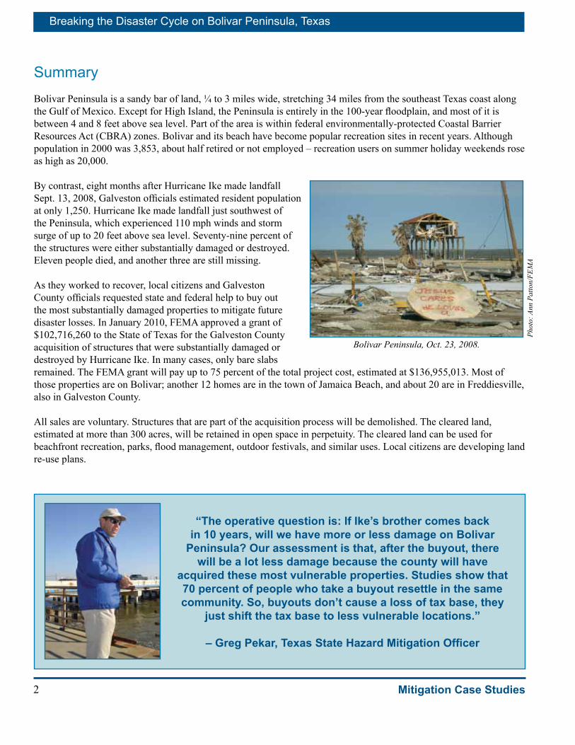
SummaryBolivar Peninsula is a sandy bar of land, ¼ to 3 miles wide, stretching 34 miles from the southeast Texas coast along the Gulf of Mexico. Except for High Island, the Peninsula is entirely in the 100-year floodplain, and most of it is between 4 and 8 feet above sea level. Part of the area is within federal environmentally-protected Coastal Barrier Resources Act (CBRA) zones. Bolivar and its beach have become popular recreation sites in recent years. Although population in 2000 was 3,853, about half retired or not employed – recreation users on summer holiday weekends rose as high as 20,000.
By contrast, eight months after Hurricane Ike made landfall Sept. 13, 2008, Galveston officials estimated resident population at only 1,250. Hurricane Ike made landfall just southwest of the Peninsula, which experienced 110 mph winds and storm surge of up to 20 feet above sea level. Seventy-nine percent of the structures were either substantially damaged or destroyed. Eleven people died, and another three are still missing.
As they worked to recover, local citizens and Galveston County officials requested state and federal help to buy out the most substantially damaged properties to mitigate future disaster losses. In January 2010, FEMA approved a grant of $102,716,260 to the State of Texas for the Galveston County acquisition of structures that were substantially damaged or destroyed by Hurricane Ike. In many cases, only bare slabs remained. The FEMA grant will pay up to 75 percent of the total project cost, estimated at $136,955,013. Most of those properties are on Bolivar; another 12 homes are in the town of Jamaica Beach, and about 20 are in Freddiesville, also in Galveston County.
All sales are voluntary. Structures that are part of the acquisition process will be demolished. The cleared land, estimated at more than 300 acres, will be retained in open space in perpetuity. The cleared land can be used for beachfront recreation, parks, flood management, outdoor festivals, and similar uses. Local citizens are developing land re-use plans.
Bolivar Peninsula, Oct. 23, 2008.
Phot
o: A
nn P
atto
n/FE
MA
“The operative question is: If Ike’s brother comes back in 10 years, will we have more or less damage on Bolivar
Peninsula? Our assessment is that, after the buyout, there will be a lot less damage because the county will have
acquired these most vulnerable properties. Studies show that 70 percent of people who take a buyout resettle in the same community. So, buyouts don’t cause a loss of tax base, they
just shift the tax base to less vulnerable locations.”
– Greg Pekar, Texas State Hazard Mitigation Officer

3
Breaking the Disaster Cycle on Bolivar Peninsula, Texas
Mitigation Case Studies
About Bolivar PeninsulaThe Place
Before Hurricane Ike, Bolivar Peninsula was a peaceful place, a popular spot to
linger on a sunny beach, watch birds, or enjoy a leisurely weekend. Bolivar Peninsula offers an oceanfront beach, fishing and wildlife observation opportunities; and – before Hurricane Ike – a low-stress lifestyle. Tourism has been the Peninsula’s economic engine.
The Bolivar Peninsula is a finger of Texas land between Galveston Bay and the Gulf of Mexico. It varies from ¼ mile to 3 miles wide and is connected to the mainland along the upper (southeast) Texas coast. A ferry connects the Peninsula to Galveston Island, which lies to the southwest across about 3 miles of Gulf. The Gulf Intracoastal Waterway extends along its northern or bay side. Highway 87 runs down the Peninsula’s length and provides the only overland access to the mainland.
Although classified as a Peninsula, it’s virtually a barrier island, accessible by land from the mainland through southern Chambers County. The land is sandy, marshy, fragile, and low. Near its narrow center, the Peninsula is bisected by a canal at Rollover Pass that connects the Gulf to the bay, making the southwestern end a de facto island. The Peninsula has five primary clusters of development. From southwest to northeast, they are: Port Bolivar on the western end, Crystal Beach, Caplen, Gilchrist just east of Rollover Pass, and High Island near the northeastern connection to the mainland. High Island is so named because it is the highest spot on the Peninsula, up to 25 feet above sea level. It is, in fact, the highest spot on the Gulf Coast between Mobile, Alabama, and the Yucatan Peninsula in Mexico.
The People
Bolivar was lightly developed before the storm, with 82.5 percent of the land area in farm/ranch uses and 13.8 percent in residential use. Of the 5,500 housing units, 60 percent were seasonal units. Just over 6 percent of the homes had values above $150,000.
Recreation users could number as high as 20,000 people on summer holiday weekends, but the day-to-day population remained below 4,000. Bolivar’s permanent population rose from 1,694 in 1960 to 3,853 in 2000. Rapid growth occurred in the 1960s and 1990s but declined slightly between 2000 and 2007.
Bolivar Peninsula extends into the Gulf of Mexico from southeast Texas.
Boliv
ar B
luep
rint
/FEM
A
Children playing at the beach on Bolivar.
Phot
o: P
atri
cia
Brac
h/FE
MA

Breaking the Disaster Cycle on Bolivar Peninsula, Texas
4 Mitigation Case Studies
The permanent 3,853 population in 2000 made up 1,138 families and lived in 1,801 households. Racial makeup was 93 percent white and 6 percent Hispanic with smaller numbers of black, Native American, and Asian residents. Fewer than 10 percent of the households were in the poverty category, and about 170 had incomes above $100,000.
Nearly one-third of the homes were occupied by seniors (over 65 years of age). About half of the permanent population was retired or not employed. Of those permanent residents who were employed, about half commuted more than 40 minutes to jobs, indicating they were employed off the Peninsula. The community of Gilchrist, at the narrow center of the island near Rollover Pass, reportedly was home to a number of retirees who lived in older homes, which were less likely to be elevated.
Eight months after Hurricane Ike, Galveston officials estimated resident population was only about 1,250 people on Bolivar Peninsula. Appendix A provides the Bolivar Peninsula chronology of historical information.
Bolivar Water Board President Used to Fighting for SurvivalFor Lynette Johnson-Hardcastle, Hurricane Ike was just one more thing.
A mere hurricane could not match her challenge of staying alive after a car accident in 2003. Another driver went airborne and landed atop her car on the Dickinson Bayou bridge south of Houston. The driver was drunk, drugged — and dead. Lynette woke up in a hospital in a full cast, with not much more free than her toes and head.
“I wasn’t supposed to live,” she said. “Then they said I would never walk again. When they released me from the hospital in a wheelchair, they tried to put me in a rehab center but I said, ‘No, I’m going to the beach.’ They said, ‘You can’t do that,’ and I said, ‘Yes, I can.’”
That line pretty much sums up Lynette’s approach to life.
Now walking again — running, in fact — she has the top public job on the Peninsula, president of the Water Board, and she is fighting to help Bolivar residents recover from Hurricane Ike.
“There are too many people here who cannot stand up for themselves,” she said.
“I want us to be prepared for the next storm. I want us to be ready to hit the ground with information about the devastation over here, so we can go after resources to help these people,” she said. “The adjusters here, to a man, said they had never seen devastation like this. People know about Katrina, but most people don’t know about Ike and what happened here. I’m one of the lucky ones, because I still have my home. ”
She is certain the Peninsula will come back stronger and better. Whatever happens, Lynette has faith that she — and Bolivar — will survive. “What else could happen to us? We will never give up,” she said. “I’m never going to quit fighting.” □
Phot
o: A
nn P
atto
n/FE
MA
Lynette Johnson-Hardcastle stands on her Bolivar deck.
Bolivar resident fishing at Rollover Pass.
Phot
o: R
osan
e W
alke
r/FE
MA

5
Breaking the Disaster Cycle on Bolivar Peninsula, Texas
Mitigation Case Studies
After Hurricane Ike: Fortifying Fort Travis Seashore ParkAs storm repairs are made to one of Texas’ significant landmarks, collaborative efforts are also ongoing to preserve the historic integrity of Bolivar Peninsula’s Fort Travis Seashore Park and to help reduce future storm damage to the site.
“Fort Travis is a significant historic site, so we knew it was important to get it repaired,” said Galveston County Engineer Mike Fitzgerald. With FEMA’s help, the county is also stabilizing the fort to make it safer in a future storm. “We’re going to remove all the historic bricks around the perimeter and replace them on a base material that we think will survive a future storm when it comes over the wall,” he said.
Named in honor of William Barret Travis, the commanding officer of the Alamo, Fort Travis is a notable example of how the Federal Emergency Management Agency (FEMA) helps to restore damaged historic properties and mitigate any future storm damage.
“This park has an interesting history and is listed on the National Register of Historic Places,” said FEMA Public Assistance Specialist Brian Slie. “It’s a model of coastal defense installations from a bygone era.”
That history features the heroism of Jane Long, known as ‘The Mother of Texas.’ Married to Dr. James Long, who came to Texas to free it from Spain, Jane refused to leave the fort after she was left there by her husband along with a daughter, maid and a few troops to protect them. Each morning, Jane would fire one of the cannons; her way of showing Galveston that the fort was still being defended.
When Hurricane Ike slammed ashore on Sept. 13, 2008, it brought 18 to 20 feet of storm surge to the Bolivar Peninsula and Fort Travis, damaging more than 3,000 feet of promenade, many of the park’s roads and culverts, and depositing storm debris in the underground bunkers.
In addition to maintaining the Fort’s historic authenticity, FEMA’s Public Assistance (PA) Mitigation staff recommended repairing the seawall sidewalk using compacted soil and sand and adding rebar to reinforce the pathway. “It’s extremely cost effective to mitigate now so we won’t have to fix it again,” said FEMA PA mitigation specialist David Cockrum.
FEMA will reimburse 90 percent of eligible repair and mitigation costs to the Galveston County Beach and Parks Department, which owns the property.
Protecting Fort Travis matters for Bolivar, Galveston County, Texas, and the nation, noted County Engineer Mike Fitzgerald. By making the fort stronger and more likely to survive future storms, the partnership of Galveston County, Texas, and FEMA can preserve this important piece of history for the enjoyment of future generations. □
Fort Travis is a historic fort established in the early 1800s at Port Bolivar.
Phot
o: R
osan
e W
alke
r/FE
MA
Mike Fitzgerald, Galveston County Engineer.
Phot
o: B
illy
Zwer
schk
e/FE
MA
Breaking the Disaster Cycle on Bolivar Peninsula, Texas
6 Mitigation Case Studies
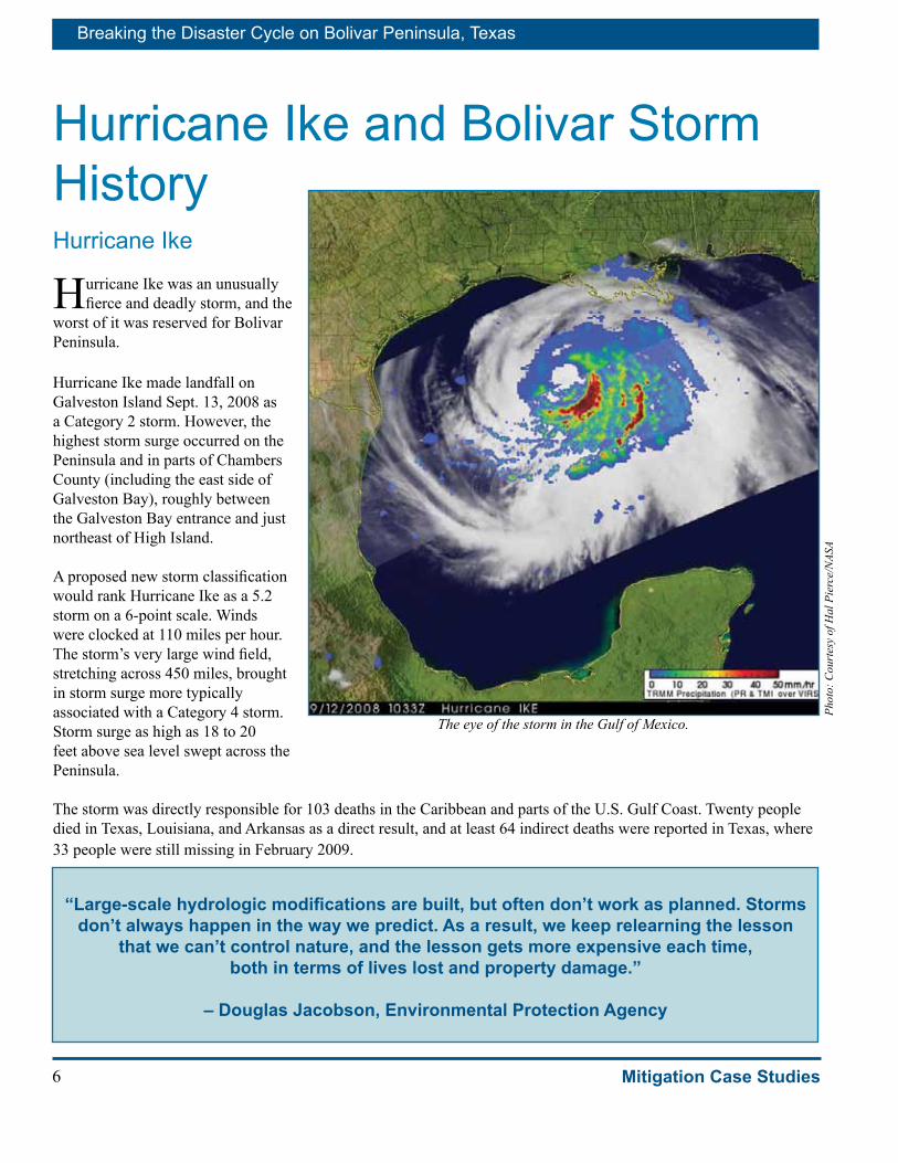
Hurricane Ike and Bolivar Storm HistoryHurricane Ike
Hurricane Ike was an unusually fierce and deadly storm, and the
worst of it was reserved for Bolivar Peninsula.
Hurricane Ike made landfall on Galveston Island Sept. 13, 2008 as a Category 2 storm. However, the highest storm surge occurred on the Peninsula and in parts of Chambers County (including the east side of Galveston Bay), roughly between the Galveston Bay entrance and just northeast of High Island.
A proposed new storm classification would rank Hurricane Ike as a 5.2 storm on a 6-point scale. Winds were clocked at 110 miles per hour. The storm’s very large wind field, stretching across 450 miles, brought in storm surge more typically associated with a Category 4 storm. Storm surge as high as 18 to 20 feet above sea level swept across the Peninsula.
The storm was directly responsible for 103 deaths in the Caribbean and parts of the U.S. Gulf Coast. Twenty people died in Texas, Louisiana, and Arkansas as a direct result, and at least 64 indirect deaths were reported in Texas, where 33 people were still missing in February 2009.
Phot
o: C
ourt
esy
of H
al P
ierc
e/N
ASA
The eye of the storm in the Gulf of Mexico.
“Large-scale hydrologic modifications are built, but often don’t work as planned. Storms don’t always happen in the way we predict. As a result, we keep relearning the lesson
that we can’t control nature, and the lesson gets more expensive each time, both in terms of lives lost and property damage.”
– Douglas Jacobson, Environmental Protection Agency

7
Breaking the Disaster Cycle on Bolivar Peninsula, Texas
Mitigation Case Studies
Hurricane Ike Costs
Hurricane Ike ranks as the fourth costliest and one of the most destructive hurricanes in U.S. history. Total damages were estimated at $21.3 billion, as of February 2009.
In addition, Hurricane Ike required expensive response and recovery outlays. For example, in the first 18 months, FEMA’s expenses for response and recovery were more than $3.8 billion and were expected to rise. FEMA’s ultimate share of disaster costs is projected to be more than $4.6 billion. Including related state projected outlays, response and recovery costs for the state and FEMA are expected to total nearly $5 billion.
These costs are only a fraction of the total response and recovery costs for Hurricane Ike; they do not include expenses by other federal agencies, local governments, private businesses, nonprofits, and private citizens.
They also do not include intangible costs, such as lost lives, suffering, loss of personal belongings, and anxiety of survivors and those who seek to help them.
Additional research is necessary to isolate Bolivar Peninsula’s share of Hurricane Ike’s specific costs, tangible and intangible. All but approximately 100 buildings were destroyed or damaged on Bolivar.
Seventy-nine percent of the buildings were either substantially damaged or destroyed. Approximately 62 percent of the housing stock was destroyed, and another 38 percent was standing but damaged. The storm wiped out $300 million in taxable property value – about half the pre-storm economic value. The tourist industry was flattened.
Protection by dunes and vegetation along the Gulf of Mexico shoreline had already been reduced from previous storms and human activity. Hurricane Ike caused further destruction.
Emergency workers respond on Bolivar after Hurricane Ike.
Phot
o: J
ocel
yn A
ugus
tino/
FEM
A
There is no real media down here. We have media in Houston and Beaumont, but not really down here. We even had people in our office that
weren’t going to leave. And we told them, you have to,there’s a surge coming.”
– Jeanie Turk, Bolivar Realtor
Gilchrist home survived Hurricane Ike with damages.Ph
oto:
Joc
elyn
Aug
ustin
o/FE
MA

Breaking the Disaster Cycle on Bolivar Peninsula, Texas
8 Mitigation Case Studies
Gulf Coast Storms
Hurricanes and tropical storms are no strangers to the Bolivar Peninsula and Galveston County. The most infamous is the nation’s deadliest hurricane, the 1900 storm that struck Bolivar and Galveston with little warning and left between 6,000 and 12,000 dead. (See Appendix B, 1900 Hurricane.) Recent strong hurricanes include the Category 3 Hurricanes Alicia in 1983, which brought 125 mph winds and 12-foot surge, and Rita in 2005.
The National Oceanic and Atmospheric Administration (NOAA) identified 76 hurricanes or tropical storms that made landfall within 55 miles of Galveston County since 1871. NOAA classified 36 as hurricanes when they arrived in Galveston County, including four Category 4 hurricanes.
NO
AA g
raph
ic, 2
009/
Boliv
ar B
luep
rint
NOAA identified 76 hurricane and tropic storm tracks near Bolivar since 1871.
Learning the hard way: Galveston County Emergency ManagementJohn Simsen’s stories about his Hurricane Ike experiences read like a training course for emergency managers. Ike’s hard lessons are guiding him through the next chapter of his work to make Galveston County a safer place.
“In tropical storms and small hurricanes, every year since I’ve been here, we’ve had to pick up houses from the Bolivar beach,” said Simsen, Galveston County emergency management coordinator.
Ike was the most demanding teacher he’s ever seen. “In the fury of Ike, we coordinated more than 600 rescues from this Emergency Operations Center (EOC), for people the length of the Peninsula. Colin Rizzo on our staff moved into a trailer with dogs for 2-1/2 months and searched the marshes for Bolivar bodies. We picked up 2 million cubic yards of debris on the Peninsula alone, plus a couple hundred thousand in wet debris (from the Gulf and bay).”
So it’s no wonder Simsen is committed to reducing future disaster losses. “I would love to be in a position where, every time a storm rolls in, we are not picking up houses,” he said.
Phot
o: J
ocel
yn A
ugus
tino/
FEM
A
Galveston County had homes and roads damaged or destroyed by storm surge pushed by Hurricane Ike.
9
Breaking the Disaster Cycle on Bolivar Peninsula, Texas
Mitigation Case Studies
The Bolivar buyout is a huge step toward that goal, he said. “These properties we’re buying will never be damaged again. ... The more we can be resilient for future storms, the better we will be.
“Now that people have had a taste of what total devastation looks like, buyout applications are pouring in. We didn’t really know what kind of interest we would have. We were responding to the crush of people into county offices looking for some kind of assistance. So many houses were destroyed. When we found out FEMA funding might be available for a buyout, we just offered it (for properties with substantial damage), and people really latched on to it. Over a thousand people county-wide said they were interested.
“For those we can buy — people will never rebuild in those locations. It’s just smart and makes so much sense, for the Peninsula particularly.”
The Peninsula lies barely above sea level and has 32 miles of beach, without a sea wall, open to the Gulf. The land rises a bare 4-5 feet above sea level; Ike storm surge was some 20 feet high — “one huge wall of water,” he said. There are two routes for evacuation — the ferry to Galveston or overland to the northeast via Highway 87, and neither was available during Ike. The ferry had to shut down and the un-elevated highway flooded out at several points.
“From Galveston,” Simsen said, “the only way out is up Interstate 45 through Houston, and subdivisions are mushrooming all along I-45. Every year it is going to get more and more complicated to evacuate this area — so mitigation is critical.”
In addition to the buyout, potential mitigation measures include public works such as elevating Highway 87, elevating houses above expected storm surge, codes and techniques for building strong structures, cooperative planning, and public education.
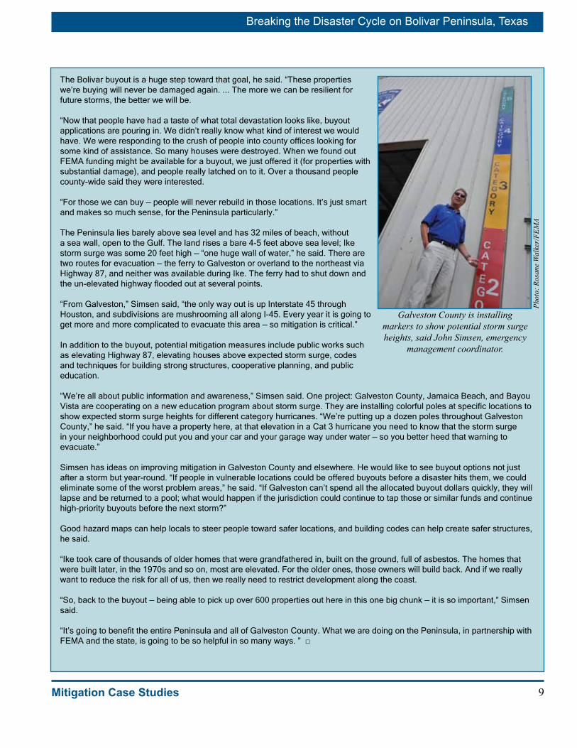
“We’re all about public information and awareness,” Simsen said. One project: Galveston County, Jamaica Beach, and Bayou Vista are cooperating on a new education program about storm surge. They are installing colorful poles at specific locations to show expected storm surge heights for different category hurricanes. “We’re putting up a dozen poles throughout Galveston County,” he said. “If you have a property here, at that elevation in a Cat 3 hurricane you need to know that the storm surge in your neighborhood could put you and your car and your garage way under water — so you better heed that warning to evacuate.”
Simsen has ideas on improving mitigation in Galveston County and elsewhere. He would like to see buyout options not just after a storm but year-round. “If people in vulnerable locations could be offered buyouts before a disaster hits them, we could eliminate some of the worst problem areas,” he said. “If Galveston can’t spend all the allocated buyout dollars quickly, they will lapse and be returned to a pool; what would happen if the jurisdiction could continue to tap those or similar funds and continue high-priority buyouts before the next storm?”
Good hazard maps can help locals to steer people toward safer locations, and building codes can help create safer structures, he said. “Ike took care of thousands of older homes that were grandfathered in, built on the ground, full of asbestos. The homes that were built later, in the 1970s and so on, most are elevated. For the older ones, those owners will build back. And if we really want to reduce the risk for all of us, then we really need to restrict development along the coast.
“So, back to the buyout — being able to pick up over 600 properties out here in this one big chunk — it is so important,” Simsen said. “It’s going to benefit the entire Peninsula and all of Galveston County. What we are doing on the Peninsula, in partnership with FEMA and the state, is going to be so helpful in so many ways. ” □
Galveston County is installing markers to show potential storm surge heights, said John Simsen, emergency
management coordinator.
Phot
o: R
osan
e W
alke
r/FE
MA

Breaking the Disaster Cycle on Bolivar Peninsula, Texas
10 Mitigation Case Studies
Recovery The difficult road to recovery on
Bolivar Peninsula will continue to stretch ahead of local residents for many years.
After Hurricane Ike, the Galveston County Commissioners Court recognized the need for a comprehensive recovery process that included mobilizing help from many state and federal agencies to help build back better and stronger.
Hurricane Ike has challenged the communities on the Texas coast but also opened up opportunities, noted Galveston County Judge James D. Yarbrough, who experienced flooding of his personal home as well as the county’s losses. “We have been meeting and planning nonstop since Sept. 13, and we share a common vision that the Peninsula can come back better than ever,” he said. “We have done a good job, in my opinion, of being prepared, but because we have never done it, our programs are not well-refined for long-term recovery.”
With the help of many partners, the county and Bolivar citizens are developing and refining recovery protocols. The Bolivar Blueprint has helped build consensus; but it has been extremely difficult to develop the processes while citizens are still reeling from Hurricane Ike’s destruction and disruption. “We are still in the middle of the battle. As a practical matter, communities need to start right now, before an event strikes, to develop recovery plans,” the Judge said. “To do all of this in the several months after the storm – it is very difficult to get it all done. Communities all need these types of sessions and planning mechanisms when things are calm. It is essential to document the lessons we are learning and share them widely.
“The buyout offers endless opportunities, even beyond what the county can now imagine,” Judge Yarbrough said. “I don’t like taking property off the tax rolls, and I am hopeful that people in the buyout will stay on the Peninsula on higher ground. But if we can build the dune back and create a linear park and the other projects in the Blueprint – the Peninsula can become the jewel of the Gulf Coast.”
Galveston County Commissioners Court. Left to right, Commissioners Bryan Lamb and Patrick Doyle; County Judge James Yarbrough; Commissioners Stephen
Holmes and Ken Clark.
Phot
o: A
nn P
atto
n/FE
MA
“It is essential to document the lessons we are
learning and share them widely.”
– Judge Yarbrough

11
Breaking the Disaster Cycle on Bolivar Peninsula, Texas
Mitigation Case Studies
Hazard MitigationBolivar Peninsula can be a dangerous place during storms. Hurricanes,
high winds, and storm surge lead the list of hazards on Bolivar Peninsula.
Based on history, hurricanes of at least the same intensity as Hurricane Ike can be expected in the future. Subsidence, shoreline erosion, and sea-level rise may increase the damaging effects of future hurricanes in the area.
Virtually all of Bolivar Peninsula, except High Island, is within the FEMA-mapped 100-year floodplain. This risk includes floods that could be as high as 16 to 19 feet above sea level – over lands that generally lie 4-8 feet above sea level. Of course, higher floods may occur that could exceed the compromise 100-year flood standard. Most of the Peninsula is at risk from additional damage from wave action. Tornadoes may occur independently or in conjunction with a hurricane or tropical storm.
Much of the area is within federal environmentally-protected CBRA zones, which limits land use and precludes the use of federal funds, including federal flood insurance.
Coastal erosion, subsidence, and sea-level rise also threaten Bolivar Peninsula. The Houston-Galveston Area Council Regional Hazard Mitigation Plan (2006) and the U.S. Army Corps of Engineers (2008) report that sand is eroding on the eastern end of the Peninsula and near Rollover Pass, while it is accumulating at the western end. In addition, subsidence continues to be a problem throughout Galveston coastal areas.
The Bolivar Blueprint plan reports that Bolivar Peninsula is believed to have experienced subsidence of about 1 foot over the past century. Meanwhile, the threat of sea level rise continues. The Blueprint reports that sea levels have risen a relative 1 to 2 feet along the Texas and Louisiana coasts over the past 100 years. Thus, in the Bolivar area, the eroding land subsided about a foot over the past century, while sea level rose about 0.6 foot, for a relative sea level rise of about 1.6 feet.
Erosion, subsidence, and sea rise add to Bolivar’s challenges.
Phot
o: A
nn P
atto
n/FE
MA
Bolivar’s CBRA zone area highlighted.

Breaking the Disaster Cycle on Bolivar Peninsula, Texas
12 Mitigation Case Studies
Hazard Mitigation Recommendations
Hazard mitigation means long-term actions and projects to reduce the risk of future death, destruction, and disruption.
Many recommendations have been made for hazard mitigation on Bolivar Peninsula. One of the recommending documents is the Houston-Galveston Area Council Regional Hazard Mitigation Plan, approved in 2006. A new plan is currently being drafted for Galveston County.
FEMA’s Mitigation Assessment Team (MAT) made additional recommendations following Hurricane Ike. The MAT team recommendations are contained in a report named “Hurricane Ike in Texas and Louisiana: Building Performance Observations, Recommendations, and Technical Guidance” (FEMA P-757 dated April 2009). The team emphasized the importance of siting buildings back from the coast, noting that “Post-hurricane inspections typically observe the greatest flood damage, loss of coastal buildings, and loss of roads and infrastructure in the area closest to the shoreline.”
Among other items, the MAT team recommended:
■ Prepare a sustainable land use plan for the Bolivar Peninsula that considers the more severe hurricane impacts expected in the future, including an assessment of shoreline erosion and sea-level rise for the coming 50 years, as a minimum.
■ Restore dunes to natural heights (9 to 14 feet). ■ Allow new construction and additions only in
areas that are deemed safe with low risk, taking into account trends over the coming 50 years. This will ensure that development stays out of the fragile coastal zone that needs to be protected for dune dynamism and growth, the MAT team noted.
■ Site new and replacement critical facilities outside the 500-year floodplain, where possible, or elevate above the 500-year flood level.
■ Upgrade mapping and standards to require and encourage buildings, where allowed, to be built higher, safer, and stronger in the face of wind and water threats along the coast.
Higher, safer, stronger house on Bolivar Peninsula.
Phot
o: A
nn P
atto
n/FE
MA
Cadaver dogs search rubble.
Phot
o: M
ike
Moo
re/F
EMA

13
Breaking the Disaster Cycle on Bolivar Peninsula, Texas
Mitigation Case Studies
Substantial DamageOne of the most complex challenges facing communities after a major disaster may be managing safe rebuilding of properties that have been substantially damaged.
After Hurricane Ike, Galveston County officials were faced with thousands of properties that were damaged or destroyed. The overwhelming numbers were on Bolivar, where only 109 of 5,931 properties had little or no damage. Surveys determined that more than 1,800 had some damage, while another 400 were unsafe because of major or substantial damage. More than 3,500 of Bolivar’s buildings were totally destroyed or washed away.
To reduce disaster losses, the rules of the National Flood Insurance Program (NFIP) require participating communities to enforce ordinances that regulate floodplain building or rebuilding. After a disaster, a community must evaluate damaged buildings. If any buildings are damaged “substantially” (more than 50 percent of fair market value), certain rules apply: the owner must bring the building into compliance with the local community’s flood-damage prevention ordinance. For example, if a building’s market value before damage was $200,000 and repairs are estimated at $120,000, that building was “substantially damaged.” Land costs are not included in the equation.
50 Percent Repairs
Following Hurricane Ike, Frank Pagano, FEMA Region 6 Mitigation Division director, sent letters reminding local communities about the substantial damage estimation requirement. The letters stated, in part:
“All new construction, substantial improvement, or restoration of substantially damaged residential structures shall have the lowest floor elevated to or above the identified Base Flood Elevation (BFE). Substantial damage exists when the cost of restoring a structure to its pre-damaged condition equals or exceeds 50 percent of the structure’s pre-disaster market value. ‘Substantial damage’ means any reconstruction, rehabilitation, addition, or other improvement of a structure, the cost of which equals or exceeds 50 percent of the market value of the structure before the ‘start of construction’ of the improvement...”
Process for managing substantial damage.
Breaking the Disaster Cycle on Bolivar Peninsula, Texas
14 Mitigation Case Studies
In the case of Bolivar, that might mean elevating a house 12 or more feet, above expected storm surge levels, plus strengthening the building to withstand hurricane-force winds.
The reasons for the substantial damage rule are to prevent future damages and to avoid re-creating vulnerable and unsafe buildings that will be damaged again and again. For those reasons, communities are required to enforce substantial damage ordinances to maintain their standing in the National Flood Insurance Program.
In practice, substantial damage determinations are done by local government officials and the process can be delicate. Building owners may be homeless, eager to rebuild, and agitated by anything that causes delay or additional expense. Building officials may be overwhelmed with regulatory and permitting demands. Many people may not understand the long-term need to regulate substantial damage, creating inordinate local political pressures. “Substantial damage” issues can be turbulent waters to navigate in the chaotic weeks after a disaster.
In the aftermath of Hurricane Ike, the State and FEMA Region 6 coordinated a major Residential Substantial Damage Estimator (RSDE) effort to communities who requested hands-on technical assistance. FEMA RSDE inspectors collected data on more than 12,000 properties in the declared area and submitted their reports to local officials for final determinations. These determinations were then used to assist local officials and homeowners to decide if rebuilding or participating in the buyout was a viable option for them. This RSDE effort provided FEMA with opportunities to make major improvements to better administer this program in the future. Appendix C describes the process used in the RSDE effort following Hurricane Ike.
Galveston County Program
Galveston County was able to perform its own substantial damage inspections in the unincorporated areas. Knowing the challenges of managing substantial damage issues after a widespread disaster, the county had plans in place before the storm for enforcing this requirement. “We hired three firms and assigned each one a geographical area to cover, to determine which properties experienced substantial damage,” said Galveston County Engineer and Floodplain Administrator Mike Fitzgerald. “I had negotiated these prepositioned contracts before Ike because I knew we wouldn’t have the resources to cover a large disaster in a timely manner.
Following Hurricane Ike, damage assessments were conducted by the consulting engineering firms for structures located within the Galveston County unincorporated areas and within the FEMA designated special flood hazard area.
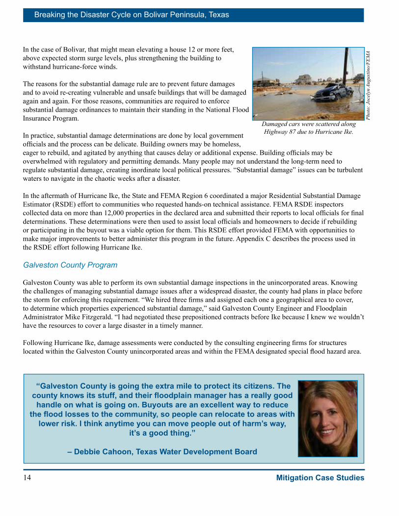
Damaged cars were scattered along Highway 87 due to Hurricane Ike.
Phot
o: J
ocel
yn A
ugus
tino/
FEM
A
“Galveston County is going the extra mile to protect its citizens. The county knows its stuff, and their floodplain manager has a really good handle on what is going on. Buyouts are an excellent way to reduce
the flood losses to the community, so people can relocate to areas with lower risk. I think anytime you can move people out of harm’s way,
it’s a good thing.”
– Debbie Cahoon, Texas Water Development Board
15
Breaking the Disaster Cycle on Bolivar Peninsula, Texas
Mitigation Case Studies
“All firms gave their data to a Texas-based engineering company each week to create a master list. Turns out this decision was invaluable as we are using our master list each day,” he said. “The master list documented post-Ike conditions before the residents had time to start any repair work. Our cost for these three firms was about $1.5 million.” FEMA did not reimburse the cost.
In the case of Galveston County, for those homeowners of properties that were not substantially damaged, the rapid and thorough assessment of building damages allowed them to proceed quickly with repairing or rebuilding.
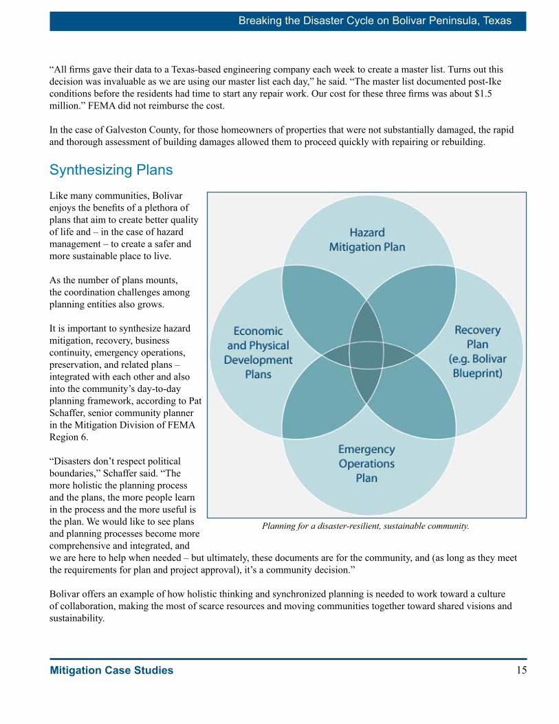
Synthesizing Plans Like many communities, Bolivar enjoys the benefits of a plethora of plans that aim to create better quality of life and – in the case of hazard management – to create a safer and more sustainable place to live.
As the number of plans mounts, the coordination challenges among planning entities also grows.
It is important to synthesize hazard mitigation, recovery, business continuity, emergency operations, preservation, and related plans – integrated with each other and also into the community’s day-to-day planning framework, according to Pat Schaffer, senior community planner in the Mitigation Division of FEMA Region 6.
“Disasters don’t respect political boundaries,” Schaffer said. “The more holistic the planning process and the plans, the more people learn in the process and the more useful is the plan. We would like to see plans and planning processes become more comprehensive and integrated, and we are here to help when needed – but ultimately, these documents are for the community, and (as long as they meet the requirements for plan and project approval), it’s a community decision.”
Bolivar offers an example of how holistic thinking and synchronized planning is needed to work toward a culture of collaboration, making the most of scarce resources and moving communities together toward shared visions and sustainability.
Planning for a disaster-resilient, sustainable community.

Breaking the Disaster Cycle on Bolivar Peninsula, Texas
16 Mitigation Case Studies
Mitigation Helped Bolivar Peninsula Homes Survive
The owners of a few surviving homes on Bolivar Peninsula, such as Jimmy and Debbie Bishop, have important stories to tell and lessons to share.
The Bishops came back to check on their vacation house a few days after the storm. The drive was eerie down Highway 87, the main road that runs the length of Bolivar Peninsula. To get to their home, they had to circle through a field, maneuvering around downed power lines, pieces of buildings and twisted debris.
“No matter how many pictures you see, the first-hand view of the reality compounds it 10 times,” Jimmy said. “Roads were covered with 2 to 3 feet of sand. There was debris everywhere. We couldn’t even find the street to our subdivision.”
Their subdivision, Sea Breeze, had about 35 houses before the storm and no more than a dozen afterward. Many of their neighbors’ houses, including the first two rows along the beachfront, had simply disappeared. Their house had been on the third row back from the beach; now it is open to the sea.
When they reached their house, they found the bottom-level breakaway walls gone, as the design had called for. Their stairs were a little askew but still sturdy enough to climb to the second-level living area.
“We opened the door and everything was just fine. Everything was just as it had been before the storm. If I had not been outside, I would not have known there was a storm,” Jimmy said. “The only thing out of place inside was one mirror that fell to the floor, and it wasn’t even broken. We were pleasantly surprised.”
Why did the Bishop house survive while neighbors’ homes did not? The Bishops’ house was the newest occupied home in the subdivision. Their builder, Mark Williams, has a nearby new house that also held up well in the storm. Both were built under the new coastal building codes and followed specifications provided by a structural engineer.
In keeping with the letter and the spirit of the code, the Bishop house is elevated high above the water, located back from the coast, held together with steel connectors, fortified with sturdy materials and shielded by a storm resistant roof. Impact-resistant glass on windows also helps protect the interior.
The building elevation may have been the most important safety factor. The required elevation was 16 feet, but the house was raised an additional seven feet, as a margin of safety. The additional height above the required elevation is called “freeboard.” It provides added protection and results in lower flood insurance premiums.
“That freeboard made all the difference,” said Chris Jones, a building sciences expert working with FEMA. He explained that building higher than required by a flood insurance rate map or a community regulation adds relatively little to the cost of new construction, yet provides substantial financial returns to the homeowner, both in the form of reduced flood insurance premiums and reduced future flood damages. He added that the additional cost of building higher is usually recovered in a few years by a homeowner along the coast.
The building codes made the difference, Jimmy said “You cuss the codes when you are building and they make you do all these things. We have friends who said, ‘Why on earth are you building your house so high?’ Now we know. That allowed the storm surge to go under our house and not knock it down.”
For the Bishops, the higher cost required to comply with the codes paid off. Jimmy said complying with the codes “doesn’t cost that much more because the building will have a longer life. In the long run, you will have less maintenance expense and grief by paying a little more up front.” □
The Bishops’ house survived Hurricane Ike nearly unscathed.
Phot
o: R
osan
e W
alke
r/FE
MA
17
Breaking the Disaster Cycle on Bolivar Peninsula, Texas
Mitigation Case Studies
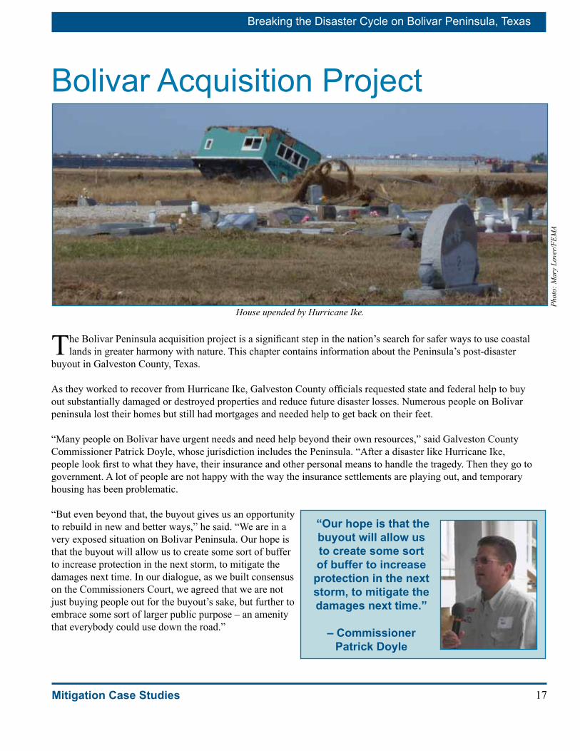
Bolivar Acquisition Project
The Bolivar Peninsula acquisition project is a significant step in the nation’s search for safer ways to use coastal lands in greater harmony with nature. This chapter contains information about the Peninsula’s post-disaster
buyout in Galveston County, Texas.
As they worked to recover from Hurricane Ike, Galveston County officials requested state and federal help to buy out substantially damaged or destroyed properties and reduce future disaster losses. Numerous people on Bolivar peninsula lost their homes but still had mortgages and needed help to get back on their feet.
“Many people on Bolivar have urgent needs and need help beyond their own resources,” said Galveston County Commissioner Patrick Doyle, whose jurisdiction includes the Peninsula. “After a disaster like Hurricane Ike, people look first to what they have, their insurance and other personal means to handle the tragedy. Then they go to government. A lot of people are not happy with the way the insurance settlements are playing out, and temporary housing has been problematic.
“But even beyond that, the buyout gives us an opportunity to rebuild in new and better ways,” he said. “We are in a very exposed situation on Bolivar Peninsula. Our hope is that the buyout will allow us to create some sort of buffer to increase protection in the next storm, to mitigate the damages next time. In our dialogue, as we built consensus on the Commissioners Court, we agreed that we are not just buying people out for the buyout’s sake, but further to embrace some sort of larger public purpose – an amenity that everybody could use down the road.”
House upended by Hurricane Ike.
Phot
o: M
ary
Love
r/FE
MA
“Our hope is that the buyout will allow us to create some sort of buffer to increase protection in the next storm, to mitigate the damages next time.”
– Commissioner Patrick Doyle
Breaking the Disaster Cycle on Bolivar Peninsula, Texas
18 Mitigation Case Studies
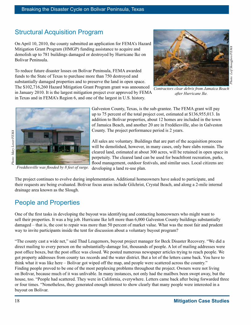
Structural Acquisition ProgramOn April 10, 2010, the county submitted an application for FEMA’s Hazard Mitigation Grant Program (HMGP) funding assistance to acquire and demolish up to 781 buildings damaged or destroyed by Hurricane Ike on Bolivar Peninsula.
To reduce future disaster losses on Bolivar Peninsula, FEMA awarded funds to the State of Texas to purchase more than 750 destroyed and substantially damaged properties and to preserve the land in open space. The $102,716,260 Hazard Mitigation Grant Program grant was announced in January 2010. It is the largest mitigation project ever approved by FEMA in Texas and in FEMA’s Region 6, and one of the largest in U.S. history.
Galveston County, Texas, is the sub-grantee. The FEMA grant will pay up to 75 percent of the total project cost, estimated at $136,955,013. In addition to Bolivar properties, about 12 homes are included in the town of Jamaica Beach, and another 20 are in Freddiesville, also in Galveston County. The project performance period is 2 years.
All sales are voluntary. Buildings that are part of the acquisition process will be demolished, however, in many cases, only bare slabs remain. The cleared land, estimated at about 300 acres, will be retained in open space in perpetuity. The cleared land can be used for beachfront recreation, parks, flood management, outdoor festivals, and similar uses. Local citizens are developing a land re-use plan.
The project continues to evolve during implementation. Additional homeowners have asked to participate, and their requests are being evaluated. Bolivar focus areas include Gilchrist, Crystal Beach, and along a 2-mile internal drainage area known as the Slough.
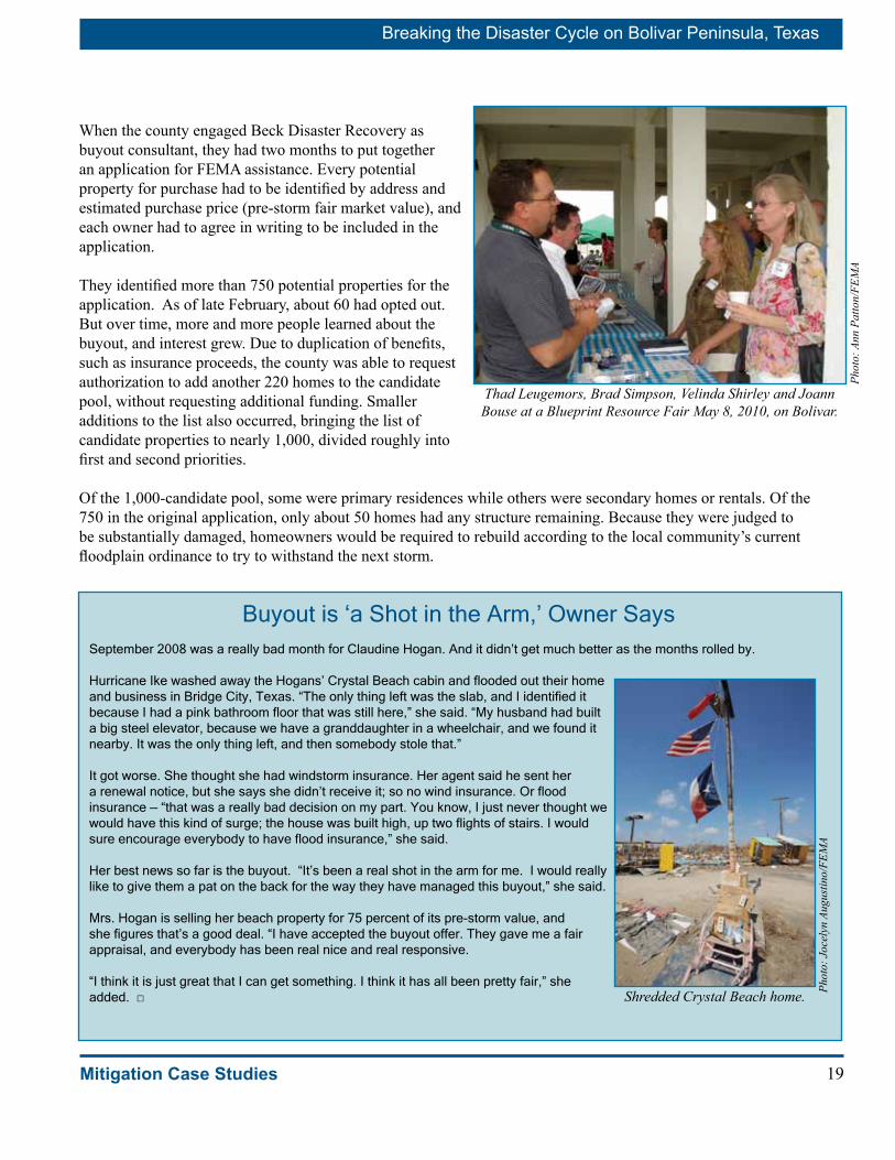
People and PropertiesOne of the first tasks in developing the buyout was identifying and contacting homeowners who might want to sell their properties. It was a big job. Hurricane Ike left more than 6,000 Galveston County buildings substantially damaged – that is, the cost to repair was more than 50 percent of market value. What was the most fair and prudent way to invite participants inside the tent for discussion about a voluntary buyout program?
“The county cast a wide net,” said Thad Leugemors, buyout project manager for Beck Disaster Recovery. “We did a direct mailing to every person on the substantially-damage list, thousands of people. A lot of mailing addresses were post office boxes, but the post office was closed. We posted numerous newspaper articles trying to reach people. We got property addresses from county tax records and the water district. But a lot of the letters came back. You have to think what it was like here – Bolivar got wiped off the map, and people were scattered across the country.” Finding people proved to be one of the most perplexing problems throughout the project. Owners were not living on Bolivar, because much of it was unlivable. In many instances, not only had the mailbox been swept away, but the house, too. “People had scattered. They were in California, everywhere. Letters came back after being forwarded three or four times. “Nonetheless, they generated enough interest to show clearly that many people were interested in a buyout on Bolivar.
Contractors clear debris from Jamaica Beach after Hurricane Ike.
Phot
o: L
eif S
koog
fors
/FEM
A
Freddiesville was flooded by 8 feet of surge.
Phot
o: M
ary
Love
r/FE
MA
19
Breaking the Disaster Cycle on Bolivar Peninsula, Texas
Mitigation Case Studies
When the county engaged Beck Disaster Recovery as buyout consultant, they had two months to put together an application for FEMA assistance. Every potential property for purchase had to be identified by address and estimated purchase price (pre-storm fair market value), and each owner had to agree in writing to be included in the application.
They identified more than 750 potential properties for the application. As of late February, about 60 had opted out. But over time, more and more people learned about the buyout, and interest grew. Due to duplication of benefits, such as insurance proceeds, the county was able to request authorization to add another 220 homes to the candidate pool, without requesting additional funding. Smaller additions to the list also occurred, bringing the list of candidate properties to nearly 1,000, divided roughly into first and second priorities.
Of the 1,000-candidate pool, some were primary residences while others were secondary homes or rentals. Of the 750 in the original application, only about 50 homes had any structure remaining. Because they were judged to be substantially damaged, homeowners would be required to rebuild according to the local community’s current floodplain ordinance to try to withstand the next storm.
Thad Leugemors, Brad Simpson, Velinda Shirley and Joann Bouse at a Blueprint Resource Fair May 8, 2010, on Bolivar.
Phot
o: A
nn P
atto
n/FE
MA
Buyout is ‘a Shot in the Arm,’ Owner Says September 2008 was a really bad month for Claudine Hogan. And it didn’t get much better as the months rolled by. Hurricane Ike washed away the Hogans’ Crystal Beach cabin and flooded out their home and business in Bridge City, Texas. “The only thing left was the slab, and I identified it because I had a pink bathroom floor that was still here,” she said. “My husband had built a big steel elevator, because we have a granddaughter in a wheelchair, and we found it nearby. It was the only thing left, and then somebody stole that.” It got worse. She thought she had windstorm insurance. Her agent said he sent her a renewal notice, but she says she didn’t receive it; so no wind insurance. Or flood insurance — “that was a really bad decision on my part. You know, I just never thought we would have this kind of surge; the house was built high, up two flights of stairs. I would sure encourage everybody to have flood insurance,” she said. Her best news so far is the buyout. “It’s been a real shot in the arm for me. I would really like to give them a pat on the back for the way they have managed this buyout,” she said. Mrs. Hogan is selling her beach property for 75 percent of its pre-storm value, and she figures that’s a good deal. “I have accepted the buyout offer. They gave me a fair appraisal, and everybody has been real nice and real responsive. “I think it is just great that I can get something. I think it has all been pretty fair,” she added. □ Shredded Crystal Beach home. Ph
oto:
Joc
elyn
Aug
ustin
o/FE
MA
Breaking the Disaster Cycle on Bolivar Peninsula, Texas
20 Mitigation Case Studies
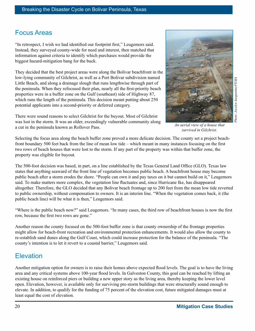
Focus Areas “In retrospect, I wish we had identified our footprint first,” Leugemors said. Instead, they surveyed county-wide for need and interest, then matched that information against criteria to identify which purchases would provide the biggest hazard-mitigation bang for the buck.
They decided that the best project areas were along the Bolivar beachfront in the low-lying community of Gilchrist, as well as a Port Bolivar subdivision named Little Beach, and along a drainage slough that runs lengthwise through part of the peninsula. When they refocused their plan, nearly all the first-priority beach properties were in a buffer zone on the Gulf (southeast) side of Highway 87, which runs the length of the peninsula. This decision meant putting about 250 potential applicants into a second-priority or deferred category.
There were sound reasons to select Gilchrist for the buyout. Most of Gilchrist was lost in the storm. It was an older, exceedingly vulnerable community along a cut in the peninsula known as Rollover Pass.
Selecting the focus area along the beach buffer zone proved a more delicate decision. The county set a project beach-front boundary 500 feet back from the line of mean low tide – which meant in many instances focusing on the first two rows of beach houses that were lost to the storm. If any part of the property was within that buffer zone, the property was eligible for buyout.
The 500-foot decision was based, in part, on a line established by the Texas General Land Office (GLO). Texas law states that anything seaward of the front line of vegetation becomes public beach. A beachfront house may become public beach after a storm erodes the shore. “People can own it and pay taxes on it but cannot build on it,” Leugemors said. To make matters more complex, the vegetation line fluctuates and, since Hurricane Ike, has disappeared altogether. Therefore, the GLO decided that any Bolivar beach frontage up to 200 feet from the mean low tide reverted to public ownership, without compensation to owners. It is an interim line. “When the vegetation comes back, it (the public beach line) will be what it is then,” Leugemors said.
“Where is the public beach now?” said Leugemors. “In many cases, the third row of beachfront houses is now the first row, because the first two rows are gone.”
Another reason the county focused on the 500-foot buffer zone is that county ownership of the frontage properties might allow for beach-front recreation and environmental protection enhancements. It would also allow the county to re-establish sand dunes along the Gulf Coast, which could increase protection for the balance of the peninsula. “The county’s intention is to let it revert to a coastal barrier,” Leugemors said.
ElevationAnother mitigation option for owners is to raise their homes above expected flood levels. The goal is to have the living area and any critical systems above 100-year flood levels. In Galveston County, this goal can be reached by lifting an existing house on reinforced piers or building a new upper story as the living area, thereby keeping the lower level open. Elevation, however, is available only for surviving pre-storm buildings that were structurally sound enough to elevate. In addition, to qualify for the funding of 75 percent of the elevation cost, future mitigated damages must at least equal the cost of elevation.
An aerial view of a house that survived in Gilchrist.
Phot
o: J
ocel
yn A
usgu
stin
o/FE
MA

21
Breaking the Disaster Cycle on Bolivar Peninsula, Texas
Mitigation Case Studies
Because most buildings were gone or not structurally sound, the county was only able to qualify about a half dozen buildings for HMGP elevation assistance throughout the entire county.
Other FEMA programs may be able to assist with elevation of qualified buildings. One source of funding is an NFIP program named Increased Cost of Compliance (ICC). ICC is available for properties that had federal flood insurance prior to the storm and met the ICC requirements. It offers up to $30,000 in flood insurance coverage to help elevate, relocate, demolish, or floodproof buildings that are covered by standard NFIP policies. In other instances, owners may decide to relocate outside the floodplain, and FEMA funds may be available to help.
Phot
o: P
atsy
Lyn
ch/F
EMA
A home is elevated to comply with requirements for homes being built or repaired in Crystal Beach – May 2010.
Hurricane Ike Drives Homeowner to Nevada “So far so good.” That’s how Joe Martino summed up his experience with the Bolivar buyout, as of mid-June 2010. “I would be a lot happier if I had the check in my hand,” Martino said. “Things have been going real well, but I guess I just keep wondering if it will actually work out the way we’ve been promised.” He wants it all to be over so he and his wife can move on with life. “The company that has been assigned to do the survey and appraisal did a fantastic job, and they have definitely kept me in the loop,” he said. “But I can’t really relax until I get the settlement so I can quit thinking about the beautiful beachfront property we lost.” Joe and Doris Martino were in the habit of going to the beach house every week. It was in Gilchrist, on stilts about 14 feet high, and 150 feet from the Gulf. They loved it. “Visualize a beautiful porch on the Gulf side where we could watch dolphins and flocks of pelicans. We would wade out into the surf and go swimming and watch the fish in the water. We walked on the beach every morning and collected sea glass – we had quite a collection. It’s all gone now,” said Martino. When they heard Hurricane Ike was coming, they evacuated to their home north of Houston, where the storm also roared through. “It ripped up trees everywhere, and I thought the windows were going to break out. Even that far north, it was the scariest thing I ever saw. I don’t think I would ever want to go through that again,” added Martino. When they got back to the beach house two weeks later, there was nothing left but 12 poles sticking out of the ground. They didn’t have flood insurance. The Gulf now laps ashore half way up what was their property, now undoubtedly declared to be public beach. “We would not be allowed to rebuild,” he said. “Fortunately, we were able to put in for the buyout.” What lessons would he like to share with others? “Across the road from our beach house, somebody built about a dozen units, and they were built up three stories instead of just two. They were affected by water but not destroyed. Our house was at 14 feet, but I understand the waves were 21 feet high. If anybody were to build there, they better go up 24 feet, not just 14. “Personally, I’m scared of the Gulf now. That’s why I live in Las Vegas now. I’ve decided to move where there are no hurricanes,” said Martino. □
Joe and Doris assess damage after
Hurricane Ike.
Phot
os c
ourt
esy
of D
oris
Mar
tino

Breaking the Disaster Cycle on Bolivar Peninsula, Texas
22 Mitigation Case Studies
Cost SharingThe FEMA acquisition grant comes through the Hazard Mitigation Grant Program (HMGP). HMGP funds are intended to be used for up to 75 percent of the cost of eligible projects to reduce (mitigate) losses in future disasters. An HMGP grant goes from FEMA to the state, and a local entity – in this case, Galveston County – is a sub-grantee who carries out the project in accordance with state and federal laws and regulations. The local share – 25 percent – can be provided by cash match or in kind services, such as support work done by county staff.
In the case of the Galveston County buyout, participating home owners are forfeiting 25 percent of the value of their property to cover the local share. The cost-share split for property acquisition is shown on the following table. This unusual arrangement allows the county to conduct the buyout without a large local budget, although 25 percent of the consultant’s administration (costs that cannot be attributed to work on a specific parcel, in this case about $500,000) is a county expense. “Our grant administration budget is 1 to 2 percent of project costs,” said Leugemors. Identified county administrative expenses can be eligible for 75 percent reimbursement.
Cost 75% Share 25% Share*Purchase price FEMA grant ownerClosing Cost FEMA grant ownerDemolition FEMA grant ownerAdministration FEMA grant county
* The General Land Office is paying local share for some beachfront properties up to $65,000.
Each applicant is required to pay a non-reimbursable $375 up front fee for 25 percent of the cost of an appraisal plus buyout preparation and presentation fees. The FEMA grant pays the other 75 percent ($1,125) of those costs, even if the applicant eventually declines the offer to buy.
The total grant budget includes $102,716,260 from FEMA’s HMGP program, plus 25 percent local share, for a total project estimated cost of $136,955,013.
Managing the ProcessA buyout process is lengthy, at best, for disaster survivors whose homes have been damaged or destroyed. “People need us to move as quickly as possible,” Leugemors said.
FEMA, state, county, and the county’s consultants are working together to find ways to speed up the process as much as possible. Here are a few highlights of their techniques to manage the process.
Environmental Clearances
An early step was to get clearance from historic preservation officials. Early in the application process, the county obtained State Historic Preservation Office (SHPO) clearance – certifying that candidate properties were not historic structures. The acquisition project received a categorical exclusion from the need to prepare an environmental impact statement. However, the county must proceed with consideration for environmental protection. This requirement includes protection of the peninsula’s endangered sea turtles and piping plovers. Ph
oto:
Ros
ane
Wal
ker/
FEM
A
Piping plovers on Bolivar.
23
Breaking the Disaster Cycle on Bolivar Peninsula, Texas
Mitigation Case Studies
Galveston County’s Buyout Has Lessons to ShareThe Galveston County Acquisition Project is unique, according to Connie Dill, the FEMA Region 6 hazard mitigation project manager.
“The project stands out, first, because of its size,” she said. “This is the largest single hazard mitigation grant awarded in Texas by FEMA Region 6 and one of the biggest in the nation’s history,” she said. The federal share contributed by FEMA is more than $102 million.
Another difference is that the Galveston project was submitted as what Texas calls a “fast track” application. The Texas Department of Emergency Management, the state office that administers the Hazard Mitigation Grant Program, requested acquisition applications for buildings 45 years old or less.
“Properties less than 45 years old enable a quick clearance on historic preservation requirements, and they are not turning ground so they can be excused from some of the environmental requirements of construction projects.” Dill said. “The homes were also all substantially damaged, so a benefit-cost analysis was not required.
“The project is running smoothly,” she said. “As of mid June 2010, Galveston County has closed and paid for 91 homes, representing $14,120,000 in reimbursements to the County. I am very impressed with the county and the state operation. They are on top of everything that needs to be accomplished, and the county contractors have been wonderful.
“The buyout partnership is working exceptionally well,” she said. “In addition to some face-to-face team meetings, we have monthly conference calls with — the state, the county, long-term
planners, environmental, all the people involved in the project. The partnership includes our FEMA Region 6 office in Denton, the Texas Department of Emergency Management in Austin, Galveston County and FEMA’s Hurricane Ike Recovery Office. We are in constant contact so that everyone knows what is going on and, if anything does arise, we can resolve many issues before they become problems.”
This is the first project she has seen where most of the houses were swept away by the storm, and one of the major challenges has been to locate the homeowners. “The county has been very determined to find the property owners. I am amazed at how well they have done tracking down homeowners. They are also continuing community outreach, not just saying the involvement ends when the properties are bought.” she said.
As of mid-June 2010, the county had identified about $55 million in duplication of benefits (structural insurance payments or other proceeds to owners, which are subtracted from the purchase price), freeing up grant funds that allowed the county to propose buying hundreds of additional properties without requesting additional FEMA funds. The county continued to identify additional priority properties for possible acquisition until the June 16 State application deadline.
What is the most important lesson Connie Dill would share with others? “Keep the partnership alive. By staying involved, you can head off problems before they happen,” she said.
Her greatest satisfaction in working with the Galveston County buyout is to know that “these people will never have to go through this again. There is a 100 percent guarantee that the houses being bought will never flood again.” □
Connie Dill, FEMA Region 6
Splintered homes, shattered lives.
Phot
o: M
ike
Moo
re/F
EMA

Breaking the Disaster Cycle on Bolivar Peninsula, Texas
24 Mitigation Case Studies
Appraisals, Offers, and Appeals
The appraisal process kicked off Feb. 1, 2010. The county’s contractor hired specialists to conduct appraisals, make offers, and close sales. An owner signs a form granting permission for an appraisal and pays the up-front fee of $375. Half (234) of the applicants in initial focus areas paid their up front fee within the first three weeks of the program, and by Feb. 25, appraisers had contacted all those who had paid. The first 20 appraisals were delivered two weeks later (five weeks into the process) and property inspections were underway. Thereafter, the appraisers delivered about 40 appraisals a week.
Buyout Allows Homeowner to Move on With Life“I really appreciate this buyout program,” said Crystal Beach homeowner Stephen Bergh. “It allows us to turn the page and go on with life.
“Bad things happen for good reasons. Because of this help, now we’re ready to move on.”
When he allows himself to look back, Bergh recalls a big covered deck overlooking the Gulf, behind dunes that he and his neighbor hoped would protect them in a storm. “I can still visualize myself sitting on that deck. We loved it so much,” he said.
His beach house was elevated a dozen feet. He is a construction analyst, and he knew Crystal Beach was vulnerable. He did everything he could to mitigate the risk — but he believes the surge from Hurricane Ike was 26 feet. He believes his house was just in the wrong place at the wrong time.
“We got the brunt of Hurricane Ike. A lady down the street, who got trapped into staying, says she watched my house explode. Now it’s totally gone except for a few pilings sticking out of the sand,” he lamented.
Bergh had four insurance policies on the house. “I collected on two, but still the insurance wasn’t enough to cover it. Wind insurance didn’t pay much. But when all is said and done, we will come out of this whole — because of the buyout program.” (His buyout settlement deducted insurance payments and his 25 percent of buyout costs.)
His advice to other homeowners: “I think insurance is very important. My neighbor had completely remodeled and elevated his house higher on stronger pilings. He didn’t have insurance because he thought he was safe. His house is gone.”
If he could recommend changes in the buyout program, he would somehow improve the flow of information. “People get caught in their fears about the buyout program and not knowing what’s going to happen, and then as things change, it’s hard to keep up to date with what is really going on and what’s going to happen,” he said.
What will happen for the Bergh family? “I think Crystal Beach is the best-kept secret in the country. I have looked at beachfront property from Maine to Florida to Hawaii, and you can’t find beachfront anywhere for under a million dollars – except on Crystal Beach,” he said. “Bolivar will come back and be beautiful and picturesque again. But that may take years, and I’m 61.
“I’m not sure where we will settle, but I’m just grateful we have a chance to move on and find new opportunities,” he said □
Stephen Bergh prepares his house for Hurricane Ike.
Phot
o co
urte
sy o
f Ste
phen
Ber
gh.

25
Breaking the Disaster Cycle on Bolivar Peninsula, Texas
Mitigation Case Studies
“Appraising a property where the buildings have washed away is an art,” said Beck’s subject matter expert, subcontractor Jeff Ward. “Appraisers have access to before-and-after aerials and other photos, building permits, and other documents. Most properties sell through the Multiple Listing Service (MLS), and those records are available for two years”, Leugemors said. “In some cases, the owner has added onto the property but it has not been reflected in the assessor’s records. If the property has been destroyed, the owner can still get credit for the addition if he can prove his work through photos, building permits or other documentation.”
To ensure the values are fair and equitable, appraisers work entire blocks of property in the three focus areas, Crystal Beach, Gilchrist, and Little Beach. The state-certified appraiser sets the purchase price based on the pre-disaster market value of the property – an important point, since values of some properties, now vacant lots, dropped to a fraction of their pre-storm value.
A title company works with owners preparing for settlement and closing. Every other week is “offer week,” a blitz of 12-hour days. A vacancy inspection is conducted on each property, because it must be certified as vacant at the time of closing. If the owner has received insurance proceeds or other reimbursements for structural damage, those “duplicate benefits” are deducted from the purchase price. Ward meets with each owner and makes an offer of the appraised price, minus required deductions including 25 percent of demolition cost.
There is no negotiation. If the homeowners accept the offer, they sign the sales contract. The closing follows. The deed is transferred to the county. The county has 90 days after closing to demolish and to clear the property. If the homeowners do not accept the offer, they have the option to pay for a second appraisal, which must be done by a state-certified appraiser. Both appraisals are sent to the state where a third appraiser reconciles both, and the homeowners can then accept or decline the final offer and walk away.
Data Management
Managing a buyout starts, Leugemors said, by automating routine tasks. “If we had to do this the old way, we could never do it for a buyout of this size. It would take forever.
“To manage a large project, you really need good Geographic Information System (GIS) capability,” he said. “We imported layers for our maps, including flood overlays, aerial photos and the 200-foot line from the GLO, and parcel identifications and boundaries for each property.
“I can’t overemphasize the importance of data management and version control. Everything we do is backed up continually. Every version is identified by date and initials of anyone who changes anything.
“Everything is digital, plus paper copies are maintained for audit. Every property has its own file, by parcel number, and every piece of data and transaction is recorded there. Data researchers and the management team customized a 25-page PDF file representing physical and economic
“I can’t overemphasize the importance of data
management and version control. Everything we do is backed up
continually.”
– Thad Leugemors, Beck Disaster Recovery
Aerial view of Gilchrist after Hurricane Ike.
Phot
o: J
ocel
yn A
ugus
tino/
FEM
A

Breaking the Disaster Cycle on Bolivar Peninsula, Texas
26 Mitigation Case Studies
characteristics that they capture for each property,” he said. Every property has before-and-after photos. If the homeowners have submitted photos or other documents, they are scanned in and added to the homeowners’ digital file. After closing, every document is included, including the signed contract and closing documents. Spread sheets track the overall program. In addition to being the framework for management, the system is constantly maintained in audit-ready condition.
Money Management
As mentioned earlier, the county consultant requests funds for purchase before closing. The county maintains a dedicated mail box for receiving the $375 checks; each check is scanned and logged into a secure check list. The checks are put into a lock box that is taken to the county grant manager. Owners are notified that their checks have been received.
Communications Management
Good communication with homeowners is vital to buyout success. Contractors believe they were successful in contacting 99 percent of affected homeowners, but it has not been easy, because most people left the area and most homes were destroyed.
Buyout Helps Gilchrist Senior Citizens After Hurricane LossDonald Mazzu grew up salt water fishing on Bolivar Peninsula.
“My dad bought property down there on the cut at Rollover Pass in the ‘40s,” Mazzu said. “Everybody had small cabins. It was a fishing camp. We grew up fishing and swimming in that Gulf.
“My wife Anna and I bought property down there in ’81 and built our own house. It was up on poles.
“We have a little place we built up here in Houston, but we spent all our time at Gilchrist. We’re both retired. We’re what you’d call senior citizens, on social security.”
Mazzu is a man of few words. He says they were content and enjoyed life on Bolivar. They were two streets from the Rollover Pass cut, where locals believe the fishing was world class, like none elsewhere. What could be better?
When they heard Hurricane Ike was coming, they headed north to Houston. It was a good thing. Gilchrist was gone with the waves.
“After Ike, there was nothing left of our house. Just the concrete underneath and maybe 5 broken poles. Ike wiped it all off and left sand and debris everywhere. A buddy and I went down to look it over right after the storm. My wife wouldn’t go for weeks.”
They had windstorm insurance but said they couldn’t afford flood insurance premiums. Wind insurance paid 11.2 percent of the claim, the damage the windstorm people said was caused by wind, as opposed to storm surge. “We got very little from our loss there – it was all a total loss. I have absolutely nothing left there except a few friends I hope will invite me down for fishing sometimes.”
The buyout was welcome news and will provide funds the Mazzu family will need toward their living expenses for a long time. “We’re too old to go into debt, and we won’t be rebuilding on the coast,” he said. “It will take it all just to keep us going here. But I’m grateful for the help – I wish the buyout moved faster, but it’s all been fair. We’re well pleased with the way it’s all turning out.” □
The Mazzu house before and after Hurricane Ike.
Phot
os c
ourt
esy
of D
onal
d M
azzu
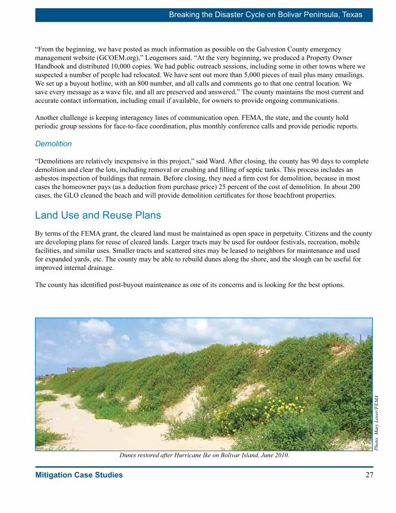
27
Breaking the Disaster Cycle on Bolivar Peninsula, Texas
Mitigation Case Studies
“From the beginning, we have posted as much information as possible on the Galveston County emergency management website (GCOEM.org),” Leugemors said. “At the very beginning, we produced a Property Owner Handbook and distributed 10,000 copies. We had public outreach sessions, including some in other towns where we suspected a number of people had relocated. We have sent out more than 5,000 pieces of mail plus many emailings. We set up a buyout hotline, with an 800 number, and all calls and comments go to that one central location. We save every message as a wave file, and all are preserved and answered.” The county maintains the most current and accurate contact information, including email if available, for owners to provide ongoing communications.
Another challenge is keeping interagency lines of communication open. FEMA, the state, and the county hold periodic group sessions for face-to-face coordination, plus monthly conference calls and provide periodic reports.
Demolition
“Demolitions are relatively inexpensive in this project,” said Ward. After closing, the county has 90 days to complete demolition and clear the lots, including removal or crushing and filling of septic tanks. This process includes an asbestos inspection of buildings that remain. Before closing, they need a firm cost for demolition, because in most cases the homeowner pays (as a deduction from purchase price) 25 percent of the cost of demolition. In about 200 cases, the GLO cleaned the beach and will provide demolition certificates for those beachfront properties.
Land Use and Reuse PlansBy terms of the FEMA grant, the cleared land must be maintained as open space in perpetuity. Citizens and the county are developing plans for reuse of cleared lands. Larger tracts may be used for outdoor festivals, recreation, mobile facilities, and similar uses. Smaller tracts and scattered sites may be leased to neighbors for maintenance and used for expanded yards, etc. The county may be able to rebuild dunes along the shore, and the slough can be useful for improved internal drainage.
The county has identified post-buyout maintenance as one of its concerns and is looking for the best options.
Dunes restored after Hurricane Ike on Bolivar Island, June 2010.
Phot
o: M
ary
Love
r/FE
MA

Breaking the Disaster Cycle on Bolivar Peninsula, Texas
28 Mitigation Case Studies
Coastal Barrier Resources ActBolivar Peninsula includes sections of land that are designated as Coastal Barrier Resources Act of 1982 (CBRA) zones. The legislation removed federal support for flood insurance, buildings, or development within CBRA zones, which are designated for natural resource protection and preservation. Although CBRA zones on Bolivar are generally undeveloped, private high-end residential development has occurred, apparently unprotected by federal flood insurance. Counties in Texas do not have zoning authority over unincorporated lands, and the county’s position is that it does not have power to prevent privately financed buildings within CBRA zones.
The county’s acquisition application originally included 19 properties within CBRA zones. FEMA removed those 19 properties from the county’s approved grant because FEMA policy precludes use of HMGP within CBRA zones, even for structural acquisition.
In March 2010, the county filed an appeal requesting authorization to buy the CBRA properties. “It has always been the intention of the county to let these areas revert to their natural state,” said County Judge James Yarbrough in his appeal letter. “The county may also restore dunes on the beachfront lands to try to stabilize the shore,” he said.
FEMA and the State of Texas are looking for alternative solutions to purchase these properties. As of June 1, 2010, properties that meet certain requirements may be bought out using non-disaster grants.
Costs and BenefitsAll homes in the project have been determined to be substantially damaged, so the county was not required to prepare a benefit/cost analysis for the buyout grant. Nonetheless, it would be useful to recognize the full range of buyout costs and benefits.
Costs
The FEMA grant, approved for $102,716,260, is expected to cover up to 75 percent of the total project budget of $136,955,013. The county expects private property owners to cover their matching portion of project costs, which in some cases will be paid from insurance proceeds.
In addition to the project cost, the county will experience some loss of tax base when private properties are taken off the tax rolls and converted into public lands. More than 300 acres will be taken off local tax rolls and put into public use. Buyout participants will be displaced to new locations, albeit voluntarily, and it is unknown how many will choose to relocate on the Peninsula or within Galveston County. It is also unknown whether all owners will choose to replace vacation homes and if so, where.
Estimates of the tax loss range widely. The Bolivar Blueprint reported that the Peninsula accounted for about 3 percent of the county property value before the storm but only 1.6 percent after Hurricane Ike. The county assessor reported the pre-storm tax base of $640,409,000 dropped by 48 percent – a loss of about $300 million.
Family enjoying a picnic on Bolivar.Ph
oto:
Ann
Pat
ton/
FEM
A
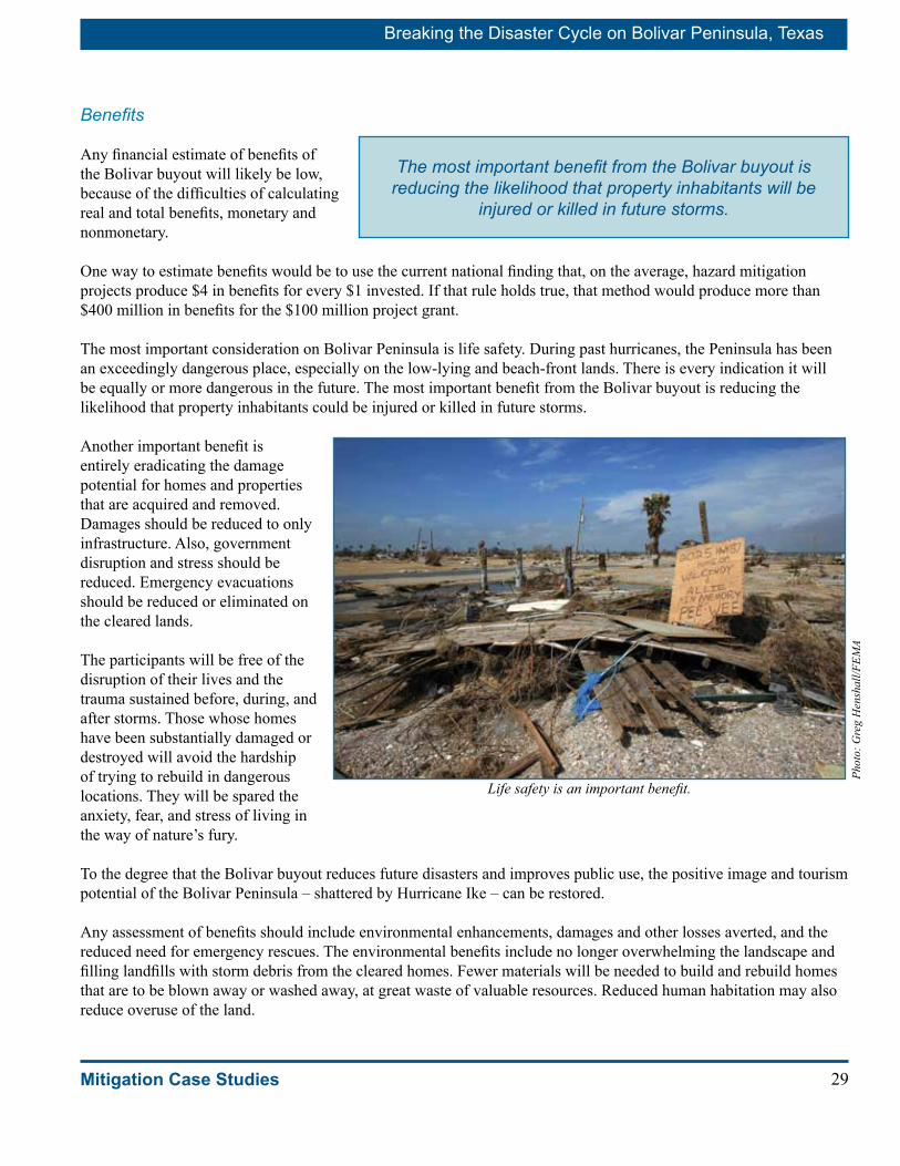
29
Breaking the Disaster Cycle on Bolivar Peninsula, Texas
Mitigation Case Studies
Benefits
Any financial estimate of benefits of the Bolivar buyout will likely be low, because of the difficulties of calculating real and total benefits, monetary and nonmonetary.
One way to estimate benefits would be to use the current national finding that, on the average, hazard mitigation projects produce $4 in benefits for every $1 invested. If that rule holds true, that method would produce more than $400 million in benefits for the $100 million project grant.
The most important consideration on Bolivar Peninsula is life safety. During past hurricanes, the Peninsula has been an exceedingly dangerous place, especially on the low-lying and beach-front lands. There is every indication it will be equally or more dangerous in the future. The most important benefit from the Bolivar buyout is reducing the likelihood that property inhabitants could be injured or killed in future storms.
Another important benefit is entirely eradicating the damage potential for homes and properties that are acquired and removed. Damages should be reduced to only infrastructure. Also, government disruption and stress should be reduced. Emergency evacuations should be reduced or eliminated on the cleared lands.
The participants will be free of the disruption of their lives and the trauma sustained before, during, and after storms. Those whose homes have been substantially damaged or destroyed will avoid the hardship of trying to rebuild in dangerous locations. They will be spared the anxiety, fear, and stress of living in the way of nature’s fury.
To the degree that the Bolivar buyout reduces future disasters and improves public use, the positive image and tourism potential of the Bolivar Peninsula – shattered by Hurricane Ike – can be restored.
Any assessment of benefits should include environmental enhancements, damages and other losses averted, and the reduced need for emergency rescues. The environmental benefits include no longer overwhelming the landscape and filling landfills with storm debris from the cleared homes. Fewer materials will be needed to build and rebuild homes that are to be blown away or washed away, at great waste of valuable resources. Reduced human habitation may also reduce overuse of the land.
Life safety is an important benefit.
Phot
o: G
reg
Hen
shal
l/FEM
A
The most important benefit from the Bolivar buyout is reducing the likelihood that property inhabitants will be
injured or killed in future storms.

Breaking the Disaster Cycle on Bolivar Peninsula, Texas
30 Mitigation Case Studies
Ike Offers Chance to Build Back Better, Commissioner SaysThe Bolivar buyout offers the Peninsula an opportunity to recover and rebuild in new and better ways, said Patrick Doyle, the Galveston County Commissioner from Precinct I, which includes Bolivar.
A lot of Bolivar housing was older, so the recovery process can jumpstart the process of rebuilding to modern standards, he said. “Bolivar can be rebuilt as a stronger and safer community. People can feel they are part of the long-term solution for the recovery of Bolivar Peninsula, and we can begin to rebuild the tax base for the Peninsula.”
Commissioner Doyle believes many people will resettle in safer areas within the same vicinity. “They will become part of the economic engine we are hoping to recreate for Bolivar — as described in the Bolivar Blueprint long-term community recovery plan. With the planning process, we have been able to ease the apprehensions of a lot of folks and get local buy-in for what needs to happen in the long term.”
Galveston County did not have the recent disaster experience that would build expertise in recovery management, he said. In some cases, they didn’t know what help could become available after the storm.
“We had an enormous learning curve on our end,” he said. “But somehow, the bureaucratic process has to be speeded up. Immediately after a storm, you have to get through the first recovery period. Then my suggestion is that the government should immediately initiate some sort of pre-set equations that can be tweaked for local conditions and then put into place quickly — so the money can begin to flow in a month to six weeks after a storm. And then you would be on the road to recovery.
“I do want to emphasize,” Commissioner Doyle said, “that there are some things you just can’t do alone locally. We are grateful for the partnerships that are helping us get back on our feet. If we didn’t have these federal and state programs for assistance, we would be in big trouble. We could not have done any of this without the federal government.” □
Doyle and Careen Plummer, Blueprint director, on Bolivar.
Phot
o: A
nn P
atto
n/FE
MA
In fact, any estimate of benefits of the Bolivar buyout would probably be low because of the many intangible benefits including life safety, natural resource protection and recreational amenities. Also important are the expanded economic advantages for tourism when the peninsula recaptures its image as a safe and sustainable destination.
Aerial view of Crystal Beach after Hurricane Ike.
Phot
o: J
ocel
yn A
ugus
tino/
FEM
A
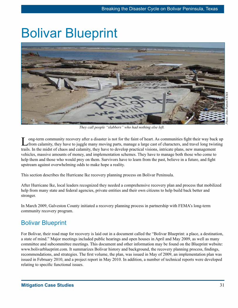
31
Breaking the Disaster Cycle on Bolivar Peninsula, Texas
Mitigation Case Studies
Bolivar Blueprint
Long-term community recovery after a disaster is not for the faint of heart. As communities fight their way back up from calamity, they have to juggle many moving parts, manage a large cast of characters, and travel long twisting
trails. In the midst of chaos and calamity, they have to develop practical visions, intricate plans, new management vehicles, massive amounts of money, and implementation schemes. They have to manage both those who come to help them and those who would prey on them. Survivors have to learn from the past, believe in a future, and fight upstream against overwhelming odds to make hope a reality.
This section describes the Hurricane Ike recovery planning process on Bolivar Peninsula.
After Hurricane Ike, local leaders recognized they needed a comprehensive recovery plan and process that mobilized help from many state and federal agencies, private entities and their own citizens to help build back better and stronger.
In March 2009, Galveston County initiated a recovery planning process in partnership with FEMA’s long-term community recovery program.
Bolivar BlueprintFor Bolivar, their road map for recovery is laid out in a document called the “Bolivar Blueprint: a place, a destination, a state of mind.” Major meetings included public hearings and open houses in April and May 2009, as well as many committee and subcommittee meetings. This document and other information may be found on the Blueprint website: www.bolivarblueprint.com. It summarizes Bolivar history and background, the recovery planning process, findings, recommendations, and strategies. The first volume, the plan, was issued in May of 2009, an implementation plan was issued in February 2010, and a project report in May 2010. In addition, a number of technical reports were developed relating to specific functional issues.
They call people “slabbers” who had nothing else left.
Phot
o: A
nn P
atto
n/FE
MA

Breaking the Disaster Cycle on Bolivar Peninsula, Texas
32 Mitigation Case Studies
VisionHere is the vision statement approved by Bolivar Blueprint participants outlining what they would like to see as Bolivar recovers from Hurricane Ike:
“A rebuilt Bolivar Peninsula will be a resilient, affordable, and safe place to live where residents and visitors enjoy nature and recreation in a diverse community of small businesses, families, and neighborhoods, close to water and beaches. It will be built with respect for the environment and developed with sustainable land use, infrastructure, and community services.”
The Bolivar Blueprint contains a number of recovery recommendations, including the following most relevant to this report: “Use disaster-related HMGP or other mitigation program buyout opportunities to increase beach/dune area…. Work with the county to update the hazard mitigation plan to incorporate a long-term hazard buyout program for the Peninsula.”
Steering CommitteeThe hub of recovery planning is the Bolivar Blueprint Steering Committee. Galveston County Commissioners appointed the Steering Committee members.
The long-term community recovery team helped the seven-member recovery Steering Committee establish subcommittees to focus on specific issues, including education; economic development; environment; housing; human services; infrastructure; parks, recreation, and tourism.
“The Steering Committee is a very organized group, very active, and includes the people most familiar with the recovery projects,” said Careen Plummer, Blueprint director. “Those individuals who serve as subcommittee chairs and project champions will be the individuals who interface with resources and implement the projects, project funding, and construction.”
PenDeCo, Bolivar’s Recovery CorporationBy spring of 2010, Blueprint committees were ready to organize and implement their plans. Bolivar citizens worked through Blueprint committees and partnerships; but to carry out recovery projects, they also needed a funding vehicle that could accept grants and private, tax-deductible donations.
They established a non-profit corporation named PenDeCo (Peninsula Development Coalition Inc.) PenDeCo was incorporated in April 2010 as a nonprofit business entity to be funded by public and private sources. PenDeCo applied for tax-exempt and tax-deductible status under section 501-C-3 of the Internal Revenue Code.
PenDeCo has a nine-member board. Sid Bouse, a local surveyor and rancher, was elected PenDeCo president.
PenDeCo members meeting.
Phot
o: A
nn P
atto
n/FE
MA

33
Breaking the Disaster Cycle on Bolivar Peninsula, Texas
Mitigation Case Studies
PenDeCo developed its own business plan enabling income generated from business ventures to support implementation of Bolivar Blueprint recovery projects.
The mission of the corporation is to develop projects that serve the residents and businesses of the Peninsula. PenDeCo is working to identify a range of potential funding options including public and private funds. In addition to PenDeCo and the Blueprint committees, two other groups are important parts of the Bolivar recovery structure.
■ The PenDeCo Patrons Board will mobilize resources for recovery projects.
■ The PenDeCo Advisory Board will supply technical expertise for business model development, property management, and environmental issues.
Plummer and Bouse at the Galveston County emergency office.
Phot
o: A
nn P
atto
n/FE
MA
‘The Strong People Stayed and Will Make a Better Community’Maryanne Rogers believes Bolivar Peninsula is in for “tremendous change. I see us coming back as a bigger and stronger and more resilient community,” said the Peninsula business woman.
Rogers and her husband own Pat’s Tires, a Bolivar business hub. They lost their business, their home, and three wrecker trucks in the storm. But the biggest loss was business interruption. “Nobody told us about the surge. We had eight employees, gave them extra money and said, ‘Be back Monday.’ We took nothing, only the boxes to our computers, and came back to nothing. We lost everything.
“I believe a lot of people couldn’t get out — there were hundreds of cars buried in the sand, from people who tried to swim or walk from Rollover up to High Island, but it was flooded out. Nobody really knows. I think we lost a lot of people.”
Now they are rebuilding their business and their lives. Rogers’ passion is building a coalition — the Bolivar Small Business Coalition (BSBC) — to support small businesses on the Peninsula. Its mission is to foster the establishment and support of a diverse and resilient economy on the Bolivar Peninsula. As President of BSBC, she plays a key role in the development of the Bolivar Peninsula Business Resource Center, which will provide training, loan assistance, consulting, and resources to the Peninsula’s small business community. In that pursuit, she seldom, if ever, misses a county or community meeting in her desire to cultivate relationships with local, state and federal agencies for the purpose of creating jobs on the Peninsula and fostering creation and communication of business resources.
“I wish the big contractors had hired more local people; that would have jump-started us to come back. But they didn’t — so being the wild Bolivar people that we are, people just went out on their own and got things going. That’s how we survived.”
She believes people are happy, in general, about the Bolivar buyout. “It’s voluntary. We will have extra beach, extra drainage slough area which we have always needed.
“The strong people stayed — the survivors — and will make a better community,” Rogers said. “Our people are capable of working. I think people are here to stay. You have the people who left, and you always have the complainers, but I think the people who came back here looked at it the way it was and said, ‘We are here, we are going to rebuild and make it a good community.’
“I think a lot of good things are going to come out of this,” said Rogers. □ Maryanne Rogers

Breaking the Disaster Cycle on Bolivar Peninsula, Texas
34 Mitigation Case Studies
Working PartnershipsThe management structure for community recovery on the Peninsula continues to evolve. “The Steering Committee and PenDeCo are both long-term vehicles,” Plummer said. “Some of those individuals who have been with this recovery in the long term are also interested in working with PenDeCo. PenDeCo is the vehicle for some projects, but it may not be for all – some may be too large or other individuals may be taking responsibility. In some cases the project champions are personally seeing the projects through to completion.
“So some projects kind of trickle out on their own, others PenDeCo will prioritize and work on funding and implementation,” Plummer said. “And the PenDeCo board and the Steering Committee are the agents that will see it all through. It is all migrating together beautifully.”
The secret to making the fluid structure work is a common vision and working partnerships.
Implementation ChallengesPlummer sees four major challenges in carrying out the Blueprint recovery strategy.
Overcoming a Bolivar History of Isolation
Bolivar’s physical isolation is part of its charm. To the northeast, the nearest towns are across miles of marshland and a fragile Sabine Pass crossing. To the southwest, Galveston Island is across 3 miles of water and connected by a ferry.
It has been an ideal location for people who want to get away from it all in the sun, on a strip of beach and surf. But creating partnerships with the outside world has been problematic.
The Peninsula dweller, said one county official, has been historically a rugged individualist with a “them versus us” mentality who believes he and his homeland never get an even break with Galveston County. Bolivar citizens have traditionally believed they are “neglected stepchildren” and often react with hostility that makes off-peninsula agencies wary about working with them, another observer said. This wariness can reinforce the cycle of perceived neglect.
“I will quote one woman from Bolivar who summed up that attitude well. She said over the years Bolivar has had nothing but false hopes and empty promises,” Plummer said.
Recovery is allowing Bolivar citizens to see and experience the benefits of creating flourishing off-Peninsula partnerships, according to Plummer. In that regard, Hurricane Ike is bringing positive changes.
The fierce independence and self sufficiency that has become a way of life for Peninsula residents is portrayed by Sid Bouse: He is only the second generation to have electricity since his family settled here before 1900 to raise cattle.
Volunteers hand out Blueprint materials at a meeting on the beach.
Phot
o: P
atri
cia
Brac
h/FE
MA
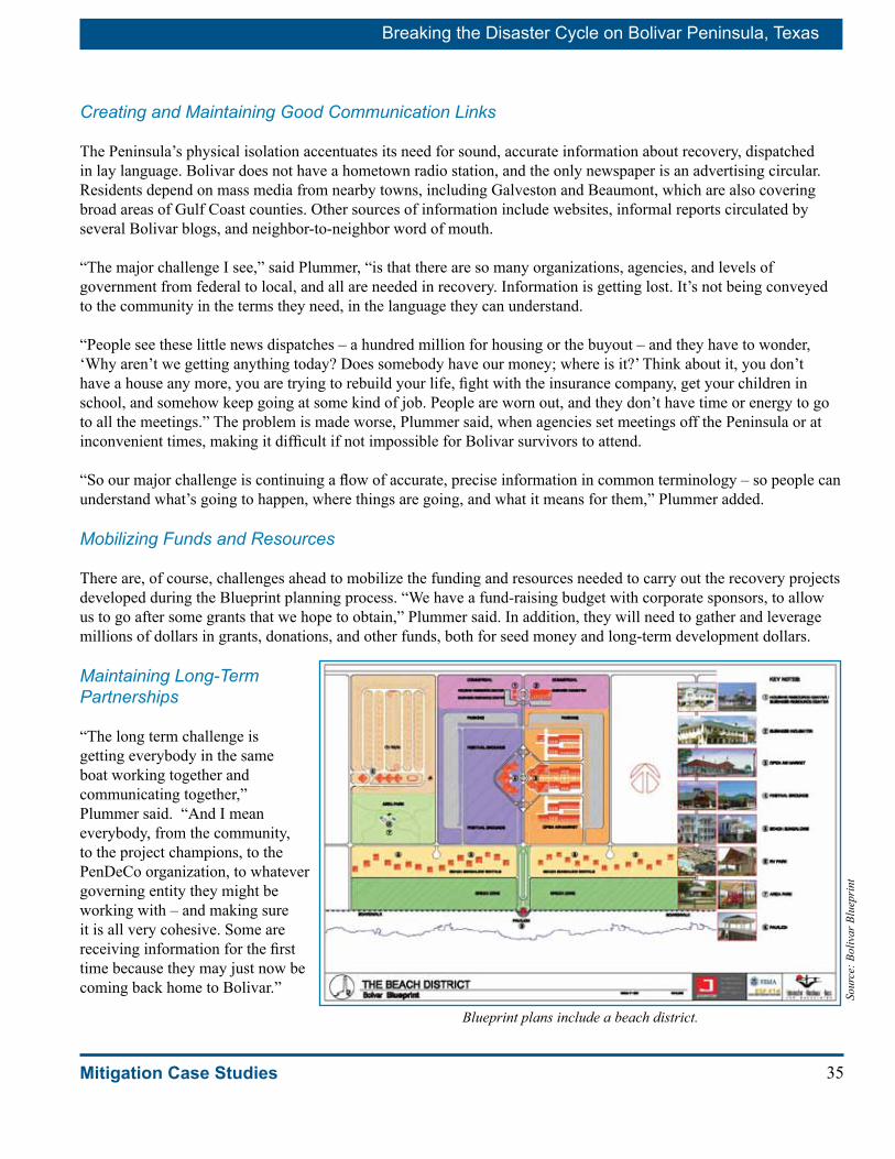
35
Breaking the Disaster Cycle on Bolivar Peninsula, Texas
Mitigation Case Studies
Creating and Maintaining Good Communication Links
The Peninsula’s physical isolation accentuates its need for sound, accurate information about recovery, dispatched in lay language. Bolivar does not have a hometown radio station, and the only newspaper is an advertising circular. Residents depend on mass media from nearby towns, including Galveston and Beaumont, which are also covering broad areas of Gulf Coast counties. Other sources of information include websites, informal reports circulated by several Bolivar blogs, and neighbor-to-neighbor word of mouth. “The major challenge I see,” said Plummer, “is that there are so many organizations, agencies, and levels of government from federal to local, and all are needed in recovery. Information is getting lost. It’s not being conveyed to the community in the terms they need, in the language they can understand.
“People see these little news dispatches – a hundred million for housing or the buyout – and they have to wonder, ‘Why aren’t we getting anything today? Does somebody have our money; where is it?’ Think about it, you don’t have a house any more, you are trying to rebuild your life, fight with the insurance company, get your children in school, and somehow keep going at some kind of job. People are worn out, and they don’t have time or energy to go to all the meetings.” The problem is made worse, Plummer said, when agencies set meetings off the Peninsula or at inconvenient times, making it difficult if not impossible for Bolivar survivors to attend.
“So our major challenge is continuing a flow of accurate, precise information in common terminology – so people can understand what’s going to happen, where things are going, and what it means for them,” Plummer added.
Mobilizing Funds and Resources
There are, of course, challenges ahead to mobilize the funding and resources needed to carry out the recovery projects developed during the Blueprint planning process. “We have a fund-raising budget with corporate sponsors, to allow us to go after some grants that we hope to obtain,” Plummer said. In addition, they will need to gather and leverage millions of dollars in grants, donations, and other funds, both for seed money and long-term development dollars.
Maintaining Long-Term Partnerships
“The long term challenge is getting everybody in the same boat working together and communicating together,” Plummer said. “And I mean everybody, from the community, to the project champions, to the PenDeCo organization, to whatever governing entity they might be working with – and making sure it is all very cohesive. Some are receiving information for the first time because they may just now be coming back home to Bolivar.”
Blueprint plans include a beach district.
Sour
ce: B
oliv
ar B
luep
rint

Breaking the Disaster Cycle on Bolivar Peninsula, Texas
36 Mitigation Case Studies
Burkett Wants to Re-green the PeninsulaWinnie Burkett lost her Bolivar home to Hurricane Ike, but she found a new mission: restoring the unique ecology of Bolivar Peninsula.
She’s working to “green up” the Peninsula, from the standpoint of restoring both economic prosperity and native plants.
As sanctuary manager for the Houston Audubon Society, Winnie was already the guardian for seven bird and wildlife preserves that cover 2,000 acres on the Peninsula. Most Peninsula vegetation was destroyed by the hurricane and the cleanup activities after the storm. Burkett hopes to see the Peninsula replanted in native plants and grasses, which are naturally adapted to salt and acclimated to the coast. After the storm, the exotic grasses were still brown, but the native grasses quickly were green again, she said.
Burkett is involved in the Blueprint planning and also serves on the board of the nonprofit PenDeCo, which is working to implement recovery projects. She is hoping to develop expanded parks and recreation areas, walking trails, and a new emphasis on eco-tourism.
“Bolivar Peninsula has a tremendous potential as an eco-tourism destination — which would bring in visitors who are focused on the environment,” Burkett said. The key will be to restore habitat and ecological balance, as well as providing amenities such as shops and restaurants for tourists to enjoy.
“Bird watching is a major eco-tourism draw on the Peninsula. In the spring, bird watchers come here from all over the world. Last year we had visitors from 48 states and 15 foreign countries, because such a wide variety of birds stop here during migration. When birds are flying 600 to 800 miles across the Gulf of Mexico, they need a place to rest, drink, and eat; and they come here. During the rest of the year, an amazing variety of water birds wander the Peninsula’s wetlands and beaches feeding on the abundant invertebrates that live there. So habitat restoration helps not only the water birds but also the economy of the Peninsula, because it brings visitors here,” she said.
“We are talking about taking a buyout site to grow dune grasses. A lot of people want to do dune restoration, but they have to buy the grasses from either Florida or the Carolinas, which may not be the same subspecies that grow on the Texas coast. That could be a really good use of some of the buyout property.”
Ike was the third hurricane to hit High Island in four years, she said — following Rita and Humberto. “It will happen again — somewhere. It always does.”
For Burkett, the key to recovery is restoration. “The hope is that we can have the redevelopment and still protect our environment,” she said. “That’s what makes Bolivar Peninsula unique.” □
Phot
o: M
ary
Love
r/FE
MA
Winnie Burkett
Phot
o: B
ill F
agan
/FEM
A

37
Breaking the Disaster Cycle on Bolivar Peninsula, Texas
Mitigation Case Studies
Secrets of SuccessThe long-term community planning process and the Blueprint were very helpful in gaining working consensus on Bolivar to move forward, according to Judge Yarbrough.
What were some keys to success in mobilizing Bolivar citizens to plan and execute their own recovery from Hurricane Ike?
A first key to success was the strength and perseverance of the Peninsula survivors.
“I think, initially, it was challenging to ask people to look into the future,” Plummer said, “they’re stressed out, maxed out, they’ve hit the limit – and you ask them to get themselves organized to work toward objectives and goals that will benefit them in the future. These are survivors, just trying to get through the day, day by day.”
“Yet people rose to the challenge,” she said. “During project development, they decided they didn’t want to wait, and they picked up the ball, got a grant for an environmental project for their school, and they are doing their own thing. They are getting stuff done. And that’s all part of community recovery. It’s not just the plan. It’s the individual taking recovery forward.”
A second key was strong local leadership. “The orchestration here in this case has worked extremely well,” Plummer said. “We have the support of the county, and the guidance, the direction. For example, when building codes were going to be changed, we knew a week before and knew what was going to happen. Little things like that are so important. Local government has been completely supportive of the process and understood from the beginning that they needed to support the Bolivar community.”
A third key to success was the partnership with the long-term community recovery team. “It’s worked very well,” Plummer said, “to have somebody who understands the process, who has experience, like Bill Fagan and John Boyle (long-term community recovery planners), because they can come in and say, ‘Here’s a timeline, here’s what we need to work toward. Here’s how we can do it, but more important, let me show you some examples of what’s happened in the past and what has worked for these other communities. It may not work for your community, so let’s identify what’s going to work for you all.’”
A fourth key is being sure that the ownership of the process belongs first, last, and always to the community. “It’s very, very important that the quicker we facilitators can phase out, the better,” Plummer said.
“This process,” said Fagan, “is theirs. It’s not the county’s; it’s not the state’s; it’s not the government’s. It belongs to the Peninsula, and they’re going to do what it takes to make their vision a reality. And they will.”
Recovery ProjectsLong-term community recovery projects are developed jointly by the community and the long-term community recovery team. Working with the team, they considered a series of factors to help identify projects that would achieve their recovery vision; these factors include ensuring that the project will fulfill a post-disaster need and have realistic outcomes. The local projects complement and build on other recovery programs such as repair and rebuilding homes and upgrading infrastructure.
Long-term recovery planners facilitate Blueprint meeting.
Phot
o: A
nn P
atto
n/FE
MA
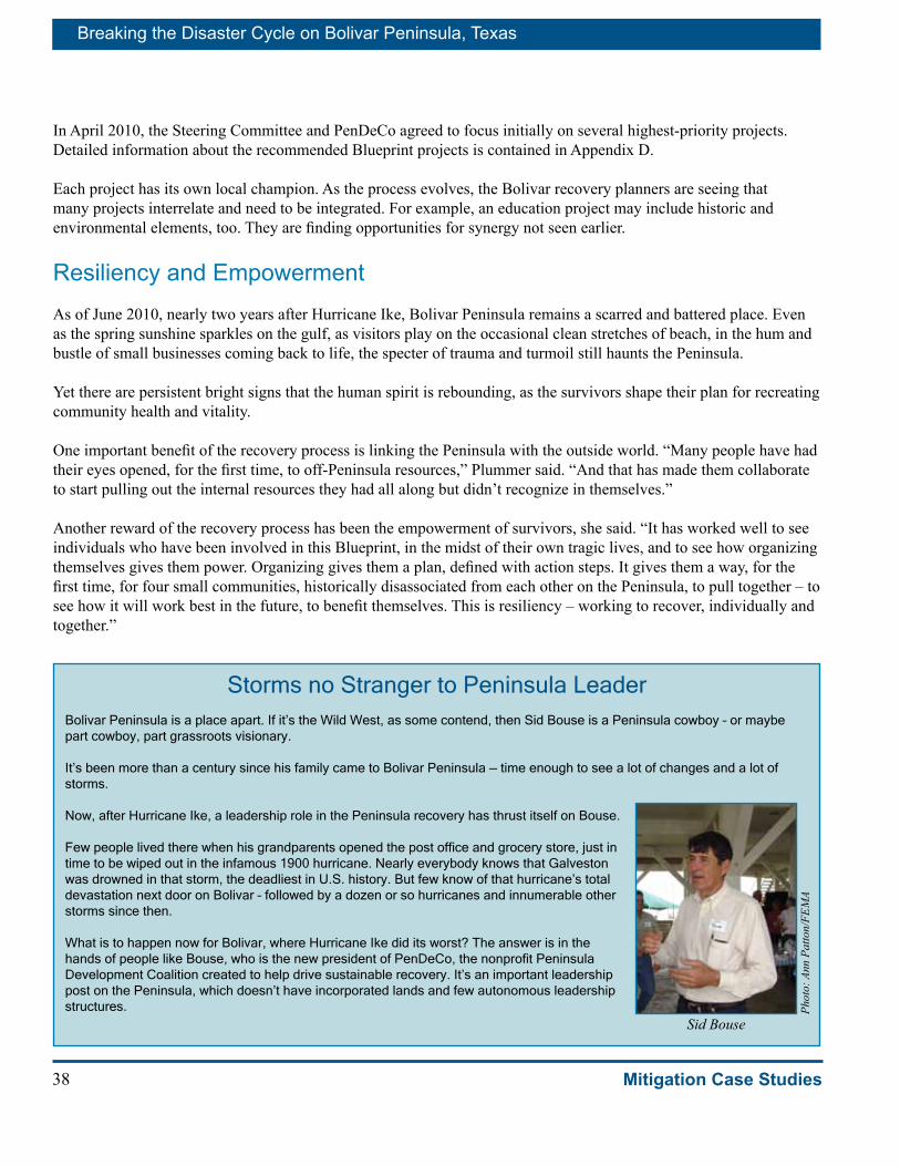
Breaking the Disaster Cycle on Bolivar Peninsula, Texas
38 Mitigation Case Studies
In April 2010, the Steering Committee and PenDeCo agreed to focus initially on several highest-priority projects. Detailed information about the recommended Blueprint projects is contained in Appendix D. Each project has its own local champion. As the process evolves, the Bolivar recovery planners are seeing that many projects interrelate and need to be integrated. For example, an education project may include historic and environmental elements, too. They are finding opportunities for synergy not seen earlier.
Resiliency and EmpowermentAs of June 2010, nearly two years after Hurricane Ike, Bolivar Peninsula remains a scarred and battered place. Even as the spring sunshine sparkles on the gulf, as visitors play on the occasional clean stretches of beach, in the hum and bustle of small businesses coming back to life, the specter of trauma and turmoil still haunts the Peninsula.
Yet there are persistent bright signs that the human spirit is rebounding, as the survivors shape their plan for recreating community health and vitality.
One important benefit of the recovery process is linking the Peninsula with the outside world. “Many people have had their eyes opened, for the first time, to off-Peninsula resources,” Plummer said. “And that has made them collaborate to start pulling out the internal resources they had all along but didn’t recognize in themselves.”
Another reward of the recovery process has been the empowerment of survivors, she said. “It has worked well to see individuals who have been involved in this Blueprint, in the midst of their own tragic lives, and to see how organizing themselves gives them power. Organizing gives them a plan, defined with action steps. It gives them a way, for the first time, for four small communities, historically disassociated from each other on the Peninsula, to pull together – to see how it will work best in the future, to benefit themselves. This is resiliency – working to recover, individually and together.”
Storms no Stranger to Peninsula LeaderBolivar Peninsula is a place apart. If it’s the Wild West, as some contend, then Sid Bouse is a Peninsula cowboy – or maybe part cowboy, part grassroots visionary.
It’s been more than a century since his family came to Bolivar Peninsula — time enough to see a lot of changes and a lot of storms.
Now, after Hurricane Ike, a leadership role in the Peninsula recovery has thrust itself on Bouse.
Few people lived there when his grandparents opened the post office and grocery store, just in time to be wiped out in the infamous 1900 hurricane. Nearly everybody knows that Galveston was drowned in that storm, the deadliest in U.S. history. But few know of that hurricane’s total devastation next door on Bolivar – followed by a dozen or so hurricanes and innumerable other storms since then.
What is to happen now for Bolivar, where Hurricane Ike did its worst? The answer is in the hands of people like Bouse, who is the new president of PenDeCo, the nonprofit Peninsula Development Coalition created to help drive sustainable recovery. It’s an important leadership post on the Peninsula, which doesn’t have incorporated lands and few autonomous leadership structures. Ph
oto:
Ann
Pat
ton/
FEM
A
Sid Bouse
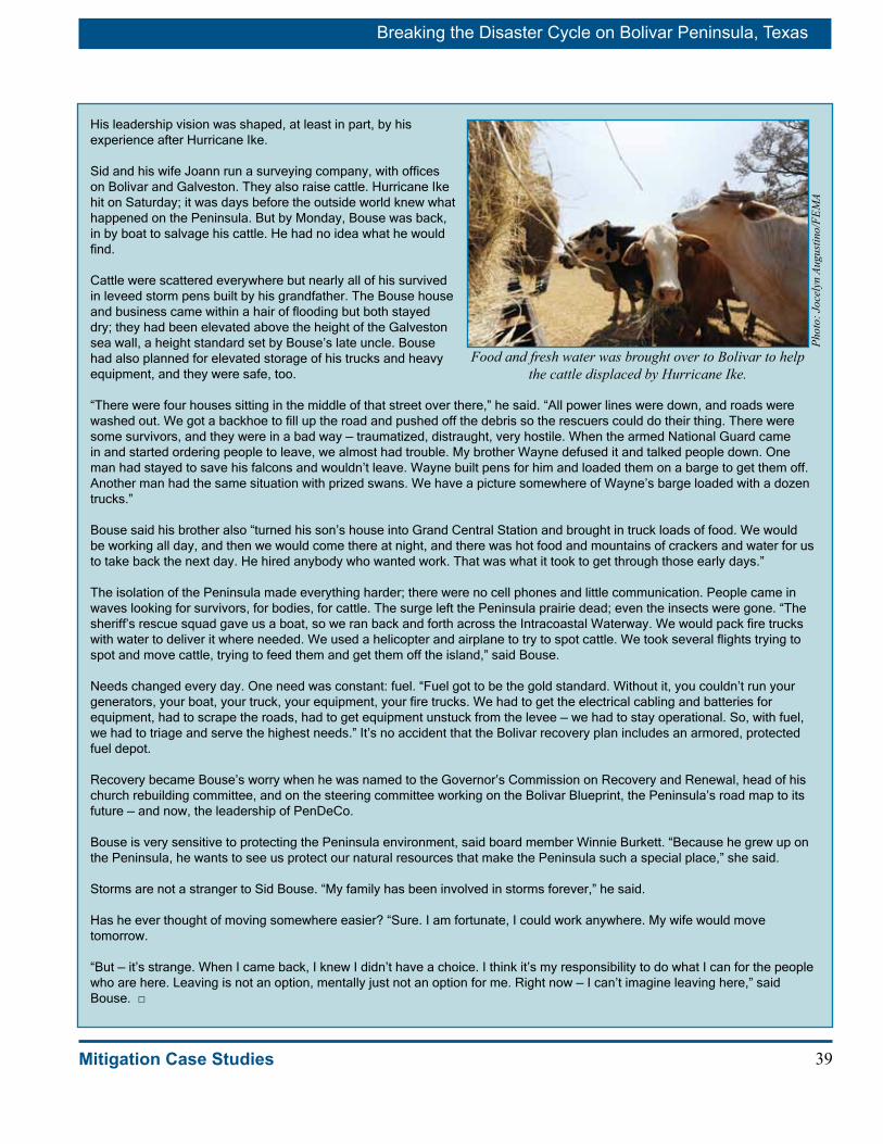
39
Breaking the Disaster Cycle on Bolivar Peninsula, Texas
Mitigation Case Studies
His leadership vision was shaped, at least in part, by his experience after Hurricane Ike.
Sid and his wife Joann run a surveying company, with offices on Bolivar and Galveston. They also raise cattle. Hurricane Ike hit on Saturday; it was days before the outside world knew what happened on the Peninsula. But by Monday, Bouse was back, in by boat to salvage his cattle. He had no idea what he would find.
Cattle were scattered everywhere but nearly all of his survived in leveed storm pens built by his grandfather. The Bouse house and business came within a hair of flooding but both stayed dry; they had been elevated above the height of the Galveston sea wall, a height standard set by Bouse’s late uncle. Bouse had also planned for elevated storage of his trucks and heavy equipment, and they were safe, too.
“There were four houses sitting in the middle of that street over there,” he said. “All power lines were down, and roads were washed out. We got a backhoe to fill up the road and pushed off the debris so the rescuers could do their thing. There were some survivors, and they were in a bad way — traumatized, distraught, very hostile. When the armed National Guard came in and started ordering people to leave, we almost had trouble. My brother Wayne defused it and talked people down. One man had stayed to save his falcons and wouldn’t leave. Wayne built pens for him and loaded them on a barge to get them off. Another man had the same situation with prized swans. We have a picture somewhere of Wayne’s barge loaded with a dozen trucks.”
Bouse said his brother also “turned his son’s house into Grand Central Station and brought in truck loads of food. We would be working all day, and then we would come there at night, and there was hot food and mountains of crackers and water for us to take back the next day. He hired anybody who wanted work. That was what it took to get through those early days.”
The isolation of the Peninsula made everything harder; there were no cell phones and little communication. People came in waves looking for survivors, for bodies, for cattle. The surge left the Peninsula prairie dead; even the insects were gone. “The sheriff’s rescue squad gave us a boat, so we ran back and forth across the Intracoastal Waterway. We would pack fire trucks with water to deliver it where needed. We used a helicopter and airplane to try to spot cattle. We took several flights trying to spot and move cattle, trying to feed them and get them off the island,” said Bouse.
Needs changed every day. One need was constant: fuel. “Fuel got to be the gold standard. Without it, you couldn’t run your generators, your boat, your truck, your equipment, your fire trucks. We had to get the electrical cabling and batteries for equipment, had to scrape the roads, had to get equipment unstuck from the levee — we had to stay operational. So, with fuel, we had to triage and serve the highest needs.” It’s no accident that the Bolivar recovery plan includes an armored, protected fuel depot.
Recovery became Bouse’s worry when he was named to the Governor’s Commission on Recovery and Renewal, head of his church rebuilding committee, and on the steering committee working on the Bolivar Blueprint, the Peninsula’s road map to its future — and now, the leadership of PenDeCo.
Bouse is very sensitive to protecting the Peninsula environment, said board member Winnie Burkett. “Because he grew up on the Peninsula, he wants to see us protect our natural resources that make the Peninsula such a special place,” she said.
Storms are not a stranger to Sid Bouse. “My family has been involved in storms forever,” he said.
Has he ever thought of moving somewhere easier? “Sure. I am fortunate, I could work anywhere. My wife would move tomorrow.
“But — it’s strange. When I came back, I knew I didn’t have a choice. I think it’s my responsibility to do what I can for the people who are here. Leaving is not an option, mentally just not an option for me. Right now — I can’t imagine leaving here,” said Bouse. □
Food and fresh water was brought over to Bolivar to help the cattle displaced by Hurricane Ike.
Phot
o: J
ocel
yn A
ugus
tino/
FEM
A

Breaking the Disaster Cycle on Bolivar Peninsula, Texas
40 Mitigation Case Studies
Conclusion – the Way Forward
Challenges and Opportunities
Hurricane Ike has brought many challenges to Bolivar Peninsula, but it also offers opportunities to learn and share invaluable lessons that can make the Texas coast and the nation safer in future disasters.
The fragile and vulnerable Bolivar Peninsula will continue to be battered by future storms. Scientists anticipate that the sandy Peninsula will continue to subside and erode and the seas will continue to slowly rise. Priceless environmental resources will be threatened by continued development and over-use.
Buildings have been constructed over the years on parts of CBRA zones. This issue demands a comprehensive strategy to chart the best ways to proceed, to protect both environmental and human needs. FEMA and the State of Texas continue to make progress identifying potential cost share funding sources to purchase these properties.
Although the buyout offers an opportunity to protect more than 300 acres on Bolivar Peninsula, repair and development of existing and new homes and businesses must also be conducted wisely, given the inherent risk of future damages and loss of life. All stakeholders need to work together to ensure that buildings are higher, stronger, safer, and prudently sited.
The Peninsula is experiencing significant problems with septic tanks and sewage disposal. Even if development is low-density and carefully sited, inherent challenges remain, including management of septic tanks and human waste.
Because evacuation undoubtedly saved the lives of most residents of Bolivar Peninsula during Hurricane Ike, there are urgent needs to protect evacuation lifelines, Highway 87 and the Galveston ferry. Evacuation protocols also need to be re-examined and strengthened before the next major storm.
Phot
o: A
nn P
atto
n/FE
MA
The newer, higher elevated Bolivar house, left, survived Ike with little damage, while the house on the right was heavily damaged.

41
Breaking the Disaster Cycle on Bolivar Peninsula, Texas
Mitigation Case Studies
Existing federal programs and procedures address many, but not all, of the local needs for help in recovering from a disaster such as Hurricane Ike. There are significant opportunities to improve and accelerate federal assistance for acquisition projects.
The Bolivar Blueprint long-term planning process linked local citizens with federally supported expert planning help to produce a prototype plan for recovery. When long-term community recovery planners leave, residents are faced with developing and carrying out detailed, functional and implementation plans. In addition, the Bolivar recovery offers fresh opportunities to strengthen and extend federal assistance for local planners and to integrate planning across programs and jurisdictions.
Communication, always a challenge in disaster settings, needs to be broadened and strengthened to maintain the strong partnerships among citizens, with the private and non-profit sectors, and across government jurisdictions.
After the landmark Bolivar acquisition, cleared lands usage, ownership, management, and maintainance will need to be determined. Long-term institutional and fiscal arrangements will need to be developed.
The recovery also offers opportunities to find creative ways to rebuild the local economy without compromising future safety, security, and environmental preservation. The Blueprint contains many ideas for preserving and enhancing Bolivar. For example, the Peninsula could become a tourist Mecca for mobile, seasonal activities such as open-air markets, festivals, traders markets, sports events, or circuses. Strategies can be made to maximize the benefits of natural recreation, such as sponsoring eco-tourism. Mitigation can be incorporated into economic development.
Hurricane Ike recovery offers opportunities to strengthen collaboration among local, state, and federal partners, such as the U.S. Army Corps of Engineers (USACE), U.S. Fish and Wildlife Service (FWS), National Oceanic and Atmospheric Administration (NOAA), and the United States Geological Survey (USGS). Bolivar Peninsula can become a testing ground for more vigorous teamwork and real innovation, across the board, on behalf of hurricane recovery, disaster mitigation, and sustainable coastal living.
“We have to find ways to accelerate post-disaster acquisition projects. We want to see sustainable redevelopment. We want
to integrate hazard mitigation planning with long-term recovery, economic development, and open space planning.
The question is – how can we best link all these together for successful recovery
– a winning combination!”
– Frank Pagano, Mitigation Director, FEMA Region 6

Breaking the Disaster Cycle on Bolivar Peninsula, Texas
42 Mitigation Case Studies
Recommendations Recommendations for moving forward with documenting and improving the Bolivar buyout, Blueprint, and recovery experience include the following.
■ Use lessons learned in the Bolivar experience to develop accelerated methods for buyout programs so survivors can move on with their lives.
■ Develop an on-going communication strategy with all related state and federal agencies, private and non-profits interests, and survivors.
■ Integrate hazard mitigation, recovery, and redevelopment processes. Link county-eligible federal recovery programs under one recovery document, “The Way Forward.” Thereby allowing hazard mitigation plans, recovery plans, and housing strategies to be synthesized into one interlinked document and cooperative process. The process should establish goals, objectives, and measurable milestones.
■ Create an interagency project team with federal partners, such as FWS, USACE, NOAA, and USGS with state, local entities and local citizens, to seek creative ways to seize opportunities offered by the Bolivar experience.
■ Conduct a comprehensive review of issues relating to CBRA zones and the best ways to preserve these vulnerable lands on Bolivar’s coast.
■ Document the issues, progress, and lessons learned in the Bolivar buyout and recovery experience to motivate and encourage mitigation activities throughout the nation and to enlighten national policy and procedures.
■ Document the benefits and savings of the Bolivar buyout and recovery experience.
ConclusionThe Bolivar experience offers a fertile field for learning and creative recovery management. With continued visionary leadership by local officials, vigorous involvement by citizens and businesses, dedication by state officials, and innovative management by federal interests, the Bolivar Peninsula, after Hurricane Ike, can be the site of important advances in the human quest to live safely on the coast, in harmony with nature.
Phot
o: R
osan
e W
alke
r/FE
MA
The historic lighthouse at Port Bolivar.

43Mitigation Case Studies
AppendixesAppendix A - Bolivar Peninsula Chronology
Appendix B - 1900 Hurricane
Appendix C - Hurricane Ike Residential Substantial Damage Estimator (RSDE) Effort
Appendix D - Bolivar Blueprint Recovery Projects
Appendix E - References

44 Mitigation Case Studies
“This page intentionally left blank.”

A-1Mitigation Case Studies
ABolivar Peninsula Chronology1700s – Rollover Pass named for smugglers’ rolling barrels of freight across the Peninsula from ships in the Gulf to ships in the East Bay to avoid paying tariffs levied on wares imported through the Port of Galveston. (Blueprint 27)
1871-2009 – NOAA says 76 tropical storms or hurricanes made landfall within 55 miles of Galveston County. (Blueprint 28-30) The first recorded Texas hurricane struck near Galveston on Sept. 4, 1766. (http://www.texasalmanac.com/history/timeline/early)
Early 1800s – Pirate Jean LaFitte said to visit Bolivar. Bolivar was instrumental in slave trade between Galveston and Louisiana. (Blueprint 26)
Early 19th Century – Because Peninsula was used in the early 19th Century by Texans who sought to free Mexico from Spain, the Peninsula was named for Simon Bolivar, the South American hero in struggle for independence. (Blueprint 26)
1816-1820 – Fort Travis built as mud fort at Point Bolivar. (Blueprint 27)
1840s – Farmers on Bolivar Peninsula supplemented their incomes by harvesting whale oil. (Blueprint 27)
1865+ – After Civil War, Sea Island Cotton grown. The protruding salt dome of High Island attracted a few settlers who covered much of it with peach and plum orchards. (Blueprint 27)
1872 – 117-foot-tall lighthouse was completed by government. (Sold in 1947) (Blueprint 27)
1880 – Bolivar had become watermelon capital of Texas. (Blueprint 27)
1885 – Bolivar produced half of all the oysters in Texas from a 15-mile oyster reef along the south shore of East Bay. (Blueprint 27)
1896 – The Gulf and Interstate Railway began operation between Port Bolivar and Beaumont. (Blueprint 27)
1898 – North Jetty construction completed from the southwestern end of the Peninsula into the Gulf to protect the deepwater channel between the Gulf and Galveston Bay. Also used for sports fishing and provides some beach erosion protection for beaches in Port Bolivar area. (Blueprint 27)
1898 – During Spanish-American War, a brick fortress built at Fort Travis. (Blueprint 27)
1900 – Hurricane of 1900 killed 41 on Bolivar (6-12,000 on neighboring Galveston). Almost every Bolivar home washed away; 125 Bolivar residents survived who took refuge in the lighthouse. (Blueprint 27)
1915 – Another hurricane struck with force equal to 1900. Railway and equipment destroyed, but service continued between Port Bolivar and High Island until the Great Depression led to abandonment of service in 1932. (Blueprint 27)
1900-1950s – Peninsula economy based on agriculture and ranching plus some oil production. Pasture west of Rollover Pass supported 10,000 head of cattle and 2,000 sheep; east of Rollover, about 12,000 head of cattle.
1908 - The railroad became part of Santa Fe Railway. (Blueprint 27)
1930s – Texas begins operating a free ferry between Port Bolivar and Galveston. (1.6 million vehicles in 2008.) (Blueprint 28) Highway 87 opens. (Wikipedia.org)
1940s – Fort Travis enlarged during WWII; 2,500 troops stationed there. (Blueprint 27)
Middle of 20th century – Tourism established as economic key component, despite storm threat. Warm climate, beach, boating, fishing. (Blueprint 28)
1955 – Rollover Pass constructed by Texas Fish and Game Commission to introduce sea water into East Bay. (Blueprint 32)
1960 – Bolivar population 1694 (Blueprint 26)
1970 – Bolivar population 2424 (Blueprint 26)
1971 – Galveston County joined National Flood Insurance Program. (Blueprint 30)
1978 – Texas A&M report on “Bolivar Peninsula: Growth Management and Beach Access Study.” (Blueprint 25)

A-2 Mitigation Case Studies
1980 – Bolivar population 2670 (Blueprint 26)
1981 – Congress amends the national flood insurance act to prohibit issuance of flood insurance for new construction or substantial improvements of structures located on undeveloped coastal barriers.
1982 – Congress approves the Coastal Barrier Resources Act (CBRA), which removed federal government support, such as flood insurance, for buildings and development in undeveloped portion of hazardous coastal area generally referred to as CBRA zones. However, some high-end private development occurred in Bolivar CBRA despite these restrictions. (Blueprint 32)
1990 – Permanent Bolivar population about 4,000. Hundreds of vacation homes for summer and weekend visitors – swimming, sunbathing, fishing, hunting, beachcombing, bird watching. Population could swell to 20,000 on a busy summer day. (Blueprint 28)
1998 – Galveston County Parks, Recreation, and Open Space Plan adopted. (Blueprint 37)
2000 – 5,500 housing units on Peninsula; 60 percent seasonal units. (Blueprint 38)
2001-2007 – Seven named tropical storms or hurricanes passed through the Peninsula. (Blueprint 28)
2003 – Galveston County Master Plan updated. (update planned) (Blueprint 37)
2004 – Houston-Galveston Regional Hazard Mitigation Plan completed. (Blueprint 30) Galveston County update is under way (as of May 2009; (Blueprint 32)
2005 – Crenshaw School opened. (Blueprint 41)
Sept. 13, 2006 – Galveston County implemented plan for accessing the beach: Galveston County Dune Protection and Beach Access Plan.” (Blueprint 30)
Sept. 13, 2008 – Hurricane Ike made landfall on northeastern Galveston Island, just southwest of Bolivar. (Blueprint 28)
March 2009 – Galveston County launched its recovery planning process in conjunction with FEMA’s Long-Term Community Recovery Program.
Apr. 10, 2009 – Galveston County submits FEMA HMGP application to acquire 781 damaged or destroyed on Bolivar Peninsula.
May 2009 – Bolivar recovery planners issue their Bolivar Blueprint, a road map for community recovery.
Jan. 13, 2010 – FEMA approves buyout application for 759 properties. The award provides $102,716,260 to the State of Texas to pay up to 75 percent of the total project cost, estimated at $136,955,013. The project performance period is two years. It is the largest single hazard-mitigation grant ever awarded by FEMA Region 6.
February 2010 – Bolivar Blueprint planners issue a second report with detailed implementation recommendations.
Feb 25, 2010 – County, state, and FEMA hold interagency meeting. County reports that 60 owners opted out of the buyout, and 253 properties northwest of Highway 87 have dropped into second priority. The county is now pursuing 497 highest priority properties, all southeast of Highway 87. The county also asks to add 220 more properties, whose owners have recently requested consideration; but is not asking for more money. Appraisals are under way and should progress in blocks at a rate of about 40 a week.
Mar. 3, 2010 – County requests authorization to add 220 candidate properties.
Apr. 5, 2010 – County authorizes outreach to owners of properties in the buyout areas who have not yet participated in the buyout, in an attempt to submit one final group of applicants before the FEMA deadline.
Apr. 8, 2010 – Bolivar Blueprint planners vote to create a nonprofit corporation named PenDeCo (Peninsula Development Coalition) and to apply to the IRS for 501-c-3 tax-deductible status.
Apr. 9, 2010 – County, State and FEMA hold a monthly conference call for coordination. County reports that 322 owners have paid the $375 each to initiate appraisals for their properties.
Apr. 9, 2010 – FEMA extends HMGP application deadline to July 9, 2010.
Apr. 13, 2010 – County, state, and federal officials and Bolivar citizens hold a coordination workshop on the buyout, recovery and hazard mitigation planning.
May 8, 2010 – Blueprint planners hold a resource fair to draw together citizens and agency resources.
May 17, 2010 – FEMA approves additional 217 properties to be included in the voluntary buyout on Bolivar.

B-1Mitigation Case Studies
B1900 HurricaneGalveston’s 1900 hurricane, the most deadly in U.S. history, is the stuff of legend; but less well documented is the devastation that happened right next door on Bolivar Peninsula.
Galveston and Bolivar were created by the same sea that perennially threatens to destroy them. Over many centuries, swirling currents dropped salty sand and silt at the mouth of Galveston Bay to form a shifting strip of barrier islands that guard the Texas coast from the Gulf. Capricious storms move the sand back and forth.
Before the stormGalveston occupies the eastern tip of Galveston Island, to the southwest of Bolivar Peninsula. Spaniards discovered the islands in the 1700s. Settlers were drawn by the natural channel scooped by bay currents. The islands were variously used by Native Americans, fishing outposts, pirate hideaways, and military encampments.
By 1840, the city of Galveston had been established on the commercial promise of the natural harbor, which for a time made it the most important seaport in Texas.
Galveston thrived during the latter 19th century. The coastal storage and shipping point for cotton and other goods, rivaled Houston, as well as New York, New Orleans, and Great Britain. Galveston was the top cotton port in the nation. Newfangled ocean transports, powered by steam, demanded deeper harbors and produced an overpowering lust for deep water. Over the last half of the 19th century, Galveston launched various schemes to deepen the harbor and remove sand bars that blocked Galveston’s harbor.
By the start of the 20th century, despite the 11 recorded hurricanes that hit the island during the 19th century, Galveston was home to 37,000 people drawn to warm Gulf waters and an enterprising spirit. The sophisticated city was one of the wealthiest in the country, dubbed “The New York of Texas.”
Meanwhile, next door, the Bolivar Peninsula remained a remote outpost with a nub of civilization and hardship centered around a mud fort at Port Bolivar, one of the first ports established in Texas. To the north, the elevated salt dome at High Island was a place of refuge for settlers as early as 1845. The railroad first began operating in the 1890s. Thousands of people were attracted to mineral springs in the High Island area, where a post office opened in 1897. However, the area may be best remembered as a hideout for the famed pirate, Jean Lafitte.
The 1900 hurricaneGalveston
There was virtually no warning. On the morning of Sept. 8, 1900, some Galveston families strolled to the coast to watch the early high tide. Silver swells carried in a measured rise of the Gulf that crept up the beach, slivered across the front roads and yards, slowly inched up the fences and porches and higher. No one had the slightest idea about what was to transpire.
It didn’t take long. The water welled up relentlessly. By noon, housewives were chopping holes in their floors to let in the water, hoping it would anchor their houses. The highest house on the island was barely 8 or 9 feet above sea level. By 1 p.m. houses were washing away. By suppertime, the entire island was under water.
“In reality, there was no island, just the ocean with houses standing out of the waves which rolled between them,” wrote weatherman Isaac Cline in his memoirs.
Houses from the Gulf side of the island were crashing into houses to the north. A two-story-high line of debris was pushing across the island. Survivors clung to shards of their homes, others were less fortunate. An orphanage and 90 orphans disappeared. Winds rose to around 140 mph; the surge, to more than 15 feet. Galveston was disintegrating.
Bolivar Point Lighthouse sheltered 125 people during the 1900 hurricane and received relatively little damage.
Phot
o: C
ourt
esy
of th
e U
.S. C
oast
Gua
rd

B-2 Mitigation Case Studies
Many stories of survivors are too gruesome to tell. “The battle for our lives, against the elements,” Cline wrote, “lasted from 8 p.m. until near midnight. This struggle to live continued through one of the darkest of nights with only an occasional flash of lightning which revealed the terrible carnage about us.”
Bolivar
Nearby, on Bolivar, the first warning came as the water began to rise. Some people were able to leave on the last train before the storm struck. One hundred twenty-five people rode out the storm in the lighthouse. Others clung to whatever shelter they could find. Joe Stephenson and his son Ernest hid in an elevated concrete building with Ernest’s dog tied to the rafters in a cotton sack above the water. Agnes Bloom, who would later become Ernest’s wife, survived in a cedar tree with eight others including her mother holding a baby while barely keeping their heads above water.
The aftermathWhen the storm subsided, Ernest remembered that they walked nearly a mile over dead mules from the Texas City Army base. Hundreds of dead bodies washed up on the Bolivar beach, presumably from Galveston.
At least 41 people died on Bolivar, although some believe the death toll was in the hundreds. Every single home was damaged, washed away or destroyed.
The storm devastated the 28 miles of railroad track between Port Bolivar and High Island, as well as the barge connection with Galveston.
Dawn revealed that much of Galveston was gone and most of what remained was battered beyond belief. Few buildings escaped without damage, and no one escaped without loss of property or family. Two-thirds of the city’s buildings including more than 3,600 homes, were destroyed.
Estimates of the death toll range upwards to 12,000, but the truth will never be known because so many disappeared without a trace. In terms of human toll, Galveston’s 1900 storm still ranks as the worst natural disaster in American history.
To those survivors, estimated at 30,000, fell the work of burying the dead, mending the injured, clearing the debris, reconstructing the economy, and somehow finding the spirit to recover.
They faced a haunting question. Could Galveston ever be safe from hurricanes? Perhaps it would be wiser to simply abandon the island. The resounding answer came from Army Engineer Henry M. Robert, who said the 1900 storm was unique and Galveston should go forward in establishing safety and prosperity.
Galveston survivors attacked the future with a vengeance, dredging out a harbor, using the sand to raise the island and its buildings as much as 8 feet, and constructing a 17-foot sea wall. It saved the town in 1915, when another hurricane, as fierce as the 1900 one, hit the coast, killing at least 275 people.
Bolivar’s recovery was more modest. The storm and loss of the railroad devastated plans to develop the Port of Bolivar into a great economic center. Instead of becoming a booming city, Bolivar remained a nature-focused family place. Bolivar residents rebuilt the railroad and houses, only to see them washed away, again, in the storm that battered the coast in 1915. And many times since.
A storm twisted house (above), St. Patrick Church in Galveston
(right) and floating wreckage (below) after the 1900 hurricane.
Phot
os: C
ourt
esy
of L
ibra
ry o
f Con
gres
s

C-1Mitigation Case Studies
C
RSDE inspectors examine home damaged due to Hurricane Ike.
Phot
o: C
hris
toph
er S
mith
/FEM
A
Hurricane Ike Residential Substantial Damage Estimator
(RSDE) EffortAs part of the recovery requirements, local communities participating in the National Flood Insurance Program (NFIP) must determine degrees of structural damage to buildings before any floodplain development permits can be issued. In the aftermath of Hurricane Ike, local communities, already overwhelmed with the response and recovery efforts required of them, had to conduct substantial damage estimation of properties affected by the hurricane.
FEMA Region 6 and the State of Texas coordinated efforts to provide hands-on technical assistance to those communities requesting data collection support. Not all communities within the declared area needed help; some were able to perform their own.
An aid in expediting the determinations was a free software program provided by FEMA to participating communities called the Residential Substantial Damage Estimator (RSDE). While a community, with a small number of homes that have sustained damage, will have an easier time making substantial damage determinations with or without the use of the RSDE software, larger communities, requiring thousands of determinations, see great use from this program. The RSDE program provides an easy-to-use and convenient method of calculating and storing damage determination data, but it takes time to actually collect the information.
FEMA provided contractors and compiled a team of highly skilled reservists from different regions across the United States to assist with data collection following Hurricane Ike.
The most important part of the RSDE process was to secure active participation and support of the local community’s leaders prior to starting the data collection phase. The team scheduled meetings with elected and appointed officials instructing them on how the process worked. In addition, training was provided to local officials on the data collection and RSDE software. This outreach effort ensured that the process was clear to all.
Participating local officials provided the RSDE teams a list of potential properties to inspect, as well as the market value, dimensions and area of the structures and an agreement on the cost to repair structures on a per square foot basis. The teams then coordinated the schedule with local officials so they could notify home owners of the damage assessment project and receive “right to enter” authorization.
Both the contract teams and FEMA reservist teams collected data, took photographs and submitted their reports to the local officials, who then made the final determinations. Damage collections were conducted on residential structures only, excluding detached garages, sheds, storage barns, etc.
Inspection results and the final product were delivered to the community. Included with the delivery of all data obtained during the inspection process was the Privacy Act Notice, electronic copies of all RSDE databases, hard copies of the standard summary reports and instructions on the operation of the electronic databases. Local officials were also assisted with formatting damage notification letters.
This FEMA initiated effort was completed because of the extent of the damages and need following such a large event. The NFIP is a locally administered program, therefore the data collected is provided to the communities to make the final determination in issuing local floodplain development permits.
The coordinated efforts for the RSDE process for Hurricane Ike resulted in alleviating the burden on local communities that did not have the capabilities or manpower. It also provided communities with the training and competency needed to conduct future substantial damage inspections on their own and contributed to several structural acquisition projects and allowed homeowners to either relocate to safer areas or rebuild stronger, safer homes using current building codes.

D-1Mitigation Case Studies
DBolivar Blueprint Recovery ProjectsThis appendix describes some recovery vehicles being developed by Bolivar citizens and some of the recovery projects they are working to carry out, as of this writing. The information in this chapter comes from Blueprint documents and personal interviews.
Bolivar recovery projects planning is a fluid process. That is, ideas arise among various committees and individuals. They are tested and reshaped, organized into categories for further exploration, combined with other ideas, refined, and prioritized. The ideas that evolve need to be vetted for feasibility and supported by one or more dedicated champions willing to push them into reality. The following pages describe priority projects. Estimated startup costs continue to evolve and are not included here. The projects are discussed in categories, but in reality each project will fulfill numerous goals and stretch into multiple categories.
1. HousingA key recovery issue identified by residents was to include development of housing that working families could afford. Having affordable housing for workers in businesses such as commercial fishing, construction, restaurants and bars that serve visitors is important to the economic recovery of the Peninsula. The combination of Bolivar’s sense of history, love for “life on the Peninsula” and opportunities for rebuilding, led the Housing Steering Committee to establish the following goals and objectives:
Goal
Establish safe, sustainable, and affordable housing.
Objectives
• Replace and repair housing to ease the housing deficiency caused by Hurricane Ike.
• Utilize state and federal programs to support efforts that provide affordable housing on the Peninsula.
• Rebuild homes in a manner that enables them to withstand future storm events with minimal damage and minimizes the cost to insure.
• Educate homeowners and builders about “green” building practices, such as incorporating Energy Star appliances and super insulation, and other measures to reduce energy and resource use to make housing more affordable.
• Educate residents and builders about hazard mitigation building techniques and the potential benefits of using stronger, safer, and better mitigation practices, such as reduced insurance premiums and reduced damages from future storms.
• Promote awareness of available programs such as Community Development Block Grants (CDBG) and the Hazard Mitigation Grant Program (HMGP).
• Pre-qualify housing plans so that construction of affordable units can begin as soon as funding is available.
• Establish an outreach program to contact people who might qualify for assistance through nonprofit and volunteer housing assistance organizations.
Housing Resource Center
Action Steps:
• Establish the PenDeCo 501 c 3 organization.
• Develop a non-profit housing business plan.
• Work with the County to identify potential sites for workforce housing.
• Identify a local person to be the volunteer coordinator.
• Develop a program for qualifying persons for workforce housing.
• Coordinate with faith-based and other volunteer organizations.
• Establish guidelines for ensuring that pricing for workforce housing remains affordable and provides adequate revenue to re-pay debt and maintain the units.

D-2 Mitigation Case Studies
2. EconomyThe economy of the Peninsula was hard hit by the hurricane. Prior to Hurricane Ike, unemployment was below 3 percent; and half of the population 16 years of age or older were employed. In addition, local entrepreneurs made up a 12 percent share of the economy, indicating that there were many small business ventures on the Peninsula. The small size and relative seclusion of the Peninsula creates unique opportunities for small business. The hurricane damaged or destroyed most businesses; after 18 months, relatively few businesses have reopened. The loss of businesses and households due to the disaster has had a devastating effect on the economy.
In response to the impacts of the hurricane, the Bolivar Blueprint Steering Committee established an Economic Subcommittee with the charge of identifying projects that would help restart the Peninsula economy. The following goals and objectives were identified to support disaster recovery:
Goal
Establish a diverse and resilient economy on Bolivar Peninsula.
Objectives
• Establish a program to provide small business opportunities and support.
• Re-establish the economy of Bolivar Peninsula by repairing park facilities.
• Provide opportunities for eco-tourism.
• Re-establish tourism economy by providing better access, clean beaches, public safety, and affordable housing.
• Provide basic services, such as grocery stores, for residents of Bolivar Peninsula.
The subcommittee proposes to establish the Peninsula Development Coalition (PenDeCo) as an umbrella organization for implementing Bolivar Blueprint recovery projects.
The organization of PenDeCo includes branch divisions (Housing, Economy, Infrastructure, Quality of Life, and Administrative). Each branch will take responsibility for implementing recovery projects and coordinating project implementation between branches. The Economic Development Branch of PenDeCo has identified the following projects.
Recovery and Economic Projects
• Business Resource Center and Bolivar Small Business Coalition
• Beach Districts (Tourism and Beach Enhancements)
• Gilchrist Community Recreational Fishing
• Port Bolivar/Fort Travis Beach/Intracoastal District
• Business Recruitment
• Casino Gaming Feasibility Study
• Navigation District
3. Parks, Recreation, and TourismMost parks and recreational facilities sustained damage by Hurricane Ike and need to be restored or rebuilt. The Bolivar Blueprint Subcommittee on Parks, Recreation, and Tourism recognized that there is an opportunity to restore and rebuild park facilities in a manner that will benefit residents and enable the community to expand tourism opportunities. The Subcommittee established the following goals and objectives:
Goal
Create comprehensive and diverse parks and recreational opportunities, including eco-tourism, for residents and visitors.
D-3Mitigation Case Studies
Objectives
• Develop and implement a master plan for all park and recreation areas on Bolivar Peninsula that also addresses educational programming and environmental protection.
• Investigate Federal, state, and private funding opportunities to support park and recreation improvements.
• Support the Beach Parking Sticker Program using revenues to enhance and maintain beaches.
• Utilize areas of the beach to develop parks with public restrooms, showers, and access to the beach.
• Work with the County and Texas General Land Office to develop and implement a beach and bay use.
Parks, Recreation, and Tourism Projects
• Bolivar Peninsula Parks Recreation and Tourism Master Plan (establish Bolivar Blueprint projects as an element of the Galveston County Parks Master Plan).
• Establish and enhance Beach District areas.
• Increase tourism.
Conceptual Projects
• Port Bolivar
• Fort Travis
• Crystal Beach District
• Gregory Park
• Recreational Fishing at Rollover Pass
• High Island
4. Transportation and InfrastructureThe Bolivar Blueprint subcommittee for infrastructure has identified the following goals and objectives to guide recovery of critical public services and transportation:
Goal
Repair facilities damaged by Hurricane Ike and support Peninsula population and economy with appropriate systems of transportation, drainage, water supply, and wastewater treatment.
Objectives
• Review, update, and finalize existing Bolivar Peninsula Wastewater Study.
• Develop, implement, and maintain a Stormwater Drainage Master Plan for the entire Peninsula in coordination with local, state, and Federal entities.
• Improve Bolivar Peninsula access.
• Harden utility facilities in a manner that reduces the risk of damage from future storms.
• Manage integrity of the dune system through beach management.
• Review the possibility of incorporating the Peninsula.
• Provide a fuel depot on Bolivar Peninsula for first responders.
Transportation and Infrastructure Projects
• Construct information signage on the Peninsula.
• Establish and enhance Beach District areas.
• Provide water for fire fighting and Increased water pressure for homes and businesses.
D-4 Mitigation Case Studies
Projects and issues
• Transportation and Infrastructure Committee will engage cooperatively with other entities and monitor scope, status, and schedule:
• Reduction of trash on Bolivar Peninsula.
• Infrastructure -Beach/Dune access walking bridges.
• Provide mitigation measures for Infrastructure to reduce future damage.
• Rebuild and improve the Bolivar Peninsula Special Utility District (BPSUD).
• Private sanitary sewer system.
• Support flood protection and relocation of State Highway 87
• Improve stormwater drainage
• Provide alternative transit services.
5. EnvironmentLife on Bolivar Peninsula is tightly linked to the environment; the quality of the environment provides direct economic benefit to residents and businesses. Thousands of tourists come to the Peninsula to fish, crab, and bird watch. Peninsula salt marshes are the nursery grounds for fish, shrimp, and crabs, and some Peninsula residents make a living fishing, crabbing, and shrimping or in the commercial fisheries or fisheries-related industry in some manner.
Hurricane Ike not only exposed the fragile nature of the Peninsula environment, it also demonstrated the importance of maintaining a balance between human activities and the coastal environment. The environmental subcommittee established the following goals and objectives to guide the recovery process:
Goal
Repair environmental damage caused by Hurricane Ike and resume programs focused on environmental education, protection of wildlife habitat, improvement of water quality, and support for a balanced ecosystem.
Objectives
• Develop an environmental education and outreach program.
• Re-establish and maintain the integrity of the beach/dune ecosystem.
• Re-establish and maintain the integrity of the marsh ecosystem.
• Re-establish and maintain the integrity of the terrestrial ecosystem.
Environmental Projects
• Stabilization of the shoreline of the Gulf Intracoastal Waterway (GIWW)
• Restoration of pastures and woodlands
• Restoration of wetlands
• Environmental education program
• Erosion control, beach restoration, and dune construction
6. EducationDevelop Bolivar Education and Community Help (BEACH) Program to benefit the youth of Bolivar Peninsula.
Goal
Promote youth programs and after school activities for all children.

D-5Mitigation Case Studies
Objectives
• Create environmental and educational partnerships with the Housing and Environmental Committees to help develop green initiatives, habitat restoration, and marine biology projects.
• Identify youth programs and after-school activities with resources such as Boys and Girls Clubs and Head Start, research means to establish language classes, improve technological resources, and coordinate with surrounding area higher education institutions for distance learning.
• Work in collaboration with Parks Committee to enhance Gregory Park and other facilities to establish recreational programs.
• Work in collaboration with state and local historians, historical commissions, and others to develop an accurate and formal record of the history of Bolivar Peninsula. Educate the school-age population of the Peninsula, as well as all other interested residents and visitors, on the history, and developing future of the Peninsula.
Action Steps
Develop Project Details:
• Pen Pal Partnership
• Sailing program with Texas A&M Galveston
• Marine Biology, Bird, and Habitat Restoration projects
• Peninsula video production
• Identify project champions
7. Human ServicesAlong the length of Bolivar Peninsula, a wide range of neighborhoods can be found with diverse development styles. This rural, rustic diversity has been an important part of the character of the community. The approaches to implementing recovery strategies have been designed to enable residents and community leaders to maintain this character as rebuilding occurs. Strategies do not have to be implemented uniformly. The unique needs and opportunities of areas within the community may require that strategies be tailored. The overriding outcome of the recovery process is to create a community where individuality and preferences can coexist with strong, safe, sustainable rebuilding practices.
Goal
Rebuild, re-establish, and expand human services to make Bolivar Peninsula a safe, functional community.
Objectives
• Enhance emergency response services that serve the needs of the community.
• Provide services for seniors that will allow them to remain in, or return to, their homes.
• Provide opportunities for all Bolivar Peninsula residents to be active in their community.
• Expand provision of basic medical services and an emergency clinic centrally located on Bolivar Peninsula.
• Improve public safety on the Peninsula.
• Promote Galveston County’s “Blackboard Connect” program.
Blackboard Connect is a mass-communication service for emergency notifications and general public information. Messages can be targeted to entire communities or specific blocks or neighborhoods. Its value lies in its ability to send messages by multiple means – landline phone, work phone, personal cell phone, email, and SMS text. Citizens are required to enter their personal contact information on the Blackboard Connect web site to receive more than the landline message.

E-1Mitigation Case Studies
E ReferencesBooksA Fascinating Voyage on the Bolivar Ferry. A. Pat Daniels, Texas: Peninsula Press of Texas. 1992.
Battered, not Beaten: Hurricane Ike One Year Later. Galveston: The Galveston County Daily News, 2009.
BOLIVAR! Gulf Coast Peninsula. A. Pat Daniels. Crystal Beach, Texas: Peninsula Press of Texas. 1985. (from Lynette Johnson-Hardcastle)
Galveston: A History. David G. McComb. University of Texas Press, Austin, 1986.
Galveston: A City on Stilts. Jody Wright-Gidley and Jennifer Marines. Arcadia, Publishing, Charleston, SC, 2008.
Galveston and the 1900 Storm: Catastrophe and Catalyst. Patricia Bellis Bixel and Elizabeth Hayes Turner, University of Texas Press, Austin, 2000.
Hurricane Ike Impact Report. FEMA ESF 14, December 2008.
Hurricane Ike: The Life Stories of the Residents of Bolivar Peninsula. Texas. Compiled by Sarah Terry Standridge. iUniverse, Bloomington, IN, 2010.
Ike: Stories of the Storm. Galveston: The Galveston County Daily News, 2008.
Isaac’s Storm. Erik Larson. Vintage Books, Random House, New York, 1999.
A Weekend in September. John Edward Weems. Texas A&M University Press, 1957.
Documents and Reports“Bolivar Blueprint: a place, a destination, a state of mind. “Galveston County, Texas, Office of Emergency Management and FEMA ESF 14 team. May 2009, February 2010, and May 2010.
“Buyout Process Overview,” internal memorandum, BDR. No date (circa Feb 25, 2010)
FEMA Hazard Mitigation Grant Program application for Bolivar Buyout, excerpts. Approved Jan. 13, 2010.
FEMA News release #1791-552. “Bolivar Peninsula’s hazard mitigation property acquisition project for $102 million is largest ever funded by FEMA in Texas.” Jan. 6, 2010.
FEMA Presentation on Mitigation Assessment Team report on Hurricane Ike. No date.
Formal appeal letter from Galveston County Judge James Yarbrough to State of Texas, re: CBRA issue, FEMA 1791-59. Mar. 26, 2010.
Galveston County Draft Hazard Mitigation Plan Update, “Preparing for a Secure and Sustainable Future.” DRAFT October 2009.
“Hurricane Ike in Texas and Louisiana: Building Performance Observations, Recommendations, and Technical Guidance.” FEMA Mitigation Assessment Team. FEMA P-757 / April 2009. 458 pages. http://www.fema.gov/library/viewRecord.do?id=3577
“Surviving the Terror…Ike.” Manuscript by Carole P. Hamadey, owner of Out by the Sea Bed and Breakfast, Crystal Beach, TX.
FEMA Standard Operating Procedure — RSDE Damage Estimates for Communities*

E-2 Mitigation Case Studies
InternetBolivar Chamber of Commerce . http://www.bolivarchamber.org/BolivarPeninsula.aspx
FEMA External Affairs’ Hurricane Ike page. http://www.fema.gov/hazard/hurricane/2008/ike/index.shtm
Gallery of 1900 pix. http://commons.wikimedia.org/wiki/1900_Galveston_Hurricane
Galveston County Office of Emergency Management . www.gcoem.org
“Galveston: Destruction and Reconstruction,” by Debbie Elliott. National Public Radio, Sept 10, 2005 / Nov. 18, 2008. www.npr.org/templates/story/story.php?storyId=4840557.
“Galveston Hurricane 1900.” www.nhc.noaa.gov/HAW2/english/history.shtml.
Galveston on stilts, with photos, May 31, 2007.http://pruned.blogspot.com/2007/05/galveston-on-stilts.html And http://www.treehugger.com/files/2008/09/galveston-on-stilts.php
Handbook of Texas online: http://www.tshaonline.org/handbook/online
http://en.wikipedia.org/wiki/Hurricane/ike, 9/23/08.
“Hurricane destroyed Galveston in 1900.” CNN.com, 9/12/08.
“Hurricane Rita, September 24, 2005.” www.srh.noaa.gov/hgx/projects/rita05.htm
“Memorable Gulf Coast hurricanes of the 20th century,” NOAA. www.aoml.noaa/general/lib/mgch.html
Rosenberg library reproduction policy. http://www.gthcenter.org/photorepro.htm
Rosenberg library list of photos. http://www.gthcenter.org/exhibits/graderaising/Buildings/index.html
Texas Almanac: http://www.texasalmanac.com/history
“Tropical Storm Frances – Sept 3-17, 1998.” www.hpc.ncep.noaa.gov/tropical/rain/frances1998.html.
“Tropical Storm Allison Floods, June 509, 2001.” www.srh.noaa.gov/hgx/projects/allison01.htm
“The 1900 Storm: Tragedy and Triumph.” The Galveston County Daily News online: 1900storm.com. 2000. Reporters include Heidi Lutz and Michael A. Smith
Interviews & meeting notes*Bolivar meeting notes, Feb. 25, 2010
*Bolivar meeting notes, April 13, 2010
*Bolivar trip report, Kent Baxter
Bergh, Stephen. Bolivar homeowner. Telephone interview, June 10, 2010.
Bishop, Jimmy and Debbie. Crystal Beach homeowners, personal interview, December 2008.
Brody, Sam. Director, Center for Texas Beaches and Shores, Texas A&M University. Personal interview at Galveston, Apr. 16, 2010.
Burkett, Winnie. Sanctuary Manager, Houston Audubon Society. Video interview May 11, 2010.
Bouse, Sid. President, Peninsula Development Coalition Inc. Personal interview May 13, 2010. 17, 2010.
Cahoon, Debbie. Field Representative, Texas Water Development Board. Personal interview May
Cochrum, David. 406 Mitigation Specialist, FEMA. Personal interview Apr. 15, 2010.
Daniels, A. Patrick. Author. Telephone interview March 2010, et seq.
Dill, Connie. Hazard Mitigation Administration Specialist, FEMA Region 6. Personal communications, February-June 2010.
Doyle, Patrick. Galveston County Commissioner, Precinct 1. Personal interview in Galveston, TX, Apr. 14, 2010.

E-3Mitigation Case Studies
Fitzgerald, Mike. Galveston County Engineer. Personal interviews in Galveston, TCX, May 11, 2010.
Hamrick, William. Finance/Admin Section Chief/Comptroller, Hurricane Ike Recovery Office. Interview and email correspondence Mar. 13, 2010.
Hogan, Claudine. Bolivar homeowner. Telephone interview, June 10, 2010.
Jacobson, Douglas. Director for Coastal programs, Environmental Protection Agency. Personal interview on Bolivar Peninsula, May 8, 2010.
Johnson-Hardcastle, Lynette. President, Bolivar Peninsula Special Utility District. Personal interview in Crystal Beach, TX, Mar. 19, 2010.
Leugemors, Thad. Bolivar Buyout Project Manager, Beck Disaster Recovery. Personal interviews in Dickinson, TX, Apr. 9 and May 17, 2010.
Martino, Joe. Bolivar homeowner. Telephone interview, June 10. 2010.
Mazzu, Donald. Bolivar homeowner. Telephone interview. June 15, 2010.
Pagano, Frank. Mitigation Division Director, FEMA Region 6. Personal interview in Galveston, TX, Apr. 13, 2010. Phone interviews and email correspondence, February-April 2010.
Pekar, Greg. Texas State Hazard Mitigation Officer. Meeting comments, May 8, 2010, and email correspondence, June 9, 2010.
Plummer, Careen. Director, Bolivar Blueprint. Personal interview Apr. 16, 2010.
Rogers, Mary Anne. Bolivar Small Business Coalition. Personal interview in Crystal Beach, Mar. 19, 2010.
Schaffer, Patricia. Senior Community Planner, FEMA Region 6. Personal communications, February-June, 2010.
Shirley, Velinda. Bolivar homeowner. Telephone interview May 12, 2010.
Simsen, John. Galveston County Emergency Management Coordinator. Personal interview in Dickinson, TX, Mar. 17, 2010.
Turk, Jeanie. Bolivar realtor. Personal interview in Crystal Beach, TX, May 8, 2010.
Ward, Jeff. Buyout subject matter expert, subcontractor to Beck Disaster Recovery. Comments from meetings of Feb. 25 and Apr. 9, 2010.
Williams, Mark. Galveston County builder. Personal interview, December 2008.
Yarbrough, James D. Galveston County Judge. Personal interview in Galveston, TX, Apr. 14, 2010.
MiscellaneousMultimedia
DVD – Isaac’s Storm 1900. History Channel
*Internal document