Embed Size (px)
Citation preview

Brant County Council Report
To: To the Mayor and Members of Brant County Council From: Cindy Stevenson, General Manager of Community & Protective Services Date: May 25, 2021 Subject: RPT-21-141 – Brant River Access, 2021 User Mitigation Strategy Purpose: For approval
Recommendation Whereas at the March 23, 2021 Administration and Operations Committee meeting, staff was directed by Council to develop a more appropriate parking system for the 2021 season, for the areas connected to the Eric Thomlinson River Access Point, Penman’s Dam River Access Point, and Bean Park River Access Point; And whereas at the April 20, 2021 Administration and Operations Committee meeting, Committee deferred staff report RPT-21-94, River Access Parking System and Mitigation Plan, 2021 Season, for one meeting cycle to conduct further consultation with local residents; And whereas public engagement has been conducted by staff on the proposed mitigation plan, via various methods, and public feedback has been considered by staff to amend the plan contained in RPT-21-94; That the County of Brant Council contact other agency stakeholders including the GRCA, Ministry of Natural Resources, Regional Tourism Organization (RTO3), and OPP, via letter from the Mayor, requesting their partnership, cooperation, and assistance in management and capacity issues with respect to use of the Grand River by all river users; That commercial river access permits not be issued to any commercial outfitter for the 2021 season; That staff be authorized to file an application to the Ministry of Attorney General to increase the penalty for unauthorized parking in a Municipal Permit Only Parking Area to $95.00, if paid within seven (7) days of issuance, and $110.00, if paid within fifteen (15) days of issuance; That additional seasonal staff resources within the Regulatory and Enforcement Services Division be acquired for the purpose of monitoring and enforcement of parking restrictions at each of the three (3) river access points, at an estimated cost of $70,000 to be funded from the 2021 operating budget; That a seasonal residential parking permit system be implemented from May 15th to October 15th, from 9:00 a.m. to 7:00 p.m., at no charge to residents, with one parking permit issued per address, and that each parking permit allow up to four (4) plated vehicles registered to the address;
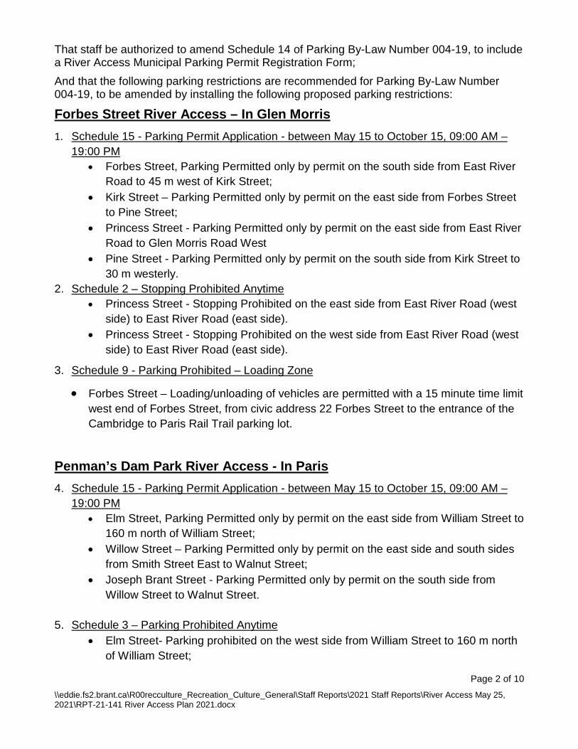
That staff be authorized to amend Schedule 14 of Parking By-Law Number 004-19, to include a River Access Municipal Parking Permit Registration Form; And that the following parking restrictions are recommended for Parking By-Law Number 004-19, to be amended by installing the following proposed parking restrictions:
Forbes Street River Access – In Glen Morris 1. Schedule 15 - Parking Permit Application - between May 15 to October 15, 09:00 AM –
19:00 PM • Forbes Street, Parking Permitted only by permit on the south side from East River
Road to 45 m west of Kirk Street; • Kirk Street – Parking Permitted only by permit on the east side from Forbes Street
to Pine Street; • Princess Street - Parking Permitted only by permit on the east side from East River
Road to Glen Morris Road West • Pine Street - Parking Permitted only by permit on the south side from Kirk Street to
30 m westerly. 2. Schedule 2 – Stopping Prohibited Anytime
• Princess Street - Stopping Prohibited on the east side from East River Road (west side) to East River Road (east side).
• Princess Street - Stopping Prohibited on the west side from East River Road (west side) to East River Road (east side).
3. Schedule 9 - Parking Prohibited – Loading Zone
• Forbes Street – Loading/unloading of vehicles are permitted with a 15 minute time limit west end of Forbes Street, from civic address 22 Forbes Street to the entrance of the Cambridge to Paris Rail Trail parking lot.
Penman’s Dam Park River Access - In Paris 4. Schedule 15 - Parking Permit Application - between May 15 to October 15, 09:00 AM –
19:00 PM • Elm Street, Parking Permitted only by permit on the east side from William Street to
160 m north of William Street; • Willow Street – Parking Permitted only by permit on the east side and south sides
from Smith Street East to Walnut Street; • Joseph Brant Street - Parking Permitted only by permit on the south side from
Willow Street to Walnut Street.
5. Schedule 3 – Parking Prohibited Anytime • Elm Street- Parking prohibited on the west side from William Street to 160 m north
of William Street;
Page 2 of 10 \\eddie.fs2.brant.ca\R00recculture_Recreation_Culture_General\Staff Reports\2021 Staff Reports\River Access May 25, 2021\RPT-21-141 River Access Plan 2021.docx
• Mick Jones Way – Parking prohibited on the east side from Willow Street to Smith Street East;
• Mick Jones Way – Parking prohibited on the west side from Willow Street to Smith Street East;
• Joseph Brant Street - Parking prohibited on the north side from Willow Street to Walnut Street.
• Penmans Dam Park River Access Laneway – Parking Prohibited on the west side from Willow Street to 15 m west of Willow Street.
6. Schedule 2 – Stopping Prohibited Anytime • Willow Street – Stopping prohibited on the west side and north sides from 100 m
North/East of Hampton Street to William Street; 7. Schedule 9 - Parking Prohibited – Loading Zone
• Penmans Dam Park River Access Laneway – Loading/unloading of vehicles are permitted with a 15 minute time limit from 15 m west of Willow Street to 35 m west of Willow Street.
Bean Park River Access - In Paris 8. Schedule 15 - Parking Permit Application - between May 15 to October 15, 09:00 AM –
19:00 PM • Race Street - Parking Permitted only by permit on the east side from Spencer
Street to 120 m north of Spencer Street; • Spencer Street – Parking Permitted only by permit on the north side from Race
Street to Ball Street; • Charles Street - Parking Permitted only by permit on the east side from Spencer
Street to Patterson Street. 9. Schedule 3 – Parking Prohibited Anytime
• Race Street - Parking prohibited on the west side from Spencer Street to 120 m north of Spencer Street;
• Spencer Street – Parking prohibited on the south side from Race Street to Ball Street;
• Charles Street - Parking prohibited on the west side from Spencer Street to Patterson Street.
• Bean Park River Access Laneway – Parking Prohibited on both sides from Spencer Street/Race Street intersection to 100 m east of the Spencer Street/Race Street intersection.
10. Schedule 9 - Parking Prohibited – Loading Zone • Bean Park River Access Laneway – Loading/unloading of vehicles are permitted with
a 15 minute time limit from 100 m east of Spencer Street/Race Street to 135 m east of Spencer Street/Race Street intersection.
Page 3 of 10 \\eddie.fs2.brant.ca\R00recculture_Recreation_Culture_General\Staff Reports\2021 Staff Reports\River Access May 25, 2021\RPT-21-141 River Access Plan 2021.docx
Strategic Priority 1- Sustainable and Managed Growth 2- Effective Communication 3- Economic Resilience 4- Reliable Infrastructure 5- Healthy, Safe, and Engaged Citizens 6- Stable and Responsive Governance
Financial Considerations The proposed river access mitigation strategies for the 2021 season will require increased staffing for enforcement and additional signage related to parking restrictions. The estimated cost to up-staff for by-law enforcement for the 2021 season is estimated at $70,000. It is anticipated some costs will be offset by revenue generated from enforcement. Additional signage placed at the three river access points related to parking restrictions is estimated at $2,000 per location for a total of $6,000, with sufficient fund available in the 2021 sign operating budget.
Executive Summary The amended Brant River Access 2021 User Mitigation Strategy has been guided by the significant public feedback received by residents and users through the public engagement process. While there were a number of differing opinions received, the majority of feedback indicated that residents are in support of taking steps to control the number of users, with support for a seasonal residential parking permit system for the 2021 season. The proposed parking permit system requiring permits has been revised to remove fees and simplify the registration process, scale back on the restrictions in the three (3) area zones to alleviate concerns on impacts to community facilities and address comments received on lack of necessity for broad areas to be included, and increase the proposed fine for the penalty for parking violations. The amended mitigation strategy will be monitored throughout the 2021 season, and is scalable to respond to concerns that may arise. In addition, significant feedback was provided on concerns related to broader management and control of the river, which cannot be addressed by the County alone given the interconnectivity of the river and role and mandates of various stakeholders. As such, it is recommended County Council connect with these agencies to express the County’s concerns and request their partnership and cooperation in addressing the issues in a collaborative manner.
Background At the March 2021 Administration and Operations Committee meeting, following a delegation from concerned residents in the Glen Morris area, staff were directed to “develop a more appropriate parking system, including potential for both a Seasonal Residential Parking Permit System and drop off/pick up facilities combined with remote parking,” for the Glen Morris, Bean Park and Penman’s Dam areas, to introduce they system for the 2021 season (May 1 – Oct 30, 2021). Staff were also directed “to develop a more appropriate parking system, including potential for the 2022 budget consideration and implementation of an e-booking system for the 2022 season, such a system would enable the public to research in
Page 4 of 10 \\eddie.fs2.brant.ca\R00recculture_Recreation_Culture_General\Staff Reports\2021 Staff Reports\River Access May 25, 2021\RPT-21-141 River Access Plan 2021.docx
advance the availability of parking or be directed to other available locations for river access and parking and reserve such sights to better manage the resources of the County of Brant.”
A staff report, RPT-21-94, River Access Parking System and Mitigation Plan, 2021 Season, was considered by the Administration and Operations Committee, at the April 20, 2021 meeting. The recommendations contained in this staff report were deferred by Committee and Council for one meeting cycle to conduct further consultation with local residents.
Report
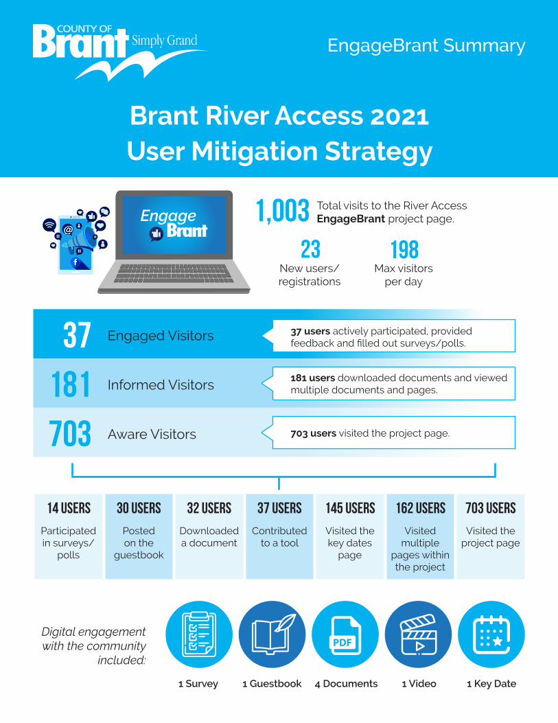
Advertisement, Communication and Engagement Process Overview Public input, advice, and concerns, obtained through a variety of advertisements, communications and engagement opportunities, have shaped the refinement of the Brant River Access 2021 User Mitigation Strategy. The following section provides a synopsis of the mechanisms used to generate community input. Engage Brant The dedicated Engage Brant website served as a portal for all information and engagement activities. The website included a comprehensive overview of the mitigation proposals, relevant documents and resources, information about engagement events and opportunities to provide feedback, including an online survey and guestbook. A summary of engagement data including survey results collected from participants on the Engage Brant page may be reviewed in Attachment 1. County Social Media The County utilized its Facebook, Instagram and Twitter feeds to advertise information related to engagement opportunities. Public Notices Formal, hard copy notices were mailed to local residents and members of the community in and around the three public river access points discussed in RPT-21-94 (Eric Thomlinson in Glen Morris, and Penman’s Dam Park and Bean Park in Paris). The purpose of the public notice was to advise of the public engagement opportunities and to promote and encourage participation. Dedicated Email Address A dedicated email address ([email protected]) was created and advertised to receive all specific comments, questions, advice and concerns. Virtual Town Hall On May 12, 2021, the County hosted a virtual town hall, via Zoom webinar link. The meeting was designed to encourage broad participation through a variety of formats (PowerPoint presentation, facilitated discussion through professional facilitator Glenn Pothier, of GLPi and question and answer opportunities between the public and staff panelists). A summary of the results of polling questions asked of participants during the course of the evening may be reviewed in Attachment 2.
Page 5 of 10 \\eddie.fs2.brant.ca\R00recculture_Recreation_Culture_General\Staff Reports\2021 Staff Reports\River Access May 25, 2021\RPT-21-141 River Access Plan 2021.docx

Summary of Participant Feedback The engagement process generated significant feedback, ideas and actions to inform the refinement of the mitigation strategy. The following is a high-level synopsis of the overarching recurring comments, concerns and / or advice received through all engagement activities. Namely, the proposed seasonal residential parking permit system, parking restriction areas and associated signage, shuttling / off-site parking options, enforcement of seasonal parking restrictions and parking violations, commercial outfitters, tourism and the County’s engagement process. This synopsis is not intended to be a verbatim summary of all feedback received. Any correspondence received by the Clerk, following the authoring of this report, would be attached to the agenda as correspondence.
Seasonal Residential Parking Permit System The overwhelming sentiment expressed by participants was that any parking system implemented by the County must favour the community within which it is being established. It was repeatedly noted that a fair parking permit system cannot be approached with a one-size-fits-all mindset. The vast majority of participants noted their strong opposition to a paid parking permit system for residents. A variety of suggestions were provided with respect to parking permits being issued to residents, including that no less than two no-cost parking permits per household be issued.
Signage for Parking Restriction Areas A variety of comments were received with respect to proposed parking restriction areas and associated signage. Of particular concern to participants was what type of assessment would be undertaken in order to properly understand the effect that restricted parking in one area might then have on unrestricted parking in other areas. Other comments received ranged from concerns about emergency access and public safety to disregard for existing signage and private property.
Shuttling / Off-Site Parking Options Participants encouraged the reconsideration of a shuttle / off-site parking option. There were comments received that perhaps a pay-to-use shuttle could be provided by the County and off-site parking options such the Brant Sports Complex or the South Dumfries Community Centre could be further explored.
Enforcement of Seasonal Parking Restrictions and Parking Violations A broad range of opinions were collected regarding the enforcement of seasonal parking restrictions. It was suggested that a detailed enforcement plan should be shared with residents, before it is implemented. Concern was expressed with regard to the existing By-law Enforcement Officer staffing complement and the perceived short-comings of a complaint-only based system of By-law enforcement. Several participants suggested that a By-law Enforcement Officer be stationed on-site, full-time on weekends and long weekends to assist with educating tourists and, where necessary, enforce parking restrictions.
Commercial Outfitters and County of Brant Tourism
Page 6 of 10 \\eddie.fs2.brant.ca\R00recculture_Recreation_Culture_General\Staff Reports\2021 Staff Reports\River Access May 25, 2021\RPT-21-141 River Access Plan 2021.docx

A prominent theme expressed by participants was one of feeling “penalized” for living near a public river access point. Questions were posed as to why residents are being asked to consider paying to park, or, have limited parking in front of their residences, in order to accommodate the business operations of commercial outfitters and the perceived “over promotion” of the County by the County’s Tourism division. Additional comments were heard from resident participants with respect to loss of enjoyment of personal property, increased litter and noise, and general feelings of being disrespected by people using the public river access points. Suggestions were made for stringent monitoring of commercial outfitter operations and the implementation of a fee to utilize public river access points. Comments were also received regarding directing tourists and commercial outfitters to a centralized access location where paid river access, parking staff, transportation to and from Brant Park (or other centralized points) would allow for better emergency service access, mitigate neighbourhood issues and facilitate revenue generation opportunities for the County.
Engagement Process Many participants expressed support and thanked County staff for their work. Several participants expressed concern that the first iteration of the mitigation strategy had been developed with little to no public engagement or consultation. While some participants indicated that County staff are “on the right track,” others said that more engagement should be conducted. Feedback was also received about the polling questions utilized at the virtual town hall and the utilization of the data collected.
Amended River Access Mitigation Strategy Seasonal Residential Parking Permit System Public feedback received through EngageBrant and the Virtual Town Hall indicates that the majority of residents are in favour of a parking permit system in 2021, with some amendments to the original plan. The updated strategy recommends that permits are issued to residents free of charge. Concerns with payment for a permit were expressed by members of Council at the April Administration and Operations Committee meeting, and a significant number of comments were received by members of the public in opposition to charging any fee. The updated plan also recommends that residences within the permit area zones have the opportunity to register for one (1) parking permit per address. It is further proposed that each parking permit allow for up to four (4) licence plates, for vehicles registered at the permit address. Each vehicle would be provided a tag for display. Following approval of the revised plan, communication will be sent out to affected residents within the permit area zones with detailed instructions on how to register for a permit. There was some public feedback received with questions related to guest parking. Given the current conditions of the pandemic and current restrictions regarding social gatherings, it is recommended that consideration for guest parking be deferred, with the opportunity to be revisited should restrictions loosen. During this period, residents are encouraged to register for a parking permit, and may park on street to allow for guest parking in the driveway. Staff have also reviewed and updated the proposed area zones that would require a parking permit for on street parking and some of the other no stopping and parking prohibited areas. Based on public feedback, each proposed area zone has been scaled back, given concerns
Page 7 of 10 \\eddie.fs2.brant.ca\R00recculture_Recreation_Culture_General\Staff Reports\2021 Staff Reports\River Access May 25, 2021\RPT-21-141 River Access Plan 2021.docx

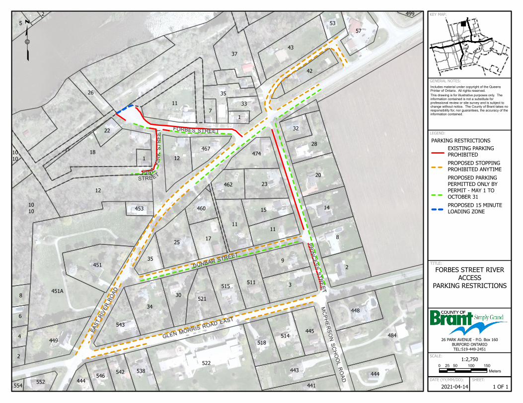
expressed regarding impact to other community facilities, and suggestions that the proposed span of area zones may not be necessary. The updated area zones are referenced in Attachment 3 – Aerial View – Glen Morris River Access, Attachment 4 – Aerial View – Penman’s Dam Park River Access, and Attachment 5 – Aerial View – Bean Park River Access. The original area zones from RPT-21-94, are attached for referenced in Attachment 6 – Aerial View – Glen Morris River Access, Attachment 7 – Aerial View – Penman’s Dam Park River Access, and Attachment 8 – Aerial View – Bean Park River Access. At the Eric Thomlinson Access Point, the majority of public feedback indicated a desire to scale back on the restrictions, in order to limit the consequences restrictions could have on the church, school, and community centre. The permit area zone has been significantly modified to remove proposed restrictions on East River Road, Glen Morris Road East, and Dunbar Street. At the Penman’s Dam Park River Access, Walnut Street has been removed from the permit zone area. The no stopping zone has also been extended on Willow Street. At the Bean Park River Access, Race Street south of the River Access point and Ball Street have been excluded from the permit area zone, as public feedback suggested that these areas may not require permitting. As the revised permit area zones have been reduced in size, it is noted that these areas will be monitored by By-Law Enforcement staff throughout the season, supplemented by feedback the County may receive from area residents, to determine if there is a need to scale up the area zones to place additional restrictions/permit streets. Comments were also received regarding the necessity of parking permits during off peak time periods. After further review, it is proposed that parking permits in the area zones be required from May 15th to October 15th, noting that for the 2021 season, enforcement would begin on July 1st. In addition, for permit streets in the area zones, permits would be required for day time use, between 9 a.m. and 7 p.m., rather than 24 hours per day. This would also alleviate potential enforcement issues, as the OPP have indicated that resources for enforcement after hours would be limited. Signage for Parking Restriction Areas All signs shall be erected in accordance with Regulation 615 of the Highway Traffic Act, as well as the Ontario Traffic Manual. The above noted work will be completed once the necessary by-laws have been approved by County Council concurrently with this report, and the regulations have been amended.
Enforcement of Seasonal Parking Restrictions
Noting general public support for additional enforcement of the river access sites, staff recommend the recruitment of additional by-law enforcement staff resources to station at each of the three river access points for the expected peak periods of the season and times of day, including weekends and holidays. On site staffing may adapt over the course of the season as trends in higher activity times are responded to. The additional staffing will be needed to inform and educate visitors on the parking restrictions, and ticket non-conformance.
Page 8 of 10 \\eddie.fs2.brant.ca\R00recculture_Recreation_Culture_General\Staff Reports\2021 Staff Reports\River Access May 25, 2021\RPT-21-141 River Access Plan 2021.docx

Parking Violations Public feedback received indicated support to increase the penalty set for parking in a municipal permit only area, and some expressed that the increase from $30.00 to $80.00, if paid within seven (7) days of issuance, was not a large enough increase to deter some visitors. Staff note that the recommended fine increase must be approved by the Ministry of Attorney General’s Office, but believe that a higher fine may be approved in the circumstances. As such, it is recommended the fine increase to $95.00 if paid with seven (7) days of issuance, and $110.00 if paid within fifteen (15) days of issuance. Commercial Outfitters Staff received feedback from one commercial outfitter requesting that commercial permits be allowed in 2021, noting their shuttle service does not impact the parking capacity and the pandemic’s general detrimental impact to the tourism industry. While staff appreciate the concern, much of the general public’s feedback related to concerns around capacity, volume, congestion and safety at all three sites. Accordingly, staff recommend that commercial permits are not granted for commercial operators for the 2021 season. Tourism and the R.S.V.P. Program The Responsible Safe Visitation is our Priority in Brant Plan (R.S.V.P.) is underway, and all marketing with respect to river access this season will be restricted or adjusted to (a) focus on other less popular destinations away from paddling and/or (b) keep any paddling marketing pointing to the commercial outfitters and away from the public launching sites in Brant. Summary Staff feel that the public engagement for this matter was extremely valuable, and has strengthened the proposed plan for the 2021 season. There are many differing opinions from the public on river access within the County of Brant, and staff believe the amended strategy balances all feedback received under the current timelines and circumstances. Staff also received excellent suggestions on future considerations for the access points, including study on river capacity and environmental concerns, potential for other access point locations, consideration for shuttling options, and paid municipal parking or paid river permit systems, among others. Staff will monitor the success of the 2021 mitigation strategy and report to Council in the fall. Acknowledgement The author of this report would like to extend appreciation to the numerous staff who contributed to the development of this report.
Attachments 1 – EngageBrant Summary 2 - Brant River Access Virtual Town Hall, May 12, 2021 - Polling Question Results 3 – REVISED Aerial View – Glen Morris River Access 4 – REVISED Aerial View – Penman’s Dam Park River Access 5 – REVISED Aerial View – Bean Park River Access 6 – ORIGINAL Aerial View – Glen Morris River Access
Page 9 of 10 \\eddie.fs2.brant.ca\R00recculture_Recreation_Culture_General\Staff Reports\2021 Staff Reports\River Access May 25, 2021\RPT-21-141 River Access Plan 2021.docx

7 – ORIGINAL Aerial View – Penman’s Dam Park River Access 8 – ORIGINAL Aerial View – Bean Park River Access
Copy to 1. SMT 2. K. Ballantyne, Director of Parks and Facilities 3. L. Jackson, Project Manager, Community & Protective Services 4. R. Press, Director of Economic Development & Tourism 5. G. Demers, Director of Roads 6. J. DeMunck, Roads Operations Manager 7. R. Knap, Road Operations Technologist 8. K. McAllister, Road Superintendent 9. S. McDonald, Road Superintendent 10. B. McDonald, Road Superintendent 11. G. Bergeron, Manager of Enforcement and Regulatory Services 12. J. Bishop, Parks and Facilities Supervisor 13. Sgt. A. Hampson, Brant County OPP
File
In adopting this report, is a bylaw or agreement required? If so, it should be referenced in the recommendation section. By-law required (Yes) Agreement(s) or other documents to be signed by Mayor and /or Clerk (No) Is the necessary by-law or agreement being sent concurrently to Council? (Yes)
Page 10 of 10 \\eddie.fs2.brant.ca\R00recculture_Recreation_Culture_General\Staff Reports\2021 Staff Reports\River Access May 25, 2021\RPT-21-141 River Access Plan 2021.docx
EngageBrant Summary
Brant River Access 2021 User Mitigation Strategy
Total visits to the River Access EngageBrant project page.1,003
23New users/registrations
198Max visitors
per day
37 Engaged Visitors
181 Informed Visitors
703 Aware Visitors
37 users actively participated, provided feedback and filled out surveys/polls.
181 users downloaded documents and viewed multiple documents and pages.
703 users visited the project page.
14 users 30 users 32 users 37 users 145 users 162 users 703 users
Participated in surveys/
polls
Posted on the
guestbook
Downloaded a document
Contributed to a tool
Visited the key dates
page
Visited multiple
pages within the project
Visited the project page
1 Key Date1 Survey 1 Guestbook 4 Documents 1 Video
Digital engagement with the community
included:
@@

How did the community find the River Access project on EngageBrant?
370 Facebook Social Media
51 Google Search Engine
23 County of Brant’s website Referral
17 Oceanhero.today Referral
13 Android app Referral
5 Other Referral
2 Twitter Social Media
1 News Manager (brant news) Referral
@@
Are you concerned with the number of visitors who utilize the County of Brant’s public River Access Points?
Yes (11 responses)
No (3 responses)
The County has proposed a Municipal Parking Permit System for the 2021 season to mitigate the number of visitors this year. Are you in favour of this proposal?
Yes (2 responses)
No (12 responses)
Staff have been directed to research the implementation of an e-booking system for the 2022 season, enabling the public to research in advance the availability of parking or be directed to other available locations for river access. Would you use such a system?
Yes (6 responses)
No (8 responses)
42% (30 responses)County of Brant resident living outside of any of the proposed parking permit areas
19% (14 responses)Resident within the proprosed parking permit area of the Penman’s Dam launch point
17% (12 responses)Resident within the proprosed parking permit area of the Bean Park launch point
15% (11 responses)Resident within the proprosed parking permit area of the Eric Thomlinson launch point
7% (5 responses)Non County of Brant residents
Where our respondents live in relation to a River Access launch point:
Survey Results

Brant River Access Virtual Town Hall, May 12, 2021 Polling Question Results
How often do you or members of your immediate family typically visit one of the County of Brant’s public River Access park areas during the summer months (May to October)? (70 total responses)
9% Once per season (6 respondents)
3% Never(2 respondents)
16% 2 to 5 times per season(11 respondents)
73%More than 5 times
per season (51 respondents)
Are you concerned with the number of users who visit the County of Brant’s public River Access park areas? (71 total responses)
11%No concerns
24%Yes, I am concerned
for other reasons not listed
61%Yes, parking
overflow onto nearby streets concerns me
65%Yes, visitor
attitudes and behaviours
concerns me
76%Yes, environmental
harm to the river/park areas
concerns me
Half 50%
8/71 responses
17/71 responses
43/71 responses
46/71 responses
54/71 responses
15% (11 responses)Resident within the proprosed parking permit area of the Eric Thomlinson launch point
17% (12 responses)Resident within the
proprosed parking permit area of the Bean Park
launch point
19% (14 responses)Resident within the proprosed
parking permit area of the Penman’s Dam launch point
42% (30 responses)County of Brant resident living outside of any of the proposed parking permit areas
7% (5 responses)Non County of Brant residents
Where our respondents live in relation to a River Access launch point: (72 total responses)
Do you believe it is important for some variation of a parking permit system be in place for the 2021 season? (73 total responses)
68%(50 responses)
32%(23 responses)
32%
68%

GLEN MOR
RIS ROAD
EAST
GLEN MOR
RIS ROAD
EAST
PINE
STREETPINE
STREET
EAST RIVER ROAD
EAST RIVER ROAD
FORBESSTREETFORBESSTREET
KIRKSTREET
KIRKSTREET
PRINCESS STREET
PRINCESS STREET
MCPHERSONSCHOOLROAD
MCPHERSONSCHOOLROAD
DUNBAR S
TREET
DUNBAR S
TREET
4
22
35
3
14
499
8
543
453
467
23
20
554
5
1010
1010
451A
538
12
25
460
521
522
42
448
552
18
37
9
32
445
443
53
8
2
449
451
12
117
17
462
515
35
33
43
2
444
542
1
30
1
514
28
57
6
26
11
474
518
444
484
2
546
34
511
15
11
441 1 OF 1 SHEET:
2021-05-19 DATE (YY/MM/DD):
0 50 100 15025Meters
1:2,750 SCALE:
26 PARK AVENUE - P.O. Box 160BURFORD ONTARIOTEL:519-449-2451
FORBES STREET RIVERACCESS
PARKING RESTRICTIONS
TITLE:
PARKING RESTRICTIONSEXISTING PARKINGPROHIBITED
PROPOSED STOPPINGPROHIBITED ANYTIME
PROPOSED PARKINGPERMITTED ONLY BYPERMIT - MAY 15 TOOCTOBER 15
PROPOSED 15 MINUTELOADING ZONE
LEGEND:
Includes material under copyright of the QueensPrinter of Ontario. All rights reserved..
This drawing is for illustrative purposes only. Theinformation contained is not a substitute forprofessional review or site survey and is subject tochange without notice. The County of Brant takes noresponsibility for, nor guarantees, the accuracy of theinformation contained.
GENERAL NOTES:
KEY MAP:

WALNUT STREET
WALNUT STREET
MULH
OLLA
ND DRIVE
MULH
OLLA
ND DRIVE
ELM STR
EET
ELM STR
EET
WILLIAM STRE
ET
WILLIAM STRE
ET
WILLO
W STR
EET
WILLO
W STR
EET
JOSEPH
BRANTSTREET
JOSEPH
BRANTSTREET
ELM LAN
E
ELM LAN
E
BALMORAL
STREET
BALMORAL
STREET
SMITH STREET EAST
SMITH STREET EAST
WALNUT
LANEWALNUT
LANE
MICK JO
NES W
AY
MICK JO
NES W
AY
PORTLANDSTREETPORTLANDSTREET
HAMPTONSTREET
HAMPTONSTREET
NIMMO
STREET
NIMMO
STREET
185
115
109
99
62
62
15
20
79
84
66
29
27
31
67A67
30
68
30
30
7573
63
78
151
187
26
111
110
107
25
106
102
107
99
105
97
13
129
89
139B
22
83
19
23A
22
10
14
15
13
55
44
24
31
98
61
21
133
10
3
139A
31
80
35
30
69
27A
79
2
30
30
160
169
193
33
112
27
105
121
55
95
59
94
92
4
18
7
86
135
19
17
32
85
77
30
21
29
77
3030
8
24
18
11
42
30
116
19
125
93
87A87
8
30
71
33
19
27
30
23
28
21
16
167
38
191
34
32
46 48
39
116
58
101
97
127
89
232527
21
16
33
25
30
6
74
30
12
5957
29
100
123
90
91
81
30
70
81
17
30
25A
71
4
75
66
20
9
27
149
165
6
28
35
50
108
2
54
23
56
88
4
104
60
53 57
96
101
88
83
137
87
82
75
18
73
23
25
34
32
64
1719
61
7
1 OF 1 SHEET:
2021-05-18 DATE (YY/MM/DD):
0 50 100 15025Meters
1:2,750 SCALE:
26 PARK AVENUE - P.O. Box 160BURFORD ONTARIOTEL:519-449-2451
PENMANS DAM PARKRIVER ACCESS
PARKING RESTRICTIONS
TITLE:
PARKING RESTRICTIONSEXISTING PARKINGPROHIBITED
PROPOSED STOPPINGPROHIBITED ANYTIME
PROPOSED PARKINGPROHIBITED ANYTIME
PROPOSED PARKINGPERMITTED ONLY BYPERMIT - MAY 15 TOOCTOBER 15
PROPOSED 15 MINUTELOADING ZONE
LEGEND:
Includes material under copyright of the QueensPrinter of Ontario. All rights reserved..
This drawing is for illustrative purposes only. Theinformation contained is not a substitute forprofessional review or site survey and is subject tochange without notice. The County of Brant takes noresponsibility for, nor guarantees, the accuracy of theinformation contained.
GENERAL NOTES:
KEY MAP:

ANN STREETANN STREET
RACE STR
EET
RACE STR
EET
CHARLES STR
EET
CHARLES STR
EET
SPENCER STREET
SPENCER STREET
PATTERSON
STREET
PATTERSON
STREET
AMELIA
STREET
AMELIA
STREET
BALL S
TREET
BALL S
TREET
5
33
18
52
58
58
60
73
17
18
82
9
93
10
22
26
28
30
36
59
50
85
62
84
45
16
89
101
53
55
79
87
20
15
87
98
4
7
100
8
9
37
34
51
57
42
63B
1
81
64
16
90
9
103
102
43
24
6
55
40
54
7513
78
76
47
92
3
20
7
4
57
5 3
46
77
83
56
89
66
74
23
80
49
97
95
14
7
2
91
40
94
80
45
47
38
65
58
60
99
21
11
44
42
83
96
104
35
39
49
2
61
63A
62
1719
22
12
48
46
38
1 OF 1 SHEET:
2021-05-18 DATE (YY/MM/DD):
0 50 100 15025Meters
1:2,000 SCALE:
26 PARK AVENUE - P.O. Box 160BURFORD ONTARIOTEL:519-449-2451
BEAN PARK PARK RIVERACCESS
PARKING RESTRICTIONS
TITLE:
PARKING RESTRICTIONSEXISTING PARKINGPROHIBITED
PROPOSED PARKINGPROHIBITED ANYTIME
PROPOSED PARKINGPERMITTED ONLY BYPERMIT - MAY 15 TOOCTOBER 15
PROPOSED 15 MINUTELOADING ZONE
LEGEND:
Includes material under copyright of the QueensPrinter of Ontario. All rights reserved..
This drawing is for illustrative purposes only. Theinformation contained is not a substitute forprofessional review or site survey and is subject tochange without notice. The County of Brant takes noresponsibility for, nor guarantees, the accuracy of theinformation contained.
GENERAL NOTES:
KEY MAP:
GLEN MOR
RIS ROAD
EAST
GLEN MOR
RIS ROAD
EAST
PINE
STREETPINE
STREET
EAST RIVER ROAD
EAST RIVER ROAD
FORBESSTREETFORBESSTREET
KIRKSTREET
KIRKSTREET
PRINCESS STREET
PRINCESS STREET
MCPHERSONSCHOOLROAD
MCPHERSONSCHOOLROAD
DUNBAR S
TREET
DUNBAR S
TREET
4
22
35
3
14
499
8
543
453
467
23
20
554
5
1010
1010
451A
538
12
25
460
521
522
42
448
552
18
37
9
32
445
443
53
8
2
449
451
12
117
17
462
515
35
33
43
2
444
542
1
30
1
514
28
57
6
26
11
474
518
444
484
2
546
34
511
15
11
441 1 OF 1 SHEET:
2021-04-14 DATE (YY/MM/DD):
0 50 100 15025Meters
1:2,750 SCALE:
26 PARK AVENUE - P.O. Box 160BURFORD ONTARIOTEL:519-449-2451
FORBES STREET RIVERACCESS
PARKING RESTRICTIONS
TITLE:
PARKING RESTRICTIONSEXISTING PARKINGPROHIBITED
PROPOSED STOPPINGPROHIBITED ANYTIME
PROPOSED PARKINGPERMITTED ONLY BYPERMIT - MAY 1 TOOCTOBER 31
PROPOSED 15 MINUTELOADING ZONE
LEGEND:
Includes material under copyright of the QueensPrinter of Ontario. All rights reserved..
This drawing is for illustrative purposes only. Theinformation contained is not a substitute forprofessional review or site survey and is subject tochange without notice. The County of Brant takes noresponsibility for, nor guarantees, the accuracy of theinformation contained.
GENERAL NOTES:
KEY MAP:

WILLIAM STRE
ET
WILLIAM STRE
ET
MULH
OLLA
ND DRIVE
MULH
OLLA
ND DRIVE
WALNUT STREET
WALNUT STREET
ELM STR
EET
ELM STR
EET
WILLO
W STR
EET
WILLO
W STR
EET
JOSEPH
BRANTSTREET
JOSEPH
BRANTSTREET
ELMLANE
ELMLANE
SMITH STREET EAST
SMITH STREET EAST
WALNUT LANE
WALNUT LANE
PORTLAND STREETPORTLAND STREET
MICK JO
NES W
AY
MICK JO
NES W
AY
185
115
109
99
62
62
15
20
84
31
67A67
30
68
30
26
111
110
107
25
106
4
102
107
99
105
97
13
89
22
83
23A
15
44
24
31
98
61
81
3
80
69
27A
79
30
30
169
33
112
27
105
55
95
59
9492
18
86
19
17
32
85
77
29
77
42
30
116
19
93
87A87
30
71
33
19
27
30
23
28
21
38
34
32
46 48
39
116
58
101
97
89
21
16
30
74
29
100
90
91
70
81
25A
71
75
66
28
35
50
51
108
2
54
23
56
8 8
4
104
60
53 57
96
101
88
83
79
87
66
82
75
18
73
25
34
32
64
1719
1 OF 1 SHEET:
2021-04-14 DATE (YY/MM/DD):
0 50 100 15025Meters
1:2,000 SCALE:
26 PARK AVENUE - P.O. Box 160BURFORD ONTARIOTEL:519-449-2451
PENMANS DAM PARKRIVER ACCESS
PARKING RESTRICTIONS
TITLE:
PARKING RESTRICTIONSEXISTING PARKINGPROHIBITED
PROPOSED STOPPINGPROHIBITED ANYTIME
PROPOSED PARKINGPROHIBITED ANYTIME
PROPOSED PARKINGPERMITTED ONLY BYPERMIT - MAY 1 TOOCTOBER 31
PROPOSED 15 MINUTELOADING ZONE
LEGEND:
Includes material under copyright of the QueensPrinter of Ontario. All rights reserved..
This drawing is for illustrative purposes only. Theinformation contained is not a substitute forprofessional review or site survey and is subject tochange without notice. The County of Brant takes noresponsibility for, nor guarantees, the accuracy of theinformation contained.
GENERAL NOTES:
KEY MAP:

ANN STREETANN STREET
RACE STR
EET
RACE STR
EET
CHARLES STR
EET
CHARLES STR
EET
SPENCER STREET
SPENCER STREET
PATTERSON
STREET
PATTERSON
STREET
AMELIA STREET
AMELIA STREET
BALL S
TREET
BALL S
TREET
5
33
18
52
58
58
60
73
17
18
82
9
93
10
22
26
28
30
36
59
50
85
62
84
45
16
89
101
53
55
79
87
20
15
87
98
4
7
100
8
9
37
34
51
57
42
63B
1
81
64
16
90
9
103
102
43
24
6
55
40
54
7513
78
76
47
92
3
20
7
4
57
5 3
46
77
83
56
89
66
74
23
80
49
97
95
14
7
2
91
40
94
80
45
47
38
65
58
60
99
21
11
44
42
83
96
104
35
39
49
2
61
63A
62
1719
22
12
48
46
38
1 OF 1 SHEET:
2021-04-14 DATE (YY/MM/DD):
0 50 100 15025Meters
1:2,000 SCALE:
26 PARK AVENUE - P.O. Box 160BURFORD ONTARIOTEL:519-449-2451
BEAN PARK PARK RIVERACCESS
PARKING RESTRICTIONS
TITLE:
PARKING RESTRICTIONSEXISTING PARKINGPROHIBITED
PROPOSED PARKINGPROHIBITED ANYTIME
PROPOSED PARKINGPERMITTED ONLY BYPERMIT - MAY 1 TOOCTOBER 31
PROPOSED 15 MINUTELOADING ZONE
LEGEND:
Includes material under copyright of the QueensPrinter of Ontario. All rights reserved..
This drawing is for illustrative purposes only. Theinformation contained is not a substitute forprofessional review or site survey and is subject tochange without notice. The County of Brant takes noresponsibility for, nor guarantees, the accuracy of theinformation contained.
GENERAL NOTES:
KEY MAP:


![The Brant County Board of Education and the Attorney ... · Eaton v. Brant County Board of Education, [1997] 1 S.C.R. 241 The Brant County Board of Education and the Attorney General](https://img.pdfslide.us/doc/110x75/5c4e0aed93f3c3143648c4a4/the-brant-county-board-of-education-and-the-attorney-eaton-v-brant-county.jpg)