Embed Size (px)
Citation preview

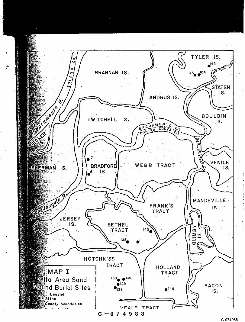
,i " TYLER IS.’-
~162
BRANNAN IS.
~¯ . ¯STATEN¯
ANDRUS IS.
i TWlTCHELL IS, B0.ULDIN
- , :- .:: .,:. - _ ..: : "--i’: :~,,’.. "’.: .-’.." " ." ... "" ".. ¯
.iS.. BRADI . WEBB TRACT., :.".~"-’: ..,. ~ IS. , IS;
’ ’
.: FRANK’SMANDEVILLE
...:. ,,.,~-~,¯- TRACT " "JERSEY
-:- IS. BETHEL "-TRACT ~4o "
: "~’ ’ "." 1~5~ 01
HOTCHKISSTRACT HOLLAND
AP I TRACTArea S~nd ~% o’~
0129 BACONBurial Sites , ~I~8 11146
Legend IS.Sites
boundaries-’--,- :-’,~,.~ VEALE TRACT
C--074987C-074987
TWlTCHELL IS BOULDIN¯ .I S.
" ....... " RVENICE
AN-iS. BRAD.FO [ WEBB TRACT IS..... , ~ IS.
MANDEVILLE’" FRANK’S IS.:: TRACT
dERSEY~,. : :. IS. BETHEL
-. ,TRACT I : i40,
. 1350 01 ::3
HOTCHKISSTRACT HOLLAND
MAP I TRACTArea Sand ~8. ~9
BACONBurial Sites ¯ ~28 t~46 IS.Legend
boundaries
C--074988C-074988
CULTURAL RESOURCES INVENTORY AND EVALUATIONOF
DELTA WETLANDS WATER STORAGE PROJECT,
CONTRA COSTA AND SAN JOAQUIN COUNTIES,
CALIFORNIA
Prepared For:
JONES & STOKES ASSOCIATES, INC.
1725 23rd Street"Sacramento, California
FEBRUARY 24, 1989
Final Report
Submitted By:
PAR & ASSOCIATES
P.O. Box 1607562116 T StreetSacramento, California
C--074989C-074989

CULTURAL RESOURCES INVENTORY AND EVALUATION OF
DELTA WETLANDS WATER STORAGE PROJECT,
CONTRA COSTA AND SAN JOAQUIN COUNTIES,
CALIFORNIA
Prepared For:
JONES & STOKES-ASSOCIATES, INC.
1725 23rd StreetSacramento, California
By:
Mary L. ManieryandKeith A. Syda
With Contributions byJudith Cunningham
FEBRUARY 24, 1988Final Report
Submitted By:° PAR & ASSOCIATES
P.O. Box 1607562116 T StreetSacramento, California
C--074990C-074990

PREFACE
Delta Wetlands proposes to create water storage reservoirs on Webb and Hollandtracts, Bacon and Bouldin islands to impound high winter flows in the Delta region.Plans call for a reconstruction of interior levees on each island to accommodate in-creased erosion from wave action. Water would be stored on the islands from Januarythrough April and would be discharged back into the Delta from May through July. Duringthe remainder of the year activities would focus on creating riparian habitat and opera-tion of duck hunting clubs.
A cultural resources investigation was conducted on the four islands between Sep-tember, 1988 and February, 1989, in compliance with CEQA guidelines and Section 106 ofthe National Historic Preservation Act. These laws protect significant archaeological,architectural, or engineering sites, buildings, distric-Ns, or cultural lifeways impor-tant to interpreting history or prehistory of a region. The work was conducted undercontract between Jones & Stokes Associates and PAR & Associates, both of Sacramento.Mary L. Maniery acted as Principal Investigator during the project. Judith Cunninghamserved as architectural, historian. Archaeological fieldwork was directed by Keith Sydaand Randy Bethard and was completed between December 15, 1988, and January 3I, 1989.The following report documents the results of archival research and field reconnaissanceand provides preliminary significance assessments of cultural resources identified "oneach island.
Twenty-five sites and 22 isolated features or artifacts were identified and re-Corded during the survey. Records have been submitted to the California ArchaeologicalInventory, Northwest Information Center (Holland and Webb tracts), and South CentralInformation Center (Bacon. and Bouldin Islands). Six sites and 22 isolated features orartifacts are not considered potentially eligible to the National Register of HistoricPlaces due to the lack of research potential or lack of integrity. Three prehistoricsites on Holland Tract are potentially eligible to the Register under criterion 36 CFR60.4 (d). Thirteen sites (including 54 standing historical structures) are includedwithin the proposed Bacon Island Historical District and are potentially eligible forinclusion to the Register under 36 CFR 60.4 criteria (a), (b). and (d). Three histor-ical archaeology sites, two on Bouldin and one on Webb Tract, are also potentiallyeligible to the Register under criterion 36 CFR 60.4 (d).
Prehistoric human remains have been identified within the project. These remains,and others that may be present on the islands, are protected under Public Health Codesand Senate Bill 297. Delta Wetlands is advised to work with the Native American Heri-tage Commission in Sacramento to devise appropriate treatment, plans for these sensitiveresources.
Certain information contained in this report is of a confidential nature and PARrecommends that site-specific data not be released to the .general public. Of furthernote, as with any surface survey, vegetation and standing water inhibited ground visi-bility in some areas during the project. In addition, several areas of high prehistoricsensitivity exist on Holland and Webb tract. While no surface indications of prehis-toric u.se was evident at these location, it is possible that subsurface deposits mayexist. If state and federal permits are issued to the project proponent, then thesedeposits are protected under CEQA and Section ! 10(a)(2) of the NHPA. In the event anyhistoric properties are uncovered during the life of the project, Delta Wetlands isrequired to stop work in that immediate vicinity and to contact the SHPO in Sacramentofor a determination of resource significance.
ii
C--074991C-074991

TABLE OF CONTENTS
- PREFACE ii
INTRODUCTION !Scope of Work -~ !Previous Investigations 2
PROJECT GUIDELINES AND METHODS 4Framework for Analysis 4Research Goals "" 6Methods and Techniques 6
Archival Research 6Field Research 8
Bacon Island 8Bouldin Island 0Holland Tract 0Webb Tract 0
Historic Sites Survey 1
ENVIRONMENTAL AND CULTURAL SETTING 6Environmental History 16Prehistoric/Archaeological Setting 16
o. Ethnographic Setting 18Historic Setting 19
Reclamation - 1860- I900 19Reclamation - 1900-1920 21Agriculture 23Other Uses 26
SURVEY RESULTS 28Bacon Island 28Bouldin Island 39Holland Tract 45Webb Tract 49
RESOURCE EVALUATION 55Bacon Island 55Bouidin Island 60Holland Tract 61Webb Tract 61
IMPACTS AND MITIGATION MEASURES 63Impacts on Historic Sites ’ 63Impacts on Prehistoric Sites 64Recommended Mitigation Measures 65
Bacon Island 66Bouldin Island 68Holland Tract 68Webb Tract 68
General Mitigation Recommendations 69
ooo111
C--074992C-074992

SUMMARY AND CONCLUSIONS 70Resources Judged Ineligible 70Sites Judged Potentially Eligible 70Conclusions 72
REFERENCES CITED 73
APPENDICESA. Resource Location MapsB. Site and Isolated Feature Records (Bound Separately)
LIST OF FIGURESI. Vicinity Map 32. Archaeological Survey Coverage Map - Bacon Island 123. Archaeological Survey Coverage Map - Bouldin Island 134. Archaeological Survey Coverage Map - Holland Tract .145. Archaeological Survey Coverage Map - Webb Tract 156. Overview of Camp #2 on Bacon Island 327. Views North and West of Boarding House #14, Camp 3, Bacon Island 348a. Craftsman-style residence at Shima’s Camp #I I, Bacon Island 388b. Bridge Tender’s House on Bacon Island 389. lvledicinal and Ink Bottles from BI-2; dated 1925-1930 4210. Diagnostic Obsidian Tools from CA-CC0-147. ¯ 501 I. George Shima’s office at Camp #3, Bacon Island 59
LIST OF TABLES1. Repositories/Agencies Visited or Contacted 7
,. 2. Summary of Surveyed Acreage 93. Summary of Reclamation Efforts in the Delta Wetlands Project 224. Presently Identified Cultural Resources on Bacon Island 295. Architectural Data Summary of Bacon Island 316. Presently Identified Cultural Resources on Bouldin Island 407. Presently Idefitified Cultural Resources on Holland Tract 468. Presently Identified Cultural Resources on Webb Tract 519. Architectural Data Summary of Bouldin Island, Holland Tract, and
Webb Tract 52
iv
C--074993C-074993

INTRODUCTION
Delta Wetlands proposes to create water" storage reservoirs on Webb and HollandTracts, Bacon Island, .and Bouldin Island to impound high winter flows in the Delta
(Jones & Stokes Associates 1988). The islands are all located in the Sacramento/SanJoaquin River delta and are within Contra Costa and San Joaquin counties (Figure 1).Webb and Holland tracts are situated in southeast Contra Costa County east of Antiochand Oakley. Franks Tract State Recreation Area separates the two tracts. Bacon and
Bouldin Islands are within San Joaquin County and are west and north of Stockton.Bouldin is crossed by state route 12 and is immediately west of Terminous. The southernedge of Bacon Island is bordered by the Southern Pacific Railroad. Old River separatesBacon and Holland from each other while the San Joaquin River flows between Webb and
Bouldin.Ideally, water would be stored on the islands bel~ween January 1 and April 30 a.nd
would be discharged back into the Delta from May to July 3 i. August and September wouldbe used for revegetation and seeding and the islands would be partially flooded between
October and December to create riparian habitat and to facilitate private duck huntingclubs operating during those months. Project alternatives that are .being consideredinclude no project, increasing the amount of water stored on each islands, and inten-sifying agricultural use. The latter alternative would result in a change in the types
of crops currently being grown on Bacon and Bouldin islands, and an increase in weederadication and ditch maintenance .programs on Bouldin Island and Webb Tract. Intenseagricultural use on Holland Tract would require redevelopmer~t of agriculture and ditchmaintenance systems on the island, a weed and rodent control program, reinstitution ofhog feeding, and a shift to orchards and vineyards as a crop type (Jones & Stokes Asso-
ciates 1988).
Scope of Work
In September, 1988, PAR & Associates (PAR) conducted archaeological and historicalrecord searches, limited field reconnaissance, and preliminary assessments of the arch-
aeological sensitivity of the Delta Wetlands project under contract with Jones andStokes Associates (J&S). Based on this work, PAR identified areas of historical sensi-tivity on all four islands and prehistoric sensitivity on Holland and Webb tracts.Historic resources were confined to areas around the perimeters of the islands (on or at
C--074994C-074994

the base of the levees), while, prehistoric resources occurred in azsociation with Pipersoils deposits (Maniery 1988).
Consultation between the State Water Resources Control Board (SWRCB) and J&S ied toan agreement that a 100-percent survey of the identified prehistoric and historically-sensitive areas, in combination with a 20 percent sample survey of each island’s inter-ior, was adequate to identify cultural resources within the Delta Wetlands project. Inaddition, a historic sites survey was recommended for all islands to asses.s the poten-tial significance of standing structures within the project. This report summarizesresults of the record search conducted in September, 1988, and documents the archaeolog-ical and historic sites surveys completed for. each island.
Previous InvestigationsNumerous investigations have been carried out near the Delta Wetlands project since
the advent of cultural resource management laws passed by 1970. The majority of thesehave consisted of inventories and preliminary evaluations and have focused on BethelIsland and the Hotchkiss Archaeological District, both situated west of the project (cf.Bard and Busby 1978; Desgrandchamp and Chavez 1984; Hampson 1985; Jackson and Fredrick-son I979; Jones et al. 1980; Moratto et al. I974; Poswall I978; Weigel 198 I). The StateLands Commission and California Department of Parks and Recreation have also conducted
work in the region (Paterson et. al 1978; Waugh 1986).Two of these projects, conducted by Hampson (1985) and Paterson et. ai (1978), dis-.
cussed resources on all or portions of the four islands currently under study. An ex-tensive historical evaluation of the Delta waterways, prepared by Paterson, Herbert, andWee under a contract with State Lands Commission, included data on all islands within "the Delta Wetlands project. In particular, reclamation work on Bouldin and Bacon Is-
lands was discussed in detail (Paterson et al. 1978). Hampson surveyed 50 acres in thesouthern portion of Holland Tract in 1985 for Jack Williams Ranches but did not locateany cultural resources. Results of these investigations are incorporated into the pre-historic and archaeological summary presented below.
2
C--074995C-074995

Figure 1. VicinityMap3
C--074996(3-074996
PROJECT GUIDELINES AND METHODS
Framework for Analysis
The cultural resources survey was conducted in compliance with the CaliforniaEnvironmental Quality Act and Section 106 of the National Historic Preservation Act.
The National Historic Preservation Act of 1966 (NHPA) as amended (80 Stat. 915, 94 Stat.2987; 16 USC 470) requires federal agencies to inventory, evaluate, nominate, and at-tempt to preserve cultural resources, both on federal lands and on lands over which thefederal agencies have permit, licensing or financial authority. Issuance of a 404permit by the Army Corps of Engineers requires compliance with NHPA.
Section 106 of NHPA directs federal agencies to take into account the effect oftheir "undertakings" on cultural resources and to afford the Advisory Council on His-
toric Preservation an .opportunity to comment. In addition, until it has been determinedthat a resource is not significant, it must be managed as if it were, in compliance withsection 110(a) (2) of the NHPA, which requires that resources be located, inventoriedand assessed for signficance.
Cultural resource significance is evaluated in terms of each resource’s eligibilityfor listing in the National Register of Historic Places (36 CFR 60.4 [48 R 46306]) as
outlined below.
The quality of significance in American history, architecture, archaeologyand culture is present in districts, sites, buildings, structures, and ob-jects of State and local importance that possess integrity of location, de-sign, setting, materials, workmanship, feeling and association and:
(a) That are as, sociated with events that have made a significant contribu-tion to the broad patterns of our history; or
(b) That are associated with the lives of persons significant in our past;or
(c) That embody the distinct characteristics of a type, period, method ofconstruction, or that represent the work of a master, or that possesshigh artistic values, or that represent a significant and distinguish-able entity whose components may lack individual dtstinction, or;
(d) That have yielded, or may be likely to yield, information important inprehistory or history.
Sites younger than 50 years, unless of exceptional importance, are not eligible for theNational Register.
4
C--074997C-074997

An integral part of assessing cultural resource significance, aside from applyingthe above criteria, is the physical integrity of the resource. Prior to assessing aresource’s potential for ~listing on the National Register, it is important to understand
the subtleties of the seven kinds of integrity mentioned in 36 CFR 60.4. To summarize aNational Park Service (NPS) handbook, entitled How to Apply the National Register Cri-teria for Evaluhtion (1982:35-36), the types of integrity are defined as:
o Location is where a historic resource was constructed or where an impor-tant event took place.
o ~ is the basic look and creation of the resource and includes organ-~zatmn of space, proportion, scale, technology and ornament.
o Se.tting applies to the physical environment of the historic or prehis-toric property and Should illustrate the character of the place in whichthe resource played its role.
o Materials includes the artifacts and features deposited at the resourceduring a particular period.
o Workmanship is the physical evidence of the crafts of a particular cul-ture and can apply to buildings, machinery, pottery, and constructiontechniques, for example.
o Feeling is intangible but depends upon the quality of the resource inportraying a sense of the historic past.
o Association is the direct link between a property and an event, person,etc., that makes the property significant.
To qualify for the National Register, a resource must have at least two types of integ-rity and meet one of the criteria listed above.
California Environmental Quality Act (CEQA) of 1970, as amended (Title 14, Cali-fornia Administrative Code, Appendix K 1983:324.13-324.16), requires that five criteria
be considered in assessing cultural properties in compliance with CEQA regulations.These criteria are:
A. Is the resource associated with an event or person of I) recognized sig-nificance in California or AmErican history or 2) recognized scientificimportance in prehistory;
B. Can the resource provide information that is both of demonstrable publico interest and useful in addressing scientifically consequential and rea-
sonable archaeological research questions;
C. Does the resource have a special or particular quality such as oldest,best example, largest, or last surviving example of its kind;
5
C--074998C-074998

D. Is it at least 100 years old and possesses substantial stratigraphic in-tegrity; or
E. Does it involve important research questions that historical researchhas shown can be answered only with archaeological methods.
Research GoalsIn light of the above, the inquiry at this level of research is to determine if any
historic properties within the .project area qualify for listing on the National Registerof Historic Places or meet CEQA criteria. To address this question, a survey was per-formed to locate, identify, record, and assess all cultural resources within the DeltaWetlands project. ~
The specific goals of the survey were:
o Locate, record, and map all cultural resources within areas identifiedas high archaeological sensitivity (i.e., Piper soil areas);
o Survey a 20 percent sample of each island or tract interior;
o Record and map all historic and prehistoric cultural resources identi-fied in the preliminary assessment report;
o Conduct a historic sites survey of standing structures on all islandsbuilt prior to 1946;
o Assess the research potential of all recorded cultural resources with-in the project; and
o Provide a report documenting methods and results of the survey, in-cluding evaluations of significance and assessment of sites in termsof their potential eligibility for listing on the National Register ofHistoric Places and significance under CEQA guidelines, as appropri-ate.
Methods and TechniquesArchival Research. Extensive archival research was completed as part of the pre.-
liminary assessment phase of the initial project (c.f. Maniery 1988) and as part of thehistoric sites survey. Eighteen repositories, agencies, and individuals were visited o.rcontacted by PAR staff and site specific data was collected (Table 1). Research focused
on examining historical maps, written histories,, and census material for each island toidentify landing sites, agricultural camps, and other activity areas originally present
6
C--074999C-074999

Table 1. Repositorles/Agencles Visited or Contacted
Place/Location Information
Northwest Information Center, Sonoma State University* Previously recorded she records, survey reports, excavation field notes, soil suwey data, NationalRegister of Historic Places listings.
South Central Information Center, Californla State University, Stanlslaus* Previously recorded site records and survey reports, National Register of Historic Places listings.
Native American Heritage Commission, Sacramento*+ Native American concerns, sacred areas, referral list o! consultants
William Franklin, lone, Native American concerns
California State Historic Preservation Office, Sacramento* Ethnlc survey data, historic sites sun/ey file, points of historic Interest listings, Native Americanconcerns, architectural data
Califomla Room, California State Llbrary, Sacramento+ Historic maps, county histories.
Government Public~tlons, California State Library, Sacramento+ Historic maps, soil reports.
..j Mlckey Grove.Museum, Lodl+ San Joaquin County records, reclamation district maps.
... San Joaquln County Assessors/Recorders Office, Stockton+ Plats and deeds.
Contra Costa County Assessors/Recorders Office, Martinez, Plats and deeds, reclamation district records.
State Lands Commission, Sacramento* Cultural resources reports.
USDI, Bureau of Land Management, Sacramento+ " General land office plat maps, field notes.
Contra Costa County C~roner’s Office* Burial data
State Department of Water Resources* Past cultural resources re,otis
US Army Corps of Engineers, Sacramento* Past cultural resources repods
Gene Baugh, caretaker+ Site specific information, Holland Tract
Hong Huey, farmer, Local history, site specific Information, Bacon Island
Mr. Marvin, ferry operator+ Local history, site specific Information, Webb Tract
* = contacted by letter or telephone, = visited

in the project that may be represented in the field. Archival research was also con-ducted during the field phase of the project to aid in the identification of construc-tion dates for buildings on the islands and to assess potential site significance.
Field Research. After completing archival research, areas of potential archaeolog-ical sensitivity were identified for each island. Generally, these consisted of anyarea marked as Piper sandy loam or Piper sand on county soil maps (USDA n.d.) and loca-tions of historic resources situated around the perimeter of each island. Aside from
the Piper soils, no areas of high archaeological sensitivity were identified in theinterior portions of the islands. After consultation with SWRCB and J&S, it was decidedthat a survey of a 20-percent sample of each island’s interior, in addition to Pipersoil regions and identified historic locations, would adequately identify culturalresources within the project (Table 2).
Land within all four islands was surveyed by PAR staff using a complete su.rveystrategy. Crew members walked transects spaced 20 to 30 meters apart. Each transectgenerally followed furrows in plowed fields, resulting in precisely spaced coverage overlengthy distances. Fallow fields and pastures were walked with the aid of a compass.Roads and ditches providgd excellent parcel boundaries on all tracts. In some areas,however, the ditches, were uncrossable, making it necessary to survey the parcel in sec-tions or to circumnavigate the ditch and realign on the other side before continuing the
transect.Piper soil areas were located on Holland and Webb tracts and were surveyed using a
complete coverage. North!south or east/west transects were conducted across the pipermound at 20-meter intervals. Road cuts, cut banks, and ditches were examined carefullyfor evidence of any buried deposits. Where necessary, the ground surface was scraped toreveal the mineral surface.
Although sample areas were plotted on maps p~ior to beginning the fieldwork, rain
and seasonal flooding of tracts made it necessary to change strategy in the field.Small flooded areas (0.5 acres or less) were navigated, while large flooded areas wereavoide~l. In the latter case the surveyors walked adjoining, unflooded parcels to ac-count for the unsurveyable acreage.
Bacon IslandExcluding the levees, Bacon Island contains 5,500 acres of land, all used for
agriculture. PAR surveyed 1,095 acres of land, spaced evenly in all four quarters of
8
C--075001(3-075001

Table ~2. Summary of Surveyed Acreage
Island/Tract Surveyable Required No. of No. of Piper Total TotalAcres 20% Sample Interior Soil Acres Surveyed Portion
of Interior Acres Surveyed Acres SampledAcres Surveyed (%)
Bacon 5,360 1,072 1,095 0 1,095 20Island
B ouldln 5,825 1,165 1,460 0 1,460 25Island
Holland 3,690 792 870 221 1,091 30Tract
Webb Tract 4,450 890 890 335 1,225 27I~.
’ ITOTAL 19,325 3,919 4,315 556 4,871 25 O

the island as part of the 20-percent sample (Figure 2). In addition, a cursory inspec-tion of land along the base of the levee was completed by driving slowly on the leveeroad and stopping to field check any likely looking spot or historic location. No Pipersand mounds were present on Bacon Island and ground visibility was excellent in all sur-veyed parcels.
Bouldin Island . ’Bouldin Island contains, over 5,800 acres and is the largest within the project.
Initially, PAR projected that 1,165 acres would need to be surveyed to complete the 20-percent sample. Approximately one-fifth of the island was flooded during the fieldworkand parcels located within the flooded areas were abandoned and new, adjacent parcelswere substituted. Flooded areas were later drained and PAR surveyed 295 additionalacres within these parcels in order to more evenly sample the entire island (Figure 3).Similar to Ba.con Island, no Piper soils were present on the Island and ground visibil.ity ~’
throughout the majority of the parcels was excellent. _~.~ .-
Holland Tract ~PAR sampled 870 acres on Holland Tract, and surveyed an additional 221 acres of
Piper soils. Approximately 800 acres in the southwest quarter of the tract were notsampled due to access limitations. This area contains about 100 acres of Piper sandmounds. In addition, a small lake and marshy area in the northeastern portion of thetract were not sampled (Figu.re 4).
Three Piper soils areas depicted in the Contra Costa County soils survey (USDAn.d.) are no longer visible in the field. One small Piper soil area in the northeastcorner, another in the center, and a third in the southern edge of the tract were notlocated due to lack of mounded topography and dense vegetation. Several mounds havebeen removed by agricultural pursuits in the last 25 years and were not located. Visi-bility was poor in about 120 acres of the sample area surveyed due to heavy vegetatibn;the remaining parcels had excellent ground visibility.
Webb TractSeveral areas of Webb Tract were not accessible to PAR. due to private ownership.
The northeast quarter of the tract, encompassing approximately 600 acres, and a 120-acreparcel in the south central portion of the tract were not included in the sample. In
C--075003(3-075003

addition, a large lake and associated marshland, remnants of a levee break in 1950,prohibited survey of an additional 500 acres in the northcentral portion of Webb.
A total of 890 acres were sampled on the tract (Figure 5). In addition, 302 acresof Piper soils were closely inspected. Several areas of Piper soils identified throughsoil surveys were not located in the field due to leveling of mounds by agriculturalactivities or heavy vegetation. Approximately 140 acres surveyed on Webb Tract con-tained standing water, vegetation, or mud, resulting in poor ground visibility.
Historic Sites Survey. Standing structures on each island were described in termsof architectural design and photographed. If part of a complex, a sketch was made ofthe complex, using existing blue-line topographic maps as a base. Historic structureswere numbered and their physical location in relationship to other buildings in the
" complex was noted. State of California Historic Site Invento~ Forms were completed for
those structures that were constructed before 1946.
II
C--075004C-075004

C--075005C-075005

900cJZO-O
900~LO--O
13

L
Figure 4 Archaeological Survey Coverage Map - Holland Tract
C--075007C-075007


ENVIRONMENTAL AND CULTURAL SETTING , ,~.
Environmental History
Prior to the Pliocene ~ooding of the San FranciSco Bay (approximately 11,000 years
ago) the present day Delta was part of a large river valley of the Lower Sacramento and
San Joaquin rivers. (The environment waslands and savannah ~5ordering the rivers. With the advent of the Pliocene period, sea
levels rose, flooding the lower part of the Sacramento Valley. The rivers slowed their
"flow to the sea and deposition of inorganic and organic matter increased, slowly forming
the Delta marshland. The marshiand, being at or~below sea level,, contained a variety of
ecological zones cut by many sloughs and meanders. Numerous sand mounds provided high
spots throughout the marshes (Desgrandchamps and Chavcz 1984; Hackcl 1966:217-238).
Reclamation ~f the delta marshes began in the 1850s but reached its peak irr the
late 19th and early 20th centuries. During this time levees were built, lhe marshes
were drained, and the subsequent .reclaimed land was utilized for agriculture, pasture
lands, and recreation. Intensive agricultural use has resulted in land subsidence
caused chiefly by intensive pumping of ground water and oxidation of peal lands (Poland
and Evenson 1966:239-248). Today the islands support a variety of crops including po-
tatoes, sunflowers, onion, asparagus, and corn, as well as vineyards on Bacon Island.
Prehistoric/Archaeolo.gica! SettingPrior to Delta reclamation, small hummocks or islands of sand protruded from the
rule marshes of the Delta. Composed primarily of Piper sands and loam, these islands
were above flood level and were used by prehi.storic and ethnographic populations for
villages and/or burial sites. Transportation between the small islands was by rule
canoe. The use of these hummocks allowed for a greater exploitation of the resources in
the Delta, such as waterfowl, fish, freshwater shellfish, and game (Desgrandchanaps and
Chavez 1984: 14). Over time, the sand mounds were often covered with a peat deposit, the
result of repeated, d long-term flooding.
Not, surprisingly, the archaeological sites that have been recorded or excavated todate in the Delta arc all located on small mounds of P, iper fine-grained sandy loam soil,
" remnants of thoseareas that were above sea level in prehistoric times. The archaeo-
- logical record indicates that the earliest recognized prehistoric use of the region
16
C--075009 ~C-075009
dates from approximately 2500 B.C. to 1000 B.C. and has been labeled the Early Horizon(Fredrii::kson 1974); however, it is probable that the Delta region was used much earlier,but that evidence of this use is buried beneath river alluvium or peat deposits (Waugh1986:CR-I !). The Early Horizon is characterized by distinctive shell ornaments andcharmstones, large projectile points with concave ba~es and stemmed points, baked clayballs (used for cooking), fishing implements and grinding tools (Moratto 1984).
Burials were almost always extended, faced down, and were westerly oriented (Heizer1949). Early Horizon burials.have typically been recovered from lower levels of indur-ated sand mounds. Known sites have been discovered through initial exposure by agri-cultural activities; little or no surficial evidence is present at these sites.
The Middle Horizon period in the Delta has been dated from ca. 1000 B~C. to A.D.
500. Sites associated with this period often overlie Early Horizon sites and containsubstantial midden deposits with shell, mammal and fish bone, charcoal, grinding tools,and other artifacts. Increased use of obsidian, shell, and bead assemblages indicate agreater complexity of exchange networks and social stratification during this time per-iod. Burials were flexed, as opposed to extended (Frederickson 1974; Waugh 1986:CR-12-CR-13).
The Late Horizon in the Delta dates from A~D. 500 to Spanish incursion in the
region (approximately A.D. 1800). This phase is marked by large village sites situatedon high ground, use of the bow and arrow (as indicated by small projectile points),presence of shell beads, and increased acorn and nut processing. Deeply serrated pro-jectile points (often referred to as Stockton serrated) and small, convex-based side-
notched projectiles are diagnostic implements used during this period (King 1978:68).Clam shell disc beads, used as a medium of exchange~ continued exchange of commoditiesfor obsidian, and glass trade beads indicate an extensive exchange system in operationduring the kate Horizon (Moratto 1984). The end of the Horizon, within the last 500
years, saw an increase in the use of cremation as a mortuary practice (Johnson 1982:40).The Delta region was occupied into the first quarter of the nineteenth century,
when a combination of epidemics and forced removal to Spanish missions effectivelyeliminated the Native population of the area (Bennyhoff 1977). M0ratto (1984), Waugh(1986), Fredrickson (1974), and Desgrandchamps and Chavez (1984) present summaries ofthe known prehistoric complexes in the region. The reader is referred to the, se sourcesfor detailed overviews.
17
C--07501 0(3-075010

Sixteen archaeological sites have been recorded or excavated within several miles
of the islands: 12 on Bethel island and Hotchkiss Tract, two on Veale Tract, and two onHolland Tract. Ten of these are burial sites with no midden deposit, whereas the re-maining sites contain both burials and midden. Generally, the burials occur in thehard, almost compact sand situated below ttie upper peat deposits, possibly indicatingthat the burials are older than the midden and habitation debris that occur in the morerecent, upper peat deposits (Cook and Elsasser 1956; Desgrandchamps and Chavez 1984:15).In most cases, the burial style is typical of the Early Horizon culture, while the arti-facts and midden deposit materials are more characteristic of the Middle Horizon, lead-ing some investigators to suggest that these sites represent a transition phase betweenthe Early and Middle Horizon (labeled an early Middle Horizon phase) (Cook and Elsasser1956; Waugh 1986:CR-12). The majority of the sites also contain Late Horizon compon-ents.
Fifteen of the resources were found accidentally through plowing, leveling,, orditching. Researchers in the Delta region point out that most of the known burial sitesare impossible to locate from the surface because there is no distinctive accumulationof occupation debris or a soil color change as in midden sites. It is only when thehard, compact sand layer is penetrated through agricultural pursuits, flooding, or otherimpacts that the buri.al deposits are exposed (Cook and Elsasser 1956). This has ledseveral investigators to believe that the recorded sites in the Delta are only a randomsample of what is potentially present, perhaps only a small fraction of the total numberyet to be discovered (Cook and Etsasser 1956:32; Fredrickson 1974).
Ethnographic Setting
Ethnographically, the Delta region was inhabited by, several groups, including theBay Miwok (Contra Costa County), the Plains Miwok (Sacramento County and a portion ofSan Joaquin County), and the Northern Valley Yokuts (San Joaquin River). All of thesegroups relied on ~the rich resources of the Delta for both dietary needs and materialculture. Tules provided material from the stalks that were woven into matting and used
for house and canoe construction and clothing~ while the roots were pounded and used forfood. Acorns, collected on yearly excursions to the foothills and stored in granarybins, provided the dietary staple, complemented by the abundant waterfowl, fish, shell-fish, and large game that lived in or visited the Delta (Bennyhoff 1977; Levy 1978;Waugh 1986).
18
C--075011C-075011

Permanent settlements were located on high ridges or knolls near watercourses or onthe sandy islands in the Delta. The islands were als0 used regularly for hunting andfishing base camps. Social structure was centered around the tribelet, with small sat-ellite villages radiating from a main tribelet center (Kroeber 1925).
The native way of life changed after 1790, with increased forays into the Deltaregion by Spanish soldiers in search of potential mission neophytes. The main rivergroups of the region were forced into the mission system between 1806 and 1813 (Millikeni982). The natives that were not removed to the missions succumbed to European-intro-duced diseases that spread through the Delta between the late 1700s and circa 1835 (Levy1978:400). By the time ethnographers began gathering data in the late 1800s, there werevirtually no survivors of the Delta tribelets (Levy 1978). Ethnographic summaries Ofthe various Native groups who occupied the area are provided in Bennyhoff (I977) andLevy (1978).
Historic SettingHistorical use of the Delta has centered around reclamation, agriculture, and rec-
reation. Several documents have summarized the history of the region, particularlyPaterson et al. (1978) and Waugh (1986), and the reader is referred to those sources foroverviews. The synthesis presented below focuses on those islands included within DeltaWetlands project.
Reclamation - 1860-1900. When the gold rush began in I848 the Delta consisted of aseries of waterways interspersed with islands formed by natural sand levee deposits.American entrepreneurs viewed the area as potential farmland, recognizing the richnessof the upper peat soil deposits. The passing of the Swamp and Overflow Land act of 1850transferred ownership of the Delta from the federal government to the stale and openedup the land for speculation by land developers (Thompson and West 1879). Soon afterreclamation districts were established and attempts to reclaim the islands began inearnest. Bouldin Island was one of the islands included in the Swamp and Overflow Land
act and was included in Swamp Land District No. 22 in 1861; however, no serious attemptsto reclaim the island were made at that time (Paterson et al. 1978:16; San JoaquinCounty).
Massive efforts in the Delta did not begin until the late 1860s, when Chineselaborers laid off from railroad construction provided the work force necessary for theall-out effort. The first of the Bedford islands to be reclaimed was Bouldin Island.
19
C--07501 2(3-075012

Bouldin was owned by the Sargent brothers and Smith until 1871, when ~it was sold toSteven Baker and Company of San Francisco for $12,000 (Thompson and West 1879: 133).Using Chinese labor, Baker and Company constructed a levee around the island and beganplanting crops. Cracks in the levee and annual flooding resulted in the island beingabandoned in 1874, with the owners suffering a $65,000 loss (Paterson et al. 1978: 16).
° In I877 the Island was sold to the Pacific Distillery Company of San Francisco,owned by Henry Voorman, George Oulton and F. and J. Schultz, for $64,000. Using Chineselabor, the Distillery company.spent $250,000 on levee construction and reclamation ef-forts, and completed the project by 1878. In that year over 4,000 acres were in culti-vation and two crops were grown at various times of year: grains and potatoes. Thereclamation of Bouldin was considered to be so ~uccessful that during the big flood of1878 it alone survived with its levee system intact (Thompson and West 1879:43). By1886 the Island was the principal source of potatoes for the San Francisco market (Pat-
erson et al. !978: 16).Early attempts to reclaim Bacon Island were not as successful. In 1872 Henry
Bacon, Sherman Day, and S. C. Hastings purchased a 9,000-acre tract from the Tide LandReclamation Company with the purpose of reclaiming the land and selling it for a profit.A levee was constructed in 1872 and Bacon burned the reclaimed land and planted his
_ first crop during the winter of 1872-1873. In June of 1873 the levee brol<e, the cropwas ruined, and levee Work began again (Paterson et al. 1978:14).
Over the next five years Bacon tried many methods of levee construction, includingdriving piles, using brush mattresses to tie levees together, and using mud from theriver bottom, held together with posts and boards, to form levees. The interior of the
island was also leveed to separate Day’s western holdings from Bacon’s east side proper-ties. Although houses and landings were established on Bacon Island by 1879, reclama-tion efforts were not successful; levees continued to sink into the river due to theunstable peat soils, cracks developed, and the island flooded on a regular basis into
the early I900s (Paterson et al. 1914-1915).Initial reclamation of Webb Tract also occuired between 1870 to 1872, using members
of the Chinese labor force to construct the levees. While not much is known concerning
early reclamation efforts, other than the work was initiated by David Webb and ThomasWilliams, it is documented that the tract was flooded and the Ievee system lost in thewinter of 1872-1873 and reclamation was not attempted again until the twentieth century(Paterson et al. 1978:22; Thompson and West 1882).
20
C--07501 3C-075013

Reclamation 1900-1920. With the exception of Bouldin Island, pea! soil lractsantl islands situated in the interior Delta region were not successfully reclaimed untilafter the invention of various dredging machinery in the late 1800s (Table 3). Theclamshell dredger, hydraulic, dredger, and steam driven dredge allowed for levees to beconstructed using river bottom sediment instead or unstable peat soil. This, in combin-ation with engineering advancements, resulted in the construction of permanent levee.systems that were more resistant to cracks, breaks, and sinkage problems, providing thatthey were constantly maintained (Paterson et al. 1978:21-22).
As with initial levee work, reclamation after 1900 required substantial resourcesof financial capital, consolidated ownership of large tracts of land, and engineering.experience. As an example, in 1904 the levee at Central Landing on Bouldin Islandbroke, washing away the small community situated there. After the break, the waterdepth at ihe place where the levee broke was estimated at 75 feet. Derelict sailingShips loaded with rocks were sunk in an unsuccessful attempt to close the hole. lfi ad-dition, double rows of pilings, fill~d in with sediment were constructed. These effortswere in wdn, however, and further breaks occurred in the same location in 1906 ~and1908. After the last break the island was abandoneduntil 1916, when reclamation workbegan again (Paterson et al. 1978:45).
The final reclamation of all four project islands was the result of the cooperativeventure between three .men: Phillips, Cochran, and Rindge. Based out of Los Angeles,these men began buying tracts of land in the Delta in 1902, with the intention of drain-ing the islands and reselling the newly-acquired farm land for a handsome profit. Ini-tially, individual companies were set up specifically to purc.hase and reclaim each tract
of land (e.g., Holland Land and Water Company, Webb Land Company). By 1912, Phillipshad parted with his partners and had consolidated the separate companies into the Cali-fornia Delta Farms Company (Paterson et al. 1978:23). Through the efforts of the Cali-fornia Delta Farms Company, Holland and Webb Tracts and Bacon Island were finally leveedin i910, ! 912, and I915, respectively,
Sometime before 1910 Phillips worked ou{ an arrangement with George Shima, a Japan-ese farmer who leased farm land and worked in the Delta. Shima arrived in the UnitedStates from Japan in I889 and began working as a laborer at a potato farm along thecoast (Fujita 1980:2; Hata and Hata 1986:56), He grew potatoes experimentally in theDelta in the early 1890s and successfully harvested a crop on Staten Island. Despite amajor financial setback in !895, when a flood destroyed the majority of his crops, he
21
C--07501 4C-075014

Table 3. Summary of Reclamation Efforts on the Delta Wetlands Project
Tract/Island Early Reclamation Effort/ Final Reclamation/ Tenant/Farmer Reclamation District/ KnownCompany Company Organization Date Major Floods
Bacon Island 1872-1877 1915 Shlma (1915- #2028/1918 1873, 1879,Bacon, Day, and Hastlngs Califomla Delta Farms 1936÷) 1907 - 1910(later Bacon Land and Loan Company)
Bouldin Island 1871.1874 1916-1918 Shlma ( car 1904- #22/1861 1874, 1904,Sleven, Baker & Co. 1878 California Delta Farms 1910) #756/19040 1918 1908, 1907,
- Pacific Distillery Company : 1908 - 1916
Holland Tract 1910 1910 Shima (ca. 1910- #2025/1918 1980Holland Land and Water Company Holland Land and 1919)(division of California Delta Farms) Water Company
Webb Tract 1870-1872/? ca. 1912 Shlma (ca. 1910- #2026/1918 1872-1873,Webb Land Company 1919) 1934, 1950,(division of California 1980Delta Farms)
Source: Paterson et al. 1978:22; San Joaquin and Cor~tra Costa Counties Reclamation Records.

persevered and continued to buy and lease land in the Delta (Fujita 1980; Hata and Hata
1986:57).Shima and Phillips were partners and friends. Shima apparently owned stock in the
California Delta Farms Company and worked out an arrangement early in the twentieth cen-tury with Phillips in which the company would obtain unreclaimed land, build levees, andthen lease the holdings to Shima for reclamation and farming purposes. Through~thisarrangement, Shima reclaimed Webb, Holland, Orwood, Empire, McDonald, Shima, Bishop,Cohn, and Henning tracts and King, Medford, Mandeville, and Bacon Islands. At one timehe owned over 4,000 acres of land and leased an additional 25,000 acres (Fujita 1980:3).Between 1889 and 1913 he reclaimed close to 29,000 acres and is credited with reclaiminga total of 102,000 acres of land; 62,000 of these were located in the Delta (Byron Times1912; Fujita 1980a:2).
By 1909 Shima was known as "the Potato King," a man who was credited with estab-lishing the reputation of the Sacramento-San Joaquin River Delta region as a prime agri-cultural region. A true entreprenuer, he was the first to realize that using appealingpackaging methods when shipping his product would aid in marketing. Red bags marked
._ "Shima Fancy" were used to package and ship his potatoes and became his trademark be-tween 1910 and 1926 (Yoshimura 1981:24; 28).
Agriculture. Even before reclamation efforts were successful, the various islandshad landings to accommodate ferry traffic and the loading of crops. Webb Landing, namedfor an early-day owner and located in the extreme northeast comer of the tract, wasestablished by 1885 (McMahon and Minto 1885). Two additional landings were in operationnear Webb in 1901 (Punnett Brothers 1901). Days Lariding, named after Sherman Day, thelandowner, was situated along the Old River levee in the northwest portion of BaconIsland by 1883 (Reid 1883). Day’s ,Landing was also known as the Bee Ranch Landing by
1905 (Quail 1905)., Two landings were established in the southwest comer of Bouldin Island by 1894,Schultz and Central (Compton 1894). Fourteen additional landings had been constructedby 1901 (Punnett Brothers 1901). Central Landing, located in the west central sectionof the island on the levee, was established prior to 1904 and consisted of a hotel,
various houses, barns, and a steamboat wharf (Paterson et al. 1978:45; Punnett Brothers1901). Levee breaks at Central Landing in 1904, 1906, and 1908 resulted in the demiseof the community (Paterson et al. 1978),
23
C--07501 6(3-075016

Only seven landings were still in existence on Bouldin in 1912 (Quail 1912). Ac-
cording to Paterson et al. (1978:39), landings were simple in construction and wereroutinely built. A typical landing consisted of a small pier or floating dock. Strongpilings, often driven in rows, extended along the levee bank for use in securing bargesor large boats for loading and unloading crop, seed, machinery, and other cargo. In
¯gome cases, barges or boats would nose into a cleared area along the levee and securelines to trees or pilings.
The landings were established as a means to transport grains and produce grown onthe islands to markets in San Francisco, Sacramento, and Stockton and were often locatedat agricultural camps or canneries. Along with the reclamation efforts came extensiveconstruction of ditch systems and pump stations around the .islands as a means of drain-
ing water. Agriculture on Bouldin Island was successful by the 1880s and the island was
on its way to establishing its reputation in Delta agriculture, particularly as the homeof asparagus (Paterson et al. 1978:49).
The first attempts to grow asparagus commercially occurred on Bouldin Island in
1892, a venture that eventually led to the region becoming known as the asparagus cap-ital of the world. Asparagus, along with potatoes, beans, and grains, were the primarycrops grown on the islands before I900 (Chan I986: 163). In 1910, Bouldin, Bacon Islandsand Webb Tract were planted in potatoes and onions (Sierra Art and Engineering CompanyI910). RObert Hickmott was operating two asparagus canneries on Bouldin Island in 1905and 1912 (Punnett Brothers 1907; Quail I905, 1912), Both of these structures were builton the levees, with a steam plant installed on pilings over the water and ’ warehousesbuilt on the island. Hickmott lost his canneries when Bouldin Island flooded repeatedlybefore 1916 and moved his operations to Orwood Tract by 1919 (Paterson et al. 1978:49).By 1928 the main crops grown on the islands were again asparagus and potatoes, withcelery, lettuce, and barley also cultivated on Webb and Holland Tracts (Thomas Brothers1928).
Farming was conducted either by large-scale operations or by tenant farmers whorented the land from the landowner. Most of the laborers and tenant farmers before cir-ca 1942 were Asian. Initially Chinese provided the major labor force; after completingthe levee systems they were often hired to begin preparing the land for cultivation andwere kept on as seasonal laborers. Other situations developed where the land ownerleased land to one Chinese person, who then brought in his countrymen to farm (ChanI986:208-209). Chinese farmers were working on BouIdin Island in 1882 and were farming
24
C--07501 7C-075017

more than one-quarter of Bacon Island between 1910 and 1919. Their involvement declinedrapidly after this date (Chan 1986).
By the late 1890s Japanese immigrants were steadily arriving in Amei-ican, joiningthe Chinese work force. The numbers of Japanese coming to the United States, rapidlyswelled during the first two decades of the 20th century. These men quickly replacedthe Chinese as tenant farmers and laborers in some areas of the Delta. This Japanesepopulation was augmented at times by East Indians (1910s) and Philippinos (1920s), butwas the dominant labor force until the forced removal of Japanese from the area duringWorld War II (Maniery and Costello 1986:38-45).
Initially, laborers were housed in bunks or tents on top of the levee high grbund.By 1900, however, Delta .farmers devised a series of camps to facilitate cultivating thevast fields on the islands. Each tract of land was divided into sections, ranging from100 to 500 acres in size. A laborer camp, located within one of the parcels, and usu-ally situated at the base of a levee, was responsible for each section of land, oftengrowing different crops. ~
The camps functioned as autonomous units. Each had its own housing, cooking facil-ities, barn..sheds, horses, and farm implements. In addition, large warehouses, usedfor packing, storing, and processing crops, were often located on tops of levees, inclose proximity to landings or wharfs. Crops were then removed from each camp by bargeor steamboat (Paterson et al. 1978:42-43). A camp foreman was in charge of all thelaborers, the cook, and the stable groom. During the off season the camps were desertedexcept for the foreman, cook, and groom (Chan 1986:209).
While init!ally camps were established to .accommodate Chinese levee builders andagricultural laborers, by 1910 the camps on the islands were being constructed by George
¯ Shima for use during his reclamation efforts and farming ventures: Shima’s camps weresimilar to others constructed in the Delta in that a camp was built for every 400 to 500acres of land and included a place to live, kitchen, and barn. Every two or three camps
had an office (Fujita 1980:3). Shima maintained a consistent work force, arranging his
reclamation efforts and farming activities so that he could keep men employed year round(Paterson et aI. 1978:26). By 1913, he was considered the wealthiest Japanese man inCalifornia, operated a fleet of river barges and boats used to haul his crops to market,and employed hundreds of Japanese, Chinese, and East Indian workers (Hata and Hata 1986:59). Shima also created conditions favorable to the transition of the Japanese from
25
C--07501 8C-075018

~ wage earners to tenant farmers by frequently subleasing his holdings to othe’r Japanese
| farmers (Hata and Hata 1986; Paterson et al. 1978:21-24).
i Asian laborer camps were present on all tracts. A 1917 map of the Delta area de-
: picts 12 camps on Holland Tract, 17 on Webb Tract, I2 on Bacon Island, and none on
Bouldin Island, which was in the process of being reclaimed. Webb and Bacon each had a
headquarters facility as well (Widdows 1917). These camps were all operated by Shima
under a lease to the California Delta Farms Company. In addition, Shima maintained a
residence at Camp l on Bacon .Island and his headquarters office was located in Camp 3 on
Bacon Island (Fujita 1980, 1980a). Following reclamation of Bouldin in 1918, numerous
camps were constructed around the perimeter of that island. Amap published in 1926
depicts 37 camp locations on Bouldin Island (Budd and W.iddows 1926).
The passage of the Alien Land Law in 1913, followed by the amendment of an even
tougher law in 1919, resulted in many Asian tenant farmers moving out of the Delta. The
laws made it difficult for Asians to lease farm Ihnd .after I913 and into the 1930s, al-
though Shima found ways to circumvent the statues and continued to farm on.Bacon Island
until his death in 1926 (Hata and Hata 1986:55). Holland Tract, however, was subdivided
and sold as smaIl-acreage farms to non-Asian owners between i920 and 1922. Webb Tract
was also liquidated by California Delta Farms and sold, as was Bouldin I~land. By 1938
Shima’s widow had sold his holdings in the Delta and given up the leases and the Shima:.
.family moved to New York (Fujita 1980; Hata and Hata 1986:6I).
Japanese continued to work in the Delta as laborers until the outbreak of World War
II, when they were removed from the area .and placed in camps. After the War, .few Japa-
nese returned to the Delta, compared to the "small army" who were working for Shima af-
ter 1910. Of the islands within the project, only Bacon continued to be farmed by Jap-
anese after 1946, maintaining the tradition started by Shima. Today, more than half of
Bacon Island is leased or owned and farmed by Asians,. with labor provided by Mexicans.
Other Uses. The large n’umber of laborers working Bouldin IsIand in the 1920s.re-
sulted in the establishment of a school in the west central area of the island. The
school is noted on a 1926 map as being near the current pumping station; by 1940 it had
been moved approximately one-half mile north (Budd and Widdows 1926; Metsker 1940).
County-records for this school are housed at the San Joaquin County Mickie Grove Museum
in Lodi (Bennett 1988).
.:
26
C--07501 9C-075019

Today, Bacon, Bouldin, and Webb are still used primarily f~r agricultural pursuits.
Portions of Holland and Webb Tracts, and Bouldin Island are used for grazing sheep andcattle. Seasonal sheep camps are established during the summer and fall on Bouldin andWebb, while cattle grazing occurs year round on Holland Tract. In addition, severalhunting clubs were established on Holland Tract in the 1950s; one of these is still in
operation and is used seasonally by members who hunt ducks and other water fowl on theisland. Two small marinas are also present on this tract and are used by year-roundresidents who live in house boats, and by seasonal or weekend recreationalists.
27
C--075020(3-075020

SURVEY RESULTS
Twenty-five archaeological sites and 22 features or isolated artifacts were located
on the four islands. In addition, 54 standing historical structures were inventoried.Resource types range from prehistoric cemeteries and habitation sites to Japanese laborcamps with bunkhouse, cookhouse, washhouse, and other structures. These resources re-present nearly 3,000 years of occupation and land use.
Bacon IslandThirteen agricultural camps, a bridge tender’s house, and two isolated historic
artifacts were recorded on Bacon Island. The camps were constrticted by George Shimabetween 1915 and 1918 and consist of a variety of houses, sheds, garages, washrooms, andbarns (Tables 4, 5).
BC-I: Located at the site .of Shima’s Camp I, BC-1 consists of a two story bunk-
house, a mess hall, detached cookhouse, shower house, toilet facilities, cement cistern,pier blocks, and trash. Artifacts rioted on the surface include glass (clear, aqua,green, amber), metal, and Japanese blue-and-white transferprinted fragments. All build-ings and material are located at the base of the levee. Shima lived at Camp 1 whileworking on the island and it is probable that his residence was tom down and is repre-sented by the pier blocks. The camp is abandoned and the bunkhouse and mess hail are
boarded up at present.Architectural Description. All of the buildings, except for the toilet facility,
are craftsmen in style and are characterized by gable roofs, exposed rafters, multi-
paned windows, and paneled doors. A small, shed roof addition has been added to thesouth side of the mess hall. The toilet house has a shed roof and a concrete floor withsingle-paned windows and may have been built at a later date.
BC-2: Shima’s Labor Camp Number 2 contains two boarding houses (one occupied andone abandoned), a shed, garages, and modern mobile homes situated at the base of the OldRiver levee. In addition, a sheet metal building, probably used as a packing shed atone time, is present on top of the existing levee.
A covered wooden footbridge crosses an irrigation canal that separates one of thegarages from a boarding house. Modem trash was noted around the abandoned building.
28
C--075021-C-075021

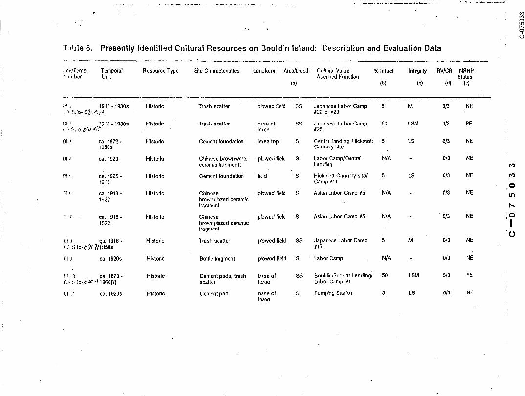
Table 4. Presently Identified Cultural Resources on Bacon Island: Description and Evaluation Data
Site/Temp. Temporal Resource Type Site Characteristics Landform Area/Depth CulturalValue %Intact Integrity RV/CR NRHPNumber Unit Ascribed Function Status
(a) (b) (c) (d) (e}
BC-1 ca. 1913. Architectural/ Structures, trash base of SS Shima’s Japanese Labor 95 LSDAWMF 4/3 PECA-S~:~-~///l~ca. 1960
Histodc scatter, pier blocks levee Camp #1
BC-2 ~’ Z~/2,/1~ ca. 1915 - Architectural/ Structures, trash base of S Shlma’s Japanese Labor 100 LSDAWMF 4/3 PECA-SJo~" present Historic scatter levee Camp #2
BC-3 ca. 1915 - Architectural/ Structures, trash base of S Shima’s Headquarters/ 100 LSDAWMF 4/3 PECA-SJo-O,,~/~/present Histodc scatter levee Japanese Labor Camp
BC-4 ca. 1915 - Architectural/ Structures, trash base of S Shima’s Japanese Labor 10.0 LSDAWMF 4/3 PECA-SJo-~2..~/~pres ent Historic scatter levee Camp #4
BC-5 ca. 1870s - Historical Cement pads, trash base of SS Day Ranch 1873- 19 50 LSM 3/2 PECA-SJo- ~’Jl~’~ 1950 scatter levee Bee Ranch 1901-191"~/
Shlma’s Japanese LaborCamp #5 (after ca 1915)
BC-6 _ ca. 1915 Architectural/ Structure, cement base of SS Shima’s Japanese Labor 75 LSA ,3/3 PECA-SJo-6"~-’~-’~{ Historic pad, trash scatter levee Camp .#6
BO-7 ca. 1915 - ? Architectural/ Structures, trash base of S Shlma’s Ja ~anese Labor 75 LSDAWMF 3/3 PECA-SJo-C’~’~ Histodc scatter, pier blocks levee Camp #8
BO-8 ^,.~l.lca. 1915 - Architectural/ Structures, trash base of S Shlma’s Ja ~anese Labor 100 LSDAWMF 4/3 PECA-SJo- 0Zl/npresent Historic scatter levee Camp #9
BO-9 .,,~d ca, 1915 - Architectural/ Structures, trash base of S Shima’s Japanese Labor 100 LSDAWMF 4/3 PECA-SJo-~’~’’’ present Historic scatter levee Camp #10
BC-10 ., ca. 1915 - Archltectural/ Structures, trash base of S Shlma’s Japanese Labor 100 LSDAWMF 4/3 PECA-SJo-~",?-]q/~ present Historic scatter levee Camp #10 1/2
BC-11 .,~.ca. 1915 - Architectural/ Structures, trash base of S Shlma’s Japanese Labor 100 LSDAWMF 4/3 PECA-SJo- ~’~L’~present Historic scatter levee Camp #| 1
¯
BC-12 ~ll~ ca. 1915- Architectural Structures top and side S Bridge Tender’s 100 LSDAWMF ’ 4/3 PECA-SJo~ present of levee Residence

Table 4. Presently Identified Cultural Resources on Bacon Island: Description and Evaluation Data(concluded)
Site/3"emp. Temporal Resource Type Site Characteristics Landform AreaJDepth Cultural Value % Intact Integrity RV/CR NRHPNumber Unit Ascribed Function Status
(a) (b) (c) (d)
BC-13 ca 1915 - Architectural/ Structures, trash base of SS Shima’s Japanese Labor 100 LSDAWMF 4/3 PECA-SJo-O~.]-~} present Historic scatter levee Camp #12
BC-14 post - 1915 Historic Porcelain fragment plowed field S Japanese N/,~ None 0/3 NENone
B0-15 post - 1915 Histodc Porcelain fragment plowed field S Japanese N/A None 0/3 NENone
I
a. S ,,=Surface deposits; SS = Surface deposits with possible subsurface depositsb. 25 = Historic appearance greatly altered; 50 = Some historic appearance retained; 75 = Most histodc appearance present; 100 = Hlstodc appearance intact; N/A =
not applicablec. National Register of Htstodc Places evaluation criteria: L = Location, S = Setting, D = Design, A = Association, W = Workmanship, M = Materials, F = Feelingd. RV = Research value; ranked from 0 (no value) to 5 (highest value)~ CR = Confidence in the assigned RV; I = Judgement Is more guess than science and Is likely to
be not reliable, 2 = Judgement Is .moderately reliable, 3 = Judgement is most likely to be reliablee, NRHP = National Register o! Historic Places NE = Site Is not eligible for Inclusion on NRHP, PE = Site Is potentially eliglble.

Table 5. Architectural Data Summary of Bacon Island
Temp Descriptive Barns Sheds Bunkhouse Packing Single Boarding Modem Other Total No.No. Name Shed Residence House Structures " of Structures
BC-1 Camp #1 1 - Dining hall, washroom, toilet, 5cookhouse
BC.2 Camp #2 1 1 2 :~ Garage, small ~ootbddge, 9domestla trees
BC-3 Camp #3 2 1 4 1 :~ 11 Laundry room, kllchen, orange 24and acacia trees, woodensidewalks, wooden footbridge
BC-4 Camp #4 1 Duplex, walnut trees and 4grapes, 2 gai"ages
BC-5 Camp #5 Large cement pad, fig trees 0
BC-6 Camp #6 1 3 Cement foundation = 4 ~1
u.) BC-7 Camp #8 1 1 4 Possible office 7
BC-8 Camp #9 1 1 1 6 Garden 9
BC-9 Camp #10 1 1 1 None 3
BC-10 Camp #10-1/2 1 2 3 Cookhouse, fig tree 7
BC-11 Camp #11 - 1 1 5 Yard 7~ BC-12 Bridge Tender’s 1 2 Dock 3
Residence
BC-13 Camp #12 2 1 3 2 20 Bathhouse, 2 duplexes, 31shrubbery, roses

Figure 6 Overview of Camp ~2 on Bacon Island, View East
In addition, fragments of a large,, quart-sized Japanese stoneware sake bottle werelocated near the footbridge, as well as fragments of solarized amethyst-colored glass.
Architectural Description. The two b6arding houses have end-gabled shingled roofswith exposed rafters, paneled doors, porches, and multi-paned windows (Figure 6), Thebuildings are supported by concrete piers. A small shed with a gable and shingled roof,horizontal board siding, and a diamond-shaped louvre in the end gable is located at thenorth end of the camp. Finally, a large (I 15 feet long by 30 foot wide) building ispresent on the levee. This structure has a gabled roof, monitor ’ents and louvres onthe roof, sliding metal doors, and is covered with metal. A collapsed loading dock is
situated on the east side of shed. Given the size and its location near the river, itis probable that the building was used as a packing and processing shed.
32
C--075025C-075025

BC-3: Labor Camp .3 served as George Shima’s headquarters for farming operations inthe Delta and is now the headquarters for Rancho del Rio, a Japanese-owned farming oper-ation. The camp contains 22 structures; half of these date to the initial constructionera. Modem buildings include large metal sheds, trailers, single-family residences,
~ ~ and garages. Pre-1918 buildings consists of three multi-storied boarding houses, two
i barns, four bunkhouses, sheds, a laundry room, and single-family dwellings. Wooden~ , -. walkways and foot bridges connect the boarding houses to each other and cross over ir-
rigation canals. Orange and acacia trees, false bamboo, roses, and gardens adorn thecompound. Modem trash is scattered around the buildings and has been deposited in thecanaIs. Fragments of solarized glass and Japanese porcelain were also noted on site.
Architectural Description. The structures within Camp #3 are Craftsman/CraftsmanVernacular in style and have similar architectural elements. The 11 historic buildingsare supported on wooden or concrete piers, have gabled roofs, exposed rafters, multi-parted windows, dormers on the two-storied structures, and paneled doors. Buildin.gsdating to Shima’s occupation include two, two-storied boarding houses (one originallyserved~ as Shima’s office), one two-and-one-half storied boarding house (Figure 7), six
one-story bunkhouses, residences, or mess halls, two barns, and assorted outbuildings(laundry house, sheds), Alterations to the structures include enclosing the porches~
adding fire ladders .and ~taircases to the outside of the buildings, replacing some win-dows with aluminum,.and.building shed-roofedadditions. Overall, however, the buildings
are in near-original condition.
BC-4: The site of Camp 4 :also contains historic structures, including a two-storyboarding house, one story duplex, and garages. Walnuts and grapes are growing in theyard, as well as roses. Modem trash is deposited around both houses and several frag-
ments of Japanese transferprinted wares were noted. The area is still in use as a farm¯ laborer camp.
Architectural Description. The two-story, gable-roof boarding house has exposedrafters, channeled siding with end boards, staircases, paneled doors, and six-panewindows. This massive structure is supported by tall, concrete piers. The single-storied duplex is also 9n pier blocks and has a low-pitched, end gable roof covered with
metal. Enclosed porches, with shed roofs, are located on the south and north sides ofthe duplex and there is an addition with a shed roof attached to the east rear.
33
C--075026C-075026

V~ews _,~L,_ lt,~,~~ and ,.~,~-*" (bottom) of Boarc!in~ House
escape !adders, and porches.
C--075027C-075027

BC-5: The Days or Bee Landing site contains two mature fig trees, a developedpond, and bulldozed piles of boards, water pipes, and other structural remains, includ-ing a concrete pad. Historic material is scattered along the levee road for over a mileand includes glass fragments (amethyst, aqua, olive, clear, brown), ceramic sherds, andmetal bits. Similar type material is present in the plowed fields east of the site fora distance of about 400 feet. Pilings are visible in Old River adjacent to~ the site andmay represent remnants of a wharf or pier.
Day’s Landing was used by.Sherman Day soon after he purchased the Island in 1872.The site was known as Bee Ranch after 1905 and by 1915 was being used by George Shima as
Camp #5.
BC-6: The 1917 Camp 6 site is characterized by a large concrete pad (probableremnants of a long, narrow warehouse or packing shed), an abandoned two-story boardinghouse, a metal packing shed, and a trailer. The original two-story boarding housestructure is currently being dismantled and has broken windows and floorboards. It ismissing both interior walls and outer doors. Historic and modem trash is scatteredaround the structure and inside the house.
Architectural Description. This Craftsman house is one-story on the levee side and..... s.or,eo behind. It has a low-pitched end-gab!ed roof with exposed rafters and
louvres in the gabled ends. The lower story has board and batten siding while the upperis of horizontal two-in-one board. The interior of the house has tongue and groovefloors, sheet rock over the original wallboard, knob and tube wiring, French doors, and~, buii~-in china cabinet.
BC-7: "-r’;,;~ ,~;,,.. cui:~iSi.~ Oi" [.WO ;’: .... ;.- b,,-~,-c-i;ng h~,,~e~ ~nri twn hacking_ sheds or
barns. Noted on a 1917 map as Camp 8, the camp is no longer in use and the buiidings~are rapidly deteriorating. Artifacts noted on the surface around the. buildings incJudeglass fragments and porcelain sherds.
Architecturm Description. Both residences are one story, single family units withend or side gabled roofs, exposed rafters, and multi-paned sash windows. They are rep-resentative of a Craftsman vernacular style. A large wooden packing shed and a barn arealso associated with the camp; both structures are badly deteriorated and are collaps-ing.
~5
C--075028C-075028

BC-8: Shima’s Camp 9 contains a barn and two sheds, as well as six modem build-ings. The original residences were removed due to their dilapidated condition. Modemgarbage and a few sherds of Japanese blue-and-white transferprinted vessels were notedai-ound the structures.
Architectural Description. The barn and Jcwo sheds have gabled roofs covered withcorrugated metal. The barn and one of the sheds ha~,e board and batten siding and aresupported by concrete piers. The large packing shed is on a concrete foundation and iscovered with corrugated metal siding.
BC-9:BC-9 is the location of Labor Camp 10 and consists of one house, a barn, anda modem trailer. Pampas grass and cactus grow around the barn. The camp is still inuse.
Architectural Description. Craftsman in style, the house has a low pitched, metalgable roof with exposed rafters and louvres in the gable ends. The house is coveredwith green asphalt siding and the original windows have been replaced with aluminum.The barn has a metal gable roof, board and batten siding, and is supported by woodenpiers.
BC-10: Shima’s Camp 10-t/2 contains a Foreman’s House, bunkhouse, probable cook-house, and a residence, as well as three modem buildings. A fig tree, roses, andshrubs are present around the foreman’s house. These wooden structures date to theinitial establishment of the camp and are currently being used by’farm laborers.
Architectural Description. The historical structures are supported by wooden piersand have gabled roofs, exposed rafters, multi-paned windows, and paneled doors. Theforeman’s house, cookinouse, and residence ’ .....’- .......... ., .-.:,,.. ~.~.~,, o;.~; .....
the bunkhouse has board and batten siding. Additions have ’-~^-u~, added to each strucm,,..
BC-II: Situated at the base of the levee, this site represents the remains ofShima’s Camp 11 and includes five modem structures, a residence, and a.wooden packingshed.
Architectural Description. The house has several elements of Craftsman style andis architecturally more sophisticated than most of the buildings on the Island. The
C--075029C-075029

low-pitched front gable roof has exposed rafters and five knee braces. The housc haschanneled siding., six pane windows flanked with louvres, a paneled front wood anti glassdoor, and a recessed porch across the front (Figure 8a). The shed has horizontal wooden
siding, a gabled roof, and three shed-roofed exlensions.
BC-12: One two-story wood frame housc is situated on the south side or tile BaconIsland Bridge. This house served as the,bridge reader’s residence. A clock extends out
into Middle River below the house and two modern structures are located at the base ofthe levee in this location.
Architectural Description. This Craftsman-style house is one-slory on tile leveesidc and two stories in back (Figure 8b). l~ has a low-pitched gable roof wilh exposedrafters and a front entry .with intersecting gable roof. Additions to the building in-clude a new railing on the porch, and aluminum sashwm,.,uw:,": .... .
BC-13: Like BC-3. this site is a major compound and houses a large population offarm workers and equipment. Located at the 1917 site of Shima’s Camp 12, BC-13 conlains10 historic structures and 20 modem houses and trailers. Ornamental, elaboratelyr
.~hnped shrubs adorn one yard and pampas grass, cactus, roses and flowers are also pres-ent. Abandoned equipment and trash heaps litter the area.
Architectural Description. There are two two-storied boarding houses at this camp.Both have steeply-pitched gable roofs of corrugated metal with exposed rafters. One ofthe houses has a three-windowed dormer, of four panes each; in the front. The boardinghouses are supported by wooden piers and have stairways attached to the outside of the
buildings.Sin e-storied buildings include two o..,_,pmxc~,
duplexes have channeled siding and are supported by woollen piers. Both have low-pitchedend-gabled roofs with exposed rafters; one has iouvres on the gable end. Additions tothe duplexes include shed-roofed garages, and new windows. The bunkhouse is a long,narrowbuilding with low-pitched front-gable roof and a central louvre. It is on wooden
piers and is covered with asphalt siding. The two houses have board and batten siding,low-pitched, end-gabled roofs, and porches. Both are supported by wooden piers.
Other structures at Camp 12 that (late to Shima’s occupation include a washhouse andtwo sheds. All have gabled roofs and multi-paned windows and the sheds have exposedraF,,., ~,.
C--075030C-075030

C--075031C-075031

BC-14 and BC-15: These locations contain isolated fragments of Japanese ceramics.The material was located in plowed fields and original context could not be determined.
Other Resources: A recent farm compound, used for large equipment storage and croptransport is located in the northeast section of the island. A Iarge mounded area atYoung’s Slough was examined for prehistoric remains. This area is heavily disturbed byanimal burrows, contains a dense vegetation cover, and is surrounded by the slough; noresources were noted. A modem trash dump is situated just south of this mound alongYoung’s Slough. Recent trash, primarily aluminum cans, bottles, and glass fragments,were randomly scattered over all areas surveyed on the island. Finally, pilings visiblein Middle River, off the east side of Bacon Island, represent the location of the orig-inal levee built between 1872 and 19.95 by H. Bacon.
Bouldin IslandHistoric research indicated that at one time or another Bouldin Island had 37
camps, two school locations, two canneries, and 21 landings. In addition, canals andditches criss-crossed the island, pumping stations were situated in three locations, anda ferry opcratcd between Terminous and the_ oortheast comer of Bouldin. These histori-cal locations were depicted on count)’ maps between 1894 and 1940 (see Historical Settingsection). Five archaeological sites and eight isolated features or artifacts were lo-cated on Bouldin Island and represent the agricultural development of the island (Tables
out along the edges of a plowed ’field. Artifacts include Japanese porcelain sherds,glass, depression-era domestic trash, and plastic. The site h~ been disturbed andoriginal context’and location of the material could not be determined.
BI-2: This resource is also a historical trash scatter and is associated with alabor camp built on the island after 1918. Artifacts noted on the site surface includetwo small bottles (Figure 9); one with a base mark dated between 1925 and 1930 (Toulouse
on the surface. A nearby mound of blackberry brambles, squarish in shape and about 10
C--075032C-075032
"l~fl:~le 6. Presently Identified Cultural Resources on Bouldin Island: Description and Evaluation Data
.~,~.,~[l’emp. Temporal Resource Type Site Gharacterlstlcs .Landform Area/Depth Cult~Jral Value % Inlact Integrlt~ RV/CR NRHPI’h~.,~ber Unit Ascribed Function Status
(a) (b) (o1 (d) (e)
i’.’ 1 1918 - 1930s Histodc Trash scatter plowed field SS Japar~ese Labor Camp 5 M 0/3 NE~..’,. "~;Jo- ~-(’~’~’i’~ #22 or #23
I~1 .’ 1918 - 1930s Historic Trash scatter base of S.S Japa~ese Labor Camp 50 LSM 3/2 PE~,"~ SJo ~ 7);~’1~" levee #25
~i~I ’.! ca. 1872 - Hlslodc Cement foundation levee top S Centr-~l landing, Hickmott 5 LS 0/3 NE1950s Canl~e~y site
UI .: ca. 1920 Hlstorl~ Chinese brownware, plowed ~eld S Labor Camp/Central N/A 0/3 NEceramic fragments Landing
~i~I ’, ca. 1905 - Historic Cement foundation field S Hickmott Cannery site/ 5 LS 0/3 NE1918 Camp #11
!31 ~.; ca. 1918 - Historic Chinese plowed field S Asian t.abor Camp #5 N/A 0/3 NE1922 brownglazed ceramic
Iragm~:nt
iil ~ ca. 1918 - Hlstodc Chinese plowed field S Asian Labor Camp #5 N/A " 0/3 NE1922 browngtazed ceramic Ifragment
I!~l ~) qa. 1918 - Historic Trash scatter p’owed field SS Japanese Labor Camp 5 M 0/3 NEc,’, ,’~Jo- o~ 7/]1950s # 17
131.9 ca. 1920s Historic Botlle fragment plowed field S Labor Camp N/A 0/3 NE
13! 10 , ca. 1873 - Hlstodc Cement pads, trash base of $8 Boul,fin/Schultz Landing) 50 LSM 9/3 PE(;A SJo- o~z,, d 1960(?) scalier h:vee Labor Camp # I
~]1 11 ca. 1920s Hlstodc Cement pad base of S Pumpi~g Slation 5 LS 0/3 NElevee


BI-3: Located at a pumping station, this area through time contained Central
Landing (ca. 1872-1904), Hickmott Cannery (1905), and Bouldin School (1926). Ph.ysicairemains include one concrete foundation slab on top of the levee. Abandoned modem farmequipment (boiler, gears, machinery) is present at the base of the levee. CentralLanding was destroyed when the levee broke in 1904, 1906, and 1908. Due to the lack of
artifactual material and structural remains, the resource was recorded as an isolatedfeature.
BI-4: Several sherds of Chinese brown-glazed vessels, such as soya sauce pots or
wine jugs, were located in a plowed field on the west side of the island.
BI-5: Situated at the I905 site of Hickmott Cannery. ruins at BI-5 consist of one
cement foundation. Initial inspection of the site in September, 1988, revealed cementpier blocks, two foundations, and artifacts associated vdth the cannery, area, includingbrown, clear, and amethyst colored glass, brick fragments, and recent trash. However,when the area was visited in January, 1989, only one foundation was evident due to cur-rent use of the s~te as a fill dump and laydown area by California Department of Trans-
portation while working on the Terminous/Bouldin Island bridge. Given the lack of cul-tural material the resource was recorded as an isolated feature.
BI-6 and BI-7: Several sherds of Chinese brown-glazed vessels fragments were notedat two different locations on the Islands. both in plowed fields.
an Asian labor camp waslocated in a plowed field. The material was dispersed uniforrnly throughout the fieldand origina! location and context was not determined. Artifacts include, glass, metal,ceramic, and plastic and appear to date post-1925.
BI-9: One bottle fragment was found in a plowed field near the historical locationof one of the -, ~;~,~,¯ .g,.,.u,tura! labor camps that were on the island in 1926. No other mate-rial was noted.
BI-10: This site represents remnants of the historical Bouldin/Schultz Landing, inopera’,ion from arQund 1873 into .’.he l e~;n~ On m.-,n~ ,ta~ed ,q,’,,~r ~Q ~’) this ’ "--E was
0--075036C-075036

foundation pads, brick fragments, scrap metal, cast iron fragments, and glass fragments.Glass and metal fragments were noted scattered over the entire area. The site is locat-ed at the base of the levee.
BI-11: One cement pad was recorded as an isolated feature at the site,of an oldpumping station. The pad may be associated with mid-1920s use of the Island. No oihercultural material was noted in the area.
BI-12: One modem structure is located in the south center portion of the island
and is surrounded by plowed fields. This farming headquarters building was built after1946.
BI-13: Labor Camp 21, noted on a 1926 county map, is still in use by the BouldinFarming Company. It consists of several cement foundations, a large bulldozed mound ofstructural and farm equipment debris, and corru~ated~ tin sheds. In addition, two woodenstructures (two stories each) are located on site and date to the original constructionof the camp sometime between. 1918 and 1925.
Architectural Description. The two structures at Camp 21 are Craftsman in designand are one story on the levee side and two stories in the rear. Both houses have !ow-pitched, gabled roofs with exposed rafters and louvres in the gable ends. They havehorizontal siding with end boards, five-paneled doors, poured concrete foundations, andsmall, rece}sed porches.
Other Resources: A double row of pilings in the river west of Central Landingrepresent the location of the pre-1904 levee. This levee ’,,;,as breached in 1904 and thehole was plugged by sinking derelict sailing vessels filled with rock into the void.These attempts were unsuccessful and the existing levee, built behind the old barrier,was constructed between 19 ! 6 and 1918.
Modem alterations to the island include several residences along the levee northof Highway 12 and one in the center of the island south of Highway 12 (all built post-.1946), temporary sheep camps, and recent debris and abandoned equipment.
C--075037(3-075037

Holland TractThree prehistoric archaeological sites and two architectural sites were located and
recorded on Holland Tract. In addition, three prehistoric isolated artifacts and fourhistoric/moderu features were noted during the survey (Table 7). One prehistoric sitewas noted in the southwest coruer of the tract in 1943. CA-CCo-146 was partially exca-vated in 1954 by Elsasser, after a local landowner reported finding burials (Elsas~er1954; Hampson 1985). Elsasser removed four burials -from the area. A thorough search ofthe area during the current i~avestlgation did not reveal any evidence of this mound or
cultural material on the existing ground surface; the site appears to be completelydestroyed.
HT-I: The combined locations of the 1917 Camps I and 2 are now used by" a duck-hunting club as a seasonal headquarters. One board-and-batten building, is located atCamp I and several recent structures are at Camp 2. Palm, magnolia, orange, and apricottrees are in the yard around the headquarters.
Architectural Description. The gun club house is a simple Craftsman-style buildingwith a low-pitched end-gabled asphalt roof with decorative and curved exposed rafters.A small porch with square posts is pres~:"lt at. the west ,,,, ~ r .,, ,,,,,, and a new shed andfish/duck-cleaning sink are attached to the structure.
HT-2: One prehistoric basalt flake was noted in a dirt road used by farming vehi-cles. This artifact is probably associated with nearby CA-CCo-!47.
HT-3: This resource consists of a cement pad situated in a plowed field. The padwas probably laid around 1915 and was used in connection first with Asian labor camps
operating on the Island until I922 and later with local tenant fannerL The structurethat originally stood on the foundation was destroyed when Holland Tract .flooded in,o~n ~r~.~:,,:be !9!7:e at!e efShima’sC p
HT-4: One historic structure, a house, is present on the east side of the tract
.just north of the 1917 location of Camp 5. Orange trees and camellia bushes are groxvingin the yard around the house and a modem trailer is just north of the building.
Architectural Description. The foreman’s residence is a one-story building on the~ ..... ~t ,.’3 ,_’J. . - ~..,-~-: _, ......." " . ...... ~ .v~de t .....’^’:-~ on ,he ~ntennr island side The foundation is poured con-
C--075038C-075038

"table /’. Presently identilied Cultural Resources on Holland Tract: Description and Evaluation Data
::ilr,/T,~,,i. Ter~,l~oral Reso= ,ce Type Silt Characle~islics Landform AreaJDepth CulturaIVahJe % Intact Integrity RV/CR NRHPt,lur~l.~. Uf~i’ ^scdbed F~;~clion Status
(a) (b) (c) (d) (e)
(:h,.~3C:, 1000 BC - Preh=~todc I’uman remains,’ "piper sand SS Native American/ 30 LSM 4/3 PE147 AD ~000 li~hic de.bitage, tools mound cemetery, village
t.11-~ ca. 1910 - Architectural ~;truclure levee top S Labor Cam~) #1/ 100 LSDW 3/2 NE(.;A- C L~, ~ pres,:nt Gun Club
ttT-2 ? Prehistoric fl~|ke edge of S Native American N/A None 0/3 NEpiper s~ndmound
!1I.3 ca. 1910 - Hist.:,dc Cement pad plowed field S Labor Camp #4 5 LS 0/3 NE198(~
1~I’-4 ca. !910 - Archqectural/ Structure, Cement levee top S Labor Camp #5 60 LS 1/3 NE(3A ~L;(~;:~ 192;~ Histcdc p~d and sid,~
14T.5 ca. ~955 - Mod,~.rn Pads, debds plowed field SS Hunting Club 25 L 0/3 NE1
ItT.~; 250~} BC - Prehistoric Human remains, Pil:,el" sand SS Native Ame~k:an/ 80 LSWM 5/3 PE~3A-C(~;~- AD 1O00 lilhic debitage and mou~ld cemetery, village
I~,ols, shell artifacts,g. oundstone
!.-IT-7 ca. 1920s Hlslodc Cement pad Piper sand S I lunting club (?), N/A L 0/3 NEmound ranching
!1"[ ~ ? Prel, isforlc IVlano Piper sand S Native Am~;dcan N/A None 0/3 NEmound
HI-9 ca. 1920s Historic I~:ement pad Piper sand S Flanching N/A None 0/3 NEmound
I I [- I 0 ? Prel~istodc E one fragmenls Piper sand S Nalive American N/A None 0/3 NEmound
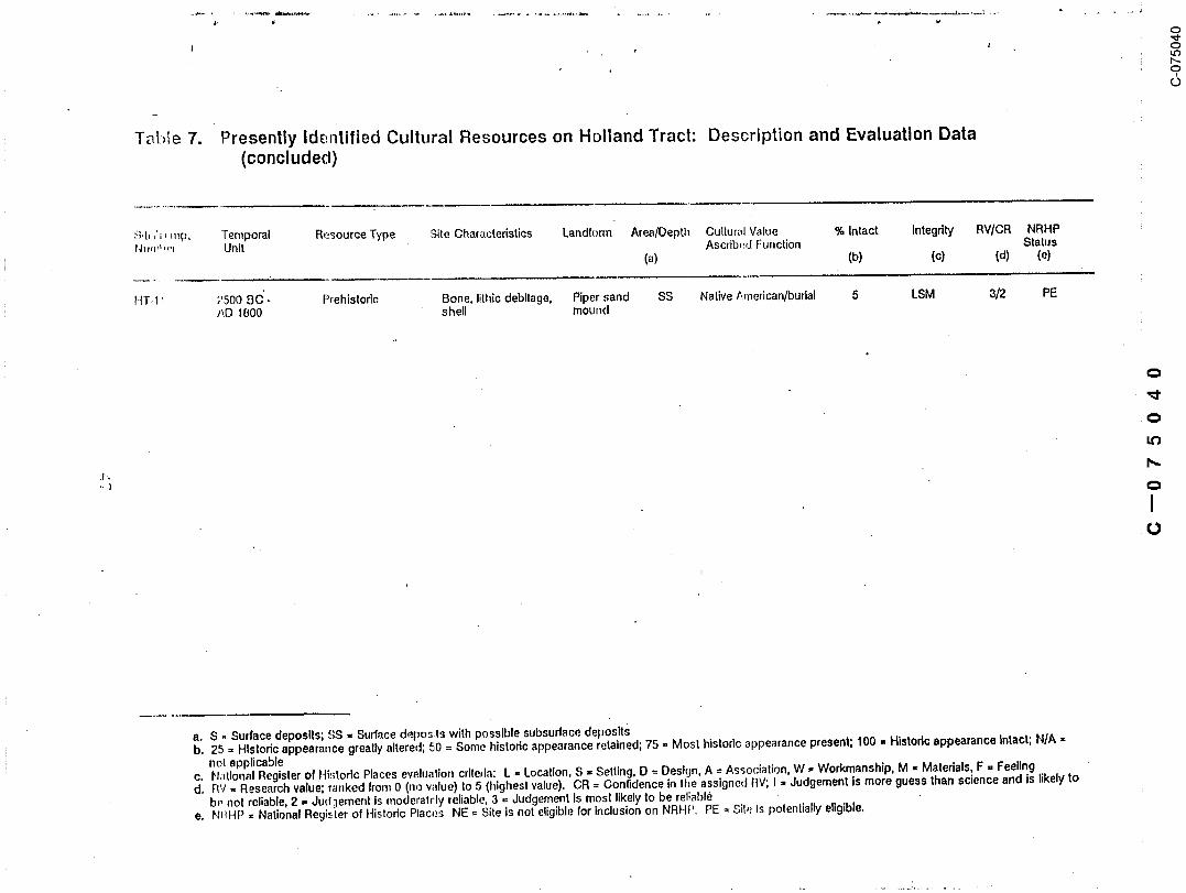
l~l.-)!e 7. Presently Identified Cultural Resources on Holland Tract: Description and Evaluation Data(concluded)
~;~t,,’=, rap. Temporal R~sourceType Site Characteristics Landform Area/Depth Cultur~fl Value % Intact Integrl~ RWCR NRHPt,h~m! ,,.I Unit Ascrib~d Function Stalus
(a) (b) (c) (d) (e)
HT.t ~ 2500 BC’- Prehistoric Bone, lithic debitage, Piper sand SS Native/~.merican/budal 5 LSM 3/2 PE
t’~D 1800 shell mound
a. S - Surface deposits; SS - Surface deposts with possible subsurface depositsb. 25 = Historic appearance greatly altered; 50 = Some historic appearance retained; 75 = Most histodc appearance present; 100 ¯ Historic appearance intact; N/A ¯
not applicablec. N;itlonal Register of Histodc Places evaluation criteria: L = Location, S = Setting, D =Destgn, A = Association, W ¯ Workmanship, M = Materials, F = Feelingdo Rv ,, Research value; ranked Irom 0 (no wflue) to 5 (highes! value). CR = Confidence in Ihe assigned RV; I = Judgement Is more guess than science and is likely to
b~, not reliable, 2 ,, Jud:lement Is moderatrly reliable, 3 = Judgement Is most likely to be reliablee. NI~HP = National Regi~’.-ter of Histodc Plac~:s NE = Site is not eligible for Inclusion on NRHP. PE = SII~: is potentially eligible.

crete. The low-pitched, end-gabled roof has a lower hip roof over a porch on the northside and is covered with tar paper. Roof rafters are exposed. The house has channeledsiding with end boards on all corners. Lighting fixtures inside the house date to themid-1920s. Other features include tongue and groove interior floors, varnished pinedoor and trim, pine kitchen cabinets, and vertical paneled doors.
HT-5: The remains of a 1950s hunting club are present at this location. Struc-tures were destroyed during ihe 1980 flood. Cement pads, asphalt siding and linoleumfragments, boards, screw top mason jars, and other debris are present in this location.
HT-6: This prehistoric site is situated on top of a Piper sand mound in the center
of Holland Tract. Artifacts found on the surface of the site include obsidian debita~e~al,~, clamshell anc~ ot~’,’c,,,~ disk beads,and tools, a shaped metate, baked clay cooking
groundstone, biface fragments, and basalt and chert debitage. Hundreds of fragments ofhuman and mammal bone were noted on the site surface, The site appears to have ser~edas a cemetery and perhaps as an occupation site for prehistoric people. The top of the
mound has been disced and bones were located in the furrows.
¯ .,T-,. This cement pad was situated on ~’-’v of a Piper sand mound and vvas used forranching operations after 1922. No artifacts were found associated with the pad and itwas recorded as an isolated feature.
HT-8: One isolated mano, used to grind seeds and nuts by prehistoric and ethno-graphic populations, was located on a Piper sand mound.
HT-9: One cement pad was recorded as an isolated feature. No structural remainsor artifactual materia! was noted around the pad.
HT-10: Two fragments of unidentifiable bone; associated with prehistoric use ofthe area, were noted on .a Piper sand mound.
HT-II: Less than five percent remains of this Piper sand mound. The mound hasbeen removed as levee fill and most of the cultural material is no longer on site.
C--075041C-075041

Several flakes of obsidian and chert, one biface, groundstone, and possible human bonefragments were noted in the cut bank of the mound and in the surrounding area. Thepresence of cultural material indicate that the mound originally may have containedprehistoric burials.
CA-CCo-I47: This site, originally recorded in 1943, is located on top of a s~nd
mound in the southwest quarter of the tract, The site is characterized by bone frag-o
ments (bird, fish, mammal, human), shell, obsidian and chert debitage, fire crackedrock, ground stone implements, and stone tools typical of a Late Horizon occupation(Figure I0).
The west side of this mound was severe!v eroded by wave action dur.ing the 1980flooding of the tract.,.-,~^’ that time, human remain~,_ were noted in the cut bank of themound. The surface of the mound is subject to on-going disturbance by cattle (it isnear a corral and salt block area). It is estimated that 30 percent of the origina!Site is intact; the remainder was washed away through flooding.
Other.Resources: According to Hampson, buildings and structures situated at his-toric camp locations on the South and east side of the tract ,,,,,ere destroyed by flooding
in 1980 and were subsequentlv, removed (Hampson !985:6). Several locations around theperimeter of the island contain bulldozed piles of concrete slab fragments, pier blocks,and fragments of milled lumber. While these piles of debris probably represent laborcamp locations, no data potential exists at these locati~ns.
WebbSeven resources were identified on .’vebb Tract; two architectural sites and five
historical isolated features or artifacts associated with labor camps present on theisland before 1920 (Table 8, 9)~
WT-I: A solarized amethyst-colored glass tumbler base was located in a plowedfield. This artifact is probably associated with agricultural labor camps present onthe island from circa i913 to 1922.
C--075042(3-075042


rab Presently Identified Cultural Resources on Webb Tract: Description and Evaluation Data
Sile/h~;rq~ Temporal Reso=~rce Type Site Characteristics Landforrn Area/Depth CulturaIValue % Intact Integrity RV/CR NRHPt’,/u mb,,~ Uhil Ascribed Function Status
(a) (b) (c) (d) (e)
Wi’-I ca. ~912 - Hlst,~dc £un tinted emelhyst Plowed field S Japanese I.abor Camp N/A None 0/3 NE192~ !,tlass tumbler base #’17
wr-2 ca. ~912 - Hlsturlc ,qlx while improved Plowed ~eld S Japanese t.abor Camp N/A None 0/3 NE192,~ ~arfhenware (?)
l~agments
Wf-3 ca. t912 - HIs;,~do ~:lve while Improved Plowed field S Japanese labor Camp N/A None 0/3 NE192’)
Iragmenls
W]’-,l ca. 1915 - Arc ilectural .":erry hou;;e In river; lop S Ferry Lam~ing 95 LS 2/3 NECA-(3C~: pre’.;ent ol levee
Ycr.-5 1912. Arc/itectural/ Slructure, trash Piper sand SS Japanese Iabor Camp 75 LSM 3/3 PECA- CC,: pre’; ent His
W’I-6 ca. !912 - Hisl )ric Cement Pad Base of S Pumping Station N/A L 0/3 NE19;:- 0 levee
WT-7 ca. 1912 - Hlst.~do Cement pad Base19’,0 levee
a. S = Surface deposits; &.~ ¯ Surface deposlls with possible subsurface depnsllsb. 25 = Ilistoric appearance greatly altered; 50 ,, Some histodc appearance relalned; 75 = Most historic-appearance present; 100 = Hisloric appearance Intact; N/A =
not a~plicablec. National Register of Hlstodc Places evalualion criteria: L = Location, S = Setting, D = Design, A ~ Association, W.= Workmanship, M = Materials, F = Feelingd. RV = Research value; ranked from 0 (no value) to 5 (highest value). CR ;, Conlidence in the assigned RV; I = Judgement Is more guess than science and is likely to
be not reliable, 2 = Judgement is moder,:=tely reliable, 3 = Judgement is most likely to be reliablee. NRII!’ = Nalional Registe~ o! Histodc Pluces NE = Site is not eligible for inclusion on NRHP. PE = Site is potentially eligible,

T~tl:e 9. Architectural Oata Summary of Bouldin Island, Holland Tract, and Webb Tract
I’~escriptlve Barnv She~ s Bunkhouse Packing S~ngle Boarding M~d~:~n Olher Total No.:,lame, Shed Re’,~idence House Structures of Structures
Camp #21 1 1 3 Cement pads. trash scatter 5
Duck Club/Labor 1 Orange, apdcot, magnolia, 3Camp #1 palm trees, dock
Foremans 1 1 Cement pad, orange trees 2Residence. Camp#5 u")Ferry House 1 ’ Ferry landing 1 %-
Asian Labor Camp - 1 1 Trash scatter 2 ~#10 14)

WT-2 and WT-3: Fragments of white improved earthenware were noted in plowed fields
in two locations on the tract (six sherds at WT-2 and five at WT-3). The ceramic piecesare probably associated with labor camps present on the island between circa 1913 and1922.
WT-4: A ferry house is located at this location. A telephone booth is constructed
outside the house. Associa!.ed features include the ferry landing. According to theferry operator, the house was moved to Webb Tract over 20 years ago from an unknownlocation.
Architectural Description. The ferry house is a one-story, board and batten struc-ture supported on wooden pilings. The low-pitched gable roof has exposed rafters and iscovered wi~.h corrugated metal. The west side of the building, has two six-pane horizon=tal windows. Architecturally, the style is consistent with Craftsman and the buildingwas probabIy constructed between 1910 and 1920,
WT-5: Situated at the site of Shima’s Camp 10, this site consists of a large,one-story wooden boarding house constructed on top of a sand mound. Trash, both histor-ical and recent, has been deposited off the sides of the mound to the north and south.Historic artifacts observed on top of the mound by the house and downslope include aqua,
amethyst, olive, and clear colored bottle glass fragments, window pane fragments, cer-amic sherds (whiteware), one brass suspender buckle embossed with the letter "B", andone Chinese brown-glazed vessel fragment. A metal Quonset hut-style barn, currentlyused for storing hay bales, is present on the mound.
..-.,L,:~t~-,.,orm Descr tlon. This Craftsman L--_~:__ ~ .....has a
~a,~ers aria "~-ieg *-. ...... L,ogvres mr. present ongabled roof with exposed -r. ^ ~’ ~,,,,,.,.o. -- the gableends. The windows are origina! and are of ":~"’~-,s,,---v,~ ....double-hung sash. The originalboard siding has been covered with-plywood siding and new window surrounds. The houseis supporteO by ....."~-wuuuc, piers.
WT-6: Located east of a current pumping station, this area contains one concretefoundation and a bulldozed pile of modem boards, "~=~;~ ~,,a r~thPr dehri~. The pad
C--075046(3-075046

WT-7: The 1917 site of Camp 14 is represented in the field by a concrete slabfoundation pad. The pad was recorded as an isolated feature. No artifacts or other
cultural material was noted in association with the pad.
Other Resources: Recent trash is present in plowed fields. As with Holland Tract,several areas of bulldozed concrete slabs and pier blocks were noted. These are notassociated with known labor camp locations and do not appear on historic maps.
Several areas of Piper fi~e-grained sandy loam were surveyed on Webb Island. Theseareas contain a high potential for prehistoric burial sites, although no surface indica-otions were present.
C--075047C-075047

RESOURCE EVALUATION
.I1 - Resources identified on each island were assessed in terms of National Register of- Historic Places (the Register) criteria and CEQA guidelines. Six sites and all 22i isolated features and artifacts were measured, recorded, sketched, and/or photographed.
.., These resources do not appear to contain data potential beyond that recorded at the" inventory level and neednot be considered any further in the Section 106 process.
Nineteen sites are potentially eligible to the Register under 36 CFR 60.4 (a), (b),
and/or (d).
Bacon IslandAll of the !3 sites on Bacon !s!and are related to agricultural acti.vities that oc-
curred between circa 1910 and the present. The National Register considers resources i-ndividually or as a district. A district is a geographically definable area that pos-
sesses a significant concentration or continuity of sites, buildings, structures, orobjects united by past events (Department of the Interior 1982:5). District boundariesare established after reviewing a property’s physical use, visual qualities, and re-search values. Bacon island meets the criteria as a Nat~on,, c,~,,.;~t,~r district due toits continuity of agricultural use and the concentration of labor camps still in use onthe island. Virtually no intrusive (non-agricultural) elements have been imposed on thehistoric landscape to destroy the identifiable locations of the original labor camps,ditches, canals, pumping stations, and field~.
~ S,,mm-r?’ Most of the ori~inaI buildings on the island were con-structed in the Craftsman style, which was the dominant architectural style for smai.ierhouses built throughout the countrv, ~:a~,.,q,n~,.~,= the pe.r-iod 1905 throuTh~ the early 1920s. Thestyle originated in Southern California, inspired primarily by the work of Charles and
Hear3, Green, ’---~-t.,~,_.t~,,.~. ....... ,,,.~.~," ~,,-,,.--~.--,~d. ~ ....... ~n. r’n~nd,-.~.~.., from !893 to 1914. Their residenceswere given extensive publicity in many architectural and home magazines, familiarizingthe nation with their Craftsman style. As a result, a flood of pattern books appeared,,~ffer~ng~ ...... plans for Craftsman bungalows, and, in some cases, pre-cut packages of lumber
and~,.,~,,,,~~’~’":~:;-~ v:...,-~ e ~ffe,-e~ ~,-, the !~ome builder.
C--075048C-075048

Given the similarity of the Bacon Island buildings, it is not unlikelythal lhcywere constructed from pattern books. Boarding houses at three separate camps are exact-
iy alike, while others have minor alterations of the same plan. These boarding houses,and one very large house at Camp 3 (see Figure 7), embody lhc highest Craftsman stylewith cross-gabled roofs, dormers, decorative beams, or braces, exposed rafters, recessedporches, supported with square columns, triangular braced supports, gable stickwork,multi-pane sash windows, and other architectural elements (see Figure ! I).
Differing from the basic Craftsman style, however, are two- and three-story stair-
ways, leading to exterior entrances, imposed upon the facades and sides of the .housesand necessary to provide access for the many workers who residcJ in the houses. This isin contrasl to the usual single family Craftsman house. Other "..:’-nacu!,’,.r elements havebeen imposed upon the basic .....oi-~he bu" ’h-,a to adapt ~ ....... -:~’j ~’-2 I ~.~ ~ .~,~2:~: ~ ’,’&7::2iv O~r t.,t.,, "~ ........~ ,~o~I~-""
and agricultural uses by the laborers.Some of ti~c individual residences,.,-’r ..... the camps.._.,~,,.~,,.,,::." ..... ;"~’ ":’~,~," fi,’,~,~., v:erc ~,.,~ bv
foremen, are typical of the Craftsman Bungalow slyle found in an:’ small California town.Sheds, barns, and bunkhouses also have Craftsman elements in vauing degrees.
Evaluation. The resourceson Bacon Island arc polentially eligible for inclusionIo lhe National Register of Historic Places under criteria a. b. and d. Given thecommon occurrence of Craftsman-style structures in California. the district does notmeet criterion c. Most-of the camps retain integrity of location, setting, design,
re~,, ....... ,~...~ ,workmanship, association, materials, and feelings. BC-5 ,,.:-< ,,,o,-,,- ,,, of lecationsetting, and materials, while BC-6 has integrity of location, setting, and association.
Criterion AThe resources within tim proposed Bacon !sland District arc associated with
ation or Delta lands and the continued use of the Island for agriculture. The reclama-tion of the Delta and the development of agriculture in the region played an irnportan~part in the economic history and ,development of California. The rich peat soil in theDelta supported a wide variety of crops and proved especially productive in the gro(vingof asparagus and potatoes.
The District constitutes a ms~oncaii) co~npie~c ¯’ag;it..a, at2:: t, .:.i~ cO;,:a;,",..
evidence ,-,r -,, ~� ~!’e st, r,.’,er’,, r~,,-.;m;o< related to a.o_.riculturein addition to tlma,S~:v,,.~v:3 :.;,.-,:,, ........ ...;.’.i.2 :: ...... ’ ....[:’:.’..i 7.: ~_-,r :-,:: .... !~:i’. ’,::-~. ~" .,i _~[ ..
C--075049C-075049

isolated enterprises unrelated to a larger agricultural landscape, the proposed BaconIsland District encompasses a complete geographical area with a 75-year period of agri-cultural use. This includes the related levees, drainage and irrigation systems, peatsoil, pumping stations, agricultural buildings, and the labor camps with their residen-tial facilities.
The majority of the camps present within the District retain their earliest config-uration of residences, boarding houses, bunkhouses, washhouses, offices, barns, equip-
ment and packing sheds. Although some newer buildings have been constructed and theoriginal buildings have undergone some alterations, the integrity of the camps remains
relatively intact.The importance of the camps increases when one considers their use by Japanese
laborers. The Japanese were instrumenta! in land reclamation and agricultural develop-ment in the Delta. Eleven camps that were built by a Japanese man to house his Japaneseworkers are intact within the District, as well aS ruins of a twelfth. More important-
ly, unlike most other islands in the region, Japanese continue to farm the island today,increasing its importance under criterion a.
Criterion BLand reclamation and agricultural development of Bacon lsland is the result of the
efforts of George Shima, a well known Japanese entrepreneur. Between 1889 and 1926Shima was the driving force behind much of the reclamation work in the region. Inaddition, his willingness to take .risks, exemplified by his efforts to establish thepotato as a viable crop in the region, did much to advance the reputation of the Deltaas a rich a~ricultural_ region. Innovative marketing techniques developed by Shima, suchas using red bags marked with "~-" - ~ ....... "~credibility to products grown in the DeRa and made "Shima Fancy" a common householditem.
Shima also played an important role in the Japanese community. Not only did heprovide hundreds of jobs to his fellow countrymen, he arranged work so as to keep n’tenemployed year round, eliminating the transient, seasonal lifestyle required of many farmlaborers. He leased his own farmland to other Japanese, allowing them to try their handat tenant farrning and giving them an opportunity to become entrepreneurs in their ownright.
C--075050C-075050

Shima worked to advance a positive image of Japanese in an era of extreme racialprejudice. He was the founder and president of the Japanese Association of America,wrote regularly to local and national newspapers in attempts to diffuse prejudice a-gainst Asians, and contributed liberally to Stanford University and various communityorganizations in Berkeley. He was respected by both American and Japanese businessmenand by his employees.
Although Shima constructed camps on numerous islands throughout theDelta, a cur-sory survey in.dicates that only Bacon Island retains the majority of labor camps associ-ated with him. Individual structures that were probably built by Shima around the sametime period (1915-1920) are present on Bouldin Island, Webb and Holland tracts, Orwood
Tract, and Mandeville Island. The majority of the camps associated with Shima, however,appear to have been dismantled, increasing the importance of the Bacon Island resources.In addition, Shima lived at Camp 1 for atime prior to 1915 and maintained his Deltaoffice at Camp 3 (Figure 11), both on Bacon Island, contributing to the significance ofthe District under criterion B. Finally, Bacon Island and George Shima’s office at Camp3 are included as important resources in the State Office of Historic Preservation’sEthnic Suwey program (Fujita 1980, 1980a).
Criterion DThe proposed Bacon Island District offers an important opportunity to study the
Japanese agricultural experience. The availability of well-preserved architectural andpotentia! historica! archaeological remains, good ethnic documentation, and probableinformant data allows for a uniquely complete and accurate reconstruction of historical
agricultural actMties. The District resources are representative of agricultura!activities and architectural desig,~s tha~ were commonAbandoned farm equipment is also present on the island. Information available from astudy of the District may be applicable to other agricultural sites and districts in thestate.
Potential subsurface archaeological deposits relating to the use of the camps byShima’s work force are present at several of the camps with structures and at BC-5, adismantled camp. Artifacts noted on the surface indicate a retention of Asian domesticgoods and food products by the laborers. A study of deposits on the island may yieldinformation concerning changes in ethnic populations over time, subsistence, demographiccomposi:ion, and cu]tura! continuity.
C--075051C-075051

~ Figure 11 George Shima’s office at Camp 3, Bacon !s!and, now,* as a boarding house. View’s west (top) and~
northeast (bottom)
C--075052C-075052

Bouldin IslandOf the 13 resources identified within the project on Bouldin Island eight are iso-
lated features (concrete pad) or artifacts. These have been recorded on State of Cali-fornia forms, do not have additional research potential, and are not eligible for list-ing on the National Register of Historic Places. Two sites, BI-I and BI-8, consist ofdomestic trash scattered across the surface of plowed fields. Both sites appear to, be
surface scatters only and the original context and location of the material could not bedetermined. Therefore, these two resources are not eligible for inclusion to the Na-tional Register of Historic Places.
BI-2 is a trash scatter situated along the base of the levee. Two complete bottleswere identified at this site, indicating a potentially intact subsurface deposit. Inaddition, a large blackberry thicket, squarish in shape, is present on the site and mayhave grown up over a structure or foundation. The site retains integrity of location,setting, and materials. There is a paucity of information concerning the day-to-daye.,dstence of Asian laborers in the early !900s. The site has the potential to answerquestions regarding eocnomic exchange, subsistence, material preference, and ,ethniccontinuity and is potentially eligible to the National Register of Historic Places under
36 CFR 60.4 (,d).
BI-10 is the historic site of Bouldin Landing and was occupied from circa 1873 intothe .second half of the twentieth century, Surface artifacts date post-1900 and it ispossible that a subsurface archaeologica! deposit is present on si~e. Littie is knownconcerning pre-1900 landing sites on the interior islands of the Delta region and any
................ r, atmg the im~.iM ube ol mr. ’o ..... v:~_:information concerning economic and material development of Bouldin Landing. The site
retains integrity of ~"" : ",,,,.at, on~ setting, and materials. Based on the data ~otentia! andintegrity of the resource, it is potential eligible for inclusion to the NationalRegister under criterion 36 CFR 60.4 (d). ~ .
B!-!3 includes two Craftsman-style. boarding houses, cement foundations, and recenttrash. The~,~,,,~,,,~o are not unique occurrences of Craftsman style in the Della. Inaddition, there is a better representation, of this type of structure built ~o houselaborers on .Bacon !sland. The cement foundations and trash are not unique and do notmeet .X;at~onai ;,.-,.~i~.=- ,
C--075053C-075053
Holland TractTwo architectural sites, HT-I and HT-4 are related to early agricultural develop-
ment of the tract by George Shima. These two structures are Craftsman in style and arecommon in the region. More intact and representative examples of labor camp architec-ture are present on Bacon Island. As such the two sites are not considered potentially
eligible for inclusion to the National Register of Historic Places.Three prehistoric isolated artifacts were recorded during the survey. These items
were not associated with oti~er cultural material, are not unique; and do not containfurther research value. As such, they are not eligible to the National Register. Fourconcrete pads were also identified, measured, and recorded as isolated features. No
artifactual material was located in association with the foundations and they do notwarrant further investigation.
,r’~. CO,,,,,,ee prehistoric sites were identified during them~" ’~,.st,g; ",;~"~ .......Ailhuman bone, Iithic debitage and tools, groundstone, and other diagnostic artifacts.Although prehistoric sites are known to occur in the Delta, the.’,’ have disappeared at analarming rate due to intense agricultural land use, subdivisions, and flooding. CA-CCo-
147 and HT-6 contain numerous diagnostic tools indicating an occup,ation dating back per-haps as early as 2,500 BC,. while HT-11 may also contain diagnostic artifacts. The widevariety of materia! identified on the surface of the site, including mammal bone, indi--cates that the resources may have functioned as village sites as well as cemeteries.These sites have the potential to yield information important to the reconstruction ofprehistoric lifeways in the Delta, including economic exchange patterns, demographic andsocial organization, subsistence and ’ "~ ’~- "’"se,u,.m..,,t, a.,n.,~ h, mr- technology. The three sitesare potentially eligible to the National Register of Historic Places under criterion d.
American remains contained in all three sites. The human remains ar~ protected under
Public Health Code and under Senate Bill 297 and their disposition is being taken underconsideration by the Native American Heritage Commission in Sacramento and the localindian community.
Webb TractFive of the seven /esource~ "" "~-’~,,,~ m..~,-, are ;~,~.a~d a.~ifacts
features and do not have the potential to yield important information.. These artifacts
61
C--075054C-075054

and concrete pads were recorded on State of California forms and no further work isrequired.
WT-4 consists of the ferry house. This house is typical or lhe Craflsman architec-
tural style common throughout the Delta and is not t!nique. It does not meet NRHP cri-teria for listing; as a significant resource.
WT-5 structure is also Craftsman in style and is not unique. However, the house
sits on a Piper sand mound and garbage has traditionally been deposited over the sidesof the mound. Artifacts dating to the initial occupation of the site around 1913 werenoted on the surface and in the cut bank. It is possible tha~ a subsurface deposit is
the site, subsistence, and changes in ethnic population over time. Therefore, the sitehas the potential to yield information important in reconstructing the life of .~sianfarm laborers on the tract prior to 1922 and is eligible to the Register under 36 CFR60,4 (d). WT-5 also retains integrity of location, setting, materials, as association.increasing its importance.
c-o75o55C-075055

IMPACTS AND MITIGATION MEASURES
The following discussion takes into account only those sites that are potentiallyeligible for inclusion to the National Register of Historic Places. This includes all
13 ~;ites identified on Bacon Island, BI-2 and BI-10 on Bouldin Island, CA-CCo-147, HT-6and HT-I 1 on Holland Tract, and WT-5 on Webb Tract. The remaining identified resourceson all four islands have been recorded on appropriate State of California ArchaeologicalSite or Feature records. ~ Th~se records have been submitted to California Archaeological
Inventory, Northwest and South Central Information Centers for assignment of a permanentstate-issued trinomial designation and eventual inclusion into the State Office of His-toric Preservation Data Bank. No further cultural resource management is recommendedunder Section I06 for these r~sour~s.
Four alternatives are being considered for the project. The suggested alternativeis the proposed water storage project previously described. Other alternatives includeno-project, maximum water storage on all islands, and intensified agricultural use.Impacts to the resources will be discussed in light of each proposed alternative.
Impacts on Historic SitesPreferred Alternative. The historic resources that are potentially eligible for
inclusion to the Register lie primarily around the perimeters of the islands at the base
levee system. These areas are designated to be to create gently-slop-of the filled ining "beach slopes" and will be the most severely disturbed by levee construction dur-ing the water storage project.All structures located on the sides or near the bases of
t~,o~ .... Sitesaffected " ’ "~ ’ ~,-,,,’tu,-es nno dismantled camp and bridgemc~u,,e the 1 ~ camps ,...,;t~ standing .......,fender’s house on Bacon Island, and the two sites on Bouldin. The Webb Tract si~e iswithin the borrow area and will also be significantly impacted by the project.
No-Project Alternative. This alternative assumes that existing use of the islandswill continue. The majority of the :o’ "’"h,o,O,~,, structures within the project are beingused today as storage facilities, residences, boarding houses, and washhouses. Normal,,,ear and tear of the structures, combined ’,v;.t.h modifications and renovations when nec-essary, will continue to degrade the integrity of the resources. In addition, some of
C--075056C-075056

the structures are abandoned and slated for removal. The no-project alternative willresult in continued deterioration of the buildings through intensive use, neglect, and
natural elements.~ The archaeological resources that date to the historic period wouldcontinue to be impacted by grazing sheep and cattle, plowing, and recreationalists.
Maximum Water Storage Alternative. The impacts of the maximum water storage alter-native on. the historical resources would be identical to those described under the pre-ferred water storage alternative.
Intensified Agricultural Alternative. The shift from present agricultural prac-tices to more intensive agriculture within the Delta Wetlands project area would differhtue from the existing conditions. However, increased numbers ofsult in additional wear and tear of the standing structures. Structures that currently
are not in use on Bacon Island (for example, Camp I): may be upgraded and opened up tolaborers again if agriculture intensified. Increased laborers on the islands may di-rectly affect the archaeological resources through vandalism, plowing of those areas
currently allowed to remain undisturbed, and increased livestock grazing around theperimeter of the levees.
Impacts on Prehistoric Sites
~, ~perThree prehistoric resources were ~d~n .....d on Holland Tract. In addition, ~"
sand mounds on Holland and Webb tracts may contain subsurface prehistoric remains thatwere not identified during the inventory...
Pre%n-.ed Alternative. All three sites lie outside the area of impact from leveereconstruction but within the proposed inundation zone. Current plans call for thewater level on Holland to be : ¯ ; ’~,’ f:.-,--~ ’ " n..~n -ma,n,a,n~.a at zero ~. au~.’e
CA-CCo-147 is at five feet amsl, at HT-6 it is seven feet amsl, and at HT-I I the highestpoint reaches five feet are!!. While material on the top of the mounds would not be af-fected by flooding, the potential exists,,.,,r^" erosion of the sides of the sand mounds by;~ind-g~:ner.a~ed waves ~nd c,v per;crJJc mund.’"t~on n~.,.u a:~:,,,.:._= In nrld{!~an res0t-.’rc.-~that may be present in Piper soil mounds on Holland and Webb tracts, but were not iden-i~’i-:~ ’ ,, ,r. ¯-~--^-. : ......: ....:,- ....... ~-,_- -,...-~.-~" ,u ......:, : ..... :~,:..,..,
C--075057C-075057

No-Project Alternative. All three prehistoric sites on Holland Tract are currentlybeing impacted. CA-CCo-147 is impacted daily by cattle trampling across the site.Plowing has exposed burials and other material at HT-6. Backhoes have removed themajority of HT-II by using the sand in the Piper mound for levee reconstruction andstrengthening projects. These impacts to each site would continue if the water storageproject does not proceed, In addition, agricultural use of the islands results in de-flation of peat soils and increases the exposure of the Piper sand mounds, thereby in-
creasing the potential for erosion of the site margins, particularly through wind actionand. cattle trampling.
Maximum Water Storage Alternative. This alternative would result in the sameimpacts to the Piper sand mounds as would the normal water storage plan. Water levelwould be higher, however, and may result in compiete inundation of each site, alteringthe wave action and erosion potential to each site.
Intensified Agricultural Alternative. Any intensification of activities on Hollandand Webb tracts that affect the Piper sand mounds could disturb prehistoric resources.Plowing the tops of the mounds or removing the e.,,dsting mounds through agricultural orlevee building activities would expose subsurface deposits on known and unknown sites.Reintroduction of hog feeding could affect the Piper sand mounds on Holland Tract if theanimals are alIowed to concentrate in known Piper soil areas.
Recommended ation Measurest.c impacts to known cultural resources within tlne Delta
National Register Of Historic Places criteria may be reduced to less than significantlevels with adequate mitigation measures developed through consultation and coordinationwith the State Office of Historic Preservation. The following discussion considerspotentially eligible resources on an island-by-island basis and offers recommendations
for treatment of the resources,
C--075058C-075058

Bacon IslandThe eleven camps with standing structures, the bridge tender’s house, and the
archaeological site of BC-5 will be significantly impacted by the water storage project.Several treatment options concerning the existing labor camps are offered below.
o Redesign the project to avoid damaging the structures;
o Relocate the structures outside the construction or inundation zone;
o Stabilize, upgrade, and create adaptive reuse of the structures;
o Retrieve significant historic aspects and information potential of thehistorical district through a combination of methods, resulting in aFinding of No Adverse Effect on the resources.
Constructing "beach slope" levees is crucial to successful completion of the.water storage project and it mav not be feasible to redesign this aspect of the project.Moving the structures away from flooding and construction zones may require removing thebuildings from the island, entirely, or relocating the structures on top of the leveesand may not be cost effective. Adaptive reuse of the structures is applicable only tothose buildings situated on top of the levee by the time of !evee reconstruction. Al-though this option preserves certain resources, it would not compensate for the destruc-tion of the remainder of the structures. It is the totality of the resources, not in-dividual elements, that provide the greatest significance in the district.
It is recommended that the retrieva! of significant historical aspects and informa-tion potential of the District be pursued. Historical and ethnographic research are
cost-effective :,:., " ,,~ r,~ ,~m,.g~,tl~,, measures. Most ...s..arch domains pertinent to the(such as agricultural technologica! changes through time, ethnicity, sociai, religious,and demographic data) can be addressed bv careful identification, mapping recordation,documentary, research and consultant interviews.
!n order to redvce ~rnn,nct~. to the D~t,,-ict to less-than-si~,.nificant levels, severaltreatment measures are recommended. These measures, sponsor.ed by the project proponent,should be completed prior to destruction of the sites.
I. C~nduct extensive archival research tO locate historical documentation" from public and private collections, pho~ographs, labor ernp~c, bn~cc.~
. records, historic newspaper accounts of agriculture and Shima’s enter-~ri~es of~cia! com~.".n,-’ records, a~ricui;.u~-a! production statistics,-q~ C:2.:.’~!,!.~ ’.!:.d.a. S:r~ca s~;~2"~2 ::i .~,~.:-’.:_ .-._,&¯;,~., ~:~:2.’-." ~.’_ v.~.-’F,-}p .::[:-
nese, a h=storian" capable of rr,~<.._,:..C,,cmm~;’~’ ~ re.nO ......’~,~rprc~ma~’ o Jat~anese.,,-~d~actcts is recommenGed.
C--075059C-075059

’ 2. Conduct consultant interviews to identify specific buildings, uses andoccupants at various time period, Io identify "invisible" historical ’elements of the cultural landscape, and to provide information on non-physical aspects oF sdcial, elhnic, religious, economic, and polilicalevents. If possible, informants should be taken to the sites and formal
: interviews should be tape-recorded, transcribed, and curated at a local’- repository, such as the San Joaquin Historical Society lVluseum. Due to
¯ potential language barrier problems, a trained historian fluent in Japa-nese is recommended for this task.
3, Produce maps of the cultural landscape specific .to several identifiedtime periods and occupations, showing specific uses of identified build-ings or structures and changes in function through time.
~ 4, Using large format cameras, provide technical photographic recordation; of remains of the camps and buildings (both interior and exterior) in! accordance to standards outlined for the Historic Arnerican Buildings! ..,_,< .......,.., (HABS). ~v".’,,;’~w~,~. ,~--~ of each camp., d,’nictin.’,_. ~ camp lax, out and design~
are important elements of the pholographic documentation.
The program outlined above is designed to retrieve a variety of data on development of
agriculture on the island, technological changes, and ethnic diversity and use of thecamp, focusing on cultural elements. In order to maximize dispersal of .the data. atechnical report, with appended interview transcripls, maps, and detailed descriptionand ana!ysis, should be prepared and filed wi.th the San Joaquin County Museum, SoulhCentral Information Center, and State Historic Preservation Office. A popular article,designed for distribution to the general public, should be prepared for publication.Avenues for publication may include the Pacific Historian (published .by the University’of the Pacific in Stockton) The ’-" ~ " . ....¯ ,..a,i~ornians, California H;~t~rv (Quarlerly Journal ofthe California Historical Society). the AmerAsian Journal (published by University of
America.D~s~r .... some of t~" campsAside from the arcinitecturaI and design elements of the " ’ :~’ ,.~
have artifacts scattered across the surface and may contain subsurface historical archa-.eological deposits. ~C-5, the site oi Day’s ....:-- - ..... ~’: ......."~,,~,.,~ (~,a,a-igl0) any, ~,,,,,~,= ~ Camp 5(1915-1926), no longer has standing structures but may have subsurface deposits. Anal-ysis of artifactual material data from this site, and other camps¯ will shed light Onthe material lifestyle represented in a Japanese labor camp before 1925. When combined
a more ~h,",rou,’,h..... . = reconstruction of twentieth-century, labor camps in the Delta. It is;= ...............’ ....... ,--~ :~. ,: ~:-<’.] !.~ :-.:....’o~.: ..... .........., ¯ ... "
.... D,.,.:. be .... ~ ....... ... ...... prior .. Icvcc
C--075060(3-075060

construction, particularly at BC-5. This work should b~, by a research designapproved by the State Office of Historic Prescrvatickfi"-/(SOHP)~tate .Water ResourcesControl Board (SWRCB), and the United States Army-""-’-"~- "Corps of Engineers (ACOE).
Bouldin Island ,-., ~"L’--~Two sites on this island, BI-2 and BI-! i, have the potential to yi~l¢l informaiion
concerning early development of landing sites in the Delta, material culture of Japaneselabor camps in the first half of the twentieth century, ethnic diversity and culturalcontinuity, and development of agriculture on. the island. Both sites are located nearthe base of the levee and avoidance during the water storage project may not be fcas-ible.
,̄:, xcava~.~c.-, p-.e.-rnrn. "l,-’~.~ned to ;-"’-" rv and recover those ,.la,atial to address questions pertinent in understanding the early development of llm. islandand the role of ~he Japanese laborer is recommended. This program should be guided by aresearch design approved by the SHPO, SWRCB, and ACOE, and should combine focused archi-val research with field work. Field work may include using mechanized’ equipment to
trench across each site (exposing subsurface deposits) excavating rapid recovery unitsto determine horizontal extent of each resource, digging excavation units to vci-it-v sub-
surface integrity, composition, and feature identification, and/or clearing away black-berry brambles from each site to identify presently-unidentified structural remains.
Ho!land TractThree prehistoric sites have been identified on Holland Tract. In accordance with
I"~,.I.I:~ T_l’~T,I-, .... ! ...... ! ~2 ..... 1D;II 397 t|’~o �’~nnfr~ ("n~l."l {~_Cllln[v Coroner ..... the Native,- ....:-r.-,,-r.~. ~.-,,I ,-,r ,~,,~ p,-,~,onee of i!~m~an remains on tall threeAmerican Heritage Commission ~ .....,,,.,.
sites. A field visit was ,.~ .......... on F.bru_.,. !, !989, with reoresentatives from DeltaWetlands, Jones & Stokes Associates, PAR & Associates, NAHC, and the local Native Ameri-
’-m., ~,~ ^LI¢-" ~. c’ur’ranllv it!. the process of drawin~
up recommendations on appropriate treatment of these significant resources. The selec-tion of mitigation measures will depend on final projectd,..,,gn, concern..s of the localNative American community, approva! and guidance by responsible agencies, and agreemems’~ith Dc’,:.~ ’"’""~- ’~ ~ ..-’;~;,-~,,.-~. ~,,r~,~. :~,~, q,-,-:i,-n !0~; consul~.alion process.
~:~." e:,~ :~ q’. .....
:s;:.t: on ....... ~s potcnti eiiglbic to.. il,c """ .....’ ~’’: ................ . -- , ............~ ....,., usme ,t combination
C--075061(3-075061

historical and archaeological field research is recommended. As with similar sites onBouldin Island, this program should be designed to v~rify subsurface integrity, composi-tion, and research potential of the resource and to collect data important in addressing
questions concerning the history of the region.
General Mitigation RecommendationsHolland and Webb tracts contain Piper sand mounds that may have prehistoric burials
within them. It is suggested that a cultural resources expert examine the margins ofthe Piper sand mounds during annual drawdown for evidence of exposure of cultural re-sources through erosion. If such evidence is discovered, archaeological recordation andmitigation measures developed in consultation with the NAHC, SHPO. SWRCB. and AcoE sh-ould be implemented prior to additiona! water storage on the tract. These examinationsshould be required at least once per year for the life of the project.
The no-project alternative or intensive agricultural alternative may result in im-
pacts to the Piper sand mounds through plowing, increased grazing, or hunting activi-ties. Delta Wetlands should maintain an awareness of the potential for cultural re-sources that exist on the property and make all reasonable ~fl’orls to retain lhe naturalstate ,-,r ,h,. ~;~,o. sand mounds. ^-~- ’:--........ ~ .... . cv,,,..e,,trat,,,g agricultural activities on the tow-lyingpeat soil areas.
The effect of deflating peat soils on the exposure and erosion of Piper sand mounclsmay be mitigated somewhat by instituting erosion control measures on tlm margins of the
mounds. !f substantial regrading or trenching througl~ are,~s of Piper soils arc contem-plated, an experienced professional archaeologist should be retained to monitor the work
anti to recommend appropriate actions if cultural resources are found.If at any time human remains are noted .... ’"--c, uu,,,g out of a mound, or arc found On the
ground surface.. Work should stop in that area immediately and the appropriate courtly
coroner should be notified to determine the antiquity of the remains. If it is deter-mined that the remains ..’,.re Nallve American in origin~ .then AB 297 reouires that theNative American .Heritage Commission be notified and given an opportunity to examine thesite and recommend mitigative action.
Finally, PAR did not have access to several hundred acres on both Holland and Webbtracts that were not owned by Delta Wetlands. Piper sand mounds were included withinthese "no-access’ areas and may contain surface indications of prehistoric use or sub-~t~rfar’~ c.tcr~c.sits. If a,-,~,-~ ,~ these parcels is ~’~’~’"- at a laterS~.,2.~,l,.~ ¯ : . , ~ .
C--075062C-075062

SUMMARY AND CONCLUSIONS
Twenty-five cultural resources, including one previously recorded site, and 22
isolated features or artifacts have been identified and documented within the DeltaWetlands project area. The sites have been formally recorded and were submitted to theNorthwest and South Central Information Centers for permanent trinomial numbers. Sitetypes include historic and prehistoric archaeologicalresources andarchitecturalremains and are listed below."
Resources Judged IneligiblePrelimina~ assessment indicates that six sites and all of the isolated features
and artifacts do not appear to meet the criteria for significant resources as outlinedby 36 CFR 6u.4, due to their 1.~..,. of fu~her research potential or lack of integrity andare probably not eligible to the National Register of Historic Places. The majority ofthe isolates consists of concrete pad or ceramic sherd witk no other cultural context.
The majority of the non-eligible sites are buildings constructed in a common Craftsmanstyle or surface trash scatters with no contextual or locational data. Recoverabletechnical data, such as measurements, descriptive data of building style or artifact,photographs, and sketches, were obtained at the inventory, level and no further manage-ment of these resources under Section 106 is recommended.
BI-1 (Historic - Trash Scatter)BI-8 (Historic - Trash Scatter)BI- 13 (Historic - Structures)HT- ! (Historic - St_nacture)
WT-4 (Historic - Ferry House)
Sites Judged Potentially Eligible
o.,~s, ,,. on Bacon !sland, have been prelimin-m-ily evaluated as beingpotentially eligible to the National Register based on 36 CFR 60.4 (a), (b), and (d) dueto their association ;v~th the deveiopment of agriculture inlaborers, and with George Shima, and for their potential to yield significant data.
C--075063C-075063
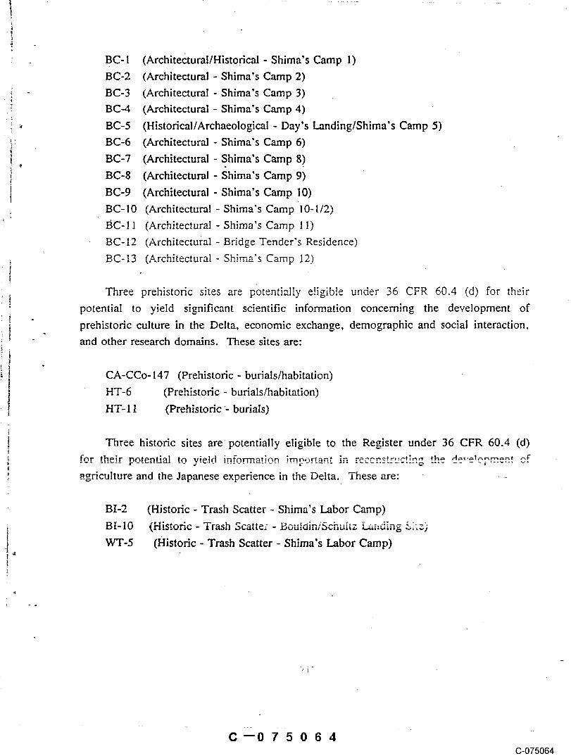
BC- 1 (Architectural/Historical - Shima’s Camp 1)BC-2 (Architectural - Shima’s Camp 2)BC-3 (Architectural - Shima’s Camp 3)BC-4 (Architectural - Shima’s Camp 4)BC-5 (Historical/Archaeological - Day’s Landing/Shima’s Camp 5)BC-6 (Architectural - Shima’s Camp 6)BC-7 (Architectural - Shima’s Camp 8)BC-8 (Architectural - ~hima’s Camp 9)
BC-9 (Architectural - Shima’s Camp I0)BC-10 (Architectural - Shima’s Camp 10-1/2)BC-11 (Architectural - Shima’s Camp 11)BC-12 (Architectural - Bridge Tender’s Residence)
BC-13 (,architectural - Shima’s Camp 12)
Three prehistoric sites are p~3tentia!ly eligible under 36 CFR 60.4 (d) for their
potential to yield significant scientific information concerning the development ofprehistoric culture in the Delta, economic exchange, demographic and social interaction,and other research domains. These sites are:
CA-CCo-147 (Prehistoric - burials/habitation)HT-6 (Prehistoric - burials/habitation)HT-I 1 (Prehistoric ’- burials)
Three historic sites are potentially eligible to the Register under 36 CFR 60.4 (d)fnr their pntentiai to yield information impo~ant ":n r.~-,,-.~:,-,,,-~;.~ ~r,,. n ....I~,?,..,~., ,.ragriculture and the Japanese experience in the Delta. These are:
BI-2 (Historic - Trash Scatter - Shima’s Labor Camp)
i B[-10 (Historic- Trash 5catte; - BouidiniSchultz ,....,:,.,,,,~,~-.~ ---"--’-" ~.~.~)" ^’
.!,WT-5 (Historic - Trash Scatter - Shima’s Labor Camp)
C--075064C-075064

ConclusionsThematically, the resources identified within the Delta Wetlands project are
related to reclamation and agricultural development of the Delta. While a few resources
may date to the mid-1870s, the majority are associated with George Shima’s working ofthe islands between 1910 and 1926. Prehistoric use is represented by burial sites withoccupational debris. Native American values and concerns have ~also .been voiced for.theproject, particularly in regard to presence and disposal of the human remains on thethree Holland Tract sites, l~vidence gathered during the surface inventory indicate that
the Delta Wetlands project was inhabited perhaps as early as 2,500 years ago. Land useintensified in the early 1900s with reclamation projects, and agricultural developmentand use of the region is on-going today.
C--075065(3-075065

REFERENCES CITED
Bard, .lames C., and Colin Busby1978 An Evaluation of the Hotchkiss Archaeological District. Report on file,
Northwest Information Center, Sonoma State University~
Bennett, Michael W. (San Joaquin County Museum Director)1988 Letter to Mary L. Maniery, PAR & Associates dated September 30, 1988.
Bennyhoff, James "1977 Ethnography of the Plains Miwok. Center for Archaeological Research at Davis
Publication No. 5. University of California, Davis.
Budd and Widdows1926 IVlap of San Joaquin County and Vicinity, California. Budd and Widdows, Civil
Engineers, S.tockton. On file, ~2alifornia Room, California State Library.,Sacramento.
Byron Times1.912 George Shima. In Byron Times Third Booster Edition.
Chan, Sucheng1986 This Bitter-Sweet Soil. University of California Press, Berk_eley.
Compton, H. T.i894 Map of the County of San Joaquin, i895. On file, California Room, California
State Library, Sacramento.
Cook, S., and A. B. Elsasser1956 Burials in the Sand Mounds of the Delta Region of the Sacramento-San Joaquin
River System. University of California Archaeological Survey Report No. 35, Paper45:26-46. Berkeley.
Desgrandchamps, Cindy, and David Chavez!98~. Pre!imin~ C~0mral Resources Evaluation for the Bethe! Island Area, Contra
Costa County, California. Repo(t onState University.
Elsasser, A. B.t954 Update notes attached to the site record for CA-CCo-146. On file, Northwest
1988 Personal communication with Mary L. Maniery, Sacramento, California.
Fredrickson, David A.197,t. Cultural Diversltv in early Central ,.-,~,-,-,,,--,r’^~:¢"":" a V;a’’v..,, from tho. ....North Coast
R~,,ges, Jnurn, a! of (~alifom..ia Anthropo!ogy i (1):41-53.
Fujita, Kathleen
C--075066C-075066

1980a George Shima’s Office at Camp #, Bacon Island Ethnic Survey Form. ON file,State Office of Historic Preservation� Ethnic Survey File, Sacramento, CA.
Hackel, Otto1966 Summary of the Geology of the Great Valley. In Geolog2� of Northern California.
Edgar H. Bailey, editor. California Division of Mines i~fid Geology Bulletin 190.Pp. 217-238. San Francisco.
Hampson, R. Paul1985. Preliminary Cultural Resources Reconnaissance of a Portion of Holland Tract,
Contra Costa County, California. Report on file, Northwest Information Center,Sonoma State University.
Hata, Don, and Nadine HataI986 George Shima: "The Potato King of California." Journal of the West
25(’I):55-63.
Heizer. Robert F.1949 The Archaeology of Central California i: The Early Horizon. Anthropo!ogical
Records I2:1. University of California Press, Berkeley.
Historic Record Company1926 History of Contra Costa County, California. Historic Record Company, Los
Angeles.
Jackson..Robert, and David Fredrickson .1979 An Archaeological Investigation within the Proposed Delta Coves r~ ....
Bethe! Island, Contra Costa County, California. Report on fi!e, NorthwestInformation Center, Sonoma State University.
Johnson, Jerald Jay1982 Summary Of the Prehistory of the Lower Sacramento Valley and Adjacent Foothills.
On file. North Central Information Center, California State University, Sacramento.
Jones. T.. L. Weigel, and D. Fredrickson!980 An ArchaeNogic, l Investigation of Selected Areas within the Delta Coves
ProJect, Contra Costa Cotmty. Re~o~ onState University.
Jones & Stokes Associates1988 Administrative Draft EIPUEIS, Delta Wetlands Project. On file, Jones & Stokes
King, Chester1978 Protohistoric and Historic Archaeology. In Handbook of North American Indians,
Volume 8: California. Smithsonian institution, Government Printing Office,Washington.
Kroeber A. L.!925 Handbook of the California Indians. Bureau of American Ethnology, Bulletin 78.
C--075067(3-075067

Levy, Richard1978 Eastern Miwok. In Handbook of the North American Indians, Volume 8:
California. R. F. Heizer, editor. Smithsonian’ Institution, WaShington D.C.
Maniery, Mary L.1988 Cultural Resources Assessment of Bedford Properties, Contra Costa and San
Joaquin Counties, California. Submitted to Jones & Stokes Associates, Sacramento.
Maniery, Mary L., and Julia G. Costello1986 Celedons and Sake Bottles: Asian History Underground. In The Pacific Historian
30(4):36-47.
McMahon, T. A.1908 Official Map of Contra Costa County, California. On file, California Room,
California State Library, Sacramento.
McMahon. T. A., and W. Minto1885 Official Map of Contra Costa County, California. On file~ California Room.
California State Library, Sacramento.
Metsker, Charles1939 Metsker’s Map of Contra Costa County, California. IVletsker Map Company, Tacoma,
Washington.
1940 Metsker’s Map of San Joaquin County, California. Metsker Map Company, Tacoma.Washington.
Mi!liken, Randall1982 An Ethnographic Study of the Clayton Area, Contra Costa County, California:
Part II of Cultural Resources Evaluation of the Keller Ranch, Clayton, California,by Holman and Associates. Report on file, Northwest Information Center, SonomaState University.
Moratto, Michael J.1984 California Archaeology. Academic Press, New York.
Paterson, ^’~’- o,..,,4 t~o,.~,,~,., and Stephen Wee1978 Histo~cal Evaluation of the Delta Waterways. Report on file, State Lands
Corn ..... mort, Sacramento.
Poiand, J. F., and R. E. Evenson
Geology of Northern California. Edgar H. Bailey, editor. California Divisioa ofMines and’Geology Btilletin 190. Pp. 239-252. San Francisco.
Poswall, B,1978 Report on Human Bone Fragments found on Bethel Island at CA-CCo-337. Report on
Punnett Brothers
C--075068(3-075068

1907 Chart of the Sacramento and San Joaquin Rivers, showing all landings toSacramento and Stockton arid roads leading to them. Punnett Brothers Company, SanFrancisco. On file, California Room, California State Library, Sacramento.
1908 Map of Bay Counties. Punnett Brothers. San Francisco. On file, California ’Room, California State Library, Sacramento.
1908b Map of Sacramento and San Joaquin Counties, California. Punnett BrothersCompany, San Francisco. On file, California Room, California State Library,Sacramento.
Purcell, Mac Fisher1940 Histon] of Contra Costa County. The Gillick Press, Berkeley.
Quail F.C.1905 Official Map of San Joaquin County, California. Drawn by D.C. Carlton from
Official Records and Surveysof F. C. Quail. On file, California Room, CaliforniaState Library. Sacramento.
1912 Official Map of San Joaquin County, California. Drawn by A. B. Massey fromnotes and surveys by F. C. Quail. On file, California Room, California StateLibrary, Sacrament(3.
Reid, John C.1883 Map of the County of San Joaquin, California. Compiled from Official Sources
and Books of R. E. Wilhoit. On file, California Room, California State Library,Sacramento.
Rose, A. H.1895 Sacramento Valley, from Iron Canyon to Suisun Bay. California Commissioner of
Public Works. Map on file, California Room, California State Library, Sacramento.
Sierra Art and Engineering Company "I910 San Joaquin: The Gateway County of California: Pictorial Map. Printed by
Boite and Braden Company, San Francisco. On file; California Room, California StateLibrary., Sacramento.
Thomas Brothers1928 Industrial and A~riculturat Map of Contra Costa. Compiled by Contra Costa
County Title CompaT~y, Martinez. Published and copyright by Thomas Brothers,Oakland, CA. On file, California Room, California State Library, Sacramento.
Thompson, T., and AI West1879 History of San Joaquin County, California. Reprinted by Howell-North Books,
Berkeley ( 1971).
!97! Bottle Makers and Their Marks. Thomas Nelson, New York.
Waugh, Georgie
G-075069

Widdows, Charles H.1917 Map of San Joaquin County, California. Budd and Widdows. Civil Engineers,
Stockton. On file, California Room, California State Library, Sacramento.
Weigel, L.1981 An Archaeological Survey of the Proposed Bethel island Recreation "Water-Slide"
in Eastern Contra Costa County, California. Report on file, Northwest InformationCenter, Sonoma State University. ¯
Yoshimura, Toshio1981 George Shima, Potato King and Lover of Chinese Classics. Tokyo, Japan.
C--075070C-075070


A_PPENqDIX A
RESOURCE LOCATION MAPS
C~075072C-075072

C--075073(3-075073


C--075075C-075075

APPENDIX B
SITE AND ISOLATE FEATURES
(Bound separately)
C--075076C-075076

CULTURAL RESOURCES INVENTORY AND EVALUATION OF
: DELTA WETLANDS WATER STORAGE PROJECT,............ CONTRA COSTA AND SAN JOAQUIN COUNTIES,
:̄~ CALIFORNIAI
~ :~: ii:i:!:i":...,.Prepared For:
, ., JONES &-STOKES ASSOCIATES, INC.
1725 23rd StreetSacramento, California
FEBRUARY 24, 1989
Final Report
Submitted By:
PAR & ASSOCIATESP.O. Box 1607562116 T StreetSacramento, California