Embed Size (px)
Citation preview
Middleton-in-Teesdale
Hexham
Stanhope
Alston
North PenninesAONB & UNESCO Global Geopark
Rookhope
Walk start
Welcome to Brandon Walls MineDiscover the legacy of lead mining in a quiet valley which once bustled with industry
This varied walk takes you through a North
Pennine landscape that has been shaped by
centuries of mining. After passing the remains of
an old lead mine beside the Rookhope Burn you
climb up to be rewarded with fine views across
the Rookhope valley and beyond. Once busy with
industry, this is now a peaceful landscape of
meadows, stone walls, moors and wildlife.
Walk length/time: 3.2 km (2 miles) with 132m (433ft) of ascent, taking about 1 – 1½ hours
Start/finish: On the Eastgate to Rookhope road GR: NY 943 417. There is a layby in front of some old concrete quarry storage bays.
Terrain: This route undulates along public footpaths through riverside fields and woodland, before climbing up the valley side to a minor road and descending via footpaths through farmland. There are some fairly steep sections and several stiles. Some of the terrain is rough underfoot and can be boggy in places, so suitable walking shoes are recommended. Some fields may contain cattle. Please keep dogs on a lead and leave gates as you find them.
Take care near the old mine workings and ruins.
Facilities: There are pubs at Eastgate and Rookhope. Rookhope also has a small village shop. Stanhope is 8 km (5 miles) away and has a wide range of shops and facilities.
Useful maps: Ordnance Survey1:50 000 Landranger 87 Hexham & Haltwhistle1:25 000 Explorer 307 Consett & Derwent ReservoirBritish Geological Survey1:50 000 Geological Sheet 25 Alston
Tragedy strikes at Brandon Walls Lead mining was a tough and often dangerous occupation. Many miners and surface workers were injured or died as a result of rock collapses, falls, explosions, machinery accidents or inhaling dust.
The Durham Advertiser reported an inquest into the death of George Todner, a mechanic who was working on the mine pumps at Brandon Walls.
Fatal AccidentAn inquest was held at High Brandon Walls, in Weardale, on the 20th inst., before Mr. Thornton, Deputy Coroner, on view of the body of George Todner, aged 32 years. The deceased was a machine wright, and lived in this city. He had been engaged by the owners of Brandon Walls lead mine to lower the pumps, and had been at work since the Thursday previous. On Monday morning, some spears had to be lowered by a rope into the shaft. Deceased wanted someone to go down by the rope to loosen the spears off, but no one would do so, it being very dangerous, and the rope being wet and slippery. When he found no one would do it, he jumped to the rope himself suddenly, and was soon out of sight. Hearing a rumble at the bottom, the men at the top were sure that he had slipped and was killed. They immediately made haste down by the waygate, and one of the miners at the bottom took his light, and found the body of the deceased lying on the slide, quite dead. His head was most dreadfully shattered, he having fallen about 41 fathoms. The deceased had been told of the danger, but the suddenness of the act prevented the men stopping him. The proper way down the shaft is by ladders in the waygate, part of the shaft being partitioned off for that purpose. Verdict – Accidentally killed. The deceased has left a widow and three children. He was accounted a very skilful mechanic, and was the inventor of several useful machines for agricultural purposes.
Centuries of miningThe Rookhope valley was once at the heart of the North Pennine lead mining industry, which was at its height in the 18th and 19th centuries. The mines here were working lead-rich mineral veins which cut across the valley. Brandon Walls Mine and the smaller Thorny Brow Mine developed to exploit two of these veins (see map overleaf).
Brandon Walls Mine was first recorded in 1662, but most of the features visible today date from the 19th century. The ownership of the mine changed many times and its fortunes varied. Between 1850 and 1886 it yielded only 1,354 tons of lead ore ready for smelting into lead. In the 1870s the mine’s potential was rather exaggerated, attracting large amounts of money from unsuspecting investors. Brandon Walls was never as productive as other mines further up the valley and it finally closed in the 1880s.
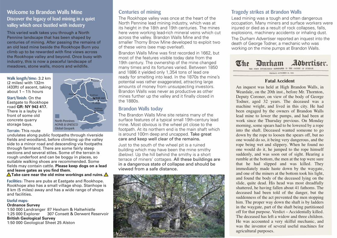
Brandon Walls todayThe Brandon Walls Mine site retains many of the surface features of a typical small 19th-century lead mine. Most obvious is the wheel pit close to the footpath. At its northern end is the main shaft which is around 100m deep and uncapped. Take great care and keep well clear of the remains.
Just to the south of the wheel pit is a ruined building which may have been the mine smithy (below). Up the hill behind the smithy is a short terrace of miners’ cottages. All these buildings are in a dangerous state of collapse and should be viewed from a safe distance.
Printed on 150gsm Cacoon 100% recycled Silk
OREsome North PenninesThis walk leaflet was devised as part of the North
Pennines AONB Partnership’s two-year-long Heritage
Lottery-funded project ‘OREsome’. The project aimed to
enthuse, engage and enable local communities to help
conserve upland ore mining landscapes. One objective
was to communicate the stories associated with the sites
to local people and visitors.
Other OREsome project sites you can visit:Nenthead Mines
Lots to see and do – mine tours and open days led by
experienced volunteers. Go to
www.nentheadmines.com for more information.
Whitesike and Bentyfield Mines
A walk leaflet is available to help you explore this
fascinating area. Discover remains of mine buildings, an
old quarry and earlier mine features higher up the fell. Also
a wonderful display of flowers in early summer.
All of our walks leaflets are available as downloadable pdfs
from www.northpennines.org.uk
Thanks to Dot Coe and Martin Green (lead volunteers for Brandon Walls) and Alan Blackburn of the Weardale Museum for additional information on local mining history.
Nenthead Mines www.skyimage.co.uk
North Pennines Area of Outstanding Natural Beauty (AONB) and UNESCO Global GeoparkThe North Pennines was designated as an Area of
Outstanding Natural Beauty (AONB) in 1988. It includes
parts of the counties of Durham, Northumberland and
Cumbria (with a very small part of North Yorkshire), and
at 2,000km2, it is the second largest of the 38 AONBs in
England and Wales. For more information on AONBs,
visit www.landscapesforlife.org.uk
The area is also a UNESCO Global Geopark - a place
where outstanding geological heritage is used to support
sustainable development, through conservation,
education, interpretation and nature tourism. For more
information visit www.unesco.org/geoparks
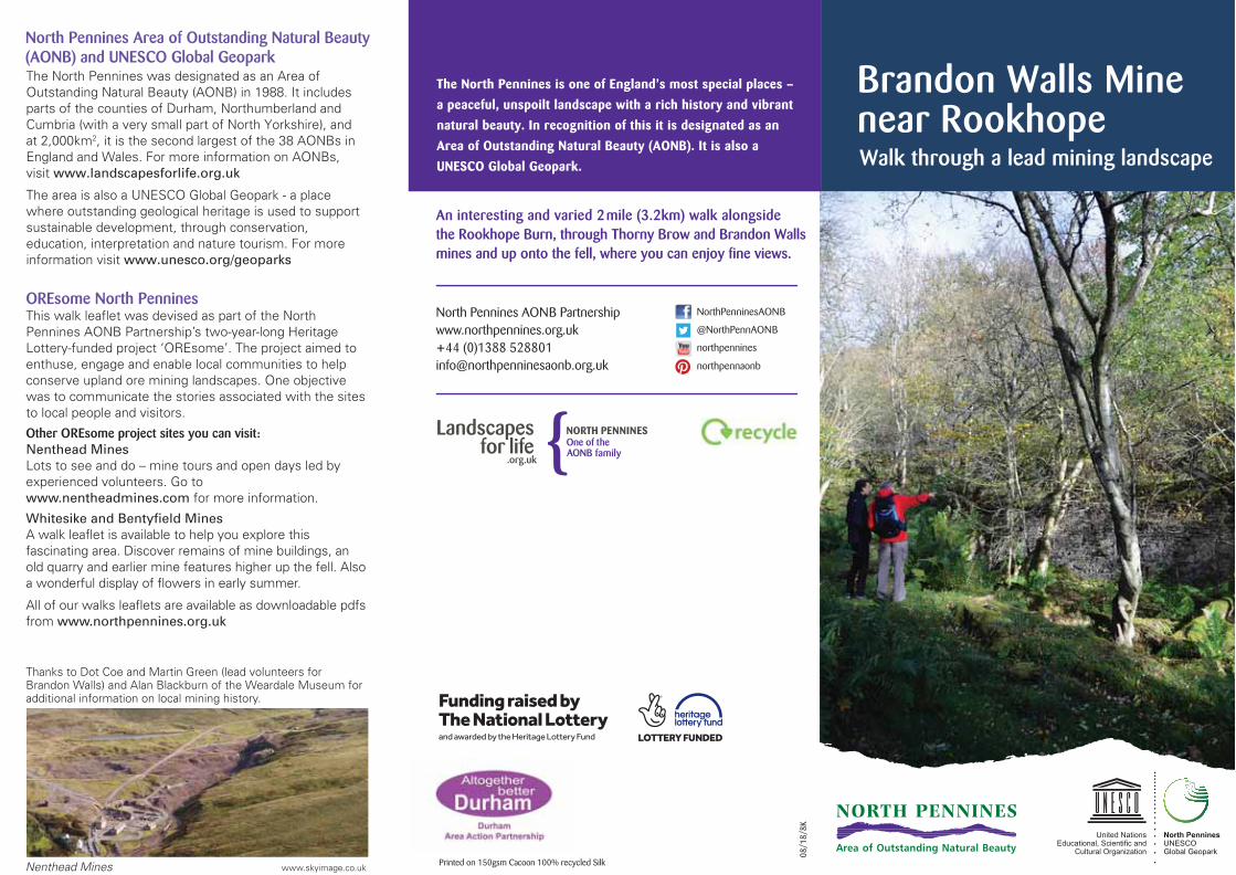
Brandon Walls Minenear RookhopeWalk through a lead mining landscape
The North Pennines is one of England’s most special places –
a peaceful, unspoilt landscape with a rich history and vibrant
natural beauty. In recognition of this it is designated as an
Area of Outstanding Natural Beauty (AONB). It is also a
UNESCO Global Geopark.
An interesting and varied 2mile (3.2km) walk alongsidethe Rookhope Burn, through Thorny Brow and Brandon Wallsmines and up onto the fell, where you can enjoy fine views.
North Pennines AONB Partnershipwww.northpennines.org.uk+44 (0)1388 [email protected]
NorthPenninesAONB
08/1
8/8K
@NorthPennAONB
northpennines
northpennaonb
Middleton-in-Teesdale
Hexham
Stanhope
Alston
North PenninesAONB & UNESCO Global Geopark
Rookhope
Walk start
Welcome to Brandon Walls MineDiscover the legacy of lead mining in a quiet valley which once bustled with industry
This varied walk takes you through a North
Pennine landscape that has been shaped by
centuries of mining. After passing the remains of
an old lead mine beside the Rookhope Burn you
climb up to be rewarded with fine views across
the Rookhope valley and beyond. Once busy with
industry, this is now a peaceful landscape of
meadows, stone walls, moors and wildlife.
Walk length/time: 3.2 km (2 miles) with 132m (433ft) of ascent, taking about 1 – 1½ hours
Start/finish: On the Eastgate to Rookhope road GR: NY 943 417. There is a layby in front of some old concrete quarry storage bays.
Terrain: This route undulates along public footpaths through riverside fields and woodland, before climbing up the valley side to a minor road and descending via footpaths through farmland. There are some fairly steep sections and several stiles. Some of the terrain is rough underfoot and can be boggy in places, so suitable walking shoes are recommended. Some fields may contain cattle. Please keep dogs on a lead and leave gates as you find them.
Take care near the old mine workings and ruins.
Facilities: There are pubs at Eastgate and Rookhope. Rookhope also has a small village shop. Stanhope is 8 km (5 miles) away and has a wide range of shops and facilities.
Useful maps: Ordnance Survey1:50 000 Landranger 87 Hexham & Haltwhistle1:25 000 Explorer 307 Consett & Derwent ReservoirBritish Geological Survey1:50 000 Geological Sheet 25 Alston
Tragedy strikes at Brandon Walls Lead mining was a tough and often dangerous occupation. Many miners and surface workers were injured or died as a result of rock collapses, falls, explosions, machinery accidents or inhaling dust.
The Durham Advertiser reported an inquest into the death of George Todner, a mechanic who was working on the mine pumps at Brandon Walls.
Fatal AccidentAn inquest was held at High Brandon Walls, in Weardale, on the 20th inst., before Mr. Thornton, Deputy Coroner, on view of the body of George Todner, aged 32 years. The deceased was a machine wright, and lived in this city. He had been engaged by the owners of Brandon Walls lead mine to lower the pumps, and had been at work since the Thursday previous. On Monday morning, some spears had to be lowered by a rope into the shaft. Deceased wanted someone to go down by the rope to loosen the spears off, but no one would do so, it being very dangerous, and the rope being wet and slippery. When he found no one would do it, he jumped to the rope himself suddenly, and was soon out of sight. Hearing a rumble at the bottom, the men at the top were sure that he had slipped and was killed. They immediately made haste down by the waygate, and one of the miners at the bottom took his light, and found the body of the deceased lying on the slide, quite dead. His head was most dreadfully shattered, he having fallen about 41 fathoms. The deceased had been told of the danger, but the suddenness of the act prevented the men stopping him. The proper way down the shaft is by ladders in the waygate, part of the shaft being partitioned off for that purpose. Verdict – Accidentally killed. The deceased has left a widow and three children. He was accounted a very skilful mechanic, and was the inventor of several useful machines for agricultural purposes.
Centuries of miningThe Rookhope valley was once at the heart of the North Pennine lead mining industry, which was at its height in the 18th and 19th centuries. The mines here were working lead-rich mineral veins which cut across the valley. Brandon Walls Mine and the smaller Thorny Brow Mine developed to exploit two of these veins (see map overleaf).
Brandon Walls Mine was first recorded in 1662, but most of the features visible today date from the 19th century. The ownership of the mine changed many times and its fortunes varied. Between 1850 and 1886 it yielded only 1,354 tons of lead ore ready for smelting into lead. In the 1870s the mine’s potential was rather exaggerated, attracting large amounts of money from unsuspecting investors. Brandon Walls was never as productive as other mines further up the valley and it finally closed in the 1880s.
Brandon Walls todayThe Brandon Walls Mine site retains many of the surface features of a typical small 19th-century lead mine. Most obvious is the wheel pit close to the footpath. At its northern end is the main shaft which is around 100m deep and uncapped. Take great care and keep well clear of the remains.
Just to the south of the wheel pit is a ruined building which may have been the mine smithy (below). Up the hill behind the smithy is a short terrace of miners’ cottages. All these buildings are in a dangerous state of collapse and should be viewed from a safe distance.
Printed on 150gsm Cacoon 100% recycled Silk
OREsome North PenninesThis walk leaflet was devised as part of the North
Pennines AONB Partnership’s two-year-long Heritage
Lottery-funded project ‘OREsome’. The project aimed to
enthuse, engage and enable local communities to help
conserve upland ore mining landscapes. One objective
was to communicate the stories associated with the sites
to local people and visitors.
Other OREsome project sites you can visit:Nenthead Mines
Lots to see and do – mine tours and open days led by
experienced volunteers. Go to
www.nentheadmines.com for more information.
Whitesike and Bentyfield Mines
A walk leaflet is available to help you explore this
fascinating area. Discover remains of mine buildings, an
old quarry and earlier mine features higher up the fell. Also
a wonderful display of flowers in early summer.
All of our walks leaflets are available as downloadable pdfs
from www.northpennines.org.uk
Thanks to Dot Coe and Martin Green (lead volunteers for Brandon Walls) and Alan Blackburn of the Weardale Museum for additional information on local mining history.
Nenthead Mineswww.skyimage.co.uk
North Pennines Area of Outstanding Natural Beauty (AONB) and UNESCO Global GeoparkThe North Pennines was designated as an Area of
Outstanding Natural Beauty (AONB) in 1988. It includes
parts of the counties of Durham, Northumberland and
Cumbria (with a very small part of North Yorkshire), and
at 2,000km2, it is the second largest of the 38 AONBs in
England and Wales. For more information on AONBs,
visit www.landscapesforlife.org.uk
The area is also a UNESCO Global Geopark - a place
where outstanding geological heritage is used to support
sustainable development, through conservation,
education, interpretation and nature tourism. For more
information visit www.unesco.org/geoparks
Brandon Walls Minenear RookhopeWalk through a lead mining landscape
The North Pennines is one of England’s most special places –
a peaceful, unspoilt landscape with a rich history and vibrant
natural beauty. In recognition of this it is designated as an
Area of Outstanding Natural Beauty (AONB). It is also a
UNESCO Global Geopark.
An interesting and varied 2mile (3.2km) walk alongsidethe Rookhope Burn, through Thorny Brow and Brandon Wallsmines and up onto the fell, where you can enjoy fine views.
North Pennines AONB Partnershipwww.northpennines.org.uk+44 (0)1388 [email protected]
NorthPenninesAONB
08/18/8K
@NorthPennAONB
northpennines
northpennaonb
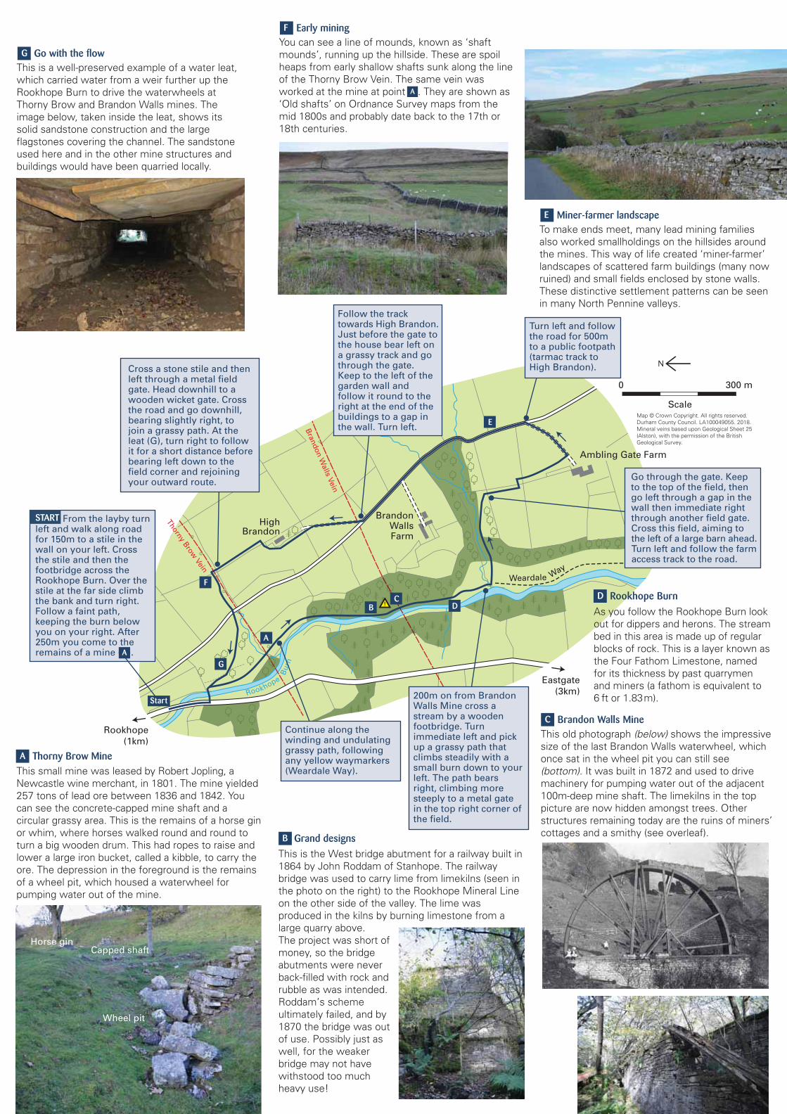
0 300 m
Scale
B DC
E
F
G
Start
A
Weardale
Rookhope
Bu
rn
HighBrandon
Bra
nd
on
Walls V
ein
Thorn
y Bro
w V
ein
Eastgate
(3km)
Rookhope
(1km)
Ambling Gate Farm
BrandonWallsFarm
N
Way
Map © Crown Copyright. All rights reserved.
Durham County Council. LA100049055. 2018.
Mineral veins based upon Geological Sheet 25
(Alston), with the permission of the British
Geological Survey.
Horse ginCapped shaft
Wheel pit
This small mine was leased by Robert Jopling, a
Newcastle wine merchant, in 1801. The mine yielded
257 tons of lead ore between 1836 and 1842. You
can see the concrete-capped mine shaft and a
circular grassy area. This is the remains of a horse gin
or whim, where horses walked round and round to
turn a big wooden drum. This had ropes to raise and
lower a large iron bucket, called a kibble, to carry the
ore. The depression in the foreground is the remains
of a wheel pit, which housed a waterwheel for
pumping water out of the mine.
This old photograph (below) shows the impressive
size of the last Brandon Walls waterwheel, which
once sat in the wheel pit you can still see
(bottom). It was built in 1872 and used to drive
machinery for pumping water out of the adjacent
100m-deep mine shaft. The limekilns in the top
picture are now hidden amongst trees. Other
structures remaining today are the ruins of miners’
cottages and a smithy (see overleaf).
A Thorny Brow Mine
D Rookhope Burn
To make ends meet, many lead mining families
also worked smallholdings on the hillsides around
the mines. This way of life created ‘miner-farmer’
landscapes of scattered farm buildings (many now
ruined) and small fields enclosed by stone walls.
These distinctive settlement patterns can be seen
in many North Pennine valleys.
E Miner-farmer landscape
You can see a line of mounds, known as ‘shaft
mounds’, running up the hillside. These are spoil
heaps from early shallow shafts sunk along the line
of the Thorny Brow Vein. The same vein was
worked at the mine at point A. They are shown as
‘Old shafts’ on Ordnance Survey maps from the
mid 1800s and probably date back to the 17th or
18th centuries.
F Early mining
This is a well-preserved example of a water leat,
which carried water from a weir further up the
Rookhope Burn to drive the waterwheels at
Thorny Brow and Brandon Walls mines. The
image below, taken inside the leat, shows its
solid sandstone construction and the large
flagstones covering the channel. The sandstone
used here and in the other mine structures and
buildings would have been quarried locally.
G Go with the flow
C Brandon Walls Mine
B Grand designs
This is the West bridge abutment for a railway built in
1864 by John Roddam of Stanhope. The railway
bridge was used to carry lime from limekilns (seen in
the photo on the right) to the Rookhope Mineral Line
on the other side of the valley. The lime was
produced in the kilns by burning limestone from a
large quarry above.
The project was short of
money, so the bridge
abutments were never
back-filled with rock and
rubble as was intended.
Roddam’s scheme
ultimately failed, and by
1870 the bridge was out
of use. Possibly just as
well, for the weaker
bridge may not have
withstood too much
heavy use!
As you follow the Rookhope Burn look
out for dippers and herons. The stream
bed in this area is made up of regular
blocks of rock. This is a layer known as
the Four Fathom Limestone, named
for its thickness by past quarrymen
and miners (a fathom is equivalent to
6 ft or 1.83m).
A
START From the layby turn left and walk along road for 150m to a stile in the wall on your left. Cross the stile and then the footbridge across the Rookhope Burn. Over the stile at the far side climb the bank and turn right. Follow a faint path, keeping the burn below you on your right. After 250m you come to the remains of a mine (A).
Follow the track towards High Brandon. Just before the gate to the house bear left on a grassy track and go through the gate. Keep to the left of the garden wall and follow it round to the right at the end of the buildings to a gap in the wall. Turn left.
Cross a stone stile and then left through a metal field gate. Head downhill to a wooden wicket gate. Cross the road and go downhill, bearing slightly right, to join a grassy path. At the leat (G), turn right to follow it for a short distance before bearing left down to the field corner and rejoining your outward route.
Turn left and follow the road for 500m to a public footpath (tarmac track to High Brandon).
Go through the gate. Keep to the top of the field, then go left through a gap in the wall then immediate right through another field gate. Cross this field, aiming to the left of a large barn ahead. Turn left and follow the farm access track to the road.
200m on from Brandon Walls Mine cross a stream by a wooden footbridge. Turn immediate left and pick up a grassy path that climbs steadily with a small burn down to your left. The path bears right, climbing more steeply to a metal gate in the top right corner of the field.
Continue along the winding and undulating grassy path, following any yellow waymarkers (Weardale Way).
A