Embed Size (px)
Citation preview
drinking water source protection plan
Boyanup Water Reserve
Boyanup town water supply
Water resource protection series Report WRP 169March 2019

Boyanup Water Reserve drinking water source protection plan Boyanup town water supply
Department of Water and Environmental Regulation
Water resource protection series
Report no. 169
March 2019
Department of Water and Environmental Regulation
Prime House 8 Davidson Terrace
Joondalup Western Australia 6027
Telephone +61 8 6364 7000
Facsimile +61 8 6364 7001
National Relay Service 13 36 77
www.dwer.wa.gov.au
© Government of Western Australia
March 2019
This work is copyright. You may download, display, print and reproduce this material in unaltered form
only (retaining this notice) for your personal, non-commercial use or use within your organisation.
Apart from any use as permitted under the Copyright Act 1968, all other rights are reserved. Requests
and inquiries concerning reproduction and rights should be addressed to the Department of Water and
Environmental Regulation.
ISSN 1835-3924 (online)
Acknowledgements
The Department of Water and Environmental Regulation would like to thank the following for their
contribution to this publication: Justin King, Chris Qiu, Stephen Watson and Nigel Mantle (Department
of Water and Environmental Regulation) and Louise Holbrook (Water Corporation).
For more information about this report, contact
Water Source Protection Planning on +61 8 6364 7000 or [email protected].
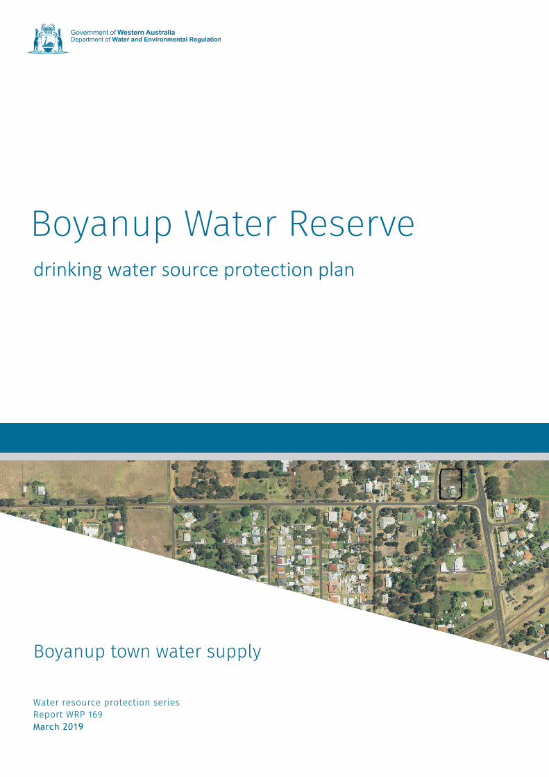
Cover photograph: Aerial photo of the Boyanup Water Reserve
Disclaimer
This document has been published by the Department of Water and Environmental Regulation. Any
representation, statement, opinion or advice expressed or implied in this publication is made in good
faith and on the basis that the Department of Water and Environmental Regulation and its employees
are not liable for any damage or loss whatsoever which may occur as a result of action taken or not
taken, as the case may be in respect of any representation, statement, opinion or advice referred to
herein. Professional advice should be obtained before applying the information contained in this
document to particular circumstances.
The Department of Water and Environmental Regulation was established by the Government of
Western Australia on 1 July 2017. It is a result of the amalgamation of the Department of
Environmental Regulation, Department of Water and the Office of the Environmental Protection
Authority. This publication may contain references to previous government departments and
programs. Please email the Department of Water and Environmental Regulation to clarify any specific
information.
This publication is available at our website www.dwer.wa.gov.au or for those with special needs it can be made available in alternative formats such as audio, large print, or Braille.
Boyanup Water Reserve drinking water source protection plan WRP no. 169
Department of Water and Environmental Regulation iii
Contents Summary ..................................................................................................................... v
1 Overview ................................................................................................................. 1
1.1 The drinking water supply system .................................................................................... 1 1.2 Water management .......................................................................................................... 1
1.2.1 Licence to take water .............................................................................................................. 1 1.2.2 Water planning ........................................................................................................................ 2 1.2.3 Future water needs ................................................................................................................. 2
1.3 Characteristics of the catchment ...................................................................................... 2 1.3.1 Physical environment .............................................................................................................. 2 1.3.2 Climate.................................................................................................................................... 2 1.3.3 Hydrogeology .......................................................................................................................... 2
1.4 How is this drinking water source currently protected? .................................................... 3 1.5 Aboriginal native title claims ............................................................................................. 3
2 Common contamination risks .................................................................................. 5
2.1 Microbiological risks ......................................................................................................... 5 2.2 Physical risks ................................................................................................................... 6 2.3 Chemical risks .................................................................................................................. 7
3 Contamination risks in this drinking water source .................................................... 8
3.1 Water quality .................................................................................................................... 8 3.2 Land uses and activities ................................................................................................... 8
3.2.1 Bore seals ............................................................................................................................... 8 3.2.2 Other groundwater bores in the area ...................................................................................... 9
4 Protecting your drinking water source ................................................................... 10
4.1 Proclaiming public drinking water source areas ............................................................. 10 4.2 Defining priority areas .................................................................................................... 10 4.3 Defining protection zones ............................................................................................... 11 4.4 Planning for future land uses ......................................................................................... 11 4.5 Using best management practices ................................................................................. 11
5 Recommendations ................................................................................................ 13
6 Consultation .......................................................................................................... 14
6.1 Stakeholder consultation process .................................................................................. 14
Appendices ................................................................................................................ 15
Appendix A — Figures ............................................................................................................. 15 Appendix B — Water quality data ............................................................................................ 19 Appendix C — Photographs .................................................................................................... 23 Appendix D — How do we protect public drinking water source areas? .................................. 25
List of shortened forms .............................................................................................. 29
Glossary .................................................................................................................... 31
References ................................................................................................................ 35
Further reading .......................................................................................................... 37
WRP no. 169 Boyanup Water Reserve drinking water source protection plan
____________________________________________________________________________________________________________
iv Department of Water and Environmental Regulation
Tables
Table 1 Key information about the Boyanup Water Reserve ......................... vi
Boyanup Water Reserve drinking water source protection plan WRP no. 169
Department of Water and Environmental Regulation v
Summary This drinking water source protection plan establishes a boundary for the Boyanup Water Reserve, which supplies drinking water to Boyanup, a town about 18 km south of Bunbury. The plan identifies and assesses the risks to water quality in the water reserve and recommends strategies to address these risks to ensure a safe, good quality and affordable drinking water supply for Boyanup now and in the future.
Boyanup’s water is supplied by the Water Corporation from the Yarragadee aquifer. The water supply system consists of two deep production bores, screened for abstraction between 180 and 230 m, located in separate compounds within the town centre and a water treatment plant.
The Yarragadee aquifer is a deep, confined water source at Boyanup. There is very low risk of contamination of the Yarragadee aquifer from land uses surrounding the production bores because of the confined nature of the aquifer.
The Boyanup Water Reserve covers only the Water Corporation compounds containing the production bores (see Figure A3). DWER has determined the boundaries and priority areas for this water reserve to provide an appropriate level of protection for Boyanup’s drinking water source.
The main outcomes of this plan are:
Constitute the Boyanup Water Reserve under the Country Areas Water Supply Act 1947 to allow by-laws to be applied to protect water quality.
Assign a priority 1 (P1) area to the water reserve. Include the water reserve boundary in the local planning scheme. Permanently seal the bores to prevent entry by small animals or insects.
This plan is consistent with the Australian drinking water guidelines (ADWG) (NHMRC & NRMMC 2011) and State planning policy no. 2.7: Public drinking water source policy.
Table 1 shows important information about the Boyanup Water Reserve.
WRP no. 169 Boyanup Water Reserve drinking water source protection plan
vi Department of Water and Environmental Regulation
Table 1 Key information about the Boyanup Water Reserve
Boyanup Water Reserve
Status of this report This report is based on information from the 2015–16 financial year. Public drinking water source area boundaries, priority areas, bore locations, wellhead protection zones and other data may be subject to change. For up-to-date information, please email [email protected].
Local government authority
Shire of Capel
Location supplied Boyanup
Water service provider Water Corporation
Aquifer type Confined – Yarragadee aquifer
Licensed abstraction 325 000 kL/year (Licence number 65326)
Number of bores 2
Bore names and GPS coordinates
1/87 (E 381 66.9, N 6 294 901.1, zone 50)
2/87 (E 381 098.8, N 6 294 510.2, zone 50)
Date of bore completion 1/87: 1987
2/87: 1987
Bore depth and screening 1/87: 220 m, screened from 184 m to 220 m
2/87: 227 m, screened from 195 m to 226 m
Date of drinking water source protection report
2018 – Boyanup Water Reserve drinking water source protection plan (this document)
Consultation Key stakeholders including Water Corporation, Shire of Capel, Department of Health, Department of Planning, Lands and Heritage and Department of Mines, Industry Regulation and Safety
Proclamation status Proclamation will need to be progressed under the Country
Areas Water Supply Act 1947 when this report is finalised
Reference documents Australian drinking water guidelines (NHMRC & NRMMC 2011)
Boyanup Water Reserve drinking water source protection plan WRP no. 169
Department of Water and Environmental Regulation vii
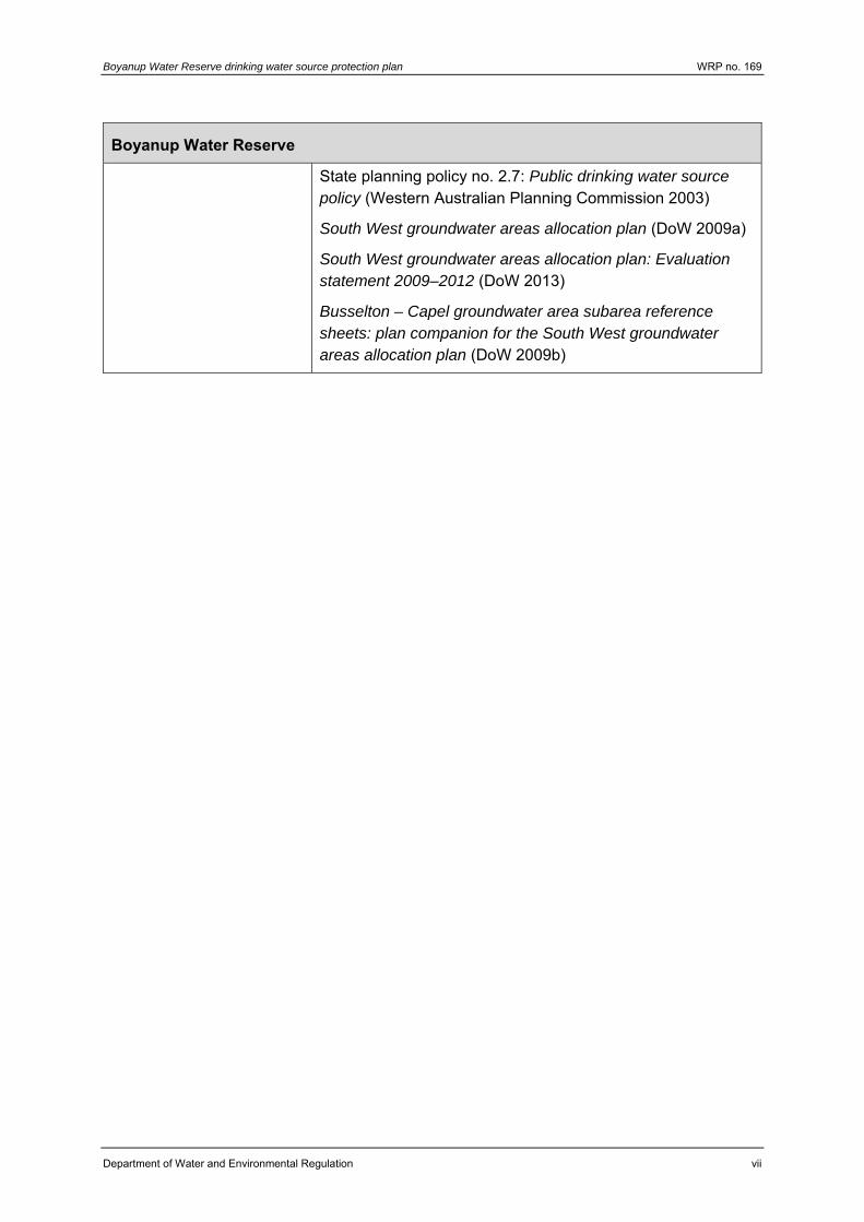
Boyanup Water Reserve
State planning policy no. 2.7: Public drinking water source policy (Western Australian Planning Commission 2003)
South West groundwater areas allocation plan (DoW 2009a)
South West groundwater areas allocation plan: Evaluation statement 2009–2012 (DoW 2013)
Busselton – Capel groundwater area subarea reference sheets: plan companion for the South West groundwater areas allocation plan (DoW 2009b)

Boyanup Water Reserve drinking water source protection plan WRP no. 169
Department of Water and Environmental Regulation 1
1 Overview
1.1 The drinking water supply system
Boyanup is a small country town located on the South Western Highway about 18 km south-east of Bunbury, within the Shire of Capel. Boyanup had a residential population of around 800, which is expected to increase over the next 20 to 30 years with further residential development.
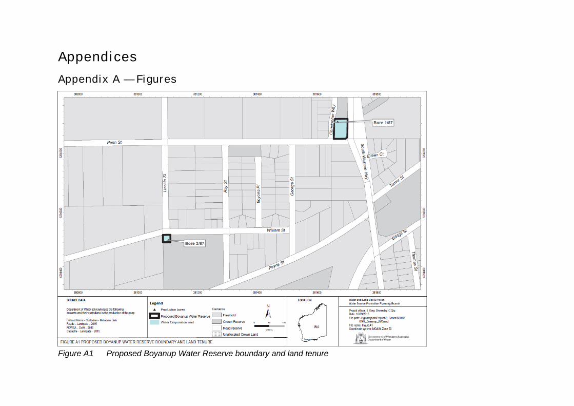
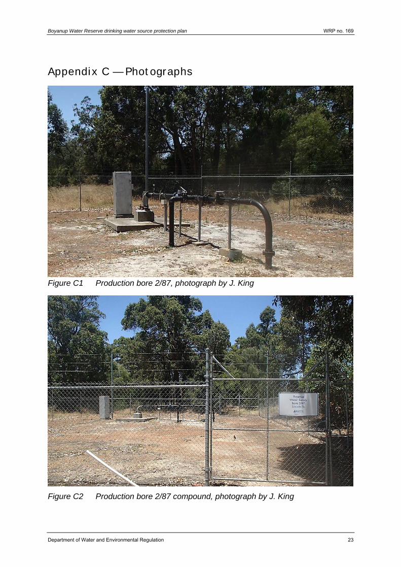
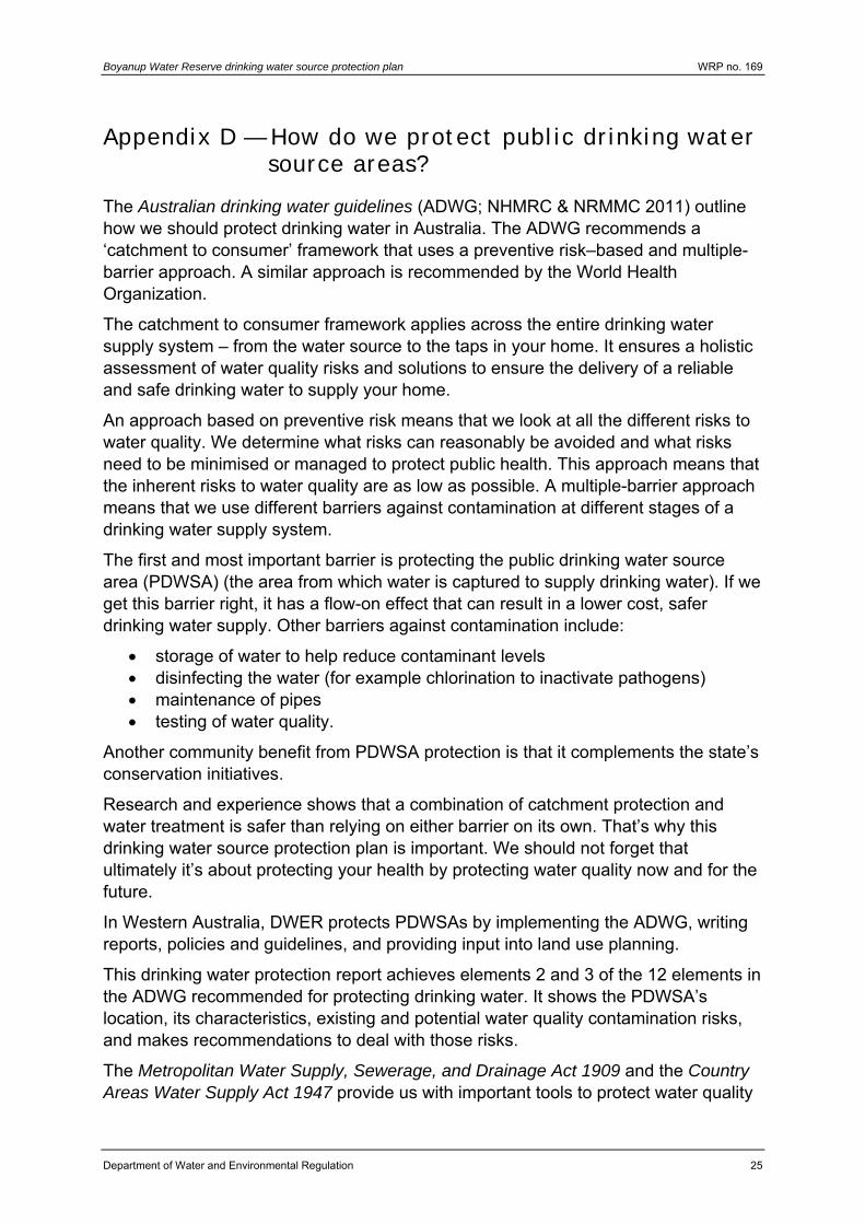
The Boyanup scheme is sourced from the Yarragadee aquifer by two production bores, 1/87 and 2/87, within compounds in the Boyanup town site (figures A1, C1 and C3). These bores abstract water from between approximately 180 m and 230 m below ground level. The bores and scheme are operated by the Water Corporation.
Water drawn from the Yarragadee aquifer is chlorinated to disinfect the water, aerated and filtered to reduce naturally occurring iron levels, before being stored in an elevated tank for distribution to the scheme.
It should be recognised that although treatment and disinfection are essential barriers against contamination, public drinking water source area (PDWSA) management is the first step in protecting water quality and ensuring a safe drinking water supply. This approach is endorsed by the Australian drinking water guidelines (ADWG) (NHMRC & NRMMC 2011) and reflects a preventive, risk-based, multiple-barrier approach for providing safe drinking water to consumers. This combination of catchment protection and water treatment will deliver a more reliable, safer and lower cost drinking water to consumers than either approach could achieve individually.
For more information on why it is important to protect our PDWSAs see Appendix D.
1.2 Water management
1.2.1 Licence to take water
Water resource use and conservation in Western Australia is administered by DWER in accordance with the Rights in Water and Irrigation Act 1914. Under this Act, the right to use and control water is vested with the Crown. This means that a licence is required for drilling bores and abstracting groundwater (pumping water from a bore, spring or soak) within proclaimed groundwater areas throughout the state. Some exemptions apply such as abstracting water for domestic purposes only.
The Boyanup Water Reserve is located within the Bunbury Groundwater Area (and the Bunbury – Yarragadee subarea) which is proclaimed under the Rights in Water and Irrigation Act 1914. The Water Corporation is licensed by the DWER, under the Rights in Water and Irrigation Act 1914, to abstract water from the Yarragadee aquifer for public water supply. The annual abstraction from this aquifer for public water supply is 325 000 kL under groundwater licence 65326.
WRP no. 169 Boyanup Water Reserve drinking water source protection plan
2 Department of Water and Environmental Regulation
1.2.2 Water planning
The South West groundwater areas allocation plan (DoW 2009a) provides our direction for the allocation of groundwater in the south-west of Western Australia. The plan also provides the department’s policies on licensing and allocating water, objectives for the water resource and objectives for managing water allocation. The Yarragadee aquifer in the Bunbury – Yarragadee subarea is fully allocated with no additional water available, other than for public water supply.
The South West groundwater areas allocation plan: Evaluation statement 2009–2012 (DoW 2013) reviewed and updated allocation limits for the South West groundwater areas. A total of 4.7 GL per year reserved for public water supply in the Bunbury – Yarragadee subarea in 2012 remains.
1.2.3 Future water needs
The number of households at Boyanup has steadily increased over time, and is predicted to continue increasing in the short-term. However, water abstraction has recently decreased from almost 250 000 kL in 2008-09 to below 140 000 kL in 2012-13, due to the closure of a dairy industry in the town.
Future abstraction is expected to increase slowly in the short-term and remain below 150 000 kL per year, well within the licensed allocation of 325 000 kL per year.
1.3 Characteristics of the catchment
1.3.1 Physical environment
Boyanup is located about 18 km south-east of Bunbury on the Swan Coastal Plain (Figure A1). The town lies next to the Preston River and the South Western Highway.
The two Boyanup production bores are contained within Water Corporation compounds in the town. Production bore 1/87 is located with the Boyanup water treatment plant near the centre of the town, while production bore 2/87 is located in a compound on the western extent of the residential area (Figure A2).
1.3.2 Climate
Boyanup has a Mediterranean-type climate with cool, wet winters and warm, dry summers. The average annual rainfall in the Capel area is around 800 mm. Winter temperatures typically range from 5 oC to 26 oC, while summer temperatures typically range from 14 oC to 40 oC.
1.3.3 Hydrogeology
The Boyanup scheme is sourced from the Yarragadee aquifer which is regionally confined by a layer of rock about 60 m to 70 m thick. In the Boyanup area, this aquifer begins about 170 m below ground level and is about 750 m thick.
Boyanup Water Reserve drinking water source protection plan WRP no. 169
Department of Water and Environmental Regulation 3
The Yarragadee aquifer is recharged to the south-south-west of Boyanup by leakage from the overlying Leederville aquifer where the confining rock layer is absent. The Yarragadee aquifer flow is generally north-north-west.
As Boyanup’s drinking water is drawn from a confined groundwater source there is little potential for groundwater contamination from surface land uses. This is because the source is adequately protected from surface contamination by the considerable depth to the groundwater and the presence of a confining layer of rock that sits above the groundwater. This confining layer acts as a barrier to contamination.
1.4 How is this drinking water source currently protected?
The Boyanup Water Reserve is not yet proclaimed under the Country Areas Water Supply Act 1947. However, the water reserve is located entirely on private land owned by the Water Corporation.
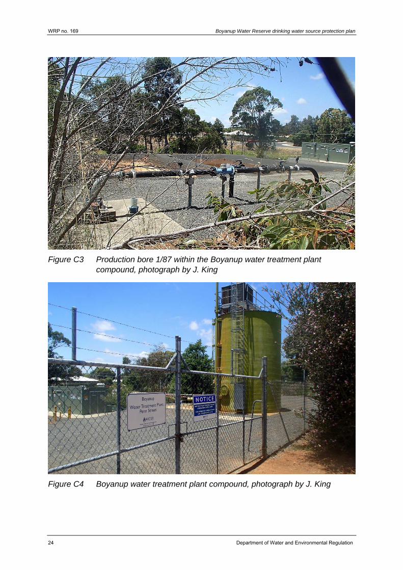
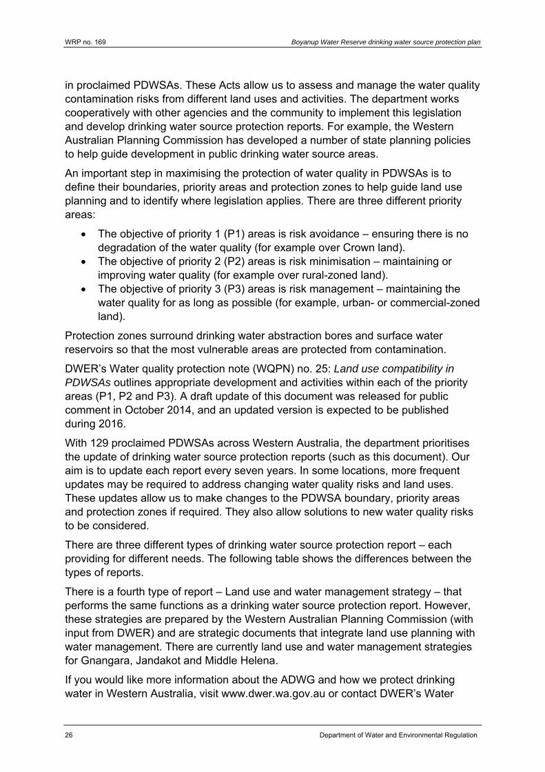
The production bores and water treatment plant are contained in fenced, locked compounds to deter unauthorised access and vandalism (figures C2 and C4). The Water Corporation employs best management practices for operating and managing the production bores, water treatment plant and compounds (Water Corporation 2011). The compounds are regularly inspected by Water Corporation staff.
1.5 Aboriginal native title claims
Native title is the recognition in Australian law that some Aboriginal people continue to hold native title rights and interests in lands and waters. The Boyanup Water Reserve lies within the Single Noongar Claim (Area 2) (WAD6012/2003) and Gnaala Karla Booja (WAD6274/1998) claim areas.
The State Government of Western Australia and the Noongar native title claimants have negotiated a South West Native Title Settlement.
The settlement recognises the Noongar people as the traditional owners of land in the South West Settlement Area (see Figure A4).
The settlement includes six identical Indigenous Land Use Agreements (ILUAs). The agreements enable some types of land-based customary activities to be undertaken by Noongar people in PDWSAs within the South West Settlement Area. On 8 June 2016, we amended two sets of by-laws (Metropolitan Water Supply, Sewerage and Drainage By-laws 1981 and the Country Areas Water Supply By-laws 1957) to enable this.
The ILUAs are available via the Department of Premier and Cabinet, see www.dpc.wa.gov.au. Refer to Water quality information sheet 39: Aboriginal customary activities in public drinking water source areas in the South West Native Title Settlement Area (DoW 2017).
WRP no. 169 Boyanup Water Reserve drinking water source protection plan
4 Department of Water and Environmental Regulation
The DWER is committed to working with Aboriginal people in its planning and management activities. The department recognises that native title is an important framework for water management.
Boyanup Water Reserve drinking water source protection plan WRP no. 169
Department of Water and Environmental Regulation 5
2 Common contamination risks Land development and land or water-based activities within a water reserve can directly affect the quality of drinking water and its treatment. Contaminants can reach drinking water sources through runoff over the ground and infiltration through soil. A wide range of microbiological, chemical and physical contamination risks can impact on water quality and therefore affect the provision of safe, good quality drinking water to consumers.
Some contaminants in drinking water can affect human health. Other impurities can affect the water’s aesthetic qualities, including its appearance, taste, smell and ‘feel’ but are not necessarily hazardous to human health. For example, cloudy water with a distinctive odour or strong taste may not be harmful to health, but clear, pleasant-tasting water may contain harmful, undetectable microorganisms (NHMRC & NRMMC 2011). Contaminants can also interfere with water treatment processes, and damage water supply infrastructure (such as iron corroding pipes).
The ADWG (NHMRC & NRMMC 2011) outlines criteria for acceptable drinking water quality to protect human health, manage aesthetics and maintain water supply infrastructure.
For more information about water quality in this PDWSA, see section 3.
Some commonly seen contamination risks relevant to groundwater drinking water sources are described below.
2.1 Microbiological risks
Pathogens are types of microorganisms that are capable of causing illness. These include bacteria, protozoa and viruses. In drinking water supplies, pathogens are commonly found in the faeces of humans and domestic animals (such as dogs and cattle).
Pathogens can enter drinking water supplies from faecal contamination in the water reserve. In groundwater sources, this occurs indirectly – faecal material can infiltrate through the soil and into the groundwater. For example, contamination can occur from septic tanks or grazing animals.
A number of pathogens are commonly known to contaminate water supplies worldwide. These include bacteria (for example Salmonella, Escherichia coli and cholera), protozoa (such as Cryptosporidium and Giardia) and viruses. Monitoring for the presence of E. coli in water supplies provides an indication of the level of recent faecal contamination.
Pathogen contamination of a drinking water source is influenced by many factors including the existence of pathogen carriers (humans and domestic animals), the transfer to and movement of the pathogen in the water source and its ability to survive in the water. The percentage of humans in the world that carry pathogens varies. For example, it is estimated that between 0.6 to 4.3 per cent of people are
WRP no. 169 Boyanup Water Reserve drinking water source protection plan
6 Department of Water and Environmental Regulation
infected with Cryptosporidium worldwide, and 7.4 per cent with Giardia (Geldreich 1996).
The survival and movement of pathogens in groundwater is influenced by the characteristics of the pathogen (such as its size and the length of time it normally takes to decay) and the groundwater properties (including flow rate, porosity, amount of carbon in the soil, temperature and pH). Inactivation rate (the time it normally takes a pathogen to decay) is one of the most important factors governing how far pathogens may migrate. Typical half-lives of pathogens range from a few hours to a few weeks. For example, some reported migration distances of bacteria in groundwater are:
600 m in a sandy aquifer 1000–1600 m in channelled limestone 250–408 m in glacial silt-sand aquifers (Robertson & Edbery 1997).
Unlike chemicals, which dissipate and dilute when they enter a water source, pathogens can multiply under the right conditions, increasing the likelihood of contamination. Therefore it is important to understand both the surface water and groundwater systems to be able to protect the drinking water source from pathogens.
When people consume drinking water contaminated with pathogens the consequences vary considerably, ranging from mild illness (such as stomach upset or diarrhoea) to hospitalisation and sometimes even death. During 2000, seven people died in Walkerton, Canada, because the town’s water supply was contaminated by a pathogenic strain of E. coli and Campylobacter (NHMRC & NRMMC 2011).
Given the wide variety of pathogens, the differences in how they act in the environment and the potential consequences of consuming contaminated water, the most effective way to protect public health and reduce water treatment costs is to avoid the introduction of pathogens into a water source.
2.2 Physical risks
Turbidity is the result of soil or organic particles becoming suspended in water (cloudiness). Increased turbidity can result in cloudy or muddy-looking water, which is not aesthetically appealing to consumers. Turbidity can also reduce the effectiveness of treatment processes (such as disinfection). This is because pathogens can adsorb onto soil particles and may be shielded from the effects of disinfection. Chemicals can also attach to suspended soil particles.
Some physical properties of water such as pH (a measure of acidity or alkalinity) can contribute to the corrosion and encrustation of pipes. Other properties such as iron and dissolved organic matter can affect the colour and smell of water. Although not necessarily harmful to human health, coloured or ‘hard’ water will not be as appealing to consumers. Salinity can affect the taste of drinking water.
Boyanup Water Reserve drinking water source protection plan WRP no. 169
Department of Water and Environmental Regulation 7
2.3 Chemical risks
Chemicals can occur in drinking water as a result of natural leaching from mineral deposits or from different land uses (NHMRC & NRMMC 2011). A number of these chemicals (organic and inorganic) are potentially toxic to humans.
Pesticides include agricultural chemicals used to control:
weeds (herbicides) pests (insecticides, rodenticides) worms (nematicides) mites (miticides).
Contamination of a drinking water source by pesticides (and other chemicals) may occur as a result of accidental spills, incorrect use or leakage from storage areas. In these cases, the relevant authorities should be notified promptly and the spill cleaned up to prevent contamination of the drinking water source.
Hydrocarbons (such as fuels and oils) are potentially toxic to humans, and harmful chemical by-products may be formed when they are combined with chlorine during the water treatment process. Hydrocarbons can occur in water supplies as a result of spills and leakage from vehicles.
Drinking water sources can also be contaminated by nutrients (such as nitrogen) from fertiliser, septic systems, and faecal matter from domestic or feral animals that washes through or over soil and into a water source. Nitrate and nitrite (forms of nitrogen) can be toxic to humans at high levels, with infants younger than three months being most susceptible (NHMRC & NRMMC 2011).
Other chemicals and heavy metals can be associated with land uses such as industry and landfill. These may enter drinking water sources and could be harmful to human health.
WRP no. 169 Boyanup Water Reserve drinking water source protection plan
8 Department of Water and Environmental Regulation
3 Contamination risks in this drinking water source
3.1 Water quality
The Water Corporation regularly monitors the quality of raw water from the Boyanup wellfield for microbiological, health-related and aesthetic (non-health-related) characteristics. This data shows the quality of water in the PDWSA. An assessment of the drinking water quality once treated is also made against the ADWG.
A water quality summary for the Boyanup wellfield from December 2009 to November 2014 is presented in Appendix B. For more information on water quality, see the Water Corporation’s most recent drinking water quality annual report at www.watercorporation.com.au.
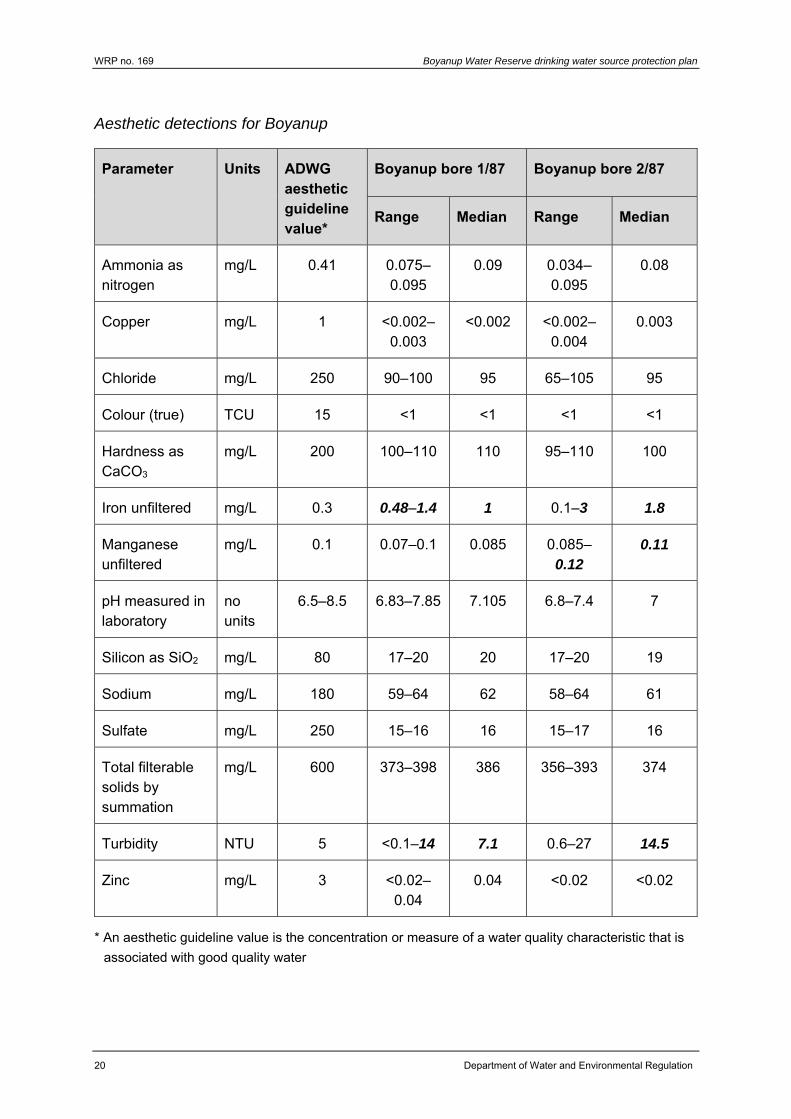
Water from the Yarragadee aquifer at Boyanup is characterised by naturally occurring turbidity, manganese and iron above the ADWG aesthetic guideline values. Escherichia coli was detected in 3.3 per cent samples during the period, which is attributed to small animals or insects entering the bores.
Water from this wellfield is disinfected via chlorination and treated to ensure that the levels of turbidity, manganese and iron in the reticulated water meet the ADWG guidelines before supply to consumers.
3.2 Land uses and activities
The Boyanup Water Reserve is located on freehold land owned by the Water Corporation. The bores are within a single compound also containing water treatment facilities and storage tanks.
As Boyanup’s drinking water is drawn from a confined groundwater source there is little potential for contamination from surrounding surface land uses. This is because the source is adequately protected from surface contamination by the considerable depth to the groundwater and the presence of a confining layer of rock that sits above the groundwater. This confining layer acts as a barrier to contamination.
3.2.1 Bore seals
The production bores are adequately constructed to prevent the inflow of potentially contaminated surface waters directly into the Yarragadee aquifer (figures C1 and C3). However, inadequate sealing has previously allowed small animals or insects to enter the bores. Detections of microbial contaminants in the raw water have been attributed to the entry of these animals into the bores and may pose a risk to water quality.
The bores should be permanently sealed to prevent the entry by small animals and insects.
Boyanup Water Reserve drinking water source protection plan WRP no. 169
Department of Water and Environmental Regulation 9
3.2.2 Other groundwater bores in the area
The Water Corporation operates drinking water bores in the Boyanup Water Reserve. If bores for other purposes (for example irrigation or private household use) are drilled near a public drinking water supply bore, they can cause contamination of the drinking water source. For example, a poorly constructed private bore may introduce contaminants from surface leakage down the outside of the bore casing into an otherwise uncontaminated aquifer.
It is therefore important to ensure that any bores are appropriately located and constructed to prevent contamination of the public drinking water source. This will be assessed through the DWER’s water licensing process where applicable under the Rights in Water and Irrigation Act 1914. All bores should be constructed in accordance with Minimum construction requirements for water bores in Australia (National Uniform Drillers Licensing Committee 2012).
There are no licensed users of the Yarragadee aquifer nearby.
WRP no. 169 Boyanup Water Reserve drinking water source protection plan
10 Department of Water and Environmental Regulation
4 Protecting your drinking water source This objective of the actions in this plan is to protect water quality in the Boyanup Water Reserve to ensure safe drinking water for the local public water supply.
4.1 Proclaiming public drinking water source areas
To protect the quality of the drinking water source, we are proposing to proclaim the Boyanup Water Reserve under the Country Areas Water Supply Act 1947.
Drinking water sources that are supplied from a confined aquifer, such as this one, only require a boundary that reflects the compound in which the drinking water bores are located. This ensures that the location of this important drinking water supply will be proclaimed and mapped so it is considered in future land use decisions or development of other bores. A larger boundary is not deemed necessary because the source is adequately protected from surface contamination risks by a confining layer of rock (figures A2 and A3).
Once the water reserve is proclaimed, the local government should incorporate the PDWSA into their planning schemes consistent with State planning policy no. 2.7: Public drinking water source policy. PDWSAs are commonly shown in planning schemes as special control areas. This provides guidance for state and local government planning decision makers and developers.
Proclamation of a PDWSA will not change the zoning of this land. All existing, approved land uses and activities in a proclaimed area can continue. However, we recommend that best management practices are employed in PDWSAs to protect the quality of the drinking water source. New developments or expansion of existing land uses or activities need to consider the recommendations in this plan. As a general guide, DWER does not recommend land use intensification in a PDWSA because of the increased risks to water quality and public health.
For more guidance on appropriate land uses and activities please refer to our Water quality protection note (WQPN) no. 25: Land use compatibility tables for public drinking water source areas.
4.2 Defining priority areas
The protection of PDWSAs relies on statutory and non-statutory measures for water resource management and land-use planning. The DWER’s policy for the protection of PDWSAs includes a system that defines three specific priority areas:
Priority 1 (P1) areas have the fundamental water quality objective of risk avoidance (for example state forest and other Crown land).
Priority 2 (P2) areas have the fundamental water quality objective of risk minimisation (for example land that is zoned rural).
Priority 3 (P3) areas have the fundamental water quality objective of risk management (for example areas zoned urban, industrial or commercial).
Boyanup Water Reserve drinking water source protection plan WRP no. 169
Department of Water and Environmental Regulation 11
The determination of priority areas is based on the strategic importance of the land or water source including risks to water quality and quantity, the local planning scheme zoning, the form of land tenure and existing approved land uses or activities. For further detail, please refer to our WQPN no. 25: Land use compatibility tables for public drinking water source areas.
The priority area for the Boyanup Water Reserve has been determined in accordance with current DWER policy. This area is described below and displayed in Figure A3. Our WQPN no.25 outlines activities that are ‘acceptable’, ‘compatible with conditions’ or ‘incompatible’ within the different priority areas. For an explanation of the background and support for protection of PDWSAs, please refer to WQPN no. 36: Protecting public drinking water source areas.
We propose to assign all the land in the Boyanup Water Reserve as P1 because:
water from this source is the only supply available to Boyanup all the land within the water reserve is owned by, or vested in, the Water
Corporation.
4.3 Defining protection zones
In addition to priority areas, protection zones are defined in PDWSAs to protect water from contamination in the immediate vicinity of water extraction facilities (i.e. bores or dams). Specific conditions may apply within these zones such as restrictions on the storage of chemicals or prohibition of public access.
Wellhead protection zones (WHPZs) are generally circular (unless information is available to determine a different shape or size), with a 500 m radius around each production bore in a P1 area and a 300 m radius around each production bore in P2 and P3 areas. WHPZs do not extend outside the boundary of the water reserve and they adopt the priority area of the land over which they occur.
WHPZs are not considered necessary for the Boyanup Water Reserve due to the confined nature of the water source, the depth of the bores and the fenced compound that protects the bores on land owned by the Water Corporation.
4.4 Planning for future land uses
Appropriate protection mechanisms in statutory land-use planning processes are necessary to secure the long-term protection of drinking water sources. As outlined in the WAPC’s State planning policy no. 2.7: Public drinking water source policy (2003) it is appropriate that the Boyanup Water Reserve and its priority areas be recognised in the Shire of Capel’s local planning scheme.
4.5 Using best management practices
There are opportunities to reduce water contamination risks by carefully considering design and management practices. To help protect water sources, DWER will continue to encourage the adoption of best management practices.
WRP no. 169 Boyanup Water Reserve drinking water source protection plan
12 Department of Water and Environmental Regulation
Guidelines on best management practices for many land uses are available in the form of industry codes of practice, environmental guidelines and WQPNs. They recommend practices to help managers reduce their impacts upon water quality. These guidelines have been developed in consultation with stakeholders such as industry groups, agricultural producers, state government agencies and technical advisers. Examples include Minimum construction requirements for water bores in Australia (National Uniform Drillers Licensing Committee 2012).
Education and awareness-raising, such as through providing information on signs and publications, are key mechanisms for protecting water quality, especially for people visiting the area.
Boyanup Water Reserve drinking water source protection plan WRP no. 169
Department of Water and Environmental Regulation 13
5 Recommendations The following recommendations apply to the Boyanup Water Reserve. The bracketed stakeholders are those expected to have a responsibility for, or an interest in, the implementation of that recommendation.
1. Proclaim the Boyanup Water Reserve under the Country Areas Water Supply Act 1947 in accordance with Figure A3. (DWER)
2. Incorporate the findings of this plan and location of the Boyanup Water Reserve (including its priority area) in the Shire of Capel’s local planning scheme in accordance with the WAPC’s State planning policy no. 2.7: Public drinking water source policy. (Shire of Capel)
3. Ensure incidents covered by Westplan–HAZMAT in the Boyanup Water Reserve are addressed by ensuring that:
the Shire of Capel local emergency management committee is aware of the location and purpose of the Boyanup Water Reserve
the locality plan for the Boyanup Water Reserve is provided to the Department of Fire and Emergency Services headquarters for the HAZMAT emergency advisory team
the Water Corporation acts in an advisory role during incidents in the Boyanup Water Reserve
personnel dealing with Westplan–HAZMAT incidents in the area have ready access to a locality map of the Boyanup Water Reserve and information to help them recognise the potential impacts of spills on drinking water quality. (Water Corporation)
4. Ensure the production bores are permanently sealed to prevent access by small animals and insects. (Water Corporation)
5. Maintain signs along the boundary of the Boyanup Water Reserve including an emergency contact telephone number, in accordance with the Water Corporation’s S111 Source protection signage (2013). (Water Corporation)
6. Update this plan within seven years. (DWER)
WRP no. 169 Boyanup Water Reserve drinking water source protection plan
14 Department of Water and Environmental Regulation
6 Consultation
6.1 Stakeholder consultation process
The draft recommendations and water reserve boundary were consulted with the Shire of Capel, Water Corporation, Department of Planning, Lands and Heritage, Department of Mines, Industry Regulation and Safety and Department of Health during the preparation of this drinking water source protection plan. No contentious issues were raised.
Appendices
Appendix A — Figures
Figure A1 Proposed Boyanup Water Reserve boundary and land tenure
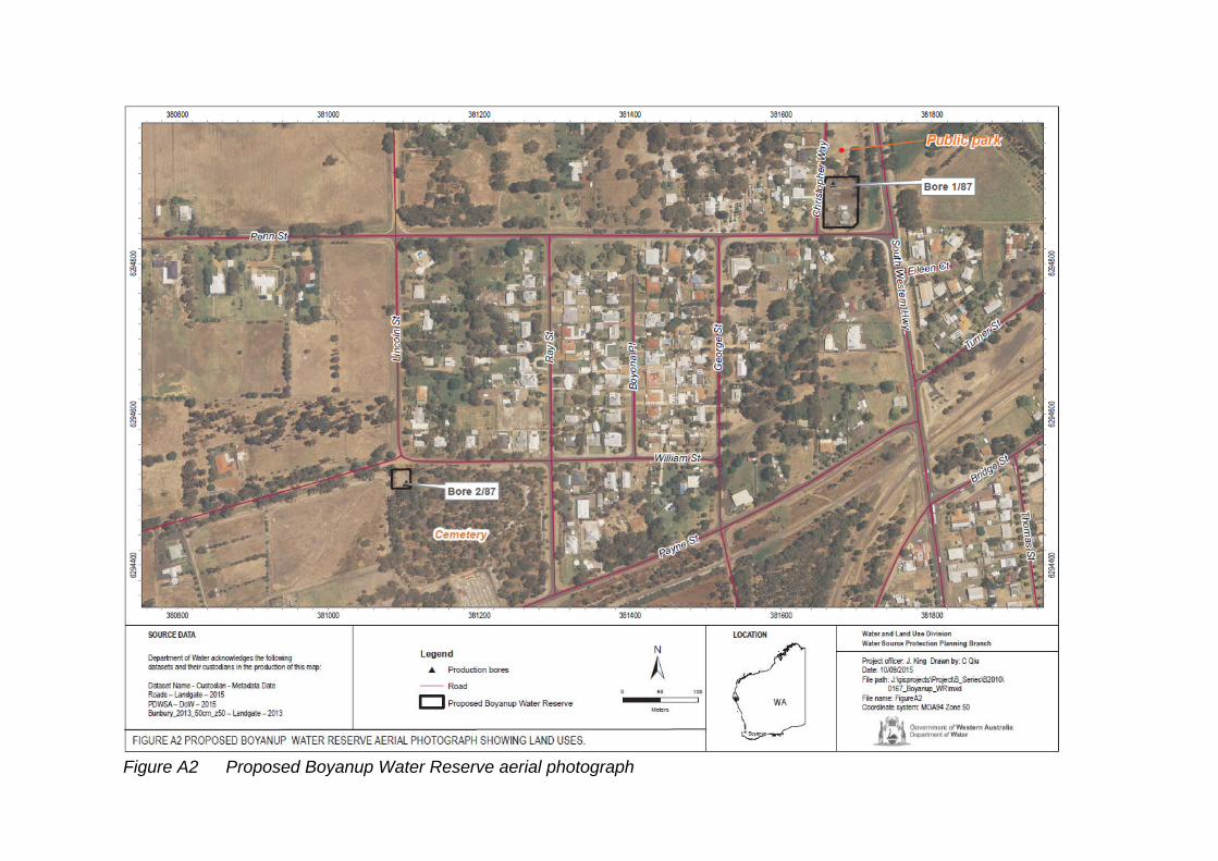
Figure A2 Proposed Boyanup Water Reserve aerial photograph
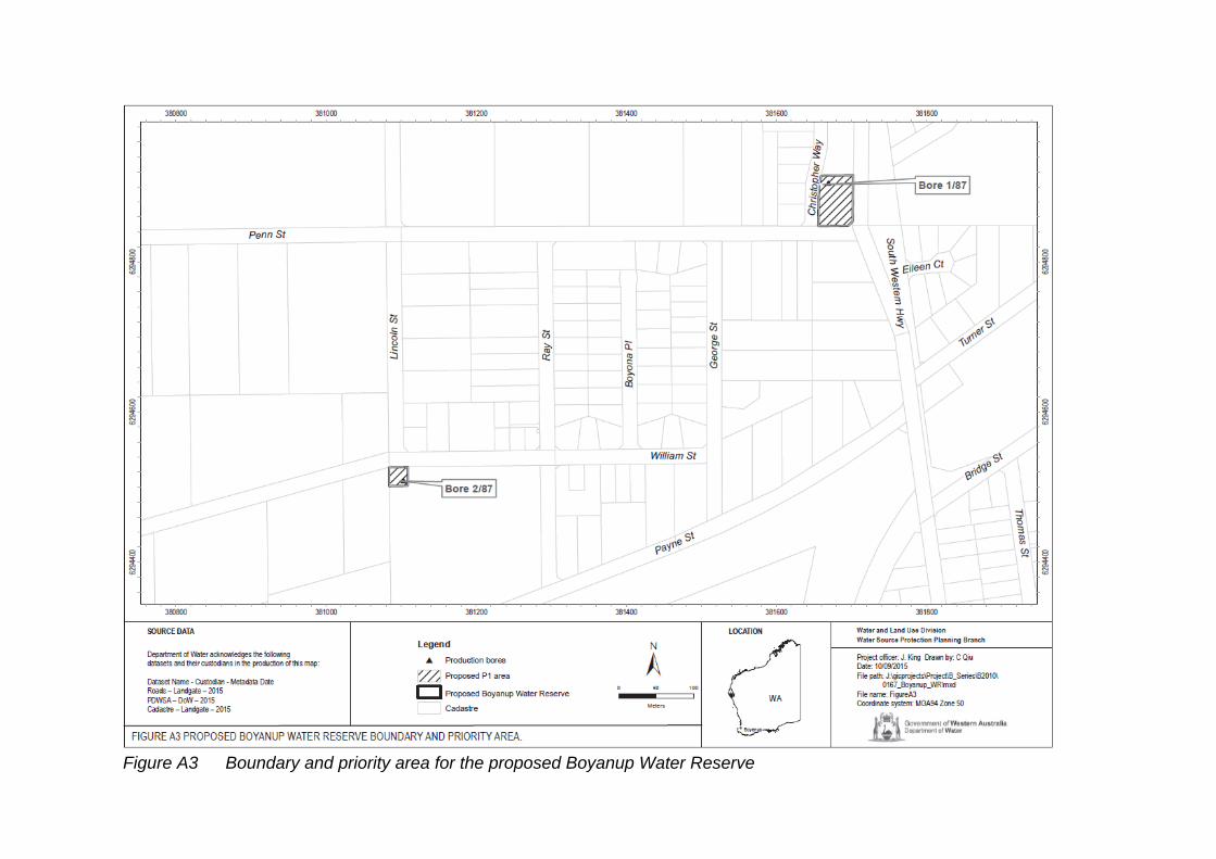
Figure A3 Boundary and priority area for the proposed Boyanup Water Reserve

Figure A4 South West Native Title Agreement area (source: Department of Premier and Cabinet)
Boyanup Water Reserve drinking water source protection plan WRP no. 169
Department of Water and Environmental Regulation 19
Appendix B — Water quality data
The information provided in this appendix has been supplied by the Water Corporation.
The Water Corporation has monitored the raw (source) water quality from Boyanup wellfield in accordance with the requirements of the Australian drinking water guidelines (ADWG; NHMRC & NRMMC 2011) and interpretations agreed to with the Department of Health. This data shows the quality of water in the public drinking water source area (PDWSA). The raw water is monitored regularly for:
aesthetic characteristics (non-health-related) health-related characteristics including:
health-related chemicals microbiological contaminants.
The following data represents the quality of raw water from Boyanup. In the absence of specific guidelines for raw-water quality, the results have been compared with the ADWG values set for drinking water, which defines the quality requirements at the customer’s tap. Any water quality parameters that have been detected are reported; those that on occasion have exceeded the ADWG are in bold and italics to give an indication of potential raw-water quality issues associated with this source. The values are taken from ongoing monitoring for the period December 2009 to November 2014.
It is important to appreciate that the raw-water data presented does not represent the quality of drinking water distributed to the public. Barriers such as storage and water treatment exist downstream of the raw water to ensure it meets the requirements of the ADWG.
For more information on the quality of drinking water supplied to Boyanup refer to the most recent Water Corporation drinking water quality annual report at www.watercorporation.com.au.
Aesthetic characteristics
The aesthetic quality analyses for raw water from Boyanup are summarised in the following table.
WRP no. 169 Boyanup Water Reserve drinking water source protection plan
20 Department of Water and Environmental Regulation
Aesthetic detections for Boyanup
Parameter Units ADWG aesthetic guideline value*
Boyanup bore 1/87 Boyanup bore 2/87
Range Median Range Median
Ammonia as nitrogen
mg/L 0.41 0.075–0.095
0.09 0.034–0.095
0.08
Copper mg/L 1 <0.002–0.003
<0.002 <0.002–0.004
0.003
Chloride mg/L 250 90–100 95 65–105 95
Colour (true) TCU 15 <1 <1 <1 <1
Hardness as CaCO3
mg/L 200 100–110 110 95–110 100
Iron unfiltered mg/L 0.3 0.48–1.4 1 0.1–3 1.8
Manganese unfiltered
mg/L 0.1 0.07–0.1 0.085 0.085–0.12
0.11
pH measured in laboratory
no units
6.5–8.5 6.83–7.85 7.105 6.8–7.4 7
Silicon as SiO2 mg/L 80 17–20 20 17–20 19
Sodium mg/L 180 59–64 62 58–64 61
Sulfate mg/L 250 15–16 16 15–17 16
Total filterable solids by summation
mg/L 600 373–398 386 356–393 374
Turbidity NTU 5 <0.1–14 7.1 0.6–27 14.5
Zinc mg/L 3 <0.02–0.04
0.04 <0.02 <0.02
* An aesthetic guideline value is the concentration or measure of a water quality characteristic that is
associated with good quality water

Boyanup Water Reserve drinking water source protection plan WRP no. 169
Department of Water and Environmental Regulation 21
Health-related chemicals
Raw water from Boyanup is analysed for chemicals that are harmful to human health, including inorganics, heavy metals, industrial hydrocarbons and pesticides. Health-related parameters that have been detected in the source are summarised in the following table.
Health-related detections for Boyanup
Parameter Units ADWG health guideline value*
Boyanup bore 1/87 Boyanup bore 2/87
Range Median Range Median
Annual radiation dose
mSv 1 <0.064–0.066
<0.065 <0.065 <0.065
Barium mg/L 2 0.018 0.18 0.018–0.2 0.18
Boron mg/L 4 0.08–0.1 0.09 0.07–0.08 0.07
Copper mg/L 2 <0.002–0.003
<0.002 <0.002–0.004
0.003
Fluoride measured in laboratory
mg/L 1.5 0.15–0.2 0.15 0.15–0.2 0.2
Manganese unfiltered
mg/L 0.5 0.07–0.1 0.085 0.085–0.12
0.11
Nitrate as nitrogen
Mg/L 11.29 <0.002–0.016
<0.002 <0.002–0.074
<0.002
Nitrite plus nitrate as nitrogen
mg/L 11.29 <0.002–0.064
<0.05 <0.002–0.078
<0.05
Radon-222 Bq/L 100 2.57–5.24 2.82 <2.29–4.11
2.6
Sulfate mg/L 500 15–16 16 15–17 16
* A health guideline value is the concentration or measure of a water quality characteristic that, based
on present knowledge, does not result in any significant risk to the health of the consumer over a
lifetime of consumption (NHMRC & ARMCANZ 2011).
WRP no. 169 Boyanup Water Reserve drinking water source protection plan
22 Department of Water and Environmental Regulation
† A guideline value of 11.29 mg/L (as nitrogen) has been set to protect bottle-fed infants less than
three months of age. Up to 22.58 mg/L (as nitrogen) can be safely consumed by adults and children
over three months of age.
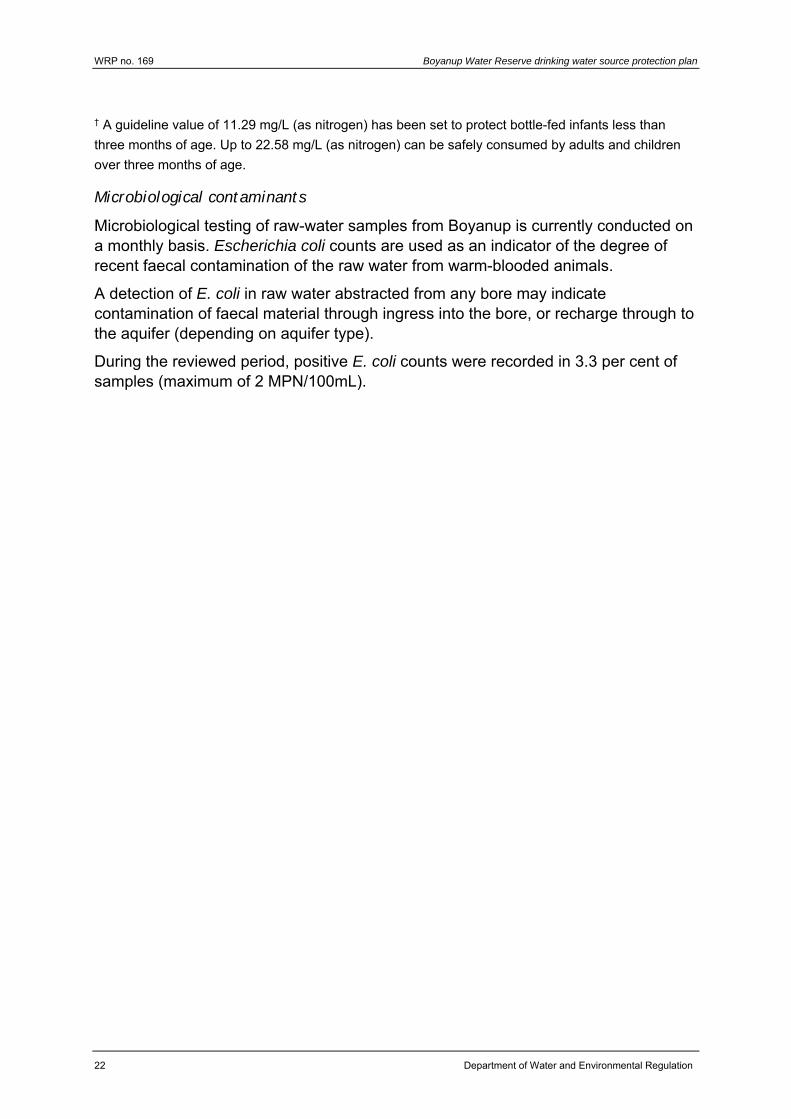
Microbiological contaminants
Microbiological testing of raw-water samples from Boyanup is currently conducted on a monthly basis. Escherichia coli counts are used as an indicator of the degree of recent faecal contamination of the raw water from warm-blooded animals.
A detection of E. coli in raw water abstracted from any bore may indicate contamination of faecal material through ingress into the bore, or recharge through to the aquifer (depending on aquifer type).
During the reviewed period, positive E. coli counts were recorded in 3.3 per cent of samples (maximum of 2 MPN/100mL).
Boyanup Water Reserve drinking water source protection plan WRP no. 169
Department of Water and Environmental Regulation 23
Appendix C — Photographs
Figure C1 Production bore 2/87, photograph by J. King
Figure C2 Production bore 2/87 compound, photograph by J. King
WRP no. 169 Boyanup Water Reserve drinking water source protection plan
24 Department of Water and Environmental Regulation
Figure C3 Production bore 1/87 within the Boyanup water treatment plant compound, photograph by J. King
Figure C4 Boyanup water treatment plant compound, photograph by J. King
Boyanup Water Reserve drinking water source protection plan WRP no. 169
Department of Water and Environmental Regulation 25
Appendix D — How do we protect public drinking water source areas?
The Australian drinking water guidelines (ADWG; NHMRC & NRMMC 2011) outline how we should protect drinking water in Australia. The ADWG recommends a ‘catchment to consumer’ framework that uses a preventive risk–based and multiple-barrier approach. A similar approach is recommended by the World Health Organization.
The catchment to consumer framework applies across the entire drinking water supply system – from the water source to the taps in your home. It ensures a holistic assessment of water quality risks and solutions to ensure the delivery of a reliable and safe drinking water to supply your home.
An approach based on preventive risk means that we look at all the different risks to water quality. We determine what risks can reasonably be avoided and what risks need to be minimised or managed to protect public health. This approach means that the inherent risks to water quality are as low as possible. A multiple-barrier approach means that we use different barriers against contamination at different stages of a drinking water supply system.
The first and most important barrier is protecting the public drinking water source area (PDWSA) (the area from which water is captured to supply drinking water). If we get this barrier right, it has a flow-on effect that can result in a lower cost, safer drinking water supply. Other barriers against contamination include:
storage of water to help reduce contaminant levels disinfecting the water (for example chlorination to inactivate pathogens) maintenance of pipes testing of water quality.
Another community benefit from PDWSA protection is that it complements the state’s conservation initiatives.
Research and experience shows that a combination of catchment protection and water treatment is safer than relying on either barrier on its own. That’s why this drinking water source protection plan is important. We should not forget that ultimately it’s about protecting your health by protecting water quality now and for the future.
In Western Australia, DWER protects PDWSAs by implementing the ADWG, writing reports, policies and guidelines, and providing input into land use planning.
This drinking water protection report achieves elements 2 and 3 of the 12 elements in the ADWG recommended for protecting drinking water. It shows the PDWSA’s location, its characteristics, existing and potential water quality contamination risks, and makes recommendations to deal with those risks.
The Metropolitan Water Supply, Sewerage, and Drainage Act 1909 and the Country Areas Water Supply Act 1947 provide us with important tools to protect water quality
WRP no. 169 Boyanup Water Reserve drinking water source protection plan
26 Department of Water and Environmental Regulation
in proclaimed PDWSAs. These Acts allow us to assess and manage the water quality contamination risks from different land uses and activities. The department works cooperatively with other agencies and the community to implement this legislation and develop drinking water source protection reports. For example, the Western Australian Planning Commission has developed a number of state planning policies to help guide development in public drinking water source areas.
An important step in maximising the protection of water quality in PDWSAs is to define their boundaries, priority areas and protection zones to help guide land use planning and to identify where legislation applies. There are three different priority areas:
The objective of priority 1 (P1) areas is risk avoidance – ensuring there is no degradation of the water quality (for example over Crown land).
The objective of priority 2 (P2) areas is risk minimisation – maintaining or improving water quality (for example over rural-zoned land).
The objective of priority 3 (P3) areas is risk management – maintaining the water quality for as long as possible (for example, urban- or commercial-zoned land).
Protection zones surround drinking water abstraction bores and surface water reservoirs so that the most vulnerable areas are protected from contamination.
DWER’s Water quality protection note (WQPN) no. 25: Land use compatibility in PDWSAs outlines appropriate development and activities within each of the priority areas (P1, P2 and P3). A draft update of this document was released for public comment in October 2014, and an updated version is expected to be published during 2016.
With 129 proclaimed PDWSAs across Western Australia, the department prioritises the update of drinking water source protection reports (such as this document). Our aim is to update each report every seven years. In some locations, more frequent updates may be required to address changing water quality risks and land uses. These updates allow us to make changes to the PDWSA boundary, priority areas and protection zones if required. They also allow solutions to new water quality risks to be considered.
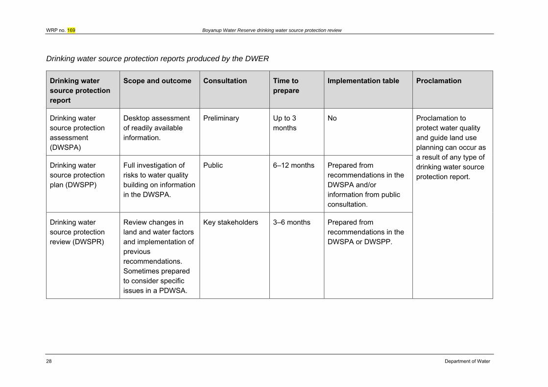
There are three different types of drinking water source protection report – each providing for different needs. The following table shows the differences between the types of reports.
There is a fourth type of report – Land use and water management strategy – that performs the same functions as a drinking water source protection report. However, these strategies are prepared by the Western Australian Planning Commission (with input from DWER) and are strategic documents that integrate land use planning with water management. There are currently land use and water management strategies for Gnangara, Jandakot and Middle Helena.
If you would like more information about the ADWG and how we protect drinking water in Western Australia, visit www.dwer.wa.gov.au or contact DWER’s Water
Boyanup Water Reserve drinking water source protection plan WRP no. 169
Department of Water and Environmental Regulation 27
source protection planning branch on +61 8 6364 7600 or email [email protected].
WRP no. 169 Boyanup Water Reserve drinking water source protection review
28 Department of Water
Drinking water source protection reports produced by the DWER
Drinking water source protection report
Scope and outcome Consultation Time to prepare
Implementation table Proclamation
Drinking water source protection assessment (DWSPA)
Desktop assessment of readily available information.
Preliminary Up to 3 months
No Proclamation to protect water quality and guide land use planning can occur as a result of any type of drinking water source protection report.
Drinking water source protection plan (DWSPP)
Full investigation of risks to water quality building on information in the DWSPA.
Public 6–12 months Prepared from recommendations in the DWSPA and/or information from public consultation.
Drinking water source protection review (DWSPR)
Review changes in land and water factors and implementation of previous recommendations. Sometimes prepared to consider specific issues in a PDWSA.
Key stakeholders 3–6 months Prepared from recommendations in the DWSPA or DWSPP.
Boyanup Water Reserve drinking water source protection plan WRP no. 169
Department of Water and Environmental Regulation 29
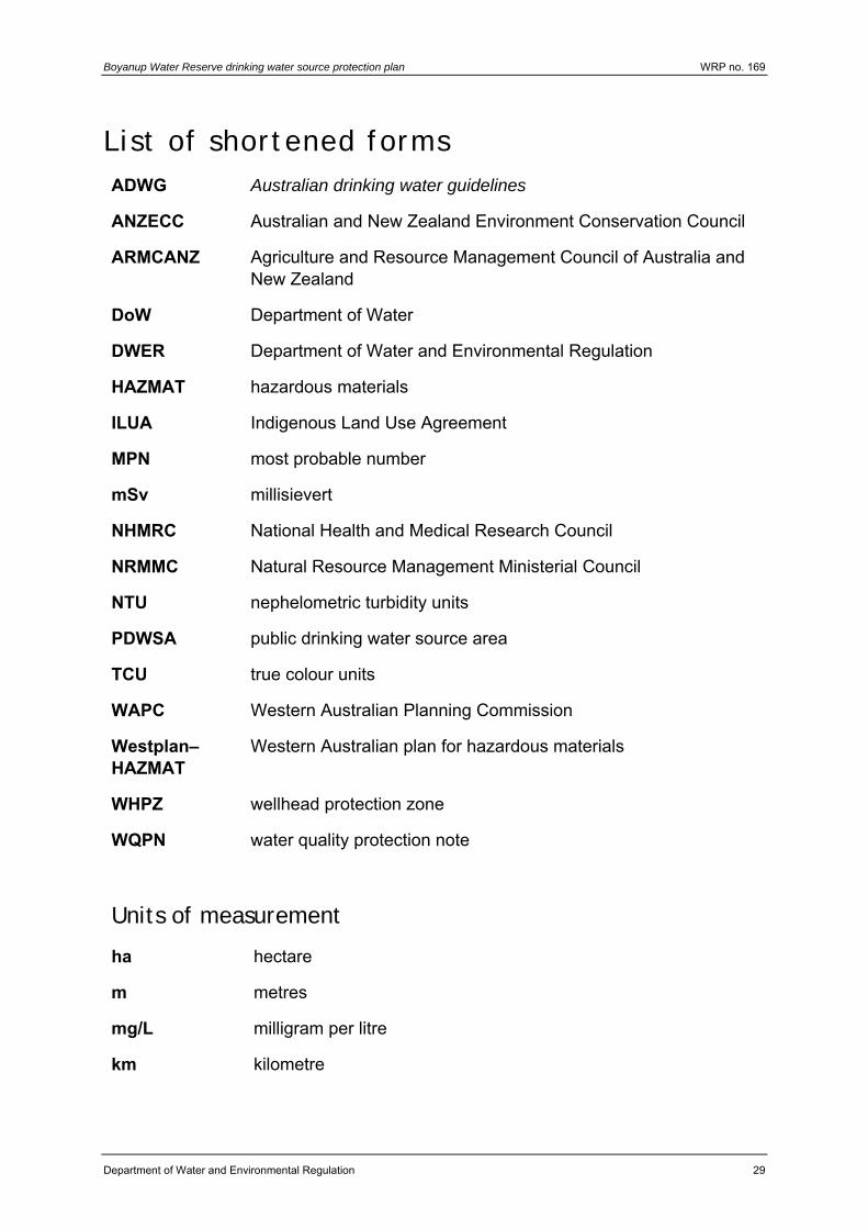
List of shortened forms ADWG Australian drinking water guidelines
ANZECC Australian and New Zealand Environment Conservation Council
ARMCANZ Agriculture and Resource Management Council of Australia and New Zealand
DoW Department of Water
DWER Department of Water and Environmental Regulation
HAZMAT hazardous materials
ILUA Indigenous Land Use Agreement
MPN most probable number
mSv millisievert
NHMRC National Health and Medical Research Council
NRMMC Natural Resource Management Ministerial Council
NTU nephelometric turbidity units
PDWSA public drinking water source area
TCU true colour units
WAPC Western Australian Planning Commission
Westplan–HAZMAT
Western Australian plan for hazardous materials
WHPZ wellhead protection zone
WQPN water quality protection note
Units of measurement
ha hectare
m metres
mg/L milligram per litre
km kilometre
WRP no. 169 Boyanup Water Reserve drinking water source protection review
30 Department of Water and Environmental Regulation
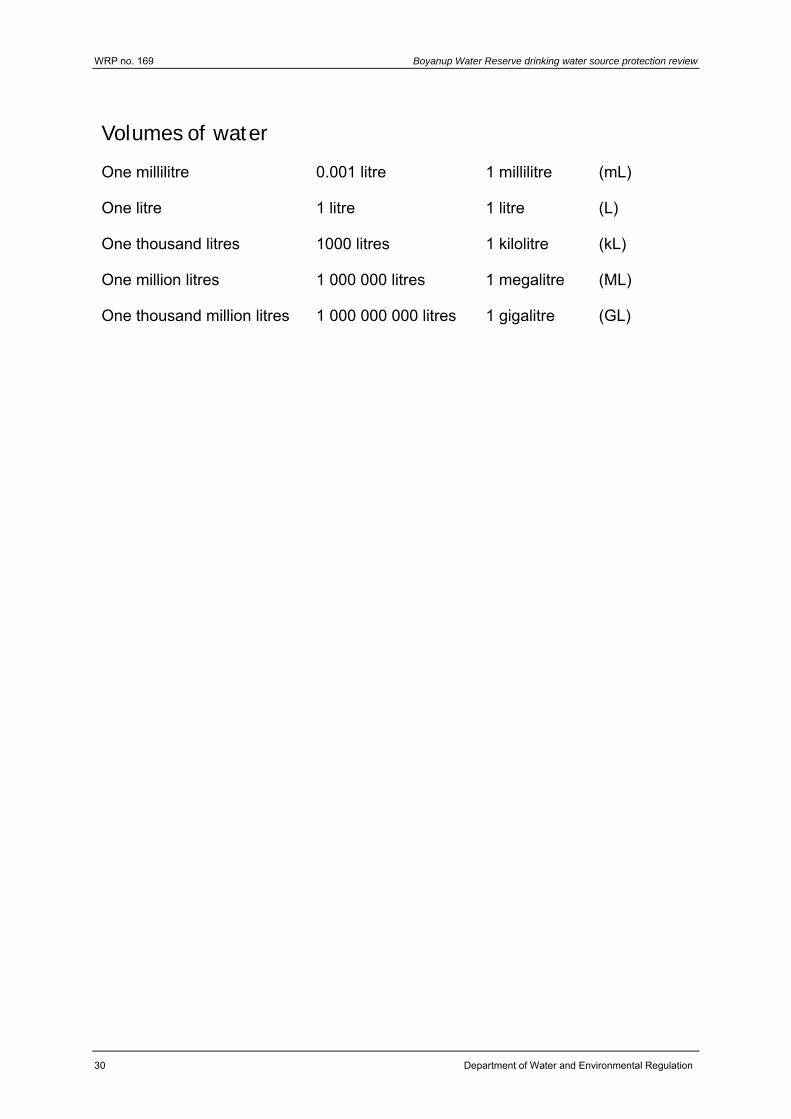
Volumes of water
One millilitre 0.001 litre 1 millilitre (mL)
One litre 1 litre 1 litre (L)
One thousand litres 1000 litres 1 kilolitre (kL)
One million litres 1 000 000 litres 1 megalitre (ML)
One thousand million litres 1 000 000 000 litres 1 gigalitre (GL)
Boyanup Water Reserve drinking water source protection plan WRP no. 169
Department of Water and Environmental Regulation 31
Glossary Abstraction The pumping of groundwater from an aquifer, or the removal of
water from a waterway or water body.
Adsorb Adsorb means to accumulate on the surface of something.
Aesthetic guideline value
The concentration or measure of a water quality characteristic that is associated with acceptability of water to the consumer, such as appearance, taste and odour (NHMRC & NRMMC 2011).
Allocation Is the volume of water that a licensee is permitted to abstract, usually specified in kilolitres per annum (kL/a).
Aquifer An aquifer is a geological formation or group or formations able to receive, store and transmit significant quantities of water.
Australian drinking water guidelines
The National water quality management strategy: Australian drinking water guidelines 6, 2011 (NHMRC & NRMMC 2011) (ADWG) outlines acceptable criteria for the quality of drinking water in Australia (see this plan’s References).
Bore A bore is a narrow, lined hole drilled into the ground to monitor or draw groundwater (also called a well).
Catchment The area of land which intercepts rainfall and contributes the collected water to surface water (streams, rivers, wetlands) or groundwater.
Confined aquifer
An aquifer that is confined between non-porous rock formations (such as shale and siltstone) and therefore contains water under pressure.
Contamination A substance present at concentrations exceeding background levels that presents – or has the potential to present – a risk of harm to human health, the environment, water resources or any environmental value.
Drinking water source protection report
A report on water quality hazards and risk levels within a public drinking water source area; includes recommendations to avoid, minimise, or manage those risks for the protection of the water supply in the provision of safe drinking water supply.
Health guideline value
The concentration or measure of a water quality characteristic that, based on current knowledge, does not result in any significant risk to the health of the consumer over a lifetime of consumption (NHMRC & NRMMC 2011).
WRP no. 169 Boyanup Water Reserve drinking water source protection review
32 Department of Water and Environmental Regulation
Hydrocarbons A class of compounds containing only hydrogen and carbon, such as methane, ethylene, acetylene and benzene. Fossil fuels such as oil, petroleum and natural gas all contain hydrocarbons.
Hydrogeology The study of groundwater, especially relating to the distribution of aquifers, groundwater flow and groundwater quality.
Leaching/ leachate
The process by which materials such as organic matter and mineral salts are washed out of a layer of soil or dumped material by being dissolved or suspended in percolating rainwater. The material washed out is known as leachate. Leachate can pollute groundwater and waterways.
mg/L A milligram per litre (0.001 grams per litre) is a measurement of something (such as salinity) in a solution.
Microbe A microorganism, usually one of vegetable nature, a germ. Also known as a bacterium, especially one causing illness.
Millisievert A millisievert is a measure of annual radiological dose, with a natural dose equivalent to 2 mSv/yr.
Most probable number
Most probable number is a measure of microbiological contamination.
Nephelometric turbidity units
Nephelometric turbidity units are a measure of turbidity in water.
Nutrients Minerals, particularly inorganic compounds of nitrogen (nitrate and ammonia) and phosphorous (phosphate) dissolved in water which provide nutrition (food) for plant growth.
Pathogen A disease-producing organism that can cause sickness and sometimes death through the consumption of water, including bacteria (such as Escherichia coli), protozoa (such as Cryptosporidium and Giardia) and viruses.
Pesticides Collective name for a variety of insecticides, fungicides, herbicides, algicides, fumigants and rodenticides used to kill organisms.
pH A logarithmic scale for expressing the acidity or alkalinity of a solution. A pH below seven indicates an acidic solution and above seven indicates an alkaline solution.
Boyanup Water Reserve drinking water source protection plan WRP no. 169
Department of Water and Environmental Regulation 33
Public drinking water source area
The area from which water is captured to supply drinking water. It includes all underground water pollution control areas, catchment areas and water reserves constituted under the Metropolitan Water Supply, Sewerage, and Drainage Act 1909 or the Country Areas Water Supply Act 1947.
Recharge Recharge is the action of water infiltrating through the soil/ground to replenish an aquifer.
Recharge area An area through which water from a groundwater catchment percolates to replenish (recharge) an aquifer. An unconfined aquifer is recharged by rainfall throughout its distribution. Confined aquifers are recharged in specific areas where water leaks from overlying aquifers, or where the aquifer rises to meet the surface.
Scheme supply Water diverted from a source or sources by a water authority or private company and supplied via a distribution network to customers for urban and industrial use or for irrigation.
Total filterable solids by summation
Total filterable solids by summation is a water quality test which is a total of the following ions: Na (sodium), K (potassium), Ca (calcium), Mg (magnesium), Cl equivalent (chloride), alkalinity equivalent, SO4 equivalent (sulfate) or S (sulfur) in grams, Fe (iron), Mn (manganese), and SiO2 (silicon oxide). It is used as a more accurate measure than total dissolved solids. The higher the value, the more solids that are present and generally the saltier the taste.
Treatment Application of techniques such as settlement, filtration and chlorination to render water suitable for specific purposes, including drinking and discharge to the environment.
True colour units
True colour units are a measure of degree of colour in water.
Turbidity The cloudiness or haziness of water caused by the presence of fine suspended matter.
Unconfined aquifer
An aquifer in which the upper surface of water is lower than the top of the aquifer itself. The upper surface of the groundwater within the aquifer is called the watertable. This is also known as a superficial aquifer.
Water quality Water quality is the collective term for the physical, aesthetic, chemical and biological properties of water.
WRP no. 169 Boyanup Water Reserve drinking water source protection review
34 Department of Water and Environmental Regulation
Water reserve A water reserve is an area proclaimed under the Country Areas Water Supply Act 1947 or the Metropolitan Water Supply, Sewerage, and Drainage Act 1909 for the purposes of protecting a drinking water supply.
Wellfield A wellfield is a group of bores located in the same area used to monitor or withdraw groundwater.
Wellhead The top of a well (or bore) used to draw groundwater is referred to as a wellhead.
Wellhead protection zone
A wellhead protection zone is usually declared around wellheads in public drinking water source areas to protect the groundwater from immediate contamination threats in the nearby area.
Boyanup Water Reserve drinking water source protection plan WRP no. 169
Department of Water and Environmental Regulation 35
References Department of Water 2009a, South West groundwater areas allocation plan, Water
resource allocation and planning series, Report no. 21, Government of Western Australia, Perth, available www.dwer.wa.gov.au.
——2009b, Busselton-Capel groundwater area subarea reference sheets: plan companion for the South West groundwater areas allocation plan, Government of Western Australia, available www.dwer.wa.gov.au.
——2013, South West groundwater areas allocation plan: Evaluation statement 2009–2012, Government of Western Australia, Perth, available www.dwer.wa.gov.au.
——Water quality protection notes (WQPNs), Government of Western Australia, Perth, available www.dwer.wa.gov.au.
2009, WQPN 36: Protecting public drinking water source areas.
2016, WQPN 25: Land use compatibility tables for public drinking water source areas
Geldreich, EE 1996, ‘Pathogenic agents in freshwater resources’, Hydrological Processes, vol. 10, pp. 315-333.
Government of Western Australia 1909, Metropolitan Water Supply, Sewerage, and Drainage Act, reprinted under the Reprints Act 1984 as at 27 April 2008, State Law Publisher, Perth.
—— 1914, Rights in Water and Irrigation Act, Reprinted under the Reprints Act 1984 as at 1 February 2008, State Law Publisher, Perth.
——1947, Country Areas Water Supply Act, reprinted under the Reprints Act 1984 as at 4 May 2012, State Law Publisher, Perth.
——2015, Guide to the regulatory framework for shale and tight gas in WA: A whole-of-government approach, Government of Western Australia, Perth, available www.dmirs.wa.gov.au.
National Health and Medical Research Council (NHMRC) & Natural Resource Management Ministerial Council (NRMMC) 2011, National Water Quality Management Strategy: Australian drinking water guidelines, Australian Government, Canberra.
——2004, Water made clear – A consumer guide to accompany the Australian drinking water guidelines 2004, Australian Government, Canberra.
National Uniform Drillers Licensing Committee 2012, Minimum construction requirements for water bores in Australia, 3rd edn, Australian Government National Water Commission, Victoria, available www.dwer.wa.gov.au.
Robertson, JB & Edbery, SC 1997, Natural protection of spring and well drinking water against surface microbial contamination. I. Hydrogeological parameters, Critical Reviews in Microbiology, vol. 23(2), pp. 143 – 178.
WRP no. 169 Boyanup Water Reserve drinking water source protection review
36 Department of Water and Environmental Regulation
Shire of Capel 2014, Shire of Capel profile 2014, Planning and development services Division, Capel.
State Emergency Management Committee 2005, Policy statement no. 7: Western Australian emergency management arrangements, Government of Western Australia, Perth.
Water Corporation 2013, S111 Source protection signage, unpublished corporate standard, Water Corporation, Leederville.
——2013, SG097 Source protection operations manual, Water Corporation, Perth.
Western Australian Planning Commission 1997, State planning strategy, Government of Western Australia, Perth.
——2003, State planning policy no. 2.7: Public drinking water source policy, Government Gazette Western Australia, 10 June 2003, pp. 2077-82, Government of Western Australia, Perth.
Boyanup Water Reserve drinking water source protection plan WRP no. 169
Department of Water and Environmental Regulation 37
Further reading Agriculture and Resource Management Council of Australia and New Zealand
(ARMCANZ) & Australian and New Zealand Environment and Conservation Council (ANZECC) 1996, Draft rural land uses and water quality – A community resource document, ARMCANZ & ANZECC, Canberra.
Department of Water & Department of Health 2008, Risks from pathogenic micro-organisms in public drinking water source areas, Government of Western Australia, Perth, available www.dwer.wa.gov.au.
Department of Water 2011, Living and working in public drinking water source areas, Government of Western Australia, Perth, available www.dwer.wa.gov.au.
——Water quality protection notes (WQPNs), Government of Western Australia, Perth, available www.dwer.wa.gov.au.
2006, WQPN 10: Contaminant spills – emergency response
Hrudey, SE & Hrudey, EJ 2004, Safe drinking water – Lessons from recent outbreaks in affluent nations, IWA Publishing, London.
National Health and Medical Research Council (NHMRC) & Natural Resource Management Ministerial Council (NRMMC) 2004, Water made clear – A consumer guide to accompany the Australian drinking water guidelines 2004, Australian Government, Canberra, available http://www.nhmrc.gov.au/_files_nhmrc/publications/attachments/eh33.pdf.
Western Australian Planning Commission 2006, State planning policy no. 2.9: Water resources, Government Gazette Western Australia, 19 December 2006, pp. 5707-22 Government of Western Australia, Perth, available www.planning.wa.gov.au.
World Health Organization 2004, Guidelines for drinking-water quality – Volume 1 – Recommendations, 3rd edn, World Health Organization, Geneva, www.who.int/.


Department of Water and Environmental Regulation Prime House 8 Davidson Terrace Joondalup WA 6027
Locked Bag 10 Joondalup DC WA 6919 Phone: 08 6364 7600
Fax: 08 6364 7601National Relay Service 13 36 77
dwer.wa.gov.au
11754 0618