Embed Size (px)
Citation preview

BOUNDARY
RETRACEMENT
LATEST CASES By Jeffery N. Lucas
Land Surveyor, Attorney at Law
E-Mail: [email protected]
Copyright © 2002-2017

Lucas & Company, LLC © 2002-2017 Page 1 of 23
JOSEPH DYKES and ZAN DYKES v.
JOE D. ARNOLD COURT OF APPEALS OF OREGON
204 Ore. App. 154; 129 P.3d 257 Argued and Submitted
October 6, 2004 Filed
February 8, 2006, LUCAS LETTER HEAD NOTES [LLHN]: [1] [1] All head notes in this opinion provided by the Editor of TLL for the convenience of our readers. JNL.
Real Property Law; Deeds; Construction & Interpretation: Real Property Law; Boundaries; Evidence of Boundaries: [LLHN1] There is no legal authority that holds that a mere reference to “the center” of a section com-pels the conclusion, as a matter of law, that the parties intended to be governed by the mathematical cen-ter as it might be located in the future, rather than as it had been located. What sparse case law we can find is, instead, to the contrary. In addition to not being legally warranted, such a presumption would also strain common sense. [See Footnote 11.]
Real Property Law; Deeds; Construction & Interpretation: Real Property Law; Deeds; Deed Interpretation; Rules of Construction: [LLHN2] Where there are certain definite and ascertained particulars in the description, the addition of others, which are indefinite, unknown or false, does not frustrate the conveyance, but it is to be con-strued by such particulars, if they constitute a sufficient description to ascertain its application.
Real Property Law; Deeds; Deed Interpretation; Rules of Construction: Real Property Law; Boundaries; Evidence of Boundaries: [LLHN3] Boundaries may be proved by every kind of evidence admissible to establish any other con-troverted fact.
Civil Procedure; Appeals; Credibility Determinations: Civil Procedure; Appeals; Standards of Review; De Novo Review: [LLHN4] As for the credibility of the witnesses, from our review of the record and the competing con-clusions that might be drawn, we are not willing to disturb the trial court’s inherent credibility assess-ments. On de novo review, the appellate court is to give considerable weight to the findings of the trial judge who had the opportunity to observe the witnesses and their demeanor in evaluating the credibility of their testimony.
Real Property Law; Boundaries; Surveys; Original Surveys: Real Property Law; Boundaries; Evidence of Boundaries; Actually Run on the Ground: [LLHN5] Because the county surveyor was the first official to survey the interior of section 12 and to establish the center of the section, his survey should be regarded as an original survey that is controlling despite any errors in it, just as the General Land Office (GLO) survey is. That conclusion should follow

Lucas & Company, LLC © 2002-2017 Page 2 of 23
at least in circumstances like these, where the county surveyor was the only recorded survey to monu-ment the center of section 12 during nearly a 100-year period, and the center as he located it has been relied on and has determined the lines of occupation over that time.
Real Property Law; Public Lands; Government Surveys; Original Surveys: Real Property Law; Boundaries; Evidence of Boundaries; Actually Run on the Ground: Real Property Law; Public Lands; Sections & Subdivision of Sections: [LLHN6] The federal statute governing the survey of public lands before they are conveyed into private ownership has remained relatively unchanged since its original enactment. The current codification of the provision pertinent to this case, 43 USC § 752, provides in part that “boundary lines actually run and marked in the surveys … shall be established as the proper boundary lines of the sections, or subdivi-sions, for which they were intended.” That provision has led to the long-settled rule that the original sur-vey, as actually run “on the ground,” controls, even if the survey was done incorrectly and the bounda-ries are in error. In government surveys, the line actually run upon the ground by the original surveyors is the true line. The federal statute goes on to direct how the boundaries that were not actually run and marked are to be ascertained. See 43 USC § 752. The statute says nothing, however, about who is to make the survey of those additional boundaries or the effect of a survey that does so incorrectly.
Real Property Law; Public Lands; Government Surveys; Original Surveys: Real Property Law; Public Lands; Sections & Subdivision of Sections: [LLHN7] To subdivide a section into quarter sections, run straight lines from the established quarter-section corners to the opposite quarter-section corners. The point of intersection of the lines thus run will be the corner common to the several quarter sections, or the legal center of the section.
Real Property Law; Public Lands; Government Surveys; Original Surveys: Real Property Law; Public Lands; Government Surveys; Manual of Surveying Instructions: Real Property Law; Ownership of Property; Federal & State Government: Real Property Law; Public Lands; Sections & Subdivision of Sections: [LLHN8] It is not apparent that the instructions in the Manual of Surveying Instructions (1973) (the Manual) are binding by their own terms on a local interior survey of lands that have passed by federal grant into private hands. Nor is it clear by what authority Congress could exercise such power. The gen-eral rule is that questions involving ownership of land are determined under state law, even when the federal government is a party. The instructions expressly observe that, as a rule, the “sections are not subdivided in the field” by the federal government, although “certain subdivision-of-section lines” (e.g., interior quarter-section boundaries) are protracted on the plat. Instead, the “local surveyor is employed as an expert to identify lands which have passed into private ownership,” a task that entails the “subdivi-sion of the section into the fractional parts shown upon the approved plat.
Real Property Law; Public Lands; Government Surveys; Manual of Surveying Instructions: Real Property Law; Public Lands; Sections & Subdivision of Sections: [LLHN9] As the Manual observes, it is “a matter of expert or technical procedure to mark out the legal subdivisions called for in a patent,” a process that includes “locating the legal center of the section in order to determine the boundaries of a quarter section.” The Manual further observes that, in performing that survey work, “the local surveyor is performing a function contemplated by law.”
Lucas & Company, LLC © 2002-2017 Page 3 of 23
Real Property Law; Public Lands; Government Surveys; Manual of Surveying Instructions: Real Property Law; Public Lands; Sections & Subdivision of Sections: Real Property Law; Ownership of Property; Federal & State Government: [LLHN10] The federal government assumes no control or direction over the acts of local and county surveyors in the matters of subdivision of sections and reestablishment of lost corners of original sur-veys where the lands have passed into private ownership. The rules that control the acts of the federal government’s own surveyors are, instead, to be considered by all other surveyors as merely advisory and explanatory of the principles which should prevail in performing such duties. And, even as to disputes over uncertain or erroneous location of corners or boundaries originally established by the federal gov-ernment, the federal government will exercise no jurisdiction; those matters, too, are to be settled by lo-cal authorities. Thus, in all respects, once the land is conveyed into private hands, the states, not the fed-eral government, have jurisdiction over it.
Real Property Law; Public Lands; Government Surveys; Original Surveys: Real Property Law; Boundaries; Evidence of Boundaries; Actually Run on the Ground: Real Property Law; Boundaries; Rule of Repose: [LLHN11] The settled rule for federal government surveys accords dignity to the boundaries and monu-ments physically set on the land, even when not done pursuant to the applicable survey law. The rule is one of repose. Nothing is better understood than that few of our early plats will stand the test of a careful and accurate survey without disclosing errors. This is as true of the government surveys as of any others, and if all the lines were now subject to correction on new surveys, the confusion of lines and titles that would follow would cause consternation in many communities. Indeed the mischiefs that must follow would be simply incalculable, and the visitation of the surveyor might well be set down as a great public calamity.
Real Property Law; Public Lands; Government Surveys; Original Surveys: Real Property Law; Public Lands; Sections & Subdivision of Sections: Real Property Law; Ownership of Property; Federal & State Government: [LLHN12] Federal law says nothing—one way or the other—about later surveys of section interiors. Despite expressly contemplating the need for those surveys, neither the federal statutes nor the instruc-tions in the Manual direct what must happen when the same kinds of errors are made in those original local surveys. The silence does not suggest that the original surveys that marked a section’s interior boundaries and center should not be accorded the same dignity; it suggests only that matter, too, was left to state law.
Real Property Law; Public Lands; Government Surveys; Original Surveys: Real Property Law; Public Lands; Sections & Subdivision of Sections: Real Property Law; Ownership of Property; Federal & State Government: [LLHN13] Consistently with federal law, ORS 209.200 directs how a “resurvey” of lands surveyed by the federal government is to be performed by the county surveyor. Section and quarter-section corners set by the original federal survey are controlling and must “stand,” regardless of the accuracy of that sur-vey. If they must be “reestablished,” they must be placed where the original survey placed them, even if it was wrong. It is only if an original federal corner cannot be found or its original location cannot be determined that a county surveyor establishes it pursuant to the Manual. But nothing in ORS 209.200 or any other statute directs what should be done with a center originally surveyed and marked inaccurately by a county surveyor. The solution has been left to the courts to devise, as a matter of common law.

Lucas & Company, LLC © 2002-2017 Page 4 of 23
Real Property Law; Deeds; Deed Interpretation; Ambiguities: Real Property Law; Boundaries; Surveys; Retracement Survey: [LLHN14] Boundaries determined by the express and unambiguous description in a deed control over boundaries determined by a later survey. The fact that the later survey was erroneously made was simply further reason not to let the survey control the deed.
Real Property Law; Deeds; Construction & Interpretation: Real Property Law; Deeds; Deed Interpretation; Intent: [LLHN15] In construing a deed our duty is to ascertain and give effect to the intentions of the parties, as evidenced by the language of the instrument and the circumstances attending its execution.
Real Property Law; Boundaries; Surveys; Original Surveys: Real Property Law; Boundaries; Surveys; Retracement Survey: Real Property Law; Boundaries; Evidence of Boundaries; Reliance: Real Property Law; Deeds; Deed Interpretation; Intent: [LLHN16] It is seldom that surveys are made with perfect accuracy. The appropriate inquiry in cases of this kind is not whether a survey is completely accurate, but whether the lots are purchased in reliance upon the boundaries which it establishes. When there is such reliance, to sanction the relocation of boundaries on the basis of subsequent surveys would defeat the intentions of the parties and subvert the security of possession.
Real Property Law; Boundaries; Surveys; Original Surveys: Real Property Law; Boundary Establishment; Common Grantor Doctrine: [LLHN17] An inaccurate survey should be given effect over an accurate survey when the evidence es-tablishes that lots have been conveyed based on the boundaries established by the inaccurate survey, when a common predecessor in interest held a large parcel of property and a survey error that affected only the lots that were created when the larger parcel was subdivided. The boundaries of the original parcel being not in dispute. In other words, there being no question that the common predecessor in in-terest owned everything that he subdivided. Michael C. Petersen argued the cause for appellants-cross-respondents. With him on the briefs was Heltzel, Upjohn, Williams, Yandell, Roth, Smith & Petersen, P. C. Dennis L. Bartoldus argued the cause and filed the briefs for respondent-cross-appellant. Before Haselton, Presiding Judge, and Linder and Ortega, Judges. [204 Ore.App. 156] [129 P.3d 258] OPINION: LINDER, J.
Plaintiffs and defendant, who own several adjacent lots in a rural area in Lincoln County, dispute the location of one of their boundary lines and, as a result, the ownership of a strip of property. Plaintiffs brought this ejectment action seeking possession of the disputed strip. In addition to their claim for ejectment, plaintiffs also sought a declaration that they had a permanent easement to draw water from a spring on defendant’s property. Defendant counterclaimed to quiet title in his favor on the basis that he was the fee owner of it.1
1 Defendant also raised adverse possession and acquiescence claims, which the trial court rejected. Those claims have not been pursued on appeal.

Lucas & Company, LLC © 2002-2017 Page 5 of 23
Relying principally on the testimony of defendant’s expert surveyor, the trial court agreed that the boundary was where defendant claimed and that the disputed property belongs to him. The court there-fore dismissed plaintiffs’ claim for ejectment and quieted title to the property in defendant. The trial court also declared that plaintiffs have a perpetual easement to draw water from the spring on defend-ant’s property. Plaintiffs appeal, challenging the trial court’s conclusion that defendant owns the dis-puted strip of land. Defendant cross-appeals, asserting [129 P.3d 259] that the trial court erred in grant-ing the easement to plaintiffs. We reject defendant’s cross-appeal without discussion. On plaintiffs’ ap-peal, for the reasons we explain below, we affirm.
I. THE DISPUTE The parties own a total of 12 parcels of property (lots) that lie around the center of a segment of land
that is most easily referred to as “section 12” in Lincoln County.2 This particular controversy involves four of those lots—three owned by plaintiffs and one owned by defendant. Although the following dia-gram is not to scale and is not precise in the shapes of what it depicts, it illustrates the basic “lay of the land” involved in the general area of the dispute.
Map 1 [204 Ore.App. 157] Defendant owns lot 1401, as well as
property north, east, and northeast of that lot (indicated in a general way by the lighter shaded areas). Plaintiffs own lots 1400, 1402, and 1403 that border lot 1401 to the south, as well as other prop-erty to the south and east of those lots (the latter indicated by the darker shaded areas). A county road—Tomjack Road—runs through the area and borders several of the parcels.
The crux of the dispute is over the lo-cation of the center of section 12. The deed for lot 1401 specifies the center of section 12 as the beginning point of the lot’s boundaries. From that beginning
point, pursuant to the deed’s metes and bounds description, the boundaries basically run west, then south, then east, then north back to the starting point--that is, back to the center of section 12.3 Thus, the
2 As we later explain in more detail, a “section” is an official unit of land under the Public Land Survey System and is used in the description of lands originally granted by the federal government to settlers in Oregon. The cor-rect full reference for the particular section involved in this case is Section 12, Township 11 South, Range 11 West, Willamette Meridian, in Lincoln County (section 12).
3 The descriptive portion of the deed reads as follows:
“Beginning at the center of said Section 12; Thence west along the east and west center line 350 feet more or less to the center of the County Road; Thence S 38& # 8728; 00’ W along said road 100 feet; thence S 50& # 8728; 00’ W 33 feet; thence east parallel to the east and west center line of said Section 12 437 feet more or less to the north and south center line of said Section 12; thence north 100 feet to the point of beginning.”
Lucas & Company, LLC © 2002-2017 Page 6 of 23
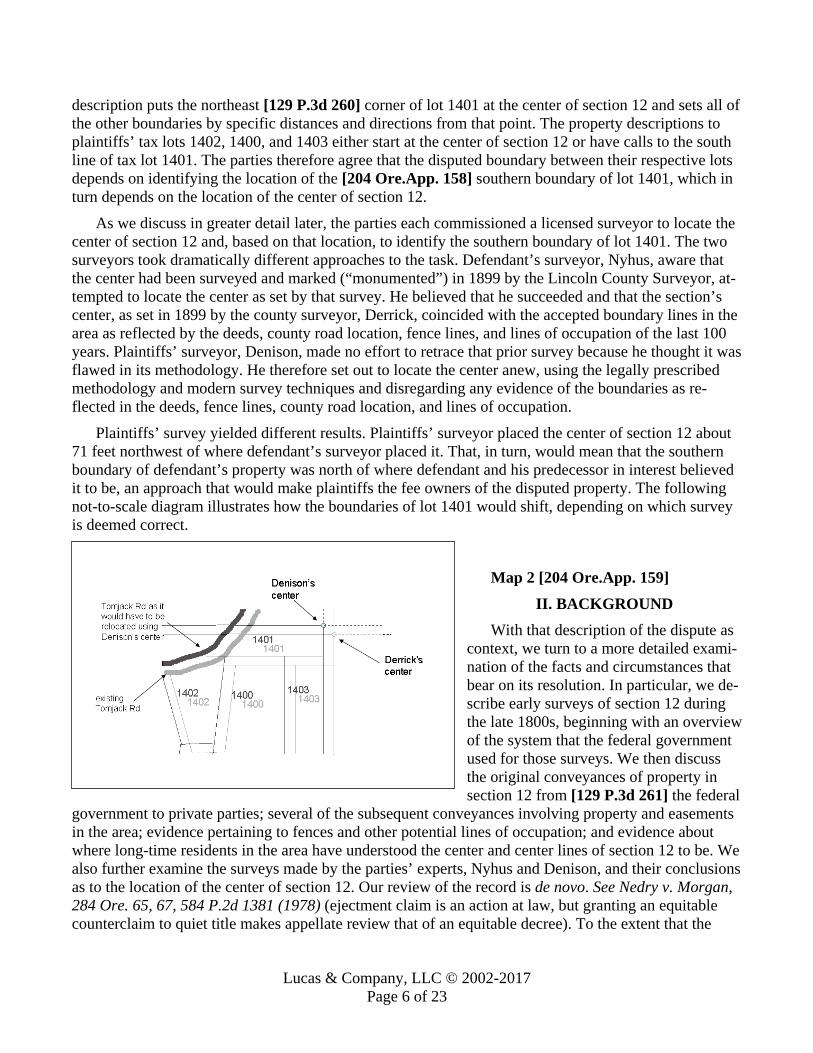
description puts the northeast [129 P.3d 260] corner of lot 1401 at the center of section 12 and sets all of the other boundaries by specific distances and directions from that point. The property descriptions to plaintiffs’ tax lots 1402, 1400, and 1403 either start at the center of section 12 or have calls to the south line of tax lot 1401. The parties therefore agree that the disputed boundary between their respective lots depends on identifying the location of the [204 Ore.App. 158] southern boundary of lot 1401, which in turn depends on the location of the center of section 12.
As we discuss in greater detail later, the parties each commissioned a licensed surveyor to locate the center of section 12 and, based on that location, to identify the southern boundary of lot 1401. The two surveyors took dramatically different approaches to the task. Defendant’s surveyor, Nyhus, aware that the center had been surveyed and marked (“monumented”) in 1899 by the Lincoln County Surveyor, at-tempted to locate the center as set by that survey. He believed that he succeeded and that the section’s center, as set in 1899 by the county surveyor, Derrick, coincided with the accepted boundary lines in the area as reflected by the deeds, county road location, fence lines, and lines of occupation of the last 100 years. Plaintiffs’ surveyor, Denison, made no effort to retrace that prior survey because he thought it was flawed in its methodology. He therefore set out to locate the center anew, using the legally prescribed methodology and modern survey techniques and disregarding any evidence of the boundaries as re-flected in the deeds, fence lines, county road location, and lines of occupation.
Plaintiffs’ survey yielded different results. Plaintiffs’ surveyor placed the center of section 12 about 71 feet northwest of where defendant’s surveyor placed it. That, in turn, would mean that the southern boundary of defendant’s property was north of where defendant and his predecessor in interest believed it to be, an approach that would make plaintiffs the fee owners of the disputed property. The following not-to-scale diagram illustrates how the boundaries of lot 1401 would shift, depending on which survey is deemed correct.
Map 2 [204 Ore.App. 159] II. BACKGROUND
With that description of the dispute as context, we turn to a more detailed exami-nation of the facts and circumstances that bear on its resolution. In particular, we de-scribe early surveys of section 12 during the late 1800s, beginning with an overview of the system that the federal government used for those surveys. We then discuss the original conveyances of property in section 12 from [129 P.3d 261] the federal
government to private parties; several of the subsequent conveyances involving property and easements in the area; evidence pertaining to fences and other potential lines of occupation; and evidence about where long-time residents in the area have understood the center and center lines of section 12 to be. We also further examine the surveys made by the parties’ experts, Nyhus and Denison, and their conclusions as to the location of the center of section 12. Our review of the record is de novo. See Nedry v. Morgan, 284 Ore. 65, 67, 584 P.2d 1381 (1978) (ejectment claim is an action at law, but granting an equitable counterclaim to quiet title makes appellate review that of an equitable decree). To the extent that the

Lucas & Company, LLC © 2002-2017 Page 7 of 23
facts are disputed or the parties disagree about what inferences should be drawn from certain facts, our description is based on the facts and inferences that we find persuasive.
A. The method of subdividing lands for conveyances from federal government ownership into pri-vate ownership
As is true of all land in the United States north of the Ohio River and west of the Mississippi River, title to land in Oregon was originally vested in the federal government, and much of it was conveyed into private ownership pursuant to federal land “patents,” or grants, issued by the General Land Office (GLO). Before the federal government would transfer title through those original grants, the land first had to be surveyed by a federal government surveyor. Once surveyed, a plat of the survey, together with the surveyor’s field notes, had to be filed with and approved by the federal government.4 [204 Ore.App. 160]
The surveys were made using the “rectangular survey system,” which divided the land into a grid-like pattern of increasingly small squares. Starting with an initial reference line called a “meridian,” the first level of the grid was formed by the intersection of “township” lines running north and south with “range” lines running east and west. The intersection of those lines formed squares that were six miles on each side, called “townships.” Townships were then subdivided into “aliquot” parts--which means “contained in a larger whole an exact number of times; fractional[.]” Black’s Law Dictionary 81 (8th ed 2004). In particular, a township was subdivided into 36 one-mile squares called “sections,” each with an area of 640 acres. The sections were assigned a number from 1 to 36, starting in the upper right-hand corner of the township and continuing alternately left and right down the sections, with the square in the lower right hand corner assigned the number 36. Thus, on paper, a subdivided township looked gener-ally like this:
Map 3 [129 P.3d 262] The rectangular survey system also contemplated the po-
tential subdivision of sections into aliquot parts, in part to make the land more affordable for settlers buying it on a per acre basis. Sections were subdivided into quarters of 160 acres each, referred to as the northwest quarter, northeast [204 Ore.App. 161] quarter, southwest quarter, and south-east quarter. The quarters, in turn, could be subdivided into half-quarters of 80 acres and quarter-quarters of 40 acres. Quarter-quarters were the smallest unit of land for which the federal government would issue a grant. Once land passed into private ownership, landowners were free to subdivide it
4 The background information presented throughout this section is distilled from the following sources: Walter G. Robillard & Lane J. Bouman, Clark on Surveying and Boundaries chs 4, 6, and 8 (7th ed 1997); Joyce Palomar, 1 Patton and Palomar on Land Titles § 116 (3d ed 2002); and C. Albert White, A History of the Rectangular Survey System (1983). For ease of reading, and because much of the information from the sources has been blended, we do not provide particular citations, except for quoted material and for the description of the relationship of federal government and county surveyors, which we consider uniquely pertinent to the dispute in this case.

Lucas & Company, LLC © 2002-2017 Page 8 of 23
further and sell it in lots of whatever acreage and shape they chose.5 The following map illustrates the sizes of the possible aliquot parts of a section:
Map 4 [129 P.3d 263] The physical work of measuring and marking
the boundaries of townships and sections “on the ground” was done by surveyors employed by or un-der contract to the federal government. In the late 1800s, when the federal surveys were made of the land at issue in this case, the work was accom-plished using compass bearings and chains to locate, measure, and mark the boundaries for the sides. The chains were 66 feet long. “Eighty chains,” laid length to length, totaled a mile. Surveys were per-formed by crews of at least two who would measure
the boundaries by starting at a fixed beginning point, walking the chain along a compass bearing until it reached its length, placing a temporary marker at that position, and then walking the chain another 66 feet, [204 Ore.App. 162] placing another temporary marker, and so on. After doing that 80 times, the crew successfully would have marked off a mile.
The federal surveyors also physically marked, or “monumented,” the corners of the sections, often using stakes or posts. Halfway between the corners, along the outside boundaries of each section, the federal surveyors also set marks at what are known as the “quarter corners.” The federal survey did not mark the interior boundaries of a section or the center of a section. Rather, the center lines were drawn on the survey plat through projection, thus providing the boundaries for the quarter sections (160-acre parcels) on paper only. The interior boundaries for the smaller aliquot parts (half-quarter and quarter-quarter parcels) were not projected, however. As a result, a plat of a section as surveyed by the federal government, together with the monumented corners, looked much like this:
Map 5 [129 P.3d 264] Where the federal government’s
work left off, the local government’s work began. The federal govern-ment’s objective was to be able to accurately describe the land with as little surveying as possible, and then convey the land into private owner-ship. Walter G. Robillard & Lane J. Bouman, Clark on Surveying and
5 The “rectangular survey system” provided a systematic way not only of measuring and dividing land, but also describing it accurately for purposes of conveying it into private hands. For example, the southwest quarter of sec-tion 12, where the disputed boundary in this case lies, would be referenced as SW 1/4, S12, T11S, R11W, WM (i.e., Southwest Quarter, Section 12, Township 11 South, Range 11 West, Willamette Meridian).

Lucas & Company, LLC © 2002-2017 Page 9 of 23
Boundaries § 4.05, 111 (7th ed 1997) (Clark on Surveying). As a result, the federal government sur-veyed a section’s exterior boundaries only; the interior survey work customarily was left to be per-formed by local officials:
[204 Ore.App. 163] “The county surveyor played an important part in the development of America. It was intended that he would complete the identification of the individual parcels or aliquot parts of the sections after the federal government surveyors created the sections and the land went into pri-vate ownership.”Id. § 2.13 at 55. Most states therefore provided for an official local surveyor whose duty was to survey the lands for
individual ownership, usually at the landowner’s request and expense. Id. § 2.13 at 55-56; § 4.05 at 111. Over time, as the lands came into private ownership, thousands of miles of interior boundaries and their necessary corners were surveyed by official local surveyors and their deputies. Id. § 2.13 at 55-56.
Not surprisingly, those surveys of the 1800s were not models of precision. The challenges involved were substantial: the surveying equipment and chains were heavy and by some standards “inferior”; the chains could become worn and less exact; the terrain was often rough, steep, and densely forested. See id. § 4.05 at 111. Frequently, the crews took shortcuts of various kinds, rather than follow to the letter the technical instructions prescribed by the federal government. Those problems, and more, injected large inaccuracies into the initial surveys. But, although the means and the methods seem crude by to-day’s standards, the achievement of so systematically surveying some 1.5 billion acres of the land north of the Ohio River and west of the Mississippi River was a remarkable accomplishment in its time and remains so today.6 [204 Ore.App. 164] [129 P.3d 265]
B. The early surveys and conveyances of land in section 12 Section 12 was first surveyed by George Mercer, a federal surveyor. He performed the work in two
stages. His field notes indicate that, in 1867, he set the northeast corner of section 12, then proceeded to the southeast corner, and set the east quarter corner midway between those points. He then returned to section 12 in 1870 and completed the survey by marking the remaining corners and quarter corners. As was customary, he did not survey the interior boundaries or set the section center. Instead, he surveyed only the exterior boundaries and monumented, with stakes, the four corners and four quarter corners around the section perimeter. That same year--1870--Mercer’s survey plat covering section 12 was filed and accepted by the GLO, thus permitting the land to be conveyed into private hands.
6 As described on the Cadastral Survey website for the Bureau of Land Management:
“The rectangular survey system, which was first proposed by Thomas Jefferson and enacted into law by the Land Ordinance of 1785, forms the backbone of the Nation’s land surveys. As a young nation, we faced the daunting task of surveying over 1.8 billion acres of public domain lands acquired through the Louisiana Pur-chase, the Alaska Purchase, and other acquisition actions. Contract surveyors chosen through competitive bid-ding were eventually replaced with today’s professional cadre of Cadastral Surveyors.
“Over the past two centuries, almost 1.5 billion acres have been surveyed into townships and sections and monumented. This impressive accomplishment represents the greatest land surveying project ever undertaken: there are about 2.6 million section corners throughout the United States, each one located about a mile apart. Placing these corners required a vast expenditure of human energy in carrying heavy surveying equipment, dragging chains, cutting trails, climbing mountains, placing monuments, digging pits, and blazing ‘witness’ trees.”
Bureau of Land Management, Cadastral History, at http://www.blm.gov/cadastral/Tools/Multimedia/His-tory/history.html.
Lucas & Company, LLC © 2002-2017 Page 10 of 23
The first grant of land in section 12 to private ownership was made in 1876. The GLO conveyed the full southwest quarter of the section--which includes the property and boundaries in dispute in this case--to Eugene Adams. The conveyance described the land as the “South West quarter of Section Twelve” according to “the official plat of the survey of said land returned to the General Land Office by the Sur-veyor.” In 1876, the southeast quarter was conveyed to Thomas Adams (possibly a relative of Eugene Adams).
No other land grants in the section were made for several years. Eugene Adams evidently conveyed his entire interest in the southwest quarter to C. H. Williams sometime before 1897. Then, in 1897, C. H. Williams conveyed his interest in the “southwest quarter” to David H. Williams.
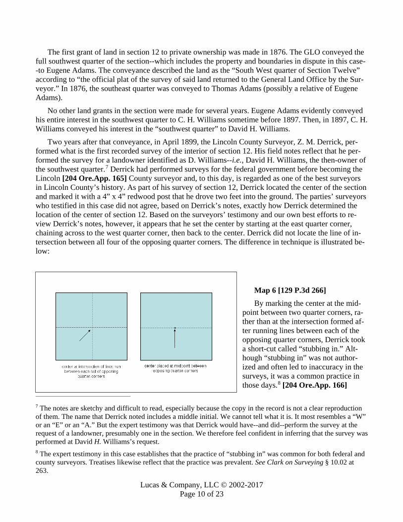
Two years after that conveyance, in April 1899, the Lincoln County Surveyor, Z. M. Derrick, per-formed what is the first recorded survey of the interior of section 12. His field notes reflect that he per-formed the survey for a landowner identified as D. Williams--i.e., David H. Williams, the then-owner of the southwest quarter.7 Derrick had performed surveys for the federal government before becoming the Lincoln [204 Ore.App. 165] County surveyor and, to this day, is regarded as one of the best surveyors in Lincoln County’s history. As part of his survey of section 12, Derrick located the center of the section and marked it with a 4” x 4” redwood post that he drove two feet into the ground. The parties’ surveyors who testified in this case did not agree, based on Derrick’s notes, exactly how Derrick determined the location of the center of section 12. Based on the surveyors’ testimony and our own best efforts to re-view Derrick’s notes, however, it appears that he set the center by starting at the east quarter corner, chaining across to the west quarter corner, then back to the center. Derrick did not locate the line of in-tersection between all four of the opposing quarter corners. The difference in technique is illustrated be-low:
Map 6 [129 P.3d 266] By marking the center at the mid-
point between two quarter corners, ra-ther than at the intersection formed af-ter running lines between each of the opposing quarter corners, Derrick took a short-cut called “stubbing in.” Alt-hough “stubbing in” was not author-ized and often led to inaccuracy in the surveys, it was a common practice in those days.8 [204 Ore.App. 166]
7 The notes are sketchy and difficult to read, especially because the copy in the record is not a clear reproduction of them. The name that Derrick noted includes a middle initial. We cannot tell what it is. It most resembles a “W” or an “E” or an “A.” But the expert testimony was that Derrick would have--and did--perform the survey at the request of a landowner, presumably one in the section. We therefore feel confident in inferring that the survey was performed at David H. Williams’s request. 8 The expert testimony in this case establishes that the practice of “stubbing in” was common for both federal and county surveyors. Treatises likewise reflect that the practice was prevalent. See Clark on Surveying § 10.02 at 263.

Lucas & Company, LLC © 2002-2017 Page 11 of 23
C. The subdivision of the southwest quarter and the first deeds referencing the center of section 12 The remainder of the land in section 12 was conveyed from the federal government to private parties
in the years that followed.9 David Williams, who had requested the Derrick survey, sold his full interest in the southwest quarter to the McBee family in 1922. The conveyance described the property simply as the southwest quarter of section 12, without reference to the original Mercer plat or to the Derrick sur-vey. The McBees were the first owners of the southwest quarter to subdivide it and convey it to other owners. All of the lots in dispute in this case originally were part of a larger, irregularly shaped parcel in the northeast corner of the McBees’ quarter section that they conveyed to the Hazeltons in 1926. Appar-ently, that was the first deed to make a specific “call” to the center of section 12. The description began at “the center of section 12” and then, using metes and bounds, described the directions and lengths of the parcel’s various boundaries, coming back to the beginning point. The deed did not refer to the Der-rick survey or Derrick’s redwood post monument. Nor did it refer to any other measure for the center of the section, such as the “geological” center of section 12. It called, merely, to the “center of section 12.”
The parcel of land created by that conveyance from the McBees to the Hazeltons contained all of the lots at issue in this case, plus some land to the south of the road. On a map, it looked generally like this:
Map 7 [204 Ore.App. 167] [129 P.3d
267] Subsequent conveyances of the parcel—
first to other members of the Hazelton fam-ily, and then to the Grays—used the identi-cal description. Thus, each ensuing convey-ance began and ended the property’s bound-aries at the center of section 12.
The next event of note took place in 1931. By then, the McBees had subdivided and sold off several portions of the south-west quarter. That year, the Grays and three other owners of lots in the southwest quarter deeded portions of their property to Lincoln County for Tomjack Road. A total of six
conveyances were required. Each of the six identified the property being conveyed to the county through deeds that began their descriptions by references to “the center of section 12.” The location of Tomjack Road therefore was dependent on the location of the center of section 12.
The details of the next several conveyances involving the property in dispute are not important to this case. The Grays subdivided their parcel further and sold those lots, but the portion that they retained included all of the property involved in this dispute. Of some note is that the McBees (who had origi-nally sold the parcel to the Hazeltons) issued a correction deed to the Grays to cure an error in the de-scription. In doing so, the new description used Tomjack Road as marking a portion of the western
9 Not all of the grants are a matter of record. Included in the record, however, is an 1899 grant of a 40-acre parcel in the northeast quarter that was made only months after the Derrick survey. Also, the record includes a 1924 grant of an 80-acre parcel in the northeast quarter.

Lucas & Company, LLC © 2002-2017 Page 12 of 23
boundary of the parcel. Eventually, the Grays conveyed the land that they retained to family members, who in turn conveyed it to the Fishers in 1968. Each of those conveyances used the center of section 12 as the beginning reference for the parcel’s description. And each identified the location of Tomjack Road in relation to the parcel’s boundaries.
D. The creation of lots 1401, 1402, and 1403 by the parties’ common predecessor in interest From 1968 to 1977, the Fishers retained the full parcel conveyed to them by the Grays, which, to re-
iterate, included all of what later became the lots (1400, 1401, 1402, and 1403) involved in this dispute. The Fishers thus were the parties’ common predecessors in interest.
The Fishers created lot 1401 and sold it to defendant in 1977. Defendant wanted to buy that section of the [204 Ore.App. 168] Fishers’s property because [129 P.3d 268] it abutted property to the north that defendant’s family owned. Defendant approached the Fishers and asked them to sell him a strip of land approximately 350 feet wide and 100 feet deep along the northern boundary of the Fishers’ prop-erty. The Fishers agreed. Defendant and Mr. Fisher then walked the property to identify the boundaries of the parcel to be created and sold to defendant. A fence post marked what the Fishers and defendant’s family had long believed to be the center of section 12. A fence line ran west from that post, marking what the two families believed was the boundary between the Fishers’ property and defendant’s family’s property to the north. Another fence line ran south from the post and had long been treated as marking the boundary between the Fishers’ property and the property to the east. Starting at the fence post--which they believed marked the center of section 12--defendant and Mr. Fisher measured the property lines for what would become lot 1401. No survey was made of the property. Instead, defendant went to the Lincoln County Surveyor, who drew up the legal description for the conveyance based on Mr. Fisher’s representation that he wanted to sell the northernmost 100 feet of what was then tax lot 1400 to defendant. The surveyor prepared the deed based on the property description for the Fishers’ tax lot and the measurements that Mr. Fisher provided. Thus, as did the description in the Fishers’ original deed, the description for the deed to the newly created lot 1401 began and ended at the center of section 12.
The next year, the Fishers sold the remainder of what they owned to the Browns. That deed, like the others in the chain of title, used the center of section 12 as the starting point of the property and included a specific call to Tomjack Road at a specified distance west from the center. But it also expressly ex-empted the property conveyed to defendant in 1977. While the Browns owned the property, they subdi-vided it into lots 1402 and 1403, leaving a smaller lot 1400. Through three conveyances made in 1990 and 1992, the Browns sold those three lots to plaintiffs. Each deed either began the property description at the center of section 12 or specifically referenced the south boundary to tax lot 1401 and [204 Ore.App. 169] included a call to Tomjack Road at a specified distance west from the center.
E. The understanding of long-time local residents Defendant, as well as defense witness Cody Alvin Gray, both lived on properties bounded by
Tomjack Road in section 12 while they were growing up in the 1950s and 1960s. As earlier noted, the Gray family at one point owned the parcel of land that included all of the lots involved in this dispute. Cody Alvin Gray was a member of that family and grew up on that land. He was 54 years old at the time of trial and had lived in the area throughout his life. He also had relatives who lived on other parcels in the southwest quarter.
Cody Alvin Gray testified that, as he was growing up, an old fence ran south from the center of the section and that a square wood post was located at the center of the section. His father had told him that the fence was important, because it was what separated the four properties that met at the center of the

Lucas & Company, LLC © 2002-2017 Page 13 of 23
section. Gray specifically understood that post to be where the four quarters of section 12 met. Although the fence was no longer standing, remnants of it could still be found in the area.
Defendant’s testimony was similar. As he was growing up, defendant’s family lived on the property directly northeast of the center of the section 12. The center of the section marked where defendant’s family’s property and the Grays’ property met. A fence post in that area was the accepted “corner” for both lots, and a fence running south from that post was the understood boundary between the Grays’ property and the property to the east.
F. The Nyhus and Denison surveys That brings us to the present time and the current dispute and, more specifically, to the competing
surveys presented by the parties. As we noted at the outset, the parties’ surveyors approached the task of identifying the center of section 12 with different objectives. Nyhus, defendant’s surveyor, after discov-ering [129 P.3d 269] that the center had been surveyed and monumented in 1899 by Derrick, set out to locate Derrick’s center. Using Derrick’s notes, together with the [204 Ore.App. 170] lines of occupation as shown by old fences, and the placement of the county road, Nyhus focused on a three-foot diameter circle as the probable location where Derrick had placed the center. He carefully removed the topsoil in that area and found a square stain of dark wood organic material that tapered to a point roughly one foot down, which he concluded was the remains of Derrick’s redwood center post. Nyhus was satisfied that he had found the remains of Derrick’s original redwood post. In retracing Derrick’s steps, Nyhus was also satisfied that Derrick had used Mercer’s original corners and quarter corners in making his survey. Nyhus therefore used the Derrick center as the center of section 12 for purposes of locating the disputed boundary line between plaintiffs’ and defendant’s lots. Nyhus concluded that the center of section 12 was where defendant and his predecessor in interest, who had originally created all of the lots in ques-tion, believed it to be.
Plaintiff’s surveyor, Denison, took a different approach. He concluded that Derrick’s survey should be disregarded because Derrick had not used what was then—and still is—the legally prescribed method for measuring to the center of a section. That is, Derrick had “stubbed in” to find the center, rather than running east-west and north-south center lines between the opposing quarter corners and then placing the center at the point where the two lines intersected. Because no other recorded survey in the nearly 100 years since had attempted to located the center of section 12, Denison approached it as though the center of the section had never been identified by any authoritative survey. He therefore located the cen-ter anew, using the legally prescribed methodology and modern survey equipment. According to Den-ison’s survey, the center of section 12 should be located about 71 feet northwest of where Nyhus located it.
As earlier described, based on Denison’s survey, the boundary between plaintiffs’ and defendant’s properties is substantially north of where the Fishers and defendant thought they were creating it. As a result, lot 1401, if located based on the Denison center, is not where defendant and the Fishers intended it to be, because the center of the section is not where they thought it was. If the Denison survey were [204 Ore.App. 171] controlling on where the boundaries are, plaintiffs would then own the disputed strip of land.
But that conclusion has more fundamental implications as well. As Nyhus testified, Denison’s cen-ter, if legally controlling, would result in a kind of boundary “chaos” throughout the area. If the Denison center were used for every deed and easement that had, over the years, made a specific call to the center of the section, the legal boundaries for property throughout the area would not coincide with the lines of occupation. Tomjack Road would not be where it should be, based on the deeds conveying the property

Lucas & Company, LLC © 2002-2017 Page 14 of 23
to the county. Fences that had long been treated as running on boundary lines between parcels would be well off of those boundary lines. Driveways would be out of place. Tomjack Road would be in the wrong place. And at least one property owner’s house would no longer be on his lot, but would sit in the middle of where Tomjack Road should be located. The map below shows in a general way how bounda-ries would shift if Denison’s center were legally controlling.
Map 8 [129 P.3d 270] Treating Derrick’s center as the center
of section 12, in contrast, would not create that same confusion or chaos. Rather, the legal boundaries would coincide--within expected tolerances--to the boundaries sug-gested by such things as the lines of occu-pation, the location of Tomjack Road, and the fence lines and their remnants.
III. LEGAL ANALYSIS The central dispute between the parties
boils down to which of the two surveys—Nyhus’s or Denison’s—legally controls. In that regard, the parties’ positions have a common [204 Ore.App. 172] starting point. The parties effectively agree that the controlling inquiry in determining the boundary line between their properties is “to ascertain and give effect to the intentions of the parties [to the deed], as evidenced by the language of the [deed of conveyance] and the circumstances attending its execution.” Wirostek v. Johnson, 266 Ore. 72, 75, 511 P.2d 373 (1973). That is, the parties agree that we need to construe the deed to lot 1401 with the aim of determining what was intended by the language “the center of section 12.”
From there, however, the parties’ positions sharply diverge. Plaintiffs argue that “there is no deed here that specifically refers to the Derrick Survey, the marker purportedly set by Derrick, or any other monument purportedly set at the center of Section 12. Consequently, that point must be located accord-ing to applicable survey law.” In other words, plaintiffs contend that, as a matter of law, the reference in the deed to the center of section 12 must be deemed a reference to the center as a correct survey would locate it. Plaintiffs further argue that, in setting the center of section 12, Derrick did not follow applica-ble survey law and that Derrick’s center is therefore a legal nullity. Plaintiffs thus maintain that, because Denison’s survey located the technically correct center of the section pursuant to “applicable survey law,” and because Nyhus’s survey merely retraced Derrick’s arguably invalid one, Denison’s survey, not Nyhus’s, must be used to determine the correct location of the disputed boundaries.
Defendant takes issue with the proposition that the deed’s reference to the center of section 12 le-gally must be understood to mean the center of the section as a modern and technically correct survey now would set it. Rather, according to defendant, that language is ambiguous and could mean either the “mathematical” center of the section or [129 P.3d 271] the center as it had been marked on the ground by Derrick and perpetuated by the fence post in the ensuing years. Defendant argues that the flaw in Derrick’s survey methodology does not, as a matter of law, defeat reliance on the center that he set, and that the collateral evidence amply establishes that, in fact, the fence post that perpetuated the location of

Lucas & Company, LLC © 2002-2017 Page 15 of 23
the Derrick center was relied on to create the boundaries to lot [204 Ore.App. 173] 1401. Thus, accord-ing to defendant, the Nyhus survey, which located and restored the Derrick center, should control.
A. The intention of the parties to the deed With regard to whether the deed’s reference to the center of section 12 is ambiguous, indefinite, or
uncertain, we have no difficulty concluding that it is. To be sure, as plaintiffs argue, the deed does not specify the center of section 12 as determined by the Derrick survey. Nor does it refer to any particular monument, such as the fence post that local adjacent residents believed marked the center. The same is true of every other deed in evidence, including several of the other deeds in the parties’ common chain of title that refer to the center of section 12.
But neither do those deeds, including the deed to lot 1401, refer to the center by reference to the original Mercer plat, which is the language that plaintiffs would read into them. Nor do they refer, as ap-parently other deeds drafted in the late 1800s sometimes did, to the “geographical center of the sec-tion.”10 [LLHN1] We know of no legal authority—and plaintiffs cite none—that holds that a mere refer-ence to “the center” of a section compels the conclusion, as a matter of law, that the parties intended to be governed by the mathematical center as it might be located in the future, rather than as it had been located. What sparse case law we can find is, instead, to the contrary. See Reed v. Tacoma Bldg. & Sav. Ass’n, 2 Wash 198, 202, 26 P 252, 252-53 (1891) (the mere reference in a deed to the northeast corner of section 8 was not sufficient to raise the presumption that the parties intended to be governed by the United States survey rather than to refer to a known point represented by a monument or other specific permanent object), cited with approval in McDowell v. Carothers, 75 Ore. 126, 135, 146 P 800 (1915) (general reference in deed to the “south line” of a donation land claim sufficiently referenced the actual monument on the ground marking the boundary as it was long understood to be, rather than the bound-ary as located correctly by later surveys); see [204 Ore.App. 174] also Dorsey v. Ryan, 110 Ill. App. 3d 577, 584, 442 N.E.2d 689, 694, 66 Ill. Dec. 263 (1982) (mere fact that a deed gives a call for north does not require the line to be run true north or astronomically north, rather than to the established boundary lines of the quarter section).11
The next question, then, is what did the parties intend when they referred to the “center of section 12” as the starting point for the description of lot 1401? There are two possible ways to approach an-swering that question, either of which takes us to the same conclusion.
The first approach is to regard the reference to “the center of section 12” as an indefinite or uncertain term in the deed. Here, all of the properties in dispute were a part of what was, at one point, a larger lot (1400) owned by the Fishers. As noted above, the earliest deeds to that property referred only to the cen-ter of section 12, followed by metes and bounds descriptions. In 1950, however, a corrected deed for that property was recorded that, in addition to beginning and ending its metes and bounds [129 P.3d
10 See, e.g., Wilder v. Nicolaus, 50 Cal App 776, 778, 195 P 1068, 1070 (1920) (reciting language of 1865 deed that referred to the “geographical center of section 14”). 11 In addition to not being legally warranted, such a presumption would also strain common sense, at least in the context of a case like this one. We would have to assume that, for about 70 years, local residents and the county used “the center of section 12” as a reference point for boundaries, easements, fences, and so on without feeling a need to know where the center actually was. The legal presumption that plaintiffs urge would preclude us from asking and answering the questions: What did the parties have in mind when they referred to the “center of sec-tion 12”? Was it a known and identifiable place on the ground? Or did they intend it to be the center of the section as a survey some day would later establish it to be?

Lucas & Company, LLC © 2002-2017 Page 16 of 23
272] description at the center of section 12, also made a specific call to Tomjack Road. Thus, even if the deed’s reference to the center of section 12 is treated as “indefinite” or “unknown,” the deed also con-tains a “definite and ascertained particular[]”—i.e., the county road—that can be used to determine the lot’s boundaries. See ORS 93.310(1).12 All of the parties to this dispute acquired the properties in ques-tion long after the property description was corrected in 1950. Using the definite measurement to the county road, and tracing the line back to what the deed would [204 Ore.App. 175] then treat as the cen-ter of the section, places that point at, essentially, Derrick’s center.
Alternatively, the reference to “the center of section 12” may also be considered ambiguous, in which case we can consider parol and other evidence as to what the parties intended. McDowell, 75 Ore. at 131 [LLHN3] (“Boundaries may be proved by every kind of evidence admissible to establish any other controverted fact.”). The testimony is uncontradicted that, when the Fishers and defendant meas-ured for lot 1401, they understood the center of section 12 to be marked by a particular fence post. There is also ample evidence, as well, that residents in the area had, for many years, understood that fence post to mark the center of the section, and that Derrick’s center, as retraced and located by Nyhus, was con-sistent with the location of that fence post. Plaintiffs dispute that conclusion, arguing that the record does not persuasively establish that Nyhus in fact located Derrick’s center. Plaintiffs also dispute the credibil-ity of defendant and other witnesses who recounted the past understandings of local residents. From our review of the record, however, we are satisfied that Nyhus did successfully locate the remains of the original Derrick monument and, therefore, that he found the center where Derrick placed it. [LLHN4] As for the credibility of the witnesses, from our review of the record and the competing conclusions that might be drawn, we are not willing to disturb the trial court’s inherent credibility assessments. See State ex rel Juv. Dept. v. Geist, 310 Ore. 176, 194, 796 P.2d 1193 (1990) (on de novo review, the appellate court is to give “considerable weight to the findings of the trial judge who had the opportunity to ob-serve the witnesses and their demeanor in evaluating the credibility of their testimony”).
B. The legal validity of Derrick’s survey The above analysis does not fully resolve this dispute. Plaintiffs further argue that, in all events, Der-
rick’s survey was a legal nullity due to his failure to follow the correct methodology for locating the cen-ter of section 12. Plaintiffs’ position is that federal law mandates that the center be located using a par-ticular methodology, that Derrick’s failure to use that methodology resulted in the misplacement of the [204 Ore.App. 176] center, and that no property can lawfully be conveyed by reference to that mis-placed center.
As we explain, we agree that Derrick failed to follow the methodology that he was legally supposed to follow. But we disagree that either federal law, state law, or our own cases require that his survey be treated as a nullity. Rather, we conclude that, [LLHN5] because Derrick was the first official to survey the interior of section 12 and to establish the center of the section, his survey should be regarded as an original survey that is controlling despite any errors in it, just as Mercer’s survey is. That conclusion
12 ORS 93.310(1) provides that, when the description of the property being conveyed by a deed leaves the con-struction doubtful,
[LLHN2] “where there are certain definite and ascertained particulars in the description, the addition of oth-ers, which are indefinite, unknown or false, does not frustrate the conveyance, but it is to be construed by such particulars, if they constitute a sufficient description to ascertain its application.”

Lucas & Company, LLC © 2002-2017 Page 17 of 23
should follow at least in circumstances like these, where Derrick’s was the only recorded survey to mon-ument the center of section 12 during nearly a 100-year period, and the center as he located it has been relied on and has determined the lines of occupation over that time.
1. Applicable survey law [LLHN6] The federal statute governing the survey of public lands before they are conveyed into pri-
vate ownership has remained relatively unchanged since its original enactment. [129 P.3d 273] The cur-rent codification of the provision pertinent to this case, 43 USC § 752, provides in part that “boundary lines[] actually run and marked in the surveys * * * shall be established as the proper boundary lines of the sections, or subdivisions, for which they were intended[.]” That provision has led to the long-settled rule that the original survey, as actually run “on the ground,” controls, even if the survey was done in-correctly and the boundaries are in error. United States v. Doyle, 468 F.2d 633, 636 (10th Cir 1972) (canvassing authorities); see Goodman v. Myrick, 5 Ore. 65, 68 (1873) (“in government surveys, the line actually run upon the ground by the original surveyors is the true line”). The federal statute goes on to direct how the boundaries that were not actually run and marked are to be ascertained. See 43 USC § 752. The statute says nothing, however, about who is to make the survey of those additional boundaries or the effect of a survey that does so incorrectly.
The more detailed provisions for surveying public lands, which have remained largely unchanged since their [204 Ore.App. 177] original publication in the 1800s, are contained in The Manual of In-structions for the Survey of Public Lands of the United States (1973 ed) (Manual) and a supplement to it entitled Restoration of Lost or Obliterated Corners and Subdivision of Sections (1974 ed) (Supplement), both published by the Bureau of Land Management (the successor to the GLO).13 The instructions in the Manual identify the method by which a section is to be subdivided—i.e., the method by which the center lines of a section should actually be run on the ground and the center of the section located so that it can be monumented:
[LLHN7] “To subdivide a section into quarter sections, run straight lines from the established quar-ter-section corners to the opposite quarter-section corners. The point of intersection of the lines thus run will be the corner common to the several quarter sections, or the legal center of the section.” Manual § 3-87; see also Supplement at 26-27. In other words, the federal survey instructions require the center of a section to be marked at the in-
tersection of the center lines running north-south and east-west through the middle of the section. A sur-veyor may not, as Derrick did, “stub in” the center by finding the midpoint of only one of the two center lines.
[LLHN8] It is less apparent than plaintiffs assume it to be, however, that the instructions in the Manual are binding by their own terms on a local interior survey of lands that have passed by federal grant into private hands.14 The instructions expressly observe that, as a rule, the “sections are not subdi-vided in the field” by the federal government, although “certain subdivision-of-section lines” (e.g., inte-rior quarter-section boundaries) are protracted on the plat. Manual § 3-74; Supplement at 22. Instead, the “local surveyor is employed as an expert to identify lands which have passed into private ownership,” a
13 Because the instructions have changed little over the years, we cite to and rely on the most recent and easily accessible editions of them. 14 Nor is it clear by what authority Congress could exercise such power. The general rule is that questions involv-ing ownership of land are determined under state law, even when the federal government is a party. Mason v. United States, 260 U.S. 545, 558, 43 S. Ct. 200, 67 L. Ed. 396 (1923).

Lucas & Company, LLC © 2002-2017 Page 18 of 23
task that entails the “subdivision [204 Ore.App. 178] of the section into the fractional parts shown upon the approved plat.” [LLHN9] Manual § 3-76; see also Supplement at 25-27. As the Manual observes, it is “a matter of expert or technical procedure to mark out the legal subdivisions called for in a patent,” a process that includes “locating the legal center of the section in order to determine the boundaries of a quarter section.” Manual § 3-92. The Manual further observes that, in performing that survey work, “the local surveyor is performing a function contemplated by law.” Id. § 3-76.
But the Manual cautions that [LLHN10] the federal government “assumes no control or direction over the acts of local and county surveyors in the matters of subdivision of sections and reestablishment of lost corners of original surveys where the lands have passed into private ownership[.]” Id. The rules that control the acts of the federal government’s own surveyors are, instead, to be considered “by [129 P.3d 274] all other surveyors as merely advisory and explanatory of the principles which should prevail in performing such duties.” Id. And, even as to disputes over uncertain or erroneous location of corners or boundaries originally established by the federal government, the federal government will exercise no jurisdiction; those matters, too, are to be settled by local authorities. Id. Thus, in all respects, once the land is conveyed into private hands, the states, not the federal government, have jurisdiction over it.
Those provisions suggest that federal law, in and of itself, did not require Derrick to follow the in-structions in the Manual in locating the center of section 12. That is not to say, however, that his “stub-bing in” methodology was legally permissible. State law, rather than federal, required him to follow the survey techniques as set forth in the Manual. In particular, in 1899, when Derrick performed the interior survey of section 12, a county surveyor’s official duties included surveying any land in the county at a landowner’s request and expense. See The Codes and General Laws of Oregon, ch XIII, title IV, § 2480 (Hill 2d ed 1892). The law further directed the county surveyor, in the subdivision of land, to “make all surveys of legal subdivisions in conformity with the laws and regulations of the general land-office of the United States.” Id. at ch LXXVII, § 4151.15 As we have already concluded, [204 Ore.App. 179] Derrick did not do so. By “stubbing in” the center of the section by placing it at the midpoint of only the east-west centerline, Derrick took a shortcut commonly taken by federal government and local surveyors of the day. The shortcut that he took, however, was not a legally authorized one under state law.
2. The consequences of Derrick’s error One significant question remains: What now? Nearly 100 years later, what should be the legal conse-
quences of Derrick’s shortcut? Plaintiffs urge that Derrick’s survey is a legal nullity. But the fact is that no statute, state or federal, so provides.
As already described, federal law specifically dictates that the boundaries and markers placed on the ground by federal surveyors are binding, even if the surveyor did not follow the instructions in the Man-ual or otherwise performed the survey inaccurately. In effect, [LLHN11] the settled rule for federal gov-ernment surveys accords dignity to the boundaries and monuments physically set on the land, even when not done pursuant to the applicable survey law. The rule is one of repose, as identified in one of Justice Cooley’s often-cited passages:
“Nothing is better understood than that few of our early plats will stand the test of a careful and ac-curate survey without disclosing errors. This is as true of the government surveys as of any others, and if all the lines were now subject to correction on new surveys, the confusion of lines and titles
15 Substantially the same requirement is now in ORS 209.070(4), which provides that the county surveyor of each county is to “make all surveys of legal subdivisions with reference to the current United States Manual of Survey-ing Instructions.”

Lucas & Company, LLC © 2002-2017 Page 19 of 23
that would follow would cause consternation in many communities. Indeed the mischiefs that must follow would be simply incalculable, and the visitation of the surveyor might well be set down as a great public calamity.” Diehl v. Zanger, 39 Mich. 601, 605 (1878). But [LLHN12] federal law says nothing—one way or the other—about later surveys of section inte-
riors. Despite expressly contemplating the need for those surveys, neither the federal statutes nor the in-structions in the Manual direct what must happen when the same kinds of errors are made [204 Ore.App. 180] in those original local surveys. The silence does not suggest that the original surveys that marked a section’s interior boundaries and center should not be accorded the same dignity; it suggests only that matter, too, was left to state law.
State law, however, is also silent. It was in 1899, and it remains so today. [LLHN13] Consistently with federal law, ORS 209.200 directs how a “resurvey” of lands surveyed by the federal government is to be performed by the county surveyor. Section and quarter-section corners set by the original federal survey are controlling and must “stand,” regardless of the accuracy of that survey. See ORS 209.200. [129 P.3d 275] If they must be “reestablished,” they must be placed where the original survey placed them, even if it was wrong. See id. It is only if an original federal corner cannot be found or its original location cannot be determined that a county surveyor establishes it pursuant to the Manual. See id. But nothing in ORS 209.200 or any other statute directs what should be done with a center originally sur-veyed and marked inaccurately by a county surveyor. The solution has been left to the courts to devise, as a matter of common law.
We turn, then, to the key cases cited by the parties to determine if there is precedent that either binds us or guides us. The primary Oregon authority that plaintiffs rely on is Talbot v. Smith, 56 Ore. 117, 107 P 480, on reh’g, 56 Ore. 117, 108 P. 125 (1910). In Talbot, the plaintiff’s predecessors in interest con-veyed portions of a section by a deed that referenced the “northeast corner” of the section, followed by specific metes and bounds measurements. The deed made no reference to the section’s east-west center line, although the parties to the deed apparently had assumed that the parcel’s southern boundary would end up, through the metes and bounds description, at that line. Id. at 118; 56 Ore. at 124 (on rehearing). Some years later, a county surveyor purported to establish the east-west center line of that section. 56 Ore. at 121-22. He did so without locating the original government quarter-corner needed to mark one end of the east-west centerline and without reestablishing it in the way he was legally required to do. 56 Ore. at 120-21; see also ORS 209.200(2). The issue for the court was whether the unambiguous terms in the deed should control, in which case the property did not run to the center line as the survey estab-lished it; [204 Ore.App. 181] or whether the erroneous survey should control over the description in the deed, even though it came later in time and was done in error.
The court declined to let the erroneous later survey control the description in the deed. Talbot, 56 Ore. at 121-23. Plaintiffs understand Talbot to have reached that result because the county surveyor failed to follow federal instructions in locating the center line of the section. We disagree. Although the court observed that the flaws in the survey rendered it “wholly unreliable,” only a few sentences later, the court held that “regardless of any of the surveys offered in evidence, the descriptions in the deeds are conclusive.” Id. at 121. The court reiterated the point, stating that, “wherever the quarter section line or the division line of the claim may be located, it cannot control the descriptions in the deeds.” Id. at 123. The court was unwilling to conclude, where no monuments were mentioned in the deed, that monuments placed by a later survey should control the deed’s description. Id. at 121; see also 56 Ore. at 126 (on re-hearing). In short, as we read Talbot, it stands for the unremarkable conclusion that the [LLHN14] boundaries determined by the express and unambiguous description in a deed control over boundaries

Lucas & Company, LLC © 2002-2017 Page 20 of 23
determined by a later survey. The fact that the later survey was erroneously made was simply further reason not to let the survey control the deed.
This case involves almost the converse of the facts that confronted the court in Talbot. Here, the er-roneous survey came before the deed, not after. Here, the Derrick monument at the center of the section, or at least the fence post that perpetuated its approximate location, existed when the deed was drafted; it did not come later. And here, as we have already concluded, the deed’s reference to the “center of sec-tion 12” was a reference to the center of the section as it had been located by Derrick. So, here, the ques-tion is whether the erroneous survey is to be disregarded in favor of a later mathematically correct one made after the deed was drafted. On that question, we find no guidance in Talbot.16 [204 Ore.App. 182]
Closer to the mark is the primary case on which defendant relies, Wirostek. There, the parties’ com-mon predecessor in interest [129 P.3d 276] subdivided a parcel into eight lots based on an incorrect sur-vey by Leuthold, a private surveyor. Wirostek, 266 Ore. at 73-74. The plaintiffs purchased the lot di-rectly to the east of one purchased by the defendants. The defendants constructed improvements on an area that, according to the incorrect survey, was actually on the plaintiffs’ property. Id. at 74. When the property dispute arose, a second survey, by Pacific Surveys, determined that Leuthold had not correctly located the centerline of the section. Id. The defendants took the position that the property lines should be based on the survey that correctly identified the section center line. The plaintiffs took the position that the boundaries were those that were established on the ground by the earlier survey. Id. The court agreed with the plaintiffs, stating:
[LLHN15] “In construing a deed our duty is to ascertain and give effect to the intentions of the par-ties, as evidenced by the language of the instrument and the circumstances attending its execution. As we have indicated, both defendants’ and plaintiffs’ deeds made reference to the Leuthold survey. That survey was commissioned and conducted for the sole purpose of establishing boundaries for each tract that the [common predecessors in interest] were planning to sell, and the corner stakes set by Mr. Leuthold were conspicuous and known to all the parties. It is evident that conveyances of the parcels were made on the assumption that the stakes marked their boundaries, and that when they purchased neither plaintiffs nor defendants had any idea that the Leuthold survey may have been in-correct. [LLHN16] “It is seldom that surveys are made with perfect accuracy. Indeed, in the present case the Pacific survey disagrees in various respects with a survey of the same area and utilizing the same center section line conducted by Marx & Chase, Inc. in 1969, and with a survey conducted by D. T. Meldrum in 1933. The appropriate inquiry in cases of this kind is not whether a survey is completely accurate, but whether the lots are purchased in reliance upon the boundaries which it establishes. When there is such reliance, to sanction the relocation of boundaries on the basis of subsequent sur-veys would defeat the intentions of the parties and subvert the security of possession.” Id. at 75-76 (emphasis added) (footnotes omitted). [204 Ore.App. 183] Wirostek thus holds that [LLHN17] an inaccurate survey should be given effect over an accurate
survey when the evidence establishes that lots have been conveyed based on the boundaries established
16 If anything, Talbot could be understood to suggest implicitly that, notwithstanding the error in the county’s sur-vey, if that survey had been made before the deed was drawn and if the deed’s description had been intended to rely on a monument set by that survey, the survey would be given effect for purposes of determining the bounda-ries set by the conveyance.

Lucas & Company, LLC © 2002-2017 Page 21 of 23
by the inaccurate survey. Although helpful at first blush, its holding is limited by its facts. Wirostek in-volved a common predecessor in interest who held a large parcel of property and a survey error that af-fected only the lots that were created when the larger parcel was subdivided. The boundaries of the orig-inal parcel were not in dispute. In other words, there was no question that the common predecessor in interest owned everything that he subdivided. The only issue was where, within the larger parcel that he owned, the subdivision boundaries belonged. Thus, the court signaled that its holding was limited to that situation by cautioning at the end of the opinion:
“This is not a case where property not originally owned by the grantor is encroached upon as a result of possession in conformance with an allegedly erroneous survey. Under either the Leuthold or the Pacific survey, plaintiffs’ and defendants’ properties lie entirely within the tract originally owned by [their common predecessor in interest].” Id. at 76. In this case, Derrick’s placement of the center had the effect of altering the inside boundaries of each
of the quarter sections of the section. Among other problems, the southwest quarter section ran over onto what should have been part of the land in the southeast quarter and did not extend as far north as it should. The following illustration shows the essential problem:
Map 9 [204 Ore.App. 184] [129 P.3d
277] Thus, the conveyance of lot 1401 using a
description referencing the center of the sec-tion as set by Derrick potentially could en-croach on land not owned by the grantor. Re-liance on Derrick’s survey therefore presents a different problem—or at least a further one—than the court addressed in Wirostek.
That leaves us looking for guidance.17 We have found it—in two places. The first is one of the foremost treatises on surveying, Clark
on Surveying. That authority identifies precisely the problem that confronts us in this case—i.e, the problem of the center of a section, as it would be located by a correct survey, not conforming to the lines of occupation. Among the chief reasons for that happening, Clark explains, is the tendency of surveyors to “stub in” the center of the section using only one or two of the quarter-section corners or the mid-point of the north-south or east-west section center line. Clark on Surveying § 10.22 at 276. Clark then lists, in apparent order of preference, the generally endorsed solutions. The first is to deem the center of
17Although plaintiffs draw from authorities in other jurisdictions, none are helpful to us. For example, they rely heavily on Vaught v. McClymond, 116 Mont 542, 155 P.2d 612 (1945). That case concerned whether either of two surveys sufficiently established the center line of a section. In Vaught, however, neither of the surveys used the quarter-section corners established in the original federal government survey to locate the section’s center line. Id. at 550, 155 P.2d at 617. That failure to follow the section’s exterior boundaries and monuments as set on the ground by the original government survey differs from the problem that this case presents. Here, the evidence es-tablishes to our satisfaction that Derrick did accurately retrace the original Mercer survey of the section’s exterior boundaries and monuments. His only error was in measuring to the center of the section, which was an interior measurement that Mercer never made.

Lucas & Company, LLC © 2002-2017 Page 22 of 23
the section an original corner if it was first set by a county surveyor.18 Id. The second is to defer to long-standing local reliance on boundaries as reflected by the lines of occupation. Id. (“If the interested land-owners have always relied on the location of the center of the section, albeit incorrectly located, it be-comes the center of the section and no one should tamper with it.”). The final resolution, which appar-ently applies if no county survey has located the center and local reliance has not done so de facto, is to locate the center “in accordance with the federal statute” and to treat the ensuing disputes as ones of property rights, not survey law. Id. [204 Ore.App. 185]
Under the facts of this case, then, Clark would advocate treating Derrick’s center as an original cor-ner and giving it the same dignity as a corner originally set by the federal government—that is, the same controlling status as if it had been set, however erroneously, in Mercer’s survey. That approach was taken by the court in Adams v. Hoover, 196 Mich. App. 646, 493 N.W.2d 280 (1993), which is factually on point and highly persuasive in its reasoning. [129 P.3d 278]
In Adams, the federal government had surveyed the exterior boundaries and corners of a land grant in 1904. But, “as was the custom,” the center of the section was left to be set by local surveyors, and the county surveyor located it and marked it with a post in 1950. Id. at 648, 493 N.W.2d at 281. In doing so, the county surveyor took the same kind of shortcut that Derrick took in this case--that is, he did not lo-cate the intersection of the two center lines, but instead marked the center at the midpoint of one of them. Later surveys of the area relied on the center as marked by the 1950 survey, despite the survey’s flawed methodology. Then, in the mid-1970s, another surveyor working in the area discovered that the 1950 survey had not followed the statutorily prescribed methodology for locating the center. Because it did not, that surveyor located and marked the “actual geographic center” of the section consistently with the intersection method that was legally prescribed. Id. at 649, 493 N.W.2d at 281-82. The question for the Michigan court was which survey—the flawed 1950 survey that first set the center of the section or the later one that did so correctly—should legally control.
The court held that the 1950 survey should legally control, despite the error in it. The court began its analysis by stating that “public policy clearly favors consistency in ascertaining boundary lines, espe-cially where, as here, a multitude of boundaries have been established in reliance upon the [center post set in the 1950 survey].” Id. at 651, 493 N.W.2d at 282-83. It then quoted the generally recognized prin-ciple that “the original survey in all cases must, whenever possible, be retraced, since it cannot be disre-garded or needlessly altered after property rights have been acquired in reliance upon it.” Id. at 652, 493 N.W.2d at 283 (quoting Boundaries, 12 Am Jur 2d 462-63 § 57 (1997)) (emphasis omitted). The court effectively regarded the county’s survey, [204 Ore.App. 186] as the first to locate the center of the sec-tion, to be an original survey and the post marking the center to be an original monument. Consequently, to locate the center of the section, the same rule applied that would apply to relocating a “lost” monu-ment: “The question is not how an entirely accurate survey would have located the lots, but how the original survey stakes located them.” Id. at 652, 493 N.W.2d at 283 (citation omitted). Citing the “pub-lic’s need for finality and uniformity of boundaries and land titles” and observing that any other ap-proach “could unsettle boundaries throughout the entire Section[,]” the court held that the 1950 survey “should be left in repose” and given legal effect. Id. at 652-55, 493 N.W.2d at 283-84.
We conclude that is the appropriate rule to apply in this case. The center of section 12 was not lo-cated and marked by Mercer. If it had been, Derrick would have been obligated to walk in Mercer’s steps, to find Mercer’s center as he located it, and to leave it where Mercer put it. Instead, as the federal
18 The center of a section is often termed the “center corner” because it marks the interior corner of each of the four quarter sections.

Lucas & Company, LLC © 2002-2017 Page 23 of 23
government’s survey procedures expressly anticipated, the county surveyor—Derrick—Was the first to go into the interior of the section and perform the survey necessary for the actual subdivision of the sec-tion. When Derrick did so, he was performing a legally contemplated, customary, and ultimately neces-sary official function. He did so pursuant to his statutory duties as the county surveyor, even if at private request and expense (as were all such Oregon surveys of the day).
No evidence suggests that Derrick’s survey was called into question for nearly 100 years. To the contrary, the record amply persuades us that the local reliance on Derrick’s center has been extensive and long-standing. As Nyhus put it, “chaos” could ensue throughout this area of section 12 if Derrick’s center were disregarded and the center of section 12 were located based on the correct methodology and modern survey techniques. Beginning in 1926, deed after deed has made calls to the center of the sec-tion. Property has been subdivided, homes have been built, the county road has been established, and lots have been conveyed and reconveyed in reliance on a section center that was monumented by Der-rick and that has remained a known and identifiable [204 Ore.App. 187] point on the ground for local residents. Among other problems, if the center of the section were moved based on Denison’s survey, the county road would be in the wrong place, a house would sit where the county road should be, and the lines of occupation in [129 P.3d 279] the area would not match the boundaries dictated by such a dis-placement of the center.
The flaw that infected Derrick’s work, or other flaws like it, may infect many, if not most, of the first interior surveys of what were originally public lands all over the state. As Justice Cooley cautioned, few of the early surveys of public lands can stand the test of “a careful and accurate survey without disclos-ing errors.” Diehl, 39 Mich. at 605. For the same reasons that a federal government survey of a section’s exterior boundaries is given legal effect despite its errors, an original county survey of a section’s inte-rior boundaries should be as well. We therefore agree with Clark and the court in Adams that an original county survey marking the center of a section, despite a flawed methodology, should be deemed an orig-inal survey, one that is “left in repose” and given legal effect. Derrick’s center, as physically marked on the ground, is therefore controlling in this case, even if incorrectly placed. Consequently, the trial court correctly dismissed plaintiffs’ claim for ejectment and quieted title to the disputed property in defendant.
Affirmed on appeal and cross-appeal.

Lucas & Company, LLC © 2013 Page 1 of 8
FIRST BEAT ENTERTAINMENT, LLC v.
ECC, LLC 2050819
COURT OF CIVIL APPEALS OF ALABAMA 962 So. 2d 266
January 12, 2007, Released LUCAS LETTER HEAD NOTES: Real Property Law; Adjoining Landowners; Fences: [LLHN1] Section 35-7-3, Code of Alabama, 1975, states: “Partition fences between improved lands are to be erected and repaired at the joint expense of the occupants; or if any person makes a fence a parti-tion fence by joining to or using it as such, he must pay to the person erecting it his proportion of the ex-pense, taking into consideration the condition of such fence at the time it is so joined or used.”
Real Property Law; Public Lands; Boundaries: Real Property Law; Public Lands; Government Surveys: Real Property Law; Public lands; Sections & Subdivision of Sections: [LLHN2] First. All the corners marked in the surveys returned by the Secretary of the Interior or such agency as he may designate, shall be established as the proper corners of sections, or subdivisions of sections, which they were intended to designate; and the corners of half- and quarter-sections not marked on the surveys shall be placed as nearly as possible equidistant from two corners which stand on the same line. See 43 U.S.C.S. § 752.
Real Property Law; Public Lands; Boundaries: Real Property Law; Public Lands; Boundaries; Actually run & Marked: Real Property Law; Public lands; Sections & Subdivision of Sections: [LLHN3] Second. The boundary lines, actually run and marked in the surveys returned by the Secretary of the Interior or such agency as he may designate, shall be established as the proper boundary lines of the sections, or subdivisions, for which they were intended, and the length of such lines as returned, shall be held and considered as the true length thereof. And the boundary lines which have not been ac-tually run and marked shall be ascertained, by running straight lines from the established corners to the opposite corresponding corners; but in those portions of the fractional townships where no such opposite corresponding corners have been or can be fixed, the boundary lines shall be ascertained by running from the established corners due north and south or east and west lines, as the case may be, to the water-course, Indian boundary line, or other external boundary of such fractional township. See 43 U.S.C.S. § 752.
Real Property Law; Public Lands; Boundaries: Real Property Law; Public Lands; Government Surveys: Real Property Law; Public lands; Sections & Subdivision of Sections: [LLHN4] Third. Each section or subdivision of section, the contents whereof have been returned by the Secretary of the Interior or such agency as he may designate, shall be held and considered as containing the exact quantity expressed in such return; and the half sections and quarter sections, the contents

Lucas & Company, LLC © 2013 Page 2 of 8
whereof shall not have been thus returned, shall be held and considered as containing the one-half or the one-fourth part, respectively, of the returned contents of the section of which they may make part. See 43 U.S.C.S. § 752.
Real Property Law; Public Lands; Boundaries: Real Property Law; Public Lands; Boundaries; Actually run & Marked: Real Property Law; Public lands; Sections & Subdivision of Sections: [LLHN5] 43 U.S.C. § 752 provides that the corners of a section and any other landmarks within the sec-tion established by the original government survey shall be adhered to in the future. However, it does not purport to state that every time a survey is made of a line dividing a quarter of a section into quar-ters, the original government survey of that section must be retraced. Moreover, First Beat has cited no caselaw holding that 43 U.S.C. § 752 requires such a retracing. The reasonable inference to be drawn from the earlier surveys locating the south line and the iron pipes marking the termini of the south line was that earlier surveyors had located the termini of the south line and its location based on the location of the four corners of Section 26 as established by the original government survey of Section 26.
Civil Procedure; Appeals; Standards of Review; Ore Tenus Rule: Civil procedure; Appeals; Standards of Review; Clearly Erroneous Ruling: [LLHN6] The ore tenus rule provides that a trial court’s findings of fact based on oral testimony have the effect of a jury’s verdict, and that a judgment, grounded on such findings, is accorded, on appeal, a presumption of correctness which will not be disturbed unless plainly erroneous or manifestly unjust. The ore tenus rule is grounded upon the principle that when the trial court hears oral testimony it has an opportunity to evaluate the demeanor and credibility of witnesses. The trial court’s judgment in cases where the evidence is heard ore tenus will be affirmed, if, under any reasonable aspect of the testimony, there is credible evidence to support the judgment. In ore tenus proceedings, the trial court is the sole judge of the facts and of the credibility of the witnesses, and it should accept only that testimony which it considers worthy of belief.
Civil Procedure; Trials; Bench Trials; Evidence Ore Tenus: Civil procedure; Appeals; Standards of Review; Ore Tenus Rule: [LLHN7] Appellate courts do not sit in judgment of disputed evidence that was presented ore tenus be-fore the trial court. When the evidence in a case is in conflict, the trier of fact has to resolve the conflicts in the testimony, and it is not within the province of the appellate court to reweigh the testimony and substitute its own judgment for that of the trier of fact. An appellate court may not substitute its judg-ment for that of the trial court. To do so would be to reweigh the evidence, which Alabama law does not allow.
Civil Procedure; Trials; Bench Trials; Evidence Ore Tenus: Civil procedure; Appeals; Standards of Review; Ore Tenus Rule: [LLHN8] In the case of judgments establishing the location of a boundary line between coterminous landowners, the ore tenus presumption of correctness reflects the fact that in boundary-line cases wit-nesses frequently point to maps and make gestures that are not reflected in the trial record. For Appellant: Stephen T. Etheredge of Buntin, Etheredge & Dowling, L.L.C., Dothan. For Appellee: William L. Lee III and William W. Nichols of Lee & McInish Attorneys, P.C., Dothan. BRYAN, Judge. Crawley, P.J., and Thompson and Pittman, JJ., concur. Murdock, J., concurs in the re-sult, without writing. OPINION BY: Bryan [962So.2d267]

Lucas & Company, LLC © 2013 Page 3 of 8
On Application for Rehearing BRYAN, Judge.
The no-opinion affirmance of December 1, 2006, is withdrawn, and the following is substituted therefor.
First Beat Entertainment, L.L.C. (“First Beat”), appeals a judgment establishing the location of the boundary line between its property and the property owned by ECC, L.L.C. (“ECC”). We affirm. First Beat owns a rectangular strip of property (“First Beat’s property”) in Section 26, Township 2 North, Range 26 East (“Section 26”) in Houston County. The northern boundary of First Beat’s property abuts a portion of the southern boundary of a parcel of property owned by ECC (“ECC’s property”). Thus, First Beat’s property and ECC’s property share a common boundary line. The parties agree that the legal description of their common boundary line is the south line of the north half of the northeast quarter of Section 26, but they disagree regarding where the south line is physically located on the land. The east-ern boundary of First Beat’s property abuts the west right-of-way of U.S. Highway 231 (“the highway”), which runs generally north and south. Thus, the south line, which runs east and west, intersects with the west right-of-way of the highway. At a point south of the intersection of the south line and the west right-of-way of the highway (“the intersection”) the course of the highway’s west right-of-way shifts westward at an angle of approximately 90 degrees. The parties refer to that point as the “jog” in the west right-of-way of the highway. Since at least 1968, surveyors have used the jog as a landmark to assist them in locating the intersection.
First Beat erected a fence (“the fence”) along what it contended was the location of the south line to keep ECC from trespassing on First Beat’s property. Wanting to restore its ability to cross First Beat’s property at will, ECC, in March 2004, sued First Beat, seeking an injunction requiring First Beat to re-move the fence. First Beat answered and asserted a counterclaim. In its counterclaim, First Beat alleged that ECC was liable for damages for trespass and was liable for half of the cost of the fence pursuant to § 35-7-3, Ala. Code 1975.1
When it first filed its lawsuit, ECC did not contend that the fence was on its property. Consequently, the trial court, holding that a landowner has a right to erect a fence on his property, dismissed ECC’s claim for an injunction requiring First Beat to remove the fence. First Beat’s counterclaim remained pending.
After the dismissal of ECC’s claim but before the adjudication of First Beat’s counterclaim, First Beat moved the trial court to find ECC in contempt of the trial court’s order dismissing ECC’s claim be-cause ECC had allegedly removed a portion of the fence. In response, ECC contended that at least a por-tion of the fence was on its property. Accordingly, the trial court ordered the parties to each nominate two registered surveyors as candidates for the trial court to consider in selecting a master to assist the trial court in determining [962So.2d268] where the south line was located in relation to the fence. Both parties listed registered surveyor Rick Kinsaul as one of their two candidates, and the trial court ap-pointed Rick Kinsaul to serve as the master.
1 Section 35-7-3, Code of Alabama, 1975, states:
[LLHN1] “Partition fences between improved lands are to be erected and repaired at the joint expense of the oc-cupants; or if any person makes a fence a partition fence by joining to or using it as such, he must pay to the per-son erecting it his proportion of the expense, taking into consideration the condition of such fence at the time it is so joined or used.”

Lucas & Company, LLC © 2013 Page 4 of 8
In November 2005, Kinsaul completed his survey. According to Kinsaul’s survey, approximately half of the fence was located along the south line, but approximately half was located north of the south line and, therefore, was on ECC’s property.
On April 27, 2006, the trial court held an evidentiary hearing regarding the issue of where the south line was located in relation to the fence. At the hearing, the trial court received the testimony of Kinsaul and three other registered surveyors, John Steensland, Elijah Branton, and Burl Mercer. The trial court also received Kinsaul’s survey, three other surveys, a map, and 11 deeds as evidence.
Kinsaul testified that he determined the location of the south line as follows. He did the field work necessary to physically locate the southwest corner of the northwest quarter of the northeast quarter of Section 26, which is the western terminus of the south line. The location of that corner had been marked previously with an iron pipe. He also did the field work necessary to physically locate the southeast cor-ner of the northeast quarter of the northeast quarter of Section 26, which is the eastern terminus of the south line. That corner had also been marked previously with an iron pipe. He used the location of those two corners to determine the location of the south line, which connects those two corners. He testified that he did not locate the south line by retracing the original government survey of Section 26.2 How-ever, he verified his placement of the south line by checking his placement mathematically in relation to landmarks described in previous surveys of property in the vicinity of the south line and landmarks de-scribed in the legal descriptions of deeds to property situated in the vicinity of the south line.
The jog was one of the landmarks he used to verify the accuracy of his determination of the location of the south line. Kinsaul’s determination of the location of the south line placed the intersection 156.20 feet north of the jog. John Steensland’s 1980 survey of the property that later became ECC’s property indicated that the intersection was 164.85 feet north of the jog. However, John Steensland’s father, Mau-rice Steensland, had performed a survey in 1968, and his survey indicated that the intersection was 156 feet north of [962So.2d269] the jog. Burl Mercer performed several surveys of property in the vicinity of the south line between 1970 and 1990. In those surveys, Mercer indicated that the intersection was 156 feet north of the jog. However, in 1990, Mercer’s surveys of property in the vicinity of the south line began to indicate that the intersection was 165 feet north of the jog instead of 156 feet.
John Steensland testified that retracing the original government survey of the section as described in footnote 2, supra, is the protocol for determining the location of a line subdividing the section. However, Steensland further testified that, because the monuments established by the original government surveys
2 Locating the south line by retracing the original government survey of Section 26 would involve (1) performing the field work to determine the location of the four corners of Section 26 established by the original government survey; (2) performing the field work to divide the section into quarters based on the location of the four corners of the section; and (3) performing the field work to divide the northeast quarter of the section into quarters.
Dividing the section into quarters based on the location of the four corners of the section would involve (1) con-necting the four corners of the section with lines; (2) determining the precise midpoint of each of those lines; (3) connecting the midpoints of the north and south section lines with a line; and (4) connecting the midpoints of the east and west section lines with a line. The lines resulting from steps (3) and (4) would divide the section into quarters.
Dividing the northeast quarter into quarters would involve (1) determining the precise midpoint of each line form-ing the northeast quarter of the section; (2) connecting the midpoints of the north and south lines of the northeast quarter with a line; and (3) connecting the midpoints of the east and west lines of the northeast quarter with a line. The lines resulting from steps (2) and (3) would divide the northeast quarter into quarters, and the line resulting from step (3) would be the south line.
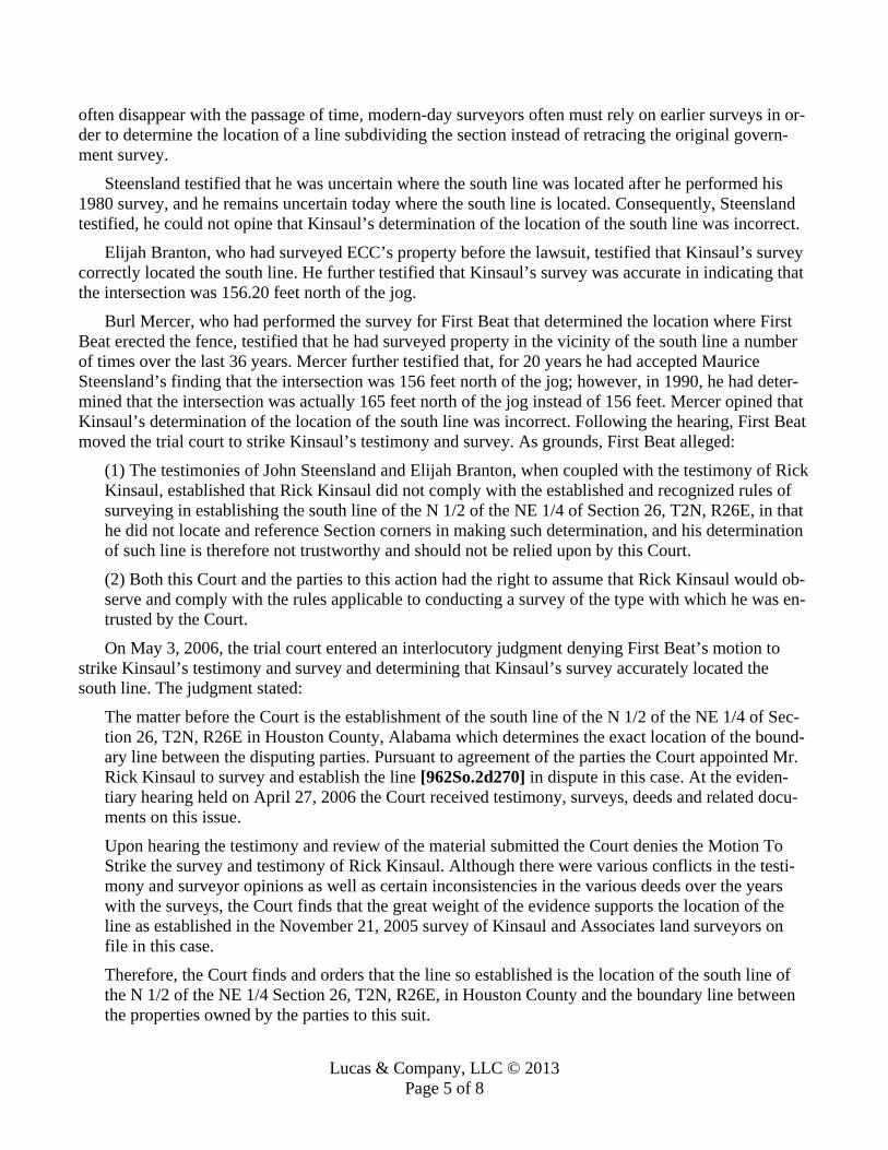
Lucas & Company, LLC © 2013 Page 5 of 8
often disappear with the passage of time, modern-day surveyors often must rely on earlier surveys in or-der to determine the location of a line subdividing the section instead of retracing the original govern-ment survey.
Steensland testified that he was uncertain where the south line was located after he performed his 1980 survey, and he remains uncertain today where the south line is located. Consequently, Steensland testified, he could not opine that Kinsaul’s determination of the location of the south line was incorrect.
Elijah Branton, who had surveyed ECC’s property before the lawsuit, testified that Kinsaul’s survey correctly located the south line. He further testified that Kinsaul’s survey was accurate in indicating that the intersection was 156.20 feet north of the jog.
Burl Mercer, who had performed the survey for First Beat that determined the location where First Beat erected the fence, testified that he had surveyed property in the vicinity of the south line a number of times over the last 36 years. Mercer further testified that, for 20 years he had accepted Maurice Steensland’s finding that the intersection was 156 feet north of the jog; however, in 1990, he had deter-mined that the intersection was actually 165 feet north of the jog instead of 156 feet. Mercer opined that Kinsaul’s determination of the location of the south line was incorrect. Following the hearing, First Beat moved the trial court to strike Kinsaul’s testimony and survey. As grounds, First Beat alleged:
(1) The testimonies of John Steensland and Elijah Branton, when coupled with the testimony of Rick Kinsaul, established that Rick Kinsaul did not comply with the established and recognized rules of surveying in establishing the south line of the N 1/2 of the NE 1/4 of Section 26, T2N, R26E, in that he did not locate and reference Section corners in making such determination, and his determination of such line is therefore not trustworthy and should not be relied upon by this Court. (2) Both this Court and the parties to this action had the right to assume that Rick Kinsaul would ob-serve and comply with the rules applicable to conducting a survey of the type with which he was en-trusted by the Court. On May 3, 2006, the trial court entered an interlocutory judgment denying First Beat’s motion to
strike Kinsaul’s testimony and survey and determining that Kinsaul’s survey accurately located the south line. The judgment stated:
The matter before the Court is the establishment of the south line of the N 1/2 of the NE 1/4 of Sec-tion 26, T2N, R26E in Houston County, Alabama which determines the exact location of the bound-ary line between the disputing parties. Pursuant to agreement of the parties the Court appointed Mr. Rick Kinsaul to survey and establish the line [962So.2d270] in dispute in this case. At the eviden-tiary hearing held on April 27, 2006 the Court received testimony, surveys, deeds and related docu-ments on this issue. Upon hearing the testimony and review of the material submitted the Court denies the Motion To Strike the survey and testimony of Rick Kinsaul. Although there were various conflicts in the testi-mony and surveyor opinions as well as certain inconsistencies in the various deeds over the years with the surveys, the Court finds that the great weight of the evidence supports the location of the line as established in the November 21, 2005 survey of Kinsaul and Associates land surveyors on file in this case. Therefore, the Court finds and orders that the line so established is the location of the south line of the N 1/2 of the NE 1/4 Section 26, T2N, R26E, in Houston County and the boundary line between the properties owned by the parties to this suit.
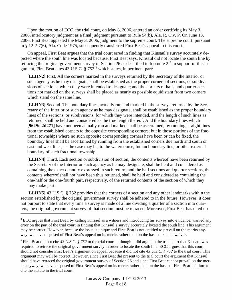
Lucas & Company, LLC © 2013 Page 6 of 8
Upon the motion of ECC, the trial court, on May 8, 2006, entered an order certifying its May 3, 2006, interlocutory judgment as a final judgment pursuant to Rule 54(b), Ala. R. Civ. P. On June 13, 2006, First Beat appealed the May 3, 2006, judgment to the supreme court. The supreme court, pursuant to § 12-2-7(6), Ala. Code 1975, subsequently transferred First Beat’s appeal to this court.
On appeal, First Beat argues that the trial court erred in finding that Kinsaul’s survey accurately de-picted where the south line was located because, First Beat says, Kinsaul did not locate the south line by retracing the original government survey of Section 26 as described in footnote 2.3 In support of this ar-gument, First Beat cites 43 U.S.C. § 752,4 which states, in pertinent part:
[LLHN2] First. All the corners marked in the surveys returned by the Secretary of the Interior or such agency as he may designate, shall be established as the proper corners of sections, or subdivi-sions of sections, which they were intended to designate; and the corners of half- and quarter-sec-tions not marked on the surveys shall be placed as nearly as possible equidistant from two corners which stand on the same line. [LLHN3] Second. The boundary lines, actually run and marked in the surveys returned by the Sec-retary of the Interior or such agency as he may designate, shall be established as the proper boundary lines of the sections, or subdivisions, for which they were intended, and the length of such lines as returned, shall be held and considered as the true length thereof. And the boundary lines which [962So.2d271] have not been actually run and marked shall be ascertained, by running straight lines from the established corners to the opposite corresponding corners; but in those portions of the frac-tional townships where no such opposite corresponding corners have been or can be fixed, the boundary lines shall be ascertained by running from the established corners due north and south or east and west lines, as the case may be, to the watercourse, Indian boundary line, or other external boundary of such fractional township. [LLHN4] Third. Each section or subdivision of section, the contents whereof have been returned by the Secretary of the Interior or such agency as he may designate, shall be held and considered as containing the exact quantity expressed in such return; and the half sections and quarter sections, the contents whereof shall not have been thus returned, shall be held and considered as containing the one-half or the one-fourth part, respectively, of the returned contents of the section of which they may make part. [LLHN5] 43 U.S.C. § 752 provides that the corners of a section and any other landmarks within the
section established by the original government survey shall be adhered to in the future. However, it does not purport to state that every time a survey is made of a line dividing a quarter of a section into quar-ters, the original government survey of that section must be retraced. Moreover, First Beat has cited no
3 ECC argues that First Beat, by calling Kinsaul as a witness and introducing his survey into evidence, waived any error on the part of the trial court in finding that Kinsaul’s survey accurately located the south line. This argument may be correct. However, because the issue is unique and First Beat is not entitled to prevail on the merits any-way, we have disposed of First Beat’s appeal on its merits rather than on the basis of such a waiver. 4 First Beat did not cite 43 U.S.C. § 752 to the trial court, although it did argue to the trial court that Kinsaul was required to retrace the original government survey in order to locate the south line. ECC argues that this court should not consider First Beat’s argument on appeal because it did not cite 43 U.S.C. § 752 to the trial court. This argument may well be correct. However, since First Beat did present to the trial court the argument that Kinsaul should have retraced the original government survey of Section 26 and since First Beat cannot prevail on the mer-its anyway, we have disposed of First Beat’s appeal on its merits rather than on the basis of First Beat’s failure to cite the statute in the trial court.
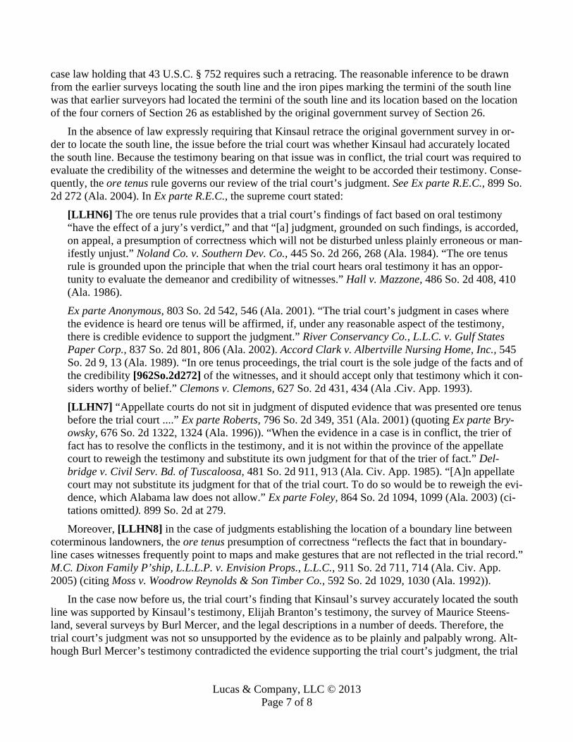
Lucas & Company, LLC © 2013 Page 7 of 8
case law holding that 43 U.S.C. § 752 requires such a retracing. The reasonable inference to be drawn from the earlier surveys locating the south line and the iron pipes marking the termini of the south line was that earlier surveyors had located the termini of the south line and its location based on the location of the four corners of Section 26 as established by the original government survey of Section 26.
In the absence of law expressly requiring that Kinsaul retrace the original government survey in or-der to locate the south line, the issue before the trial court was whether Kinsaul had accurately located the south line. Because the testimony bearing on that issue was in conflict, the trial court was required to evaluate the credibility of the witnesses and determine the weight to be accorded their testimony. Conse-quently, the ore tenus rule governs our review of the trial court’s judgment. See Ex parte R.E.C., 899 So. 2d 272 (Ala. 2004). In Ex parte R.E.C., the supreme court stated:
[LLHN6] The ore tenus rule provides that a trial court’s findings of fact based on oral testimony “have the effect of a jury’s verdict,” and that “[a] judgment, grounded on such findings, is accorded, on appeal, a presumption of correctness which will not be disturbed unless plainly erroneous or man-ifestly unjust.” Noland Co. v. Southern Dev. Co., 445 So. 2d 266, 268 (Ala. 1984). “The ore tenus rule is grounded upon the principle that when the trial court hears oral testimony it has an oppor-tunity to evaluate the demeanor and credibility of witnesses.” Hall v. Mazzone, 486 So. 2d 408, 410 (Ala. 1986). Ex parte Anonymous, 803 So. 2d 542, 546 (Ala. 2001). “The trial court’s judgment in cases where the evidence is heard ore tenus will be affirmed, if, under any reasonable aspect of the testimony, there is credible evidence to support the judgment.” River Conservancy Co., L.L.C. v. Gulf States Paper Corp., 837 So. 2d 801, 806 (Ala. 2002). Accord Clark v. Albertville Nursing Home, Inc., 545 So. 2d 9, 13 (Ala. 1989). “In ore tenus proceedings, the trial court is the sole judge of the facts and of the credibility [962So.2d272] of the witnesses, and it should accept only that testimony which it con-siders worthy of belief.” Clemons v. Clemons, 627 So. 2d 431, 434 (Ala .Civ. App. 1993). [LLHN7] “Appellate courts do not sit in judgment of disputed evidence that was presented ore tenus before the trial court ....” Ex parte Roberts, 796 So. 2d 349, 351 (Ala. 2001) (quoting Ex parte Bry-owsky, 676 So. 2d 1322, 1324 (Ala. 1996)). “When the evidence in a case is in conflict, the trier of fact has to resolve the conflicts in the testimony, and it is not within the province of the appellate court to reweigh the testimony and substitute its own judgment for that of the trier of fact.” Del-bridge v. Civil Serv. Bd. of Tuscaloosa, 481 So. 2d 911, 913 (Ala. Civ. App. 1985). “[A]n appellate court may not substitute its judgment for that of the trial court. To do so would be to reweigh the evi-dence, which Alabama law does not allow.” Ex parte Foley, 864 So. 2d 1094, 1099 (Ala. 2003) (ci-tations omitted). 899 So. 2d at 279. Moreover, [LLHN8] in the case of judgments establishing the location of a boundary line between
coterminous landowners, the ore tenus presumption of correctness “reflects the fact that in boundary-line cases witnesses frequently point to maps and make gestures that are not reflected in the trial record.” M.C. Dixon Family P’ship, L.L.L.P. v. Envision Props., L.L.C., 911 So. 2d 711, 714 (Ala. Civ. App. 2005) (citing Moss v. Woodrow Reynolds & Son Timber Co., 592 So. 2d 1029, 1030 (Ala. 1992)).
In the case now before us, the trial court’s finding that Kinsaul’s survey accurately located the south line was supported by Kinsaul’s testimony, Elijah Branton’s testimony, the survey of Maurice Steens-land, several surveys by Burl Mercer, and the legal descriptions in a number of deeds. Therefore, the trial court’s judgment was not so unsupported by the evidence as to be plainly and palpably wrong. Alt-hough Burl Mercer’s testimony contradicted the evidence supporting the trial court’s judgment, the trial

Lucas & Company, LLC © 2013 Page 8 of 8
court could have found that Mercer’s testimony was not credible. See Ex parte R.E.C. Accordingly, the trial court’s judgment is due to be affirmed. APPLICATION OVERRULED; NO-OPINION AFFIRMANCE OF DECEMBER 1, 2006, WITH-DRAWN; OPINION SUBSTITUTED; AFFIRMED. Crawley, P.J., and Thompson and Pittman, JJ., concur. Murdock, J., concurs in the result, without writing.

Lucas & Company, LLC © 2008-2017 Page 1 of 8
PETER STRANSKY, PLAINTIFF-APPELLANT/CROSS-RESPONDENT v.
THE MONMOUTH COUNCIL OF GIRL SCOUTS, INC., JOHN WILLIAMS AND LYNNDA WILLIAMS, HIS WIFE, DEFENDANTS-RESPONDENTS/CROSS-APPELLANTS, AND THE MANASQUAN RIVER REGIONAL SEWERAGE AUTHORITY, AND THE TOWNSHIP OF HOWELL, DEFENDANTS-RESPONDENTS, AND SUSAN MCCLURE, D & D, INC., D & D LANDSCAPING, INC., MATRIX CAPITAL BANK, MON-OC FEDERAL CREDIT UNION,
AMERICAN MORTGAGE NETWORK, INC., MORTGAGE ELECTRONIC REGISTRATION SYSTEMS, INC., AS NOMINEE FOR DIVISION OF WELLS FARGO HOME MORTGAGE, A
DIVISION OF WELLS FARGO BANK, NA, DEFENDANTS. MONMOUTH COUNCIL OF GIRL SCOUTS, INC., THIRD-PARTY PLAINTIFF
v. TRANSNATION TITLE INSURANCE COMPANY AND THOMAS LYNCH, LYNCH GIULI-
ANO & ASSOCIATES, P.A., THIRD-PARTY DEFENDANTS. JOHN WILLIAMS AND LYNNDA WILLIAMS, HIS WIFE, THIRD-PARTY PLAINTIFFS
v. CITICORP MORTGAGE, INC., THIRD-PARTY DEFENDANT.
DOCKET NO. A-4531-05T3 SUPERIOR COURT OF NEW JERSEY, APPELLATE DIVISION
393 N.J. Super. 599; 925 A.2d 45 April 18, 2007, Argued June 15, 2007, Decided
On appeal from the Superior Court of New Jersey, Chancery Division, Monmouth County, Docket No. C-322-00. LUCAS LETTER HEAD NOTES [LLHN]: [1] [1] All head notes in this opinion provided by the Editor of TLL for the convenience of our readers. JNL.
Real Property Law; Deeds; Construction & Interpretation: Real Property Law; Deeds; Deed Interpretation; Ambiguities: [LLHN1] The construction of a deed is a question of law. When an ambiguity is present, however, a factual issue is presented and extrinsic evidence can be considered to aid the construction effort.
Real Property Law; Deeds; Legal Descriptions; Calls: Real Property Law; Deeds; Construction & Interpretation: [LLHN2] A “call” is a landmark chosen by a surveyor or utilized in a deed to designate real property boundaries. Generally, in boundary disputes, permanent and natural monuments, like the Spanish oak tree, control over all other calls. This is so because such a reference is the most satisfactory evidence of the proper boundary, and is based upon a recognition that surveyors and chainbearers often made mis-takes in handling the instruments of measurement and in recording the observed results.

Lucas & Company, LLC © 2008-2017 Page 2 of 8
Real Property Law; Deeds; Construction & Interpretation: Real Property Law; Deeds; Legal Descriptions; Priority of Calls: [LLHN3] In construing deeds, a hierarchy of calls has been utilized over the years to determine the proper boundary of the property conveyed. Calls will generally control in descending order of priority by monuments (natural being preferred over human-made structures), followed by direction, distance, and quantity of the land conveyed.
Real Property Law; Deeds; Construction & Interpretation: Real Property Law; Deeds; Legal Descriptions; Priority of Calls: [LLHN4] The established hierarchy has been described as follows: Natural monuments (e.g. trees) pre-vail over artificial monuments (e.g. surveyor’s stakes), which prevail over references to adjacent bound-aries (e.g., “to Hunter’s property line”), which prevail over directions (e.g. northwest), which prevail over distances (e.g. 30 feet), which prevail over area (e.g., 5 acres), which prevails over place names (e.g., “the Quinn farm”).
Real Property Law; Deeds; Construction & Interpretation: Real Property Law; Deeds; Legal Descriptions; Call for a Monument: Real Property Law; Deeds; Deed Interpretation; Parol Evidence: [LLHN5] When a monument referenced in a deed is missing, it does not lose its significance as a monu-ment if its original location can be determined. If the monument can be reestablished through extrinsic evidence, it has the same legal significance as if it were not missing. Generally, parol evidence relating to the location of a missing monument is admissible. Therefore, if the location of a missing monument can be determined, it will generally prevail over the deed’s course and distance calls.
Real Property Law; Deeds; Construction & Interpretation: Real Property Law; Deeds; Legal Descriptions; Priority of Calls: Real Property Law; Deeds; Deed Interpretation; Intent: [LLHN6] The purpose of call priorities, such as the general preference for natural monuments, is subor-dinate to the manifest intent of the grantor if this can be ascertained. The prime consideration in deter-mining the meaning of the basic title instruments is the intention of the parties. Courts should interpret a deed’s words to effectuate the grantor’s intent, so far as possible.
Real Property Law; Deeds; Priority & Recording; Race-Notice: [LLHN7] Because New Jersey is a notice/race state, if a common grantor sells the same land to two per-sons, the first to record will prevail. Peter Stransky, appellant/cross-respondent, argued the cause Pro se. Mark Williams argued the cause for respondent/cross-appellant Monmouth Council of Girl Scouts, Inc. (Mehr, LaFrance & Williams, attorneys; Mr. Williams, on the brief). Tennant D. Magee, Sr. argued the cause for respondents/cross-appellants John & Lynnda Williams (Maggs & McDermott, attorneys; Mr. Magee, on the brief). Bongiovanni & Pavliv, attorneys for respondent Township of Howell relied on the brief filed on behalf of respondents/cross-appellants, John and Lynnda Williams. Cleary, Alfieri, Jones & Hoyle, attorneys for respondent Manasquan River Regional Sewerage Author-ity relied on the brief filed on behalf of respondents/cross-appellants, John and Lynnda Williams. JUDGES: Before Judges LEFELT, PARRILLO and SAPP-PETERSON. The opinion of the court was delivered by LEFELT, P.J.A.D.

Lucas & Company, LLC © 2008-2017 Page 3 of 8
[393 N.J. 603] [925 A.2d 47] OPINION: The opinion of the court was delivered by LEFELT, P.J.A.D.
Plaintiff Peter Stransky and defendants John and Lynnda Williams (Williams) are owners of adjoin-ing properties [925 A.2d 48] in Howell Township. After Williams1 granted a sewer easement to defend-ant Monmouth Council of Girl Scouts, Stransky sued his neighbors and the Girl Scouts, claiming that the easement had been unlawfully placed on his property and that the Girl Scouts were trespassers. The trial court conducted an evidentiary hearing to establish the location of a Spanish oak tree which, alt-hough no longer in existence, was a boundary monument utilized in Stransky’s deed. Despite the court’s location of the Spanish oak, Williams and Stransky still could not agree on the boundary between their properties. Consequently, the court directed Richard F. Smith, Jr., to prepare a survey based upon the court’s [393 N.J. 604] location of the missing boundary monument. The boundary line established by Smith reflected that the easement had been placed upon Stransky’s property and, therefore, the court en-tered judgment in his favor. Stransky, Williams, and the Girl Scouts all appealed.
On appeal, Stransky argues that the boundary should have been determined by a jury and that his neighbors lacked legal title to their property as a fraud had been perpetrated in a prior conveyance. Stransky also questioned the trial court’s location of the Spanish oak, the appointment of the surveyor, and argued that the surveyor failed to comply with the trial court’s direction.
Williams and the Girl Scouts also appealed, arguing that the trial court erred in the rationale it uti-lized to resolve this case. These parties contend that the conveyances to Williams and Stransky estab-lished the proper boundary between the two properties and reveal that the sewer easement is on Wil-liams’ property rather than Stransky’s. We agree with this position and reverse and remand for entry of a judgment in Williams favor.
I. The lots directly at issue in this land dispute are located in Howell Township, Monmouth County,
and are designated 26, 27, 28, and 29. Williams owns lots 26 and 27, and Stransky owns lots 28 and 29. Lot 28 is located to the west of lots 26 and 27. Lot 29 is located to the north of lot 28. The Yellow Brook runs in a roughly north-south direction to the west of lots 28 and 29, and intersects the Ma-nasquan River at the southwesterly corner of lot 28. The river then flows in a south-easterly direction along the southern border of lot 28, and then turns in a southerly direction along lot 26.
In 1958, Adele A. Tomberg sold lots 28 and 29 to Williams Sr. and his wife,2 who are the parents of plaintiff John Williams. The [393 N.J. 605] deed, which was recorded, described the conveyed tract by using a natural monument for one course, “a Spanish Oak tree standing on the edge of the river bank.” Distances were described by using chains and links rather than feet and inches and reference was made to the owners of nearby lands almost two hundred years ago.
Also in 1958, Robert Greenberg performed a survey of the 10.0 acre tract of lots 28 and 29, con-veyed by Tomberg, depicting a stake near a blazed Spanish oak tree at the bottom of the drawing next to the Manasquan River, and referring to lands formerly of James Johnson to the east of the boundary line drawn from that stake. This survey set the length of the disputed boundary line at 891 feet. [925 A.2d 49] 1 For ease of reference only, we refer to both John and Lynnda Williams in the singular form as Williams. 2 For the reader’s ease, each time we refer hereafter to Williams Sr. in this opinion, we intend to also include his wife, Stella.

Lucas & Company, LLC © 2008-2017 Page 4 of 8
In 1974, Murray L. Rosenzweig sold and conveyed lots 26 and 27 to Williams Sr. and plaintiffs John and Lynnda Williams. This deed was recorded and recited that the property contained “7.73 acres according to a survey made by M. Eugene McDonald,” and that the description contained in the deed had been drawn from that survey. Then, in 1975, a quiet title judgment in favor of Williams Sr. was en-tered. The parcel involved was a small semi-rectangle on the south-east portion of Lot 29, between lots 27 and 28, encompassing about three and one-half acres.
Thus, from 1974 through 1982, Williams Sr., together with Williams, owned lots 26 and 27 and, on his own, also owned lots 28 and 29. In 1982, by deed filed in 1984, Williams Sr. conveyed his interest in lots 26 and 27 to Williams. The deed recited that the lots contained 7.73 acres, and described the prop-erty by reference to the McDonald survey. This survey set the length of the disputed boundary line at 835 feet.
In 1986, two years after the deed for lots 26 and 27 had been recorded, Williams Sr. conveyed to Stransky, and his wife Ivanka, lots 28 and 29. This conveyance included the small parcel which had been the subject of the 1975 quiet title judgment. The deed was recorded in 1987, and specifically refer-enced that the land conveyed was bound “on the east by the premises conveyed to [393 N.J. 606] John F. Williams, Sr. [] by Book 3867 of Deeds page 834, the Rosenzweig deed, in which the premises con-veyed were based upon the McDonald survey and were subsequently conveyed by Williams Sr. to Wil-liams as lots 26 and 27.”
The contract of sale between Williams Sr. and Stransky recited that the property consisted of ap-proximately fourteen, but not less than thirteen and one-half, acres. A survey affidavit executed by Wil-liams Sr. recited that the Greenberg survey had been examined and there were no changes in the bound-ary lines. Commonwealth Title insured Stransky’s title as it had Williams’ years before.
The description in Stransky’s deed includes a reference to the Spanish oak tree and a reference to a southern boundary on land “formerly belonging to Peter Cook, deceased, now James Johnson.” This de-scription is identical to the description in the 1958 Tomberg to Williams, Sr. deed, with the exception of the closing language in the 1958 deed: “preference being had to a deed given by Peter Cook wood chop-per and wife, to Joseph Goodenough, dated November 20, 1817, and recorded in the clerk’s Office at Freehold, December 4, 1817, will more fully appear.”
Although Stransky did not order a new survey in conjunction with his purchase of lots 28 and 29, in 1987 at Stransky’s request, Crest Engineering Associates, Inc. surveyed the lots. The Crest survey showed an iron pipe located at the very bottom of the drawing next to the Manasquan River, and set the length of the disputed boundary line at 1,158 feet.
Then in 1990, Ivanka Stransky conveyed her interest in lots 28 and 29 to Stransky. That deed con-tained the same description of the lots, including reference to the Spanish oak tree, as the 1987 deed in which Williams Sr. conveyed the lots to Stransky and his wife.
Over the ensuing years, neither Stransky nor Williams fenced their land, cleared it to the common boundary line for cultivation, [393 N.J. 607] or did anything else which would physically evidence the owner’s intent as to the location of the border.
In 1997, Williams conveyed a sanitary sewer easement and right-of-way to defendant Girl Scouts. The easement was recorded in 1998 and reflected its location “within Lots 26 and 27.” In 2000, the Girl [925 A.2d 50] Scouts conveyed this easement to Howell Township and the Manasquan River Regional Sewer Authority. Stransky, contending that the easement was not on lots 26 and 27 but was on his prop-erty, commenced the law suit that culminated in this appeal.

Lucas & Company, LLC © 2008-2017 Page 5 of 8
II. After conducting a lengthy bench trial, the trial court found Stransky’s chain of title superior to that
of Williams and consequently, Stransky’s deed description controlled. The court further reasoned “that Peter Cook was the original common grantor of both tracts.” This was so even though Peter Cook never owned all of the property involved in this dispute. Stransky’s property “was described as consisting of 10 1/2 acres as early as 1817 [and the court found that] [t]he original description of its boundaries has remained constant and . . . the same description of the property has been utilized with each transfer.”
The trial judge did not agree with Williams’ argument that “Williams, Sr. had an interest in both properties in question that supplanted Peter Cook as the common grantor of both tracts.” The judge be-lieved it determinative that Williams Sr. “did not solely own both properties, such that an examination into their intent at the time they transferred the property to Stransky (and then transferred the other prop-erty to Williams, Jr.) might be relevant.” Instead, the court concluded that “[t]he repeated use of the same deed description down through the ages represents irrefutable evidence of [the desire to transfer precisely what had been previously received] and the claim that the court should somehow attempt to gain insight into the subjective intent [of] any such transferor later possessed is preposterous.” [393 N.J. 608]
The court thus believed that the description of Lots 28 and 29 consistently utilized the missing Span-ish oak tree as its boundary line to lots 26 and 27. Consequently, the court found the location of the tree from the evidence at the hearing and directed Smith to prepare a survey based on this location. The Smith survey established the length of the disputed boundary line at 1,224.16 feet, and found that the easement had been located on Stransky’s property. Based on this finding, the court subsequently entered judgment in Stransky’s favor.
III. Williams, Stransky, and the Girl Scouts all have problems with the approach taken by the trial court
to reach its decision. Williams and the Scouts argue that the trial judge erroneously fixated on the loca-tion of the Spanish oak and in the process lost sight of the parties’ intention. Even though Stransky pre-vailed, he claims the court wrongly located the Spanish oak and erroneously instructed Smith to prepare the survey based upon that location. The resulting survey, according to Stransky, “ignores historical monuments and their locations” and “creates an ‘unsupported new line’ which subdivides . . . [Stran-sky’s] property and ignores [the] superiority of . . . his title.”
Stransky maintains, on appeal, that the northeast corner of his property should have been drawn through a large white oak tree, which, according to Stransky, was located well to the east of lots 26 and 27. He states, “[s]imply put, this ancient boundary line is not between Stransky and Williams but is lo-cated at the historical location of the large white oak tree monument found in the maps, deeds, and sur-veys presented to the Court.” We reject these arguments for the same reason we believe the judge should not have located [925 A.2d 51] the Spanish oak tree to resolve this dispute.
IV. [LLHN1] The construction of a deed is a question of law. Hofer v. Carino, 4 N.J. 244, 250, 72 A.2d
335 (1950). When an ambiguity is [393 N.J. 609] present, however, a factual issue is presented and ex-trinsic evidence can be considered to aid the construction effort. Ibid. Here, much extrinsic evidence was presented partly in an effort to locate the “calls” referenced in the deeds describing the property in dispute.

Lucas & Company, LLC © 2008-2017 Page 6 of 8
[LLHN2] A “call” is a landmark chosen by a surveyor or utilized in a deed to designate real prop-erty boundaries. Black’s Law Dictionary 196 (7th ed.1991). In this case, the Spanish oak tree was one of the calls utilized for this purpose. Generally, in boundary disputes, permanent and natural monuments, like the Spanish oak tree, control over all other calls. See S.R.H. Corp. v. Rogers Trailer Park, Inc., 54 N.J. 12, 20, 252 A.2d 713 (1969). This is so because such a reference is “the most satisfactory evidence” of the proper boundary, ibid., and is based upon a recognition that surveyors and chainbearers often “ma[d]e mistakes in handling the instruments of measurement and in recording the observed results.” McCullough v. Absecon Beach Land & Imp. Co., 48 N.J. Eq. 170, 185, 21 A. 481 (Ch. 1891).
[LLHN3] In construing deeds, a hierarchy of calls has been utilized over the years to determine the proper boundary of the property conveyed. S.R.H. Corp., supra, 54 N.J. at 20, 252 A.2d 713. Calls will generally control in descending order of priority by monuments (natural being preferred over human-made structures), followed by direction, distance, and quantity of the land conveyed. See 6 Thompson, on Real Property § 3044 at 576 (1962). [LLHN4] The established hierarchy has been described as fol-lows:
Natural monuments (e.g. trees) prevail over artificial monuments (e.g. surveyor’s stakes), which pre-vail over references to adjacent boundaries (e.g., “to Hunter’s property line”), which prevail over directions (e.g. northwest), which prevail over distances (e.g. 30 feet), which prevail over area (e.g., 5 acres), which prevails over place names (e.g., “the Quinn farm”). Jesse Dukeminier & James E. Krier, Property 630 (3rd. Ed. Little, Brown & Co.1993). [LLHN5] “When a monument referenced in a deed is missing, it does not lose its significance as a
monument if its original location can be determined.” Lloyd v. Benson, 2006 ME 129, 910 A.2d 1048, 1051 [393 N.J. 610] (Me.2006). If the monument can be reestablished through extrinsic evidence, it “has the same legal significance as if it were not missing.” Ibid. Generally, “parol evidence relating to the location of [a missing monument is] admissible.” Schroeder v. Engroff, 33 N.J. 204, 206, 162 A.2d 845 (1960). Therefore, if the location of a missing monument can be determined, it will generally “pre-vail over the deed’s course and distance calls.” Theriault v. Murray, 588 A.2d 720, 722 (Me.1991).
Given this general understanding of the hierarchy of calls, we can understand why the trial court at-tempted to locate the missing Spanish oak tree, especially because the tree was referenced in the 1817 deed, the 1958 deed from Tomberg to Williams Sr., and the 1987 deed to Stransky. However, it was not necessary to establish the tree’s location to decide this dispute.
[LLHN6] The purpose of call priorities, such as the general preference for natural monuments, is subordinate “to the manifest [925 A.2d 52] intent of the grantor if this can be ascertained.” S.R.H. Corp., supra, 54 N.J. at 20, 252 A.2d 713 (quoting 6 Thompson, supra, § 3044 at 575); see also Schroeder, supra, 33 N.J. at 205-06, 162 A.2d 845. “[T]he prime consideration in determining the meaning of the basic title instruments is the intention of the parties.” Normanoch Assoc., Inc. v. Balda-sanno, 40 N.J. 113, 125, 190 A.2d 852 (1963). Courts should interpret a deed’s words to effectuate the grantor’s intent, so far as possible. E.g., Jefferson v. Davis, 25 N.J. Super. 135, 140, 95 A.2d 617 (Ch.Div.1953).
In the dispute at issue, we believe the intent of Williams Sr. was actually and constructively ex-pressed to Stransky and his wife by the conveyance of lots 28 and 29 in 1987, after having previously conveyed lots 26 and 27 to Williams.
In 1958, Williams Sr. commenced ownership of lots 28 and 29. The 1974 deed for lots 26 and 27 from Rosenzweig to Williams Sr. and John and Lynnda Williams incorporated the McDonald survey,

Lucas & Company, LLC © 2008-2017 Page 7 of 8
which established the boundary lines for those tracts. The western boundary of lots 26 and 27 abutted lots 28 and 29, which [393 N.J. 611] were already owned by Williams Sr. As of 1974, therefore, Wil-liams Sr. had a tenancy-in-common with John and Lynnda Williams in lots 26 and 27, and Williams Sr. owned lots 28 and 29 outright.
When Williams Sr. conveyed his interest in lots 26 and 27 to John and Lynnda Williams in 1982, that deed contained the description and boundary lines established by the McDonald survey. Williams Sr., therefore, intended to convey all property within the boundaries established by that survey, thereby adopting the McDonald survey boundaries to delineate the dividing line between his properties, lots 26, 27, 28, and 29. When he conveyed lots 26 and 27 to John and Lynnda Williams he intended that their western boundary be reflected in the McDonald survey.
Subsequently, when Stransky took title to lots 28 and 29, the deed recited that his land was bounded on the east by property owned by Williams Sr. Stransky’s deed referenced the Rosenzweig deed to Wil-liams Sr. for lots 26 and 27, which was the property to the east of Stransky’s lots. A title search would have disclosed the Rosenzweig deed, which noted that the conveyance contained “7.73 acres, according to a survey made by M. Eugene McDonald . . . from which the . . . description [set forth in the deed] had been drawn.” The search thus would have placed Stransky on notice of the McDonald survey, and that lots 26 and 27 had been deeded by Williams Sr. to Williams and recorded more than two years before. See N.J.S.A. 46:22-1. Thus, Stransky took title subject to the prior deed to Williams establishing the western boundary of lots 26 and 27, which was the eastern boundary of Stransky’s lots 28 and 29. After all, Williams Sr. could only have transferred to Stransky what was left after having deeded lots 26 and 27 to Williams several years before.
Even assuming that part of Stransky’s property was included in the McDonald survey, Williams still prevails in this dispute. [LLHN7] Because New Jersey is a notice/race state, “if a common grantor sells the same land to two persons, the first to record . . . will prevail.” Palamarg Realty Co. v. Rehac, 80 N.J. 446, 454, 404 [393 N.J. 612] A.2d 21 (1979). Williams Sr. made his conveyance to his son about five years before he conveyed any land to Stransky. That deed was recorded two years before the convey-ance to Stransky. Stransky, therefore, could not receive from Williams Sr. that which Williams Sr. had already conveyed to his son.
Accordingly, we conclude that the boundary between Stransky and Williams [925 A.2d 53] had been established by the McDonald survey. The Scouts relied on this survey to locate the sewer ease-ment, and all parties agree that the McDonald survey places the Girl Scout easement on Williams’ prop-erty. Therefore, we must reverse the trial court’s judgment to the contrary and remand for the entry of a judgment conforming to this determination.
V. Stransky also contends, in his appeal however, that Williams does not have legal title to lots 26 and
27 because the chain of title includes a fraudulent conveyance. He points to a 1939 conveyance to three individuals with the sur-name Schwartz by the executor of Harry Leland’s will. He claims that a con-veyance ten years later by Schwartz to Rosenzweig had been fraudulent because Schwartz never owned the land and that the fraud was continued by the 1974 conveyance from Rosenzweig to Williams Sr. and John and Lynnda Williams.
The trial court has not ruled on this contention and the record has not been fully developed. Our re-view of the record reveals that Stransky has not properly presented this issue to the trial court. Writing

Lucas & Company, LLC © 2008-2017 Page 8 of 8
letters and sending packages to the court and parties apprising them of this argument is not properly pre-senting the issue for decision. Consequently, the contention would ordinarily not be considered by us and could be rejected solely on this basis. Nieder v. Royal Indem. Ins. Co., 62 N.J. 229, 234, 300 A.2d 142 (1973).
In any event, even if Stransky could prove that a fraud had been committed, his contention that such a fraud would divest Williams of title is dubious at best. Preliminarily we note that [393 N.J. 613] Stran-sky did not seek to update his deed or exert any dominion over the property he claims to now own until thirteen years after his purchase of lots 28 and 29. The Schwartz-Rosenzweig transaction took place over a half century ago in November 1950. The property had been conveyed by Rosenzweig to Williams Sr. and John and Lynnda Williams in 1974, apparently for $ 33,400, and their interest in the land contin-ues to date. Accordingly, any number of legal theories would preclude ousting Williams of title, includ-ing bona fide purchaser for value, see Persons v. Bergmann, 182 N.J. Super. 476, 480, 442 A.2d 647 (App.Div.1982); Hyland v. Kirkman, 204 N.J. Super. 345, 377, 498 A.2d 1278 (Ch. Div. 1985); B and H.S. Corp. v. Holly, 198 N.J. Super. 83, 88, 486 A.2d 862 (Ch.Div.1984); adverse possession, see J&M Land Co. v. First Union National Bank, 166 N.J. 493, 517, 766 A.2d 1110 (1999); and considerations of equity, e.g., O’Neill v. State Highway Dept. of N.J., 50 N.J. 307, 319, 235 A.2d 1 (1967), Noyes v. Co-hen, 123 N.J. Super. 471, 481, 303 A.2d 605 (Ch.Div.1973), Reeves v. White, 84 N.J. Eq. 661, 668, 95 A. 184 (Ch.Div.1915), Smith v. Specht, 58 N.J. Eq. 47, 58, 42 A. 599 (Ch.Div.1899). Accordingly, we reject Stransky’s fraud contention on the merits.
VI. Stransky further argues that the attempt “to locate the true boundary [presumably through the white
oak tree] has been made impossible through lies and cover-ups which have been in action prior, during and after this trial.” Leveling accusations of “white collar crime,” Stransky charges the trial court with nonfeasance and hints of malfeasance. He asserts that a jury trial, to which he was entitled, would have resulted in a “‘complete verdict’ on the boundary.”
We reject the scurrilous charges against the trial court as completely [925 A.2d 54] unsupported by the record and totally meritless. Any party demanding a trial by jury for “any issue triable of right by a jury” must make such a demand “in writing not later than 10 days after the service of the last pleading directed to such issue.” [393 N.J. 614] R. 4:35-1(a). A waiver of a jury trial will occur if a required de-mand is not served. Ibid. The demand “may not be made for the first time in an amended or supple-mental pleading unless new issues triable by jury are raised therein, and if so, it is only as to those issues for which a jury trial will be required.” Pressler, Current New Jersey Court Rules, comment 1 on R. 4:35-1 (2007).
Stransky raised the issue revolving around the location of the boundary line in the first count of the original and subsequent amended complaints. Since no jury trial was demanded in the original com-plaint (or the amended through second amended complaints, for that matter), a trial by jury of this issue has been waived. Pressler, supra, comment 1 on R. 4:35-1.
VII. In conclusion, on Williams and the Scouts cross-appeals, we reverse and remand to the Chancery
Division for entry of a judgment reflecting that the boundary between Stransky’s and the Williams’ properties be set by the McDonald survey. We reject all of Stransky’s arguments on appeal as lacking merit and dismiss his appeal. We do not retain jurisdiction. Reversed and remanded.

Lucas & Company, LLC © 2013 Page 1 of 10
WILLIAM M. STEELE, Appellant, v.
DANIEL CALLAHAN, Appellee. Court of Appeals of Indiana
970 N.E.2d 799 (Ind.App.2012) July 17, 2012
LUCAS LETTER HEAD NOTES [LLHN]: Civil Procedure; Appeals; Standards of Review; Sua Sponte Findings: Civil Procedure; Appeals; Standards of Review; General Judgments: [LLHN1] When a trial court enters findings sua sponte, as it did in this case, we use a two-step standard of review to determine first, whether the evidence supports the findings and next, whether the findings support the judgment. We consider only evidence most favorable to the judgment and all reasonable inferences drawn therefrom. We will not reweigh evidence nor reassess the credibility of witnesses. Sua sponte findings control only the issues they cover, whereas a general judgment controls as to the issues upon which there are no findings. A general judgment entered with findings will be affirmed if it can be sustained on any legal theory supported by the evidence.
Civil Procedure; Appeals; Standards of Review; Clearly Erroneous Ruling: [LLHN2] When a claim is tried by the trial court without a jury, the court on appeal shall not set aside the findings or judgment unless clearly erroneous. Therefore, a challenger to a judgment bears a heavy burden and must show that the trial court’s findings were clearly erroneous.
Civil Procedure; Appeals; Standards of Review; Clearly Erroneous Ruling: Civil Procedure; Appeals; Standards of Review; Adverse & Negative Judgments: Civil Procedure; Appeals; Standards of Review; Burden of Proof: [LLHN3] The clearly erroneous standard is defined according to whether the trial court’s judgment was negative or adverse. A negative judgment is rendered against a party who bears the burden of proof, whereas an adverse one is entered against a party defending on a given question. Here, the trial court entered judgment in favor of plaintiff, the party bearing the burden of proof. Therefore, defendant is appealing an adverse judgment and has the burden to show that the trial court’s findings were clearly erroneous and not supported by substantial evidence of probative value.
Civil Procedure; Appeals; Standards of Review; Clearly Erroneous Ruling: [LLHN4] even if the evidence is substantial, we will reverse the judgment if we are left with a definite and firm conviction a mistake has been made.
Civil Procedure; Limitations on Actions; Statutes of Limitations; Generally: [LLHN5] Statutes of limitation are favored because they afford security against stale claims and promote the peace and welfare of society. They are founded on the notion that one with a well-founded claim will not delay in enforcing it. The nature or substance of the cause of action, rather than the form of the action, determines the applicable statute of limitations.
Torts; Negligence; Professional Negligence; Standard of Care: [LLHN6] Surveyors are recognized as professionals who can be liable in tort for failing to exercise reasonable care in conducting their duties.
Civil Procedure; Limitations on Actions; Discovery Rule: Civil Procedure; Limitations on Actions; Accrual: [LLHN7] Under Indiana’s discovery rule, a cause of action accrues, and the statute of limitations begins to run when the claimant knows or in exercise of ordinary diligence should have known of the

Lucas & Company, LLC © 2013 Page 2 of 10
injury. For an action to accrue, it is not necessary that the full extent of the damage be known or even ascertainable, but only that some ascertainable damage has occurred.
Torts; Negligence; Elements: [LLHN8] Negligence consists of: (1) a duty owed to the plaintiff by the defendant; (2) a breach of that duty by the defendant; and (3) injury to the plaintiff proximately caused by that breach.
Torts; Negligence; Duty of Care: Contract Law; Contractual Obligations; Breach of Contract: [LLHN9] One who contracts to perform services may commit both a breach of contract and the tort of negligence when he negligently fails to perform in a workmanlike manner. And certain professionals, by virtue of the nature of their business, make representations, render opinions, and give advice in the course of performing a contract. Surveyors may be liable in tort for failure to skillfully discharge their contractual obligation.”
Torts; Negligence; Elements; Causation: Torts; Negligence; Foreseeability: [LLHN10] An indispensable element of an action for negligence is that the act complained of must be the proximate cause of the accident producing the injury. In defining proximate cause, the Indiana Supreme Court has stated that a negligent act or omission is the proximate cause of an injury if the injury is a natural and probable consequence which, in light of the circumstances, should reasonably have been foreseen or anticipated. Foreseeability of the injury is the critical test for determining the defendant’s liability. The foreseeability of whether the defendant’s act proximately caused the plaintiff’s injuries is a question for the trier of fact.
Torts; Negligence; Elements; Causation: Torts; Negligence; Foreseeability: [LLHN11] Under negligence theory, the injured party is able to recover only those damages proximately caused by the tortfeasor’s breach. The damages claimed for such a breach must be the natural, foreseeable and proximate consequence of the breach.
Remedies; Damages; Actual: [LLHN12] Damages are awarded to compensate an injured party fairly and adequately for the loss sustained. A party is limited in recovery to the loss actually suffered; the injured party cannot be placed in position better than one in which the breach had not occurred. Additionally, windfalls and double recovery are disfavored.
Remedies; Costs & Attorney Fees; American Rule: [LLHN13] The “American Rule” states that each party pays its own attorney fees.
Remedies; Costs & Attorney Fees; American Rule: Remedies; Costs & Attorney Fees; Recovery of Costs: [LLHN14] Care must be taken to distinguish between the rule prohibiting the recovery of attorney fees from the losing party by the prevailing party in litigation and the rule allowing the recovery of attorney fees incurred in litigation with third parties necessitated by defendant’s wrongful act. It is fundamentally important to determine that an action for which the attorney fees are claimed is brought or defended by a third party, a party that is not part of the contract, agreement, or events that caused the original litigation to arise. Further, these litigation expenses and attorney fees must be foreseeable by the defendant. NOT FOR PUBLICATION APPEAL FROM THE VIGO SUPERIOR COURT The Honorable Christopher A. Newton, Judge Cause No. 84D04-1011-SC-9731 ATTORNEY FOR APPELLANT: JOHN J. KLOTZ Klotz Law Office Terre Haute, Indiana.

Lucas & Company, LLC © 2013 Page 3 of 10
ATTORNEY FOR APPELLEE: DAVID P. FRIEDRICH Wilkinson, Goeller, Modesitt, Wilkinson & Terre Haute, Indiana.
MEMORANDUM DECISION MATHIAS, Judge.
Daniel Callahan (“Callahan”) filed a complaint in Vigo Superior Court alleging that William M. Steele (“Steele”) negligently surveyed Callahan’s property, and that Steele’s negligent survey proximately caused Callahan to incur damages related to an additional survey of the property, the moving of a fence, and related landscaping. Steele filed a motion to dismiss on the grounds that Callahan’s complaint was untimely. Following a bench trial, the trial court denied the motion to dismiss and entered judgment for Callahan in the amount of $4,000. However, the trial court denied Callahan’s request for attorney fees. Steele appeals the trial court’s denial of the motion to dismiss and its finding that inconsistencies in Steele’s surveys were the proximate cause of Callahan’s damages. Callahan cross-appeals on the trial court’s denial of his claim for attorney fees.
We affirm in part, reverse in part, and remand to the trial court to enter judgment consistent with this opinion.
Facts and Procedural History In 2008, Callahan contracted with Steele, a licensed surveyor, to survey Callahan’s property, locate
the four corners of Callahan’s property, and to give Callahan an “approximation of where [he] should put [a] fence.” Tr.p.7. In the 2008 survey of Callahan’s property, Steele found four existing corner pins. The southeast corner was marked on the survey with “Exist. I.P. in Concrete,” indicating that Steele found an existing iron pin, or monument, 1 at that location indicated on the survey document. Ex.Vol.p.3. In addition, Steele marked each corner of the Callahan property with wooden stakes and ribbon. Steele charged Callahan $400 for the survey.
Based on Steele’s 2008 survey and starting at the southeast corner of his parcel, Callahan “eyeball[ed]” a line along the entirety of Callahan’s south boundary line, which was approximately 285 feet long. Tr.p.8. Callahan had a fence built along this eyeballed line. Callahan testified that when eyeballing the line, he was aware that his fence might encroach onto his neighbor’s property but was not concerned because he was bearing the cost of the fence and improvement to his property.
Subsequent to Callahan’s survey in April 2008 and fence installation in the summer of 2008, Matthew Riggs (“Riggs”) purchased the land directly south of and contiguous with Callahan’s property. Riggs sought to install a dog fence along the northern boundary of his parcel and the southern boundary of Callahan’s parcel. In preparation for installing the fence, Riggs located three of the four corner pins of his property after September 2008. He was unable to locate his northeast (Callahan’s southeast) corner pin. Riggs then performed basic calculations and concluded that Callahan’s fence encroached on Riggs’s land by up to nine feet in some places.
Because of his own observations about the location of Callahan’s fence, in 2009, Riggs hired Steele, who had performed the 2008 survey on Callahan’s property, to survey Riggs’s newly purchased land. When retained to perform the survey for Riggs, Steele was unaware that Riggs’s property was contiguous with Callahan’s and did not recall that he had surveyed Callahan’s property only eighteen months prior to his survey for Riggs.
While conducting the 2009 survey for Riggs, Steele was unable to locate a pin for Riggs’s northeast (Callahan’s southeast) corner of the property and set a new pin in that location. Steele testified that he
1 Monuments are pins, pipes, stakes, or other forms of representation used by surveyors to indicate boundary lines.
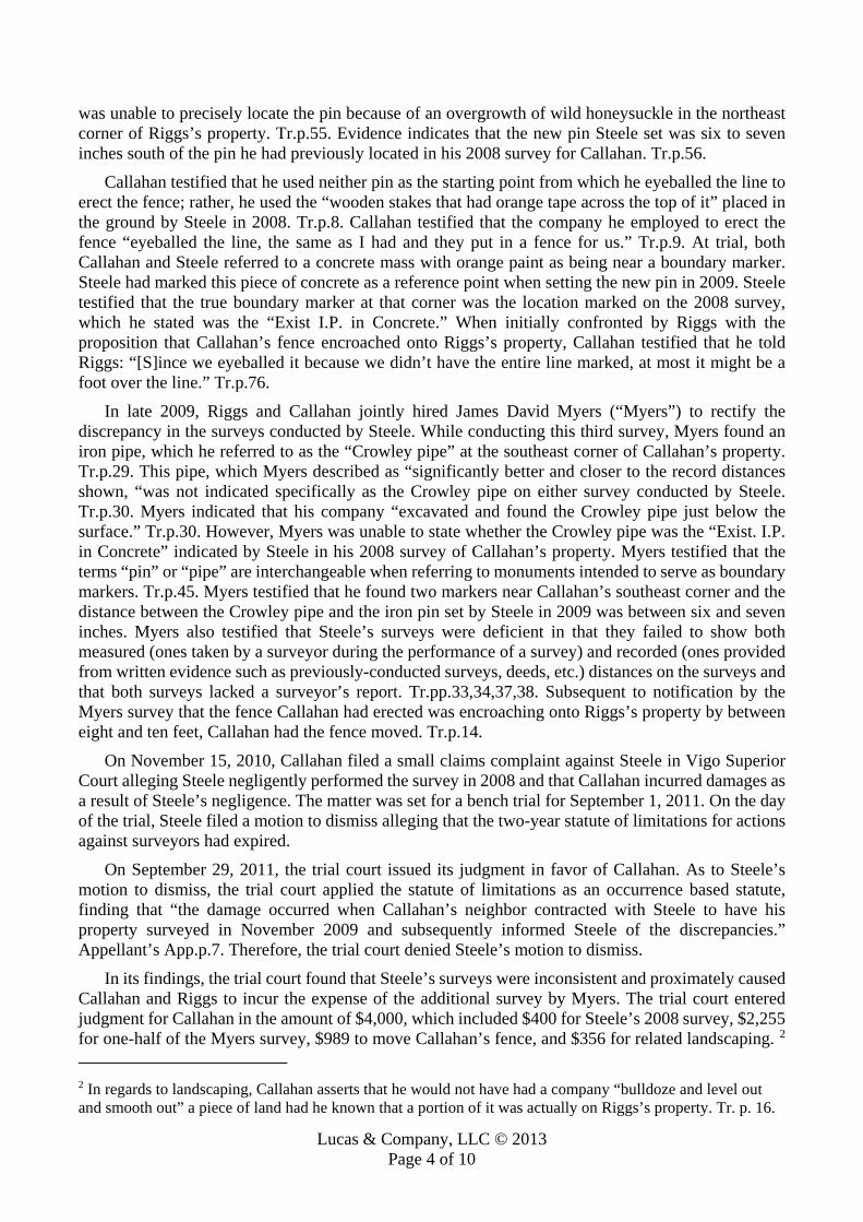
Lucas & Company, LLC © 2013 Page 4 of 10
was unable to precisely locate the pin because of an overgrowth of wild honeysuckle in the northeast corner of Riggs’s property. Tr.p.55. Evidence indicates that the new pin Steele set was six to seven inches south of the pin he had previously located in his 2008 survey for Callahan. Tr.p.56.
Callahan testified that he used neither pin as the starting point from which he eyeballed the line to erect the fence; rather, he used the “wooden stakes that had orange tape across the top of it” placed in the ground by Steele in 2008. Tr.p.8. Callahan testified that the company he employed to erect the fence “eyeballed the line, the same as I had and they put in a fence for us.” Tr.p.9. At trial, both Callahan and Steele referred to a concrete mass with orange paint as being near a boundary marker. Steele had marked this piece of concrete as a reference point when setting the new pin in 2009. Steele testified that the true boundary marker at that corner was the location marked on the 2008 survey, which he stated was the “Exist I.P. in Concrete.” When initially confronted by Riggs with the proposition that Callahan’s fence encroached onto Riggs’s property, Callahan testified that he told Riggs: “[S]ince we eyeballed it because we didn’t have the entire line marked, at most it might be a foot over the line.” Tr.p.76.
In late 2009, Riggs and Callahan jointly hired James David Myers (“Myers”) to rectify the discrepancy in the surveys conducted by Steele. While conducting this third survey, Myers found an iron pipe, which he referred to as the “Crowley pipe” at the southeast corner of Callahan’s property. Tr.p.29. This pipe, which Myers described as “significantly better and closer to the record distances shown, “was not indicated specifically as the Crowley pipe on either survey conducted by Steele. Tr.p.30. Myers indicated that his company “excavated and found the Crowley pipe just below the surface.” Tr.p.30. However, Myers was unable to state whether the Crowley pipe was the “Exist. I.P. in Concrete” indicated by Steele in his 2008 survey of Callahan’s property. Myers testified that the terms “pin” or “pipe” are interchangeable when referring to monuments intended to serve as boundary markers. Tr.p.45. Myers testified that he found two markers near Callahan’s southeast corner and the distance between the Crowley pipe and the iron pin set by Steele in 2009 was between six and seven inches. Myers also testified that Steele’s surveys were deficient in that they failed to show both measured (ones taken by a surveyor during the performance of a survey) and recorded (ones provided from written evidence such as previously-conducted surveys, deeds, etc.) distances on the surveys and that both surveys lacked a surveyor’s report. Tr.pp.33,34,37,38. Subsequent to notification by the Myers survey that the fence Callahan had erected was encroaching onto Riggs’s property by between eight and ten feet, Callahan had the fence moved. Tr.p.14.
On November 15, 2010, Callahan filed a small claims complaint against Steele in Vigo Superior Court alleging Steele negligently performed the survey in 2008 and that Callahan incurred damages as a result of Steele’s negligence. The matter was set for a bench trial for September 1, 2011. On the day of the trial, Steele filed a motion to dismiss alleging that the two-year statute of limitations for actions against surveyors had expired.
On September 29, 2011, the trial court issued its judgment in favor of Callahan. As to Steele’s motion to dismiss, the trial court applied the statute of limitations as an occurrence based statute, finding that “the damage occurred when Callahan’s neighbor contracted with Steele to have his property surveyed in November 2009 and subsequently informed Steele of the discrepancies.” Appellant’s App.p.7. Therefore, the trial court denied Steele’s motion to dismiss.
In its findings, the trial court found that Steele’s surveys were inconsistent and proximately caused Callahan and Riggs to incur the expense of the additional survey by Myers. The trial court entered judgment for Callahan in the amount of $4,000, which included $400 for Steele’s 2008 survey, $2,255 for one-half of the Myers survey, $989 to move Callahan’s fence, and $356 for related landscaping. 2 2 In regards to landscaping, Callahan asserts that he would not have had a company “bulldoze and level out and smooth out” a piece of land had he known that a portion of it was actually on Riggs’s property. Tr. p. 16.

Lucas & Company, LLC © 2013 Page 5 of 10
Finally, the trial court denied Callahan’s request for attorney fees. Steele now appeals the denial of the motion to dismiss as untimely, the finding that the inconsistencies in his surveys proximately caused the need for the third survey, and the damages awarded to Callahan. Callahan cross-appeals the denial of his request for attorney fees.
Standard of Review [LLHN1] When a trial court enters findings sua sponte, as it did in this case, we use a two-step
standard of review to determine first, whether the evidence supports the findings and next, whether the findings support the judgment. Humphries v. Ables, 789 N.E.2d 1025, 1030 (Ind.Ct.App. 2003) (citing Smith v. Brown, 778 N.E.2d 490, 494 (Ind.Ct.App. 2002)). We consider only evidence most favorable to the judgment and all reasonable inferences drawn therefrom. Id. We will not reweigh evidence nor reassess the credibility of witnesses. Id. Sua sponte findings control only the issues they cover, whereas a general judgment controls as to the issues upon which there are no findings. Tracy v. Morrell, 948 N.E.2d 855, 862 (Ind.Ct.App. 2011). A general judgment entered with findings will be affirmed if it can be sustained on any legal theory supported by the evidence. Id. at 862. [LLHN2] When a claim is tried by the trial court without a jury, “the court on appeal shall not set aside the findings or judgment unless clearly erroneous.” Ind. Trial Rule 52(A). Therefore, a challenger to a judgment bears a heavy burden and must show that the trial court’s findings were clearly erroneous.
[LLHN3] The clearly erroneous standard is defined according to whether the trial court’s judgment was negative or adverse. Garling v. Ind. Dep’t of Natural Res., 766 N.E.2d 409, 411 (Ind.Ct.App. 2002). A negative judgment is rendered against a party who bears the burden of proof, whereas an adverse one is “entered against a party defending on a given question.” Vanderburgh Cnty. Bd. of Comm’rs v. Rittenhouse, 575 N.E.2d 663, 666 (Ind.Ct.App. 1991). Here, the trial court entered judgment in favor of Callahan, the party bearing the burden of proof. Therefore, Steele is appealing an adverse judgment and has the burden to show that the trial court’s findings were clearly erroneous and not “supported by substantial evidence of probative value.” Garling, 766 N.E.2d at 411. However, [LLHN4] even if the evidence is substantial, we will reverse the judgment if we are “left with a definite and firm conviction a mistake has been made.” Id.
I. Statute of Limitations and Motion to Dismiss as Untimely Steele claims that the two-year statute of limitations that relates to actions against surveyors has
expired and thus, the complaint is time-barred. Specifically, Steele claims that the trial court used the wrong accrual date and thus improperly denied his motion to dismiss by finding that Callahan’s damages as a result of Steele’s negligence did not occur until Riggs presented Callahan with the 2009 survey. Steele asserts that the damage to Callahan occurred in early 2008, when Callahan had the fence built.
Indiana favors [LLHN5] statutes of limitation because they “afford security against stale claims and promote the peace and welfare of society.” Shaum v. McClure, 902 N.E.2d 853, 855 (Ind.Ct.App. 2009), trans denied (quoting Morgan v. Brenner, 712 N.E.2d 500, 502 (Ind.Ct.App. 1999), trans denied). “They are founded on the notion that one with a well-founded claim will not delay in enforcing it.” Shaum, 902 N.E.2d at 855. “The nature or substance of the cause of action, rather than the form of the action, determines the applicable statute of limitations.” Id. (quoting King v. Terry, 805 N.E.2d 397, 400 (Ind.Ct.App. 2004)).
The applicable statute of limitations in this case is Indiana Code section 34-11-2-4, which provides that:
An action for: (1) injury to a person or character, (2) injury to personal property; or

Lucas & Company, LLC © 2013 Page 6 of 10
(3) a forfeiture of penalty given by a statute; must be commenced within two (2) years after the cause of the action accrues. 3 [LLHN6] Surveyors are recognized as professionals who can be liable in tort for failing to exercise
reasonable care in conducting their duties. Racquet v. Thompson, 693 N.E.2d 969 (Ind.Ct.App. 1998) (citing Estate of Reasor v. Putnam Cnty., 635 N.E.2d 153 (Ind. 1994)). In Racquet, this court applied Indiana Code section 34-1-2-2(1), the predecessor to section 34-11-2-4, to a surveyor who failed to identify a piece of property as being located in a flood plain. Section 34-11-2-4 was subsequently applied in Shaum v. McClure, 902 N.E.2d 853 (Ind.Ct.App. 2009), where landowners sued a surveyor for a discrepancy among the boundary stakes the surveyor had placed on a lot. The Shaums argued that section 34-11-2-4 was inapplicable because the action they brought related to real property, not personal property, as defined in the statute. Id. at 856. We concluded that the claim was one for professional malpractice; therefore, the two-year statute of limitations in section 34-11-2-4 was applicable. Id.
[LLHN7] “Under Indiana’s discovery rule, a cause of action accrues, and the statute of limitations begins to run when the claimant knows or in exercise of ordinary diligence should have known of the injury.” Pflanz v. Foster, 888 N.E.2d 756, 759 (Ind. 2008); Wehling v. Citizens Nat. Bank, 586 N.E.2d 840, 843 (Ind. 1992). “For an action to accrue, it is not necessary that the full extent of the damage be known or even ascertainable, but only that some ascertainable damage has occurred.” Shaum, 902 N.E.2d at 857 (quoting Cooper Industries, LLC v. City of South Bend, 899 N.E.2d 1274, 1280 (Ind. 2008)).
Here, the trial court correctly concluded that Callahan’s damage occurred when Riggs contracted with Steele to have his property surveyed in November 2009 and subsequently informed Callahan of the discrepancies. The discrepancies in Steele’s 2008 and 2009 surveys necessitated the third, Myers survey to rectify the difference in the previous two. Callahan filed his claim on November 15, 2010, only a year after Riggs notified Callahan of the discrepancy in surveys, thus well within the applicable statute of limitations. Therefore, the trial court properly denied Steele’s motion to dismiss Callahan’s complaint as untimely.
II. Negligence and Proximate Cause Steele next argues that the trial court erred in 1) finding that inconsistencies in Steele’s 2008 and
2009 surveys caused Callahan’s damages in regards to third survey, and 2) awarding damages resulting from the movement of the fence, the 2008 Steele survey, and certain landscaping expenses. Steele claims that the inconsistencies were inconsequential and that Callahan’s own negligence was the proximate cause of his damages relating to the movement of the fence, the 2008 Steele survey, and landscaping. Callahan claims that Steele’s failure to accurately and consistently identify the boundary marker in the southeast corner of Callahan’s property was the cause of Callahan’s injuries.
3 Although the trial court properly applied a two-year statute of limitations, the specific statute referenced by the trial court was incorrect. The trial court applied Indiana Code section 34-11-2-3 and made the following finding regarding the statute of limitations: “The Court finds the two-year statute of limitations applicable in this case is found in I.C. 34-11-2-3 . . . This statute is ‘occurrence based’ meaning that it ‘accrues when the conduct that caused the damage occurs.’ The Court finds the damage occurred when the Plaintiff’s neighbor contracted with the Defendant to have his property surveyed in November 2009 and subsequently informed the Defendant of the discrepancies.” However, the cited statute applies to “physicians, dentists, surgeons, hospitals, sanitariums, or others.” Ind. Code § 34-11-2-3 (2012). The Indiana Supreme Court ruled in Shideler v. Dwyer, 275 Ind. 270, 417 N.E.2d 281 (1981), that “the doctrine of ejusdem generis limits the application to the term ‘or others, ‘ as used in [Indiana Code section 34-11-2-3], to others of the medical care community.” (discussing the predecessor statute, which the court held was not applicable to a malpractice action against an attorney).

Lucas & Company, LLC © 2013 Page 7 of 10
[LLHN8] Negligence consists of: (1) a duty owed to the plaintiff by the defendant; (2) a breach of that duty by the defendant; and (3) injury to the plaintiff proximately caused by that breach. Foddrill v. Crane, 894 N.E.2d 1070, 1075 (Ind.Ct.App. 2008). On appeal, Steele fails to reference the first two elements (duty and breach), but solely contends that his actions were not the proximate cause of Callahan’s injuries.
[LLHN9] “One who contracts to perform services may commit both a breach of contract and the tort of negligence when he negligently fails to perform in a workmanlike manner.” Essex v. Ryan, 446 N.E.2d 368, 370 (Ind.Ct.App. 1983). “And certain professionals, by virtue of the nature of their business, make representations, render opinions, and give advice in the course of performing a contract.” Id. “Surveyors … may be liable in tort for failure to skillfully discharge their contractual obligation.” Id. at 371.
[LLHN10] “An indispensable element of an action for negligence is that the act complained of must be the proximate cause of the accident producing the injury.” Havert v. Caldwell, 452 N.E.2d 154, 158 (Ind. 1983). In defining proximate cause, the Indiana Supreme Court has stated that a “negligent act or omission is the proximate cause of an injury if the injury is a natural and probable consequence which, in light of the circumstances, should reasonably have been foreseen or anticipated.” Id. Foreseeability of the injury is the critical test for determining the defendant’s liability. Nat’l. R.R. Passenger Corp. v. Everton, 655 N.E.2d 360, 366 (Ind.Ct.App. 1995). The foreseeability of whether the defendant’s act proximately caused the plaintiff’s injuries is a question for the trier of fact. Id. at 366-67.
Steele argues that the discrepancy in surveys was inconsequential because Callahan’s fence encroached onto Riggs’s land by nine feet, a distance much greater than the seven-inch variance between surveys. Further, Steele claims that the fence would have encroached onto Riggs’s property regardless of whether Callahan used the 2008 or 2009 location of the southeast corner boundary marker from which to have the fence erected. Steele also asserts that the encroaching fence was built prior to Callahan being notified of the discrepancy and cites testimony from Callahan indicating that Callahan was aware at the time the fence was erected that it could intrude onto Riggs’s land. He also claims that because of the discrepancy between the 2008 and 2009 surveys, the 2009 survey conducted by Steele gave Callahan an additional six inches of land and that the fence would have encroached onto Riggs’s property regardless.
Callahan’s chief claim is that he used the 2008 survey conducted by Steele as the baseline according to which he had the fence erected. Had this survey been accurate, Callahan asserts that he would not have been informed of the discrepancy between the 2008 and 2009 surveys, a discrepancy that led him to incur the expenses of an additional survey and to move his fence, plus the cost of the initial landscaping prior to the erection of the fence.
We agree with the trial court that the inconsistences in Steele’s survey proximately caused Callahan and Riggs to incur costs related to the third survey conducted by Myers. Steele could have reasonably foreseen or anticipated that Callahan and Riggs could each reasonably rely upon his surveys for them. Had Steele’s surveys been consistent, any need for an additional survey would have been avoided. The damage to Callahan regarding the additional survey occurred when he was notified of the disparity in the surveys; it was at this time that he incurred costs to rectify the discrepancy by contracting for the Myers survey. We affirm that portion of the trial court’s judgment of $2, 255, which is the cost of one-half of the Myers survey.
However, we cannot conclude that Steele’s actions proximately caused Callahan’s injuries in regards to the movement of the fence, the 2008 survey conducted by Steele, and landscaping costs.
[LLHN11] Under negligence theory, the injured party is able to recover only those damages proximately caused by the tortfeasor’s breach. INS Investigations Bureau, Inc. v. Lee, 784 N.E.2d 566,

Lucas & Company, LLC © 2013 Page 8 of 10
577 (Ind.Ct.App. 2003), trans denied. “The damages claimed for such a breach must be the natural, foreseeable and proximate consequence of the breach.” Id. An award will be reversed only when it is not within the scope of evidence before the trier of fact. Id. Here, the trial court’s conclusion that Steele’s negligence caused Callahan’s injury as it relates to the movement of the fence was clearly erroneous.
First, the fence encroached onto Riggs’s land by a margin greatly disproportionate to the variance in surveys. A full year before Callahan was notified of the less-than-seven-inch discrepancy between surveys, he built a fence that encroached onto Riggs’s land by up to nine feet. Further, even though the 2009 survey gave Callahan an additional six to seven inches of land, he erected a fence that would have encroached onto Riggs’s land by at least eight feet within the framework of either the 2008 or 2009 southeast corner boundary location. Simply said, any error in the first survey would have given Callahan less land than which he was entitled to possess and therefore cannot explain how the fence was erected beyond his actual property line at all, much less an additional eight feet onto Riggs’s parcel. Callahan’s argument would have been more persuasive had the fence needed to be moved closer to Callahan’s property by the same distance as the disparity in surveys. But we fail to see how Steele’s negligence proximately caused the necessary movement of the fence by approximately nine feet. Steele could not have reasonably foreseen or anticipated that Callahan would reasonably rely upon his 2008 survey to erect a fence nine feet onto his neighbor’s property.
Utilization of Steele’s 2008 survey leads to a conclusion that the fence encroached onto Riggs’ property by nine feet; the 2009 survey yields a distance of eight-and-a-half feet. Therefore, the fence was an encroaching one regardless of the six-inch disparity in the surveys.
Callahan asserts that the trial court’s finding could be based on its belief that Callahan used the concrete slab with orange paint, which is 9.5 feet to the south and 11.7 feet to the east of the more precise location of the southeast corner, as a reference point from which to start eyeballing the line for the fence. However, this directly contradicts Callahan’s own testimony that “[Steele] had wooden stakes that had orange tape across the top of it and I went by those stakes” and that “I never even looked at a chunk of concrete because, you know, we were operating off the wooden posts with the [orange] tape across the top.” Tr.pp.8,22. He also indicated that he didn’t notice any concrete until 2009, when he and Riggs went to look at the corner location in dispute. Tr.p.22. Finally, Callahan’s own testimony indicates that he knew from the outset that the fence he had erected encroached upon Riggs’s property. Tr.pp.75-76. For all of these reasons, we reverse the $989 portion of the trial court’s judgment related to Callahan’s expense incurred to move the fence.
We also fail to see how Steele’s actions proximately caused Callahan damages regarding the 2008 survey and landscaping costs. Callahan retained Steele’s services to locate the four corner pins of Callahan’s property. This Steele did with some accuracy. Indeed, had Callahan “eyeballed” the line for his fence within any reasonable margin of error (and had he not chosen to mow well across the property line onto Riggs’s property), it is entirely possible that no dispute would have arisen at all.
[LLHN12] “Damages are awarded to compensate an injured party fairly and adequately for the loss sustained.” INS Investigations Bureau, Inc. v. Lee, 784 N.E.2d 566, 577 (Ind.Ct.App. 2003). A party is limited in recovery to the loss actually suffered; the injured party cannot be placed in position better than one in which the breach had not occurred. Bank One Nat’l. Ass’n v. Surber, 899 N.E.2d 693, 704 (Ind.Ct.App. 2009). Additionally, windfalls and double recovery are disfavored. Id. The trial court’s judgment is erroneous in both regards. We therefore reverse the $400 portion the trial court’s judgment related to the cost of Steele’s 2008 survey and the $356 portion of the judgment related to Callahan’s initial, preparatory landscaping for the fence installation.
III. Attorney Fees Callahan cross-appeals the trial court’s denial of attorney fees. Specifically, Callahan seeks

Lucas & Company, LLC © 2013 Page 9 of 10
recovery of attorney fees as a result of the boundary dispute with Riggs. [LLHN13] The “American Rule” states that each party pays its own attorney fees. Liberty Mut. Ins. Co. v. OSI Industries, Inc., 831 N.E.2d 192, 205 (Ind.Ct.App. 2005). Indiana follows this general principle. Id. Ind. Code § 34-52-1-1 also reflects this principle and strictly limits that award of attorney fees to narrow and exceptional grounds:
(a) In all civil actions, the party recovering judgment shall recover costs, except in those cases in which a different provision is made by law. (b) In any civil action, the court may award attorney’s fees as part of the cost to the prevailing party, if the court finds that either party:
(1) brought the action or defense on a claim or defense that is frivolous, unreasonable, or groundless; (2) continued to litigate the action or defense after the party’s claim or defense clearly became frivolous, unreasonable, or groundless; or (3) litigated the action in bad faith.
(c) The award of fees under subsection (b) does not prevent a prevailing party from bringing an action against another party for abuse of process arising in any part on the same facts. However, the prevailing party may not recover the same attorney’s fees twice. Callahan does not claim that attorney fees should be awarded pursuant to subsection (b), but rather
asserts a claim for attorney fees under the third-party litigation exception. In 2005, Indiana adopted a third-party litigation exception to the general rule that parties pay their
own attorney fees in Masonic Temple Ass’n of Crawfordsville v. Ind. Farmers Mut. Ins. Co., 837 N.E.2d 1032, 1039 (Ind.Ct.App. 2005). The elements of the third-party litigation exception are as follows:
(1) the plaintiff became involved in litigation either because of a breach of contract by the defendant, or because of defendant’s tortious conduct, that is, that the party sought to be charged with the fees was guilty of a wrongful or negligent act or breach of agreement; (2) the litigation was with a third party, not with the defendant from whom the fees are sought to be recovered; and (3) the attorneys fees were incurred in that third-party litigation. Id. (quoting W. Sunview Props. LLC v. Federman, 338 F.Supp.2d 1106, 1127-28 (D. Haw. 2004)). Callahan asserts that Steele’s negligence caused the discrepancy in the surveys, which necessitated
a third-party survey by Myers to determine the actual boundary between their properties. Therefore, Callahan mistakenly asserts that attorney fees incurred from this dispute should be awarded to him.
[LLHN14] “Care must be taken to distinguish between the rule prohibiting the recovery of attorney fees from the losing party by the prevailing party in litigation and the rule allowing the recovery of attorney fees incurred in litigation with third parties necessitated by defendan[t’s] wrongful act.” Masonic Temple, 837 N.E.2d at 1038 (quoting Nalivaika v. Murphy, 458 N.E.2d 995, 997 (Ill.App.Ct. 1983)). It is fundamentally important to determine that an “action for which the attorney fees are claimed is brought or defended by a third party, a party that is not part of the contract, agreement, or events that caused the original litigation to arise.” Id. at 1038-39. Further, these litigation expenses and attorney fees must be foreseeable by the defendant. Id. at 1039.
Callahan’s reliance on Masonic Temple fails for at least two reasons. First, Masonic Temple concerns an insurer’s basic, contractual duty to defend its insured in litigation for a claim arguably within the coverage of the underlying policy, whether with or without a reservation of rights. In
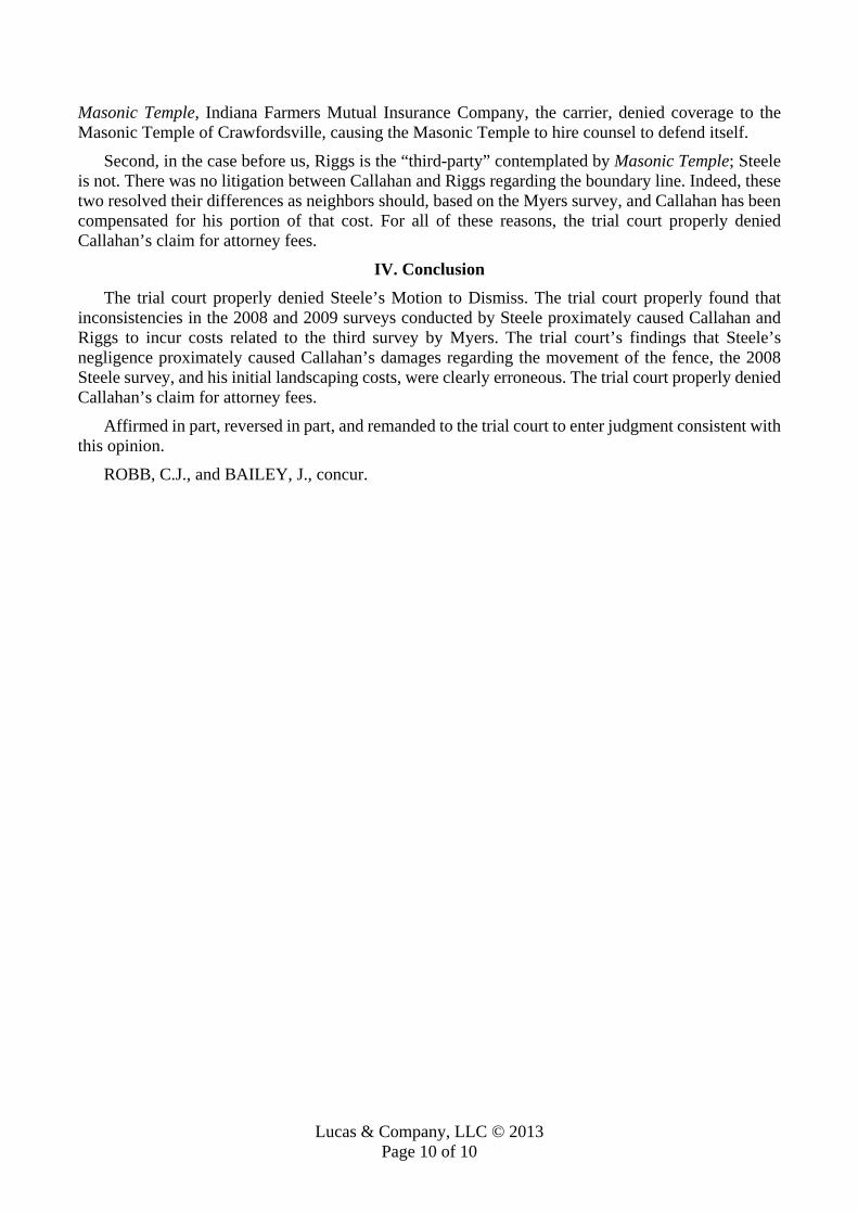
Lucas & Company, LLC © 2013 Page 10 of 10
Masonic Temple, Indiana Farmers Mutual Insurance Company, the carrier, denied coverage to the Masonic Temple of Crawfordsville, causing the Masonic Temple to hire counsel to defend itself.
Second, in the case before us, Riggs is the “third-party” contemplated by Masonic Temple; Steele is not. There was no litigation between Callahan and Riggs regarding the boundary line. Indeed, these two resolved their differences as neighbors should, based on the Myers survey, and Callahan has been compensated for his portion of that cost. For all of these reasons, the trial court properly denied Callahan’s claim for attorney fees.
IV. Conclusion The trial court properly denied Steele’s Motion to Dismiss. The trial court properly found that
inconsistencies in the 2008 and 2009 surveys conducted by Steele proximately caused Callahan and Riggs to incur costs related to the third survey by Myers. The trial court’s findings that Steele’s negligence proximately caused Callahan’s damages regarding the movement of the fence, the 2008 Steele survey, and his initial landscaping costs, were clearly erroneous. The trial court properly denied Callahan’s claim for attorney fees.
Affirmed in part, reversed in part, and remanded to the trial court to enter judgment consistent with this opinion.
ROBB, C.J., and BAILEY, J., concur.
Lucas & Company, LLC © 2015 Page 1 of 14
Daniel R. Northrop, Plaintiff, Kay M. Boerst and Peter S. Boerst, Plaintiffs-Appellants-Peti-tioners
v. Betty Opperman, Connie Henn, Floyd Opperman, Keith Opperman, Mark Henn and Pamela
Opperman, Defendants-Respondents. No. 2009AP1559
SUPREME COURT OF WISCONSIN 2011 WI 5; 2011 Wisc. LEXIS 4
December 1, 2010, Argued February 3, 2011, Filed
NOTICE: THIS OPINION IS SUBJECT TO FURTHER EDITING AND MODIFICATION. THE FINAL VERSION WILL APPEAR IN THE BOUND VOLUME OF THE OFFICIAL REPORTS.
LUCAS LETTER HEAD NOTES [LLHN]: Real Property Law; Boundary Establishment: Real Property Law; Deeds; Deed Interpretation; Ambiguities: [LLHN1] A boundary line different from that described in the respective deeds of adjoining land-owners may be established under the respective principles of adverse possession, prescription, agreement, practical location, acquiescence or estoppel. Each of these has a different factual back-ground though too often they are confused by the courts.
Real Property Law; Boundary Establishment; Adverse Possession: Real Property Law; Deeds; Deed Interpretation; Ambiguities: [LLHN2] It is also well settled that, where the description of the premises in a deed is definite, cer-tain, and unambiguous, extrinsic evidence to show acquiescence in a different location is inadmissi-ble, unless such practical location is followed by an adverse possession for such a length of time as to bar an action for the recovery of the lands.
Real Property Law; Boundary Establishment; Doctrine of Acquiescence: Real Property Law; Boundary Establishment; Doctrine of Estoppel: Real Property Law; Deeds; Deed Interpretation; Ambiguities: [LLHN3] Insofar as boundary disputes are concerned, we are unable to discern from the cases any functional differences between acquiescence and estoppel. These two terms do not represent sepa-rate doctrines or concepts. Acquiescence is a condition or fact which, if proven, results in an estop-pel against the party who has acquiesced.
Real Property Law; Boundary Establishment; Doctrine of Acquiescence: Real Property Law; Deeds; Deed Interpretation; Ambiguities: [LLHN4] The word “acquiescence” has been used in numerous Wisconsin cases, not always con-sistently. Sometimes the word is seemingly used to mean that the conduct of the parties in acquiesc-ing, that is, agreeing to or complying with, a boundary line constitutes the best evidence of the boundary line. The word “acquiescence” is thus used to mean that the conduct of neighbors is evi-dence of a boundary line.

Lucas & Company, LLC © 2015 Page 2 of 14
Real Property Law; Boundary Establishment; Practical Location: Real Property Law; Boundary Establishment; Doctrine of Acquiescence: Real Property Law; Deeds; Deed Interpretation; Ambiguities: [LLHN5] Other times the word “acquiescence” is seemingly used in the case law to refer to a legal doctrine, namely boundary by acquiescence or agreement. The doctrine of acquiescence has also sometimes been referred to as “rules as to practical location.”
Real Property Law; Boundary Establishment; Doctrine of Acquiescence: Real Property Law; Boundary Establishment; Doctrine of Estoppel: Real Property Law; Deeds; Deed Interpretation; Ambiguities: [LLHN6] If parties acquiesce in a wrong boundary, when the true boundary can be ascertained from the deed, it is treated both in law and equity as a mistake and neither party is estopped from claiming to the true line.
Real Property Law; Boundary Establishment; Doctrine of Acquiescence: Real Property Law; Boundaries; Evidence of Boundaries: Real Property Law; Deeds; Deed Interpretation; Ambiguities: [LLHN7] The case law relating to the doctrine of acquiescence is not consistently stated or applied. The concept of acquiescence in the evidentiary sense is often used in cases resolving conflicts be-tween a landmark and a survey.
Real Property Law; Boundaries; Evidence of Boundaries: [LLHN8] Since the applicable principles do not vary depending on the nature of the barrier claimed to have become a boundary, the term “fence” is used generically to denote all barriers allegedly marking boundaries between adjoining landowners, without regard to whether the barrier was man-made or natural.
Real Property Law; Boundary Establishment; Evidence of Boundaries: Real Property Law; Boundaries; Evidence of Boundaries; Best Available Evidence: Real Property Law; Deeds; Deed Interpretation; Rules of Construction: Civil Procedure; Appeals; Standards of Review; Clearly Erroneous Review: [LLHN9] In the survey/fence cases, a circuit court first determines whether the boundary line can be determined from the deed and original monuments or markers. If the boundary line cannot be so determined, the circuit court looks to the best evidence of the boundary line. The circuit court’s de-termination of the best evidence locating the boundary line in the survey/fence cases is essentially a finding of fact. An appellate court does not set aside findings of fact unless they are clearly errone-ous.
Real Property Law; Boundaries; Evidence of Boundaries; Occupation: [LLHN10] The evidence of undisputed occupation and fencing in accordance with the originally surveyed line for about 30 years, not only of the piece of land in controversy, but of other parcels of land in that immediate neighborhood, raises a presumption that the line so recognized is the true line. So strong a presumption is thus raised in the present case that we do not regard it as overcome or seriously weakened by the simple fact that upon a resurvey, based upon no original monument, another line several rods distant is established.
Real Property Law; Boundaries; Evidence of Boundaries; Best Available Evidence: Real Property Law; Boundaries; Evidence of Boundaries; Extrinsic Evidence: Real Property Law; Boundaries; Evidence of Boundaries; Monuments:

Lucas & Company, LLC © 2015 Page 3 of 14
Real Property Law; Boundaries; Evidence of Boundaries; Survey Measurements: Real Property Law; Deeds; Deed Interpretation; Rules of Construction: [LLHN11] The original location of monuments must always prevail, but that when those monu-ments have disappeared they must be established by the best evidence the nature of the situation is susceptible of. Extrinsic evidence, such as an old fence, may have so much greater probative force than more recent surveying measurements as to prevail over the latter as a matter of law.
Real Property Law; Boundaries; Evidence of Boundaries; Best Available Evidence: Real Property Law; Boundaries; Evidence of Boundaries; Extrinsic Evidence: Real Property Law; Boundaries; Evidence of Boundaries; Monuments: Real Property Law; Deeds; Deed Interpretation; Rules of Construction: [LLHN12] The answer to the pertinent question—where is the boundary line?—must be estab-lished by the best evidence available. Monuments set by the original survey in the ground, and named or referred to in the plat, are the highest and best evidence. If there are no such monuments, then stakes set by the surveyor or soon thereafter are the next best evidence. Buildings, fences, and other substantial improvements built according to the stakes laid out while they were present are the next best evidence of the line.
Real Property Law; Boundaries; Evidence of Boundaries; Best Available Evidence: Real Property Law; Boundaries; Evidence of Boundaries; Extrinsic Evidence: Real Property Law; Deeds; Deed Interpretation; Rules of Construction: [LLHN13] The time will soon come when the boundary line will have been lost by the destruction of all monuments, natural or artificial, and by the death of the old inhabitants. Then resort must be had to evidence of lesser degree to establish ancient boundaries, and long-continued occupation with respect to unchanged lines, and reputation, even, may be the best evidence available.
Real Property Law; Boundary Establishment; Doctrine of Acquiescence: Real Property Law; Boundaries; Evidence of Boundaries; Best Available Evidence: Real Property Law; Boundaries; Evidence of Boundaries; Extrinsic Evidence: Real Property Law; Boundaries; Evidence of Boundaries; Parol Evidence: Real Property Law; Boundaries; Evidence of Boundaries; Monuments: Real Property Law; Deeds; Deed Interpretation; Rules of Construction: [LLHN14] If original monuments can be found and identified, they will govern. If no certain monu-ments can be found a lesser degree of testimony may be resorted to; and long continued occupancy and acquiescence, and even reputation and hearsay as to the boundaries, may have weight.
Real Property Law; Boundary Establishment; Doctrine of Acquiescence: Real Property Law; Boundaries; Evidence of Boundaries; Best Available Evidence: Real Property Law; Boundaries; Evidence of Boundaries; Fences and Landmarks: [LLHN15] Under the repeated decisions of this court the ancient fence lines around this parcel of land, maintained as they were for at least thirty and probably fifty years, should be taken as fixing the correct boundaries of the tract.
Real Property Law; Boundary Establishment; Doctrine of Acquiescence: [LLHN16] Where the exact location of a boundary line is not definitely known, a dispute involving the boundary line must be determined by looking to the conduct of the parties with reference thereto. Thus, long acquiescence by the owners of adjoining lands in the location of the dividing line between their lands may, in effect, establish such line.

Lucas & Company, LLC © 2015 Page 4 of 14
Real Property Law; Boundaries; Evidence of Boundaries; Resurveys: [LLHN17] Resurveys may be unreliable as evidence of a boundary line.
Real Property Law; Boundary Establishment; Practical Location: Real Property Law; Boundaries; Evidence of Boundaries; Occupation: [LLHN18] Boundary lines may be established by practical location and undisturbed possession for a great many years, and there does not seem to have been any necessity to disturb them at this late day.
OPINION REVIEW of a decision of the Court of Appeals.
[P1] SHIRLEY S. ABRAHAMSON, C.J. This is a review of a published decision of the court of appeals,1 which affirmed in part and reversed in part the judgment of the Circuit Court for Ash-land County, John P. Anderson, Judge. Kay and Peter Boerst seek review of that part of the court of appeals decision affirming the circuit court’s determination that the boundary line between their property and the property of Betty and Floyd Opperman is the center line of Henn Road.2 2 We af-firm this part of the decision of the court of appeals.
[P2] The Boersts own a parcel of land in Section 9 that is adjacent to and east of a parcel of land in Section 8 owned by the Oppermans. The boundary line in dispute in this action is the west-ern boundary of the Boersts’ property in Section 9 and the eastern boundary of the Oppermans’ property in Section 8.
[P3] The circuit court determined that the center line of Henn Road (which runs north and south) is the boundary line between the Boersts’ and the Oppermans’ properties. The court of ap-peals affirmed this part of the circuit court’s judgment.3
[P4] The Boersts present the issue as “whether the doctrine of acquiescence allows mistaken boundaries [LEXIS at 3] to become legal boundaries after twenty years of mistaken belief has passed.” This presentation of the issue is driven by the circuit court’s and the court of appeals’ use of the word “acquiescence” in their analyses. Our review is not constrained by this statement of the issue. The issue before the court is whether the court of appeals erred in holding that the circuit court correctly determined that the center line of Henn Road is the boundary line separating the par-cel of land owned by the Boersts from the parcel of land owned by the Oppermans.
1 Northrop v. Opperman, 2010 WI App 80, 325 Wis. 2d 445, 784 N.W.2d 736. 2 The court of appeals reversed that part of the circuit court’s judgment relating to obliteration of the section corner and “suggesting [LEXIS at 2] Henn Road is the section boundary.” Northrop, 2010 WI App 80, 325 Wis. 2d 445, P15, 784 N.W.2d 736. Neither party has sought review of this part of the decision of the court of appeals.
As the court of appeals explained, the suit was initiated by Daniel Northrop, who owns the parcel immedi-ately to the north of the Boersts. Northrop sued the owners of the parcel north of the parcel owned by Betty and Floyd Opperman. Only the Boersts appealed the circuit court’s judgment to the court of appeals and sought review in this court. Northrop, 325 Wis. 2d 445, ¶4 n.1, 2010 WI App 80, 784 N.W.2d 736. 3 Northrop, 2010 WI App 80, 325 Wis. 2d 445, P12, 784 N.W.2d 736.

Lucas & Company, LLC © 2015 Page 5 of 14
[P5] We conclude that in determining the boundary line by evaluating the evidence of common usage and acquiescence and not by using the legal doctrine of acquiescence, the circuit court ap-plied the correct legal analysis in the present case. After finding that the actual boundary line4 could not be determined from the deed and original monuments or markers, the circuit court evaluated the evidence and established the boundary line based upon the best evidence available. There are suffi-cient facts in the record upon which the circuit court based its findings that the actual boundary line could not be determined from the deed and the original monument [LEXIS at 4] or markers and that the best evidence supports the center line of Henn Road as the boundary line separating the parcels owned by the parties to this review. The best evidence was not the successive surveys but common usage and acquiescence.
I [P6] Resolution of a boundary dispute is ordinarily fact-driven, and the present case is no ex-
ception. The record in this case reflects a rich history of over 120 years involving the lands in ques-tion in Sections 8 and 9.
[P7] We begin the history in July 9, 1886, with the original survey of Henn Road. The Butter-nut Town Board laid out a public highway, Henn Road, described as beginning at the “southwest corner of section 9 (nine) thence north on the sec line to the north west corner of section 9 (nine).” Henn Road then continues west from the northerly end of the north/south part of the road. Although the Road presently curves, apparently it was originally a right-angle intersection with the corner common to Sections 4, 5, 8, and 9 believed to be at the intersection of the [LEXIS at 5] two parts of the Road.
[P8] In 1907, the Town of Butternut contracted with Ashland County Surveyor George Parker to run survey lines according to the original government survey or, if the original landmarks were destroyed or lost, to reestablish those corners under the general rules adopted by the government in the survey of public lands. Parker submitted a survey in 1908. Shortly thereafter the Town Board directed Parker to complete the survey and finish setting the monuments as contracted.
[P9] As a result of the 1908 Parker survey, litigation ensued between owners of parcels in Sec-tion 8 and Section 5. Section 5 borders Section 8 to the north, and Sections 5, 8, and 9 share (along with section 4) a common corner. In that litigation it was alleged that the 1908 survey moved the boundary line between Sections 8 and 5 south of the east/west part of Henn Road. The jury returned a verdict determining that the owner of parcels in Section 8 owned the land up to the center line of the east/west part of Henn Road.
[P10] In 1911 another survey by Parker was presented to the Town Board. The Town Board records indicate some wrangling over the acceptance of the 1911 survey, but in 1912 a certificate of survey [LEXIS at 6] bearing Parker’s name was recorded. The 1912 survey contains different bear-ings than the 1908 survey submitted by Parker for the boundary line between Sections 8 and 9.
[P11] In 1917 the same owner of parcels in Section 8 again initiated litigation to resolve a boundary dispute. In the 1917 action, the owner of parcels in Section 8 claimed title to portions of
4 The actual or true boundary line ordinarily refers to the line that was fixed by the original survey or plat. See, e.g., City of Racine v. Emerson, 85 Wis. 80, 86, 55 N.W. 177 (1893).

Lucas & Company, LLC © 2015 Page 6 of 14
land north of the east/west part of Henn Road. He based his claim on the 1912 Parker survey, argu-ing that the boundary line between Sections 8 and 5 was north of Henn Road. The owner of parcels in Section 5 alleged that the road was accepted by everyone as the boundary line between Sections 5 and 8 and that people living along the road, relying upon that line, had made large and extensive im-provements on the land.
[P12] Based on the evidence introduced at trial, the parties stipulated that the common corner of Sections 4, 5, 8, and 9 in Township 41 North, Range 1 West, Ashland County, Wisconsin, is at the intersection of the center line of Henn Road, setting Henn Road as the boundary between Sec-tions 5 and 8.
[P13] For 88 years after this stipulation, the record supports the proposition that Henn Road was honored as the boundary line between Sections 5 [LEXIS at 7] and 8, and the original intersec-tion of Henn Road was honored as the common corner.
[P14] One example of reliance by the government and property owners upon that common cor-ner can be found in the 1935 conveyance of land from the then-owners of parcels in Section 8 to the State of Wisconsin for the purposes of building a new Highway 13 through Section 8 and the plat of the right of way required. The conveyance described the land conveyed by reference to the north-east corner of Section 8, and the Plat of the Right of Way Required shows the common corner of Sections 4, 5, 8, and 9 at the original intersection of the north/south and east/west parts of Henn Road.5
[P15] The “boundary peace” was disturbed in 2005 when a surveyor found a concrete monu-ment in the swamp northwest of the original intersection of Henn Road and notified the county sur-veyor. The county surveyor accepted the concrete monument as a section corner under the 1912 sur-vey and recorded a corner restoration sheet (tie sheet) for the corner common to Sections 4, 5, 8, and 9. According to the 2005 survey, north/south Henn Road actually lies entirely in Section 9, ap-proximately 600 feet east of Section 8, giving the Boersts additional acreage and the Oppermans less acreage.
[P16] The Oppermans, through an independent surveyor, prepared an alternative tie sheet for the common corner, setting the original intersection of Henn Road as the common corner. The county surveyor did not accept this alternative tie sheet.
[P17] The 2005 survey caused significant disruption and confusion for landowners in the area.6 This litigation ensued.
5The 1935 conveyance for Highway 13 described the real estate conveyed as follows:
All that part of a strip or parcel of land lying within the Southeast Quarter (SE 1/4) of the Northeast Quarter (NE 1/4 ) and the West Half (W 1/2) of the Northeast Quarter (NE 1/4) of Section 8, Town-ship 41 North, Range 1 West, a reference line to which is more fully described as follows:
Beginning at a point on the North section line and 2594.1 ft. west of the Northeast corner of Section 8 aforesaid; thence southeasterly at an angle of 48 degrees 19 [LEXIS at 8] minutes with said North section line for a distance of 3615.6 ft. to an intersection with the East and West one-quarter line of Section 8 aforesaid.
6 Letter from Ashland County Highway Department to affected property owners (Oct. 3, 2006):

Lucas & Company, LLC © 2015 Page 7 of 14
II [P18] The Boersts commenced this action, asking the circuit court to declare them the rightful
owners of land lying west of the north/south Henn Road. A one-day trial ensued consisting almost entirely of expert testimony concerning the location of the corner common to Sections 4, 5, 8, and 9.
[P19] Pertinent to our analysis, the circuit court made the following findings of fact:
• The original section corner monument between Sections 4, 5, 8, and 9 in Town-ship 41 North, Range 1 West, Ashland County, Wisconsin no longer exists.
• No competent evidence is before the court to determine where the original section corner monument was originally placed.
• No clear and convincing evidence exists that the resetting [LEXIS at 10] of the corners in the 1912 Parker survey (upon which the 2005 tie sheet is based) was correct.
• Neither party has shown by clear and convincing evidence where the actual boundary line exists.
[P20] The circuit court further concluded that the original boundary line between Sections 8 and 9 cannot be determined solely by the descriptions in the deeds.
[P21] The deed to the Boersts’ parcel describes the real estate as “The Southwest one-fourth (1/4) of the Northwest one-fourth (1/4) of Section Nine (9), Township Forty-one (41) North, Range One (1) West, Town of Chippewa, County of Ashland, Wisconsin.” The deed to the Oppermans’ parcel describes the real estate as “The Southeast Quarter of the Northeast Quarter, Section 8, Township 41 North, of Range 1 West ….”
[P22] Although the descriptions in the deeds are unambiguous on their face, the real estate de-scribed cannot be located on the ground because, as the circuit court explained, “the corner of Sec-tions 4,7 5, 8, and 9 cannot be located.” Thus it is not possible using the deed descriptions and noth-ing more to locate on the ground the southwest one-fourth of the northwest one-fourth of Section 9 and the southeast quarter of the northeast quarter [LEXIS at 11] of Section 8.8
It has come to the attention of [LEXIS at 9] Ashland County, that a serious mistake has been discov-ered with respect to property boundaries in Sections 4, 5, 6, 7, 8 and 9, Township 41 North, Range 1 W, Town of Chippewa, Ashland County. For many years, property has been utilized and occupied based on assumptions that the Town Roads fell on the Section lines when in-fact, the Section Lines and Sections Corners are up to 100 to 400 feet off of the road centerline. This discrepancy has al-ready led to conflicts with neighboring property owners.
7 Section 4 is north of section 9. 8 A description of a parcel as a quarter section in one deed may be ambiguous although a reference to a dif-ferent quarter section in another deed may be unambiguous. Likewise, a statute that is unambiguous in one context may be ambiguous in another context. Teschendorf v. State Farm Ins. Cos., 2006 WI 89, ¶20, 293 Wis. 2d 123, 717 N.W.2d 258. In contrast with the present case, in Chandelle Enterprises, LLC v. XLNT Dairy Farm, Inc., 2005 WI App 110, ¶¶12-16, 282 Wis. 2d 806, 699 N.W.2d 241, the court of appeals con-cluded that under the facts of that case the description of the property as a quarter section was not ambigu-ous. In Chandelle, the court of appeals did not look to extrinsic evidence outside of the deeds because “the

Lucas & Company, LLC © 2015 Page 8 of 14
[P23] The circuit court therefore looked to extrinsic evidence to determine the boundary line and concluded that “the best evidence available are the lines of occupation and possession” and that the landowners and [LEXIS at 12] the County have used the center line of Henn Road as the bound-ary line between the properties at issue for “almost all of the twentieth century and up until the year 2005.” Accordingly, the circuit court concluded that “[i]t is the judgment of this court that a longstanding common usage and acquiescence to ownership and possession to real estate has oc-curred in the area of the Henn Road in Ashland County near the common sections of 4, 5, 8, and 9 [and] [t]he centerline of the existing Henn Road is determined to be the boundary line between the property owners in this case.” For the reasons set forth, we agree with the circuit court’s determina-tion of the location of the boundary line at issue based on the evidence in this case, not based on the legal doctrine of acquiescence.
[P24] The court of appeals devoted its decision predominantly to rejecting the Boersts’ argu-ment (which relied on Buza v. Wojtalewicz, 48 Wis. 2d 557, 180 N.W.2d 556 (1970)) that the doc-trine of acquiescence is not applicable in the present case because the doctrine applies only to boundary disputes arising from ambiguous deeds. The court of appeals concluded that Buza does not hold that an unambiguous deed trumps mistaken [LEXIS at 13] boundary lines after the statu-tory period has run.
III [P25] The Boersts dispute the court of appeals’ affirmance of the circuit court’s judgment that
the center line of Henn Road marks the boundary line. [P26] Wisconsin has a long line of cases settling boundary disputes. The case law demonstrates
that the resolution of boundary disputes depends on fact-specific analyses. The court has stated that “[a]s is usual, boundary disputes are generally between friends who become enemies and the facts are detailed and somewhat confusing, all of which give rise to the conflicting principles of law.”9 These conflicting principles of law are not unique to Wisconsin law.
[P27] The parties and the amicus curiae brief of the Wisconsin Realtors Association attempt to categorize a multitude of Wisconsin boundary dispute cases in an effort to establish principles of law that can be applied in the present case. The parties do not necessarily agree on the categoriza-tion of the cases or the principles of law derived from the cases. Indeed, the cases cannot easily and consistently be divided into doctrinal categories, and doctrinal categories significantly overlap. [LEXIS at 14]10
fact that a surveyor, using the deeds, has established what the parties agree is the true boundary line demon-strates that the descriptions were sufficiently clear and definite.” Chandelle, 282 Wis. 2d 806, ¶16, 2005 WI App 110, 699 N.W.2d 241. 9 Beduhn v. Kolar, 56 Wis. 2d 471, 473, 202 N.W.2d 272 (1973). 10 [LLHN1] “A boundary line different from that described in the respective deeds of adjoining landowners may be established under the respective principles of adverse possession, prescription, agreement, practical location, acquiescence or estoppel. Each of these has a different factual background though too often they are confused by the courts.” 6 John S. Grimes, Thompson on Real Property § 3034, at 506 (1962).
Lucas & Company, LLC © 2015 Page 9 of 14
[P28] One “category” of cases is adverse possession, now governed by Wis. Stat. § 893.25 (2007-08).11 As both parties clearly state, in their briefs and at oral argument, neither party is assert-ing adverse possession in this case.12 We therefore do not review the present case as an adverse pos-session case.
[P29] Other formulations of categories of cases include cases in which adjoining owners dis-pute the location of the boundary line, subsequently establish a boundary line by mutual agreement, and acquiesce in its location;13 cases in which adjoining owners take conveyances from a common grantor that describe the premises conveyed [LEXIS at 15] by lot numbers but the grantees have purchased with reference to a boundary line then marked on the ground;14 cases in which adjacent property owners agree to have the land surveyed to build a fence, build a fence in reliance on the survey, and acquiesce to the boundary;15 cases in which the description of the premises in a deed is definite, certain, and unambiguous and extrinsic evidence is inadmissible to show acquiescence to a boundary line in a different location;16 cases in which a survey is in conflict with a longstanding fence line;17 and estoppel cases.18 These formulations or categories tend to overlap and are not used in a consistent fashion in the case law.19
[P30] No attempt is made to include herein an exhaustive list of the formulations, terminology, or categories used by this court in the numerous boundary dispute cases. Instead we have included a number of the more commonly [LEXIS at 17] used formulations to illustrate the language used in our case law to resolve boundary disputes and the historic inability of the court to consistently clas-sify boundary disputes into doctrinal categories.
11 All references to the Wisconsin Statutes are to the 2007-08 version unless otherwise noted. 12 The amicus argued that the present case is an adverse possession case. 13 See, e.g., Pickett v. Nelson, 71 Wis. 542, 546, 37 N.W. 836 (1888). 14 See, e.g., Thiel v. Damrau, 268 Wis. 76, 81, 66 N.W.2d 747 (1954). 15 See, e.g., Nagel v. Philipsen, 4 Wis. 2d 104, 110, 90 N.W.2d 151 (1958). 16 See, e.g., Grosshans v. Rueping, 36 Wis. 2d 519, 528, 153 N.W.2d 619 (1967) (quoting Elofrson v. Lind-say, 90 Wis. 203, 205, 63 N.W. 89 (1895)); Elofrson v. Lindsay, 90 Wis. 203, 205, 63 N.W. 89 (1895) [LLHN2] (“It is also well settled that, where the description of the premises in a deed is definite, certain, [LEXIS at 16] and unambiguous, extrinsic evidence to show acquiescence in a different location is inadmis-sible, unless such practical location is followed by an adverse possession for such a length of time as to bar an action for the recovery of the lands.”). 17 See, e.g., City of Racine v. Emerson, 85 Wis. 80, 55 N.W. 177 (1893). 18 See, e.g., Gove v. White, 23 Wis. 282 (1868). For discussions of boundary by estoppel, see Jacqueline P. Hand & James Charles Smith, Neighboring Property Owners § 6.11 (1988); Clark on Surveying and Bound-aries § 20.04 (7th ed. 1998). 19 For instance, in Buza v. Wojtalewicz, 48 Wis. 2d 557, 567, 180 N.W.2d 556 (1970), the court stated that [LLHN3] “insofar as boundary disputes are concerned, we are unable to discern from the cases any func-tional differences between acquiescence and estoppel. These two terms do not represent separate doctrines or concepts. Acquiescence is a condition or fact which, if proven, results in an estoppel against the party who has acquiesced.”

Lucas & Company, LLC © 2015 Page 10 of 14
[P31] In the present review, the parties focus on the word “acquiescence,” used by the circuit court and court of appeals. [LLHN4] The word “acquiescence” has been used in numerous Wiscon-sin cases, not always consistently.
[P32] Sometimes the word is seemingly used to mean that the conduct of the parties in acqui-escing, that is, agreeing to or complying with, a boundary line constitutes the best evidence of the boundary line. The word “acquiescence” is thus used to mean that the conduct of neighbors is evi-dence of a boundary line.
[P33] [LLHN5] Other times the word “acquiescence” is seemingly used in the case law to refer to a legal doctrine, namely boundary by acquiescence or agreement.20 The doctrine of acquiescence has also sometimes been referred to as “rules as to practical location.”21
[P34] Citing Pickett v. Nelson, 71 Wis. 542, 546, 37 N.W. 836 (1888), the Boersts assert that the doctrine of acquiescence applies only when a party proves (1) genuine uncertainty about the boundary line that cannot be resolved; (2) a dispute or controversy concerning the line; and (3) an agreement that resolves the dispute.
[P35] The circuit court in the present case seemed to use the word “acquiescence” in the evi-dentiary sense as well as in reference to the legal doctrine of acquiescence. [LEXIS at 19] The cir-cuit court used the word “acquiescence” in the evidentiary sense, concluding that it is “necessary to look to extrinsic evidence [to determine the boundary line] and this court believes the best evidence available are the lines of occupation and possession. … [L]ongstanding common usage and acquies-cence to ownership and possession to real estate have occurred in the area of the Henn Road in Ash-land County, near the common sections of 4, 5, 8, and 9.”
[P36] The circuit court appears to have also concluded that the legal doctrine of acquiescence is applicable in the present case because the boundary line is in dispute and cannot be determined by the legal description in the deed.
[P37] In contrast, the Boersts contend that the legal doctrine of acquiescence does not apply in the present case. The Boersts contend that the deed is unambiguous and therefore extrinsic evidence should not have been used to determine the boundary line.22
20 For discussions of the two separate and distinct uses of the word “acquiescence,” see Annotation, Estab-lishment of Boundary Line by Oral Agreement or Acquiescence, 69 A.L.R. 1430, § IV(a), (i) (1930 & Cu-mulative Supp.); James [LEXIS at 18] O. Pearson, Annotation, Fence as Factor in Fixing Location of Bound-ary Line, 7 A.L.R. 4th 53, § 2.1 (1981 & Cumulative Supp.).
For discussions of the doctrine of boundary by acquiescence, see Hand & Smith, supra note 18, § 6.10; Clark on Surveying and Boundaries § 20.03 (7th ed. 1998); Lawrence Berger, Unification of the Doctrines of Ad-verse Possession and Practical Location in the Establishment of Boundaries, 78 Neb. L. Rev. 1, 11-15. 21 Ross v. Severance, 198 Wis. 489, 491-92, 224 N.W. 711 (1929) (quoting 9 Corp. Jur. 242); Lundgreen v. Stratton, 73 Wis. 659, 663, 41 N.W. 1012 (1889).
For a discussion of the doctrine of practical location of boundaries, see Clark on Surveying and Boundaries § 20.05 (7th ed. 1998). 22 In Chandelle Enterprises, LLC v. XLNT Dairy Farm, Inc., 2005 WI App 110, ¶16, 282 Wis. 2d 806, 699 N.W.2d 241, the court of appeals concluded that “because, in this case at least, the description by quarter sec-tion is not ambiguous, the doctrine of acquiescence [LEXIS at 20] does not apply.”

Lucas & Company, LLC © 2015 Page 11 of 14
[P38] [LLHN7] The case law relating to the doctrine of acquiescence is not consistently stated or applied.23 The concept of acquiescence in the evidentiary sense is often used in cases resolving conflicts between a landmark and a survey. We therefore turn to this line of cases.
[P39] After reviewing the case law, we conclude that the instant case most closely approxi-mates and is governed by the principles set forth in boundary dispute cases in which a survey is in conflict with a longstanding landmark. In these cases, the survey raises questions about the accuracy of a landmark that has generally been accepted by property owners as the boundary line for a sub-stantial period of time.
[P40] Cases involving this type of dispute ordinarily have involved a conflict between a survey and a longstanding fence line. The applicable principles in these cases do not, however, depend on the fact that the landmark is a fence. A fence in these cases [LEXIS at 22] is analogous to any land-mark allegedly marking a boundary between adjoining landowners.24
IV [P41] We turn to the survey/fence cases for guidance in resolving the boundary dispute in the
present case.
[LLHN6] If parties acquiesce in “a wrong boundary, when the true boundary can be ascertained from the deed, it is treated both in law and equity as a mistake and neither party is estopped from claiming to the true line.” Hartung v. Witte, 59 Wis. 285, 289, 18 N.W. 175 (1884) (quoted with approval in Chandelle, 282 Wis. 2d 806, ¶11, 2005 WI App 110, 699 N.W.2d 241).
See also cases cited in note 16, supra. 23 Citing Buza v. Wojtalewicz, 48 Wis. 2d 557, 563, 180 N.W.2d 556 (1970), the court of appeals in the pre-sent case viewed the doctrine of acquiescence as a court-adopted doctrine supplementing the doctrine of ad-verse possession. According to the court of appeals, adverse or hostile intent is a prerequisite of adverse pos-session, and the doctrine of acquiescence substitutes mutual acquiescence for adverse or hostile intent. Northrup, 325 Wis. 2d 445, ¶9, 2010 WI App 80, 784 N.W.2d 736.
Several cases have recognized, however, that hostile intent “does not mean a deliberate, willful, [LEXIS at 21] unfriendly animus. If the elements of open, notorious, continuous and exclusive possession are satisfied, the law presumes the element of hostile intent.” Burkhardt v. Smith, 17 Wis. 2d 132, 139, 115 N.W.2d 540 (1962).
In Peter H. & Barbara Steuck Living Trust v. Easley, 2010 WI App 74, ¶34, 325 Wis. 2d 455, 785 N.W.2d 631, the court of appeals declared that “it is not clear whether the doctrine of acquiescence remains a distinct means of proving adverse possession when, as here, there is no issue concerning the twenty-year time pe-riod.” 24 See, e.g., Brew v. Nugent, 136 Wis. 336, 339, 117 N.W. 813 (1908) (evidence of acquiescence in the loca-tion of a fence since torn down along with “evidence that a stone existed at the easterly end of such fence some years after it was constructed, which people regarded as a landmark, was sufficient to warrant the con-clusion that such old fence was properly placed and the disputed boundary 50 feet south of it, notwithstand-ing the very positive evidence of the surveyor ….”; James O. Pearson, Annotation, Fence as Factor in Fixing Location of Boundary Line, 7 A.L.R. 4th 53, § 1[a] (1981 & Cumulative Supp.) [LLHN8] (“Since the appli-cable principles do not vary depending on the nature of the barrier claimed to have become a boundary, the term ‘fence’ is used generically to denote all barriers allegedly marking boundaries between adjoining land-owners, without regard to whether the barrier was man-made or natural.”).

Lucas & Company, LLC © 2015 Page 12 of 14
[P42] [LLHN9] In the survey/fence cases, a circuit court first determines whether the boundary line [LEXIS at 23] can be determined from the deed and original monuments or markers. If the boundary line cannot be so determined, the circuit court looks to the best evidence of the boundary line. The circuit court’s determination of the best evidence locating the boundary line in the sur-vey/fence cases is essentially a finding of fact.25 An appellate court does not set aside findings of fact unless they are clearly erroneous. Wis. Stat. § 805.17(2).26
[P43] The survey/fence analysis is demonstrated in Welton v. Poynter, 96 Wis. 346, 71 N.W. 597 (1897), in which a fence line that existed for 30 years was thought to mark the boundary line. A survey was performed under which the boundary line did not coincide with the fence line. It was not established, however, how the new survey line was located, nor whether any original stakes or mon-uments were [LEXIS at 24] used. The court, faced with choosing between the fence and the survey as the boundary line, relied on evidence of undisputed occupancy rather than the survey. The court was unwilling to disturb the existing understanding of the property owners. The court explained its reasoning as follows:
[LLHN10] [T]he evidence of undisputed occupation and fencing in accordance with [the originally surveyed] line for about 30 years, not only of the piece of land in con-troversy, but of other parcels of land in that immediate neighborhood, raises a pre-sumption that the line so recognized is the true line …. So strong a presumption is thus raised in the present case that we do not regard it as overcome or seriously weak-ened by the simple fact that upon a resurvey, based upon no original monument, an-other line several rods distant is established. Welton, 96 Wis. at 347.
[P44] In Brew v. Nugent, 136 Wis. 336, 117 N.W. 813 (1908), the court was again asked to de-termine whether a longstanding fence line or a survey should be used to establish the boundary line. The court determined, based on what it viewed as settled law, that [LLHN11] the original location of monuments must always prevail, but that when those monuments have [LEXIS at 25] disap-peared “they must be established by the best evidence the nature of the situation is susceptible of.” Brew, 136 Wis. at 338. The court concluded that extrinsic evidence, such as an old fence, may have so much greater probative force than more recent surveying measurements “as to prevail over the latter as a matter of law ….” Brew, 136 Wis. at 339.
[P45] A more recent case involving a boundary dispute predicated on the discrepancy between an ancient fence line and a survey supports using an evidentiary analysis. See Grell v. Ganser, 255 Wis. 381, 39 N.W.2d 397 (1949).
[P46] The court was prescient in City of Racine v. Emerson, 85 Wis. 80, 55 N.W. 177 (1893), in providing principles that remain sound more than a century after the decision was written. In that case, a resurvey commissioned by the City of Racine created boundary lines that did not coincide with the defendant’s existing fence line, which he alleged was set along the original stakes laying out the street running on the boundary of his property.
25 Nagel v. Philipsen, 4 Wis. 2d 104, 107, 90 N.W.2d 151 (1958). See also Okemo Mountain, Inc. v. Lysobey, 178 Vt. 608, 883 A.2d 757, 760 (Vt. 2005). 26 The clearly erroneous standard of review for findings of fact made by a circuit court is essentially the same as the great weight and clear preponderance test. State v. Hambly, 2008 WI 10, ¶16 n.7, 307 Wis. 2d 98, 745 N.W.2d 48.

Lucas & Company, LLC © 2015 Page 13 of 14
[P47] The City of Racine court concluded that [LLHN12] the answer to the pertinent ques-tion—where is the boundary line?—must be established by the best evidence available. It declared that “monuments [LEXIS at 26] set by the original survey in the ground, and named or referred to in the plat, are the highest and best evidence.”27 If there are no such monuments, then stakes set by the surveyor or soon thereafter are the next best evidence.28 Buildings, fences, and other substantial im-provements built according to the stakes laid out while they were present are the next best evidence of the line.29
[P48] The City of Racine court predicted that original monuments will be lost or destroyed and that the time will come when the best evidence to establish property lines may be long continued occupation:
[LLHN13] The time will soon come when [the boundary line] will have been lost by the destruction of all monuments, natural or artificial, and by the death of the old in-habitants. Then resort must be had to evidence of lesser degree to establish ancient boundaries, and long-continued occupation with respect to unchanged lines, and repu-tation, even, may be the best evidence available. City of Racine, 85 Wis. at 88-89.
[P49] The time has come in the present case to apply the rule that an ancient fence (or other landmark) may be competent evidence [LEXIS at 27] of the location of the boundary when original monuments cannot be found.30
[P50] The circuit court made findings of fact that the original section corner monument be-tween Sections 4, 5, 8, and 9 in Township 41 North, Range 1 West, Ashland County, Wisconsin no longer exists; that no competent evidence is before the court to determine where the original section corner monument was originally placed; that no clear and convincing evidence exists that the reset-ting of the corners in the 1912 Parker survey was correct; that neither party has shown by clear and convincing evidence where the actual boundary line exists. All of these findings of fact are sup-ported by the record.
27 City of Racine v. Emerson, 85 Wis. 80, 86-87, 55 N.W. 177 (1893). 28 Id. 29 Id. 30 Nys v. Biemeret, 44 Wis. 104, 110 (1878) further illustrates this rule that when the actual boundary line cannot be determined, the circuit court must use extrinsic evidence to determine the location of the boundary line: [LLHN14] “If original monuments can be found and identified, they will govern. … If no certain mon-uments can be found . . . a lesser degree of testimony may be resorted to; and long continued occupancy and acquiescence, and even reputation and hearsay as to the boundaries, may have weight.”
See also Wunnicke v. Dederich, 160 Wis. 462, 467, 152 N.W. 139 (1915) [LLHN15] (“Under the repeated decisions of this court the ancient fence lines around this parcel of land, maintained as they were for at least thirty and probably fifty years, should be taken as fixing the correct boundaries of the tract.”).
See also 10 David A. Thomas ed., Thompson on Real Property: Second Thomas Edition § 90.03(a)(7), at 628 (1998) [LLHN16] (“Where the exact location of a boundary line is not definitely known, a dispute involving the boundary line must be determined by looking to the conduct of the parties with reference thereto. Thus, long [LEXIS at 28] acquiescence by the owners of adjoining lands in the location of the dividing line be-tween their lands may, in effect, establish such line ….”) (citations omitted).

Lucas & Company, LLC © 2015 Page 14 of 14
[P51] The Boersts rely upon the 2005 survey (based on a survey performed in 1912) using a corner marker that was found to establish a common corner for Sections 4, 5, 8, and 9. This 2005 survey disrupted the long-honored boundary line in reference to the center line of Henn Road.
[P52] Based on these facts, the circuit court properly focused its analysis on what constitutes the best evidence available to establish the boundary line. The best [LEXIS at 29] evidence of the boundary line in the present case is, as the circuit court found, the long occupation of the properties by the parties to the present case, their neighbors and their predecessors in title. According to the record, for more than a century the center line of Henn Road has been honored as the boundary be-tween the properties by not only the parties in this suit (and their predecessors in interest), but also generally throughout the surrounding area and by the government.
[P53] Henn Road is the landmark that was laid out closest in time to the original government survey. The records of the boundary dispute litigation between neighbors owning property in Sec-tions 8 and 5 in 1909 and 1917 (involving the 1912 survey relied upon by the Boersts) provide sup-porting evidence that Henn Road was reputed to lie on the boundary line and that the center line of Henn Road has been relied upon by the property owners in the area as the boundary line for many, many years. Finally, as stated in City of Racine, [LLHN17] resurveys may be unreliable as evi-dence of a boundary line. City of Racine, 85 Wis. at 86-87.
[P54] The record supports the circuit court’s determination that the center line of Henn Road has [LEXIS at 30] been relied upon by the government and private owners alike as the boundary line between sections 8 and 9 in Township 41 North, Range 1 West, Ashland County, Wisconsin. The evidence in the record prior to the events leading to this litigation supports a finding of long-time undisturbed possession of property based upon the center line of Henn Road as the boundary line.
[P55] The court’s conclusion in City of Racine applies here: [LLHN18] Boundary lines may be established by “practical location and undisturbed possession for a great many years, and there does not seem to have been any necessity to disturb them at this late day.” City of Racine, 85 Wis. at 89-90.
[P56] In sum, in determining the boundary line by evaluating the evidence of common usage and acquiescence and not by using the legal doctrine of acquiescence, the circuit court applied the correct legal analysis in the present case. After concluding that the actual boundary line could not be determined from the deed and original monuments or markers, the circuit court evaluated the evi-dence and established the boundary line based upon the best evidence available. There are sufficient facts in the record upon which the circuit court based its findings [LEXIS at 31] that the actual boundary line could not be determined from the deed and the original monument or markers and that the best evidence supports the center line of Henn Road as the boundary line separating the par-cels owned by the parties to this action. The best evidence was not the successive surveys but com-mon usage and acquiescence.
By the Court. The decision of the Court of Appeals is affirmed.

Lucas & Company, LLC © 2002-2017 Page 1 of 26
CLIFFORD G. LARSEN and PATRICIA P. LARSEN, Plaintiffs, Counterdefendants, Appellees, and Cross-Appellants,
v.
KENNETH RICHARDSON, JR., LORNA RICHARDSON, DENNIS RUANA, JOYCE RUANA and all other persons, unknown, claiming or who might claim any right, title, estate or interest in or lien or encumbrance upon the real property described in the complaint adverse to the Plaintiffs’ ownership or any cloud upon Plaintiffs’ title thereto, whether such claim or
possible claim be present or contingent, Defendants, Counterclaimants, Appellants, and Cross-Appellees.
No. DA 10-0210
Supreme Court of Montana
2011 MT 195
August 16, 2011
LUCAS LETTER HEAD NOTES [LLHN]: Civil Procedure; Appeals; Standards of Review; Clearly Erroneous Review: Civil Procedure; Appeals; Standards of Review; Substantial Evidence: Civil Procedure; Trials; Province of Court & Jury: Evidence; Testimony; Credibility: Civil Procedure; Appeals; Standards of Review; De Novo Review: [LLHN1] We review the factual findings of a trial court sitting without a jury to determine whether the findings are clearly erroneous. A finding is clearly erroneous if it is not supported by substantial evidence, if the trial court has misapprehended the effect of the evidence, or if a review of the record leaves this Court with a definite and firm conviction that a mistake has been made. In determining whether substantial evidence supports the trial court’s findings, we view the evidence in the light most favorable to the prevailing party. Furthermore, due regard must be given to the opportunity of the trial court to judge the credibility of the witnesses. It is the province of the trial court to weigh the evidence and resolve any conflicts between the parties’ positions, and this Court will not second-guess the trial court’s determinations regarding the strength and weight of conflicting testimony. Lastly, we review a trial court’s conclusions of law de novo, to determine whether the court’s interpretation of the law is correct. Real Property Law; Quiet Title Actions: Real Property Law; Title Quality: [LLHN2] In an action to quiet title or remove a cloud thereon the general rule is that plaintiff must succeed on the strength of his own title and not on the weakness of his adversary’s, except where the parties claim title from a common source. Want of title in plaintiff renders it unnecessary to examine that of defendant. Real Property Law; Boundaries; Evidence of Boundaries; Any & All Evidence: [LLHN3] In ascertaining the true and correct boundaries of a parcel, the surveyor is obligated to consider any and all evidence. This rule is inflexible. Real Property Law; Boundaries; Rules for Locating Boundaries: Real Property Law; Boundaries; Evidence of Boundaries; Actually Run on the Ground: Real Property Law; Boundaries; Evidence of Boundaries; Following in the Footsteps [LLHN4] The object of all rules for the establishment of boundaries is to ascertain the actual location

Lucas & Company, LLC © 2002-2017 Page 2 of 26
of the boundary as made at the time. As to boundary disputes, the primary purpose is to track the footsteps of the original surveyor, to locate the survey as it was intended to be located on the ground by him. Although, in the present case, the deeds to the Section 13 properties were prepared without the benefit of a proper field survey, we conclude that the foregoing principles nevertheless apply in determining the locations of the boundaries described in those deeds. In other words, the duty is to track the courses laid out by the deed writers in the boundary descriptions. Real Property Law; Deeds; Deed Interpretation; Rules of Construction: Real Property Law; Deeds; Deed Interpretation; Contemporaneous Circumstances: Real Property Law; Deeds; Deed Interpretation; Parol Evidence: [LLHN5] For the proper construction of a deed, the circumstances under which it was made or to which it relates, including the situation of the subject of the deed and of the parties to it, may be shown so that the judge is placed in the position of those whose language the judge is to interpret. When a property description alludes to facts beyond the deed, parol evidence may be offered, not to contradict the description, but to locate the deed upon the land. Real Property Law; Boundaries; Evidence of Boundaries: Real Property Law; Boundaries; Evidence of Boundaries; Following in the Footsteps: Real Property Law; Boundaries; Evidence of Boundaries; Best Available Evidence: [LLHN6] When a surveyor is unable to follow the precise “footsteps” of his or her predecessor, then a surveyor must attempt to track the original surveyor’s work using whatever recoverable evidence that exists. Real Property Law; Boundaries; Evidence of Boundaries: Real Property Law; Boundaries; Evidence of Boundaries; Monuments: [LLHN7] Discovery of the original monument itself is not a necessity, since many types of evidence can be resorted to that will suffice as proof of the original location. Real Property Law; Deeds; Deed Interpretation; Rules of Construction: Real Property Law; Deeds; Legal Descriptions: Real Property Law; Deeds; Legal Descriptions; Priority of Calls: [LLHN8] The priority of calls in the description of property was developed through case law in the 1800’s and is also governed by statutory law. The general hierarchy is as follows: lines actually run on the ground by the creating surveyor prevail over natural monuments (e.g., a tree), which prevail over artificial monuments (e.g., surveyor’s stakes), which prevail over references to adjoining boundaries (e.g., “to Hunter’s property line”), which prevail over directions (e.g., northwest), which prevail over distances (e.g., 30 feet), which prevail over area (e.g., 5 acres), which prevails over place names. These rules grew out of the peculiar exigencies of the country, and were molded by experience, to meet the demands of justice. The rules are founded on reason, experience and observation and pertain, not to the admissibility, but to the weight of evidence. Real Property Law; Deeds; Deed Interpretation; Rules of Construction: Real Property Law; Deeds; Legal Descriptions: Real Property Law; Deeds; Legal Descriptions; Priority of Calls: Real Property Law; Boundaries; Evidence of Boundaries; Monuments: [LLHN9] Any natural object, when called for distinctly, and satisfactorily proved—and the more prominent and permanent the object, the more controlling as a locator—becomes a landmark not to be rejected, because the certainty which it affords, excludes the probability of mistake, whereas course and distance, depending, for their correctness, on a great variety of circumstances, are constantly liable to be incorrect.
Lucas & Company, LLC © 2002-2017 Page 3 of 26
Real Property Law; Deeds; Deed Interpretation; Rules of Construction: Real Property Law; Deeds; Legal Descriptions: Real Property Law; Deeds; Legal Descriptions; Priority of Calls: Real Property Law; Boundaries; Evidence of Boundaries; Monuments: [LLHN10] The priority of calls is not absolute, however, and a lower-ranked call may prevail over a higher-ranked call if the circumstances show that the lower-ranked call is the more reliable evidence of the boundary’s true location. Monuments, as a general rule, prevail over courses and distances unless the result would be absurd and one clearly not intended, or all the facts and circumstances show that the call for course and distance is more reliable than the call for monuments. Still, the lowest grade, to wit, course or distance, is made to prevail over the highest grade, to wit, rivers, creeks, etc., when, upon applying the calls of the grant to the land, the surrounding and connected circumstances adduced in proof to explain the discrepancy, show that course or distance is the most certain and reliable evidence of the true locality of the grant. Although area is the lowest ranking element, if the instrument conveyed an exact area of one acre, then area would be the controlling element, and lines and monuments would probably yield. Real Property Law; Deeds; Deed Interpretation; Rules of Construction: Real Property Law; Deeds; Legal Descriptions; Priority of Calls: Real Property Law; Deeds; Deed Interpretation; Intent: [LLHN11] The general rule is that in determining boundaries resort is to be had, first, to natural objects or landmarks, because of their very permanent character, next, to artificial monuments or marks, then to boundary lines of adjacent owners, and then to courses and distances. But this general rule, as to the relative importance of these guides to the ascertainment of a boundary of land, is not an inflexible or absolute one. The use of the rule is as a means to the discovery of the intention of the parties. To arrive at the intention of the parties to the instrument is the purpose of all rules of construction, and this applies to the description of premises conveyed as well as to other parts of the instrument. Real Property Law; Deeds; Deed Interpretation; Rules of Construction: Real Property Law; Deeds; Legal Descriptions; Priority of Calls: Real Property Law; Boundaries; Evidence of Boundaries; Monuments: [LLHN12] It is not true, that there is such magic in a monument called for that it will be made to control in construction invariably. If it controls it is only because it is to be regarded as more certain than course or distance. If it should in a given case be less certain, the rule would fail with the reason for it and the monument would yield to the course and distance and an artificial monument will yield more readily than a natural one. Real Property Law; Deeds; Deed Interpretation; Rules of Construction: Real Property Law; Boundaries; Evidence of Boundaries; Retracement Surveys: Real Property Law; Boundaries; Evidence of Boundaries: Real Property Law; Boundaries; Evidence of Boundaries; Best Available Evidence: [LLHN13] The order of application a surveyor should consider and the attorney should apply is not an absolute rule of application to determine where the “true and correct” location of the disputed boundary line(s) was originally placed. If, in conducting a retracement, the surveyor encounters possibly conflicting interpretations of the evidence indicated and then recovered, preference should be towards that decision which best fits the majority of the recovered evidence—in other words the decision that has the fewest number of conflicting elements. The final decision accepted should then best reflect what the original intent was in the conveyance. This philosophy should not be a problem to either the surveyor, the attorney, or the court, even though it may be that an element lower in the

Lucas & Company, LLC © 2002-2017 Page 4 of 26
scale is given preference over one placed in a higher ranking. Real Property Law; Deeds; Deed Interpretation; Rules of Construction: Real Property Law; Boundaries; Evidence of Boundaries; Monuments: Real Property Law; Deeds; Deed Interpretation; Intent: [LLHN14] In the construction of the property description, the trial court was not bound to give controlling effect to every call in the field notes, or even to strictly follow the ordinary priority of calls. Circumstances may vary their usual order of dignity. These preferences for monuments over courses and distances are merely constructional preferences and will yield to the manifest intent of the grantor if this can be ascertained. Contract Law; Contract Interpretation; Intent: Real Property Law; Deeds; Deed Interpretation; Intent: [LLHN15] A contract must be so interpreted as to give effect to the mutual intention of the parties as it existed at the time of contracting, so far as the same is ascertainable and lawful. Furthermore, the whole of a contract is to be taken together so as to give effect to every part if reasonably practicable, each clause helping to interpret the other. Real Property Law; Boundaries; Evidence of Boundaries; Monuments: Real Property Law; Deeds; Legal Descriptions; Priority of Calls: Real Property Law; Deeds; Deed Interpretation; Intent: Real Property Law; Boundaries; Evidence of Boundaries; Retracement Surveys: [LLHN16] A monument controls only if it can be regarded as more certain than other calls ranked lower in the hierarchy. Furthermore, a boundary determination should best reflect the original intent of the parties to the conveyance, and preference should be for the determination that best fits the majority of the recovered evidence. Real Property Law; Boundaries; Evidence of Boundaries; Fences and Landmarks: [LLHN17] There is a critical distinction between a fence which establishes a boundary line, and a fence that merely separates one side of the fence from the other. The former is a monument as well as a fence, while the latter is merely a fence. Real Property Law; Easements; Prescriptive Easements: Real Property Law; Easements; Prescriptive Easements; Burden of Proof: Real Property Law; Easements; Prescriptive Easements; Elements: [LLHN18] The burden at trial on a party seeking to establish an easement by prescription is to show, by clear and convincing evidence, open, notorious, exclusive, adverse, continuous, and uninterrupted use of the claimed easement for the full statutory period, which is five years. All elements must be proved because one who has legal title should not be forced to give up what is rightfully his without the opportunity to know that his title is in jeopardy and that he can fight for it. If the claimant shows open, notorious, exclusive, continuous, and uninterrupted use, a presumption arises that the use was also adverse and the burden shifts to the landowner to establish that the claimant’s use was permissive. Real Property Law; Easements; Prescriptive Easements: Real Property Law; Easements; Prescriptive Easements; Burden of Proof: Real Property Law; Easements; Prescriptive Easements; Elements: [LLHN19] The mere use of the land for the required statutory period, however, is generally insufficient to give rise to the presumption of a grant. Occasional recreational use is insufficient to raise the presumption of adverse use. Unexplained use cannot form a basis for a claim of prescriptive right. Generally some circumstances or act, in addition to the use, tending to indicate that the use was

Lucas & Company, LLC © 2002-2017 Page 5 of 26
not merely permissive, is required. To be adverse, the use of the alleged easement must be exercised under a claim of right and not as a mere privilege or license revocable at the pleasure of the owner of the land; such claim must be known to, and acquiesced in by, the owner of the land. Real Property Law; Easements; Prescriptive Easements: Real Property Law; Easements; Prescriptive Easements; Adverse Use: Real Property Law; Easements; Prescriptive Easements; Permissive Use: [LLHN20] Use of a neighbor’s land based on neighborly accommodation or courtesy is not adverse and cannot ripen into a prescriptive easement. Neighborly accommodation, express or implied, is a form of permissive use which, by custom, does not require permission at every passing. If a use begins as a permissive use, it is presumed to continue as such, and periodic express grants of permission are not required to maintain the permissive character of the use, especially where the use remains essentially the same. OPINION
James C. Nelson Justice
¶1 Plaintiffs Clifford G. Larsen and Patricia P. Larsen (the Larsens) commenced this action in the Fourth Judicial District Court, Missoula County, seeking to quiet title to a 26.96-acre parcel of land. Defendants Kenneth Richardson Jr., Lorna Richardson, Dennis Ruana, and Joyce Ruana (collectively, the Richardsons) counterclaimed that they hold an easement by prescription over a portion of that land. Subsequently, the Richardsons amended their counterclaim to allege they own the northernmost 9.74 acres of the parcel outright, retaining their easement theory as an alternative ground for relief. Following a bench trial, the District Court ruled that the Larsens own the entire 26.96 acres and that the Richardsons do not hold a prescriptive easement. The District Court granted in part, and denied in part, the Larsens’ request for costs and attorney’s fees.
¶2 The Richardsons appeal and the Larsens cross-appeal, raising the following issues:
1. Did the District Court err in determining that the Larsens own the disputed 9.74 acres?
2. Did the District Court err in determining that the Richardsons do not hold a prescriptive easement?
3. Did the District Court err in denying the Larsens’ request for attorney’s fees?
4. Did the District Court err in denying the Larsens’ request for certain costs? We affirm as to Issues 1, 2, and 3. We reverse and remand as to Issue 4.
BACKGROUND
The Property in Dispute
¶3 In August 2003, the Larsens purchased approximately 400 acres of land enclosed by the bold line and designated “Parcel 1” on Diagram I below. (The diagrams displayed herein are included in the record, with some labeling added and editorial modification for clarity.) This land is located northwest of the City of Missoula and is bounded along its east edge by LaValle Creek Road. The Richardsons own adjacent property (roughly 1,500 acres) to the north and west. Dougherty Ranch owns adjacent property to the east.
¶4 Parcel 1 is situated primarily in Section 23 of Township 14 North, Range 20 West, Principal Meridian, Montana. It also extends east into Section 24 and then north into Section 13. When the Larsens filed this action, they sought to quiet title to the portion of Parcel 1 jutting up into Section 13, which is the shaded 26.96-acre finger of land on Diagram I above and the area enclosed by the letters C, F, E, and D on Diagram II below. The Richardsons did not contest the Larsens’ ownership of the southern 17.22 acres. Rather, the dispute centered on the northern 9.74 acres, represented by

Lucas & Company, LLC © 2002-2017 Page 6 of 26
crosshatching and enclosed by the letters B, F, E, and A on Diagram II.
¶5 The Richardsons’ land to the west is used for pasturing cattle annually from May to October. Since the 1940s, the Richardson family and, in later years, the Richardsons’ lessees have used some old corrals, a loading chute, and fences within the disputed 9.74 acres to move cattle to and from the Richardsons’ land. Thus, the Richardsons claimed an easement to continue using the corrals and adjacent area (roughly 1.5 acres in total) as they had for the previous 60 years.
¶6 As noted, the Richardsons later added a claim of outright ownership of the 9.74 acres. This claim was premised on the fact that various deeds, dating back to 1910, describe the boundary between what is now the Larsens’ property and the Richardsons’ property within Section 13 as a “line of fence” that proceeds northeasterly from Point C (see Diagram II) to a point where said fence “jogs” to the east across LaValle Creek to LaValle Creek Road. (The approximate course of LaValle Creek has been added to Diagram II.) This “jog” represents the northern boundary of the Larsens’ finger of land. The Richardsons claimed that the existing fence from Point B to Point A is the “jog” referenced in the deeds. If correct, then they own the disputed 9.74 acres north of that fence. But if the “jog” is located further north, from Point F to Point E as the Larsens contend, then the Larsens own the 9.74 acres.
The Deeds
¶7 At the end of 1909, all of Section 13 was owned by John R. Latimer. Latimer conveyed his ownership of Section 13 in three separate transactions. First, in 1910, he sold the portion of Section 13 now owned by the Richardsons, referred to herein as “the Richardson property, “ which is the area west of LaValle Creek Road except the finger of land. Second, in 1913, Latimer sold the portion of Section 13 now owned by Dougherty, referred to herein as “the Dougherty property, “ which is the area east of LaValle Creek Road. Third, in 1933, Latimer sold the portion of Section 13 now owned by the Larsens, referred to herein as “the Larsen property, “ which is the finger of land.

Lucas & Company, LLC © 2002-2017 Page 7 of 26
¶8 The subsequent deeds conveying the Dougherty property and the Larsen property contain boundary descriptions that are identical, in material respects, to the 1913 and 1933 deeds, respectively. As for the Richardson property, the 1910 deed describes the boundary without specific measurements, but the 1943 deed of that property, by which it was conveyed to the Richardson family, includes specific bearings and distances.
¶9 The synopsis of the deed language is as follows. Diagram II is displayed again here for reader convenience. [Not shown again.]
First, the boundary between the Richardson property and the Larsen property (within Section 13) begins at Point C and proceeds in a northeasterly direction along a line of fence to a point where said fence jogs to the east across LaValle Creek, thence easterly along the jog in the fence to LaValle Creek Road. The 1910 deed of the Richardson property and all deeds of the Larsen property state that the “jog” is “near the center” of Section 13. The courses provided in the 1943 deed of the Richardson property likewise indicate that the jog is near Section 13’s east-west midsection line (see Diagram II). The 1943 deed further states that the jog is 350 feet in length. The deeds to the Dougherty property and the Larsen property establish that the jog ends at the point where LaValle Creek Road crosses the east-west midsection line, which is therefore the northeast corner of the finger of land. All of this leads to the conclusion that the jog began approximately at Point F (which is 350 feet west of LaValle Creek Road on the midsection line) and ran east to Point E. In fact, there is no dispute that the deeds, “as they are written,” place the jog from Point F to Point E. The Larsens’ expert (James R. Weatherly, a licensed

Lucas & Company, LLC © 2002-2017 Page 8 of 26
professional engineer with WGM Group, Inc.) and the Richardsons’ expert (Ronald D. Milam, a professional land surveyor with DJ&A, P.C.) agreed on this point.
¶10 Nevertheless, Weatherly and Milam ultimately disagreed about the location of the jog. Weatherly maintained that it was from Point F to Point E, while Milam insisted that it was from Point B to Point A. This disagreement was based on existing conditions in the field. On one hand, there presently is a fence from Point C to Point B, which seemingly “jogs” over to Point A. In contrast, there is no fence presently running north from Point B to Point F to Point E. Furthermore, while there is evidence of old fencing north of Point B, it is unclear whether these remains were part of a prior boundary fence. On the other hand, however, there is no evidence that the B-to-A fence existed when the 1910 deed was written, and language in the various deeds indisputably puts the “jog” in the vicinity of Points F and E. Moreover, evidence introduced at trial indicates that the finger of land was understood to be 30 acres in size. If the jog is from Point F to Point E, then the finger works out to be 26.96 acres. But if the jog is from Point B to Point A, then the finger works out to be only 17.22 acres.
¶11 As fleshed out at trial, Milam’s conclusion that the jog is from Point B to Point A is grounded in two propositions. The first is that the writers of the 1910, 1913, 1933, and 1943 deeds “did not know where [Section 13’s] east-west midsection line was located upon the ground.” Milam opined that there in fact was a fence from Point B to Point A in 1910, which the deed writers mistakenly thought was situated approximately on the midsection line; therefore, when they referred to a jog “near the center” of Section 13, they meant this fence. Essentially, Milam posited that the deed writers understood the midsection line to be 1, 150 feet south of where it actually is, nearly halfway between the true midsection line and Section 13’s southern boundary.
¶12 Milam conceded, however, that surveyors of the era could have established an accurate east-west midsection line. Weatherly testified to the same effect and noted that even if the deed writers got it wrong, “[w]e certainly wouldn’t expect them to be eleven hundred and fifty feet off of that line.” Weatherly pointed out that while the 1910 deed writers simply referred to a jog in the fence “near the center” of Section 13, the post-1910 deed writers went to the trouble of giving specific bearings and distances in order to nail down the boundaries more tightly. Weatherly attributed significance to the fact that they made this effort, and he disagreed with the notion that the deed writers were as mistaken as Milam suggested. Furthermore, Weatherly’s research revealed that Latimer was involved in a boundary dispute in 1910 relating to other property he owned in the area and that he had gone to court to get the legal description of the property clarified. Weatherly, therefore, doubted Milam’s assumption that Latimer was so careless as to sell his property in Section 13 with such dramatically incorrect legal descriptions.
¶13 The second proposition underlying Milam’s approach is that the B-to-A fence is an “artificial monument” which has “a higher order of importance” than the bearings and distances stated in the deeds. Surveyors retracing a metes-and-bounds 1 description are guided by a hierarchy or “priority of calls” in the event of a conflict between elements within the land description. Monuments 2 generally control over inconsistent courses and areas (i.e., number of acres), the rationale being that the latter depend for their correctness on a variety of circumstances and, therefore, are generally less reliable than a monument established on the ground at the time of the survey. See Walter G. Robillard & Lane J. Bouman, Clark on Surveying and Boundaries § 14:21, 397 (7th ed., Lexis Law 1997), § 15:08A, 147 (LexisNexis Matthew Bender Supp. 2010); Walter G. Robillard & Donald A. Wilson, Brown’s 1 Metes and bounds: “The territorial limits of real property as measured by distances and angles from designated landmarks and in relation to adjoining properties.” Black’s Law Dictionary 1080 (Bryan A. Garner ed., 9th ed., Thomson Reuters 2009).
2 Monument: “Any natural or artificial object that is fixed permanently in land and referred to in a legal description of the land.” Black’s Law Dictionary 1099.

Lucas & Company, LLC © 2002-2017 Page 9 of 26
Boundary Control and Legal Principles 121-23 (6th ed., John Wiley & Sons 2009). Milam took the position that the B-to-A fence is a “jog” in the fence line; that it is thus a monument called for in the deeds; and, as such, that it controls over the bearings, distances, number of acres, and “near the center” language recited in the deeds. He therefore expressly “disregarded” any terms in the deeds that were inconsistent with the jog’s being located between Points B and A. Weatherly, in contrast, refused to treat the B-to-A fence as a controlling monument without any evidence that it was the “jog” to which the deed writers were referring, particularly when doing so would require disregarding the vast majority of descriptive language in the deeds.
The Instant Lawsuit
¶14 Based on the deeds and field measurements, Weatherly and his land surveyors completed a survey, ultimately recorded as Certificate of Survey 5900, depicting the exterior boundaries of the Larsens’ property (see Diagram I). The survey showed the northern boundary of the finger of land from Point F to Point E, indicating that the Larsens own the disputed 9.74 acres. The Larsens provided a copy of the survey to the Richardsons in January 2005. By their own admission, the Richardsons believed it to be “true and accurate.” They did not assert that they “owned” the area north of the B-to-A fence. Rather, they told the Larsens that they wanted to continue using the corrals and surrounding area for transporting cattle to and from their property. In a letter addressed to the Larsens, the Richardsons stated: “All we want is to use the existing corrals 4 or 5 times a year and be able to access our property which would be about 11/2 acres. We along with other neighbors have done this for the past several years with no problems.” The parties considered a lease or a land swap, but when negotiations reached an impasse, the Larsens recorded Weatherly’s survey (COS 5900) and notified the Richardsons that they intended to fence the property along the boundary lines shown on COS 5900. Concerned about liability exposure, the Larsens asked the Richardsons to remove the corrals and holding fences, which were in a dilapidated condition. The Richardsons refused, claiming a prescriptive easement.
¶15 The Larsens thus commenced the present action in July 2007. In February 2008, the Richardsons advised the District Court that they believed COS 5900 contained “major errors.” They requested a four-month extension of discovery so that Milam could examine the property, which could not be done while there was still snow on the ground. The District Court granted this request. Ultimately, Milam issued a report in June 2008 and a supplemental report in September 2009, offering the opinion that the property line of the Richardsons and the Larsens “is upon the existing fence line as in existence today” (i.e., from Point C to Point B to Point A), meaning that the Richardsons own the disputed 9.74 acres. Milam based this determination on where the fence, the jog, and the road can be found at present. He expressly “disregarded” all bearings, distances, and language in the deeds indicating that the jog is from Point F to Point E.
The District Court’s Decision
¶16 After the District Court denied the parties’ cross-motions for summary judgment, the case proceeded to a bench trial in September and October 2009. Ten witnesses testified, including Weatherly and Milam. The District Court entered its Findings of Fact and Conclusions of Law and Order in March 2010.
¶17 First, the court found that despite minor differences in the language used, all deeds in the Richardsons’ and the Larsens’ chains of title describe the location of the jog in the fence as at or near the midsection of Section 13. The court observed that a fence presently existing at Section 13’s midsection “is not necessary to determine the boundary, when the language describing the boundary can be traced back to 1910 and other information in the deeds places the boundary near the midsection of Section 13.”
¶18 Next, addressing the Richardsons’ claim that the B-to-A fence is the “jog” to which the deeds

Lucas & Company, LLC © 2002-2017 Page 10 of 26
refer, the District Court observed that the location of this fence “does not match up with language and measurements placing the jog at the east-west midsection line of Section 13 and does not comply with the legal description of Richardson’s property as set forth in the 1943 grant.” The District Court found that placing the jog at the B-to-A fence “would require the court to ignore and give no meaning to significant conflicting language contained in the deeds pertaining to the boundary.”
¶19 The District Court observed that there is some onsite physical evidence of posts and wire near Section 13’s east-west midsection line and north of Point B. The court found that the posts and wire could be the remains of a fence existing in 1910 (along the B-to-F-to-E lines on Weatherly’s survey). As for a “jog” between Point B and Point A, the District Court observed that there “is no evidence that an east-west fence south of the cattle corrals existed in 1910. Aerial photos of the property are inconclusive.” 3 The District Court further found that there “is no evidence that the existing [B-to-A] fence was built for purposes of delineating a property boundary. Instead, the evidence indicates that the fence was built for purposes of holding cattle for loading and off loading.”
¶20 The District Court specifically found Weatherly’s testimony to be “much more convincing” than Milam’s testimony. Moreover, based on prior correspondence between the Richardsons and the Larsens, and as confirmed by the testimony of Cliff Larsen and Lorna Richardson at trial, the court observed that “[i]t is evident what the mutual mindset of the parties to this litigation was prior to the surveys. The mutual belief was that the lands upon which the corrals are located belong to the Larsens.” The court noted that, according to tax records, the Larsens and their predecessors in interest have been paying taxes on the disputed 9.74 acres for over 100 years. The Richardsons, in contrast, have never paid taxes on that property. “It was only after the survey of Ron Milam that the Richardsons came to believe that they owned the land where the corrals are located.” The court indicated that it found Milam’s surveying approach to be “inept.”
¶21 Lastly, as to the question whether the Richardsons hold a prescriptive easement, the District Court credited the testimony of Judith Anderson and Alex Polakow indicating that the Richardsons’ use of the corrals and surrounding area was permissive. Anderson was the Larsens’ predecessor in interest. She owned the Larsen property from 1990 to 2003. Her father, Walter L. Pope, owned the property from 1940 to 1969. Polakow was a groundskeeper for Pope in the 1950s and 1960s. According to Polakow, Kenneth Richardson Sr. requested and obtained permission from Pope to place a fence across the property near the corrals in order to increase the size of his holding area when loading cattle. Anderson testified (by deposition) that the corrals were located at a flat spot in the terrain where the county maintenance of LaValle Creek Road ended. She explained that it was more convenient for the Richardsons to load and offload cattle at that location, which Anderson and Pope permitted. In this regard, the Richardsons’ 1,500 acres border LaValle Creek Road north of the corrals. In addition, their property has been accessible on the west side from Highway 93 since the 1960s. However, according to Roger Indreland (a neighboring rancher) and Lorna Richardson (one of the defendants in this case), the corrals were in place in the 1940s when the Richardsons first began using them—in fact, they were already “old” at that point—and it would have been “very expensive” for the Richardsons to create an access point to their property north of the corrals. The District Court, therefore, found that Pope accommodated the Richardsons by giving them permissive use of the property for the ingress and egress of their cattle and by allowing the Richardsons to use the corrals located on his property.
¶22 In its Conclusions of Law, as to the competing claims of ownership, the District Court concluded that COS 5900 shows the correct boundary between the Richardson property and the Larsen property
3 Several aerial photographs were introduced at trial. The photographs were dated 1937, 1940, 1966, 1981, and 1996. As such, they provided no evidence of a fence prior to 1937. Moreover, the only evidence of a fence in the 1937 and 1940 photographs was the appearance of a change in vegetation in the vicinity of Points B and A. No actual fence posts could be discerned in the photographs due to the altitude.
Lucas & Company, LLC © 2002-2017 Page 11 of 26
in Section 13. The court rejected Milam’s contention that the B-to-A fence is an ascertained monument which takes precedence over all other language in the deeds. The court observed that the location of the “jog” referred to in the deeds is a factual issue, and there is no evidence showing that the B-to-A fence was the intended “jog” or that it even existed in 1910.
¶23 As to the prescriptive easement counterclaim, the District Court concluded that the Richardsons had failed to show their use of the disputed 9.74 acres was adverse. Instead, the court concluded that the Larsens had presented evidence showing the Richardsons’ use of the corrals and surrounding area was a “neighborly accommodation” by Pope and, as such, was permissive.
¶24 In light of the foregoing, the District Court ordered that the Larsens are the owners of the property described by COS 5900 and that the Richardsons do not have a prescriptive easement over any portion of the Larsens’ property. Thereafter, the Larsens filed a Bill of Costs and a separate Motion to Assess Attorney’s Fees. The District Court awarded some of the requested costs and denied others. The court also denied the request for attorney’s fees in its entirety. The Richardsons appeal the District Court’s rulings against them regarding their ownership and prescriptive easement claims, and the Larsens appeal the District Court’s denial of attorney’s fees and certain costs.
STANDARDS OF REVIEW
¶25 [LLHN1] We review the factual findings of a trial court sitting without a jury to determine whether the findings are clearly erroneous. Eldredge v. Asarco, Inc., 2011 MT 80, ¶ 30, 360 Mont. 112, 252 P.3d 182; M. R. Civ. P. 52(a). A finding is clearly erroneous if it is not supported by substantial evidence, if the trial court has misapprehended the effect of the evidence, or if a review of the record leaves this Court with a definite and firm conviction that a mistake has been made. Eldredge, ¶ 30. In determining whether substantial evidence supports the trial court’s findings, we view the evidence in the light most favorable to the prevailing party. Guthrie v. Hardy, 2001 MT 122, ¶ 24, 305 Mont. 367, 28 P.3d 467. Furthermore, due regard must be given to the opportunity of the trial court to judge the credibility of the witnesses. M. R. Civ. P. 52(a). It is the province of the trial court to weigh the evidence and resolve any conflicts between the parties’ positions, and this Court will not second-guess the trial court’s determinations regarding the strength and weight of conflicting testimony. State v. Lally, 2008 MT 452, ¶ 22, 348 Mont. 59; 199 P.3d 818. Lastly, we review a trial court’s conclusions of law de novo, to determine whether the court’s interpretation of the law is correct. Eldredge, ¶ 30; Stanley v. Lemire, 2006 MT 304, ¶ 52, 334 Mont. 489, 148 P.3d 643. This includes the trial court’s interpretation and application of a statute. Patrick v. State, 2011 MT 169, ¶ 11, ___Mont. ___, ___P.3d ___(“A district court’s interpretation and application of a statute is a conclusion of law that this Court reviews for correctness.”).
DISCUSSION
¶26 Issue 1. Did the District Court err in determining that the Larsens own the disputed 9.74 acres?
¶27 The Richardsons (more specifically, their counsel) commence their opening brief on appeal with the statement: “The question before the Court is whether the property the Richardsons have owned, used and maintained since 1943 should be taken away from them.” This statement, apparently designed to engender sympathy for the Richardsons’ plight, is patently misleading. That is not the question before this Court, nor has it ever been the question in this case. The question, rather, is whether the Richardsons (or the Larsens) own the disputed property in the first place. As the District Court found, the Richardsons’ belief was that the land upon which the corrals are situated belongs to the Larsens. Their response upon seeing COS 5900—which they believed to be “true and accurate”—was not that they own the area north of the existing B-to-A fence, but that they have a right to continue using the area (approximately 1.5 acres) for loading and offloading cattle. As the Richardsons stated in a March 2006 letter to the Larsens: “All we want is to use the existing corrals 4 or 5 times a year and be able to access our property which would be about 11/2 acres. We along with other neighbors have done this

Lucas & Company, LLC © 2002-2017 Page 12 of 26
for the past several years with no problems.” It was only after Milam generated his opinion about the B-to-A fence that the Richardsons claimed they own the land north of that fence. The question remains whether Milam’s analysis is legally correct.
¶28 In this regard, the Richardsons contend that the District Court “misapplied the rules of deed construction” and made “numerous reversible errors” in its findings of fact and conclusions of law. The Richardsons’ brief is a virtual laundry list of alleged errors. Yet, the Richardsons utterly fail to present a cogent analysis explaining why, under the facts and the law, they own the disputed 9.74 acres and the Larsens do not. Their arguments are disjointed, conclusory, and ultimately without merit.
¶29 For starters, the Richardsons shoot themselves in the foot with repeated citations to the following legal principle: [LLHN2] “‘In an action to quiet title or remove a cloud thereon the general rule is that plaintiff must succeed on the strength of his own title and not on the weakness of his adversary’s, except where the parties claim title from a common source. Want of title in plaintiff renders it unnecessary to examine that of defendant.’” McAlpin v. Smith, 123 Mont. 391, 395, 213 P.2d 602, 603-04 (1950) (quoting 51 C.J. Quieting Title § 73). The Richardsons assert that the Larsens must establish ownership based strictly on the deed they received from Judith Anderson in 2003 and that it is improper to consider any “weaknesses” in the Richardsons’ chain of title. 4
¶30 The first problem with this argument is that it cuts both ways. The Richardsons contend that the Larsens “cannot prove ownership based on their own deed, [and thus] their case should be dismissed with ownership of the disputed property vested in the Richardsons” (emphasis added). However, the failure of the Larsens’ claim would not, ipso facto, establish ownership in the Richardsons. The Richardsons filed a counterclaim asserting ownership of the disputed 9.74 acres, yet at no point have they demonstrated, based “on the strength of [their] own title and not on the weakness of [their] adversary’s,” that they own this property. And in fact, the language of the 1943 deed by which the Richardson family acquired their property in Section 13 indisputably puts the “jog” near Section 13’s midsection line, in the vicinity of Points F and E. In other words, the Richardsons themselves cannot succeed on the strength of their own title insofar as their claim of ownership is concerned. Hence, under the Richardsons’ argument based on McAlpin, neither they nor the Larsens would own the disputed 9.74 acres. Rather, that property would still be vested in Latimer.
¶31 Furthermore, the Richardsons’ reliance on McAlpin is not well taken. The Larsens hired a surveying firm to conduct a retracement survey of the exterior boundaries of their property. The Richardsons then hired their own surveyor to review that retracement survey. Both Weatherly and Milam began their respective analyses by, first, obtaining the deeds in the Larsens’ chain of title and the chains of title of the adjacent landowners (Dougherty and the Richardsons). This is standard practice in conducting a retracement survey, as both Weatherly and Milam testified. See also Robillard & Bouman, Clark on Surveying and Boundaries § 14:21, 397 (1997) [LLHN3] (“In ascertaining the true and correct boundaries of a parcel, the surveyor is obligated to consider any and all evidence. This rule is inflexible.”). 5 Weatherly and Milam reached their ultimate conclusions regarding the boundaries based on the language of the deeds in all three chains of title. Thus, the Richardsons’ criticisms of the Larsens and the District Court for considering the deeds to the Richardson property
4 The Larsens and the Richardsons disagree as to whether they “claim title from a common source.” We do not address this question, however, as it is unnecessary to do so for the reasons which follow.
5 At trial, Weatherly and Milam testified that they rely on, or are guided by, three so-called “bibles” of surveying: Curtis M. Brown, Walter G. Robillard, & Donald A. Wilson, Evidence and Procedures for Boundary Location; Walter G. Robillard & Lane J. Bouman, Clark on Surveying and Boundaries; and Walter G. Robillard & Donald A. Wilson, Brown’s Boundary Control and Legal Principles. These treatises, therefore, offer helpful insights concerning the issues addressed herein and are cited as persuasive authority.

Lucas & Company, LLC © 2002-2017 Page 13 of 26
in their respective boundary analyses rings hollow, given that the Richardsons and their expert did the very same thing in their boundary analysis.
¶32 In any event, the Larsens can prove ownership based on their own deed, and this case, therefore, does not involve an attempt to establish ownership through “weaknesses” in an adversary’s title. [LLHN4] The object of all rules for the establishment of boundaries is to ascertain the actual location of the boundary as made at the time. Karlson v. Rosich, 2006 MT 290, ¶ 14, 334 Mont. 370, 147 P.3d 196. As to boundary disputes, the primary purpose is to track the footsteps of the original surveyor, to locate the survey as it was intended to be located on the ground by him. Karlson, ¶ 14; see also Olson v. Jude, 2003 MT 186, ¶ 39, 316 Mont. 438, 73 P.3d 809. Although, in the present case, the deeds to the Section 13 properties were prepared without the benefit of a proper field survey, we conclude that the foregoing principles nevertheless apply in determining the locations of the boundaries described in those deeds. In other words, the duty is to track the courses laid out by the deed writers in the boundary descriptions.
¶33 In the 2003 deed from Anderson to the Larsens, the boundary of the finger of land is described as starting at a point 588 feet east of Section 24’s northwest corner (Point C on Diagram III below), and then proceeding through three courses:
Course 1. “thence continuing in a Northeasterly direction along a line of fence to a point near the center of Section 13 where said fence jogs to the East across [LaValle] Creek to the [LaValle] Creek road”;
Course 2. “thence Easterly to a point 2880 feet West of the quarter corner of Sections 13 and 18”;
Course 3. “thence in a Southwesterly direction along the East side of said [LaValle] Creek Road to a point 1403 feet West of the quarter corner of Sections 24 and 13” (Point D on Diagram III).
Regarding Course 2, note that the eastern boundary of Section 13 is also the western boundary of Section 18 in the neighboring township. Hence, “the quarter corner of Sections 13 and 18” is the quarter corner on the east side of Section 13.
¶34 Tracking these courses, there first is a fence running northeasterly from Point C to Point B. At that point, the northeasterly fence line ends. There is a fence from Point B to Point A, which is an ostensible easterly “jog,” but this B-to-A fence is situated roughly halfway between Section 13’s midsection line and southern boundary and, thus, cannot fairly be characterized as “near the center of Section 13.” Moreover, the deed states that upon reaching the jog, the next courses are easterly across LaValle Creek to a point 2, 880 feet west of the quarter corner of Sections 13 and 18, and then southwesterly along LaValle Creek Road. These two courses indicate that the northeast corner of the jog is at the point where LaValle Creek Road crosses Section 13’s midsection line (Point E) and that the jog begins somewhere westerly of that point. Accordingly, the language of the Larsens’ deed establishes that the boundary line continues north from Point B, eventually reaching a point on the west side of LaValle Creek near Section 13’s midsection line, and then proceeds easterly across the creek to Point E. This means that the corrals—which are located east of the creek, next to LaValle Creek Road, about 600 feet south of the midsection line—are undeniably on land owned by the Larsens.

Lucas & Company, LLC © 2002-2017 Page 14 of 26
¶35 The only matter left for determination is the precise location of the finger’s western and northern boundary lines, which ran along a fence northeasterly from Point B and then easterly across the creek to Point E. 6 To that end, [LLHN5] for the proper construction of a deed, the circumstances under which it was made or to which it relates, including the situation of the subject of the deed and of the parties to it, may be shown so that the judge is placed in the position of those whose language the judge is to interpret. Sections 1-4-102, 70-20-202(2), MCA; see also Mary J. Baker Revocable Trust v. Cenex Harvest States, Coops., Inc., 2007 MT 159, ¶¶ 41-55, 338 Mont. 41, 164 P.3d 851 (discussing § 1-4-102, MCA). When a property description “‘alludes to facts beyond the deed, parol evidence may be offered, not to contradict the description, but to locate the deed upon the land.’” Baker Revocable Trust, ¶ 43 (quoting Donnell v. Humphreys, 1 Mont. 518, 526 (1872)). Here, the 2003 deed refers to a fence running northeasterly from Point C and then, near the center of Section 13, jogging easterly to the point where LaValle Creek Road crosses the east-west midsection line (Point E). However, while there is evidence of old fencing (posts and wire) north of Point B, this evidence is not sufficient to
6 While the fence’s location presumably was apparent in 1910 when it was first referenced for boundary purposes, the difficulty now, over 100 years later, is determining where the fence was, which prompted the trial judge in this case to remark: “I think that it ought to carry a term of imprisonment for any surveyor who uses a fence line in a deed.” If there were a case justifying such a punishment, this would surely be it.

Lucas & Company, LLC © 2002-2017 Page 15 of 26
establish the route of the former boundary fence. 7 It thus is necessary and appropriate to examine other deeds in the Larsens’ and the adjacent property owners’ chains of title, and any other pertinent evidence, in order to locate the 2003 deed upon the land and to ensure that the retraced boundary line does not encroach upon the property of neighboring landowners. Doing so, the 1943 deed of the Richardson property states that the “jog” is 350 feet in length. Hence, Weatherly measured 350 feet west from Point E, set the resulting point (Point F) as the northwest corner of the finger, and then drew a straight line from Point B to Point F. 8
¶36 In the absence of an ascertainable fence line on the ground north of Point B, the lines drawn by Weatherly from Point B to Point F and Point F to Point E are a reasonable course to follow in rounding out the western and northern boundaries of the finger, based on the evidence available. See Robillard & Bouman, Clark on Surveying and Boundaries § 15:08, 124 (Supp. 2010) [LLHN6] (“When a surveyor is unable to follow the precise ‘footsteps’ of his or her predecessor, then a surveyor must attempt to track the original surveyor’s work using whatever recoverable evidence that exists.”); Curtis M. Brown, Walter G. Robillard, & Donald A. Wilson, Evidence and Procedures for Boundary Location 42 (2d ed., John Wiley & Sons 1981) [LLHN7] (“Discovery of the original monument itself is not a necessity, since many types of evidence can be resorted to that will suffice as proof of the original location.”). In fact, Milam followed the same course (B to F to E) when he drew the common boundaries of the Richardson, Dougherty, and Larsen properties on a topographic map of Section 13, based on his analysis of the deeds “as they are written.” The Richardsons present no compelling argument to the contrary. Rather, they maintain that the boundary line simply does not continue north from Point B at all. They make several arguments in this regard.
¶37 First, the Richardsons seek to invalidate the 2,880-foot call in the Larsens’ deed, which provides: “thence Easterly [along the jog in the fence] to a point 2,880 feet West of the quarter corner of Sections 13 and 18; thence in a Southwesterly direction along the East side of said [LaValle] Creek Road . . . .” This language is the basis for establishing Point E as the finger’s northeast corner. The Richardsons point out that the distance from the quarter corner of Sections 13 and 18 (i.e., from Section 13’s east quarter corner) to the point where LaValle Creek Road crosses the east-west midsection line (Point E) is actually 3,087 feet, not 2,880 feet, a discrepancy of 207 feet (see Diagram IV below). The Richardsons, therefore, characterize the 2,880-foot dimension as an “errant” call.
Notably, Weatherly and Milam offered several possible explanations for this discrepancy: (1) the deed writers measured the distance from Section 13’s east quarter corner to the road incorrectly; 9 (2) the original monument at the east quarter corner, which the deed writers theoretically relied on, was situated 207 feet farther west (closer to the road) than the second-generation monument at the east
7 According to a 2006 report issued by the Missoula County Survey Office (which is part of the record in this case), a “severe flood event” occurred in the LaValle Creek drainage some years ago due to an ice dam and subsequent sudden release of water. In light of this information, Weatherly opined that there may have been other fence posts in the vicinity of Points B and F that have since been washed out.
8 There is no dispute that at the east end of the jog, whether Point E or Point A, the boundary of the finger then proceeds southwesterly along LaValle Creek Road through Point D. Dougherty and the Larsens executed an agreement establishing the boundary between their properties within Section 13 as LaValle Creek Road’s centerline.
9 See Robillard & Wilson, Brown’s Boundary Control and Legal Principles 103 (“The retracing surveyor should realize that the referenced or recorded measurements probably were ‘estimated.’ The authors have no personal knowledge that the early surveyors carried tape measures to measure the length of posts or diameter tap or calipers to measure tree diameters. A surveyor’s outstretched hand was considered as 6 inches from thumb to little finger, the width of the thumb nail was 1 inch, a step was 3 feet, a pace was 6 feet. Today these references do not translate to exact measurements.”).

Lucas & Company, LLC © 2002-2017 Page 16 of 26
quarter corner, which Weatherly and Milam relied on; 10 or (3) the 2,880-foot dimension was “an office calculation,” rather than a ground measurement. 11 But regardless of the reason for the discrepancy, the deeds to the Larsen property (dating back to 1933) and the deeds to the Dougherty property (dating back to 1913) plainly contemplate being “along the east side of [LaValle Creek Road]” at the point 2,880 feet west of Section 13’s east quarter corner. It is undisputed that the road
existed in 1913, and Weatherly’s and Milam’s research indicates that the road’s location has not changed. The fact that the road is actually 3,087 feet from the quarter corner does not defeat the validity of the 2,880-foot call, or justify “disregarding” it entirely, when it is clear from surrounding language that the 2,880-foot measurement was understood to correspond with the point where the road crosses the midsection line. The 2,880-foot call was intended as a reference—albeit with an inaccurately measured or calculated distance—to the crossing point; and Point E, therefore, is a valid interpretation of the deeds.
¶38 Next, the Richardsons take the position that “near” is “a relative term without positive or precise meaning” and that the B-to-A fence “is more ‘near’ the mid-section line than it is to the south section line.” This argument is absurd, and we reject it for the reasons given by the District Court. At trial, the
10 The 1870 surveyor of Section 13 placed stone monuments at the quarter corners. The original monument at the west quarter corner still exists; however, surveyors in 1972 were unable to locate the original monument at the east quarter corner. Thus, they established a second-generation monument at that quarter corner, which may be in the same exact location as the original monument, but more than likely is not. 11 Regarding the third possibility, which Weatherly and Milam seemed to think was most likely, the perimeter dimensions of Section 13 vary from a standard 5,280-foot mile due to the equipment available in 1870 when the section lines were established, and thus office calculations based on record dimensions were not always accurate.

Lucas & Company, LLC © 2002-2017 Page 17 of 26
Richardsons’ counsel asked Milam whether “since ‘near’ is an imprecise term, isn’t it also true that [the B-to-A fence] is closer to the midsection line than it is to the south section line?” Milam agreed with this statement, which prompted the trial judge to interject: “Do you believe that a land surveyor—registered land surveyor—would call [the B-to-A fence] near the center of that section?” (Recall that this fence is 1,150 feet south of the midsection line, nearly halfway between the midsection line and Section 13’s southern boundary.) Milam responded, “It’s near, yes. It’s nearer to the center than it is to the [south] section line.” The judge observed that this “defies logic.” He pointed out that the B-to-A fence is “a long way from the center of that section, you know, and you would describe it some way else, if it’s that far away. You would describe it in a measurement or something. But you can’t just say, nearer the center of a section, when it’s that far off.”
¶39 It should also be noted that the term used in the deeds is “near” the center of Section 13, not “nearer” the midsection line than the southern boundary. This is not the only instance, however, in which Milam distorted deed language in order to prove the Richardsons’ claim. The 1943 deed of the Richardson property describes the eastern boundary of that property as starting at Point C and then proceeding through five courses:
Course 1. “thence running in a Northeasterly direction along a line of fence bounding said tract on the East, North twenty-nine (29) degrees East, a distance of three thousand (3000) feet”;
Course 2. “thence following along said fence where it jogs to the East across LaValle Creek, North Eighty-four (84) degrees East, a distance of three hundred and fifty (350) feet”;
Course 3. “thence running North fourteen (14) degrees East, a distance of three hundred and sixty (360) feet along said fence”;
Course 4. “thence running North thirty (30) degrees East along the fence on the Western Boundary of the County Road a distance of four hundred (400) feet”;
Course 5. “thence running North thirty-nine (39) degrees East in a Northeasterly direction along said fence on the Western Boundary of said County Road a distance of two thousand five hundred and seventy-five (2575) feet to a point on the North line of said Section Thirteen (13), a distance of nine hundred and ten (910) feet West of the Northeast corner of said Section Thirteen (13).”
Each course is shown below on Diagram V as a dashed line bounded by two black dots.
¶40 Milam asserted that Courses 2, 3, and 4 “closely fit” the B-to-A fence and the first two northerly courses along the existing westerly LaValle Creek Road fence line, which suggests that the “jog” (Course 2) is between Points B and A. He conceded, however, that in order to obtain this “close fit, “ he disregarded the bearings (i.e., “north X degrees east”) in Courses 2, 3, and 4, and he disregarded Courses 1 and 5 altogether (on the ground that the deed writers were mistaken as to the location of Section 13’s midsection line). Milam also ignored the fact that the westerly LaValle Creek Road fence line has been moved and rebuilt twice since 1943, and he attributed no significance to the fact that the B-to-A fence is presently 361 feet, not 350 feet.
¶41 Obviously, boundary descriptions can be made to “closely fit” anything on the ground if some of the dimensions are disregarded and others are modified to achieve a preferred outcome. The fact is that none of the bearings and distances stated in the deeds to the Section 13 properties matches existing ground conditions exactly. As Milam and Weatherly explained, this could be due to a variety of factors such as measurement errors in the field and calculation errors in the office (by the deed writers). In any case, it is undisputed that the general path of the boundary described in the 1943 deed is consistent with the language of the other deeds placing the “jog” in the vicinity of Points F and E.
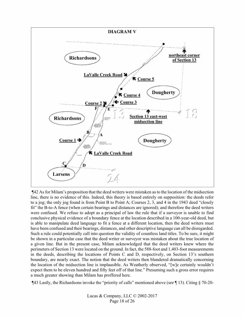
Lucas & Company, LLC © 2002-2017 Page 18 of 26
¶42 As for Milam’s proposition that the deed writers were mistaken as to the location of the midsection line, there is no evidence of this. Indeed, this theory is based entirely on supposition: the deeds refer to a jog; the only jog found is from Point B to Point A; Courses 2, 3, and 4 in the 1943 deed “closely fit” the B-to-A fence (when certain bearings and distances are ignored); and therefore the deed writers were confused. We refuse to adopt as a principal of law the rule that if a surveyor is unable to find conclusive physical evidence of a boundary fence at the location described in a 100-year-old deed, but is able to manipulate deed language to fit a fence at a different location, then the deed writers must have been confused and their bearings, distances, and other descriptive language can all be disregarded. Such a rule could potentially call into question the validity of countless land titles. To be sure, it might be shown in a particular case that the deed writer or surveyor was mistaken about the true location of a given line. But in the present case, Milam acknowledged that the deed writers knew where the perimeters of Section 13 were located on the ground. In fact, the 588-foot and 1,403-foot measurements in the deeds, describing the locations of Points C and D, respectively, on Section 13’s southern boundary, are nearly exact. The notion that the deed writers then blundered dramatically concerning the location of the midsection line is implausible. As Weatherly observed, “[w]e certainly wouldn’t expect them to be eleven hundred and fifty feet off of that line.” Presuming such a gross error requires a much greater showing than Milam has proffered here.
¶43 Lastly, the Richardsons invoke the “priority of calls” mentioned above (see ¶ 13). Citing § 70-20-

Lucas & Company, LLC © 2002-2017 Page 19 of 26
201(2), MCA, they assert that monuments are paramount and control over other evidence. They contend, therefore, that the 2003 deed of the Larsen property must be applied according to the monuments called for in the deed, which they list as a fence running northeasterly from Point C to a jog fence, the jog fence, and the fence along LaValle Creek Road. Applying this theory to presently existing objects in the field, they assert that the boundary is from Point C to Point B to Point A to Point D, notwithstanding the bearings, distances, acreages, and other descriptive language in the deeds indicating that the boundary is from Point C to Point F to Point E to Point D.
¶44 The Richardsons’ approach is contrary to the law of surveying and without any evidentiary foundation. “If there were any principle that perhaps is misinterpreted and possibly misapplied by surveyors, attorneys, and courts, it is the priority of calls.” Robillard & Wilson, Brown’s Boundary Control and Legal Principles 92. [LLHN8] The priority of calls was developed through case law in the 1800s and is also governed by statutory law. The general hierarchy is as follows: lines actually run on the ground by the creating surveyor prevail over natural monuments (e.g., a tree), which prevail over artificial monuments (e.g., surveyor’s stakes), which prevail over references to adjoining boundaries (e.g., “to Hunter’s property line”), which prevail over directions (e.g., northwest), which prevail over distances (e.g., 30 feet), which prevail over area (e.g., 5 acres), which prevails over place names (e.g., “the Quinn farm”). Robillard & Bouman, Clark on Surveying and Boundaries § 14:21, 397 (1997), § 15:08A, 147 (Supp. 2010); Robillard & Wilson, Brown’s Boundary Control and Legal Principles 121-23; Pollard v. Shively, 5 Colo. 309, 313 (1880); Riley v. Griffin, 16 Ga. 141, 147-48 (1854); M’Clintock v. Rogers, 11 Ill. 279, 296-97 (1849); Tewksbury v. French, 6 N.W. 218, 218-19 (Mich. 1880); Hoffman v. Beecher, 12 Mont. 489, 502, 31 P. 92, 96 (1892); Lodge v. Barnett, 46 Pa. 477, 484-85 (1864). These rules “gr[ew] out of the peculiar exigencies of the country, and were moulded by experience, to meet the demands of justice.” Riley, 16 Ga. at 148; see also Booth v. Upshur, 26 Tex. 64, 70 (1861) (the rules are “founded on reason, experience and observation” and “pertain[ ], not to the admissibility, but to the weight of evidence”). The rationale is that that the lower-ranked calls are generally less reliable than the higher-ranked calls. As explained by the court in Riley, 16 Ga. at 148, [LLHN9] “any natural object, when called for distinctly, and satisfactorily proved—and the more prominent and permanent the object, the more controlling as a locator—becomes a landmark not to be rejected, because the certainty which it affords, excludes the probability of mistake,” whereas “course and distance, depending, for their correctness, on a great variety of circumstances, are constantly liable to be incorrect. Difference in the instrument used, and in the care of surveyors and their assistants, lead to different results.” See also McCullough v. Absecon Beach Co., 21 A. 481, 487 (N.J. Ch. 1891).
¶45 [LLHN10] The priority of calls is not absolute, however, and a lower-ranked call may prevail over a higher-ranked call if the circumstances show that the lower-ranked call is the more reliable evidence of the boundary’s true location. George W. Thompson, Real Property vol. 6, § 3044, 571-75 (1962) (“[M]onuments, as a general rule, prevail over courses and distances . . . unless the result would be absurd and one clearly not intended, or all the facts and circumstances show that the call for course and distance is more reliable than the call for monuments.” (footnotes omitted)); Booth, 26 Tex. at 70 (“Still, the lowest grade, to wit, course or distance, is made to prevail over the highest grade, to wit, rivers, creeks, etc., when, upon applying the calls of the grant to the land, the surrounding and connected circumstances adduced in proof to explain the discrepancy, show that course or distance is the most certain and reliable evidence of the true locality of the grant.”); Robillard & Bouman, Clark on Surveying and Boundaries § 15:08, 429 (1997) (“Although area is the lowest ranking element, if the instrument conveyed an exact area of one acre, then area would be the controlling element, and lines and monuments would probably yield . . . .”).
¶46 As aptly stated by the Supreme Court of Tennessee:
[LLHN11] The general rule is that in determining boundaries resort is to be had, first, to natural objects

Lucas & Company, LLC © 2002-2017 Page 20 of 26
or landmarks, because of their very permanent character, next, to artificial monuments or marks, then to boundary lines of adjacent owners, and then to courses and distances. But this general rule, as to the relative importance of these guides to the ascertainment of a boundary of land, is not an inflexible or absolute one.
The use of the rule is as a means to the discovery of the intention of the parties. To arrive at the intention of the parties to the instrument is the purpose of all rules of construction, and this applies to the description of premises conveyed as well as to other parts of the instrument.
[LLHN12] It is not true, as appellant supposes, that there is such magic in a monument called for that it will be made to control in construction invariably. If it controls it is only because it is to be regarded as more certain than course or distance.
“If it should in a given case be less certain, the rule would fail with the reason for it and the monument would yield to the course and distance and an artificial monument will yield more readily than a natural one.” Note 30 Am. Dec. 734, 740.
Pritchard v. Rebori, 186 S.W. 121, 122 (Tenn. 1916) (emphasis added).
¶47 Likewise, it has been said that:
[LLHN13] [t]he order of application a surveyor should consider and the attorney should apply is not an absolute rule of application to determine where the “true and correct” location of the disputed boundary line(s) was originally placed. If, in conducting a retracement, the surveyor encounters possibly conflicting interpretations of the evidence indicated and then recovered, preference should be towards that decision which best fits the majority of the recovered evidence—in other words the decision that has the fewest number of conflicting elements. The final decision accepted should then best reflect what the original intent was in the conveyance. This philosophy should not be a problem to either the surveyor, the attorney, or the court, even though it may be that an element lower in the scale is given preference over one placed in a higher ranking.
Robillard & Bouman, Clark on Surveying and Boundaries § 15:08A, 146 (Supp. 2010); see also Stuart v. Coldwell Banker & Co., 552 S.W.2d 904, 909 (Tex. App.--Houston 1st Dist. 1977) [LLHN14] (In the construction of the property description, “the trial court was not bound to give controlling effect to every call in the field notes, or even to strictly follow the ordinary priority of calls. Circumstances may vary their usual order of dignity.” (citations omitted)); S.R.H. Corp. v. Rogers Trailer Park, Inc., 252 A.2d 713, 717 (N.J. 1969) (“‘These preferences [for monuments over courses and distances] are merely constructional preferences and will yield to the manifest intent of the grantor if this can be ascertained.’” (quoting Thompson, Real Property vol. 6, § 3044, 575)).
¶48 Montana law governing the interpretation of contracts 12 similarly provides that [LLHN15] “[a] contract must be so interpreted as to give effect to the mutual intention of the parties as it existed at the time of contracting, so far as the same is ascertainable and lawful.” Section 28-3-301, MCA. Furthermore, “[t]he whole of a contract is to be taken together so as to give effect to every part if reasonably practicable, each clause helping to interpret the other.” Section 28-3-202, MCA.
¶49 For these reasons, Milam and the Richardsons are incorrect in their contentions that monuments are always paramount. [LLHN16] A monument controls only if it can be regarded as more certain than other calls ranked lower in the hierarchy. Furthermore, a boundary determination should best reflect the original intent of the parties to the conveyance, and preference should be for the determination that best fits the majority of the recovered evidence. In this regard, Weatherly testified that when a surveyor draws up a survey and puts it of record, it is “a compilation of all the evidence 12 “Grants are to be interpreted in like manner with contracts in general, except so far as is otherwise provided in this part.” Section 70-1-513, MCA.

Lucas & Company, LLC © 2002-2017 Page 21 of 26
that’s available to the surveyor at the time that the survey is completed,” including the deeds, field observations, and interviews with persons having knowledge of the property. He acknowledged that there is a hierarchy of survey evidence, meaning that certain types of evidence generally carry more weight than other types, but he emphasized that this does not mean anything below the highest piece of evidence may be disregarded outright. More to the point, when asked whether fences, jogs, roads, and creeks have priority over bearings and distances, Weatherly stated: “If I have reason to believe that they were in the location where they may have been at the time the conveyance, or legal description, was prepared.” Here, he observed, there is no evidence that the B-to-A fence existed in 1910.
¶50 Milam also testified on this subject. He stated that a monument controls if it has been “undisturbed.” He also conceded that if the B-to-A fence did not presently exist, “I would consider the east-west midsection line” as the northern boundary of the finger. His boundary determination, therefore, depends on the premise that the B-to-A fence existed in 1910 and was the intended “jog” across the creek (as opposed to another “jog” further north)—a premise for which there admittedly is no evidence. It is stated in Robillard & Bouman, Clark on Surveying and Boundaries § 15:10, 434 (1997), that “[i]n order to rely on a fence as the true and correct dividing line, the fence itself must be supported by testimony or parol evidence indicating the fence was built on the correct original line.” Milam testified that he agreed with this rule, and when asked what testimony or parol evidence he was relying on for his conclusion that the B-to-A fence is the “jog,” Milam stated: “It’s been maintained as a property line, and observed by the adjacent landowners for many years.” He admitted under further questioning, however, that there had been no testimony by any person that this fence was built “on the original correct line.” Later, when asked again what corroborating evidence he had to establish that the B-to-A fence is anything other than a fence, Milam merely responded: “I have the deed.” Yet, he acknowledged that the deeds, “as they are written,” place the jog 1,150 feet north of the B-to-A fence, on or near the midsection line.
¶51 We addressed a similar situation in Pilgrim v. Kuipers, 209 Mont. 177, 679 P.2d 787 (1984), where the claim was that “the old ‘fox farm’ fence” was a monument that established the boundary. We disagreed, explaining:
[LLHN17] There is a critical distinction between a fence which establishes a boundary line, and a fence that merely separates one side of the fence from the other. The former is a monument as well as a fence, while the latter is merely a fence. Unlike the highway right-of-way and the Beaverhead River, there are no calls in the legal description to the “fox farm” fence. There is no evidence that the fence line was surveyed or that the fence was built to conform to a surveyed line. One witness testified that the fence was built zig-zag apparently around trees and without any pattern at all. Another said it “jogged” by as much as 20 feet. In contrast, the legal description calls for a straight line. There simply is no evidence to support the fence as a monument.
Nor does a fence establish a boundary line when it does not conform to the true line, even though the property owners thought it was the boundary. Where two adjoining properties are divided by a fence, which both owners suppose to be on the line, such fence is a division fence, as between them, until the true line is ascertained, when they must conform to the true line.
Pilgrim, 209 Mont. at 181-82, 679 P.2d at 790 (internal quotation marks omitted).
¶52 Likewise, here, the legal description in the 2003 deed of the Larsen property—and in all other deeds in the Larsens’ and the Richardsons’ chains of title—calls for a fence near the center of Section 13, not halfway between Section 13’s midsection line and southern boundary. There is no language in any of the deeds indicating that a fence 1,150 feet south of the midsection line is the intended “jog.” For that matter, there is no evidence that the B-to-A fence existed in 1910 or was built on the correct original line, and none of the lay witnesses called by the Richardsons had any actual knowledge of the

Lucas & Company, LLC © 2002-2017 Page 22 of 26
correct boundary lines of the finger of land.
¶53 The fact is Milam had no evidentiary basis whatsoever for relying on the B-to-A fence as the true and correct dividing line. It was manifestly wrong, therefore, for him to treat this fence as a controlling monument called for in the deeds and, on this basis, [is] to negate the vast majority of descriptive language in the deeds. Application of the priority of calls is not one of “pick and choose” or “pick the one I want to suit the answer I need.” Robillard & Bouman, Clark on Surveying and Boundaries § 15:08A, 148 (Supp. 2010). Unfortunately, however, that is what Milam did here.
¶54 The Richardsons’ reliance on § 70-20-201, MCA, is, thus, misplaced. The statute lists rules of construction for resolving inconsistencies in the descriptive part of a conveyance of real property. Pilgrim, 209 Mont. at 180, 679 P.2d at 789; cf. Robillard & Wilson, Brown’s Boundary Control and Legal Principles 121 (The priority of calls is a rule of construction that applies “only in cases of conflict between elements within a land description.”). The rules apply “when the construction is doubtful and there are no other sufficient circumstances to determine it.” Section 70-20-201, MCA. Here, however, the only doubtful aspect of the 2003 deed is the precise route of the fence line between Point B and Point E, which is resolved, under the authority of § 70-20-202(2), MCA, by the second course in the 1943 deed of the Richardson property defining the jog as 350 feet in length. Furthermore, the Richardsons rely specifically on the rule that boundaries and monuments are paramount. Section 70-20-201(2), MCA. Yet, this rule applies only “[w]hen permanent and visible or ascertained boundaries or monuments are inconsistent with the measurement, either of lines, angles, or surfaces,” § 70-20-201(2), MCA, and here, because the fence from Point B to Point A has not been established as a “monument” called for in the deeds, there is no “inconsistency” to be resolved by resort to the priority of calls, and the B-to-A fence cannot be “paramount.”
¶55 In sum, the Richardsons have failed to show any error in the District Court’s findings and conclusions concerning the ownership issue. Weatherly’s survey is based on a correct application of the law and surveying standards. The Larsens demonstrated they own the disputed 9.74 acres. Milam’s analysis, in contrast, is factually and legally unsupported, and the Richardsons have no basis for claiming ownership of that land.
¶56 Issue 2. Did the District Court err in determining that the Richardsons do not hold a prescriptive easement?
¶57 [LLHN18] The burden at trial on a party seeking to establish an easement by prescription is to show, by clear and convincing evidence, open, notorious, exclusive, adverse, continuous, and uninterrupted use of the claimed easement for the full statutory period, which is five years. Leichtfuss v. Dabney, 2005 MT 271, ¶ 24, 329 Mont. 129, 122 P.3d 1220; Hellerv. Gremaux, 2002 MT 199, ¶ 12, 311 Mont. 178, 53 P.3d 1259. All elements must be proved because one who has legal title should not be forced to give up what is rightfully his without the opportunity to know that his title is in jeopardy and that he can fight for it. Heller, ¶ 15. If the claimant shows open, notorious, exclusive, continuous, and uninterrupted use, a presumption arises that the use was also adverse and the burden shifts to the landowner to establish that the claimant’s use was permissive. Heller, ¶ 15; Albert v. Hastetter, 2002 MT 123, ¶ 20, 310 Mont. 82, 48 P.3d 749 (noting that this is the minority rule).
¶58 [LLHN19] The mere use of the land for the required statutory period, however, is generally insufficient to give rise to the presumption of a grant. Heller, ¶ 14; see also Albert, ¶ 20 (occasional recreational use is insufficient to raise the presumption of adverse use); Leisz v. Avista Corp., 2007 MT 347, ¶ 16, 340 Mont. 294, 174 P.3d 481 (unexplained use cannot form a basis for a claim of prescriptive right). Generally some circumstances or act, in addition to the use, tending to indicate that the use was not merely permissive, is required. Heller, ¶ 14. To be adverse, the use of the alleged easement must be exercised under a claim of right and not as a mere privilege or license revocable at the pleasure of the owner of the land; such claim must be known to, and acquiesced in by, the owner

Lucas & Company, LLC © 2002-2017 Page 23 of 26
of the land. Kessinger v. Matulevich, 278 Mont. 450, 457, 925 P.2d 864, 868 (1996). We have repeatedly held that a landowner should not be forced to give up title to his property without notice of the alleged adverse claim and the opportunity to know that his title is in jeopardy. Amerimont, Inc. v. Gannett, 278 Mont. 314, 324, 924 P.2d 1326, 1333 (1996).
¶59 [LLHN20] Use of a neighbor’s land based on neighborly accommodation or courtesy is not adverse and cannot ripen into a prescriptive easement. Heller, ¶ 14. This Court has consistently reaffirmed this doctrine. See Public Lands Access Assn. v. Boone and Crockett Club Found., 259 Mont. 279, 284, 856 P.2d 525, 528 (1993); Lemont Land Corp. v. Rogers, 269 Mont. 180, 186, 887 P.2d 724, 728 (1994); Amerimont, 278 Mont. at 324, 924 P.2d at 1333; Kessinger, 278 Mont. at 457, 925 P.2d at 869; Tomlin Enters. v. Althoff, 2004 MT 383, ¶ 18, 325 Mont. 99, 103 P.3d 1069. Neighborly accommodation, express or implied, is a form of permissive use which, by custom, does not require permission at every passing. Heller, ¶ 14; Kessinger, 278 Mont. at 457, 925 P.2d at 868-69. If a use begins as a permissive use, it is presumed to continue as such, and periodic express grants of permission are not required to maintain the permissive character of the use, especially where the use remains essentially the same. Rettig v. Kallevig, 282 Mont. 189, 196, 936 P.2d 807, 811 (1997); Rathbun v. Robson, 203 Mont. 319, 322-24, 661 P.2d 850, 852 (1983).
¶60 In the present case, the District Court found that the Richardsons’ use of the corrals and surrounding area was permissive. While the Richardsons contend there is no testimony substantiating this determination, we conclude the District Court’s finding is supported by substantial evidence in the record. The testimony of Judith Anderson, Alex Polakow, Cliff Larsen, and Lorna Richardson, as well as the correspondence between the Larsens and the Richardsons prior to the filing of this lawsuit, indicate that Pope accommodated the Richardsons by giving them permissive use of his property for the ingress and egress of their cattle and by allowing the Richardsons to use the corrals located on his property. This use began as a neighborly accommodation in the 1940s because it was more convenient for the Richardsons to load and offload cattle at that location and it would have been “very expensive” for the Richardsons to create an access point to their property along LaValle Creek Road north of the corrals. The record further reflects that Anderson allowed this permissive use to continue while she owned the property (until 2003). The Richardsons admittedly viewed the corrals as “community corrals” used by themselves, Dougherty, and others.
¶61 The Richardsons’ challenges to the District Court’s analysis boil down to simple disagreement with the court’s credibility determinations and their view that the testimony at trial supports a finding of adverse use. As we have said, however, we review a trial court’s findings “to determine whether substantial evidence supports those findings, not contrary findings.” Montanans for Justice v. State ex rel. McGrath, 2006 MT 277, ¶ 78, 334 Mont. 237, 146 P.3d 759 (emphasis in original). Moreover, it is the province of the trial court to weigh the evidence and resolve any conflicts between the parties’ positions, and this Court will not second-guess the court’s determinations regarding the strength and weight of conflicting testimony. Montanans for Justice, ¶ 78. Due regard must be given to the opportunity of the trial court to judge the credibility of the witnesses. M. R. Civ. P. 52(a). Here, the District Court evaluated the strength and weight of the conflicting testimony, judged the credibility of the witnesses, and determined that the Richardsons’ use was permissive. Substantial evidence supports this determination.
¶62 We accordingly hold that the Richardsons do not hold a prescriptive easement over any part of the Larsens’ 9.74 acres north of the B-to-A fence.
¶63 Issue 3. Did the District Court err in denying the Larsens’ request for attorney’s fees?
¶64 Following the District Court’s entry of its Findings of Fact and Conclusions of Law and Order, the Larsens filed a motion to assess attorney’s fees under § 25-7-105, MCA. This statute provides, in pertinent part, that at any time more than 60 days after service of the complaint and more than 30 days

Lucas & Company, LLC © 2002-2017 Page 24 of 26
before the trial begins, any party may serve upon the adverse party a written offer to settle a claim for the money or property or to the effect specified in the offer. An offer not accepted is considered withdrawn. If the final judgment is less favorable to the offeree than the offer, then the offeree shall pay the costs, including reasonable attorney’s fees, incurred by the offeror after the offer was made. The statute applies to an action or claim which involves real property and for which the amount contained in a pleading is $50,000 or less, exclusive of costs, interest, and service charges. Section 25-7-105(1), (3), (4)(b), MCA.
¶65 In September 2008, well over 60 days after service of the Larsens’ complaint, the Larsens served upon the Richardsons a written offer to settle. They offered to create an agricultural easement over a 73-foot-wide strip of land, approximately 0.62 acres in size, along the north side of the B-to-A fence. The easement would “allow the Richardsons access from LaValle Creek Road to their property to the west of Larsens” and would “allow egress and ingress for livestock and equipment in support of raising livestock.” The Richardsons rejected the offer. The case proceeded to trial in September 2009, after which the District Court ruled that the Richardsons neither own the disputed 9.74 acres nor hold an easement over any part of that property. Accordingly, the Larsens argued in their motion to assess attorney’s fees that the final judgment was less favorable to the Richardsons than the offer of a 0.62-acre agricultural easement and that the Larsens, therefore, were entitled to recover their attorney’s fees incurred after the offer was made.
¶66 It is important to note the factual circumstances which existed at the time the Larsens offered to settle. They commenced this lawsuit on July 10, 2007, seeking to quiet title to the 26.96-acre finger of land. On August 3, 2007, the Richardsons filed their Answer and Counterclaim, requesting a declaration of prescriptive easement “over that portion of the subject property which includes the corrals, fences, and adjacent grounds.” On February 7, 2008, the Richardsons filed a motion to amend the scheduling order to give their recently retained expert (Milam) time to analyze COS 5900 and the property at issue. On June 25, 2008, Milam issued his report, concluding that the Richardsons own the northernmost 9.74 acres. On September 10, 2008, the Larsens made their offer to settle, which the Richardsons rejected five days later. On September 17, 2008, the Richardsons filed a motion to amend their Answer and Counterclaim to include a claim of ownership. The District Court granted the motion. On December 2, 2008, the Richardsons filed an Amended Answer and Counterclaim, asserting ownership of the 9.74 acres and, in the alternative, a prescriptive easement over the entire 9.74 acres.
¶67 The only claims existing when the Larsens made their offer were the Larsens’ request that title to the 26.96 acres be quieted in their names and the Richardsons’ counterclaim for a prescriptive easement “over that portion of the subject property which includes the corrals, fences, and adjacent grounds.” Accordingly, in their reply brief in support of their motion to assess attorney’s fees, the Larsens stated that their offer was directed at the Richardsons’ prescriptive easement counterclaim. In the motion itself, however, the Larsens sought to recover attorney’s fees “arising in the case after the Defendants’ rejection of the Offer of Settlement.” Neither their motion nor their attached affidavit distinguishes, in any apparent fashion, between the attorney’s fees incurred with respect to the prescriptive easement counterclaim and the attorney’s fees incurred with respect to the subsequently filed ownership counterclaim. Yet, the Larsens’ offer did not apply to the ownership counterclaim, since that counterclaim had not yet been alleged.
¶68 These factual circumstances raise some important questions concerning the proper application of § 25-7-105, MCA. Is a party entitled to recover attorney’s fees incurred in the litigation of a claim or counterclaim that is added to the case after the settlement offer is made? In other words, may the Larsens recover attorney’s fees incurred on the ownership counterclaim, even though their offer did not pertain to this claim (since it did not exist at the time the offer was made)? Does it depend on whether the original claim (the one for which the offer was made) and the later-added claim (the one added after the offer was made) are of such nature that all of the attorney’s fees would have been

Lucas & Company, LLC © 2002-2017 Page 25 of 26
incurred regardless of whether the later claim had been added? What if, in their Amended Answer and Counterclaim, the Richardsons had dismissed their prescriptive easement claim and pursued only their ownership claim? Is the dispositive fact the fact that this litigation, at its core, has always been about the Larsens’ attempt to disperse any and all clouds upon their title to the 26.96-acre property, whatever form that cloud might take (an easement claim, a possessory claim, or some other encumbrance)?
¶69 The parties have not briefed these questions. The Larsens assume they are entitled to all attorney’s fees incurred after September 10, 2008, while the Richardsons argue that the Larsens’ claim fails for another reason. Because we agree with the Richardsons’ argument, we leave resolution of the foregoing questions to another case in which they have been properly argued and briefed. We shall assume, for purposes of the present case, that the Larsens may be entitled to recover attorney’s fees incurred litigating both the prescriptive easement issue and the ownership issue.
¶70 There is no question that the claims in this case involve real property. Section 25-7-105(4)(b), MCA. There also is no question that the offer to settle otherwise satisfies the criteria of the statute, with the exception of the amount in controversy. By its terms, the statute “applies only to an action or claim for which the amount contained in a pleading is $50,000 or less, exclusive of costs, interest, and service charges.” Section 25-7-105(4), MCA. As an initial matter, we agree with the Larsens and the Richardsons that parties cannot be allowed to manipulate the application of § 25-7-105, MCA, by stating in their pleadings an amount above or below $50,000 (regardless of the true value of the property at issue), or by not stating an amount at all, in order to avoid the statute’s application or in order to apply it to situations that the Legislature never intended. The statute is designed to encourage the settlement of lawsuits involving real property 13 where the amount in controversy is not more than $50,000. Hence, “the amount contained in a pleading”—to which the $50,000 limit applies—refers to the value of the real property interest that is at issue in the particular claim or claims to be settled.
¶71 As the moving party, therefore, it was incumbent on the Larsens to show that the value of the subject property (the 9.74 acres), the value of the prescriptive easement claimed by the Richardsons, or the value of both (given that the Larsens claim attorney’s fees for litigating both the ownership claim and the easement claim) was not more than $50,000. As the Richardsons point out, however, and as the District Court observed in denying the Larsens’ motion, the parties “provided no evidence establishing the market value of their claimed property rights in the disputed parcel of land.” Accordingly, we hold that the Larsens did not meet their burden under § 25-7-105(4), MCA, and that the District Court correctly denied their motion for attorney’s fees due to a failure of proof.
¶72 Issue 4. Did the District Court err in denying the Larsens’ request for certain costs?
¶73 Following the District Court’s entry of its Findings of Fact and Conclusions of Law and Order, the Larsens filed a Bill of Costs. The District Court granted some of the requested costs and denied others. The Larsens’ arguments on appeal relate to the costs associated with preparing maps and surveys.
¶74 Section 25-10-201(8), MCA, provides that a party is entitled to include in their bill of costs “the reasonable expenses for making a map or maps if required and necessary to be used on trial or hearing.” This Court has held repeatedly that expenses incurred in preparing maps, surveys, and charts for the purpose of explaining the factual situation to the court are allowed as recoverable costs. See Johnson v. Jarrett, 169 Mont. 408, 417, 548 P.2d 144, 149 (1976); Funk v. Robbin, 212 Mont. 437, 449, 689 P.2d 1215, 1222 (1984); Goodover v. Lindey’s Inc., 255 Mont. 430, 443-44, 843 P.2d 765, 773 (1992).
¶75 The District Court denied costs for maps and surveys in this case for two reasons. First, the court observed that COS 5900 was prepared prior to the filing of this lawsuit and, thus, the costs related to
13 It also applies to contract claims. Section 25-7-105(4)(a), MCA.

Lucas & Company, LLC © 2002-2017 Page 26 of 26
the preparation of COS 5900 were not recoverable. Second, citing Witty v. Pluid, 220 Mont. 272, 714 P.2d 169 (1986), the court observed that expert witness fees are limited to $10.00 per day for each day the expert testifies.
¶76 The error in this analysis, as the Larsens point out, is that they are not claiming costs for the preparation of COS 5900 and are not claiming expert witness fees. Rather, they are claiming costs for the preparation of additional and supplemental maps for purposes of trial. They note that the bills submitted by WGM Group (Weatherly’s firm) include charges for additional survey work and for preparing additional maps to explain to the court the facts at issue. While the Richardsons submit that none of these maps were required or necessary to be used at trial, the record belies this contention. The transcript is replete with references by counsel, various witnesses, and the trial judge to points on the supplemental maps prepared by Weatherly. These maps were introduced into evidence; in fact, one of them is included among the Richardsons’ own trial exhibits. Furthermore, this case revolved around two surveyors’ contradictory conclusions about the location of the boundary line at issue. To explain how they reached their respective conclusions, numerous maps, diagrams, and photographs were introduced at trial. There was exhaustive testimony regarding deeds that refer to fences, jogs, and roads and that contain bearings and distances which do not precisely line up with existing ground conditions. The maps and surveys created by Weatherly provided important details not included in COS 5900, were critical for an understanding of Weatherly’s and Milam’s differing interpretations of the deeds, and assisted the court in determining the existence and location of the boundary line at issue.
¶77 Accordingly, pursuant to § 25-10-201(8), MCA, the Larsens are entitled to costs for the reasonable expenses incurred in preparing the additional maps and surveys for purposes of trial. The District Court’s June 9, 2010 Opinion and Order re: Attorney’s Fees and Costs is reversed to this limited extent, and the case is remanded to the District Court for further proceedings on this one issue.
¶78 The Richardsons contend that some of the charges included in the WGM Group invoices do not relate specifically to the preparation of maps. We agree that any charges which were not incurred specifically in making the additional maps and surveys are not recoverable under § 25-10-201(8), MCA. But this is a factual matter to be resolved by the District Court on remand.
CONCLUSION
¶79 The District Court did not err in determining that the Larsens own the disputed 9.74 acres and that the Richardsons do not hold a prescriptive easement over the property. The District Court also did not err in denying the Larsens’ request for attorney’s fees under § 25-7-105, MCA. The District Court did err, however, in denying the Larsens’ request for costs under § 25-10-201(8), MCA. The case is remanded for further proceedings on that issue--specifically, for a determination and award of the reasonable expenses incurred in the preparation of supplemental maps and surveys (i.e., other than COS 5900 itself) for purposes of trial. As a final matter, we hold that the Larsens are entitled to costs on appeal pursuant to Rule 19(3)(a) of the Montana Rules of Appellate Procedure, which the District Court is directed to determine on remand.
¶80 Affirmed in part, reversed in part, and remanded for further proceedings.

Lucas & Company, LLC © 2008-2016 Page 1 of 38
TH INVESTMENTS, INC., Appellant v.
KIRBY INLAND MARINE, L.P. and PORT OF HOUSTON AUTHORITY OF HARRIS COUNTY, TEXAS, Appellees
NO. 14-05-00204-CV COURT OF APPEALS OF TEXAS, FOURTEENTH DISTRICT, HOUSTON
218 S.W.3d 173; February 1, 2007, Judgment Rendered
February 1, 2007, Corrected Opinion Filed LUCAS LETTER HEAD NOTES [LLHN]: [1]
Real Property Law; Water Rights; Riparian & Littoral Rights: [LLHN1] The term “riparian” means belonging or relating to the bank of a river or stream. A “riparian owner” is one whose land is bounded by a river. Real Property Law; Water Rights; Riparian & Littoral Rights: [LLHN2] The term “littoral” means belonging to the shore, and a “littoral owner” is one whose land borders an ocean, sea, or lake. Real Property Law; Water Rights; Submerged Lands; Ownership: Real Property Law; Water Rights; Public Waters: Real Property Law; Water Rights; Navigable Waters; Generally: [LLHN3] Generally, the soil covered by the bays, inlets, and arms of the Gulf of Mexico within tide-water limits belongs to the State, and constitutes public property that is held in trust for the use and ben-efit of all the people. The State of Texas owns the water and the beds and shores of the Gulf of Mexico and the arms of the Gulf of Mexico within the boundaries provided in this section, including all land which is covered by the Gulf of Mexico and the arms of the Gulf of Mexico either at low tide or high tide.
Real Property Law; Water Rights; Public Waters: Real Property Law; Water Rights; Navigable Waters; Generally: [LLHN4] Navigable waters and streams are reserved to the State for the use of the public generally, and no one should have an exclusive right to the enjoyment of such property, unless and until the Legislature has granted such right. Thus, two presumptions arise regarding submerged lands: (1) they are owned by the State and (2) the State has not acted to divest itself of title to them.
Real Property Law; Water Rights; Navigable Waters; Generally: [LLHN5] “Navigable waters” are defined broadly in Texas and they include waters within the tidewater limits of the Gulf of Mexico and streams that are navigable in law or fact. Navigable waters include nav-igable streams, as defined by statute, lakes, bays, inlets, and other areas within tidewater limits within its borders. The bays inlets, and other waters along the Gulf Coast which are subject to the ebb and flow of the tide of the Gulf of Mexico are defined as “navigable waters.”
[1] All head notes in this opinion provided by the Editor of TLL for the convenience of our readers. JNL.
Lucas & Company, LLC © 2008-2016 Page 2 of 38
Real Property Law; Water Rights; Navigable Waters; Generally: Real Property Law; Water Rights; Submerged Lands; Ownership: Real Property Law; Water Rights; Submerged Lands; Disposal: [LLHN6] Land under navigable waters is withdrawn from the general provisions of the statutes confer-ring upon the Land Commissioner the right to contract for the sale or lease thereof. Instead, only the Texas Legislature may convey submerged tidal lands.
Real Property Law; Water Rights; Submerged Lands; Ownership: Real Property Law; Water Boundaries; Boundary Line: Real Property Law; Water Rights; Common-Law Rule: [LLHN7] The Texas Supreme Court long ago announced the boundary between State and private own-ership of submerged tidal lands. For common law land grants, the boundary is the line of mean high tide; for Spanish or Mexican grants, it is the line of mean higher high tide.
Real Property Law; Water Rights; Submerged Lands; Ownership: Real Property Law; Water Boundaries; Boundary Line: Real Property Law; Water Rights; Common-Law Rule: [LLHN8] Mean high tide is measured by taking an average of all the daily highest readings over a long period. Mean high tide is the same as mean high water.
Real Property Law; Water Rights; Submerged Lands; Ownership: Real Property Law; Water Boundaries; Boundary Line: Real Property Law; Water Rights; Common-Law Rule: [LLHN9] Water boundaries are not static. The boundary moves because the line of the tide moves over time, and as that line moves, so does the boundary between State-owned submerged lands and privately owned uplands. Texas follows the general rule that when the location of the margin or bed of a body of water that constitutes the boundary of a tract of land is gradually and imperceptibly changed or shifted by accretion, reliction, or erosion, the margin or bed of the body of water, as so changed, remains the boundary line of the tract, which is extended or restricted accordingly. The general rule is that a riparian or littoral owner acquires or loses title to the land gradually or imperceptibly added or taken to or from his fast bank or shore. The location of the shoreline, wherever it may be at any given time, represents the boundary of a littoral owner’s property. With respect to the landward advance of the line of mean high tide, the Supreme Court has written that if the sea encroaches and the upland owner loses his land, he has no redress.
Real Property Law; Water Boundaries; Boundary Line: Real Property Law; Water Boundaries; Ambulatory Nature: Real Property Law; Water Boundaries; Accretion, Reliction & Avulsion: [LLHN10] The tide is not the only factor changing the boundary. It also can be changed by nature’s forces—primarily water—that add to or subtract from a body of land. Additions to land generally are created by accretion or reliction. With accretion, land increases gradually and imperceptibly when water deposits solid material so that land once covered by water becomes dry. Reliction occurs when previ-ously submerged land is uncovered by permanently receding water. Decreases in tidal lands generally are caused by erosion, which gradually and imperceptibly wears away the land. All of these processes may cause a riparian or littoral owner to gain or lose title to the land.

Lucas & Company, LLC © 2008-2016 Page 3 of 38
Real Property Law; Water Boundaries; Boundary Line: Real Property Law; Water Boundaries; Ambulatory Nature: Real Property Law; Water Boundaries; Accretion, Reliction & Avulsion: [LLHN11] A different rule is usually applied to water boundaries in the case of the sudden removal or deposit of land; this rapid or perceptible change is termed “avulsion.” Generally, title does not pass by avulsion. Nor may a landowner acquire title to accreted land by artificially building up submerged land into dry land along his shoreline.
Real Property Law; Water Rights; Public Waters: Real Property Law; Water Rights; Submerged Lands; Disposal: [LLHN12] Property conveyed by the State to an individual can remain privately owned even if it is sub-merged under tide waters—but only under very special circumstances in which the State manifested its intent that the private landowner continue to own the property even if submerged.
Real Property Law; Conveyances; Generally: Real Property Law; Deeds; Priority & Recording; Junior/Senior Conveyances: [LLHN13] One may not convey more than one owns.
Real Property Law; Water Boundaries; Boundary Line: Real Property Law; Water Boundaries; Ambulatory Nature: Real Property Law; Water Rights; Riparian & Littoral Rights: [LLHN14] The general rule is that a riparian or littoral owner loses title to land that is worn away grad-ually by erosion, and gains title to land added gradually by accretion. However, the Court distinguished subsidence from these processes, stating that subsidence is not an ordinary hazard of riparian ownership; it is not the result of the force of the waters which takes from some owners and gives to others.
Civil Procedure; Appeals; Standards of Review; Sufficiency of Evidence: Evidence; Procedural Considerations; Weight & Sufficiency: [LLHN15] A trial court’s findings are reviewable for legal and factual sufficiency by the same stand-ards that are applied in reviewing evidence supporting a jury’s answer. Civil Procedure; Appeals; Standards of Review; Sufficiency of Evidence: Evidence; Procedural Considerations; Weight & Sufficiency: Evidence; Burden of Proof; Credible Evidence: [LLHN16] In determining whether legally sufficient evidence supports the trial court’s findings of fact, we consider the evidence in the light most favorable to the challenged finding and indulge every reason-able inference that would support it. We must credit favorable evidence if a reasonable factfinder could and disregard contrary evidence unless a reasonable factfinder could not disregard it. We must deter-mine whether the evidence at trial would enable a reasonable and fair-minded person to find the facts at issue.
Civil Procedure; Appeals; Standards of Review; Sufficiency of Evidence: Civil Procedure; Trials; Trier of Facts; Credibility of Witnesses: Evidence; Burden of Proof; Conclusive Evidence: [LLHN17] The factfinder is the sole judge of the credibility of the witnesses and the weight to give their testimony. Evidence is conclusive only if reasonable people could not differ in their conclusions.

Lucas & Company, LLC © 2008-2016 Page 4 of 38
Civil Procedure; Appeals; Standards of Review; Sufficiency of Evidence: Evidence; Burden of Proof; Conclusive Evidence: [LLHN18] When a party attacks the legal sufficiency of an adverse finding when it had the burden of proof on the issue, it must demonstrate on appeal that the evidence establishes, as a matter of law, all vital facts in support of the issue. The court must first examine the record for evidence that supports the finding, while ignoring all evidence to the contrary. If no evidence supports the finding, we then exam-ine the entire record to determine if the contrary proposition is established as a matter of law. We may sustain the issue only if the contrary proposition is conclusively established.
Civil Procedure; Appeals; Standards of Review; Sufficiency of Evidence: Evidence; Burden of Proof; Preponderance of Evidence: Evidence; Burden of Proof; Uncontradicted Evidence: [LLHN19] In reviewing a factual insufficiency point, we consider all the evidence presented at trial. When a party attacks the factual sufficiency of an adverse finding on an issue on which it has the burden of proof, it must demonstrate on appeal that the adverse finding is against the great weight and prepon-derance of the evidence. We may set aside a verdict only if the evidence is so weak or if the finding is so against the great weight and preponderance of the evidence that it is clearly wrong and unjust. Unchal-lenged fact findings are binding on this Court unless the contrary is established as a matter of law or there is no evidence to support the finding.
Real Property Law; Deeds; Purpose; Evidence of Title: Real Property Law; Deeds; Legal Descriptions; Sufficiency of Description: [LLHN20] In a trespass to try title case, the general test for determining the sufficiency of a description of land is whether the tract can be identified with reasonable certainty.
Real Property Law; Water Boundaries; Boundary Line: Real Property Law; Water Boundaries; Meander Lines: [LLHN21] Meander lines of surveys of land adjacent to or bounding upon a stream are not to be consid-ered as boundaries, but they are to follow the general course of the stream, which itself constitutes the real boundary. Thus, there can be no “meanders” or distinct boundaries created by the course of a river when the waters of the river cover the site.
Civil Procedure; Appeals; Judicial Precedence (stare decisis): Real Property Law; Property Rights; Title to Property: [LLHN22] Stare decisis is never stronger than in protecting land titles, as to which there is great virtue in certainty.
Real Property Law; Water Boundaries; Boundary Line: Real Property Law; Water Boundaries; Ambulatory Nature: Real Property Law; Water Rights; Riparian & Littoral Rights: [LLHN23] A riparian owner thus loses title to portions of the land that are worn, washed away, or en-croached upon by the water. The general rule is that a riparian or littoral owner acquires or loses title to the land gradually or imperceptibly added or taken to or from his fast bank or shore.
Real Property Law; Water Boundaries; Boundary Line: Real Property Law; Water Boundaries; Ambulatory Nature: Real Property Law; Water Boundaries; Accretion, Reliction & Avulsion: [LLHN24] A private party may not acquire title through self-help that raises land from submerged land lying under tidal waters. A widely-recognized exception to the general rule is that accretion does not be-
Lucas & Company, LLC © 2008-2016 Page 5 of 38
long to the owner of the land adjoining the water when the owner causes the accretion. A riparian or lit-toral owner may not acquire title to submerged land through self-help by filling and raising the land level..
Real Property Law; Public Lands; Government Property; Generally: Real Property Law; Water Rights; Submerged Lands; Ownership: [LLHN25] An island arising out of the bed of a navigable stream or the submerged lands of a tidewater bay becomes the property of the State.
Real Property Law; Boundaries; Evidence of Boundaries; Actually Run on the Ground: Real Property Law; Boundaries; Question of Law and Fact: [LLHN26] Texas law is well settled that unless the facts are undisputed, the location of a survey line, as it was run on the ground by the original surveyor, is a question of fact for the jury. The Texas Supreme Court has explained that as to what are boundaries, is a question of law for the determination of the court; as to where the boundaries are upon the ground, is a question of fact to be determined from the evidence.
Real Property Law; Boundaries; Evidence of Boundaries; Following in the Footsteps: Real Property Law; Boundaries; Evidence of Boundaries; Actually Run on the Ground: [LLHN27] When finding the lines of a survey, the cardinal rule is that the footsteps of the original sur-veyor, if they can be ascertained, should be followed. The primary objective in locating a survey is to “follow the footsteps of the surveyor”; by which is meant to trace on the ground the lines as he actually ran them in making the survey. If the actual lines and corners run by the original surveyor can be found, they are controlling, even if they are inconsistent with the calls and references in that surveyor’s field notes. The footsteps of the original surveyor are controlling and prevail over calls for course and dis-tance. When the actual lines run by the surveyor can be found, they constitute the true boundary and cannot be made to yield to course and distance calls. If the footsteps of the original surveyor can be identified and followed, they will control the location of the line or boundary in question even though they may not be in harmony with the field note calls.
Real Property Law; Boundaries; Evidence of Boundaries; Following in the Footsteps: Real Property Law; Boundaries; Evidence of Boundaries; Actually Run on the Ground: Real Property Law; Boundaries; Evidence of Boundaries; Extrinsic Evidence: [LLHN28] When one can locate on the ground with certainty and without inconsistency the objects or monuments designated by the original surveyor as marking the lines he actually traced, the survey must be laid out from those points, and extraneous evidence cannot be admitted to contradict the assertion of the surveyor that he actually went to the points he so designated. However, if the location of the actual footsteps of the surveyor cannot be established with reasonable certainty, all the surrounding facts and circumstances should be considered in order to arrive at the purpose and intent of the surveyor who made the original survey.
Real Property Law; Boundaries; Evidence of Boundaries; Actually Run on the Ground: Real Property Law; Boundaries; Evidence of Boundaries; Extrinsic Evidence: Real Property Law; Boundaries; Evidence of Boundaries; Best Available Evidence: [LLHN29] Although the original surveyor’s marks and calls are generally controlling, when the sur-veyor’s marks have disappeared over time, the lines and corners of the survey may be established using any evidence tending to show their location that is the best evidence of which the case is susceptible. Courts generally consider the “best evidence” to be that evidence which is the more specific and definite as against that which is merely general and indefinite or descriptive.

Lucas & Company, LLC © 2008-2016 Page 6 of 38
Real Property Law; Boundaries; Evidence of Boundaries; Following in the Footsteps: Real Property Law; Boundaries; Evidence of Boundaries; Subsequent Surveys: [LLHN30] When a subsequent surveyor is shown to have found the natural and artificial objects called for in a senior survey, and to have re-marked those lines and corners in the same location, that subse-quent survey will assume the dignity of the original. So, although a junior survey cannot be used to cre-ate an ambiguity in or to change the lines of a senior survey, it may be used as evidence of the location of the lines of a senior survey.
Real Property Law; Boundaries; Surveys; Original Surveys: Real Property Law; Boundaries; Surveys; Original Surveys; Presumptions: [LLHN31] Surveyors are presumed to have performed their official duties and to have actually sur-veyed and marked all the lines to the corners. A surveyor is presumed to have done his official duties. Absent proof to the contrary, it is presumed the original surveyor performed his duties, including mark-ing the lines. This is particularly true after their work has been accepted by the GLO. After an extended lapse of time, and issuance of a patent, the county surveyor should be presumed to have properly dis-charged his official duties.
Real Property Law; Boundaries; Surveys; Original Surveys: Evidence; Procedural Considerations; Admissibility of Evidence: [LLHN32] The original surveyor’s field book, which was not patented, was properly excluded because the patented survey and field notes control over unpatented field books.
Real Property Law; Boundaries; Surveys; Original Surveys: Real Property Law; Boundaries; Evidence of Boundaries; Retracement Surveys: Real Property Law; Deeds; Deed Interpretation; Rules of Construction: Real Property Law; Boundaries; Evidence of Boundaries; Monuments: [LLHN33] When the natural and artificial objects of the grant cannot be identified upon the ground, the proper method of locating the lines and corners will be by course and distance from the nearest recog-nized and established corner or artificial object with which the fieldnotes are connected.
Real Property Law; Boundaries; Evidence of Boundaries; Retracement Surveys: Real Property Law; Deeds; Deed Interpretation; Rules of Construction: Real Property Law; Deeds; Legal Descriptions; Priority of Calls: [LLHN34] The order of preference courts give to the dignity of surveyors’ calls: (1) natural objects; (2) artificial objects; (3) course; and (4) distance..
Real Property Law; Boundaries; Evidence of Boundaries; Retracement Surveys: Real Property Law; Deeds; Deed Interpretation; Rules of Construction: Real Property Law; Deeds; Legal Descriptions; Priority of Calls: [LLHN35] Bearings and course calls should not be used to establish the location of a survey line if there is other reliable evidence showing where it was actually run on the ground. Footsteps of original sur-veyor control over calls for course and distance. Where actual lines run can be found, they constitute the true boundary and cannot be made to yield to course and distance calls.

Lucas & Company, LLC © 2008-2016 Page 7 of 38
Civil Procedure; Appeals; Standards of Review; De Novo Review: Civil Procedure; Summary Judgment; Standards of Review: [LLHN36] An appellate court reviews the trial court’s summary judgment ruling de novo. An appellate court takes as true all evidence favorable to the nonmovant, and indulge every reasonable inference and resolve any doubts in the nonmovant’s favor. When the parties moved for summary judgment on the same issues, an appellate court considers the summary judgment evidence presented by all sides, deter-mine all questions presented, and, if the trial court erred, renders the decision the trial court should have rendered.
Real Property Law; Conveyances; Generally: Real Property Law; Deeds; Legal Descriptions; Gap and Gore Doctrine: [LLHN37] The strip-and-gore doctrine is intended to avoid litigation by presuming that a grantor has no intention of reserving a fee in a narrow strip of land adjoining the land conveyed when it ceases to be of use to him, unless such fee is clearly reserved. The doctrine applies only to relatively narrow strips of land, small in size and value in comparison to the adjoining tract conveyed by the grantor. Therefore, if the land conveyed does not adjoin the strip or gore, the doctrine does not apply.
Civil Procedure; Appeals; Standards of Review; Abuse of Discretion: Evidence; Testimony; Expert Witness Testimony; Admissibility: [LLHN38] An appellate court reviews a trial court’s decision to admit or exclude expert evidence under and abuse of discretion standard.
[218 S.W.3d 179] Andrew Lovell Strong, Houston, TX; Arthur L. Schechter, Houston, TX; David E. Harrell, Houston, TX; John L. Hill, Jr., Houston, TX; Michael V. Powell, Dallas, TX; Roland Garcia Jr., Houston, TX; for Appellants. Catherine B. Smith, Houston, TX; Daniel V. Flatten, Houston, TX; David H. Brown, Houston, TX; James S. Barrick, Houston, TX; John James Michael, Houston, TX; Mark E. Lowes, Houston, TX; for Appellees: Justices Hudson, Fowler, and Seymore. OPINION BY: Wanda McKee Fowler
CORRECTED OPINION: We originally issued our opinion affirming the trial court’s judgment on January 9, 2007. On Kirby
Inland Marine, L.P.’s, unopposed motion to correct the opinion, we withdraw our previous opinion and substitute this corrected opinion in its place.1
This appeal by a private landowner, TH Investments (“THI”) against the Port of Houston Authority and Kirby Inland Marine, asks us to decide who owns two tracts of property on the Old River and the San Jacinto River. As will be discussed in greater detail below, both rivers are subject to the tides. Three broad issues—and many sub-issues—are presented.
The first two issues pertain to the first tract, Tract 1. We first must determine whether the State has gained ownership of it because the property is covered by shallow tidal waters. Second, we are asked to decide if the location the trial court chose for the southern boundary of Tract 1 coincides with the
1 We correct the opinion to clarify our description of the trial court’s disposition of Kirby’s motion for summary judgment in footnote 35.

Lucas & Company, LLC © 2008-2016 Page 8 of 38
boundary set by the original 1838 survey of the property. The third issue involves Tract 2. We are asked to decide whether THI owns Tract 2. In the body of the opinion we will address the many sub-issues, but for purposes of this overview, we hold the following regarding the three broad issues. First, the State did gain ownership of Tract 1 because it became submerged as a result of indistinguishable effects of erosion and subsidence. Therefore, the trial court correctly ruled that the Port owns Tract 1. Second, the southern boundary set by the trial court for Tract 1 is the same as boundary set by the original 1838 sur-vey. Third, as the trial court held, THI does not own Tract 2. In short, we affirm the trial court’s rulings.
Factual and Procedural Background The property lies near the confluence of the Old River and the San Jacinto River, east of Houston
near Channelview, in Harris County, Texas. Tract 1, which historically consisted of 27 acres, is now a “flat,” almost completely submerged beneath the waters of the two rivers.2 Occasionally, [218 S.W.3d 180] Tract 1 becomes exposed during the fall and winter months during low tide when a north wind blows. Tract 2 is a small parcel of land to the east consisting of 6.1 acres variously described as an is-land or a strip of riverbank. The two tracts are sometimes identified by their acreage as “the 27 Acre Tract” and “the 6.1 Acre Tract.” The area around the property is subject to significant commercial mari-time use, as well as occasional use for recreational purposes by pleasure craft and for fishing.
2 The trial court’s Finding of Fact No. 3, which is unchallenged, specifically states that Tract 1 “lies in Harris County, east of the City of Houston, north of the confluence of the Houston Ship Channel and the San Jacinto River, south of Interstate 10, and in the area of confluence of the San Jacinto River (to the east and south of the property) and Old River (to the north and west of the property).”
Approximate Location of Action in the Case

Lucas & Company, LLC © 2008-2016 Page 9 of 38
What follows are the relevant facts framing the dispute; more specific details are developed in the discussion of the issues.
THI’s Purchase of the Property In November 2002, THI acquired record title to Tract 1 by a non-warranty deed from the record
owners, known collectively as the “Carter Heirs,” and acquired Tract 2 by quitclaim deed from the Carter Heirs. The contract of sale for Tract 1 included an “Addendum for Coastal Area Property,” which provided to THI the following notice:
NOTICE REGARDING COASTAL AREA PROPERTY 1. The real property described in and subject to this contract adjoins and shares a common boundary with the tidally influenced submerged lands of the state. The boundary is subject to change and can be determined accurately only by a survey on the ground made by a licensed state land surveyor in accordance with the original grant from the sovereign. The owner of the property described in this contract may gain or lose portions of the tract because of changes in the boundary. *** 3. State law prohibits the use, encumbrance, construction, or placing of any structure in, on, or over state-owned submerged lands below the applicable tide line, without proper permission. 4. The purchaser or grantee is hereby advised to seek the advice of an attorney or other quali-fied person as to the legal nature and effect of the facts set forth in this notice on the property described in and subject to this contract. Information regarding the location of the applicable tide line as to the property described in and subject to this contract may be obtained from the surveying division of the General Land Office in Austin. (emphasis added). When he signed the contract for sale, THI’s president, Earl Thrift, neither read the deeds himself nor
engaged counsel to do so. When THI purchased the land from the Carter Heirs in 2002, the Carter Heirs also assigned to THI a
lease with Kirby Inland Marine, L.P. THI, which intended to start its own barge fleeting business, then informed Kirby that it would either have to vacate the area and remove any improvements made or start paying $35,000 monthly in rent.3 When Kirby did not agree to THI’s demands, THI terminated [218 S.W.3d 181] the lease and threatened to evict Kirby.
The Lawsuit As a result of THI’s actions, Kirby filed suit against THI to enjoin it from interfering with Kirby’s
business operations and to obtain a declaratory judgment that the State of Texas—not THI—owned Tract 1.4 Kirby later joined the Port, asserting that the State conveyed ownership of the property to the
3 Since 1978, Kirby, or its predecessor, Western Towing Co., had leased Tract 1 from the Carter Heirs to conduct its barge mooring and fleeting business adjacent to the property. From 1978 until 1991, the Carter Heirs charged $500 a month for the lease, and in 1991 increased it to $1,000 a month. 4 The trial court granted a temporary restraining order prohibiting THI from interfering with Kirby’s use and pos-session, and the parties later agreed to a temporary injunction pending trial.

Lucas & Company, LLC © 2008-2016 Page 10 of 38
Port by statute.5 Eventually, the posture of the case evolved into, primarily, an action by THI on its counterclaims and cross-claims for trespass to try title to Tract 1 and Tract 2. THI claimed record title to both tracts, and Kirby claimed ownership of Tract 2. The Port claimed that it owned any part of Tract 1 or 2 that was-below mean high tide or was raised above mean high tide by artificial means or “self-help.”
The trial court tried the issues in two phases. Phase 1 was a bench trial with THI as plaintiff on its trespass to try title action involving Tract 1; the parties presented evidence on the ownership and bound-aries of the tract. The trial court heard two weeks of evidence from numerous witnesses and received many exhibits into evidence. At the conclusion of the trial, the court entered detailed findings of fact and conclusions of law. It found that THI never owned Tract 1 and that ownership of Tract 1 passed to the Port, as successor to the State of Texas, because the tract became submerged below the line of mean high tide. The court also set the southern boundary for Tract 1.
Following the bench trial, Phase 2 proceeded on Tract 2. The court considered the parties’ cross-mo-tions for summary judgment as to ownership of the tract. The court granted the Port’s and Kirby’s mo-tions for summary judgment on THI’s claim of record title to Tract 2, denying THI’s claim of owner-ship. The trial court did not determine who owned Tract 2; it held only that THI did not own it.
At the conclusion of phase 2, the trial court signed a final judgment incorporating its earlier orders and attaching as an exhibit its findings of fact and conclusions of law entered after Phase 1. This appeal followed.
I. Part 1: Ownership of Tract 1 We turn now to the first general area of contention, the ownership of Tract 1. In Part 1 of its brief,
THI claims that it, not the Port, owns Tract 1 because this case falls within an exception to the general rule that the State owns all property covered by tide waters. This claim is based on two concepts it ar-gues apply here and on several allegedly erroneous findings of fact the trial court entered. The two con-cepts are that (1) private owners can own property under tide waters, and (2) if the property is sub-merged under tide waters because of subsidence, the general rule that the state owns submerged lands does not apply.
THI interweaves these two concepts throughout six issues: (1) the trial court erred by holding that THI lost its riparian land to the Port as the land subsided and most of it [218 S.W.3d 182] became shallowly submerged beneath the waters of the Old River; (2) the trial court erred by not following Coastal Industrial Water Authority v. York, 532 S.W.2d 949 (Tex. 1979); (3) the trial court’s ruling constitutes a taking in violation of the Texas and United States Constitu-tions; (4) no evidence or insufficient evidence supports the trial court’s finding reciting that the extent to which subsidence versus erosion contributed to the submergence of Tract 1 cannot be determined, or alternatively, the trial court misplaced the burden of proof and applied incorrect legal standards;
5 Kirby joined both the Port and the General Land Office of the State of Texas (“GLO”). However, the trial court later granted the GLO’s plea to the jurisdiction and motion to dismiss, in which it argued in part that the State had no interest in the property at issue because the property was conveyed to the Port by statute.

Lucas & Company, LLC © 2008-2016 Page 11 of 38
(5) no evidence or insufficient evidence supports the trial court’s findings that a boundary of Tract 1 described as “the meanders of Old River” cannot now be identified or located, and that the tract can-not be distinguished from the bed of Old River, or alternatively, the trial court applied the wrong standard; and (6) no evidence or insufficient evidence supports the trial court’s findings that the entirety of Tract 1 became submerged at some time in the past and that the portions of the tract that now lie above mean high water re-emerged as the result of the deposit of dredge spoils by Kirby and its predeces-sor, Western Towing. Before we address THI’s specific issues and the two concepts underlying them, we will review gen-
erally the law that applies to riparian and littoral owners.6
A. Tract 1 is Under Tidal Waters which Typically are Owned by the State. 1. The State Presumptively Owns Lands Lying under Tidal Waters.
[LLHN3] Generally, “[t]he soil covered by the bays, inlets, and arms of the Gulf of Mexico within tidewater limits belongs to the State, and constitutes public property that is held in trust for the use and benefit of all the people.” Lorino v. Crawford Packing, 142 Tex. 51, 175 S.W.2d 410, 413 (1943). Sec-tion 11.012(c) of the Texas Natural Resources Code echos the Lorino holding: “The State of Texas owns the water and the beds and shores of the Gulf of Mexico and the arms of the Gulf of Mexico within the boundaries provided in this section, including all land which is covered by the Gulf of Mex-ico and the arms of the Gulf of Mexico either at low tide or high tide.” TEX. NAT. RES. CODE § 11.012(c). [LLHN4] “[N]avigable waters and streams7 are reserved to the State for the use of the public generally, and no one should have an exclusive right to the enjoyment of such property, unless and until the Legislature has granted such right.” Lorino, 175 S.W.2d at 414. Thus, two presumptions arise re-garding submerged lands: (1) they are owned by the State and [218 S.W.3d 183] (2) the State has not acted to divest itself of title to them. See, e.g., Lorino, 175 S.W.2d at 414; City of Galveston v. Mann, 135 Tex. 319, 143 S.W.2d 1028, 1033 (1940); State v. Bradford, 121 Tex. 515, 50 S.W.2d 1065, 1069 (1932); Landry v. Robison, 110 Tex. 295, 219 S.W. 819, 820 (1920); City of Galveston v. Menard, 23 Tex. 349, 392 (1859).
Addressing these presumptions, the Lorino court explained that [LLHN6] “land under navigable waters is withdrawn from the general provisions of the statutes conferring upon the Land Commissioner the right to contract for the sale or lease thereof.” Lorino, 175 S.W.2d at 413. Instead, only the Texas Legislature may convey submerged tidal lands. See id. at 414. The Court explained the reason for this rule as follows:
6 [LLHN1] The term “riparian” means “belonging or relating to the bank of a river or stream.” Brainard v. State, 12 S.W.3d 6, 15 n.2 (Tex. 1999). A “riparian owner” is one whose land is bounded by a river. Id. [LLHN2] The term “littoral” means “belonging to the shore,” and a “littoral owner” is one whose land borders an ocean, sea, or lake. Id. at 21 n.7. 7 [LLHN5] “Navigable waters” are defined broadly in Texas and they include waters within the tidewater limits of the Gulf of Mexico and streams that are navigable in law or fact. See State v. Bradford, 121 Tex. 515, 50 S.W.2d 1065, 1069 (“navigable waters” includes “navigable streams, as defined by statute, lakes, bays, inlets, and other areas within tidewater limits within its borders”); Lorino, 175 S.W.2d at 413 (“The bays inlets, and other waters along the Gulf Coast which are subject to the ebb and flow of the tide of the Gulf of Mexico are defined as “navigable waters.”).

Lucas & Company, LLC © 2008-2016 Page 12 of 38
It has always been the policy of the State to dispose of ordinary public lands to settlers, and under usual circumstances it may be presumed that the State has parted with title; but navigable waters and streams are reserved to the State for the use of the public generally, and no one should have an ex-clusive right to the enjoyment of such property, unless and until the Legislature has granted such right. Therefore, it has been the policy of the State to retain title to lands covered by navigable wa-ters, and the presumption is that there has not been any act of the State divesting itself of title. Id. at 414 (citing Bradford, 50 S.W.2d at 1069). The public policy that informs the presumption of State ownership is also reflected in the Texas
Legislature’s 1927 conveyance to the Port’s predecessor, a political subdivision of the State. The Legis-lature conveyed to the Port’s predecessor all of the submerged lands “as now or hereafter located” in the areas presently at issue, including those lands submerged beneath the waters of the Old River and the San Jacinto River. See Act of April 5, 1927, 40th Leg., R.S., ch. 292, 1927 Tex. Gen. Laws 437, 438. This conveyance included “all the submerged lands lying and being situated under the waters of … San Jacinto River … [and] … Old River … so far up said streams as the State may own same, together with all lands lying and being situated under the waters of Old River … and all other tidal flats or overflow land adjacent to or appurtenant to the above mentioned streams … as now or hereafter located ….” Id. at 438, § 1.8 The Legislature directed the Port to administer these lands “for public [218 S.W.3d 184] pur-poses and the development of commerce only” in connection with the development of the Port of Hou-ston. Id. The Legislature also directed that the Port was not at any time to “give or alien said lands or any part thereof” and empowered the Port to “abate and remove any and all encroachments or structures of any kind now or hereafter existing on such property.” Id. at 439, §§ 2, 3.
However, we do not read this section to abridge any of the general rules of riparian or littoral rights applied here. In fact, the Act did not cause THI to lose title; these well-established rules caused THI’s loss. The only relevant question is the location of the line of mean high tide. The Act merely fixed the ownership of the property in the Port once the property became submerged below the line of mean high tide.
2. Unchallenged Findings of Fact State that the Land is Under Tide Waters. The trial court entered a fact finding, unchallenged by THI, that the waters of Old River and the San
Jacinto River are navigable.9 Also unchallenged by THI is the trial court’s finding that the land is sub-ject to the ebb and flow of the tide, is within the tidewater limits of the Gulf of Mexico, and is tidally influenced:
8 The trial court concluded that, as Tract 1 became submerged below the line of mean high tide, ownership of that submerged property passed to the Port pursuant to Texas law and the provisions of the Act of April 5, 1927 . THI contends the trial court’s interpretation of the 1927 Act was in error, because its ruling that Tract 1 reverted to the State conflicts with the following language of section 4 of the Act:
The purposes and provisions of the Act, and the grants, rights and privileges, thereunder to [Port], shall not affect, curtail or abridge the rights of riparian owners of lands abutting upon the islands and lands subject to overflow, and lands lying under the streams, bays and lakes herein described or referred to, as the same ex-isted under the Common Law or the Constitution or Statutes of Texas at the time this Act shall become in force and effect, or to deprive riparian owners of access to such streams, channels or waterways.
9 The trial court also concluded that the waters of Old River and the San Jacinto River are navigable in law, be-cause the waters are tidally influenced and the rivers average more than 30 feet in width from their mouths up,
Lucas & Company, LLC © 2008-2016 Page 13 of 38
The water over, around and in the area of the 27-Acre Tract is subject to the ebb and flow of the tide, being within the tidewater limits of the Gulf of Mexico. The waters of Old River and the San Jacinto River likewise are tidally influenced in the area in question. The facts in the record demonstrate the area is tidally influenced. The parties likewise stipulated the area is tidally influenced.
3. The Boundary between Public Submerged Tidal Lands and Private Lands Derived from a Common-Law Grant is Mean High Tide.
[LLHN7] The Texas Supreme Court long ago announced the boundary between State and private ownership of submerged tidal lands. For common law land grants, the boundary is the line of mean high tide; for Spanish or Mexican grants, it is the line of mean higher high tide. See Luttes v. State, 159 Tex. 500, 324 S.W.2d 167, 175 (1958) (civil law); Rudder v. Ponder, 156 Tex. 185, 293 S.W.2d 736, 741 (1956) (common law); see also Kenedy Mem’l Found. v. Dewhurst, 90 S.W.3d 268, 270 (Tex. 2002) (applying rule of Luttes to locate shoreline boundary). Because the property at issue passed under a common-law grant, the boundary line that applies here, in the absence of any exception, is the line of mean high tide.10
[LLHN9] This boundary is not static. The boundary moves because the line of the tide moves over time, and as that line moves, so does the boundary between State-owned submerged lands and privately owned uplands. See Brainard v. State, 12 S.W.3d 6, 17 (Tex. 1999) (“Texas follows the general rule that when the location of the margin or bed of a body of water that constitutes the boundary of a tract of land is gradually and imperceptibly changed or shifted by accretion, reliction, or erosion, the margin or bed of the body of water, as so changed, remains the boundary line of the tract, which is extended or re-stricted accordingly.”); Coastal Indus. Water Auth. v. York, 532 S.W.2d 949, 952 (Tex. 1976) (“The general rule is that a riparian or littoral owner acquires or loses title to the land gradually or impercepti-bly added or taken to or from his fast bank or shore.”); City of Port Isabel v. Mo. Pac. R. Co., 729 S.W.2d 939, 942 (Tex. App.--Corpus [218 S.W.3d 185] Christi 1987, writ ref’d n.r.e.) (“[T]he location of the shoreline, wherever it may be at any given time, represents the boundary of a littoral owner’s property.”); City of Corpus Christi v. Davis, 622 S.W.2d 640, 643 (Tex. App.--Austin 1981, writ ref’d n.r.e.) (“With respect to the landward advance of the line of mean high tide, the Supreme Court has writ-ten that if the sea encroaches and the upland owner loses his land, he has no redress.”) (citing State v. Balli, 144 Tex. 195, 190 S.W.2d 71, 100 (1944)).
[LLHN10] The tide is not the only factor changing the boundary. It also can be changed by nature’s forces—primarily water—that add to or subtract from a body of land. Additions to land generally are created by accretion or reliction. Brainard, 12 S.W.3d at 17. With accretion, land increases gradually and imperceptibly when water deposits solid material so that land once covered by water becomes dry. Id. Reliction occurs when previously submerged land is uncovered by permanently receding water. Id. Decreases in tidal lands generally are caused by erosion, which gradually and imperceptibly wears away the land. See York, 532 S.W.2d at 952. All of these processes may cause a riparian or littoral owner to gain or lose title to the land.11
citing Lorino, 175 S.W.2d at 413, Bradford, 50 S.W.2d at 1069, and Texas Natural Resources Code section 21.001(3). 10 [LLHN8] Mean high tide is measured by taking an average of all the daily highest readings over a long period. Luttes, 324 S.W.2d at 174. Mean high tide is the same as mean high water. See id. 11 [LLHN11] A different rule is usually applied in the case of the sudden removal or deposit of land; this rapid or perceptible change is termed “avulsion.” York, 532 S.W.2d at 952. Generally, title does not pass by avulsion. Id.

Lucas & Company, LLC © 2008-2016 Page 14 of 38
B. This Case Does Not Fall Under Any Potential Exceptions or Case Law THI Cites. With these general legal principals in mind, we turn now to the exceptions and case law THI claims
apply. THI claims this case falls within one of several exceptions that would allow it to continue to own land submerged under tide waters. First, THI refers us to at least one case in which the State has con-veyed land to an individual. Second, THI relies heavily on Coastal Industrial Water Authority v. York and its holding that an individual owned property beneath the San Jacinto River that became submerged because of subsidence. THI also cites us to a handful of appellate court opinions it claims allowed indi-viduals to continue owning land that became submerged.12
We consider these claims below. However, as we explain, we disagree that either claimed exception applies here, and, in light of Luttes, Rutter, Lorino, Brainard, and Kenedy Memorial Foundation—the seminal cases explaining the boundaries between state-owned and privately owned land—we find the cited case law either of questionable validity or distinguishable. See Luttes v. State, 159 Tex. 500, 324 S.W.2d 167 (1958); Rudder v. Ponder, 156 Tex. 185, 293 S.W.2d 736 (1956); Lorino v. Crawford Pack-ing, 142 Tex. 51, 175 S.W.2d 410 (1943); Brainard v. State, 12 S.W.3d 6 (Tex. 1999); Kenedy Mem’l Found. v. Dewhurst, 90 S.W.3d 268 (Tex. 2002).
1. Private Individuals Can Own Land Conveyed to Them by the State Even When the Land is Un-der Water.
a. Submerged property conveyed by the State can be owned by a private individual if the convey-ance contemplated submerged land. [218 S.W.3d 186]
[LLHN12] Property conveyed by the State to an individual can remain privately owned even if it is submerged under tide waters—but only under very special circumstances in which the State manifested its intent that the private landowner continue to own the property even if submerged.
An example of a case in which the Texas Supreme Court found that a private individual owned shal-lowly submerged flats is City of Galveston v. Menard, 23 Tex. 349 (1859), involving Galveston Island, located in the tidal waters of Galveston Bay. Menard, as the original grantee of the state, claimed that he owned the submerged flats because they were sold to him through a legislative grant by the Republic of Texas in 1836 and through a patent issued in 1838. Id. at 391. The City claimed that the 1836 grant did not include the flats, and that they remained in republic and state ownership until a later date, when the Texas Legislature conveyed the flats to the City. Id.
The Court recognized the well-established common-law doctrine that an ordinary grant of land upon a bay, where the tide ebbs and flows, “does not convey the shore or any of the land of the bay covered with water.” Id. at 396. But, based on the object of the grant, its location, and the acts of the contracting parties, the Court determined that the Legislature intended to convey the submerged flats to Menard, specifically to encourage the construction of a port of entry for commercial activities and promote the building of a city on Galveston Island. Id. at 398-408. Menard’s rights were limited only by the City’s right to build and regulate the wharves and to open, improve, and use streets across the property out to the channel. Id. at 408.
b. Tract 1 was dry land when conveyed by the State. Nor may a landowner acquire title to accreted land by artificially building up submerged land into dry land along his shoreline. Brainard, 12 S.W.3d at 19; York, 532 S.W.2d at 952. 12 THI also cited an attorney general opinion, but it was not highly relevant to the resolution of the issues before us. See Op. Tex. Att’y Gen. No. GA-0181 (2004).

Lucas & Company, LLC © 2008-2016 Page 15 of 38
This appeal does not involve a conveyance like Menard. Although THI attempts to overcome the presumption of state ownership by showing that the Republic of Texas patented Tract 1 and other prop-erty into private ownership in 1845, the only land that THI’s predecessors received from the patent was a grant of dry land. THI does not contend that the State granted to its predecessors any submerged lands. Indeed, THI states in its briefing that “[i]t is undisputed that Tract 1 was dry land at the time of the . . . Grant.” [LLHN13] One may not convey more than one owns, and in this case, it is undisputed that the 1845 patent did not convey any submerged property. Nor do we find any evidence that the grant con-templated ownership by an individual if the property became submerged. Therefore, the patent does not overcome the presumption of state ownership. See Lorino, 175 S.W.2d at 414; Mann, 143 S.W.2d at 1035; City of Port Isabel, 729 S.W.2d at 942-43.
Thus, although private individuals can own submerged property if the State’s conveyance contem-plated private ownership of submerged lands, the State’s patent concerning Tract 1 did not reflect an in-tent that it remain in private ownership if it became submerged.13 [218 S.W.3d 187]
2. York and Any Exceptions it Creates Do Not Apply. We now turn to THI’s claim that Coastal Industrial Water Authority v. York, 532 S.W.2d 949 (Tex.
1979), creates an exception to the general rule of state ownership of submerged lands, that York controls the outcome of this appeal, and that the trial court erred when it refused to apply it. We disagree and ex-plain below that York is distinguishable from this case in several important respects.
a. Two defining and narrowing facts in York distinguish it from this appeal. In York, the Water Authority sought to condemn York’s land near the San Jacinto Monument. 532
S.W.2d at 951. A survey of York’s property in 1950 showed 28.083 acres above the water level, but when the Water Authority commenced condemnation in 1970, only 24.73 acres lay above water—a dif-ference of 3.353 acres. Id. York’s land indisputably was in an area where the land surface had been slowly subsiding during several decades because area industries and municipalities had removed enor-mous amounts of underground water. Id. As the land subsided, the adjacent waters encroached upon and submerged the land. Id. York argued, and the lower courts agreed, that the Water Authority should com-pensate York for the all of the acreage originally conveyed to him, including the 3.353 acres that had become submerged. Id.
13 Under this section of its brief, THI also argues another exception to the presumption that the State owns sub-merged tidal lands by suggesting that when the water is only tidally influenced—not tidal—the typical cases in-volving land subject to tide waters do not apply. Relying on the opinion of one of its experts, THI argues that the environment of Tract 1 is “fluvial,” meaning it is dominated by the processes of river water moving downstream, rather than littoral, meaning dominated by wave or tide-induced processes, and the area is not a bay, inlet, or arm of the Gulf of Mexico. Although the Port’s expert acknowledged that the area is affected by fluvial processes, he described the site as a “coastal environment,” in which the waters of Old River and the San Jacinto River are brackish, tidally influenced estuaries of the Gulf. Moreover, we find no exception made in the case law for tidally influenced water and THI. The Texas Supreme Court in Kenedy Memorial Foundation makes it clear that only a very little movement of water suffices for tide-water cases to apply. See 90 S.W.3d at 280 (applying the line of the tide where “seawater inundation is regular, shallow, and somewhat infrequent”); see also Crary v. Port Arthur Channel & Dock Co., 92 Tex. 275, 47 S.W. 967, 970 (1898) (holding the phrase “waters of the gulf of Mexico” was “comprehensive” and “sufficiently broad to embrace at least all bays, inlets, and streams upon the Gulf Coast to the extent to which they are subject to the ebb and flow of the tide”). Consequently, this argument also does not overcome the general presumption.

Lucas & Company, LLC © 2008-2016 Page 16 of 38
As the York court explained, [LLHN14] the general rule is that a riparian or littoral owner loses title to land that is worn away gradually by erosion, and gains title to land added gradually by accretion. Id. at 952. However, the Court distinguished subsidence from these processes, stating that subsidence is not “an ordinary hazard of riparian ownership; it is not the result of the force of the waters which takes from some owners and gives to others.” Id. at 954. Determining that no conflict between private and public interests existed under the facts before it, the Court concluded that it was “consistent with the interests of all to permit the riparian owner to protect his land—rather than to watch helplessly as his boundary retreats.” Id. Thus, because York’s property became submerged below the water level of the Houston Ship Channel solely as a result of subsidence, the Court held that York owned the submerged land as of the date the Water Authority had sought to take York’s property by condemnation. Id. Consequently, the Water Authority was required to compensate York for the submerged property. See id.
At least two courts—including the Texas Supreme Court itself—have recognized the very limited nature of the York holding. See Brainard, 12 S.W.3d at 20 (“Nonetheless, we find nothing in York’s lim-ited holding that precludes the operation of the rules of accretion, reliction, and erosion to artificially influenced changes in a river channel.”); Davis, 622 S.W.2d at 643 (“Although [218 S.W.3d 188] the [York] Court reaffirmed the rules with respect to property loss and gain due to erosion and accretion, those rules were not employed by the Court in its determination that the riparian owner held title to the submerged land since there was no erosion involved, only subsidence.”). As we discuss, statements made by the York court itself limit the opinion to such a degree that it does not control our decision here, and the trial court appropriately did not apply it.
(1) York did not involve land covered by tidal waters. The first, and most important, limitation of York is that it did not involve tide waters. The York court
expressly stated it assumed that the tide was of no effect: “The testimony of the surveyor witnesses indi-cates that the level of the water upon the York land does not fluctuate with the ebb and flow of the tide, and we will assume that the tide has no effect at this point.” Id. at 951 (emphasis added). In footnote 1, the court explained that the effect of the tide on the legal outcome of the case simply was not an issue raised by the parties: “The parties have not, at any point in this litigation, made any reference to the fact or legal effect of the tide. For this reason, the court’s opinion is restricted to the issues presented by the peculiar facts of this record and the contentions of the parties.” Id. at 951 n.1 (emphasis added). Author Justice Reavley added: “The writer of this opinion, speaking personally, chooses to emphasize the nar-rowness of the holding and to warn against any misinterpretation of its effect upon the boundary of pri-vate ownership to lands within reach of the tide.” Id. (emphasis added).14 Although the intermediate ap-pellate court’s opinion in York did state that the property was subject to tide water, the Supreme Court expressly assumed no tide water covered the property. See id. at 951.
(2) York involved only subsidence and not other forces. A second important distinction between this appeal and York, as we explain below, is that the York
property was submerged due to subsidence alone. No erosion was involved. In fact, the York court rec-ognized that the result could have been different if other forces, such as erosion, had affected the prop-erty. The Court noted “[i]t might be expected” that part or all of the contested acreage would have been eroded by the current of the water “so as to leave this three-acre area indistinct from the bed of the ship
14 THI dismisses this footnote. It asserts it is not a holding of the Texas Supreme Court, but only the author’s per-sonal opinion. Although that part of the footnote expressing the author’s personal opinion is not a holding of the court, it is some indication of the facts the court considered important.

Lucas & Company, LLC © 2008-2016 Page 17 of 38
channel.” Id. at 951-52. Had that happened, the Court acknowledged that “ownership would have been lost to the riparian owner . . . and passed to the City of Houston under the authorities to be discussed.” Id. at 952. However, as the case was presented to the Court, “there has been no displacement of the sub-merged land in relation to the bed of the ship channel.” Id.15
In short, the two facts that define York, especially for comparison with this case [218 S.W.3d 189] are these: (1) tide waters did not cover the York property,16 and (2) York involved only subsidence with-out any erosion.
b. The trial court’s findings distinguish this appeal from York. Several of the trial court’s findings relate directly to York and whether York controls this case. Ac-
cording to the Port, if we uphold these findings, York does not control this case. We will consider first the court’s findings that the boundary of Tract 1 cannot be distinguished from the Old River and that the boundary on one side of the property, which followed “the meanders of the Old River,” cannot be iden-tified now.17 We then will turn to the findings reflecting the court’s decision that one cannot determine the extent to which subsidence, as opposed to erosion, contributed to the submergence of Tract 1.
THI claims these findings are both legally and factually insufficient. [LLHN15] A trial court’s find-ings are reviewable for legal and factual sufficiency by the same standards that are applied in reviewing evidence supporting a jury’s answer. Catalina v. Blasdel, 881 S.W.2d 295, 297 (Tex. 1994). [LLHN16] In determining whether legally sufficient evidence supports the trial court’s findings of fact, we consider the evidence in the light most favorable to the challenged finding and indulge every reasonable infer-ence that would support it. See City of Keller v. Wilson, 168 S.W.3d 802, 822 (Tex. 2005). We must credit favorable evidence if a reasonable factfinder could and disregard contrary evidence unless a rea-sonable factfinder could not disregard it. See id. at 827. We must determine whether the evidence at trial would enable a reasonable and fair-minded person to find the facts at issue. See id. [LLHN17] The fact-finder is the sole judge of the credibility of the witnesses and the weight to give their testimony. See id. at 819. Evidence is conclusive only if reasonable people could not differ in their conclusions. See id. at 816.
[LLHN18] When a party attacks the legal sufficiency of an adverse finding when it had the burden of proof on the issue,18 it must demonstrate on appeal that the evidence establishes, as a matter of law,
15 The court of appeals had applied a rule in favor of York which assumed the boundaries of the 28.083 acres were identified, and the Water Authority did not contest this issue. 532 S.W.2d at 952. Nor did the Water Authority claim any erosion of the subsided shelf. Id. The supreme court therefore assumed that the property’s boundaries were identifiable and there had been no erosion of the 3.353 acres. Id. Thus, York did not address a situation in-volving land affected by subsidence and other processes like erosion. 16 THI claims tide waters must have covered the York property because it was in the same general area as Tract 1 but south of Tract 1, meaning that it was closer to Galveston Bay and the Gulf. Yet, as we have noted, the York court stated quite explicitly that it assumed—and expert testimony showed—that tide waters did not affect the property. Id. at 951. 17 This finding is significant because it relates directly to whether the property eroded or subsided. According to at least one of the experts, if Tract 1 had merely subsided, it simply would have dropped and its boundaries would have remained relatively intact. 18 According to THI, by stipulation it owned record title to Tract 1; so, because the Port sought to divest THI’s record title, the burden should have been on the Port and Kirby to prove the Port held a superior right to THI’s title. THI pursued a trespass to try title claim as a counterclaim. The Texas Supreme Court recently held that a

Lucas & Company, LLC © 2008-2016 Page 18 of 38
all vital facts in support of the issue. Dow Chem. Co. v. Francis, 46 S.W.3d 237, 241 (Tex. 2001). We first examine the record for evidence that supports the finding, while ignoring all evidence to the con-trary. Id. If no evidence supports the finding, we then examine the entire record to determine [218 S.W.3d 190] if the contrary proposition is established as a matter of law. Id. We may sustain the issue only if the contrary proposition is conclusively established. Id.
[LLHN19] In reviewing a factual insufficiency point, we consider all the evidence presented at trial. Plas-Tex, Inc. v. U.S. Steel Corp., 772 S.W.2d 442, 445 (Tex. 1989). When a party attacks the factual sufficiency of an adverse finding on an issue on which it has the burden of proof, it must demonstrate on appeal that the adverse finding is against the great weight and preponderance of the evidence. Dow Chem. Co., 46 S.W.3d at 242. We may set aside a verdict only if the evidence is so weak or if the find-ing is so against the great weight and preponderance of the evidence that it is clearly wrong and unjust. Id. Unchallenged fact findings are binding on this Court unless the contrary is established as a matter of law or there is no evidence to support the finding. McGalliard v. Kuhlmann, 722 S.W.2d 694, 696 (Tex. 1986).
To resolve these issues, we examine the evidence presented by both side’s experts, who testified ex-tensively concerning their opinions.
(1) The boundaries of Tract 1 cannot be located. We turn now to consider the trial court’s finding that the boundaries of Tract 1 could not be located.
Before addressing the fact findings THI challenges, we set out those THI does not challenge:
• “A 1916 topographical map (Common Exhibit 29) shows that the land at the location in question was generally in the shape of what the parties and witnesses called a ‘Rabbit’s Head.’ No such shape can now be identified at the location in question. The shape of the tract surveyed by THI’s surveyor, Bill Merten, is called ‘Tract 1’ and differs materially in shape from the historic ‘Rab-bit’s Head.’”
• “At present, there exists at the location what the parties and witnesses have called a ‘Flat’ This Flat is typically covered by tidal waters but is occasionally uncovered, as shown by many of the photographic exhibits. While there exists a drop off to the north of the Flat, the evidence shows that this was created by dredging. The Flat extends to the south beyond the boundaries claimed by THI for the 27-Acre Tract. The topography of the Flat is generally flat, with minor differ-ences in elevation.”
THI’s expert testified that he could locate the border described as “the meanders of the Old River.” The Port’s and Kirby’s expert testified, on the other hand, that she could not find the border of Tract 1 defined by the meanders of the Old River. The dispute on this issue turned on which expert used the proper method for locating the meanders. We first review the method THI’s expert used to determine the northern and western boundaries of Tract 1.
trespass to try title suit is the proper cause for all land title disputes, including boundary disputes. Martin v. Amer-man, 133 S.W.3d 262, 264-67 (Tex. 2004). THI is correct that one of the ways to prevail in such a suit is “to prove a regular chain of conveyances from the sovereign,” see id. at 265, but a trespass to try title plaintiff must also prove the location and identity of the land. See Hancock v. Moore, 137 S.W.2d 45, 50 (Tex. Civ. App.--El Paso 1939), aff’d, 135 Tex. 619, 146 S.W.2d 369 (Tex. 1940). As discussed in greater detail below, THI did not prevail on those requirements.

Lucas & Company, LLC © 2008-2016 Page 19 of 38
THI’s surveyor, William Merten, is a Licensed State Land Surveyor (“LSLS”)19 in Texas who sur-veyed the property for this litigation. THI hired Merten to survey all of Tract 1, but for purposes of this issue the only portion of Merten’s survey in dispute is his survey of the northern and [218 S.W.3d 191] western boundaries of Tract 1—the “meanders of Old River.”
Merten surveyed the area to the north and east of Tract 1 with the goal of locating the bank of the Old River as it was before Kirby’s predecessor dredged it out. To find this portion of the bank, Merten visually inspected the site, viewed photographs, and reviewed a Corps of Engineers dredging permit. He described his methodology as an estimate of where he believed the historic meander shoreline should have been. Merten’s “thinking was where will the line be if the barges were not there, if the area was not dredged.” So, he “came up with an estimate of—where you see here of where I believed the natural line would be if all this man-made activity had not occurred.” Thus, Merten drew the line along the north and northeast in the dredged area based on his belief of where he believed the natural, now submerged, meander line should have been. When asked at trial whether a boundary existed on the river bottom to-day that someone attempting to retrace Merten’s steps could find, Merten responded, “On the river bot-tom, no.”
19 Merten testified that there were approximately seventy LSLSes in Texas, and that they are qualified to file sur-veys and field notes delineating boundaries between State and private land with the General Land Office. A Reg-istered Professional Land Surveyor (“RPLS”), in contrast, is not qualified to file such surveys. According to Merten, there are about 2,500 RPLSes in Texas.
Possible Location of the Tracts

Lucas & Company, LLC © 2008-2016 Page 20 of 38
To survey the boundary to the north and west, Merten employed a “probing” technique in which he walked into the water over the submerged land as he probed the bottom to locate the purported sub-merged bank of Old River. Merten described the “probing” as wading through the water while hanging onto a boat. He felt the bottom with his feet, alternately stepping from hard to soft ground, while taking Global Position System (“GPS”) readings at intervals so that he could connect them and draw a line. The hard ground he assumed was the former bank of Old River.
Merten admitted that he had never before used “probing” to locate a submerged boundary line. Merten also acknowledged that there were no authoritative sources stating that probing was an accepted method, and even offered (perhaps unwittingly) that “[w]e are on uncharted grounds here.” None of ap-pellees’ witnesses testified that probing was an accepted procedure to identify a submerged boundary line in a title dispute.20
The Port’s surveyor, Nedra Foster, also an LSLS, testified that, given the existing site, the only way to survey the meanders today was to survey the line of mean high tide. She explained that the line of mean high tide is the proper line to use because the chain of title for Tract 1 is derived from a common-law grant located within a tidally influenced area. Foster’s mean high water survey reflected that the only existing meander lines between upland and water are the present meanders of Old River and the San Jacinto River around an island, which is what THI calls Tract 2. Foster testified that if she literally followed an 1896 deed description, the only land above water remaining at the site would be a small site less than one tenth of an acre, described as the “Little Thumb.” She also identified two other “very small portions” of emergent land outside of the original 27-Acre Tract. Merten’s own [218 S.W.3d 192] mean high tide survey substantially agreed with Foster’s survey.
THI contends that Merten’s survey of these boundaries provides undisputed evidence that a licensed surveyor could and did identify and locate the current “submerged boundaries” of Tract 1 along the me-anders of Old River, while the Port’s surveyor, Nedra Foster, did not even try to survey these bounda-ries.21 THI maintains that, if it is legally permissible for a surveyor to survey the boundaries of private land that is shallowly submerged due to subsidence, then its surveys stand as undisputed evidence of the boundary. Thus, while THI complains about the trial court’s fact findings, it frames the issue as one of law.
We agree with THI to the extent that the issue is one of law. The Texas Supreme Court, in discuss-ing the determination of a waterfront boundary in Kenedy Memorial Foundation, stated, “But here, as in Luttes, the exercise is made no easier by basing the boundary determination on a surveyor’s subjective observations of the terrain. For certainty in land titles, it is important to have a rule, and the civil law as interpreted in Luttes provides one.” 90 S.W.3d at 284. Thus, the determining question here is not
20 THI also contends the trial court should have considered the deposition testimony of Sid Bouse, a surveyor ini-tially designated by the Port and then de-designated in favor of Nedra Foster, who testified that he would use a similar method to find submerged boundaries. If the trial court did not consider this testimony with the other evi-dence THI presented and determined Merten’s survey to be unreliable, THI contends this constitutes an abuse of discretion. However, the trial court does not abuse its discretion merely because it determines the correctness of conflicting expert opinions in a way one party does not like. Additionally, the court limited both parties to one expert on this issue, which, in its discretion, it could do. 21 THI also points to a survey prepared by F.G. Huffman, an RPLS, who also surveyed the northern and western boundaries for THI in 2002. Merten testified that Huffman used a probing technique from a boat to locate the pur-ported submerged boundaries. The parties dispute whether Huffman’s survey was consistent with Merten’s. THI ultimately chose Merten over Huffman as their designated surveyor, and did not call Huffman at trial.

Lucas & Company, LLC © 2008-2016 Page 21 of 38
whether a surveyor could or did mark lines for the northern and western “meander” boundaries of the tract, but whether the surveyor properly surveyed lands bounded and covered by tidally-influenced wa-ters. As our discussion of the relevant law makes clear, the only valid way to survey such land is to sur-vey the line of mean high tide. See Luttes, 324 S.W.2d at 175; Rudder, 293 S.W.2d at 741. THI argues that its land became submerged as a result of subsidence and therefore, based on the Texas Supreme Court’s holding in York, it is legally permissible to survey the submerged property. But, as we discuss in greater detail below, we reject THI’s argument that subsidence alone is responsible for the submergence of Tract 1, and therefore we reject its attempted survey of the submerged property as legally insufficient.
Moreover, [LLHN20] in a trespass to try title case, the general test for determining the sufficiency of a description of land is whether the tract can be identified with reasonable certainty. Zobel v. Slim, 576 S.W.2d 362, 369 (Tex. 1978). The 1896 Magee/Hudson deed provides a metes and bounds descrip-tion that includes calls to the meanders of Old River. [LLHN21] “[M]eander lines of surveys of land adjacent to or bounding upon a stream are not to be considered as boundaries, but they are to follow the general course of the stream, which itself constitutes the real boundary.” Stover v. Gilbert, 112 Tex. 429, 247 S.W. 841, 843 (1923). Thus, there can be no “meanders” or distinct boundaries created by the course of Old River in this case when the waters of Old River cover the site. The evidence demonstrated that Merten’s hypothesized survey outline—based on purportedly submerged banks and his belief as to where the natural boundary would have been but for dredging—is not reliable. We therefore agree with the trial court’s finding that the northern and western boundaries of Tract cannot be identified or located today. We also find the evidence is legally and factually sufficient to support the trial court’s finding that Tract 1 cannot be distinguished [218 S.W.3d 193] from the surrounding area and the bed of Old River.
(2) The effect of subsidence cannot be assessed. THI also complains that the trial court erred when it held that no one could assess the extent to
which subsidence and/or erosion caused Tract 1 to become submerged. The trial court’s finding is set out below:
The physical evolution of the 27 Acre Tract over time was caused by various natural and man-made forces, including subsidence, erosion, deposition, accretion, flooding, tidal inundation, sea level rise, dredging, dredge spoil dumping, boat wakes, storm surges, and the location of sunken barges and barge fleeting in The Big Empty. 22 The effects of all of these varied forces on the site cannot be sep-arated, and the extent to which subsidence versus erosion contributed to the submergence cannot be determined. THI attacks this finding, claiming that the evidence conclusively shows that subsidence caused the
submergence. Alternatively, THI contends the trial court misplaced the burden of proof and applied in-correct legal standards, and the evidence is insufficient to support the finding. To resolve the issue, we examine the evidence presented by both sides’ experts, who testified extensively concerning their opin-ions.
(i) The experts did not agree. THI relied primarily on its experts Robert Gabrysch and Dr. William Dupre. Gabrysch is a hydraulic
engineer and groundwater hydrologist with an extensive background in land surface subsidence in the
22 “The Big Empty” was the name of the area where Kirby operated its barge fleeting business, located to the north and east of and adjacent to Tract 1.

Lucas & Company, LLC © 2008-2016 Page 22 of 38
Houston/Galveston area. Dr. Dupre is an associate professor at the Department of Geosciences at the University of Houston, where he has been a member of the faculty for twenty-eight years. His stated ar-eas of expertise are in sedimentology, geomorphology, and photo interpretation.
Gabrysch testified that his studies and physical inspection of Tract 1 led him to believe the amount of subsidence was probably between eight and nine feet. Dr. Dupre concurred and ultimately concluded that but for man-made subsidence resulting in groundwater withdrawal from the subsurface, Tract 1 would not be submerged today. Dr. Dupre supported his conclusion with (1) photographs of the area taken over the past 75 years showing the shape of the tract consistently shrinking and gradually sinking beneath the water, (2) historical photographs and inspection of the land showing the preservation of nat-ural channels or splays over time, and (3) the presence of buried tree trunks on the tract, which he opined would have been undercut and washed down river had the land been eroded away.
Dr. Douglas Sherman testified on behalf of the Port and Kirby. At the time of trial, Dr. Sherman was a tenured professor and head of the Department of Geography at Texas A&M University, specializing in geomorphology and sedimentology. Dr. Sherman refused to adopt Gabrysch’s opinion of the amount of subsidence that had occurred in the area of Tract 1, and he also disagreed that subsidence alone could account for the changes in the shape of the site over time. In support of his opinion, he pointed out that the historic shape of the property, which the parties referred to as a “rabbit’s head,” could no longer be identified. He explained that “[i]f subsidence were the only force of change at this site, we would still see that rabbit’s head preserved. It would just be deeper.” Dr. Sherman also disagreed with Dr. Dupre’s [218 S.W.3d 194] opinion that subsidence alone caused the tract’s submergence. Further, Dr. Sherman testified that both subsidence and erosion were acting on the property, and he concluded that even if he were to exclude the effects of subsidence from his analysis of the submergence of the tract, most, if not all, of the property would still be submerged. According to Dr. Sherman, the area was transformed from a rabbit’s head to a submerged and featureless flat by a number of forces, including erosion, deposition, and human activities such as dredging, as well as subsidence. Viewing all the circumstances, Dr. Sher-man testified that he could not quantify the degree to which the various causes impacted the site.
The parties’ experts also disagreed concerning the reasons why the tract was not submerged to a depth consistent with the amount of subsidence in the region. In 1916, most of the original 27-Acre Tract was less than two feet in elevation above mean sea level. THI’s experts contended the tract had subsided approximately eight feet, so presumably the tract should have dropped to approximately six feet below sea level. However, evidence showed depths of one to one and one-half feet below sea level, the deepest measurement being 1.7 feet. Dr. Dupre testified that, next to subsidence, the most influential process at work on the tract was the deposit of sediment onto the land as water moved across it. He opined that more sediment was deposited than was lost to erosion, resulting in a net accretion (deposit of sediment) on Tract 1 of one and one-half feet to five feet in the area.
However, Dr. Sherman, the Port’s and Kirby’s expert, testified that four or more feet of accretion would be needed to make up the difference, and, while he agreed that there was “net deposition” at the site, he disputed the amount of deposition proposed by THI.23
23 Dr. Sherman testified in part:
I don’t know where the sediment would come from. We’ve seen the reports that 80-plus percent of the sedi-ment supplied by this river is blocked out by the Lake Houston Dam. We have to add on to that but Lake Houston Dam takes out probably a hundred percent of the sand supply. I mean, we would of had to have an incredible scavenging of the flood plain to get all this material. Even if we accepted that, there’s no reason for it to make a pile here and nowhere else on this part of the basin.

Lucas & Company, LLC © 2008-2016 Page 23 of 38
(ii) Testimony supports a finding that one cannot assess the degree to which subsidence or erosion caused submergence.
Based on our review of the record, we find the evidence is legally and factually sufficient to support the court’s finding that one could not ascertain the extent of erosion versus subsidence.24 THI would have us hold that the finding is insufficiently supported by evidence because no witness testified that Tract 1 had not subsided, and no witness testified, based on any scientific analysis, that Tract 1 had sub-sided less than approximately eight feet. Further, THI points out that even Dr. Sherman acknowledged that subsidence had occurred at the THI property, although he could not say how much. The Port’s sur-veyor, Foster, also acknowledged that the area has been affected by subsidence. However, though it may be undisputed that subsidence has occurred, that fact does not render the court’s finding insufficient.
The finding acknowledges Tract 1 has subsided, but finds that the [218 S.W.3d 195] extent to which subsidence versus erosion contributed to the submergence cannot be determined.25 Even THI’s experts acknowledged that subsidence was not the only factor at work. Dr. Dupre stated that “by looking at the historical maps and aerial photos, it’s clear that you can document evidence of subsidence, of naturally occurring sediment deposition, naturally occurring bank erosion and the presence of human-in-place dredged materials. So, all of these processes to—to one extent or another have been dominant.”
Thus, the trial court’s finding of fact is supported by legally and factually sufficient evidence. We overrule this issue.
3. Other Appellate Case Law Allowing Private Ownership of Land Under Tide Waters and Rivers Either is of Dubious Value or Distinguishable.
We now turn to THI’s third claimed exception to the general rule, that the state owns all land under tidewaters: appellate case law other than York. From our perspective, THI uses these cases to try to chip away at Luttes, Rudder, and Lorino, but, as we explain below, these cases are distinguishable and three of the four were handed down before the Luttes, Rudder, and Lorino trilogy.
THI primarily relies on four cases other than York—Diversion Lake Club v. Heath, 126 Tex. 129, 86 S.W.2d 441 (1935), Fitzgerald v. Boyles, 66 S.W.2d 347 (Tex. Civ. App.--Galveston 1931, writ dism’d), Fisher v. Barber, 21 S.W.2d 569 (Tex. Civ. App.--Beaumont 1929, no writ), and Port Acres Sportsman’s Club v. Mann, 541 S.W.2d 847 (Tex. Civ. App.--Beaumont 1976, writ ref’d n.r.e.)—to ar-gue that “submergence does not necessarily destroy the title of the owner.” York, 532 S.W.2d at 954.26 Heath involved land submerged by an artificial lake created after a dam was constructed. Heath, 86 S.W.2d at 442. Fitzgerald and Fisher involved land that either became submerged by tidal waters or be-came dry as a result of the creation of a channel. Fitzgerald, 66 S.W.2d at 348; Fisher, 21 S.W.2d at 569-70. In each of these cases, the character of the property was not changed as a result of the ordinary force of the water; there was no “transportation of the land beyond the owner’s boundary to effect that result.” See York, 532 S.W.2d at 954 (citing 5A Thompson on Real Property § 2562 (Grimes ed. 1957)).
24 THI also claims that the trial court imposed an “irrebuttable presumption” of state ownership of submerged lands that could not be overcome. We disagree that the trial court imposed an “irrebuttable presumption” against it. The trial court simply held against THI on crucial fact findings. 25 In effect, THI would have us hold that any amount of subsidence precludes the application of the general law applied to land under tide waters. This we refuse to do. 26 York cites the three older cases in support of its statement that submergence does not necessarily destroy the title of the owner. See York, 532 S.W.2d at 953-54.

Lucas & Company, LLC © 2008-2016 Page 24 of 38
In Mann, the trial court analogized the submergence of marsh land by the continued use of air boats through the marsh over a long period of time to the construction of the dam in Heath, and reasoned that the landowner did not lose title to submerged land although the landowner could not exclude others from fishing in the waters above the property. Mann, 541 S.W.2d at 849-50.
We do not find these cases controlling here. First, they are distinguishable. None of the cases in-volved erosion or other forces that we have in this case. Second, to the extent they arguably cast any doubt on the bright line rules announced in Luttes, Rudder, and Lorino, we think it significant that three of the cases were written before Luttes, Rudder, and Lorino, and the fourth, without mentioning Luttes, Rudder, and Lorino, relies on one of the earlier three to reach its result. To our reading, the trilogy of Luttes, Rudder, and Lorino recognized and explained the bright line rules that have long dictated land ownership. And, the trilogy of York, [218 S.W.3d 196] Kenedy Memorial Foundation, and Brainard re-affirmed the bright line rules. As the Court recently confirmed in Kenedy Memorial Foundation, Luttes is still the law:
The Court’s interpretation of the civil law in Luttes is reasonable and workable, and it has provided a rule for determining boundaries for more than forty years. While we recognize that the subject is not beyond reconsideration, [LLHN22] stare decisis is never stronger than in protecting land titles, as to which there is great virtue in certainty. We would be very reluctant to discard a rule determining seashore boundaries that has served as long and satisfactorily as the rule in Luttes, thereby upsetting long-settled expectations, and we could not do so absent far more compelling evidence than can be offered here. Kenedy Mem’l Found., 90 S.W.3d at 281 (citation omitted). As was the case in Kenedy Memorial Foundation, “nothing in the record and argument now before
us convinces us that we should reconsider the rule determined in Luttes.” See id. For these reasons, we choose not to follow whatever rule or exception is created by the four cases THI cites. Instead, we choose to follow the six Supreme Court cases that announce and reaffirm the Luttes/Rudder bright line rule.
4. The Trial Court’s Judgment Does Not Violate the Takings Clause Next, THI contends the trial court’s ruling constitutes a taking in violation of the Texas and United
States Constitutions. See U.S. CONST. amend. V; TEX. CONST. art. I, § 17. Although we depend on the fact-finder to resolve disputed facts regarding the extent of governmental intrusion, the ultimate issue of whether the facts constitute a taking is a question of law. See City of Austin v. Travis County Landfill Co., 73 S.W.3d 234, 240-41 (Tex. 2002).
THI relies on York and Lucas v. South Carolina Coastal Council, 505 U.S. 1003, 112 S. Ct. 2886, 120 L. Ed. 2d 798 (1992), to argue that submergence by subsidence is not an inherent hazard of owning Tract 1 and there is no exception to the takings clauses that would permit the State to take THI’s land without just compensation. However, as we have held, Tract 1 was not affected by subsidence alone, and this and the other factors discussed remove it from the rule applied in York. THI acknowledges that the possibilities of loss of land from processes such as erosion are limitations on the ownership rights of the State and private landowners along riparian or littoral boundaries. See Brainard, 12 S.W.3d at 18 [LLHN23] (“A riparian owner thus . . . loses title to portions of the land that are worn, washed away, or encroached upon by the water.”); York, 532 S.W.2d at 952 (“The general rule is that a riparian or littoral owner acquires or loses title to the land gradually or imperceptibly added or taken to or from his fast bank or shore.”). The trial court likewise recognized and applied these limitations, and its order does not effect an unlawful confiscation of THI’s property. Nothing in Lucas is inconsistent with this result. THI

Lucas & Company, LLC © 2008-2016 Page 25 of 38
cites no Texas case involving riparian or littoral property in which it was held that property lost as a re-sult of natural occurrences or even natural occurrences in conjunction with manmade causes violates the takings clause, and we are not aware of any.
C. Any Pieces of Disputed Property Above the High Tide Line Also Are Owned by the Port. 1. THI’s Complaints.
THI’s next issue pertains to several findings of fact and one conclusion of [218 S.W.3d 197] law. The trial court found that the entirety of Tract 1 became submerged at some time in the past and that the portions of the tract that now lie above mean high water re-emerged as the result of the deposit of dredge spoils by Kirby and its predecessor, Western Towing, and concluded that the small portions of Tract 1 currently lying above the water line resulted from “self-help” by THI or its predecessors, so that THI does not own these small portions of land.
The contested findings of fact are as follows:
• “Over a period of decades, the 27-Acre Tract became submerged below the line of mean high tide. This submergence occurred gradually and imperceptibly and caused the historic meander boundary of the 27-Acre Tract to slowly contract and eventually to disappear.”
• “The only existing meander lines between land and water that now exist at the location are the present meanders of Old River and the San Jacinto River around an Island, part of which is claimed by THI to lie within the 27 Acre Tract, and most of which is claimed by THI to lie within the northerly part of the Island, called ‘Tract 2’ by THI.”
• “Small portions of land above the line of mean high tide within the area claimed by THI as the 27 Acre Tract arose from submerged soil beneath the waters of Old River due to the deposit of dredged spoil, sunken barges, and accretion caused by the sunken barges and barge fleeting in and around The Big Empty. These small portions of land would not exist but for such activities, which were conducted by the lessees of the Carter heirs, namely Western Towing and Kirby.”
2. Some Evidence Shows that Tract 1 was Permanently Submerged in the Past. THI’s surveyor, Merten, identified three areas within his survey of Tract 1 that lie above mean high
water. THI first contends there is no evidence that the portions of Tract 1 above mean high water ever were permanently submerged below mean high tide in the past. THI points to the testimony of its expert, Dr. Dupre, who testified that he saw no evidence that Tract 1 ever became completely submerged except perhaps during major storm events, and every aerial photograph he reviewed showed emergent land. In contrast, Dr. Sherman, the Port’s expert, testified that the submerged areas of the site had been sub-merged “at least since 1973,” and that at some point, the entire area became submerged. Dr. Sherman explained that he reviewed a number of sources to support his opinion, including aerial photography of the property, maps produced by the Bureau of Economic Geology showing the site completely inun-dated by storm surges from hurricanes Beulah and Carla, and another map from the Bureau depicting submerged lands of the Texas coast that showed, based on 1979 aerial photography, no island visible at all.
THI argues that Dr. Sherman’s opinions are suspect because he admitted he did not know what the level of mean high tide was in photographs he reviewed, and he relied on a map which THI contends was based on a photograph taken when the water level was elevated. However, these arguments ignore the totality of Dr. Sherman’s testimony concerning the bases for his opinions. Concerning the map, Dr. Sherman explained that the high tide readings THI complains of were only recorded from a remote, sin-gle tide gauge in Trinity Bay, and there were no tide gauge readings directly applicable to Tract 1 when

Lucas & Company, LLC © 2008-2016 Page 26 of 38
the [218 S.W.3d 198] photograph was taken. He also testified at length about the reasons why he inter-preted the map to show that Tract 1 was completely submerged, including the absence of vegetation at the site, and he interpreted the map’s data to mean that the entire area was submerged.
3. Some Evidence Proves that Portions of Tract 1 were Above Mean High Tide Because of Self-Help.
THI next challenges the evidence supporting the trial court’s findings that the small portions of land above mean high tide were the product of dredging and other self-help activities of the Carter Heirs’ les-sees, Western and Kirby. Much of the testimony THI relies on is from witnesses who did not see dredg-ing occur, did not engage in dredging, or had no knowledge of dredging. For example, a witness for the Port did not know of any dredging in the area, and a representative of the Carter Heirs testified they did not dredge or deposit spoils on or near the tract. Earl Thrift, Jr., who lived just north of Tract 1 from 1979 through 1983 and piloted tugboats in the area since 1983, testified he never observed dredging along the tract.
THI acknowledges that Patrick Smith, a Western Towing employee from 1989 through 1995, testi-fied that Western Towing did some dredging on the Carter Heirs’ property, but emphasizes that he testi-fied that the dredge spoil was to be dumped either in hopper barges or on dry land—not in the waters of Old River. And, after Smith left Western, he testified that he spent the next seven years, until 2002, managing a business next door to Tract 1, and saw no dredging adjacent to Tract 1 by Kirby or anyone else. However, Smith admitted that he did not know what dredging activities may have occurred in the area before 1989. He also acknowledged that he did not actually watch the dredging operations on a daily basis and agreed that it was possible that dredge spoil could have been dumped elsewhere. He also acknowledged that the bottoms of the barges were largely rusted out, and dredge spoil could have leaked from them.
In addition to the evidence that Western Towing conducted dredging operations at the site, Dr. Sher-man testified that the re-emergence of “land” at the site, which was completely submerged, was caused by the placement of barges and the dumping of dredge spoil. Dr. Sherman also testified that the barges anchored at the site in the 1980s changed the flow pattern of the water around them, causing the deposit of sediment in shoals forming behind them and preventing even greater erosion from occurring. Sher-man testified that “if the barges weren’t here anywhere, I don’t think there would be any land above mean high water anywhere.” He also explained, based on an aerial photograph, that there was “clear vis-ual evidence that material has been deposited by human means. . . . [A]nd in this circle that’s labeled as the thumb, there was also a dredge spoil disposal. And along the line between these circles called the islet and barge debris, there was also a line of material deposited.” Dr. Sherman concluded that, except for human activity, “this site would have been washed over routinely.” Dr. Dupre, THI’s expert, also testified that he identified evidence of dredge spoils in the three areas, including the area of the “thumb.”
We hold that the evidence is both legally and factually sufficient to support the trial court’s fact find-ings.
4. The Court Correctly Concluded as a Matter Of Law that Portions of Tract 1 Were Above Mean High Tide because of Self-Help. [218 S.W.3d 199]
Additionally, we agree with the trial court’s conclusion of law concerning self-help. [LLHN24] A private party may not acquire title through self-help that raises land from submerged land lying under tidal waters. Brainard, 12 S.W.3d at 19 (“A widely recognized exception to the general rule is that ac-
Lucas & Company, LLC © 2008-2016 Page 27 of 38
cretion does not belong to the owner of the land adjoining the water when the owner causes the accre-tion.”); York, 532 S.W.2d at 952 (“A riparian or littoral owner may not acquire title to submerged land through self-help by filling and raising the land level.”). [LLHN25] An island arising out of the bed of a navigable stream or the submerged lands of a tidewater bay becomes the property of the State. See Giles v. Basore, 154 Tex. 366, 278 S.W.2d 830, 835 (1955); Lakefront Trust, Inc. v. City of Port Arthur, 505 S.W.2d 606, 609 (Tex. App.--Beaumont 1974, writ ref’d n.r.e.).
THI contends that if dredge spoils were placed elsewhere along Old River, but then were washed onto Tracts 1 or 2 by the water, that would not constitute self-help depriving THI of the upland acreage. For this proposition, THI cites Natland Corp. v. Baker’s Port, Inc., 865 S.W.2d 52 (Tex. App.--Corpus Christi 1993, writ denied). THI also contends Natland supports its claim that the actions of the Carter Heir’s lessees should not be attributed to THI. In that case, Natland’s predecessor granted the Corps of Engineers a spoil disposal easement on which the Corps piled spoil from the dredging of the intracoastal waterway. The spoil was placed on dry land inland from the shore. Id. at 56. Over time, by the action of rain, wind, and gravity, some of the spoil gradually was washed from the piles toward the sea, extending the land seaward. Id. at 57. The Natland court held that the upland owner gained title to the land created by the gradual run-off of that material. Id. at 58. The court also held that the owner’s granting of a dredging easement to the Corps of Engineers “was not sufficient participation by the owner to require forfeiture of his right to the resulting accretions under the principles of Lorino.” Id.
However, we have already determined that legally and factually sufficient evidence supports the trial court’s findings, disputing THI’s claim that the emergent areas were the product of accretions onto dry land. We also find Natland distinguishable on the issue of self-help, because the grant of an easement to a government authority to dump dredge spoil from a project unrelated to the owner’s property is not the equivalent of a lease to private entities to conduct barge fleeting and related dredging operations at the site.
We therefore overrule this issue. Having overruled each of THI’s issues related to ownership of Tract 1, this concludes our discussion of that issue and we turn to the second broad issue in the case, the southern boundary of Tract 1.
II. Part 2: The Surveying Issues We now consider the second part of THI’s appeal, which concerns the location of the southern
boundary of the J.T. Harrell survey. As the trial court found, Tract 1 is bounded by (1) the Jones-Hare line to the east (a vertical, north-south line), (2) the south line of the J.T. Harrell survey to the south (a horizontal, east-west line), and the meanders of Old River to the north and west. The location of the Jones-Hare line is undisputed. And, we have already determined that the 1838 meanders of the Old River cannot be located today. Therefore, the only remaining boundary issue is the location of the south line of the J.T. Harrell survey.27 [218 S.W.3d 200]
This issue was hotly contested by the parties, because THI’s placement of the line—several hundred feet further south than the Port and Kirby locate it—gives THI more land in Tract 1 and could establish
27 To give a better visual of the location of the boundaries, assuming the property is very loosely in the shape of a triangle, we know the location of the vertical line (the Jones-Hare line), which is on the right side of the triangle, we know only in a very general sense the location of the diagonal (meandering) line (the meanders of the Old River to the north and west, which have been eroded away), and now we are attempting to set the location of the horizontal line at the bottom of the triangle (the south line of the J.T. Harrell survey).
Lucas & Company, LLC © 2008-2016 Page 28 of 38
that Tracts 1 and 2 are contiguous. As discussed in greater detail in Part 3 of this opinion, the placement of the south line is central to THI’s claim that it owns Tract 2.
THI raises five issues challenging the trial court’s fact findings and conclusions of law, which adopt Foster’s survey of the south line of the J.T. Harrell survey as the correct one and find Merten’s survey incorrect and unreliable. In issues seven through nine, THI attacks Finding of Fact No. 20, set out be-low:
The J.T. Harrell line is correctly located by the survey of Nedra Foster (Kirby Exhibit 2), which is incorporated herein as if set out verbatim. This is the same line as that found by the surveys of J.S. Boyles that were patented by the Texas General Land Office in 1936 and 1953. THI contends (1) the trial court erred by concluding that the southern boundary of Tract 1 is cor-
rectly located by Foster, (2) if Finding No. 20 is correctly a fact finding, there is no evidence, or alterna-tively, insufficient evidence to support it, and (3) the trial court committed harmful error by excluding evidence demonstrating errors in Boyles’s surveys on which Foster relied.
In its tenth issue, THI challenges the trial court’s finding that Merten’s survey was incorrect and un-reliable, and in its eleventh issue, THI contends there is no evidence, or alternatively, insufficient evi-dence to support the finding that the riparian boundaries of Tract 1 cannot be surveyed.28
A. The Facts Relating to the Relevant Historical Surveys. In 1838, H. Trott surveyed a tract of public land conveyed by the Republic of Texas to J.T. Harrell.
In 1845, Trott’s survey was patented by the General Land Office (“GLO”). The description of the J.T. Harrell survey was as follows:
. . . beginning at the mouth of Bear Bayou, at the point, Thence south 62 1/2 degrees west, 4300 va-ras to a stake and mound in the prairie the same being Carpenter & Harris corner as corrected by or-der of the commissioner general. Thence east 5820 varas with this line to the San Jacinto River, Thence up the west bank of same as it meanders to the beginning ….29 Trott’s survey, being the oldest survey of this property, is considered the senior survey of the J.T.
Harrell grant; later surveys are considered junior to it. The property we know as Tract 1 was part of the J.T. Harrell grant. [218 S.W.3d 201]
In 1895, Tract 1 was severed from the larger tract and sold separately. Tract 1 was first described in the deed of May 27, 1895, from Mary Jones to J.P. McGee, and then described in the deed of February 15, 1896, from J.P. McGee to Emma Hudson. The Magee/Hudson deed of 1896 described the south boundary of Tract 1 as commencing at the Jones-Hare line (the north-south line forming the eastern boundary), “[t]hence west 1636’ feet along the common line of the Harris and Carpenter league and the JT Harrell.” Thus, the south line of the J.T. Harrell survey forms the south boundary of Tract 1.
Our record does not reflect another survey of this area until 1936, when J.S. Boyles, then the Harris County Land Surveyor, surveyed purported vacancies existing in areas west of Old River and south of
28 To the extent we have already addressed these two issues in Part 1 of this opinion, we will not revisit them; we will address only THI’s issues concerning the placement of the south line of the J.T. Harrell survey. 29 Apparently, Trott’s survey reflected an erroneous belief that the Harris/Carpenter grant extended north to a common boundary with the Harrell grant. A vacancy was later found to exist between the Harrell grant and the actual north boundary of the Harris/Carpenter. Therefore, the call for adjoinder to the Harris/Carpenter survey cannot be relied upon to find the southwest corner of the J.T. Harrell Survey.

Lucas & Company, LLC © 2008-2016 Page 29 of 38
the J.T. Harrell survey. To determine the extent of the vacant land, Boyles was required to fix the sur-rounding survey lines, including the south line of the J.T. Harrell survey. Boyles found the south line on the ground, reporting to the GLO that:
The J.T. Harrell can be located with a fair degree of accuracy, giving due recognition to [its] begin-ning call at the mouth of Bear Bayou. [Its] north line, while substantially 2 degrees off of [its] called course, is well marked and recognized on the ground. The South line of the same is also well recog-nized and marked on the ground. By taking the intersection of the two marked lines of the Harrell at their Western terminus, we find that this point is 1694.2 varas North of the Northeast corner of the Vince Survey and further that Trott in 1838 made this distance, in his survey of the Peter J. Duncan, 1700 varas, which is a very close check after a hundred years. (emphasis added). Thus, Boyles was able to locate Trott’s markings on the ground for the South line of the J.T. Harrell
survey. Based upon Boyles’s survey, a patent was issued for the W.T. Carter survey, located directly be-low the south line of the J.T. Harrell grant, and for the W.M. Buehler and B.N. Garrett surveys. The Buehler and Garrett surveys were immediately below the Carter survey and had as their western borders a continuation of the western border of the Carter survey.30
In 1951, Boyles surveyed the unappropriated areas east of Old River, and based upon his survey, the State issued a patent to Mary Niedermeier for a 730.6-acre tract abutting and immediately south of the J.T. Harrell survey. The northern boundary of the Niedermeier survey is the J.T. Harrell south line.31 Thus, both the Carter and Neidermeier surveys share the south line of the J.T. Harrell survey as their northern boundary, the Carter survey to the west and the Neidermeier survey to the east.
B. The Competing Surveys of the South Line by Merten and Foster. The placement of the south line was disputed primarily because Trott’s 1838 [218 S.W.3d 202] de-
scription did not include any calls to natural monuments or other objects that could be used today to lo-cate the south line on the ground, and the description merely provided that from the southwest corner the line proceeded “[t]hence east 5820 varas . . . to the San Jacinto River.” 1. Merten’s Method of Locating the Line.
THI’s surveyor, Merten, testified that, to locate the south line, he first sought to determine the loca-tion of the southwest corner of the J.T. Harrell survey. To do this, he found the north line of the Vince survey (which is south and west of the H.T. Harrell survey), “turned a record angle” based on Trott’s field notes, and projected a line 1700 varas north. Merten then sought to trace the east line of the adja-cent Duncan survey, which bounds the J.T. Harrell survey on the west, to find a common point.32 From his southwest corner, Merten then “turned 90 degrees” and projected the J.T. Harrell south line “due east,” based on Trott’s “thence east” course call.
30 If one were to imagine three rectangles stacked neatly one on top of the other, the top rectangle represents the W.T Carter survey, the middle rectangle represents the Buehler survey, and the bottom rectangle represents the Garrett survey. The top horizontal side of the top rectangle is the south line of the J.T. Harrell survey and the left vertical sides of the three rectangles form a single vertical (north-south) line. 31 Niedermier sold a one-half interest in her 730.6-acre tract to the Port in 1952. In 1979, the Port condemned the remaining half interest in the uplands of the 730.6-acre tract then owned by the Carter Heirs. THI does not dispute that the Port owns all of the property immediately south of the south line of the Harrell survey. 32 Merten used Boyles’s 1936 survey to find the general area from which he located the southwest corner, but oth-erwise he rejected Boyles’s work as “highly unreliable” to use in locating the south line.

Lucas & Company, LLC © 2008-2016 Page 30 of 38
Merten also testified that he checked his work by determining that the relationship between the angle of the north line of the J.T. Harrell survey and the south line as he placed it was 27 1/2 degrees, which corresponded with Trott’s call for the line (coming from the opposite direction) from Bear Bayou to the southwest corner to be on the course of “south 62 1/2 degrees west.” By comparison, Merten explained that the angle between Foster’s placement of the north and south lines was 25 degrees, as opposed to Trott’s 27 1/2 degrees, and her south line did not run due east.
Merten testified that using record angles was an appropriate method to use to reconstruct a survey when there are no marks on the ground or possession lines that can be connected to the senior survey.33 Merten acknowledged, however, that from where he placed the southwest corner of the J.T. Harrell sur-vey, his north-south survey line would not correspond with the existing west line of the Carter, Buehler, and Garrett surveys.
2. Foster’s Method of Locating the Line. Foster testified on behalf of the Port and Kirby concerning her placement of the J.T. Harrell south
line. Foster explained that she set out to find Trott’s footsteps on the ground to reestablish his line. Fos-ter testified that she began her survey by locating the calls to the natural objects identified in Trott’s 1838 survey, such as the mouth of Bear Bayou and the San Jacinto River. She explained that, because other marks Trott made were gone, she also looked at Boyles’s surveys and field notes, and explained that Boyles “had of necessity found the established lines of the senior surveys. And so we also looked at his work where he had found Mr. Trott. The perpetuation of that survey.”
She located the southwest corner by locating Boyles’s marks on the ground: “When Boyles ran the lines and found the [218 S.W.3d 203] marks left on the ground, he said that he ran it to an intersection out to the west, and he said that it was 7.4 varas south of the intersection of the railroad and Sheldon Road.” Foster testified she located this exact point. Foster then located Boyles’s calls for objects along the south line, fixing her south line at the same location as Boyles. Foster further testified that although the junior surveys agreed with Trott’s senior survey, she was not using the junior surveys to find the J.T. Harrell south line; she was using Trott’s survey of the J.T. Harrell grant.
Foster also testified that she had worked in the area previously, and in 1988 had located the north and south lines of the J.T. Harrell survey in the course of her work. In conducting the survey for this liti-gation, she checked her earlier work to confirm she had done it correctly. Foster testified she found the south line in the same location where she had located it in 1988.
Foster criticized Merten’s reliance on “turning angles” as inappropriate for use in retracing a sur-vey’s boundaries. She acknowledged that the bearings on her survey were not exactly 62 1/2 degrees, but stated that bearings were just a guide and were not controlling; rather, what controlled was “the marked line on the ground.” Foster also testified that her survey located the south line in the same place as Trott’s 1838 survey and Boyles’s 1936 and 1951 surveys, and her placement of the south line created no conflicts with the adjacent surveys in the area.
As placed, Foster’s line was approximately 325-400 feet further north than Merten’s line.
33 Merten actually did two surveys, one in May of 2003, and one in September of 2003. He testified that in the September 2003 survey, he placed the south line 10 feet further north than he did in the May 2003 survey. He also moved the Jones-Hare line 23 feet further east, to be in agreement with the other surveyors’ placement of the line. According to Foster, Merten also placed the southwest corner in May 2003 some 137 feet away from where he placed it in September 2003, and his final placement of the point was 83 feet east of Boyles’ and Foster’s location of the point. THI relies on the second survey.

Lucas & Company, LLC © 2008-2016 Page 31 of 38
C. The Law Controlling Surveys and Surveyors. THI contends the issue of which surveyor correctly surveyed the line is a matter of law. It claims
that Trott’s survey of 1838 is the senior survey and must control the location of the south line. Accord-ing to THI, Merten followed well-established law by using Trott’s survey to draw the south line due east from the southwest corner of the J.T. Harrell grant. THI contends Foster disregarded Trott’s survey and improperly relied on junior surveys to mark Trott’s senior survey. Alternatively, THI argues that if the issue is not a matter of law but a fact issue, then (a) there is no evidence or legally insufficient evidence to support the trial court’s fact finding that Foster correctly surveyed the southern boundary of Tract 1, and (b) the trial court abused its discretion by not permitting THI to introduce evidence that would demonstrate that Boyles erred in drawing his lines.
1. The Location of the J.T. Harrell South Line is a Question of Fact. We first address THI’s argument that the correctness of the surveyors’ work is a matter of law.
[LLHN26] Texas law is well settled that unless the facts are undisputed, the location of a survey line, as it was run on the ground by the original surveyor, is a question of fact for the jury. See East Tex. Pulp & Paper Co. v. Cox, 381 S.W.2d 78, 83-85 (Tex. Civ. App.--Beaumont 1964, writ ref’d n.r.e); Angelina County Lumber Co. v. McKnight, 265 S.W.2d 246, 249-50 (Tex. Civ. App.--Waco 1954, writ ref’d n.r.e.). The Texas Supreme Court has explained that “[a]s to what are boundaries, is a question of law for the determination of the court; as to where the boundaries are upon the ground, is a question of fact to be determined from the evidence.” Farley v. Deslonde, 58 Tex. 588, 591 (1883).
THI cites Brainard v. State, 12 S.W.3d at 26, for the proposition that the choice between legally cor-rect and incorrect surveys [218 S.W.3d 204] is a question of law. We conclude Brainard does not con-trol here. In Brainard, the question was the location of the boundary dividing private property from state property. The boundary was in dispute not because of competing surveys, as here, but because the width of the river had narrowed significantly from 3400 feet to 20-50 feet. Id. at 12. The Court had to decide whether the boundary should be based on the present-day riverbed, as advocated by the landowners, or the “natural” riverbed as it existed before the dam was closed. Id. at 10-11. The Court held as a matter of law that the boundary line was the present-day riverbed, not the so-called “natural” riverbed, because the State owns the riverbed, and held that the State’s survey of the “natural” riverbed did not reveal the true property line. Id. at 10, 26. Thus, the State’s survey was immaterial, and did not raise a fact issue, because it was not a survey of the boundary line.
In contrast, everyone agrees that the J.T. Harrell survey line is the property line of Tract 1. The only question is which of the competing surveys accurately shows the location of the line as found by H. Trott in 1838. This question is a question of fact. See Farley v. Deslonde, 58 Tex. at 591. We therefore briefly review the applicable law and turn to THI’s legal and factual sufficiency arguments.
2. The Law Governing How to Find the Original Surveyor’s Footsteps. [LLHN27] When finding the lines of a survey, “[t]he cardinal rule is that the footsteps of the origi-
nal surveyor, if they can be ascertained, should be followed.” Hurr v. Hildebrand, 388 S.W.2d 284, 288 (Tex. Civ. App.--Houston 1965, writ ref’d n.r.e.); see also Humble Oil & Ref. Co. v. State, 162 S.W.2d 119, 132 (Tex. Civ. App.--Austin 1942, writ ref’d) (“The primary objective in locating a survey is to ‘follow the footsteps of the surveyor’; by which is meant to trace on the ground the lines as he actually ran them in making the survey.”). If the actual lines and corners run by the original surveyor can be found, they are controlling, even if they are inconsistent with the calls and references in that surveyor’s field notes. See Wheeler v. Stanolind Oil & Gas Co., 151 Tex. 418, 252 S.W.2d 149, 151 (1952) (stating

Lucas & Company, LLC © 2008-2016 Page 32 of 38
that the footsteps of the original surveyor are controlling and prevail over calls for course and distance); Thatcher v. Matthews, 101 Tex. 122, 105 S.W. 317, 318 (1907), (stating that when the actual lines run by the surveyor can be found, they constitute the true boundary and cannot be made to yield to course and distance calls); Teal v. Powell Lumber Co., 262 S.W.2d 223, 226-27 (Tex. Civ. App.--Beaumont 1953, no writ) (stating that “if the footsteps of the original surveyor can be identified and followed, they will control the location of the line or boundary in question even though they may not be in harmony with the field note calls”).
[LLHN28] When one can locate on the ground with certainty and without inconsistency the objects or monuments designated by the original surveyor “as marking the lines he actually traced . . ., the sur-vey must be laid out from those points, and extraneous evidence cannot be admitted to contradict the assertion of the surveyor that he actually went to the points he so designated.” Humble Oil, 162 S.W.2d at 132-33. However, if the location of the actual footsteps of the surveyor cannot be established with reasonable certainty, “all the surrounding facts and circumstances should be considered in order to ar-rive at the purpose and intent of the surveyor who made the original survey.” Hurr, 388 S.W.2d at 288.
Thus, [LLHN29] although the original surveyor’s marks and calls are generally controlling, [218 S.W.3d 205] when the surveyor’s marks have disappeared over time, the lines and corners of the survey may be established using any evidence tending to show their location that is “the best evidence of which the case is susceptible.” See, e.g., City of Carrollton v. Duncan, 742 S.W.2d 70, 72, 76-77 (Tex. App.--Fort Worth 1987, no writ); Angelina County Lumber Co. v. McKnight, 265 S.W.2d 246, 249-50 (Tex. Civ. App.--Waco 1954, writ ref’d n.r.e.); Taylor v. Higgins Oil & Fuel Co., 2 S.W.2d 288, 300 (Tex. Civ. App.--Beaumont 1928, writ dism’d w.o.j.). Courts generally consider the “best evidence” to be “that evidence which is the more specific and definite as against that which is merely general and indefi-nite or descriptive.” Taylor, 2 S.W.2d at 300.
D. The Trial Court’s Decision to Adopt Foster’s South Line is Supported by the Evidence. 1. Although Foster Used Boyles’s Junior Survey, She Did Not Improperly Rely on It.
THI contends Foster improperly relied on Boyles’s junior surveys to mark Trott’s senior survey. THI cites Strayhorn v. Jones, 157 Tex. 136, 300 S.W.2d 623, 630 (Tex. 1957), for the proposition that the description in the senior survey controls when locating a line of that survey over any junior survey of that line, unless the evidence proves that the senior survey is in error.
Because there is no evidence that Trott made an error in describing the Harrell line, THI contends, Merten correctly performed his survey by relying on Trott’s “thence east” course call. However, courts have held that, when the original surveyor’s marks can no longer be found, the calls and recitals in a junior survey may be the best evidence of the original boundaries of the senior survey. Dixon v. Dewhurst, 169 S.W.3d 515, 518-19 (Tex. App.--Texarkana 2005, no pet.); Hill v. Whiteside, 749 S.W.2d 144, 152 (Tex. App.--Fort Worth 1988, writ denied) (per curiam); Barnes v. Wingate, 342 S.W.2d 352, 357 (Tex. Civ. App.--Beaumont 1960, writ dism’d). Further, [LLHN30] when a subse-quent surveyor is shown to have found the natural and artificial objects called for in a senior survey, and to have re-marked those lines and corners in the same location, that subsequent survey will assume the dignity of the original. Humble Oil, 162 S.W.2d at 133; Taylor, 2 S.W.2d at 301. So, although a junior survey cannot be used to create an ambiguity in or to change the lines of a senior survey, Kirby Lumber Corp. v. Lindsey, 455 S.W.2d 733, 739 (Tex. 1970), it may be used as evidence of the location of the lines of a senior survey. Dixon, 169 S.W.3d at 518-19; Hill, 749 S.W.2d at 152.

Lucas & Company, LLC © 2008-2016 Page 33 of 38
Foster testified that she sought to find Trott’s footsteps on the ground. One of the ways she did that was to find the perpetuation of Trott’s survey by looking to county surveyor Boyles’s patented surveys, which in turn were based on Trott’s survey, to locate the south line of the J.T. Harrell grant. Foster found that, in 1936 and again in 1951, Boyles surveyed the south line of the J.T. Harrell survey as part of his survey of untitled vacancies immediately to the south of that line. Boyles reported at the time that the line was “well marked and recognized on the ground,” and filed detailed survey and field notes with the GLO that were the basis for the Carter, Buehler, Garrett, and Neidermeier patents. Boyles’s surveys of the vacancies expressly called for a common line with the J.T. Harrell Survey, and detailed physical objects and markings along that line. Using Boyles’s surveys and field notes, Foster retraced the south line of the J.T. Harrell survey, just as she [218 S.W.3d 206] had done in 1988 in a survey not prepared for litigation. Foster did not improperly rely on Boyles’s junior survey.
2. Boyles Located Trott’s Marks for the South Line of the J.T. Harrell Grant. THI also complains that Foster wrongly assumed Boyles necessarily established the lines of Trott’s
senior survey when surveying the boundaries of other tracts. THI notes that in Boyles’s 1936 survey, he reported that the south line of the J.T Harrell was “well marked and recognized on the ground,” but as-serts that there is nothing to connect any marks that Boyles may have found to Trott’s survey, and that, after the passage of 98 years between Trott’s 1838 survey and Boyles’s 1936 survey, there can be no presumption that any marks left were Trott’s work.34
However, Boyles stated that he was able to find Trott’s line, and Foster found where Boyles perpetu-ated that line. [LLHN31] Surveyors are presumed to have performed their official duties and to have actually surveyed and marked all the lines to the corners. See State v. Sullivan, 127 Tex. 525, 92 S.W.2d 228, 232 (1936) (stating that a surveyor is presumed to have done his official duties); East Tex. Pulp & Paper Co., 381 S.W.2d at 84 (stating that absent proof to the contrary, it is presumed the original sur-veyor performed his duties, including marking the lines). This is particularly true after their work has been accepted by the GLO. See State v. Sun Oil Co., 114 S.W.2d 936, 945-46 (Tex. Civ. App.--Austin 1938, writ ref’d) (stating that after an extended lapse of time, and issuance of a patent, the county sur-veyor should be presumed to have properly discharged his official duties). No evidence indicates the
34 In support of these arguments, THI cites Gill v. Peterson, 126 Tex. 216, 86 S.W.2d 629 (1935); Wood v. Stone, 359 S.W.2d 68 (Tex. Civ. App.--Houston 1962, writ ref’d n.r.e.); Teal v. Powell Lumber Co., 262 S.W.2d 223 (Tex. Civ. App.--Beaumont 1953, no writ); and Boyt v. Weiser, 180 S.W.2d 953 (Tex. Civ. App.--Amarillo 1944, writ ref’d). However, these cases merely illustrate that the general rules have to be applied based on the court’s evaluation of the facts and evidence in each case. For example, in Gill, the court noted the general rule that “the location of lines or corners of a survey may not be established or controlled by artificial objects or marks not called for in the field notes,” but found no error in allowing the surveyor to testify about where he placed marks not referred to in field notes when that evidence aided in locating the surveyor’s line. Gill, 86 S.W.2d at 631, 632. In Wood, the court found no competent evidence that two tracts were adjacent when the junior surveyor was shown to have no knowledge of the line of the senior survey or any common corners. Wood, 359 S.W.2d at 74-75. In Teal, the court held that a survey calling for the property to adjoin that of a senior survey was not entitled to the presumption that the surveyor actually surveyed and found the line of the senior survey when there was no evi-dence the surveyor had any knowledge of the senior survey’s line or corners, and all competent evidence was to the contrary. Teal, 262 S.W.2d at 237-40. Finally, in Boyt, the court held that a piece of flat iron, first seen as a corner marker fifty-eight years after the original surveys of the area were made, and which was not connected in any way to the surveys, was no evidence of the corner’s location, and, because of the ambiguities in the original surveys’ field notes and uncertainty about the piece of flat iron, the trial court properly admitted parol evidence to establish the south line of the property at issue. Boyt, 180 S.W.2d at 955-56.

Lucas & Company, LLC © 2008-2016 Page 34 of 38
line Boyles found was not Trott’s line. Additionally, the GLO accepted Boyles’s survey and field notes, and the State of Texas issued patents based on those surveys and field notes.
3. The Trial Court Did Not Abuse Its Discretion by Excluding Boyles’s 1951 Field Book and the Testimony of Bouse.
THI also contends the trial court erred in excluding Boyles’s 1951 field book and the testimony and exhibits of surveyor Bouse, which THI contends demonstrated [218 S.W.3d 207] errors in Boyles’s sur-vey. We review the trial court’s exclusion of evidence for abuse of discretion. City of Brownsville v. Al-varado, 897 S.W.2d 750, 753 (Tex 1995). [LLHN32] Boyles’s field book, which was not patented--un-like Boyles’s survey and field notes--was properly excluded because the patented survey and field notes control over unpatented field books. See Stanolind Oil & Gas Co. v. State, 129 Tex. 547, 101 S.W.2d 801, 808 (1937). Excluding Bouse’s testimony and exhibits also was proper because the trial court was enforcing a pre-trial order (sought by THI) limiting each party to one surveying expert, and THI chose Merten over Bouse. Even if the trial court had abused its discretion, however, THI makes no effort to argue or demonstrate that any error was reasonably calculated and probably did result in an improper judgment. See TEX. R. APP. P. 44.1(a).
4. Merten’s Reliance on Certain Calls in Trott’s Survey Was Not the Only Correct Way to Locate the South Line Line of the J.T. Harrell Survey.
We turn next to THI’s claim that Merten’s reliance on Trott’s “thence east” course call was the only correct manner of surveying the south line of the J.T. Harrell survey, and that Foster improperly disre-garded Trott’s course call. As support for this proposition, THI cites the following statement from Kirby Lumber Co. v. Adams, 127 Tex. 376, 93 S.W.2d 382, 385 (1936): “[W]here [LLHN33] the natural and artificial objects of the grant cannot be identified upon the ground, the proper method of locating the lines and corners will be by course and distance from the nearest recognized and established corner or artificial object with which the fieldnotes are connected.” THI also cites [LLHN34] the order of prefer-ence courts give to the dignity of surveyors’ calls: (1) natural objects; (2) artificial objects; (3) course; and (4) distance. See Mohnke v. Greenwood, 915 S.W.2d 585, 591 (Tex. App.--Houston [14th Dist.] 1996, no writ). Because no marks or monuments can now be found along the south line, THI argues, Trott’s unambiguous course call must control.
The rule THI relies on, however, does not control when other evidence is available from which the actual location of the survey line can be established. See Wheeler, 252 S.W.2d at 151; Thatcher, 105 S.W. at 318; Teal, 262 S.W.2d at 226-27. Here, Foster found and followed Trott’s footsteps. Foster placed the south line at the same location that Boyles found Trott’s original marked line, and there are no overlaps or conflicts among these surveys.
In addition, Merten acknowledged that Foster’s placement of Trott’s south line matches Boyles’s 1936 and 1951 locations of that line, and matches the location of the Carter, Buehler, and Garrett sur-veys. Long-recognized and established boundaries will be disturbed only upon the most cogent and compelling evidence. See Strong v. Delhi-Taylor Oil Corp., 405 S.W.2d 351, 375-76 (Tex. Civ. App.--Austin 1930, writ ref’d n.r.e.) (citing Blaffer v. State, 31 S.W.2d 172, 191 (Tex. Civ. App.--Austin 1930, writ ref’d)); see also Kenedy Mem’l Found., 90 S.W.3d at 281 (“[S]tare decisis is never stronger than in protecting land titles, as to which there is great virtue in certainty.”).
Merten, in contrast, disregarded Trott’s physical call to the mouth of Bear Bayou—an existing natu-ral object named in Trott’s survey—as the starting point, and instead found a point he believed to be the

Lucas & Company, LLC © 2008-2016 Page 35 of 38
southwest corner of the J.T. Harrell survey and drew a “due east” line across the area. Merten acknowl-edged that a surveyor goes out in the field to find the lines as they were marked on the ground, and agreed that one way to find the original surveyor’s marks in the field is to see how those marks have been perpetuated over time. But, Merten did not traverse all of the survey lines he placed to look for marks. Instead, he merely turned an angle and looked at bearings.
Both Merten and Foster agreed that the course calls in a survey can vary from one surveyor to the next. Foster testified that bearings are just a guide, and even Merten acknowledged that it is “very com-mon for two different surveyors to be surveying the same line and have a call for a different bearing.” [LLHN35] Bearings and course calls should not be used to establish the location of a survey line if there is other reliable evidence showing where it was actually run on the ground. See Wheeler, 252 S.W.2d at 151 (footsteps of original surveyor control over calls for course and distance); Thatcher, 105 S.W. at 318 (where actual lines run can be found, they constitute the true boundary and cannot be made to yield to course and distance calls).
Based on the foregoing, we hold that the hotly contested issue of the location on the ground of the south line of the J.T. Harrell survey was a fact issue for the trial court to determine. We further hold that the evidence is legally and factually sufficient to support the trial court’s Finding No. 20, and its finding that Merten’s location of the south line of the J.T. Harrell survey was incorrect. We also hold THI has not demonstrated the trial court reversibly erred in excluding its proffered evidence.
We therefore overrule THI’s issues seven through eleven.
III. Part 3: The Summary Judgments on Tract 2. In the third part of its brief, THI raises three issues all related to the ownership of Tract 2: In its
twelfth issue, it contends the trial court erred when it granted the Port’s motions for summary judgment and Kirby’s motion for summary judgment in part, determining that THI did not own Tract 2. In its thir-teenth issue, THI contends the trial court also erred by not granting its motion for partial summary judg-ment on its claimed ownership of Tract 2. Finally, in its fourteenth issue, THI contends the trial court erred when it refused to admit evidence from a newly designated photogrammetry expert, Wayne Grip.
THI’s only claim of ownership on appeal depends for its success on Tracts 1 and 2 being contigu-ous. As we explain below, Kirby and the Port moved for summary judgment, in part, arguing just the opposite--that Tracts 1 and 2 are not contiguous. Thus, they argued, if the strip-and-gore doctrine were to apply, it could not apply in THI’s favor. We hold that Tracts 1 and 2 are not contiguous and therefore Tract 2 could not have passed as a strip or gore with Tract 1. Because we agree with Kirby and the Port that the strip-and-gore doctrine, if applicable, does not apply in THI’s favor, we hold that the trial court properly granted Kirby and the Port’s motions for summary judgment, and also properly denied THI’s motion. We also determine that excluding Grip’s affidavit was not an abuse of discretion.
A. Procedural History and Background. All three parties filed motions for summary judgment. THI and Kirby both claimed to own of Tract
2. Kirby also pleaded in the alternative simply that THI did not own Tract 2. The Port moved for sum-

Lucas & Company, LLC © 2008-2016 Page 36 of 38
mary judgment claiming only that neither THI nor Kirby owned Tract 2. Ultimately, the trial court con-cluded THI did not own Tract 2, though it did not determine who owned the tract. The trial court did not identify any particular basis for its [218 S.W.3d 209] ruling.35
Kirby and the Port advanced four bases upon which summary judgment could be granted in their fa-vor: (1) the 1896 deed from Hudson to Magee did not effectively reserve Tract 2 for Hudson’s estate; (2) the strip-and-gore doctrine does not apply; (3) if the strip-and-gore doctrine applies, it does not apply in THI’s favor; and (4) Tract 2 never truly existed, but was instead located south of the J.T. Harrell line and thus already owned by the Port. These are the four possible bases to support the trial court’s grant of summary judgment in appellees’ favor. We hold that the third basis is adequate to support the trial court’s ruling.
THI advanced several theories for why it owned Tract 2 and thus should receive summary judgment in its favor. These included the following: its predecessors in interest acquired title by adverse posses-sion, the Carter heirs quitclaimed the property to THI, the land was passed under a theory of “more or less” language included in the 1905 deed, and the land was a strip or gore that passed with the 1905 deed.
The Port and Kirby claim that THI has not addressed all possible bases upon which we could affirm summary judgment, and thus we must affirm due to waiver. See Malooly Bros., Inc. v. Napier, 461 S.W.2d 119, 121 (Tex. 1970); see also F.M. Props. Operating Co. v. City of Austin, 22 S.W.3d 868, 872 (Tex. 2000) (stating that when a trial court does not specify the grounds on which summary judgment was based, we must affirm if any of the grounds raised was meritorious). We have carefully reviewed the record and briefing to this court, and we disagree that the issue is waived. THI has attacked all possi-ble bases Kirby and the Port presented upon which we could affirm, and has also presented its own the-ory upon which it believes we could render summary judgment in its favor or remand for a trial--the strip-and-gore doctrine.36
To reverse the trial court’s ruling and hold that THI should have received summary judgment in its favor, we must determine that THI’s proffered basis of the strip-and-gore doctrine supports its argument that it should have received summary judgment in its favor. However, if Kirby and the Port are correct that the strip-and-gore doctrine cannot apply in THI’s favor, then we must affirm the trial court’s grant of summary judgment in Kirby and the Port’s favor, and its denial of summary judgment in THI’s favor. We disagree with THI that the strip-and-gore doctrine would apply to grant it ownership to Tract 2 be-cause the tracts are not contiguous; therefore, we affirm summary judgment.
B. Standard of Review. [LLHN36] We review the trial court’s summary judgment ruling de novo. Valence Operating Co. v.
Dorsett, 164 S.W.3d 656, 661 (Tex. 2005). In our review, we take as true all evidence favorable to the nonmovant, and indulge every reasonable inference and resolve any doubts in the nonmovant’s favor. Id. When the parties [218 S.W.3d 210] moved for summary judgment on the same issues, as they did in this case, we consider the summary judgment evidence presented by all sides, determine all questions
35 Kirby has not contested the trial court’s denial of its motion for summary judgment that it owns Tract 2. There-fore, we are presented only with the question of whether the trial court properly granted the Port’s motion to de-termine THI did not own Tract 2, or if the trial court should have granted THI’s motion. 36 THI mentions the Carter heirs’ quitclaim deeds and adverse possession in its Statement of Facts Pertaining to Tract 2. However, it provides no argument, and no appropriate citations to the record and authorities regarding these theories of ownership. Therefore, they are not properly presented on appeal.

Lucas & Company, LLC © 2008-2016 Page 37 of 38
presented, and, if the trial court erred, render the decision the trial court should have rendered. See id. We hold that the trial court did not err.
C. The 1896 and 1905 Deeds. Kirby and the Port argue that Tract 2 passed from Hudson to Magee in 1896. At that time, Hudson, a
minor, owned a significant amount of land including: Tract 1; a 107 acre parcel of land north of the J.T. Harrell line that included the 6.1 acres comprising Tract 2; and 800 acres located south of the J.T. Har-rell line and which is contiguous with Tract 2. Hudson’s guardian, Farmer, executed a deed selling “all that tract or parcel of land containing 100 9/10 acres out of the north part of 107 . . . .” The deed also contains a metes and bounds description of the land conveyed. Then, in 1905, Farmer executed another deed conveying to Donaldson and Hart Tract 1 and 800 acres south of the J.T. Harrell line. Although no other deeds are recorded transferring Hudson’s land between 1896 and 1906, Farmer’s inventory of Hudson’s estate filed in 1907 did not list the 6.1 acres of Tract 2 as realty Hudson owned. Thus, ques-tion the parties attempted to answer below was: what happened to Tract 2?
Kirby and the Port contend Tract 2 passed by the 1896 deed because that deed was ineffective to re-serve any portion of the 107 acres. THI counters that the 1896 deed was effective to reserve 6.1 acres--Tract 2--and that the land passed as a strip or gore with the 1905 conveyance to Donaldson and Hart.
THI cannot maintain its claim of ownership under the strip-and-gore doctrine without first proving that the 6.1 acres were effectively reserved. However, we need not determine whether or not the reserva-tion was effective because we hold that, even if it was effectively reserved, THI could not own the prop-erty under the strip-and-gore doctrine. Therefore, for purposes of our analysis, we will assume arguendo that the 1896 deed was an effective reservation 6.1 acres.
D. The Strip-and-Gore Doctrine Does Not Apply to Tracts 1 and 2. [LLHN37] The strip-and-gore doctrine is intended to avoid litigation by presuming that “a grantor
has no intention of reserving a fee in a narrow strip of land adjoining the land conveyed when it ceases to be of use to him, unless such fee is clearly reserved.” Cantley v. Gulf Prod. Co., 135 Tex. 339, 143 S.W.2d 912, 915 (1940) (emphasis added). The doctrine applies only “to relatively narrow strips of land, small in size and value in comparison to the adjoining tract conveyed by the grantor.” Angelo v. Biscamp, 441 S.W.2d 524, 526-27 (Tex. 1969) (emphasis added). Therefore, if the land conveyed does not adjoin the strip or gore, the doctrine does not apply.
Here, the trial court’s placement of the J.T. Harrell south line precludes any application of the strip-and-gore doctrine. As the exhibits attached to the findings of fact and conclusions of law show, Tracts 1 and 2 are not contiguous. In addition, no party argues that Tracts 1 and 2 were ever contiguous in 1896 or 1905 at the J.T. Harrell south line, and THI has not pointed us to a place in the record containing proof of contiguousness in 1896 or 1905.37 [218 S.W.3d 211] Tract 2 is contiguous with the land to its north, and the 800 acres to its south, which the Port owns. As a result, if it is a strip or gore, it must pass with the land adjoining it, which Tract 1 does not.
THI has not argued on appeal any other legal basis on which it should receive summary judgment. Having determined that Tracts 1 and 2 are not contiguous as required by the strip-and-gore doctrine, we hold that the trial court properly granted summary judgment in Kirby and the Port’s favor, and correctly denied THI’s motion.
37 By “J.T. Harrell line” we refer to the trial court’s placement of that line, which we affirmed in Part II of this opinion.
Lucas & Company, LLC © 2008-2016 Page 38 of 38
E. The Grip Affidavit. The trial court placed the J.T. Harrell south line during the first part of the bifurcated trial. That line,
as is shown clearly in the exhibits attached to the findings of fact and conclusions of law, shows the south line’s location and also shows that Tracts 1 and 2 are not contiguous, adjoining tracts.
During the summary judgment phase, THI claimed that the appellees had introduced a “voodoo” ex-hibit, which moved the south line by several hundred feet to the north. To prove their point, they at-tempted to introduce expert evidence via a photogrammetry expert, Wayne Grip, who would have placed the south line in a different location. However, Grip’s affidavit would have served only as an at-tempt to relitigate the location of the J.T. Harrell grant south line. The trial court had already heard ex-tensive expert testimony regarding the location of the south line. It made a finding on that issue and in-corporated exhibits depicting where the line lay on the ground. As a result, Grip’s affidavit—which served only to refute the placement of that line—was unnecessary and it was within the trial court’s dis-cretion to exclude it. See Vela v. Wagner & Brown, Ltd., 203 S.W.3d 37, 52 (Tex. App.--San Antonio 2006, no pet.) [LLHN38] (we review a trial court’s decision to admit or exclude expert evidence under and abuse of discretion standard). We overrule appellant’s summary judgment issues.
IV. Conclusion We overrule THI’s issues and affirm the trial court’s judgment. /s/ Wanda McKee Fowler, Justice Judgment rendered and Corrected Opinion filed February 1, 2007. Panel consists of Justices Hudson, Fowler, and Seymore.

Lucas & Company, LLC © 2013 Page 1 of 5
ESTATE OF JOANNE ROCKS and ROLLY MARINE SERVICE, INC.
v.
MCLAUGHLIN ENGINEERING COMPANY; JERALD MCLAUGHLIN; and CARL E. AL-BREKSTEN
COURT OF APPEAL OF FLORIDA, FOURTH DISTRICT
49 So.3d 823
December 1, 2010, Decided
LUCAS LETTER HEAD NOTES:
Civil Procedure; Pleading & Practice; Defenses & Objections; Failure to State Claims: Civil Procedure; Pleading & Practice; Defenses & Objections; Motion to Dismiss: Civil Procedure; Pleading & Practice; Defenses & Objections; Dismissal with Prejudice: [LLHN1] Dismissal with prejudice for failure to state cause of action not warranted unless pleader is given opportunity to amend. Where plaintiffs were permitted an amendment to complaint and did not seek further amendments in trial court, claim that did not state cause of action properly dismissed with prejudice.
Civil Procedure; Judgments; Relief from Judgment; Final Judgments: [LLHN2] An order finally disposing of claim interdependent with other pending claims is not appeala-ble.
Civil Procedure; Appeals; Standards of Review; De Novo Review: Civil Procedure; Pleading & Practice; Defenses & Objections; Failure to State Claims: [LLHN3] The de novo standard of review is applied to order dismissing cause of action for insuffi-ciency of pleading.
Torts; Negligence; Professional Negligence: Torts; Negligence; Professional Negligence; General Overview: [LLHN4] Surveyors, like other professionals may be held liable for their negligent acts. Land surveying requires a great degree of specialized knowledge. The preparation of a survey, involving as it does such intricate knowledge of mathematics, geography and the physical sciences, is a “professional act.”
COUNSEL: Justin C. Leto of The Leto Law Firm, Miami, for appellants.
Jordana L. Goldstein of Ferencik Libanoff Brandt Bustamante & Williams, P.A., Fort Lauderdale, for appellees.
JUDGES: FARMER, J. GROSS, C.J., and DAMOORGIAN, J., concur.
OPINION BY: FARMER [49 So.3d 824]
The owner of land and the operators of a marina thereon (clients) engaged a company offering pro-fessional surveying services to do several surveys over the years to delineate the property lines on which the marina did business. The adjoining property was owned by Broward County, who notified clients after several surveys had been done that some improvements made in reliance on the surveys were en-croaching on its land. Clients sued the surveyors for damages arising from breach of contract, profes-sional malpractice, and various theories of negligence. Ultimately the trial court dismissed all claims for failure to state a cause of action. We reverse.
Lucas & Company, LLC © 2013 Page 2 of 5
Between 1997 and 2004, surveyors produced nine separate surveys, all of which certified that a ten foot strip of land on the west side of the property was within the property’s boundary line. All surveys were accompanied by a surveyor’s certificate affirming that the survey was correct in all respects, an ac-curate depiction of the boundary lines, and that there were no encroachments onto any adjacent property. In reliance on surveys, the owner first purchased the land and leased it to the marina, and then the im-provements were built. Clients sought the final survey to obtain a loan for further improvements secured by a mortgage on the land.
The initial complaint 1 sued the company and two of its surveyors (collectively surveyors). It alleged two basic causes of action against each defendant: breach of oral contract and professional malpractice. The allegations of each breach of contract claim are identical, as are each professional malpractice claim. The professional malpractice claims specifically alleged that defendants were licensed surveyors under section 471.023, Florida Statutes; that all owed a duty as licensed surveyors to perform their en-gagement with the same level of skill and accuracy as any professional so licensed under the statute; and that they [49 So.3d 825] had deviated from that duty and caused damages.
Surveyors responded by moving to dismiss the claims for failure to state a cause of action for breach of oral contract, to strike pleadings, and for a more definite statement. They contended that the breach of oral contract claims were barred by the statute of limitations, and the professional malpractice claims were inconsistent, as well as conflicting and repugnant with the other claims. That motion to dismiss was granted, but with leave to amend.
The second amended complaint included the same breach of oral contract and professional malprac-tice claims, with some minor additions. Apart from those claims, the new pleading added two new claims: one for gross negligence/fraudulent concealment combined into a single claim, and the other for negligent misrepresentation. Surveyors again moved to dismiss, making the same arguments as before. At the conclusion of the hearing the trial judge orally stated his decision was to grant their motion. Spe-cifically he found the oral contract claims time-barred. As to the professional malpractice claims he found that as pleaded they did not state a cause of action. In announcing his decision on the record, he again allowed pleadings to be further amended.
A written order on the dismissal of the second amended complaint was not entered until three months later. When submitted to the judge it was labeled agreed order. Contrary to the court’s pro-nouncement at the hearing to allow further amendment, it stated that the dismissal of some claims was “with prejudice.” Because the meaning of the quoted words is the source of some controversy, we set forth the order’s dispositive part:
1. Counts I, III, V, VII for Breach of Oral Contract which have been filed against [surveyors] are dis-missed with prejudice.
2. Counts II, IV, VIII for Professional Malpractice which have been filed against [surveyors] are dis-missed with prejudice specifically with respect to services performed by said company and/or indi-viduals as licensed surveyors and mappers pursuant to Florida Statutes § 472.015. This dismissal shall not affect plaintiffs’ entitlement to bring a claim for professional malpractice pertaining to ser-vices performed to any other license and/or statute.
1 Plaintiffs amended their initial pleading less than 10 days after filing. The change is not relevant to the issues in this appeal.

Lucas & Company, LLC © 2013 Page 3 of 5
The order further specified that the dismissals of the claims for gross negligence/fraudulent conceal-ment and negligent misrepresentation were without prejudice.
Clients filed a third amended complaint containing three causes of action. The first one, simple neg-ligence, alleges that the surveys were inaccurate; that surveyors failed to properly advise clients of errors in multiple surveys; that surveyors failed to warn against making improvements in the encroaching area; and that surveyors negligently verified each survey. The second cause of action, negligence per se, al-leges that each defendant’s performance as a surveyor for clients consisted of the same failures alleged in the negligence counts; that their performance fell below the minimum standards for surveying and mapping authorized by § 472.027, Florida Statutes; and that each defendant is personally liable for neg-ligence per se for the failure to perform according to those minimum standards, and for misconduct or wrongful acts committed in the performance of surveying. The third cause of action, negligent misrepre-sentation, alleges that each defendant misrepresented the boundary of the property as well as the absence of encroachment; that clients reasonably relied on those misrepresentations [49 So.3d 826] to their dam-age; and that each defendant is personally liable for the misrepresentations negligently made in the course of performance as a surveyor.
Surveyors again moved to dismiss. First they argued the new pleading was an improper attempt to circumvent the order dismissing the second amended complaint “with prejudice.” All claims, they fur-ther contended, are barred by the economic loss rule (ELR). Next they contended that surveyors are not “professionals” within the meaning of the Florida Supreme Court’s exemption from the ELR. Finally they contended that the doctrine of negligence per se is not applicable because the statutes cited merely allow violations to be evidence of negligence but do not constitute negligence per se. The trial court ac-cepted these arguments and dismissed all remaining claims with prejudice.
A threshold issue is the argument that the words “with prejudice” in the order dismissing the second amended complaint bar clients from appealing the dismissal of claims in the third amended complaint. Defendants are mistaken. In context, it is clear that the words “with prejudice” mean only that plaintiffs were willing to forego the right to further amend the designated claims contained in the second amended complaint and accept the court’s dismissal for failure to state a cause of action as final on the subject of the legal sufficiency of those claims. See Al-Hakim v. Holder, 787 So.2d 939 (Fla. 2d DCA 2001) ([LLHN1] dismissal with prejudice for failure to state cause of action not warranted unless pleader is given opportunity to amend); Mendelson v. City of Miami Beach, 386 So.2d 1276 (Fla. 3d DCA 1980) (where plaintiffs were permitted an amendment to complaint and did not seek further amendments in trial court, claim that did not state cause of action properly dismissed with prejudice).
In other words, by agreeing to the inclusion of the words “with prejudice” as to the designated claims, plaintiffs abandoned further attempts to justify the sufficiency of them, leaving them with only the right to appeal the dismissal. We reject the argument that on appeal clients are barred from raising the issue of the sufficiency of the claims in the second amended complaint dismissed with prejudice. See Mendez v. West Flagler Family Ass’n, 303 So.2d 1 (Fla. 1974) ([LLHN2] order finally disposing of claim interdependent with other pending claims not appealable); Fla. R. App. P. 9.110(k) (partial final judgments reviewable either on appeal from the partial final judgment or on appeal from the final judg-ment in the entire case); Jimenez v. Cmty. Asphalt Corp., 947 So.2d 532, 532-33 (Fla. 4th DCA 2006) (under Mendez order disposing of separate and distinct cause of action interdependent with other claims still pending not immediately appealable); Pellegrino v. Horwitz, 642 So.2d 124 (Fla. 4th DCA 1994) (final orders dismissing fewer than all of interrelated claims involving same transaction and parties are not appealable).
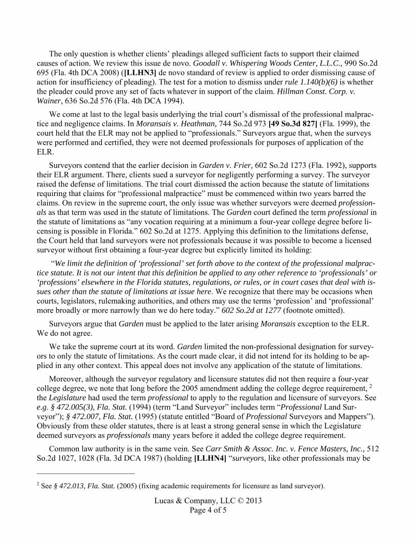
Lucas & Company, LLC © 2013 Page 4 of 5
The only question is whether clients’ pleadings alleged sufficient facts to support their claimed causes of action. We review this issue de novo. Goodall v. Whispering Woods Center, L.L.C., 990 So.2d 695 (Fla. 4th DCA 2008) ([LLHN3] de novo standard of review is applied to order dismissing cause of action for insufficiency of pleading). The test for a motion to dismiss under rule 1.140(b)(6) is whether the pleader could prove any set of facts whatever in support of the claim. Hillman Const. Corp. v. Wainer, 636 So.2d 576 (Fla. 4th DCA 1994).
We come at last to the legal basis underlying the trial court’s dismissal of the professional malprac-tice and negligence claims. In Moransais v. Heathman, 744 So.2d 973 [49 So.3d 827] (Fla. 1999), the court held that the ELR may not be applied to “professionals.” Surveyors argue that, when the surveys were performed and certified, they were not deemed professionals for purposes of application of the ELR.
Surveyors contend that the earlier decision in Garden v. Frier, 602 So.2d 1273 (Fla. 1992), supports their ELR argument. There, clients sued a surveyor for negligently performing a survey. The surveyor raised the defense of limitations. The trial court dismissed the action because the statute of limitations requiring that claims for “professional malpractice” must be commenced within two years barred the claims. On review in the supreme court, the only issue was whether surveyors were deemed profession-als as that term was used in the statute of limitations. The Garden court defined the term professional in the statute of limitations as “any vocation requiring at a minimum a four-year college degree before li-censing is possible in Florida.” 602 So.2d at 1275. Applying this definition to the limitations defense, the Court held that land surveyors were not professionals because it was possible to become a licensed surveyor without first obtaining a four-year degree but explicitly limited its holding:
“We limit the definition of ‘professional’ set forth above to the context of the professional malprac-tice statute. It is not our intent that this definition be applied to any other reference to ‘professionals’ or ‘professions’ elsewhere in the Florida statutes, regulations, or rules, or in court cases that deal with is-sues other than the statute of limitations at issue here. We recognize that there may be occasions when courts, legislators, rulemaking authorities, and others may use the terms ‘profession’ and ‘professional’ more broadly or more narrowly than we do here today.” 602 So.2d at 1277 (footnote omitted).
Surveyors argue that Garden must be applied to the later arising Moransais exception to the ELR. We do not agree.
We take the supreme court at its word. Garden limited the non-professional designation for survey-ors to only the statute of limitations. As the court made clear, it did not intend for its holding to be ap-plied in any other context. This appeal does not involve any application of the statute of limitations.
Moreover, although the surveyor regulatory and licensure statutes did not then require a four-year college degree, we note that long before the 2005 amendment adding the college degree requirement, 2 the Legislature had used the term professional to apply to the regulation and licensure of surveyors. See e.g. § 472.005(3), Fla. Stat. (1994) (term “Land Surveyor” includes term “Professional Land Sur-veyor”); § 472.007, Fla. Stat. (1995) (statute entitled “Board of Professional Surveyors and Mappers”). Obviously from these older statutes, there is at least a strong general sense in which the Legislature deemed surveyors as professionals many years before it added the college degree requirement.
Common law authority is in the same vein. See Carr Smith & Assoc. Inc. v. Fence Masters, Inc., 512 So.2d 1027, 1028 (Fla. 3d DCA 1987) (holding [LLHN4] “surveyors, like other professionals may be
2 See § 472.013, Fla. Stat. (2005) (fixing academic requirements for licensure as land surveyor).

Lucas & Company, LLC © 2013 Page 5 of 5
held liable for their negligent acts”). To like effect is Cristich v. Allen Engineering, Inc., 458 So.2d 76 (Fla. 5th DCA 1984), where the court noted that:
[49 So.3d 828] “land surveying requires a great degree of specialized knowledge. [T]he preparation of a survey, involving as it does such intricate knowledge of mathematics, geog-raphy and the physical sciences, is a ‘professional act.’” 458 So.2d at 79.
As the court further explained:
“Land surveying is regulated by the Board of Land Surveyors, Department of Professional Regulation, pursuant to Chapter 472, Florida Statutes (1981). Section 472.005 includes the following definition: (4)(a) ‘Practice of land surveying’ means, among other things, any professional service or work, the adequate performance of which involves the application of special knowledge of the principles of mathematics, the related physical and applied sci-ences….” 458 So.2d at 78-79.
This sense is understandable when one compares kindred professions like architecture and engineer-ing. As with architects and engineers, surveyors are engaged by clients to perform a skilled service solely under their control and competence. Their clients do not direct or specify their manner of perfor-mance in the same way, for example, a factory boss might direct and control production line personnel. The service to be performed by a surveyor is one requiring special education, training, experience and skill. Because of that fact the client is not competent to perform the service personally or to direct the person engaged to perform that service in any particular way. Their engagement contracts give clients of the professional no power of direction or manner, and leave performance up to the skill and expertise of the professional. Because the contracts lack such specifications, it would be incoherent to apply the ELR to these professionals. An action for professional malpractice is indeed the client’s remedy.
It follows, therefore, that it was error to dismiss clients’ claims for professional malpractice at the pleading stage. Florida pleading rules require only the allegation of ultimate facts stating a cause of ac-tion. See Fla. R. Civ. P. 1.110(b). The pleadings in this case met at least that requirement. As for the later added negligence, negligence per se and negligent misrepresentation claims, clients assert that they were induced by surveyors’ negligent misrepresentations as to the boundary and lack of encroachments to repeatedly engage them when they required professional surveys. We agree that their allegations con-tain a sufficient aspect of inducement to be exempt from the ELR. Allen v. Stephan Co., 784 So.2d 456, 457 (Fla. 4th DCA 2000). Reversed for further consistent proceedings.
GROSS, C.J., and DAMOORGIAN, J., concur.