Embed Size (px)
Citation preview
BOSQUE 33(3): 303-308, 2012 DOI: 10.4067/S0717-920020120003000013
303
Boundaries and mosaics: an approach to evaluate changes and to profit landscape planning, São Sebastião Island, SP/Brazil
Fronteras y mosaicos: una aproximación para evaluar cambios y apoyar la planificación del paisaje, São Sebastião Island- SP/Brazil
Lídia S Bertolo a*, Pilar M de Agar b, Carlos L de Pablo b, Rozely F Santos a,c
*Corresponding author: a Campinas State University, Environmental Planning Laboratory, SP, Brazil, tel.: (+55) (19)3521-2385, [email protected]
b Universidad Complutense de Madrid, Departamento de Ecología, Spain. c São Paulo University, Department of Ecology, Brazil.
SUMMARY
This study assumed that the spatial identification of mosaics obtained by the analysis of interactions between frontiers over time would be a great strategy to obtain planning units, since the boundaries reveal the changes, heterogeneity and fluxes in a landscape. For this purpose, we selected 16 watersheds in São Sebastião Island (São Paulo, BR), mapped the land use and cover (1962 and 2009) and built matrices of patches by boundaries. The analysis of these matrices using multivariate ordination and clustering allowed us to identify mosaics. The mosaics showed very well the temporal diversity of interactions across frontiers and the landscape conservation status, but had limitations to indicate management practices.
Key words: environmental planning, forest conservation, landscape ecology.
RESUMEN
Este estudio asume que la identificación espacial de mosaicos obtenida a través del análisis de interacciones entre fronteras en el tiempo sería una buena estrategia para obtener unidades de planificación, ya que los límites revelan los cambios, heterogeneidad y flujos en un paisaje. Para este propósito, se seleccionaron 16 cuencas en São Sebastião Island (São Paulo, BR), se mapeó el uso y cobertura de suelo (1962 y 2009) y construyeron matrices de parches por fronteras. El análisis de estas matrices usando ordenación y agrupamiento multivariado permitió identificar los mosaicos. Los mosaicos mostraron bien la diversidad temporal de interacciones a través de las fronteras y el estado de conservación del paisaje, pero tuvieron limitaciones en indicar prácticas de manejo.
Palabras clave: planificación ambiental, conservación de bosque, ecología de paisaje.
INTRODUCTION
The Brazilian landscapes have been showing the mul-tiplicity of accumulated uses over time, often resulting in very heterogeneous landscapes and generating major conflicts among social actors (Brito 2003). This territories are relevant to environmental planning (Polette and Sil-va 2003) because they are complex landscapes extremely fragile, which should be strongly conserved, but have numerous interests of human uses (Santos and Caldeyro 2007).
The heterogeneity, rarely discrete in a territory and de-rived from a wide range of habitats (Lovett et al. 2005); can be analyzed through the diversity of types and configu-ration of elements that compose the landscape, the intensi-ty of interaction between these elements and the nature of the relationship between the elements (Mimra 1993). It can also be observed by different kinds of pressure over natu-ral fragments (Gergel and Turner 2002), the porosity of the
matrix (Coulson et al. 1999) or by connectivity between elements (Li and Reynolds 1995, McGarigal and Marks 1995). It is important to note that one can not directly rela-te landscape complexity to presence of impacts. De Pablo (2000) has shown that certain landscapes structures may or may not cause negative impacts, depending on the types and quantities of interactions among their elements.
Several authors have interpreted the heterogeneity using the patch-corridor-matrix model (Forman 1995, Dramstad et al. 1996). Another way is to evaluate mosaics that reproduce specific sets of elements and their inte-ractions (Forman 1995, Roldán-Martin et al. 2003). This method identifies the mosaics as a set of patches with the same frequency of boundaries, that is, the same pattern of ecological interactions. Thus, they are part of a network of similar interactions (Cadenasso et al. 2003, Valverde et al. 2008). This conception assumes that boundaries or transition zones between patches are the areas where eco-logical flows take place, which can be altered by changes
BOSQUE 33(3): 303-308, 2012IUFRO Landscape Ecology Conference 2012: Sustaining humans and forests in changing landscapesBoundaries and mosaics approach
304
in the patterns of spatial arrangement (Roldán-Martin et al. 2006, Turner and Cardille 2007).
If each mosaic represents one aspect of heterogenei-ty and conservation status, it can be assumed that also it could have specifi c management actions. This is the pre-mise evaluated in this study. This study aims to evaluate the possibility of identifying management units through mosaics defi ned by the interactions between frontiers.
METHODS
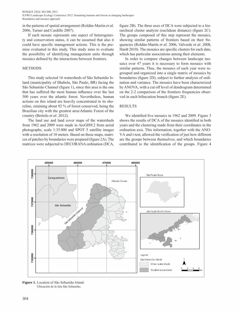
This study selected 16 watersheds of São Sebastião Is-land (municipality of Ilhabela, São Paulo, BR) facing the São Sebastião Channel (fi gure 1), since this area is the one that has suffered the most human infl uence over the last 500 years over the atlantic forest. Nevertheless, human actions on this island are heavily concentrated in its sho-reline, retaining about 92 % of forest conserved, being the Brazilian city with the greatest area/Atlantic Forest of the country (Bertolo et al. 2012).
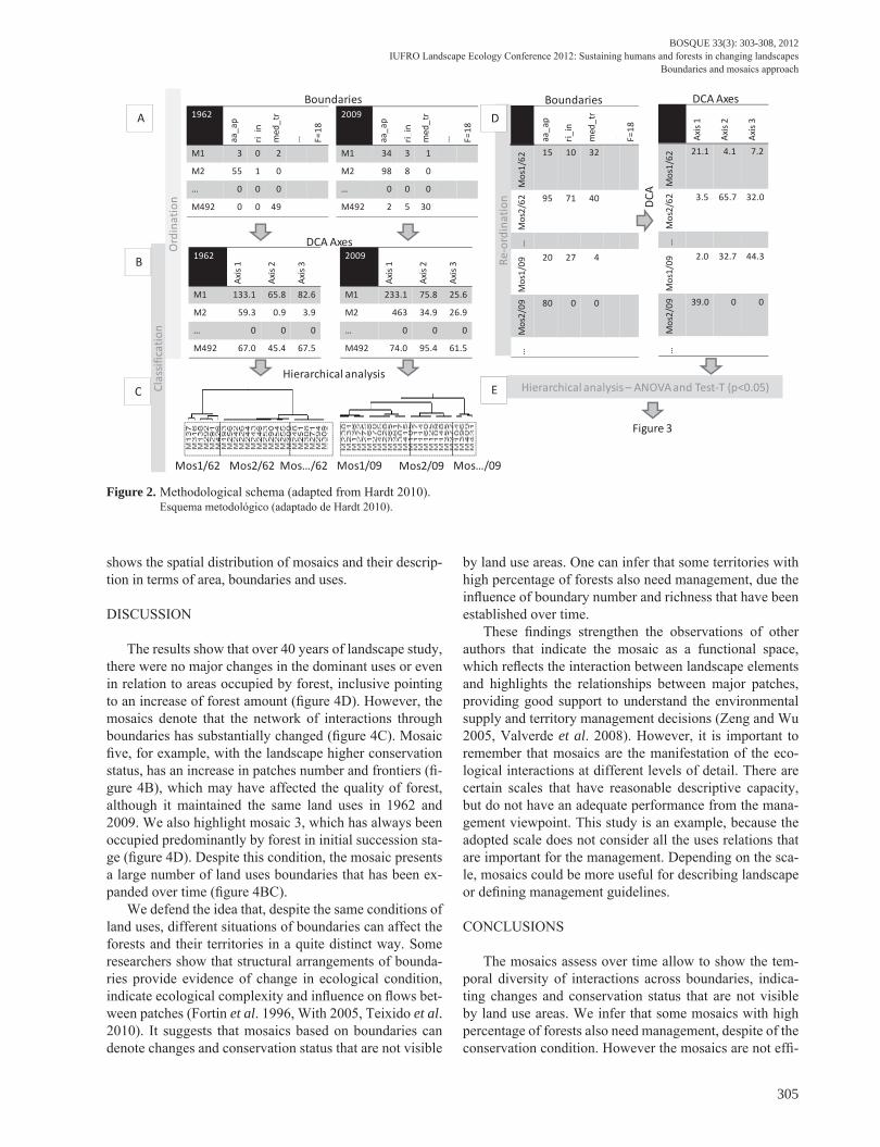
The land use and land cover maps of the watersheds from 1962 and 2009 were made in ArcGIS9.2 from aerial photographs, scale 1:35.000 and SPOT 5 satellite images with a resolution of 10 meters. Based on those maps, matri-ces of patches by boundaries were prepared (fi gure 2A). The matrices were subjected to DECORANA ordination (DCA,
fi gure 2B). The three axes of DCA were subjected to a hie-rarchical cluster analysis (euclidean distance) (fi gure 2C). The groups composed of this step represent the mosaics, showing similar patterns of frontiers based on their fre-quencies (Roldán-Martín et al. 2006, Valverde et al. 2008, Hardt 2010). The mosaics are specifi c clusters for each date, which has particular associations among their elements.
In order to compare changes between landscape mo-saics over 47 years it is necessary to form mosaics with similar patterns. Thus, the mosaics of each year were re-grouped and organized into a single matrix of mosaics by boundaries (fi gure 2D), subject to further analysis of ordi-nation and variance. The mosaics have been characterized by ANOVA, with a cut off level of dendrogram determined on the 2-2 comparison of the frontiers frequencies obser-ved in each bifurcation branch (fi gure 2E).
RESULTS
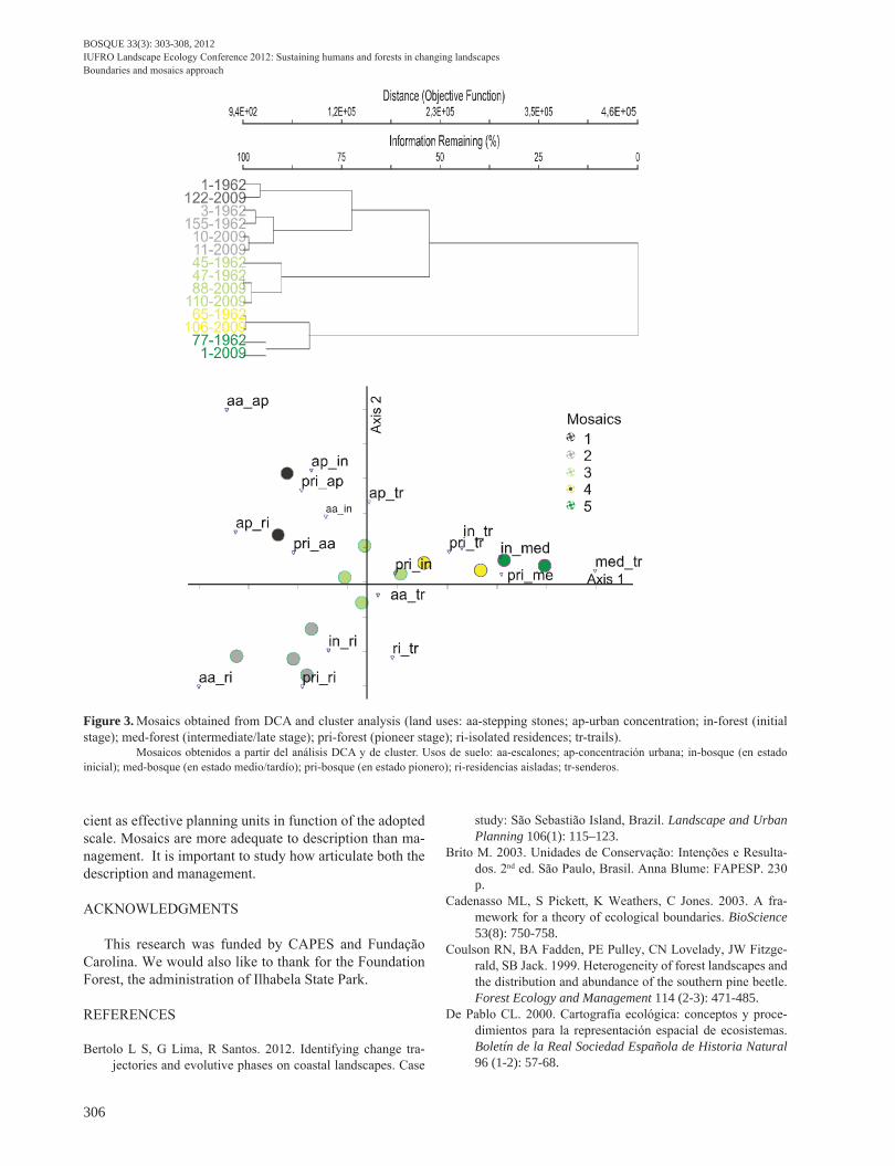
We identifi ed fi ve mosaics in 1962 and 2009. Figure 3 shows the results of DCA of the mosaics identifi ed in both years and the clustering made from their coordinates in the ordination axis. This information, together with the ANO-VA and t-test, allowed the verifi cation of just how different are the groups between themselves, and which boundaries contributed to the identifi cation of the groups. Figure 4
Figure 1. Location of São Sebastião Island. Ubicación de la Isla São Sebastião.
BOSQUE 33(3): 303-308, 2012IUFRO Landscape Ecology Conference 2012: Sustaining humans and forests in changing landscapes
Boundaries and mosaics approach
305
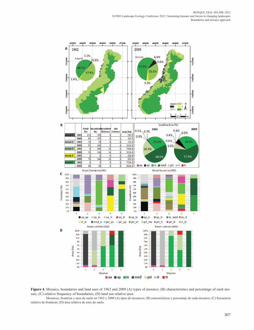
shows the spatial distribution of mosaics and their descrip-tion in terms of area, boundaries and uses.
DISCUSSION
The results show that over 40 years of landscape study, there were no major changes in the dominant uses or even in relation to areas occupied by forest, inclusive pointing to an increase of forest amount (fi gure 4D). However, the mosaics denote that the network of interactions through boundaries has substantially changed (fi gure 4C). Mosaic fi ve, for example, with the landscape higher conservation status, has an increase in patches number and frontiers (fi -gure 4B), which may have affected the quality of forest, although it maintained the same land uses in 1962 and 2009. We also highlight mosaic 3, which has always been occupied predominantly by forest in initial succession sta-ge (fi gure 4D). Despite this condition, the mosaic presents a large number of land uses boundaries that has been ex-panded over time (fi gure 4BC).
We defend the idea that, despite the same conditions of land uses, different situations of boundaries can affect the forests and their territories in a quite distinct way. Some researchers show that structural arrangements of bounda-ries provide evidence of change in ecological condition, indicate ecological complexity and infl uence on fl ows bet-ween patches (Fortin et al. 1996, With 2005, Teixido et al. 2010). It suggests that mosaics based on boundaries can denote changes and conservation status that are not visible
by land use areas. One can infer that some territories with high percentage of forests also need management, due the infl uence of boundary number and richness that have been established over time.
These fi ndings strengthen the observations of other authors that indicate the mosaic as a functional space, which refl ects the interaction between landscape elements and highlights the relationships between major patches, providing good support to understand the environmental supply and territory management decisions (Zeng and Wu 2005, Valverde et al. 2008). However, it is important to remember that mosaics are the manifestation of the eco-logical interactions at different levels of detail. There are certain scales that have reasonable descriptive capacity, but do not have an adequate performance from the mana-gement viewpoint. This study is an example, because the adopted scale does not consider all the uses relations that are important for the management. Depending on the sca-le, mosaics could be more useful for describing landscape or defi ning management guidelines.
CONCLUSIONS
The mosaics assess over time allow to show the tem-poral diversity of interactions across boundaries, indica-ting changes and conservation status that are not visible by land use areas. We infer that some mosaics with high percentage of forests also need management, despite of the conservation condition. However the mosaics are not effi -
1962
aa_a
p
ri_in
med
_tr
… F=18
M1 3 0 2
M2 55 1 0
… 0 0 0
M492 0 0 49
Boundaries2009
aa_a
p
ri_in
med
_tr
… F=18
M1 34 3 1
M2 98 8 0
… 0 0 0
M492 2 5 30
1962
Axis
1
Axis
2
Axis
3M1 133.1 65.8 82.6
M2 59.3 0.9 3.9
… 0 0 0
M492 67.0 45.4 67.5
DCA Axes2009
Axis
1
Axis
2
Axis
3
M1 233.1 75.8 25.6
M2 463 34.9 26.9
… 0 0 0
M492 74.0 95.4 61.5
Hierarchical analysis
Ord
inat
ion
Clas
sific
atio
n
(a)
(b)
(c)
Re-o
rdin
atio
n
(d)
aa_a
p
ri_in
med
_tr
… F=18
Mos
1/62
15 10 32
Mos
2/62 95 71 40
…M
os1/
09
20 27 4
Mos
2/09 80 0 0
…
Boundaries
Hierarchical analysis – ANOVA and Test-T (p<0.05)
DCA
Axis
1
Axis
2
Axis
3
Mos
1/62
21.1 4.1 7.2
Mos
2/62 3.5 65.7 32.0
…M
os1/
09
2.0 32.7 44.3
Mos
2/09 39.0 0 0
…
DCA Axes
(e)
Figure 3
Mos1/62 Mos2/62 Mos…/62 Mos1/09 Mos2/09 Mos…/09
A
B
C
D
E
Figure 2. Methodological schema (adapted from Hardt 2010). Esquema metodológico (adaptado de Hardt 2010).
BOSQUE 33(3): 303-308, 2012IUFRO Landscape Ecology Conference 2012: Sustaining humans and forests in changing landscapesBoundaries and mosaics approach
306
Figure 3. Mosaics obtained from DCA and cluster analysis (land uses: aa-stepping stones; ap-urban concentration; in-forest (initial stage); med-forest (intermediate/late stage); pri-forest (pioneer stage); ri-isolated residences; tr-trails). Mosaicos obtenidos a partir del análisis DCA y de cluster. Usos de suelo: aa-escalones; ap-concentración urbana; in-bosque (en estado inicial); med-bosque (en estado medio/tardío); pri-bosque (en estado pionero); ri-residencias aisladas; tr-senderos.
cient as effective planning units in function of the adopted scale. Mosaics are more adequate to description than ma-nagement. It is important to study how articulate both the description and management.
ACKNOWLEDGMENTS
This research was funded by CAPES and Fundação Carolina. We would also like to thank for the Foundation Forest, the administration of Ilhabela State Park.
REFERENCES
Bertolo L S, G Lima, R Santos. 2012. Identifying change tra-jectories and evolutive phases on coastal landscapes. Case
study: São Sebastião Island, Brazil. Landscape and Urban Planning 106(1): 115–123.
Brito M. 2003. Unidades de Conservação: Intenções e Resulta-dos. 2nd ed. São Paulo, Brasil. Anna Blume: FAPESP. 230 p.
Cadenasso ML, S Pickett, K Weathers, C Jones. 2003. A fra-mework for a theory of ecological boundaries. BioScience 53(8): 750-758.
Coulson RN, BA Fadden, PE Pulley, CN Lovelady, JW Fitzge-rald, SB Jack. 1999. Heterogeneity of forest landscapes and the distribution and abundance of the southern pine beetle. Forest Ecology and Management 114 (2-3): 471-485.
De Pablo CL. 2000. Cartografía ecológica: conceptos y proce-dimientos para la representación espacial de ecosistemas. Boletín de la Real Sociedad Española de Historia Natural 96 (1-2): 57-68.
BOSQUE 33(3): 303-308, 2012IUFRO Landscape Ecology Conference 2012: Sustaining humans and forests in changing landscapes
Boundaries and mosaics approach
307
Figure 4. Mosaics, boundaries and land uses of 1962 and 2009 (A) types of mosaics; (B) characteristics and percentage of each mo-saic; (C) relative frequency of boundaries; (D) land use relative area. Mosaicos, fronteras y usos de suelo en 1962 y 2009 (A) tipos de mosaicos; (B) características y porcentaje de cada mosaico; (C) frecuencia relativa de fronteras; (D) área relativa de usos de suelo.
Area
(ha)
Fron
tiers
(%)
Area
(ha)
BOSQUE 33(3): 303-308, 2012IUFRO Landscape Ecology Conference 2012: Sustaining humans and forests in changing landscapesBoundaries and mosaics approach
308
Dramstad W, J Olson, R Forman. 1996. Landscape ecology principles in landscape architecture and land-use planning. Washington, USA. Island Press. 80 p.
Forman R. 1995. Land mosaics: the ecology of landscapes and regions. Cambridge, UK. Cambridge University Press. 605 p.
Fortin M, P Drapeau, G Jacquez. 1996. Quantification of the spatial co-occurrences of ecological boundaries. Oikos 77: 51-60.
Hardt E. 2010. Conservação ambiental em cenários de uso: me-didas de mudanças, heterogeneidade e valoração da paisa-gem. Ph.D. Thesis. Campinas, SP, Brasil. Universidade Estadual de Campinas. 192 p.
Li H, J Reynolds. 1995. On definition and quantification of hete-rogeneity. Oikos 73: 280-284.
Lovett G, C Jones, M Turner, K Weathers. 2005. Ecosystem function in heterogeneous landscapes. New York, USA. Springer. 489 p.
Mcgarigal K, B Marks. 1995. FRAGSTATS: spatial pattern analysis program for quantifying landscape structure. USDA Forest Service General Technical Report PNW-GTR-351. Portland, OR, USA. Pacific Northwest Research Station. 122 p.
Mimra M. 1993. Spacial Heterogeneity Assessment of Cultural Landscape. Ph.D. Thesis. Prague, Czech. Czech University of Agriculture. 202 p.
Polette M, L Silva. 2003. GESAMP, ICAM E PNGC - Análise comparativa entre as metodologias de gerenciamento cos-teiro integrado. Ciência e Cultura 55(4): 27-31.
Roldán-Martín M J, C de Pablo, P Agar. 2003. Landscape mo-
saics recognition and changes over time: a methodologi-cal approach. In Mander U, M Antrop eds. Multifunctio-nal landscapes: continuity and change, v.3 Continuity and change. Southampton. 264 p.
Roldán-Martín M, C de Pablo, P Agar. 2006. Landscape changes over time: comparison of land uses, boundaries and mo-saics. Landscape Ecology 21: 1075-1088.
Santos RF, V Caldeyro. 2007. Paisagens, condicionantes e mu-danças. In Santos RF ed. Vulnerabilidade ambiental. Brasí-lia, DF, Brasil. Ministério do Meio Ambiente.13-22 p.
Teixido AL, L Quintanilli, F Carreno, D Gutierrez. 2010. Impacts of changes in land use and fragmentation patterns on Atlan-tic coastal forests in northern Spain. Journal of Environ-mental Management 91: 879–886.
Turner MG, J Cardille. 2007. Spatial heterogeneity and ecosys-tem processes. In Wu J, RJ Hobbs eds. Key topics in lands-cape ecology. Cambridge, UK. Cambridge University Press. p. 62-77.
Valverde V, M Roldán-Martín, G Campos, P Pérez, P Agar, C de Pablo. 2008. Análisis de la estructura espacial del paisaje: mosaicos del paisaje. In Maestre FT, A Escudero, A Bonet eds. Introducción al análisis espacial de dados en ecología y ciencias ambientales: métodos y aplicaciones. p. 747-759.
With KA. 2005. Landscape conservation: a new paradigm for the conservation of biodiversity. In Wiens J, M Moss. Is-sues and perspectives in landscape ecology. Cambridge, UK. Cambridge University Press. p. 238-247.
Zeng H, BX Wu. 2005. Utilities of edge-based metrics for stu-dying landscape fragmentation. Computers, Environment and Urban Systems 29: 159-178.
Recibido: 24.05.12Aceptado: 10.10.12