Embed Size (px)
Citation preview
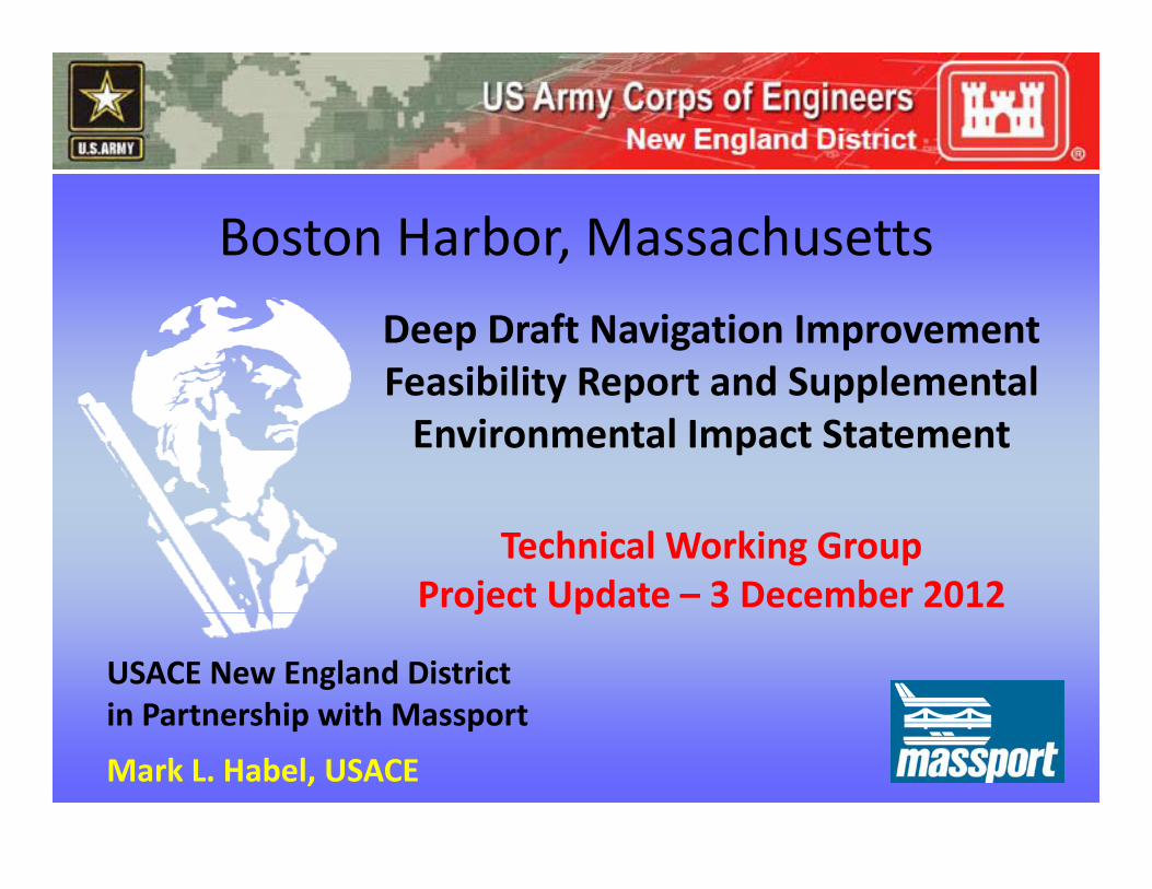
Boston Harbor, Massachusetts
Deep Draft Navigation Improvement Feasibility Report and SupplementalFeasibility Report and SupplementalEnvironmental Impact Statement
Technical Working Group Project Update – 3 December 2012
USACE New England District in Partnership with Massport
j p
in Partnership with Massport
Mark L. Habel, USACE
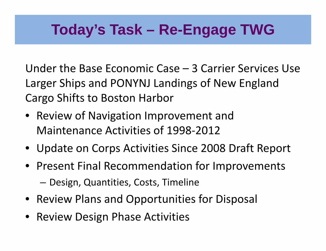
Today’s Task – Re-Engage TWG
Under the Base Economic Case – 3 Carrier Services Use Larger Ships and PONYNJ Landings of New England Cargo Shifts to Boston Harbor
• Review of Navigation Improvement and Maintenance Activities of 1998‐2012
• Update on Corps Activities Since 2008 Draft Report
• Present Final Recommendation for Improvements– Design, Quantities, Costs, Timeline
• Review Plans and Opportunities for Disposalpp p
• Review Design Phase Activities
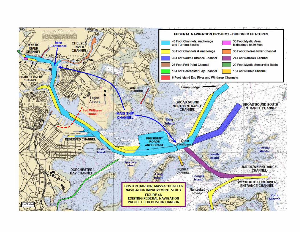
FEDERAL NAVIGATION PROJECT - DREDGED FEATURES
4O -F00I C"""",,ls . Anchoraoe lind T .. ning SHiM
l 5-F00I Myst ic Area Mltintained to lCI Feet
D l 5-F00I C"""",,,s & Arn:horaoe D l8 -F00I C"" ...... Ri¥er C""""'"
_ lG -FOOl Sou'" Entrance Channel _ 21 -F00I Narrows Channel
_ ll-FOOI Fort Point C"""",,, _ 2G -F00I Myst ic_Somerville 885in
D 18 -F00I Dofche500r 88y CIwIoeI D 15-F00I Nubble CIwIoeI
_ 6-l'ootlsland End Ri_ and W"'throp Channels
BOSTON HARBOR. MASSACHUSETTS NAVIGATION IMPROVEMENT STUDY
FIGURE .fA EXISTING FEDERAl NAVIGATION PROJECT FOR BOSTON HARBOR
. .
• ..<
.' '. i._ . .
. . .' .
CHELSEA RIVER
MYSTIC RIVER BOSTON HARBOR, MASSACHUSETTS
InnerConfluence
RIVERNAVIGATION IMPROVEMENT STUDY
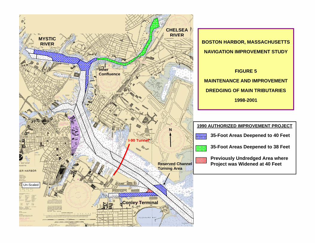
FIGURE 5
MAINTENANCE AND IMPROVEMENT
DREDGING OF MAIN TRIBUTARIES
1998-2001
N1990 AUTHORIZED IMPROVEMENT PROJECT
35-Foot Areas Deepened to 40 Feet
Reserved Channel T i A
I-90 Tunnel
35 Foot Areas Deepened to 40 Feet
35-Foot Areas Deepened to 38 Feet
Previously Undredged Area where Project was Widened at 40 Feet
Turning Area
Un-Scaled
Conley Terminal
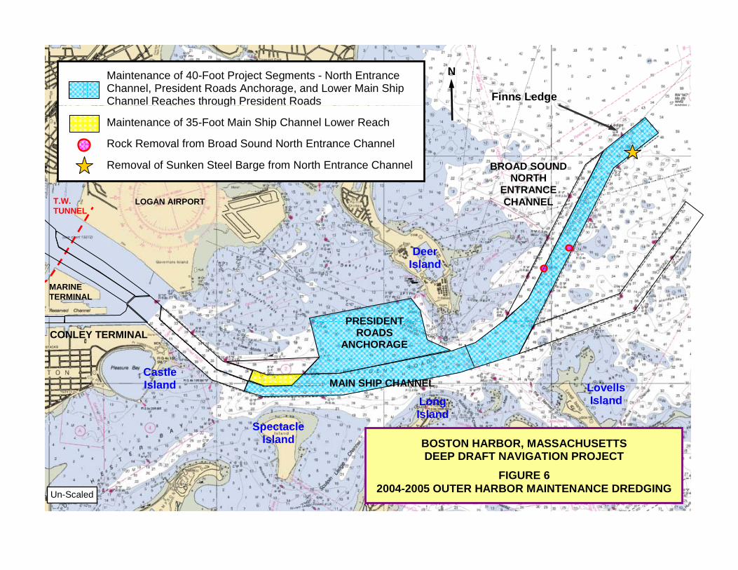
Maintenance of 40-Foot Project Segments - North Entrance Channel, President Roads Anchorage, and Lower Main Ship Channel Reaches through President Roads
N
Finns Ledge g Maintenance of 35-Foot Main Ship Channel Lower Reach Rock Removal from Broad Sound North Entrance Channel Removal of Sunken Steel Barge from North Entrance Channel
BROAD SOUND NORTHNORTH
ENTRANCE CHANNEL
Deer
LOGAN AIRPORT T.W. TUNNEL
MARINE TERMINAL
PRESIDENT
Deer Island
CONLEY TERMINAL PRESIDENT
ROADS ANCHORAGE
MAIN SHIP CHANNEL Castle Island Lovells
BOSTON HARBOR, MASSACHUSETTS DEEP DRAFT NAVIGATION PROJECT
SpectacleIsland
Long Island
Island
FIGURE 6 2004-2005 OUTER HARBOR MAINTENANCE DREDGING Un-Scaled
""~?-,,..,.,,"'-
~ iYn -j Channel
,;."j
BOSTON HARBOR, MASSACHUSETTS NAVIGATION IMPROVEMENT STlJOY
FIGURE 7A LOWER INNER HARBOR MAINTENANCE
.1:
"
... , . "
, .
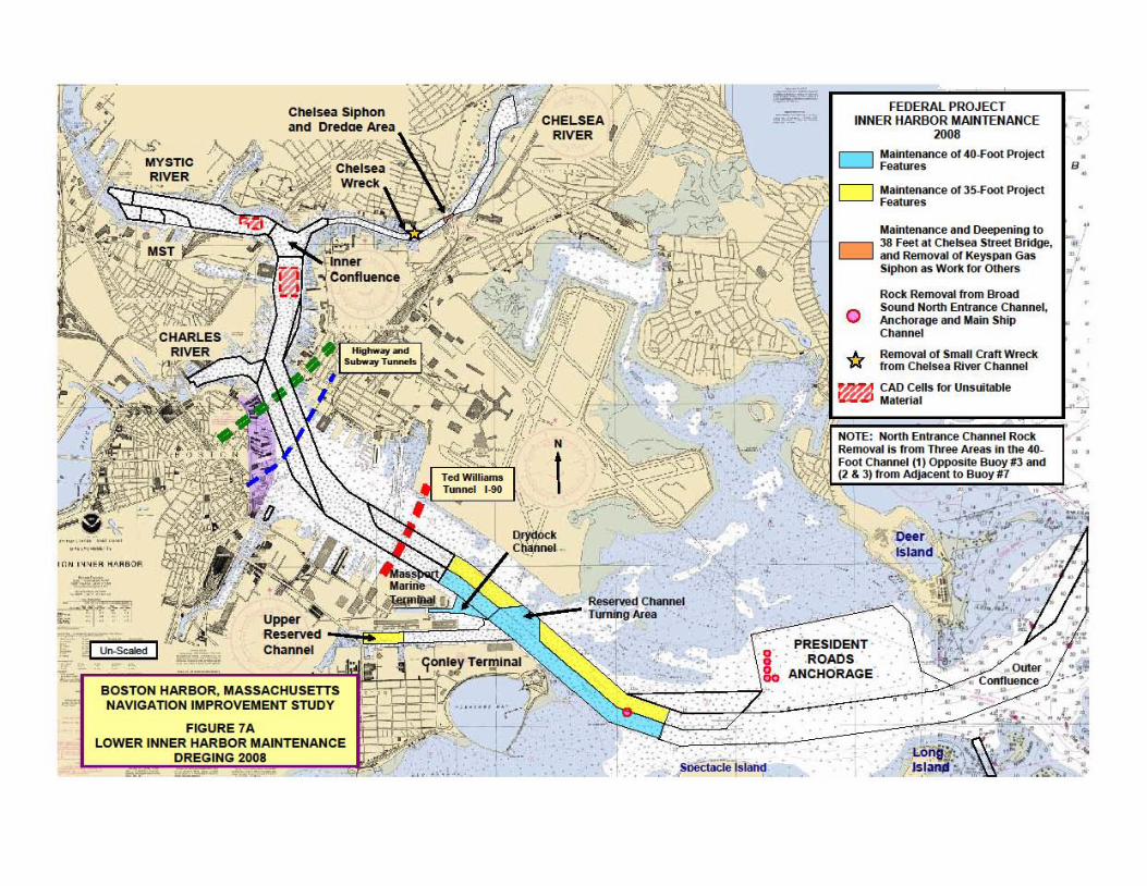
FEDERAL PROJECT INNER HARBOR MAINTENANCE
>00. • •
•
Maintenance of 4O-J'oot Protect •
D
o
. PRESIDENT ROADS '
ANCHORAGE
Featurn B
Mltintenance of J 5-Foot Protect F .... tures
M!tintenance and Deepening to )8 Feet at Chelsea Stroot Bridge, .... Removal of Ke)'Span Gas Siphon ItS WOfI< lor Othefs
Rode R"""",a/ from Elma<! Sound NOfth Enlr"""" Chan nel. Anchor_ and ""'in Ship Ch""neI
Remoyal of Smal l Crafr Wreck from Che15ea Ri.....-Chlln nel
CAD Cells for U ... uilllllie Material
• •
•
•
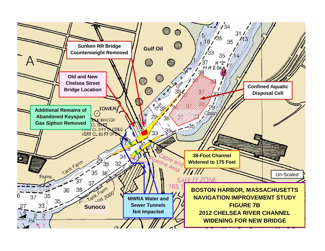
Sunken RR Bridge Gulf Oil
Old and New
Sunken RR Bridge Counterweight Removed
Old and New Chelsea Street
Bridge Location Confined Aquatic Disposal Cell
Additional Remains ofAdditional Remains of Abandoned Keyspan Gas Siphon Removed
U S l d
38-Foot Channel Widened to 175 Feet
BOSTON HARBOR, MASSACHUSETTS NAVIGATION IMPROVEMENT STUDY
FIGURE 7B
Un-Scaled
SMWRA Water and
Sewer Tunnels FIGURE 7B2012 CHELSEA RIVER CHANNEL
WIDENING FOR NEW BRIDGE
Sunoco Sewer TunnelsNot Impacted
BOSTON HARBOR, MASSACHUSETTS NAVIGATION IMPROVEMENT STUDY
FEDERAL PROJECT LOWER INNER HARBOR 2012
FIGURE 7C LOWER INNER HARBOR 2012 ROCK REMOVAL
N
Rock Removal from 7 Areas in the Lower Main Ship Channel
Logan Airport Ted Williams
Tunnel I-90
Deer Island
PRESIDENT ROADSConley Terminal ROADS
ANCHORAGEConley Terminal
Rock Areas
Long IslandSpectacle Island
Un-Scaled
Areas
71 °4'O"W 71°2'O"W
...:::.~:.'::::.:;:...-:~!~':..'.t:.'~"':,~"';,,~:;-=:-:: ,',:, - ", - , ,, - -<~ ,.,-~ ,,,~ ;, ,. '''' .... ''''' " "'"".... ... " .. ,_ ... .". .. """ .... ~" •• ~· ... "' · ... N, .... ~· ... ~' .. i" ... _'_ ,,""' ..... _ ,H .~.,_..-" .• T . ~, ........ , ." -,........,_.,.. " ,.
~=~:-.; ;~ .... -: -;:; ,~~: :.":'C~~,-:.::.ft~~";,';;'.:~ ~ . toMoI."""·'" ,_ ..... " ,' •• "'_~ ..... " , .... ~ ;;~; ... '.'.,~ ... U • __ ~ .C ,~ ~,.,_ ~ ~ ,~ .. ,,.,
...... ,.", .. " } ,
, ,.,.- , .... :~ ;!, ";) ,
71 °0'O"W 700 58'O"W
BOSTON HARBOR. MASSACHUSETTS PROJECTS DREDGED
BETWEEN 1998 AND 2012
o 05 1.5 2
i.:::..--~-~~~I"".' ~ Klometefs o
1:55,000 NOAA CHART 13270 GCS NAD1983
700 56'O"W 70 0 54'O"W
Legend: -- Boston Harbor Channel Extents
" ~' 1998-2001 Improvement Project
CT
_ 2004-2005 Ou ter Harbor Maintenance
_ 2008 Inner Harbor Maintenance
_ 2012 Chelsea River Widening
? 9
-o.t-~ c:I- 8J 1-. ...
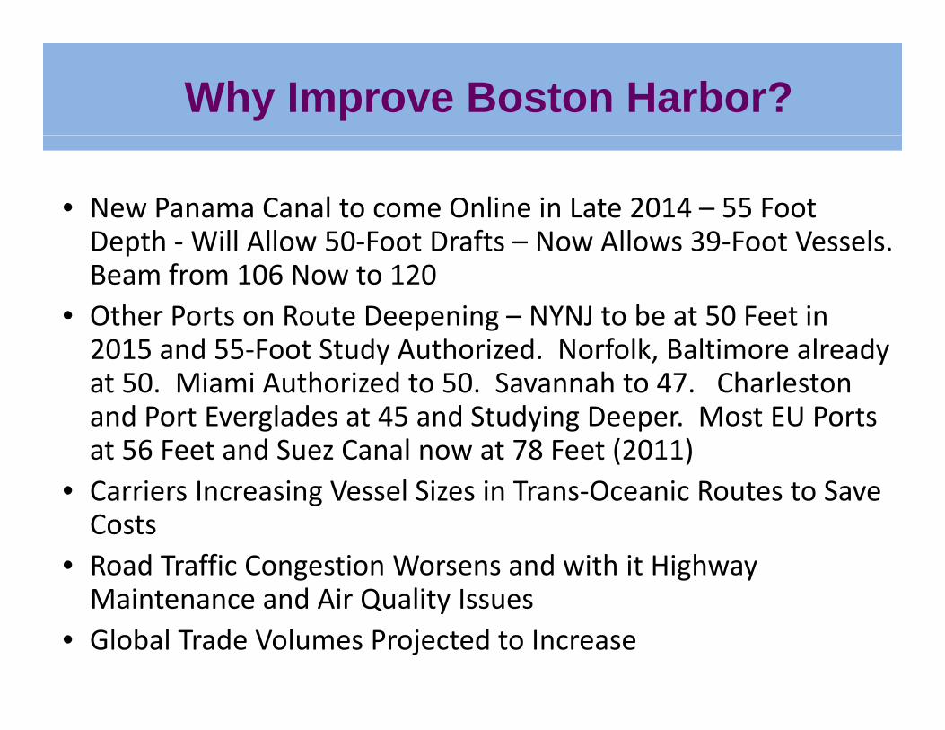
Why Improve Boston Harbor?
• New Panama Canal to come Online in Late 2014 – 55 Foot Depth ‐Will Allow 50‐Foot Drafts – Now Allows 39‐Foot Vessels. Beam from 106 Now to 120
• Other Ports on Route Deepening – NYNJ to be at 50 Feet inOther Ports on Route Deepening NYNJ to be at 50 Feet in 2015 and 55‐Foot Study Authorized. Norfolk, Baltimore already at 50. Miami Authorized to 50. Savannah to 47. Charleston d P t E l d t 45 d St d i D M t EU P tand Port Everglades at 45 and Studying Deeper. Most EU Ports
at 56 Feet and Suez Canal now at 78 Feet (2011) • Carriers Increasing Vessel Sizes in Trans‐Oceanic Routes to Save gCosts
• Road Traffic Congestion Worsens and with it Highway Maintenance and Air Quality IssuesMaintenance and Air Quality Issues
• Global Trade Volumes Projected to Increase
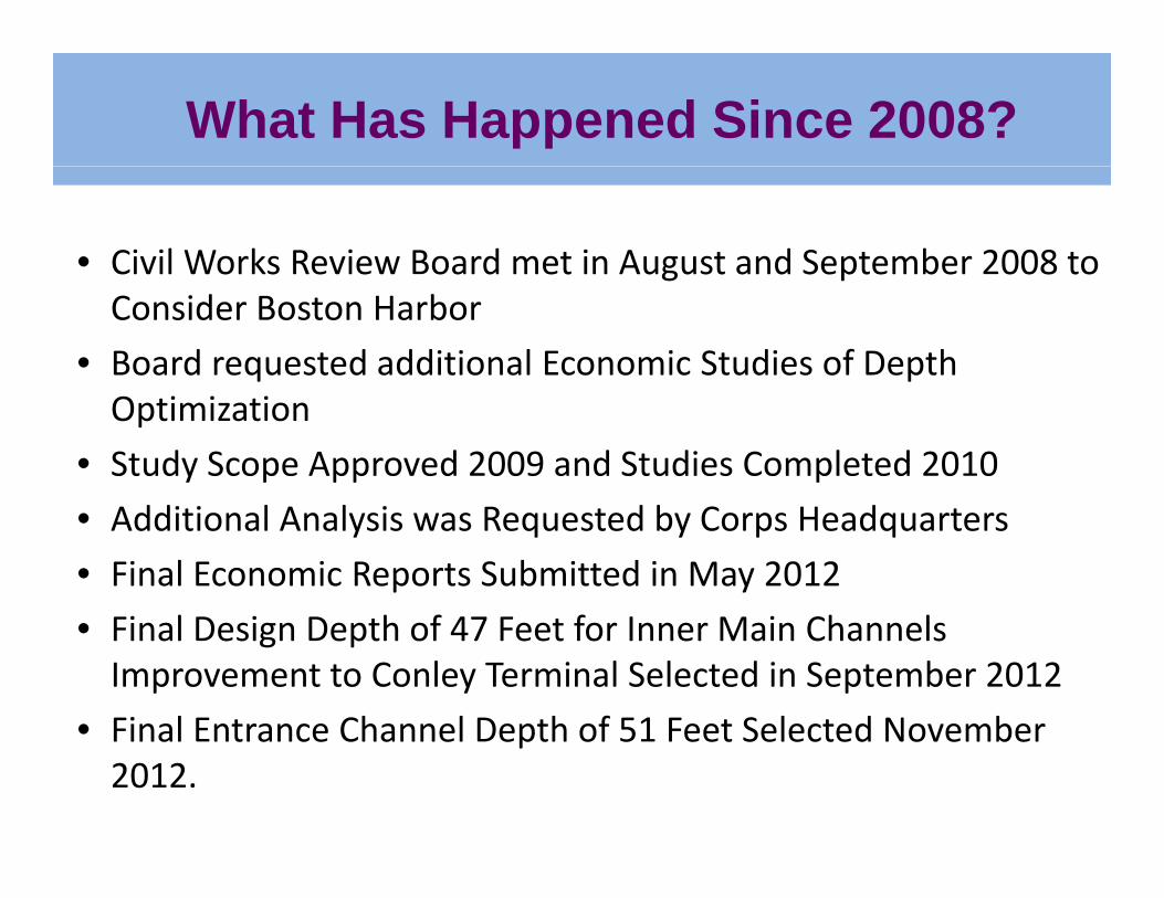
What Has Happened Since 2008?
• Civil Works Review Board met in August and September 2008 to g pConsider Boston Harbor
• Board requested additional Economic Studies of Depth Optimization
• Study Scope Approved 2009 and Studies Completed 2010
dd l l d b d• Additional Analysis was Requested by Corps Headquarters
• Final Economic Reports Submitted in May 2012
Fi l D i D th f 47 F t f I M i Ch l• Final Design Depth of 47 Feet for Inner Main Channels Improvement to Conley Terminal Selected in September 2012
• Final Entrance Channel Depth of 51 Feet Selected November• Final Entrance Channel Depth of 51 Feet Selected November 2012.
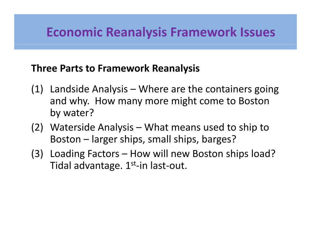
Economic Reanalysis Framework Issues
Three Parts to Framework Reanalysis
(1) Landside Analysis – Where are the containers going and why. How many more might come to Boston y y gby water?
(2) Waterside Analysis – What means used to ship to l h ll h b ?Boston – larger ships, small ships, barges?
(3) Loading Factors – How will new Boston ships load? Tidal advantage 1st in last outTidal advantage. 1st‐in last‐out.
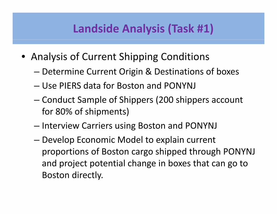
Landside Analysis (Task #1)
• Analysis of Current Shipping Conditions– Determine Current Origin & Destinations of boxes
– Use PIERS data for Boston and PONYNJ
– Conduct Sample of Shippers (200 shippers account for 80% of shipments)
– Interview Carriers using Boston and PONYNJ
– Develop Economic Model to explain current proportions of Boston cargo shipped through PONYNJ and project potential change in boxes that can go to Boston directlyBoston directly.
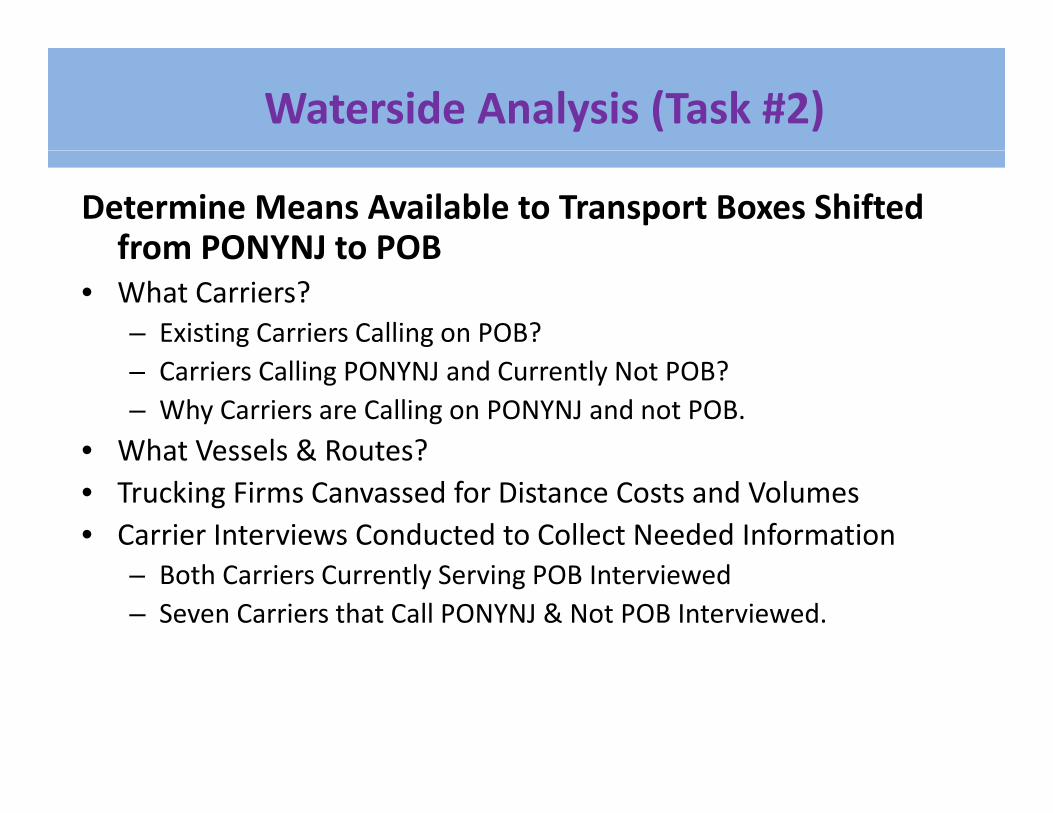
Waterside Analysis (Task #2)
Determine Means Available to Transport Boxes Shifted from PONYNJ to POBfrom PONYNJ to POB
• What Carriers?– Existing Carriers Calling on POB?– Carriers Calling PONYNJ and Currently Not POB?– Why Carriers are Calling on PONYNJ and not POB.
• What Vessels & Routes?What Vessels & Routes?• Trucking Firms Canvassed for Distance Costs and Volumes• Carrier Interviews Conducted to Collect Needed Information
– Both Carriers Currently Serving POB Interviewed– Seven Carriers that Call PONYNJ & Not POB Interviewed.
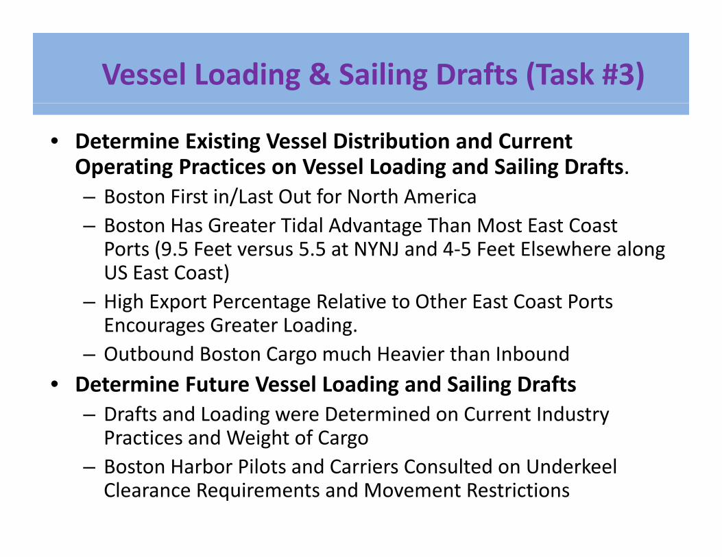
Vessel Loading & Sailing Drafts (Task #3)
• Determine Existing Vessel Distribution and Current Operating Practices on Vessel Loading and Sailing Drafts.Operating Practices on Vessel Loading and Sailing Drafts.– Boston First in/Last Out for North America– Boston Has Greater Tidal Advantage Than Most East Coast P t (9 5 F t 5 5 t NYNJ d 4 5 F t El h lPorts (9.5 Feet versus 5.5 at NYNJ and 4‐5 Feet Elsewhere along US East Coast)
– High Export Percentage Relative to Other East Coast Ports Encourages Greater Loading.
– Outbound Boston Cargo much Heavier than Inbound• Determine Future Vessel Loading and Sailing Drafts• Determine Future Vessel Loading and Sailing Drafts
– Drafts and Loading were Determined on Current Industry Practices and Weight of Cargo
– Boston Harbor Pilots and Carriers Consulted on Underkeel Clearance Requirements and Movement Restrictions
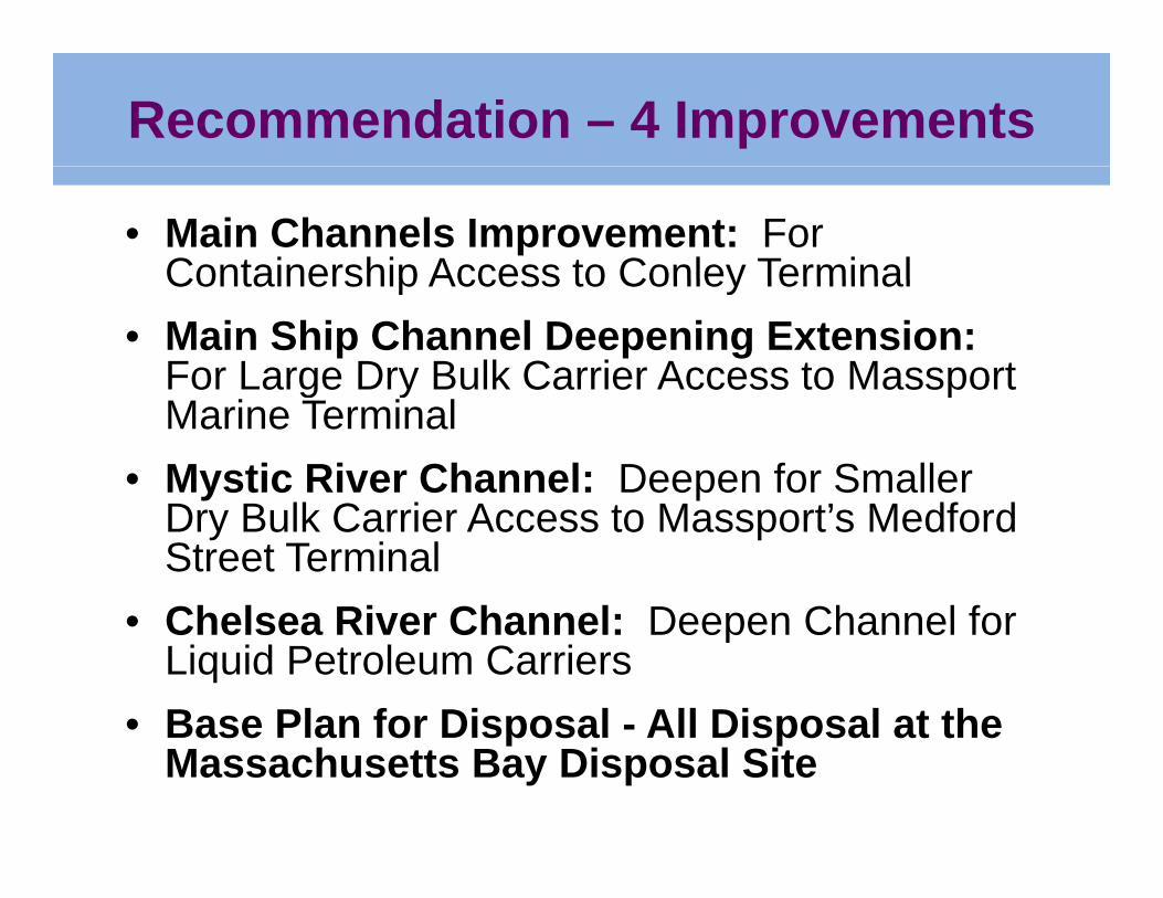
Recommendation – 4 Improvements
• Main Channels Improvement: For Containership Access to Conley TerminalContainership Access to Conley Terminal
• Main Ship Channel Deepening Extension: For Large Dry Bulk Carrier Access to Massport g y pMarine Terminal
• Mystic River Channel: Deepen for Smaller D B lk C i A t M t’ M df dDry Bulk Carrier Access to Massport’s Medford Street Terminal
• Chelsea River Channel: Deepen Channel for• Chelsea River Channel: Deepen Channel for Liquid Petroleum Carriers
• Base Plan for Disposal - All Disposal at theBase Plan for Disposal All Disposal at the Massachusetts Bay Disposal Site
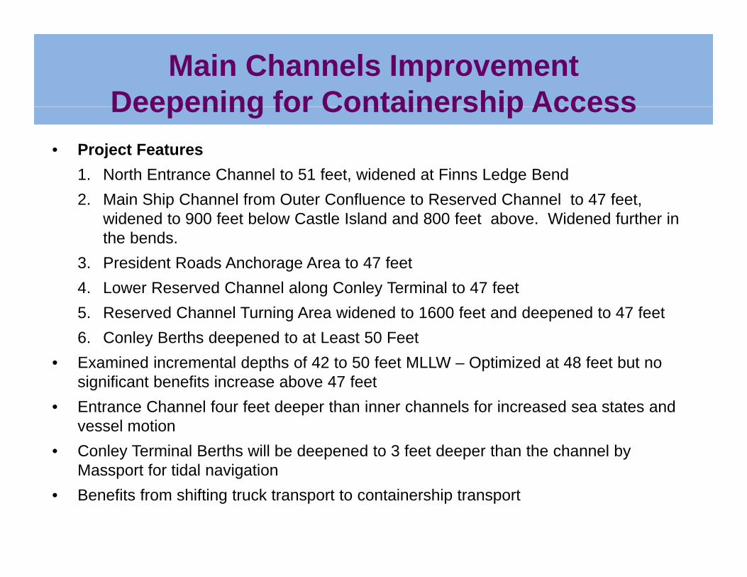
Main Channels ImprovementDeepening for Containership AccessDeepening for Containership Access
• Project Features 1. North Entrance Channel to 51 feet, widened at Finns Ledge Bend1. North Entrance Channel to 51 feet, widened at Finns Ledge Bend2. Main Ship Channel from Outer Confluence to Reserved Channel to 47 feet,
widened to 900 feet below Castle Island and 800 feet above. Widened further in the bends.
3. President Roads Anchorage Area to 47 feet4. Lower Reserved Channel along Conley Terminal to 47 feet5. Reserved Channel Turning Area widened to 1600 feet and deepened to 47 feet6. Conley Berths deepened to at Least 50 Feet
• Examined incremental depths of 42 to 50 feet MLLW – Optimized at 48 feet but no significant benefits increase above 47 feet
• Entrance Channel four feet deeper than inner channels for increased sea states and vessel motion
• Conley Terminal Berths will be deepened to 3 feet deeper than the channel by Massport for tidal navigationMassport for tidal navigation
• Benefits from shifting truck transport to containership transport
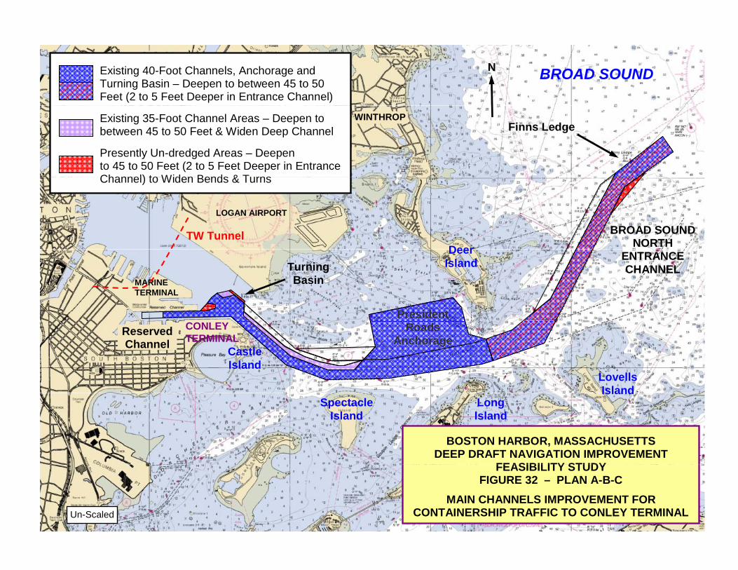
Existing 40-Foot Channels, Anchorage and Turning Basin – Deepen to between 45 to 50 Feet (2 to 5 Feet Deeper in Entrance Channel)
N BROAD SOUND
Existing 35-Foot Channel Areas – Deepen to between 45 to 50 Feet & Widen Deep Channel Presently Un-dredged Areas – Deepen to 45 to 50 Feet (2 to 5 Feet Deeper in Entrance Channel) to Widen Bends & Turns
Finns Ledge
WINTHROP
Channel) to Widen Bends & Turns
TW Tunnel
LOGAN AIRPORT
BROAD SOUND NORTH Deer
MARINE TERMINAL
ENTRANCE CHANNEL Turning
Basin
Deer Island
President CONLEY TERMINAL
Castle Island
Roads Anchorage
Lovells Island
Reserved Channel
BOSTON HARBOR, MASSACHUSETTS DEEP DRAFT NAVIGATION IMPROVEMENT
FEASIBILITY STUDY
Spectacle Island
IslandLongIsland
FEASIBILITY STUDYFIGURE 32 – PLAN A-B-C
MAIN CHANNELS IMPROVEMENT FOR CONTAINERSHIP TRAFFIC TO CONLEY TERMINAL Un-Scaled
BOSTON HARBOR, MASSACHUSETTS DEEP DRAFT NAVIGATION IMPROVEMENT
FEASIBILITY STUDY
Un-Scaled
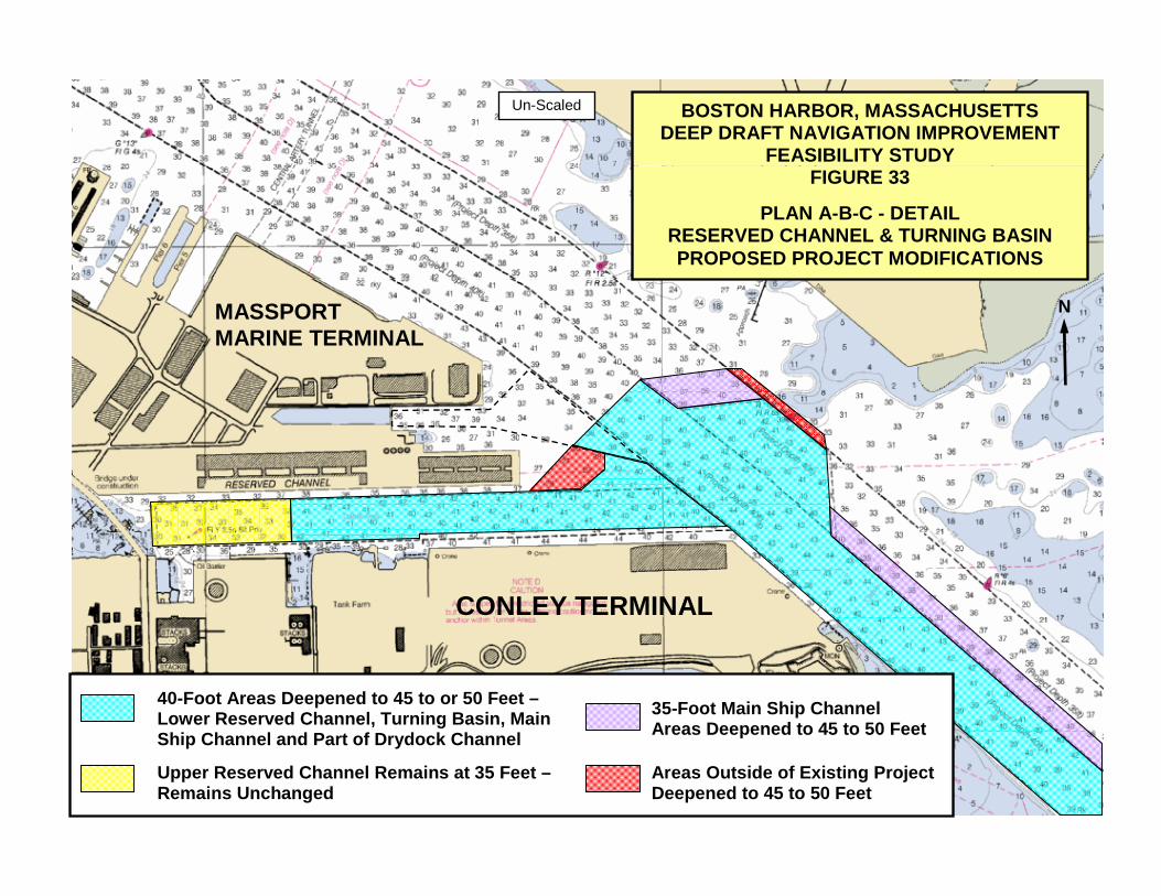
FIGURE 33
PLAN A-B-C - DETAIL RESERVED CHANNEL & TURNING BASIN PROPOSED PROJECT MODIFICATIONS
N
MASSPORT MARINE TERMINAL
CONLEY TERMINAL
40-Foot Areas Deepened to 45 to or 50 Feet – Lower Reserved Channel, Turning Basin, Main 35-Foot Main Ship Channel
Areas Deepened to 45 to 50 FeetShip Channel and Part of Drydock Channel Areas Deepened to 45 to 50 Feet
Upper Reserved Channel Remains at 35 Feet – Remains Unchanged Areas Outside of Existing Project
Deepened to 45 to 50 Feet
BOSTON HARBOR, MASSACHUSETTS DEEP DRAFT NAVIGATION IMPROVEMENT
FEASIBILITY STUDY
N
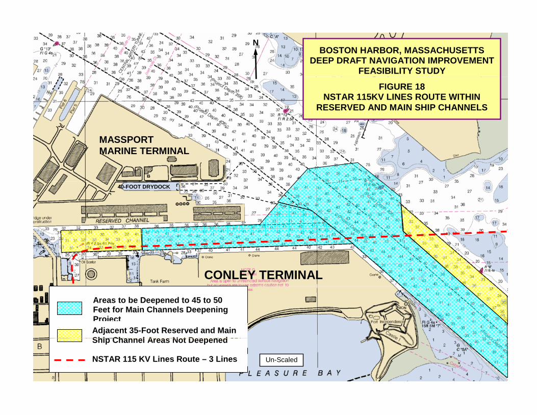
FIGURE 18 NSTAR 115KV LINES ROUTE WITHIN
RESERVED AND MAIN SHIP CHANNELS
MASSPORT MARINE TERMINAL
40-FOOT DRYDOCK
CONLEY TERMINAL
Areas to be Deepened to 45 to 50Feet for Main Channels Deepening ProjectAdjacent 35-Foot Reserved and Main Ship Channel Areas Not DeepenedShip Channel Areas Not Deepened
NSTAR 115 KV Lines Route – 3 Lines Un-Scaled
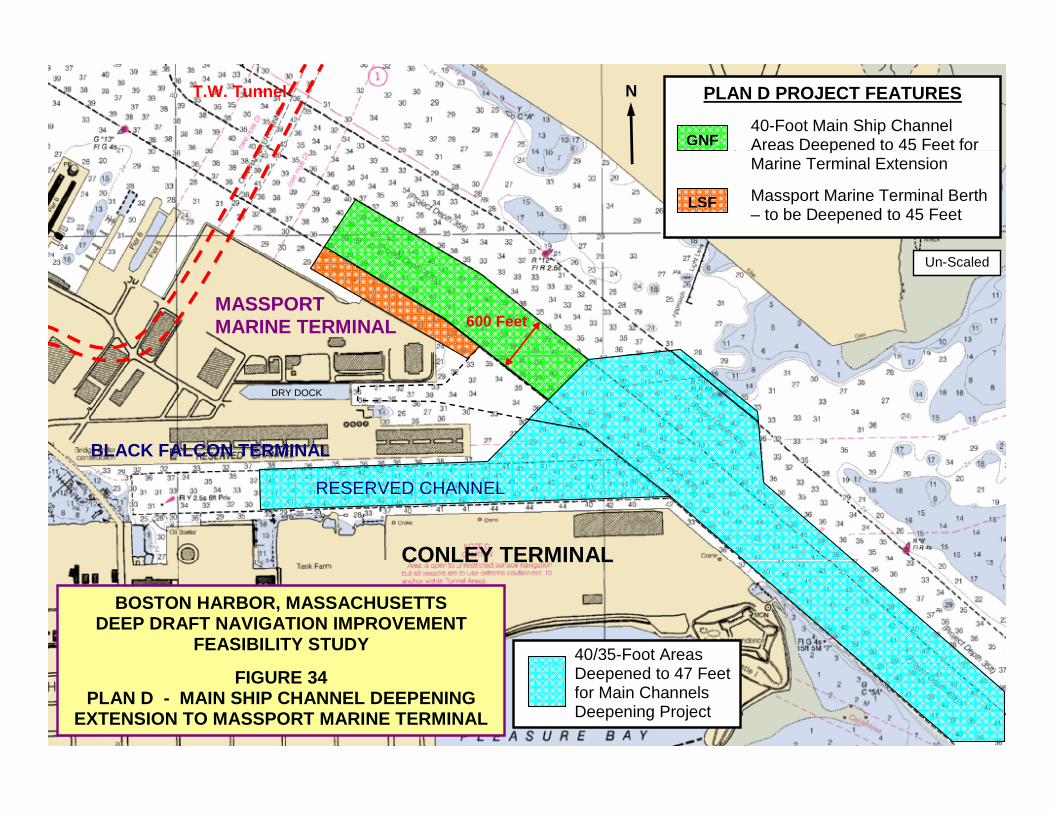
PLAN D PROJECT FEATURES 40-Foot Main Ship Channel Areas Deepened to 45 Feet for GNF
N T.W. Tunnel
pMarine Terminal Extension Massport Marine Terminal Berth – to be Deepened to 45 Feet
LSF
MASSPORT MARINE TERMINAL
Un-Scaled
600 Feet
BLACK FALCON TERMINAL
DRY DOCK
CONLEY TERMINAL
RESERVED CHANNEL
BOSTON HARBOR, MASSACHUSETTSDEEP DRAFT NAVIGATION IMPROVEMENT
FEASIBILITY STUDY
CONLEY TERMINAL
40/35-Foot Areas
FIGURE 34 PLAN D - MAIN SHIP CHANNEL DEEPENING
EXTENSION TO MASSPORT MARINE TERMINAL
Deepened to 47 Feet for Main Channels Deepening Project
ExxonProlerized Distrigas
BOSTON HARBOR, MASSACHUSETTS FEASIBILITY STUDY
Boston Generating (Power Plant) Exxon
(Petroleum)(Scrap) Distrigas
(LNG) FIGURE 35 - NAVIGATION IMPROVEMENTS PLAN E - MYSTIC RIVER PROJECT FEATURES
30-Foot
35-Foot
40 F t
40-Foot Mystic Channel Deepen for MST
35-Foot 30-Foot
G O O C
Massport Boston Autoport
40-Foot Inner
Confluence Massport – Medford Street Terminal (Bulk)
U.S.Gypsum
FEDERAL NAVIGATION PROJECTIMPROVEMENT FEATURES – MYSTIC RIVER CHANNEL
Improvement – Deepen 35-Foot Mystic River Area at Massport’s Medford Street Terminal to -40 Feet MLLW
40-Foot Main Ship
40-Foot Main Ship Channel, Inner Confluence and Mystic River Channel Areas – No Changes 35-Foot Main Ship Channel Lane & Mystic River Areas No Changes Mystic River Channel Area Authorized to 35 Feet but
N
Channel
35
Mystic River Channel – Area Authorized to 35 Feet but only Deepened and Maintained to 30 Feet – No Changes Un-Scaled
35 Ft
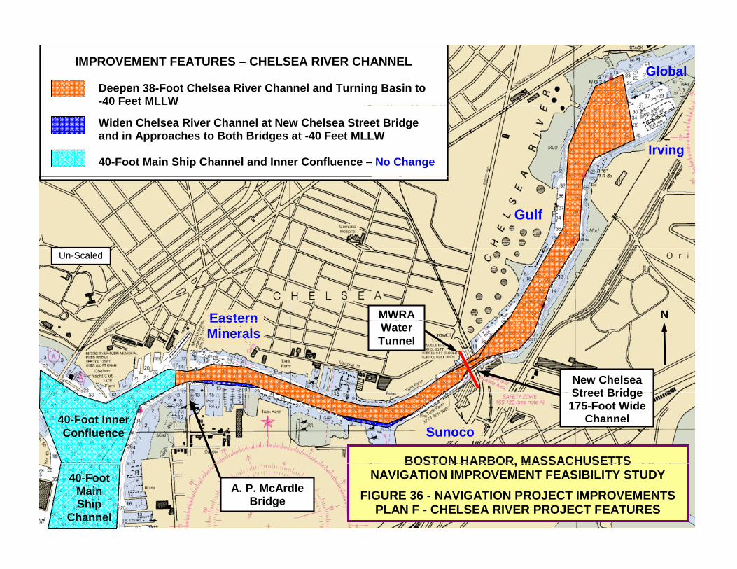
IMPROVEMENT FEATURES – CHELSEA RIVER CHANNEL
Deepen 38-Foot Chelsea River Channel and Turning Basin to -40 Feet MLLW
Global
Widen Chelsea River Channel at New Chelsea Street Bridge and in Approaches to Both Bridges at -40 Feet MLLW 40-Foot Main Ship Channel and Inner Confluence – No Change
Irving
Gulf
N
Un-Scaled
Eastern MWRA
New Chelsea Street Bridge
Eastern Minerals Water
Tunnel
BOSTON HARBOR, MASSACHUSETTS
Street Bridge175-Foot Wide
Channel40-Foot Inner Confluence Sunoco
BOSTON HARBOR, MASSACHUSETTSNAVIGATION IMPROVEMENT FEASIBILITY STUDY
FIGURE 36 - NAVIGATION PROJECT IMPROVEMENTS PLAN F - CHELSEA RIVER PROJECT FEATURES
A. P. McArdleBridge
40-Foot Main Ship
Channel
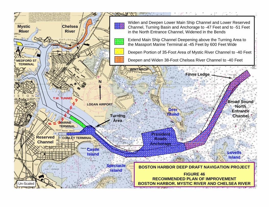
Widen and Deepen Lower Main Ship Channel and Lower Reserved Channel, Turning Basin and Anchorage to -47 Feet and to -51 Feet in the North Entrance Channel, Widened in the Bends E t d M i Shi Ch l D i b th T i A t
Chelsea River
Mystic River
Extend Main Ship Channel Deepening above the Turning Area to the Massport Marine Terminal at -45 Feet by 600 Feet Wide Deepen Portion of 35-Foot Area of Mystic River Channel to -40 Feet Deepen and Widen 38-Foot Chelsea River Channel to -40 Feet MEDFORD ST
TERMINAL
N
Finns Ledge
TERMINAL WINTHROP
Broad Sound
North Entrance Channel
LOGAN AIRPORT
T.W. TUNNEL
Deer IslandTurning
CONLEY TERMINAL
MARINE TERMINAL
Channel
Reserved Channel
President Roads
A h
Turning Area
BOSTON HARBOR DEEP DRAFT NAVIGATION PROJECT
Channel
Spectacle I l d
CastleIsland
Anchorage
LovellsIsland
FIGURE 46 RECOMMENDED PLAN OF IMPROVEMENT
BOSTON HARBOR, MYSTIC RIVER AND CHELSEA RIVER Un-Scaled
Island
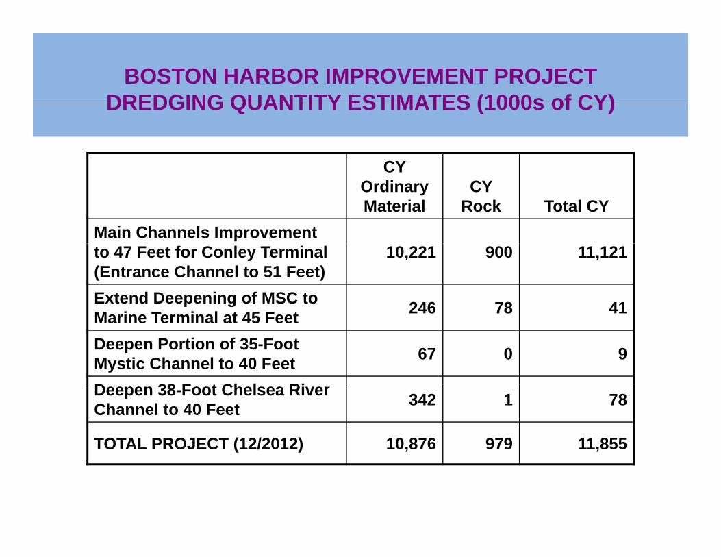
BOSTON HARBOR IMPROVEMENT PROJECTDREDGING QUANTITY ESTIMATES (1000s of CY)DREDGING QUANTITY ESTIMATES (1000s of CY)
CY Ordinary Material
CY Rock Total CY
Main Channels Improvement to 47 Feet for Conley Terminal (Entrance Channel to 51 Feet)
10,221 900 11,121
Extend Deepening of MSC to M i T i l t 45 F t 246 78 41Marine Terminal at 45 FeetDeepen Portion of 35-Foot Mystic Channel to 40 Feet 67 0 9
D 38 F t Ch l RiDeepen 38-Foot Chelsea River Channel to 40 Feet 342 1 78
TOTAL PROJECT (12/2012) 10,876 979 11,855
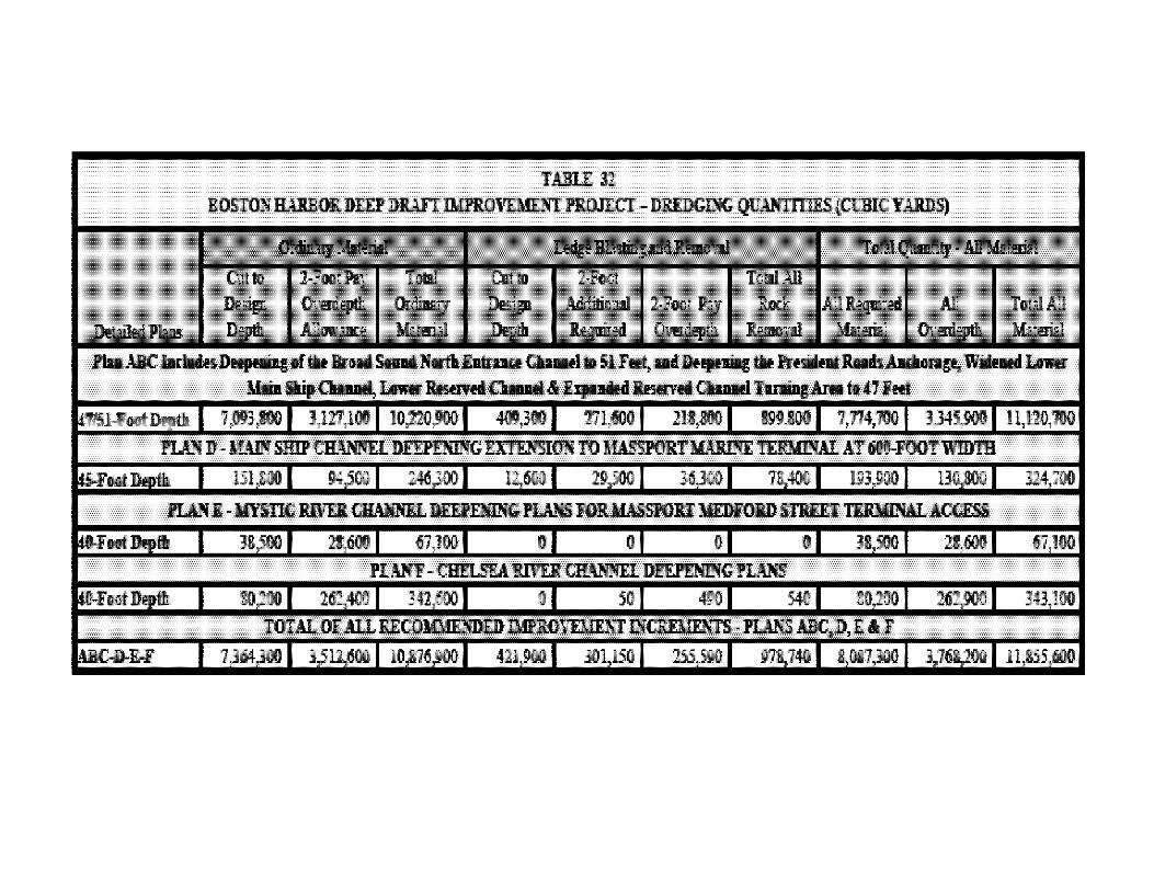
TJJJ:LE D B05TOIfIWlBO!l.DElPDI.lFTIMPItOVEML~ ROJICT -DHlDGDiIG QUANTI11IS(CllBICYARIS)
~ QdilMJ
DIt!p'WPIa AIlIwIlllt ...... fiIIIaiIl ......
PIa ABC '-I11III8 Deqteeiac If. Br.d SlIIIIIIIIrIII ~CIIaHl to 51 rlllJt"IIIIIIJ'irHp-iIc • Pmidafllillls AIdIiin&e. 'I'iIIueIl~ J&iII CIIaHl6 Jle!!med CIIaHl .. ,' Fet
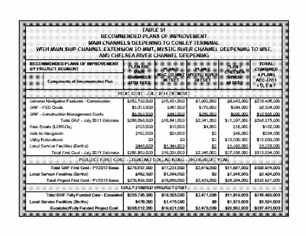
TABLE 51 RECOMMENDED P'LANS OF IMP'ROVEMENT
MAlIN CHANNELS DEEP'ENIIIG TO CONLEY TERMINAL WITH MAlIN SHIP' CHANNEL EXTENSION TO MIMI, MYSTIC RIVER CHANNEL DEEPENING TO MIST.
AND CHELSEA RIVER CHANNEL DEEP'ENING
RECOIIIIEnDED PU1115 OF RPROVEIIENT BY PROJECT IiEGMBIT ...
ClWI\ELII 4lllit FEE!
PLUIID PLUIIE IIIiC TO 1lIIY 11IIn1'\ln!l1r RIVEIII
_FlEET
RR5T COST -JULY 2111 ESTIMATE
General
GNF - PED Casts
GNF -~ Management Ccsts
TotalGNF - :an Estim. Real EsIBIie (LERROs)
Aiid!i to NnigatiilYl
·15.373.£100 $110.000
S2GgOOll
UliIitJt RBllICStians III
loo::al Service FllCiilities !!! TDIaI FlrstCost- :al1 Estim.
PROJECT FIRST COST -CONS1JIiIIT DOlUIR BASIS - 2113 BUDGE! YEAR
Total GNF Filst Cost - PY2013 Basis
loo::al Service FllCiilities rElettnJ;;~
TDIaI FIr!if: Cost - PY2013 Basis
TDIaI GNF FullyFIII!IdIed CosI
Serrice FllCiilities (8eIthis)
FI.JLLY FUNDED PROJECT COST
SM1!i.ooo
$2.411.000
III
$304.000
TOTAl... COIIBlfED .PUlllIi
ABC-41111i1 +D, E&F
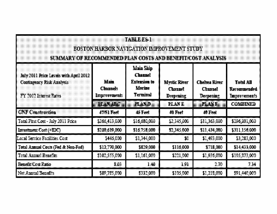
TABU!.E>l
BOSTONR.umoKNA\1GA110NIMPROl'DfENT STIlDY
~Y OF RECOMUlNDEDPLAN COSTS.oU;1) BENDlTICOST ANALYSIS
Joly 2m 1 Price.Lm!Is. wifII April 2012
~RBt~ MailI Cbllllll'.b
blpIlIIItmIIIh
.I.baSlUp
Orrnd ~ ..
IIuiIle raMi II
JII..Ilt:D
45I'HlI:
11,1.1,000
L40
!Ir.I:J!ifu:: Iirer: CW!R1irer: Q .... l 0-"
DHpaiar; DHptaiIIc
JII..IltI JII..Ilt:r
"FHI: .FHlI:
TofBAil ko- :_ •• Impnftlllllllh
COMmNED
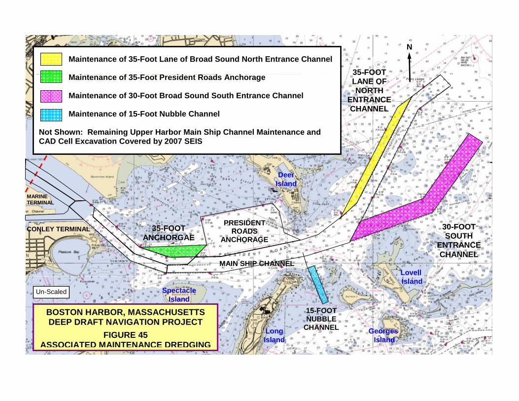
Maintenance of 35-Foot Lane of Broad Sound North Entrance Channel
N
35-FOOTMaintenance of 35-Foot President Roads Anchorage Maintenance of 30-Foot Broad Sound South Entrance Channel Maintenance of 15-Foot Nubble Channel
35 FOOT LANE OF NORTH
ENTRANCE CHANNEL
Not Shown: Remaining Upper Harbor Main Ship Channel Maintenance and CAD Cell Excavation Covered by 2007 SEIS
Deer
MARINE TERMINAL
PRESIDENT 30 FOOT35 FOOT
Deer Island
CONLEY TERMINAL ROADS ANCHORAGE
MAIN SHIP CHANNEL
30-FOOT SOUTH
ENTRANCE CHANNEL
35-FOOT ANCHORGAE
Lovell
BOSTON HARBOR, MASSACHUSETTSDEEP DRAFT NAVIGATION PROJECT
Un-Scaled
15-FOOT NUBBLE
CHANNEL
SpectacleIsland
Island
FIGURE 45 ASSOCIATED MAINTENANCE DREDGING
CHANNELLong Island
Georges Island
,0" ''',," . ,"",,, .,w'-"" .,...,.,,"'-.~
f.i 1 ~ 1
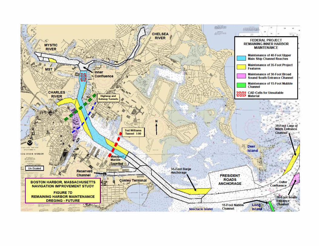
BOSTON HARBOR, MASSACHUSETTS NAVIGATION IMPROVEMENT STUDY
REMAINING
I r • • -1'
..... , .. - I
• •
FE DERAl PROJECT REMAINING INNER HARBOR
MAINTENANCE
' .
o o D
PRESIDENT ROADS ·
ANCHORAGE
Iolalntenance of 4O.Foot Uppe< Main 5111p CIIenneI ReKhft
Malnt .... ance Df 35.foot Project F""tUfe5
.... lntenllRCfl of ;lO.foot Bfoad 5oun.d South Entrance e ll_nne!
IIlIlntenance of 15.1'001 Nubt>Ie ,-~
CAll Cells lor Unsuitable .... t!!'rial
• •
•• •
•
•
•
• • •
• •
•
• •
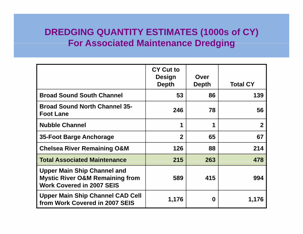
DREDGING QUANTITY ESTIMATES (1000s of CY)For Associated Maintenance DredgingFor Associated Maintenance Dredging
CY Cut to Design Depth
Over Depth Total CY
Broad Sound South Channel 53 86 139
Broad Sound North Channel 35-Foot Lane 246 78 56
Nubble Channel 1 1 2
35-Foot Barge Anchorage 2 65 67
Chelsea River Remaining O&M 126 88 214
Total Associated Maintenance 215 263 478Total Associated Maintenance 215 263 478
Upper Main Ship Channel and Mystic River O&M Remaining from Work Covered in 2007 SEIS
589 415 994
Upper Main Ship Channel CAD Cell from Work Covered in 2007 SEIS 1,176 0 1,176
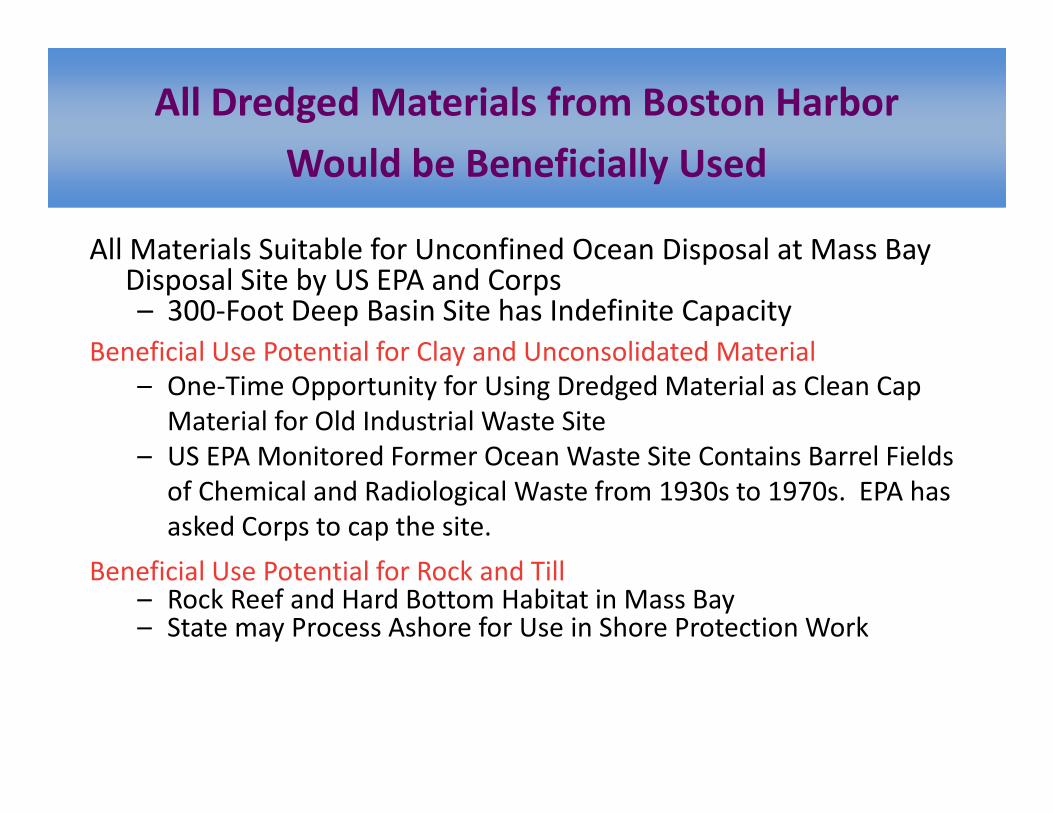
All Dredged Materials from Boston Harbor
W ld b B fi i ll U dWould be Beneficially Used
All Materials Suitable for Unconfined Ocean Disposal at Mass BayAll Materials Suitable for Unconfined Ocean Disposal at Mass Bay Disposal Site by US EPA and Corps– 300‐Foot Deep Basin Site has Indefinite Capacity
Beneficial Use Potential for Clay and Unconsolidated MaterialBeneficial Use Potential for Clay and Unconsolidated Material– One‐Time Opportunity for Using Dredged Material as Clean Cap
Material for Old Industrial Waste Site– US EPA Monitored Former Ocean Waste Site Contains Barrel Fields– US EPA Monitored Former Ocean Waste Site Contains Barrel Fields
of Chemical and Radiological Waste from 1930s to 1970s. EPA has asked Corps to cap the site.
f l l f k d llBeneficial Use Potential for Rock and Till– Rock Reef and Hard Bottom Habitat in Mass Bay– State may Process Ashore for Use in Shore Protection Work
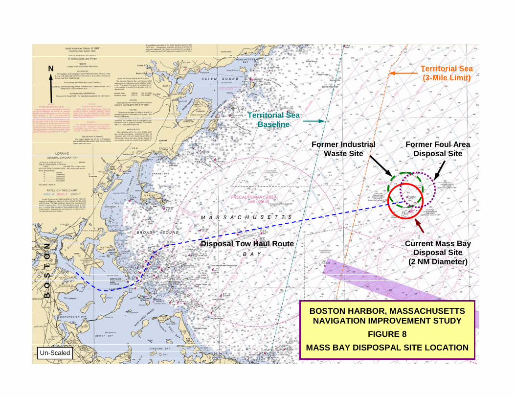
N Territorial Sea
(3-Mile Limit)
Territorial Sea Baseline
Former Foul Area Disposal Site
Former Industrial Waste Site
Baseline
Current Mass BayDisposal Site
(2 NM Diameter)
Disposal Tow Haul Route
S T
O N
BOSTON HARBOR, MASSACHUSETTS NAVIGATION IMPROVEMENT STUDY
B O
S
FIGURE 8
MASS BAY DISPOSPAL SITE LOCATION Un-Scaled
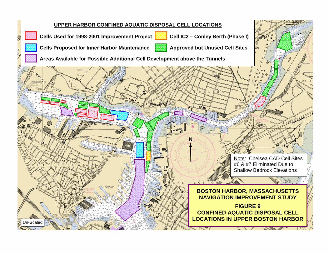
UPPER HARBOR CONFINED AQUATIC DISPOSAL CELL LOCATIONS
Cells Used for 1998-2001 Improvement Project Cell IC2 – Conley Berth (Phase I) Cells Proposed for Inner Harbor Maintenance Approved but Unused Cell SitesCells Proposed for Inner Harbor Maintenance Approved but Unused Cell Sites Areas Available for Possible Additional Cell Development above the Tunnels
N
Note: Chelsea CAD Cell Sites #6 & #7 Eliminated Due to Shallow Bedrock Elevations
BOSTON HARBOR, MASSACHUSETTS NAVIGATION IMPROVEMENT STUDY
FIGURE 9
FIGURE 9CONFINED AQUATIC DISPOSAL CELL
LOCATIONS IN UPPER BOSTON HARBOR Un-Scaled
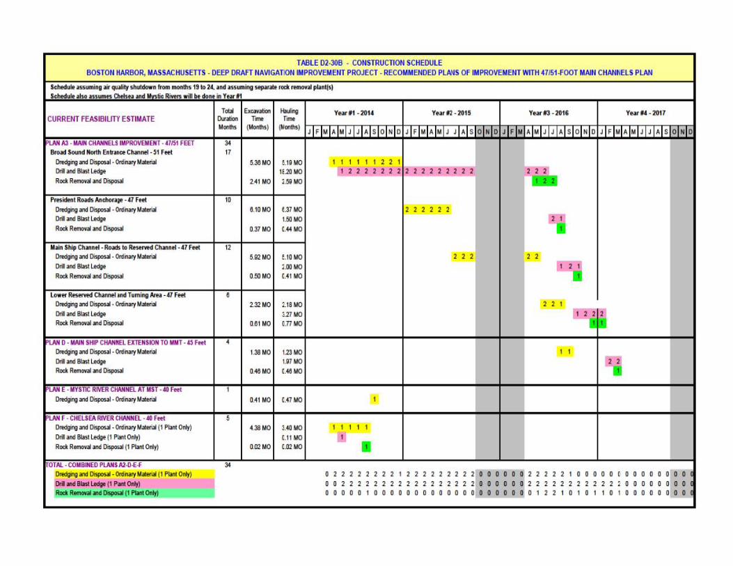
TABLE 02·308 • COO STRUCn OO SCHEOOLE BO STOO HARBOR, MASSACHUSrnS · DEEP DRAfT NAVIGATION IMPROVEMENT PROJECT· RECOMWENDED PlA.~S OF IMPROVEMENT WITH 47151./'OOT MAIN CHAHNELS PLAN
1Ito.ad1<l<MHl_ ~._ C ....... • 11 F ....
~nDiopowl .~II1_ Ort n _ L.odtIt
Rocl R_a' n o;,po.aI
~n Diopowt . 0nWry 111_ Ort n _ L.odtIt __ .II n o;,po.aI
Oroqvn Diopowt . ~ 111_ Ort n 11M! L.odtIt __ .II n DispooJI
0r0dgifI0 wllispos.al· 00Ii'Iary 111_11 PlMtOnly) DIll n _ L.odtIt 11 P\aIO:~ Rocl R_ n DispooJI 1I PIMt om,)
Orqing w Diopowt. 0rdN0y 111_11 PlMtOnly)
~n_lodp 11 P"~ __ n DispooJI 1I PIMt Ontrl
"
' _11·2015 ' _1l·2OIi
1 1 1 1 1 1 2 2 \
1 1 1 1 1
"
, "
, ,
tit 1 I
II
0 11111 111 I 1 1 1 11111 1 0 0 DO 0' 11111 I 001111111111111111100000 01 11111 00000 0000000000000QOQOO ' 0122 0
000 00 1' 00000 11111 00000
o 0 \ 00000
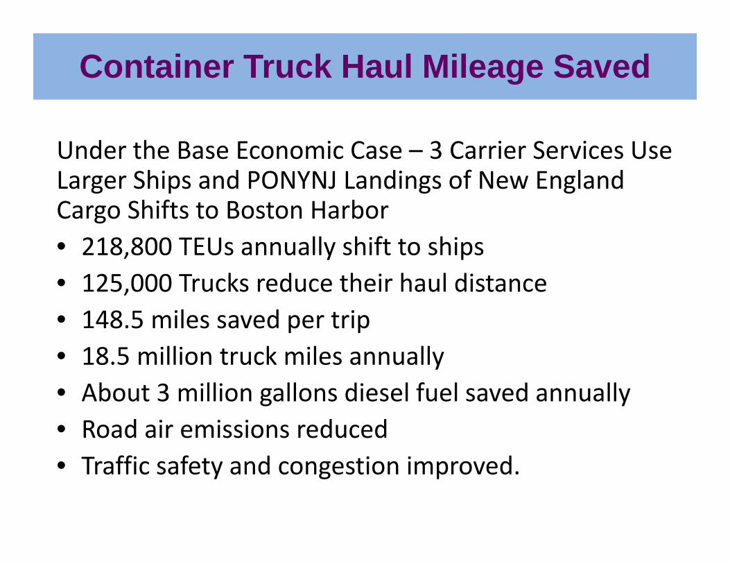
Container Truck Haul Mileage Saved
Under the Base Economic Case – 3 Carrier Services Use L Shi d PONYNJ L di f N E l dLarger Ships and PONYNJ Landings of New England Cargo Shifts to Boston Harbor• 218 800 TEUs annually shift to ships• 218,800 TEUs annually shift to ships• 125,000 Trucks reduce their haul distance• 148 5 miles saved per trip• 148.5 miles saved per trip• 18.5 million truck miles annually• About 3 million gallons diesel fuel saved annually• About 3 million gallons diesel fuel saved annually• Road air emissions reduced T ffi f t d ti i d• Traffic safety and congestion improved.
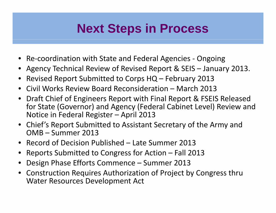
Next Steps in Process
• Re‐coordination with State and Federal Agencies ‐ OngoingA T h i l R i f R i d R t & SEIS J 2013• Agency Technical Review of Revised Report & SEIS – January 2013.
• Revised Report Submitted to Corps HQ – February 2013• Civil Works Review Board Reconsideration – March 2013• Draft Chief of Engineers Report with Final Report & FSEIS Released for State (Governor) and Agency (Federal Cabinet Level) Review and Notice in Federal Register – April 2013
• Chief’s Report Submitted to Assistant Secretary of the Army and OMB – Summer 2013
• Record of Decision Published – Late Summer 2013• Reports Submitted to Congress for Action – Fall 2013• Design Phase Efforts Commence – Summer 2013 • Construction Requires Authorization of Project by Congress thruConstruction Requires Authorization of Project by Congress thru Water Resources Development Act
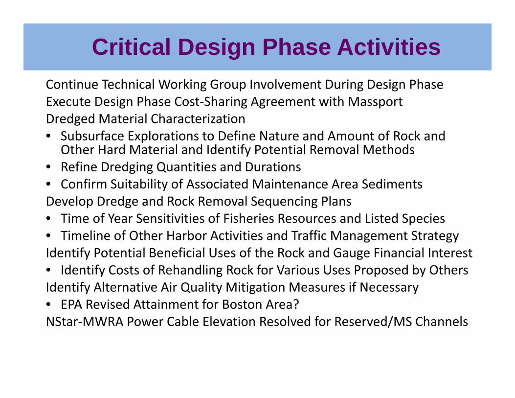
Critical Design Phase ActivitiesContinue Technical Working Group Involvement During Design PhaseExecute Design Phase Cost‐Sharing Agreement with MassportDredged Material Characterizationg• Subsurface Explorations to Define Nature and Amount of Rock and
Other Hard Material and Identify Potential Removal Methods• Refine Dredging Quantities and Durations • Confirm Suitability of Associated Maintenance Area SedimentsDevelop Dredge and Rock Removal Sequencing Plans• Time of Year Sensitivities of Fisheries Resources and Listed Speciesp• Timeline of Other Harbor Activities and Traffic Management Strategy Identify Potential Beneficial Uses of the Rock and Gauge Financial Interest• Identify Costs of Rehandling Rock for Various Uses Proposed by OthersIdentify Costs of Rehandling Rock for Various Uses Proposed by OthersIdentify Alternative Air Quality Mitigation Measures if Necessary• EPA Revised Attainment for Boston Area? NStar‐MWRA Power Cable Elevation Resolved for Reserved/MS ChannelsNStar MWRA Power Cable Elevation Resolved for Reserved/MS Channels
Critical Design Phase ActivitiesRemaining Cultural Resource Investigations • Cultural Resource Surveys in Chelsea River Widening Areas • Cultural Resource Investigations at Proposed Rock Reef Creation Sites• Cultural Resource Investigations at Proposed Rock Reef Creation Sites • Cultural Resource Investigations for Shipwrecks at IWS if to be Capped Update Project Cost and Cost‐Sharing Congress Includes Project in Water Resources Development Act Identify Non‐Federal Funding Sources Execute Project Cooperation Agreement with MassportExecute Project Cooperation Agreement with Massport