Embed Size (px)
Citation preview

`Appendix 5: Borough of Garwood
February 2016
Union County, New Jersey: 2016 Hazard Mitigation Plan Update 5-1
Appendix 5: Borough of Garwood
This appendix is part of the 2016 Union County Hazard Mitigation Plan (HMP) update, and includes only
jurisdiction-specific information about the Borough of Garwood, which is one of the 20 municipalities
within Union County that is participating in the plan update. Union County led the planning process and
outreach for this update. For a detailed description of the planning process and the public outreach
efforts for this update, see Section 3 of the 2016 HMP.
1. Planning Process and Participation
The County formed a Steering Committee, which was responsible for key decisions during the plan
update. This committee sent a letter to the Mayor of each municipality within the County. The Mayors
and local officials selected a single individual to represent the town in the broader process. This person
was the point of contact for the plan update, but worked with other municipal employees, consultants,
volunteers, and other stakeholders throughout the planning process. This collection of participants,
considered the local planning committee, is listed below. The committee was responsible for various
decisions that informed the development of this appendix, including: prioritizing the natural hazards
that can affect the community, reviewing and prioritizing the mitigation actions that are included in
Table 5-1, and informing community leaders about the status of the County mitigation plan update,
including this appendix
The Borough of Garwood Planning Committee evaluated and identified the hazards of concern,
completed the request for information (RFI), reviewed the plan documents and vulnerability
assessment, and worked collectively to update the mitigation strategy. In order to complete the update
process, the Borough of Garwood attended the kickoff meeting held by Princeton Hydro in May 2014.
To further the plan development, the Planning Committee met with the Consultant to review the plan
documents and revise the mitigation strategy in a workshop format on February 22nd 2015. Local
ordinances, site plan requirements, emergency procedures and response plans, and stormwater
management plans were reviewed for integration into this plan update. As the plan was developed, the
Planning Committee reviewed all of the drafts and provided input on this individual appendix.
Table 5-1 Borough of Garwood Planning Committee Members
Name Title Organization Role in Process
Ken Capobianco Emergency Management Coordinator Borough of Garwood Point of Contact
Michael Tharaldsen Fire Chief Borough of Garwood Fire and Rescue
Bruce Underhill Chief of Police Borough of Garwood Law Enforcement
Frederick W. Corbitt Superintendent of Public Works Borough of Garwood Public Works
Patricia Quattrocchi Mayor Borough of Garwood Chief Executive
Megan Avallone Health Officer Borough of Garwood Public Health
Donald R. Guarriello Borough Engineer Borough of Garwood Damage Assessment
Eugene Kobliska, Sr. Captain Garwood First Aid Squad Emergency Medical
Services
`Appendix 5: Borough of Garwood
February 2016
Union County, New Jersey: 2016 Hazard Mitigation Plan Update 5-2
2. Community Profile
The Borough of Garwood has a total area of 0.664 square miles and is located between Cranford and
Westfield in Union County, New Jersey. As of the 2010 Census, the population was estimated at 4,521.1
This was an 8.9% increase from the 2000 Census population, which was estimated at 4,153. 2
John Maxwell, former president of the Central Railway of New Jersey, purchased land that was the
“Garwood Land and Improvement Company” in the 1890’s.3 Garwood’s history includes the
development of local industries, including Hercules Tubeworks, Thatcher Furnace, and the Aeolian,
Weber Piano and Pianola Company factory, situated alongside the railroad tracks. Later the factory site
became a paper mill, and the railroad service continued on with a station on the NJ Transit Raritan
Valley line serving the Borough.4
The Borough of Garwood was originally a neighborhood of Cranford and Westfield, but seceded on
March 19, 1903.5 Garwood follows a Borough system of government, having an elected mayor and six
council members elected at large. The mayor serves a four-year term and council members serve
staggered three year terms so that two members conclude terms in each year.
2.1 Land Use and Development
Garwood is a densely developed community, with nearly 97 percent of its 0.64 square miles of land
area classified as urban/developed. Over 82 percent of the parcels within Garwood are classified as
residential, based on tax assessment data. Between 2004 and 2012, 25 building permits were issued for
residential homes within the Borough. This is 1.67 percent of the total building permits issued for Union
County during this time period. Fifty-four (54) percent of these permits were for 1- and 2-family homes.
Garwood has a population density of 6603 people per square mile. The 2010 census estimates that 37
percent of the housing within the Borough was renter-occupied, higher than the County average of
30.5 percent renter-occupied properties.
1 Borough of Garwood New Jersey. Demographics. http://garwood.org/index.asp?SEC=EDC95279-B9BA-463F-9B4C-54DD51D4FD7C&Type=B_BASIC Retrieved 9/10/14. 2 U.S. Dept. of Commerce, Bureau of the Census. Garwood. http://censtats.census.gov/data/NJ/1603425800.pdf. Retrieved 10/10/14. 3 Garwood New Jersey. History of Garwood. http://garwoodnj.com/history.htm Retrieved 10/10/14. 4 Borough of Garwood New Jersey. Historical Maps and Photos. http://garwood.org/index.asp?SEC=FA8413CD-7159-4B44-9620-6B9870813F17&Type=B_BASIC Retrieved 10/10/14. 5 Borough of Garwood New Jersey. The Evolution of Garwood. http://garwood.org/index.asp?SEC=041145C1-74BA-4B5E-98B6-379A56E31A0C&Type=B_BASIC. Retrieved 10/10/14.

`Appendix 5: Borough of Garwood
February 2016
Union County, New Jersey: 2016 Hazard Mitigation Plan Update 5-3
6 Uses the 2007 land cover values
Land Cover Class
2002 (acres)
2007 (acres)
Percent Change
Percent of Total Land6
Agriculture
Barren Land 3.56 0.00 -100.00% 0.00%
Forest 13.64 13.00 -4.70% 3.13%
Urban 398.76 402.96 1.05% 96.88%
Water
Wetlands
Figure 5-1 Land Use/Land Cover Map Borough of Garwood
Table 5-2 Land Use/Land Cover Trends (NJDEP GIS, 2007)

`Appendix 5: Borough of Garwood
February 2016
Union County, New Jersey: 2016 Hazard Mitigation Plan Update 5-4
3 Hazard Identification and Risk Assessment
This section of the Garwood mitigation plan appendix describes
the natural hazards and risks that can affect the community. It
should be noted that -- in accordance with FEMA requirements --
only the hazards with aspects that are unique to the community
(versus the County as a whole) are included in detail in this
appendix.
3.1 Background and Hazard Rankings
Like all the other jurisdictions in Union County, the Borough of
Garwood is potentially subject to the effects of all the hazards
that are considered in this mitigation plan. However, the majority
of these hazards have minimal impacts on the area, and are
discussed in detail in the County part of the mitigation plan.
FEMA mitigation planning guidance requires that County
mitigation plans include a risk assessment section that “assess[es]
each jurisdiction’s risks where there vary from the risks facing the
entire planning area” (44CFR 201.6 (c) (2) (iii). Because the Union
County HMP update includes separate appendices for each
jurisdiction, this requirement is met in the appendices, while risks
that affect the entire County uniformly are discussed in the
County part of the HMP.
One of the first steps in developing jurisdictional appendices was
for participating municipalities to review and prioritize the
hazards that can affect them. This was done based on how often
a hazard has occurred, how significant effects have been in the
past, the difficulty and cost of recovering from such events.
Jurisdictions ranked the list of hazards as either high, medium,
low, or no concern.
Table 5-3 shows Garwood’s hazard rankings. The level of
discussion and detail about specific hazards in this section are
based on these rankings. Hazards that are ranked high include
the most detail, and to the extent possible include probabilistic
assessments of risk, i.e. likely future damages in the community
based on the likelihood of occurrence. Hazards that are ranked
medium have less detail and may in some cases refer to the main
part of the county mitigation plan; they usually do not have
probabilistic risk assessments, although potential future losses
Table 5-3 Borough of Garwood Hazard
Identification and Prioritization
Hazard Priority
Flood Med
High wind – tornado Med
Ice storm Med
Severe storm – winter weather
Med
Straight-line winds Med
Dam failure Low
Drought Low
Earthquake / Geological Low
Erosion Low
Extreme temperature – cold
Low
Extreme temperature – heat
Low
Hail Low
Hazmat release – fixed site
Low
Hazmat release – transportation
Low
Landslide (non-seismic) Low
Severe storm – lightning Low
Storm surge Low
Wildfire Low
*Only the hazards ranked high and
medium are analyzed in this appendix

`Appendix 5: Borough of Garwood
February 2016
Union County, New Jersey: 2016 Hazard Mitigation Plan Update 5-5
are discussed based on best available data. Hazards ranked low and none are not addressed in this
jurisdictional appendix because they are discussed in the County part of the HMP, and there are no
significant differences in risk between the County and the municipality.
3.2 Flood Hazard
3.2.1 Type, Location and Extent
As shown in Figure 5-2 below, Garwood Borough has one significant Special Flood Hazard Area (100-
year floodplain). It is related to Garwood Brook, a tributary to Rahway River, which crosses the central
part of the jurisdiction in a generally west-east direction. The only other, relatively small SFHA (of 500-
year flooding) is in the extreme north part of the jurisdiction, where floodplain of Gallows Hill Road
Branch (otherwise in Town if Westfield) crosses over the municipal boundary and extends the 500-year
flood hazard. Both streams are tributaries to Rahway River that flows to the east of the community.
There are not very many NFIP insurance claims in general (37 total, including a singular repetitive loss
property).
There are not significant concentrations of NFIP insurance claims in Garwood Borough, but the most
claims are located in the central/eastern part of the community, along the Garwood Brook, in the area
along Willow, Myrtle, and Spruce Avenues, between Center and New Streets. The number of flood
insurance claims (37) and the average amount of the claims ($11,411) in Garwood Borough suggests a
moderate level of vulnerability to floods in this community, in terms of both the numbers of claims
versus the overall number of parcels (1,524) and the presumed severity of flooding based on the claims
amounts.
One of the best resources for determining flood risk in a jurisdiction is Flood Insurance Rate Maps
(FIRMs), which are produced by FEMA. The FIRM is the official map of a community on which FEMA has
delineated both the special flood hazard areas (1% annual chance of flooding) and the risk premium
zones applicable to the jurisdiction. The effective FIRM date for Union County is September 20th, 2006,
which is shown in Figure 2-2. The Preliminary FIRMs were released for Union County on January 30th,
2015. The area within Garwood was not studied as part of this map update. There are no changes
between the Effective FIRM and the Preliminary FIRM in Garwood.
Current FEMA guidance uses the term extent as analogous to potential severity. Compared to most
other jurisdictions in Union County, Garwood Borough has a relatively small to medium area of
floodplain. Although it is difficult to deduce potential severity accurately, it is safe to assume that the
extent of flooding in Garwood is moderate; in more severe events such as tropical cyclones and
nor’easters some areas can expect to have significant flooding along the Garwood Brook, especially
given the fact that the present SFHA is a function of low lying terrain in its lower reach and hydraulic
constriction of the culverts below Raritan Valley NJ Transit railroad and Route 28.

`Appendix 5: Borough of Garwood
February 2016
Union County, New Jersey: 2016 Hazard Mitigation Plan Update 5-6
Figure 5-2 Effective FIRM Borough of Garwood
Table 5-4 shows the number of parcels in Garwood Borough with at least 60% of their area in the 100-
year (1% annual) and 500-year (0.2% annual) floodplain. Although these figures offer some insight into
the flood hazard in this jurisdiction, they are not particularly reliable as a risk indicator because in many
cases structures and infrastructure (where the risk-producing impacts occur) are not located in the
specific areas that are in the floodplain.
Table 5-4 Flood-prone Properties
Flood hazard area Number of Parcels
100-year (1%) floodplain 90
500-year (0.2%) floodplain 11

`Appendix 5: Borough of Garwood
February 2016
Union County, New Jersey: 2016 Hazard Mitigation Plan Update 5-7
3.2.2 Previous Occurrences and the Probability of Future Floods
Minor flooding occurs in Garwood Borough at least annually,
although the severity of these frequent events is minimal. As
discussed in the main (County) section of the mitigation plan, more
significant events like tropical cyclones and nor-easters occur every
few years (section citation to main plan), and can result in significant
flooding. Notwithstanding the potential effects of climate change on
weather patterns, the Borough can probably expect to experience
some level of flooding every year or two, with more significant
events happening every five to ten years on average. The main
(County) part of this HMP discusses past occurrences in detail, and
that history and statistics are generally the same as for Garwood.
3.2.3 Flood Impacts and Vulnerability to Flooding
As discussed elsewhere, flood impacts in Garwood Borough are
relatively moderate based on various metrics such as NFIP claims,
FEMA PA Program Project Worksheets, and the known history of
flooding. There is no significant history of flood damage to critical
facilities or populations in the jurisdiction.
As expected, the most frequent and serious damages appear to be
related to structures that are well within the boundaries of the
floodplain, i.e. close to the stream center line or in vicinity of non-
transitional change of stream bed and flow direction. As shown in
Figure 5-2, this community has a singular NFIP repetitive loss
property.
Community vulnerabilities to flooding include some exposure to yard
and basement inundation, particularly in the floodplain area in the
east-central part of the jurisdiction, as discussed above. This is
related to “backwater” and overbank flooding from the constricted
channelized bed of Garwood Brook, which has two sudden 90
degree turns that most probably overflow the banks even for the
moderate storm events. In addition, more lasting hydraulic
conveyance and bank stabilization projects, he jurisdiction can
somewhat alleviate the existing problems with keeping up with
maintenance and debris clearance.
Table 5-5 NFIP Policies and Claims
Number of Parcels: Garwood: 1,524 Union County: 199,489 Number of Policies In-Force: Garwood: 79 Union County: 6,055 Number of Claims: Garwood: 37 Union County: 5,560 Total Paid Claims Garwood: $423,320 Union County: $96,782,279 Repetitive Loss Properties: Garwood: 1 Union County: 729 Total Building Garwood: $138,548 Union County: $16,597,500 Total Contents Garwood: $79,994 Union County: $3,787,671 Number of Claims Garwood: 4 Union County: 2,115 Average Claim Garwood: 54,636 Union County: $9,891

`Appendix 5: Borough of Garwood
February 2016
Union County, New Jersey: 2016 Hazard Mitigation Plan Update 5-8
3.2.4 National Flood Insurance Program and Repetitive Loss Properties
To provide a sense of the flood risk in a community it is also beneficial to summarize the policies in
force and claims statistics from the National Flood Insurance Program (NFIP). The U.S. Congress
established the NFIP with the passage of the National Flood Insurance Act of 1968. The NFIP is a Federal
program enabling property owners in participating communities to purchase insurance as a protection
against flood losses in exchange for State and community floodplain management regulations that
reduce future flood damages. Participation in the NFIP is based on an agreement between communities
and the Federal Government. If a community adopts and enforces a floodplain management ordinance
to reduce future flood risk to new construction in floodplains, the federal government will make flood
insurance available within the community as a financial protection against flood losses. Garwood
Borough has been a member of the NFIP since 1977.
FEMA NFIP statistics indicate that as of February 2014, federal flood insurance policies were in-force on
79 properties in Garwood Borough. This represents a dollar value of property and contents coverage
totalling $20,956,900. Between 1977 and 2014, there have been a total of 37 NFIP insurance claims in
Garwood Borough with a total claims value of $423,320.7 Table 5-5 compares the number of policies in-
force and paid claims in the jurisdiction. The Table shows that Garwood Borough comprises 1.3% of the
NFIP policies in-force in Union County.
Garwood Borough is not presently a member of the Community Rating System (CRS), a voluntary
program for communities participating in the NFIP. The CRS is a voluntary incentive program that
recognizes and encourages community floodplain management activities that exceed the minimum
NFIP requirements. For CRS participating communities, flood insurance premium rates are discounted
in increments of 5% based on creditable activities.8 CRS communities are ranked between 1 and 10,
with Class 1 communities receiving a 45% premium discount.
It should be noted that NFIP claims are not a direct or completely accurate proxy for flood risk in a
community. The data does not include flood damages to structures that had no flood insurance. Also, in
some cases, structures or contents may have been underinsured. The NFIP claims data also does not
include any damages to public facilities, which may be insured via other means (such as self-insurance
or non-FEMA policies); such damages may also be addressed through other federal programs such as
FEMA’s Public Assistance Program.
FEMA requires a discussion of NFIP Repetitive Loss and Severe Repetitive flood loss statistics in hazard
mitigation plans. The NFIP defines repetitive loss properties as those with two or more claims of more
than $1,000 each during any rolling ten-year period.
The flood risk assessment method is based on analysis of NFIP data on repetitive flood loss properties
The NFIP defines repetitive loss (RL) properties as those that have received at least two NFIP insurance
payments of more than $1,000 each in any rolling ten-year period. As of February 2014, Union County
7 FEMA – Policy and Claim Statistics for Flood Insurance 8 FEMA – Community Rating System (CRS).

`Appendix 5: Borough of Garwood
February 2016
Union County, New Jersey: 2016 Hazard Mitigation Plan Update 5-9
had 707 such properties based on a query of the FEMA BureauNet NFIP interface. Of this total, a single
property was located within Garwood. Table 5-5 provides a comparison of the residential repetitive loss
claims for Union County and Garwood Borough.
3.2.5 Flood Risk to Repetitive Loss Properties in Garwood
As of February 2014, the Garwood Borough had one NFIP repetitive flood loss property. Data for this
property is insufficient to perform a meaningful risk assessment.
3.2.6 Flood Risk to Severe Repetitive Loss Properties in Garwood
The definition of Severe Repetitive Flood Loss is included in the County portion of this mitigation plan.
As of February 2014, Garwood Borough had one NFIP severe repetitive flood loss property. Data for this
property is insufficient to perform a meaningful risk assessment.

`Appendix 5: Borough of Garwood
February 2016
Union County, New Jersey: 2016 Hazard Mitigation Plan Update 5-10
3.3 Tornados
3.3.1 Type, Location, and Extent
Tornado risks are discussed in detail in Section 4 of the County portion of this mitigation plan. There are
no significant differences in the type, location or extent of this hazard between the County and
Garwood Borough, and there are no aspects of the hazard that are unique to this jurisdiction.
3.3.2 Previous Occurrences and the Probability of Future Occurrences
Previous occurrences of the tornado hazard are discussed in detail in the County portion of this hazard
mitigation plan (see Section 4), and for reasons of brevity are not repeated here. There are no
meaningful differences between the County as a whole versus Garwood Borough with regard to
occurrences or the future probability of this hazard.
3.3.3 Tornado Impacts and Vulnerabilities to the Hazard
Because of the size of the sample area and the nature of the built environment, tornado impacts in
Garwood Borough are substantially similar to the County as a whole. The most significant potential
impacts from this hazard are damage to structures (and to a lesser degree, infrastructure), injuries and
deaths. The results of the risk assessment are shown in Table 5-6 below. The figures were calculated
using the FEMA Benefit-Cost Analysis software Version 5.0, which incorporates statistical probabilities
of tornadoes in by State and County, and uses historical data and algorithms to calculate direct
damages, injuries and deaths expected from tornados in this area.
Table 5-6
Tornado Risks, Garwood Borough Annual, 50- and 100-year Planning Horizons
Horizon Direct Damage Injuries Deaths
Annual risk $33,010 $32,052 $103,845
50-year risk $455,542 $442,314 $1,433,056
100-year risk $471,057 $457,378 $1,481,862
3.4 Straight Line Wind Hazard
3.4.1 Type, Location, and Extent
The high wind – straight-line wind hazard (including type, location and extent) is uniform across Union
County, and is discussed in detail in the County portion of this mitigation plan (see Section 4). For
reasons of brevity these details are not repeated here. There are no wind hazards that are unique to
Garwood Borough.

`Appendix 5: Borough of Garwood
February 2016
Union County, New Jersey: 2016 Hazard Mitigation Plan Update 5-11
Table 5-7: Straight-line Wind Risks for Range of Loss Types, Borough of Garwood
Annualized and 50- and 100-year Planning Horizons
3.4.2 Previous Occurrences and the Probability of Future Occurrences
Previously occurrences and the probability of future events are the same for Garwood Borough as for
Union County. Refer to Section 4 for that information at a County level.
3.4.2 Straight Line Wind Impacts and Vulnerabilities to the Hazard
Garwood Borough is a typical residential community, predominated by balloon-frame and unreinforced
masonry residential structures, the majority of which have gable or hip roofs. As discussed in the
County part of the plan, wind profiles in this area of the country indicate a relatively low potential for
severe events, and adequate construction techniques and building codes have generally sufficed to
keep risks low.
There are two main sources of potential wind damage in such communities: (1) structural damage to
residential and non-residential buildings, and (2) power losses, mainly due to trees falling on above-
ground lines. There are established methodologies for completing general risk assessments for these
hazards. These are explained in detail in the County portion of the plan (see Section 4). Table 5-7 below
summarizes annual straight-line wind risks and cumulative risks over 50- and 100-year planning
horizons in Garwood Borough. Risks are in seven discreet categories: building damages, contents
damages, inventory loss, relocation costs, business income lost, rental income lost and wages lost.
The next table shows power loss risks in Garwood Borough, again annualized and for 50- and 100-year
planning horizons. The methodology for these calculations (and additional jurisdiction-level data) can
be found in Section 4 of the County plan.
Occupancy Class
Total SF Total
Annualized Damages
50-year Risk 100-year
Risk
Residential 2,338,438 $46,576 $642,801 $664,599
Commercial 765,174 $9,274 $127,986 $132,326
Industrial 556,648 $7,222 $99,666 $103,046
Agricultural 10,393 $127 $1,748 $1,807
Religious 36,400 $468 $6,456 $6,675
Government 11,481 $324 $4,477 $4,629
Education 27,400 $288 $3,976 $4,111
Total 3,745,934 $64,279 $887,111 $917,193

`Appendix 5: Borough of Garwood
February 2016
Union County, New Jersey: 2016 Hazard Mitigation Plan Update 5-12
3.5 Winter Weather Hazards – Extreme Cold, Severe Weather, Ice
Storm
3.5.1 Type, Location, and Extent
Because the hazards severe storm – winter weather, ice storms and extreme temperatures – cold are
closely related, they are combined in this subsection of the appendix. Severe storms and winter
weather risks are discussed in detail in Section 4 of the County portion of this mitigation plan. There are
no significant differences in the type, location or extent of this hazard between the County and
Garwood Borough, and there are no aspects of the hazard that are unique to this jurisdiction.
3.5.2 Previous Occurrences and the Probability of Future Occurrences
Previous occurrences of the severe storm-winter weather/ice storm/extreme temperature - cold
hazards are discussed in detail in the County portion of this hazard mitigation plan (see Section 4), and
for reasons of brevity are not repeated here. There are no meaningful differences between the County
as a whole versus Garwood Borough with regard to occurrences or the future probability of these
hazards.
3.5.3 Winter Weather Impacts and Vulnerabilities to the Hazard
The impacts from these three hazards in Garwood Borough are substantially similar to the County as a
whole, and include lost productivity, traffic accidents, downed trees (and related power losses),
medical events (such as heart attacks), and hypothermia (which rarely causes any significant or long-
term problems). The community has no unique or pronounced vulnerabilities to these hazards. Like
most established communities, over time Garwood Borough has adapted its systems and infrastructure
to minimize the effects of cold weather and associated meteorological effects. In rare cases, buildings
may experience structural problems due to snow loads, and public or private infrastructure may fail
due to freezing. However, these problems are usually minor and are addressed by private citizens
(through their own work, or via insurance proceeds) or by the government in the case of infrastructure.
Perhaps the most significant potential impacts of winter weather are traffic accidents (with related
injuries and fatalities), and power losses from ice and downed trees. For the most part, damage to
vehicles is addressed via private insurance, records of which are proprietary. However, there are
national statistics regarding injuries and deaths related to such weather. Local values for injuries and
Period Risk Value
Annual $46,779
50-year planning horizon $645,585
100-year planning horizon $667,501
Table 5-8 Power Loss Horizons

`Appendix 5: Borough of Garwood
February 2016
Union County, New Jersey: 2016 Hazard Mitigation Plan Update 5-13
Table 5-9 Winter Storm-related Risks (traffic injuries and fatalities),
Borough of Garwood 50- and 100-year Planning Horizons
deaths can be deduced from national statistics. Figures for Garwood Borough are displayed in the table
below. Refer to the County portion of this mitigation plan for source citations and an explanation of the
methodology.
An additional source of risk from cold and winter weather is hypothermia deaths. Although the risk
from this hazard is relatively small, it can nevertheless be calculated by deduction from national
statistics. Annual deaths nationwide were obtained from a U.S. Centers for Disease Control report
(National Health Statistics Reports, Deaths Attributed to Heat, Cold and Other Weather Events in the
United States, 2006-2010).
Injuries (combined) Deaths
Snow/sleet $580,423 $65,914
Icy pavement $451,574 $49,714
Snow/sleet $435,265 $43,800
Total annual risk (all hazards)
$1,467,262 $159,427
50-year risk $20,248,213 $2,200,094
100-year risk $20,937,826 $2,275,024
Table 5-10 Risks from Hypothermia Garwood Borough
Annually and 50- and 100-year Planning Horizons
2010 Population % of US Annual Death $ 50-year Horizon 100-year Horizon
4,226 0.0013% $114,033 $1,573,658 $1,627,254

`Appendix 5: Borough of Garwood
February 2016
Union County, New Jersey: 2016 Hazard Mitigation Plan Update 5-14
3.6 Critical and Public Facilities
The Borough of Garwood does not have any critical and public facilities in the Special Flood Hazard
Area. The Borough reports no facilities have experienced losses from natural hazards in recent history.
Facility Address
Washington Sch. 500 East St.
St. Anne's Sch. 320 Second Ave.
Mun. Bldg. & Police H.Q. 403 South Ave.
Garwood Station Fire Headquarters 415 South Avenue
Lincoln School 400 Second Ave.

`Appendix 5: Borough of Garwood
February 2016
Union County, New Jersey: 2016 Hazard Mitigation Plan Update 5-15
4. Borough of Garwood Mitigation Strategy
This section contains hazard mitigation goals, objectives, and action items for the Borough of Garwood.
The goals are similar to the goals outlined in the County plan, but the objectives are adjusted for the
jurisdiction. The definitions for these terms can be found in Section 5 of the Union County Plan Update.
4.1 Goals
Goal 1: Improve LOCAL KNOWLEDGE about the potential impacts of hazards, and the identification of specific measures that can be taken to reduce their impacts
Goal 2: Improve DATA COLLECTION, USE, AND SHARING to reduce the impacts of hazards Goal 3: Improve CAPABILITIES, COORDINATION, AND OPPORTUNITIES to plan and implement
risk reduction projects, programs, and activities Goal 4: Pursue a range of MITIGATION OPPORTUNITIES, including addressing NFIP repetitive
and severe repetitive loss properties, and reducing risk to public properties and infrastructure
4.2 Objectives
Objective 1.A: Increase risk awareness among officials and citizens.
Objective 1.B: Maintain and improve jurisdiction-level awareness regarding funding opportunities for mitigation, including that provided by FEMA and other federal and State agencies.
Objective 2.A: Improve the availability and accuracy of risk- and mitigation-related data at the local level, as the basis for planning and development of risk-reduction activities.
Objective 2.B: Ensure that government officials and local practitioners have accurate and current information about best practices for hazard mitigation planning, project identification, and implementation.
Objective 2.C: Develop and maintain detailed data about critical facilities, as the basis for risk assessment and development of mitigation options.
Objective 3.A: Continue support of hazard mitigation planning, project identification, and implementation at the municipal level.
Objective 3.B: Continue close coordination with the County in a range of risk-related areas, such as FEMA programs, mitigation planning, development of hazard mitigation projects, etc.
Objective 3.C: Increase property owner participation in the National Flood Insurance Program.
Objective 3.D: Implement activities to improve the community’s CRS rating.
Objective 3.E: Work towards increasing the integration of mitigation principles and activities in a range of local regulations, plans, ordinances and activities.
Objective 3.F: Maintain and improve coordination with surrounding communities with regard to understanding and reducing risks.
Objective 4.A: Facilitate development and timely submittal of project applications meeting state and federal guidelines for funding (1) for RL and SRL properties and (2) for hardening/retrofitting infrastructure that is at the highest risk.
Objective 4.B: Maintain and enhance local planning and regulatory standards related to future development and investments.

`Appendix 5: Borough of Garwood
February 2016
Union County, New Jersey: 2016 Hazard Mitigation Plan Update 5-16
4.3 Mitigation Strategy
The tables below list prioritized mitigation projects and actions identified by the Borough of Garwood.
4.3.1 Existing Mitigation Actions
Mitigation Action, Program, or Project
Hazard Priority Implementation
Mechanism Responsible Party
Target Start Date
Project Duration
Estimated Cost
Current Status
Conduct all-hazards public education and outreach program for hazard mitigation and preparedness.
All High Emergency
Management
OEM Coordinator, in coordination
with County OEM One Year Staff Time
4.3.2 New Mitigation Actions
Mitigation Action, Program, or Project
Hazard Priority Implementation
Mechanism Responsible Party Project Duration Estimated Cost
The Borough is pursuing generators for multiple critical facilities to use as warming/cooling stations and maintain critical Borough operations.
All High Capital Improvement OEM 1-2 years 200,000-575,000
each
Mitigate single repetitive loss property through elevation or acquisition as funding permits
Flood High Grants OEM 1 year Varies

`Appendix 5: Borough of Garwood
February 2016
Union County, New Jersey: 2016 Hazard Mitigation Plan Update 5-17
4.4 Capability Assessment
As part of this plan update each town self-assessed their existing planning and regulatory tools,
communication and emergency response capabilities, staff and personnel, and their capabilities to
leverage municipal funds to achieve hazard mitigation planning objectives. This capability assessment
should be updated as part of the ongoing maintenance process.
4.4.1 Planning and Regulatory
Tool Borough Has (y/n)
Zoning Ordinance Y
Subdivision Ordinance Y
Flood Damage Prevention Ordinance (per NFIP) Y
Special Purpose Ordinances (e.g. wetlands, critical or sensitive areas) Y – State reqs
Stormwater Management Plan/Ordinance Y
Comprehensive Plan / Master Plan Y
Capital Improvements Plan Y
Site Plan Review Requirements Y
Habitat Conservation Plan N
Economic Development Plan N
Local EOP
Continuity of Operations Plan
Post Disaster Recovery Plan or Ordinance N
Wildfire Protection Plan N
Real Estate Disclosure req. Y
Other (e.g. steep slope ordinance, local waterfront revitalization plan) Y – Steep Slopes
Freeboard N
Cumulative Substantial Damages N
Shoreline Management Plan NA
4.4.2 Communication and Emergency Response
Does the Borough have
this (y/n)
Outdoor warning system N
Nixle N
Auto-Dialer/Reverse 911/Emailer Y
Social Media Y
Website Updates Y
Other Emergency Communications N
Mutual Aid Agreements Y
Emergency Operations Center Y
Evacuation Vehicles Y
Swift-water rescue N
Shallow water boats N
`Appendix 5: Borough of Garwood
February 2016
Union County, New Jersey: 2016 Hazard Mitigation Plan Update 5-18
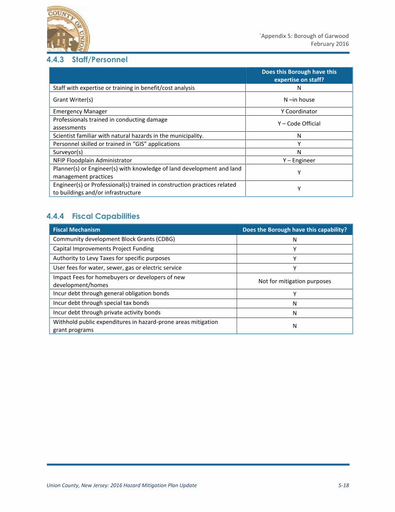
4.4.3 Staff/Personnel
Does this Borough have this
expertise on staff?
Staff with expertise or training in benefit/cost analysis N
Grant Writer(s) N –in house
Emergency Manager Y Coordinator
Professionals trained in conducting damage assessments
Y – Code Official
Scientist familiar with natural hazards in the municipality. N
Personnel skilled or trained in “GIS” applications Y
Surveyor(s) N
NFIP Floodplain Administrator Y – Engineer
Planner(s) or Engineer(s) with knowledge of land development and land management practices
Y
Engineer(s) or Professional(s) trained in construction practices related to buildings and/or infrastructure
Y
4.4.4 Fiscal Capabilities
Fiscal Mechanism Does the Borough have this capability?
Community development Block Grants (CDBG) N
Capital Improvements Project Funding Y
Authority to Levy Taxes for specific purposes Y
User fees for water, sewer, gas or electric service Y
Impact Fees for homebuyers or developers of new development/homes
Not for mitigation purposes
Incur debt through general obligation bonds Y
Incur debt through special tax bonds N
Incur debt through private activity bonds N
Withhold public expenditures in hazard-prone areas mitigation grant programs
N

`Appendix 5: Borough of Garwood
February 2016
Union County, New Jersey: 2016 Hazard Mitigation Plan Update 5-19
5. Plan Maintenance and Adoption
5.1 Plan Maintenance
The Borough of Garwood will review this Appendix of the County’s hazard mitigation plan appendix
each year and give the County’s HMP Coordinator an annual progress report. The Office of Emergency
Management Coordinator is responsible for convening the LPC, initiating the plan review, and
submitting the annual progress report. The LPC may use worksheets #1 and #3 in the FEMA 386-4
guidance document, to facilitate the review and progress report. FEMA guidance worksheets are
provided in Appendix G. Local progress reports shall be provided to the County HMP Coordinator at
least two weeks prior to the annual plan review meeting.
Additionally, the LPC will convene and review the plan when major hazard events impact the
jurisdiction, potentially yielding opportunities for mitigation grant funding, or when new information
suggests that plan elements do not accurately reflect the community’s risk or its mitigation priorities.
If necessary, the Borough Engineer will convene a meeting of the LPC to review and approve all
changes. The Borough retains the discretion to implement minor changes to the document without
formal procedures involving the Borough Council subject to local policies and regulations.
In addition to the annual progress report, the Borough of Garwood will provide Union County with a
copy of the written notice of any changes to the jurisdictional appendix at the time such changes are
implemented.
The LPC shall document, as needed and appropriate:
Hazard events and losses in Garwood and the effects that mitigation actions have had on impacts and losses,
Progress on the implementation of mitigation actions, including efforts to obtain outside funding for projects,
Any obstacles or impediments to the implementation of actions,
Additional mitigation actions believed to be appropriate and feasible,
Any changes to local capabilities,
Efforts to integrate the information included in this plan into other local planning mechanisms including, but not limited to, the comprehensive plan, capital improvement planning, budgeting, zoning amendments, and variance approvals,
All public and stakeholder input and comment on the Plan that has been received by the Borough,
Copies of any grant applications filed on behalf of the Borough

`Appendix 5: Borough of Garwood
February 2016
Union County, New Jersey: 2016 Hazard Mitigation Plan Update 5-20
5.1.2 Continued Public Input
The Borough of Garwood is committed to incorporating public input into its ongoing hazard mitigation
planning. The public will have an opportunity to comment on the Plan prior to any changes and during
the 5-year plan update. The annual progress reports will be posted on the County mitigation website in
addition to the adopted Plan. The Borough will place a link to the Plan on the municipal website.
All public comments and input on the plan will be recorded and addressed, as appropriate. Opportunity
to comment on the plan will be provided directly through the County’s website. Public comments can
also be submitted in writing to the County’s HMP Coordinator. All public comments shall be addressed
to: Union County Office of Emergency Management c/o All Hazards Pre-disaster Mitigation Plan
Coordinator 300 North Ave East, Westfield, NJ 07090.
The Borough of Garwood’s LPC shall ensure that:
Copies of the latest approved Plan are available for review at Borough Hall along with instructions to facilitate public input and comment on the Plan.
Public notices are made as appropriate to inform the public of the availability of the Plan, particularly during Plan update cycles.
For minor changes to this appendix, the Borough of Garwood will post a notice on the Borough’s website and invite the public to review and comment.
For major changes involving Borough Council approval, the Borough will use its standard public notice procedures inviting the public to review the document and provide feedback.
5.2 Plan Integration
The Hazard Mitigation Plan is a critical tool to help identify vulnerabilities and develop specific projects
to reduce studied risk within the jurisdiction. However, it is not the only tool that may help minimize
the impact of future hazard events on the people, infrastructure, and economy in the community. Using
the data included in this Plan update to inform future updates of its Comprehensive Plan, Capital
Improvement Planning and annual budget, stormwater management, zoning and code updates, and
variance and subdivision applications will improve the resiliency of the community and reduce future
risk to persons and property. All efforts to integrate the plan into other local mechanisms can be
reported to the Plan Coordinator at each annual update.
5.3 Plan Adoption
On [insert date] Union County submitted the initial draft of the 2016 Plan Update to NJOEM for review
and comment. After addressing NJOEM comments in the document, the HMP was resubmitted for final
consideration and approval by NJOEM and FEMA. FEMA approved the plan on [insert date], and the
Plan update was forwarded to the Union County Board of Chosen Freeholders for adoption, which
occurred on [insert date].

`Appendix 5: Borough of Garwood
February 2016
Union County, New Jersey: 2016 Hazard Mitigation Plan Update 5-21
The Borough Council approved the plan on [insert date]. The Borough’s resolution for adoption and the
County’s adoption resolution are provided as Appendix E of the 2016 HMP update. Following adoption,
the plan update was resubmitted to FEMA for final approval, which occurred on [insert date]. The
FEMA approval letter is included as Appendix D.


![Garwood, Julie - Shadow Music[1]](https://img.pdfslide.us/doc/110x75/577cd4711a28ab9e78988937/garwood-julie-shadow-music1.jpg)