Embed Size (px)
Citation preview

Aerial of the study area showing the Bangus Quarry in the mid-distance.
ABORIGINAL ARCHAEOLOGICAL IMPACT ASSESSMENT
BANGUS QUARRY LANDFILL
COOTAMUNDRA GUNDAGAI LGA
OCTOBER 2019
Report prepared by
OzArk Environment & Heritage
for Salvestro Planning
This page has intentionally been left blank.

OzArk Environment & Heritage
Aboriginal Archaeological Impact Assessment Report: Bangus Quarry Landfill, Cootamundra Gundagai LGA. i
DOCUMENT CONTROLS
Proponent
Client Salvestro Planning / Insitu Advisory
Document Description Aboriginal Archaeological Impact Assessment Report: Bangus Quarry
Landfill, Cootamundra Gundagai LGA.
File Location OzArk Job No.
Salvestro Planning>Bangus Quarry
Landfill Tumblong Ab H
Sept2019>report items
2443
Document Status V3.0 FINAL Date 30 October 2019
Draft V1.1 Author to Editor OzArk 1st Internal (Series
V1._ = OzArk internal edits)
V1.0 AG author 30/9/19
Draft V2.0 Report Draft for release to client
(Series V2._ = OzArk and Client edits)
V2.0 BC edit 10/10/19
V2.1 AD edit 28/10/10
FINAL V3._once latest version of draft approved by
client
V3.0 to client 30/10/19
Prepared For Prepared By
Garry Salvestro
PO Box 783
Wagga Wagga, NSW, 2650
02 6921 8588
Ben Churcher and Adelia Gower
Principal and Project Archaeologist
OzArk Environment & Heritage
145 Wingewarra Street (PO Box 2069)
Dubbo NSW 2830
P: 02 6882 0118
F: 02 6882 6030
COPYRIGHT
© OzArk Environment & Heritage 2019 and © Salvestro Planning 2019
All intellectual property and copyright reserved.
Apart from any fair dealing for private study, research, criticism or review, as permitted under the Copyright Act,
1968, no part of this report may be reproduced, transmitted, stored in a retrieval system or adapted in any form
or by any means (electronic, mechanical, photocopying, recording or otherwise) without written permission.
Enquiries should be addressed to OzArk Environment & Heritage.

OzArk Environment & Heritage
Aboriginal Archaeological Impact Assessment Report: Bangus Quarry Landfill, Cootamundra Gundagai LGA. ii
Acknowledgement
OzArk acknowledge Traditional Owners of the area on which this assessment took place and pay respect
to their beliefs, cultural heritage and continuing connection with the land. We also acknowledge and pay
respect to the post-contact experiences of Aboriginal people with attachment to the area and to the elders,
past and present, as the next generation of role models and vessels for memories, traditions, culture and
hopes of local Aboriginal people.

OzArk Environment & Heritage
Aboriginal Archaeological Impact Assessment Report: Bangus Quarry Landfill, Cootamundra Gundagai LGA. iii
EXECUTIVE SUMMARY
OzArk Environment & Heritage (OzArk) has been engaged by Salvestro Planning and Insitu
Advisory (the clients), on behalf of MH Earthmoving Pty Ltd (the proponent) to complete an
Aboriginal Archaeological Impact Assessment (AAIA) of the Bangus Quarry over Lot 7004
DP1028797 and Lot 7300 DP11449008, with the stockpile area on Lot 10 DP1210362. The
Bangus Quarry is proposed to be used as a general solid waste (non-putrescible) landfill site (the
proposal). The proposal is in the Cootamundra Gundagai Local Government Area.
The assessment of the study area was undertaken by OzArk on the Friday, 27 September 2019.
Peter Bulger from Bungle Tumut Local Aboriginal Land Council was present for the survey.
No Aboriginal sites were recorded as a result of the field survey. In addition, due to the
extent of past landform modification in some portions of the study area and the sloping
nature of the unmodified landforms, it was assessed that there was a low possibility for
subsurface archaeological deposits in the study area.
Recommendations concerning Aboriginal cultural values within the study area are as follows:
1. No Aboriginal objects will be harmed by the proposal. As such, an Aboriginal Heritage
Impact Permit is not required, and the works can proceed without further archaeological
investigation.
2. As no Aboriginal cultural heritage values will be impacted by the proposal, undertaking
the Aboriginal cultural heritage consultation requirements for proponents or the
development of an Aboriginal Cultural Heritage Assessment Report are not required.
3. This assessment is confined to within the assessed study area. Should the parameters of
the proposed work extend beyond these assessed locations, the further archaeological
assessment may be required.
4. All staff involved with the Bangus Quarry landfill activities should be aware of the
legislative protection of Aboriginal objects under the NPW Act and the contents of the
Unanticipated Finds Protocol (Appendix 3).
5. In the event of skeletal remains being identified during the works, the Unanticipated
Skeletal Remains Protocol (Appendix 4) should be followed.
6. All staff involved with the Bangus Quarry landfill activities should undergo cultural heritage
induction to ensure they recognize Aboriginal artefacts. A sample guide is provided in
Appendix 5.

OzArk Environment & Heritage
Aboriginal Archaeological Impact Assessment Report: Bangus Quarry Landfill, Cootamundra Gundagai LGA. iv
CONTENTS
EXECUTIVE SUMMARY.................................................................................................................. III
1 INTRODUCTION ..................................................................................................................... 1
1.1 Description of the proposal .......................................................................................... 1
1.2 Study area ................................................................................................................... 1
2 THE ARCHAEOLOGICAL ASSESSMENT ................................................................................... 3
2.1 Date of archaeological assessment ............................................................................. 3
2.2 OzArk involvement ....................................................................................................... 3
2.2.1 Field assessment .................................................................................................. 3
2.2.2 Reporting .............................................................................................................. 3
2.3 Relevant legislation ...................................................................................................... 3
2.3.1 State legislation .................................................................................................... 3
2.3.2 Commonwealth legislation .................................................................................... 4
2.3.3 Applicability to the proposal .................................................................................. 5
2.4 Assessment approach ................................................................................................. 5
2.5 SEARs ......................................................................................................................... 5
2.6 Purpose and objectives ................................................................................................ 6
2.6.1 Aboriginal archaeological assessment objectives ................................................. 6
2.7 Report compliance with the Code of Practice ............................................................... 6
3 ABORIGINAL COMMUNITY CONSULTATION ............................................................................. 8
3.1 Aboriginal community consultation ............................................................................... 8
3.1.1 Aboriginal community participation ........................................................................ 8
4 LANDSCAPE CONTEXT .......................................................................................................... 9
4.1 Topography.................................................................................................................. 9
4.2 Geology and soils ...................................................................................................... 10
4.3 Hydrology .................................................................................................................. 10
4.4 Vegetation ................................................................................................................. 10
4.5 Climate ...................................................................................................................... 10
4.6 Land–use history and existing levels of disturbance ................................................... 11
4.7 Conclusion ................................................................................................................. 11

OzArk Environment & Heritage
Aboriginal Archaeological Impact Assessment Report: Bangus Quarry Landfill, Cootamundra Gundagai LGA. v
5 ABORIGINAL ARCHAEOLOGY BACKGROUND ........................................................................ 12
5.1 Ethno-historic sources of regional Aboriginal culture .................................................. 12
5.2 Regional archaeological context ................................................................................ 15
5.3 Cultural landscape ..................................................................................................... 16
5.4 Local archaeological context ...................................................................................... 16
5.4.1 Desktop database searches conducted .............................................................. 16
5.5 Predictive model for site location ................................................................................ 18
5.5.1 Settlement strategies .......................................................................................... 19
5.5.2 Past land use ...................................................................................................... 19
5.5.3 Previously recorded sites .................................................................................... 19
5.5.4 Landform modelling ............................................................................................ 19
5.5.5 Previous studies ................................................................................................. 20
5.5.6 Conclusion .......................................................................................................... 20
6 RESULTS OF ABORIGINAL ARCHAEOLOGICAL ASSESSMENT ................................................. 21
6.1 Sampling strategy and field methods ......................................................................... 21
6.2 Project constraints ..................................................................................................... 21
6.3 Effective survey coverage .......................................................................................... 22
6.4 Aboriginal sites recorded............................................................................................ 23
6.5 Previously recorded Aboriginal sites located .............................................................. 23
6.5.1 Discussion .......................................................................................................... 23
7 RECOMMENDATIONS ........................................................................................................... 24
REFERENCES ............................................................................................................................ 25
PLATES ..................................................................................................................................... 27
APPENDIX 1: ABORIGINAL CONSULTATION LOG .......................................................................... 30
APPENDIX 2: AHIMS EXTENSIVE SEARCH .................................................................................. 31
APPENDIX 3: ABORIGINAL HERITAGE: UNANTICIPATED FINDS PROTOCOL .................................... 33
APPENDIX 4: UNANTICIPATED SKELETAL REMAINS PROTOCOL .................................................... 34
APPENDIX 5: ABORIGINAL HERITAGE: ARTEFACT IDENTIFICATION ................................................ 35

OzArk Environment & Heritage
Aboriginal Archaeological Impact Assessment Report: Bangus Quarry Landfill, Cootamundra Gundagai LGA. vi
FIGURES
Figure 1-1: Map showing the location of the proposal. ............................................................... 1
Figure 1-2: Aerial showing the study area. ................................................................................. 2
Figure 4-1: Topography of the study area. ................................................................................. 9
Figure 5-1: Location of previously recorded AHIMS sites in relation to the study area.............. 18
Figure 6-1: Aerial showing pedestrian transects and survey units. ........................................... 21
Figure 6-2: Aerial of the eastern portion of the study area denoted by the red dotted line. ....... 23
TABLES
Table 2-1: Report compliance with the Code of Practice. ........................................................... 6
Table 5-1: Aboriginal cultural heritage: desktop-database search results. ................................ 17
Table 5-2: Site types and frequencies of AHIMS sites near the study area. ............................. 17
PLATES
Plate 1: View of survey unit 1, Bangus Quarry section. View over the quarry pit. ..................... 27
Plate 2: View of survey unit 1, Bangus Quarry section showing earthmoving activity beyond the
quarry pit. ................................................................................................................................. 27
Plate 3: View of survey unit 1, Bangus Quarry section. View of the areas around the quarry pit.
................................................................................................................................................ 28
Plate 4: View of survey unit 2, stockpile location. View of the flat landform in the south of this
portion. ..................................................................................................................................... 28
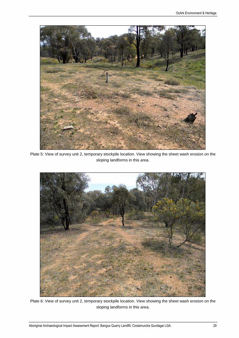
Plate 5: View of survey unit 2, stockpile location. View showing the sheet wash erosion on the
sloping landforms in this area. .................................................................................................. 29
Plate 6: View of survey unit 2, stockpile location. View showing the sheet wash erosion on the
sloping landforms in this area. .................................................................................................. 29

OzArk Environment & Heritage
Aboriginal Archaeological Impact Assessment Report: Bangus Quarry Landfill, Cootamundra Gundagai LGA. 1
1 INTRODUCTION
1.1 DESCRIPTION OF THE PROPOSAL
OzArk Environment & Heritage (OzArk) has been engaged by Salvestro Planning and Insitu
Advisory (the clients), on behalf of MH Earthmoving Pty Ltd (the proponent) to complete an
Aboriginal Archaeology Impact Assessment (AAIA) of the Bangus Quarry. The Bangus Quarry is
proposed to be used as a general solid waste (non-putrescible) landfill site (the proposal). The
proposal is in the Cootamundra Gundagai Local Government Area (LGA) (Figure 1-1).
The proponent requires development consent in accordance with the provisions of Part 4 of the
Environmental Planning and Assessment Act 1979 (EP&A Act). The development application will
be accompanied by an Environmental Impact Stations (EIS) as the proposal is classified as
“Designated Development”.
Figure 1-1: Map showing the location of the proposal.
1.2 STUDY AREA
The study area covers the entirety of the Bangus Quarry over Lot 7004 DP1028797 and Lot 7300
DP11449008 (Survey Unit 1); and some of Lot 10 DP1210362 where the proposed stockpile is
proposed (Survey Unit 2). The combined study area is approximately 7.6 hectares.

OzArk Environment & Heritage
Aboriginal Archaeological Impact Assessment Report: Bangus Quarry Landfill, Cootamundra Gundagai LGA. 2
The study area consists of two portions: the existing quarry, along with a small area of land around
it (Survey Unit 1); and a neighbouring block to the northeast that is a proposed temporary
stockpile area (Survey Unit 2). The study area is generally within lower slope landforms
overlooking a broad plain to the west. The study area has been completely cleared of standing
timber in the past but now supports a low density of regrowth trees. The proposed stockpile area
contains some localised gullies and there is evidence of sheet wash erosion on the moderately
steep slopes bordering these gullies.
Figure 1-2: Aerial showing the study area.

OzArk Environment & Heritage
Aboriginal Archaeological Impact Assessment Report: Bangus Quarry Landfill, Cootamundra Gundagai LGA. 3
2 THE ARCHAEOLOGICAL ASSESSMENT
2.1 DATE OF ARCHAEOLOGICAL ASSESSMENT
The fieldwork component of this assessment was undertaken by OzArk on the Friday, 27
September 2019.
2.2 OZARK INVOLVEMENT
2.2.1 Field assessment
The fieldwork component of the heritage assessment was undertaken by:
• Fieldwork Director: Ben Churcher (OzArk Principal Archaeologist; BA [Hons], Dip Ed).
2.2.2 Reporting
The reporting component of the heritage assessment was undertaken by:
• Report Author: Ben Churcher (OzArk Principal Archaeologist; BA [Hons], Dip Ed).
• Contributor: Adelia Gower (background research).
2.3 RELEVANT LEGISLATION
Cultural heritage is managed by several state and national Acts. Baseline principles for the
conservation of heritage places and relics can be found in the Burra Charter (Burra Charter 2013).
The Burra Charter has become the standard of best practice in the conservation of heritage
places in Australia, and heritage organisations and local government authorities have
incorporated the inherent principles and logic into guidelines and other conservation planning
documents. The Burra Charter generally advocates a cautious approach to changing places of
heritage significance. This conservative notion embodies the basic premise behind legislation
designed to protect our heritage, which operates primarily at a state level.
Several Acts of parliament provide for the protection of heritage at various levels of government.
2.3.1 State legislation
Environmental Planning and Assessment Act 1979 (EP&A Act)
This Act established requirements relating to land use and planning. The framework governing
environmental and heritage assessment in NSW is contained within the following parts of the
EP&A Act:
• Part 4: Local government development assessments, including heritage. May include
schedules of heritage items
o Division 4.7: Approvals process for state significant development

OzArk Environment & Heritage
Aboriginal Archaeological Impact Assessment Report: Bangus Quarry Landfill, Cootamundra Gundagai LGA. 4
• Part 5: Environmental impact assessment on any heritage items which may be impacted
by activities undertaken by a state government authority or a local government acting
as a self-determining authority
o Division 5.2: Approvals process for state significant infrastructure.
National Parks and Wildlife Act 1974 (NPW Act)
Amended during 2010, the NPW Act provides for the protection of Aboriginal objects (sites,
objects and cultural material) and Aboriginal places. Under the Act (Part 6), an Aboriginal object
is defined as: any deposit, object or material evidence (not being a handicraft for sale) relating to
indigenous and non-European habitation of the area that comprises NSW, being habitation both
prior to and concurrent with the occupation of that area by persons of European extraction, and
includes Aboriginal remains.
An Aboriginal place is defined under the NPW Act as an area which has been declared by the
Minister administering the Act as a place of special significance for Aboriginal culture. It may or
may not contain physical Aboriginal objects.
As of 1 October 2010, it is an offence under Section 86 of the NPW Act to ‘harm or desecrate an
object the person knows is an Aboriginal object’. It is also a strict liability offence to ‘harm an
Aboriginal object’ or to ‘harm or desecrate an Aboriginal place’, whether knowingly or
unknowingly. Section 87 of the Act provides a series of defences against the offences listed in
Section 86, such as:
• The harm was authorised by and conducted in accordance with the requirements of an
Aboriginal Heritage Impact Permit (AHIP) under Section 90 of the Act;
• The defendant exercised ‘due diligence’ to determine whether the action would harm
an Aboriginal object; or
• The harm to the Aboriginal object occurred during the undertaking of a ‘low impact
activity’ (as defined in the regulations).
Under Section 89A of the Act, it is a requirement to notify the Secretary of the Department of
Planning, Industry and Environment (DPIE) of the location of an Aboriginal object. Identified
Aboriginal items and sites are registered on Aboriginal Heritage Information Management System
(AHIMS) that is administered by the Department of Premier and Cabinet (DPC).
2.3.2 Commonwealth legislation
Environment Protection and Biodiversity Conservation Act 1999 (EPBC Act)
The EPBC Act, administered by the Commonwealth Department of the Environment and Energy,
provides a framework to protect nationally significant flora, fauna, ecological communities and
heritage places. The EPBC Act establishes both a National Heritage List and Commonwealth
Heritage List of protected places. These lists may include Aboriginal cultural sites or sites in which

OzArk Environment & Heritage
Aboriginal Archaeological Impact Assessment Report: Bangus Quarry Landfill, Cootamundra Gundagai LGA. 5
Aboriginal people have interests. The assessment and permitting processes of the EPBC Act are
triggered when a proposed activity or development could potentially have an impact on one of
the matters of national environment significance listed by the Act. Ministerial approval is required
under the EPBC Act for proposals involving significant impacts to national/commonwealth
heritage places.
Other
The Aboriginal and Torres Strait Islander Heritage Protection Act 1984 is aimed at the protection
from injury and desecration of areas and objects that are of significance to Aboriginal Australians.
This legislation has usually been invoked in emergency and conflicted situations.
The Protection of Movable Cultural Heritage Act 1986 includes legislation that prevents objects
of cultural heritage significance, such as those that are sacred to Aboriginal peoples’ heritage,
from being exported out of Australia.
2.3.3 Applicability to the proposal
The current proposal will be assessed under Part 4 of the EP&A Act.
Any Aboriginal sites within the study area are afforded legislative protection under the NPW Act.
It is noted there are no Commonwealth or National heritage listed places within the study area,
and as such, the heritage provisions of the EPBC Act and other Commonwealth Acts do not
apply.
2.4 ASSESSMENT APPROACH
The current assessment follows the Code of Practice for the Investigation of Aboriginal Objects
in New South Wales (Code of Practice; DECCW 2010).
Field assessment and reporting followed the Guide to investigating, assessing and reporting on
Aboriginal cultural heritage in NSW (the Guide; OEH 2011).
2.5 SEARS
The Planning Secretary’s Environmental Assessment Requirements (SEARs) were issued for the
proposal on 2 April 2019.
The most relevant sections of the SEARs as they apply to Aboriginal cultural heritage are:
• The EIS [Environmental Impact Statement] must identify and describe the Aboriginal
cultural heritage values that exist across the whole area that will be affected by the
proposal. This may include the need for surface survey and test excavation. The
identification of cultural heritage values must be conducted in accordance with the Code
of Practice for Archaeological Investigations of Aboriginal Objects in NSW (OEH 2010),
and should be guided by the Guide to investigating, assessing and reporting on
Aboriginal Cultural Heritage in NSW (DECCW 2011) and consultation with OEH

OzArk Environment & Heritage
Aboriginal Archaeological Impact Assessment Report: Bangus Quarry Landfill, Cootamundra Gundagai LGA. 6
regional branch officers. The Due Diligence process is not appropriate to use as an
assessment here.
• Where Aboriginal cultural heritage values are identified, consultation with Aboriginal
people must be undertaken and documented in accordance with the Aboriginal cultural
heritage consultation requirements for proponents 2010 (DECCW). The significance of
cultural heritage values for Aboriginal people who have a cultural association with the
land must be documented in the EIS.
2.6 PURPOSE AND OBJECTIVES
The purpose of the current study is to identify and assess heritage constraints relevant to the
proposed works.
2.6.1 Aboriginal archaeological assessment objectives
The current assessment will apply the Code of Practice in the completion of an Aboriginal
archaeological assessment to meet the following objectives:
Objective One: Undertake background research on the study area to formulate a
predicative model for site location within the study area
Objective Two: Identify and record objects or sites of Aboriginal heritage significance within
the study area, as well as any landforms likely to contain further
archaeological deposits
Objective Three: Assess the likely impacts of the proposed work to Aboriginal cultural
heritage and provide management recommendations.
2.7 REPORT COMPLIANCE WITH THE CODE OF PRACTICE
The Code of Practice establishes requirements that should be followed by all archaeological
investigations where harm to Aboriginal objects may be possible. Table 2-1 tabulates the
compliance of this report with the requirements established by the Code of Practice.
Table 2-1: Report compliance with the Code of Practice.
Code of Practice Requirement Context of the Requirement Concordance in this report
Requirement 1 Review previous archaeological work
Requirement 1a Previous archaeological work Section 5.2
Requirement 1b AHIMS searches Section 5.3.1
Requirement 2 Review the landscape context Section 4
Requirement 3 Summarise and discuss the local and regional character of Aboriginal land use and its material traces
Section 5.4
Requirement 4 Predict the nature and distribution of evidence
Section 5.4
Requirement 4a Predictive model Section 5.4
Requirement 4b Predictive model results Section 5.4
Requirement 5 Archaeological survey Section 6

OzArk Environment & Heritage
Aboriginal Archaeological Impact Assessment Report: Bangus Quarry Landfill, Cootamundra Gundagai LGA. 7
Code of Practice Requirement Context of the Requirement Concordance in this report
Requirement 5a Survey sampling strategy Section 6.1
Requirement 5b Survey requirements This Requirement was fulfilled during the undertaking of the survey
Requirement 5c Survey units Section 6.1
Requirement 6 Site definition Section 6
Requirement 7 Site recording Not applicable to this report as no new sites were recorded.
Requirement 7a Information to be recorded Not applicable to this report as no new sites were recorded.
Requirement 7b Scales for photography Not applicable to this report as no new sites were recorded.
Requirement 8 Location information and geographic reporting
Requirement 8a Geospatial information Not applicable to this report as no new sites were recorded.
Requirement 8b Datum and grid coordinates All coordinates are provided in GDA Zone 55.
Requirement 9 Record survey coverage data Section 6.3
Requirement 10 Analyse survey coverage Section 6.3
Requirement 11 Archaeological Report content and format
This report adheres to this Requirement.
Requirement 12 Records OzArk undertakes to maintain all survey records for at least five years.
Requirement 13 Notifying OEH and reporting
Requirement 13a Notification of breaches Not applicable
Requirement 13b Provision of information Not applicable
Requirement 14 Test excavation which is not excluded from the definition of harm
Not applicable. No test excavation was undertaken.
Requirement 15 Pre-conditions to carrying out test excavation
Not applicable. No test excavation was undertaken.
Requirement 15a Consultation Not applicable. No test excavation was undertaken.
Requirement 15b Test excavation sampling strategy Not applicable. No test excavation was undertaken.
Requirement 15c Notification Not applicable. No test excavation was undertaken.
Requirement 16 Test excavation that can be carried out in accordance with this Code
Not applicable. No test excavation was undertaken.
Requirement 16a Test excavations Not applicable. No test excavation was undertaken.
Requirement 16b Objects recovered during test excavations
Not applicable. No test excavation was undertaken.
Requirement 17 When to stop test excavations Not applicable. No test excavation was undertaken.
OzArk Environment & Heritage
Aboriginal Archaeological Impact Assessment Report: Bangus Quarry Landfill, Cootamundra Gundagai LGA. 8
3 ABORIGINAL COMMUNITY CONSULTATION
3.1 ABORIGINAL COMMUNITY CONSULTATION
The Aboriginal cultural heritage assessment of the proposal has not followed the Aboriginal
Cultural Heritage Consultation Requirements for Proponents 2010 (ACHCRs) (DECCW 2010b).
As noted in Section 2.5, the SEARs for the proposal advocate a two-stage approach to the
assessment of Aboriginal cultural heritage:
• Step 1: Undertake an assessment following the Code of Practice and the Guide
• Step 2: If any Aboriginal cultural values are noted, then initiate full Aboriginal community
consultation under the ACHCRs guidelines. This would also involve the development of
an Aboriginal Cultural Heritage Assessment Report (ACHAR).
As no Aboriginal cultural heritage values were identified in the study area, the ACHCRs were not
initiated.
3.1.1 Aboriginal community participation
Although the ACHCRs were not initiated, an invitation was extended to the Brungle Tumut Local
Aboriginal Land Council (BTLALC) to participate in the fieldwork (Appendix 1). This enabled the
cultural values of the study area to be understood.
Peter Bulger from BTLALC attended the fieldwork. On 27 September 2019 after the fieldwork had
been completed, Peter Bulger noted that:
There are some modified trees in the neighbouring TSR – they are not located within the
study area. No other issues with the fieldwork.

OzArk Environment & Heritage
Aboriginal Archaeological Impact Assessment Report: Bangus Quarry Landfill, Cootamundra Gundagai LGA. 9
4 LANDSCAPE CONTEXT
An understanding of the environmental contexts of a study area is requisite in any Aboriginal
archaeological investigation (DECCW 2010). It is a particularly important consideration in the
development and implementation of survey strategies for the detection of archaeological sites. In
addition, natural geomorphic processes of erosion and/or deposition, as well as humanly
activated landscape processes, influence the degree to which these material culture remains are
retained in the landscape as archaeological sites; and the degree to which they are preserved,
revealed and/or conserved in present environmental settings.
4.1 TOPOGRAPHY
The study area is in the NSW South Western Slopes bioregion, and in the upper slopes subregion
(NPWS 2003). It is also in the landform type Adelong Granite Ranges as defined by Mitchell
(2002). The Adelong Granite Ranges consists of steep hills and peaks with a general elevation
of 500 to 760 metres (m), and the local relief of 20 m.
Representative landforms of the study area landforms are shown in Figure 4-1. The landform
type is described below:
• Moderate to gentle lower slopes. Most of the study area is within moderate to gentle
slopes. This landform includes moderate slopes covering most of the eastern portion of
the study area (Survey Unit 2). The western section of the study area where the quarry
is located has gentler slopes (Survey Unit 1).
Figure 4-1: Topography of the study area.
1. View of a gentle slope landform unit within Survey
Unit 1.
2. View of a gentle slope landform unit within Survey
Unit 1.

OzArk Environment & Heritage
Aboriginal Archaeological Impact Assessment Report: Bangus Quarry Landfill, Cootamundra Gundagai LGA. 10
3. View of a moderate slope landform unit within Survey
Unit 2.
4. View of a moderate slope landform unit within Survey
Unit 2.
4.2 GEOLOGY AND SOILS
The geology of the area is classified as Silurian gneissic granite and Devonian massive granite
(Mitchell 2002). The two main type of soils in the region are coarse loamy sand between rock
outcrops and gritty gradational profiles developing to yellow harsh texture-contrast soils on lower
slopes (Mitchell 2002).
4.3 HYDROLOGY
No watercourses run through the study area. The closest permanent source of water is the
Murrumbidgee River, located approximately two kilometres (km) north of the study area, and
Adelong Creek, located approximately 2.6 km southeast of the study area.
4.4 VEGETATION
Prior to colonial settlement, vegetation within the region of the study area was predominantly Box-
Gum woodlands comprising Eucalyptus albens (White Box), E. melliodora (Yellow Box) and/or E.
blakelyi (Blakely’s Red Gum) with E. bridgesiana (Apple Box), E. microcarpa (Grey Box), E.
mannifera (Brittle Gum), E. rubida (Candlebark), E. cinerea (Argyle Apple) and E. macrorrhyncha
(Red Stringybark). Colonial land use practices cleared the majority of Box-Gum woodlands within
the region with only small pockets of remnant woodlands remaining.
Vegetation in the study area consists of a mixture of box, gum trees and some scrubs. Much of
the vegetation in the study area has been cleared and disturbed by grazing and quarrying
activities.
4.5 CLIMATE
The climate in the region is temperate, with hot dry summers and cold winters. Climate statistics
from the Australian Government’s Bureau of Meteorology indicate that the temperatures range
from a mean maximum temperature of 32.8 degree Celsius in January and a mean minimum

OzArk Environment & Heritage
Aboriginal Archaeological Impact Assessment Report: Bangus Quarry Landfill, Cootamundra Gundagai LGA. 11
temperature of 2.6 degrees Celsius in July. November has the highest mean rainfall of 67.3
millimetres (mm) and April has the lowest mean rainfall of 29.6 mm (BoM 2019).
4.6 LAND–USE HISTORY AND EXISTING LEVELS OF DISTURBANCE
Bangus Quarry is a council operated gravel quarry, which covers almost all of Survey Unit 1.
Survey Unit 2 has been affected by previously clearing, grazing and has varying levels of erosion
throughout.
4.7 CONCLUSION
The topography, hydrology and climate of the study area would not have been very conducive for
use by Aboriginal people. No water sources are close by and little of the landform is flat.
The ongoing use of the land for quarrying purposes in Survey Unit 1 means that any sites in this
area, had they existed, have been removed. The visible sheet wash erosion on the moderately
sloping landforms in Survey Unit 2 has removed topsoils revealing skeletal subsoils. It is likely
that this soil loss would have impacted any sites had they existed in this area.
The former tree clearing that has taken place indicates that culturally modified trees will be very
rare if not non-existent.

OzArk Environment & Heritage
Aboriginal Archaeological Impact Assessment Report: Bangus Quarry Landfill, Cootamundra Gundagai LGA. 12
5 ABORIGINAL ARCHAEOLOGY BACKGROUND
5.1 ETHNO-HISTORIC SOURCES OF REGIONAL ABORIGINAL CULTURE
The study area is within the southern boundaries of the territory of the Wiradjuri tribal and linguistic
group (Tindale 1974). The Wiradjuri tribal area is situated within the Murray Darling Basin and
extends across three general physiographic regions: the highlands or central tablelands in the
east, the riverine plains in the west, and the transitional western slopes zone in between.
The Wiradjuri is one of the largest language groups within New South Wales, extending across
the districts of Condobolin, Booligal, Carrathool, Wagga Wagga, Cootamundra, Cowra, Parkes,
Trundle, Boorowa, Wellington, Mudgee, Bathurst, Mossgiel, Hay, Albury and Tumbarumba
(Tindale 1974). While the area had a single language, various dialects were found throughout the
region most notably in Albury and Bathurst. The study area is located near the southeast
boundary of the Wiradjuri territory, next to the Ngunnawal territory.
It is important to recognise the use and meaning of the term ‘tribe’ and the designation of lines
on a map as ‘tribal boundaries’ as being controversial issues (Bowdler 1983: 22). There is no
doubt that there were distinctive groups, which can be defined by their linguistic traits, but the
designation of lines on a map as boundaries, although useful, must also be accepted as
problematic. Unlike Tindale’s map, the map (from NSW NPWS) reproduced in Bowdler (1983:
17, Figure 2) shows a more general relationship of the language groups known to exist in NSW.
Prior to colonial settlement, the eastern margins of the Murrumbidgee River basin supported
woodland and forest habitats that provided home to a wide range of exploitable resources for the
Aboriginal population. These resources included possums, which provided a ready source of
meat and fur for cloaks (Kabaila 1998: 12). Also used were vegetables including the roots of daisy
yams (Myrrnong), the tubers of lilies and orchids, stands of bracken fern, and Kurrajong roots.
The frequent floods of the Murrumbidgee provided the local Aboriginal population with an
abundance of resources: as the flood waters receded, they left the drying pools stocked with
freshwater mussels, yabbies, fish and waterfowl as well as aquatic plants (Kabaila 1998: 12).
The first colonial explorers to visit what is known today as the Gundagai region were Hamilton
Hume and William Hovell In 1824. In October of 1824, they departed the limits of white settlement
at Yass to make their way towards the emerging settlement of Port Phillip (Melbourne). For much
of their expedition they travelled along the length of the Murrumbidgee River, passing to the east
and south of present-day Gundagai (O'Keefe et al. 2002: 5). From their journals, we have the first
eyewitness accounts of the earliest contact with Aboriginal people in the area.
Thursday, 4 November 1824:
The natives appear to be numerous; in the course of the day, their fires were seen in
different directions, and their huts or camps (which are constructed in the same

OzArk Environment & Heritage
Aboriginal Archaeological Impact Assessment Report: Bangus Quarry Landfill, Cootamundra Gundagai LGA. 13
manner as those in that part of the country which we inhabit) have been frequently
met with; they were several times hailed, but could not, although they replied, be
induced to approach.
Monday, 15 November 1824:
The natives, it would seem from their tracks, are here numerous. Kangaroos are
becoming plentiful; they succeed in killing one, as also a yellow snake.
There is also much mention by the two explorers of the swift flow of the Murrumbidgee River and
its propensity for flooding:
The river, at this ford, is at least 150 feet wide, the current strong, and the water about
two feet and a half deep. From the marks on its banks, and on the trees, this river is
evidently subject at times to floods, when the water must occasionally rise at least ten
or fifteen feet higher than its present level.
Following close behind the 1824–1825 expedition by Hume and Hovell were squatters looking for
land to settle and farm. By 1828, suitable land along the Murrumbidgee River as far south as
Gundagai had been claimed and a number of stations started. In 1825, Henry O'Brien selected
land near present day Juglong. Further, down in 1826 at the confluence of the Tumut and
Murrumbidgee rivers, Ben Warby established 'Mingay' station (Crooks 1989). Two other
southbound settlers established land holdings near present day Gundagai. "Sugar" O'Brien
established "Gundagai Station" in close proximity to ‘the crossing’ (later to become the site of Old
Gundagai town) and Peter and Henry Stuckey began Willie Ploma and Tomblong respectively
around 1828 (Crooks 1989).
When Charles Sturt set out on his expedition in 1830, the Stuckey's were the southernmost
settlers in the region. Sturt contacted the Stuckey’s when he forded the Murrumbidgee River using
their crossing point at 'Stuckey’s Crossing' (Crooks 1989). Stuckey’s Crossing was established in
1838, as the only way to cross the Murrumbidgee River on the route between Sydney and
Melbourne (NMA 2019).
Although the fires of the natives had been frequent upon the river, none had, as yet,
ventured to approach us, in consequence of some misunderstanding that had taken
place between them and Mr. Stuckey's stockmen.
Sturt 1830
The evidence above of distrust between the Aboriginal people and white settlers probably came
about as a result of the Aboriginals realisation that they were being deprived of land and access
to food and water (O'Keefe et al. 2002: 5). Sturt directly encountered Wiradjuri people
downstream at present day Wantabadgery, known to the Wiradjuri as Pontebadgery (Butcher
2002: 1).

OzArk Environment & Heritage
Aboriginal Archaeological Impact Assessment Report: Bangus Quarry Landfill, Cootamundra Gundagai LGA. 14
About noon, we fell in with a large tribe of natives, but had great difficulty in bringing
them to visit us. If they had heard of white men, we were evidently the first they had
ever seen. They approached us in the most cautious manner, and were unable to
subdue their fears as long as they remained with us. Collectively, these people could
not have amounted to less than one hundred and twenty in number.
Sturt 1830
Another account recorded by Sturt at the same location seems to indicate that not all the Wiradjuri
were wary of Europeans.
One of the blacks being anxious to get an opossum out of a dead tree, every branch
of which was hollow, asked for a tomahawk, with which he cut a hole in the trunk
above where he thought the animal lay concealed. He found, however, that he had
cut too low, and that it had run higher up. This made it necessary to smoke it out; he
accordingly got some dry grass, and having kindled a fire, stuffed it into the hole he
had cut. A raging fire soon kindled in the tree, where the draft was great, and dense
columns of smoke issued from the end of each branch as thick as that from the
chimney of a steam engine. The shell of the tree was so thin that I thought it would
soon be burnt through, and that the tree would fall; but the black had no such fears,
and, ascending to the highest branch, he watched anxiously for the poor little wretch
he had thus surrounded with dangers and devoted to destruction; and no sooner did
it appear, half singed and half roasted, than he seized upon it and threw it down to us
with an air of triumph. The effect of the scene in so lonely a forest, was very fine. The
roaring of the fire in the tree, the fearless attitude of the savage, and the associations
which his colour and appearance, enveloped as he was in smoke, called up, were
singular, and still dwell on my recollection. We had not long left the tree, when it fell
with a tremendous crash, and was, when we next passed that way, a mere heap of
ashes.
Sturt 1830
White settlers moved into the area in ever increasing numbers. A drought from 1837–1838 is
reported to have stopped the Murrumbidgee River flowing, resulting in fierce competition for food
and other resources between Europeans and Aboriginal people. This culminated in an outbreak
of hostilities further down river and to the west of Gundagai (O'Keefe et al. 2002). Killings are
recorded on both sides and a number of stock losses are reported to have been caused by
Wiradjuri spears. As settler migration increased, sheer numbers of Europeans led to the collapse
of Wiradjuri resistance by 1840 or early 1841.
There is no record or evidence that the same kind of hostilities erupted in Gundagai (O'Keefe, et
al. 2002) and the town census of 1851 just prior to the catastrophic flood of 1852 records the
OzArk Environment & Heritage
Aboriginal Archaeological Impact Assessment Report: Bangus Quarry Landfill, Cootamundra Gundagai LGA. 15
population of Gundagai at 1,019 people with 137 buildings, fourteen of stone and brick and 122
built from timber (O'Keefe et al. 2002:15).
5.2 REGIONAL ARCHAEOLOGICAL CONTEXT
Within the Wiradjuri region, the presence of Aboriginal people in the Darling Basin has been dated
to 40,000 years ago (Hope 1981 as cited in Haglund 1985). A spread east into the mountains
was thought to have occurred between 14,000 to 12,000 years ago. Systematic, regional based
archaeological studies have not been undertaken in this area. Development driven studies have
however, comprised the bulk of archaeological assessment within the Gundagai district over the
past 30 years.
Koettig 1986
Koettig conducted an archaeological assessment in relation to options for a new water treatment
plant at Gundagai. One site was located during the survey on the lower waning slopes of north
west Brummys Hill, south of the Murrumbidgee River (AHIMS # 56-3-0005). The site consisted
of a low-density scatter of stone artefacts (4) made from quartz and fine-grained materials (Koettig
1986: 6). The site was located in a heavily disturbed context from domestic livestock use and
other farming practices (1986: 7).
Navin Officer Archaeological Resource Management 1994
Navin Officer conducted an archaeological survey for the Sheahan Bridge duplication at
Gundagai. Sheahan Bridge crosses the Murrumbidgee River and associated floodplain along the
Hume Highway at Gundagai. Four archaeological sites were identified during the survey
consisting of two open artefact scatters and two carved trees (AHIMS # 56-3-0075, 0076, and
0078). Both open artefact scatters were located in disturbed contexts from recent agricultural land
use. Identified artefacts included flakes, broken flakes and manuports made from rhyolite and
quartz (Navin Officer 1994: 10).
Charles Dearling Archaeological and Cultural Heritage Consultant 2002
Dearling conducted an Aboriginal heritage study for NSW National Parks and Wildlife Service
(NPWS) in selected National Parks and Nature Reserves in the South West Slopes Region of
NSW. The study incorporated five Nature Reserves and three National Parks including Minjary
National Park to the southeast of the study area. Over 15 km of fire trails and tracks and six block
surveys (totalling 5.14 hectares) were conducted on foot within Minjary National Park (Dearling
and Grinberg 2002: 48–49). Six open artefact scatters, three carved trees and one potential
archaeological deposit (PAD) were recorded in the Park. Open artefact scatters were generally
low with just 39 artefacts in total being recorded, primarily debitage or waste material created
during knapping activities. Raw material consisted of quartz (77.5%) and volcanic (22.5%) (2002:
50). Carved trees were concentrated along the Meadow Creek corridor.
OzArk Environment & Heritage
Aboriginal Archaeological Impact Assessment Report: Bangus Quarry Landfill, Cootamundra Gundagai LGA. 16
KNC 2015
An Aboriginal archaeological survey assessment was undertaken of the Gocup Road Upgrade in
2012 (KNC 2015: 13). A full coverage survey was carried out between 17–19 October 2012 by a
team of five people comprising two representatives from the BTLALC, a representative from RMS
and two archaeologists from Kelleher Nightingale Consulting Pty Ltd.
The team closely inspected exposed ground, such as unsealed tracks or eroded surfaces, for
artefacts and any old growth trees for evidence of Aboriginal bark removal. Generally, surface
visibility was poor with a resulting low level of effective coverage. Where surface visibility was
high it was usually related to erosional or one-off disturbance events (e.g. trenching, dam
construction).
As a result of the survey, nine archaeological sites and one PAD were identified within the Gocup
Road study area. The sites comprised eight artefact scatters and one isolated artefact. The
predominant raw material observed was quartz; however, a range of other materials including
tuff, chert and fine grained siliceous were also present. Numerous quartz nodules were noted
near site Gocup Road 07 which may have been a source of the quartz raw material used at the
sites.
5.3 CULTURAL LANDSCAPE
Aboriginal cultural sites form interlinked elements within a larger cultural landscape that connects
a range of ceremonial areas and a significant ancestral being lying within the landscape. The
cultural landscape identified during an assessment of the Gocup Road upgrade to the southeast
of the study area (KNC 2015) identified places within a cultural landscape described as containing
four key areas of ceremonial or spiritual significance: Mudjarn which generally relates to the area
of Mudjarn Nature Reserve; Minjary which generally relates to the area of Minjary National Park;
the Bogong Peaks; and the Gundagai Ceremonial and Burial Areas.
The mountains at Mudjarn and Minjary are seen as interconnected and are two of the most
important cultural features in the local landscape. Both areas are associated with ceremonial
business and the Goolgul, a being connected with the Bogong Moths.
5.4 LOCAL ARCHAEOLOGICAL CONTEXT
5.4.1 Desktop database searches conducted
A desktop search was conducted on the following databases to identify any potential previously-
recorded heritage within the study area. The results of this search are summarised in Table 5-1
and presented in detail in Appendix 2.

OzArk Environment & Heritage
Aboriginal Archaeological Impact Assessment Report: Bangus Quarry Landfill, Cootamundra Gundagai LGA. 17
Table 5-1: Aboriginal cultural heritage: desktop-database search results.
Name of Database Searched Date of Search Type of Search Comment
Commonwealth Heritage Listings 3 October 2019 Cootamundra Gundagai LGA
No places listed on either the National or Commonwealth heritage lists are located within the study area
National Native Title Claims Search 3 October 2019 NSW No Native Title Claims cover the study area.
DPC AHIMS 3 October 2019 10 km x 10 km centred on the study area
No AHIMS sites are within the study area.
Local Environment Plan (LEP) 3 October 2019 Cootamundra Gundagai LEP of 2013
None of the Aboriginal places noted occur near the study area.
An extensive search of the DPC administered AHIMS database returned 34 records for Aboriginal
heritage sites within the designated search area. The majority of the AHIMS sites are modified
trees (96%), followed by and isolated find and an open campsite. Figure 5-1 shows the location
of the AHIMS sites that have been recorded near the study area.
94 per cent of the AHIMS sites recorded near the study area have been recorded by one individual
and all are scarred trees. OzArk ground-truthed some of the recordings in the Bangus Travelling
Stock Reserve (TSR) near the study area, and of the trees inspected, none would meet the criteria
for cultural modification. Therefore, the large majority of scarred trees shown in Table 5-2 should
be treated with extreme caution.
No AHIMS sites have been recorded within the study area.
Table 5-2: Site types and frequencies of AHIMS sites near the study area.
Site Type Number % Frequency
Modified Tree 32 94%
Isolated Find 1 3%
Open Campsite 1 3%
Total 34 100

OzArk Environment & Heritage
Aboriginal Archaeological Impact Assessment Report: Bangus Quarry Landfill, Cootamundra Gundagai LGA. 18
Figure 5-1: Location of previously recorded AHIMS sites in relation to the study area.
The spatial distribution of AHIMS registered sites in the region illustrates the limited extent of
previous archaeological investigations in this area. Where archaeological investigations have
occurred, artefact scatters, isolated artefacts and culturally modified trees have been identified.
Artefact scatters and isolated artefacts have generally been found adjacent to creeks or rivers.
Water sources would have been focal points for Aboriginal people due to the accessibility of
resources at these locations. Culturally modified trees have been documented near creeks and
rivers in the region; however, the spatial distribution of this site type may be distorted due to
colonial farming practices and the mis-recording prevalent with this site type.
5.5 PREDICTIVE MODEL FOR SITE LOCATION
Across Australia, numerous archaeological studies in widely varying environmental zones and
contexts have demonstrated a high correlation between the permanence of a water source and
the permanence and/or complexity of Aboriginal occupation. Site location is also affected by the
availability of and/or accessibility to a range of other natural resources including: plant and animal
foods; stone and ochre resources and rock shelters; as well as by their general proximity to other
sites/places of cultural/mythological significance. Consequently, sites tend to be found along
permanent and ephemeral water sources, along access or trade routes or in areas that have
good flora/fauna resources and appropriate shelter.

OzArk Environment & Heritage
Aboriginal Archaeological Impact Assessment Report: Bangus Quarry Landfill, Cootamundra Gundagai LGA. 19
In formulating a predictive model for Aboriginal archaeological site location within any landscape
it is also necessary to consider post-depositional influences on Aboriginal material culture. In all
but the best preservation conditions very little of the organic material culture remains of ancestral
Aboriginal communities survives to the present. Generally, it is the more durable materials such
as stone artefacts, stone hearths, shells, and some bones that remain preserved in the current
landscape. Even these, however, may not be found in their original depositional context since
these may be subject to either (a) the effects of wind and water erosion/transport—both over
short- and long-time scales—or (b) the historical impacts associated with the introduction of
European farming practices including grazing and cropping, land degradation, and farm related
infrastructure. Scarred trees, due to their nature, may survive for up to several hundred years but
rarely beyond.
5.5.1 Settlement strategies
The archaeological studies undertaken within the vicinity of the study area provide information to
obtain a limited understanding of the nature and distribution of archaeological sites within the
area. Although there is some conjecture about the relationship between stream order, site
numbers and densities, the general pattern is that most sites are close to watercourses. This
indicates that water was a valuable resource and was used to navigate the landscape.
5.5.2 Past land use
Crucial for the preservation of archaeological deposits is the history of past land use in an area.
The study area has been used as a council owned gravel quarry and conducting this activity has
cleared most of the western portion of the study area and has had significant impact on the ground
surface. In the eastern portion, vegetation clearing and grazing has led to soil depletion and sheet
wash erosion. This activity is likely to have significantly impacted sites had they existed.
5.5.3 Previously recorded sites
The results of past archaeological investigations near the study area indicates that the most
common site type will be modified trees although, as noted, this finding needs to be treated with
caution. Looking further afield to the more-scientifically conducted assessments associated with
the Gocup Road upgrade (KNC 2015), it is clear that low-density artefact scatters and isolated
finds are some of the more common site types in the district.
5.5.4 Landform modelling
A consideration of the landforms within the study area enables a prediction regarding the type
and distribution of sites to be made. The slopes in the study area are not ideal camp or settlement
locations, and as there is no water source in or near the study area, Aboriginal sites are unlikely
to be recorded in the landforms of the study area. If they are present, they are likely to be low-

OzArk Environment & Heritage
Aboriginal Archaeological Impact Assessment Report: Bangus Quarry Landfill, Cootamundra Gundagai LGA. 20
density artefact scatters or isolated finds as the landforms of the study area are unlikely to have
encouraged long-term camping.
5.5.5 Previous studies
No known previous studies have been conducted in or around the study area; apart from the
informal recordings within the Bangus TSR. Further afield, the small number of archaeological
assessments that have taken place conform to the general picture that large, complex sites are
near permanent water and there is a dramatic drop-off in site density away from water.
Confounding this image is the fact that historical disturbances have been more-intense near the
region’s main waterways and this activity has probably destroyed many of the large base camps
that would have undoubtedly existed along systems such as the Murrumbidgee River to the north
of the study area.
5.5.6 Conclusion
Based on knowledge of the environmental contexts of the study area and a desktop review of the
known local and regional archaeological record, the following predictions are made concerning
the probability of those site types that may be recorded within the study area:
• Isolated finds may be indicative of: random loss or deliberate discard of a single artefact,
the remnant of a now dispersed and disturbed artefact scatter, or an otherwise obscured
or sub-surface artefact scatter. They may occur anywhere within the landscape but are
more likely to occur in topographies where open artefact scatters typically occur.
o As isolated finds can occur anywhere, particularly within disturbed contexts, it is
predicted that this site type could be recorded within the study area.
• Aboriginal scarred trees contain evidence of the removal of bark (and sometimes wood)
in the past by Aboriginal people, in the form of a scar. Bark was removed from trees for
a wide range of reasons. It was a raw material used in the manufacture of various tools,
vessels and commodities such as string, water containers, roofing for shelters, shields
and canoes. Bark was also removed because of gathering food, such as collecting wood
boring grubs or creating footholds to climb a tree for possum hunting. Due to the
multiplicity of uses and the continuous process of occlusion (or healing) following
removal, it is difficult to accurately determine the intended purpose for any example of
bark removal. Scarred trees may occur anywhere old growth trees survive. The
identification of scars as Aboriginal cultural heritage items can be problematical
because some forms of natural trauma and European bark extraction create similar
scars. Many remaining scarred trees probably date to the historic period when bark was
removed by Aboriginal people for both their own purposes and for roofing on early
European houses. Consequently, the distinction between European and Aboriginal
scarred trees may not be clear.
o Modified trees, including scarred trees, are the most represented site type within
10 km of the study area. Due to this, it is possible there will be modified trees
present, especially in the unlikely event that remnant and undisturbed mature
native vegetation is present within the study area.

OzArk Environment & Heritage
Aboriginal Archaeological Impact Assessment Report: Bangus Quarry Landfill, Cootamundra Gundagai LGA. 21
6 RESULTS OF ABORIGINAL ARCHAEOLOGICAL ASSESSMENT
6.1 SAMPLING STRATEGY AND FIELD METHODS
Standard archaeological field survey and recording methods were employed in this study (Burke
& Smith 2004).
The survey included a full assessment of the impact area where the landfill is planned. This is
shown in Figure 6-1. Survey Unit 1 has been highly modified from earthworks as a result of
quarrying. Most of the Survey Unit 1 has been cleared. Survey Unit 2 has been impacted by
clearing, grazing and erosion. The survey inspected all of the trees for cultural modification and
areas of erosion for any artefacts.
Figure 6-1: Aerial showing pedestrian transects and survey units.
6.2 PROJECT CONSTRAINTS
The only constraint during the field survey was ground surface visibility. Although most of the
study area has been cleared from the activities relating to quarrying practices, some areas had
grass and leaf litter cover, lowering the visibility.

OzArk Environment & Heritage
Aboriginal Archaeological Impact Assessment Report: Bangus Quarry Landfill, Cootamundra Gundagai LGA. 22
6.3 EFFECTIVE SURVEY COVERAGE
Two of the key factors influencing the effectiveness of archaeological survey are ground surface
visibility (GSV) and ground surface exposure (GSE). These factors are quantified to ensure that
the survey data provides adequate evidence for the evaluation of the archaeological materials
across the landscape. For the purposes of the current assessment, these terms are used in
accordance with the definitions provided in the Code of Practice.
GSV is defined as:
… the amount of bare ground (or visibility) on the exposures which might reveal artefacts
or other archaeological materials. It is important to note that visibility, on its own, is not a
reliable indicator of the detectability of buried archaeological material. Things like
vegetation, plant or leaf litter, loose sand, stone ground or introduced materials will affect
the visibility. Put another way, visibility refers to ‘what conceals’ (DECCW 2010: 39).
GSE is defined as:
… different to visibility because it estimates the area with a likelihood of revealing buried
artefacts or deposits rather than just being an observation of the amount of bare ground.
It is the percentage of land for which erosion and exposure was sufficient to reveal
archaeological evidence on the surface of the ground. Put another way, exposure refers
to ‘what reveals’ (DECCW 2010: 37).
Survey Unit 1 in the areas outside of the quarry had reasonable visibility with 70% GSV and 25%
GSE. Most of the landscape has been cleared in this survey unit due to quarrying activities, and
there was evidence of significant earthmoving at several locations. The moderate slopes in
Survey Unit 2 had good visibility with 60% GSV and 45% GSE. Visibility was poorer in areas with
higher grass and leaf litter cover. Exposures were due to erosion, vehicle tracks and a small dam.
Figure 6-2 is an aerial image of the less disturbed Survey Unit 2. As can be seen, sheet wash
erosion is widespread and GSE over this portion almost constitutes half the study area. While the
level of GSE indicates that survey efficacy was high in Survey Unit 2, it also illustrates the high
degree of soil loss and other disturbances that have occurred in this area.
Photographs representing both survey units are presented in Plates 1 to 6.

OzArk Environment & Heritage
Aboriginal Archaeological Impact Assessment Report: Bangus Quarry Landfill, Cootamundra Gundagai LGA. 23
Figure 6-2: Aerial of the eastern portion of the study area denoted by the red dotted line.
6.4 ABORIGINAL SITES RECORDED
No Aboriginal sites were recorded during the field survey. In addition, due to the extent of
past landform modification in some portions of the study area and the sloping nature of the
unmodified landforms, it was assessed that there was a low possibility for subsurface
archaeological deposits in the study area.
6.5 PREVIOUSLY RECORDED ABORIGINAL SITES LOCATED
No previously recorded Aboriginal sites are located in the study area.
6.5.1 Discussion
The results of the survey partially conform to the predictive model (Section 5.5). The most
common site type predicted to occur in the area was modified trees, however, none were
recorded in the study area due to the lack of mature trees. Isolated finds and low-density artefact
scatters were also predicted to occur, however, the it was predicted that the lack of a water source
near the study area would make such sites rare.
The results of the survey concluded that the study area has a low integrity and has been modified
by current and past quarrying activities, vegetation clearance, grazing and soil loss.

OzArk Environment & Heritage
Aboriginal Archaeological Impact Assessment Report: Bangus Quarry Landfill, Cootamundra Gundagai LGA. 24
7 RECOMMENDATIONS
Under Section 89A of the NPW Act it is mandatory that all newly-recorded Aboriginal sites be
registered with AHIMS. As a professional in the field of cultural heritage management it is the
responsibility of OzArk to ensure this process is undertaken.
To this end it is noted that no Aboriginal sites were recorded during the assessment.
The following recommendations are made based on these impacts and with regard to:
• Legal requirements under the terms of the NPW Act whereby it is illegal to damage,
deface or destroy an Aboriginal place or object without the prior written consent of BCD,
or its equivalent
• The findings of the current investigations undertaken within the study area
• The interests of the Aboriginal community.
Recommendations concerning Aboriginal cultural values within the study area are as follows:
1. No Aboriginal objects will be harmed by the proposal. As such, an AHIP is not required,
and the works can proceed without further archaeological investigation.
2. As no Aboriginal cultural heritage values will be impacted by the proposal, undertaking
the Aboriginal cultural heritage consultation requirements for proponents or the
development of an Aboriginal Cultural Heritage Assessment Report are not required.
3. This assessment is confined to within the assessed study area. Should the parameters of
the proposed work extend beyond these assessed locations, the further archaeological
assessment may be required.
4. All staff involved with the Bangus Quarry landfill activities should be aware of the
legislative protection of Aboriginal objects under the NPW Act and the contents of the
Unanticipated Finds Protocol (Appendix 3).
5. In the event of skeletal remains being identified during the works, the Unanticipated
Skeletal Remains Protocol (Appendix 4) should be followed.
6. All staff involved with the Bangus Quarry landfill activities should undergo cultural heritage
induction to ensure they recognize Aboriginal artefacts. A sample guide is provided in
Appendix 5.

OzArk Environment & Heritage
Aboriginal Archaeological Impact Assessment Report: Bangus Quarry Landfill, Cootamundra Gundagai LGA. 25
REFERENCES
BOM 2019 Bureau of Meteorology [website]. Available from: http://www.bom.gov.au/
[accessed 3 October 2019].
Bowdler 1983 S. Bowdler. 1983. Aboriginal sites on the Crown timber lands of NSW.
Report to the Forestry Commission of NSW.
Butcher 1956 A. C. Butcher. 1956. Gundagai, Its History, Verse and Song. Gundagai
Independent Print.
Burke & Smith 2004 Burke, H. and Smith, C. 2004. The Archaeologist’s Field Handbook,
Blackwell, Oxford.
Burra Charter 2013 International Council on Monuments and Sites 2013. The Burra Charter:
The Australia ICOMOS Charter for Places of Cultural Significance.
Crooks 1989 Crooks, A. 1989. Yarri, Hero of Gundagai. Mission Publications, Lawson.
Dearling 2002 Dearling, C. and Grinberg, A. 2002. Preliminary Aboriginal Cultural
Heritage Study, Selected National Parks and Nature Reserves, South
West Slopes Region. Report to NSW NPWS, Tumut.
DECCW 2010 Department of Environment, Climate Change and Water, Sydney (now
OEH). Code of Practice for Archaeological Investigation of Aboriginal
Objects in New South Wales.
DECCW 2010b Department of Environment, Climate Change and Water, Sydney (now
OEH). Aboriginal Cultural Heritage Consultation Requirements for
Proponents 2010.
Kabaila 1998 P. Kabaila. 1998. Wiradjuri Places: The Murrumbidgee River Basin with a
section on Ngunawal country. Black Mountain Projects: ACT.
KNC 2015 Kelleher Nightingale Consulting Pty Ltd. 2015. Gocup Road (MR297)
Upgrade. Aboriginal Cultural Heritage Assessment Report. Report for
RMS.
Koettig 1986 Koettig, M. 1986. Assessment of two options for placement of water
treatment works at Gundagai. Report to Council.
Mitchell 2002 Mitchell, P. 2002. NSW Ecosystems Database Mapping Unit Descriptions,
Groundtruth Consulting.
Navin Officer 1994 Navin, K. 1994. Archaeological Survey, Proposed Sheahans Bridge
Duplication, Gundagai NSW. Report to R.A. Young Associates.

OzArk Environment & Heritage
Aboriginal Archaeological Impact Assessment Report: Bangus Quarry Landfill, Cootamundra Gundagai LGA. 26
NMA 2019 National Museum Australia [website]. Available from
http://www.nma.gov.au/definging-moments/resources/gundagai -flood
1852 [accessed 3 October 2019]
OEH 2011 Office of Environment and Heritage 2011. Guide to investigating,
assessing and reporting on Aboriginal cultural heritage in NSW.
O'Keefe et al 2002 O'Keefe, B., Pearson, M. and McIntyre, M. 2002. The Watermen of
Gundagai. Old Gundagai Project Committee. Quick Print Wagga.
Sturt 1833 Sturt, Charles. 1833. Two expeditions into the interior of southern
Australia during the years 1828, 1829, 1830, 1831 with observations on
the soil, climate and general resources of the colony of New South
Wales. A Project Gutenberg of Australia eBook.
Tindale 1974 Tindale, A. 1974. Aboriginal Tribes of Australia. University of California
Press.

OzArk Environment & Heritage
Aboriginal Archaeological Impact Assessment Report: Bangus Quarry Landfill, Cootamundra Gundagai LGA. 27
PLATES
Plate 1: View of survey unit 1, Bangus Quarry section. View over the quarry pit.
Plate 2: View of survey unit 1, Bangus Quarry section showing earthmoving activity beyond the quarry pit.

OzArk Environment & Heritage
Aboriginal Archaeological Impact Assessment Report: Bangus Quarry Landfill, Cootamundra Gundagai LGA. 28
Plate 3: View of survey unit 1, Bangus Quarry section. View of the areas around the quarry pit.
Plate 4: View of survey unit 2, temporary stockpile location. View of the flat landform in the south of this
portion.
OzArk Environment & Heritage
Aboriginal Archaeological Impact Assessment Report: Bangus Quarry Landfill, Cootamundra Gundagai LGA. 29
Plate 5: View of survey unit 2, temporary stockpile location. View showing the sheet wash erosion on the
sloping landforms in this area.
Plate 6: View of survey unit 2, temporary stockpile location. View showing the sheet wash erosion on the
sloping landforms in this area.

OzArk Environment & Heritage
Aboriginal Archaeological Impact Assessment Report: Bangus Quarry Landfill, Cootamundra Gundagai LGA. 30
APPENDIX 1: ABORIGINAL CONSULTATION LOG
Aboriginal Consultation Log – Bangus Quarry
Date Organisation Comment Method
19.9.19 Brungle – Tumut Local Aboriginal Land Council
Rebecca Hardman (RH) phoned and left message asking to call back in regards to fieldwork in their area.
Phone
19.9.19 Brungle – Tumut Local Aboriginal Land Council
RH sent invite to fieldwork Email
19.9.19 Brungle – Tumut Local Aboriginal Land Council
RH phoned, straight to message bank again Email
19.9.19 Brungle – Tumut Local Aboriginal Land Council
Sheridan baker (SB) phoned and spoke to a lady on reception. She confirmed that the computers were down yesterday but pulled up the email while SB on the phone. The lady indicated that it should be fine for next week and that they would confirm in email with workers and compensation insurance.
Phone
23.9.19 Brungle – Tumut Local Aboriginal Land Council
RH phoned and spoke to Sue. Sue said they have a site officer attending and will send paperwork through today
Phone
24.9.19 Brungle – Tumut Local Aboriginal Land Council
RH phoned and spoke to Elsie to request workers comp. Was told needs to speak to sue, she is out until 330, will get her to call RH back then
Phone
24.9.19 Brungle – Tumut Local Aboriginal Land Council
RH phoned back at 4:50pm, spoke to sue, she said the book keeper will send a copy of the workers comp through tomorrow morning. RH also asked could they please send site officers name and contact number. Sue mentioned that 2 site officers will attend. One will be learning and confirmed the fee offered for 1 site officer is accepted even though 2 will attend
Phone
25.9.19 Brungle – Tumut Local Aboriginal Land Council
RH phoned back and spoke to Sue, she said she will send through the workers comp now.
Phone
25.9.19 Brungle – Tumut Local Aboriginal Land Council
RH received copy of workers comp and site officer’s name and contact number

OzArk Environment & Heritage
Aboriginal Archaeological Impact Assessment Report: Bangus Quarry Landfill, Cootamundra Gundagai LGA. 31
APPENDIX 2: AHIMS EXTENSIVE SEARCH

OzArk Environment & Heritage
Aboriginal Archaeological Impact Assessment Report: Bangus Quarry Landfill, Cootamundra Gundagai LGA. 32

OzArk Environment & Heritage
Aboriginal Archaeological Impact Assessment Report: Bangus Quarry Landfill, Cootamundra Gundagai LGA. 33
APPENDIX 3: ABORIGINAL HERITAGE: UNANTICIPATED FINDS PROTOCOL
An Aboriginal artefact is anything that is the result of past Aboriginal activity. This includes stone
(artefacts, rock engravings etc.), plant (culturally scarred trees) and animal (if showing signs of
modification; i.e. smoothing, use). Human bone (skeletal) remains may also be uncovered while
onsite.
Cultural heritage significance is assessed by the Aboriginal community and is typically based on
traditional and contemporary lore, spiritual values, and oral history, and may take into account
scientific and educational value.
Protocol to be followed in the event that previously unrecorded or unanticipated Aboriginal
object(s) are encountered:
1. If any Aboriginal object is discovered and/or harmed in, or under the land, while undertaking
the proposed development activities, the proponent must:
a. Not further harm the object;
b. Immediately cease all work at the particular location;
c. Secure the area so as to avoid further harm to the Aboriginal object;
d. Notify Biodiversity and Conservation Division (BCD) as soon as practical on 131 555,
providing any details of the Aboriginal object and its location; and
e. Not recommence any work at the particular location unless authorised in writing by
BCD.
2. In the event that Aboriginal burials are unexpectedly encountered during the activity, work
must stop immediately, the area secured to prevent unauthorised access and NSW Police
and BCD contacted.
3. Cooperate with the appropriate authorities and relevant Aboriginal community
representatives to facilitate:
a. The recording and assessment of the find(s);
b. The fulfilment of any legal constraints arising from the find(s), including complying with
BCD directions; and
c. The development and implementation of appropriate management strategies, including
consultation with stakeholders and the assessment of the significance of the find(s).
4. Where the find(s) are determined to be Aboriginal object(s), recommencement of work in
the area of the find(s) can only occur in accordance with any consequential legal
requirements and after gaining written approval from BCD (normally an Aboriginal Heritage
Impact Permit).

OzArk Environment & Heritage
Aboriginal Archaeological Impact Assessment Report: Bangus Quarry Landfill, Cootamundra Gundagai LGA. 34
APPENDIX 4: UNANTICIPATED SKELETAL REMAINS PROTOCOL

OzArk Environment & Heritage
Aboriginal Archaeological Impact Assessment Report: Bangus Quarry Landfill, Cootamundra Gundagai LGA. 35
APPENDIX 5: ABORIGINAL HERITAGE: ARTEFACT IDENTIFICATION
Retouched blades (scale = 1cm) Flakes
Microliths (scale = 1cm) Scraper (scale = 1cm)
Flake characteristics (scale = 1cm) Core from which flakes have been removed (scale = 1cm)