Embed Size (px)
Citation preview
Land-use Intensification Risks in
the Bay of Plenty Region: An assessment of current use, capability and drivers for change
Rob van Rossen
January 2015 (with input from Bill Adam – DairyNZ)

2
Table of Contents Page:
1. Executive Summary …………………………………………………………………………………….………. 3 2. Introduction ………………………………………………………………………………………….……………. 5
2.1. Background …………………………………………………………………………………….………….. 5 2.2. Issue ……………………………………………………………………………………….………………….. 5 2.3. Project Brief …………………………………………………………………………….…………………. 5 2.4. Map of Study Area and Water Management Areas ….…………………………………….. 6
3. Approach …………………………………………………………………………….……………………………… 7 4. Constraints Identified during Data and Information Collection ….…………...……………... 8 5. Key Impacts of Land-Use Intensification on Water Quality ……………………………………. 8 6. Forestry and Pastoral Farming in the Bay of Plenty– Trends and Drivers ………………. 9
6.1. Forestry ………………………………………………………………………………………..…………... 10 6.2. Dairy ………………………………………………………………………………….…………......………. 14 6.3. Sheep, Beef and Deer …………………………………………………………………………………. 17 6.4. Horticulture ………………………………………………………………………………………………. 18
7. Options to Mitigate Nutrient Leaching and Run-off in Dairy Farming Operations ….. 18 8. Major Land-Use Changes in the Bay of Plenty Region ……………………………………...…… 19
8.1. Conversion of Forestry to Dairy ……………………………………………………....…………. 19 9. Maori Land ………………………………………………………………………………………………………… 21 10. Land-Use Data and Discussion by Water Management Area …………………………………. 24 11. Summary of Key Areas of Potential Land-Use Intensification in the Bay of Plenty …. 30 12. Appendices ………………………………………………………………………………………………………… 31
12.1. Kaituna, Maketū and Pongakawa WMA Map …………………...…………………………… 31 12.2. Rotorua Lakes WMA Map …………………………………………………………………………… 31 12.3. Tarawera WMA Map ………………………………………………………………….…..…………… 32 12.4. Rangitāiki WMA Map ………………………………………………………………….….…………… 33 12.5. Whakatāne and Waimana WMA Map …………………………………….…………….….…… 34 12.6. Ohiwa Harbour and Waiotahi WMA Map ………………………………….….……………… 35 12.7. Waioeka and Otara WMA Map ………………………………………………….………………… 36 12.8. East Coast WMA Map ………………………………………………………………….……………… 37
13. References …………………………………………………...…………………………………….……………… 38
Disclaimer:
This report has been prepared by Rob van Rossen Consulting Limited for Bay of Plenty Regional Council subject to the terms and conditions
of Purchase Order 70936 dated 18th September 2014.
The opinions and information provided in this report have been provided in good faith and on the basis that every endeavour has been made
to be accurate and not misleading and to exercise reasonable care, skill and judgment in providing such opinions and information.
The liability of Rob van Rossen Consulting Limited to Bay of Plenty Regional Council for any loss, claim or damage, whether arising out of
this Agreement, negligence or otherwise, in relation to the services provided to produce this report is limited to the value of those services.
Rob van Rossen Consulting Limited nor any persons acting on the company’s behalf or under its control accept any responsibility to any
person or organisation in respect of any information or opinion provided in this report in excess of that amount.

3
1. Executive Summary
The Bay of Plenty Regional Council sought advice on the “risks and opportunities” for freshwater from land-use intensification or change in land-use in the nine Water Management Areas across the Bay of Plenty. This study involved assessing land-use capability class versus actual land-use in each of the WMAs, identifying land that is actually available for intensification, specifying the drivers for land-use change in the region, and analysing the likelihood of land-use change happening based on these drivers and other factors. Diffuse pollution from land-use is the main cause of water quality degradation in the Bay Plenty, as is the case elsewhere in New Zealand, with nitrogen, phosphorous, faecal microbes and sediments the key contaminants from diffuse sources. Evidence from NIWA catchment studies generally show a gradient in water quality from excellent in native forest, to good in plantation forest, to poor in pastoral and urban streams. Streams and drains where dairying occurs can be amongst the most polluted. Key changes in rural land-use in the Bay of Plenty over the past decade have been:
� A reduction of plantation forestry area in the region with a 7.3% decline between 2006 and 2013 due to the comparative returns from other land-uses and little or no lasting impact from the Emissions Trading Scheme, to date, on promoting new land tree planting or discouraging deforestation.
� Some growth in the area being dairy farmed in the region, with land being converted from other pastoral farming and some land from forestry.
� Significant further intensification of land already in dairy through the use of supplementary feeds, wintering cows off farm utilising dairy support land, improved pasture species and genetics, improved stock genetics, and other technologies.
� Conversion of dairy and good quality short rotation cropping land to horticulture, primarily kiwifruit and to a lesser extent avocados. There has been a strong recovery from the outbreak of the PSA disease in late 2010, which had seriously impacted on the industry.
� A continued slow decline of sheep and beef farming in the region with market returns failing to keep up with the increasing costs of inputs. There has been recent strength in beef prices but this is not seen by the industry as turn around from the long term trend.
� Fragmentation of some farmland in the Western Bay of Plenty with sub-division into lifestyle residential blocks.
There is a range of mitigation options that can and are being applied to reduce the nutrification impact of dairy farming that provide some off-set. However, the net impact of further intensification and accompanying mitigation practices is, overall, increased nutrification. The primary issue is more cows equating to more urine and more nitrogen in the soluble nitrate form entering the soil profile. There is more than 80,000 hectares of land in the Bay of Plenty currently under plantation forest that is Land-Use Capability Class (LUC) 1-4 and much of this is feasible for dairying. There have been considerable tracts of similar plantation forest land in the Taupo-Tokoroa area of the Waikato Region that have been converted to Dairy over the past 10-15 years. Much of LUC 1-4 Class forestry land in the Bay of Plenty is in Kaingaroa Forest and is adjacent to the predominantly dairy farming area of Reporoa. Whilst the trees are owned by timberland investors the underlying land is owned by iwi groups or is being held by the Crown for settlement of iwi claims. The aspirations of iwi land owners will have a significant impact on whether any of this land is converted to dairy or dairy support in a move to improve returns to the landowners.
The WMA’s identified in this analysis as having the greatest potential for land-use intensification and the greatest risk
of adverse impacts from nutrification of freshwater waterways, are in descending order:
� Rangitāiki
� Kaituna, Maketū and Pongakawa
� Tarawera
� Whakatāne and Waimana

4
Tauranga Harbour WMA is assessed as being at a lower risk from nutrification of freshwater waterways through rural
land-use because of the very low proportion and potential for high intensity pastoral farming in this WMA.
The Rotorua Lakes WMA is subject to proposed limitations of further land-use intensification by the Bay of Plenty Regional Council. There has been widespread concern about the decline in water quality in the Rotorua lakes and the long term impact this may have on the economy of the area, particularly the impact on tourism. This will move the current regulatory framework from the ‘Rule 11” nutrient loss capping position to one that seeks to reduce on-farm nutrient losses.
Of all the WMAs in the Bay of Plenty, the Rangitāiki appears to be most at risk to nutrification from land-use intensification. It is the WMA with the largest area of dairying, the largest area of pastoral farming, and the largest area of area currently in plantation forest that could be suitable for conversion to dairy and dairy support. The risk of increased nutrification is from:
� Intensification of management of land that is already dairy land. Of special note is the relatively new “soil flipping” practice that is being trialled in the Galatea area
� Conversion of dry-stock pastoral farming to dairy in the headwaters of the Rangitāiki catchment � Potential for conversion of significant tracts of Kaingaroa forest to dairy or dairy support
The three WMA’s – Kaituna/Maketū/Pongakawa, Tarawera, and Whakatāne/Waimana, are identified as next in line, in that order, for risk from nutrification because, after Rangitāiki, they have the largest areas already under dairy. There is not significant areas of forestry land in these three WMA’s that are suitable for dairy conversion – primarily because of slope.
Iwi commercial aspirations and their spiritual values around ancestral land will have a significant influence on the potential for further land-use changes and land-use intensification, and mitigation measures to off-set nutrification, in the Rangitāiki catchment.
Understanding the aspirations and intentions of iwi with respect to forest land in the Rangitāiki WMA over which they have ownership, nutrification mitigation management practices, and Regional Council policy settings are all likely to be important parts of managing water quality in this catchment.
Over the past ten years, the reviewer assesses that incremental intensification of farming on existing dairy and dairy support land has been a more important trend in terms of increased nutrification of waterways than has been the conversion of forestry land to dairy farming across the Bay of Plenty Region.
5
1. Introduction
2.1 Background:
In 2012, Bay of Plenty Regional Council notified its National Policy Statement (NPS) Implementation Programme as required under the NPS for Freshwater Management. To help deliver on this programme in February 2014 Council’s Regional Direction and Delivery Committee approved the development of a Regional Freshwater management Strategy to provide context and direction for how freshwater resources are managed in the Bay of Plenty. The Strategy will describe what the desired outcomes of this work will be and support a more focused programme of action.
2.2 Issue:
A key component of the Strategy is to identify the key risks and challenges of freshwater management in the region and the key principles for dealing with these challenges. A number of risks have been identified, the intensification of land-use across the region is the key risk. Intensification for the purpose of this analysis is taken to mean changes in land-use activities that make greater use of productive potential but that are associated with a shift from low nutrient loss to higher nutrient loss. Within the context of economic drivers operating around land use change, an understanding is sought on what the likelihood of land-use change is, based on what is known about the physical landscape, soil type, climatic conditions and existing land-use. Additionally information is sought on where that change is likely to occur and within what time frame?
2.3 Project Brief:
Council seeks advice on the identification of “risks and opportunities” for freshwater from land-use intensification or changes in land-use in the nine Water Management Areas (WMAs) across the Bay of Plenty region by:
• Assessing Land-Use Capability (LUC) class versus current land use in each of the nine WMA areas
• Identifying land that is actually available for change or intensification (to identify risks to freshwater quality as well as potential opportunities)
• Specifying the key drivers for change across the WMAs and region
• Analysing the likelihood of land-use change happening based on available land and the key drivers such as market activity (e.g. dairy), forestry rotations, long term forecasts, etc.
Horticulture as a land-use was excluded in the brief for this work.

6
2.4 Map of Study Area and WMAs

7
3. Approach
Study Components: 1.
For each WMA, assemble the following overlays for initial analysis: a. Topographic map including key natural features and SH network b. LUC Class c. Current land use
2.
Produce refined WMA maps setting out spatially and data tables: a. Area that is LUC Class 1-4 and exotic forest b. Area that is LUC Class 5 and exotic forest c. Area that is LUC Class 1-4 and high producing grassland d. Area that is LUC Class 5 and high producing grassland e. Area that is LUC Class1-4 and low producing grassland f. Area that is LUC Class 5 and low producing grassland g. Area that is LUC Class 1-4 and short rotation cropland h. Area that is LUC Class 1-4, vineyards, orchards or other perennial crop i. Area that is LUC Class 1-4, high producing grass land, and classified as Maori land j. Area that is LUC Class 5, low producing grassland, and classified as Maori land k. Area that is LUC 1-4, short rotation cropland, and classified as Maori land
3.
Examination of the economic drivers for forestry, dairying, and conversion to dairy and dairy support from other pastoral farming or from exotic forestry, with specific reference to economic returns from these land uses over time. Utilising:
a. Recognised indices for economic returns from dairy, pastoral non-dairy, and forestry b. Examination of National Exotic Forest description data to analyse forestry new land planting,
forestry restocking and deforestation c. Reviewing the history and status of the Emissions Trading Scheme as it impacts on forestry d. Reviewing the impact of Waitangi Treaty Claims settlements on ownership of exotic forested land e. Specialist input on the parameters around conversion of land-use to dairy and intensification of
existing dairy land
4.
Set out the opportunities, risks, and risk mitigation measures for the land-use options forestry, pastoral non-dairy, and dairy using industry knowledge and information available in the public domain
5. Examine the potential for intensification of Maori land, particularly that owned at hapu level, and set out challenges for development of such land
6. Interpretation of WMA’s and overlays to delineate areas for further investigation into potential for change in land-use:
a. Other pastoral to dairy or dairy support. b. Forestry to dairy or dairy support. c. Forestry to pastoral non-dairy d. Forestry to retired or indigenous planting e. Other pastoral to forestry
7. Preparation of maps by WMA identifying areas with potential for land-use change and intensification through conversion from pastoral to forestry, conversion from forestry to dairy, dairy support, or other forms of pastoral farming, and from other forms of pastoral farming to dairy or dairy support
8. Interpretation of recent aerial photography of forestry areas in 7. viewed in stereo or other 3D enabling GIS technology to assess maturity and unplanted recent cutover at a broad scale.
9. Analyse and delineate the likelihood of land-use change and land-use intensification (new forestry planting, forestry to other pastoral or dairy/dairy support, other pastoral to dairy/dairy support) across the 9 WMA’s in the Bay of Plenty drawing on 1. to 8. Above.

8
4. Constraints Identified during Data and Information Collection
The following constraints were identified during the information and data collection phase:
a. Land-use information available in the GIS overlays was not available at a level below high producing grassland – i.e. high producing grassland was not broken down into dairy land, dairy support land, beef, and sheep farming.
b. GIS overlay information for Maori land is very poor with no area values and information from a number of sources being inconsistent.
c. A methodology for interpreting exotic forest age class (item 3 in the table in Section 3) was provided by Landcare Research Limited but this methodology was quite complex and involved. During the course of this work it was determined that this work would be deferred due to time, resources and budget. It could be picked up on as a second stage if the value of such information was deemed as justifying this work.
5. Key Impacts of Land-Use Intensification on Water Quality.
NIWA, in their July 2010 publication “How Clean are our Rivers?” stated that “diffuse pollution from land use is overwhelmingly the main cause of water quality degradation in New Zealand today. Research and monitoring have identified nitrogen (particularly its dissolved form, nitrate), phosphorus, faecal microbes, and sediments as the key contaminants from diffuse sources”. This document went on to state that pastoral farming – which accounts for 40 percent of New Zealand’s land area – is undoubtedly the main source of diffuse pollution. Evidence from NIWA catchment studies generally show a gradient in water quality from excellent in native forest, to good in plantation forest, to poor in pastoral and urban streams. Streams in dairy land are among the most polluted. NIWA have stated there is no doubt that declining river water quality in New Zealand over the last 20 years is associated with intensification of pastoral farming and the conversion of dry stock farmland to dairy farming. For example, between 1992 and 2002, the number of cows in Waikato increased by 37 percent; during the same period nitrogen levels in the region’s streams increased by 40 percent and phosphorus levels went up by 25 percent. The Ministry of Agriculture and Forestry (MAF) reported in 2008 that the average nitrogen loss from the soil on dairy farms was 39 kilograms per hectare per year, compared with 12 kilograms for deer farms and 8 kilograms for sheep and beef farms. Substantial quantities of nutrients, sediments, and faecal bacteria can wash into pastoral streams, particularly on steep country, during rainstorms. Cattle also cause significant damage to ‘riparian’ habitats along the edges of streams, wetlands, and lakes. This can radically alter stream ecology by increasing sediment loads (reducing water clarity) and removing riparian plants, which are an important natural feature of streams. These plants provide cover for fish and invertebrates, and shade the water. Without this shade, the higher water temperatures and light levels become stressful for some stream species. When coupled with nutrient enrichment, they promote the growth of riverbed algae and undesirable aquatic weeds in summer when water flow is low. NIWA state that the picture is further complicated by time lags in groundwater systems, with water sometimes taking decades after falling as rain before emerging as springs into surface water. In her report “Water Quality in New Zealand – Land Use and Nutrient Pollution (Nov 2013)”, Parliamentary Commissioner for the Environment Dr Jan Wright noted that the 2011 National Policy Statement for Freshwater Management requires that “overall quality of freshwater” in all regions of the country be maintained or improved. She stated that this couldn’t be achieved unless decision makers more actively address the link between land-use change and water quality.
9
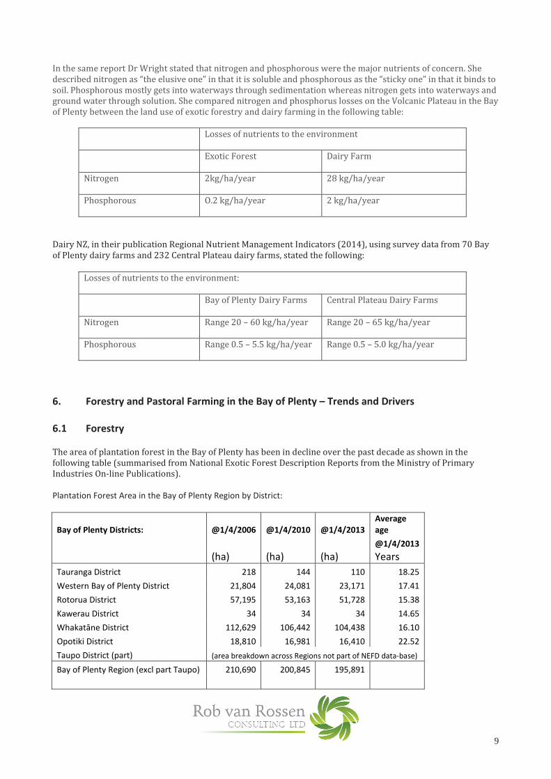
In the same report Dr Wright stated that nitrogen and phosphorous were the major nutrients of concern. She described nitrogen as “the elusive one” in that it is soluble and phosphorous as the “sticky one” in that it binds to soil. Phosphorous mostly gets into waterways through sedimentation whereas nitrogen gets into waterways and ground water through solution. She compared nitrogen and phosphorus losses on the Volcanic Plateau in the Bay of Plenty between the land use of exotic forestry and dairy farming in the following table:
Losses of nutrients to the environment
Exotic Forest
Dairy Farm
Nitrogen
2kg/ha/year 28 kg/ha/year
Phosphorous
O.2 kg/ha/year 2 kg/ha/year
Dairy NZ, in their publication Regional Nutrient Management Indicators (2014), using survey data from 70 Bay of Plenty dairy farms and 232 Central Plateau dairy farms, stated the following:
Losses of nutrients to the environment:
Bay of Plenty Dairy Farms
Central Plateau Dairy Farms
Nitrogen
Range 20 – 60 kg/ha/year Range 20 – 65 kg/ha/year
Phosphorous
Range 0.5 – 5.5 kg/ha/year Range 0.5 – 5.0 kg/ha/year
6. Forestry and Pastoral Farming in the Bay of Plenty – Trends and Drivers
6.1 Forestry
The area of plantation forest in the Bay of Plenty has been in decline over the past decade as shown in the following table (summarised from National Exotic Forest Description Reports from the Ministry of Primary Industries On-line Publications). Plantation Forest Area in the Bay of Plenty Region by District:
Bay of Plenty Districts: @1/4/2006 @1/4/2010 @1/4/2013
Average
age
@1/4/2013
(ha) (ha) (ha) Years
Tauranga District 218 144 110 18.25
Western Bay of Plenty District 21,804 24,081 23,171 17.41
Rotorua District 57,195 53,163 51,728 15.38
Kawerau District 34 34 34 14.65
Whakatāne District 112,629 106,442 104,438 16.10
Opotiki District 18,810 16,981 16,410 22.52
Taupo District (part) (area breakdown across Regions not part of NEFD data-base)
Bay of Plenty Region (excl part Taupo) 210,690 200,845 195,891

10
The total planted area reduced by 7.3% between 2006 and 2013 with each of the Region’s Districts (excluding Taupo), except Kawerau, recording a decline. The average age of the forest estate in each District, except Opotiki, is indicative of a balanced age class (about half of the typical 30 year rotation length). A number of forests in the Western Bay of Plenty, Rotorua and Whakatāne Districts are onto their third rotation and over time there has been a smoothing out of age classes. Most of the forests in Opotiki District were planted in the mid 80s to the early 90’s and there have been no second rotation forests harvested in this district yet.
No publicly available data on new-land forest planting specific to the Bay of Plenty was available but the following graph sets out the new forest land planting in New Zealand since 1992 (Source – National Exotic Forest Description – Ministry of Primary Industries, published as at 1st of April each year)
The author is not aware of significant new land planting in the Bay of Plenty during the past decade and the decline in total area of plantation forest in the region indicates that the area that has changed from forestry to another land-use is higher than any off-setting new land forest planting. The key driver for the reduction of forest area in the region is the overall low returns from forestry over the past decade. Corporate forest growers typically use a discount rate in the range 6-8% when valuing forests for acquisition. This discount rate implies an expected rate of return of 6-8% on capital invested. During the decade 2000-2010 most corporate growers were averaging returns below their target rate of return and it is very unlikely that small growers will have fared any better. The reason for the poor returns during the period 2000-2010 was the relatively flat log prices (domestic and export measured at mill door or at wharf gate in NZ dollars) in nominal terms. In real terms, for logs sold into the domestic market at least, log prices trended down in the decade 2000-2010. The graph below sets out the prices for S1/S2 sawlogs at NZ mill door and Korea Short Export Grade logs at wharf gate.
0
20,000
40,000
60,000
80,000
100,000
120,000
Ne
w l
an
d p
lan
tin
g a
rea
(h
ect
are
s)
YEAR
New Land Exotic Forest Planting in New Zealand

11
Export prices have been much more volatile than domestic log prices, with export log prices in NZ dollar terms being impacted by in-market price, exchange rate, and shipping costs. The proportion of the NZ harvest sold to export has increased steadily since 2000. China emerged as the dominant export market from 2008 and now leads export market prices, up or down, and is an important driver of domestic log prices. Beyond the data set in the graph, export log prices (expressed in NZ dollars at wharf gate) rose significantly during 2010 to early 2014 but then dropped steeply during 2014. There has been some recovery in recent months, primarily due to the NZ dollar weakening and shipping costs easing. While log prices have fluctuated, in real terms they have remained flat or have declined over the longer term. Meanwhile costs have climbed significantly over a similar period. The graph below shows logging cost movement as an index for both ground based and cable harvesting over the period 1999 to 2012. Drivers of this increasing cost are increasing fuel prices, increasing labour costs, and increased compliance costs.
Stumpage returns are the return to the forest owner at the stump – log sales revenue less the costs of production (harvest roading, harvesting, log transport and management of these operations). Stumpage does not factor in the cost of growing the crop or the cost of the underlying land.

12
The graph below is a Forme Forest Industry Consultants Index that sets out stumpage returns over the period 1989 to 2014 on a real basis for a range of tending and terrain types. Note that the growing costs of tended stands (in this index referring to pruned and thinned) are significantly higher than framing stands (thinned but not pruned), with the costs of pruning being incurred early in the rotation.
The Forme Index shows that real returns from forest growing (all management regimes) have steadily declined since the mid 1990’s to a low point in 2008. The lift between 2008 and mid 2014 still had stumpages at levels lower than a decade earlier. The New Zealand Emissions Trading Scheme (ETS), when implemented, was expected to have a positive impact on the returns from growing forests and result in more new forest planting. Under the ETS land owners who deforest pre-1990 forest must pay for deforestation liabilities, unless they have an exemption or off-set their deforestation with plantings elsewhere. Pre-1990 forest is forest land that was forest land on 31 December 1989 and remained as forest land on 31 December 2007. The vast majority of plantation forest area in the Bay of Plenty today fits into the category pre-1990 forest land. The following graph shows a time series on the price of carbon – New Zealand Units (NZU’s) and European Units (ERU’s).

13
When the price of NZU’s was around $20 per unit in 2010 deforestation liabilities were in the order of $16-18,000 per hectare, which was a significant disincentive to deforesting. At prices NZ $2 - $5 per unit, which is where NZU’s have been for the past three years, the cost of ETS liabilities for deforesting is not nearly as significant and not seen as a deterrent to conversion to another land-use. In the 2012 Deforestation Survey (MPI Technical Report No 2013/02) it was reported that large-scale forest owners intended to deforest 62,000 between 2008 and 2020 in New Zealand. It was assessed that small-scale owners would deforest another 25,000 hectares during the same period. For large owners, it was reported that the intention was that 86% of the conversion would be to dairy, 9% to sheep/beef, 4% to life-style/residential and 1% to wind-farm development. In the same report it stated that if carbon prices were to increase above $10 per unit there is likely to be a reduced rate of future deforestation. However most landowners intending to deforest have already acquired the units necessary to meet the deforestation liability for the area they intend for conversion. Sixty eight percent of the deforestation intended by large-scale owners during the period 2008 – 2020 is forecast to take place in the Central North Island.

14
6.2 Dairy
In contrast to the fortunes of forest growers, returns to dairy farmers have had a trend line of steady improvement over the last 50 years, and particularly over the past 10 years. While milk payout has been increasingly volatile over the past decade or more, the economic performance of the dairy industry has been strong. The following three graphs from the 2013 DairyNZ Economic Survey show that market returns have on average risen at a faster rate than input costs resulting in a volatile but steadily improving trend line of operating profit expressed in real terms. During 2014 the projected milk payout for the 2014-15 season has fallen back sharply but this is from an all-time high achieved in the 2013-14 season and the slump in prices is not expected to be for a prolonged period.

15
Across New Zealand the total number of dairy cows has increased significantly through a combination of increased stocking rates per hectare and more hectares in dairy. At the same time the average milk solids per cow has increased due to improved genetics, improved pasture productivity (through irrigation, fertiliser application, and improved pasture genetics and species), and off-farm feedstock inputs (silage, grains, palm kernel extract). These changes are depicted in the flowing graph from the DairyNZ Economic Survey 2013. No publicly available data was available at the Bay of Plenty level.

16
The trend in milk solids per cow indicates substantial intensification of production on existing hectares. Practices that can intensify dairy production on a per hectare basis include:
� The introduction of chicory, plantain and red clover pastures � Improving ryegrass and white clover cultivars – endophytes and tetraploids � Growing high yield lucerne � Summer crops of high yielding turnips and chicory � Winter crops of kales and fodder beet � Wintering cows off farm utilising dairy support farms � Imported feeds such as palm kernel, dried distillers grains, sunmeal, kibbled maize � Improved maize cultivars � Soil flipping techniques where soils lower down in the profile are turned to the surface. This technique is
being applied by some farmers in Galatea with early indications of 20-40% increase in annual pasture production and 2-3 year payback for a one time capital cost of around $4,000 per ha
� Continued genetic improvement of dairy stock � Sexed semen to increase the rate of genetic gain in cows and reduce replacement rates/costs � Irrigation (see below)
The following table extracted from “Analysis of Land Cover in the Bay of Plenty Region – BOPRC Internal Report 2012/08, July 2012”, sets out the percentage of each of Land Use Capability Classes 1-4 that has been assessed as irrigable:
LUC Class Area (ha) Percentage
1 2,834.7 1.52
2 51,646.3 27.70
3 61,395.0 32.93
4 70,590.2 37.86
Total 186,466.2 100.00
There are two proposed irrigation schemes for dairying in the Rangitāiki area known to the dairy farm consultant who provided input into this report. A firm proposal has been made for a community irrigation scheme in Galatea. The proposal is for an open canal out of the Upper Rangitāiki which would cross farmland, be piped under the Whirinaki and run along the bottom of the Ikawhenua range, providing water under gravity pressure to water the majority of the Galatea basin. When not in use for irrigation, surplus water would be dropped back into the Rangitāiki below the Aniwhenua dam via a penstock/turbine and would generate power. The Galatea proposal is not a foregone conclusion - there has been strong resistance by Iwi at Murupara on the basis of cultural values, by some farmers on the basis that the canal will cross their land, and by other farmers on the basis that they already have resource consent and infrastructure in place, and these would become obsolete and require further spend for no additional benefit. The second scheme, which has been discussed in concept only, is on the Lower Rangitāiki, sourcing water from below the Matahina dam to irrigate the drier areas around Te Teko/ Awakeri. There are a number of farms with private irrigation systems across the BoP. Many of these abstract water from rivers and streams such as the Rangitāiki/ Whirinaki river system, the Otamarakau stream, the Pongakawa stream, or the Tarawera river to name a few. There are also a number operating from their own private wells. Many of the ground water takes are fully allocated, or close to fully allocated, so there is limited opportunity for additional irrigation in some areas.

17
The effect of irrigation on N leaching is highly dependent on the timing, accuracy and quality of the water application. Most systems in the Bay of Plenty at the moment are fairly rudimentary systems: K-lines, Bosch long lateral systems, and a number of basic fixed rate centre pivots. It is difficult to get accuracy and timeliness to a high level particularly with manual shift systems. As a result some areas can be overwatered and leach, other areas are under-watered, grass doesn’t grow so well, and nitrogen is left underutilised in the soil, at risk of leaching in rain events. Soil moisture monitoring, rainfall and ET monitoring and variable rate irrigation systems can offset these effects to a significant degree, while saving water as well.
6.3 Beef, Sheep and Deer
Beef and Sheep farming have been slowly declining in the New Zealand during the past decade as depicted by the following two graphs from Beef+Lamb New Zealand. Rising farm costs without corresponding prices increases for meat and wool have been the primary driver for this decline. Advice from a farm consultant is that both sheep and beef have been in decline in the Bay of Plenty over the same time frame as for the data presented at the New Zealand level.

18
Whilst beef prices in 2014 have been significantly up this is not seen as a turn-around for the overall trend. Increasingly, dairy farms in the Bay of Plenty winter cows off-farm. There has been a trend for dry stock farmers to find wintering and/or young stock grazing to be more economic than sheep breeding operations, so many of these farms, which may be unsuitable for dairy farming, are partially or completely committed to dairy industry support. Beef and Sheep farming are now not major land uses in most of the Bay of Plenty. Deer farming has fluctuated widely in returns and have recently been poor but do have prospects to return to good profitability. Deer are mostly farmed on difficult sites not suited to dairy or dairy support.
6.4 Horticulture
There is continuing change of land-use from dairy to horticulture in the Western Bay of Plenty, Te Puke, Opotiki and East Coast. The driver of this change is the kiwifruit disease PSA has been brought under control and the values of orchards have rebounded strongly, export prices and grower returns are high, and new cultivars of kiwifruit are performing well. Avocados are also showing strong returns. Conversion to horticulture is not analysed further in this report as it was excluded in the brief for this work.
7. Options to Mitigate Nutrient Leaching and Run-off in Dairy Farming Operations
There is a range of mitigation practices and management options to reduce nutrient run-off and leaching that are applied to various extents on dairy farms, and other pastoral farms, in the Bay of Plenty. These include:
� Nutrient budgeting and precision application of fertiliser � Improved animal and plant genetics � Lower stocking rates coupled with higher production per cow � Strategic use of supplementary feeds including low N supplements such as maize silage, grains, molasses
and tapioca � Keeping cows off pasture at critical times using concrete stand-off pads and wintering barns coupled
with effluent management � Use of deeper rooting pasture species � Precision irrigation systems � Fencing streams and bridging stream crossings � Planting riparian strips along waterways � Constructing wetlands � Limiting soil erosion

19
8. Major Land Use Changes in the Bay of Plenty
Motu Economic and Public Policy Research has developed and run a model called “Land Use in Rural New Zealand” (LURNZ). LURNZ is a dynamic partial equilibrium model that simulates changes in private rural land use over time and space. LURNZ focuses on four key land uses – dairy, sheep/beef, forestry and scrub.
Motu recorded land projected and use change in the Bay of Plenty as follows:
Land Use
1996 – 2008 (recorded) 2008 – 2020 (projected)
Sheep and Beef - 10,900 ha -18,000 ha
Dairy +4,100 ha +4,700 ha
Plantation Forestry +2,200 ha +18,200 ha
Scrub
+200 ha -4,900 ha
Dr Jan Wright, Parliamentary Commissioner for the Environment, in her report “Water Quality in NZ – Land Use and Nutrient Pollution – November 2013”, noted that in 2011 the increases in dairy was occurring at a level consistent with the Motu projections but that the increase in forest land projected by Motu was not eventuating. The latter point is consistent with NEFD forestry statistics referred to earlier in this report. The area of exotic forestry in the Bay of Plenty declined 7.3% between 2006 and 2013.
At the time the Motu report referred to above was prepared there was an expectation that the Emissions Trading Scheme would incentivise new forest planting, primarily on LUC Class Land 5 to 7 in sheep and/or beef or scrub. Average forestry returns over the past decade and the trend for carbon prices, as discussed in Section 6.1 of this report has meant this hasn’t happened.
The main changes intensifying rural land-use in the Bay of Plenty that have been occurring and are likely to continue to occur in light of economic drivers and current policy settings are:
� Further intensification of land that is already being dairy farmed � Continued conversion of dry-stock farming to dairy or dairy support � Conversion of dairy land to kiwifruit orchards � Conversion of forestry blocks to dairy (to date this has not happened on a large scale in the Bay of Plenty
Region as compared with the scale of conversion of forestry land to dairy in the Waikato Region)
8.1 Conversion of Forestry to Dairy in a Bay of Plenty Context
There have been substantial areas of forest land converted to dairy in the Waikato Region since 2000, predominantly in the area to the north and north-west of Tokoroa and between Tokoroa and Taupo. The extent of conversion of forests to dairy in the Bay of Plenty region has been less pronounced so far.
The following four paragraphs are summary points from a paper by Iona McCarthy of Massey University titled “Can Forestry Land Produce Milk? (2004)”:
� The pumicelands of the Kaingaroa Forest were planted in forests after farmers walked off the land in despair as stock died of “bush sickness”. In the 1930’s it was identified that small doses of cobalt in fertiliser application or in salt licks for stock remedied this problem.
� Expansive dairy farming in the Reporoa area adjoining Kaingaroa Forest demonstrates that this land is suitable for dairy farming. The contour and soil drainage provides no limitation to dairy farming and the soil type is well suited to dairying with appropriate fertiliser programmes. Pumice soils are low in organic matter content and require high and frequent fertiliser inputs. Many dry-stock farms were converted to dairying in the Reporoa region during the 1990’s and these have been successful and profitable dairy operations.

20
� The climate is well suited to seasonal dairy production. Mean annual rainfall is 1400-1450 mm per year with reasonably even distribution throughout the year.
� There are virtually no water courses through Kaingaroa Forest so stock water would have to be pumped from bores. Good underground water has been sourced on dairy farms on the plateau at 100 to 200 metres. Water supply should not limit dairy production.
From a physical attributes perspective there is no reason why the conversion of forest land to dairy land that has occurred in the Waikato Region, in the Tokoroa and Taupo areas, could not be replicated in large parts of Kaingaroa Forest.
Advice from a dairy farm consultant is that, based on a milk payout of $6.50 per kg, conversion of bare stumped ex forestry land on the Volcanic Plateau is viable at a land price (stumped) of up to $13,4000 per hectare. Current slash management and stumping prices in the Tokoroa area are approximately $2,000 per hectare (per comms from a contractor currently engaged in this work). Typical current valuations for good quality easy contour forestry land on forest owners books are well below $5,000 per hectare. On this basis, and using the 15 year trend line milk payout, there is a strong economic case, ignoring any environmental external costs, for conversion of forestry land to dairy on the Volcanic Plateau.
Some ex-forest land may not go so far as becoming dairy farms but could become dairy support. Dairy farmers from other parts of the Bay of Plenty may look to increase production through cow wintering off-farm and long term grazing for heifers. A sustained period of $6.50-7.50 payouts could drive up prices for off-farm grazing. Heifer grazing is relatively low impact in terms of N leaching. Winter grazing of cows is high N impact, especially if winter crops such as swedes or kale are grazed in situ.
The dairy milk payout reached a record high of $8.40 per kg of milk solids in the 2013/14 season. At the time of preparing this report the Fontera forecast payout was down to $4.70 per kg, lower than any actual payout (ignoring dividends) in the last seven years. The market expects a recovery in milk powder prices, which is the dominant product, but it is not clear when that will occur. A milk payout of $4.70 is expected to cause financial stress for many farmers, particularly if it remained at such low levels beyond one season.

21
9. Maori Land
Thirty eight percent of the Bay of Plenty region land area is in Maori ownership (17.8% of the Bay of Plenty region is freehold Maori Land), with 1,800 Maori Land Trusts managing these assets. There are over 34 iwi and over 200 hapu.
GIS overlay information for Maori land available for analysis in this report was poor with no area values and information from a number of sources being inconsistent. There was no access to a breakdown of Maori owned land by Land-Use Capability class but it is known that there is significant area of Maori owned land within LUC Classes 1- 4, including land that is dairy farmed and land that is planted in exotic forest. Not all Maori land, particularly that owned at the hapu level, is managed as intensively as similar land under private ownership. Reasons for this include:
� Maori strongly identifying with ancestral land in a spiritual sense and this view of land can over-ride views on the economic potential of land
� Insufficient size, difficult shape, lack of contiguous blocks � Multiple ownership � Absentee ownership � Lack of communication or lack of agreement between owners � Lack of access to finance due to inability to mortgage property
Over time it is expected that some of the impediments to development of some Maori owned land may be resolved, and owners of such land may seek greater economic return from their land through development. Spiritual attachment to ancestral land is expected to remain as a key influence on how this land is managed. A report by PriceWaterHouseCoopers for the Ministry of Primary Industries – “Growing the Productive Base of Maori Freehold Land”, February 2013, examines the options for intensifying the land use of under-developed and under-utilised freehold Maori land. It does not provide Bay of Plenty specific data but provides a case study for Northland. In this case study they report that freehold Maori land makes up 9.3% of the Northland Region and there is an opportunity to develop 5,600 hectares of this freehold Maori land for dairy farming and a further 49,000 hectares for sheep and beef farming. Waitangi Treaty settlements have seen significant areas of land returned to iwi in the Bay of Plenty, as has been the case elsewhere in New Zealand. There are often significantly better skill levels and financial horsepower available at the iwi level than may exist at the hapu level, as has been evidenced by the commercial strength and commercial activity of a number of iwi in different parts of New Zealand In 2007, Ngai Tuhoe, Ngāti Tuwharetoa, Ngāti Whare, Ngāti Rangitihi and Ngāti Whakaue came together to form the Central North Island (CNI) Iwi Collective. They were joined by Ngāti Manawa, Raukawa and affiliate group Te Pumautanga O Te Arawa in 2008. These eight iwi, as the CNI Iwi Collective, signed a final settlement with the Crown in June 2008. On 1 July 2009, the land, accumulated rentals and other settlement assets were transferred back for the benefit of all Collective members. The vast majority of settlement land is part of Kaingaroa forest. The land was transferred by the Crown into a trust holding entity called CNI Iwi Holdings Ltd. This is the corporate trustee of the CNI Iwi Holdings Trust. The key functions of CNI Iwi Holdings Ltd are:
1. To receive the settlement assets. 2. To distribute the settlement assets and any ongoing revenue from those assets (including ongoing
license fees paid under the Crown Forest Licenses). 3. To safeguard the land and ensure that it is never put at risk.
It is important to note that as a trust-holding entity, CNI Iwi Holdings Ltd is not a commercial company and has no commercial functions. It is run according to a Trust Deed and Shareholders Agreement and is governed by a Board of Directors. The eight iwi are all equal shareholders of CNIIHL, with two Directors appointed for each of the eight iwi. The other shareholder is the Crown. The Crown’s shareholding is of “observer” status and the purpose is to protect the claims of iwi outside the Collective who have unsettled interests in the CNI Crown forest lands.
22
The key role of CNIIHL's Directors is to ensure that CNIIHL, as Trustee, acts in the best interests of the trust’s beneficiaries. Holdings have entered into a Land Management Agreement with CNI Iwi Land Management Ltd and under this agreement CNIIHL has delegated the day-to-day management and operations in relation to the land to CNI Iwi Land Management Ltd. However CNIIHL is still ultimately responsible for the stewardship and safe-guarding of the land and must monitor the performance of CNI Iwi Land Management Ltd as Land Manager, and in accordance with CNIIHL's legal obligations. The following map page shows Crown Forest Licensed land in the Central North Island and the areas returned to iwi ownership. Significant parts of the area shaded green (other Licensed Crown Forest Land) and shaded orange (Licensed Crown Forest Land offered to Affiliate Te Arawa iwi/hapu) fits into LUC Class1-4 (see Rangitāiki Water Management Area Map in Appendix 12.4) and could be suited to dairy farming.

23

24
In August 2014 the Draft Consultation Document “Te Ara Whanui o Rangitaiki - Pathways of the Rangitaiki” was released by the Rangitaiki River Forum. This document and the group behind it may have influence on land-use decisions by iwi on land in the Rangitaiki catchment, which includes Kaingaroa Forest.
Concern about the poor state of the Rangitaiki and growing discontent with existing management regimes gave rise to a call by iwi for a greater role in the management of the Rangitaiki. These concerns formed a platform for discussion between the Crown, Ngati Manawa and Ngati Whare as part of their respective Treaty settlement negotiations. Subsequently the Rangitaiki River Forum (the Forum) was jointly established as a co-governance forum by the Ngati Whare and the Ngati Manawa settlement legislation in May 2012.
The Forum represents a partnership between Maori and the Crown. It comprises equal representation from each of the iwi (Ngati Whare, Ngati Manawa, Ngati Awa, Ngati Tuwharetoa-BoP) that collectively claim mana whenua in the Rangitaiki, and local government representatives (Bay of Plenty Regional Council and Whakatane District Council). It provides a vehicle for direct participation of iwi in the governance of the Rangitaiki through the development of broad level policies to ensure the health and wellbeing of the Rangitaiki River and its resources, for the benefit of present and future generations.
The Forum states that its purpose is “to protect and enhance the environmental, cultural, and spiritual health and
well-being of the Rangitāiki River and its resources for the benefit of present and future generations”.
10. Land Use Data and Discussion by WMA
When considering intensification of land-use in the Bay of Plenty (outside of land being utilized for residential, industrial, and infrastructure) the author determined that the significant changes in rural land-use that result in intensification, with associated risks to water quality, are:
� More intense management of current dairy land � Conversion of dry-stock farming to dairy and dairy support � Conversion of plantation forest land to dairy and dairy support � Conversion of dairy land to horticulture
There is very little LUC Class 5 Land in the Bay of Plenty. For the purposes of this analysis it is assumed that LUC Class 6-8 is generally unsuitable for dairy farming, including dairy support, and that High Producing Exotic Grassland in LUC Classes 6-7 relate to sheep, beef and deer farming. It is known that there is some dairy activity on LUC Class land 6 but this is generally small areas adjoining and conjunction with dairy farms on LUC Class 4 and better land. The table over the page sets out the area breakdown by dominant land use cover for each of the LUC Classes in the Bay of Plenty region:

25
Areas of the Various LUC Classes and their Composition of Dominant Land Cover in the Bay of
Plenty:
LUC Class Area (has) Percentage Composition of dominant land cover
(% of LUC Class area)
1 2,839.9 0.24 High producing exotic grassland (81.6%)
Short rotation crops (9.0%)
Orchards and other perennial crops (4.9%)
2 53,198.1 4.46 High producing exotic grassland (70.8%)
Orchards and other perennial crops (14.4%)
Short rotation crops (7.5%)
3 74,774.4 6.27 High producing exotic grassland (66.2%)
Orchards and other perennial crops (7.5%)
Pine forest, closed canopy (6.6%)
Pine forest, open canopy (3.5%)
4 182,950.1 15.33 High producing exotic grassland (28.8%)
Pine forest, closed canopy (25.7%)
Pine forest, open canopy (14.1%)
Forest, harvested (11.3%)
Indigenous forest (8.1%)
Arable total 313,762.5 (26.30)
5 659.1 0.06 High producing exotic grassland (86.3%)
Orchard and other perennial crops (6.5%)
Pine forest, closed canopy (3.4%)
6 283,029.5 23.72 High producing exotic grassland (29.0%)
Indigenous forest (28.9%)
Pine forest, closed canopy (18.1%)
Pine forest, open canopy (7.2%)
Forest, harvested (5.6%)
7 393,059.3 32.95
Indigenous forest (66.7%)
High producing exotic grassland (5.7%)
Broadleaved indigenous hardwoods (3.7%)
Manuka/kanuka (3.5%)
Forest, harvested (3.3%)
Pine forest, open canopy (3.0%)
8 202,480.6 16.97 Indigenous forest (87.9%)
Broadleaved indigenous hardwoods (2.7%)
Pine forest, closed canopy (2.2%)
Non-arable, total 879,228.5 (73.70)
Grand total 1,192,991.0 100.00

26
The following tables in the rest of this section set out the break down of primary production land uses in LUC Classes
1-4 for each of the 9 Water Management Areas in the Bay of Plenty, with associated commentary regarding potential
for land-use intensification.
Tauranga Harbour
Water Management Area
Landuse on LUC Class 1-4 Hectares
% of
WMA
Area
Exotic Forest
Low Producing Grassland
High Producing Exotic Grassland
Short-rotation Cropland
Orchards, Vineyards and other Perennial Crops
5,371.9
202.1
1,811.0
543.8
7,199.0
4.35%
0.16%
1.47%
0.44%
5.83%
High producing grassland makes up only 1.47% of this WMA. According to DairyNZ figures there is 1,574 ha of dairy land in the Tauranga which is a significant proportion of the 1,811 ha of high producing grassland in this WMA.
Forestry on LUC Class 1-4 land comprises 4.35% of this WMA.
Orchards, Vineyards and other perennial crops comprise 5.83% of this WMA with Kiwifruit being the largest of this group. With the recent bounce back of the kiwifruit industry there is still a trend of conversion of pastoral land, including dairy, to kiwifruit. Advocado orchards are also expanding.
Fragmentation of dairy farms as a result of conversion to orchards has resulted in some of this land being used for cropping and cut and cart systems (maize, silage, lucerne) – effectively for dairy support elsewhere.
Small tough blocks of hilly dairy land close to Tauranga will be favoured as residential lifestyle blocks.
Tauranga is expected to continue to grow out along the coastal strips to the north-west and south-east. The Eastern arterial route currently under construction has resulted in re-organisation and aggregation of land holding.
Dairy cow numbers are declining in the Tauranga Harbour WMA according to advice from a dairy farm consultant.

27
Kaituna, Maketū and
Pongakawa
Water Management Area
Landuse on LUC Class 1-4 Hectares
% of
WMA
Area
Exotic Forest
Low Producing Grassland
High Producing Exotic Grassland
Short-rotation Cropland
Orchards, Vineyards and other Perennial Crops
4,858.2
102.8
27,716.0
741.7
7,240.0
3.94%
0.10%
25.95%
0.69%
6.75%
At 25.95%, high producing grassland is a large proportion of this WMA, larger as a proportion (but not in absolute terms) than any of the other 8 WMAs in the Bay of Plenty region. This WMA also has an equivalent area in orchards to the Tauranga Harbour WMA, these two WMAs having the majority (85% ) of the orchard area in the Bay of Plenty.
As in Tauranga Harbour WMA, there is continued growth in orchards at the expense of dairy and with similar trends for use of dairy land which is fragmented by conversion of parts to orchards.
There is pressure on farms in the lower Kaituna catchment to store effluent for long periods (up to 3 months) and only irrigate. This can require very large on-farm investments in effluent storage facilities. There are significant engineering problems and costs involved in achieving this. Soils in this area pug easily and this in combination with effluent management have created some interest in winter housing systems. At the moment these have a capital cost of ~ $3,000 per cow and are not widely considered feasible.
There is little contiguous forestry land that would be suitable for conversion to dairy in this WMA but intensification of existing dairy remains a risk.
Rotorua Lakes
Water Management Area
Landuse on LUC Class 1-4 Hectares
% of
WMA
Area
Exotic Forest
Low Producing Grassland
High Producing Exotic Grassland
Short-rotation Cropland
Orchards, Vineyards and other Perennial Crops
4,592.5
85.3
14,791.0
85.7
41.0
4.18%
0.08%
13.45%
0.08%
0.04%
High producing grassland comprises 13.45% of this WMA and forestry on LUC Class 1-4 comprises 4.18% of this WMA. There is negligible short rotation cropland and orchards/vineyards/other perennial crops.
The BOPRC Proposed Regional Water and Land Plan sets environmental standards to limit nutrient losses to the lakes. The primary rule for this is Rule 11 which caps nutrient loss levels from farms at 2001-2004 levels. This is a significant influence on how land is managed and developed in the Rule 11 catchments (Rotorua, Rotoiti, Rotoehu, Okaro and Okareka). It limits intensification of existing dairy farming and restricts conversion of forestry land to dairy in this WMA. Currently the Regional Council is working with the community on establishing new rules to reduce the amount of nutrients entering Lake Rotorua. This will further constrain the ability for intensification and forestry conversion in the Lake Rotorua catchment.

28
Tarawera
Water Management Area
Landuse on LUC Class 1-4 Hectares
% of
WMA
Area
Exotic Forest
Low Producing Grassland
High Producing Exotic Grassland
Short-rotation Cropland
Orchards, Vineyards and other Perennial Crops
6,865.9
72.1
13,118.0
962.6
419.0
8.56%
0.09%
16.36%
1.20%
0.52%
The Tarawera WMA has a significant area of forest land on LUC Class 1-4. The soils associated with this area tend to be coarse recent volcanic soils that are subject to drying out quickly and may limit the suitability for conversion to dairying when compared to further up on the volcanic plateau.
There is significant dairy farming area in this WMA in the Onepu area and on the Rangitāiki plans on the western side of the Rangitāiki River. Further intensification of these dairy farms is quite feasible.
Rangitāiki Water
Management Area
Landuse on LUC Class 1-4 Hectares
% of
WMA
Area
Rangitāiki
Exotic Forest
Low Producing Grassland
High Producing Exotic Grassland
Short-rotation Cropland
Orchards, Vineyards and other Perennial Crops
81,440.5
2,839.3
35,043.0
2,696.7
530.0
27.55%
0.96%
11.86%
0.91%
0.18%
The Rangitāiki WMA is the largest WMA in the Bay of Plenty apart from the East Coast WMA. It has the largest area of high producing grassland, short rotation cropland and forestry area on LUC Class 1-4. With the Rangitāiki Plains, Waiohau, and Galatea being long established dairying areas, the Rangitāiki has more dairy cows than any other WMA in the Bay of Plenty region. It also has the largest area of forestry land on LUC Class 1-4 (81,440 hectares) with much of this being quite contiguous and having attributes that mean it could be productive dairy or dairy support land. There is also considerable high producing grassland on flat country at the headwaters of the Rangitāiki catchment that is targeted for dairy (for example the recent acquisition of land by Shanghai Pengxin).
According to the report published by DairyNZ – “Water Quality Status and Trends: Bay of Plenty (June 2014)” -the Rangitāiki River (measured at Murupara) is the only river measured in that study in the Bay of Plenty where a worsening trend for total nitrogen loading was observed.
Of all the WMAs in the Bay of Plenty, the Rangitāiki appears to be most at risk to nutrification from land use intensification. This risk is from:
� Intensification of management of land that is already dairy land � Conversion of dry-stock pastoral farming to dairy in the headwaters of the Rangitāiki
catchment � Potential for conversion of significant tracts of Kaingaroa forest to dairy or dairy support

29
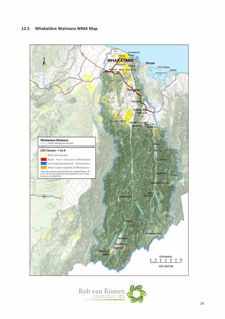
Whakatāne and Waimana
Water Management Area
Landuse on LUC Class 1-4 Hectares
% of
WMA
Area
Exotic Forest
Low Producing Grassland
High Producing Exotic Grassland
Short-rotation Cropland
Orchards, Vineyards and other Perennial Crops
578.6
107.9
14,228.0
2,446.5
254.0
0.32%
0.06%
7.93%
1.36%
0.14%
There is significant dairy farming and dairy support in the Whakatāne and Waimana catchments. A proportion of this land is Maori owned land, some of this land is owned at the hapu level. While there are impediments to intensification of under-utilised Maori land, it is happening and there is potential for further intensification – to dairy or dairy support, including growing crops such as maize.
There is very little forestry land that has potential for conversion to dairy or dairy support in this WMA. Ohiwa Harbour and
Waiotahi Water
Management Area
Landuse on LUC Class 1-4 Hectares
% of
WMA
Area
Exotic Forest
Low Producing Grassland
High Producing Exotic Grassland
Short-rotation Cropland
Orchards, Vineyards and other Perennial Crops
194.6
20.8
4,522.0
91.8
134.0
0.57%
0.06%
13.22%
0.27%
0.39%
Ohiwa Harbour and Waiotahi WMA is the smallest of the nine WMA’s in the Bay of Plenty. Dairy farming is a prominent land-use on river flat areas. As in other WMAs in the region there are current options for further intensification of these dairy farms.
Waioeka and Otara Water
Management Area
Landuse on LUC Class 1-4 Hectares
% of
WMA
Area
Exotic Forest
Low Producing Grassland
High Producing Exotic Grassland
Short-rotation Cropland
Orchards, Vineyards and other Perennial Crops
54.4
19.6
6,489.0
559.4
884.0
0.04%
0.02%
5.27%
0.45%
0.72%
Waioeka and Otara WMA is larger than the adjoining Ohiwa Harbour and Waioeka WMA but it is similar in many respects with regards to intensification, except that it has a higher proportion of orchards (kiwifruit). As is the case in the Western Bay of Plenty the expectation is that the area in kiwifruit will continue to grow, mostly at the expense of dairying.
There is negligible forestry area that has any potential for conversion to dairying or dairy support in this WMA.

30
East Coast Water
Management Area
Landuse on LUC Class 1-4 Hectares
% of
WMA
Area
Exotic Forest
Low Producing Grassland
High Producing Exotic Grassland
Short-rotation Cropland
Orchards, Vineyards and other Perennial Crops
908.8
549.7
14,087.0
635.1
419.0
0.33%
0.20%
5.11%
0.23%
0.15%
The East Coast WMA is the largest in the Bay of Plenty but also has the highest proportion of its area in native forest cover.
Cartage distances are such that the area being dairy farmed in this WMA is expected to continue to decline with land being converted to dairy support or kiwifruit.
There is very little forestry land in this WMA that is suitable for conversion to pastoral use and what exists is not contiguous.
11. Summary of WMAs Potentially at Risk from Nutirifcation of Freshwater Waterways from
Rural Land-Use Intensification in the Bay of Plenty
The WMA’s identified in this analysis as having the greatest potential for rural land-use intensification and, with that
intensification, greatest risk of adverse impacts from nutrification of freshwater waterways, are in descending order:
� Rangitāiki
� Kaituna, Maketū and Pongakawa
� Tarawera
� Whakatāne and Waimana
This analysis points to incremental intensification of management of existing dairy land as, so far, having been the key
driver of the risk of nutrification, rather than conversion of forestry land to dairy land. The Rangitāiki WMA has the
largest area of dairy, with further dairy development currently occurring in its headwaters. It also has the largest tracts
of current forestry land that has attributes making it suitable for dairy conversion.
Tauranga Harbour WMA is assessed as being at low risk from nutrification of freshwater waterways because of the
low proportion and potential for high intensity pastoral farming in this WMA.
It is assumed that current plans for restriction of further nutrient loadings in freshwater in Rotorua Lakes WMA will, if
confirmed, avert the risk of further nitrification of freshwater in this WMA.
This analysis indicates that Ohiwa Harbour and Waiotahi, Waioeka and Otara, and East Coast WMA’s face a much
lower risk of nutrification of freshwater from intensification of rural land-use compared to the four WMA’s bulleted
above.
Areas for that would warrant further investigation include:
� More in depth understanding of how dairy land use has been intensified at a specific WMA level, particularly
in the Rangitāiki, Kaituna/Maketū/Pongakawa, Tarawera, and Whakatāne/Waimana catchments along with
what mitigation measures have been applied.
� More detailed evaluation in the four WMA’s specified above of the likely pattern for further dairy
intensification
� A more detailed understanding of the intentions of iwi groups that either have ownership or are likely to
secure ownership of the underlying land in Kaingaroa Forest with respect to how they may look to balance
economic, cultural, environmental and spiritual aspirations and the how these aspirations may impact on the
likelihood of tracts of Kaingaroa Forest being converted to dairy over time.

31
12 Appendices:
12.1 Kaituna, Maketū and Pongakawa WMA Map
12.2 Rotorua Lakes WMA Map

32
12.3 Tarawera WMA Map

33
12.4 Rangitāiki WMA Map
34
12.5 Whakatāne Waimana WMA Map

35
12.6 Ohiwa Harbour Waiotahi WMA Map

36
12.7 Waioeka Otara WMA Map

37
12.8 East Coast WMA Map

38
13 References:
a. NIWA – How Clean are our Rivers? - July 2010 NIWA Website Publication b. Water Quality in New Zealand – Land Use and Nutrient Pollution – Nov 2013 – Dr Jan Wright –
Parliamentary Commissioner for the Environment c. DairyNZ Publication – Regional Nutrient Management Indicators (2014) d. National Exotic Forest Description Reports – Ministry of Primary Industries (various years cited) e. 2012 Deforestation Survey (MPI Technical Report No 2013/02) – Dr Bruce Manley f. DairyNZ 2013 Economic Survey g. Analysis of Land Cover in the Bay of Plenty Region – BOPRC Internal Report 2012/8 – July 2012
h. Can Forestry Land Produce Milk? – Iona McCarthy - Massey University Department of Finance – 2004
i. Draft Consultation Document “Te Ara o Rangitaiki - Pathways of the Rangitaiki