Embed Size (px)
Citation preview
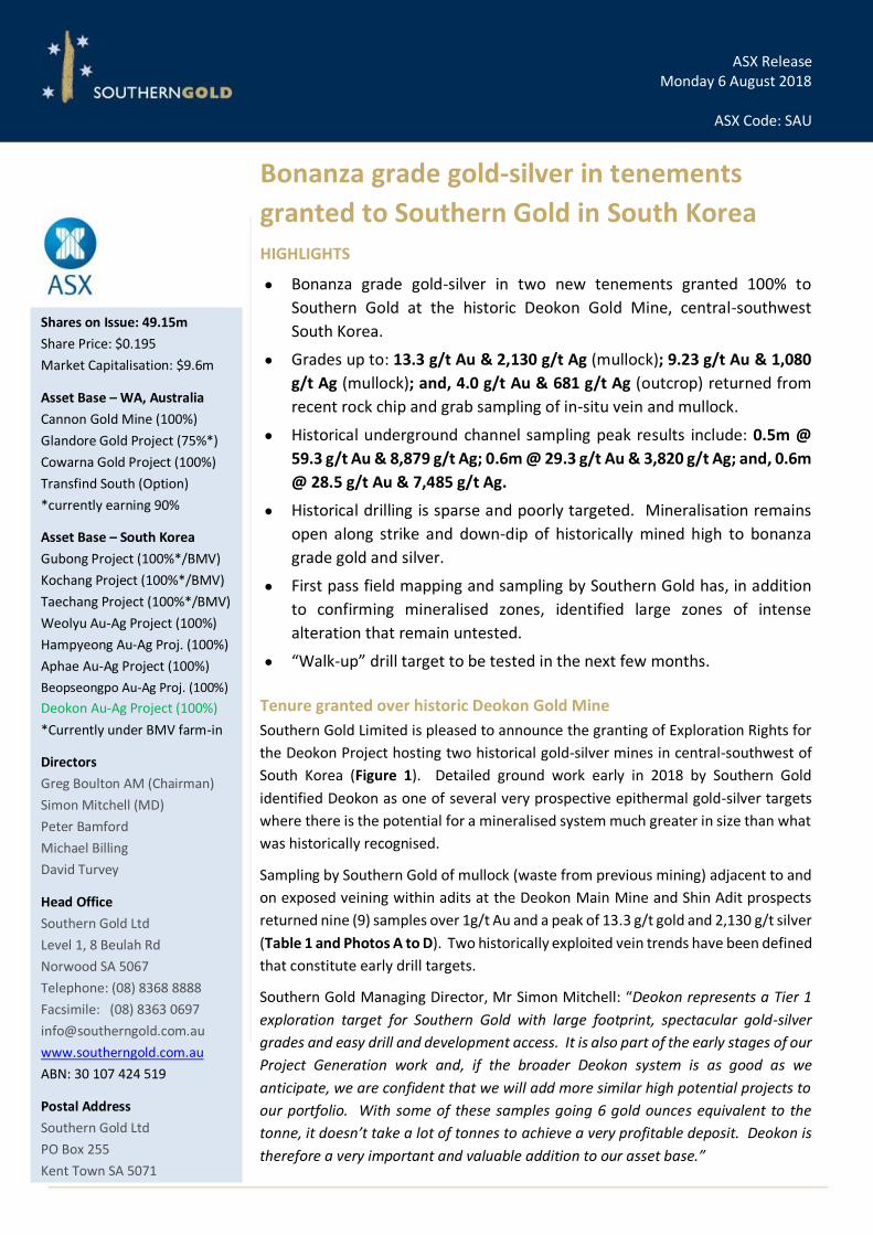
ASX Release Monday 6 August 2018
ASX Code: SAU
Bonanza grade gold-silver in tenements
granted to Southern Gold in South Korea
HIGHLIGHTS
• Bonanza grade gold-silver in two new tenements granted 100% to
Southern Gold at the historic Deokon Gold Mine, central-southwest
South Korea.
• Grades up to: 13.3 g/t Au & 2,130 g/t Ag (mullock); 9.23 g/t Au & 1,080
g/t Ag (mullock); and, 4.0 g/t Au & 681 g/t Ag (outcrop) returned from
recent rock chip and grab sampling of in-situ vein and mullock.
• Historical underground channel sampling peak results include: 0.5m @
59.3 g/t Au & 8,879 g/t Ag; 0.6m @ 29.3 g/t Au & 3,820 g/t Ag; and, 0.6m
@ 28.5 g/t Au & 7,485 g/t Ag.
• Historical drilling is sparse and poorly targeted. Mineralisation remains
open along strike and down-dip of historically mined high to bonanza
grade gold and silver.
• First pass field mapping and sampling by Southern Gold has, in addition
to confirming mineralised zones, identified large zones of intense
alteration that remain untested.
• “Walk-up” drill target to be tested in the next few months.
Tenure granted over historic Deokon Gold Mine Southern Gold Limited is pleased to announce the granting of Exploration Rights for
the Deokon Project hosting two historical gold-silver mines in central-southwest of
South Korea (Figure 1). Detailed ground work early in 2018 by Southern Gold
identified Deokon as one of several very prospective epithermal gold-silver targets
where there is the potential for a mineralised system much greater in size than what
was historically recognised.
Sampling by Southern Gold of mullock (waste from previous mining) adjacent to and
on exposed veining within adits at the Deokon Main Mine and Shin Adit prospects
returned nine (9) samples over 1g/t Au and a peak of 13.3 g/t gold and 2,130 g/t silver
(Table 1 and Photos A to D). Two historically exploited vein trends have been defined
that constitute early drill targets.
Southern Gold Managing Director, Mr Simon Mitchell: “Deokon represents a Tier 1
exploration target for Southern Gold with large footprint, spectacular gold-silver
grades and easy drill and development access. It is also part of the early stages of our
Project Generation work and, if the broader Deokon system is as good as we
anticipate, we are confident that we will add more similar high potential projects to
our portfolio. With some of these samples going 6 gold ounces equivalent to the
tonne, it doesn’t take a lot of tonnes to achieve a very profitable deposit. Deokon is
therefore a very important and valuable addition to our asset base.”
Shares on Issue: 49.15m
Share Price: $0.195
Market Capitalisation: $9.6m
Asset Base – WA, Australia
Cannon Gold Mine (100%)
Glandore Gold Project (75%*)
Cowarna Gold Project (100%)
Transfind South (Option)
*currently earning 90%
Asset Base – South Korea
Gubong Project (100%*/BMV)
Kochang Project (100%*/BMV)
Taechang Project (100%*/BMV)
Weolyu Au-Ag Project (100%)
Hampyeong Au-Ag Proj. (100%)
Aphae Au-Ag Project (100%)
Beopseongpo Au-Ag Proj. (100%)
Deokon Au-Ag Project (100%)
*Currently under BMV farm-in
Directors
Greg Boulton AM (Chairman)
Simon Mitchell (MD)
Peter Bamford
Michael Billing
David Turvey
Head Office
Southern Gold Ltd
Level 1, 8 Beulah Rd
Norwood SA 5067
Telephone: (08) 8368 8888
Facsimile: (08) 8363 0697
www.southerngold.com.au
ABN: 30 107 424 519
Postal Address
Southern Gold Ltd
PO Box 255
Kent Town SA 5071
-2-
Figure 1: Location of the Deokon Gold Project, South Korea.

-3-
The Project Generation exercise, mentioned in previous ASX releases and in which this Deokon Project is one
example, is ongoing with several other high-quality targets under review and application. The Southern Gold
technical team, including world-recognised epithermal exploration consultant geologists, is confident of
identifying several highly prospective, drill-ready projects throughout a district of known gold-silver
production, with the potential for economic discovery of Tier 1 projects.
Table 1. Significant rock chip and grab sample results (>1.0 g/t Au) from recent Southern Gold surface and underground sampling at Deokon, South Korea.
Sample ID Sample Type Au g/t Ag g/t
KRS205254 Mullock 13.30 2,130
KRS205231 Mullock 9.23 1,080
KRS205229 Mullock 7.65 558
KRS205409 Outcrop 4.00 681
KRS205288 Mullock 3.93 359
KRS205413 Outcrop 3.32 581
KRS205410 Outcrop 1.66 574
KRS205287 Mullock 1.65 124
KRS205412 Outcrop 1.39 333
KRS205302 Mullock 1.15 70
KRS205240 Mullock 1.05 191
KRS205253 Mullock 1.01 133
Deokon – Historic Gold-Silver Mines
The historic Deokon Au-Ag mines are located in the central-southwestern part of South Korea, in the Jeolla-
buk Province (Figure 1). Post-war Mines Department records show production resumed between 1958 and
1980, when a Korean national company, registered as The Deokon Mining Company Ltd., re-developed the
multilevel underground mining operations at both the Main Mine and the Shin Adit prospects (Figure 2), on a
series of through-going highly silver-gold mineralised, dacite-hosted lode and vein zones.
Main Mine
The Main Mine is reportedly comprised of at least six sub-parallel quartz-sulphide veins, mined over a strike
length of approximately 350 metres, on nine production levels between 320 mRL and 60 mRL (260 vertical
metres). Mining apparently utilised shrinkage stoping, with all levels connected by an internal shaft and access
decline (see Figure 3). Vein widths ranged between 0.3 and 1.0 metre based on historic channel sample data.
Mines Department records between 1958 and 1980 indicated minimum production totals of 37,706 oz of gold
and 2,358,045 oz of silver. However, gold production figures between 1978 and 1980 were not declared by
the operators. The Korean Mining Promotion Company (KMPC, a precursor of KORES), conducted several
diamond drilling programmes and underground resource determination works from the late 1970s through to
1981. Three diamond holes were drilled in 1977 (DDH 77-1 to 77-3), four holes in 1978 (DDH 78-1 to 78-4) and
a further three holes in 1979 (DDH 79-1 to 79-3). These drilling programmes intersected silver-gold
mineralisation, yet only a few selected intervals were sampled and assayed, with the remaining unsampled
drill core discarded in dumps on site. An extension to existing underground workings was recommended, yet
not undertaken. During 1981, the KMPC conducted a Self-Potential (SP) geophysical survey to test for along
strike extensions to mined veining to the southwest of the mine. The results of this survey are unknown.
However, four further drill holes were completed in 1982 (DDH 82-1 to 82-4).

-4-
Figure 2: Detailed Plan view of the Deokon Project, highlighting numerous bonanza gold-silver grades.

-5-
Figure 3: Cross-section and long-section views of the Main Mine, highlighting the poorly tested nature of the high-grade mineralisation.
The historical drilling has not effectively tested the down-dip or along strike potential of the Main Mine
mineralisation. When modelled in 3D, it is evident that most of the drilling did not intersect the vein trend, as
illustrated in Figure 3. The forward exploration potential is highly encouraging for along-strike and down-dip
extensions to high-grade gold and silver mineralisation.
Historical underground sampling programs conducted by KORES illustrate the exceptionally high gold-silver
grades that were historically mined. Mine records were poorly kept by the historical miners, resulting in areas
of little to no data. Significant historical underground sampling results are presented in Table 2 and include
peak results of: 0.5m @ 59.3 g/t Au & 8,879 g/t Ag; 0.6m @ 29.3 g/t Au & 3,820 g/t Ag; and, 0.6m @ 28.5 g/t
Au & 7,485 g/t Ag.
Table 2: Top 10 KORES historical underground channel sample results at Main Mine, Deokon, South Korea.
Sample ID Location Width (m) Au (g/t) Ag (g/t) Deok K-1 Main Mine 0.5 59.3 8,879
DK-132 Main Mine 0.6 29.3 3,820
DK-131 Main Mine 0.6 28.5 7,485
DK-122 Main Mine 0.6 23.3 9,708
On-3 Main Mine 2.5 20.1 1,457
DK-121 Main Mine 0.5 20.0 5,672
DK-130 Main Mine 0.3 16.5 4,227
Deok K-2 Main Mine 0.5 16.0 29
DK-133 Main Mine 0.4 15.5 4,109
DK-134 Main Mine 0.4 15.5 3,424
-6-
Shin Adit Mine
Historical production at the Shin Adit Mine was conducted by the Deokon Mining Company Ltd. between 1958
and 1980. Limited historical production or discovery information is available on the Shin Adit Mine.
Exploration by Southern Gold has identified the accessible lower Shin Adit workings as comprised of a 160-
metre-long horizontal drive with two cross-cuts following lode zones. Internal raises and stopes are present
extending to higher, yet to be assessed mine levels. Open and collapsed adits were noted on the hill-side (276
mRL, 277 mRL, & 286 mRL) of clearly varying age. No production figures are available for the historical mining
which appears to have occurred on two vein zones over 75m vertical metres and 60 horizontal metres.
In 1983, KMPC (KORES) completed an underground channel sampling exercise through the first cross-cut lode
zone at Shin Adit, returning weighted average results of 16.21 g/t gold and 1,772 g/t (57 oz/t) silver over an
average width of 0.4 metres (strike length sampled: ~61 metres). Significant results are presented in Table 3.
Peak results include: 0.3m @ 19.8 g/t Au & 2,463 g/t Ag; 0.4m @ 18.7 g/t Au & 2,205 g/t Ag; and, 0.3m @
16.3 g/t Au & 1,772 g/t Ag. Two diamond drill-holes completed in the 1970s, intersected numerous sheeted
and network vein zones (DDH 79-1 & 79-3) along strike from the historically mined vein segment. Historical
mapping states that the Shin Adit lode system can be definitively traced for more than 500 metres strike length,
based on first-pass field mapping.
Historical drilling completed to date has not effectively tested the down-dip or along strike potential of the
Shin Adit mineralisation. When modelled in 3D, it is evident that the majority of the drilling did not intersect
the vein trend below the best results observed in the underground mine. The forward exploration potential is
considered to be extremely encouraging for along strike and down dip extension to high-grade gold and silver
mineralisation.
Figure 4. Cross-section of the Shin Adit Mine.
Later, between 1997 and 2010, a group that
held a license over the Shin Adit workings
apparently re-opened the collapsed Shin Adit
mine drive, and re-initiated production. It is
inferred that an angled raise was mined up
however no production record is available.
Table 3. Top 10 KORES historical underground channel results at Main Mine.
Sample ID
Location Width
(m) Au
(g/t) Ag
(g/t)
DK-151 Shin Adit 0.3 19.8 2,463
DK-148 Shin Adit 0.4 18.7 2,205
DK-153 Shin Adit 0.3 16.26 1,772
DK-152 Shin Adit 0.3 14.5 1,356
DK-149 Shin Adit 0.4 14.2 1,333
DK-150 Shin Adit 0.1 10.3 983
Deok-7 Shin Adit 0.5 3.5 52
Deok-6 Shin Adit 0.2 3.3 548
DK-12 Shin Adit 0.4 3 500
DK-11 Shin Adit 0.2 2 300
It is acknowledged by Southern Gold that all historical sampling cannot be validated or sampling protocols and
methodology confirmed nor what QAQC processes were utilised. However, the recent Southern Gold sampling
-7-
has provided similar very high-grade results that are in the same order of magnitude, albeit from ‘mullock
dump’ grab samples. Outcrop samples show highly anomalous silver assay results on the surface traces of the
same underground veins.
Southern Gold Reconnaissance
First-pass assessment of the Deokon Project was undertaken by Southern Gold Korea in April 2018. Work
conducted included systematic traversing, extensive rock chip and grab sampling of the Shin Adit lode and vein
system at surface and an initial sampling exercise throughout an accessible lower access drive. Reconnaissance
and sampling along strike to the north of the Shin workings in excess of one kilometre was conducted with
sampling of vein exposures in the entrance of a single open adit in the Main Vein Workings to the west. A total
of 146 rock samples were collected from Tenements Jeonju 70 and 80. Sampling was thorough to allow
textural, alteration, lithology and veining characterisation. Significant gold and silver results achieved from SAU
sampling are presented above in Table 1. Four significant rock sample slabs are presented in Photos A to D.
Photos A to D: Selection of gold-silver mineralised rock grab samples from SAU reconnaissance sampling. Photo A: Sample KRS205254. Hydraulic vein breccia, with
angular rhyolite clasts, set in a flood mesocrystalline silica-
sulfide matrix (pyrite, chalcopyrite, silver sulfosalts). 13.3 g/t
Au and 2,130 g/t Ag.
Photo B: Sample KRS205231. Hydraulic vein breccia, comprised
of white silica-illite/adularia altered rhyolite fragments
engulfed by mesocrystalline to crystalline quartz with coarse-
grained sulfides (pyrite, tetrahedrite & silver sulfosalts). 9.23
g/t Au and 1,080 g/t Ag
Photo C: Sample KRS205229. Hydraulic vein breccia, comprised
of white silica-illite/adularia altered rhyolite fragments
engulfed by mesocrystalline to crystalline quartz with coarse-
grained sulfides (pyrite, tetrahedrite & silver sulfosalts). 7.65
g/t Au and 558 g/t Ag.
Photo D: Sample KRS205409. Hydraulic vein breccia.
Brecciated dacite, pervasively silica-illite/adularia altered, with
a flood crystalline interlocking to mesocrystalline quartz-
sulfides event. 4 g/t Au and 681 g/t Ag.
Geology
The Deokon target falls within an extensional northeast-southwest trending pull-apart basin, filled by
Cretaceous felsic to intermediate composition volcanic rocks and volcaniclastic sediments, punctuated by

-8-
dacitic and rhyolitic flow-domes, and a late-stage andesitic domal-eruptive event. Epithermal hydrothermal
alteration and associated oxidation is extensive, covering in excess or fifteen square kilometres, especially
along north-south trending through-going structures.
Late-stage rhyolitic dyke phases appear to have driven a well-developed and extensive paleo-hydrothermal
system, with associated epithermal alteration and lode to vein hosted bonanza gold - silver mineralisation.
The impressive traceable and inferred strike extent of mineralised veining bodes well for an extension to the
current defined target area.
Lode and vein textures are indicative of an intermediate to low sulfidation epithermal vein system, with both
end-members of this continuum exposed at surface due to block faulting. Intense green sericitic alteration
and historical petrographic studies of Main Mine veining indicates intermediate-sulfidation characteristics,
whist quartz vein textures and possible sinter or vent hydrothermal breccias coupled with highly anomalous
arsenic with low base-metal values attained from north of the Shin Adit prospect, represent the high-level low-
sulfidation end member. Potential therefore exists for several hundred down-dip metres of gold-silver
mineralisation within these vein and lode systems.
Planned Activities
A detailed review of all available historical data will be completed prior to follow-up field studies. The Deokon
Project is easily accessible by road and a program will be planned to initially conduct localised project-scale
mapping to consolidate detailed alteration, lithology and geo-structural mapping. Additional rock chip and
representative grab sampling of the broader license area will also be undertaken in parallel. A 3D model will
then be generated to assist in designing a targeted multiple hole diamond core drilling programme to test and
develop the geological model and develop a better understanding of the mineralisation distribution, aiming
towards a possible 2012 JORC Compliant Mineral Resource estimate.
Drilling will initially be focused on testing potential down-dip and along-strike extensions to historically
exploited mineralisation at the Main Mine and Shin Adit prospects. This initial programme will be completed
over the coming months pending land access and permitting.
-9-
Southern Gold Limited: Company Profile
Southern Gold Ltd is a successful gold explorer and producer listed on the Australian Securities Exchange (under ASX ticker
“SAU”). At the Cannon project near Kalgoorlie we are currently developing a small underground operation where Northern Star
Resources Ltd holds a five year right-to-mine. Southern Gold is also looking to develop a much larger mine, Gubong, in South
Korea within the next 18 months with development partner London-listed Bluebird Merchant Ventures.
We are also active explorers. Around Kalgoorlie Southern Gold is testing projects such as Glandore, Transfind Extended and
Cowarna looking for additional small high grade open pit-able gold resources to maintain cash flow. In South Korea, Southern
Gold also owns a portfolio of high grade gold projects that are a combination of decommissioned gold mines with orogenic gold
mineralisation and greenfield epithermal gold targets. Backed by a first-class technical team, including renowned geologist
Douglas Kirwin, Southern Gold’s aim is to find world-class epithermal gold deposits.
In essence, Southern Gold looks to monetise the small gold deposits while we search for the bigger ones.
Competent Person’s Statements
The information in this report that relates to Exploration Results in South Korea has been compiled under the supervision of Dr
Chris Bowden, FAusIMM(CP). Dr Bowden who is an employee of Southern Gold Limited and a Fellow and Chartered Professional
of the Australasian Institute of Mining and Metallurgy, has sufficient experience which is relevant to the style of mineralisation
and type of deposit under consideration and to the activity he has undertaken to qualify as a Competent Person as defined in the
2012 Edition of the Australasian Code for the Reporting of Mineral Resources and Ore Reserves. Dr Bowden consents to the
inclusion in this report of the matters based on the information in the form and context in which it appears.
Forward-looking statements
Some statements in this release regarding estimates or future events are forward looking statements. These may include,
without limitation:
• Estimates of future cash flows, the sensitivity of cash flows to metal prices and foreign exchange rate movements;
• Estimates of future metal production; and
• Estimates of the resource base and statements regarding future exploration results.
Such forward looking statements are based on a number of estimates and assumptions made by the Company and its
consultants in light of experience, current conditions and expectations of future developments which the Company believes are
appropriate in the current circumstances. Such statements are expressed in good faith and believed to have a reasonable basis.
However, the estimates are subject to known and unknown risks and uncertainties that could cause actual results to differ
materially from estimated results.
All reasonable efforts have been made to provide accurate information, but the Company does not undertake any obligation to
release publicly any revisions to any “forward-looking statement” to reflect events or circumstances after the date of this
presentation, except as may be required under applicable laws. Recipients should make their own enquiries in relation to any
investment decisions from a licensed investment advisor.
-10-
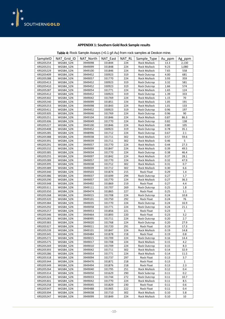
APPENDIX 1: Southern Gold Rock Sample results
Table 4: Rock Sample Assays (>0.1 g/t Au) from rock samples at Deokon mine.
SampleID NAT_Grid_ID NAT_North NAT_East NAT_RL Sample_Type Au_ppm Ag_ppm KRS205254 WGS84_52N 3949098 331844 224 Rock Mullock 13.3 2,130
KRS205231 WGS84_52N 3949099 331848 224 Rock Mullock 9.23 1,080
KRS205229 WGS84_52N 3949100 331846 224 Rock Mullock 7.65 558
KRS205409 WGS84_52N 3949452 330923 319 Rock Outcrop 4.00 681
KRS205288 WGS84_52N 3949057 331770 224 Rock Mullock 3.93 359
KRS205413 WGS84_52N 3949452 330923 319 Rock Outcrop 3.32 581
KRS205410 WGS84_52N 3949452 330923 319 Rock Outcrop 1.66 574
KRS205287 WGS84_52N 3949054 331771 224 Rock Mullock 1.65 124
KRS205412 WGS84_52N 3949452 330923 319 Rock Outcrop 1.39 333
KRS205302 WGS84_52N 3949042 331769 224 Rock Mullock 1.15 70
KRS205240 WGS84_52N 3949099 331851 224 Rock Mullock 1.05 191
KRS205253 WGS84_52N 3949098 331843 224 Rock Mullock 1.01 133
KRS205411 WGS84_52N 3949452 330923 319 Rock Outcrop 0.96 197
KRS205305 WGS84_52N 3949046 331769 224 Rock Outcrop 0.96 90
KRS205251 WGS84_52N 3949104 331846 224 Rock Mullock 0.87 86.3
KRS205306 WGS84_52N 3949049 331770 224 Rock Outcrop 0.82 138
KRS205227 WGS84_52N 3949100 331846 224 Rock Mullock 0.80 105
KRS205408 WGS84_52N 3949452 330923 319 Rock Outcrop 0.78 35.1
KRS205285 WGS84_52N 3948996 331712 224 Rock Outcrop 0.67 2.1
KRS205388 WGS84_52N 3949038 331711 302 Rock Mullock 0.57 59.6
KRS205391 WGS84_52N 3949039 331711 302 Rock Mullock 0.46 5
KRS205291 WGS84_52N 3949057 331770 224 Rock Mullock 0.44 27.3
KRS205232 WGS84_52N 3949099 331847 224 Rock Mullock 0.39 49.5
KRS205385 WGS84_52N 3949034 331770 224 Rock Outcrop 0.38 46.4
KRS205255 WGS84_52N 3949097 331842 224 Rock Mullock 0.37 28.1
KRS205289 WGS84_52N 3949057 331770 224 Rock Mullock 0.32 47.9
KRS205395 WGS84_52N 3949038 331712 302 Rock Mullock 0.31 0.7
KRS205389 WGS84_52N 3949039 331712 302 Rock Mullock 0.30 6.6
KRS205340 WGS84_52N 3949503 331874 215 Rock Float 0.29 1.4
KRS205386 WGS84_52N 3949037 331699 294 Rock Outcrop 0.27 1.7
KRS205290 WGS84_52N 3949057 331770 224 Rock Mullock 0.27 36.3
KRS205348 WGS84_52N 3949492 331869 219 Rock Float 0.27 4.4
KRS205311 WGS84_52N 3949111 331707 269 Rock Outcrop 0.25 1.8
KRS205350 WGS84_52N 3949474 331865 227 Rock Float 0.25 1.1
KRS205268 WGS84_52N 3949015 331708 224 Rock Outcrop 0.24 10.8
KRS205320 WGS84_52N 3949101 331750 292 Rock Float 0.24 76
KRS205384 WGS84_52N 3949035 331770 224 Rock Outcrop 0.24 16.9
KRS205292 WGS84_52N 3949058 331771 224 Rock Outcrop 0.24 21.1
KRS205257 WGS84_52N 3949053 331856 221 Rock Float 0.23 1
KRS205346 WGS84_52N 3949464 331893 220 Rock Float 0.23 3.2
KRS205283 WGS84_52N 3948995 331711 224 Rock Outcrop 0.20 2.7
KRS205383 WGS84_52N 3949020 331768 224 Rock Outcrop 0.20 27.9
KRS205327 WGS84_52N 3949011 331720 291 Rock Float 0.19 17.3
KRS205239 WGS84_52N 3949101 331847 224 Rock Mullock 0.19 14.8
KRS205345 WGS84_52N 3949484 331878 218 Rock Float 0.19 0.8
KRS205272 WGS84_52N 3949015 331709 224 Rock Outcrop 0.16 14.4
KRS205275 WGS84_52N 3949017 331708 224 Rock Mullock 0.15 4.2
KRS205269 WGS84_52N 3949010 331709 224 Rock Outcrop 0.15 8.3
KRS205393 WGS84_52N 3949042 331711 302 Rock Mullock 0.14 32.9
KRS205286 WGS84_52N 3949054 331771 224 Rock Mullock 0.14 11.5
KRS205318 WGS84_52N 3949094 331737 297 Rock Float 0.13 3.7
KRS205344 WGS84_52N 3949476 331871 218 Rock Float 0.13 1
KRS205349 WGS84_52N 3949494 331876 218 Rock Float 0.13 2.3
KRS205264 WGS84_52N 3949040 331795 251 Rock Mullock 0.12 0.4
KRS205314 WGS84_52N 3949050 331629 290 Rock Subcrop 0.11 0.2
KRS205324 WGS84_52N 3949033 331744 272 Rock Outcrop 0.11 10.7
KRS205301 WGS84_52N 3949042 331770 224 Rock Mullock 0.11 8.5
KRS205258 WGS84_52N 3949045 331829 230 Rock Float 0.11 0.6
KRS205347 WGS84_52N 3949488 331905 222 Rock Float 0.11 0.4
KRS205394 WGS84_52N 3949038 331710 302 Rock Mullock 0.10 5.8
KRS205247 WGS84_52N 3949099 331849 224 Rock Mullock 0.10 10

-11-
APPENDIX 2: Historical Rock Sample results
Table 5: Historical KORES Underground Rock Samples at Deokon.
Sample_ID Grid_ID Easting Northing RL Mine Width Au g/t Ag g/t Deok K-1 WGS84_52N 330732.218 3949426.14 141 Main 0.5 59.3 8,879
DK-132 WGS84_52N 330803.71 3949456.89 192 Main 0.6 29.3 3,820
DK-131 WGS84_52N 330795.824 3949447.39 192 Main 0.6 28.5 7,485
DK-122 WGS84_52N 330798.263 3949467.03 165 Main 0.6 23.3 9,708
On-3 WGS84_52N 330703.482 3949429.02 90 Main 2.5 20.1 1,457
DK-121 WGS84_52N 330792.774 3949458.41 165 Main 0.5 20.0 5,672
DK-151 WGS84_52N 331770.862 3949049.13 224 Shin 0.3 19.8 2,463
DK-148 WGS84_52N 331765.824 3949078.49 224 Shin 0.4 18.7 2,205
DK-130 WGS84_52N 330789.999 3949438.25 192 Main 0.3 16.5 4,227
DK-153 WGS84_52N 331769.867 3949029.11 224 Shin 0.3 16.26 1,772
Deok K-2 WGS84_52N 330768.456 3949468.25 141 Main 0.5 16.0 29.26
DK-133 WGS84_52N 330809.958 3949465.8 192 Main 0.4 15.5 4,109
DK-134 WGS84_52N 330816.141 3949475.3 192 Main 0.4 15.5 3,424
DK-152 WGS84_52N 331769.669 3949039.05 224 Shin 0.3 14.5 1,356
DK-149 WGS84_52N 331769.602 3949069.54 224 Shin 0.4 14.2 1,333
DK-143 WGS84_52N 330863.92 3949400.53 297 Main 0.3 12.5 1,095
DK-138 WGS84_52N 330846.843 3949487.82 211 Main 0.4 11.5 3,807
DK-150 WGS84_52N 331771.259 3949060.26 224 Shin 0.1 10.3 983
DO-3 WGS84_52N 330723.704 3949434.83 121 Main 1 9.1 7,742
DK-123 WGS84_52N 330803.64 3949474.76 165 Main 0.7 9.0 2,689
DK-145 WGS84_52N 330882.543 3949427.27 297 Main 0.4 8.5 849
DK-142 WGS84_52N 330856.078 3949390.31 297 Main 0.4 8.3 995
DO-1 WGS84_52N 330818.459 3949505.5 165 Main 0.15 7.1 3,438
DK-144 WGS84_52N 330874.841 3949415.51 297 Main 0.4 6.3 1,145
DK-129 WGS84_52N 330783.816 3949431.17 192 Main 1 6.2 843
DK-147 WGS84_52N 330897.105 3949448.56 297 Main 0.5 5.7 613
DK-146 WGS84_52N 330890.244 3949437.08 297 Main 0.3 4.8 742
DK-124 WGS84_52N 330808.793 3949483.5 165 Main 0.7 4.8 1,964
DK-135 WGS84_52N 330822.056 3949484.62 192 Main 0.3 4.2 2,058
DK-139 WGS84_52N 330792.377 3949420.96 211 Main 0.3 4.0 2,063
DK-125 WGS84_52N 330814.17 3949493.58 165 Main 0.6 3.8 336
DK-137 WGS84_52N 330838.814 3949480.36 211 Main 0.4 3.7 328
Deok-7 WGS84_52N NR NR NR Shin 0.5 3.5 52
DK-141 WGS84_52N 330847.537 3949382.05 297 Main 0.5 3.3 646
Deok-6 WGS84_52N NR NR NR Shin 0.2 3.3 548
D-2 WGS84_52N 330779.024 3949476.39 141 Main 0.3 3.0 1,448
DK-10 WGS84_52N 330792.096 3949457.65 165 Main 0.4 3.0 800
DK-12 WGS84_52N 331768.992 3949024.9 224 Shin 0.4 3.0 500
DK-127 WGS84_52N 330770.732 3949415.3 192 Main 0.2 2.8 1,373
DK-136 WGS84_52N 330832.003 3949496.5 192 Main 0.3 2.8 669
On-5 WGS84_52N 330703.942 3949402.18 141 Main 0.3 2.8 397
D-1 WGS84_52N 330781.713 3949479.53 141 Main 0.25 2.8 1,342
DK-140 WGS84_52N 330787.33 3949415.51 211 Main 0.2 2.7 2,532
D-3 WGS84_52N 330791.682 3949489.72 141 Main 0.6 2.5 1,752
DK-128 WGS84_52N 330777.005 3949422.47 192 Main 0.2 2.3 611
DK-126 WGS84_52N 330764.369 3949408.31 192 Main 0.2 2.0 714
Deok-5 WGS84_52N 330804.84 3949477.37 165 Main 0.3 2.0 716
D-5 WGS84_52N 330818.231 3949515.6 141 Main 0.3 2.0 1,152
DK-11 WGS84_52N 331709.856 3948998.59 224 Shin 0.2 2.0 300
DO-2 WGS84_52N 330834.246 3949538.87 141 Main 0.2 1.7 121
DO-4 WGS84_52N 330690.815 3949409.38 121 Main 0.3 1.6 2,944
On-1 WGS84_52N 330780.133 3949510.17 90 Main 0.3 1.0 5
Deok K-3 WGS84_52N 330743.921 3949420.52 165 Main 0.3 1.0 76
DK-09 WGS84_52N 330775.429 3949420.27 192 Main 0.4 1.0 400
On-2 WGS84_52N 330748.119 3949468.59 90 Main 0.3 0.3 20
Deok-1 WGS84_52N 330811.253 3949489.45 165 Main 0.4 0 2,653
Deok-8 WGS84_52N NR NR NR Shin 0.25 0 1,035
Deok-9 WGS84_52N NR NR NR Main NR 0 2,352
D-4 WGS84_52N 330801.988 3949497.11 141 Main 0.3 0 1,246
DK-01 WGS84_52N 330787.325 3949415.76 211 Main 0.7 0 1,150
DK-02 WGS84_52N 330810.991 3949442.05 211 Main 0.4 0 1,924
DK-03 WGS84_52N 330799.461 3949451.76 192 Main 1 0 2,724
DK-04 WGS84_52N 330811.598 3949467.94 192 Main 0.6 0 4,136
DK-05 WGS84_52N 330849.221 3949490.19 211 Main 0.3 0 8,914
DK-06 WGS84_52N 331729.362 3949000.58 285 Shin 0.5 0 3,218
DK-07 WGS84_52N 331730.009 3949027.93 285 Shin 0.6 0 3,150
DK-08 WGS84_52N 331750.237 3949020 276 Shin 0.4 0 4,027
On-4 WGS84_52N 330886.229 3949598.54 141 Main 0.3 Trace 17
Deok-2 WGS84_52N 330797.363 3949466.04 165 Main 0.1 NR 2,128
Deok-3 WGS84_52N 330785.937 3949449.13 165 Main 0.6 NR 2,126
Deok-4 WGS84_52N 330761.449 3949439.31 165 Main 0.4 NR 1,024
-12-
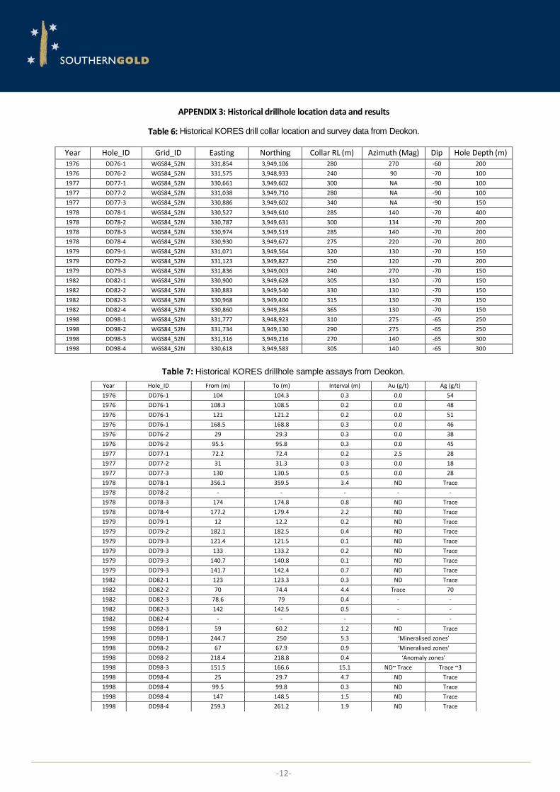
APPENDIX 3: Historical drillhole location data and results
Table 6: Historical KORES drill collar location and survey data from Deokon.
Table 7: Historical KORES drillhole sample assays from Deokon.
Year Hole_ID Grid_ID Easting Northing Collar RL (m) Azimuth (Mag) Dip Hole Depth (m) 1976 DD76-1 WGS84_52N 331,854 3,949,106 280 270 -60 200
1976 DD76-2 WGS84_52N 331,575 3,948,933 240 90 -70 100
1977 DD77-1 WGS84_52N 330,661 3,949,602 300 NA -90 100
1977 DD77-2 WGS84_52N 331,038 3,949,710 280 NA -90 100
1977 DD77-3 WGS84_52N 330,886 3,949,602 340 NA -90 150
1978 DD78-1 WGS84_52N 330,527 3,949,610 285 140 -70 400
1978 DD78-2 WGS84_52N 330,787 3,949,631 300 134 -70 200
1978 DD78-3 WGS84_52N 330,974 3,949,519 285 140 -70 200
1978 DD78-4 WGS84_52N 330,930 3,949,672 275 220 -70 200
1979 DD79-1 WGS84_52N 331,071 3,949,564 320 130 -70 150
1979 DD79-2 WGS84_52N 331,123 3,949,827 250 120 -70 200
1979 DD79-3 WGS84_52N 331,836 3,949,003 240 270 -70 150
1982 DD82-1 WGS84_52N 330,900 3,949,628 305 130 -70 150
1982 DD82-2 WGS84_52N 330,883 3,949,540 330 130 -70 150
1982 DD82-3 WGS84_52N 330,968 3,949,400 315 130 -70 150
1982 DD82-4 WGS84_52N 330,860 3,949,284 365 130 -70 150
1998 DD98-1 WGS84_52N 331,777 3,948,923 310 275 -65 250
1998 DD98-2 WGS84_52N 331,734 3,949,130 290 275 -65 250
1998 DD98-3 WGS84_52N 331,316 3,949,216 270 140 -65 300
1998 DD98-4 WGS84_52N 330,618 3,949,583 305 140 -65 300
Year Hole_ID From (m) To (m) Interval (m) Au (g/t) Ag (g/t)
1976 DD76-1 104 104.3 0.3 0.0 54
1976 DD76-1 108.3 108.5 0.2 0.0 48
1976 DD76-1 121 121.2 0.2 0.0 51
1976 DD76-1 168.5 168.8 0.3 0.0 46
1976 DD76-2 29 29.3 0.3 0.0 38
1976 DD76-2 95.5 95.8 0.3 0.0 45
1977 DD77-1 72.2 72.4 0.2 2.5 28
1977 DD77-2 31 31.3 0.3 0.0 18
1977 DD77-3 130 130.5 0.5 0.0 28
1978 DD78-1 356.1 359.5 3.4 ND Trace
1978 DD78-2 - - - - -
1978 DD78-3 174 174.8 0.8 ND Trace
1978 DD78-4 177.2 179.4 2.2 ND Trace
1979 DD79-1 12 12.2 0.2 ND Trace
1979 DD79-2 182.1 182.5 0.4 ND Trace
1979 DD79-3 121.4 121.5 0.1 ND Trace
1979 DD79-3 133 133.2 0.2 ND Trace
1979 DD79-3 140.7 140.8 0.1 ND Trace
1979 DD79-3 141.7 142.4 0.7 ND Trace
1982 DD82-1 123 123.3 0.3 ND Trace
1982 DD82-2 70 74.4 4.4 Trace 70
1982 DD82-3 78.6 79 0.4 - -
1982 DD82-3 142 142.5 0.5 - -
1982 DD82-4 - - - - -
1998 DD98-1 59 60.2 1.2 ND Trace
1998 DD98-1 244.7 250 5.3 ‘Mineralised zones’
1998 DD98-2 67 67.9 0.9 ‘Mineralised zones’
1998 DD98-2 218.4 218.8 0.4 ‘Anomaly zones’
1998 DD98-3 151.5 166.6 15.1 ND~ Trace Trace ~3
1998 DD98-4 25 29.7 4.7 ND Trace
1998 DD98-4 99.5 99.8 0.3 ND Trace
1998 DD98-4 147 148.5 1.5 ND Trace
1998 DD98-4 259.3 261.2 1.9 ND Trace
-13-
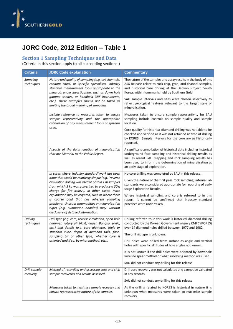
JORC Code, 2012 Edition – Table 1
Section 1 Sampling Techniques and Data (Criteria in this section apply to all succeeding sections.)
Criteria JORC Code explanation Commentary
Sampling techniques
Nature and quality of sampling (e.g. cut channels, random chips, or specific specialised industry standard measurement tools appropriate to the minerals under investigation, such as down hole gamma sondes, or handheld XRF instruments, etc.). These examples should not be taken as limiting the broad meaning of sampling.
The nature of the samples and assay results in the body of this ASX Release relate to rock chip, grab, and channel samples, and historical core drilling at the Deokon Project, South Korea, within tenements held by Southern Gold.
SAU sample intervals and sites were chosen selectively to reflect geological features relevant to the target style of mineralisation.
Include reference to measures taken to ensure sample representivity and the appropriate calibration of any measurement tools or systems used.
Measures taken to ensure sample representivity for SAU sampling include controls on sample quality and sample location.
Core quality for historical diamond drilling was not able to be checked and verified as it was not retained at time of drilling by KORES. Sample intervals for the core are as historically reported.
Aspects of the determination of mineralisation that are Material to the Public Report.
A significant compilation of historical data including historical underground face sampling and historical drilling results as well as recent SAU mapping and rock sampling results has been used to inform the determination of mineralisation at an early stage of exploration.
In cases where ‘industry standard’ work has been done this would be relatively simple (e.g. ‘reverse circulation drilling was used to obtain 1 m samples from which 3 kg was pulverised to produce a 30 g charge for fire assay’). In other cases, more explanation may be required, such as where there is coarse gold that has inherent sampling problems. Unusual commodities or mineralisation types (e.g. submarine nodules) may warrant disclosure of detailed information.
No core drilling was completed by SAU in this release.
Given the nature of the first pass rock sampling, internal lab standards were considered appropriate for reporting of early stage Exploration Results.
Where historical sampling and core is referred to in this report, it cannot be confirmed that industry standard practices were undertaken.
Drilling techniques
Drill type (e.g. core, reverse circulation, open-hole hammer, rotary air blast, auger, Bangka, sonic, etc.) and details (e.g. core diameter, triple or standard tube, depth of diamond tails, face-sampling bit or other type, whether core is oriented and if so, by what method, etc.).
Drilling referred to in this work is historical diamond drilling conducted by the Korean Government agency KMPC (KORES) over 14 diamond holes drilled between 1977 and 1982.
The drill rig type is unknown.
Drill holes were drilled from surface as angle and vertical holes with specific attitudes of hole angles not known.
It is not known if the drill holes were oriented by downhole wireline spear method or what surveying method was used.
SAU did not conduct any drilling for this release.
Drill sample recovery
Method of recording and assessing core and chip sample recoveries and results assessed.
Drill core recovery was not calculated and cannot be validated in any records.
SAU did not conduct any drilling for this release.
Measures taken to maximise sample recovery and ensure representative nature of the samples.
As the drilling related to KORES is historical in nature it is unknown what measures were taken to maximise sample recovery.
-14-
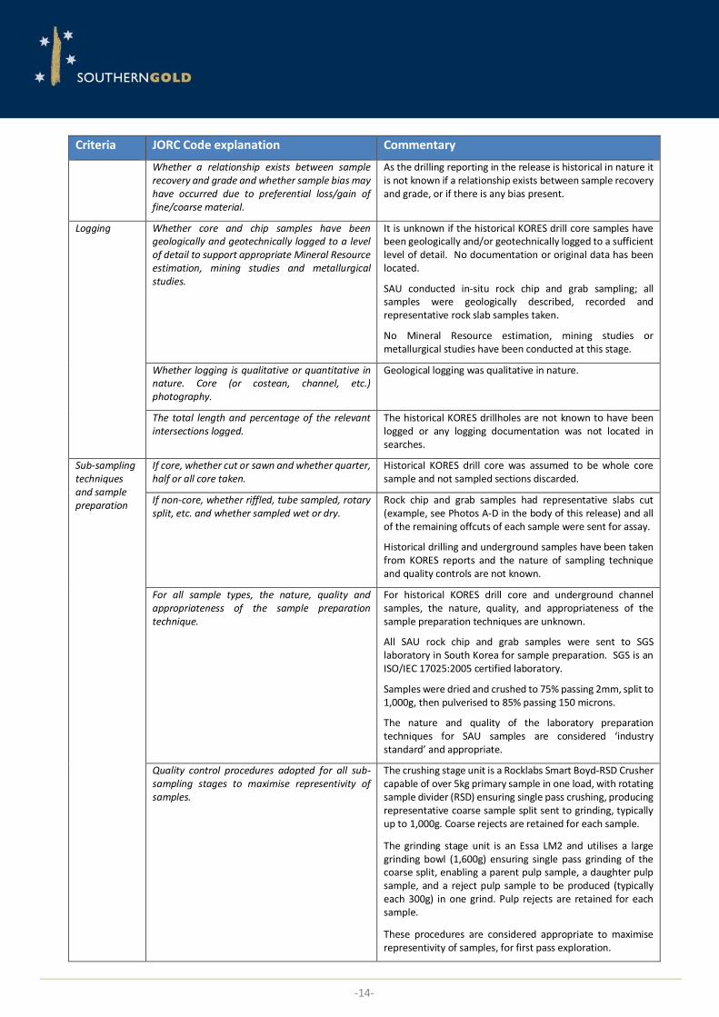
Criteria JORC Code explanation Commentary
Whether a relationship exists between sample recovery and grade and whether sample bias may have occurred due to preferential loss/gain of fine/coarse material.
As the drilling reporting in the release is historical in nature it is not known if a relationship exists between sample recovery and grade, or if there is any bias present.
Logging Whether core and chip samples have been geologically and geotechnically logged to a level of detail to support appropriate Mineral Resource estimation, mining studies and metallurgical studies.
It is unknown if the historical KORES drill core samples have been geologically and/or geotechnically logged to a sufficient level of detail. No documentation or original data has been located.
SAU conducted in-situ rock chip and grab sampling; all samples were geologically described, recorded and representative rock slab samples taken.
No Mineral Resource estimation, mining studies or metallurgical studies have been conducted at this stage.
Whether logging is qualitative or quantitative in nature. Core (or costean, channel, etc.) photography.
Geological logging was qualitative in nature.
The total length and percentage of the relevant intersections logged.
The historical KORES drillholes are not known to have been logged or any logging documentation was not located in searches.
Sub-sampling techniques and sample preparation
If core, whether cut or sawn and whether quarter, half or all core taken.
Historical KORES drill core was assumed to be whole core sample and not sampled sections discarded.
If non-core, whether riffled, tube sampled, rotary split, etc. and whether sampled wet or dry.
Rock chip and grab samples had representative slabs cut (example, see Photos A-D in the body of this release) and all of the remaining offcuts of each sample were sent for assay.
Historical drilling and underground samples have been taken from KORES reports and the nature of sampling technique and quality controls are not known.
For all sample types, the nature, quality and appropriateness of the sample preparation technique.
For historical KORES drill core and underground channel samples, the nature, quality, and appropriateness of the sample preparation techniques are unknown.
All SAU rock chip and grab samples were sent to SGS laboratory in South Korea for sample preparation. SGS is an ISO/IEC 17025:2005 certified laboratory.
Samples were dried and crushed to 75% passing 2mm, split to 1,000g, then pulverised to 85% passing 150 microns.
The nature and quality of the laboratory preparation techniques for SAU samples are considered ‘industry standard’ and appropriate.
Quality control procedures adopted for all sub-sampling stages to maximise representivity of samples.
The crushing stage unit is a Rocklabs Smart Boyd-RSD Crusher capable of over 5kg primary sample in one load, with rotating sample divider (RSD) ensuring single pass crushing, producing representative coarse sample split sent to grinding, typically up to 1,000g. Coarse rejects are retained for each sample.
The grinding stage unit is an Essa LM2 and utilises a large grinding bowl (1,600g) ensuring single pass grinding of the coarse split, enabling a parent pulp sample, a daughter pulp sample, and a reject pulp sample to be produced (typically each 300g) in one grind. Pulp rejects are retained for each sample.
These procedures are considered appropriate to maximise representivity of samples, for first pass exploration.

-15-
Criteria JORC Code explanation Commentary
Measures taken to ensure that the sampling is representative of the in situ material collected, including for instance results for field duplicate/second-half sampling.
Given the nature of the first pass rock sampling, no field duplicate samples were considered appropriate for reporting of early stage Exploration Results.
The samples collected weighted between 0.35kg to 4.5kg with and average of 2.0kg. A total of 187 samples were collected as art of the Deokon dataset.
Historical KORES drill core and underground sampling is known to be selective, and may not have sampled all mineralised material. It is unknown if any duplicate sampling was conducted.
Whether sample sizes are appropriate to the grain size of the material being sampled.
For SAU rock chip and grab samples, the sample size is considered appropriate for the target style of mineralisation, the requirements for laboratory sample preparation and analyses, and consideration reporting is for early stage Exploration Results.
Historical KORES drill core and underground sample sizes are unknown.
Quality of assay data and laboratory tests
The nature, quality and appropriateness of the assaying and laboratory procedures used and whether the technique is considered partial or total.
Pulp samples (typically 300g) prepared by SGS in South Korea are sent through registered airfreight (eg DHL) to ALS laboratory in Laos for Au analysis, with a 10g split sent to ALS Brisbane for multielement analysis. ALS is an ISO/IEC 17025:2005 and ISO9001:2015 certified laboratory. Gold was analysed on a 50g charge using fire assay fusion with an atomic absorption spectroscopy finish (ALS method Au-AA26). Detection limit range is 0.01ppm to 100ppm Au. The nature of the laboratory assay sampling techniques are considered ‘industry standard’ and appropriate.
A 35 multi-element suite was analysed on a 0.5g pulp sample split using aqua regia digest with an inductively coupled plasma – atomic emission spectroscopy (ICP-AES) finish (ALS method ME-ICP41). Silver was analysed as part of the multi-element aqua-regia digest ICP-AES (method ME-ICP41), with an upper detection limit 100g/t Ag. All initial silver assays reporting greater than 100g/t Ag were re-assayed by an aqua-regia digest and AAS or ICP-AES finish with a detection range of 100g/t to 1,500g/t Ag (ALS method Ag-OG46). Silver assays reporting greater than 1,500g/t Ag were completed using ALS method ME-CON02. The nature and quality of the laboratory assay sampling techniques for SAU samples are considered ‘industry standard’ and appropriate.
For historical KORES drill core and underground channel samples, the nature, quality and appropriateness of the sample assaying procedures are unknown.
For geophysical tools, spectrometers, handheld XRF instruments, etc., the parameters used in determining the analysis including instrument make and model, reading times, calibrations factors applied and their derivation, etc.
Not applicable - no data from geophysical tools were used to determine analytical results in this ASX Release.
The nature of historical KORES geophysical data is not known nor locatable at time of this ASX Release.
-16-
Criteria JORC Code explanation Commentary
Nature of quality control procedures adopted (e.g. standards, blanks, duplicates, external laboratory checks) and whether acceptable levels of accuracy (i.e. lack of bias) and precision have been established.
Given the nature of the first pass rock sampling, internal lab standards were considered appropriate for reporting of early stage Exploration Results.
Verification of sampling and assaying
The verification of significant intersections by either independent or alternative company personnel.
Historical KORES data cannot be independently verified.
SAU assay data has been verified by the database manager responsible for importing laboratory results into the database.
SAU logging data have been compiled by the senior geologists directly involved in the program, under guidance of the Exploration Manager (Competent Person).
The use of twinned holes. Not Applicable. No twinned holes have been completed as part of this ASX Release, as the program is at an early stage.
Documentation of primary data, data entry procedures, data verification, data storage (physical and electronic) protocols.
Historical data exists as digital copy format of original Korean logs and transcripts, but cannot be validated. It has been transcribed into SAU databases where applicable, and appropriately tagged as such.
Primary SAU data is recorded preferentially into proprietary data capture software or otherwise into digital spreadsheets or hand-written documents. All original hardcopy logs and sample reference sheets are kept for reference. Digital data entry is validated through the application of database validation rules and is also visually verified by the responsible geologist through GIS and other software. Any failures are sent back to the responsible geologist for correction and re-submission. Data is stored in an SQL database managed through proprietary software. The database is backed up as part of the Company server backup protocol.
Discuss any adjustment to assay data. Assay data is imported into the Company database from original lab files via automated queries, thus minimising error in tagging samples with results.
No adjustments are made to the assay data.
Location of data points
Accuracy and quality of surveys used to locate drill holes (collar and down-hole surveys), trenches, mine workings and other locations used in Mineral Resource estimation.
SAU rock sample XYZ locations are determined with a hand held Garmin 62s GPS, using an averaging waypoint method (15 minutes) producing levels of accuracy +/- 3m.
Specification of the grid system used. The grid system used is Universal Transverse Mercator (WGS84), Zone 52 Northern Hemisphere.
Quality and adequacy of topographic control. There is 5m contour data available from the government that is suitable for topographic control on early stage exploration programs.
Data spacing and distribution
Data spacing for reporting of Exploration Results. Historical KORES drilling were collared ‘randomly’ with no specific systematic grid spacing.
SAU rock chip and grab sampling intervals were based on geological boundary and veining where possible. On occasion multiple intervals within a single vein have also been taken to identify internal variability.
Whether the data spacing and distribution is sufficient to establish the degree of geological
No Mineral Resource or Ore Reserve have been estimated in this ASX Release.

-17-
Criteria JORC Code explanation Commentary
and grade continuity appropriate for the Mineral Resource and Ore Reserve estimation procedure(s) and classifications applied.
Whether sample compositing has been applied. No sample compositing has been applied.
Orientation of data in relation to geological structure
Whether the orientation of sampling achieves unbiased sampling of possible structures and the extent to which this is known, considering the deposit type.
Rock chip and grab sampling has been conducted in a selective manner targeting mineralised structures. Given the early stage of exploration, chip and representative grab samples across veins are considered appropriate and unbiased at this stage of the project.
If the relationship between the drilling orientation and the orientation of key mineralised structures is considered to have introduced a sampling bias, this should be assessed and reported if material.
SAU did not conduct any of its own drilling for this release.
Sample security
The measures taken to ensure sample security. From the point of sample generation to laboratory, samples (and reject returns) are under the full security and Chain of Custody of the Company. This is done by the following procedures:
Post on-site logging and processing, samples are transported to the Company’s long-term storage facility under the direct supervision of a Company representative. Samples are securely locked at the long-term storage. Samples are further processed by Company representatives under guidance of the Competent Person. Bagged samples are secured by tags and delivered by a Company representative to a courier service to deliver to the sample preparation laboratory. The preparation laboratory sends pulp samples directly to the assay laboratory for analysis via door-to-door courier service. All rejects are returned under courier service and stored in the Company’s secure lock-up long-term core storage facility.
Audits or reviews
The results of any audits or reviews of sampling techniques and data.
No audits or reviews of sampling techniques and data have been undertaken at this time.
Section 2 Reporting of Exploration Results (Criteria listed in the preceding section also apply to this section.)
Criteria JORC Code explanation Commentary
Mineral tenement and land tenure status
Type, reference name/number, location and ownership including agreements or material issues with third parties such as joint ventures, partnerships, overriding royalties, native title interests, historical sites, wilderness or national park and environmental settings.
The new tenements, Jeonju 70 and Jeonju 80 are held by Southern Gold Korea, a fully owned subsidiary of Southern Gold (see Figure 1).
There are no native title interests in Korea. It is a generally accepted requirement that mineral title holders gain the consent of local land owners and residents before undertaking any major exploration activity, such as drilling. The Deokon mineralised structures lie on privately held land. There are no known material issues with third parties.
The security of the tenure held at the time of reporting along with any known impediments to obtaining a license to operate in the area.
Following the submission of a Mineral Deposit Report for a tenement application, it is reviewed by the Mine Registration Office (MRO) who determine if the application meets specified criteria for approval and if so, grant an Exploration Right. The holder then has 1 year to submit an Exploration Plan to the Ministry outlining planned work. An initial 3 year exploration period is given to complete the exploration work,

-18-
Criteria JORC Code explanation Commentary
which can be extended to 6 years upon a successful submission to the Ministry. After the exploration period and upon an Exploration Results Report being accepted by the MRO/MOTIE, the Exploration Right is converted to an Extraction Right. Results are from Jeonju 70 and Jeonju 80, which is an Exploration Right granted on the 31/07/2018. Upon successful conversion to an Extraction Right, the holder has 3 years to submit and have an Extraction Plan authorised. An application can be made to extend this period by 1 year. The Extraction Plan is submitted to the Local Government and requires approvals from a number of stakeholders. The term of an Extraction Right is 20 years. This can be extended upon application, provided all statutory requirements have been met over the life of the mine. From the date the Extraction Plan is approved, the title holder has a 3 year period in which mine production must commence. During this 3 year period, the title holder must make a minimum level of investment on plant and mine infrastructure in the amount of KRW100 million (~AUD$120,000) and meet certain minimum annual production levels, which are dependent on the commodity being mined. There are no known impediments to obtaining a license to operate.
Exploration done by other parties
Acknowledgment and appraisal of exploration by other parties.
The Deokon Project has historically had small scale mining and adits excavated by the Deokon Mining Company from 1958 to 1980. An unknown party held the license and sporadically operated the mine from 1997 to ~2010. Historical records are not extensive and considered unreliable. The Korean government agency KORES and its predecessor KMPC, conducted diamond drilling at Deokon from 1977 to 1979 with a final round in 1982. 14 holes were drilled at the Main Adit and 2 holes at the Shin Adit. During 1981, the KMPC conducted a Self-Potential (SP) geophysical survey with original data no located. KMPC conducted an underground sampling program along the drives in 1983
In the 1990’s, Ivanhoe Mines conducted brief field reconnaissance in the area. No other details of previous work in the vicinity is known to the best of our knowledge.
Geology Deposit type, geological setting and style of mineralisation.
Exploration is targeting low- to high-sulphidation style epithermal precious metal (Au, Ag) mineralisation in Cretaceous volcanic rocks of the Korean Peninsula.
Drill hole Information
A summary of all information material to the understanding of the exploration results including a tabulation of the following information for all Material drill holes:
• easting and northing of the drill hole collar • elevation or RL (Reduced Level – elevation
above sea level in meters) of the drill hole collar
• dip and azimuth of the hole
A summary of exploration results and cross sections and associated grades is shown in Figures 2, 3 & 4 and Tables 1 & 2 in the main body of this release and full results presented in Appendix 1, 2 & 3 at the end of this release.
-19-
Criteria JORC Code explanation Commentary
• down hole length and interception depth
• hole length.
If the exclusion of this information is justified on the basis that the information is not Material and this exclusion does not detract from the understanding of the report, the Competent Person should clearly explain why this is the case.
No information has been excluded from this release for Jeonju 70 and Jeonju 80 to the best of our knowledge .
Data aggregation methods
In reporting Exploration Results, weighting averaging techniques, maximum and/or minimum grade truncations (e.g. cutting of high grades) and cut-off grades are usually Material and should be stated.
No data aggregation methods have been used.
No minimum or maximum cut-off has been applied.
Where aggregate intercepts incorporate short lengths of high grade results and longer lengths of low grade results, the procedure used for such aggregation should be stated and some typical examples of such aggregations should be shown in detail.
No data aggregation methods have been used.
The assumptions used for any reporting of metal equivalent values should be clearly stated.
No metal equivalent values have been reported in this ASX Release.
Relationship between mineralisation widths and intercept lengths
These relationships are particularly important in the reporting of Exploration Results.
No SAU drilling has been conducted for this release.
Historical drilling intercepts and the relationship between mineralisation widths and intercept lengths cannot be verified.
If the geometry of the mineralisation with respect to the drill hole angle is known, its nature should be reported.
The geometry of mineralisation with respect to historical drilling is shown in plan, cross-section and long-section in Figures 2, 3, & 4.
If it is not known and only the down hole lengths are reported, there should be a clear statement to this effect (e.g. ‘down hole length, true width not known’).
Historical drilling intercepts and the relationship between mineralisation widths and intercept lengths cannot be verified. Without clarification, it is assumed the historically reported intercepts are downhole lengths and not true widths.
Diagrams Appropriate maps and sections (with scales) and tabulations of intercepts should be included for any significant discovery being reported These should include, but not be limited to a plan view of drill hole collar locations and appropriate sectional views.
Appropriate maps, sections, and tables have been included in this ASX Release.
Balanced reporting
Where comprehensive reporting of all Exploration Results is not practicable, representative reporting of both low and high grades and/or widths should be practiced to avoid misleading reporting of Exploration Results.
Not all sample assay data has been included in this report as it is not considered material beyond the representatively reported high and low grade results presented in the main body of this ASX Release.
All material sample data is represented in Tables 1 & 2 in the body of the release and Appendix 1, 2 & 3 at the end.
Other substantive exploration data
Other exploration data, if meaningful and material, should be reported including (but not limited to): geological observations; geophysical survey results; geochemical survey results; bulk samples – size and method of treatment; metallurgical test results; bulk density, groundwater, geotechnical and rock characteristics; potential deleterious or contaminating substances.
To the best of our knowledge, no meaningful and material exploration data have been omitted from this ASX Release.
-20-
Criteria JORC Code explanation Commentary
Further work The nature and scale of planned further work (eg tests for lateral extensions or depth extensions or large-scale step-out drilling).
Southern Gold is reviewing the data to determine the best way to advance the project and will notify such plans once confirmed.
Further detailed surface ground reconnaissance and accessing the historical workings to obtain more detail geological and structural information is planned prior to developing an initial diamond drill program.
Diagrams clearly highlighting the areas of possible extensions, including the main geological interpretations and future drilling areas, provided this information is not commercially sensitive.
Refer to Figures 1, 2, 3 & 4 in the main body of this ASX Release that show where drilling (and other works) have been conducted and highlight possible extensions and where future drilling campaigns may focus.